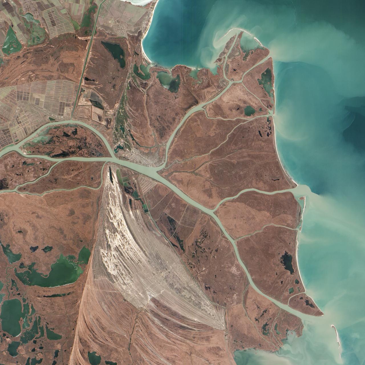
Acquired February 5, 2013 The Danube River is the largest in the European Union, its watershed draining 801,463 square kilometers (309,447 square miles) of land across 19 countries. Where that great river reaches the Black Sea, a remarkable delta has formed—the “Everglades” of Europe. The Danube Delta is home to more than 300 species of bird and 45 species of freshwater fish. The Danube Delta has been home to human settlements since the end of the Stone Age (the Neolithic Period), and the ancient Greeks, Romans, and Byzantines all built trading ports and military outposts along this coast. Today, the border between Romania and Ukraine cuts through the northern part of the delta. The area is a United Nations World Heritage Site, both for its natural and human history, and for the traditional maritime culture that persists in its marshes. All the while, the landscape has been shaped and re-shaped by nature and man. The image above was acquired on February 5, 2013, by the Advanced Land Imager (ALI) on NASA’s Earth Observing-1 (EO-1) satellite. The Danube Delta has a number of lobes formed over the past several thousand years, and this image is focused largely on the northernmost Chilia (or Kilia) lobe. It is the youngest section of the delta—somewhere between 300 to 400 years old—and lies mostly within Ukraine. Much of the land in the image above is officially considered part of the Danube Biosphere Reserve. Near the center of the image, the small city of Vylkove is known as the “Ukranian Venice,” due to its canals. To the lower left, the older Sulina lobe of the delta stretches to the south and further inland into Romania. White and brown curved lines reveal beach ridges and former shorelines, with the whiter ridges composed almost entirely of pure quartz sand in high dunes. To the east of the ridges, most of the landscape is flat marshland that is mostly brown in the barren days of winter. The Bystroye Canal through the center of the Chilia lobe has been the subject of heated debate over the past two decades. Over the centuries, damming and channeling of the Danube throughout Europe has reduced its water flow and sediment load to roughly 30 percent of what it once was, according to coastal geologist Liviu Giosan of the Woods Hole Oceanographic Institution. In recent years, the Ukrainian government has dredged some delta channels (including Bystroye) and proposed extensive dredging of others in order to provide navigational channels for large ships. Proponents argue for the economic needs of water transportation routes. Opponents note that deeper, faster channels mean less mud and sand is deposited in the delta; in some places, more is carried away by swifter currents. Both affect the sensitive ecosystems and the ability of the delta to restore itself and grow. In a 2012 report led by Giosan, scientists noted that the shape, water chemistry, and biology of Danube Delta was being altered long before the modern Industrial Era. Land use practices—particularly farming and forest clearing—added significant amounts of nutrients into the water and reduced salinity in the Black Sea, changing the dominant species of phytoplankton and sending a ripple of effects through the entire food web. NASA Earth Observatory image by Jesse Allen and Robert Simmon, using EO-1 ALI data provided courtesy of the NASA EO-1 team and the U.S. Geological Survey. Caption by Mike Carlowicz. Instrument: EO-1 - ALI More info: <a href="http://earthobservatory.nasa.gov/IOTD/view.php?id=80459" rel="nofollow">earthobservatory.nasa.gov/IOTD/view.php?id=80459</a> Credit: <b><a href="http://www.earthobservatory.nasa.gov/" rel="nofollow"> NASA Earth Observatory</a></b> <b><a href="http://www.nasa.gov/audience/formedia/features/MP_Photo_Guidelines.html" rel="nofollow">NASA image use policy.</a></b> <b><a href="http://www.nasa.gov/centers/goddard/home/index.html" rel="nofollow">NASA Goddard Space Flight Center</a></b> enables NASA’s mission through four scientific endeavors: Earth Science, Heliophysics, Solar System Exploration, and Astrophysics. Goddard plays a leading role in NASA’s accomplishments by contributing compelling scientific knowledge to advance the Agency’s mission. <b>Follow us on <a href="http://twitter.com/NASA_GoddardPix" rel="nofollow">Twitter</a></b> <b>Like us on <a href="http://www.facebook.com/pages/Greenbelt-MD/NASA-Goddard/395013845897?ref=tsd" rel="nofollow">Facebook</a></b> <b>Find us on <a href="http://instagram.com/nasagoddard?vm=grid" rel="nofollow">Instagram</a></b>
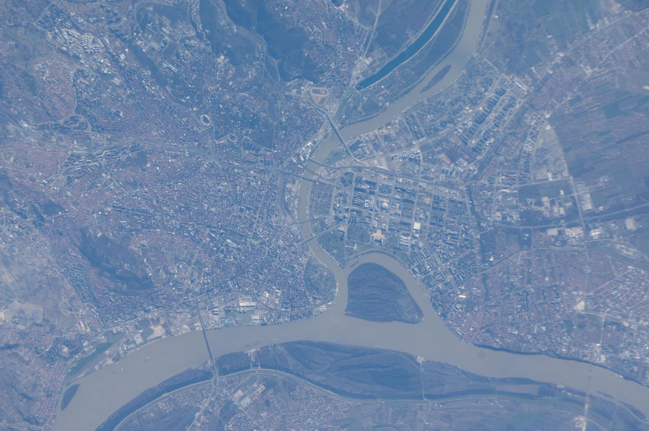
ISS034-E-61717 (5 March 2013) --- One of the Expedition 34 crew members aboard the Earth-orbiting International Space Station captured this image of Belgrade, the capital city of the Republic of Serbia. Located at the confluence of the Danube and Sava Rivers, the Belgrade metropolitan area has a population of 1.65 million (2011 census information) which ranks it as one of the largest such areas in southeastern Europe. Human occupation of the Belgrade area can be traced back over 6000 years. According to historical reports, a city that eventually became Belgrade existed by at least 279 BC. The core of old Belgrade – known as Kalemegdan –is located along the right banks of both the Danube and the Sava Rivers (image center). To the west across the Sava, Novi Beograd (New Belgrade) was constructed following World War II. The photograph was acquired on March 5, 2013 with a digital camera using the equivalent of a 700 millimeter lens.
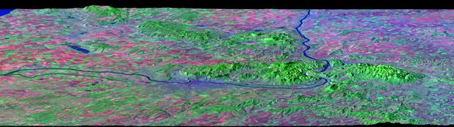
After draining the northern flank of the Alps Mountains in Germany and Austria, the Danube River flows east as it enters this west-looking scene (upper right) and forms the border between Slovakia and Hungary. The river then leaves the border as it enters Hungary and transects the Transdanubian Mountains, which trend southwest to northeast. Upon exiting the mountains, the river turns southward, flowing past Budapest (purplish blue area) and along the western margin of the Great Hungarian Plain. South and west of the Danube, the Transdanubian Mountains have at most only about 400 meters (about 1300 feet) of relief but they exhibit varied landforms, which include volcanic, tectonic, fluvial (river), and eolian (wind) features. A thick deposit of loess (dust deposits likely blown from ancient glacial outwash) covers much of this area, and winds from the northwest, funneled between the Alps and the Carpathian Mountains, are apparently responsible for a radial pattern of erosional streaks across the entire region. This image was generated from a Landsat satellite image draped over an elevation model produced by the Shuttle Radar Topography Mission (SRTM). The view uses a 3-times vertical exaggeration to enhance topographic expression. The false colors of the scene result from displaying Landsat bands 1, 4, and 7 in blue, green, and red, respectively. Band 1 is visible blue light, but bands 4 and 7 are reflected infrared light. This band combination maximizes color contrasts between the major land cover types, namely vegetation (green), bare ground (red), and water (blue). Shading of the elevation model was used to further highlight the topographic features. http://photojournal.jpl.nasa.gov/catalog/PIA04952

iss074e0149548 (Jan. 18, 2026) --- Vienna, Austria, and Bratislava, Slovakia, light up the Central European nightscape, each divided by the Danube River. Surrounding the two capital cities are wine‑country towns and historic market villages that dot the landscape. The International Space Station was orbiting 262 miles above Earth at approximately 9:09 p.m. local time when this photograph was taken. Credit: NASA/Chris Williams
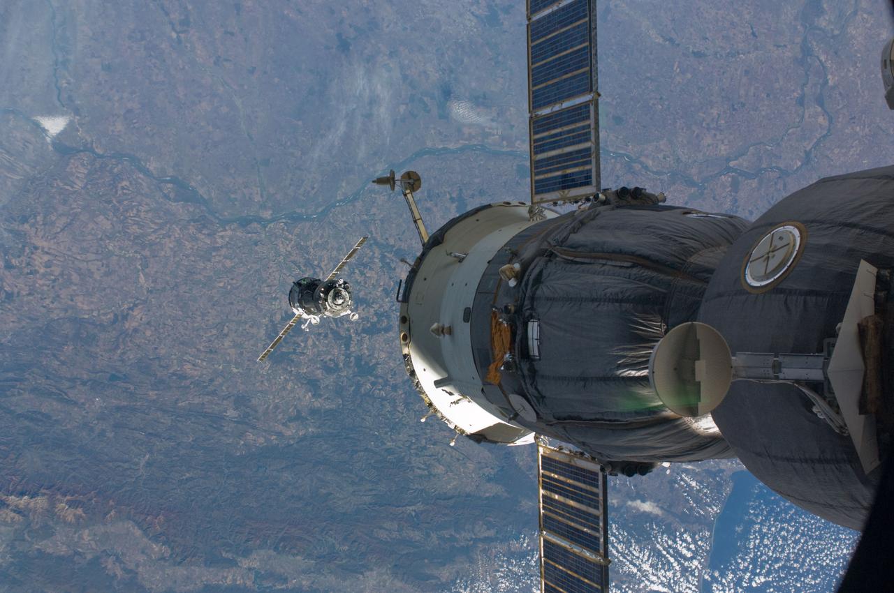
ISS017-E-019550 (14 Oct. 2008) --- The Soyuz TMA-13 spacecraft approaches the International Space Station, carrying NASA astronaut Michael Fincke, Expedition 18 commander; Russian Federal Space Agency cosmonaut Yury Lonchakov, Soyuz commander and flight engineer; and American spaceflight participant Richard Garriott. Fincke and Lonchakov will spend six months on the station, while Garriott will return to Earth on Oct. 23 with two of the Expedition 17 crewmembers currently on the complex. Northeastern Bulgaria, south of the Danube River (along the top) and north of the Balkan Mountains (along bottom), and the western Black Sea (lower right) form the backdrop for the scene.
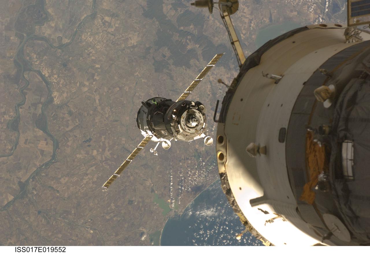
ISS017-E-019552 (14 Oct. 2008) --- The Soyuz TMA-13 spacecraft approaches the International Space Station, carrying NASA astronaut Michael Fincke, Expedition 18 commander; Russian Federal Space Agency cosmonaut Yury Lonchakov, Soyuz commander and flight engineer; and American spaceflight participant Richard Garriott. Fincke and Lonchakov will spend six months on the station, while Garriott will return to Earth on Oct. 23 with two of the Expedition 17 crewmembers currently on the complex. Eastern Romania just north of the Black Sea port of Constanta with the lower Danube River floodplain along the left side and forested parts of the Babadagului Plateau at the top form the backdrop for the scene.
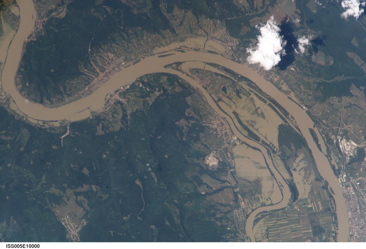
ISS005-E-10926 (23 August 2002) --- This is the second of two images recently released by the Earth Sciences and Image Analysis Laboratory at Johnson Space Center, showing some of the devastating late summer 2002 European flooding. The images were captured by astronauts using a digital still camera onboard the International Space Station (ISS). The photographs show flooding around the Danube Bend area just north of Budapest near the city of Vác, Hungary. The flood peaked in Budapest four days before this photo was made, on August 19, at about 8.5 meters (28 feet), exceeding the previous 1965 flood record. Water had begun to recede when this image was made. Image no. ISS005-E-10000 shows the area four days earlier.
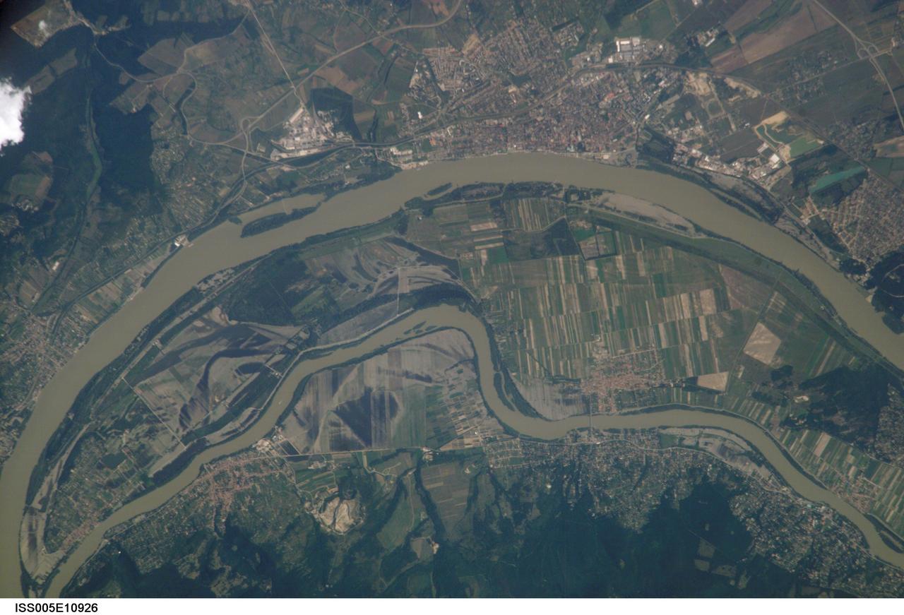
ISS005-E-10000 (18 August 2002) --- This is the first of two images recently released by the Earth Sciences and Image Analysis Laboratory at Johnson Space Center, showing the devastating European flooding in August. The images were captured by astronauts using a digital still camera onboard the International Space Station (ISS). The photographs show flooding around the Danube Bend area just north of Budapest near the city of Vác, Hungary. The flood peaked in Budapest the day after this photo was made, on August 19, at about 8.5 meters (28 feet), exceeding the previous 1965 flood record. This image shows the waters inundating farmland in the flood plain. Image no. ISS005-E-10926 shows the area four days later.