
This image taken by NASA's Dawn spacecraft shows Duginavi Crater, a large (96 miles, 155 kilometers in diameter) crater on Ceres. Duginavi's degraded rim barely stands out in this picture, which indicates this feature is very old. There are several factors that alter and eventually erase the shapes of geological features on bodies that do not have an atmosphere. These include gravity, which is responsible for landslides and scarps. The formation of newer craters, and the material that gets ejected in the process, has smoothed over craters such as Duginavi. Duginavi hosts the small Oxo Crater, recognizable by its bright rim and ejecta. Oxo is the first site at which ice was discovered on Ceres. Duginavi is named for an agriculture god of the Kogi people of northern Colombia. Oxo bears the name of the god of agriculture in Afro-Brazilian beliefs of Yoruba derivation. These features can be found on the global map of Ceres. Dawn took this image on October 8, 2015, from its high-altitude mapping orbit, at a distance of about 915 miles (1,470 kilometers) above the surface. It has a resolution of 450 feet (140 meters) per pixel. The center coordinates of this image are 39 degrees north latitude, 8 degrees east longitude. https://photojournal.jpl.nasa.gov/catalog/PIA21912
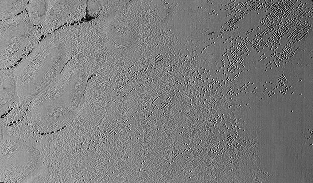
This image was taken by the Long Range Reconnaissance Imager (LORRI) on NASA's New Horizons spacecraft shortly before closest approach to Pluto on July 14, 2015; it resolves details as small as 270 yards (250 meters). The scene shown is about 130 miles (210 kilometers) across. The sun illuminates the scene from the left, and north is to the upper left. Credits: NASA/JHUAPL/SwRI It seems that the more we see of Pluto, the more fascinating it gets. With its prominent heart-shaped feature, icy mountains, and “snakeskin” terrain, Pluto has already surprised New Horizons scientists with the variety and complexity of its surface features. Now this latest image, from the heart of Pluto’s heart feature, show the plains’ enigmatic cellular pattern (at left) as well as unusual clusters of small pits and troughs (from lower left to upper right). Scientists believe that this area, informally known as Sputnik Planum, is composed of volatile ices such as solid nitrogen. They theorize that the pits and troughs – typically hundreds of meters across and tens of meters deep – are possibly formed by sublimation or evaporation of these ices. However, the reasons for the striking shapes and alignments of these features are a mystery. Adding to the intrigue is that even at this resolution, no impact craters are seen, testifying to the extreme geologic youth of Sputnik Planum. “Pluto is weird, in a good way,” said Hal Weaver, New Horizons project scientist with Johns Hopkins Applied Physics Laboratory in Laurel, Maryland. “The pits, and the way they’re aligned, provide clues about the ice flow and the exchange of volatiles between the surface and atmosphere, and the science team is working hard to understand what physical processes are at play here.” <b><a href="http://www.nasa.gov/audience/formedia/features/MP_Photo_Guidelines.html" rel="nofollow">NASA image use policy.</a></b> <b><a href="http://www.nasa.gov/centers/goddard/home/index.html" rel="nofollow">NASA Goddard Space Flight Center</a></b> enables NASA’s mission through four scientific endeavors: Earth Science, Heliophysics, Solar System Exploration, and Astrophysics. Goddard plays a leading role in NASA’s accomplishments by contributing compelling scientific knowledge to advance the Agency’s mission. <b>Follow us on <a href="http://twitter.com/NASAGoddardPix" rel="nofollow">Twitter</a></b> <b>Like us on <a href="http://www.facebook.com/pages/Greenbelt-MD/NASA-Goddard/395013845897?ref=tsd" rel="nofollow">Facebook</a></b> <b>Find us on <a href="http://instagrid.me/nasagoddard/?vm=grid" rel="nofollow">Instagram</a></b>