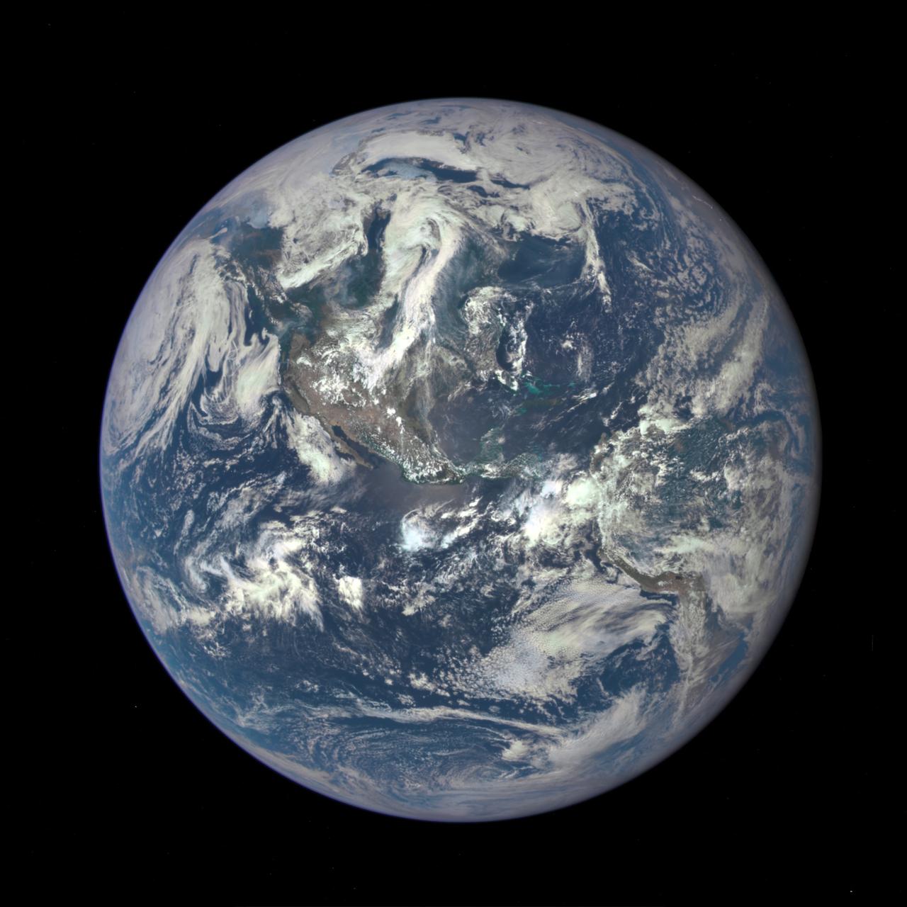
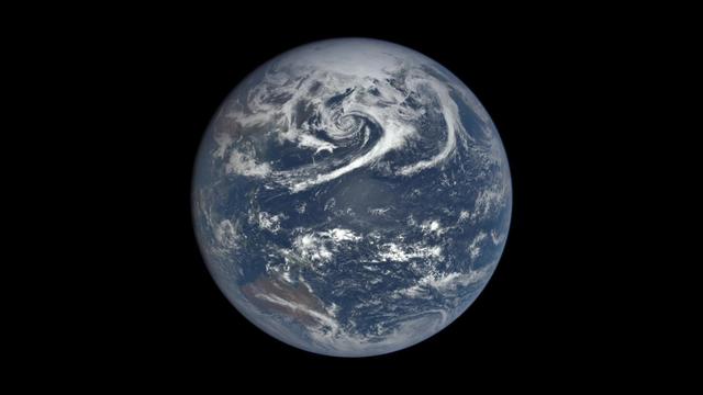
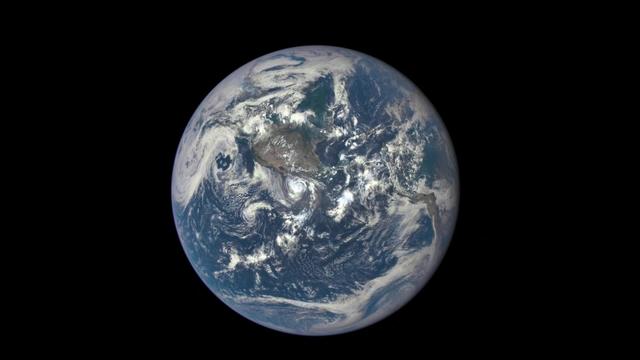
A NASA camera on the Deep Space Climate Observatory satellite has returned its first view of the entire sunlit side of Earth from one million miles away. This color image of Earth was taken by NASA’s Earth Polychromatic Imaging Camera (EPIC), a four megapixel CCD camera and telescope. The image was generated by combining three separate images to create a photographic-quality image. The camera takes a series of 10 images using different narrowband filters -- from ultraviolet to near infrared -- to produce a variety of science products. The red, green and blue channel images are used in these color images. The image was taken July 6, 2015, showing North and Central America. The central turquoise areas are shallow seas around the Caribbean islands. This Earth image shows the effects of sunlight scattered by air molecules, giving the image a characteristic bluish tint. The EPIC team is working to remove this atmospheric effect from subsequent images. Once the instrument begins regular data acquisition, EPIC will provide a daily series of Earth images allowing for the first time study of daily variations over the entire globe. These images, available 12 to 36 hours after they are acquired, will be posted to a dedicated web page by September 2015. The primary objective of DSCOVR, a partnership between NASA, the National Oceanic and Atmospheric Administration (NOAA) and the U.S. Air Force, is to maintain the nation’s real-time solar wind monitoring capabilities, which are critical to the accuracy and lead time of space weather alerts and forecasts from NOAA. For more information about DSCOVR, visit: <a href="http://www.nesdis.noaa.gov/DSCOVR/" rel="nofollow">www.nesdis.noaa.gov/DSCOVR/</a>
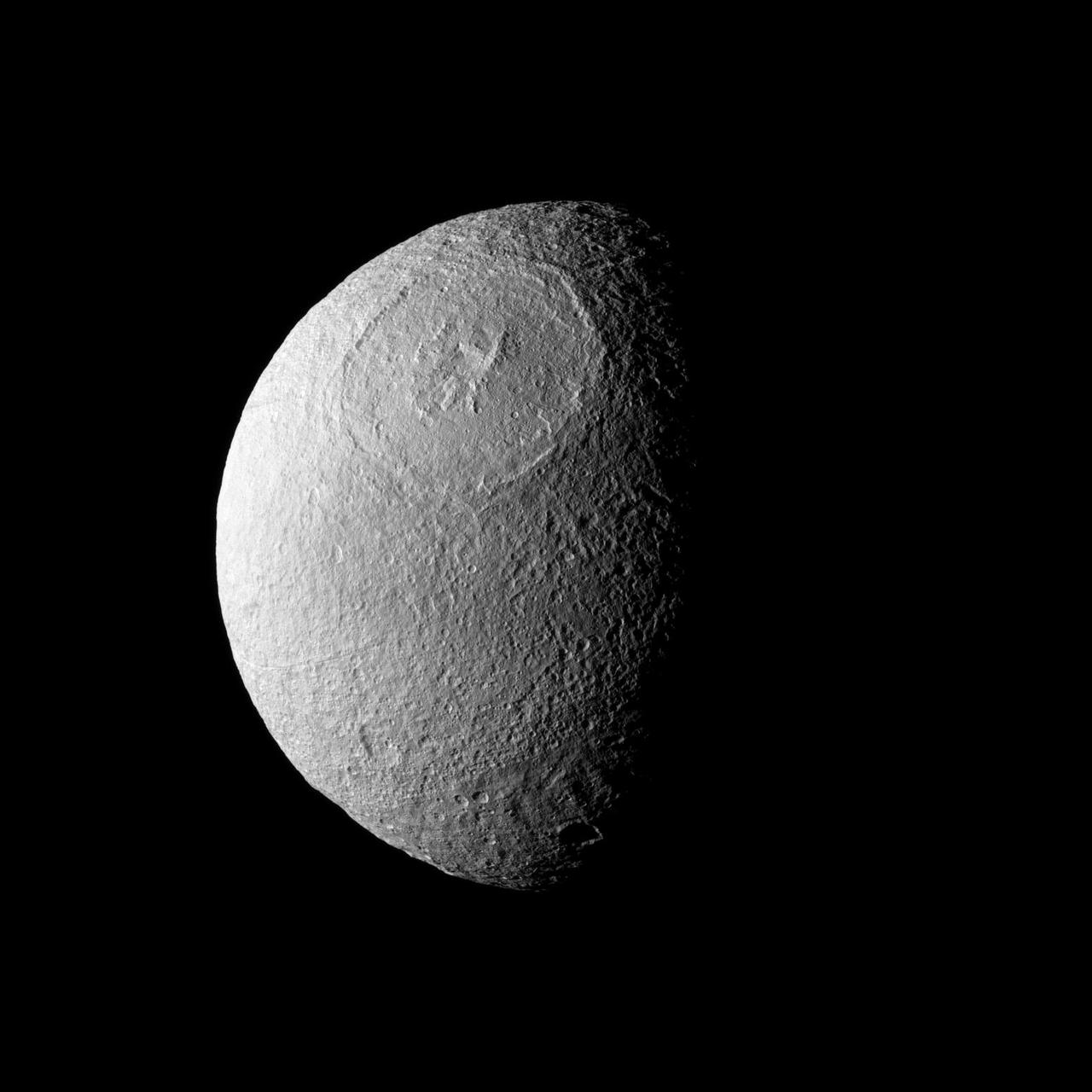
Odysseus Crater, with a size of epic proportions, stretches across a large northern expanse on Saturn moon Tethys in this image taken by NASA Cassini spacecraft.
From a million miles out in space, NASA’s Earth Polychromatic Imaging Camera (EPIC) captured natural color images of the moon’s shadow crossing over North America on Aug. 21, 2017. EPIC is aboard NOAA’s Deep Space Climate Observatory (DSCOVR), where it photographs the full sunlit side of Earth every day, giving it a unique view of total solar eclipses. EPIC normally takes about 20 to 22 images of Earth per day, so this animation appears to speed up the progression of the eclipse. To see the images of Earth every day, go to: <a href="https://epic.gsfc.nasa.gov" rel="nofollow">epic.gsfc.nasa.gov</a> <b><a href="http://www.nasa.gov/audience/formedia/features/MP_Photo_Guidelines.html" rel="nofollow">NASA image use policy.</a></b> <b><a href="http://www.nasa.gov/centers/goddard/home/index.html" rel="nofollow">NASA Goddard Space Flight Center</a></b> enables NASA’s mission through four scientific endeavors: Earth Science, Heliophysics, Solar System Exploration, and Astrophysics. Goddard plays a leading role in NASA’s accomplishments by contributing compelling scientific knowledge to advance the Agency’s mission. <b>Follow us on <a href="http://twitter.com/NASAGoddardPix" rel="nofollow">Twitter</a></b> <b>Like us on <a href="http://www.facebook.com/pages/Greenbelt-MD/NASA-Goddard/395013845897?ref=tsd" rel="nofollow">Facebook</a></b> <b>Find us on <a href="http://instagrid.me/nasagoddard/?vm=grid" rel="nofollow">Instagram</a></b>

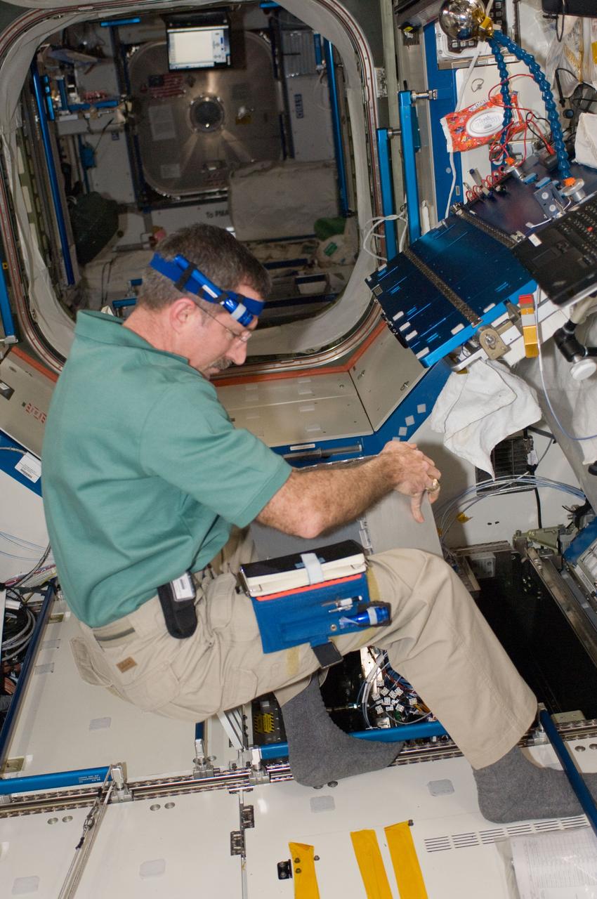
ISS030-E-017789 (29 Dec. 2011) --- Working in chorus with the International Space Station team in Houston?s Mission Control Center, this astronaut and his Expedition 30 crewmates on the station install a set of Enhanced Processor and Integrated Communications (EPIC) computer cards in one of seven primary computers onboard. The upgrade will allow more experiments to operate simultaneously, and prepare for the arrival of commercial cargo ships later this year.
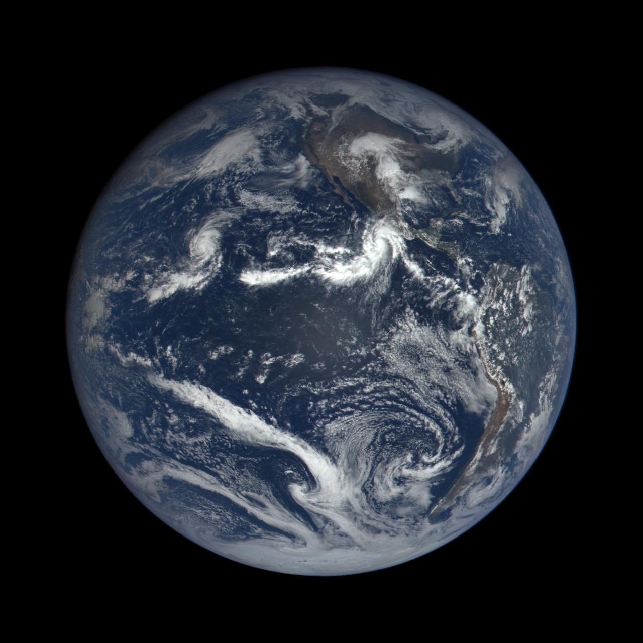
Hurricane Patricia captured by EPIC, the Earth Polychromatic Imaging Camera. The instrument flies on the Deep Space Climate Observatory (DSCOVR), a satellite built through a partnership between NASA, the National Oceanic and Atmospheric Administration (NOAA), and the U.S. Air Force. DSCOVR collects its images and measurements from a vantage point one million miles above the Earth and toward the Sun. This image was captured nearly 1 million miles from earth at 4:00 pm EDT (19:00:18 GMT), on September 22, 2015. Credit: NASA image from the DSCOVR EPIC team
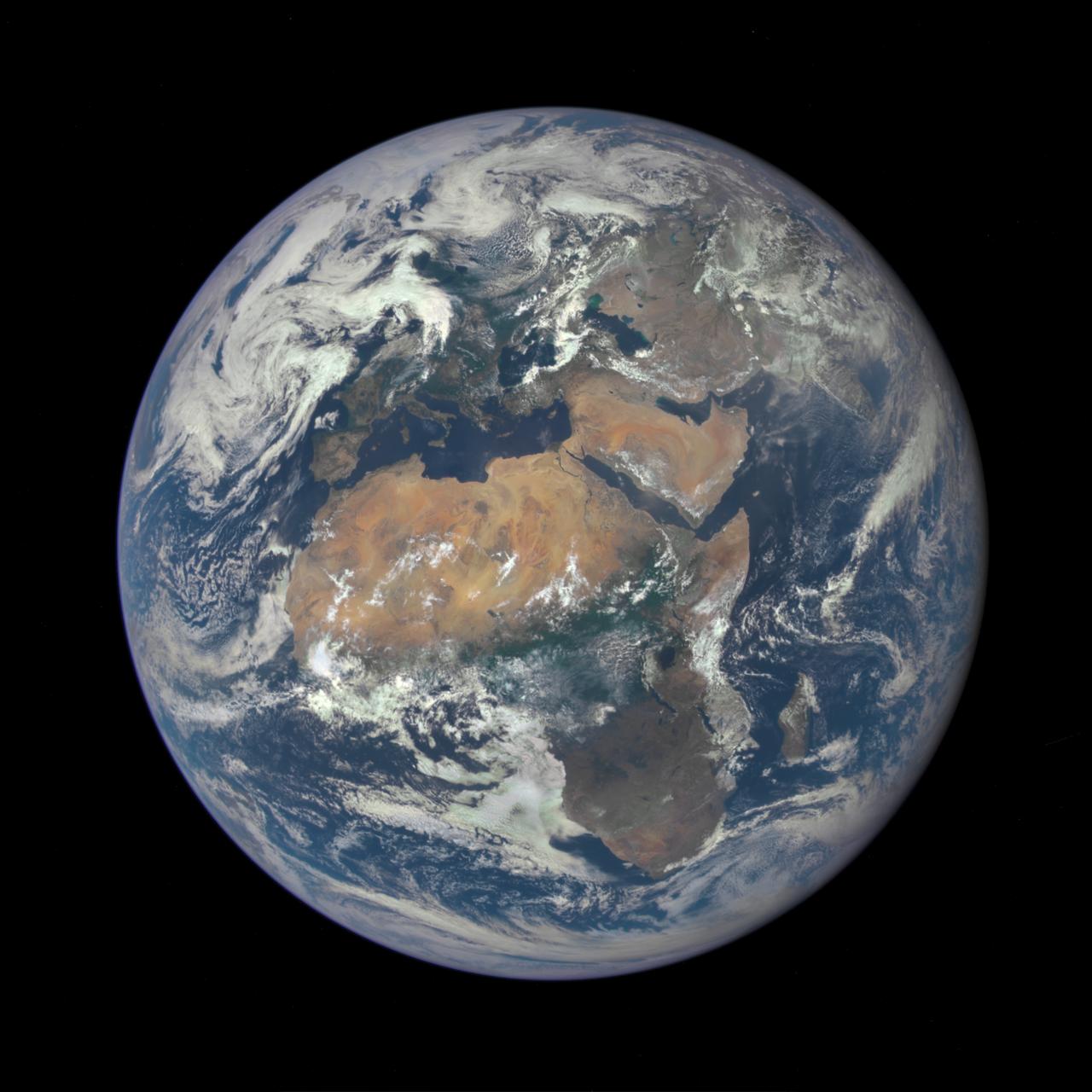
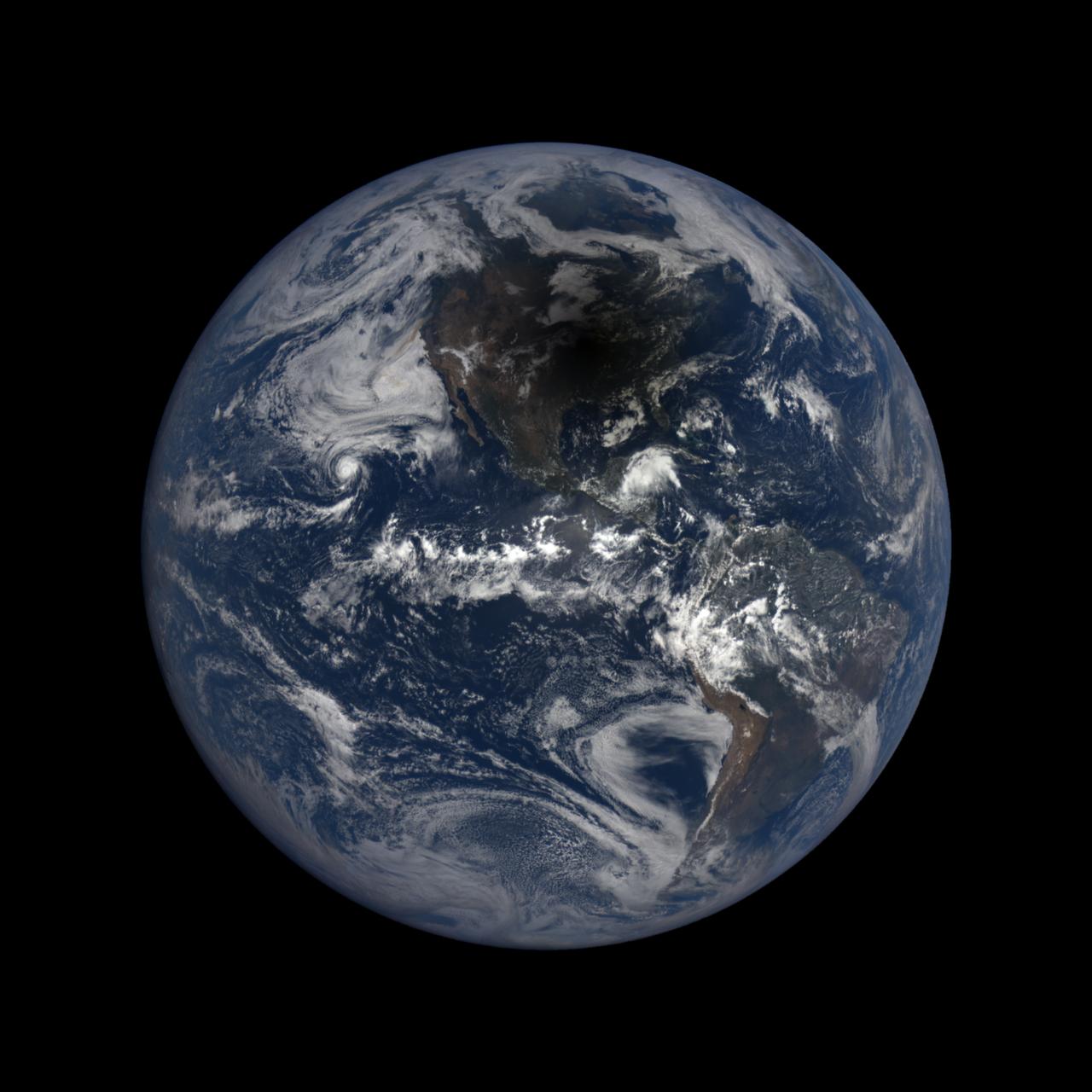
Africa is front and center in this image of Earth taken by a NASA camera on the Deep Space Climate Observatory (DSCOVR) satellite. The image, taken July 6 from a vantage point one million miles from Earth, was one of the first taken by NASA’s Earth Polychromatic Imaging Camera (EPIC). Central Europe is toward the top of the image with the Sahara Desert to the south, showing the Nile River flowing to the Mediterranean Sea through Egypt. The photographic-quality color image was generated by combining three separate images of the entire Earth taken a few minutes apart. The camera takes a series of 10 images using different narrowband filters -- from ultraviolet to near infrared -- to produce a variety of science products. The red, green and blue channel images are used in these Earth images. The DSCOVR mission is a partnership between NASA, the National Oceanic and Atmospheric Administration (NOAA) and the U.S. Air Force, with the primary objective to maintain the nation’s real-time solar wind monitoring capabilities, which are critical to the accuracy and lead time of space weather alerts and forecasts from NOAA. DSCOVR was launched in February to its planned orbit at the first Lagrange point or L1, about one million miles from Earth toward the sun. It’s from that unique vantage point that the EPIC instrument is acquiring images of the entire sunlit face of Earth. Data from EPIC will be used to measure ozone and aerosol levels in Earth’s atmosphere, cloud height, vegetation properties and a variety of other features. Image Credit: NASA <b><a href="http://www.nasa.gov/audience/formedia/features/MP_Photo_Guidelines.html" rel="nofollow">NASA image use policy.</a></b> <b><a href="http://www.nasa.gov/centers/goddard/home/index.html" rel="nofollow">NASA Goddard Space Flight Center</a></b> enables NASA’s mission through four scientific endeavors: Earth Science, Heliophysics, Solar System Exploration, and Astrophysics. Goddard plays a leading role in NASA’s accomplishments by contributing compelling scientific knowledge to advance the Agency’s mission. <b>Follow us on <a href="http://twitter.com/NASAGoddardPix" rel="nofollow">Twitter</a></b> <b>Like us on <a href="http://www.facebook.com/pages/Greenbelt-MD/NASA-Goddard/395013845897?ref=tsd" rel="nofollow">Facebook</a></b> <b>Find us on <a href="http://instagrid.me/nasagoddard/?vm=grid" rel="nofollow">Instagram</a></b>

Africa is front and center in this image of Earth taken by a NASA camera on the Deep Space Climate Observatory (DSCOVR) satellite. The image, taken July 6 from a vantage point one million miles from Earth, was one of the first taken by NASA’s Earth Polychromatic Imaging Camera (EPIC). Central Europe is toward the top of the image with the Sahara Desert to the south, showing the Nile River flowing to the Mediterranean Sea through Egypt. The photographic-quality color image was generated by combining three separate images of the entire Earth taken a few minutes apart. The camera takes a series of 10 images using different narrowband filters -- from ultraviolet to near infrared -- to produce a variety of science products. The red, green and blue channel images are used in these Earth images. The DSCOVR mission is a partnership between NASA, the National Oceanic and Atmospheric Administration (NOAA) and the U.S. Air Force, with the primary objective to maintain the nation’s real-time solar wind monitoring capabilities, which are critical to the accuracy and lead time of space weather alerts and forecasts from NOAA. DSCOVR was launched in February to its planned orbit at the first Lagrange point or L1, about one million miles from Earth toward the sun. It’s from that unique vantage point that the EPIC instrument is acquiring images of the entire sunlit face of Earth. Data from EPIC will be used to measure ozone and aerosol levels in Earth’s atmosphere, cloud height, vegetation properties and a variety of other features. Image Credit: NASA
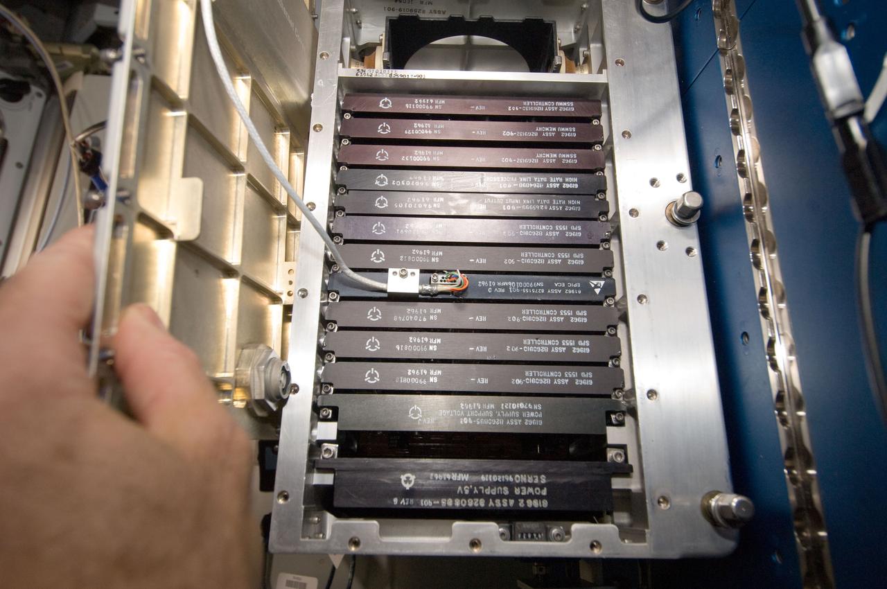
ISS030-E-017776 (29 Dec. 2011) --- Working in chorus with the International Space Station team in Houston?s Mission Control Center, this astronaut and his Expedition 30 crewmates on the station install a set of Enhanced Processor and Integrated Communications (EPIC) computer cards in one of seven primary computers onboard. The upgrade will allow more experiments to operate simultaneously, and prepare for the arrival of commercial cargo ships later this year.
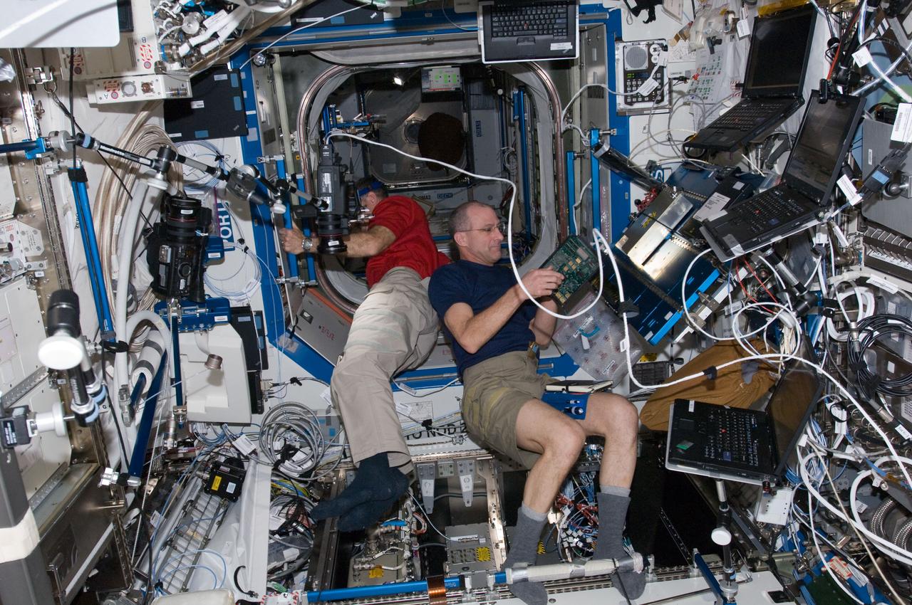
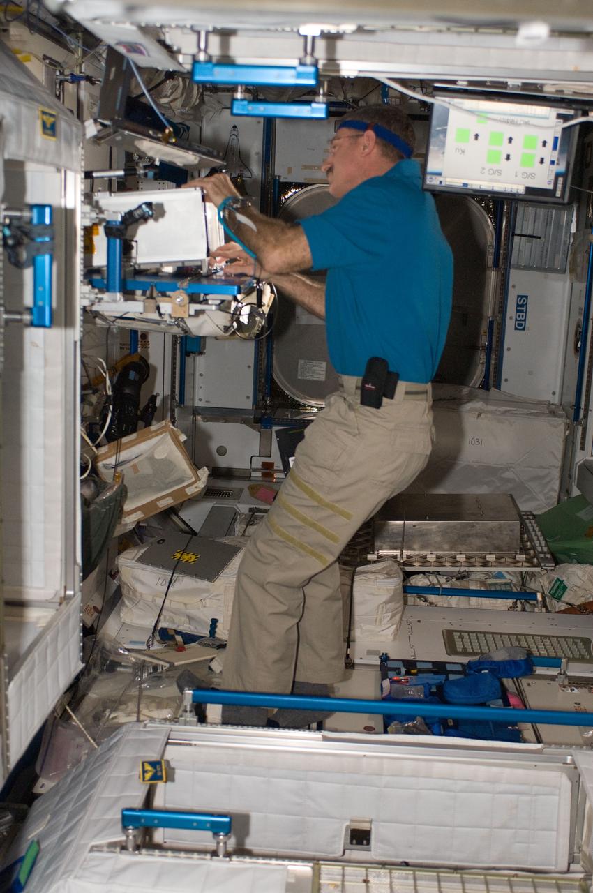
ISS030-E-022574 (28 Dec. 2011) -- NASA astronaut Don Pettit (foreground),Expedition 30 flight engineer, performs the Enhanced Processor and Integrated Communications (EPIC) card testing and X2R10 software transition. The software transition work will include EPIC card testing and card installations, and monitoring of the upgraded Multiplexer/ Demultiplexer (MDM) computers. Dan Burbank, Expedition 30 commander, is setting up a camcorder in the background.
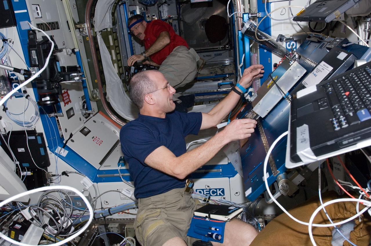
ISS030-E-022575 (28 Dec. 2011) -- NASA astronaut Don Pettit (foreground),Expedition 30 flight engineer, performs the Enhanced Processor and Integrated Communications (EPIC) card testing and X2R10 software transition. The software transition work will include EPIC card testing and card installations, and monitoring of the upgraded Multiplexer/ Demultiplexer (MDM) computers. Dan Burbank, Expedition 30 commander, is setting up a camcorder in the background.
ISS030-E-114433 (29 Feb. 2012) --- In the International Space Station?s Destiny laboratory, NASA astronaut Dan Burbank, Expedition 30 commander, upgrades Multiplexer/Demultiplexer (MDM) computers and Portable Computer System (PCS) laptops and installs the Enhanced Processor & Integrated Communications (EPIC) hardware in the Payload 1 (PL-1) MDM.

NASA image captured December 6, 2010 To view a video of this event go here: <a href="http://www.flickr.com/photos/gsfc/5258354738">www.flickr.com/photos/gsfc/5258354738</a> A very long solar filament that had been snaking around the Sun erupted (Dec. 6, 2010) with a flourish. STEREO (Behind) caught the action in dramatic detail in extreme ultraviolet light of Helium. It had been almost a million km long (about half a solar radius) and a prominent feature on the Sun visible over two weeks earlier before it rotated out of view. Filaments, elongated clouds of cooler gases suspended above the Sun by magnetic forces, are rather unstable and often break away from the Sun. Credit: NASA/GSFC/SOHO <b><a href="http://www.nasa.gov/centers/goddard/home/index.html" rel="nofollow">NASA Goddard Space Flight Center</a></b> enables NASA’s mission through four scientific endeavors: Earth Science, Heliophysics, Solar System Exploration, and Astrophysics. Goddard plays a leading role in NASA’s accomplishments by contributing compelling scientific knowledge to advance the Agency’s mission. <b>Follow us on <a href="http://twitter.com/NASA_GoddardPix" rel="nofollow">Twitter</a></b> <b>Join us on <a href="http://www.facebook.com/pages/Greenbelt-MD/NASA-Goddard/395013845897?ref=tsd" rel="nofollow">Facebook</a></b>
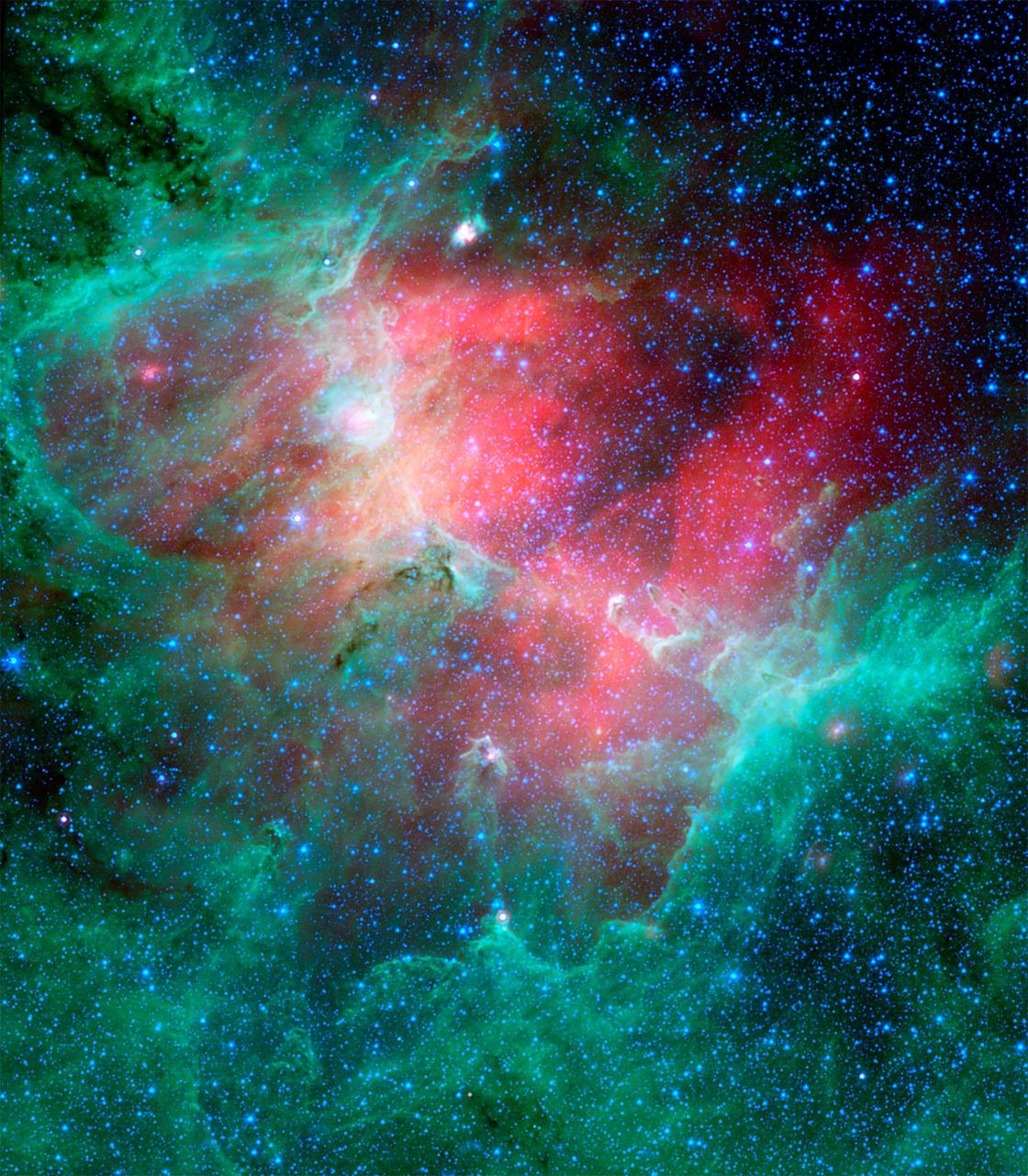
This majestic view taken by NASA Spitzer Space Telescope tells an untold story of life and death in the Eagle nebula, an industrious star-making factory located 7,000 light-years away in the Serpens constellation.
On July 20, 2015, NASA released to the world the first image of the sunlit side of Earth captured by the space agency's EPIC camera on NOAA's DSCOVR satellite. The camera has now recorded a full year of life on Earth from its orbit at Lagrange point 1, approximately 1 million miles from Earth, where it is balanced between the gravity of our home planet and the sun. EPIC takes a new picture every two hours, revealing how the planet would look to human eyes, capturing the ever-changing motion of clouds and weather systems and the fixed features of Earth such as deserts, forests and the distinct blues of different seas. EPIC will allow scientists to monitor ozone and aerosol levels in Earth’s atmosphere, cloud height, vegetation properties and the ultraviolet reflectivity of Earth. The primary objective of DSCOVR, a partnership between NASA, the National Oceanic and Atmospheric Administration (NOAA) and the U.S. Air Force, is to maintain the nation’s real-time solar wind monitoring capabilities, which are critical to the accuracy and lead time of space weather alerts and forecasts from NOAA. For more information about DSCOVR, visit: <a href="http://go.nasa.gov/29Pqm15" rel="nofollow">go.nasa.gov/29Pqm15</a>
Craig Nelson, author of "Rocket Men: The Epic Story of the First Men on the Moon" speaks during an Apollo History and Legacy roundtable discussion, Thursday, July 16, 2009, at NASA Headquarters in Washington. Photo Credit: (NASA/Paul E. Alers)
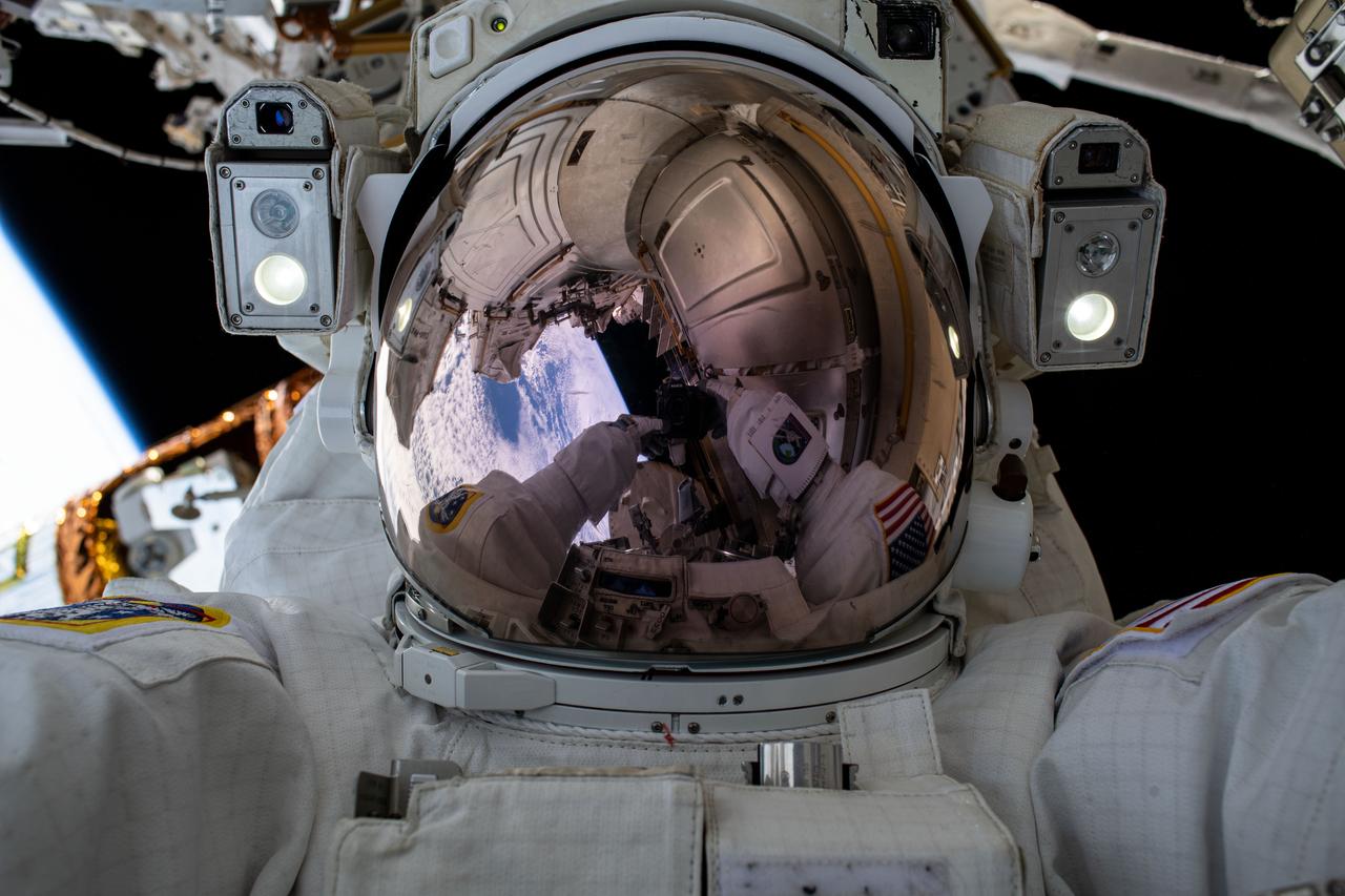
iss063e052397 (July 21, 2020) --- NASA astronaut and Expedition 63 Commander Chris Cassidy took this epic "space-selfie" during his fourth spacewalk this year at the International Space Station. Cassidy has completed 10 spacewalks throughout his career for a total of 54 hours and 51 minutes spacewalking time.
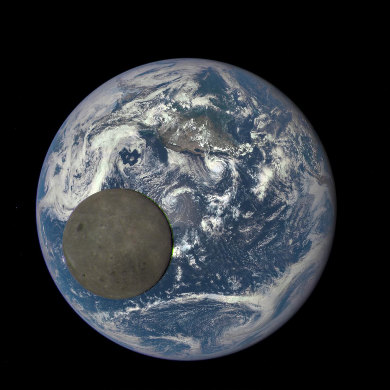
This animation still image shows the far side of the moon, illuminated by the sun, as it crosses between the DISCOVR spacecraft's Earth Polychromatic Imaging Camera (EPIC) camera and telescope, and the Earth - one million miles away. Credits: NASA/NOAA A NASA camera aboard the Deep Space Climate Observatory (DSCOVR) satellite captured a unique view of the moon as it moved in front of the sunlit side of Earth last month. The series of test images shows the fully illuminated “dark side” of the moon that is never visible from Earth. The images were captured by NASA’s Earth Polychromatic Imaging Camera (EPIC), a four megapixel CCD camera and telescope on the DSCOVR satellite orbiting 1 million miles from Earth. From its position between the sun and Earth, DSCOVR conducts its primary mission of real-time solar wind monitoring for the National Oceanic and Atmospheric Administration (NOAA).
ISS030-E-114408 (28 Feb. 2012) --- NASA astronaut Dan Burbank, Expedition 30 commander, works in Node 2 Harmony as the six crew members onboard the International Space Station wrap up a busy February.
This animation shows images of the far side of the moon, illuminated by the sun, as it crosses between the DISCOVR spacecraft's Earth Polychromatic Imaging Camera (EPIC) camera and telescope, and the Earth - one million miles away. Credits: NASA/NOAA A NASA camera aboard the Deep Space Climate Observatory (DSCOVR) satellite captured a unique view of the moon as it moved in front of the sunlit side of Earth last month. The series of test images shows the fully illuminated “dark side” of the moon that is never visible from Earth. The images were captured by NASA’s Earth Polychromatic Imaging Camera (EPIC), a four megapixel CCD camera and telescope on the DSCOVR satellite orbiting 1 million miles from Earth. From its position between the sun and Earth, DSCOVR conducts its primary mission of real-time solar wind monitoring for the National Oceanic and Atmospheric Administration (NOAA). Read more: <a href="http://www.nasa.gov/feature/goddard/from-a-million-miles-away-nasa-camera-shows-moon-crossing-face-of-earth" rel="nofollow">www.nasa.gov/feature/goddard/from-a-million-miles-away-na...</a> <b><a href="http://www.nasa.gov/audience/formedia/features/MP_Photo_Guidelines.html" rel="nofollow">NASA image use policy.</a></b> <b><a href="http://www.nasa.gov/centers/goddard/home/index.html" rel="nofollow">NASA Goddard Space Flight Center</a></b> enables NASA’s mission through four scientific endeavors: Earth Science, Heliophysics, Solar System Exploration, and Astrophysics. Goddard plays a leading role in NASA’s accomplishments by contributing compelling scientific knowledge to advance the Agency’s mission. <b>Follow us on <a href="http://twitter.com/NASAGoddardPix" rel="nofollow">Twitter</a></b> <b>Like us on <a href="http://www.facebook.com/pages/Greenbelt-MD/NASA-Goddard/395013845897?ref=tsd" rel="nofollow">Facebook</a></b> <b>Find us on <a href="http://instagrid.me/nasagoddard/?vm=grid" rel="nofollow">Instagram</a></b>

This animation still image shows the far side of the moon, illuminated by the sun, as it crosses between the DISCOVR spacecraft's Earth Polychromatic Imaging Camera (EPIC) camera and telescope, and the Earth - one million miles away. Credits: NASA/NOAA A NASA camera aboard the Deep Space Climate Observatory (DSCOVR) satellite captured a unique view of the moon as it moved in front of the sunlit side of Earth last month. The series of test images shows the fully illuminated “dark side” of the moon that is never visible from Earth. The images were captured by NASA’s Earth Polychromatic Imaging Camera (EPIC), a four megapixel CCD camera and telescope on the DSCOVR satellite orbiting 1 million miles from Earth. From its position between the sun and Earth, DSCOVR conducts its primary mission of real-time solar wind monitoring for the National Oceanic and Atmospheric Administration (NOAA). Read more: <a href="http://www.nasa.gov/feature/goddard/from-a-million-miles-away-nasa-camera-shows-moon-crossing-face-of-earth" rel="nofollow">www.nasa.gov/feature/goddard/from-a-million-miles-away-na...</a> <b><a href="http://www.nasa.gov/audience/formedia/features/MP_Photo_Guidelines.html" rel="nofollow">NASA image use policy.</a></b> <b><a href="http://www.nasa.gov/centers/goddard/home/index.html" rel="nofollow">NASA Goddard Space Flight Center</a></b> enables NASA’s mission through four scientific endeavors: Earth Science, Heliophysics, Solar System Exploration, and Astrophysics. Goddard plays a leading role in NASA’s accomplishments by contributing compelling scientific knowledge to advance the Agency’s mission. <b>Follow us on <a href="http://twitter.com/NASAGoddardPix" rel="nofollow">Twitter</a></b> <b>Like us on <a href="http://www.facebook.com/pages/Greenbelt-MD/NASA-Goddard/395013845897?ref=tsd" rel="nofollow">Facebook</a></b> <b>Find us on <a href="http://instagrid.me/nasagoddard/?vm=grid" rel="nofollow">Instagram</a></b>

“We like to say that Archean Earth is the most alien planet we have geochemical data for,” For astronomers trying to understand which distant planets might have habitable conditions, the role of atmospheric haze has been hazy. To help sort it out, a team of researchers has been looking to Earth – specifically Earth during the Archean era, an epic 1-1/2-billion-year period early in our planet’s history. Read more: <a href="http://go.nasa.gov/2kTBhPU" rel="nofollow">go.nasa.gov/2kTBhPU</a> Caption: When haze built up in the atmosphere of Archean Earth, the young planet might have looked like this artist's interpretation - a pale orange dot. A team led by Goddard scientists thinks the haze was self-limiting, cooling the surface by about 36 degrees Fahrenheit (20 Kelvins) – not enough to cause runaway glaciation. The team’s modeling suggests that atmospheric haze might be helpful for identifying earthlike exoplanets that could be habitable. Credits: NASA’s Goddard Space Flight Center/Francis Reddy

The early morning sun found hundreds of spectators on the beaches and roadways near the NASA Kennedy Space Center (KSC) where they had camped the night before to witness history by watching the epic beginning of the journey of Apollo 11. The first manned lunar landing mission launched from KSC via the Marshall Space Flight Center (MSFC) developed Saturn V launch vehicle on July 16, 1969 and safely returned to Earth on July 24, 1969. Aboard the space craft were astronauts Neil A. Armstrong, commander; Michael Collins, Command Module (CM) pilot; and Edwin E. (Buzz) Aldrin Jr., Lunar Module (LM) pilot. The CM, “Columbia”, piloted by Collins, remained in a parking orbit around the Moon while the LM, “Eagle’’, carrying astronauts Armstrong and Aldrin, landed on the Moon. On July 20, 1969, Armstrong was the first human to ever stand on the lunar surface, followed by Aldrin. During 2½ hours of surface exploration, the crew collected 47 pounds of lunar surface material for analysis back on Earth. With the success of Apollo 11, the national objective to land men on the Moon and return them safely to Earth had been accomplished.
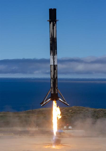
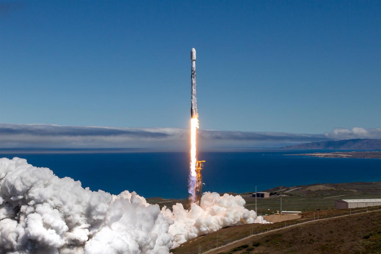
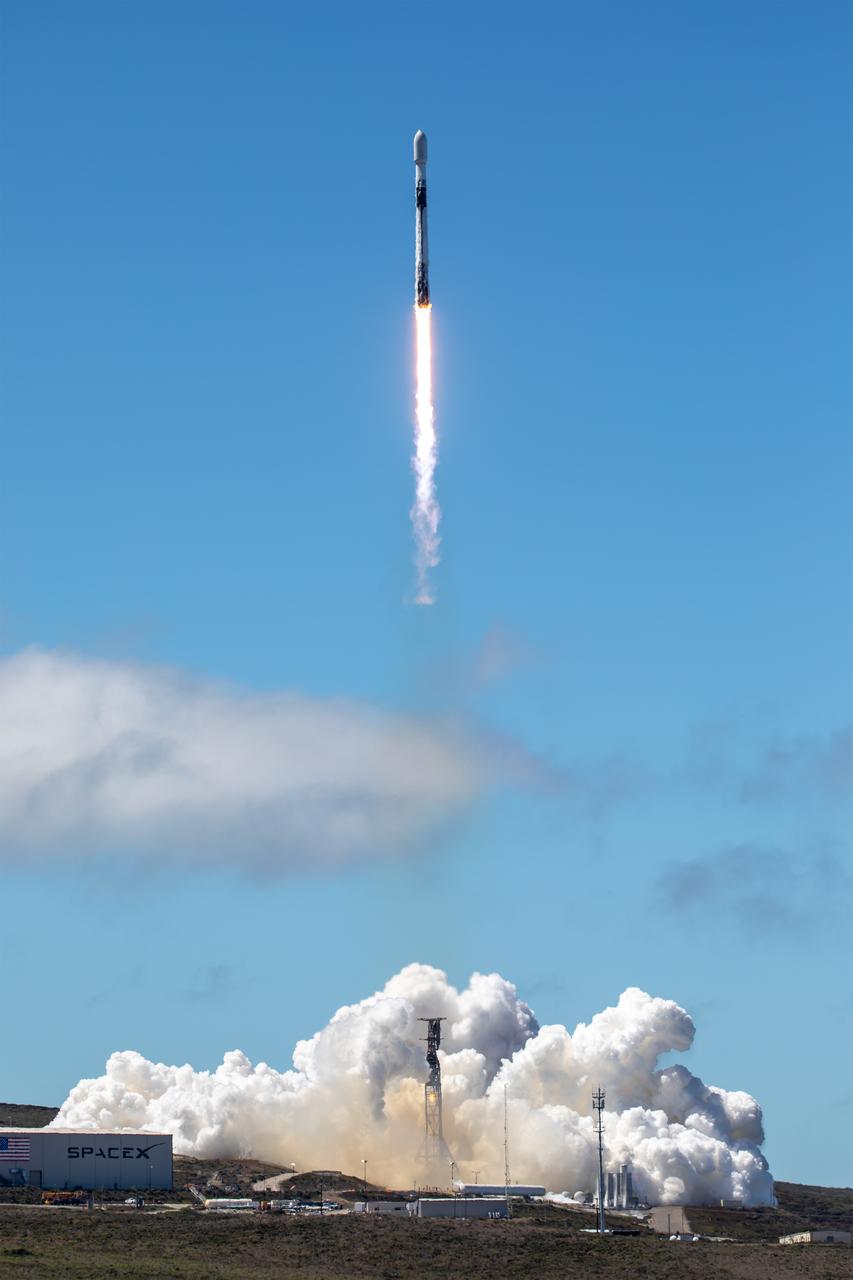
A SpaceX Falcon 9 first stage booster lands on Landing Zone 4 following liftoff of NASA’s TRACERS (Tandem Reconnection and Cusp Electrodynamics Reconnaissance Satellites) mission at Space Launch Complex 4 East at Vandenberg Space Force Base in California on Wednesday, July 23, 2025. This was the 16th flight for the first stage booster, which has previously launched these NASA missions - PACE (Plankton, Aerosol, Cloud, ocean Ecosystem, NASA’s SpaceX Crew-7, and Commercial Resupply Services-29. The TRACERS mission will study magnetic reconnection around Earth — a process in which electrically charged plasmas exchange energy in the atmosphere — to understand how the Sun’s solar wind interacts with the magnetosphere, Earth’s protective magnetic shield.

NASA’s TRACERS (Tandem Reconnection and Cusp Electrodynamics Reconnaissance Satellites) mission launches at 11:13 a.m. PDT (2:13 p.m. EDT) on Wednesday, July 23, 2025, atop a SpaceX Falcon 9 rocket at Space Launch Complex 4 East at Vandenberg Space Force Base in California. The TRACERS mission will study magnetic reconnection around Earth — a process in which electrically charged plasmas exchange energy in the atmosphere — to understand how the Sun’s solar wind interacts with the magnetosphere, Earth’s protective magnetic shield.
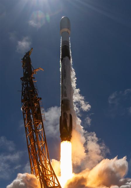
NASA’s TRACERS (Tandem Reconnection and Cusp Electrodynamics Reconnaissance Satellites) mission launches at 11:13 a.m. PDT (2:13 p.m. EDT) on Wednesday, July 23, 2025, atop a SpaceX Falcon 9 rocket at Space Launch Complex 4 East at Vandenberg Space Force Base in California. The TRACERS mission will study magnetic reconnection around Earth — a process in which electrically charged plasmas exchange energy in the atmosphere — to understand how the Sun’s solar wind interacts with the magnetosphere, Earth’s protective magnetic shield.
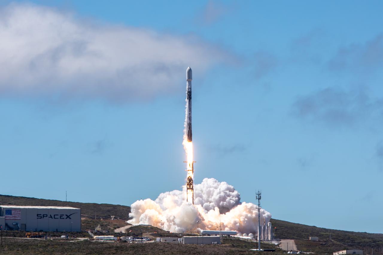
NASA’s TRACERS (Tandem Reconnection and Cusp Electrodynamics Reconnaissance Satellites) mission launches at 11:13 a.m. PDT (2:13 p.m. EDT) on Wednesday, July 23, 2025, atop a SpaceX Falcon 9 rocket at Space Launch Complex 4 East at Vandenberg Space Force Base in California. The TRACERS mission will study magnetic reconnection around Earth — a process in which electrically charged plasmas exchange energy in the atmosphere — to understand how the Sun’s solar wind interacts with the magnetosphere, Earth’s protective magnetic shield.
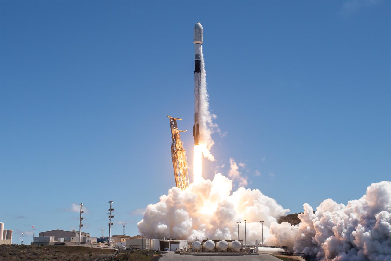
NASA’s TRACERS (Tandem Reconnection and Cusp Electrodynamics Reconnaissance Satellites) mission launches at 11:13 a.m. PDT (2:13 p.m. EDT) on Wednesday, July 23, 2025, atop a SpaceX Falcon 9 rocket at Space Launch Complex 4 East at Vandenberg Space Force Base in California. The TRACERS mission will study magnetic reconnection around Earth — a process in which electrically charged plasmas exchange energy in the atmosphere — to understand how the Sun’s solar wind interacts with the magnetosphere, Earth’s protective magnetic shield.
NASA’s TRACERS (Tandem Reconnection and Cusp Electrodynamics Reconnaissance Satellites) mission launches at 11:13 a.m. PDT (2:13 p.m. EDT) on Wednesday, July 23, 2025, atop a SpaceX Falcon 9 rocket at Space Launch Complex 4 East at Vandenberg Space Force Base in California. The TRACERS mission will study magnetic reconnection around Earth — a process in which electrically charged plasmas exchange energy in the atmosphere — to understand how the Sun’s solar wind interacts with the magnetosphere, Earth’s protective magnetic shield.
NASA’s TRACERS (Tandem Reconnection and Cusp Electrodynamics Reconnaissance Satellites) mission launches at 11:13 a.m. PDT (2:13 p.m. EDT) on Wednesday, July 23, 2025, atop a SpaceX Falcon 9 rocket at Space Launch Complex 4 East at Vandenberg Space Force Base in California. The TRACERS mission will study magnetic reconnection around Earth — a process in which electrically charged plasmas exchange energy in the atmosphere — to understand how the Sun’s solar wind interacts with the magnetosphere, Earth’s protective magnetic shield.

A SpaceX Falcon 9 rocket carrying NASA’s TRACERS (Tandem Reconnection and Cusp Electrodynamics Reconnaissance Satellites) mission stands vertical Tuesday, July 22, 2025, at Space Launch Complex 4 East at Vandenberg Space Force Base in California. The TRACERS mission will study magnetic reconnection around Earth — a process in which electrically charged plasmas exchange energy in the atmosphere — to understand how the Sun’s solar wind interacts with the magnetosphere, Earth’s protective magnetic shield.
NASA’s TRACERS (Tandem Reconnection and Cusp Electrodynamics Reconnaissance Satellites) mission launches at 11:13 a.m. PDT (2:13 p.m. EDT) on Wednesday, July 23, 2025, atop a SpaceX Falcon 9 rocket at Space Launch Complex 4 East at Vandenberg Space Force Base in California. The TRACERS mission will study magnetic reconnection around Earth — a process in which electrically charged plasmas exchange energy in the atmosphere — to understand how the Sun’s solar wind interacts with the magnetosphere, Earth’s protective magnetic shield.

Artists Bob and Louise McCall in their Paradise Valley, Arizona studio, in front of "Celebrating One Hundred Years of Powered Flight 1903-2003." The mural was created to celebrate the achievements of Wilbur and Orville Wright and to commemorate a century of powered flight. Many of the epic flights represented in the painting took place in the skies over NASA Dryden Flight Research Center. An equally important goal of this celebration is to encourage the values that have characterized 100 years of aviation history: ingenuity, inventiveness, persistence, creativity and courage. These values hold true not just for pioneers of flight, but also for all pioneers of invention and innovation, and they will remain an important part of America's future. "Celebrating One Hundred Years of Powered Flight, 1903-2003", documents many significant achievements in aeronautics and space flight from the dawn of powered flight to the present. Historic aircraft and spacecraft serve as the backdrop, highlighting six figures representing the human element that made these milestones possible. These figures stand, symbolically supported by the words of Wilbur Wright, "It is my belief that flight is possible…" The quote was taken from a letter written to his father on September 3rd, 1900, announcing Wilbur's intention to make "some experiments with a flying machine" at Kitty Hawk, North Carolina. "This year, Bob is helping us commemorate the Centennial of Flight with a beautiful mural slated for placement in our Dryden Flight Research Center that documents the history of flight from the Wright Flyer to the International Space Station. We should all take note, I think, that in the grand scheme of things, one hundred years is a very short period of time. In that blink of an eye we've gone from Kitty Hawk to Tranquility Base and now look forward to our rovers traversing the surface of Mars. Despite the challenges we face, the future we envision, like the future depicted in the artwork of Bo
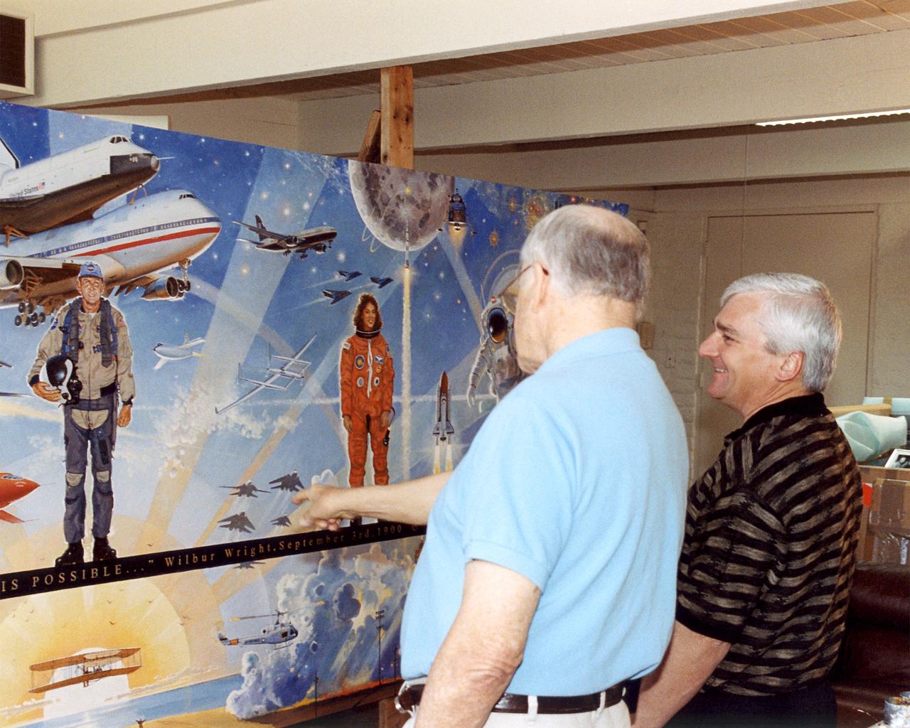
Bob Mccall and NASA Dryden Director Kevin Petersen stand by "Celebrating One Hundred Years of Powered Flight, 1903-2003", in the artist's studio in Paradise Valley, Arizona. The mural was created to celebrate the achievements of Wilbur and Orville Wright and to commemorate a century of powered flight. Many of the epic flights represented in the painting took place in the skies over NASA Dryden Flight Research Center. An equally important goal of this celebration will be to encourage the values that have characterized 100 years of aviation history: ingenuity, inventiveness, persistence, creativity and courage. These values hold true not just for pioneers of flight, but also for all pioneers of invention and innovation, and they will remain an important part of America's future. "Celebrating One Hundred Years of Powered Flight, 1903-2003", documents many significant achievements in aeronautics and space flight from the dawn of powered flight to the present. Historic aircraft and spacecraft serve as the backdrop, highlighting six figures representing the human element that made these milestones possible. These figures stand, symbolically supported by the words of Wilbur Wright, "It is my belief that flight is possible…" The quote was taken from a letter written to his father on September 3rd, 1900, announcing Wilbur's intention to make "some experiments with a flying machine" at Kitty Hawk, North Carolina. "This year, Bob is helping us commemorate the Centennial of Flight with a beautiful mural slated for placement in our Dryden Flight Research Center that documents the history of flight from the Wright Flyer to the International Space Station. We should all take note, I think, that in the grand scheme of things, one hundred years is a very short period of time. In that blink of an eye we've gone from Kitty Hawk to Tranquility Base and now look forward to our rovers traversing the surface of Mars. Despite the challenges we face, the future we envision, like the fu
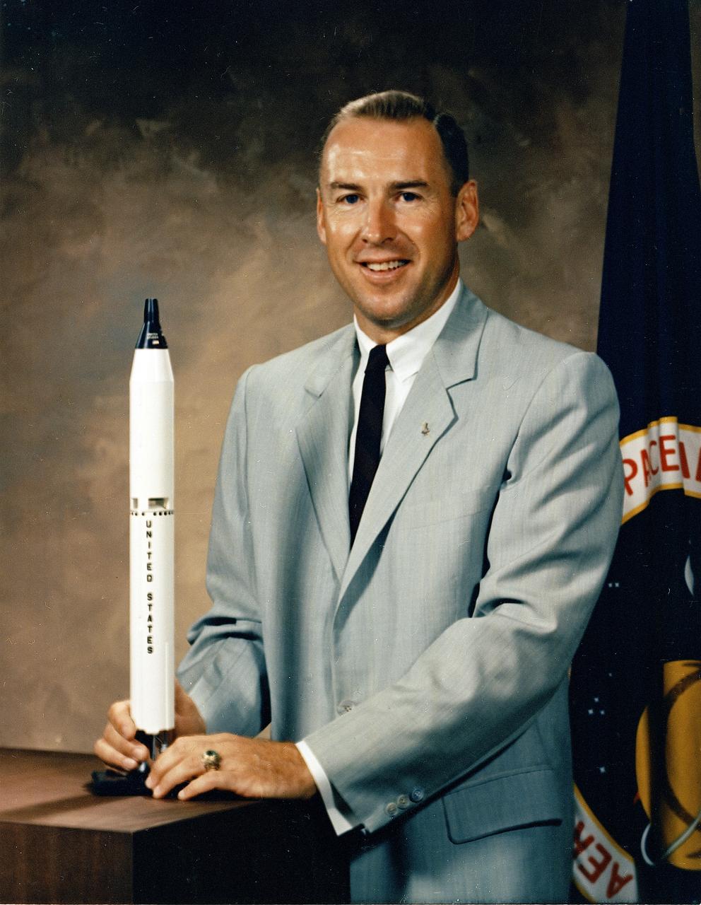
This is the official NASA portrait of astronaut James Lovell. Captain Lovell was selected as an Astronaut by NASA in September 1962. He has since served as backup pilot for the Gemini 4 flight and backup Commander for the Gemini 9 flight, as well as backup Commander to Neil Armstrong for the Apollo 11 lunar landing mission. On December 4, 1965, he and Frank Borman were launched into space on the history making Gemini 7 mission. The flight lasted 330 hours and 35 minutes and included the first rendezvous of two manned maneuverable spacecraft. The Gemini 12 mission, commanded by Lovell with Pilot Edwin Aldrin, began on November 11, 1966 for a 4-day, 59-revolution flight that brought the Gemini program to a successful close. Lovell served as Command Module Pilot and Navigator on the epic six-day journey of Apollo 8, the first manned Saturn V liftoff responsible for allowing the first humans to leave the gravitational influence of Earth. He completed his fourth mission as Spacecraft Commander of the Apollo 13 flight, April 11-17, 1970, and became the first man to journey twice to the moon. The Apollo 13 mission was cut short due to a failure of the Service Module cryogenic oxygen system. Aborting the lunar course, Lovell and fellow crewmen, John L. Swigert and Fred W. Haise, working closely with Houston ground controllers, converted their lunar module, Aquarius, into an effective lifeboat that got them safely back to Earth. Captain Lovell held the record for time in space with a total of 715 hours and 5 minutes until surpassed by the Skylab flights. On March 1, 1973, Captain Lovell retired from the Navy and the Space Program.
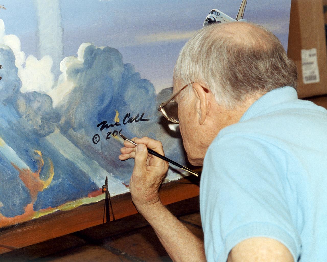
Artist Bob McCall signs the Centennial of Flight Mural in his Paradise Valley, Arizona Studio. The mural was created to celebrate the achievements of Wilbur and Orville Wright and to commemorate a century of powered flight. Many of the epic flights represented in the painting took place in the skies over NASA Dryden Flight Research Center. An equally important goal of this celebration is to encourage the values that have characterized 100 years of aviation history: ingenuity, inventiveness, persistence, creativity and courage. These values hold true not just for pioneers of flight, but also for all pioneers of invention and innovation, and they will remain an important part of America's future. "Celebrating One Hundred Years of Powered Flight, 1903-2003", documents many significant achievements in aeronautics and space flight from the dawn of powered flight to the present. Historic aircraft and spacecraft serve as the backdrop, highlighting six figures representing the human element that made these milestones possible. These figures stand, symbolically supported by the words of Wilbur Wright, "It is my belief that flight is possible…" The quote was taken from a letter written to his father on September 3rd, 1900, announcing Wilbur's intention to make "some experiments with a flying machine" at Kitty Hawk, North Carolina. "This year, Bob is helping us commemorate the Centennial of Flight with a beautiful mural slated for placement in our Dryden Flight Research Center that documents the history of flight from the Wright Flyer to the International Space Station. We should all take note, I think, that in the grand scheme of things, one hundred years is a very short period of time. In that blink of an eye we've gone from Kitty Hawk to Tranquility Base and now look forward to our rovers traversing the surface of Mars. Despite the challenges we face, the future we envision, like the future depicted in the artwork of Bob McCall, is a future of boundless possibility. "
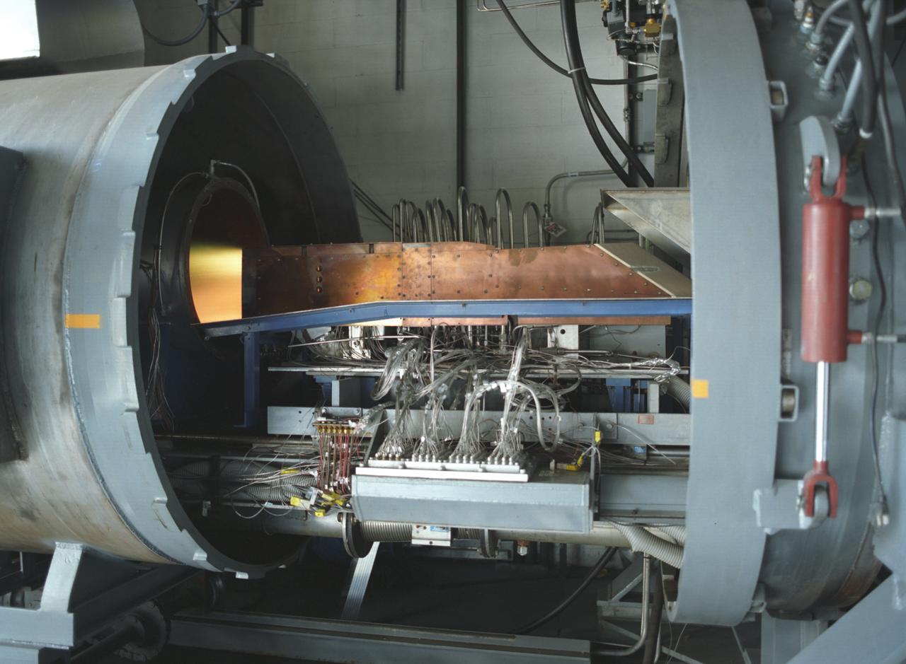
This photograph depicts an air-breathing rocket engine that completed an hour or 3,600 seconds of testing at the General Applied Sciences Laboratory in Ronkonkoma, New York. Referred to as ARGO by its design team, the engine is named after the mythological Greek ship that bore Jason and the Argonauts on their epic voyage of discovery. Air-breathing engines, known as rocket based, combined-cycle engines, get their initial take-off power from specially designed rockets, called air-augmented rockets, that boost performance about 15 percent over conventional rockets. When the vehicle's velocity reaches twice the speed of sound, the rockets are turned off and the engine relies totally on oxygen in the atmosphere to burn hydrogen fuel, as opposed to a rocket that must carry its own oxygen, thus reducing weight and flight costs. Once the vehicle has accelerated to about 10 times the speed of sound, the engine converts to a conventional rocket-powered system to propel the craft into orbit or sustain it to suborbital flight speed. NASA's Advanced SpaceTransportation Program at Marshall Space Flight Center, along with several industry partners and collegiate forces, is developing this technology to make space transportation affordable for everyone from business travelers to tourists. The goal is to reduce launch costs from today's price tag of $10,000 per pound to only hundreds of dollars per pound. NASA's series of hypersonic flight demonstrators currently include three air-breathing vehicles: the X-43A, X-43B and X-43C.
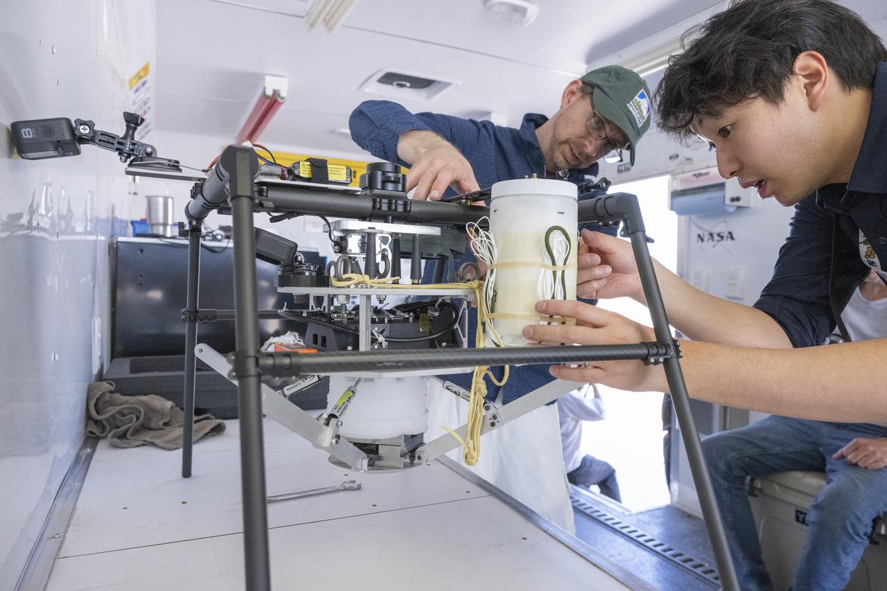
NASA researchers Paul Bean, center, and Mark Hagiwara, right, attach the capsule with parachute system to the Enhancing Parachutes by Instrumenting the Canopy test experiment on June 4, 2025, at NASA’s Armstong Flight Research Center in Edwards, California. NASA researchers are developing technology to make supersonic parachutes safer and more reliable for delivering science instruments and payloads to Mars.
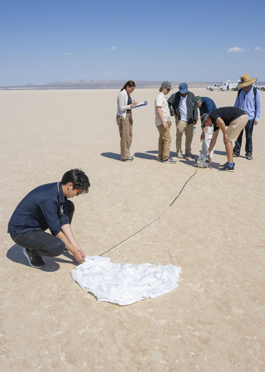
The Enhancing Parachutes by Instrumenting the Canopy project team examines a capsule and parachute following an air launch from an Alta X drone on June 4, 2025, at NASA’s Armstong Flight Research Center in Edwards, California. NASA researchers are developing technology to make supersonic parachutes safer and more reliable for delivering science instruments and payloads to Mars.
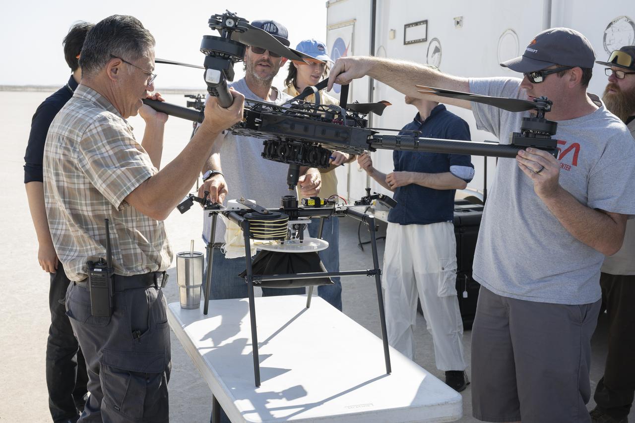
Derek Abramson, left, and Justin Link, right, attach an Alta X drone to the Enhancing Parachutes by Instrumenting the Canopy test experiment on June 4, 2025, at NASA’s Armstong Flight Research Center in Edwards, California. Abramson is NASA chief engineer at the center’s Dale Reed Subscale Flight Research Laboratory, where Link also works as a pilot for small uncrewed aircraft systems. NASA researchers are developing technology to make supersonic parachutes safer and more reliable for delivering science instruments and payloads to Mars.
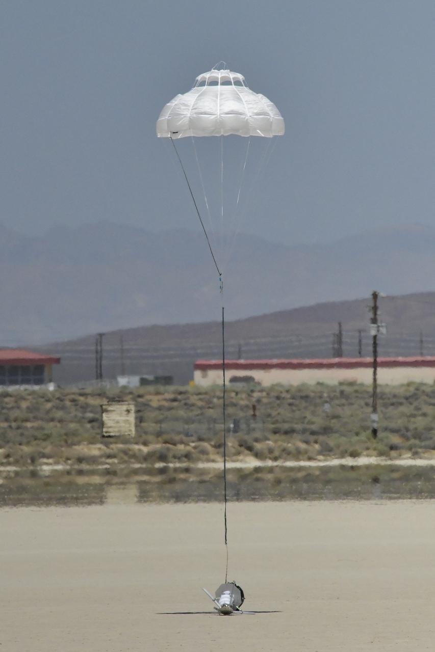
The Enhancing Parachutes by Instrumenting the Canopy test experiment lands following an air launch from an Alta X drone on June 4, 2025, at NASA’s Armstong Flight Research Center in Edwards, California. NASA researchers are developing technology to make supersonic parachutes safer and more reliable for delivering science instruments and payloads to Mars.
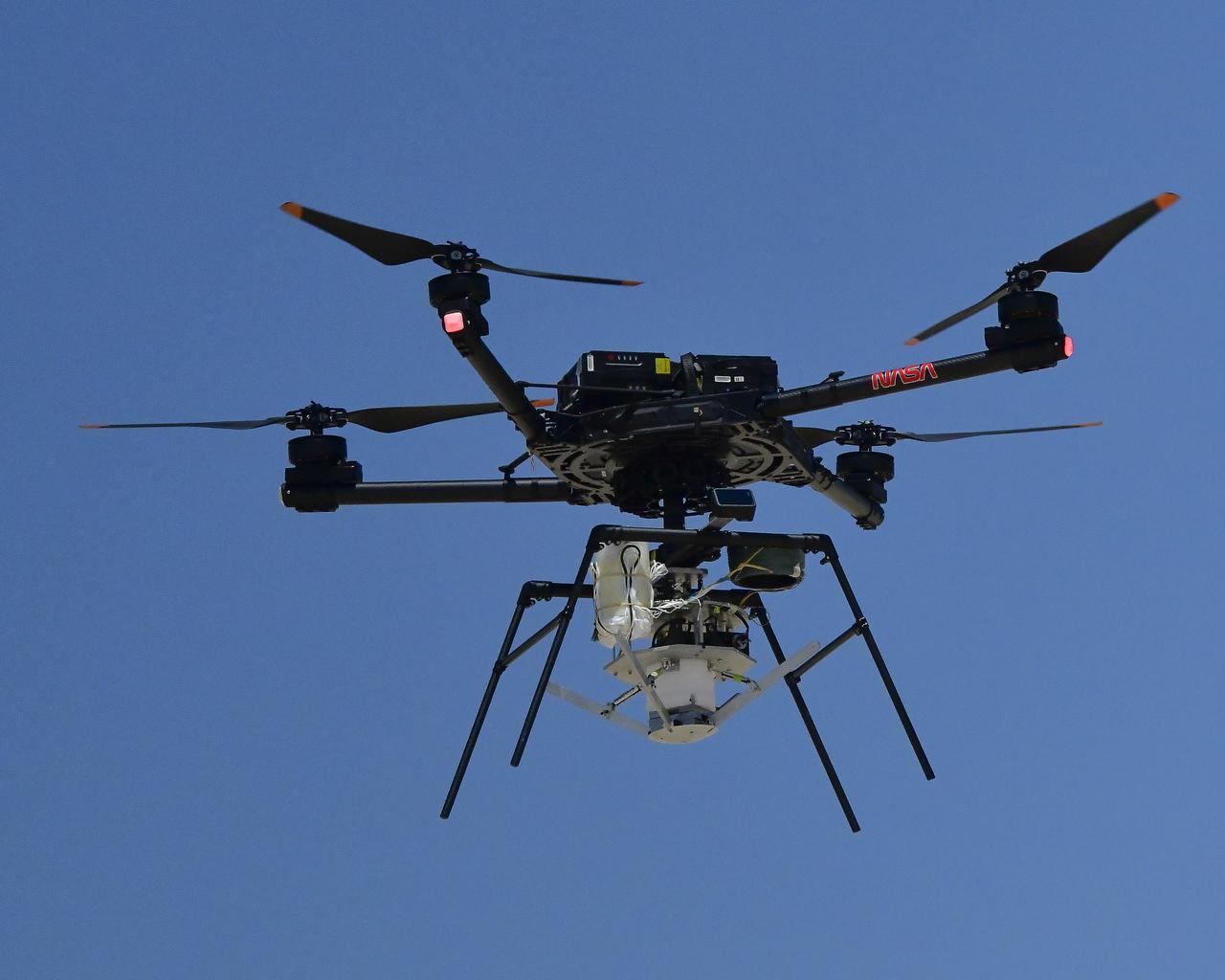
An Alta X drone is positioned at altitude for an air launch of the Enhancing Parachutes by Instrumenting the Canopy test experiment on June 4, 2025, at NASA’s Armstong Flight Research Center in Edwards, California. NASA researchers are developing technology to make supersonic parachutes safer and more reliable for delivering science instruments and payloads to Mars.
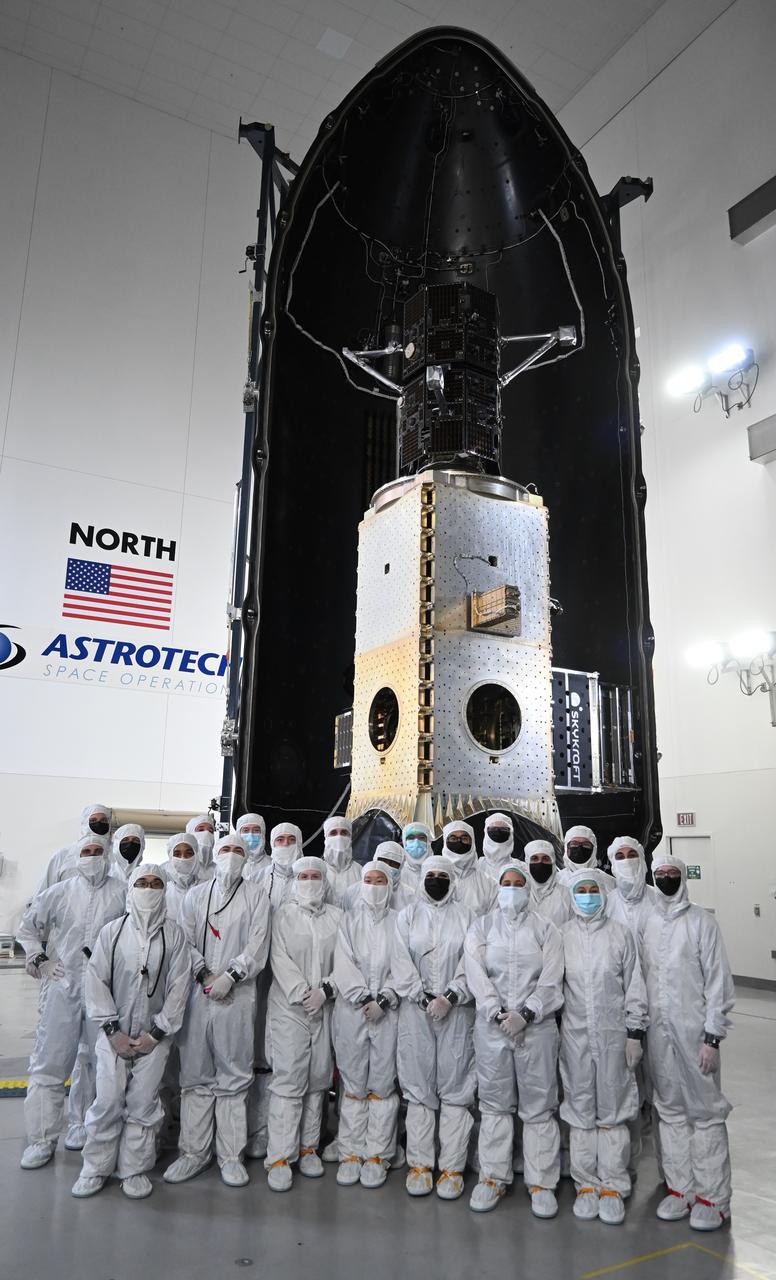
Technicians encapsulate the black twin satellites of NASA’s TRACERS (Tandem Reconnection and Cusp Electrodynamics Reconnaissance Satellites) mission within a payload fairing atop a shiny metallic stack of several other rideshare payloads at the Astrotech Space Operations facility at Vandenberg Space Force Base in California. The TRACERS mission is a pair of twin satellites that will study how Earth’s magnetic shield — the magnetosphere — protects our planet from the supersonic stream of material from the Sun called solar wind.
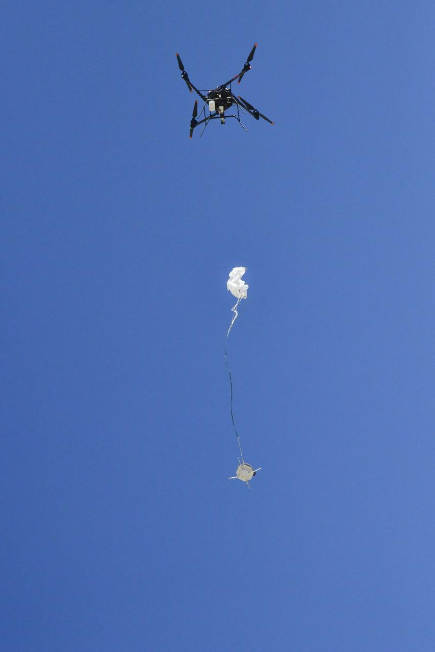
An Alta X drone air launches the Enhancing Parachutes by Instrumenting the Canopy test experiment on June 4, 2025, at NASA’s Armstong Flight Research Center in Edwards, California. NASA researchers are developing technology to make supersonic parachutes safer and more reliable for delivering science instruments and payloads to Mars.
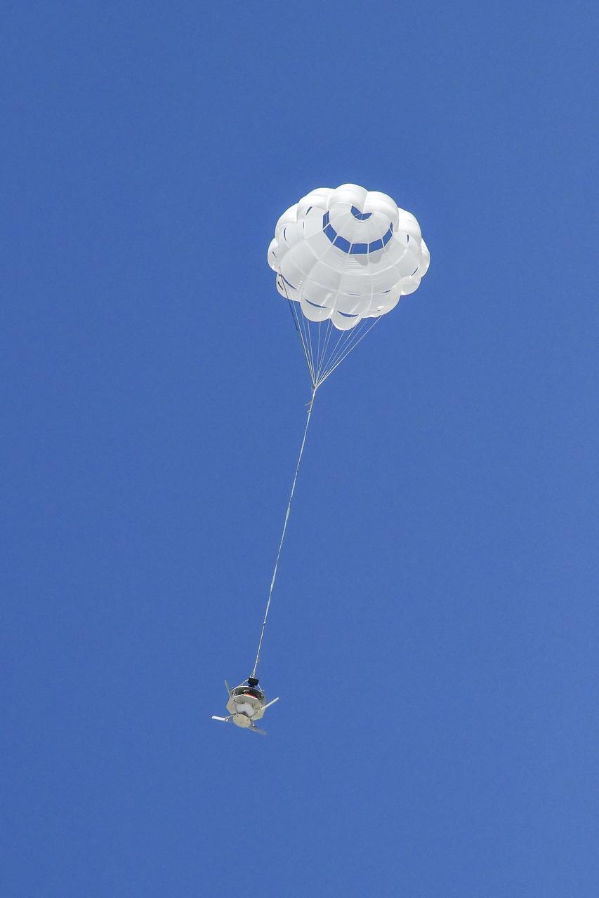
The parachute of the Enhancing Parachutes by Instrumenting the Canopy test experiment deploys following an air launch from an Alta X drone on June 4, 2025, at NASA’s Armstong Flight Research Center in Edwards, California. NASA researchers are developing technology to make supersonic parachutes safer and more reliable for delivering science instruments and payloads to Mars.
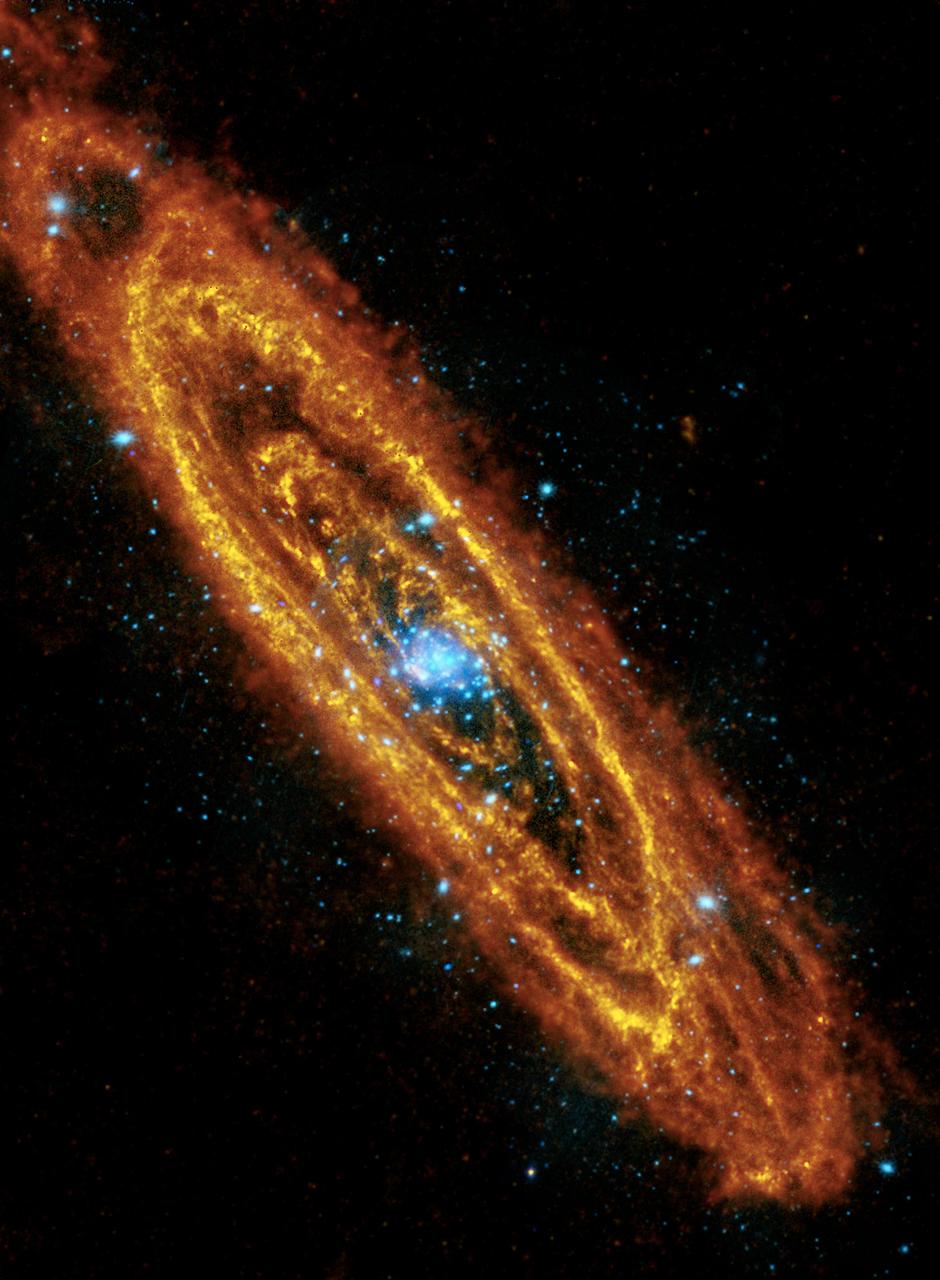
This mosaic of the Andromeda spiral galaxy highlights explosive stars in its interior, and cooler, dusty stars forming in its many rings. This is a combination of observations from the Herschel Space Observatory and the XMM-Newton telescope.
Inner structural features seen in this image from ESA Herschel Space Observatory are helping scientists to understand the mechanisms and interactions within the galaxy.

This image of the Eagle nebula shows the self-emission of the intensely cold nebula gas and dust as never seen before; the nebula intricate tendril nature, with vast cavities forms an almost cave-like surrounding to the famous pillars.