Trumpeting the Equinox
Mars Opposition and Equinox

Images acquired December 21, 2010 - September 20, 2011. To view a HD animation of this go to: <a href="http://www.flickr.com/photos/gsfc/6175313242/in/photostream/">www.flickr.com/photos/gsfc/6175313242/in/photostream/</a> To download the high res and learn more go to: <a href="http://earthobservatory.nasa.gov/IOTD/view.php?id=52248" rel="nofollow">earthobservatory.nasa.gov/IOTD/view.php?id=52248</a> One of the most frequently misunderstood concepts in science is the reason for Earth’s seasons. As we experience the September equinox today—anyone try to balance an egg yet?—we thought we’d offer a space-based view of what’s going on. Around 6 a.m. local time each day, the Sun, Earth, and any geosynchronous satellite form a right angle, affording a nadir (straight down) view of the terminator, where the shadows of nightfall meet the sunlight of dusk and dawn. The shape of this line between night and day varies with the seasons, which means different lengths of days and differing amounts of warming sunshine. (The line is actually a curve because the Earth is round, but satellite images only show it in two-dimensions.) The Spinning Enhanced Visible and Infrared Imager (SEVIRI) on EUMETSAT's Meteosat-9 captured these four views of the day-night terminator on December 21, 2010, and March 20, June 21, and September 20, 2011. Each image was taken at 6:12 a.m. local time. On March 20 and September 20, the terminator is a straight north-south line, and the Sun is said to sit directly above the equator. On December 21, the Sun resides directly over the Tropic of Capricorn when viewed from the ground, and sunlight spreads over more of the Southern Hemisphere. On June 21, the Sun sits above the Tropic of Cancer, spreading more sunlight in the north and turning the tables on the south. The bulge of our spherical Earth blocks sunlight from the far hemisphere at the solstices; that same curvature allows the Sun’s rays to spread over more area near the top and bottom of the globe. Of course, it is not the Sun that is moving north or south through the seasons, but a change in the orientation and angles between the Earth and its nearest star. The axis of the Earth is tilted 23.5 degrees relative to the Sun and the ecliptic plane. The axis is tilted away from the Sun at the December solstice and toward the Sun at the June solstice, spreading more and less light on each hemisphere. At the equinoxes, the tilt is at a right angle to the Sun and the light is spread evenly. The equinox and changing of the seasons occurs on September 23, 2011 at 9:05 a.m. Universal Time. (Our September image above is a few days early.) Equinox means "equal night" in Latin, capturing the idea that daytime and nighttime are equal lengths everywhere on the planet. That is true of the Sun's presence above the horizon, though it does not account for twilight, when the Sun's rays extend from beyond the horizon to illuminate our gas-filled atmosphere. NASA images and animation by Robert Simmon, using data ©2010 EUMETSAT. Caption by Mike Carlowicz. Instrument: Meteosat Credit: <b><a href="http://www.earthobservatory.nasa.gov/" rel="nofollow"> NASA Earth Observatory</a></b> <b><a href="http://www.nasa.gov/audience/formedia/features/MP_Photo_Guidelines.html" rel="nofollow">NASA image use policy.</a></b> <b><a href="http://www.nasa.gov/centers/goddard/home/index.html" rel="nofollow">NASA Goddard Space Flight Center</a></b> enables NASA’s mission through four scientific endeavors: Earth Science, Heliophysics, Solar System Exploration, and Astrophysics. Goddard plays a leading role in NASA’s accomplishments by contributing compelling scientific knowledge to advance the Agency’s mission. <b>Follow us on <a href="http://twitter.com/NASAGoddardPix" rel="nofollow">Twitter</a></b> <b>Like us on <a href="http://www.facebook.com/pages/Greenbelt-MD/NASA-Goddard/395013845897?ref=tsd" rel="nofollow">Facebook</a></b> <b>Find us on <a href="http://instagrid.me/nasagoddard/?vm=grid" rel="nofollow">Instagram</a></b>
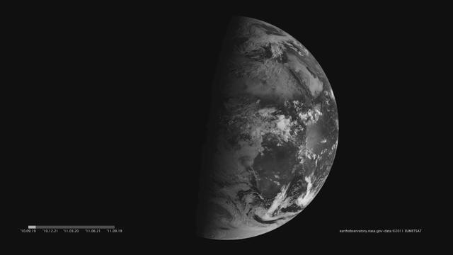
Images acquired December 21, 2010 - September 20, 2011. To download the high res and learn more go to: <a href="http://earthobservatory.nasa.gov/IOTD/view.php?id=52248" rel="nofollow">earthobservatory.nasa.gov/IOTD/view.php?id=52248</a> One of the most frequently misunderstood concepts in science is the reason for Earth’s seasons. As we experience the September equinox today—anyone try to balance an egg yet?—we thought we’d offer a space-based view of what’s going on. Around 6 a.m. local time each day, the Sun, Earth, and any geosynchronous satellite form a right angle, affording a nadir (straight down) view of the terminator, where the shadows of nightfall meet the sunlight of dusk and dawn. The shape of this line between night and day varies with the seasons, which means different lengths of days and differing amounts of warming sunshine. (The line is actually a curve because the Earth is round, but satellite images only show it in two-dimensions.) The Spinning Enhanced Visible and Infrared Imager (SEVIRI) on EUMETSAT's Meteosat-9 captured these four views of the day-night terminator on December 21, 2010, and March 20, June 21, and September 20, 2011. Each image was taken at 6:12 a.m. local time. On March 20 and September 20, the terminator is a straight north-south line, and the Sun is said to sit directly above the equator. On December 21, the Sun resides directly over the Tropic of Capricorn when viewed from the ground, and sunlight spreads over more of the Southern Hemisphere. On June 21, the Sun sits above the Tropic of Cancer, spreading more sunlight in the north and turning the tables on the south. The bulge of our spherical Earth blocks sunlight from the far hemisphere at the solstices; that same curvature allows the Sun’s rays to spread over more area near the top and bottom of the globe. Of course, it is not the Sun that is moving north or south through the seasons, but a change in the orientation and angles between the Earth and its nearest star. The axis of the Earth is tilted 23.5 degrees relative to the Sun and the ecliptic plane. The axis is tilted away from the Sun at the December solstice and toward the Sun at the June solstice, spreading more and less light on each hemisphere. At the equinoxes, the tilt is at a right angle to the Sun and the light is spread evenly. The equinox and changing of the seasons occurs on September 23, 2011 at 9:05 a.m. Universal Time. (Our September image above is a few days early.) Equinox means "equal night" in Latin, capturing the idea that daytime and nighttime are equal lengths everywhere on the planet. That is true of the Sun's presence above the horizon, though it does not account for twilight, when the Sun's rays extend from beyond the horizon to illuminate our gas-filled atmosphere. <b>NASA images and animation by Robert Simmon, using data ©2010 EUMETSAT. Caption by Mike Carlowicz.</b> Instrument: Meteosat Credit: <b><a href="http://www.earthobservatory.nasa.gov/" rel="nofollow"> NASA Earth Observatory</a></b> <b><a href="http://www.nasa.gov/audience/formedia/features/MP_Photo_Guidelines.html" rel="nofollow">NASA image use policy.</a></b> <b><a href="http://www.nasa.gov/centers/goddard/home/index.html" rel="nofollow">NASA Goddard Space Flight Center</a></b> enables NASA’s mission through four scientific endeavors: Earth Science, Heliophysics, Solar System Exploration, and Astrophysics. Goddard plays a leading role in NASA’s accomplishments by contributing compelling scientific knowledge to advance the Agency’s mission. <b>Follow us on <a href="http://twitter.com/NASAGoddardPix" rel="nofollow">Twitter</a></b> <b>Like us on <a href="http://www.facebook.com/pages/Greenbelt-MD/NASA-Goddard/395013845897?ref=tsd" rel="nofollow">Facebook</a></b> <b>Find us on <a href="http://instagrid.me/nasagoddard/?vm=grid" rel="nofollow">Instagram</a></b>
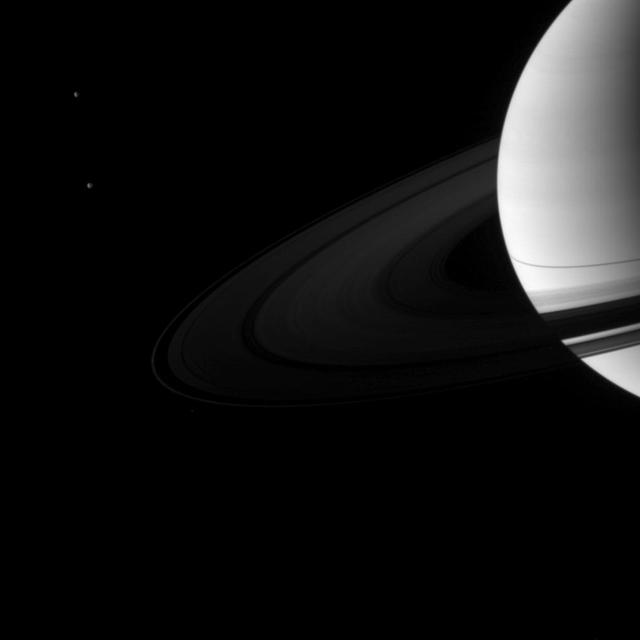
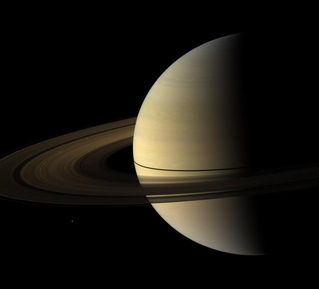
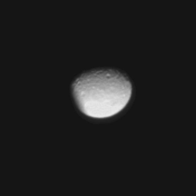
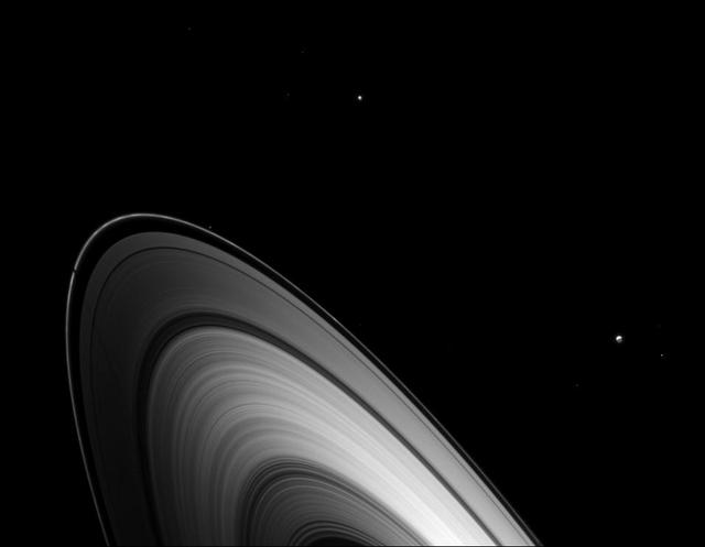
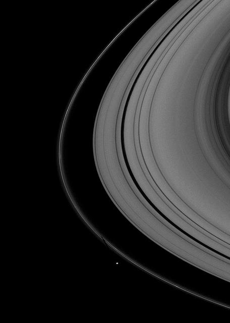
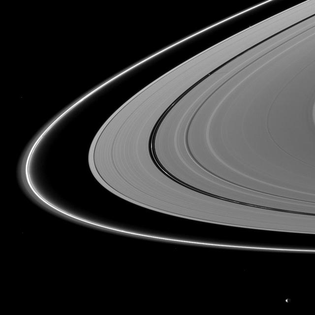
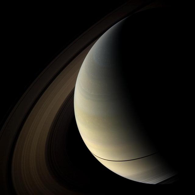
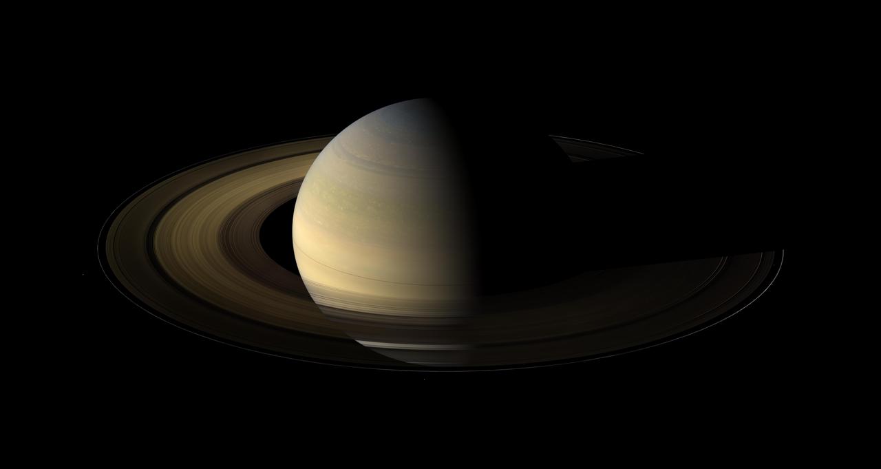
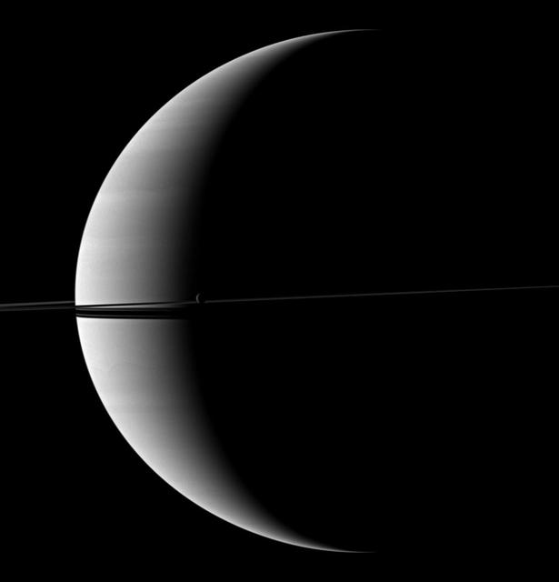
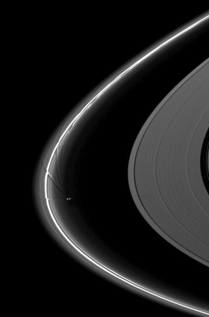
A pair of Saturn moons, Dione and Tethys, accompany the planet and its rings in this image taken shortly after the planet August 2009 equinox by NASA Cassini spacecraft.
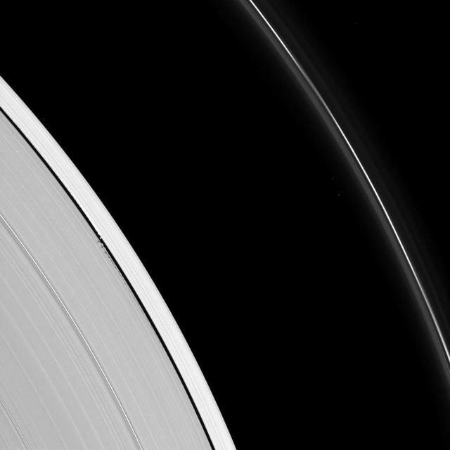
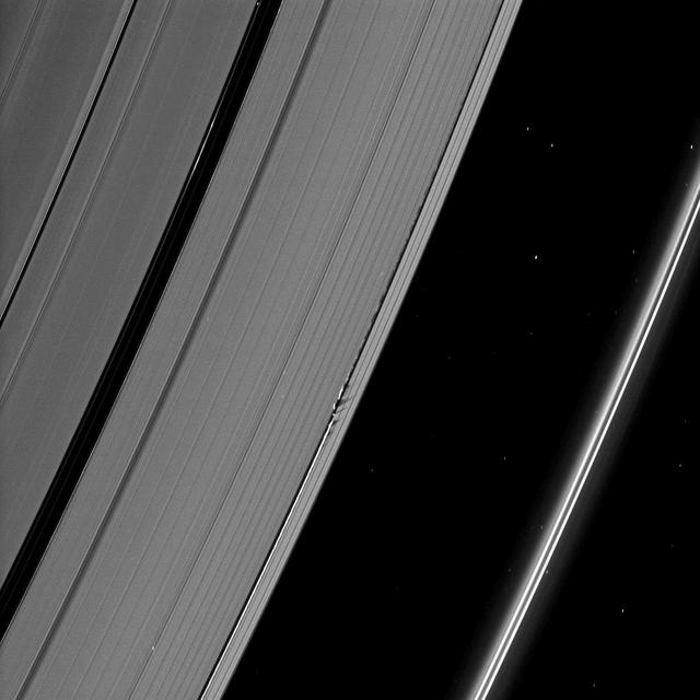
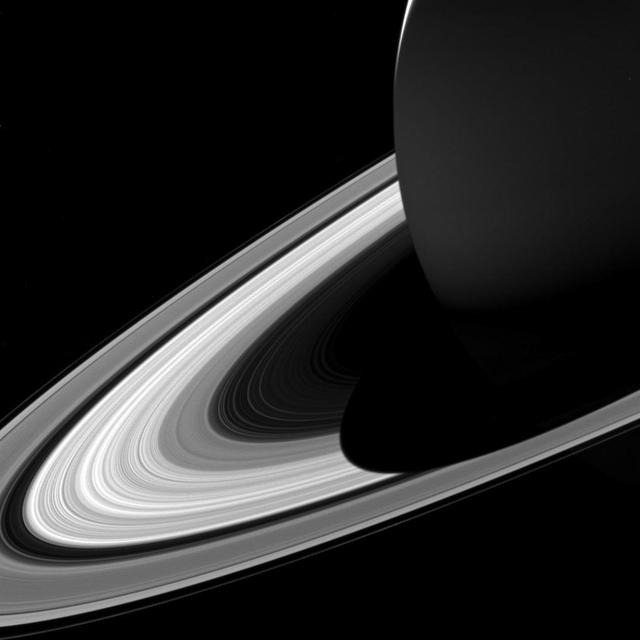
The Cassini spacecraft captured this image of a small object in the outer portion of Saturn B ring casting a shadow on the rings as Saturn approaches its August 2009 equinox.
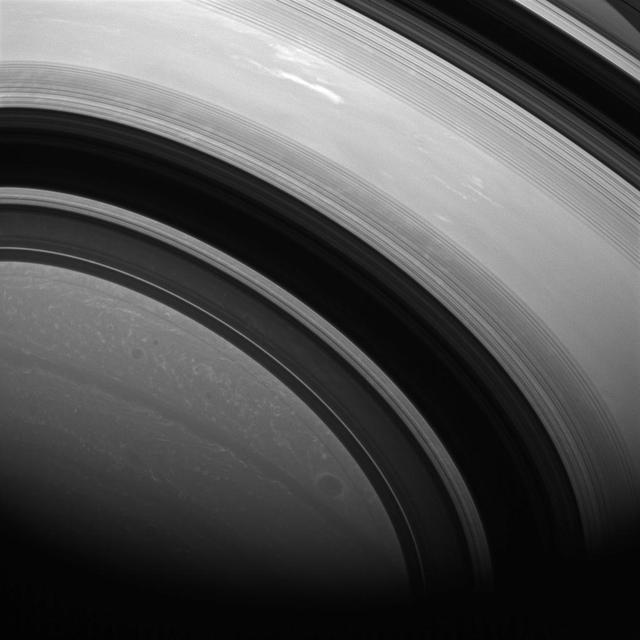
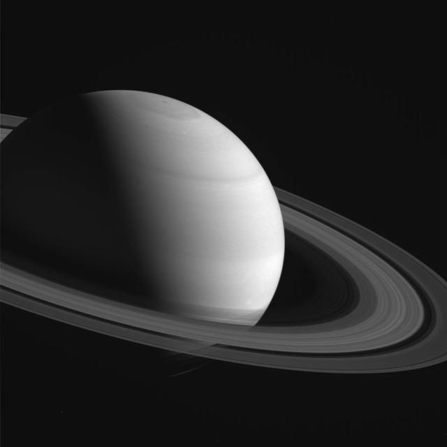
NASA Cassini Orbiter captured this natural color view of Saturn almost a month after the planet August 2009 equinox. The shadow cast on the planet by the rings remains narrow.
Saturn moon Prometheus casts a long shadow across the A ring in the middle-right side of this image taken shortly before the planet August 2009 equinox by NASA Cassini spacecraft.

The shadow of the moon Tethys cuts across the C ring in this image taken as Saturn approaches its August 2009 equinox.
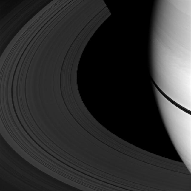
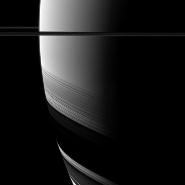
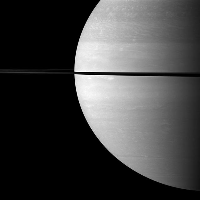
The shadows of Saturn rings appear as a narrow band on the planet in this image taken as Saturn approaches its August 2009 equinox.
As Saturn equinox continues to approach, the moon Pan casts a slightly longer shadow on the A ring.
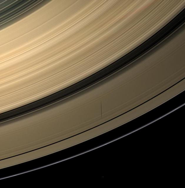
As Saturn approaches its August 2009 equinox, a shadow is cast by a narrow, vertically extended feature in the F ring.
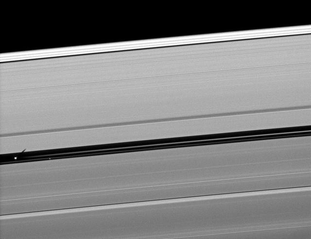
The shadow of the moon Epimetheus stretches across the B ring in this image taken by Cassini as Saturn approaches its 2009 equinox.
Atlas joins other moons casting shadows on Saturn rings as the planet approaches its August 2009 equinox.
The shadow of the moon Epimetheus crosses Saturn rings in this image taken as the planet approached its August 2009 equinox.
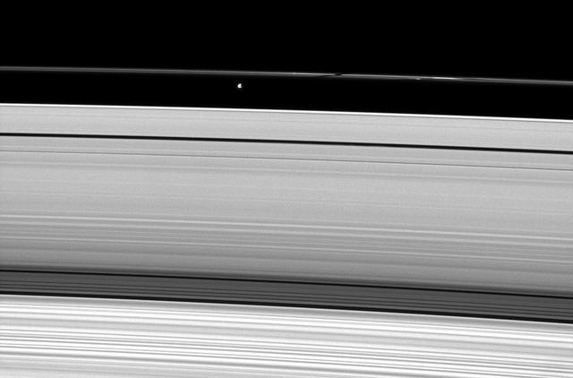
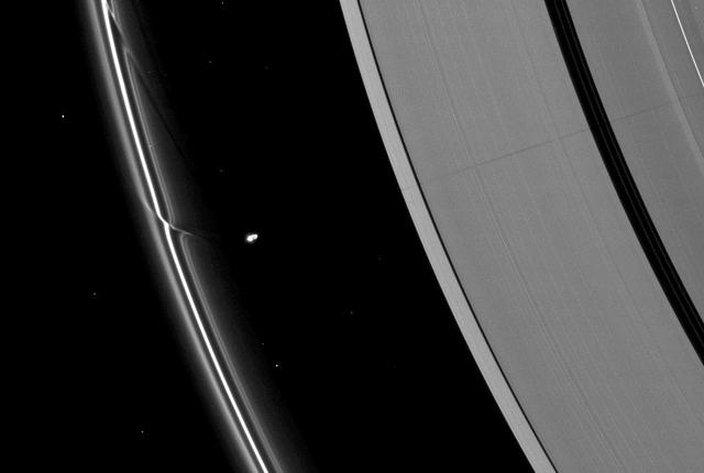
As the moon Enceladus eclipses its neighbor Mimas, Cassini records a scene possible only around the time of Saturn approaching equinox.
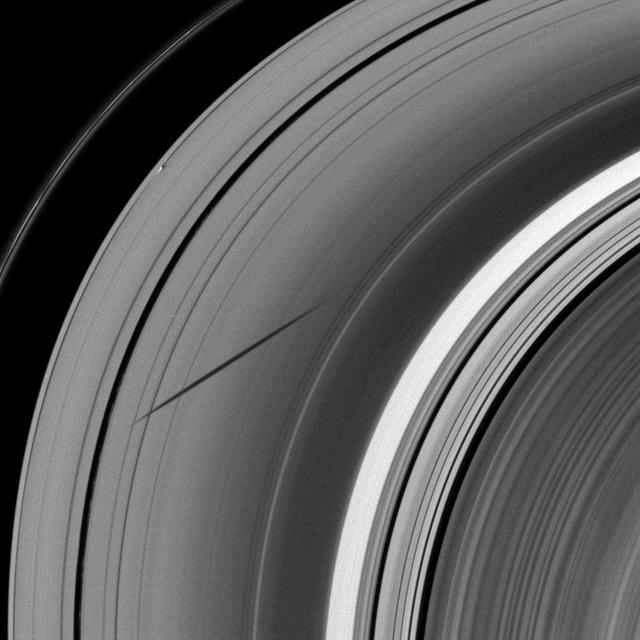
The shadow of the moon Janus dwarfs the shadow of Daphnis on Saturn A ring in this image taken as the planet approached its August 2009 equinox.
The shadow of the moon Janus dwarfs the shadow of Daphnis on Saturn A ring in this image taken as the planet approached its August 2009 equinox.
Saturn moon Pan casts a longer shadow across the A ring as the planet August 2009 equinox draws near.
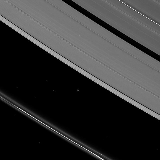
Just before Saturn August 2009 equinox, Dione joined other Saturnian moons in casting shadows on the planet main rings.

The shadow of the moon Janus crosses the Encke Gap as it strikes the plane of Saturn rings in this image taken as the planet approached its August 2009 equinox.

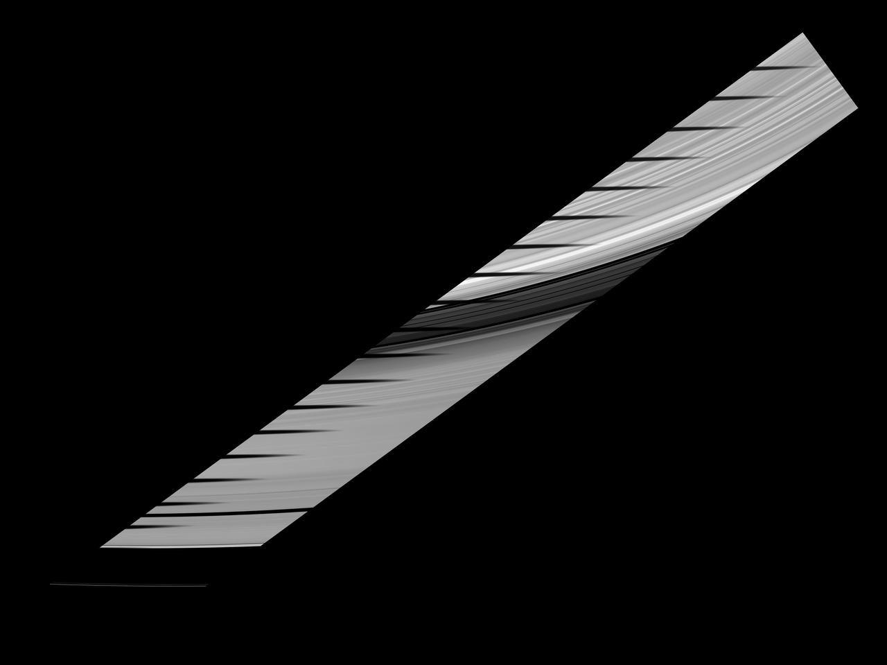
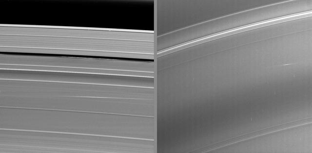
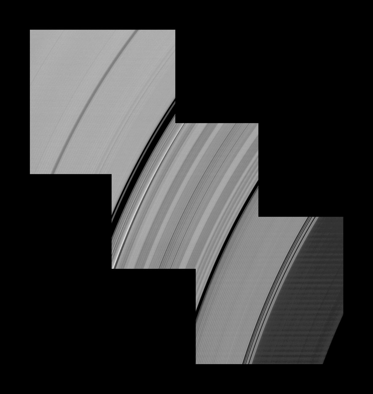
New insights into the nature of Saturn’s rings are revealed in this panoramic mosaic of 15 images taken during the planet’s August 2009 equinox, taken by NASA Cassini Orbiter.
The small moon Pan casts a short shadow on Saturn A ring in this image taken by NASA Cassini spacecraft as the planet approached its August 2009 equinox.
Cassini spies a shadow cast by a vertically extended structure or object in the F ring in this image taken as Saturn approaches its August 2009 equinox.
A wide shadow is cast onto the thin F ring and the A ring by the moon Janus in this image taken as Saturn approached its August 2009 equinox.
Saturn moon Prometheus casts a shadow on the narrow F ring in this image captured by NASA Cassini Orbiter weeks after the planet August 2009 equinox
Mimas shadow traverses the sunlit side of Saturn rings in this image and mosaic showcasing the unusual sights seen at Saturn as the planet approaches its August 2009 equinox.
NASA Cassini spacecraft watches as the shadows of Saturn rings grow wider and creep farther south as the seasons progress from the planet August 2009 equinox.
The shepherding moon Pandora, near the bottom of the image, casts a shadow on Saturn thin F ring as the planet nears its August 2009 equinox.
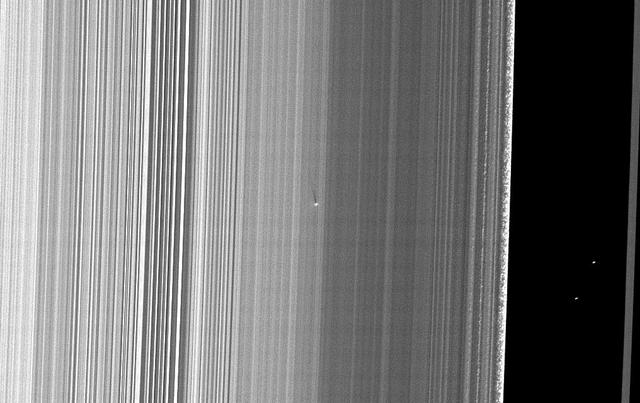
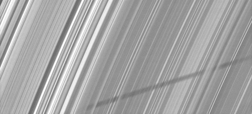
The bright streaks visible in these Cassini images taken during Saturn’s August 2009 equinox are exciting evidence of a constant rain of interplanetary projectiles onto the planet’s rings.
Moon shadows are cast on Saturn A ring in this image taken by NASA Cassini Orbiter almost a month after the planet August 2009 equinox.
The moon Prometheus casts a shadow on the thin F ring marked with streamer-channels created by the moon in this image taken as Saturn approaches its August 2009 equinox.
Saturn small moon Pan, brightly overexposed, casts a short shadow on the A ring in this image taken by NASA Cassini spacecraft before the planet August 2009 equinox.
Vertical ring structures created by the moon Daphnis cast dark shadows on Saturn A ring in this image taken as the planet approached its August 2009 equinox.
The moon Tethys casts its shadow on Saturn rings next to the shadow of the planet in this image taken as Saturn approaches its August 2009 equinox.
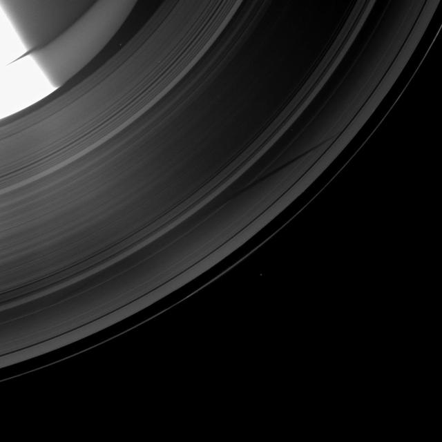
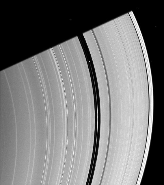
Several sets of shadows are cast onto the A ring in this image taken by NASA Cassini Orbiter about a week after Saturn’s August 2009 equinox.

Saturn moon Prometheus casts a narrow shadow on the rings near the much larger shadow cast by the planet in this image taken by NASA Cassini spacecraft about five months after Saturn August 2009 equinox.
About a month after Saturn August 2009 equinox, shadows continue to grace the planet rings in this image taken by NASA Cassini Orbiter. Pan runs through the center of this image.
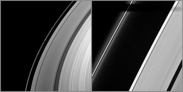
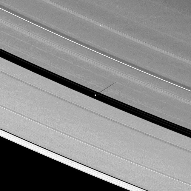
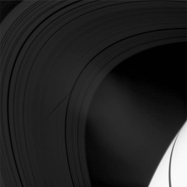
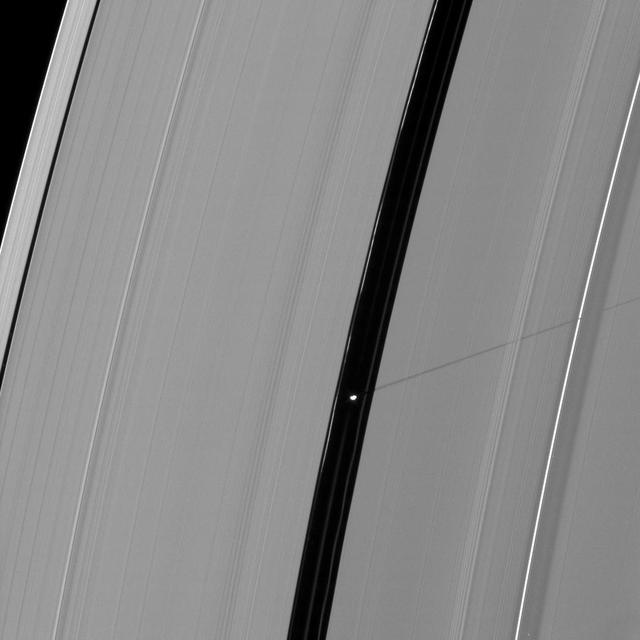
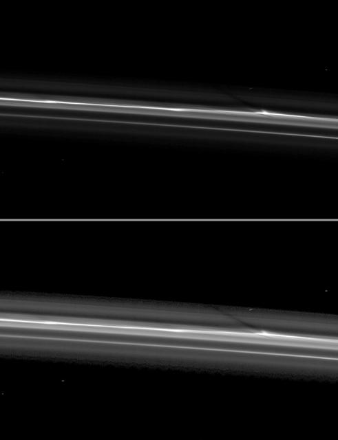
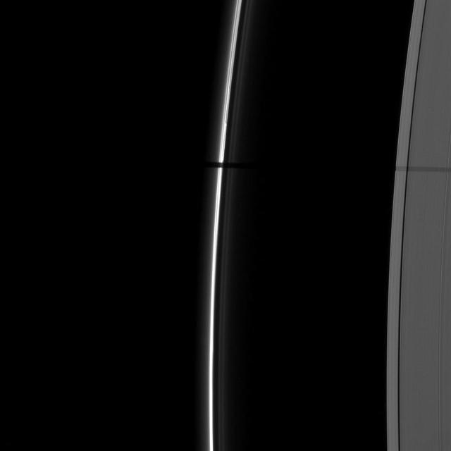
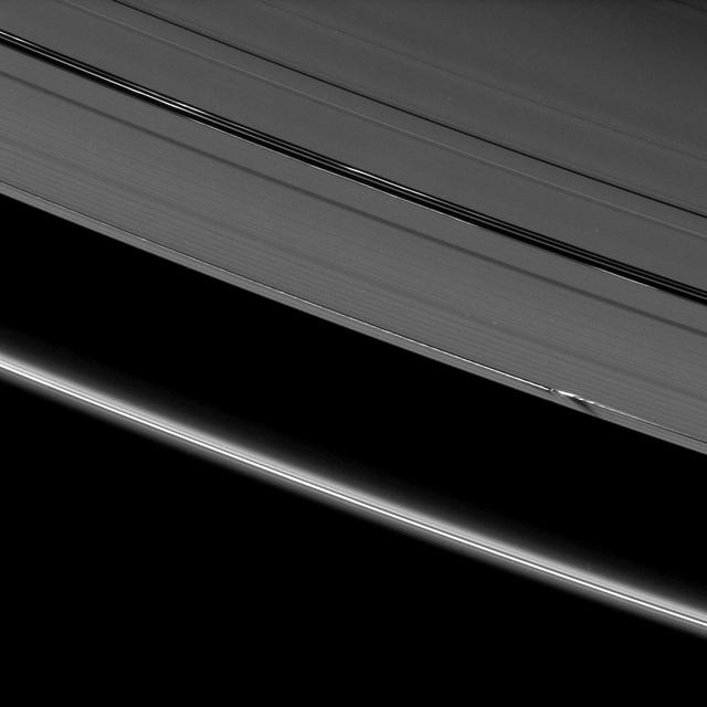
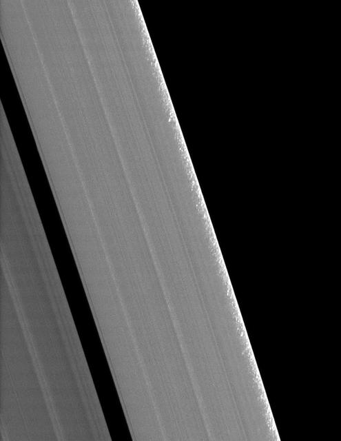
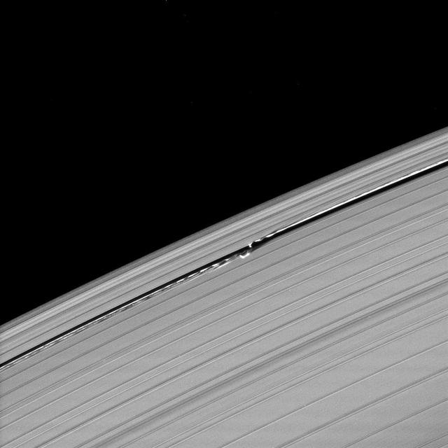
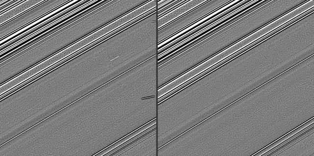
Long shadows stretch away from the towering edge waves created by the gravity of the moon Daphnis in this image taken by NASA Cassini spacecraft a little more than a week before Saturn August 2009 equinox.
NASA Cassini spacecraft catches Saturn moon Daphnis making waves and casting shadows from the narrow Keeler Gap of the planet A ring in this view taken around the time of Saturn August 2009 equinox.

The moon Prometheus casts a shadow on Saturn F ring near a streamer-channel it has created on the ring. The image was taken as the planet approached its August 2009 equinox.
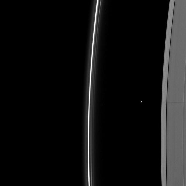
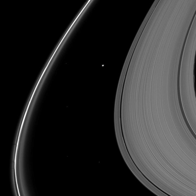
Rhea joins other Saturnian moons in casting a shadow on the rings as the planet approached its August 2009 equinox in this image taken by NASA Cassini spacecraft wide-angle camera.
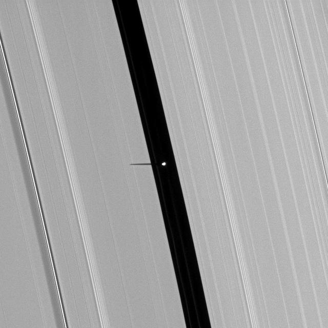
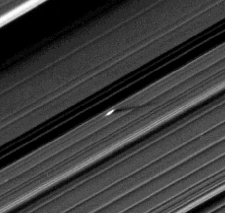
Tiny Daphnis appears as a bright dot in the Keeler Gap next to shadows cast by the moon and the edge waves it has created in the A ring in this image taken by NASA Cassini spacecraft before Saturn August 2009 equinox.
Orbiting in the Encke Gap of Saturn A ring, the moon Pan casts a shadow on the ring in this image taken about six months after the planet August 2009 equinox by NASA Cassini spacecraft.
Bright spokes grace the B ring in this image which also includes the shadow of the moon Mimas and was taken by NASA Cassini spacecraft about a month after Saturn August 2009 equinox.
The shadows of Saturn rings cast onto the planet appear as a thin band at the equator in this image taken by NASA Cassini spacecraft as the planet approached its August 2009 equinox.
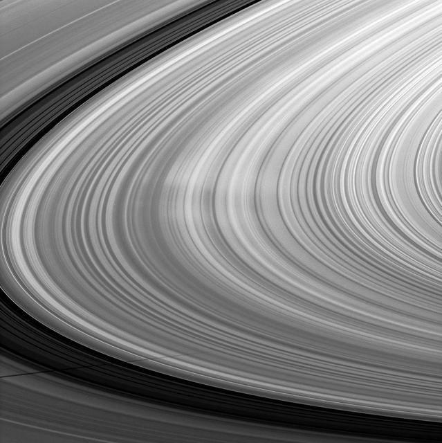
Clumps of ring material are revealed along the edge of Saturn A ring in this image taken during the planet August 2009 equinox. The granular appearance of the outer edge of the A ring is likely created by gravitational clumping of particles there.
From just above the plane of Saturn rings, NASA Cassini spacecraft snapped this shot of Saturn two months after Saturn August 2009 equinox, showing the shadow of its rings as a narrow band on the planet.
The Cassini spacecraft shows a section of Saturn and its rings which includes a special treat made possible as the planet approaches its August 2009 equinox: the shadow of a moon cast on the rings.
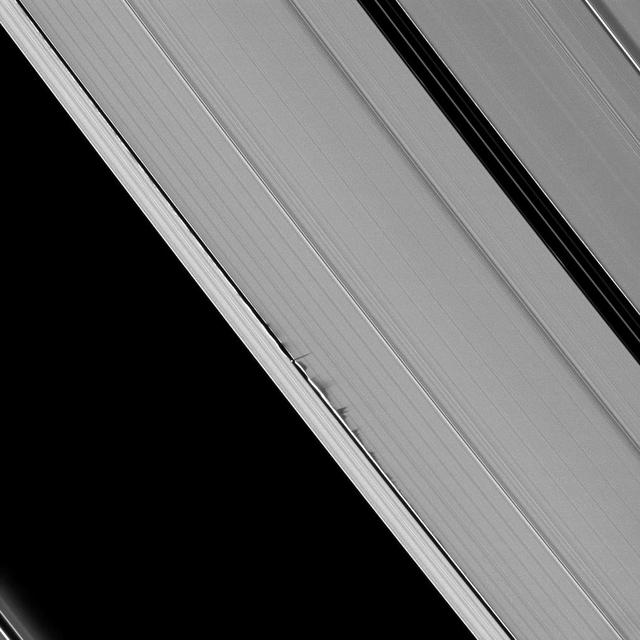
Jagged looking shadows stretch away from vertical structures of ring material created by the moon Daphnis in this image taken as Saturn approaches its August 2009 equinox.
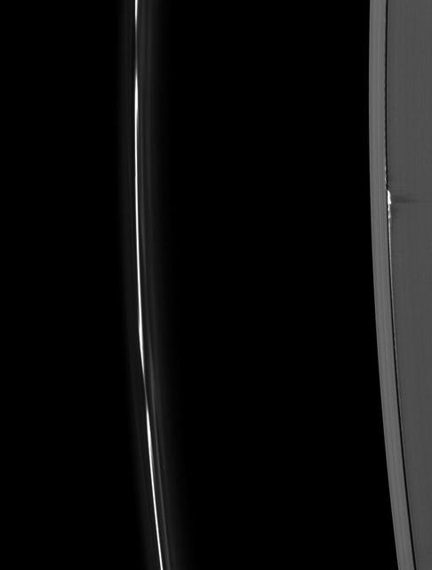
Ring material, pulled to spectacular heights above the ring plane by the gravity of the moon Daphnis, casts long shadows on Saturn’s A ring in this Cassini image taken about a month before the planet’s August 2009 equinox.
An unusually large propeller feature is detected just beyond the Encke Gap in this Cassini image of Saturn’s outer A ring taken a couple days after the planet’s August 2009 equinox.
Saturn moon Pan, orbiting in the Encke Gap near the top of the image, casts a short shadow on the A ring in this image taken by NASA Cassini spacecraft about six months after the planet August 2009 equinox.
A pair of Saturn moons, Pan and Janus, cast their shadows on the A ring in this NASA Cassini spacecraft image taken about a month and a half after Saturn August 2009 equinox.
This Saturn equinox, captured here in a mosaic of light and dark, is the first witnessed up close by an emissary from Earth, none other than our NASA faithful robotic explorer, Cassini.
Vertical structures in the variable outer edge of Saturn B ring cast shadows in these two images captured by NASA Cassini spacecraft shortly after the planet August 2009 northern vernal equinox.
Part of the shadow of Saturn moon Epimetheus appears as if it has been woven through the planet rings in this image taken about a month and a half before the planet August 2009 equinox by NASA Cassini spacecraft.
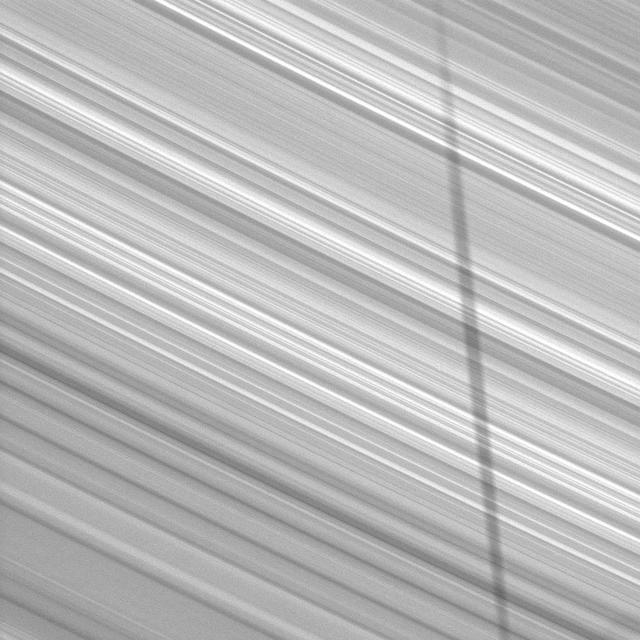
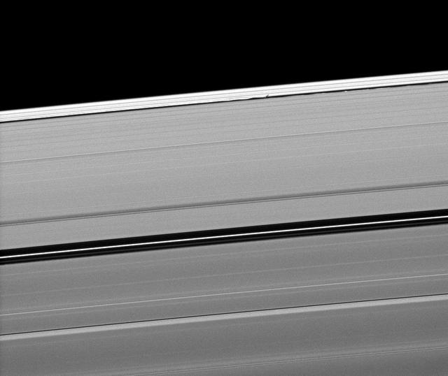
Alternating light and dark bands, extending a great distance across Saturn’s D and C rings taken by NASA Cassini spacecraft one month before the planet’s August 2009 equinox.
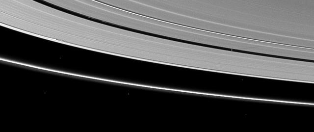
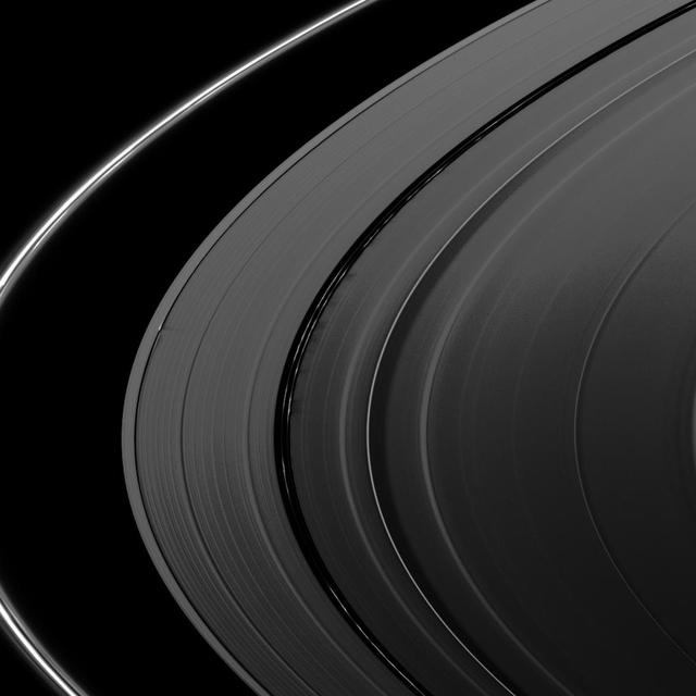
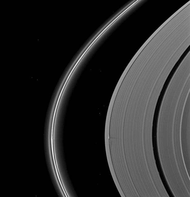
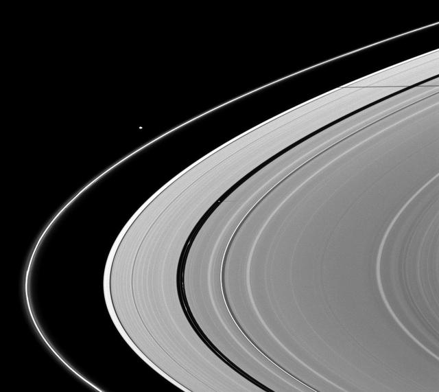
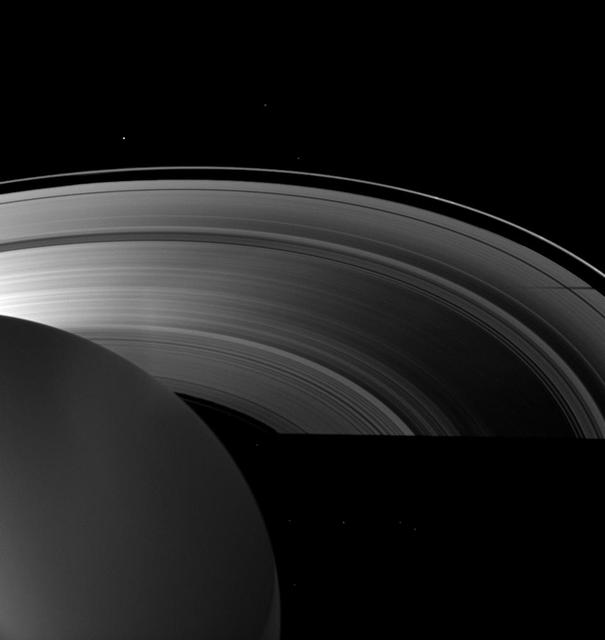
Saturn rings and its moon Rhea are imaged before a crescent of the planet in this image captured by NASA Cassini spacecraft. The shadows of the rings continue to grow wider after their disappearing act during the planet August 2009 equinox.
Saturn moon Tethys casts a shadow on the planet A ring alongside the larger shadow cast by the planet itself in this image taken as Saturn approached its August 2009 equinox.
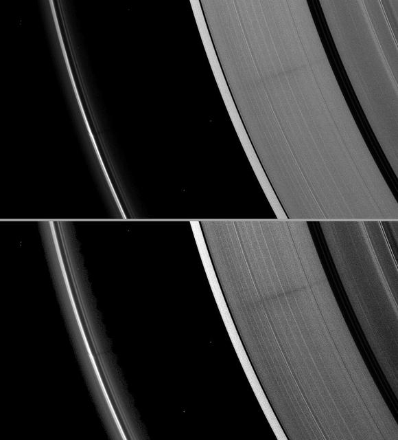
Waves in the edges of the Keeler gap in Saturn A ring, created by the embedded moon Daphnis, show considerable complexity in this image taken as Saturn approached its August 2009 equinox.
A vertically extended structure or object in Saturn F ring casts a shadow long enough to reach the A ring in this Cassini image taken just days before planet August 2009 equinox.
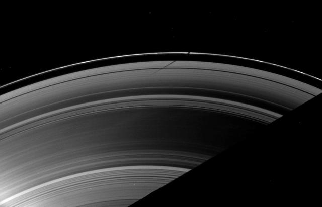
Saturn moon Epimetheus casts a shadow across colorful rings in this image taken by NASA Cassini spacecraft before the planet August 2009 equinox. Epimetheus is visible as a small dot at the center of the bottom of the image.
A moon shadow strikes Saturn rings near bright spokes on the B ring near the center of this image taken by NASA Cassini spacecraft about one month after the planet August 2009 equinox.
The effects of the small moon Prometheus loom large on two of Saturn rings in this image taken by NASA Cassini spacecraft a short time before Saturn August 2009 equinox.
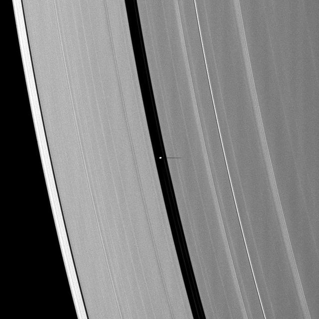
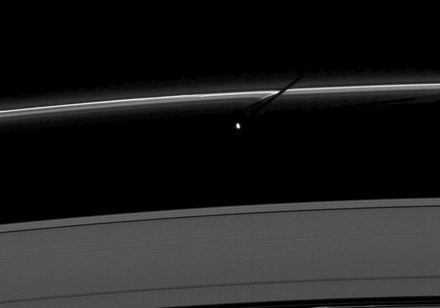
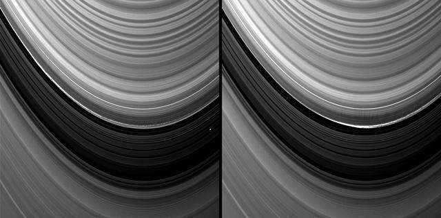
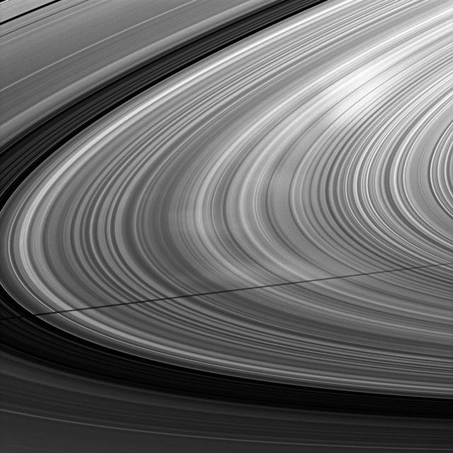
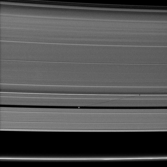
The shadow of the moon Mimas strikes the F ring at a different angle than the angle at which it is cast on the A ring, illustrating differences in the vertical heights of the rings in this image taken as Saturn approaches its August 2009 equinox.
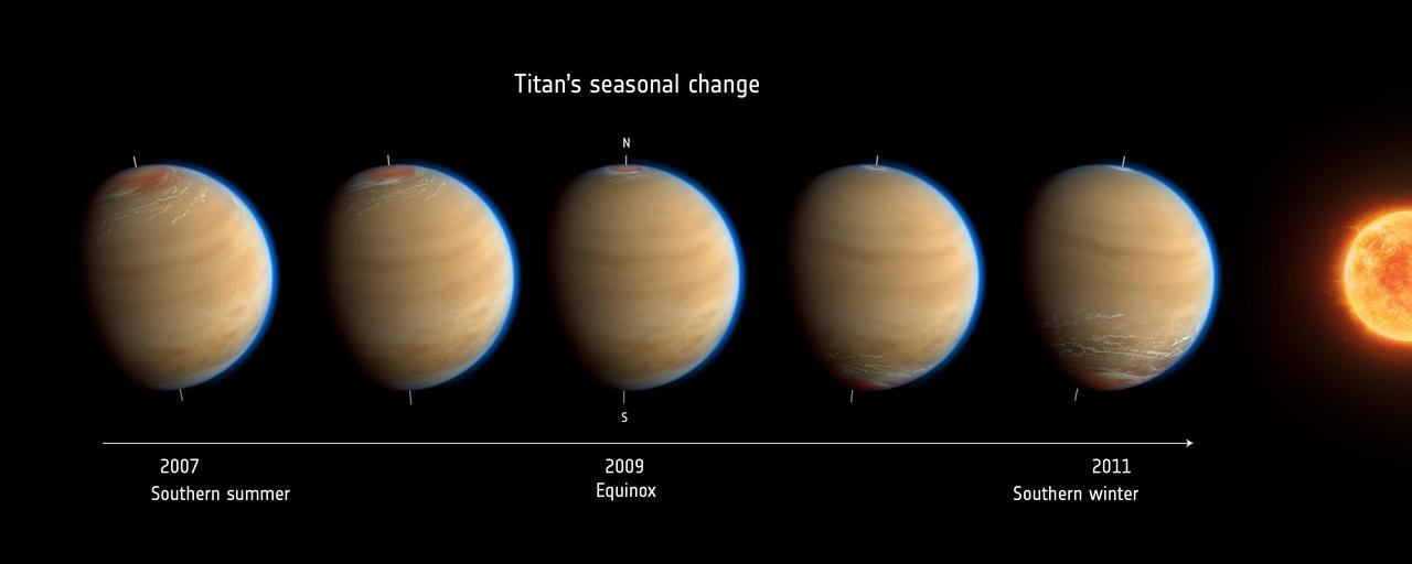
Inspired by data from NASA Cassini mission, this artist impression of Saturn moon Titan shows the change in observed atmospheric effects before, during and after equinox in 2009.
Shadows are cast by Daphnis and the moon attendant edge waves in this image from NASA Cassini spacecraft taken about a month and a half before the Saturn August 2009 equinox.

This mosaic, part of a larger mosaic of images captured by NASA Cassini Orbiter just hours before exact equinox at Saturn, shows that the spiral corrugation in the planet’s inner rings continues right up to the inner B ring.
Saturn small moon Pan casts a long shadow across the A ring in this image captured by NASA Cassini spacecraft a few days after the planet August 2009 equinox.
These two images, taken four years before Saturn’s August 2009 equinox by NASA Cassini spacecraft, indicate the streaks in these images are likely evidence of impacts into the planet’s rings.
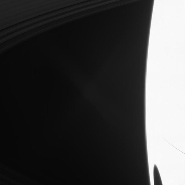
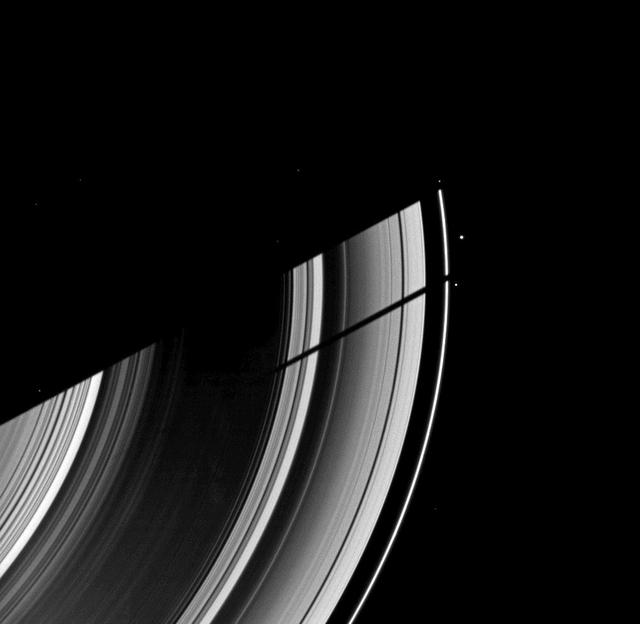
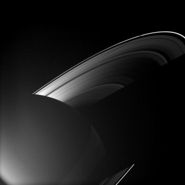
A big shadow from Saturn largest moon darkens the planet in the lower right of this image taken by NASA Cassini spacecraft shortly after Saturn August 2009 equinox.
Delicate shadows are cast outward from Saturn thin F ring in the lower left of this image taken as the planet approached its August 2009 equinox. The moon Atlas 30 kilometers, or 19 miles across is seen just above the center of the image.
The shadows of Saturn rings edge ever farther southward as Saturn creeps towards southern winter or northern summer. Saturn is now almost exactly halfway between its equinox August 2009 and southern winter solstice in May 2017.
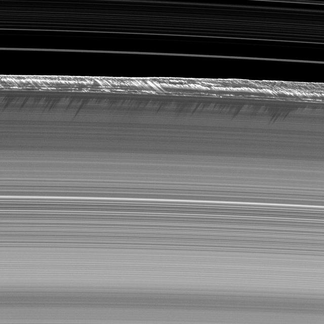
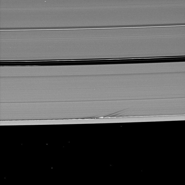
Vertical structures, among the tallest seen in Saturn main rings, rise abruptly from the edge of Saturn B ring to cast long shadows on the ring in this image taken by NASA Cassini spacecraft two weeks before the planet August 2009 equinox.
NASA Cassini spacecraft captured Saturn moon Prometheus, orbiting near the streamer-channels it has created in the thin F ring, casts a shadow on the A ring in this image taken a little more than a week after the planet August 2009 equinox.
Saturn moon Daphnis casts a short shadow on the A ring in this image taken by NASA Cassini spacecraftabout six months after the planet August 2009 equinox. Daphnis appears as a tiny bright dot in the Keeler Gap of the A ring near the center top.
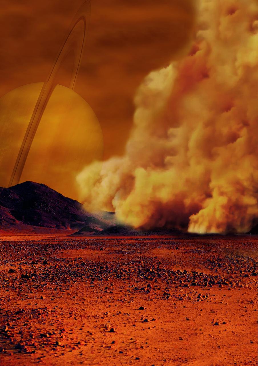
Artist's concept of a dust storm on Titan. Researchers believe that huge amounts of dust can be raised on Titan, Saturn's largest moon, by strong wind gusts that arise in powerful methane storms. Such methane storms, previously observed in images from the international Cassini spacecraft, can form above dune fields that cover the equatorial regions of this moon especially around the equinox, the time of the year when the Sun crosses the equator. The Cassini spacecraft ended its mission on Sept. 15, 2017. https://photojournal.jpl.nasa.gov/catalog/PIA22482
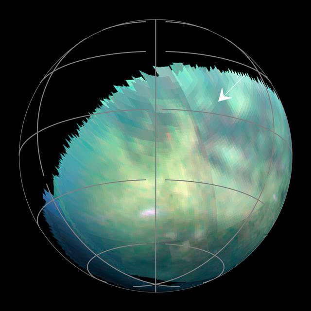
This frame from an animation -- based on images captured by the Visual and Infrared Mapping Spectrometer on NASA's Cassini mission during several Titan flybys in 2009 and 2010 -- shows clear bright spots appearing close to the equator around the equinox that have been interpreted as evidence of dust storms. The brightenings were visible only for a short period of time -- between 11 hours to five Earth weeks -- and cannot be seen in previous or subsequent images. The Cassini spacecraft ended its mission on Sept. 15, 2017. The animation is available at https://photojournal.jpl.nasa.gov/catalog/PIA22483

Saturn's shadow stretched beyond the edge of its rings for many years after Cassini first arrived at Saturn, casting an ever-lengthening shadow that reached its maximum extent at the planet's 2009 equinox. This image captured the moment in 2015 when the shrinking shadow just barely reached across the entire main ring system. The shadow will continue to shrink until the planet's northern summer solstice, at which point it will once again start lengthening across the rings, reaching across them in 2019. Like Earth, Saturn is tilted on its axis. And, just as on Earth, as the sun climbs higher in the sky, shadows get shorter. The projection of the planet's shadow onto the rings shrinks and grows over the course of its 29-year-long orbit, as the angle of the sun changes with respect to Saturn's equator. This view looks toward the sunlit side of the rings from about 11 degrees above the ring plane. The image was taken in visible light with the Cassini spacecraft wide-angle camera on Jan. 16, 2015. The view was obtained at a distance of approximately 1.6 million miles (2.5 million kilometers) from Saturn. Image scale is about 90 miles (150 kilometers) per pixel. http://photojournal.jpl.nasa.gov/catalog/PIA20498
The projection of Saturn's shadow on the rings grows shorter as Saturn's season advances toward northern summer, thanks to the planet's permanent tilt as it orbits the sun. This will continue until Saturn's solstice in May 2017. At that point in time, the shadow will extend only as far as the innermost A ring, leaving the middle and outer A ring completely free of the planet's shadow. Over the course of NASA's Cassini mission, the shadow of Saturn first lengthened steadily until equinox in August 2009. Since then, the shadow has been shrinking. This view looks toward the sunlit side of the rings from about 10 degrees above the ring plane. The image was taken in visible light with the Cassini spacecraft wide-angle camera on Feb. 3, 2017. The view was acquired at a distance of approximately 760,000 miles (1.2 million kilometers) from Saturn. Image scale is 46 miles (73 kilometers) per pixel. https://photojournal.jpl.nasa.gov/catalog/PIA21328
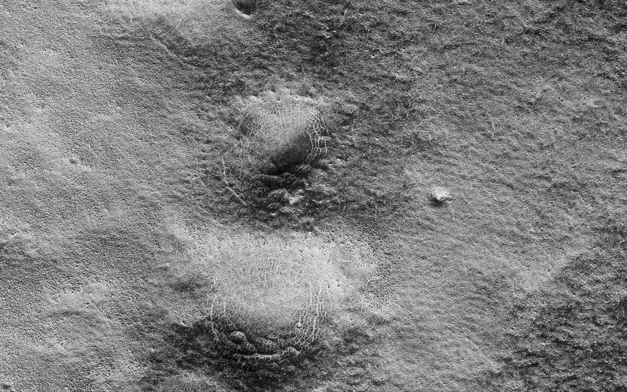
This image shows a lava channel north of Kuiper Crater in the high southern latitudes just before spring equinox. It was a target suggested by members of the public, using our suggestion tool called HiWish. The channel confluence at the top of the image illustrates interesting volcanic processes that took place long ago. However, it was the mounds on the rim of the channel to the south of the confluence that we initially found alarming. These mounds, up to 400 meters in diameter, are decorated by radial and concentric patterns that resemble spider webs. Radial and concentric fractures are familiar from forces penetrating a brittle layer, such as a rock thrown through a glass window. These particular fractures were evidently produced by something emerging from below the brittle surface of Mars. It seems likely that ice lenses, resulting from the accumulation of ice beneath the surface, created these peculiar mounds. Ice is less dense than rock, so the buried ice rose and pushed upwards on the surface and generated these spider web-like patterns. An analogous process creates similar sized mounds in arctic tundra on Earth that are known as "pingos," an Inuit word. The Martian fractures in this location are nowadays filled with dust instead of ice, so it is unclear how long ago this activity took place. It seems likely that these pingo-forming periglacial processes took place much more recently than the volcanic activity also evident in this region of Mars. http://photojournal.jpl.nasa.gov/catalog/PIA21110
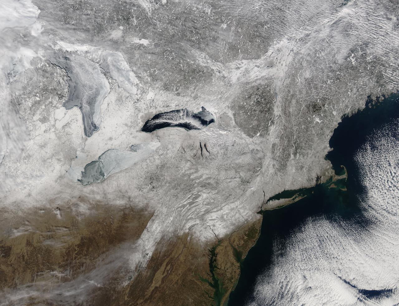
Snow covered the northeastern United States on last day of meteorological winter, 2014. Climatologists and meteorologists break seasons down into three-month groups, based on annual temperature and our calendar. This method is helpful for weather observing and forecasting, and for planning consistent agricultural dates, such as expected first frosts or best planting date. Meteorological winter – the season where temperatures are, on average, coldest and when snow is most likely to fall – runs from December 1 to February 28 in the United States and Canada. Winter can also be defined by the astronomical calendar, which is based on the rotation of the Earth around the sun. In this method, the seasons are defined by two solstices (times when the sun’s path is furthest from the Earth’s equator) and two equinoxes (the times when the sun passes directly above the equator). In the Northern Hemisphere, winter begins on the winter solstice, which falls on or around December 22 and ends on or around March 21, at the vernal (spring) equinox. On February 28, 2014, the Moderate Resolution Imaging Spectroradiometer aboard NASA’s Aqua satellite captured this true-color image of a sunny winter day in the northeastern United States. Snow stretches from Maine west to Indiana and south along the ridges of the Appalachian Mountains well into West Virginia. In Canada, the landscape appears greener, primarily because snow lies on conifers (evergreen) trees in the boreal forest regions. The Great Lakes, with the exception of Lake Ontario, are almost completely covered with ice. Credit: NASA/GSFC/Jeff Schmaltz/MODIS Land Rapid Response Team <b><a href="http://www.nasa.gov/audience/formedia/features/MP_Photo_Guidelines.html" rel="nofollow">NASA image use policy.</a></b> <b><a href="http://www.nasa.gov/centers/goddard/home/index.html" rel="nofollow">NASA Goddard Space Flight Center</a></b> enables NASA’s mission through four scientific endeavors: Earth Science, Heliophysics, Solar System Exploration, and Astrophysics. Goddard plays a leading role in NASA’s accomplishments by contributing compelling scientific knowledge to advance the Agency’s mission. <b>Follow us on <a href="http://twitter.com/NASAGoddardPix" rel="nofollow">Twitter</a></b> <b>Like us on <a href="http://www.facebook.com/pages/Greenbelt-MD/NASA-Goddard/395013845897?ref=tsd" rel="nofollow">Facebook</a></b> <b>Find us on <a href="http://instagram.com/nasagoddard?vm=grid" rel="nofollow">Instagram</a></b>

The Fall 2011 eclipse season started on September 11. Here is an AIA 171 image from 0657 UT with the first eclipse! SDO has eclipse seasons twice a year near each equinox. For three weeks near midnight Las Cruces time (about 0700 UT) our orbit has the Earth pass between SDO and the Sun. These eclipses can last up to 72 minutes in the middle of an eclipse season. The current eclipse season started on September 11 and lasts until October 4. To read more about SDO go to: <a href="http://sdo.gsfc.nasa.gov/" rel="nofollow">sdo.gsfc.nasa.gov/</a> Credit: NASA/GSFC/SDO <b><a href="http://www.nasa.gov/centers/goddard/home/index.html" rel="nofollow">NASA Goddard Space Flight Center</a></b> enables NASA’s mission through four scientific endeavors: Earth Science, Heliophysics, Solar System Exploration, and Astrophysics. Goddard plays a leading role in NASA’s accomplishments by contributing compelling scientific knowledge to advance the Agency’s mission. <b>Follow us on <a href="http://twitter.com/NASA_GoddardPix" rel="nofollow">Twitter</a></b> <b>Like us on <a href="http://www.facebook.com/pages/Greenbelt-MD/NASA-Goddard/395013845897?ref=tsd" rel="nofollow">Facebook</a></b> <b>Find us on <a href="http://instagrid.me/nasagoddard/?vm=grid" rel="nofollow">Instagram</a></b>
As Saturn's northern hemisphere summer approaches, the shadows of the rings creep ever southward across the planet. Here, the ring shadows appear to obscure almost the entire southern hemisphere, while the planet's north pole and its six-sided jet stream, known as "the hexagon," are fully illuminated by the sun. When NASA's Cassini spacecraft arrived at Saturn 12 years ago, the shadows of the rings lay far to the north on the planet (see PIA06077). As the mission progressed and seasons turned on the slow-orbiting giant, equinox arrived and the shadows of the rings became a thin line at the equator (see PIA11667). This view looks toward the sunlit side of the rings from about 16 degrees above the ring plane. The image was taken in red light with the Cassini spacecraft wide-angle camera on March 19, 2016. The view was obtained at a distance of approximately 1.7 million miles (2.7 million kilometers) from Saturn and at a Sun-Saturn-spacecraft, or phase, angle of 92 degrees. Image scale is 100 miles (160 kilometers) per pixel. http://photojournal.jpl.nasa.gov/catalog/PIA20486
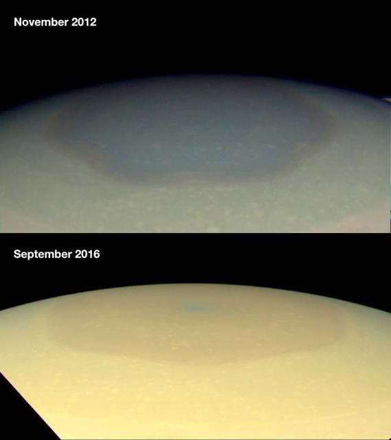
These two natural color images from NASA's Cassini spacecraft show the changing appearance of Saturn's north polar region between 2012 and 2016. Scientists are investigating potential causes for the change in color of the region inside the north-polar hexagon on Saturn. The color change is thought to be an effect of Saturn's seasons. In particular, the change from a bluish color to a more golden hue may be due to the increased production of photochemical hazes in the atmosphere as the north pole approaches summer solstice in May 2017. Researchers think the hexagon, which is a six-sided jetstream, might act as a barrier that prevents haze particles produced outside it from entering. During the polar winter night between November 1995 and August 2009, Saturn's north polar atmosphere became clear of aerosols produced by photochemical reactions -- reactions involving sunlight and the atmosphere. Since the planet experienced equinox in August 2009, the polar atmosphere has been basking in continuous sunshine, and aerosols are being produced inside of the hexagon, around the north pole, making the polar atmosphere appear hazy today. Other effects, including changes in atmospheric circulation, could also be playing a role. Scientists think seasonally shifting patterns of solar heating probably influence the winds in the polar regions. Both images were taken by the Cassini wide-angle camera. http://photojournal.jpl.nasa.gov/catalog/PIA21049
The Fall 2011 eclipse season started on September 11, 2011. Here is an AIA 304 image from 0658 UT. SDO has eclipse seasons twice a year near each equinox. For three weeks near midnight Las Cruces time (about 0700 UT) our orbit has the Earth pass between SDO and the Sun. These eclipses can last up to 72 minutes in the middle of an eclipse season. The current eclipse season started on September 11 and lasts until October 4. To read more about SDO go to: <a href="http://sdo.gsfc.nasa.gov/" rel="nofollow">sdo.gsfc.nasa.gov/</a> Credit: NASA/GSFC/SDO <b><a href="http://www.nasa.gov/centers/goddard/home/index.html" rel="nofollow">NASA Goddard Space Flight Center</a></b> enables NASA’s mission through four scientific endeavors: Earth Science, Heliophysics, Solar System Exploration, and Astrophysics. Goddard plays a leading role in NASA’s accomplishments by contributing compelling scientific knowledge to advance the Agency’s mission. <b>Follow us on <a href="http://twitter.com/NASA_GoddardPix" rel="nofollow">Twitter</a></b> <b>Like us on <a href="http://www.facebook.com/pages/Greenbelt-MD/NASA-Goddard/395013845897?ref=tsd" rel="nofollow">Facebook</a></b> <b>Find us on <a href="http://instagrid.me/nasagoddard/?vm=grid" rel="nofollow">Instagram</a></b>
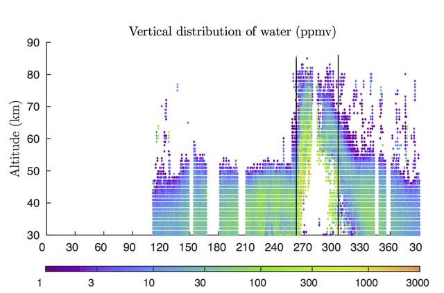
Rising air during a 2007 global dust storm on Mars lofted water vapor into the planet's middle atmosphere, researchers learned from data graphed here, derived from observations by the Mars Climate Sounder instrument on NASA's Mars Reconnaissance Orbiter. The two vertical black lines in the right half of the graph (at about 260 and 310 on the horizontal scale) mark the beginning and end of the most recent global dust storm on Mars, which burst from regional scale to globe-encircling scale in July 2007. The presence of more colored dots, particularly green ones, in the upper portion of the graph between those lines, compared to the upper portion of the graph outside those lines, documents the uplift of water vapor in connection with the global dust storm. The vertical scale is altitude, labeled at left in kilometers above the surface of Mars (50 kilometers is about 30 miles; 80 kilometers is about 50 miles). The color bar below the graph gives the key to how much water vapor each dot represents, in parts per million, by volume, in Mars' atmosphere. Note that green to yellow represents about 100 times as much water as purple does. The horizontal axis of the graph is time, from January 2006 to February 2008. It is labeled with numbers representing the 360 degrees of Mars' orbit around the Sun, from zero to 360 degrees and then further on to include the first 30 degrees of the following Martian year. (The zero point is autumnal equinox -- end of summer -- in Mars' northern hemisphere.) This graph, based on Mars Reconnaissance Orbiter observations, was used in a January 2018 paper in Nature Astronomy by Nicholas Heavens of Hampton University in Hampton, Virginia, and co-authors. The paper presents Martian dust storms' uplifting effect on water vapor as a factor in seasonal patterns that other spacecraft have detected in the rate of hydrogen escaping from the top of Mars' atmosphere. https://photojournal.jpl.nasa.gov/catalog/PIA22080
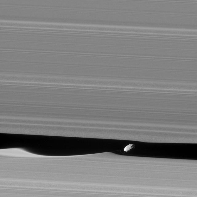
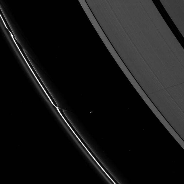
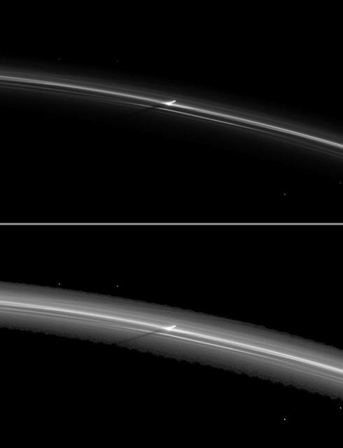
The wavemaker moon, Daphnis, is featured in this view, taken as NASA's Cassini spacecraft made one of its ring-grazing passes over the outer edges of Saturn's rings on Jan. 16, 2017. This is the closest view of the small moon obtained yet. Daphnis (5 miles or 8 kilometers across) orbits within the 42-kilometer (26-mile) wide Keeler Gap. Cassini's viewing angle causes the gap to appear narrower than it actually is, due to foreshortening. The little moon's gravity raises waves in the edges of the gap in both the horizontal and vertical directions. Cassini was able to observe the vertical structures in 2009, around the time of Saturn's equinox (see PIA11654). Like a couple of Saturn's other small ring moons, Atlas and Pan, Daphnis appears to have a narrow ridge around its equator and a fairly smooth mantle of material on its surface -- likely an accumulation of fine particles from the rings. A few craters are obvious at this resolution. An additional ridge can be seen further north that runs parallel to the equatorial band. Fine details in the rings are also on display in this image. In particular, a grainy texture is seen in several wide lanes which hints at structures where particles are clumping together. In comparison to the otherwise sharp edges of the Keeler Gap, the wave peak in the gap edge at left has a softened appearance. This is possibly due to the movement of fine ring particles being spread out into the gap following Daphnis' last close approach to that edge on a previous orbit. A faint, narrow tendril of ring material follows just behind Daphnis (to its left). This may have resulted from a moment when Daphnis drew a packet of material out of the ring, and now that packet is spreading itself out. The image was taken in visible (green) light with the Cassini spacecraft narrow-angle camera. The view was acquired at a distance of approximately 17,000 miles (28,000 kilometers) from Daphnis and at a Sun-Daphnis-spacecraft, or phase, angle of 71 degrees. Image scale is 551 feet (168 meters) per pixel. http://photojournal.jpl.nasa.gov/catalog/PIA21056
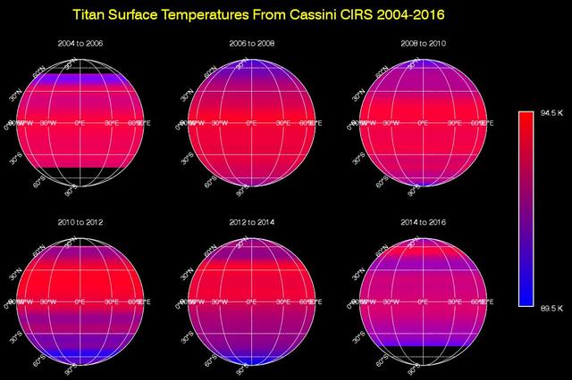
This sequence of maps shows varying surface temperatures on Saturn moon Titan at two-year intervals, from 2004 to 2016. The measurements were made by the Composite Infrared Spectrometer CIRS instrument on NASA Cassini spacecraft. The maps show thermal infrared radiation (heat) coming from Titan's surface at a wavelength of 19 microns, a spectral window at which the moon's otherwise opaque atmosphere is mostly transparent. Temperatures have been averaged around the globe from east to west (longitudinally) to emphasize the seasonal variation across latitudes (from north to south). Black regions in the maps are areas for which there was no data. Titan's surface temperature changes slowly over the course of the Saturn system's long seasons, which each last seven and a half years. As on Earth, the amount of sunlight received at each latitude varies as the sun's illumination moves northward or southward over the course of the 30-year-long Saturnian year. When Cassini arrived at Saturn in 2004, Titan's southern hemisphere was in late summer and was therefore the warmest region. Shortly after the 2009 equinox, in 2010, temperatures were symmetrical across the northern and southern hemispheres, mimicking the distribution observed by Voyager 1 in 1980 (one Titan year earlier). Temperatures subsequently cooled in the south and rose in the north, as southern winter approached. While the overall trend in the temperature shift is clearly evident in these maps, there is narrow banding in several places that is an artifact of making the observations through Titan's atmosphere. The moon's dense, hazy envelope adds noise to the difficult measurement. Although it moves in latitude, the maximum measured temperature on Titan remains around -292 degrees Fahrenheit (-179.6 degrees Celsius, 93.6 Kelvin), with a minimum temperature at the winter pole only 6 degrees Fahrenheit (3.5 degrees Celsius or Kelvin) colder. This is a much smaller contrast than exists between Earth's warmest and coldest temperatures, which can vary by more than 200 degrees Fahrenheit, or more than 100 degrees Celsius. http://photojournal.jpl.nasa.gov/catalog/PIA20020
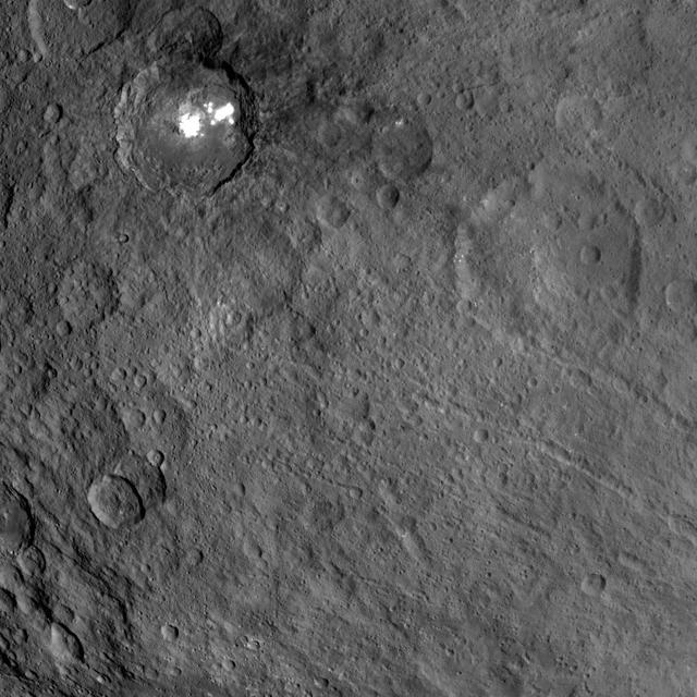
This view obtained by NASA's Dawn spacecraft during its Survey orbit illustrates the diversity and complexity of Ceres' geology. It shows familiar features: Occator Crater with its bright deposits (called faculae) of carbonates and other salts, a series of linear features (at right) called Samhain Catenae, and another large crater on the right side of the image called Kirnis. A relatively fresh crater called Lociyo, superimposed on an older crater, can be seen toward the bottom left of the picture. Studying the morphologies and relationships between various types of geological features can help scientists reconstruct Ceres' history. Occator appears to be one of the youngest features in this picture, except for a couple of smaller craters. The 71-mile-wide (115-kilometer-wide) Kirnis Crater on the other hand is an old, eroded crater. It owes its peculiar polygonal shape in part to its overlap with one of the Samhain Catenae. This illustrates the role of fractures in driving the geometry of some of Ceres' craters. The origin of these particular catenae is not understood yet, and is not necessarily related to the Pongal Catena. Kirnis Crater is named after a Lithuanian spirit-guardian of cherry trees, whereas the Samhain Catenae refer to a Gaelic festival organized at the end of the harvest season. It was observed in Ireland and Scotland during seven days in October and November, nearly halfway between the autumn equinox and the winter solstice. This picture was obtained on June 25, 2015, from an altitude of 2,700 miles (4,400 kilometers). It is centered at 1.7 degrees north latitude, and 249 degrees east longitude. https://photojournal.jpl.nasa.gov/catalog/PIA21409
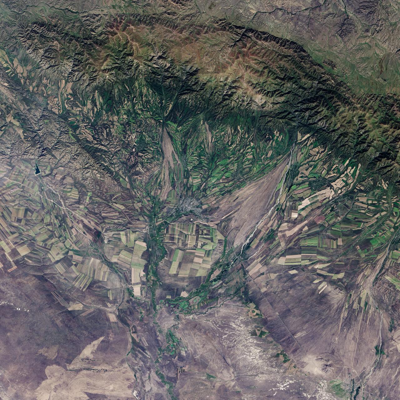
September 22, the autumnal equinox, marks the beginning of fall in the Northern Hemisphere, but the fall harvest begins early in the harsh continental climate of eastern Kazakhstan. By September 9, 2013, when the Operational Land Imager (OLI) on the Landsat 8 satellite acquired this image, several fields were already harvested and bare. Others were dark green with pasture grasses or ripening crops. The fields fill the contours of the land, running long and narrow down mountain valleys and spreading in large squares over the plains. Agriculture is an important segment of the economy in Kazakhstan: the country’s dry climate is ideal for producing high quality wheat for export. However, 61 percent of the country’s agricultural land is pasture for livestock. The area shown in this image, far eastern Kazakhstan near the Chinese border, is a minor wheat-growing region and may also produce sunflowers, barley, and other food crops. An artifact of Soviet-era collective farms, most of the farms in Kazakhstan are large, covering more than 5,000 hectares (12,500 acres). Some of the larger fields in the image reflect the big business side of agriculture. However, family farms and small agriculture businesses account for 35 percent of the country’s agricultural production, and some of these are visible as well, particularly in the uneven hills and mountains. Nearly all agriculture in Kazakhstan is rain fed. Farmers in this region have designed their fields to take advantage of rain flowing down hills, allowing the natural shape of the land to channel water to crops. The effect is a mosaic of green and tan with tones matching the natural vegetation in the mountains to the north. NASA Earth Observatory image by Jesse Allen using Landsat data from the U.S. Geological Survey. Caption by Holli Riebeek. Instrument: Landsat 8 - OLI More info: <a href="http://1.usa.gov/16IZ047" rel="nofollow">1.usa.gov/16IZ047</a> <b><a href="http://www.nasa.gov/audience/formedia/features/MP_Photo_Guidelines.html" rel="nofollow">NASA image use policy.</a></b> <b><a href="http://www.nasa.gov/centers/goddard/home/index.html" rel="nofollow">NASA Goddard Space Flight Center</a></b> enables NASA’s mission through four scientific endeavors: Earth Science, Heliophysics, Solar System Exploration, and Astrophysics. Goddard plays a leading role in NASA’s accomplishments by contributing compelling scientific knowledge to advance the Agency’s mission. <b>Follow us on <a href="http://twitter.com/NASA_GoddardPix" rel="nofollow">Twitter</a></b> <b>Like us on <a href="http://www.facebook.com/pages/Greenbelt-MD/NASA-Goddard/395013845897?ref=tsd" rel="nofollow">Facebook</a></b> <b>Find us on <a href="http://instagram.com/nasagoddard?vm=grid" rel="nofollow">Instagram</a></b>
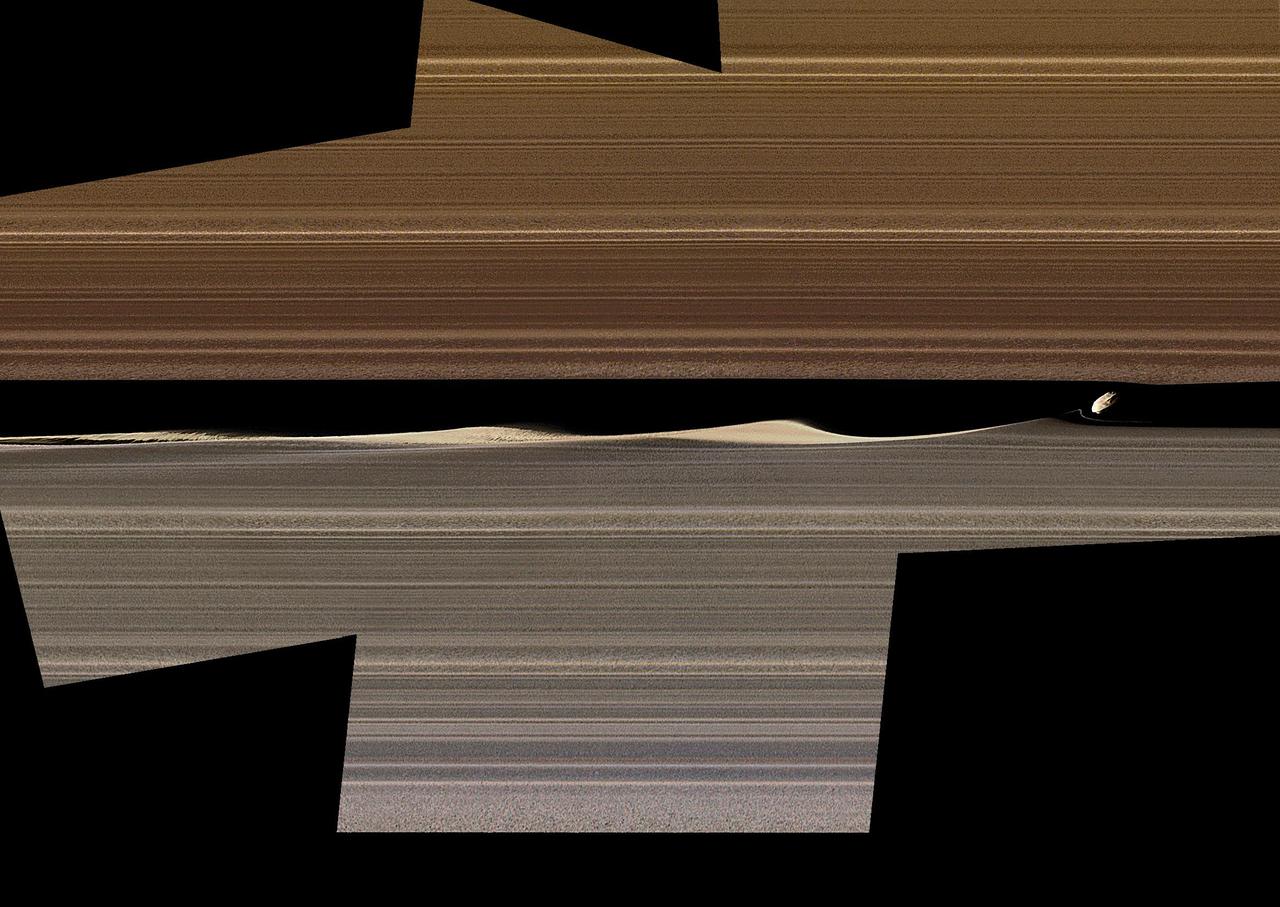
This enhanced-color image mosaic shows Daphnis, one of the moons embedded in Saturn's rings, in the Keeler gap on the sunlit side of the rings. Daphnis is seen kicking up three waves in the gap's outer edge. Three wave crests of diminishing sizes trail the moon. In each successive crest, the shape of the wave changes as the ring particles within the crest interact and collide with each other. A thin strand of ring material to the lower left of Daphnis is newly visible in this image, and there are intricate features that also hadn't been previously observed in the third wave crest downstream (see Figure 1). Cassini was at a very shallow angle above the rings (only about 15 degrees) when this image was taken. The resulting foreshortening makes it difficult to tell the difference in this image between features representing vertical structure and those representing radial, or outward from Saturn, structure within the ring plane. Nonetheless, Cassini imaging scientists have determined that the waves in the gap are largely vertical; compare this to the shadows that they were seen to cast during equinox (see PIA11547, PIA11653, PIA11655 and PIA11656). The thin strand of material is also probably vertical. Daphnis itself is actually five times smaller than the width of the gap, but it looks bigger here because of the foreshortening. The color in this image comes from using Imaging Science Subsystem images obtained by applying different filters to "paint" color onto the black-and-white version of this view previously released as PIA17212. The color of the ring region outward of the Keeler Gap (the "trans-Keeler region," in the lower portion of this image) is noticeably different from the color inward from the gap (upper portion of this image). In visible light, this color difference sharply coincides with the gap, while near-infrared Visible and Infrared Mapping Spectrometer (VIMS) images show some bleeding of the trans-Keeler region into the region inward from the gap. The reasons for the sharp change in color are mysterious, but they probably have more to do with a change in particle sizes and other properties than with a change in composition. The images in this mosaic were taken in visible light, using the Cassini spacecraft narrow-angle camera at a distance of approximately 17,000 miles (28,000 kilometers) from Daphnis and at a Sun-Daphnis-spacecraft angle, or phase angle, of 71 degrees (for the color images, 58 degrees). Image scale is 550 feet (170 meters) per pixel. The image was produced by Tilmann Denk at Freie Universität in Berlin. https://photojournal.jpl.nasa.gov/catalog/PIA23167