
NASA Image acquired March 24, 2010 To learn more and to download a high res version of this image go here: <a href="http://earthobservatory.nasa.gov/IOTD/view.php?id=43252" rel="nofollow">earthobservatory.nasa.gov/IOTD/view.php?id=43252</a> Iceland’s Eyjafjallajökull Volcano burst into life for the first time in 190 years on March 20, 2010. A 500-meter- (2,000-foot) long fissure opened in the Fimmvörduháls pass to the west of the ice-covered summit of Eyjafjallajökull. Lava fountains erupted fluid magma, which quickly built several hills of bubble-filled lava rocks (scoria) along the vent. A lava flow spread northeast, spilling into Hrunagil Gully. This natural-color satellite image shows lava fountains, lava flows, a volcanic plume, and steam from vaporized snow. The image was acquired on March 24, 2010, by the Advanced Land Imager (ALI) aboard NASA’s Earth Observing-1 (EO-1) satellite. The lava fountains are orange-red, barely visible at the 10-meter (33-foot) resolution of the satellite. The scoria cones surrounding the fissure are black, as is the lava flow extending to the northeast. White volcanic gases escape from the vent and erupting lava, while a steam plume rises where the hot lava meets snow. (The bright green color along the edge of the lava flow is an artifact of the sensor.) The eruption of Eyjafjallajökull was presaged by a series of earthquakes starting in early March. Over time, the earthquakes rose towards the surface, and land near the volcano rose at least 40 millimeters (2 inches)—both indications that magma was moving underneath the volcano. The eruption continued through at least March 26th, and may continue for several more months. Previous eruptions in the area have caused flooding due to the melting of glacial ice (a Jökulhlaup), but the current eruption is in an area covered by winter snow, not permanent ice. Although some past eruptions of Eyjafjallajökull were followed by larger, explosive eruptions at nearby Katla Volcano, there is currently no sign of activity at Katla. NASA image by Robert Simmon, using ALI data from the EO-1 team. Caption by Robert Simmon. Instrument: EO-1 - ALI <b><a href="http://www.nasa.gov/centers/goddard/home/index.html" rel="nofollow">NASA Goddard Space Flight Center</a></b> is home to the nation's largest organization of combined scientists, engineers and technologists that build spacecraft, instruments and new technology to study the Earth, the sun, our solar system, and the universe.
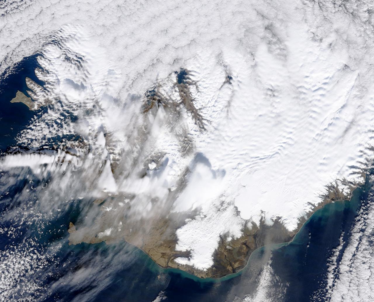
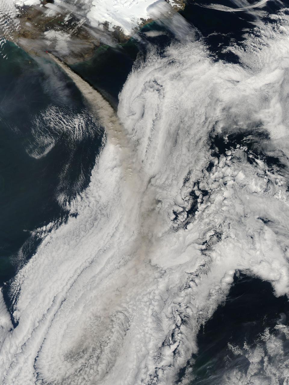
March 31, 2010..The volcanic eruption near Eyjafjallajökull persists into its second week, with continued lava fountaining and lava flows spilling into nearby canyons. The eruption is located at the Fimmvörduháls Pass between the Eyjafjallajökull ice field to the west (left) and the Mýrdalsjökull ice field to the east (right). This natural-color satellite image was acquired on March 26, 2010, by the MODIS aboard NASA’s Terra satellite. Dark ash and scoria cover the northern half of the Fimmvörduháls Pass. White snow covers the rest of the pass, sandwiched between white glaciers. Snow-free land is tan, brown, or dark gray, devoid of vegetation in early spring. To download a high res version of this image go to: <a href="http://modis.gsfc.nasa.gov/gallery/individual.php?db_date=2010-03-31" rel="nofollow">modis.gsfc.nasa.gov/gallery/individual.php?db_date=2010-0...</a> <b><a href="http://www.nasa.gov/centers/goddard/home/index.html" rel="nofollow">NASA Goddard Space Flight Center</a></b> is home to the nation's largest organization of combined scientists, engineers and technologists that build spacecraft, instruments and new technology to study the Earth, the sun, our solar system, and the universe.
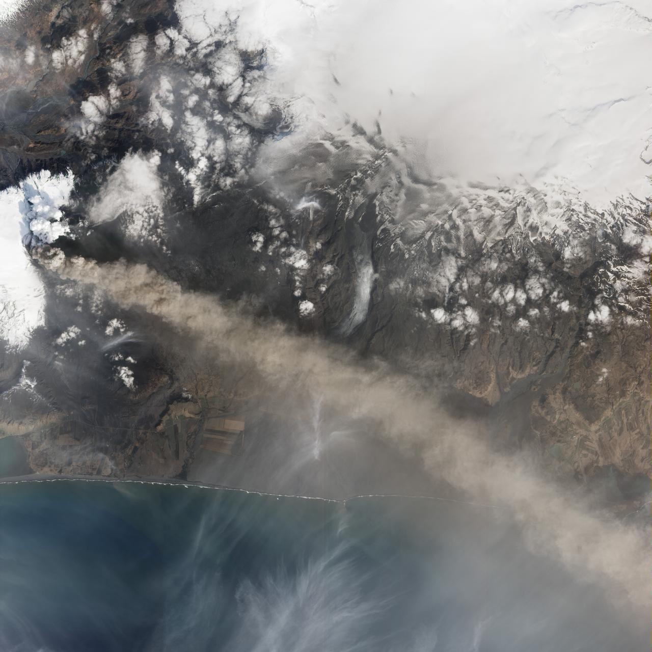
NASA satellite image acquired May 2, 2010 To view a detail of this image go to: <a href="http://www.flickr.com/photos/gsfc/4584266734/">www.flickr.com/photos/gsfc/4584266734/</a> Ash and steam continued billowing from Eyjafjallajökull Volcano in early May 2010. The Advanced Land Imager (ALI) on NASA’s Earth Observing-1 (EO-1) satellite captured this natural-color image on May 2, 2010. The volcano’s summit is near the left edge of this image, capped by a dark plume. The plume is dull gray-brown, indicating that its principal visible component is volcanic ash. Ash from the plume blows toward the east-southeast, passing over a charcoal-colored ash field on the land surface. Just to the north of Eyjafjallajökull’s summit are white puffs of steam, likely from surface lava flows vaporizing snow and glacial ice. On May 4, 2010, the Icelandic Meteorological Office warned that Eyjafjallajökull showed no signs of ending its eruptive activity in the near future. The Met Office reported that ash from the volcano had reached a height of 5.8 to 6.0 kilometers (19,000 to 20,000 feet) above sea level, and had spread 65 to 80 kilometers (40 to 50 miles) east-southeast of the volcano, where it impeded visibility for local residents. The Met Office also reported that lava continued flowing down a steep hill north of the crater. NASA image by Robert Simmon, using ALI data from the EO-1 team. Caption by Michon Scott. Instrument: EO-1 – ALI To view other images from the Earth Observatory go to: <a href="http://earthobservatory.nasa.gov/" rel="nofollow">earthobservatory.nasa.gov/</a> <b><a href="http://www.nasa.gov/centers/goddard/home/index.html" rel="nofollow">NASA Goddard Space Flight Center</a></b> is home to the nation's largest organization of combined scientists, engineers and technologists that build spacecraft, instruments and new technology to study the Earth, the sun, our solar system, and the universe.
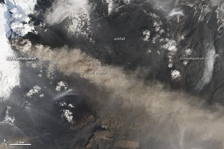
NASA satellite image acquired May 2, 2010 To see the full view of this image go to: <a href="http://www.flickr.com/photos/gsfc/4584266582/">www.flickr.com/photos/gsfc/4584266582/</a> Ash and steam continued billowing from Eyjafjallajökull Volcano in early May 2010. The Advanced Land Imager (ALI) on NASA’s Earth Observing-1 (EO-1) satellite captured this natural-color image on May 2, 2010. The volcano’s summit is near the left edge of this image, capped by a dark plume. The plume is dull gray-brown, indicating that its principal visible component is volcanic ash. Ash from the plume blows toward the east-southeast, passing over a charcoal-colored ash field on the land surface. Just to the north of Eyjafjallajökull’s summit are white puffs of steam, likely from surface lava flows vaporizing snow and glacial ice. On May 4, 2010, the Icelandic Meteorological Office warned that Eyjafjallajökull showed no signs of ending its eruptive activity in the near future. The Met Office reported that ash from the volcano had reached a height of 5.8 to 6.0 kilometers (19,000 to 20,000 feet) above sea level, and had spread 65 to 80 kilometers (40 to 50 miles) east-southeast of the volcano, where it impeded visibility for local residents. The Met Office also reported that lava continued flowing down a steep hill north of the crater. NASA image by Robert Simmon, using ALI data from the EO-1 team. Caption by Michon Scott. Instrument: EO-1 – ALI To view other images from the Earth Observatory go to: <a href="http://earthobservatory.nasa.gov/" rel="nofollow">earthobservatory.nasa.gov/</a> <b><a href="http://www.nasa.gov/centers/goddard/home/index.html" rel="nofollow">NASA Goddard Space Flight Center</a></b> is home to the nation's largest organization of combined scientists, engineers and technologists that build spacecraft, instruments and new technology to study the Earth, the sun, our solar system, and the universe.
The Advanced Land Imager onboard NASA Earth Observing-1 EO-1 spacecraft obtained this false-color infrared image of Iceland Eyjafjallajökull volcano on April 17, 2010. A strong thermal source is visible at the base of the Eyjafjallajökull plume.

NASA satellite image acquired May 6, 2010 at 11 :55 UTC To view a detail of this image go to: <a href="http://www.flickr.com/photos/gsfc/4583711511/">www.flickr.com/photos/gsfc/4583711511/</a> NASA Satellite Sees a Darker Ash Plume From Iceland Volcano NASA's Terra satellite flew over the Eyjafjallajokull Volcano, Iceland, on May 6 at 11:55 UTC (7:55 a.m. EDT). The Moderate Resolution Imaging Spectroradiometer instrument known as MODIS that flies onboard Terra, captured a visible image of the ash plume. The plume was blowing east then southeast over the Northern Atlantic. The satellite image shows that the plume is at a lower level in the atmosphere than the clouds that lie to its east, as the brown plume appears to slide underneath the white clouds. Satellite: Terra NASA/GSFC/Jeff Schmaltz/MODIS Land Rapid Response Team To learn more about MODIS go to: <a href="http://www.nasa.gov/topics/earth/features/iceland-volcano-plume.html" rel="nofollow">www.nasa.gov/topics/earth/features/iceland-volcano-plume....</a> <b><a href="http://www.nasa.gov/centers/goddard/home/index.html" rel="nofollow">NASA Goddard Space Flight Center</a></b> is home to the nation's largest organization of combined scientists, engineers and technologists that build spacecraft, instruments and new technology to study the Earth, the sun, our solar system, and the universe.
NASA image acquired May 8, 2010 at 13 :35 UTC Ash plume from Eyjafjallajokull Volcano, Iceland Satellite: Aqua NASA/GSFC/Jeff Schmaltz/MODIS Land Rapid Response Team <b><a href="http://www.nasa.gov/centers/goddard/home/index.html" rel="nofollow">NASA Goddard Space Flight Center</a></b> is home to the nation's largest organization of combined scientists, engineers and technologists that build spacecraft, instruments and new technology to study the Earth, the sun, our solar system, and the universe.
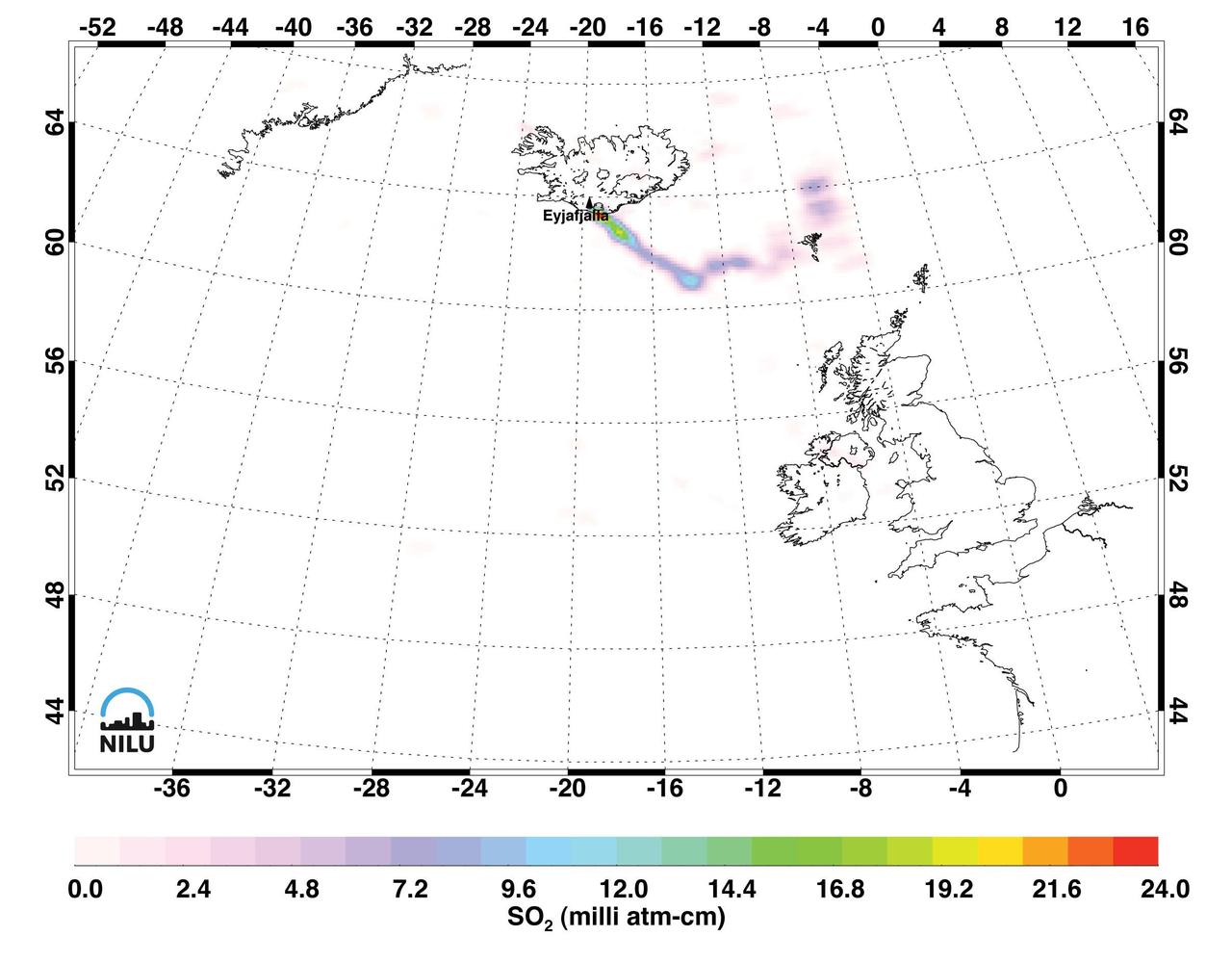
Images made with data from the Atmospheric Infrared Sounder on NASA Aqua satellite, show sulfur dioxide released from the volcanic eruption of Eyjafjallajökull.
Ash from Iceland Eyjafjallajökull volcano, viewed here in imagery from NASA Terra spacecraft on May 16, 2010, once again disrupted air traffic over Europe with the closure of major airports in the United Kingdom and the Netherlands.
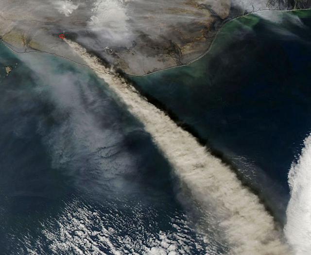
NASA Terra satellite flew directly over Iceland on April 19, 2010 and captured this image of the Eyjafjallajökull volcano and its erupting ash plume. 3D glasses are necessary to view this image.
NASA image acquired May 8, 2010 at 13 :35 UTC Ash plume from Eyjafjallajokull Volcano, Iceland Satellite: Aqua NASA/GSFC/Jeff Schmaltz/MODIS Land Rapid Response Team <b><a href="http://www.nasa.gov/centers/goddard/home/index.html" rel="nofollow">NASA Goddard Space Flight Center</a></b> is home to the nation's largest organization of combined scientists, engineers and technologists that build spacecraft, instruments and new technology to study the Earth, the sun, our solar system, and the universe.
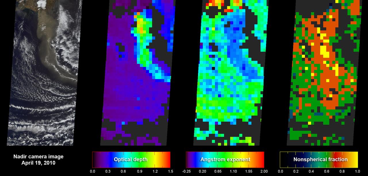
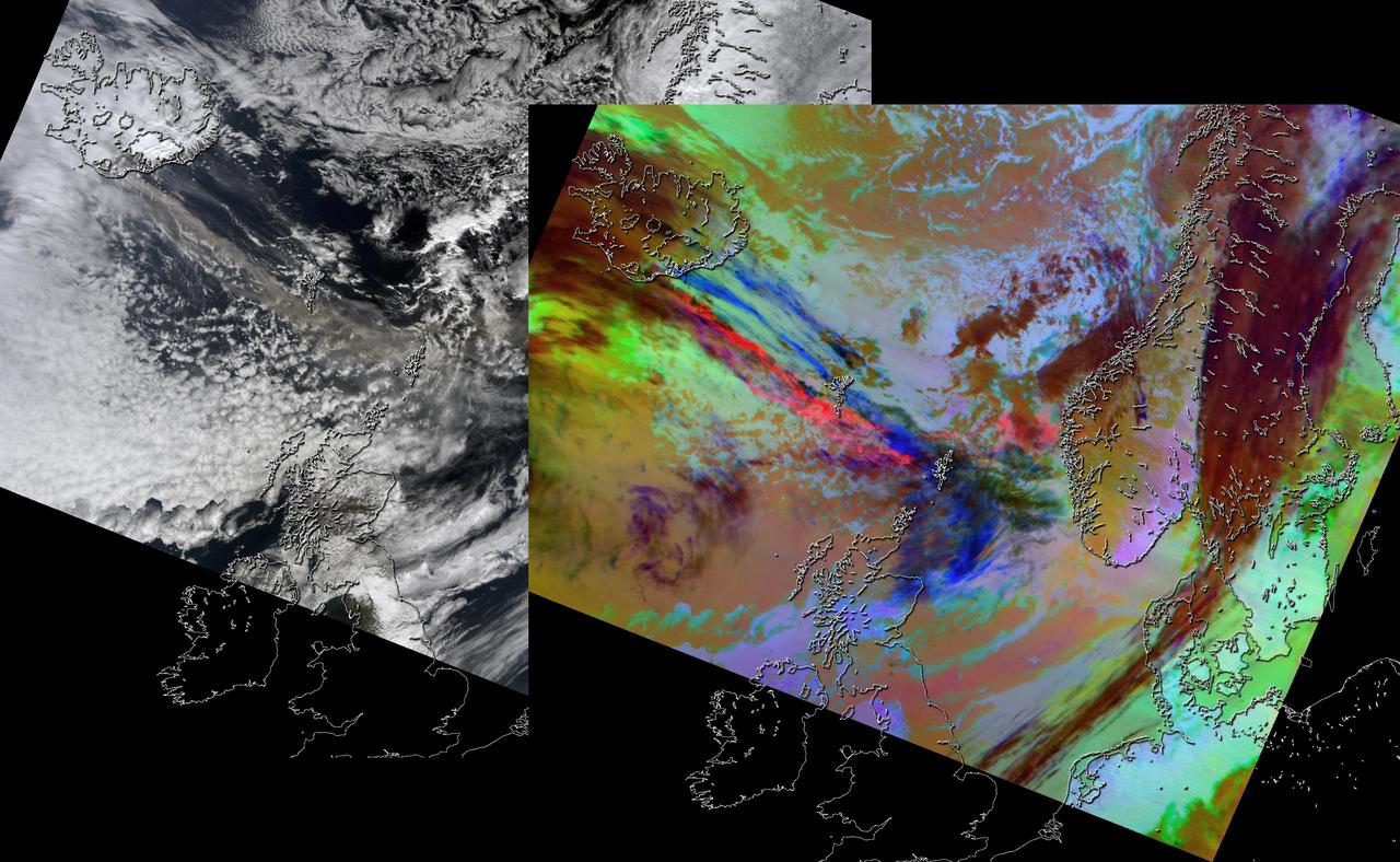
As NASA Terra satellite flew over Iceland erupting Eyjafjallajökull volcano, its Multi-angle Imaging SpectroRadiometer instrument acquired 36 near-simultaneous images of the ash plume, covering nine view angles in each of four wavelengths.

NASA satellite image acquired May 6, 2010 at 11 :55 UTC To view the full view go to: <a href="http://www.nasa.gov/topics/earth/features/iceland-volcano-plume.html" rel="nofollow">www.nasa.gov/topics/earth/features/iceland-volcano-plume....</a> NASA Satellite Sees a Darker Ash Plume From Iceland Volcano NASA's Terra satellite flew over the Eyjafjallajokull Volcano, Iceland, on May 6 at 11:55 UTC (7:55 a.m. EDT). The Moderate Resolution Imaging Spectroradiometer instrument known as MODIS that flies onboard Terra, captured a visible image of the ash plume. The plume was blowing east then southeast over the Northern Atlantic. The satellite image shows that the plume is at a lower level in the atmosphere than the clouds that lie to its east, as the brown plume appears to slide underneath the white clouds. Satellite: Terra NASA/GSFC/Jeff Schmaltz/MODIS Land Rapid Response Team To learn more about MODIS go to: <a href="http://rapidfire.sci.gsfc.nasa.gov/gallery/?latest" rel="nofollow">rapidfire.sci.gsfc.nasa.gov/gallery/?latest</a> <b><a href="http://www.nasa.gov/centers/goddard/home/index.html" rel="nofollow">NASA Goddard Space Flight Center</a></b> is home to the nation's largest organization of combined scientists, engineers and technologists that build spacecraft, instruments and new technology to study the Earth, the sun, our solar system, and the universe.
Iceland Eyjafjallajökull volcano produced its second major ash plume beginning on May 7, 2010. NASA Terra satellite passed just east of the volcano mid-morning and captured this image the same day.
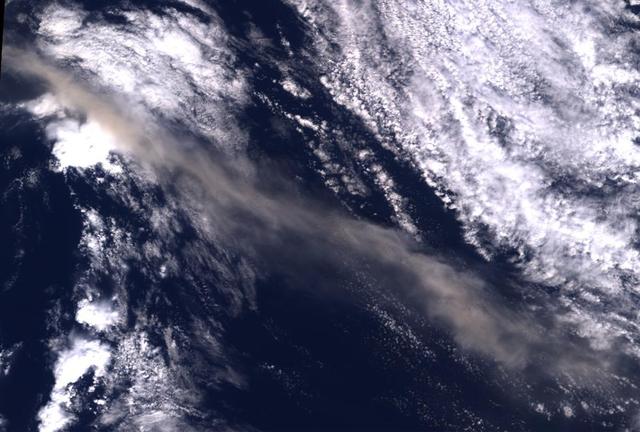
This image from NASA Terra spacecraft shows ash plumes from Eyjafjallajökull Volcano, Iceland stretching over the North Atlantic; the volcano erupted on April 14, 2010 bringing closure to major airports in Europe.
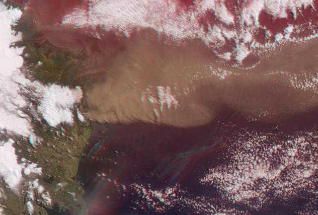
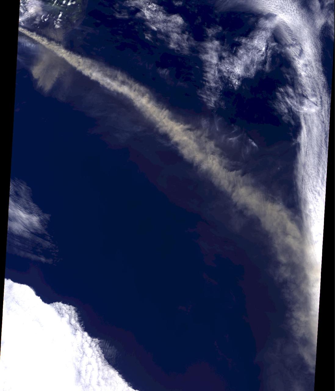
NASA Terra satellite flew directly over Iceland on April 19, 2010, to capture this stereo anaglyph generated from the nadir and 46-degree forward-viewing cameras of the Eyjafjallajökull volcano and its erupting ash plume. 3D glasses are necessary to vie
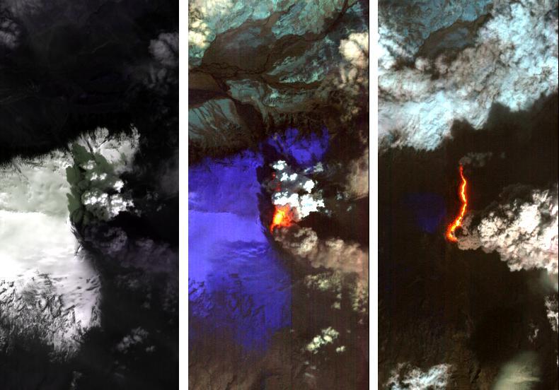
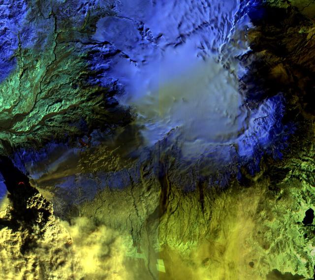
Dramatic changes have been observed at the Eyjafjallajökull volcano in Iceland by NASA's Earth Observing 1 (EO-1) spacecraft. On May 2, 2010, the Hyperion hyperspectral imager on EO-1 imaged Eyjafjallajökull and identified the extent of a lava flow extending northwards from the main eruption vent. This lava flow had been previously reported by volcanologists in Iceland, and is slowly carving its way north through the ice cap. The image on the left (Figure 1) is at visible wavelengths, and shows the persistent dark volcanic plume emanating from the main vent. This plume is still rich in ash, hence its brown coloration. This ash is still causing problems, threatening new airspace closures over parts of Europe. Large cracks at the edge of the crater are an indication of the extent of ice removal from the icecap during the eruption. To the north of this vent is another plume that is very white. This second plume is the result of ice being boiled off, generally non-explosively, by the heat from the silicate lava flow. As a result this plume is probably comprised mostly of water vapour. The black lava shows up clearly against the ice in the left-hand image. The image in the center (Figure 2) is a false-color image in the short-wavelength infrared. In this image, ice appears as blue and hot pixels appear as red. Very hot pixels appear as yellow and white. Red pixels, visible though the plume chart the extent of the lava flow, which has extended some 1.8 kilometers (1.1 miles) northwards from the area of the vent that is emitting the most energy. Total heat loss on May 2 was estimated to be at least 300 megawatts. The image on the right (Figure 3) shows the lava flow on May 4, 2010. The entire lava channel is now exposed, most of the overlying ice having been removed and the white plume has mostly disappeared. Without the plume obscuring heat loss from the lava flow, a better estimate of heat loss can be made. On May 4, the volcano was emitting at least 1,600 megawatts of energy. Each image covers an area measuring 7.7 kilometers (4.8 miles) wide, and has a resolution of 30 meters (98 feet) per pixel. The vertical direction is north-northeast. http://photojournal.jpl.nasa.gov/catalog/PIA13098
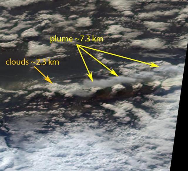
On Monday, April 19, 2010, the Advanced Spaceborne Thermal Emission and Reflection Radiometer ASTER instrument onboard NASA Terra spacecraft obtained this image of the continuing eruption of Iceland Eyjafjallajökull volcano.
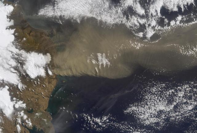
On April 15, 2010, NASA Terra spacecraft captured these images of the ongoing eruption of Iceland Eyjafjallajökull Volcano, which continues to spew ash into the atmosphere and impact air travel worldwide.
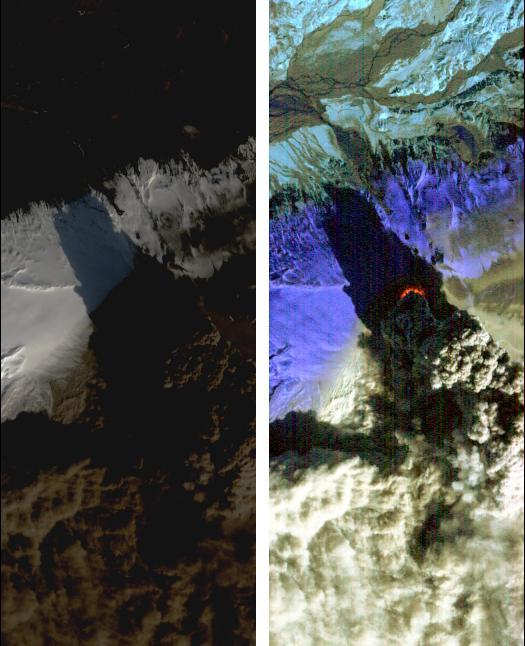
On Saturday, April 17, 2010, NASA Earth Observing-1 EO-1 spacecraft obtained this pair of images of the continuing eruption of Iceland Eyjafjallajökull volcano. On the left, new black ash deposits are visible on the ground.