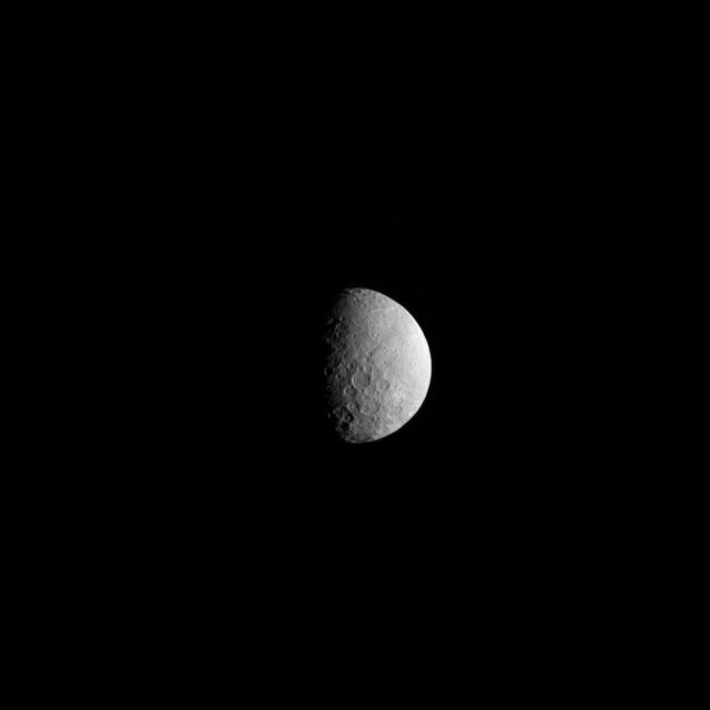
The International Astronomical Union (IAU), the internationally recognized authority for naming celestial bodies and their surface features, approved names of 14 surface features on Pluto in August 2017. The names were proposed by NASA's New Horizons team following the first reconnaissance of Pluto and its moons by the New Horizons spacecraft in 2015. The names, listed below, pay homage to the underworld mythology, pioneering space missions, historic pioneers who crossed new horizons in exploration, and scientists and engineers associated with Pluto and the Kuiper Belt. Tombaugh Regio honors Clyde Tombaugh (1906-1997), the U.S. astronomer who discovered Pluto in 1930 from Lowell Observatory in Arizona. Burney crater honors Venetia Burney (1918-2009), who as an 11-year-old schoolgirl suggested the name "Pluto" for Clyde Tombaugh's newly discovered planet. Later in life she taught mathematics and economics. Sputnik Planitia is a large plain named for Sputnik 1, the first space satellite, launched by the Soviet Union in 1957. Tenzing Montes and Hillary Montes are mountain ranges honoring Tenzing Norgay (1914-1986) and Sir Edmund Hillary (1919-2008), the Indian/Nepali Sherpa and New Zealand mountaineer were the first to reach the summit of Mount Everest and return safely. Al-Idrisi Montes honors Ash-Sharif al-Idrisi (1100-1165/66), a noted Arab mapmaker and geographer whose landmark work of medieval geography is sometimes translated as "The Pleasure of Him Who Longs to Cross the Horizons.†Djanggawul Fossae defines a network of long, narrow depressions named for the Djanggawuls, three ancestral beings in indigenous Australian mythology who traveled between the island of the dead and Australia, creating the landscape and filling it with vegetation. Sleipnir Fossa is named for the powerful, eight-legged horse of Norse mythology that carried the god Odin into the underworld. Virgil Fossae honors Virgil, one of the greatest Roman poets and Dante's fictional guide through hell and purgatory in the Divine Comedy. Adlivun Cavus is a deep depression named for Adlivun, the underworld in Inuit mythology. Hayabusa Terra is a large land mass saluting the Japanese spacecraft and mission (2003-2010) that performed the first asteroid sample return. Voyager Terra honors the pair of NASA spacecraft, launched in 1977, that performed the first "grand tour" of all four giant planets. The Voyager spacecraft are now probing the boundary between the Sun and interstellar space. Tartarus Dorsa is a ridge named for Tartarus, the deepest, darkest pit of the underworld in Greek mythology. Elliot crater recognizes James Elliot (1943-2011), an MIT researcher who pioneered the use of stellar occultations to study the solar system -- leading to discoveries such as the rings of Uranus and the first detection of Pluto's thin atmosphere. https://photojournal.jpl.nasa.gov/catalog/PIA21944
New Names for Features on Mercury http://photojournal.jpl.nasa.gov/catalog/PIA10611
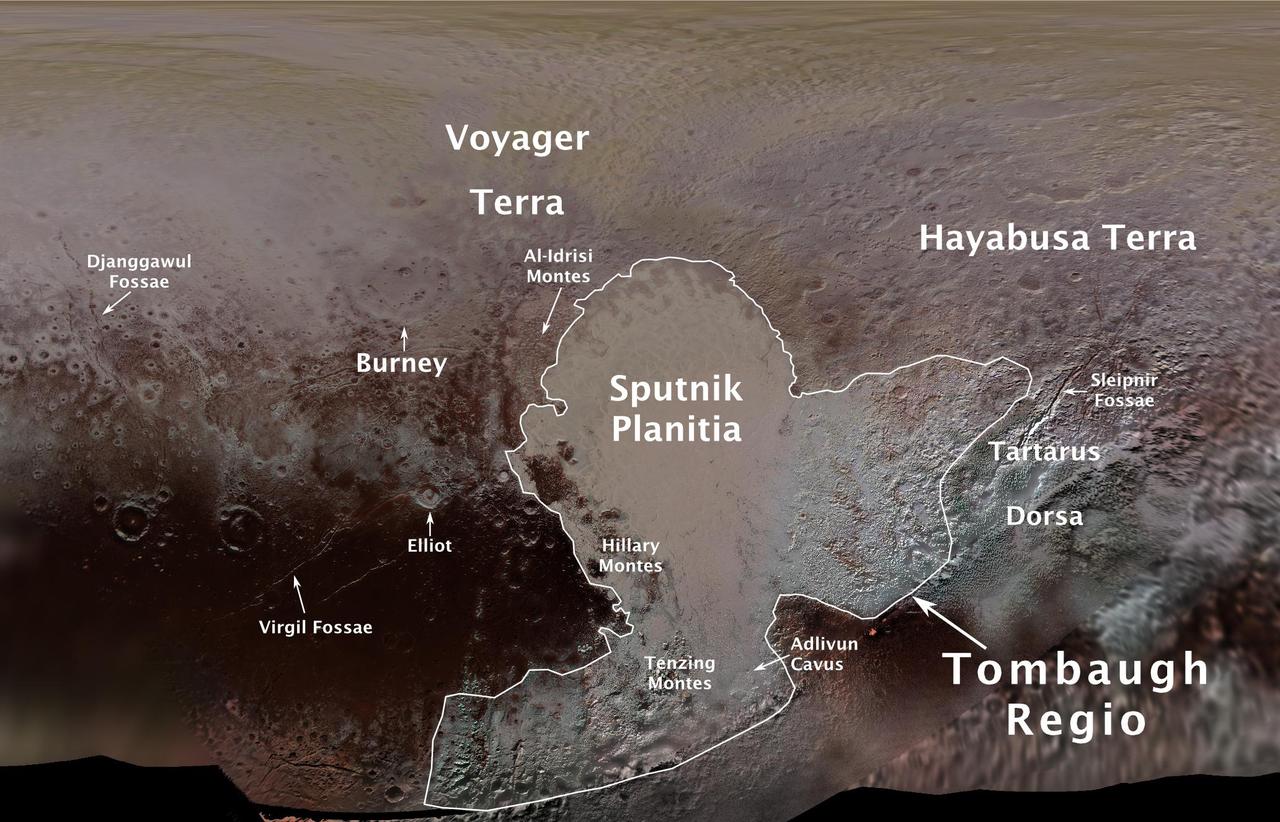
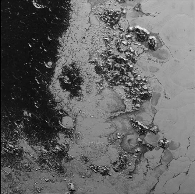
This image contains the initial, informal names being used by NASA's New Horizons team for the features and regions on the surface of Pluto. Names were selected based on the input the team received from the Our Pluto naming campaign. Names have not yet been approved by the International Astronomical Union (IAU). For more information on the maps and feature naming, visit http://www.ourpluto.org/maps. http://photojournal.jpl.nasa.gov/catalog/PIA19863
This topographical map of Ceres, made with images from NASA's Dawn spacecraft, shows all of the dwarf planet's named features as of September 2016. Dawn celebrated nine years since launch on September 27, 2016. To date, more than 110 places on Ceres have been named. These include craters such as Occator Crater, home of the brightest areas on the dwarf planet, as well as crater chains called catenae, mountains such as Ahuna Mons, and other geological features Among the most recently named features is Kwanzaa Tholus, named after the African-American winter holiday Kwanzaa, which is based on ancient African harvest festivals. A tholus is a small dome-shaped mountain or hill. There are a total of seven tholi named on Ceres. The latest list of features on Ceres can be found at the USGS Planetary Nomenclature website. http://photojournal.jpl.nasa.gov/catalog/PIA20918
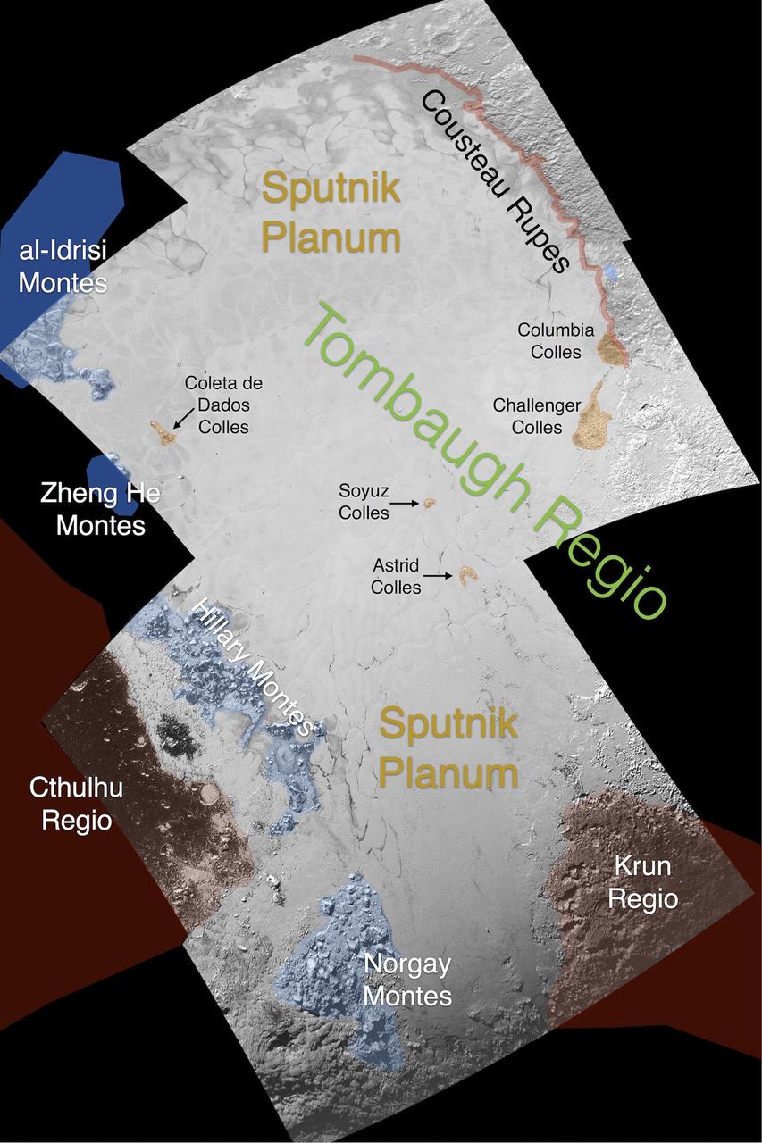
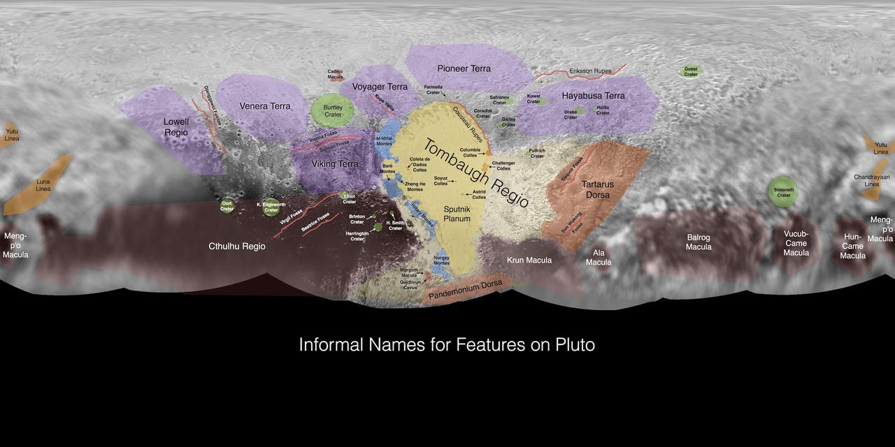
This image contains the initial, informal names being used by NASA's New Horizons team for the features on Pluto's Sputnik Planum (plain). Names were selected based on the input the team received from the Our Pluto naming campaign. Names have not yet been approved by the International Astronomical Union (IAU). For more information on the maps and feature naming, visit http://www.ourpluto.org/maps. http://photojournal.jpl.nasa.gov/catalog/PIA19865
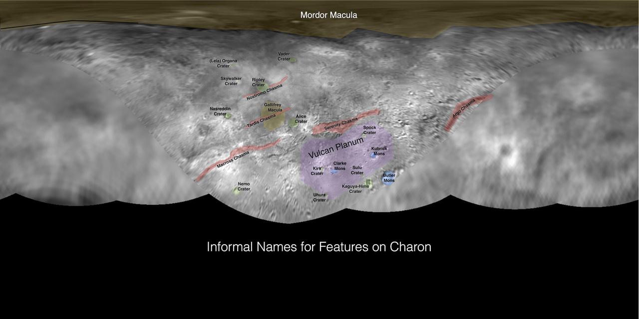
This image contains the initial, informal names being used by NASA's New Horizons team for the features on Pluto's largest moon, Charon. Names were selected based on the input the team received from the Our Pluto naming campaign. Names have not yet been approved by the International Astronomical Union (IAU). For more information on the maps and feature naming, visit http://www.ourpluto.org/maps. http://photojournal.jpl.nasa.gov/catalog/PIA19864
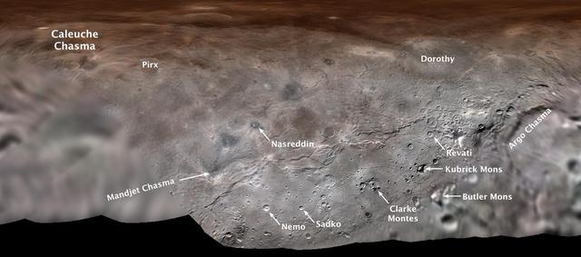
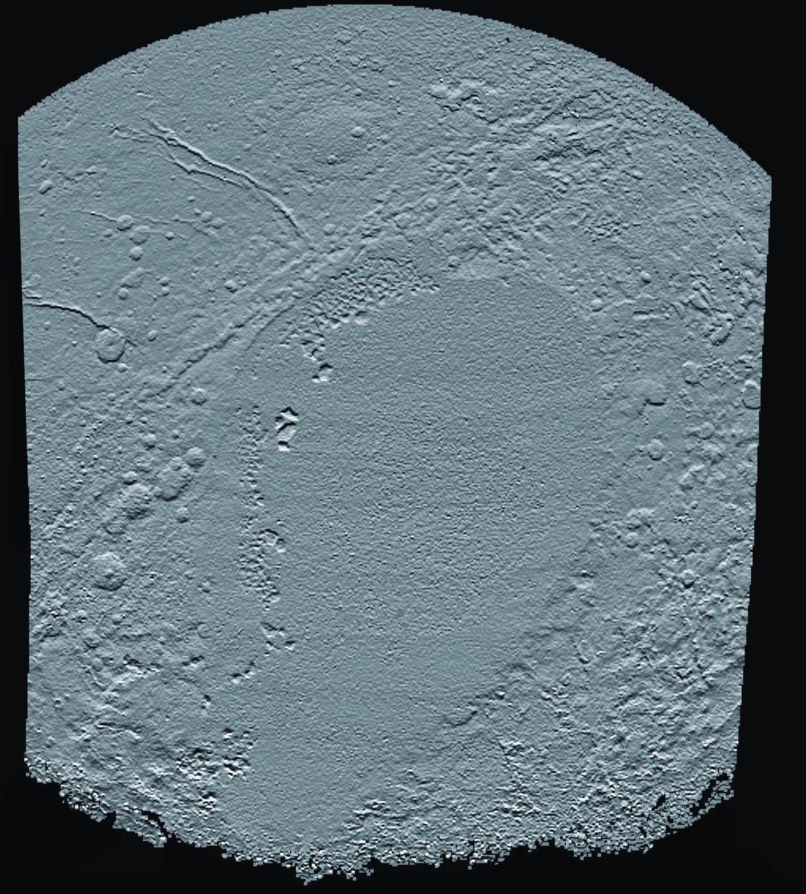
Map projection of Charon, the largest of Pluto's five moons, annotated with its first set of official feature names. With a diameter of about 755 miles, the Texas-sized moon is one of largest known objects in the Kuiper Belt, the region of icy, rocky bodies beyond Neptune. https://photojournal.jpl.nasa.gov/catalog/PIA00442
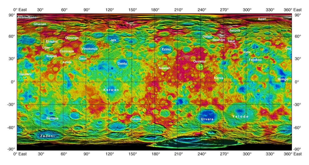
This color-coded map from NASA Dawn mission shows the highs and lows of topography on the surface of dwarf planet Ceres. It is labeled with names of features approved by the International Astronomical Union. http://photojournal.jpl.nasa.gov/catalog/PIA19974
Often, the names of features on planetary bodies are connected through a specific theme -- for example, many features on the Moon have been named after famous scientists. NASA's Dawn mission, together with the International Astronomical Union, established that craters on Ceres would be named for agricultural deities from all over the world, and other features would be named for agricultural festivals. Ceres itself was named after the Roman goddess of corn and harvests by its discoverer, Giuseppe Piazzi, who spotted it with his telescope in 1801. Since March 2015, Dawn has been orbiting Ceres and sending back many intriguing images and other data about its features. Using suggestions from the Dawn team, the IAU recently approved 25 new Ceres feature names tied to theme of agricultural deities, marked in yellow on the map. Emesh Crater, for example, is named for the Sumerian god of vegetation and agriculture. Jumi is the Latvian god of fertility of the field. The newly named surface features vary in size. Thrud, for example, is a crater with a diameter of 4.8 miles (7.8 kilometers) within the larger crater Zadeni, while Mlezi has a diameter of 28 miles (42 kilometers). For more information, the characteristics of these and other features on Ceres can be found in the IAU's Gazetteer of Planetary Nomenclature. https://photojournal.jpl.nasa.gov/catalog/PIA21755
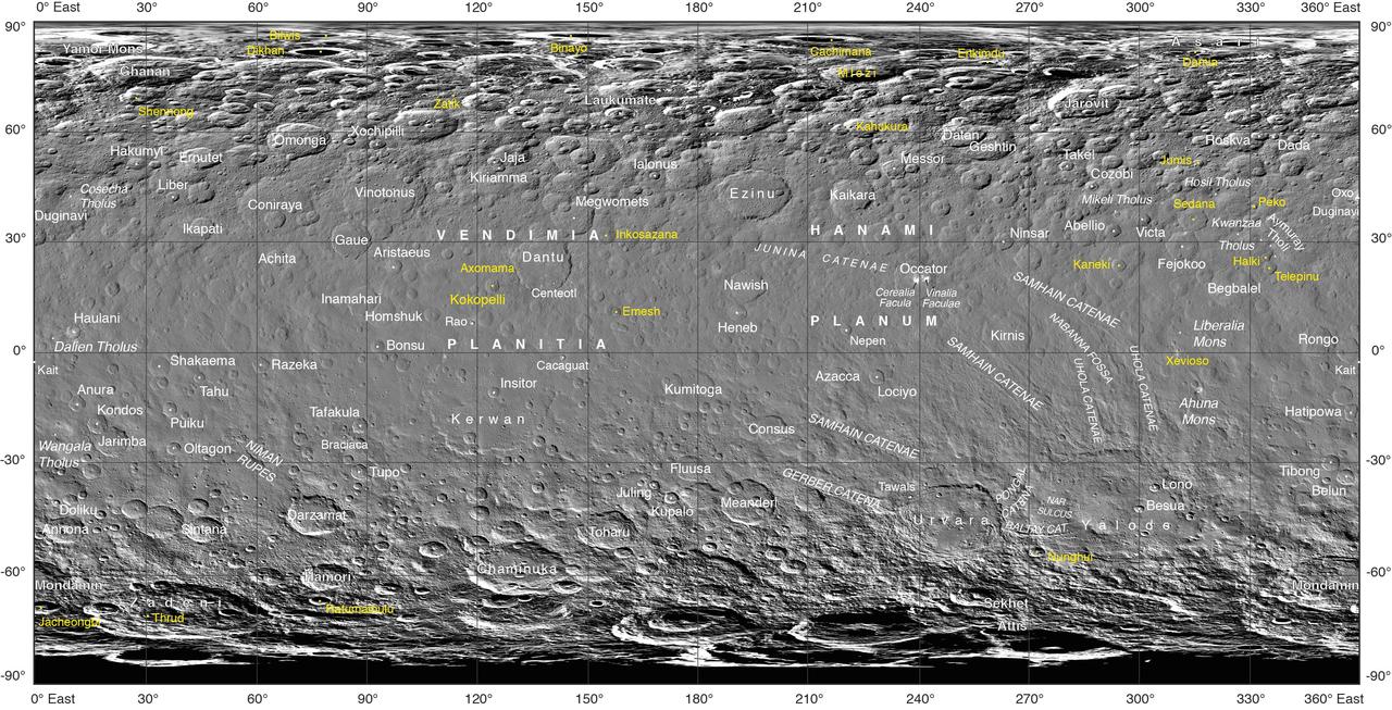
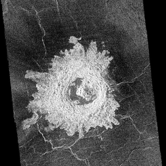
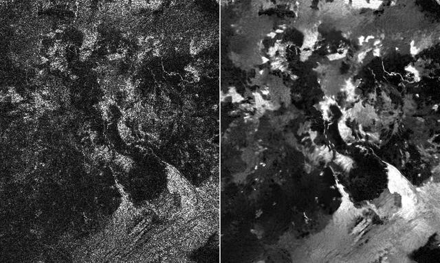
These side-by-side images obtained by NASA Cassini spacecraft show the feature named Tortola Facula on Saturn moon Titan.
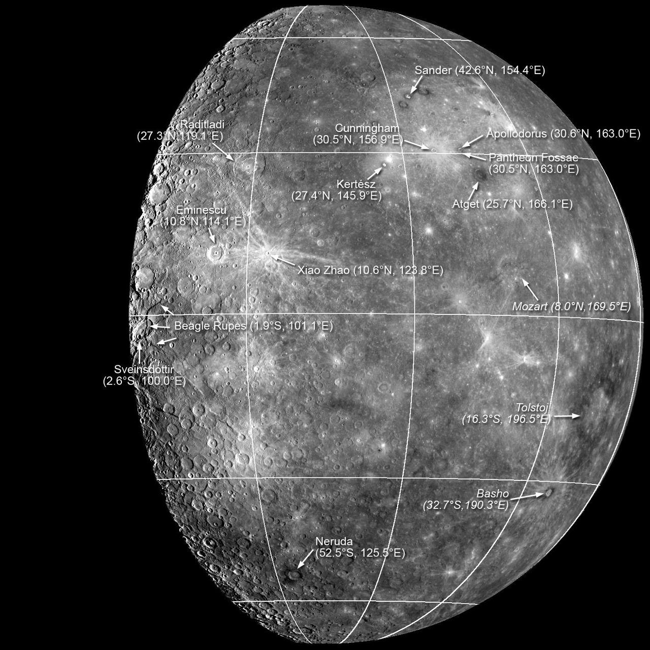
Sander, Munch, and Poe are a trio of impact craters within the Caloris impact basin. Munch and Poe were recently named, while Sander received its name in the first set of feature names after MESSENGER’s first Mercury flyby.
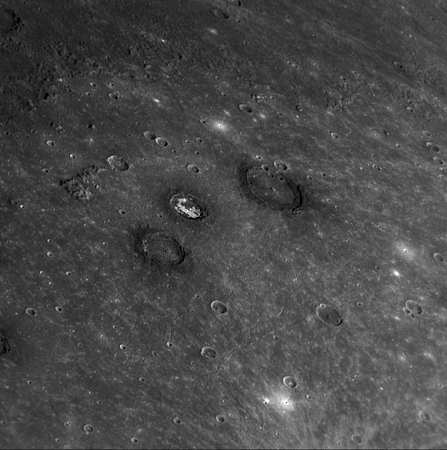
During its final close flyby of Saturn moon Enceladus, NASA Cassini orbiter shows this view featuring the nearly parallel furrows and ridges of the feature named Samarkand Sulci.
The center of Ezinu Crater on Ceres is seen in this view from NASA Dawn spacecraft. The crater features a network of canyon-like features. Ezinu measures about 72 miles 116 kilometers in diameter and was named for the Sumerian goddess of grain.
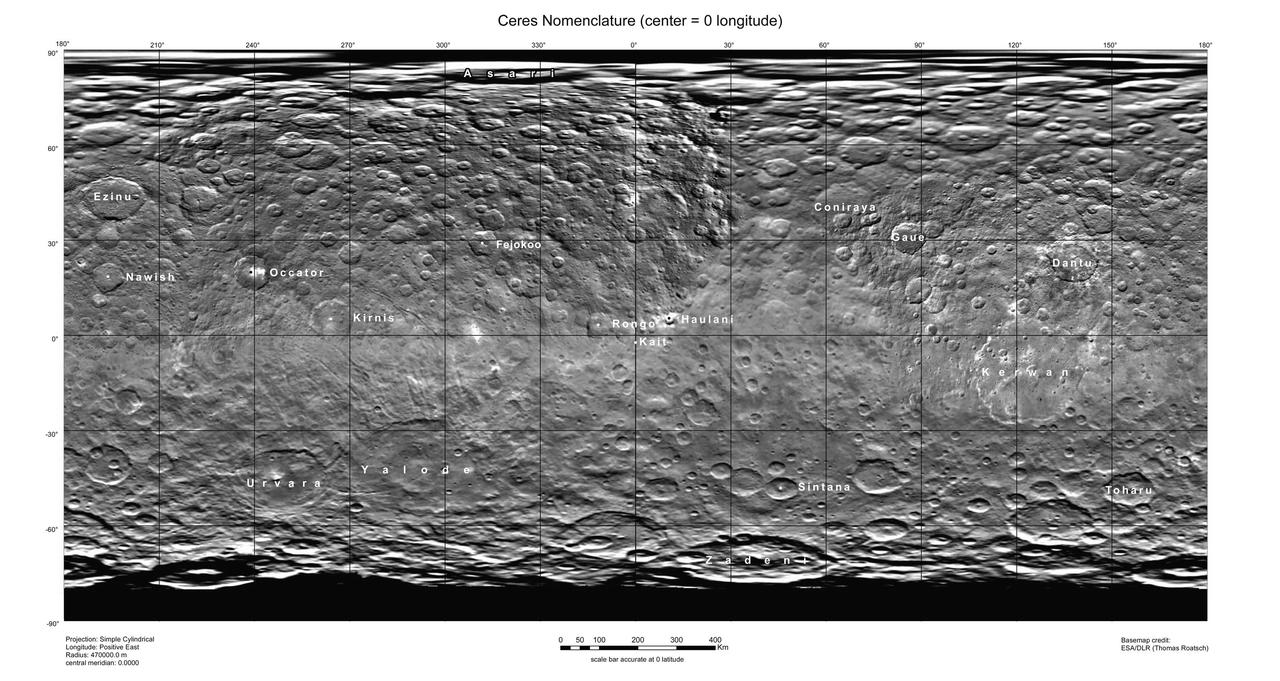
This map of Ceres, constructed from data collected by NASA's Dawn spacecraft, shows the dwarf planet's surface with features that have been named as of August 14, 2015. This is a simple cylindrical projection centered on 0 degrees east longitude, created by science team members at the German Aerospace Center (DLR). The most recently named feature is the small crater Kait, after the Hattic goddess of grain. It is a mere 0.2 miles (0.4 kilometers) across. A full list of crater names on Ceres is available at http://planetarynames.wr.usgs.gov/SearchResults%3Ftarget=CERES. http://photojournal.jpl.nasa.gov/catalog/PIA19625
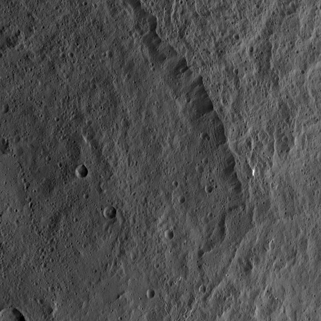
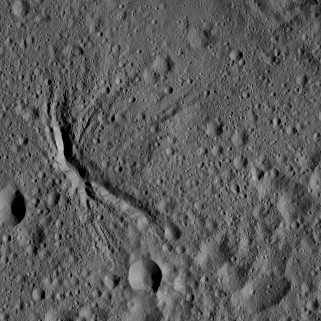
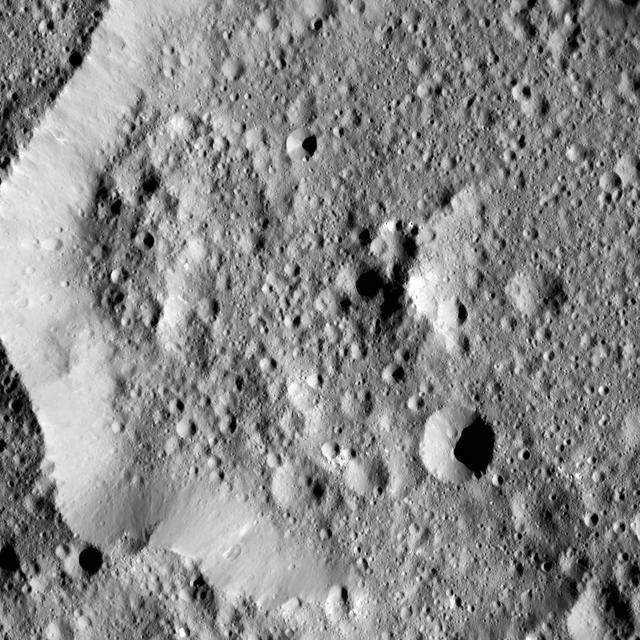
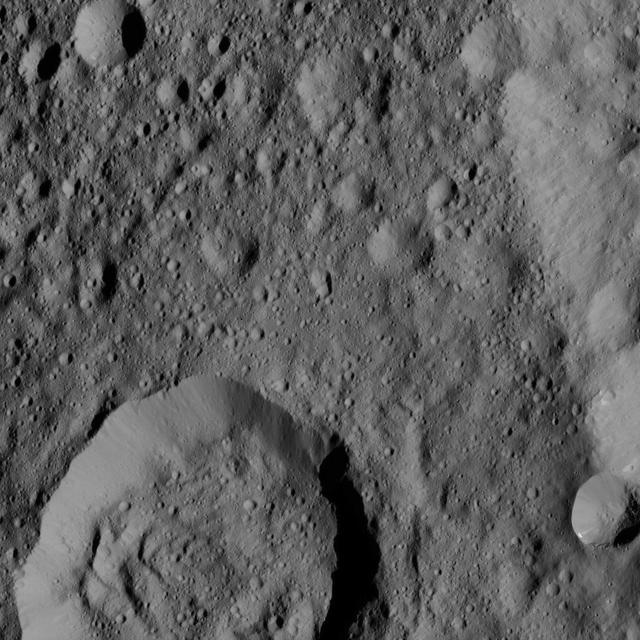
This view from NASA's Dawn spacecraft shows the rim of the large impact feature named Yalode in the southern mid-latitudes on dwarf planet Ceres. Linear, roughly parallel features are visible in the crater wall. Dawn took this image on Oct. 14, 2015, from an altitude of 915 miles (1,470 kilometers). It has a resolution of 450 feet (140 meters) per pixel. http://photojournal.jpl.nasa.gov/catalog/PIA20131
This image captured by NASA Mars Odyssey orbiter shows a Martian pit feature on the slope of an equatorial volcano named Pavonis Mons, appears to be a skylight in an underground lava tube.

The aptly named Cocoon nebula is featured in this image from NASA Wide-field Infrared Survey Explorer. This cloud of dust and gas is located in the constellation Cygnus, and is wrapped in a dark cloud of dust called Barnard 168.
Peaking into the Shadows. This image from NASA MESSENGER spacecraft features Laxness, a crater on Mercury northern plains named for Halldör Laxness, a twentieth-century Icelandic writer.
The long sharp-crested features observed in this image from NASA Mars Odyssey spacecraft are named yardangs. Yardangs form by wind erosion and typically lie in the direction of the dominant wind.
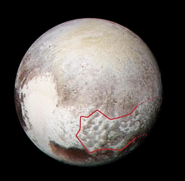
The red outline in this global view of Pluto from NASA New Horizons marks the large area of mysterious, bladed terrain extending from the eastern section of the large feature informally named Tombaugh Regio.

This infrared image from NASA Wide-field Infrared Survey Explorer features one of the bright stars in the constellation Perseus, named Menkhib, along with a large star forming cloud commonly called the California Nebula.
This NASA Mars Odyssey image shows a remarkable array of dunes on the floor of a large impact crater named Baldet. Many of the dunes in this region are isolated features with large, sand-free interdune surfaces between the individual dunes.
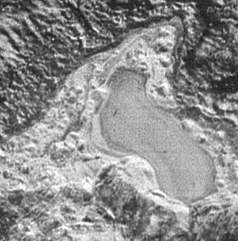
NASA New Horizons spacecraft captured this feature which appears to be a frozen, former lake of liquid nitrogen, located in a mountain range just north of Pluto informally named Sputnik Planum.
This shaded relief view from NASA New Horizons of the region surrounding the left side of Pluto heart-shaped feature, informally named Sputnik Planum, shows that the vast expanse of its icy surface.
The feature informally named Shoemaker Ridge in the Cape York segment of the western rim of Endeavour Crater includes outcrops that are likely impact breccias as seen by NASA rover Opportunity.
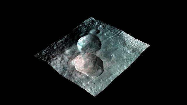
This image from NASA Dawn mission shows a 3-D rendering of the craters that make up the nowman feature on the giant asteroid Vesta. From left to right, the craters are named Marcia, Calpurnia, and Minucia.
This picture from NASA Dawn spacecraft shows a network of canyon-like features near the center of Ezinu Crater on Ceres. Ezinu measures about 72 miles 116 kilometers in diameter and was named for the Sumerian goddess of grain
Ernutet Crater is featured in this image from Ceres, taken by NASA Dawn spacecraft. Ernutet was named for the Egyptian cobra-headed goddess of the harvest. The crater measures about 32 miles 52 kilometers in diameter and is located in the northern hem

This image from the Radar instrument aboard NASA Cassini spacecraft show the evolution of a transient feature in the large hydrocarbon sea named Ligeia Mare on Saturn moon Titan.
These Mars Odyssey images show the White Rock feature on Mars in both infrared left and visible right wavelengths. White Rock is the unofficial name for this landform that was first observed during NASA Mariner 9 mission in the early 1970.
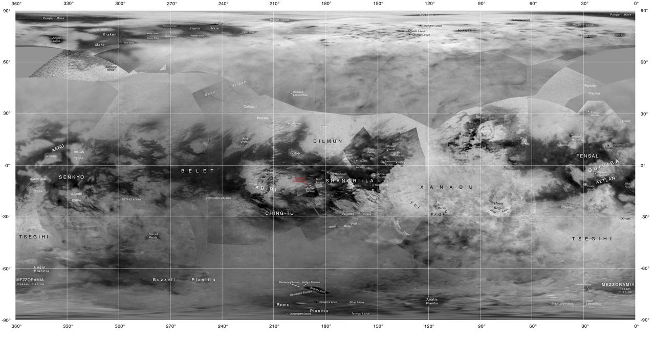
This map of Titan shows the names of many (but not all) features on the Saturnian moon that have been approved by the International Astronomical Union. This map was produced by the USGS Astrogeology Science Center for the International Astronomical Union (IAU) Working Group for Planetary System Nomenclature. http://photojournal.jpl.nasa.gov/catalog/PIA20713
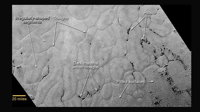
This annotated view of a portion of Pluto's Sputnik Planum (Sputnik Plain), named for Earth's first artificial satellite, shows an array of enigmatic features. The surface appears to be divided into irregularly shaped segments that are ringed by narrow troughs, some of which contain darker materials. Features that appear to be groups of mounds and fields of small pits are also visible. This image was acquired by the Long Range Reconnaissance Imager (LORRI) on July 14 from a distance of 48,000 miles (77,000 kilometers). Features as small as a half-mile (1 kilometer) across are visible. The blocky appearance of some features is due to compression of the image. http://photojournal.jpl.nasa.gov/catalog/PIA19714
NASA's Dawn spacecraft spied this relatively smooth area of Ceres' surface, which includes the feature named Dalien Tholus -- a dome-shaped feature visible in top right quadrant of the image. The image is centered at approximately 2.5 degrees north latitude, 4.3 degrees east longitude. Dawn took this image on May 28, 2016, from its low-altitude mapping orbit, at a distance of about 240 miles (385 kilometers) above the surface. The image resolution is 120 feet (35 meters) per pixel. http://photojournal.jpl.nasa.gov/catalog/PIA20878
Angustus Labyrinthus is a unique region near the south polar cap. The squares formed by intersecting ridges have given the feature the informal name of Inca City. The linear ridges are believed to have formed by volcanic and tectonic forces, where magma filled fractures in the subsurface and then erosion revealed the magmatic material. Orbit Number: 76172 Latitude: -81.2617 Longitude: 295.232 Instrument: VIS Captured: 2019-02-15 06:40 https://photojournal.jpl.nasa.gov/catalog/PIA23190
The crater identified in this NAC image was named in November 2008 for Ronald Moody, a 20th century Jamaican sculptor and painter. Moody features a central peak or peak-ring structure and an annulus of dark material on its outer floor green arrows.
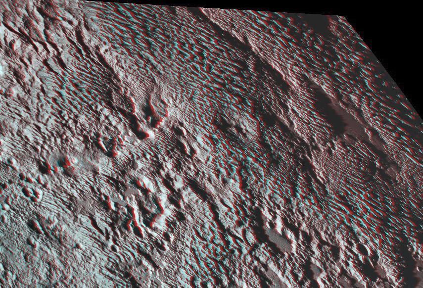
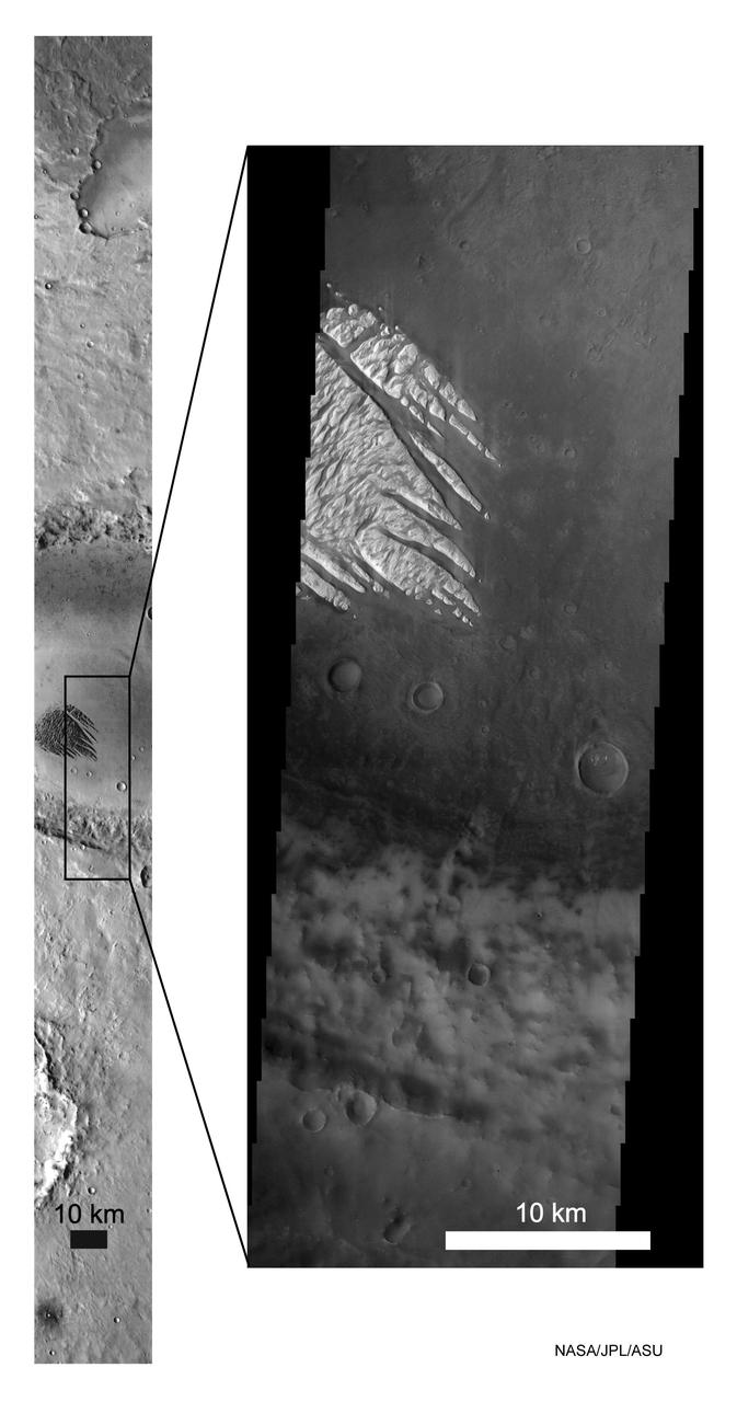
One of the strangest landforms spotted by NASA New Horizons spacecraft when it flew past Pluto last July was the bladed terrain just east of Tombaugh Regio, the informal name given to Pluto large heart-shaped surface feature.
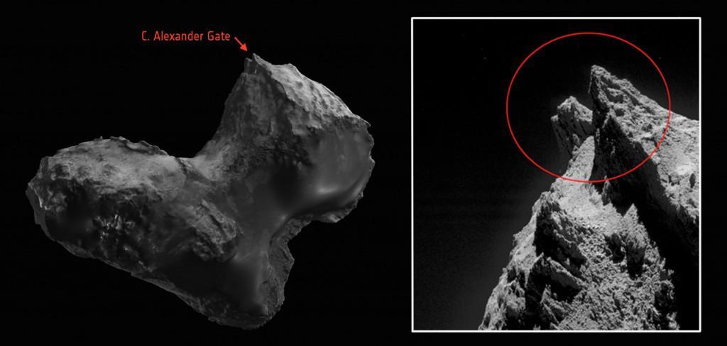
Scientists from the European Space Agency Rosetta team have honored two late team members by naming comet features after them. The comet is 67P/Churyumov-Gerasimenko, where the mission successfully landed a probe. One of the features is shown here in these Rosetta images, with the picture on the right being a close-up view. The "C. Alexander Gate" is found on the comet's smaller lobe, and is dedicated to Claudia Alexander, the U.S. project scientist from NASA's Jet Propulsion Laboratory, Pasadena, California, who passed away in July of this year. Image credit left: ESA's comet viewer http://sci.esa.int/comet-viewer. http://photojournal.jpl.nasa.gov/catalog/PIA19838
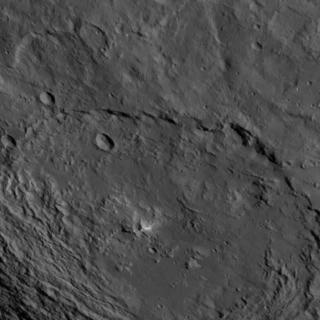
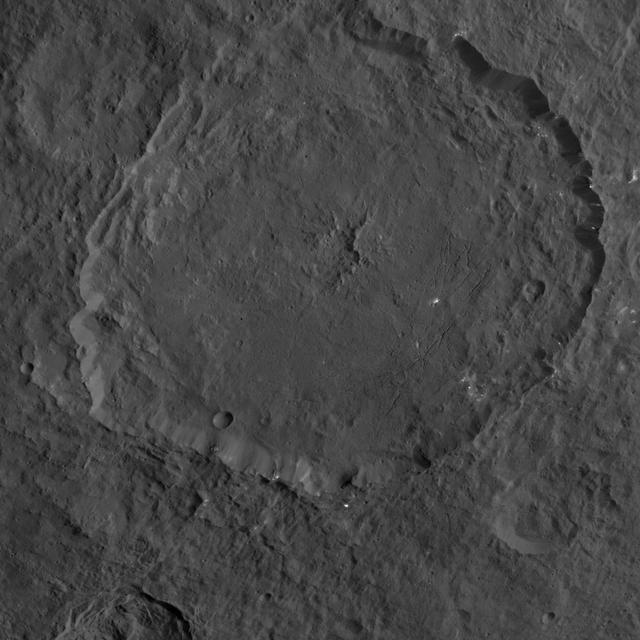
This scene from Ceres features terrain near the rim of the large crater named Kerwan, at lower left. At 174 miles (280 kilometers) in diameter, Kerwan is the largest crater that Dawn has discovered on Ceres. A much smaller, fresher crater called Cacaguat is seen in the lower right corner. Cacaguat, named for the Nicaraguan god of cacao, is 8.5 miles (13.6 kilometers) in diameter. Dawn took this image on Oct. 20, 2016, from its second extended-mission science orbit (XMO2), at a distance of about 920 miles (1,480 kilometers) above the surface. The image resolution is about 460 feet (140 meters) per pixel. http://photojournal.jpl.nasa.gov/catalog/PIA21241
Zadeni Crater on Ceres is featured in this image from NASA's Dawn spacecraft. This large southern-hemisphere crater is 79.5 miles (128 kilometers) in diameter and is named for an ancient Georgian god of bountiful harvest. Dawn took this image on Oct. 19 from its second extended-mission science orbit (XMO2), at a distance of about 920 miles (1,480 kilometers) above the surface. The image resolution is about 460 feet (140 meters) per pixel. http://photojournal.jpl.nasa.gov/catalog/PIA21229
This image, taken by NASA's Dawn spacecraft, shows a portion of the southern hemisphere of dwarf planet Ceres from an altitude of 915 miles (1,470 kilometers). The image was taken on Sept. 28, 2015, and has a resolution of 450 feet (140 meters) per pixel. Urvara crater, named for the Indian and Iranian deity of plants and fields, is featured. Its diameter is 101 miles (163 kilometers). http://photojournal.jpl.nasa.gov/catalog/PIA19992
NASA Dawn spacecraft took this image on Feb. 4, 2016, showing a double impact feature at high northern latitudes on Ceres, just south of the large crater named Ghanan. NASA's Dawn spacecraft took this image on Feb. 4, 2016, from its low-altitude mapping orbit, at a distance of about 240 miles (385 kilometers) above the surface. The image resolution is 120 feet (35 meters) per pixel. http://photojournal.jpl.nasa.gov/catalog/PIA20835
This image, taken by NASA's Dawn spacecraft, shows a portion of the northern hemisphere of dwarf planet Ceres from an altitude of 915 miles (1,470 kilometers). The image was taken on Sept. 25, 2015, and has a resolution of 450 feet (140 meters) per pixel. Dantu crater, named for the Ghanan god associated with the planting of corn, is featured in this image. Its diameter is 77.1 miles (124 kilometers). http://photojournal.jpl.nasa.gov/catalog/PIA19993
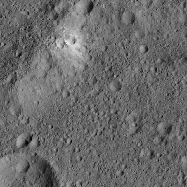
This image from NASA's Dawn spacecraft features bright material (at upper left) along the rim of the giant crater named Kerwan (174 miles, 280 kilometers wide) on Ceres. The image is centered at 1.8 degrees south latitude, 112 degrees east longitude. Dawn took this image on June 6, 2016, from its low-altitude mapping orbit, at a distance of about 240 miles (385 kilometers) above the surface. The image resolution is 120 feet (35 meters) per pixel. http://photojournal.jpl.nasa.gov/catalog/PIA20956
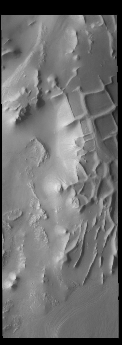
Angustus Labyrinthus is a unique region near the south polar cap. The squares formed by intersecting ridges earned the feature the informal name of the Inca City when it was discovered in Mariner 9 images in 1972. The linear ridges are believed to have formed by volcanic and tectonic forces, where magma filled fractures in the subsurface and then erosion revealed the magmatic material. Orbit Number: 84158 Latitude: -81.3484 Longitude: 296.938 Instrument: VIS Captured: 2020-12-03 20:45 https://photojournal.jpl.nasa.gov/catalog/PIA24408
Liber Crater is featured at lower left in this image from Ceres. Named for the Roman god of agriculture, Liber is 14 miles 23 kilometers. NASA's Dawn spacecraft took this image on June 16, 2016, from its low-altitude mapping orbit, at a distance of about 240 miles (385 kilometers) above the surface. The image resolution is 120 feet (35 meters) per pixel. http://photojournal.jpl.nasa.gov/catalog/PIA20834
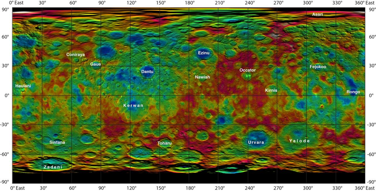
This color-coded map from NASA Dawn mission shows the highs and lows of topography on the surface of dwarf planet Ceres. It is labeled with names of features approved by the International Astronomical Union. Occator, the mysterious crater containing Ceres' mysterious bright spots, is named after the Roman agriculture deity of harrowing, a method of leveling soil. They retain their bright appearance in this map, although they are color-coded in the same green elevation of the crater floor in which they sit. The color scale extends about 5 miles (7.5 kilometers) below the surface in indigo to 5 miles (7.5 kilometers) above the surface in white. The topographic map was constructed from analyzing images from Dawn's framing camera taken from varying sun and viewing angles. The map was combined with an image mosaic of Ceres and projected as an simple cylindrical projection. http://photojournal.jpl.nasa.gov/catalog/PIA19606
NASA New Horizons scientists believe that the informally named feature Wright Mons, located south of Sputnik Planum on Pluto, and another, Piccard Mons, could have been formed by the cryovolcanic eruption of ices from beneath Pluto surface. Sputnik Planum on Pluto, is an unusual feature that's about 100 miles (160 kilometers) wide and 13,000 feet (4 kilometers) high. It displays a summit depression (visible in the center of the image) that's approximately 35 miles (56 kilometers) across, with a distinctive hummocky texture on its sides. The rim of the summit depression also shows concentric fracturing. http://photojournal.jpl.nasa.gov/catalog/PIA20155
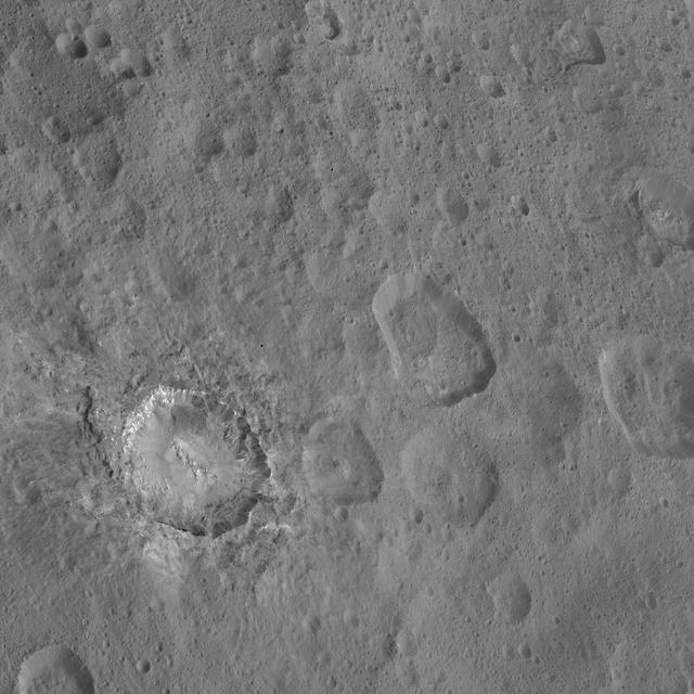
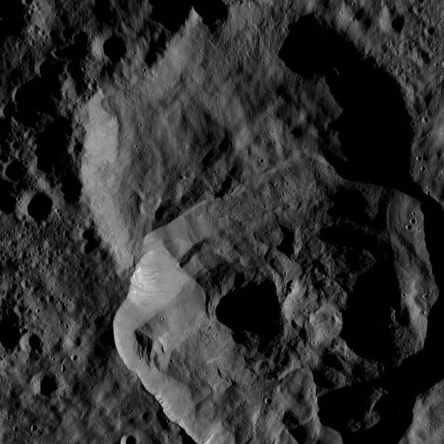
This image from NASA's Dawn spacecraft shows the dramatic-looking crater named Haulani on Ceres. This relatively young crater was named for a Hawaiian plant goddess, and measures 19 miles (31 kilometers) in diameter. The crater features a central ridge and streaks of bright material on its walls. Ejected material from the crater's formation blankets the surrounding area, muting the appearance of older impact features. Dawn took this image on Oct. 14, 2015, from an altitude of 915 miles (1,470 kilometers). It has a resolution of 450 feet (140 meters) per pixel. http://photojournal.jpl.nasa.gov/catalog/PIA20129
This view from NASA Dawn spacecraft features a crater named Oxo, which is about 6 miles 9 kilometers in diameter. A short, linear slump, where a mass of material has dropped below the surface, is seen to the left of Oxo crater rim. Dawn took this image on Oct. 17, 2015, from an altitude of 915 miles (1,470 kilometers). It has a resolution of 450 feet (140 meters) per pixel. http://photojournal.jpl.nasa.gov/catalog/PIA20136
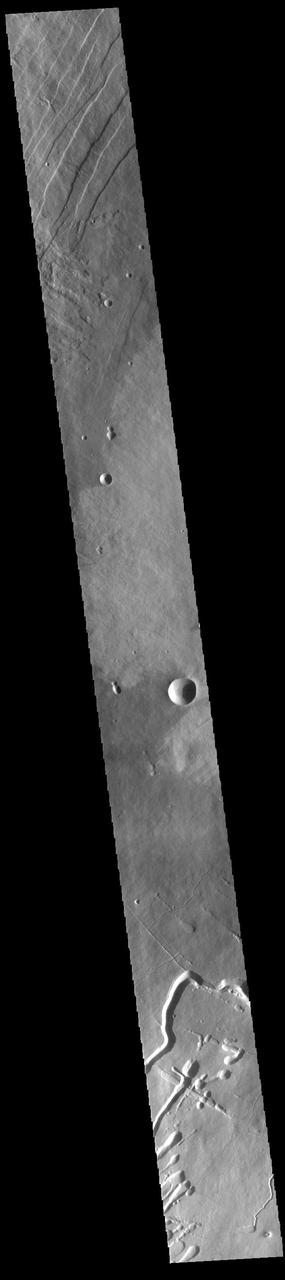
This image from NASA Mars Reconnaissance Orbiter of craters near Nilokeras Scopulus shows two pits partially filled with lumpy material, probably trapped dust that blew in from the atmosphere. This image shows two pits partially filled with lumpy material, probably trapped dust that blew in from the atmosphere. The pits themselves resemble impact craters, but they are part of a chain of similar features aligned with nearby faults, so they could be collapse features instead. Note also the tracks left by rolling boulders at the bottom of the craters. Nilokeras Scopulus is the name for the cliff, about 756 kilometers long, in the northern hemisphere of Mars where these craters are located. It was named based on an albedo (brightness) feature mapped by astronomer E. M. Antoniadi in 1930. http://photojournal.jpl.nasa.gov/catalog/PIA19304
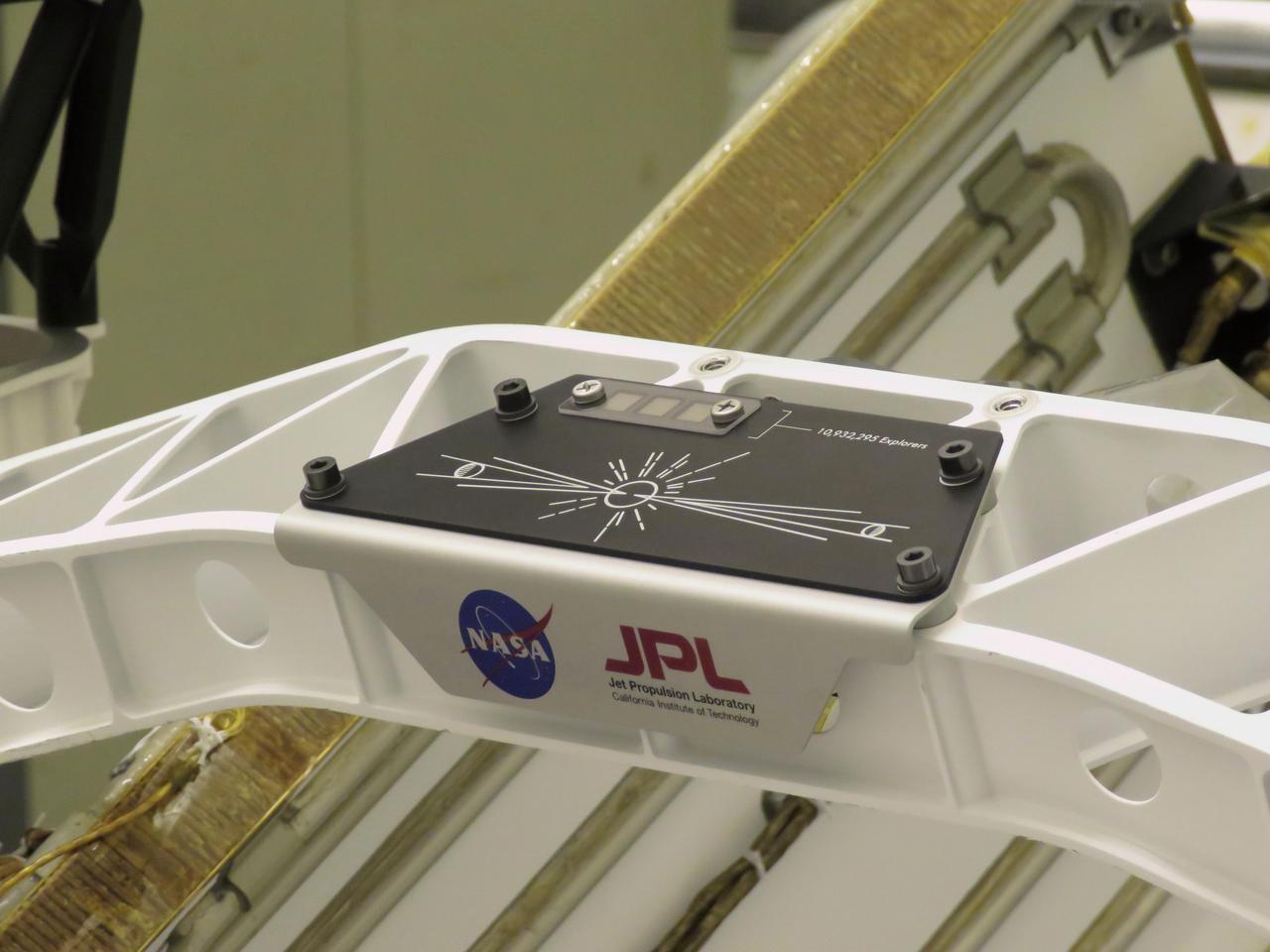
A placard commemorating NASA's "Send Your Name to Mars" campaign was installed on the Perseverance Mars rover on March 16, 2020, at NASA's Kennedy Space Center in Florida. Three fingernail-sized chips affixed to the upper-left corner of the placard feature the names of 10,932,295 people who participated. They were individually stenciled onto the chips by electron beam, along with the essays of the 155 finalists in NASA's "Name the Rover" contest. Liftoff aboard a United Launch Alliance Atlas V 541 rocket is targeted for mid-July of 2020 from Cape Canaveral Air Force Station. NASA's Launch Services Program, based at Kennedy, is managing the launch. https://photojournal.jpl.nasa.gov/catalog/PIA23769

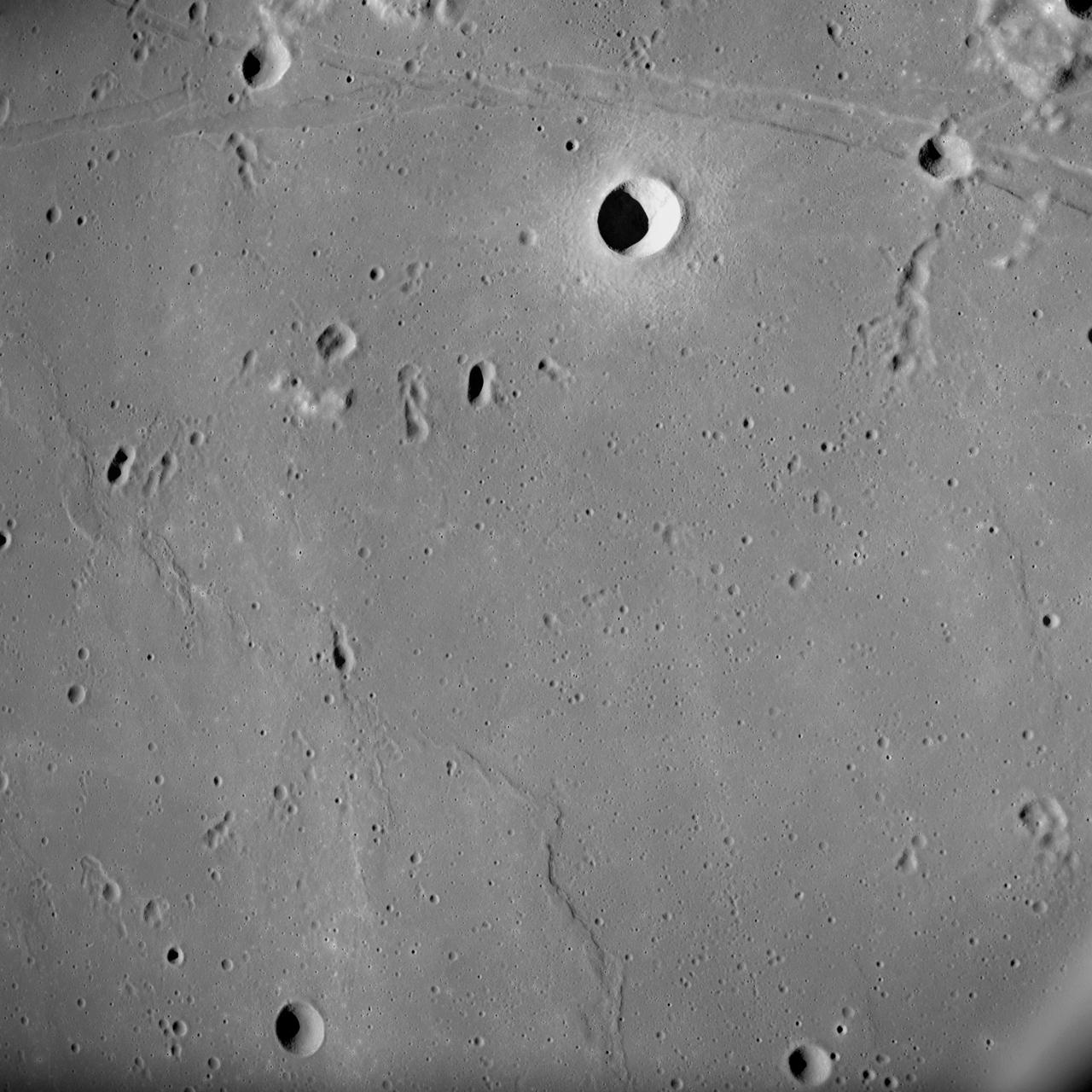
S71-40085 (July 1971) --- An enlarged Lunar Orbiter photograph of the Apollo 15 landing area in the Hadley-Apennine region on the nearside of the moon. The overlay indicates the location of the numerous informally-named surface features. These names will facilitate understanding the verbal descriptions from the astronauts during their lunar surface extravehicular activity (EVA). This is an August 1967, Lunar Orbiter V photograph of Site 26.1.

Ceres' Ezinu Crater is seen at top right in this image from NASA's Dawn spacecraft. The crater features a network of canyon-like features. Ezinu measures about 72 miles (116 kilometers) in diameter and was named for the Sumerian goddess of grain. Dawn took this image on Oct. 21, 2016, from its second extended-mission science orbit (XMO2), at a distance of about 920 miles (1,480 kilometers) above the surface. The image resolution is about 460 feet (140 meters) per pixel. http://photojournal.jpl.nasa.gov/catalog/PIA21240
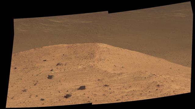
This scene from the panoramic camera (Pancam) on NASA's Mars Exploration Rover Opportunity shows "Spirit Mound" overlooking the floor of Endeavour Crater. The mound stands near the eastern end of "Bitterroot Valley" on the western rim of the crater, and this view faces eastward. For scale, the two rocks at lower center are each about 8 inches (about 20 centimeters) across. At the mound's crest line, the image covers an area about 28 feet (about 8.5 meters) wide. The component images for this mosaic were taken on Sept. 21, 2016, during the 4,501st Martian day, or sol, of Opportunity's work on Mars. Exposures were taken through three of the Pancam's color filters, centered on wavelengths of 753 nanometers (near-infrared), 535 nanometers (green) and 432 nanometers (violet). The scene is presented here in approximately true color. The informal name the rover's science team chose for this feature refers to Spirit Mound in South Dakota. The team is using names of sites visited by the Lewis and Clark Expedition as informal names for features in Mars' Bitterroot Valley (named for a valley that the expedition visited in Montana). http://photojournal.jpl.nasa.gov/catalog/PIA20851
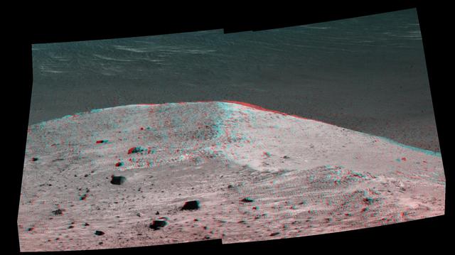
This stereo scene from NASA's Mars Exploration Rover Opportunity shows "Spirit Mound" overlooking the floor of Endeavour Crater. The mound stands near the eastern end of "Bitterroot Valley" on the western rim of the crater, and this view faces eastward. The image combines views from the left eye and right eye of the rover's panoramic camera (Pancam) to appear three-dimensional when seen through blue-red glasses with the red lens on the left. The component images were taken on Sept. 21, 2016, during the 4,501st Martian day, or sol, of Opportunity's work on Mars For scale, the two rocks at lower center are each about 8 inches (about 20 centimeters) across. At the mound's crest line, the image covers an area about 28 feet (about 8.5 meters) wide. The informal name the rover's science team chose for this feature refers to Spirit Mound in South Dakota. The team is using names of sites visited by the Lewis and Clark Expedition as informal names for features in Mars' Bitterroot Valley (named for a valley that the expedition visited in Montana). http://photojournal.jpl.nasa.gov/catalog/PIA20853
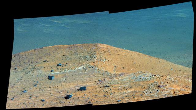
This scene from the panoramic camera (Pancam) on NASA's Mars Exploration Rover Opportunity shows "Spirit Mound" overlooking the floor of Endeavour Crater. The mound stands near the eastern end of "Bitterroot Valley" on the western rim of the crater, and this view faces eastward. In this version of the scene the landscape is presented in enhanced color to make differences in surface materials more easily visible For scale, the two rocks at lower center are each about 8 inches (about 20 centimeters) across. At the mound's crest line, the image covers an area about 28 feet (about 8.5 meters) wide. The component images for this mosaic were taken on Sept. 21, 2016, during the 4,501st Martian day, or sol, of Opportunity's work on Mars. Exposures were taken through three of the Pancam's color filters, centered on wavelengths of 753 nanometers (near-infrared), 535 nanometers (green) and 432 nanometers (violet). The informal name the rover's science team chose for this feature refers to Spirit Mound in South Dakota. The team is using names of sites visited by the Lewis and Clark Expedition as informal names for features in Mars' Bitterroot Valley (named for a valley that the expedition visited in Montana). http://photojournal.jpl.nasa.gov/catalog/PIA20852
This frame from a video shows a flyover of the intriguing crater named Occator on dwarf planet Ceres. Occator is home to Ceres brightest area. Occator is home to Ceres' brightest area. It may have been produced by upwelling of salt-rich liquids after the impact that formed the crater. The animated flyover includes topographic and enhanced-color views of the crater, highlighting the central dome feature. The central area has been named Cerealia Facula. Occator's secondary group of bright spots is called Vinalia Faculae. A video is available at http://photojournal.jpl.nasa.gov/catalog/PIA21080

The mission insignia for NASA's STS-31 mission features the Hubble Space Telescope (HST) in its observing configuration against a background of the universe it will study. The cosmos includes a stylistic depiction of galaxies in recognition of the contribution made by Sir Edwin Hubble to our understanding of the nature of galaxies and the expansion of the universe. The STS-31 crew points out that is it in honor of Hubble's work that this great observatory in space bears his name. The depicted Space Shuttle trails a spectrum symbolic of both the red shift observations that were so important to Hubble's work and new information which will be obtained with the HST. Encircling the art work, designed by the crew, are the names of its members.
This image from NASA's Dawn spacecraft shows a group of craters, left of center, that resembles a rubber duck. Halki Crater, the "head," is 12 miles (20 kilometers) in diameter, while Telepinu Crater, the "body," is 19 miles (31 kilometers) across. They can be found in the global map of Ceres' names. The "beak" crater is unnamed. Halki and Telepinu have both been recently added to the list of official names for Ceres' geological features. They are both named after Hittite (Asia Minor) deities: the goddess of grain and the god of fertility and vegetation, respectively. Dawn acquired this picture on August 20, 2015, from its high-altitude mapping orbit at about 915 miles (1,470 kilometers) above the surface. The center coordinates of this image are 26 degrees north latitude, 339 degrees east longitude. https://photojournal.jpl.nasa.gov/catalog/PIA21909
At center left of Pluto vast heart-shaped feature "Tombaugh Regio" -- lies a vast, craterless plain that appears to be no more than 100 million years old, and is possibly still being shaped by geologic processes as seen by NASA New Horizons spacecraft. This frozen region is north of Pluto's icy mountains and has been informally named Sputnik Planum (Sputnik Plain), after Earth's first artificial satellite. The surface appears to be divided into irregularly-shaped segments that are ringed by narrow troughs. Features that appear to be groups of mounds and fields of small pits are also visible. This image was acquired by the Long Range Reconnaissance Imager (LORRI) on July 14 from a distance of 48,000 miles (77,000 kilometers). Features as small as one-half mile (1 kilometer) across are visible. The blocky appearance of some features is due to compression of the image. http://photojournal.jpl.nasa.gov/catalog/PIA19841
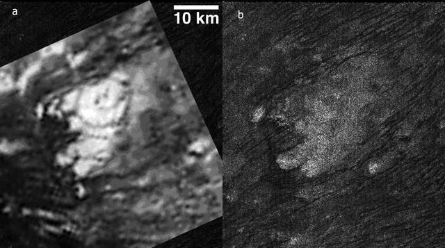
This MDIS mosaic from NASA MESSENGER spacecraft provides a detailed view of the features and structures associated with the peak-ring basin Raditladi. Raditladi, first imaged during MESSENGER's first Mercury flyby and named in April 2008, continues to be an intriguing region of study, with its well-preserved features, relatively young age, exterior impact melt ponds, hollows-covered peak ring, and concentric troughs on its floor. Instrument: Mercury Dual Imaging System (MDIS) Center Latitude: 27.1° N Center Longitude: 119.2° E Scale: Raditladi has a diameter of 258 kilometers (160 miles) http://photojournal.jpl.nasa.gov/catalog/PIA19409
Part of Ezinu Crater on Ceres is seen at top left in this image from NASA's Dawn spacecraft. The crater features a network of canyon-like features. Ezinu measures about 72 miles (116 kilometers) in diameter and was named for the Sumerian goddess of grain. Dawn took this image on Oct. 20, 2016, from its second extended-mission science orbit (XMO2), at a distance of about 920 miles (1,480 kilometers) above the surface. The image resolution is about 460 feet (140 meters) per pixel. http://photojournal.jpl.nasa.gov/catalog/PIA21239
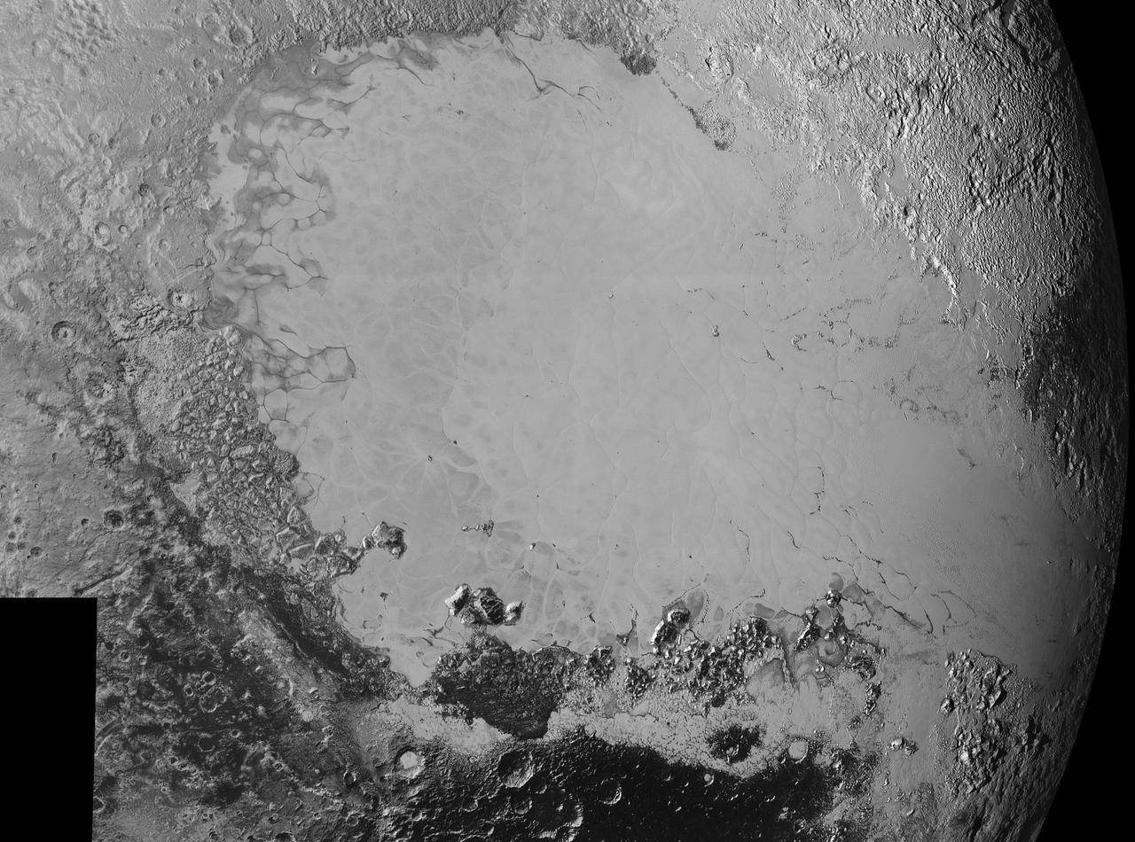
Mosaic of high-resolution images of Pluto, sent back from NASA's New Horizons spacecraft from Sept. 5 to 7, 2015. The image is dominated by the informally-named icy plain Sputnik Planum, the smooth, bright region across the center. This image also features a tremendous variety of other landscapes surrounding Sputnik. The smallest visible features are 0.5 miles (0.8 kilometers) in size, and the mosaic covers a region roughly 1,000 miles (1600 kilometers) wide. The image was taken as New Horizons flew past Pluto on July 14, 2015, from a distance of 50,000 miles (80,000 kilometers). http://photojournal.jpl.nasa.gov/catalog/PIA19936

This image taken by NASA's Dawn spacecraft shows Duginavi Crater, a large (96 miles, 155 kilometers in diameter) crater on Ceres. Duginavi's degraded rim barely stands out in this picture, which indicates this feature is very old. There are several factors that alter and eventually erase the shapes of geological features on bodies that do not have an atmosphere. These include gravity, which is responsible for landslides and scarps. The formation of newer craters, and the material that gets ejected in the process, has smoothed over craters such as Duginavi. Duginavi hosts the small Oxo Crater, recognizable by its bright rim and ejecta. Oxo is the first site at which ice was discovered on Ceres. Duginavi is named for an agriculture god of the Kogi people of northern Colombia. Oxo bears the name of the god of agriculture in Afro-Brazilian beliefs of Yoruba derivation. These features can be found on the global map of Ceres. Dawn took this image on October 8, 2015, from its high-altitude mapping orbit, at a distance of about 915 miles (1,470 kilometers) above the surface. It has a resolution of 450 feet (140 meters) per pixel. The center coordinates of this image are 39 degrees north latitude, 8 degrees east longitude. https://photojournal.jpl.nasa.gov/catalog/PIA21912
This region on Ceres, located in the vicinity of Toharu Crater, presents two small craters: Juling at top (12 miles, 20 kilometers in diameter) and Kupalo at bottom (16 miles, 26 kilometers in diameter). Both craters are relatively young, as indicated by their sharp rims. These features are located at about the same latitude (about 38 degrees south) as Tawals Crater and show similar crater shapes and rugged terrain. These features may reflect the presence of ice below the surface. Subtle bright features can be distinguished in places. These likely were excavated by small impacts and landslides along the slopes of the crater rims. This suggests that a different type of material, likely rich in salts, is present in the shallow subsurface. Juling is named after the Sakai/Orang Asli spirit of the crops from Malaysia, and Kupalo gets its name from the Russian god of vegetation and of the harvest. NASA's Dawn spacecraft acquired this picture on August 24, 2016. The image was taken during Dawn's extended mission, from its low altitude mapping orbit at about 240 miles (385 kilometers) above the surface. The center coordinates of this image are 38 degrees south latitude, 165 degrees east longitude. https://photojournal.jpl.nasa.gov/catalog/PIA21753
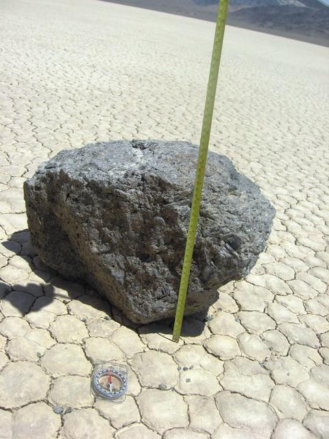
Some of the moving rocks are large. This one is about 10 inches tall. Researchers in the late 1960s and early 1970s documented the movements of one very large rock that they named Karen. (The two men named all the rocks after women.) They estimated that Karen weighed 700 pounds. Credit: NASA/GSFC/Maggie McAdam To read a feature story on the Racetrack Playa go to: <a href="http://www.nasa.gov/topics/earth/features/roving-rocks.html" rel="nofollow">www.nasa.gov/topics/earth/features/roving-rocks.html</a> <b><a href="http://www.nasa.gov/centers/goddard/home/index.html" rel="nofollow">NASA Goddard Space Flight Center</a></b> is home to the nation's largest organization of combined scientists, engineers and technologists that build spacecraft, instruments and new technology to study the Earth, the sun, our solar system, and the universe. <b>Follow us on <a href="http://twitter.com/NASA_GoddardPix" rel="nofollow">Twitter</a></b> <b>Join us on <a href="http://www.facebook.com/pages/Greenbelt-MD/NASA-Goddard/395013845897?ref=tsd" rel="nofollow">Facebook</a><b></b></b>
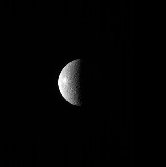
A bright spot can be seen on the left side of Rhea in this image. The spot is the crater Inktomi, named for a Lakota spider spirit. Inktomi is believed to be the youngest feature on Rhea (949 miles or 1527 kilometers across). The relative youth of the feature is evident by its brightness. Material that is newly excavated from below the moon's surface and tossed across the surface by a cratering event, appears bright. But as the newly exposed surface is subjected to the harsh space environment, it darkens. This is one technique scientists use to date features on surfaces. This view looks toward the trailing hemisphere of Rhea. North on Rhea is up and rotated 21 degrees to the left. The image was taken in visible light with the Cassini spacecraft narrow-angle camera on July 29, 2013. The view was obtained at a distance of approximately 1.0 million miles (1.6 million kilometers) fro http://photojournal.jpl.nasa.gov/catalog/PIA18300
AS10-31-4537 (18-26 May 1969) --- This near vertical photograph taken from the Apollo 10 Command and Service Modules shows features typical of the Sea of Tranquility near Apollo Landing Site 2. HOLD PICTURE WITH PRONOUNCED LINEAR FEATURE PARALLEL TO LEFT MARGIN. The proposed landing area for Apollo 11 (Lunar Landing Site 2) is a relatively smooth maria area in the upper right quadrant of the photographed area. Apollo 10 traveled from the bottom to the top of the picture. The prominent linear feature at left is Hypatia Rille (called "U.S. 1" by the Apollo 10 crew). The prominent crater centered in Hypatia Rille at top left is Moltke AC (code name "Chuck Hole"). Moltke, the prominent crater to the right of Hypatia Rille, is centered near 24.2 degrees east longitude, and 0.6 degrees south latitude.
This image, taken by NASA's Dawn spacecraft, shows a portion of the southern hemisphere of dwarf planet Ceres from an altitude of 915 miles (1,470 kilometers). The image was taken on Sept. 22, 2015, and has a resolution of 450 feet (140 meters) per pixel. Zadeni crater, named for the ancient Georgian god of bountiful harvest, is featured in this image. Its diameter is about 80 miles (129 kilometers). http://photojournal.jpl.nasa.gov/catalog/PIA19988
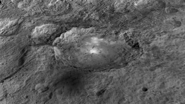
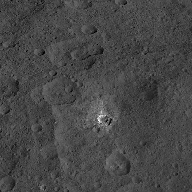
The intriguing brightest spots on Ceres lie in a crater named Occator, which is about 60 miles (90 kilometers) across and 2 miles (4 kilometers) deep. This image comes from an animation, shown in PIA19619, generated using data from NASA's Dawn spacecraft. Vertical relief has been exaggerated by a factor of five. Exaggerating the relief helps scientists understand and visualize the topography much more easily, and highlights features that are sometimes subtle. http://photojournal.jpl.nasa.gov/catalog/PIA19617

StenniSphere, the John C. Stennis Space Center's visitor center in Hancock County, Miss., features a 14,000-square-foot museum and outdoor exhibits about Stennis Space Center. Designed to entertain while educating, StenniSphere includes informative displays and exhibits from NASA, the Naval Meteorology and Oceanography Command, and other resident agencies. Recently named Mississippi's Travel Attraction of the Year, StenniSphere hosted a quarter of a million visitors in its first year and is a major school field trip destination.
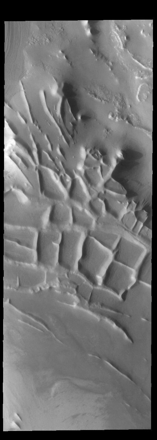
Angustus Labyrinthus is a unique region near the south polar cap. The squares formed by intersecting ridges earned the feature the informal name of the Inca City when it was discovered in Mariner 9 images in 1972. The linear ridges are believed to have formed by volcanic and tectonic forces, where magma filled fractures in the subsurface and then erosion revealed the magmatic material. Orbit Number: 84113 Latitude: -81.4396 Longitude: 296.074 Instrument: VIS Captured: 2020-11-30 03:44 https://photojournal.jpl.nasa.gov/catalog/PIA24407

The dominant features of the STS-51D emblem are an orbit formed by a Colonial American flag and a Space Shuttle. The flag in orbit signifies the U.S. flag to indicate that it comes from this country and the American people. The original 13- star flag is used to symbolize a continuity of technical achievement and progress since colonial times. The name Discovery preceding the flag represents the spirit of Discovery and exploration of new frontiers which have been a hallmark of American people even before they were formed together as a nation.
Liber Crater is featured at lower left in this image from Ceres. Named for the Roman god of agriculture, Liber is 14 miles (23 kilometers) wide. NASA's Dawn spacecraft took this image on June 16, 2016, from its low-altitude mapping orbit, at a distance of about 240 miles (385 kilometers) above the surface. The image resolution is 120 feet (35 meters) per pixel. http://photojournal.jpl.nasa.gov/catalog/PIA20834

ISS023-E-047233 (16 May 2010) --- Intersecting the thin line of Earth's atmosphere, the aft section of space shuttle Atlantis is featured in this image photographed by an Expedition 23 crew member shortly after Atlantis docked with the International Space Station. The Russian-built Mini-Research Module 1 (MRM-1), named Rassvet, is visible in the cargo bay.

The Chinese Zhurong rover, named after the god of fire in Chinese mythology, landed in Utopia Planitia in May 2021. Utopia Planitia is a volcanic region located in the low-lying Northern Hemisphere of Mars. The expansive, flat, smooth plains of Utopia are dimpled by impact craters, volcanic domes, light-toned ridges made of wind-blown materials, and troughs. If the rover continues to drive south from its landing site, this HiRISE view shows the kind of terrain and features Zhurong may explore. https://photojournal.jpl.nasa.gov/catalog/PIA24914
Angustus Labyrinthus is a unique region near the south polar cap. The squares formed by intersecting ridges have given the feature the informal name of Inca City. The linear ridges are believed to have formed by volcanic and tectonic forces, where magma filled fractures in the subsurface and then erosion revealed the magmatic material. Orbit Number: 76102 Latitude: -81.5722 Longitude: 295.757 Instrument: VIS Captured: 2019-02-09 12:13 https://photojournal.jpl.nasa.gov/catalog/PIA23188
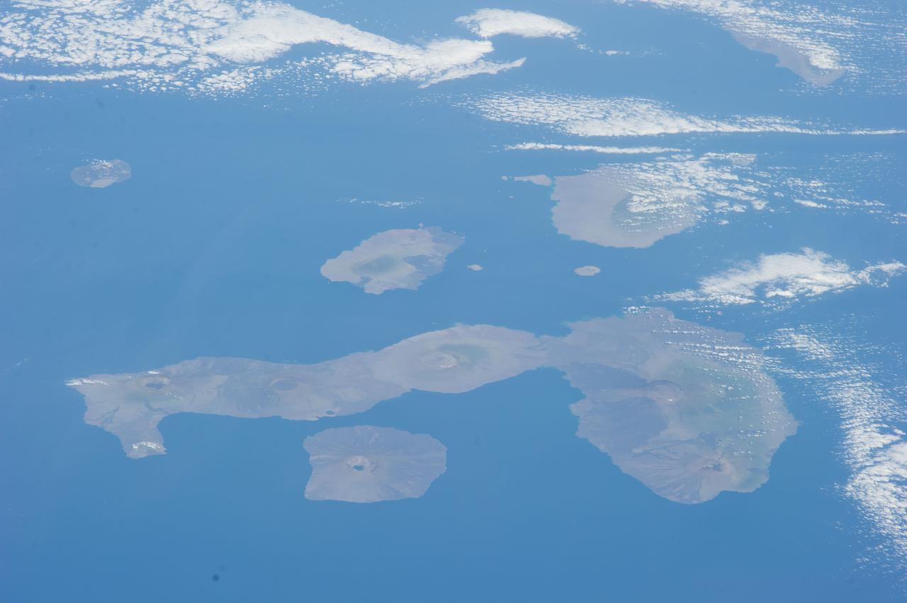
ISS038-E-000232 (11 Nov. 2013) --- One of the Expedition 38 crew members aboard the International Space Station used a 180mm lens to photograph this oblique image featuring the Galapagos Islands or Islas Galapagos, distributed on either side of the Equator in the eastern Pacific Ocean. An archipelago of volcanic islands, the group?s official name is Archipielago de Colon.

ISS023-E-047247 (16 May 2010) --- Space shuttle Atlantis is featured in this image photographed by an Expedition 23 crew member shortly after Atlantis docked with the International Space Station. The Russian-built Mini-Research Module 1 (MRM-1), named Rassvet, is visible in the cargo bay. Earth?s horizon and the blackness of space provide the backdrop for the scene.
This image, taken by NASA's Dawn spacecraft, shows the surface of dwarf planet Ceres from an altitude of 915 miles (1,470 kilometers) around mid-latitudes. The image was taken on Sept. 28, 2015, and has a resolution of 450 feet (140 meters) per pixel. The unusual mountain Ahuna Mons is featured in this image, named for the traditional post-harvest festival of the Sumi tribe of Nagaland, India. It is 4 miles (6 kilometers) tall and 12 miles (20 kilometers) in diameter. http://photojournal.jpl.nasa.gov/catalog/PIA19995

ISS023-E-047286 (16 May 2010) --- The aft section of space shuttle Atlantis is featured in this image photographed by an Expedition 23 crew member shortly after Atlantis docked with the International Space Station. The Russian-built Mini-Research Module 1 (MRM-1), named Rassvet, is visible in the cargo bay. The planet Venus and the moon are visible at top center.

This illustration shows what a sprite could look like in Jupiter's atmosphere. Named after a mischievous, quick-witted character in English folklore, sprites last for only a few milliseconds. They feature a central blob of light with long tendrils of light extending down toward the ground and upward. In Earth's upper atmosphere, their interaction with nitrogen give sprites a reddish hue. At Jupiter, where the predominance of hydrogen in the upper atmosphere would likely give them a blue hue. https://photojournal.jpl.nasa.gov/catalog/PIA23990

NASA's Europa Clipper spacecraft will carry a special message when it launches in October 2024 and heads toward Jupiter's moon Europa. The moon shows strong evidence of an ocean under its icy crust, with more than twice the amount of water of all of Earth's oceans combined. A triangular metal plate, seen here, will honor that connection to Earth. The plate is made of tantalum metal and is about 7 by 11 inches (18 by 28 centimeters). Engraved on both sides, it seals an opening in the electronics vault, which houses the spacecraft's sensitive electronics. The side shown here features U.S. Poet Laureate Ada Limón's handwritten "In Praise of Mystery: A Poem for Europa," and will be affixed with a silicon microchip stenciled with more than 2.6 million names submitted by the public. The microchip will be placed at the center of the illustration of a bottle amid the Jovian system – a reference to NASA's "Message in a Bottle" campaign, which invited the public to send their names with the spacecraft. The artwork includes the Drake Equation, which was formulated by astronomer Frank Drake in 1961 to estimate the possibility of finding advanced civilizations beyond Earth. Also featured is a reference to the radio frequencies considered plausible for interstellar communication, symbolizing how humanity uses this radio band to listen for messages from the cosmos. These particular frequencies match the radio waves emitted in space by the components of water and are known by astronomers as the "water hole." On the plate, they are depicted as radio emission lines. The plate includes a portrait of one of the founders of planetary science, Ron Greeley, whose early efforts to develop a Europa mission two decades ago laid the foundation for Europa Clipper. In the spirit of the Voyager spacecraft's Golden Record, which carries sounds and images to convey the richness and diversity of life on Earth, the layered message on Europa Clipper aims to spark the imagination and offer a unifying vision. Europa Clipper, set to launch from Kennedy Space Center in Florida, will arrive at the Jupiter system in 2030 and conduct about 50 flybys of the moon Europa. The mission's main science goal is to determine whether there are places below Europa, that could support life. The mission's three main science objectives are to determine the thickness of the moon's icy shell and its surface interactions with the ocean below, to investigate its composition, and to characterize its geology. The mission's detailed exploration of Europa will help scientists better understand the astrobiological potential for habitable worlds beyond our planet. https://photojournal.jpl.nasa.gov/catalog/PIA26062

STS090-774-028 (29 April 1998) --- This view features a 13,980-foot mountain peak in Colorado’s Sangre de Cristo Mountains in Saguache County, photographed by crewmembers of the STS-90 Space Shuttle Columbia mission in April 1998. EDITOR’S NOTE: In June 2003, the summit was named “Columbia Point” by the U.S. Department of Interior in memory of the STS-107 Space Shuttle Columbia crew, lost in an accident on February 1, 2003, and for the scientific exploration, technical excellence, and the dream of spaceflight for which the mission stood. Columbia Point is located on the east side of Kit Carson Mountain. On the northwest shoulder of the same mountain is Challenger Point, a peak previously named in memory of the Space Shuttle Challenger, which exploded soon after liftoff on January 28, 1986.
This complex crater in the Navka region of Venus was mapped by Magellan on September 26-27, 1990 during orbits 459 and 460. The crater has a diameter of 22 kilometers (13.6 miles) and is located at latitude 5.75 degrees south, longitude 349.6 degrees east. It has the terraced walls, flat radar-dark floor, and central peak that are characteristic of craters classified as 'complex.' The central peak on its floor is unusually large. Flow-like deposits extend beyond the limits of the coarser rim deposits on its west and southwest. Like about half of the craters mapped by Magellan to date, it is surrounded by a local, radar-dark halo. Buck, the proposed name for this crater honors Pearl S. Buck, American author (1892-1973). Proposed names for all features on planetary bodies are provisional until formally adopted by the International Astronomical Union. http://photojournal.jpl.nasa.gov/catalog/PIA00470
ISS043E128768 (04/21/2015) --- NASA astronaut Scott Kelly on the International Space Station May 6, 2015 tweeted this image out of an Earth observation as part of his Space Geo trivia contest. Scott tweeted this comment and clue: "#SpaceGeo! A serpent is known for deceptive traits, but don’t let this snake pull the wool over your eyes. Name it!” Congratulations to @splinesmith for correctly identifying this image first, : #BighornRiver Montana/Wyoming named in 1805 for Bighorn sheep along its banks. He will receive an autographed copy of this image when Scott returns to Earth in March 2016. Learn more about #SpaceGeo and play along every Wednesday for your chance to win: http://www.nasa.gov/feature/where-over-the-world-is-astronaut-scott-kelly
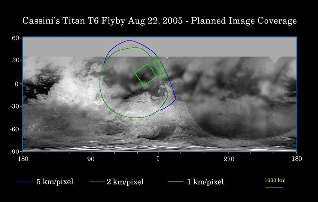
This map of Titan's surface illustrates the regions that will be imaged by Cassini during the spacecraft's close flyby of Titan on Aug. 22, 2005. At closest approach, the spacecraft is expected to pass approximately 3,800 kilometers (2,360 miles) above the moon's surface. At 5,150 kilometers (3,200 miles) across, Titan is one of the solar system's largest moons. The colored lines delineate the regions that will be imaged at differing resolutions. As Cassini continues its reconnaissance of Titan, maps of this haze-enshrouded world continue to improve. Images from this flyby will sharpen the moderate resolution coverage of terrain on the side of Titan that always faces Saturn. The highest resolution image planned for this encounter will cover a 215-kilometer-wide (134-mile) bright feature provisionally named "Bazaruto Facula." (A facula is the name chosen to denote a bright spot on Titan.) At the center of the facula is an 80-kilometer-wide (50-mile) crater (not yet named), seen by Cassini's radar experiment during a Titan flyby in February 2005 (see PIA07368). The imaging cameras and visual and infrared mapping spectrometer images taken in March and April 2005 also show this crater (see PIA06234). The southernmost corner of the highest resolution (1 kilometer per pixel) frame should also cover the northern portion of a large bright feature provisionally known as "Quivira." Wide-angle images obtained during this flyby should cover much of the Tsegihi-Aztlan-Quivira region (also known as the "H" region) at lower resolution. The map shows only brightness variations on Titan's surface (the illumination is such that there are no shadows and no shading from topographic variations). Previous observations indicate that, due to Titan's thick, hazy atmosphere, the sizes of surface features that can be resolved are up to five times larger than the actual pixel scale labeled on the map. The images for this global map were obtained using a narrow-band filter centered at 938 nanometers -- a near-infrared wavelength (invisible to the human eye) at which light can penetrate Titan's atmosphere. The images have been processed to enhance surface details. http://photojournal.jpl.nasa.gov/catalog/PIA07711
ISS009-E-05944 (7 May 2004) --- The Pinacates Biosphere Reserve is featured in this image photographed by an Expedition 9 crewmember on the International Space Station (ISS). The Pinacates—a moon-like volcanic landscape that lies in the Sonoran Desert in Mexico just a few miles from the border with Arizona—is one of the most unique and striking landscapes in North America. The volcanic range is surrounded by one of North America’s largest dune fields, Gran Desierto. The natural history of the region includes thousands of years of human occupation; it is the aboriginal homeland of the O’Odham tribe, also known as the Papago. The region also served as an early training site for Apollo astronauts in the mid-late 1960s. The name Pinacate is derived from “pinacatl,” the Aztec name for the desert stink beetle which is common in the region. The natural and cultural resource management of the region, including the archeological sites and the high biodiversity, is now guaranteed: the site was declared a UNESCO Biosphere Reserve in 1993. The high-resolution image provides a view of a large volcanic crater called Crater Elegante, which is one of the most prominent and interesting features of the Pinacates.
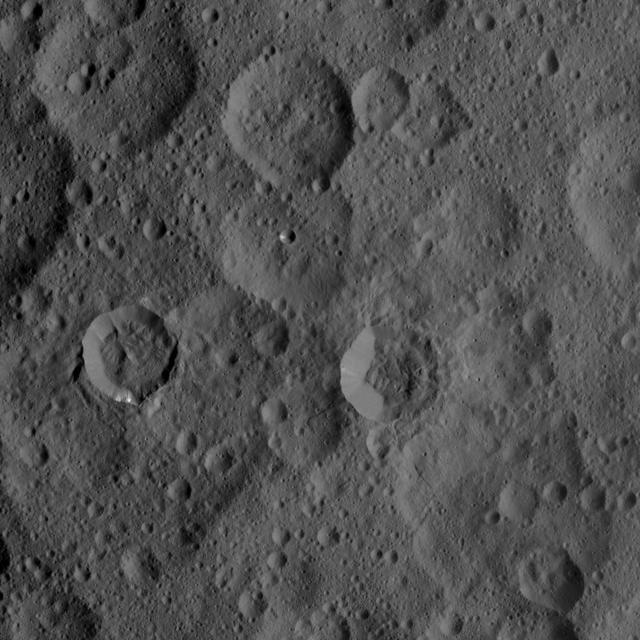
NASA's Dawn spacecraft took this picture as it reached its new orbit to observe Ceres in opposition, when Dawn is directly between the sun and the Occator Crater bright spots. Entering the very tight opposition geometry (explained here) is a major feat that requires extra checks for increased delivery accuracy. Hence, this picture was part of a series of images intended to help the navigation of the spacecraft relative to Ceres. This vantage point highlights the southern hemisphere of Ceres. Abundant polygonal craters can be seen, starting with Kerwan, Ceres' largest crater at 174 miles (280 kilometers) in diameter, in the upper right of Ceres' circular disc. Kerwan's rims appear subdued and its floor is relatively relaxed. The crater found almost in the "bullseye" of the crater is called Insitor (16 miles or 26 kilometers in diameter). The Inamahari and Homshuk craters featured here can be found at the top of the disc. Another large polygonal crater called Chaminuka (76 miles, 122 kilometers in diameter) is found toward the center. This map can be used to locate these and more features. The name "Kerwan" refers to the Hopi spirit of sprouting maize and "Chaminuka" to the Shona (Zimbabwe) spirit who provides rains in times of droughts. "Insitor" is named for the Roman agricultural deity in charge of the sowing. This picture was taken on April 17, 2017, from an altitude of about 28,000 miles (45,000 kilometers). https://photojournal.jpl.nasa.gov/catalog/PIA21403

ISS009-E-05953 (7 May 2004) --- The Pinacates Biosphere Reserve is featured in this image photographed by an Expedition 9 crewmember on the International Space Station (ISS). The Pinacates—a moon-like volcanic landscape that lies in the Sonoran Desert in Mexico just a few miles from the border with Arizona—is one of the most unique and striking landscapes in North America. The volcanic range is surrounded by one of North America’s largest dune fields, Gran Desierto. The natural history of the region includes thousands of years of human occupation; it is the aboriginal homeland of the O’Odham tribe, also known as the Papago. The region also served as an early training site for Apollo astronauts in the mid-late 1960s. The name Pinacate is derived from “pinacatl,” the Aztec name for the desert stink beetle which is common in the region. The natural and cultural resource management of the region, including the archeological sites and the high biodiversity, is now guaranteed: the site was declared a UNESCO Biosphere Reserve in 1993. The high-resolution image provides a view of a large volcanic crater called Crater Elegante, which is one of the most prominent and interesting features of the Pinacates.

ISS043E194350 (05/15/2015) --- NASA astronaut Scott Kelly on the International Space Station tweeted this image out of an Earth observation image as part of his Space Geo trivia contest. Scott tweeted this comment and clue: "#SpaceGeo Four international borders in one photo from the International @Space_Station. Name them"! Two winners! Congrats to @TeacherWithTuba & @PC101!. The correct answer is :#SpaceGeo A: #Denmark #Norway #Sweden #Germany & #Poland. The winners will receive an autographed copy of this image when Scott returns to Earth in March 2016. Learn more about #SpaceGeo and play along every Wednesday for your chance to win: <a href="http://www.nasa.gov/feature/where-over-the-world-is-astronaut-scott-kelly/" rel="nofollow">www.nasa.gov/feature/where-over-the-world-is-astronaut-sc...</a>
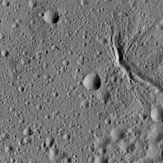
A newly discovered mountain range lies near the southwestern margin of Pluto heart-shaped Tombaugh Regio Tombaugh Region, situated between bright, icy plains and dark, heavily-cratered terrain. This image was acquired by NASA's New Horizons' Long Range Reconnaissance Imager (LORRI) on July 14, 2015, from a distance of 48,000 miles (77,000 kilometers) and sent back to Earth on July 20. Features as small as a half-mile (1 kilometer) across are visible. These frozen peaks are estimated to be one-half mile to one mile (1-1.5 kilometers) high, about the same height as the United States' Appalachian Mountains. The Norgay Montes (Norgay Mountains) discovered by New Horizons on July 15 more closely approximate the height of the taller Rocky Mountains The names of features on Pluto have all been given on an informal basis by the New Horizons team. http://photojournal.jpl.nasa.gov/catalog/PIA19842

Mosaic of high-resolution images of Pluto, transmitted by NASA's New Horizons spacecraft from Sept. 5 to 7, 2015. The image is dominated by the informally-named icy plain Sputnik Planum, the smooth, bright region across the center. This image also features a tremendous variety of other landscapes surrounding Sputnik. The smallest visible features are 0.5 miles (0.8 kilometers) in size, and the mosaic covers a region roughly 1,000 miles (1,600 kilometers) wide. The image was taken as New Horizons flew past Pluto on July 14, 2015, from a distance of 50,000 miles (80,000 kilometers). The two white rectangles show the locations of the two closeup views by New Horizons, released separately. http://photojournal.jpl.nasa.gov/catalog/PIA19935
NASA's Dawn spacecraft viewed this Cerean crater, which is covered in ridges and steep slopes, called scarps on Dec. 23, 2015. These features likely resulted when the crater partly collapsed during its formation. The curvilinear nature of the scarps resembles those on the floor of Rheasilvia, the giant impact crater on Vesta, which Dawn orbited from 2011 to 2012. The 20-mile-wide (32-kilometer-wide) crater is located just west of the larger, named crater Dantu (see PIA20193), at northern mid-latitudes on Ceres. Both of these impact features were captured during Dawn's Survey orbit (see PIA19609). Dawn took this image from its low-altitude mapping orbit (LAMO) at an approximate altitude of 240 miles (385 kilometers) above Ceres. The image resolution is 120 feet (35 meters) per pixel. http://photojournal.jpl.nasa.gov/catalog/PIA20194
This VIS image shows part of the western flank of Pavonis Mons. Pavonis Mons is the central volcano of the three large Tharsis volcanoes. All three volcanoes form a line located along a tectonic bulge caused by extensional forces in the region. Pavonis Mons is the smallest of the three with a summit of only 14km (46,000 ft). The linear features at the top of the image are concentric faults. The linear and sinuous channel-like features at the bottom of the image likely formed by collapse of the roof of lava tubes into the empty space beneath. Pavonis means peacock in Latin, making the name peacock mountain. Orbit Number: 89637 Latitude: 0.453403 Longitude: 246.269 Instrument: VIS Captured: 2022-02-28 00:23 https://photojournal.jpl.nasa.gov/catalog/PIA25454
Presented here are side-by-side comparisons of a traditional Cassini Synthetic Aperture Radar (SAR) view, at left, and one made using a new technique for handling electronic noise that results in clearer views of Titan's surface, at right. The technique, called despeckling, produces images that can be easier for researchers to interpret. The terrain seen here is in the flow region named Leilah Fluctus (55 degrees north, 80 degrees west). With the speckle noise suppressed, the overall pattern of bright and dark in the scene becomes more apparent. In particular, cone-shaped features near lower right stand out, which could be alluvial analogues on Titan -- features produced by the action of rivers or floods. North is toward right in this image, which shows an area about 50 miles (80 kilometers) wide. http://photojournal.jpl.nasa.gov/catalog/PIA19054
This VIS image shows part of the eastern flank of Pavonis Mons. Pavonis Mons is the central volcano of the three large Tharsis volcanoes. All three volcanoes form a line located along a tectonic bulge caused by extensional forces in the region. Pavonis Mons is the smallest of the three with a summit of only 14km (8.7 miles). The linear features in the image are concentric faults. Pavonis means peacock in Latin, making the name peacock mountain. Orbit Number: 86667 Latitude: 1.2754 Longitude: 249.141 Instrument: VIS Captured: 2021-06-28 11:12 https://photojournal.jpl.nasa.gov/catalog/PIA24960
Today's VIS image shows part of Angustus Labyrinthus. Angustus Labyrinthus is a unique region near the south polar cap. The squares formed by intersecting ridges earned the feature the informal name of the Inca City when it was discovered in Mariner 9 images in 1972.The linear ridges are believed to have formed by volcanic and tectonic forces, where magma filled fractures in the subsurface and then erosion revealed the magmatic material. Orbit Number: 84350 Latitude: -81.7681 Longitude: 298.221 Instrument: VIS Captured: 2020-12-19 16:04 https://photojournal.jpl.nasa.gov/catalog/PIA24412

ISS023-E-047431 (18 May 2010) --- Intersecting the thin line of Earth's atmosphere, the docked space shuttle Atlantis is featured in this image photographed by an Expedition 23 crew member on the International Space Station. The Russian-built Mini-Research Module 1 (MRM-1) is visible in the payload bay as the shuttle robotic arm prepares to unberth the module from Atlantis and position it for handoff to the station robotic arm. Named Rassvet, Russian for "dawn," the module is the second in a series of new pressurized components for Russia and will be permanently attached to the Earth-facing port of the Zarya Functional Cargo Block (FGB). Rassvet will be used for cargo storage and will provide an additional docking port to the station.
This image of Ceres, taken by NASA's Dawn spacecraft, shows a densely cratered region centered at 48 degrees north latitude, 286 degrees east longitude. The craters in the image are characterized by different degrees of freshness, reflecting different ages. The sharply defined crater to right of center is named Takel, after the Malaysian goddess in charge of the tuber harvest. Takel has a diameter of 13 miles (21 kilometers) and features a narrow tongue-like deposit extending outward from its lower rim. Dawn took this image on Oct. 1, 2015, from an altitude of 915 miles (1,470 kilometers). It has a resolution of 450 feet (140 meters) per pixel. http://photojournal.jpl.nasa.gov/catalog/PIA19997