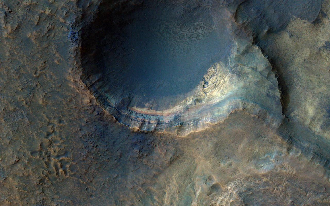
The sedimentary history of Mars is important to understanding climate change and the evolution of Mars. Sedimentary rocks consist of fine particles carried by the atmosphere and/or water and deposited in generally flat-lying layers, which become indurated (turn into rock) over time. This image covers some steep slopes with good exposures of the bedrock layers, revealing diverse color and textures. A detailed study of many such exposures along with compositional data can be used to reconstruct the sequence of events and interpret the geologic history. https://photojournal.jpl.nasa.gov/catalog/PIA25354

This artist's concept shows a black hole with an accretion disk -- a flat structure of material orbiting the black hole -- and a jet of hot gas, called plasma. Using NASA's NuSTAR space telescope and a fast camera called ULTRACAM on the William Herschel Observatory in La Palma, Spain, scientists have been able to measure the distance that particles in jets travel before they "turn on" and become bright sources of light. This distance is called the "acceleration zone." https://photojournal.jpl.nasa.gov/catalog/PIA22085

All this week, the THEMIS Image of the Day is following on the real Mars the path taken by fictional astronaut Mark Watney, stranded on the Red Planet in the book and movie, The Martian. Today's image shows a part of the flat terrain of northern Meridiani Planum. This area lies about 300 kilometers (190 miles) north of where Mars rover Opportunity is currently exploring the rim rocks of Endeavour Crater. Meridiani is a large expanse of sedimentary rock, mostly flat-lying basalt sandstone with hematite nodules ("blueberries") embedded in it. Farther south from this scene, Opportunity has examined several craters like these that expose deeper rock layers. They show that the Meridiani sandstone is made of dune sands that were soaked in sulfur-rich water. Flat terrain may make for dull scenery, but the driving is easy. This area is where astronaut Mark Watney turns his vehicle east toward Schiaparelli Crater. Before arriving here, he was driving south to get out from under a dust storm that threatened to shut off power to the vehicle's solar cells. At this point he has journeyed about 2,300 kilometers (1,400 miles) from Acidalia. Orbit Number: 6304 Latitude: 2.51711 Longitude: 355.154 Instrument: VIS Captured: 2003-05-17 13:18 http://photojournal.jpl.nasa.gov/catalog/PIA19798
A story of changes at the South Pole of Mars is told by its icy deposits. Remnants of a formerly more extensive deposit composed of dry ice form what is known as the south polar residual cap. Scientists call it "residual" because it remains after the much larger seasonal cap disappears each summer. This mesa in this cutout is shrinking over time as the frozen carbon dioxide turns to vapor. Pits in this sheet of dry ice (that give the deposit an appearance resembling Swiss cheese) are enlarging over time, exposing an older surface below that is likely made up of water ice. In contrast to shrinking ice caps on Earth, climate change is not to blame on Mars. Even as the walls of these pits ablate away the intervening flat surfaces are accumulating new dry ice. The total amount of frozen carbon dioxide at the South Pole may even be increasing. https://photojournal.jpl.nasa.gov/catalog/PIA22870
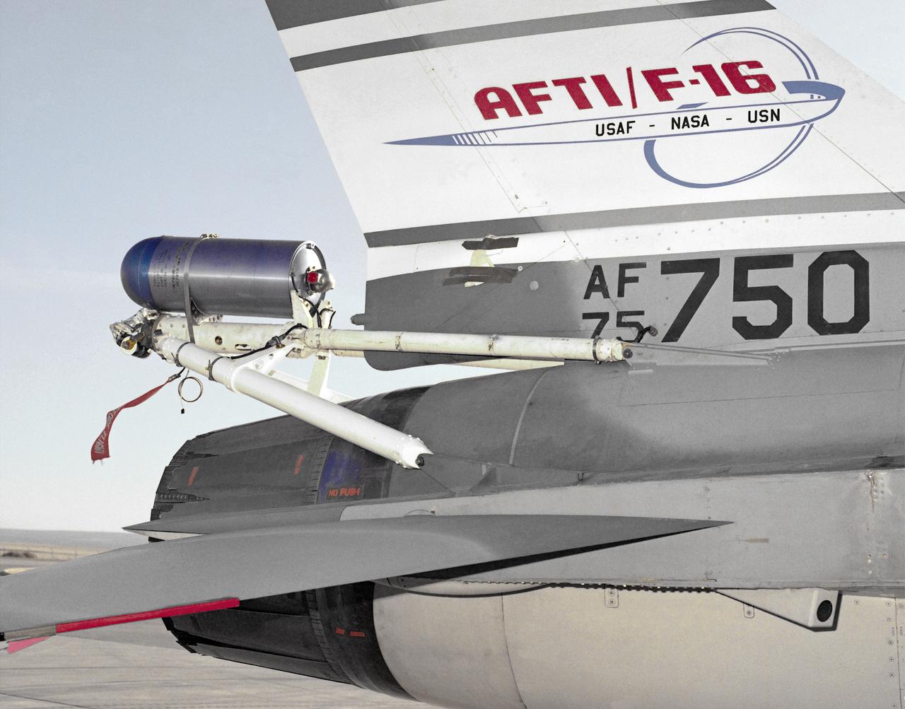
A close-up photo of the spin chute mounted on the rear fuselage of the AFTI F-16, a safety device designed to prevent the loss of aircraft in spin conditions. Under some circumstances, pilots cannot recover from spins using normal controls. It these instances, the spin chute is deployed, thus "breaking" the spin and enabling the pilot to recover. The spin chute is held in a metal cylinder attached to the AFTI F-16 by four tubes, a structure strong enough to withstand the shock of the spin chute opening. Unlike the air probe in the last photo, spin chutes are not standard equipment on research or prototype aircraft but are commonly attached expressly for actual spin tests.
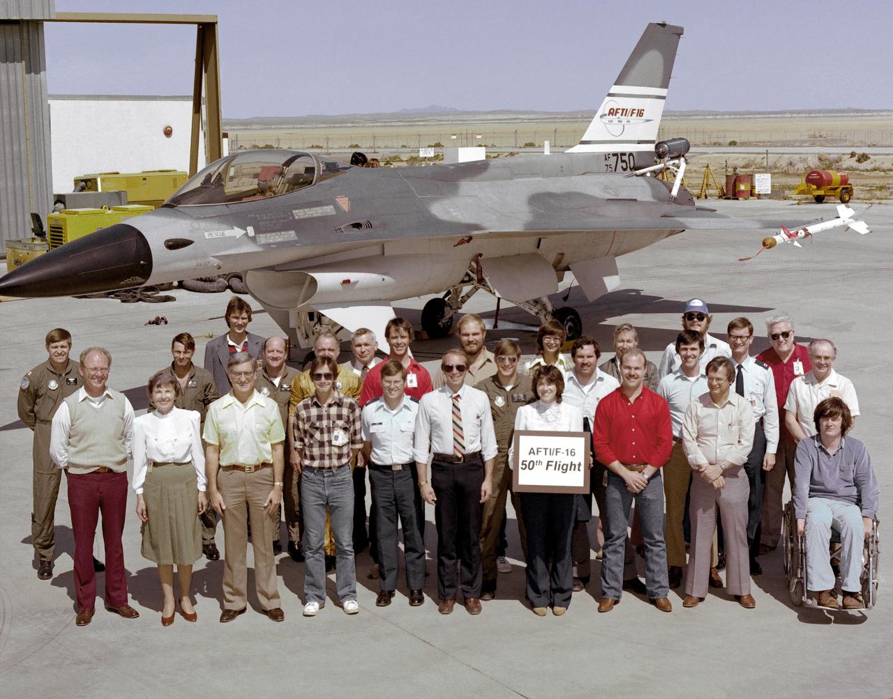
An early (1983) photograph of the AFTI F-16 team, commemorating the aircraft's 50th flight. It shows the initial configuration and paint finish of the AFTI F-16, as well as the forward mounted canards and the spin chute.
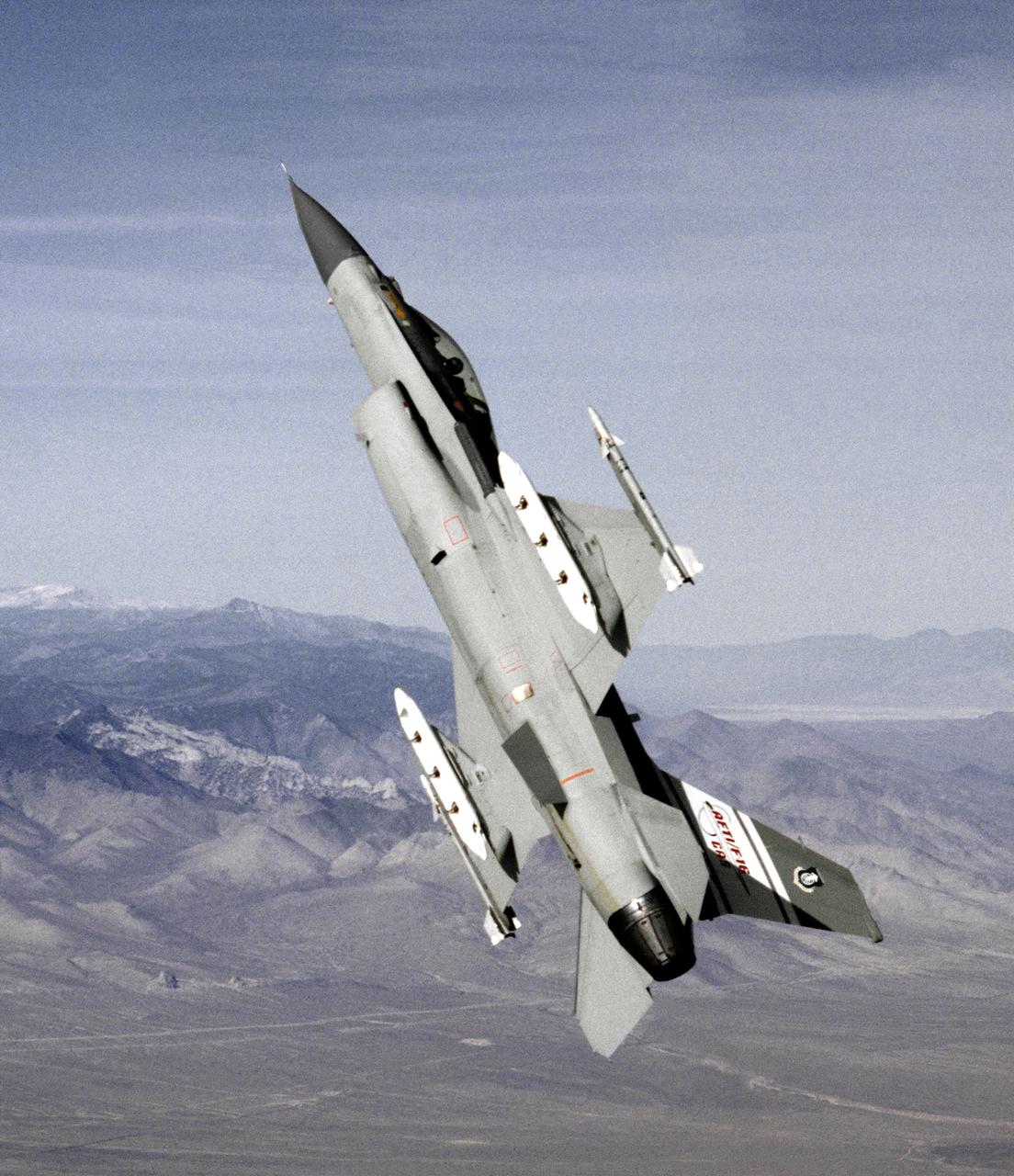
This photo depicts the AFTI F-16 in the configuration used midway through the program. The sensor pods were added to the fuselage, but the chin canards remained in place. Painted in non-standard gray tones, it carried Sidewinder air-to-air missles on its wingtips.
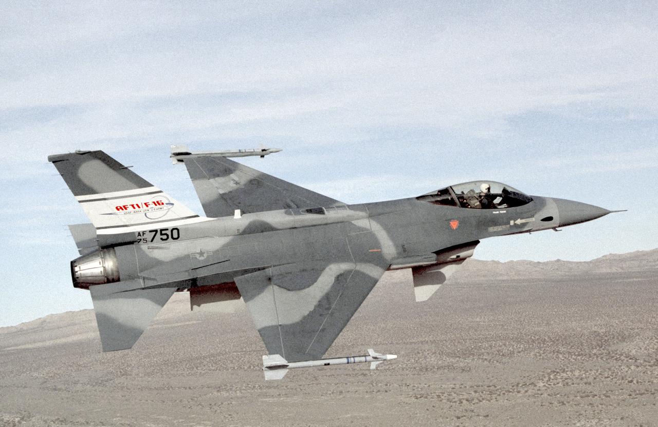
The AFTI F-16 flying at high angle of attack, shown in the final configuration and paint finish. Dummy Sidewinder air-to-air missles are attached to the wing tips. The white objects visible on the wing racks represent practice bomb dispensers, used in weapon tests.
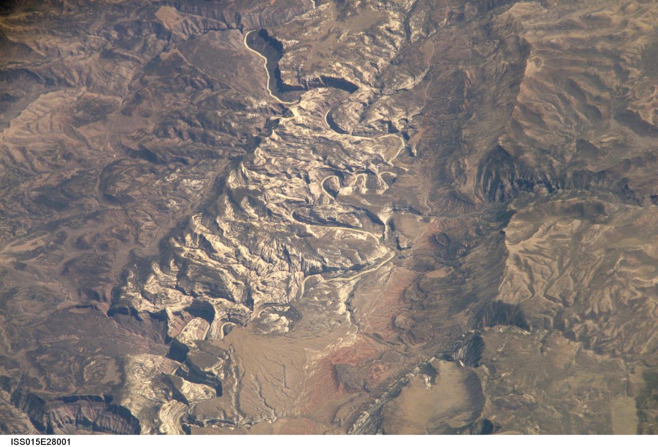
ISS015-E-28001 (12 Sept. 2007) --- A section of Dinosaur National Monument along the Yampa River in Colorado, which straddles the Colorado/Utah border, is featured in this image photographed by an Expedition 15 crewmember on the International Space Station. Dinosaur National Monument is perhaps best known for the abundant fossils found in the approximately 145 Ma (mega-annum, or millions of years old) Morrison Formation exposed in valleys and low ridges, according to scientists. The fossil assemblage is a unique record of terrestrial life of the period (dinosaurs, plants, and other animal species). Remains accumulated in streams and shallow lakes and were swiftly buried (and preserved) by sediments associated with those environments. Scientists believe these sediments in turn were lithified over many millions of years as they were buried under younger deposits -- forming the distinctive stratigraphy of the Monument. The generally flat-laying "layer cake" geology of the region -- similar to the Colorado Plateau to the south - is expressed in the image by parallel beds of tan, reddish-brown, and gray-brown sedimentary rocks cut by the Yampa River at the northern end of the Monument (top). Erosion by the Yampa River exposed the Morrison layer and its trove of fossil material. Together with other fossils found in both older and younger rock layers in the area, the Dinosaur National Monument remains an important scientific resource that continues to provide new insights into the geologic history and paleoecology of the region.
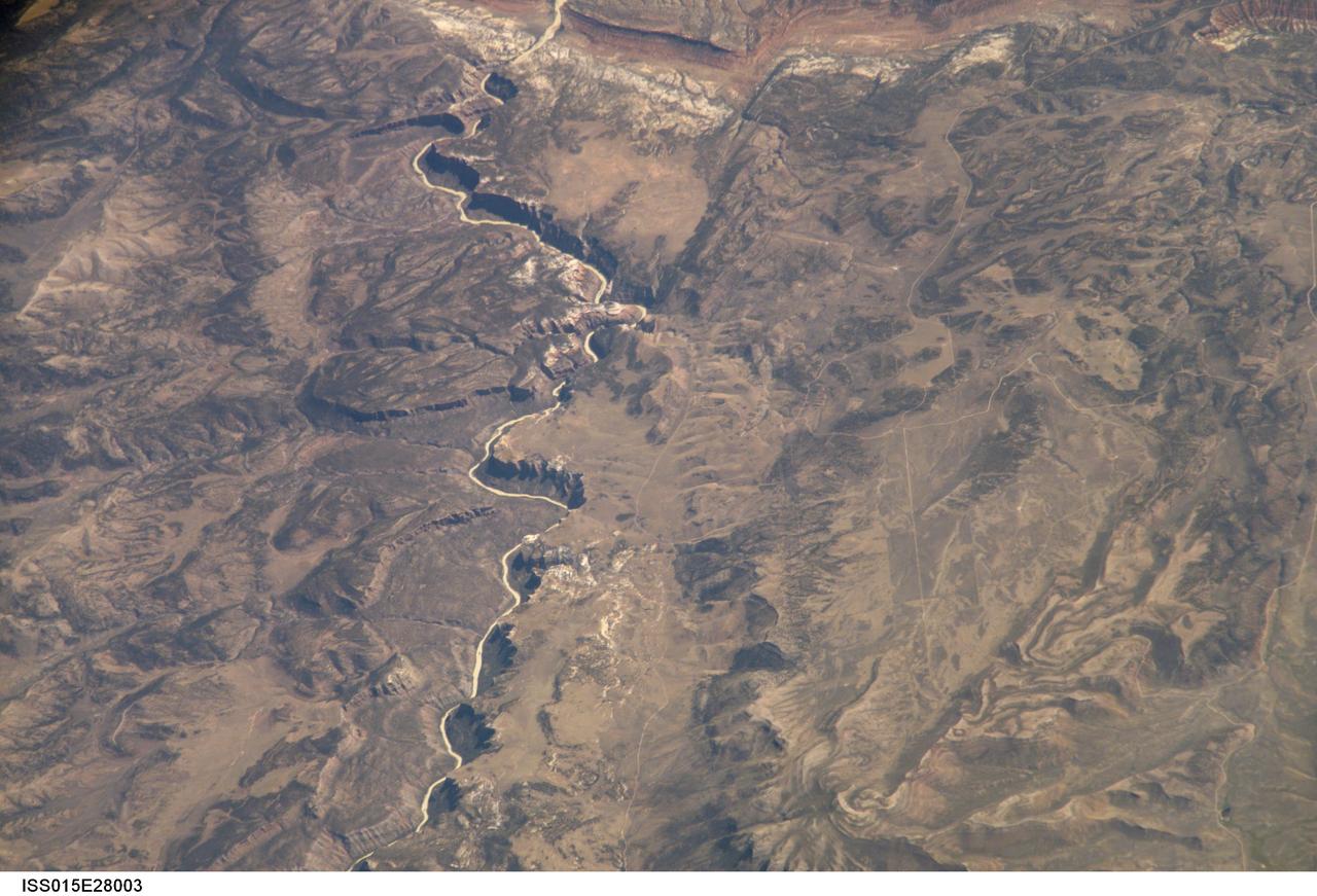
ISS015-E-28003 (12 Sept. 2007) --- A section of Dinosaur National Monument along the Yampa River in Colorado, which straddles the Colorado/Utah border, is featured in this image photographed by an Expedition 15 crewmember on the International Space Station. Dinosaur National Monument is perhaps best known for the abundant fossils found in the approximately 145 Ma (mega-annum, or millions of years old) Morrison Formation exposed in valleys and low ridges, according to scientists. The fossil assemblage is a unique record of terrestrial life of the period (dinosaurs, plants, and other animal species). Remains accumulated in streams and shallow lakes and were swiftly buried (and preserved) by sediments associated with those environments. Scientists believe these sediments in turn were lithified over many millions of years as they were buried under younger deposits -- forming the distinctive stratigraphy of the Monument. The generally flat-laying "layer cake" geology of the region -- similar to the Colorado Plateau to the south - is expressed in the image by parallel beds of tan, reddish-brown, and gray-brown sedimentary rocks cut by the Yampa River at the northern end of the Monument (top). Erosion by the Yampa River exposed the Morrison layer and its trove of fossil material. Together with other fossils found in both older and younger rock layers in the area, the Dinosaur National Monument remains an important scientific resource that continues to provide new insights into the geologic history and paleoecology of the region.
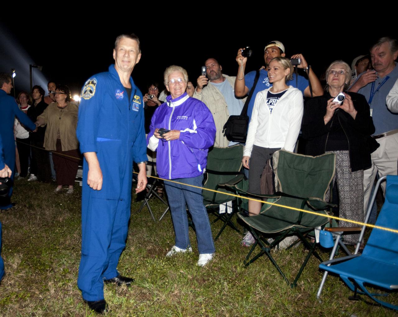
CAPE CANAVERAL, Fla. – Outside the Vehicle Assembly Building at NASA's Kennedy Space Center in Florida, STS-132 Mission Specialist Piers Sellers joins Kennedy employees and their families who turned out to watch space shuttle Atlantis begin its move to Launch Pad 39A. Atlantis' first motion on its 3.4-mile trip from the Vehicle Assembly Building was at 11:31 p.m. EDT April 21. The shuttle was secured on the pad at 6:03 a.m. April 22. Rollout is a significant milestone in launch processing activities. On the STS-132 mission, the six-member crew will deliver an Integrated Cargo Carrier, or ICC, and the Russian-built Mini-Research Module-1, or MRM-1, to the International Space Station. The ICC is an unpressurized flat bed pallet and keel yoke assembly used to support the transfer of exterior cargo from the shuttle to the space station. The MRM-1, known as Rassvet, is the second in a series of new pressurized components for Russia and will be permanently attached to the Earth-facing port of the Zarya control module. Rassvet, which translates to 'dawn,' will be used for cargo storage and will provide an additional docking port to the station. STS-132 is the 34th mission to the station and the 132nd shuttle mission overall. Atlantis is targeted to launch on May 14 at 2:19 p.m. For information on the STS-132 mission, visit http:__www.nasa.gov_mission_pages_shuttle_shuttlemissions_sts132_index.html. Photo credit: NASA_Amanda Diller
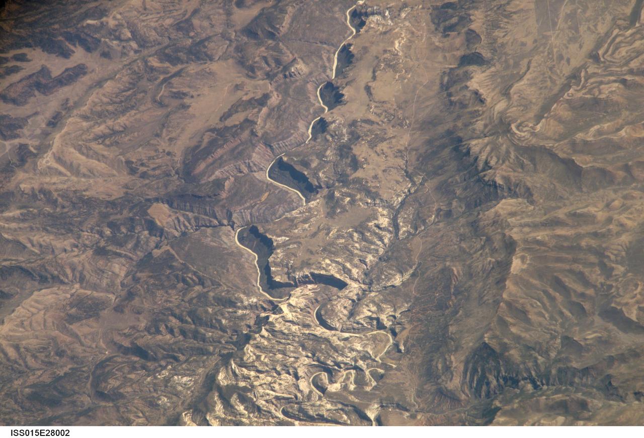
ISS015-E-28002 (12 Sept. 2007) --- A section of Dinosaur National Monument along the Yampa River in Colorado, which straddles the Colorado/Utah border, is featured in this image photographed by an Expedition 15 crewmember on the International Space Station. Dinosaur National Monument is perhaps best known for the abundant fossils found in the approximately 145 Ma (mega-annum, or millions of years old) Morrison Formation exposed in valleys and low ridges, according to scientists. The fossil assemblage is a unique record of terrestrial life of the period (dinosaurs, plants, and other animal species). Remains accumulated in streams and shallow lakes and were swiftly buried (and preserved) by sediments associated with those environments. Scientists believe these sediments in turn were lithified over many millions of years as they were buried under younger deposits -- forming the distinctive stratigraphy of the Monument. The generally flat-laying "layer cake" geology of the region -- similar to the Colorado Plateau to the south - is expressed in the image by parallel beds of tan, reddish-brown, and gray-brown sedimentary rocks cut by the Yampa River at the northern end of the Monument (top). Erosion by the Yampa River exposed the Morrison layer and its trove of fossil material. Together with other fossils found in both older and younger rock layers in the area, the Dinosaur National Monument remains an important scientific resource that continues to provide new insights into the geologic history and paleoecology of the region.
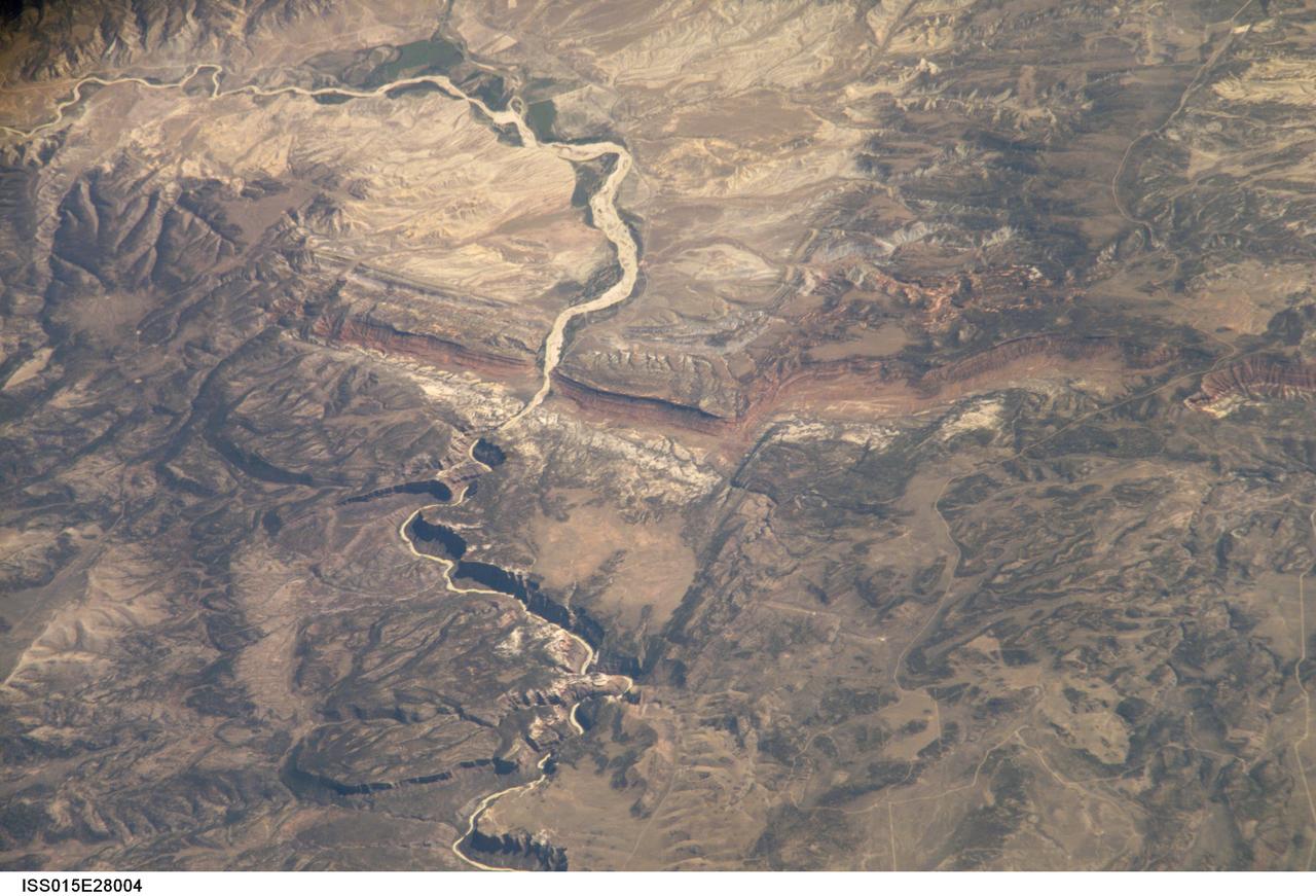
ISS015-E-28004 (12 Sept. 2007) --- A section of Dinosaur National Monument along the Yampa River in Colorado, which straddles the Colorado/Utah border, is featured in this image photographed by an Expedition 15 crewmember on the International Space Station. Dinosaur National Monument is perhaps best known for the abundant fossils found in the approximately 145 Ma (mega-annum, or millions of years old) Morrison Formation exposed in valleys and low ridges, according to scientists. The fossil assemblage is a unique record of terrestrial life of the period (dinosaurs, plants, and other animal species). Remains accumulated in streams and shallow lakes and were swiftly buried (and preserved) by sediments associated with those environments. Scientists believe these sediments in turn were lithified over many millions of years as they were buried under younger deposits -- forming the distinctive stratigraphy of the Monument. The generally flat-laying "layer cake" geology of the region -- similar to the Colorado Plateau to the south - is expressed in the image by parallel beds of tan, reddish-brown, and gray-brown sedimentary rocks cut by the Yampa River at the northern end of the Monument (top). Erosion by the Yampa River exposed the Morrison layer and its trove of fossil material. Together with other fossils found in both older and younger rock layers in the area, the Dinosaur National Monument remains an important scientific resource that continues to provide new insights into the geologic history and paleoecology of the region.
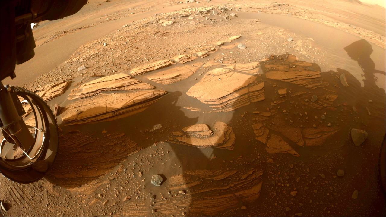
This image of the "Enchanted Lake" rocky outcrop, informally named after a landmark in Alaska's Katmai National Park and Preserve, was taken by one of the Hazard Avoidance Cameras (Hazcams) on NASA's Mars Perseverance rover on April 30, 2022, the 424th Martian day, or sol, of the mission. The image of the outcrop, near the base of Jezero Crater's delta, provided the rover science team with its first up-close glimpse of sedimentary rocks. Such rocks consist of fine particles carried by the atmosphere and/or water and deposited in generally flat-lying layers, which become indurated, or turned into rock, over time. A key objective for Perseverance's mission on Mars is astrobiology, including the search for signs of ancient microbial life. The rover will characterize the planet's geology and past climate, pave the way for human exploration of the Red Planet, and be the first mission to collect and cache Martian rock and regolith (broken rock and dust). Subsequent NASA missions, in cooperation with ESA (European Space Agency), would send spacecraft to Mars to collect these sealed samples from the surface and return them to Earth for in-depth analysis. The Mars 2020 Perseverance mission is part of NASA's Moon to Mars exploration approach, which includes Artemis missions to the Moon that will help prepare for human exploration of the Red Planet. https://photojournal.jpl.nasa.gov/catalog/PIA25325
In July 2015, NASA's New Horizons spacecraft sent home the first close-up pictures of Pluto and its moons. Using actual New Horizons data and digital elevation models of Pluto and its largest moon, Charon, mission scientists created flyover movies that offer spectacular new perspectives of the many unusual features that were discovered and which have reshaped our views of the Pluto system -- from a vantage point even closer than a ride on New Horizons itself. The flight over Charon begins high over the hemisphere New Horizons saw on its closest approach, then descends over the deep, wide canyon of Serenity Chasma. The view moves north, passing over Dorothy Gale crater and the dark polar hood of Mordor Macula. The flight then turns back south, covering the northern terrain of Oz Terra before ending over the relatively flat equatorial plains of Vulcan Planum and the "moated mountains" of Clarke Montes. (Note that all feature names are informal.) The topographic relief is exaggerated by a factor of 2 to 3 in these movies to emphasize topography; the surface colors have also been enhanced to bring out detail. Digital mapping and rendering were performed by Paul Schenk and John Blackwell of the Lunar and Planetary Institute in Houston. A video is available at https://photojournal.jpl.nasa.gov/catalog/PIA21864

Caption: A NASA-funded sounding rocket launches into an aurora in the early morning of March 3, 2014, over Venetie, Alaska. The GREECE mission studies how certain structures – classic curls like swirls of cream in coffee -- form in the aurora. Credit: NASA/Christopher Perry More info: On March 3, 2014, at 6:09 a.m. EST, a NASA-funded sounding rocket launched straight into an aurora over Venetie, Alaska. The Ground-to-Rocket Electrodynamics – Electron Correlative Experiment, or GREECE, sounding rocket mission, which launched from Poker Flat Research Range in Poker Flat, Alaska, will study classic curls in the aurora in the night sky. The GREECE instruments travel on a sounding rocket that launches for a ten-minute ride right through the heart of the aurora reaching its zenith over the native village of Venetie, Alaska. To study the curl structures, GREECE consists of two parts: ground-based imagers located in Venetie to track the aurora from the ground and the rocket to take measurements from the middle of the aurora itself. At their simplest, auroras are caused when particles from the sun funnel over to Earth's night side, generate electric currents, and trigger a shower of particles that strike oxygen and nitrogen some 60 to 200 miles up in Earth's atmosphere, releasing a flash of light. But the details are always more complicated, of course. Researchers wish to understand the aurora, and movement of plasma in general, at much smaller scales including such things as how different structures are formed there. This is a piece of information, which in turn, helps paint a picture of the sun-Earth connection and how energy and particles from the sun interact with Earth's own magnetic system, the magnetosphere. GREECE is a collaborative effort between SWRI, which developed particle instruments and the ground-based imaging, and the University of California, Berkeley, measuring the electric and magnetic fields. The launch is supported by a sounding rocket team from NASA’s Wallops Flight Facility, Wallops Island, Va. The Poker Flat Research Range is operated by the University of Alaska, Fairbanks. “The conditions were optimal,” said Marilia Samara, principal investigator for the mission at Southwest Research Institute in San Antonio, Texas. “We can’t wait to dig into the data.” For more information on the GREECE mission visit: <a href="http://www.nasa.gov/content/goddard/nasa-funded-sounding-rocket-to-catch-aurora-in-the-act/." rel="nofollow">www.nasa.gov/content/goddard/nasa-funded-sounding-rocket- </a>.<b><a href="http://www.nasa.gov/audience/formedia/features/MP_Photo_Guidelines.html" rel="nofollow">NASA image use policy.</a></b> <b><a href="http://www.nasa.gov/centers/goddard/home/index.html" rel="nofollow">NASA Goddard Space Flight Center</a></b> enables NASA’s mission through four scientific endeavors: Earth Science, Heliophysics, Solar System Exploration, and Astrophysics. Goddard plays a leading role in NASA’s accomplishments by contributing compelling scientific knowledge to advance the Agency’s mission. <b>Follow us on <a href="http://twitter.com/NASAGoddardPix" rel="nofollow">Twitter</a></b> <b>Like us on <a href="http://www.facebook.com/pages/Greenbelt-MD/NASA-Goddard/395013845897?ref=tsd" rel="nofollow">Facebook</a></b> <b>Find us on <a href="http://instagram.com/nasagoddard?vm=grid" rel="nofollow">Instagram</a></b>

Caption: A NASA-funded sounding rocket launches into an aurora in the early morning of March 3, 2014, over Venetie, Alaska. The GREECE mission studies how certain structures – classic curls like swirls of cream in coffee -- form in the aurora. Credit: NASA/Christopher Perry More info: On March 3, 2014, at 6:09 a.m. EST, a NASA-funded sounding rocket launched straight into an aurora over Venetie, Alaska. The Ground-to-Rocket Electrodynamics – Electron Correlative Experiment, or GREECE, sounding rocket mission, which launched from Poker Flat Research Range in Poker Flat, Alaska, will study classic curls in the aurora in the night sky. The GREECE instruments travel on a sounding rocket that launches for a ten-minute ride right through the heart of the aurora reaching its zenith over the native village of Venetie, Alaska. To study the curl structures, GREECE consists of two parts: ground-based imagers located in Venetie to track the aurora from the ground and the rocket to take measurements from the middle of the aurora itself. At their simplest, auroras are caused when particles from the sun funnel over to Earth's night side, generate electric currents, and trigger a shower of particles that strike oxygen and nitrogen some 60 to 200 miles up in Earth's atmosphere, releasing a flash of light. But the details are always more complicated, of course. Researchers wish to understand the aurora, and movement of plasma in general, at much smaller scales including such things as how different structures are formed there. This is a piece of information, which in turn, helps paint a picture of the sun-Earth connection and how energy and particles from the sun interact with Earth's own magnetic system, the magnetosphere. GREECE is a collaborative effort between SWRI, which developed particle instruments and the ground-based imaging, and the University of California, Berkeley, measuring the electric and magnetic fields. The launch is supported by a sounding rocket team from NASA’s Wallops Flight Facility, Wallops Island, Va. The Poker Flat Research Range is operated by the University of Alaska, Fairbanks. “The conditions were optimal,” said Marilia Samara, principal investigator for the mission at Southwest Research Institute in San Antonio, Texas. “We can’t wait to dig into the data.” For more information on the GREECE mission visit: <a href="http://www.nasa.gov/content/goddard/nasa-funded-sounding-rocket-to-catch-aurora-in-the-act/." rel="nofollow">www.nasa.gov/content/goddard/nasa-funded-sounding-rocket- </a>.<b><a href="http://www.nasa.gov/audience/formedia/features/MP_Photo_Guidelines.html" rel="nofollow">NASA image use policy.</a></b> <b><a href="http://www.nasa.gov/centers/goddard/home/index.html" rel="nofollow">NASA Goddard Space Flight Center</a></b> enables NASA’s mission through four scientific endeavors: Earth Science, Heliophysics, Solar System Exploration, and Astrophysics. Goddard plays a leading role in NASA’s accomplishments by contributing compelling scientific knowledge to advance the Agency’s mission. <b>Follow us on <a href="http://twitter.com/NASAGoddardPix" rel="nofollow">Twitter</a></b> <b>Like us on <a href="http://www.facebook.com/pages/Greenbelt-MD/NASA-Goddard/395013845897?ref=tsd" rel="nofollow">Facebook</a></b> <b>Find us on <a href="http://instagram.com/nasagoddard?vm=grid" rel="nofollow">Instagram</a></b>

Caption: A NASA-funded sounding rocket launches into an aurora in the early morning of March 3, 2014, over Venetie, Alaska. The GREECE mission studies how certain structures – classic curls like swirls of cream in coffee -- form in the aurora. Credit: NASA/Christopher Perry More info: On March 3, 2014, at 6:09 a.m. EST, a NASA-funded sounding rocket launched straight into an aurora over Venetie, Alaska. The Ground-to-Rocket Electrodynamics – Electron Correlative Experiment, or GREECE, sounding rocket mission, which launched from Poker Flat Research Range in Poker Flat, Alaska, will study classic curls in the aurora in the night sky. The GREECE instruments travel on a sounding rocket that launches for a ten-minute ride right through the heart of the aurora reaching its zenith over the native village of Venetie, Alaska. To study the curl structures, GREECE consists of two parts: ground-based imagers located in Venetie to track the aurora from the ground and the rocket to take measurements from the middle of the aurora itself. At their simplest, auroras are caused when particles from the sun funnel over to Earth's night side, generate electric currents, and trigger a shower of particles that strike oxygen and nitrogen some 60 to 200 miles up in Earth's atmosphere, releasing a flash of light. But the details are always more complicated, of course. Researchers wish to understand the aurora, and movement of plasma in general, at much smaller scales including such things as how different structures are formed there. This is a piece of information, which in turn, helps paint a picture of the sun-Earth connection and how energy and particles from the sun interact with Earth's own magnetic system, the magnetosphere. GREECE is a collaborative effort between SWRI, which developed particle instruments and the ground-based imaging, and the University of California, Berkeley, measuring the electric and magnetic fields. The launch is supported by a sounding rocket team from NASA’s Wallops Flight Facility, Wallops Island, Va. The Poker Flat Research Range is operated by the University of Alaska, Fairbanks. “The conditions were optimal,” said Marilia Samara, principal investigator for the mission at Southwest Research Institute in San Antonio, Texas. “We can’t wait to dig into the data.” For more information on the GREECE mission visit: <a href="http://www.nasa.gov/content/goddard/nasa-funded-sounding-rocket-to-catch-aurora-in-the-act/." rel="nofollow">www.nasa.gov/content/goddard/nasa-funded-sounding-rocket- </a>.<b><a href="http://www.nasa.gov/audience/formedia/features/MP_Photo_Guidelines.html" rel="nofollow">NASA image use policy.</a></b> <b><a href="http://www.nasa.gov/centers/goddard/home/index.html" rel="nofollow">NASA Goddard Space Flight Center</a></b> enables NASA’s mission through four scientific endeavors: Earth Science, Heliophysics, Solar System Exploration, and Astrophysics. Goddard plays a leading role in NASA’s accomplishments by contributing compelling scientific knowledge to advance the Agency’s mission. <b>Follow us on <a href="http://twitter.com/NASAGoddardPix" rel="nofollow">Twitter</a></b> <b>Like us on <a href="http://www.facebook.com/pages/Greenbelt-MD/NASA-Goddard/395013845897?ref=tsd" rel="nofollow">Facebook</a></b> <b>Find us on <a href="http://instagram.com/nasagoddard?vm=grid" rel="nofollow">Instagram</a></b>

Caption: A NASA-funded sounding rocket launches into an aurora in the early morning of March 3, 2014, over Venetie, Alaska. The GREECE mission studies how certain structures – classic curls like swirls of cream in coffee -- form in the aurora. Credit: NASA/Christopher Perry More info: On March 3, 2014, at 6:09 a.m. EST, a NASA-funded sounding rocket launched straight into an aurora over Venetie, Alaska. The Ground-to-Rocket Electrodynamics – Electron Correlative Experiment, or GREECE, sounding rocket mission, which launched from Poker Flat Research Range in Poker Flat, Alaska, will study classic curls in the aurora in the night sky. The GREECE instruments travel on a sounding rocket that launches for a ten-minute ride right through the heart of the aurora reaching its zenith over the native village of Venetie, Alaska. To study the curl structures, GREECE consists of two parts: ground-based imagers located in Venetie to track the aurora from the ground and the rocket to take measurements from the middle of the aurora itself. At their simplest, auroras are caused when particles from the sun funnel over to Earth's night side, generate electric currents, and trigger a shower of particles that strike oxygen and nitrogen some 60 to 200 miles up in Earth's atmosphere, releasing a flash of light. But the details are always more complicated, of course. Researchers wish to understand the aurora, and movement of plasma in general, at much smaller scales including such things as how different structures are formed there. This is a piece of information, which in turn, helps paint a picture of the sun-Earth connection and how energy and particles from the sun interact with Earth's own magnetic system, the magnetosphere. GREECE is a collaborative effort between SWRI, which developed particle instruments and the ground-based imaging, and the University of California, Berkeley, measuring the electric and magnetic fields. The launch is supported by a sounding rocket team from NASA’s Wallops Flight Facility, Wallops Island, Va. The Poker Flat Research Range is operated by the University of Alaska, Fairbanks. “The conditions were optimal,” said Marilia Samara, principal investigator for the mission at Southwest Research Institute in San Antonio, Texas. “We can’t wait to dig into the data.” For more information on the GREECE mission visit: <a href="http://www.nasa.gov/content/goddard/nasa-funded-sounding-rocket-to-catch-aurora-in-the-act/." rel="nofollow">www.nasa.gov/content/goddard/nasa-funded-sounding-rocket- </a>.<b><a href="http://www.nasa.gov/audience/formedia/features/MP_Photo_Guidelines.html" rel="nofollow">NASA image use policy.</a></b> <b><a href="http://www.nasa.gov/centers/goddard/home/index.html" rel="nofollow">NASA Goddard Space Flight Center</a></b> enables NASA’s mission through four scientific endeavors: Earth Science, Heliophysics, Solar System Exploration, and Astrophysics. Goddard plays a leading role in NASA’s accomplishments by contributing compelling scientific knowledge to advance the Agency’s mission. <b>Follow us on <a href="http://twitter.com/NASAGoddardPix" rel="nofollow">Twitter</a></b> <b>Like us on <a href="http://www.facebook.com/pages/Greenbelt-MD/NASA-Goddard/395013845897?ref=tsd" rel="nofollow">Facebook</a></b> <b>Find us on <a href="http://instagram.com/nasagoddard?vm=grid" rel="nofollow">Instagram</a></b>

Caption: A NASA-funded sounding rocket launches into an aurora in the early morning of March 3, 2014, over Venetie, Alaska. The GREECE mission studies how certain structures – classic curls like swirls of cream in coffee -- form in the aurora. Credit: NASA/Christopher Perry More info: On March 3, 2014, at 6:09 a.m. EST, a NASA-funded sounding rocket launched straight into an aurora over Venetie, Alaska. The Ground-to-Rocket Electrodynamics – Electron Correlative Experiment, or GREECE, sounding rocket mission, which launched from Poker Flat Research Range in Poker Flat, Alaska, will study classic curls in the aurora in the night sky. The GREECE instruments travel on a sounding rocket that launches for a ten-minute ride right through the heart of the aurora reaching its zenith over the native village of Venetie, Alaska. To study the curl structures, GREECE consists of two parts: ground-based imagers located in Venetie to track the aurora from the ground and the rocket to take measurements from the middle of the aurora itself. At their simplest, auroras are caused when particles from the sun funnel over to Earth's night side, generate electric currents, and trigger a shower of particles that strike oxygen and nitrogen some 60 to 200 miles up in Earth's atmosphere, releasing a flash of light. But the details are always more complicated, of course. Researchers wish to understand the aurora, and movement of plasma in general, at much smaller scales including such things as how different structures are formed there. This is a piece of information, which in turn, helps paint a picture of the sun-Earth connection and how energy and particles from the sun interact with Earth's own magnetic system, the magnetosphere. GREECE is a collaborative effort between SWRI, which developed particle instruments and the ground-based imaging, and the University of California, Berkeley, measuring the electric and magnetic fields. The launch is supported by a sounding rocket team from NASA’s Wallops Flight Facility, Wallops Island, Va. The Poker Flat Research Range is operated by the University of Alaska, Fairbanks. “The conditions were optimal,” said Marilia Samara, principal investigator for the mission at Southwest Research Institute in San Antonio, Texas. “We can’t wait to dig into the data.” For more information on the GREECE mission visit: <a href="http://www.nasa.gov/content/goddard/nasa-funded-sounding-rocket-to-catch-aurora-in-the-act/." rel="nofollow">www.nasa.gov/content/goddard/nasa-funded-sounding-rocket- </a>.<b><a href="http://www.nasa.gov/audience/formedia/features/MP_Photo_Guidelines.html" rel="nofollow">NASA image use policy.</a></b> <b><a href="http://www.nasa.gov/centers/goddard/home/index.html" rel="nofollow">NASA Goddard Space Flight Center</a></b> enables NASA’s mission through four scientific endeavors: Earth Science, Heliophysics, Solar System Exploration, and Astrophysics. Goddard plays a leading role in NASA’s accomplishments by contributing compelling scientific knowledge to advance the Agency’s mission. <b>Follow us on <a href="http://twitter.com/NASAGoddardPix" rel="nofollow">Twitter</a></b> <b>Like us on <a href="http://www.facebook.com/pages/Greenbelt-MD/NASA-Goddard/395013845897?ref=tsd" rel="nofollow">Facebook</a></b> <b>Find us on <a href="http://instagram.com/nasagoddard?vm=grid" rel="nofollow">Instagram</a></b>

A NASA sounding rocket to be launched from the Poker Flat Research Range, Alaska, between February 13 and March 3, 2017, will form white artificial clouds during its brief, 10-minute flight. The rocket is one of five being launched January through March, each carrying instruments to explore the aurora and its interactions with Earth’s upper atmosphere and ionosphere. Scientists at NASA's Goddard Space Center in Greenbelt, Maryland, explain that electric fields drive the ionosphere, which, in turn, are predicted to set up enhanced neutral winds within an aurora arc. This experiment seeks to understand the height-dependent processes that create localized neutral jets within the aurora. For this mission, two 56-foot long Black Brant IX rockets will be launched nearly simultaneously. One rocket is expected to fly to an apogee of about 107 miles while the other is targeted for 201 miles apogee. Only the lower altitude rocket will form the white luminescent clouds during its flight. Read more: <a href="http://go.nasa.gov/2kYaBgV" rel="nofollow">go.nasa.gov/2kYaBgV</a> <b><a href="http://www.nasa.gov/audience/formedia/features/MP_Photo_Guidelines.html" rel="nofollow">NASA image use policy.</a></b> <b><a href="http://www.nasa.gov/centers/goddard/home/index.html" rel="nofollow">NASA Goddard Space Flight Center</a></b> enables NASA’s mission through four scientific endeavors: Earth Science, Heliophysics, Solar System Exploration, and Astrophysics. Goddard plays a leading role in NASA’s accomplishments by contributing compelling scientific knowledge to advance the Agency’s mission. <b>Follow us on <a href="http://twitter.com/NASAGoddardPix" rel="nofollow">Twitter</a></b> <b>Like us on <a href="http://www.facebook.com/pages/Greenbelt-MD/NASA-Goddard/395013845897?ref=tsd" rel="nofollow">Facebook</a></b> <b>Find us on <a href="http://instagrid.me/nasagoddard/?vm=grid" rel="nofollow">Instagram</a></b>
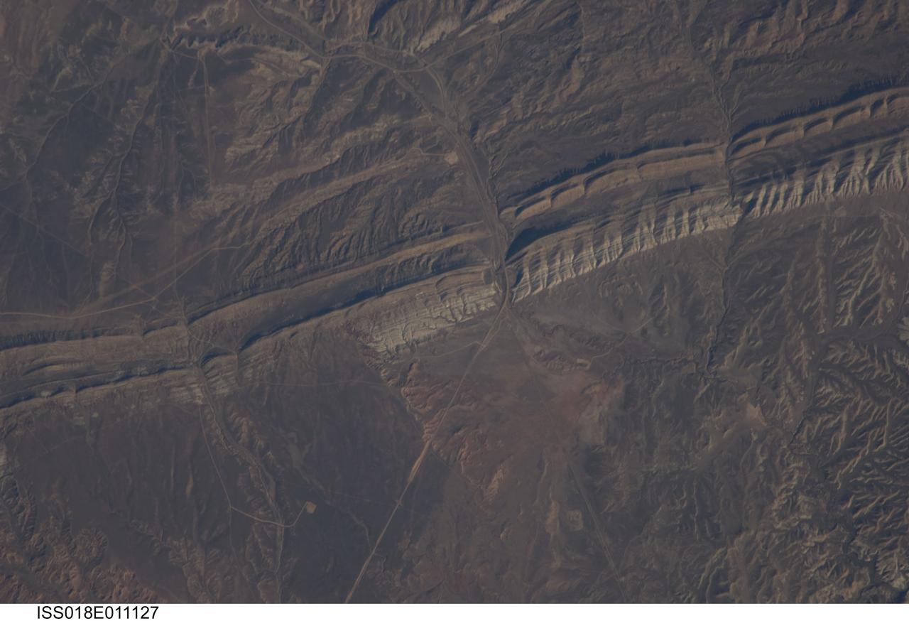
ISS018-E-011127 (6 Dec. 2008) --- Raven Ridge, Colorado is featured in this image photographed by an Expedition 18 crewmember on the International Space Station. An important way to unravel Earth?s history is to find and study old rocks that have been turned up and exposed on the surface through Earth?s tectonic activity. This image of Raven Ridge, Colorado provides a beautiful example of such a place that allows geologists to walk across rocks formed about 65 million years ago, now known as the ?K-T (or Cretaceous-Tertiary) Boundary?, according to scientists. The ridge is a dramatic topographic feature in northwestern Colorado formed by layered sedimentary rocks that span this boundary in geologic time. These sedimentary layers, originally deposited in a near-shore or marine environment as flat-lying beds, were later tilted on end to an almost vertical position by tectonic forces. The tilted beds are visible in this view as hard, resistant ridges of tan, buff, and white rocks, with a less resistant gray layer in the center of Raven Ridge (extending from left to right). The K-T Boundary is most famously known as the geological threshold where dinosaurs ? and a large number of other animal and plant species, both terrestrial and marine ? disappeared from the fossil record in a mass extinction event 66 ? 65 million years ago, according to scientists. Various hypotheses have been advanced to explain the mass extinction event - perhaps the best known being a large meteor impact that sparked widespread climate change or widespread volcanism that likewise produced significant climate change unfavorable for the existing plants and animals. The approximate location of the K-T Boundary is depicted in this image as a dotted white line ? rock layers to the south of the line belong to the Tertiary Period (lower half of image), while rocks to the north of the line are part of the Cretaceous and older Periods (upper half of image). A prominent topographic break in the ridgeline, Mormon Gap, provides road access across the Ridge. To the northwest of the Gap, several landslides formed in relatively soft Tertiary claystone, shale, and sandstone extend southwards from the crest of the Ridge.
The NASA-funded Ground-to-Rocket Electron-Electrodynamics Correlative Experiment, or GREECE, wants to understand aurora. Specifically, it will study classic auroral curls that swirl through the sky like cream in a cup of coffee. The GREECE instruments travel on a sounding rocket that launches for a ten-minute ride right through the heart of the aurora reaching its zenith over the native village of Venetie, Alaska. To study the curl structures, GREECE consists of two parts: ground-based imagers located in Venetie to track the aurora from the ground and the rocket to take measurements from the middle of the aurora itself. At their simplest, auroras are caused when particles from the sun funnel over to Earth's night side, generate electric currents, and trigger a shower of particles that strike oxygen and nitrogen some 60 to 200 miles up in Earth's atmosphere, releasing a flash of light. But the details are always more complicated, of course. Researchers wish to understand the aurora, and movement of plasma in general, at much smaller scales including such things as how different structures are formed there. This is a piece of information, which in turn, helps paint a picture of the sun-Earth connection and how energy and particles from the sun interact with Earth's own magnetic system, the magnetosphere. GREECE is a collaborative effort between SWRI, which developed particle instruments and the ground-based imaging, and the University of California, Berkeley, measuring the electric and magnetic fields. The launch is supported by a sounding rocket team from NASA’s Wallops Flight Facility, Wallops Island, Va. The Poker Flat Research Range is operated by the University of Alaska, Fairbanks. Credit: NASA Goddard <b><a href="http://www.nasa.gov/audience/formedia/features/MP_Photo_Guidelines.html" rel="nofollow">NASA image use policy.</a></b> <b><a href="http://www.nasa.gov/centers/goddard/home/index.html" rel="nofollow">NASA Goddard Space Flight Center</a></b> enables NASA’s mission through four scientific endeavors: Earth Science, Heliophysics, Solar System Exploration, and Astrophysics. Goddard plays a leading role in NASA’s accomplishments by contributing compelling scientific knowledge to advance the Agency’s mission. <b>Follow us on <a href="http://twitter.com/NASAGoddardPix" rel="nofollow">Twitter</a></b> <b>Like us on <a href="http://www.facebook.com/pages/Greenbelt-MD/NASA-Goddard/395013845897?ref=tsd" rel="nofollow">Facebook</a></b> <b>Find us on <a href="http://instagram.com/nasagoddard?vm=grid" rel="nofollow">Instagram</a></b>
The NASA-funded Ground-to-Rocket Electron-Electrodynamics Correlative Experiment, or GREECE, wants to understand aurora. Specifically, it will study classic auroral curls that swirl through the sky like cream in a cup of coffee. The GREECE instruments travel on a sounding rocket that launches for a ten-minute ride right through the heart of the aurora reaching its zenith over the native village of Venetie, Alaska. To study the curl structures, GREECE consists of two parts: ground-based imagers located in Venetie to track the aurora from the ground and the rocket to take measurements from the middle of the aurora itself. At their simplest, auroras are caused when particles from the sun funnel over to Earth's night side, generate electric currents, and trigger a shower of particles that strike oxygen and nitrogen some 60 to 200 miles up in Earth's atmosphere, releasing a flash of light. But the details are always more complicated, of course. Researchers wish to understand the aurora, and movement of plasma in general, at much smaller scales including such things as how different structures are formed there. This is a piece of information, which in turn, helps paint a picture of the sun-Earth connection and how energy and particles from the sun interact with Earth's own magnetic system, the magnetosphere. GREECE is a collaborative effort between SWRI, which developed particle instruments and the ground-based imaging, and the University of California, Berkeley, measuring the electric and magnetic fields. The launch is supported by a sounding rocket team from NASA’s Wallops Flight Facility, Wallops Island, Va. The Poker Flat Research Range is operated by the University of Alaska, Fairbanks. Credit: NASA Goddard <b><a href="http://www.nasa.gov/audience/formedia/features/MP_Photo_Guidelines.html" rel="nofollow">NASA image use policy.</a></b> <b><a href="http://www.nasa.gov/centers/goddard/home/index.html" rel="nofollow">NASA Goddard Space Flight Center</a></b> enables NASA’s mission through four scientific endeavors: Earth Science, Heliophysics, Solar System Exploration, and Astrophysics. Goddard plays a leading role in NASA’s accomplishments by contributing compelling scientific knowledge to advance the Agency’s mission. <b>Follow us on <a href="http://twitter.com/NASAGoddardPix" rel="nofollow">Twitter</a></b> <b>Like us on <a href="http://www.facebook.com/pages/Greenbelt-MD/NASA-Goddard/395013845897?ref=tsd" rel="nofollow">Facebook</a></b> <b>Find us on <a href="http://instagram.com/nasagoddard?vm=grid" rel="nofollow">Instagram</a></b>
The NASA-funded Ground-to-Rocket Electron-Electrodynamics Correlative Experiment, or GREECE, wants to understand aurora. Specifically, it will study classic auroral curls that swirl through the sky like cream in a cup of coffee. The GREECE instruments travel on a sounding rocket that launches for a ten-minute ride right through the heart of the aurora reaching its zenith over the native village of Venetie, Alaska. To study the curl structures, GREECE consists of two parts: ground-based imagers located in Venetie to track the aurora from the ground and the rocket to take measurements from the middle of the aurora itself. At their simplest, auroras are caused when particles from the sun funnel over to Earth's night side, generate electric currents, and trigger a shower of particles that strike oxygen and nitrogen some 60 to 200 miles up in Earth's atmosphere, releasing a flash of light. But the details are always more complicated, of course. Researchers wish to understand the aurora, and movement of plasma in general, at much smaller scales including such things as how different structures are formed there. This is a piece of information, which in turn, helps paint a picture of the sun-Earth connection and how energy and particles from the sun interact with Earth's own magnetic system, the magnetosphere. GREECE is a collaborative effort between SWRI, which developed particle instruments and the ground-based imaging, and the University of California, Berkeley, measuring the electric and magnetic fields. The launch is supported by a sounding rocket team from NASA’s Wallops Flight Facility, Wallops Island, Va. The Poker Flat Research Range is operated by the University of Alaska, Fairbanks. Credit: NASA Goddard <b><a href="http://www.nasa.gov/audience/formedia/features/MP_Photo_Guidelines.html" rel="nofollow">NASA image use policy.</a></b> <b><a href="http://www.nasa.gov/centers/goddard/home/index.html" rel="nofollow">NASA Goddard Space Flight Center</a></b> enables NASA’s mission through four scientific endeavors: Earth Science, Heliophysics, Solar System Exploration, and Astrophysics. Goddard plays a leading role in NASA’s accomplishments by contributing compelling scientific knowledge to advance the Agency’s mission. <b>Follow us on <a href="http://twitter.com/NASAGoddardPix" rel="nofollow">Twitter</a></b> <b>Like us on <a href="http://www.facebook.com/pages/Greenbelt-MD/NASA-Goddard/395013845897?ref=tsd" rel="nofollow">Facebook</a></b> <b>Find us on <a href="http://instagram.com/nasagoddard?vm=grid" rel="nofollow">Instagram</a></b>
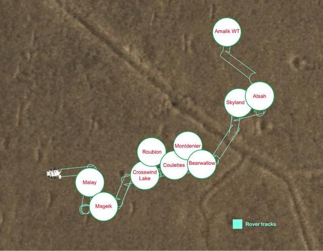
This map shows where NASA's Perseverance Mars dropped each of its 10 samples so that a future mission could pick them up from a sample depot the rover created at a location dubbed "Three Forks" in Jezero Crater. The center of each circle is the location where that sample was deployed, and the red text within that circle indicates the name of the sample as designated by Perseverance's science team. The tubes were deposited on the surface in an intricate zigzag pattern, with each sample about 15 to 50 feet (5 to 15 meters) apart from one another to ensure they could be safely recovered. The Perseverance team precisely mapped the location of each 7-inch-long (18.6-centimeter-long) tube and glove (adapter) combination so that the samples could be found even if covered with dust. The depot is on flat ground near the base of the raised, fan-shaped ancient river delta that formed long ago when a river flowed into a lake there. The first sample in the depot was dropped Dec. 21, 2022, the 653rd day, or sol, of the mission; the final sample was deposited Jan. 28, 2023, the 690th day of the mission. The Three Forks depot, the first sample depot on another world, is a crucial milestone in the NASA-ESA (European Space Agency) Mars Sample Return campaign, which aims to bring Mars samples to Earth for closer study. The Perseverance rover will be the primary means to convey the collected samples to a future robotic lander as part of the campaign. The lander would, in turn, use a robotic arm to place the samples in a containment capsule aboard a small rocket that would blast off to Mars orbit, where another spacecraft would capture the sample container and return it safely to Earth. Hosting the duplicate set, the Three Forks depot will serve as a backup if Perseverance can't deliver its samples. A key objective for Perseverance's mission on Mars is astrobiology, including the search for signs of ancient microbial life. The rover will characterize the planet's geology and past climate, pave the way for human exploration of the Red Planet, and be the first mission to collect and cache Martian rock and regolith (broken rock and dust). Subsequent NASA missions, in cooperation with ESA (European Space Agency), would send spacecraft to Mars to collect these sealed samples from the surface and return them to Earth for in-depth analysis. The Mars 2020 Perseverance mission is part of NASA's Moon to Mars exploration approach, which includes Artemis missions to the Moon that will help prepare for human exploration of the Red Planet. https://photojournal.jpl.nasa.gov/catalog/PIA25682