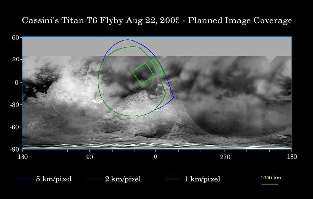
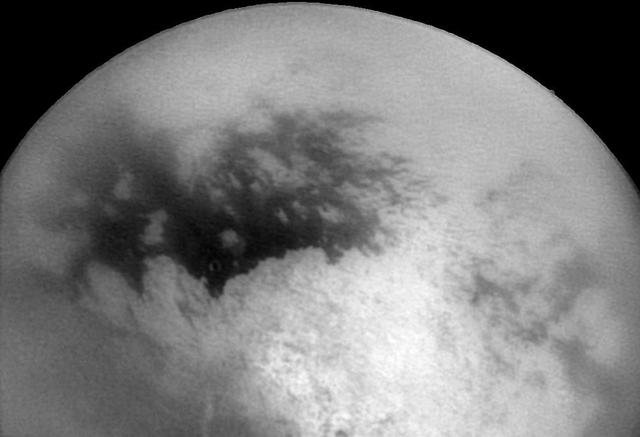
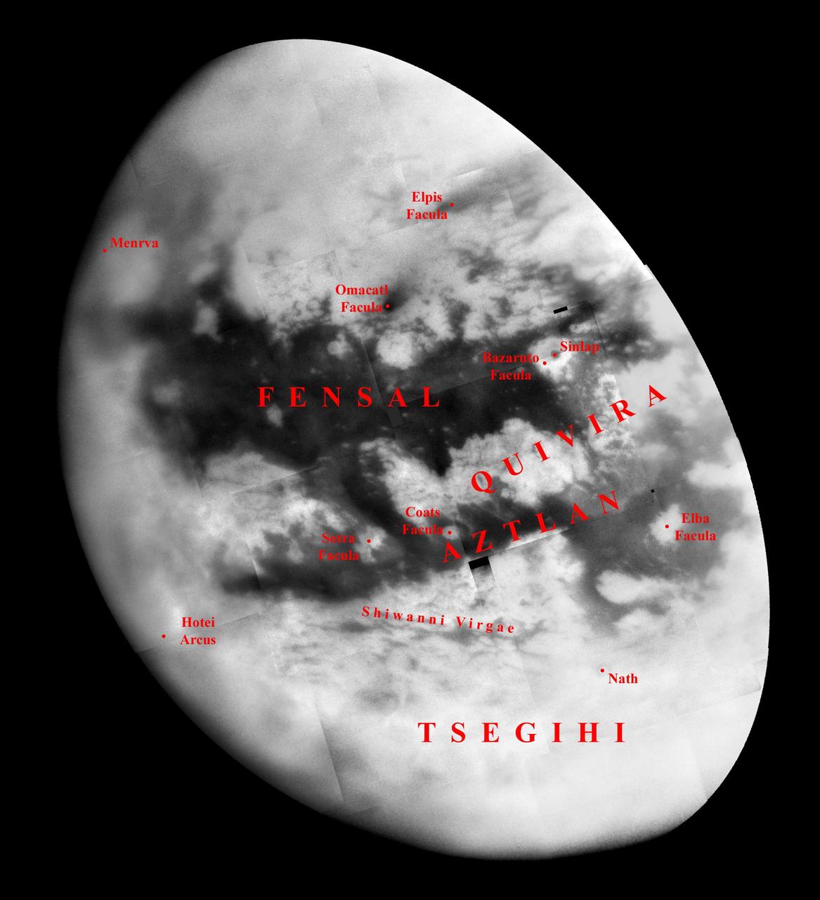
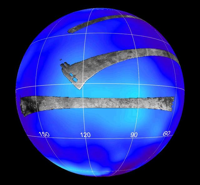
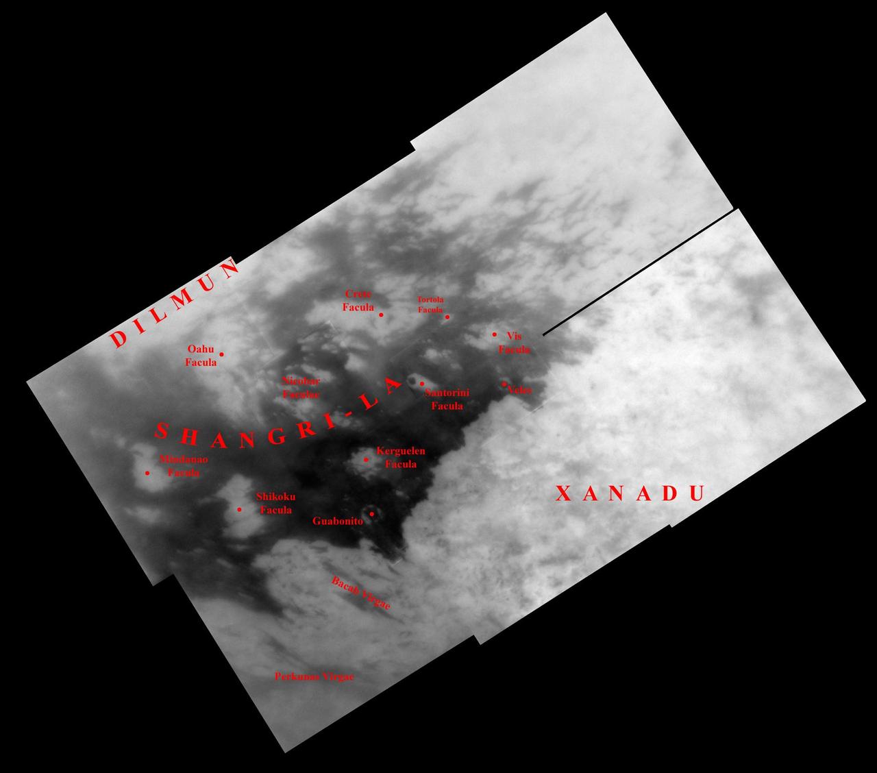
This map of Titan's surface illustrates the regions that will be imaged by Cassini during the spacecraft's close flyby of Titan on Aug. 22, 2005. At closest approach, the spacecraft is expected to pass approximately 3,800 kilometers (2,360 miles) above the moon's surface. At 5,150 kilometers (3,200 miles) across, Titan is one of the solar system's largest moons. The colored lines delineate the regions that will be imaged at differing resolutions. As Cassini continues its reconnaissance of Titan, maps of this haze-enshrouded world continue to improve. Images from this flyby will sharpen the moderate resolution coverage of terrain on the side of Titan that always faces Saturn. The highest resolution image planned for this encounter will cover a 215-kilometer-wide (134-mile) bright feature provisionally named "Bazaruto Facula." (A facula is the name chosen to denote a bright spot on Titan.) At the center of the facula is an 80-kilometer-wide (50-mile) crater (not yet named), seen by Cassini's radar experiment during a Titan flyby in February 2005 (see PIA07368). The imaging cameras and visual and infrared mapping spectrometer images taken in March and April 2005 also show this crater (see PIA06234). The southernmost corner of the highest resolution (1 kilometer per pixel) frame should also cover the northern portion of a large bright feature provisionally known as "Quivira." Wide-angle images obtained during this flyby should cover much of the Tsegihi-Aztlan-Quivira region (also known as the "H" region) at lower resolution. The map shows only brightness variations on Titan's surface (the illumination is such that there are no shadows and no shading from topographic variations). Previous observations indicate that, due to Titan's thick, hazy atmosphere, the sizes of surface features that can be resolved are up to five times larger than the actual pixel scale labeled on the map. The images for this global map were obtained using a narrow-band filter centered at 938 nanometers -- a near-infrared wavelength (invisible to the human eye) at which light can penetrate Titan's atmosphere. The images have been processed to enhance surface details. http://photojournal.jpl.nasa.gov/catalog/PIA07711

art002e024232 (April 6, 2026) - This photo of the Moon was captured by the Artemis II crew aboard the Orion spacecraft a few hours before the lunar flyby. During the flyby, the crew captured critical science observations as they traveled around the farside of the Moon, traveling farther than any humans ever before.
A Flyby Tour of Spirit Descent
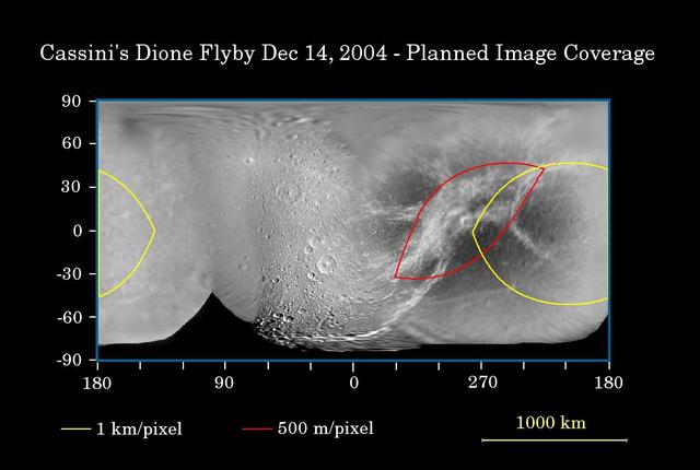
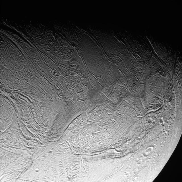
First Flyby of Dione
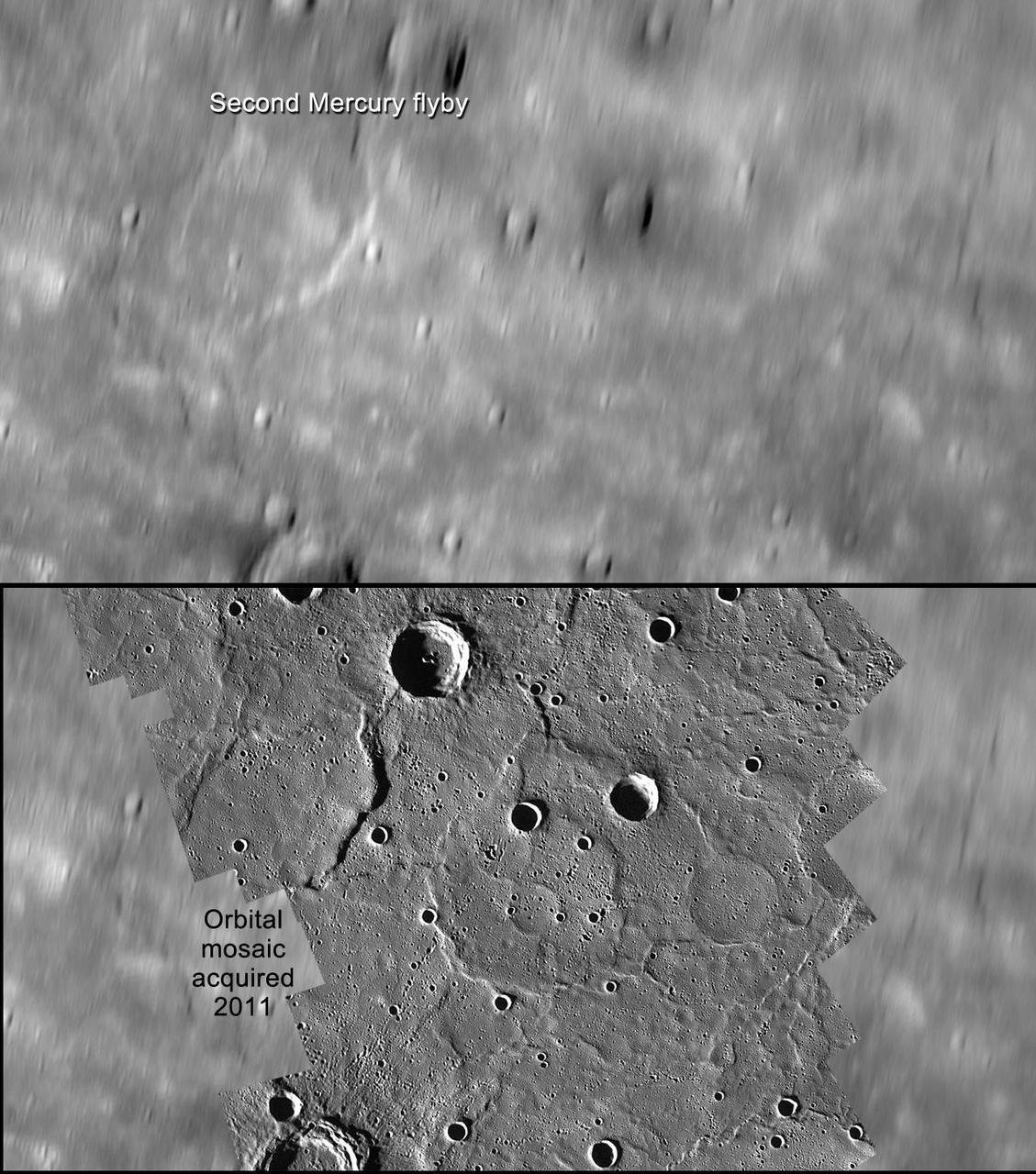
A Comparison of Flyby and Orbital Imaging
Iapetus New Year Flyby

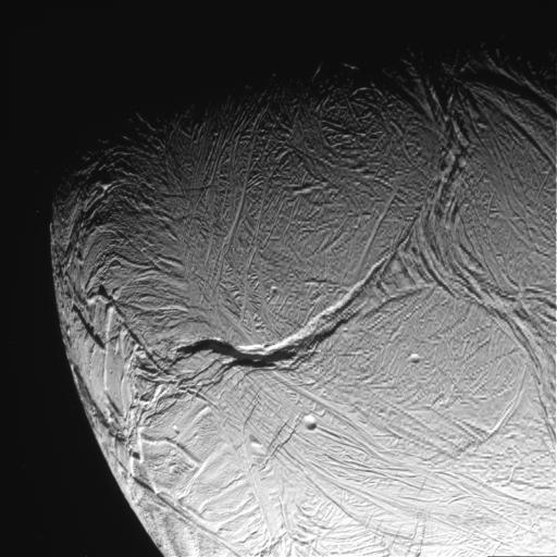
Enceladus First Flyby
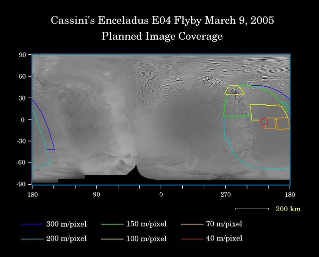
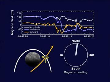
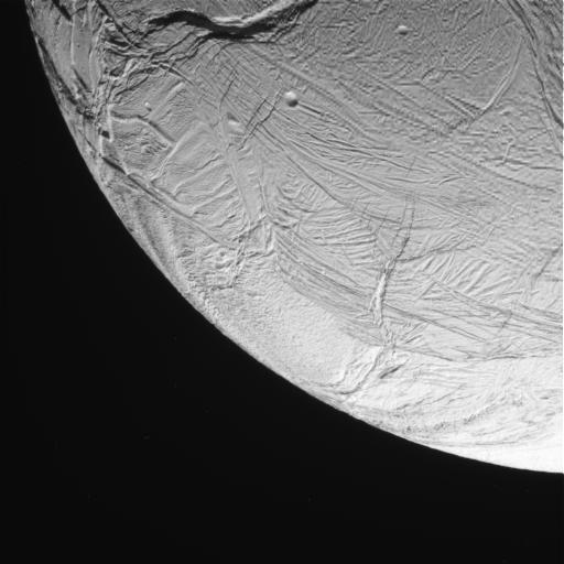
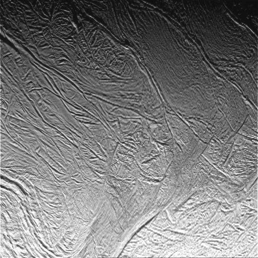
Cassini Closest Enceladus Flyby
Flyby Follow-up
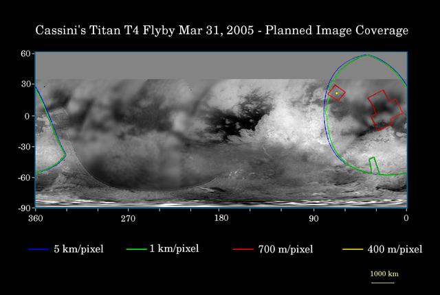
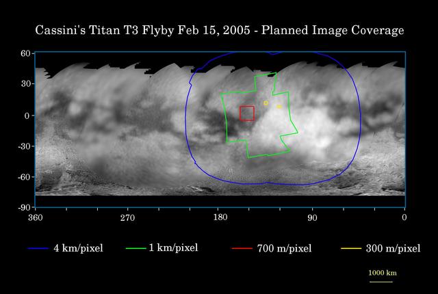
Cassini T4 Flyby
Titan Flyby Number Four
art002e019570 (April 7, 2026) – On flight day seven, following their lunar flyby, the Artemis II crew captured this view of a delicate crescent Moon on their journey back to Earth. Along the terminator—the boundary between lunar day and night—low-angle sunlight casts long shadows that accentuate craters, ridges, and subtle variations in terrain. The softly illuminated surface highlights the Moon’s rugged landscape, while much of it remains in shadow. Credit: NASA

Second Titan Targeted Flyby #2
Naming New Lands - October Flyby
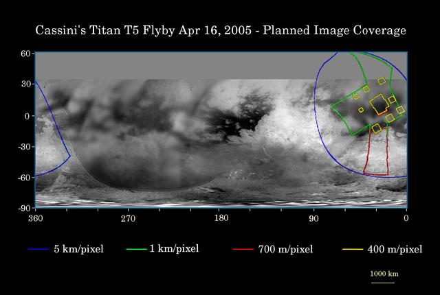
Cassini April 16 Flyby of Titan
Second Titan Targeted Flyby #1
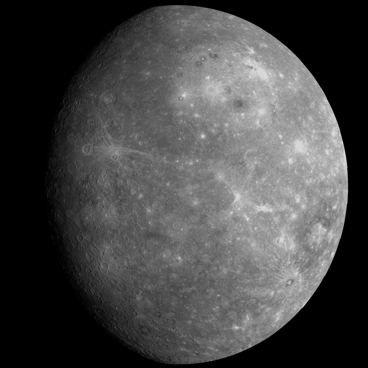
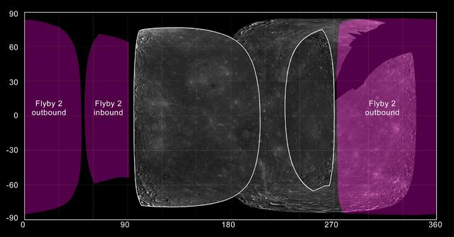
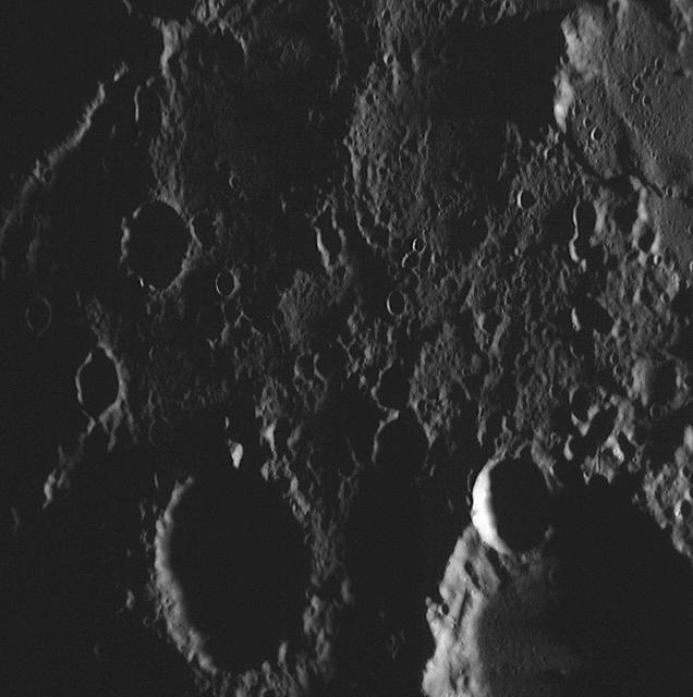
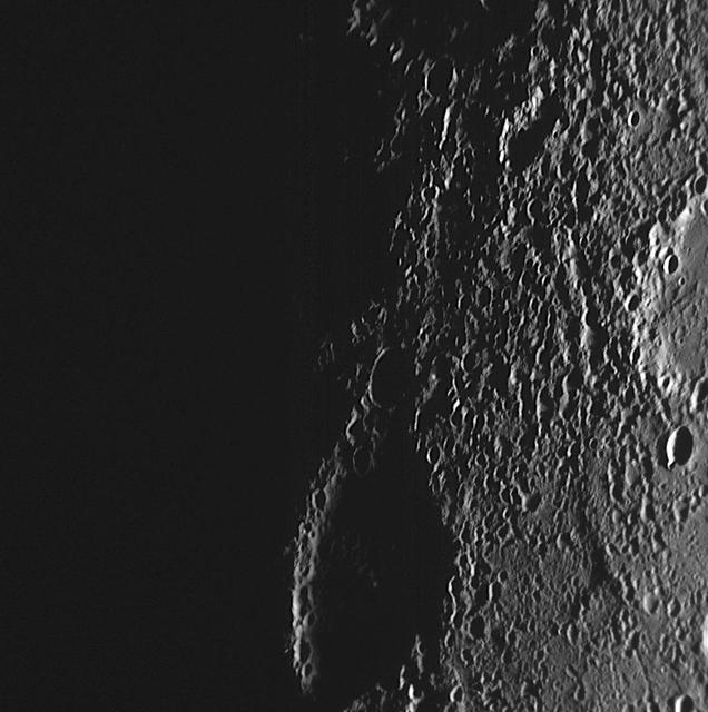
Mercury Topography from the Second Flyby
One Day to Mercury Flyby 3!

Second Titan Targeted Flyby #3
A Flyby Tour of Spirit Descent-2

Naming New Lands - September Flyby

art002e009294 (April 6, 2026) – Artemis II Pilot Victor Glover, Commander Reid Wiseman, and Mission Specialist Jeremy Hansen prepare for their journey around the far side of the Moon by configuring their camera equipment shortly before beginning their lunar flyby observations.
Naming New Lands - September Flyby annotated
Enceladus Rev 91 Flyby - Skeet Shoot #8
Enceladus Rev 91 Flyby - Skeet Shoot #1
Enceladus Rev 91 Flyby - Skeet Shoot #9
A Movie of Magnetometer Measurements from the Second Mercury Flyby
Enceladus Rev 80 Flyby Skeet Shoot #7
Radar Flyby of Titan - April 30, 2006
A Southern Horizon as Seen during Mercury Flyby 3
High-Resolution View from Mercury Flyby 1

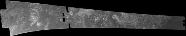
Radar Swath of Oct. 28, 2005, Titan Flyby
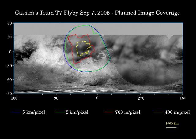
Cassini Sept. 7, 2005, Titan Flyby
Imaging Plans for MESSENGER Second Mercury Flyby

Close Titan Flyby 3, Image #1
Enceladus Rev 91 Flyby - Skeet Shoot #4
Naming New Lands - October Flyby annotated
Cassini Oct. 28, 2005, Titan Flyby
Comparing Mercury Exosphere between Two Flybys

On Target for Mercury Flyby 3 - Two Weeks To Go!
Enceladus Rev 80 Flyby Skeet Shoot #1
Enceladus Rev 80 Flyby Skeet Shoot #3
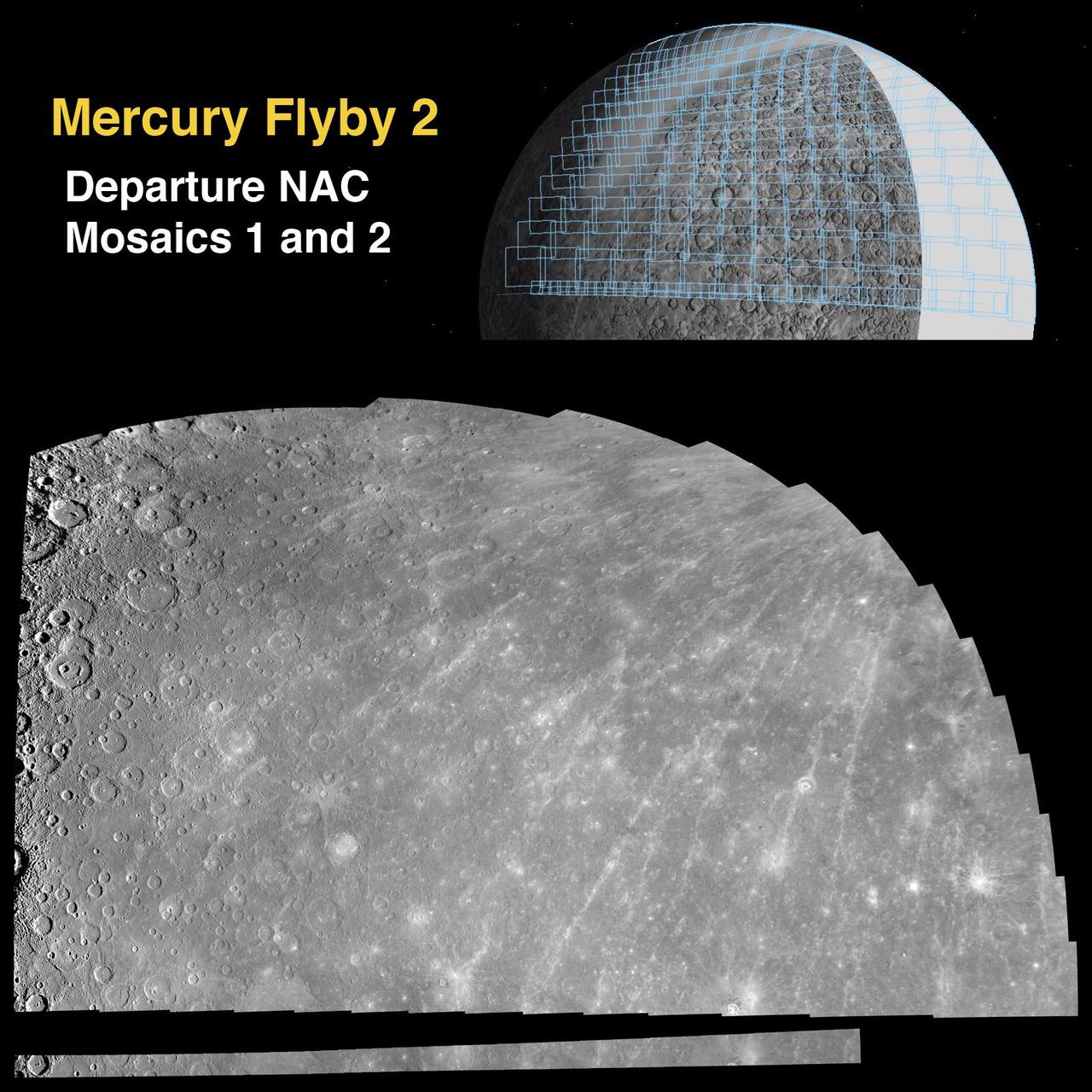
Departure Mosaics from the Second Mercury Flyby
Approach Mosaic from Mercury Flyby 3

art002e016204 (April 6, 2026) – NASA astronaut and Artemis II Pilot Victor Glover pictured here in the Orion spacecraft during the Artemis II lunar flyby. Glover and his fellow crewmates spent approximately seven hours taking turns at the Orion windows capturing science data to share with their team back on Earth. At closest approach, they came within 4,067 miles of the Moon’s surface.
art002e014235 (April 6, 2026) – CSA (Canadian Space Agency) astronaut and Artemis II Mission Specialist Jeremy Hansen is seen taking images through the Orion spacecraft window during the Artemis II lunar flyby. Hansen and his fellow crewmates spent approximately seven hours taking turns at the Orion windows capturing science data to share with their team back on Earth. At closest approach, they came within 4,067 miles of the Moon’s surface.
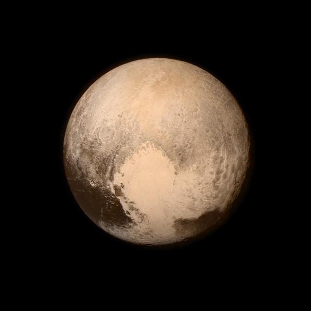
Pluto nearly fills the frame in this image from the Long Range Reconnaissance Imager (LORRI) aboard NASA’s New Horizons spacecraft, taken on July 13, 2015, when the spacecraft was 476,000 miles (768,000 kilometers) from the surface. This is the last and most detailed image sent to Earth before the spacecraft’s closest approach to Pluto on July 14. The color image has been combined with lower-resolution color information from the Ralph instrument that was acquired earlier on July 13. This view is dominated by the large, bright feature informally named the “heart,” which measures approximately 1,000 miles (1,600 kilometers) across. The heart borders darker equatorial terrains, and the mottled terrain to its east (right) are complex. However, even at this resolution, much of the heart’s interior appears remarkably featureless—possibly a sign of ongoing geologic processes. CREDIT: NASA/APL/SwRI <b><a href="http://go.nasa.gov/1L5NU1J" rel="nofollow">NASA image use policy.</a></b> <b><a href="http://go.nasa.gov/1L5NU1L" rel="nofollow">NASA Goddard Space Flight Center</a></b> enables NASA’s mission through four scientific endeavors: Earth Science, Heliophysics, Solar System Exploration, and Astrophysics. Goddard plays a leading role in NASA’s accomplishments by contributing compelling scientific knowledge to advance the Agency’s mission. <b>Follow us on <a href="http://go.nasa.gov/1L5NU1N" rel="nofollow">Twitter</a></b> <b>Like us on <a href="http://go.nasa.gov/1L5NWqt" rel="nofollow">Facebook</a></b> <b>Find us on <a href="http://go.nasa.gov/1L5NWGJ" rel="nofollow">Instagram</a></b> <b><a href="http://go.nasa.gov/1L5NWGN" rel="nofollow">Credit: NOAA/NASA GOES Project</a></b>
art002e016136 (April 6, 2026) – CSA (Canadian Space Agency) astronaut and Artemis II Mission Specialist Jeremy Hansen is seen taking images through the Orion spacecraft window during the Artemis II lunar flyby. Hansen and his fellow crewmates spent approximately seven hours taking turns at the Orion windows capturing science data to share with their team back on Earth. At closest approach, they came within 4,067 miles of the Moon’s surface.

art002e016171 (April 6, 2026) – CSA (Canadian Space Agency) astronaut and Artemis II Mission Specialist Jeremy Hansen pictured here in the Orion spacecraft during the Artemis II lunar flyby. Hansen and his fellow crewmates spent approximately seven hours taking turns at the Orion windows capturing science data to share with their team back on Earth. At closest approach, they came within 4,067 miles of the Moon’s surface.
art002e016172 (April 6, 2026) – NASA astronaut and Artemis II Mission Specialist Christina Koch pictured here in the Orion spacecraft during the Artemis II lunar flyby. Koch and her fellow crewmates spent approximately seven hours taking turns at the Orion windows capturing science data to share with their team back on Earth. At closest approach, they came within 4,067 miles of the Moon’s surface.
art002e016198 (April 6, 2026) – NASA astronaut and Artemis II Pilot Victor Glover pictured here in the Orion spacecraft during the Artemis II lunar flyby. Glover and his fellow crewmates spent approximately seven hours taking turns at the Orion windows capturing science data to share with their team back on Earth. At closest approach, they came within 4,067 miles of the Moon’s surface.

Enceladus Oct. 9, 2008 Flyby - Posted Image #4
Enceladus Oct. 9, 2008 Flyby - Posted Image #1
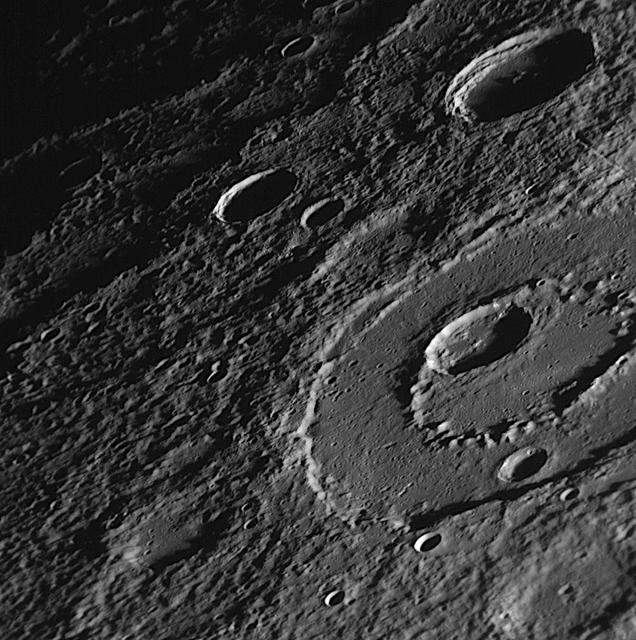
Peak-Ring Basin Close-Up from the Second Mercury Flyby
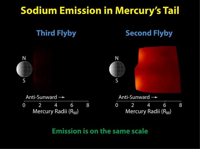
Mercury Flyby 3 Reveals a Highly Diminished Sodium Tail
Enceladus Rev 91 Flyby - Skeet Shoot 1-4 Mosaic
Enceladus Oct. 9, 2008 Flyby - Posted Image #2
The Highest-resolution Image from MESSENGER Second Mercury Flyby
Enceladus Oct. 9, 2008 Flyby - Posted Image #3
Enceladus Oct. 9, 2008 Flyby - Posted Image #5
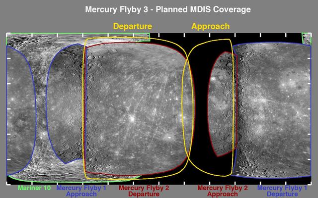
One Week to Mercury Flyby 3 - A Look at the Planned Imaging Coverage

Artemis II deputy lunar science lead, Jacob Richardson, left, and Artemis II lunar science team members, Kiarre Dumes, react to the astronauts' verbal observations of the Moon during their flyby on April 6, 2026. Along with other lunar science team members, Richardson and Dumes helped train the crew in geology both in the classroom and in the field. The science team also built the lunar targeting plan that, like an International Space Station spacewalk plan, provides strong, detailed observation guidance, plus flexibility for the crew to make decisions based on what they’re seeing and experiencing in real time. The science team had many moments of celebration during the lunar flyby as the astronauts took images of the Moon and provided verbal descriptions of what they were seeing. This type of information reveals the geologic history of an area and will be critical to collect when future Artemis astronauts explore the Moon's surface. Credits: NASA/Luna Posadas Nava

Artemis II lunar science team members, from left, Debra Needham, Juliane Gross, and Ryan Watkins, react to the astronauts' verbal observations of the Moon during their flyby on April 6, 2026. The science team trained the astronauts in geology and observation, both in the classroom and in the field. The team also built the lunar targeting plan that, like an International Space Station spacewalk plan, provides strong, detailed observation guidance, plus flexibility for the crew to make decisions based on what they’re seeing and experiencing in real time. The science team had many moments of celebration during the lunar flyby as the astronauts took images of the Moon and provided verbal descriptions of what they were seeing. This type of information reveals the geologic history of an area and will be critical to collect when future Artemis astronauts explore the Moon's surface. Credits: NASA/Luna Posadas Nava
art002e016247 (April 6, 2026) – Artemis II Pilot Victor Glover, on the left, and Mission Specialist Christina Koch, on the right, gather images and observations of the lunar surface to share with the world during the lunar flyby on the sixth day of the mission. The crew spent approximately seven hours taking turns at the windows of the Orion spacecraft as they flew around the far side of the Moon. At closest approach, they came within 4,067 miles of the Moon’s surface. Credit: NASA
art002e016195 (April 6, 2026) – Artemis II Pilot Victor Glover, on the left, and Mission Specialist Christina Koch, on the right, gather images and observations of the lunar surface to share with the world during the lunar flyby on the sixth day of the mission. The crew spent approximately seven hours taking turns at the windows of the Orion spacecraft as they flew around the far side of the Moon. At closest approach, they came within 4,067 miles of the Moon’s surface.
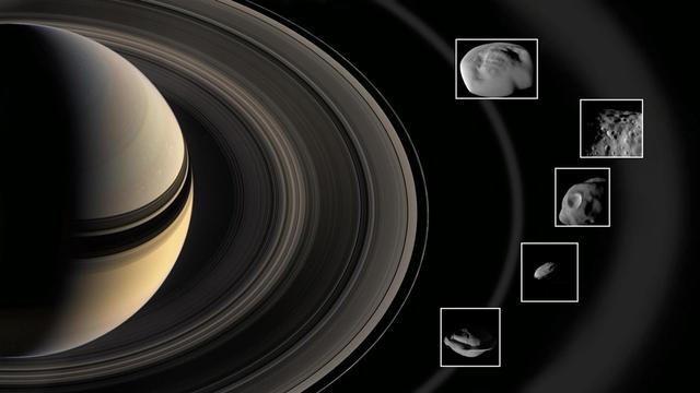
During super-close flybys of Saturn's rings, NASA's Cassini spacecraft inspected the mini-moons Pan and Daphnis in the A ring; Atlas at the edge of the A ring; Pandora at the edge of the F ring; and Epimetheus, which is bathed in material that fans out from the moon Enceladus. The mini-moons' diameter ranges from 5 miles (8 kilometers) for Daphnis to 72 miles (116 kilometers) for Epimetheus. The rings and the moons depicted in this illustration are not to scale. https://photojournal.jpl.nasa.gov/catalog/PIA22772

Artemis II deputy lunar science lead Marie Henderson, shown standing on the left, and lunar science team members, from the right foreground, Ariel Deutsch, Maria Banks behind her, Ryan Watkins to her right, and Sara Schmidt in the checkered jacket. In this image they are reacting to astronauts' observations of Moon features during their flyby on April 6, 2026. Leading up to the flight, the science team has been training the astronauts in in the classroom and in the field. They also built the lunar targeting plan that, like a spacewalk plan on the International Space Station, provides strong, detailed observation guidance, plus flexibility for the crew to make decisions based on what they’re seeing and experiencing in real time. The science team had many moments of celebration during the lunar flyby as the astronauts took images of the Moon and provided verbal descriptions of what they were seeing. This type of information reveals the geologic history of various lunar areas and will be critical to collect when future Artemis astronauts explore the Moon's surface. Credits: NASA/Luna Posadas Nava
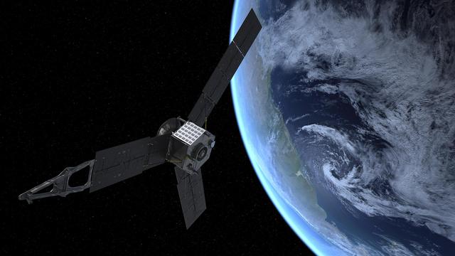
This artist rendering shows NASA Juno spacecraft during its Earth flyby gravity assist on Oct. 9, 2013. On Earth below, the southern Atlantic Ocean is visible, along with the coast of Argentina.
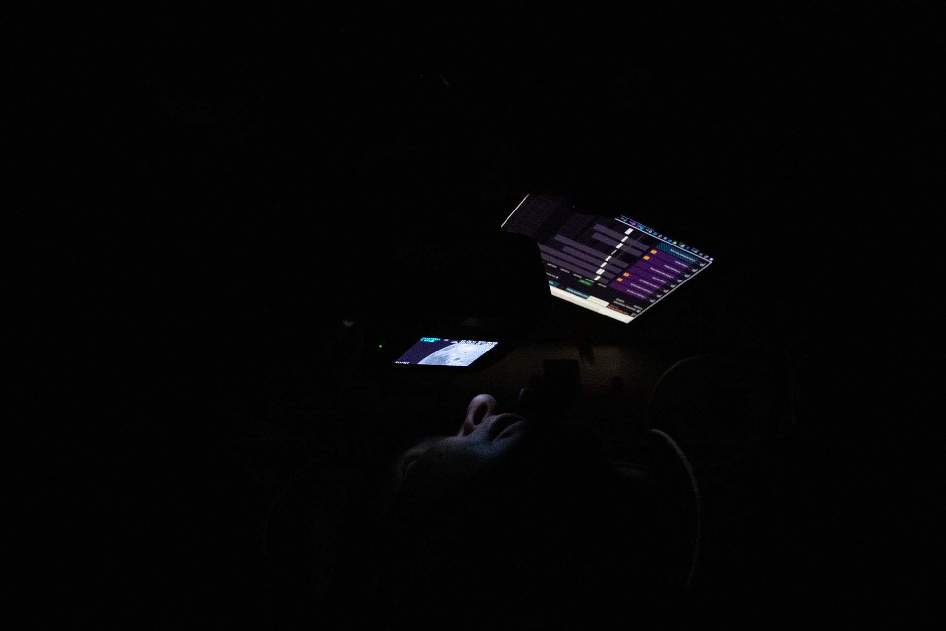
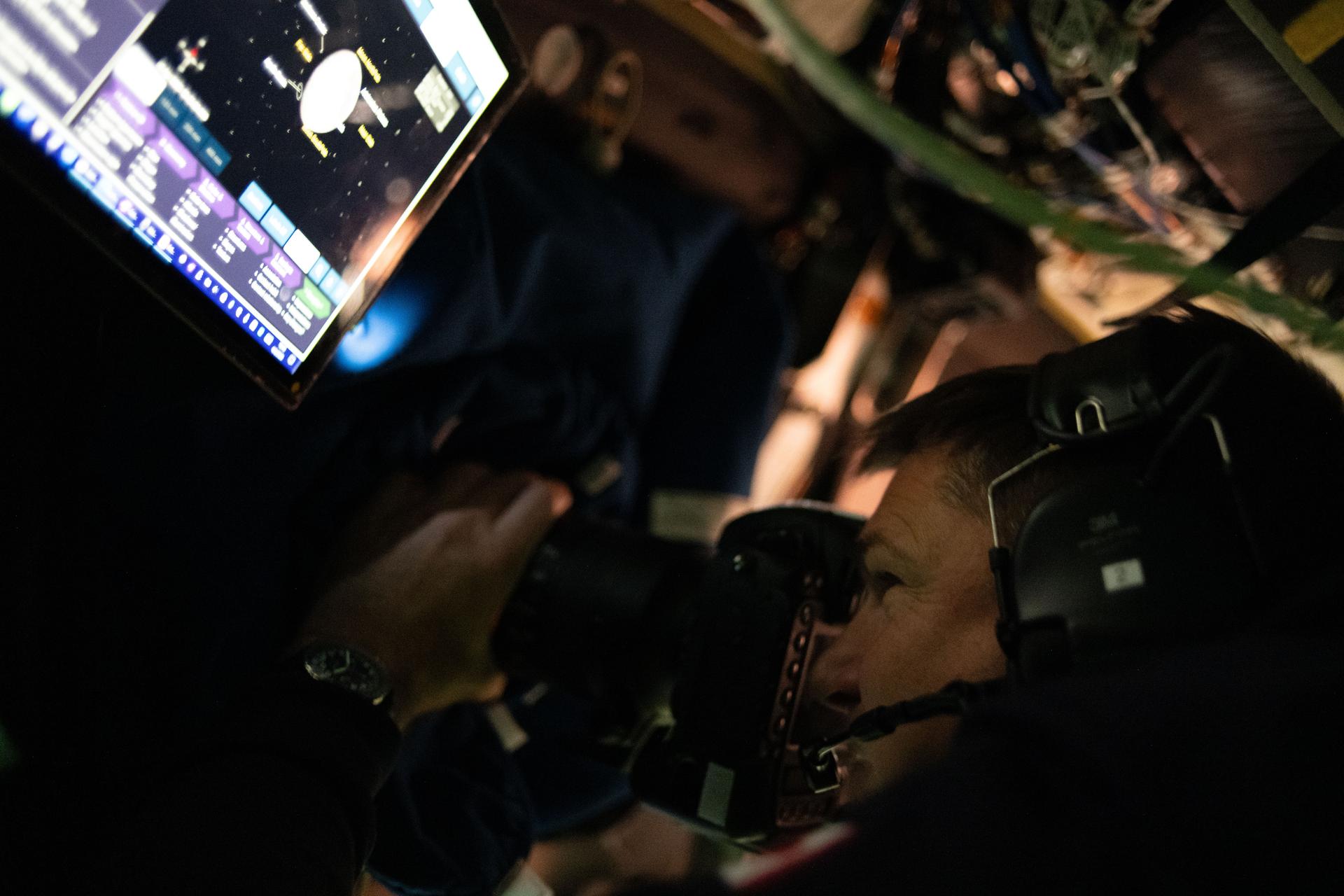
art002e014251 (April 6, 2026) – CSA (Canadian Space Agency) astronaut and Artemis II Mission Specialist Jeremy Hansen is seen taking images through the Orion spacecraft window during the Artemis II lunar flyby. Hansen and his fellow crewmates spent approximately seven hours taking turns at the Orion windows capturing science data to share with their team back on Earth. At closest approach, they came within 4,067 miles of the Moon’s surface. The application seen on the crew personal computing devices is the Lunar Targeting Plan that guides them in the execution of the lunar science observation plan. This custom software was built by the crew lunar observations team, a subset of the Artemis II lunar science team.

jsc2026e021924 (April 6, 2026) - Artemis II Flight Control Team pictured at consoles within the White Flight Control Room in the Mission Control Center at NASA’s Johnson Space Center during the Artemis II mission. This image was taken when NASA astronauts Reid Wiseman, commander; Victor Glover, pilot; Christina Koch, mission specialist; and CSA (Canadian Space Agency) astronaut Jeremy Hansen conducted the flyby of the Moon. Credit: NASA/Robert Markowitz
This image was obtained by NASA's Cassini radar instrument during a flyby on Dec. 20, 2007. South Polar Region, Western Mezzoramia. https://photojournal.jpl.nasa.gov/catalog/PIA01854
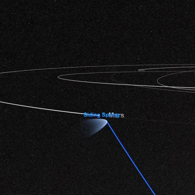
On October 19, Comet Siding Spring will pass within 88,000 miles of Mars – just one third of the distance from the Earth to the Moon! Traveling at 33 miles per second and weighing as much as a small mountain, the comet hails from the outer fringes of our solar system, originating in a region of icy debris known as the Oort cloud. Comets from the Oort cloud are both ancient and rare. Since this is Comet Siding Spring’s first trip through the inner solar system, scientists are excited to learn more about its composition and the effects of its gas and dust on the Mars upper atmosphere. NASA will be watching closely before, during, and after the flyby with its entire fleet of Mars orbiters and rovers, along with the Hubble Space Telescope and dozens of instruments on Earth. The encounter is certain to teach us more about Oort cloud comets, the Martian atmosphere, and the solar system’s earliest ingredients. Learn more: <a href="https://www.youtube.com/watch?v=FG4KsatjFeI" rel="nofollow">www.youtube.com/watch?v=FG4KsatjFeI</a> Credit: NASA’s Goddard Space Flight Center <b><a href="http://www.nasa.gov/audience/formedia/features/MP_Photo_Guidelines.html" rel="nofollow">NASA image use policy.</a></b> <b><a href="http://www.nasa.gov/centers/goddard/home/index.html" rel="nofollow">NASA Goddard Space Flight Center</a></b> enables NASA’s mission through four scientific endeavors: Earth Science, Heliophysics, Solar System Exploration, and Astrophysics. Goddard plays a leading role in NASA’s accomplishments by contributing compelling scientific knowledge to advance the Agency’s mission. <b>Follow us on <a href="http://twitter.com/NASAGoddardPix" rel="nofollow">Twitter</a></b> <b>Like us on <a href="http://www.facebook.com/pages/Greenbelt-MD/NASA-Goddard/395013845897?ref=tsd" rel="nofollow">Facebook</a></b> <b>Find us on <a href="http://instagram.com/nasagoddard?vm=grid" rel="nofollow">Instagram</a></b>
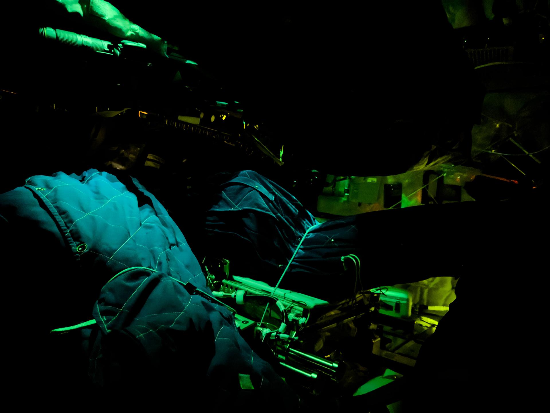
art002e009215 (April 6, 2026) - Artemis II crewmember sleeping bags are illuminated inside the Orion spacecraft on Flight Day 5 of the mission and ahead of the crew's lunar flyby on April 6, 2026.

jsc2026e020501 (April 6, 2026) - NASA Flight Directors Diane Dailey, Pooja Jesrani, and Paul Konyha pictured in the White Flight Control Room during the Artemis II crew’s lunar flyby. Credit: NASA
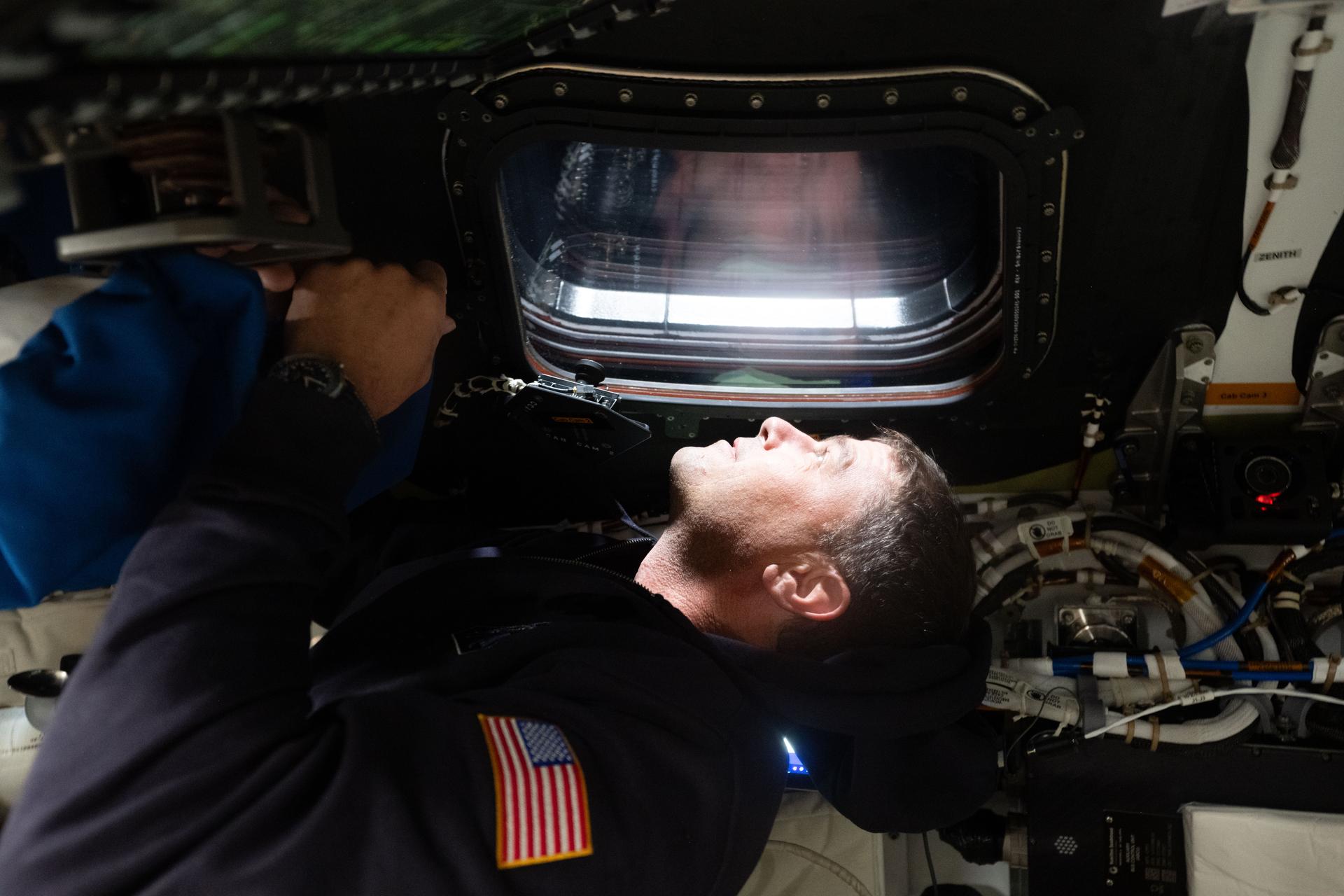
art002e029164 (April 6, 2026) - NASA astronaut and Artemis II commander Reid Wiseman gazes out the window of the Orion spacecraft upon the start of the sixth day of the mission and a few hours before the lunar flyby. Credit: NASA
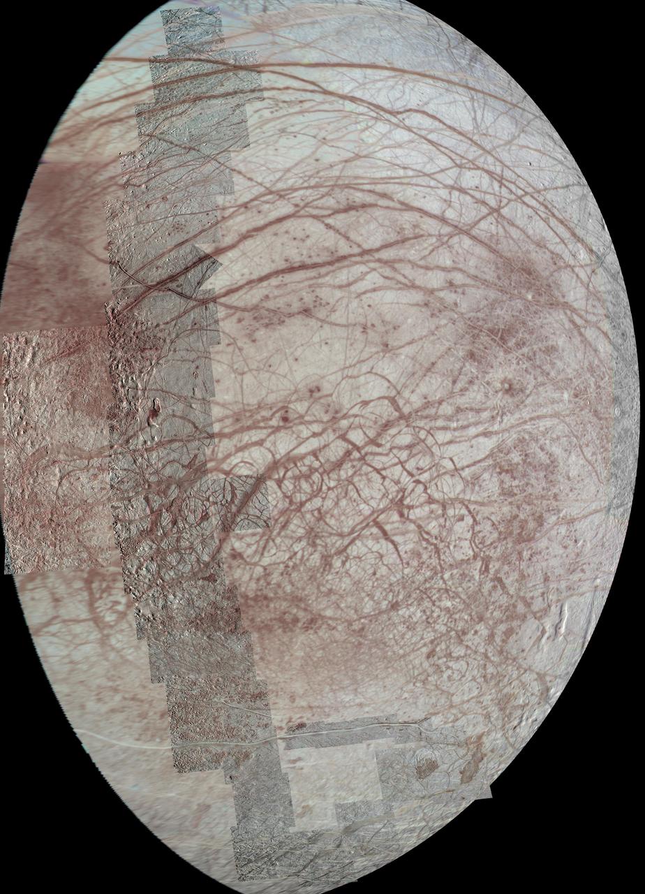
This view of Jupiter moon Europa features several regional-resolution mosaics overlaid on a lower resolution global view for context. The regional views were obtained during several different flybys of the moon by NASA Galileo mission.
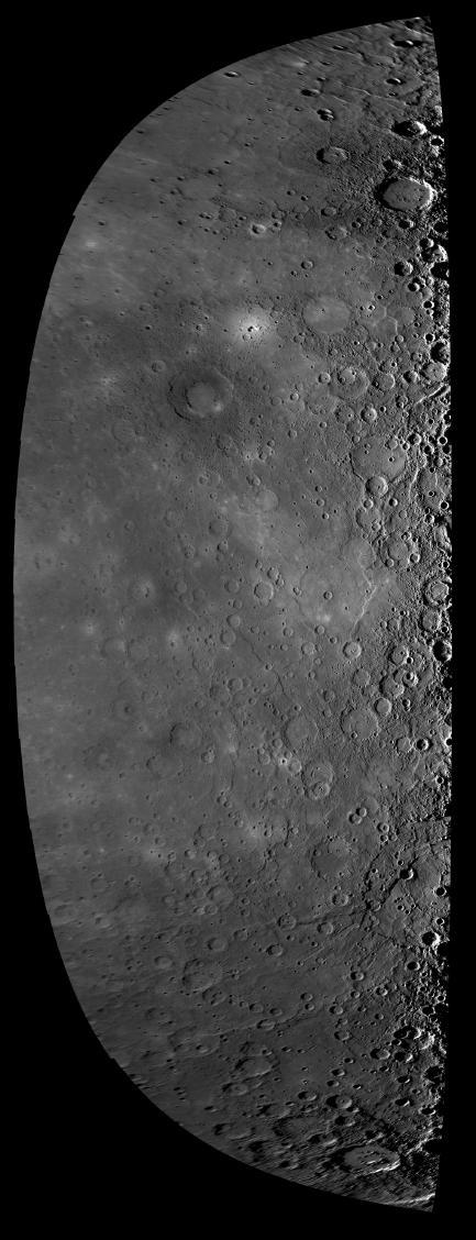
This high-resolution NAC image shows a view of Mercury dawn terminator, the division between the sunlit dayside and dark nightside of the planet, as seen as the MESSENGER spacecraft departed the planet during the mission second Mercury flyby.
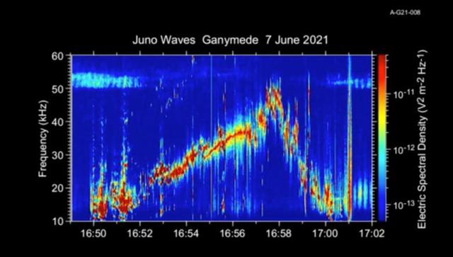
This 50-second animation provides an auditory as well as visual glimpse at data collected by Juno's Waves instrument as the spacecraft flew past the Jovian moon Ganymede on June 7, 2021. The abrupt change to higher frequencies around the midpoint of the recording represents the spacecraft's move from one region of Ganymede's magnetosphere to another. The audio track is made by shifting the frequency of those emissions – which range from 10 to 50 kHz – into the lower audio range. The animation is shorter than the duration of Juno's flyby because the Waves data is edited onboard to reduce telemetry requirements. Movie available at https://photojournal.jpl.nasa.gov/catalog/PIA25030
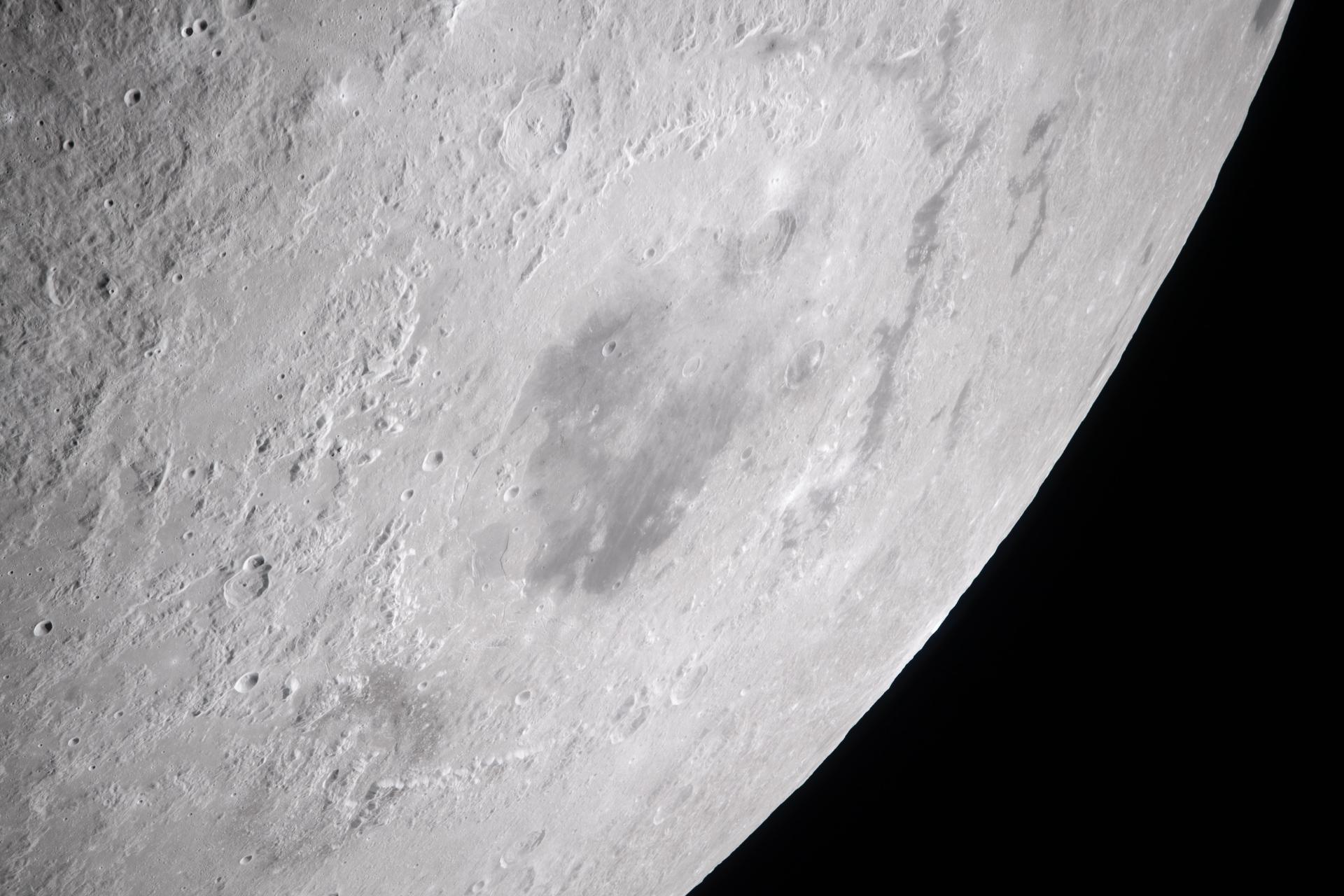
art002e010232 (April 6, 2026) – During the lunar flyby observation period, the Artemis II crew captures a detailed image of the Orientale basin, a 600-mile-wide impact crater marked by a dark patch of ancient lava that erupted through the Moon’s crust billions of years ago.

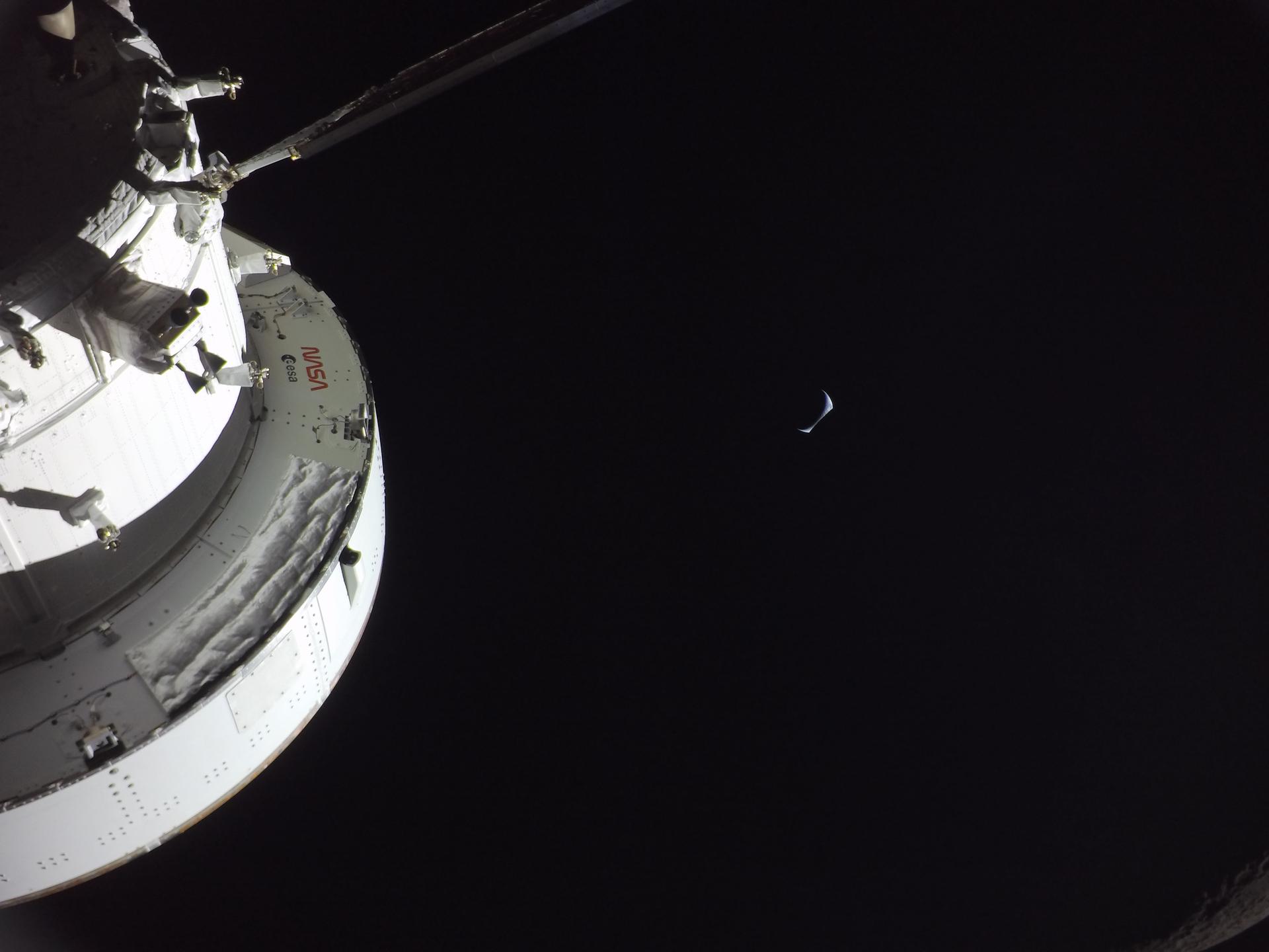
art002e021007 (April 6, 2026) – Earthset captured through the Orion spacecraft window at 6:37 p.m. EDT, April 6, 2026, during the Artemis II crew’s flyby of the Moon. A muted blue Earth with bright white clouds sets behind the cratered lunar surface. The dark portion of Earth is in nighttime. Credit: NASA
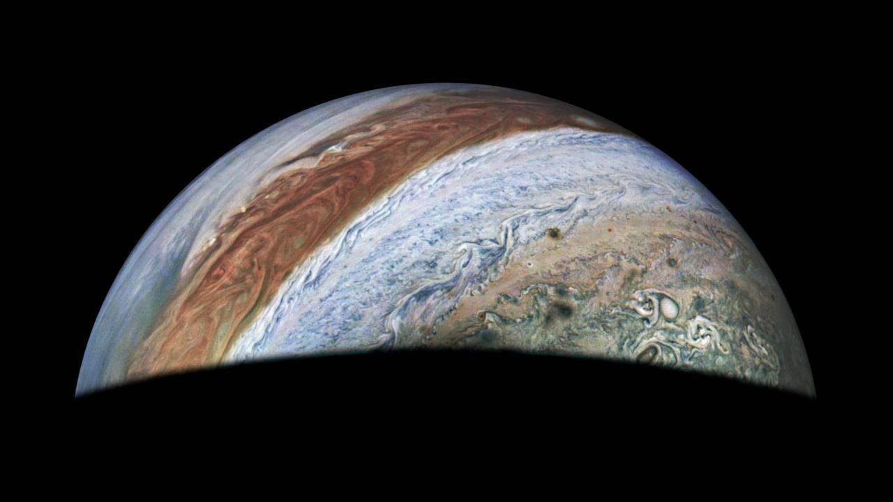
This view of Jupiter was captured by the JunoCam instrument aboard NASA's Juno spacecraft during the mission's 62nd close flyby of the giant planet on June 13, 2024. Citizen scientist Jackie Branc made the image using raw JunoCam data. https://photojournal.jpl.nasa.gov/catalog/PIA26350
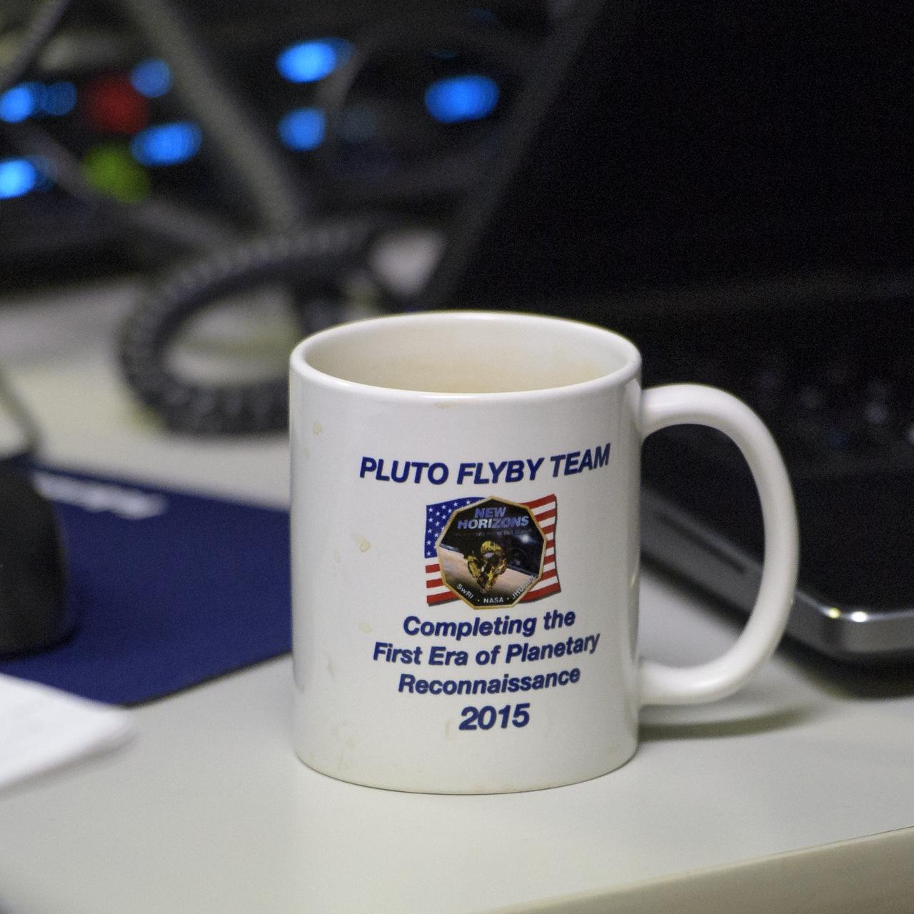
A New Horizons Pluto flyby coffee mug is seen as team members wait for a signal from the spacecraft that it is healthy and collected data during the flyby of Ultima Thule, Tuesday, Jan. 1, 2019 at the Mission Operations Center of the Johns Hopkins University Applied Physics Laboratory (APL) in Laurel, Maryland. Photo Credit: (NASA/Bill Ingalls)
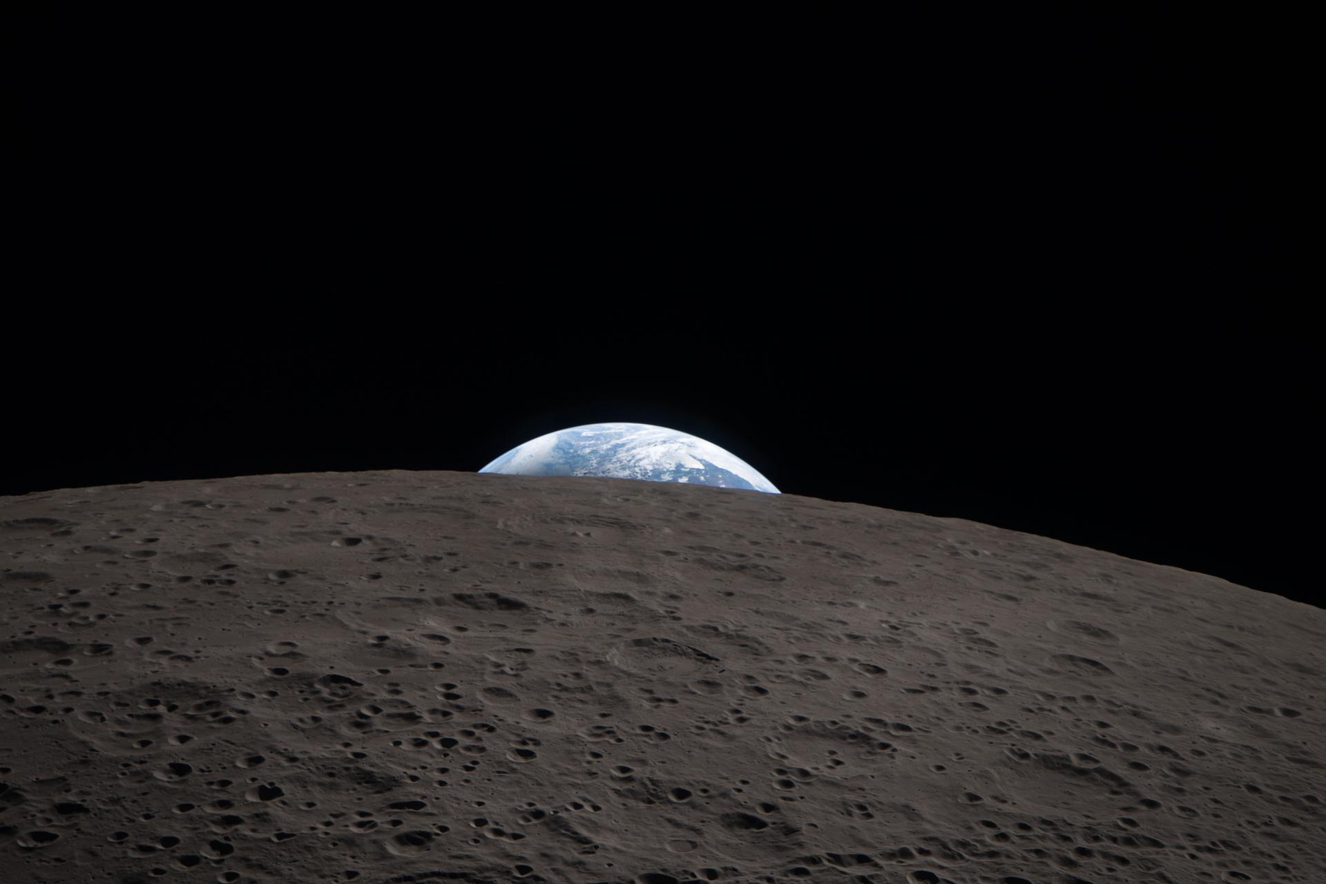
art002e021278 (April 6, 2026) – Echoing the iconic Earthrise photo captured by the Apollo 8 astronauts in 1968, during the lunar flyby, the Artemis II crew captured a shot of Earthset as they passed behind the Moon’s far side. It is one of many photos taken during the seven-hour lunar flyby by the Artemis II crew on the Orion spacecraft. Credit: NASA
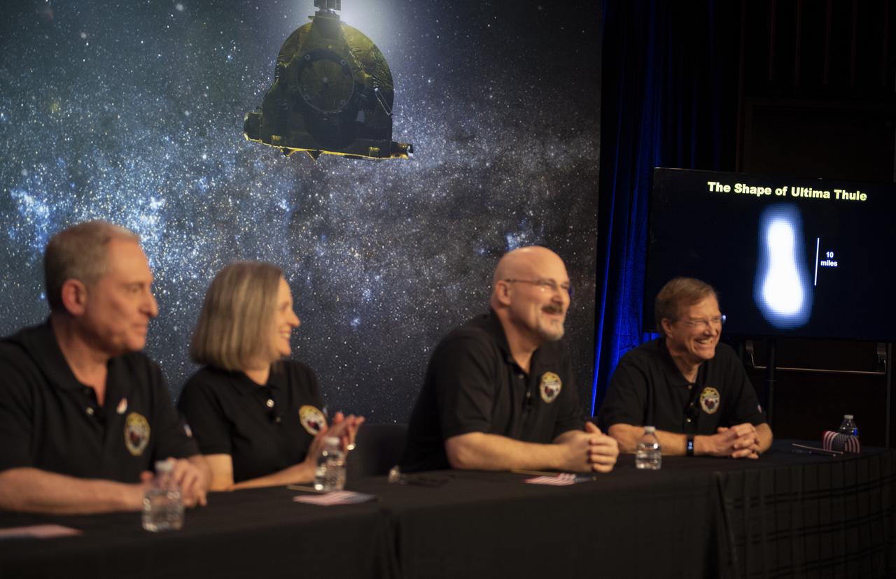
A new image of Ultima Thule is seen on a screen during a press conference after the team received confirmation from the New Horizons spacecraft that it has completed the flyby of Ultima Thule, Tuesday, Jan. 1, 2019 at Johns Hopkins University Applied Physics Laboratory (APL) in Laurel, Maryland. New Horizons principal investigator Alan Stern of the Southwest Research Institute (SwRI), Boulder, CO, New Horizons Mission Operations Manager Alice Bowman of the Johns Hopkins University Applied Physics Laboratory, New Horizons mission systems engineer Chris Hersman of the Johns Hopkins University Applied Physics Laboratory, and New Horizons project scientist Hal Weaver of the Johns Hopkins University Applied Physics Laboratory, spoke about the flyby and new pre-flyby information that was downlinked from the spacecraft. Photo Credit: (NASA/Joel Kowsky)
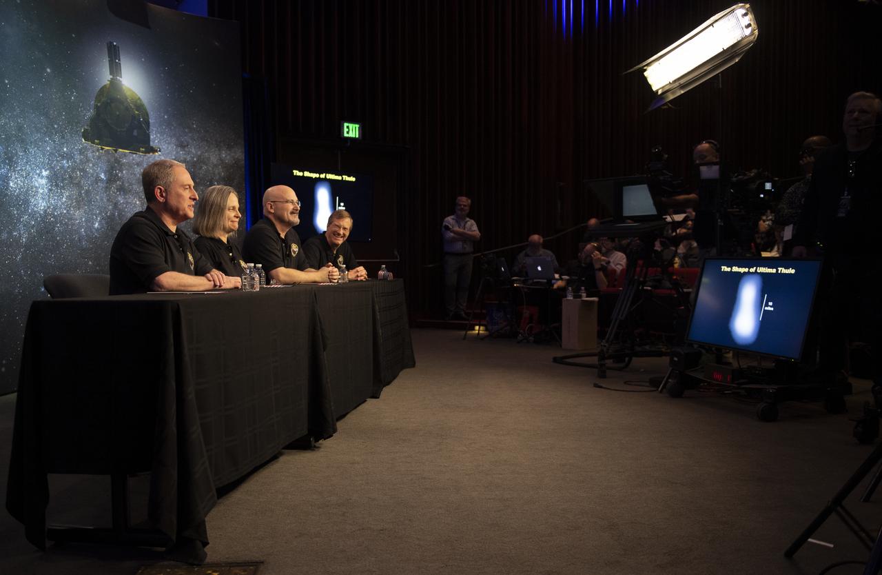
A new image of Ultima Thule is seen on a screen during a press conference after the team received confirmation from the New Horizons spacecraft that it has completed the flyby of Ultima Thule, Tuesday, Jan. 1, 2019 at Johns Hopkins University Applied Physics Laboratory (APL) in Laurel, Maryland. New Horizons principal investigator Alan Stern of the Southwest Research Institute (SwRI), Boulder, CO, New Horizons Mission Operations Manager Alice Bowman of the Johns Hopkins University Applied Physics Laboratory, New Horizons mission systems engineer Chris Hersman of the Johns Hopkins University Applied Physics Laboratory, and New Horizons project scientist Hal Weaver of the Johns Hopkins University Applied Physics Laboratory, spoke about the flyby and new pre-flyby information that was downlinked from the spacecraft. Photo Credit: (NASA/Joel Kowsky)

This image was obtained by NASA Cassini radar instrument during a flyby on Dec. 12, 2006. North Polar Pass Northern Lakes Region, Aaru. https://photojournal.jpl.nasa.gov/catalog/PIA04308

This image was obtained by NASA Cassini radar instrument during a flyby on July 7, 2010. Southern mid-latitudes trailing hemisphere, Northern Mezzoramia. https://photojournal.jpl.nasa.gov/catalog/PIA06679
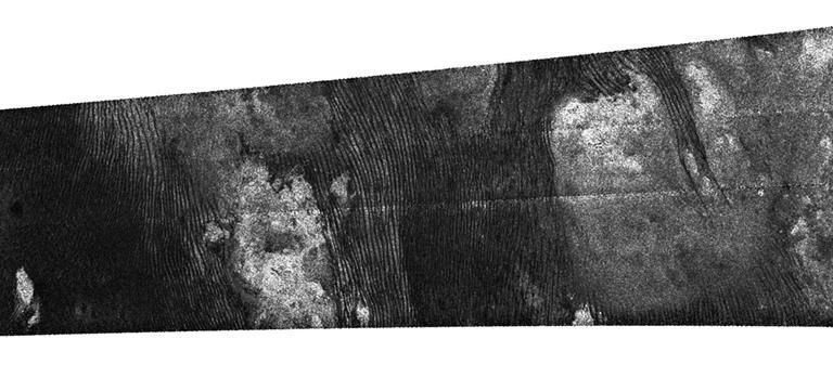
This image was obtained by NASA Cassini radar instrument during a flyby on Sept. 7, 2005. Southern Mid-latitudes Central Tsegihi, Mezzoramia. https://photojournal.jpl.nasa.gov/catalog/PIA01855

This image was obtained by NASA Cassini radar instrument during a flyby on Oct. 9, 2006. North Polar Pass Northern Lakes Region, Aaru. https://photojournal.jpl.nasa.gov/catalog/PIA03187

This image was obtained by NASA Cassini radar instrument during a flyby on Jan. 12, 2010. High southern latitudes Ontario Lacus, Mezzoramia. https://photojournal.jpl.nasa.gov/catalog/PIA00927
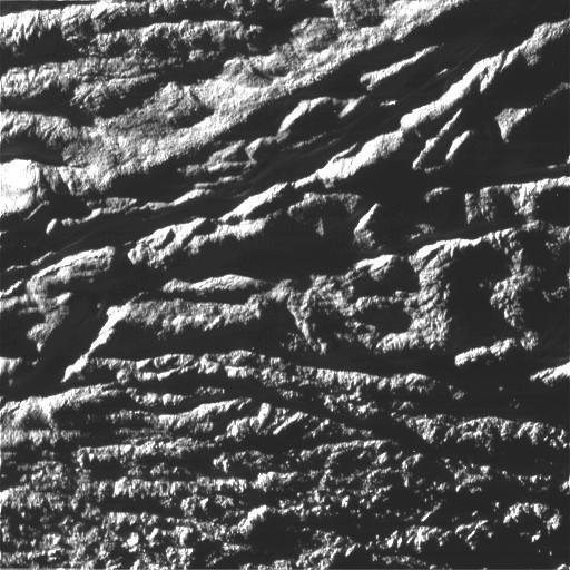
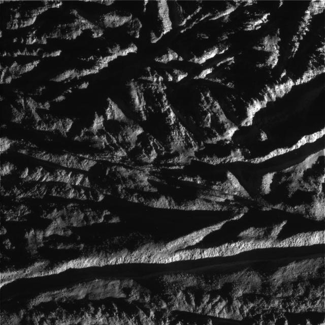
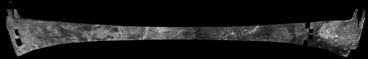
This image was obtained by NASA's Cassini radar instrument during a flyby on July 8, 2009. The radar antenna was pointing toward Titan at a 900 km altitude at the closest approach. The image has been processed with a resolution of 128 pixels/deg. https://photojournal.jpl.nasa.gov/catalog/PIA04398
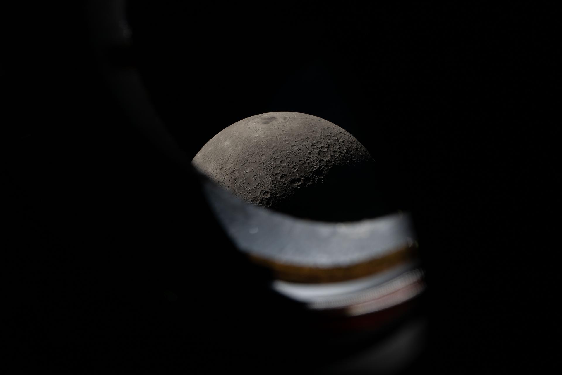
art002e012278 (April 6, 2026) - The Moon seen peeking above the window sill of the Orion spacecraft during the Artemis II lunar flyby on April 6, 2026. The Artemis II crew spent about 7 hours at the Orion windows during the flyby, taking photos and recording observations on the Moon to share with scientists on the ground.
art002e016299 (April 6, 2026) - Earthrise captured from a camera mounted on one of the Orion spacecraft’s solar array wings at 7:22 p.m. ET during the Artemis II crew’s flyby of the Moon’s far side. Earth appears as a delicate sliver - with the portion on the left darkened by shadow and a portion on the right tucking away behind the Moon. A closer look reveals that the Moon occupies the bottom right portion of the photo, identifiable by the edge of it seen in visible light near the bottom corner. Credit: NASA
This image was obtained by NASA Cassini radar instrument during a flyby on Jan. 13, 2007. Northern mid-latitudes to equator Ganesa Macula, Aaru, western Senkyo, Tsegihi. https://photojournal.jpl.nasa.gov/catalog/PIA00928
This image was obtained by NASA Cassini radar instrument during a flyby on Feb. 15, 2005. The radar antenna was pointing toward Titan at an altitude of 1,577 kilometers 890 miles during the closest approach. https://photojournal.jpl.nasa.gov/catalog/PIA04389
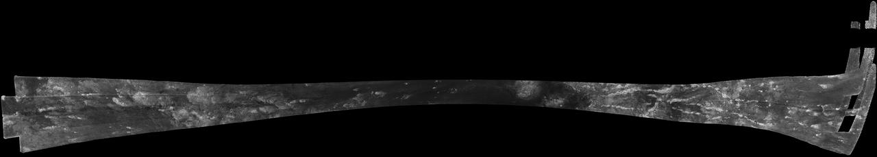
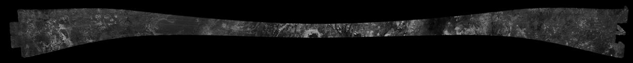
This image was obtained by NASA Cassini radar instrument during a flyby on Oct. 28, 2005. Equatorial Pass Trailing hemisphere, Central Adiri, Central Belet, Huygens Landing Site, Antillia Faculae.
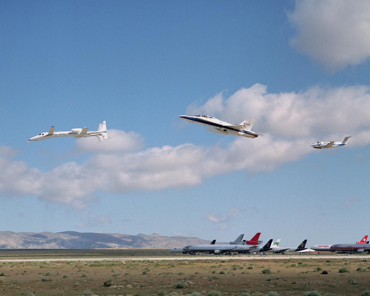
Scaled Composites' Proteus aircraft with an F/A-18 Hornet and a Beechcraft KingAir from NASA's Dryden Flight Research Center during a low-level flyby at Mojave Airport in Southern California. The unique tandem-wing Proteus was the testbed for a series of UAV collision-avoidance flight demonstrations. An Amphitech 35GHz radar unit installed below Proteus' nose was the primary sensor for the Detect, See and Avoid tests.
New Horizons project scientist Hal Weaver of the Johns Hopkins University Applied Physics Laboratory gives a talk titled "Pluto Flyby; Summer 2015", Monday, Dec. 31, 2018 at Johns Hopkins University Applied Physics Laboratory (APL) in Laurel, Maryland. Photo Credit: (NASA/Bill Ingalls)

Fred Pelletier, lead of the project navigation team at KinetX Inc. in Simi Valley, California, speaks at a press conference prior to the flyby of Ultima Thule by the New Horizons spacecraft, Monday, Dec. 31, 2018 at Johns Hopkins University Applied Physics Laboratory (APL) in Laurel, Maryland. Photo Credit: (NASA/Joel Kowsky)
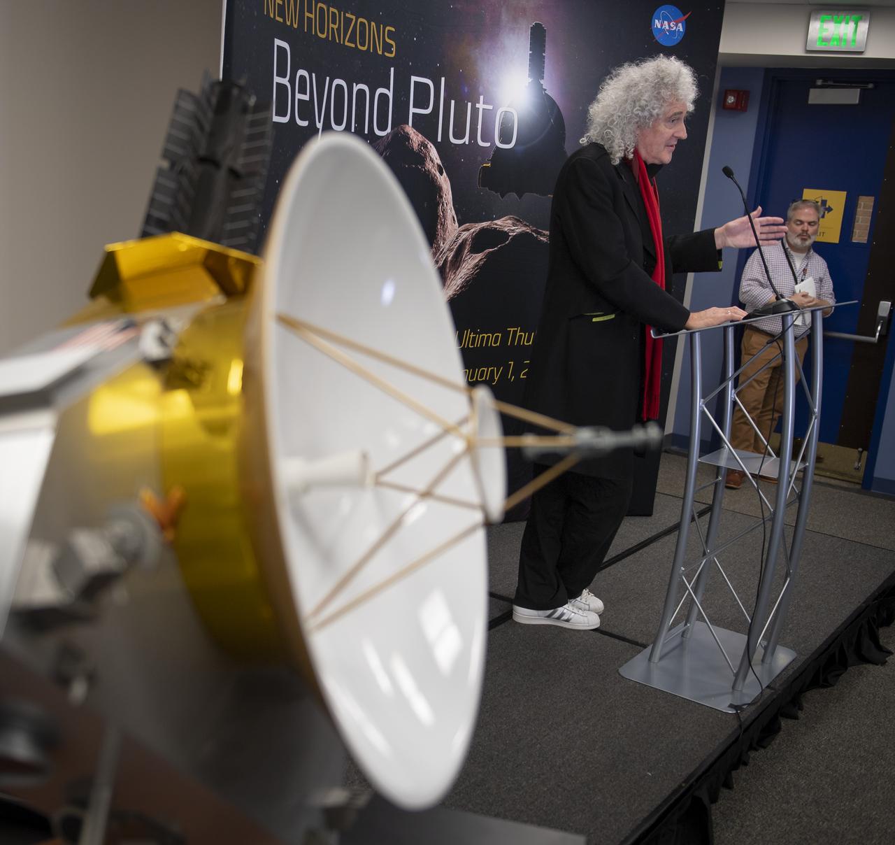
Brian May, lead guitarist of the rock band Queen and astrophysicist discusses the upcoming New Horizons flyby of the Kuiper Belt object Ultima Thule, Monday, Dec. 31, 2018 at Johns Hopkins University Applied Physics Laboratory (APL) in Laurel, Maryland. Photo Credit: (NASA/Bill Ingalls)