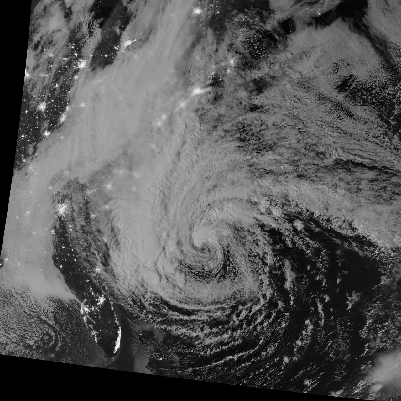
NASA image acquired October 28, 2012 <b>For the latest info from NASA on Hurricane Sandy go to: <a href="http://1.usa.gov/Ti5SgS" rel="nofollow">1.usa.gov/Ti5SgS</a></b> This image of Hurricane Sandy was acquired by the Visible Infrared Imaging Radiometer Suite (VIIRS) on the Suomi NPP satellite around 2:42 a.m. Eastern Daylight Time (06:42 Universal Time) on October 28, 2012. The storm was captured by a special “day-night band,” which detects light in a range of wavelengths from green to near-infrared and uses filtering techniques to observe dim signals such as auroras, airglow, gas flares, city lights, and reflected moonlight. In this case, the cloud tops were lit by the nearly full Moon (full occurs on October 29). Some city lights in Florida and Georgia are also visible amidst the clouds. The Suomi NPP satellite was launched one year ago today (on October 28, 2011) to extend and enhance long-term records of key environmental data monitored by NASA, the National Oceanic and Atmospheric Administration (NOAA), and the U.S. Department of Defense. NASA Earth Observatory image by Jesse Allen and Robert Simmon, using VIIRS Day-Night Band data from the Suomi National Polar-orbiting Partnership (Suomi NPP). Suomi NPP is the result of a partnership between NASA, the National Oceanic and Atmospheric Administration, and the Department of Defense. Caption by Michael Carlowicz. Instrument: Suomi NPP - VIIRS <b><a href="http://www.nasa.gov/audience/formedia/features/MP_Photo_Guidelines.html" rel="nofollow">NASA image use policy.</a></b> <b><a href="http://www.nasa.gov/centers/goddard/home/index.html" rel="nofollow">NASA Goddard Space Flight Center</a></b> enables NASA’s mission through four scientific endeavors: Earth Science, Heliophysics, Solar System Exploration, and Astrophysics. Goddard plays a leading role in NASA’s accomplishments by contributing compelling scientific knowledge to advance the Agency’s mission. <b>Follow us on <a href="http://twitter.com/NASA_GoddardPix" rel="nofollow">Twitter</a></b> <b>Like us on <a href="http://www.facebook.com/pages/Greenbelt-MD/NASA-Goddard/395013845897?ref=tsd" rel="nofollow">Facebook</a></b> <b>Find us on <a href="http://instagrid.me/nasagoddard/?vm=grid" rel="nofollow">Instagram</a></b>
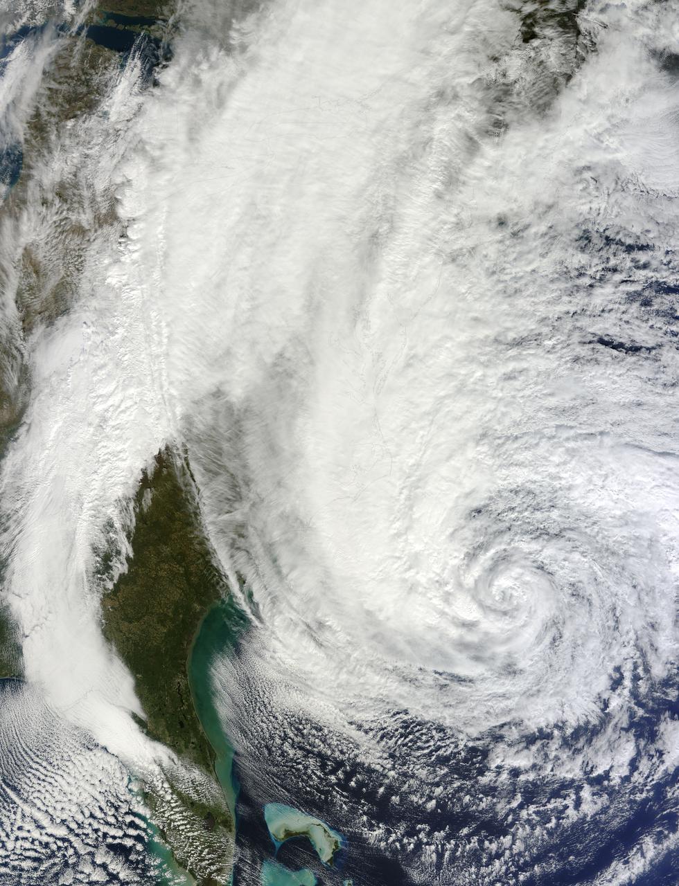
NASA image acquired acquired October 28, 2012 <b>For the latest info from NASA on Hurricane Sandy go to: <a href="http://1.usa.gov/Ti5SgS" rel="nofollow">1.usa.gov/Ti5SgS</a></b> At noon Eastern Daylight Time (16:00 Universal Time) on October 28, 2012, the Moderate Resolution Imaging Spectroradiometer (MODIS) on NASA’s Terra satellite acquired this image of Hurricane Sandy off the southeastern United States. At 11 a.m. local time (one hour before the image was captured), the U.S. National Hurricane Center reported that the storm was located at 32.5° North and 72.6° West, about 250 miles (400 kilometers) southeast of Cape Hatteras, North Carolina, and 575 miles (930 kilometers) south of New York City. Maximum sustained winds were 75 miles (120 kilometers) per hour, and the central pressure was 951 millibars (28.08 inches). Forecasters predicted that the storm would continue heading north-northeast until the morning of October and then take a hard turn to the northwest into the coastaline of Delaware, New Jersey, or New York. The wind field from the storm was said to stretch 500 to 700 miles and was likely to affect an area from South Carolina to Maine, and as far inland as the Great Lakes. The storm has already caused significant damage in the Bahamas, Cuba, Jamaica, Puerto Rico, the Dominican Republic, and Haiti; at least 65 lives have been lost to the storm. NASA image courtesy LANCE MODIS Rapid Response Team at NASA GSFC. Caption by Michael Carlowicz. Instrument: Terra - MODIS Credit: <b><a href="http://www.earthobservatory.nasa.gov/" rel="nofollow"> NASA Earth Observatory</a></b> <b><a href="http://www.nasa.gov/audience/formedia/features/MP_Photo_Guidelines.html" rel="nofollow">NASA image use policy.</a></b> <b><a href="http://www.nasa.gov/centers/goddard/home/index.html" rel="nofollow">NASA Goddard Space Flight Center</a></b> enables NASA’s mission through four scientific endeavors: Earth Science, Heliophysics, Solar System Exploration, and Astrophysics. Goddard plays a leading role in NASA’s accomplishments by contributing compelling scientific knowledge to advance the Agency’s mission. <b>Follow us on <a href="http://twitter.com/NASA_GoddardPix" rel="nofollow">Twitter</a></b> <b>Like us on <a href="http://www.facebook.com/pages/Greenbelt-MD/NASA-Goddard/395013845897?ref=tsd" rel="nofollow">Facebook</a></b> <b>Find us on <a href="http://instagrid.me/nasagoddard/?vm=grid" rel="nofollow">Instagram</a></b>