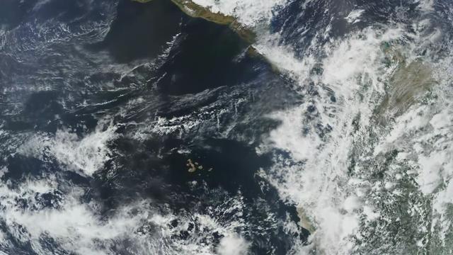
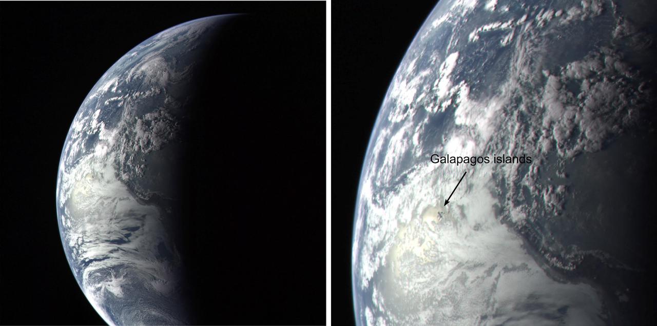
Completed: 07-16-2009 Straddling the equator approximately 1000 kilometers to the west of the South American mainland, the Galapagos Islands lie within the heart of the equatorial current system. Rising from the sea floor, the volcanic islands of the Galapagos are set on top of a large submarine platform. The main portion of the Galapagos platform is relatively flat and less than 1000 meters in depth. The steepest slopes are found along the western and southern flanks of the platform with a gradual slope towards the east. The interactions of the Galapagos and the oceanic currents create vastly different environmental regimes which not only isolates one part of the Archipelago from the other but allows penguins to live along the equator on the western part of the Archipelago and tropical corals around the islands to the north. The islands are relatively new in geologic terms with the youngest islands in the west still exhibiting periodic eruptions from their massive volcanic craters. Please give credit for this item to: NASA/Goddard Space Flight Center, The SeaWiFS Project and GeoEye, Scientific Visualization Studio. NOTE: All SeaWiFS images and data presented on this web site are for research and educational use only. All commercial use of SeaWiFS data must be coordinated with GeoEye (http://www.geoeye.com). To download this video go to: <a href="http://svs.gsfc.nasa.gov/goto?3628" rel="nofollow">svs.gsfc.nasa.gov/goto?3628</a> <b><a href="http://www.nasa.gov/centers/goddard/home/index.html" rel="nofollow">NASA Goddard Space Flight Center</a></b> is home to the nation's largest organization of combined scientists, engineers and technologists that build spacecraft, instruments and new technology to study the Earth, the sun, our solar system, and the universe.
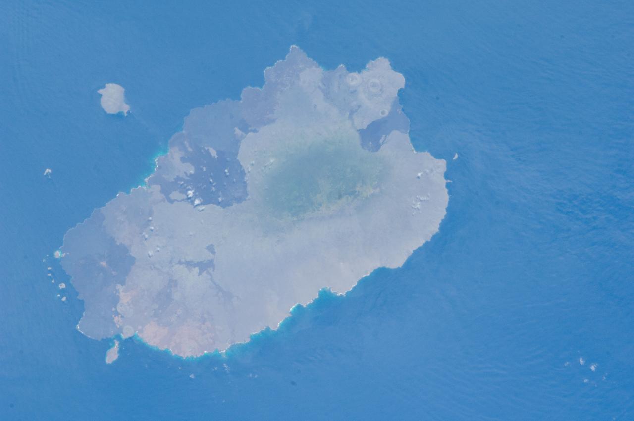
This image of the Galapagos Islands captures two large shield volcanoes on Isla Isabella, the largest and least inhabited island in the Galapagos chain. This image is from NASA EarthKAM.
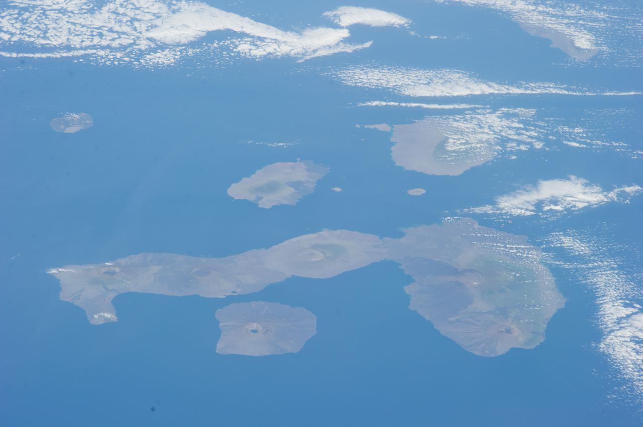
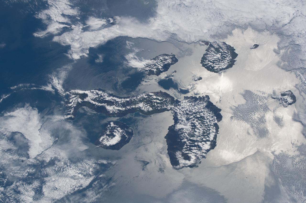
STS072-732-072 (11-20 Jan. 1996) --- Three of the nineteen Galapagos Islands are visible in this image, photographed from the Earth-orbiting Space Shuttle Endeavour. The Galapagos Islands are located 600 miles (1,000 kilometers) to the west of Ecuador. The largest of the islands, Isabela, is at center (north is toward the upper right corner). The numerous circular features on the island, highlighted by clouds, are volcanoes. The Galapagos Islands owe their existence to a hot spot, or persistent heat source in the mantle, which also is located over a rift, or place where plates are separating and new crust is being created. The rift is located between the Cocos and Nazca Plates. The dark linear features on the islands are lava flows from past eruptions. The island to the left of Isabela is Fernandina, while the island to the right is San Salvador. The Galapagos Islands were visited by the English naturalist Charles Darwin in 1835.
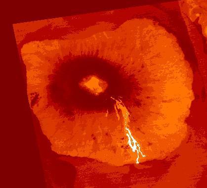
An eruption began on March 2, 2024 at Fernandina Volcano, Galapagos. Lava was seen coming from a circumferential fissure on the upper SE flank, accompanied by high sulfur dioxide emissions. By April 13, when this color coded ASTER thermal image was acquired, an estimated 44 million cubic meters of lava had erupted, making this eruption the largest in the last 15 years. The image covers an area of 5.7 by 6.3 km, and is located at 0.4 degrees south, 91.6 degrees west. https://photojournal.jpl.nasa.gov/catalog/PIA26326
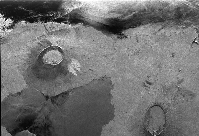
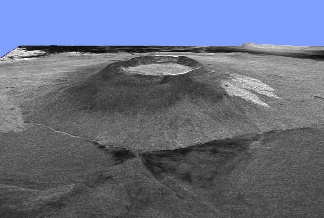
This is an image showing part of Isla Isabella in the western Galapagos Islands. It was taken by the L-band radar in HH polarization from the Spaceborne Imaging Radar C/X-Band Synthetic Aperture Radar on the 40th orbit of NASA’s space shuttle Endeavour.
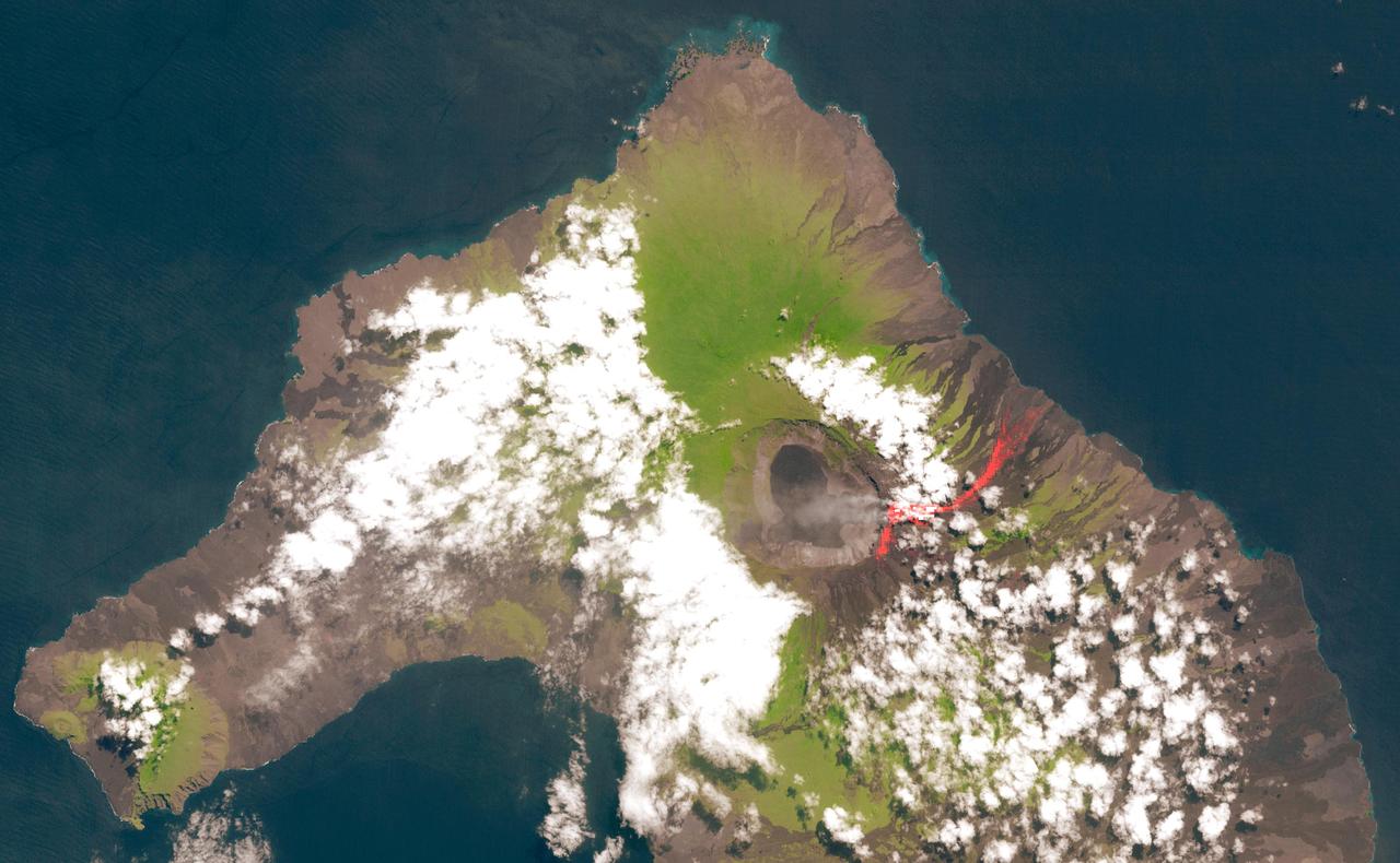
On May 26, 2015, Wolf Volcano on Isabela Island in the Galapagos Islands erupted for the first time in 33 years. This image was acquired by NASA Terra spacecraft on June 11, 2015, after the eruption had quieted.
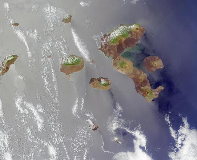
The Galapagos, situated in the Pacific Ocean roughly 1000 kilometers west of mainland Ecuador. This image from NASA Terra satellite is MISR Mystery Image Quiz #4.
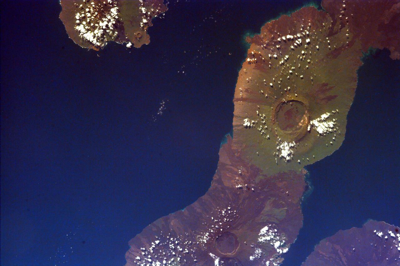
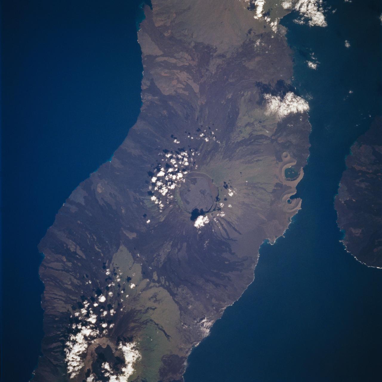
STS109-718-102 (1-12 March 2002) --- The astronauts on board the Space Shuttle Columbia took this 70mm picture featuring the Galapagos Islands. For orientation purposes, north is towards the bottom of the view. Most of the largest island in the Galapagos group, Isla Isabela, stretches across the middle of the frame. The circular feature on this island at bottom is Volcano Wolf (1707 meters in altitude). Volcano Darwin (1280 meters in sea level) is the next volcano above and to the left, partly ringed with cloud. The single island top right is Isla Fernandina, the top of another volcano (1547 meters). Recent lava flows appear as darker surfaces and the older surfaces appear green, as a result of unusual rains and vegetational greening in this normally arid part of the world. The Equator passes exactly through Volcano Wolf, roughly left to right.
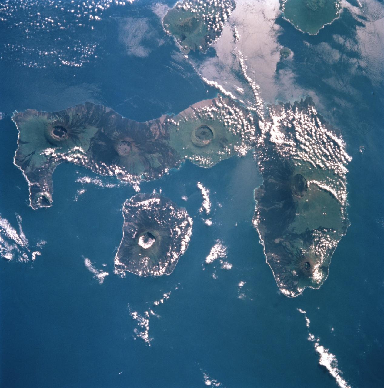
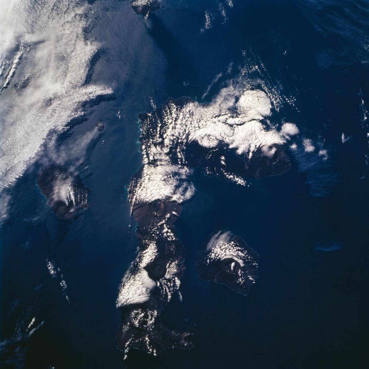
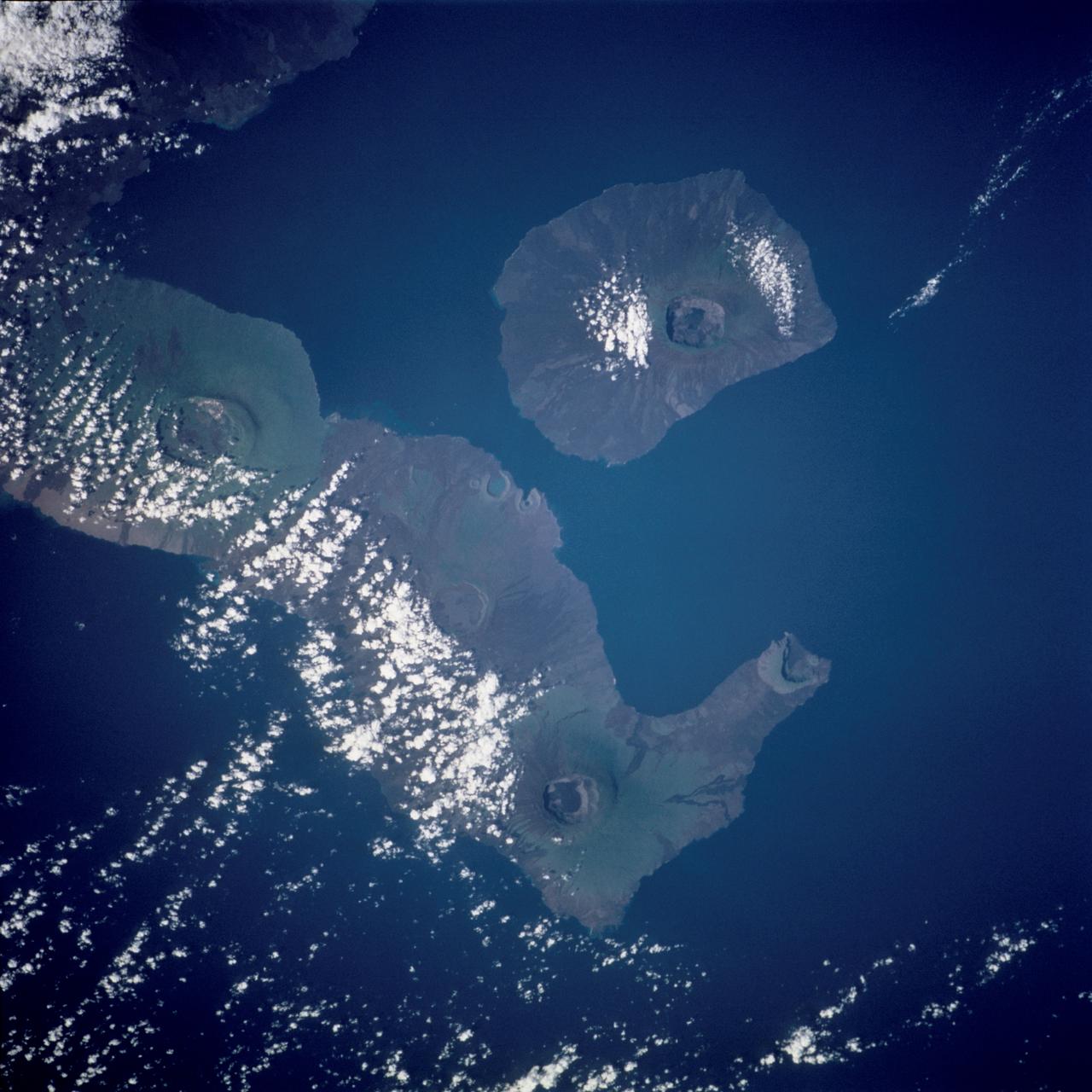
STS099-753-032 (11-22 February 2000) ---This 70mm photograph, photographed from the Space Shuttle Endeavour, centers on the two westernmost Galapagos Islands--seahorse-shaped Isla Isabela and the smaller round Isla Fernandina to its west. All of the 19 islands in the chain are volcanic in origin, and the craters of several of the shield volcanoes are visible as circular features on each of the islands. The two islands shown in this picture contain the most active volcanoes of the Galapagos. Fernandina last erupted in January-February 1995, with red-hot lava pouring into the sea. After 20 years of inactivity, Cerro Azul on Isla Isabela, last erupted in September-October 1998. Cerro Azul is the southwesternmost volcano on Isla Isabela. At 82 miles long, Isla Isabela is the largest of the islands, and comprises half of the land area of the archipelago. The islands are famous for their unique flora and fauna. Charles Darwin's observations of these species in 1835 contributed to the formation of his ideas on natural selection. Some of the most unique species include flightless cormorants, Galapagos penguins, giant land tortoises, and Galapagos finches. The range of Galapagos penguins is restricted to these western islands where upwelling enriches the ocean productivity, and the adaptation of a typically Antarctic bird family to the equator is an ecological marvel. Giant land tortoises are thought to have the oldest lifespans of any animal on Earth, but, scientists say, they have been driven near to extinction. During the most recent eruption of Cerro Azul, one tortoise was killed and many had to be relocated. The 13 species of Galapagos finches on the islands, although varied in form and lifestyle, are the descendants of an ancestor that happened to colonize this isolated archipelago. The human population of the entire archipelago is about 10,000.
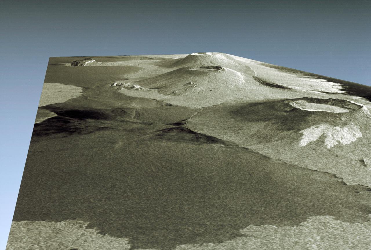
This is a three-dimensional view of Isabela, one of the Galapagos Islands located off the western coast of Ecuador, South America.
STS059-S-085 (18 April 1994) --- This is a three-dimensional perspective view of part of Isla Isabela in the western Galapagos Islands. It was taken by the L-Band radar in HH polarization from the Spaceborne Imaging Radar-C and X-Band Synthetic Aperture Radar (SIR-C/X-SAR) on the 40th orbit of the Space Shuttle Endeavour. This view was constructed by overlaying a SIR-C radar image on a U.S. Geological Survey digital elevation map. The image is centered at about .5 degrees south latitude and 91 degrees west longitude, and covers an area of 75 by 60 kilometers. The radar incidence angle at the center of the image is about 20 degrees. The western Galapagos Islands, which lie about 1200 kilometers west of Ecuador in the eastern Pacific, have six active volcanoes similar to the volcanoes found in Hawaii. Since the time of Charles Darwin's visit to the area in 1835, there have been over 60 recorded eruptions on these volcanoes. This SIR-C/X-SAR image of Alcedo and Sierra Negra volcanoes shows the rougher lava flows as bright features, while ash deposits and smooth pahoehoe lava flows appear dark. The Galapagos Islands are one of the SIR-C/X-SAR supersites and data of this area will be taken several times during the flight to allow scientists to conduct topographic change studies and to search for different lava flow types, ash deposits and fault lines. SIR-C/X-SAR is part of NASA's Mission to Planet Earth (MTPE). SIR-C/X-SAR radars illuminate Earth with microwaves allowing detailed observations at any time, regardless of weather or sunlight conditions. SIR-C/X-SAR uses three microwave wavelengths: L-Band (24 cm), C-Band (6 cm), and X-Band (3 cm). The multi-frequency data will be used by the international scientific community to better understand the global environment and how it is changing. The SIR-C/X-SAR data, complemented by aircraft and ground studies, will give scientists clearer insights into those environmental changes which are caused by nature and those changes which are induced by human activity. SIR-C was developed by NASA's Jet Propulsion Laboratory (JPL). X-SAR was developed by the Dornire and Alenia Spazio Companies for the German Space Agency, Deutsche Agentur fuer Raumfahrtangelegenheiten (DARA), and the Italian Space Agency, Agenzia Spaziale Italiana (ASI). JPL Photo ID: P-43938
Earth observations taken by Expedition 38 crewmember. Crewmember indicates Galapagos. Image was released by astronaut on Twitter.
ISS038-E-000232 (11 Nov. 2013) --- One of the Expedition 38 crew members aboard the International Space Station used a 180mm lens to photograph this oblique image featuring the Galapagos Islands or Islas Galapagos, distributed on either side of the Equator in the eastern Pacific Ocean. An archipelago of volcanic islands, the group?s official name is Archipielago de Colon.
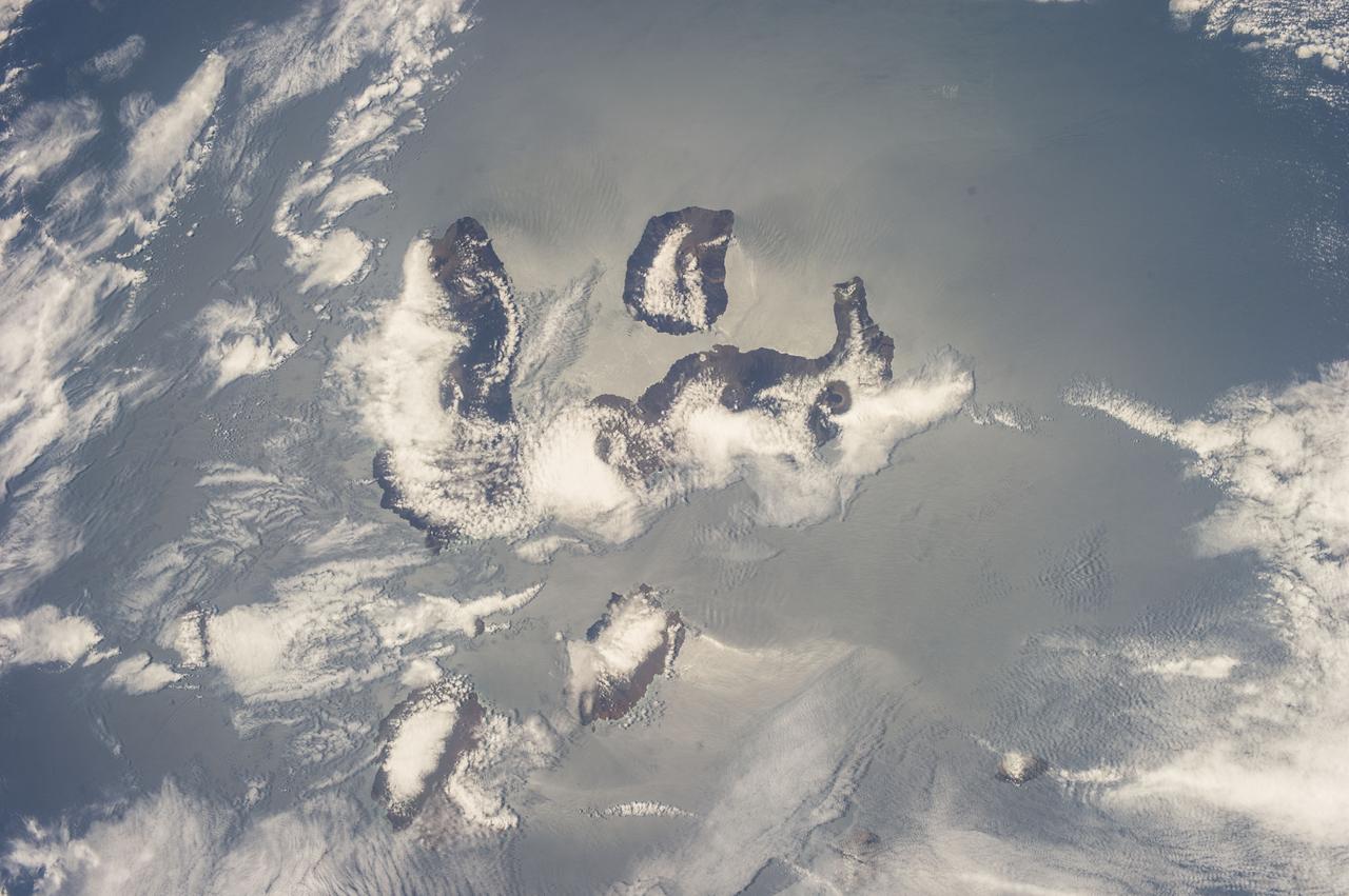
Earth Observation taken during a day pass by the Expedition 40 crew aboard the International Space Station (ISS). File lists this group of images as possibly : Misc New Zealand & Galapagos & Carribean
Earth Observation taken during a day pass by the Expedition 40 crew aboard the International Space Station (ISS). File lists this group of images as possibly : Misc New Zealand & Galapagos & Carribean
Earth Observation taken during a day pass by the Expedition 40 crew aboard the International Space Station (ISS). File lists this group of images as possibly : Misc New Zealand & Galapagos & Carribean
Earth Observation taken during a day pass by the Expedition 40 crew aboard the International Space Station (ISS). File lists this group of images as possibly : Misc New Zealand & Galapagos & Carribean
iss055e023500 (April 13, 2018) --- The cloud-covered Galapagos Islands and the sun's glint in the waters off the coast of Ecuador are pictured as the International Space Station orbited above the Pacific Ocean.
Earth Observation taken during a day pass by the Expedition 40 crew aboard the International Space Station (ISS). File lists this group of images as possibly : Misc New Zealand & Galapagos & Carribean
iss068e025397 (Nov. 28, 2022) --- The peak of La Cumbre Volcano on Ecuador's Fernandina Island, part of the Galapagos Islands, is surrounded by clouds in this photograph from the International Space Station as it orbited 261 miles above the Pacific Ocean.
iss072e145206 (Nov. 5, 2024) --- The SpaceX Dragon cargo spacecraft is pictured approaching the International Space Station as both spacecraft were orbiting 255 miles above a cloudy Pacific Ocean southwest of Ecuador's Galápagos Islands.
Earth Observation taken during a day pass by the Expedition 40 crew aboard the International Space Station (ISS). File lists this group of images as possibly : Misc New Zealand & Galapagos & Carribean
NASA Mercury-bound MESSENGER spacecraft captured several stunning images of Earth during a gravity assist swingby of its home planet on Aug. 2, 2005.
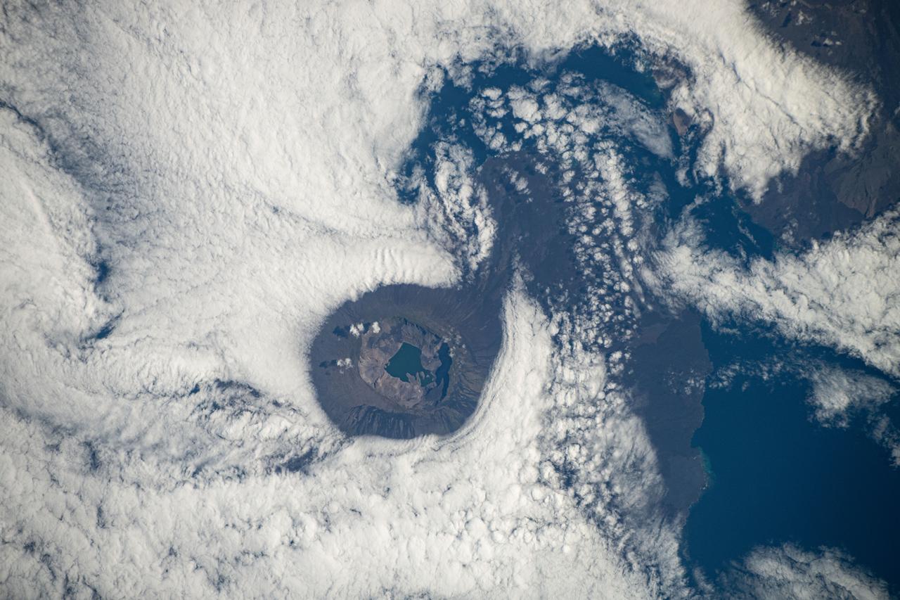
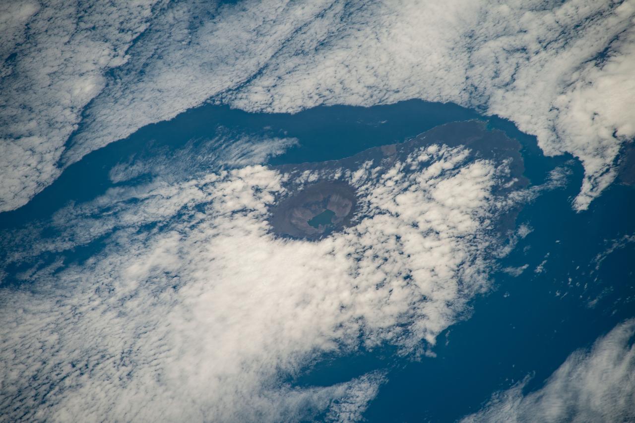
iss072e011909 (Oct. 3, 2024) -- Situated in the Galapagos is Fernandina Island. Pictured here is Fernandina's caldera, which stretches about 4 miles ( 6.5 kilometers) wide, with a sheet of clouds forming around it. As the International Space Station orbited 257 miles above, NASA astronaut Don Pettit captured this image.
iss068e025399 (Nov. 28, 2022) --- From top, the peaks of Wolf Volcano and Darwin Volcano on Ecuador's Isabel Island, part of the Galapagos Islands, are surrounded by clouds in this photograph from the International Space Station as it orbited 261 miles above the Pacific Ocean.
ISS033-E-012648 (18 Oct. 2012) --- Isla Santiago is featured in this image photographed by an Expedition 33 crew member on the International Space Station. The island of Santiago is located near the center of the Galapagos Islands off the coast of Ecuador. The Galapagos Islands are situated near the equator, and were formed from volcanism related to a large mantle plume (also known as a hot spot). This hot spot is very close to the tectonic boundary between the Galapagos Ridge, a plate boundary that is also an oceanic spreading center, and the Nazca and Cocos plates. This combination of mantle plumes and tectonic plate movements produces a unique geological environment, including underwater ridges of volcanoes that influence the water circulation around the Galapagos. All of these aspects contribute to the geology and biology of the Galapagos. Isla Santiago itself is formed from a shield volcano also called Santiago. This type of volcanic structure is recognized by low, flat summits surrounded by extensive flow fields of lava; the lava is not very viscous, so it can flow for great distances from the source vents. Several dark lava flow fields are visible in this photograph, the largest along the eastern, western, and southern coastlines. The small Isla Rabida to the south of Isla Santiago is the peak of another, mostly submerged shield volcano. In addition to the lava flows, other volcanic features known as tuff cones are visible on the eastern and western sides of the island. These cones are formed from the rapid interaction of hot flowing lava and water. The water underneath the lava flow flashes to steam explosively, and this both fragments the lava and rapidly cools it, leading to the formation of cones of glassy, relatively fine-grained volcanic material. The most recent volcanic activity on Isla Santiago occurred during 1904 – 1906. The summit ridge of the Santiago shield volcano is located in the northwestern part of the island (center). Also at center is a large but isolated region of green vegetation primarily located on the south-facing slope below the summit ridge. This image was taken during the dry, or garua, season that lasts from June to November. The season is dominated by cooler air transported by the Southeast Trade winds and cooler waters from the Humboldt and Cromwell currents. The combination of cool air and water results in rain falling only in the island highlands, with south- and east-facing slopes receiving the most precipitation. Despite the favorable topographic location, the yellow green color of the vegetation may indicate water (or other) stress.
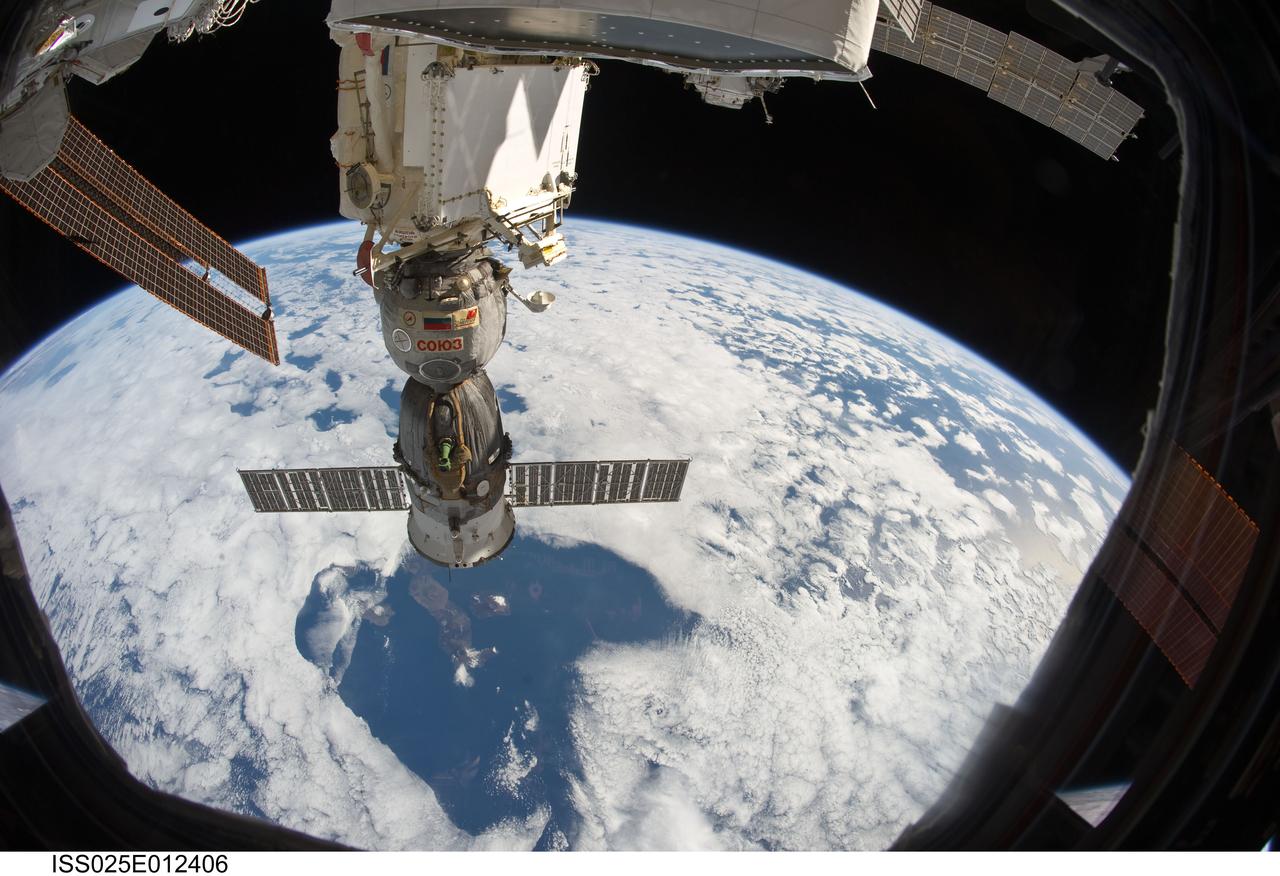
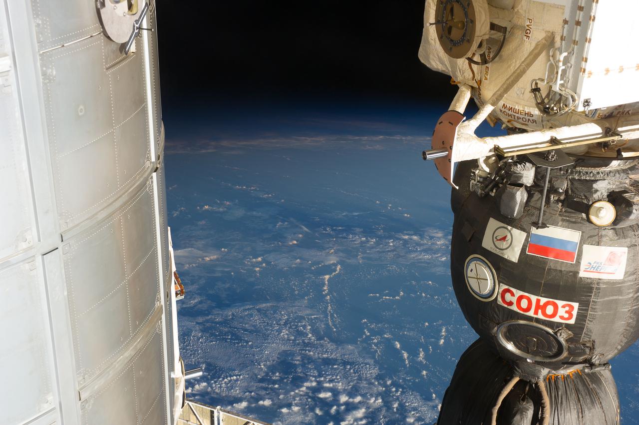
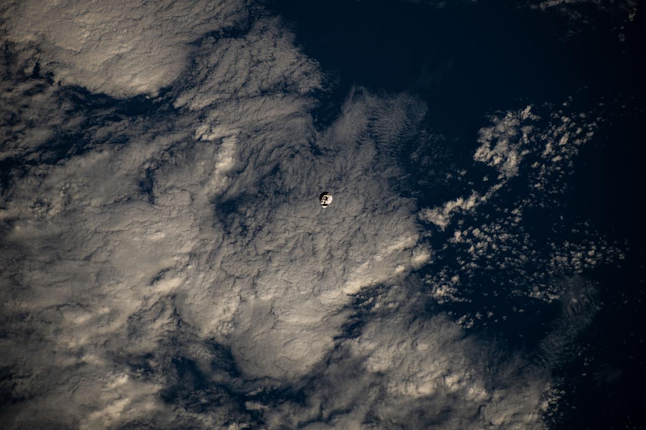
ISS025-E-012406 (28 Oct. 2010) --- At 220 miles above Earth, the unattended Soyuz TMA-19 spacecraft, docked to the International Space Station, almost appears to be a giant telescope focusing through a break in the clouds upon several islands in the Galapagos chain. Isabela is the most easily recognizable island among this chain in the Pacific Ocean.
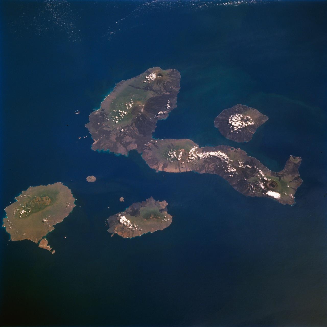
STS077-711-012 (19-29 May 1996) --- One of several volcanic-laden photo targets for the crew members was the grouping of the Galapagos Islands -composites of flat-topped volcanoes produced by a hot spot in the eastern Pacific. Dark lava flows drape the flanks of each volcano. This view centers on Isabella, the sea horse-shaped island. The most active volcano is the island of Fernandina, which sits just west (up) from the sea horse?s middle area. Fernandina erupted late last year, and Shuttle photography has documented the changes produced by eruptions over the past 10 years. Because the Galapagos Islands sit on the equator and near the junction of current systems in the eastern Pacific Ocean, and the volcano provides a sharp topographic barrier to the currents, many interesting oceanic phenomena occur and have been recorded in this region. Lighter colored water occurs just west of Isabella and Fernandina. The origin of the color difference is unknown, but could possibly be plankton blooms related to upwelling around the islands.
STS059-213-019 (9-20 April 1994) --- SRL scientists will use these photographs with the radar imagery to discriminate among different ages of basalt flows, and different ecosystems of shrub communities, on these equatorial volcanic islands. Aims are twofold: to understand the history of physical and biological systems on the islands themselves, and to extend what is learned to other, less-well-known areas globally. Hasselblad photograph.
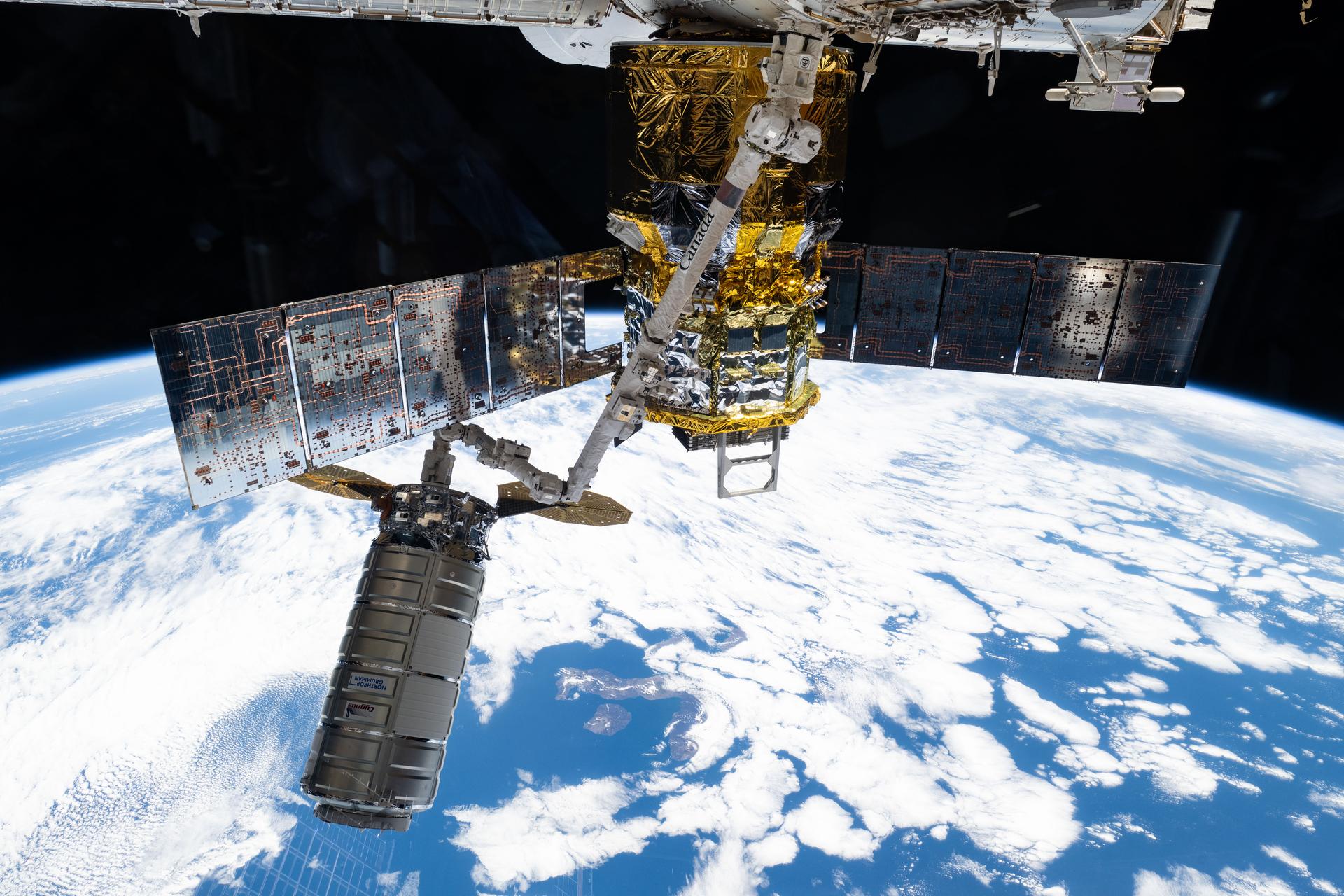
iss073e1196807 (Nov. 25, 2025) --- Northrop Grumman's Cygnus XL cargo craft is pictured in the grips of the International Space Station Canadarm2 robotic arm. Cygnus XL had been temporarily released from its Earth-facing port on the Unity module to make room for the Soyuz MS-28 crew spacecraft, which was scheduled to arrive the next day and dock to the Rassvet module. JAXA's (Japan Aerospace Exploration Agency) HTV-X1 cargo craft, with its solar arrays deployed, is seen berthed to the Earth-facing port of the Harmony module. The orbital outpost was soaring 263 miles above the Pacific Ocean southwest of Galapagos Islands at the time of this photograph.
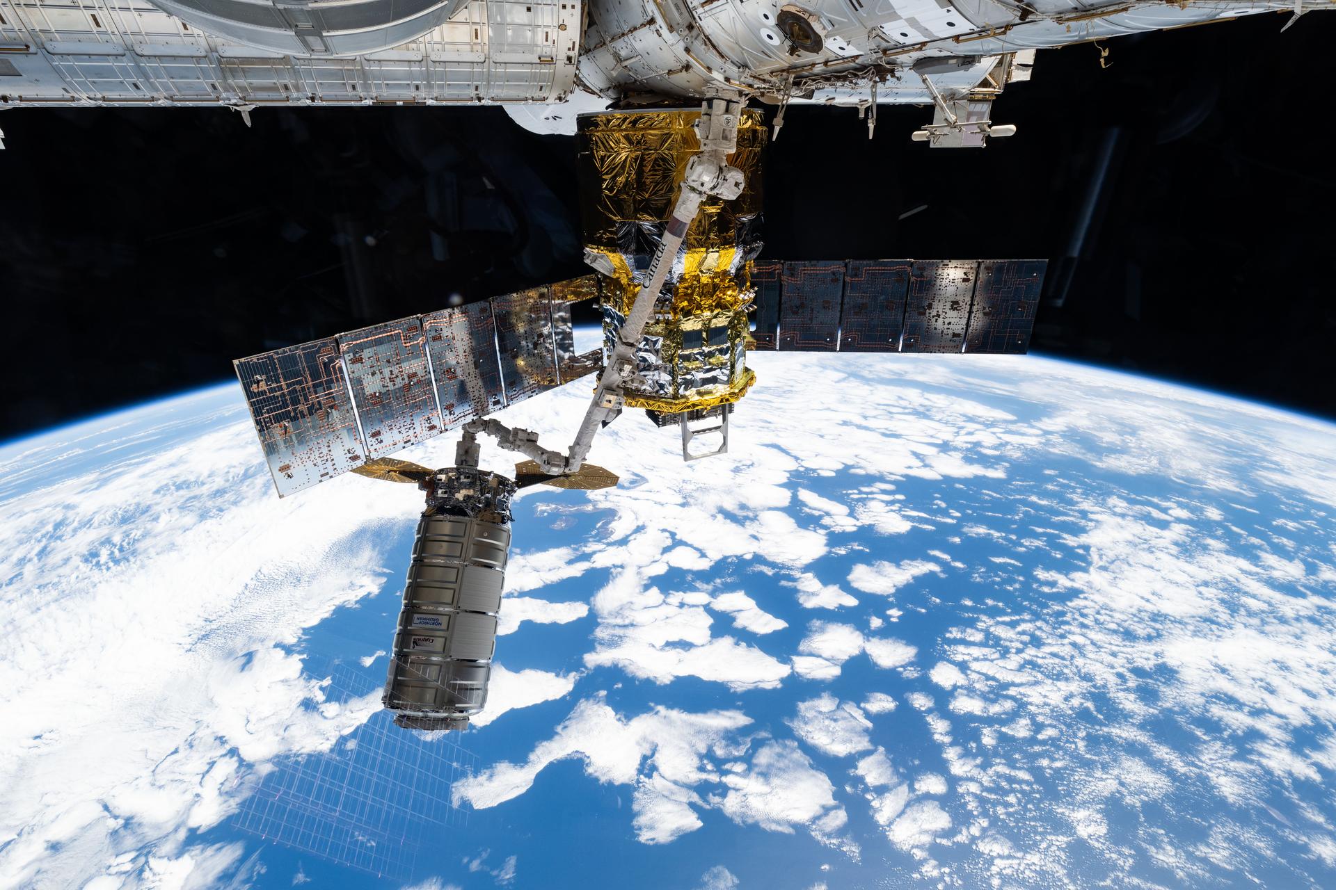
iss073e1196791 (Nov. 25, 2025) --- Northrop Grumman's Cygnus XL cargo craft is pictured in the grips of the International Space Station Canadarm2 robotic arm. Cygnus XL had been temporarily released from its Earth-facing port on the Unity module to make room for the Soyuz MS-28 crew spacecraft, which was scheduled to arrive the next day and dock to the Rassvet module. JAXA's (Japan Aerospace Exploration Agency) HTV-X1 cargo craft, with its solar arrays deployed, is seen berthed to the Earth-facing port of the Harmony module. The orbital outpost was soaring 263 miles above the Pacific Ocean southwest of Galapagos Islands at the time of this photograph.
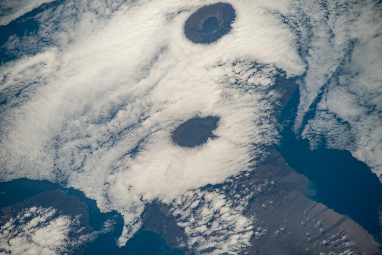
ISS018-E-035716 (24 Feb. 2009) --- Minchinmavida and Chaiten Volcanoes in Chile are featured in this image photographed by an Expedition 18 crewmember on the International Space Station. The Andes mountain chain along the western coastline of South America includes numerous active stratovolcanoes. The majority of these volcanoes are formed, and fed, by magma generated as the oceanic Nazca tectonic plate moves northeastward and plunges beneath the less dense South American continental tectonic plate (a process known as subduction). The line of Andean volcanoes marks the approximate location of the subduction zone. This astronaut photograph highlights two volcanoes located near the southern boundary of the Nazca ? South America subduction zone in southern Chile. Dominating the scene is the massive Minchinmavida stratovolcano at center. An eruption of this glaciated volcano was observed by Charles Darwin during his Galapagos Island voyage in 1834; the last recorded eruption took place the following year. The white, snow covered summit of Minchinmavida is blanketed by gray ash erupted from its much smaller but now active neighbor to the west, Volcan (volcano) Chaiten. The historically inactive Chaiten volcano, characterized by a large lava dome within a caldera (an emptied and collapsed magma chamber beneath a volcano) roared back to life unexpectedly on May 2, 2008, generating dense ash plumes and forcing the evacuation of the nearby town of Chaiten. Volcanic activity continues at Chaiten, including partial collapse of a new lava dome and generation of a pyroclastic flow several days before this photograph was taken. A steam and ash plume is visible extending to the northeast from the eruptive center of the volcano.