
Iapetan Geography
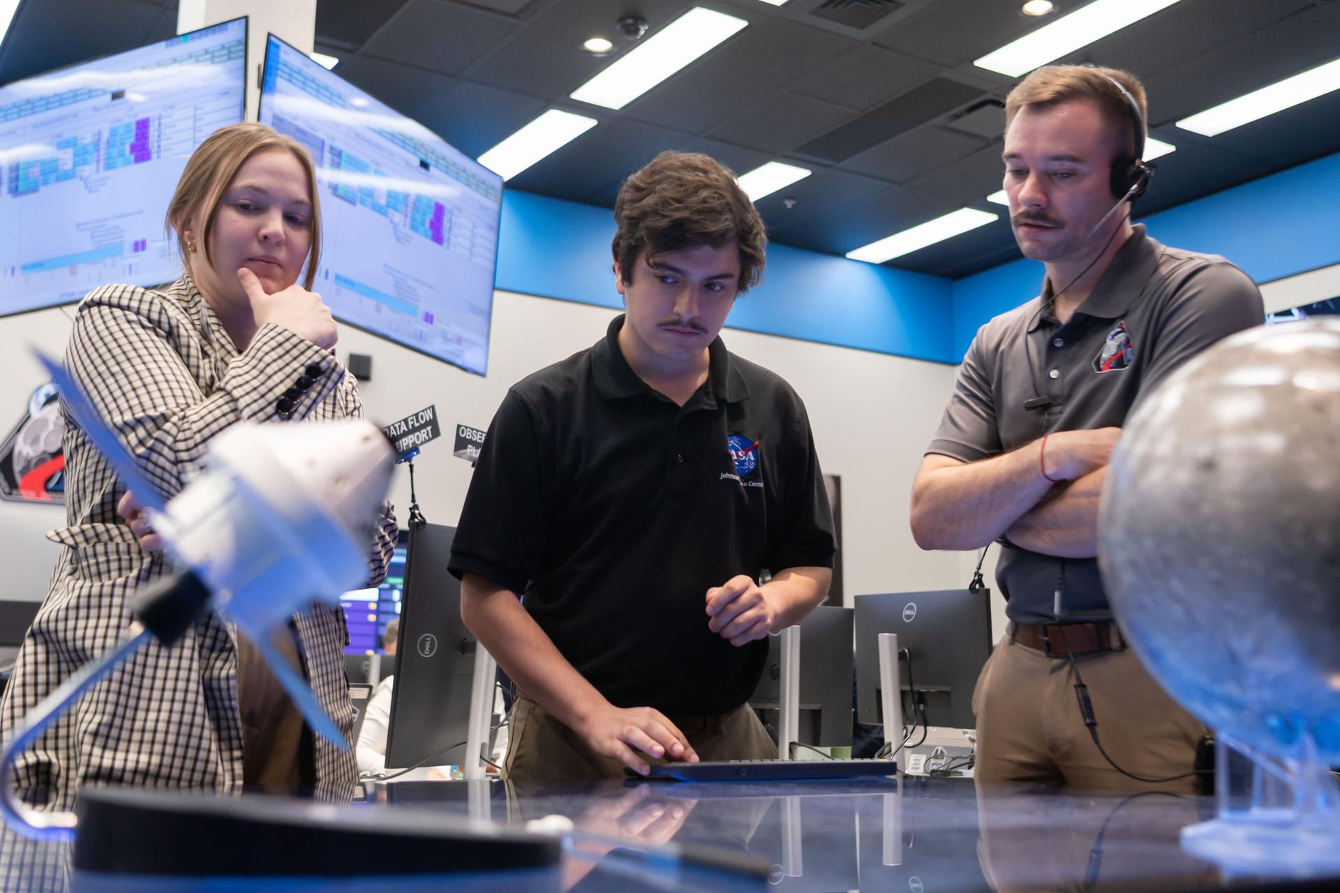
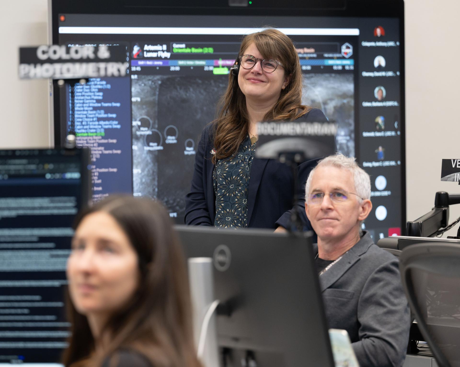
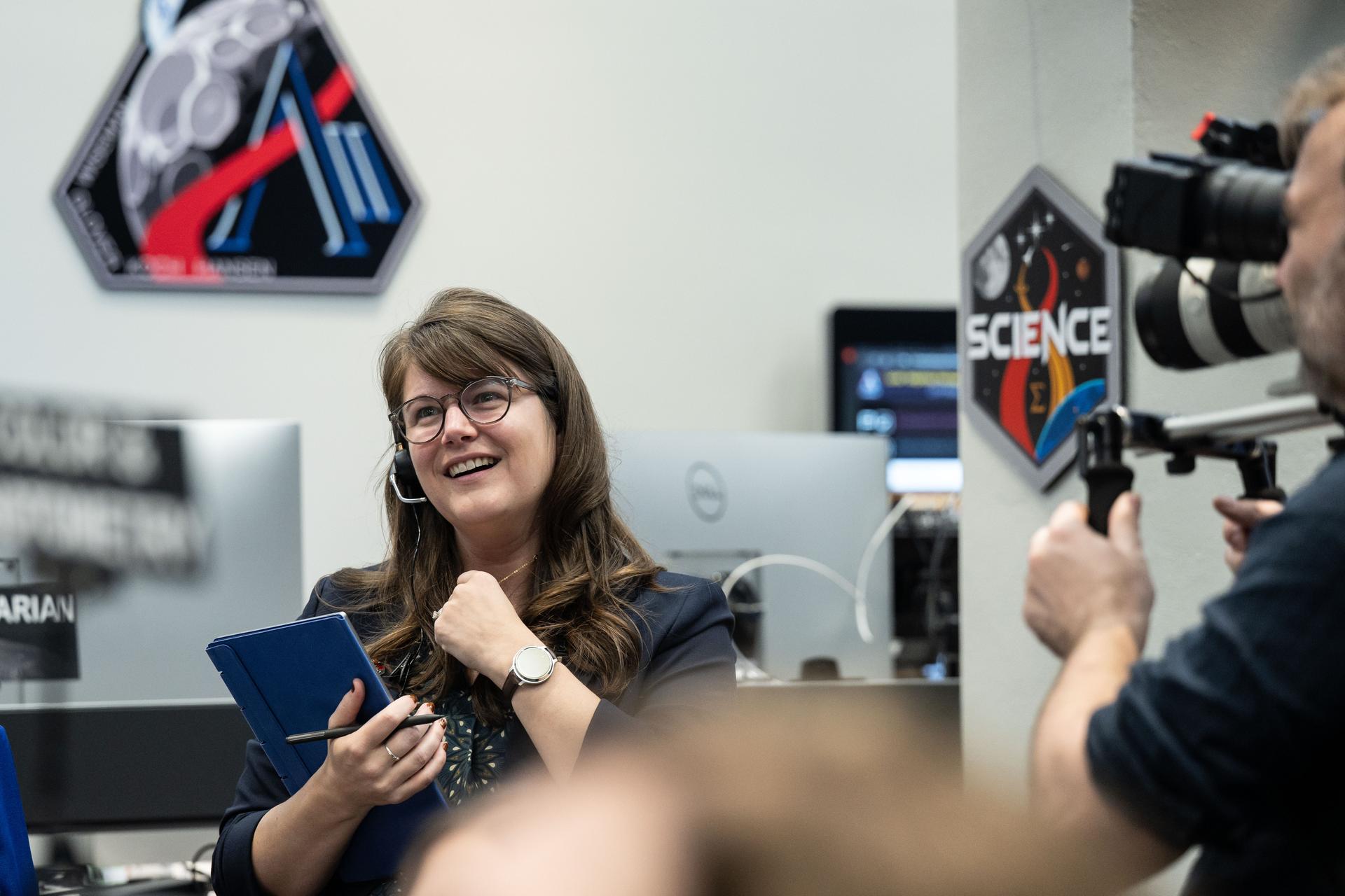
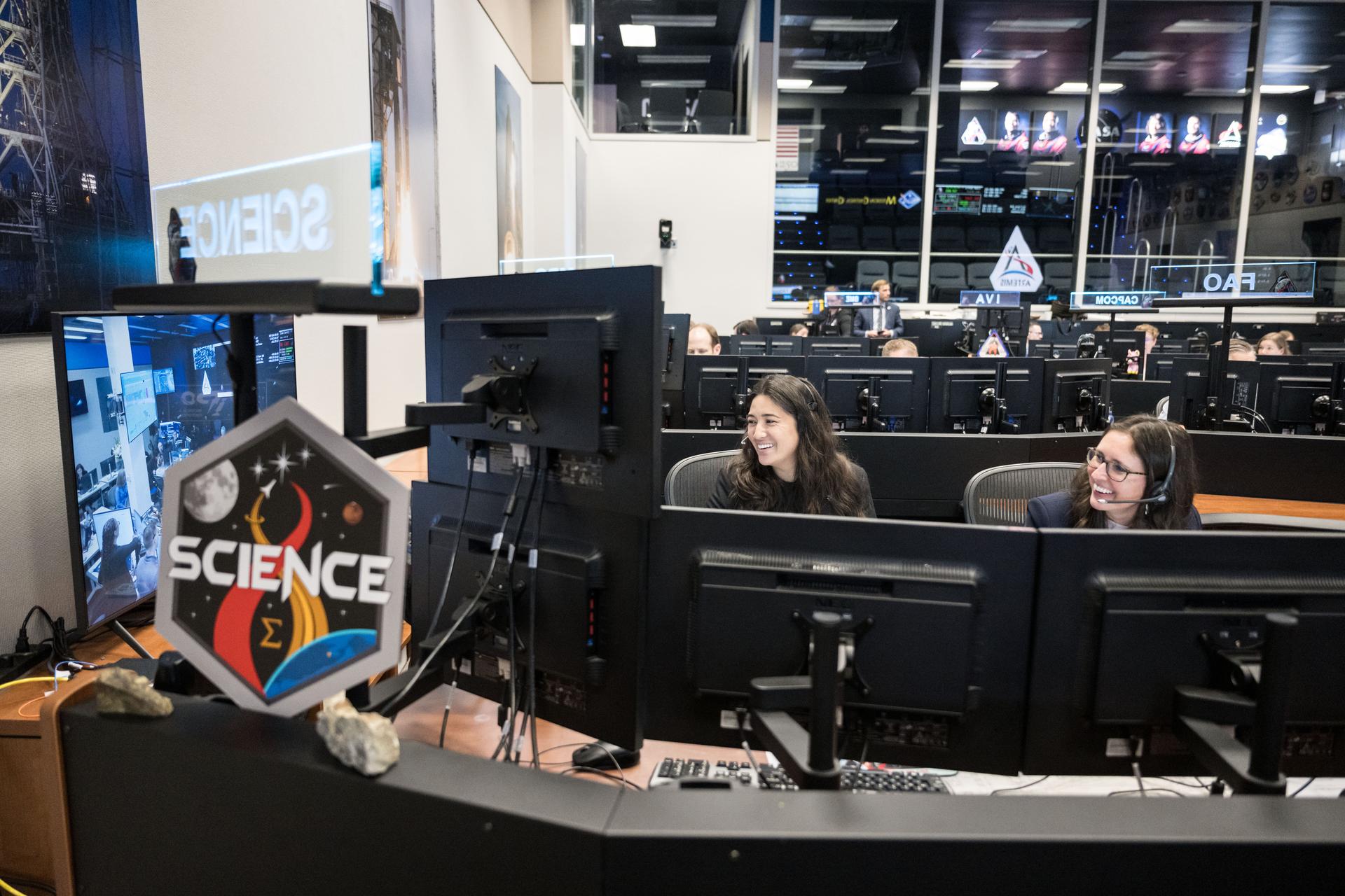
Artemis II lunar science team members, from left, Ryan Ewing, Juliane Gross, and Debra Needham, discuss lunar geography ahead of the translunar injection burn that accelerated the Orion spacecraft to break free of Earth’s orbit and began the outbound trajectory toward the Moon. They are in the Science Evaluation Room (SER) a back room that supports lunar science and planetary observations for the Artemis science officer in the mission’s main flight control room. Built specifically for Artemis missions with these science priorities in mind, the SER is equipped to support rapid data interpretation, collaborative analysis, real-time decision making, and seamless coordination between the science and operations teams.
This spaceborne radar image shows how the Atlas Mountains in northwestern Africa dominate the geography of Morocco.
iss066e144029 (Feb. 15, 2022) --- The hot and arid desert geography of Kerman Province in central Iran is pictured from the International Space Station as it orbited 258 miles above.
iss066e144020 (Feb. 15, 2022) --- The hot and arid desert geography of Semnan Province southeast of Tehran, Iran, is pictured from the International Space Station as it orbited 258 miles above.
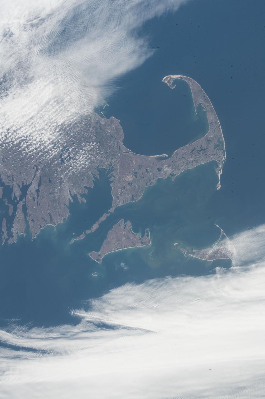
iss055e023770 (April 14, 2018) --- The southeast geography of the state of Massachusetts including Cape Cod Bay, Martha's Vineyard, Nantucket and the arm-shaped peninsula is clearly seen from the International Space Station as it orbited over the Atlantic coast of the United States.
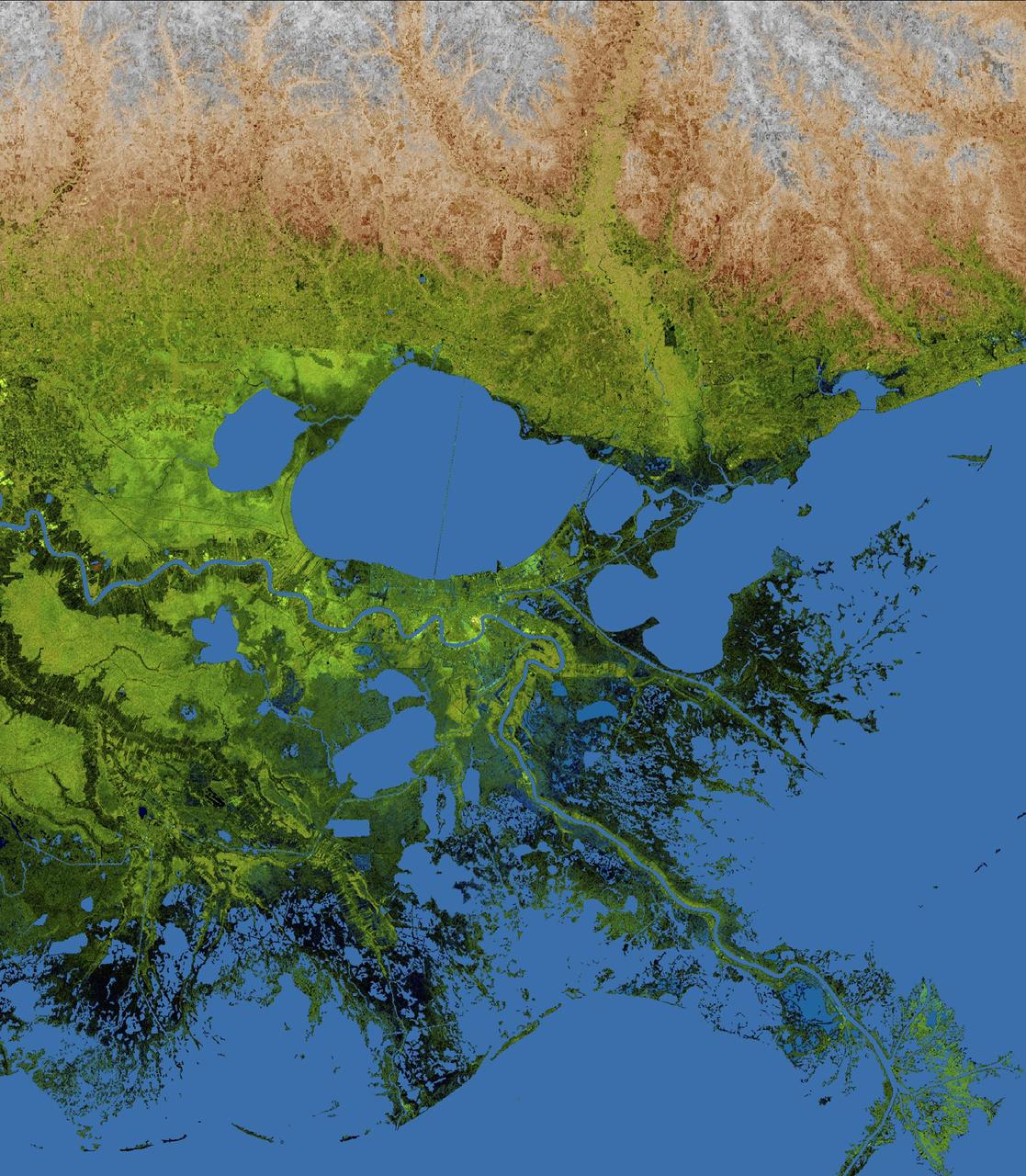
The geography of the New Orleans and Mississippi delta region is well shown in this radar image from the Shuttle Radar Topography Mission. In this image, bright areas show regions of high radar reflectivity, such as from urban areas, and elevations have been coded in color using height data also from the mission. Dark green colors indicate low elevations, rising through yellow and tan, to white at the highest elevations. New Orleans is situated along the southern shore of Lake Pontchartrain, the large, roughly circular lake near the center of the image. The line spanning the lake is the Lake Pontchartrain Causeway, the world's longest over water highway bridge. Major portions of the city of New Orleans are below sea level, and although it is protected by levees and sea walls, flooding during storm surges associated with major hurricanes is a significant concern. http://photojournal.jpl.nasa.gov/catalog/PIA04175
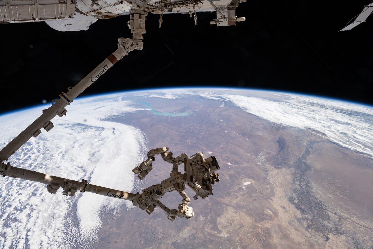
iss073e0819948 (Oct. 2, 2025) --- The Canadarm2 robotic arm, with Dextre—its fine-tuned robotic hand—attached, extends from the International Space Station’s Harmony module as the orbital outpost soars 263 miles above Kazakhstan. At upper center is Lake Balkhash, notable for its two distinct segments: the western portion contains freshwater, while the eastern portion holds saltwater due to a combination of geography, hydrology, and limited water circulation.
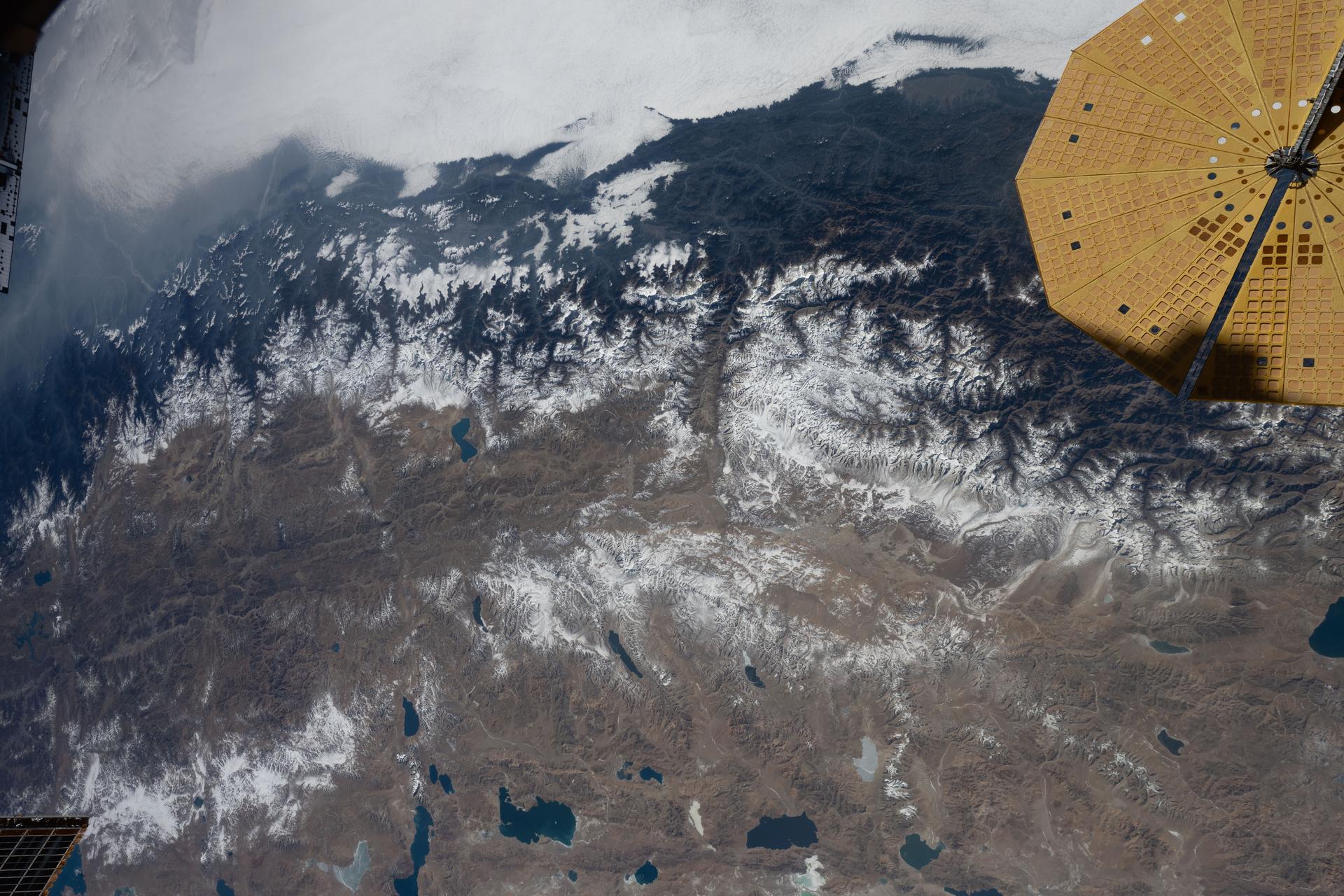
iss074e0002506 (Dec. 13, 2025) --- The Himalayas—separating the moisture-laden portion of the Indian subcontinent from the arid geography of Tibet, China—are pictured from the International Space Station as it orbited 261 miles above Nepal. At upper right is one of two UltraFlex solar arrays that power the Cygnus XL cargo craft from Northrop Grumman.
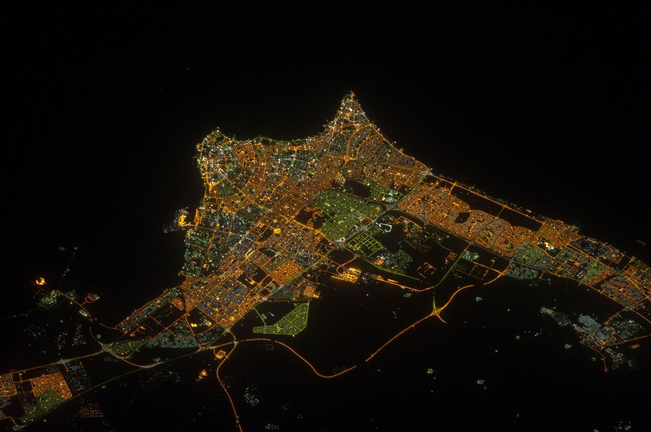
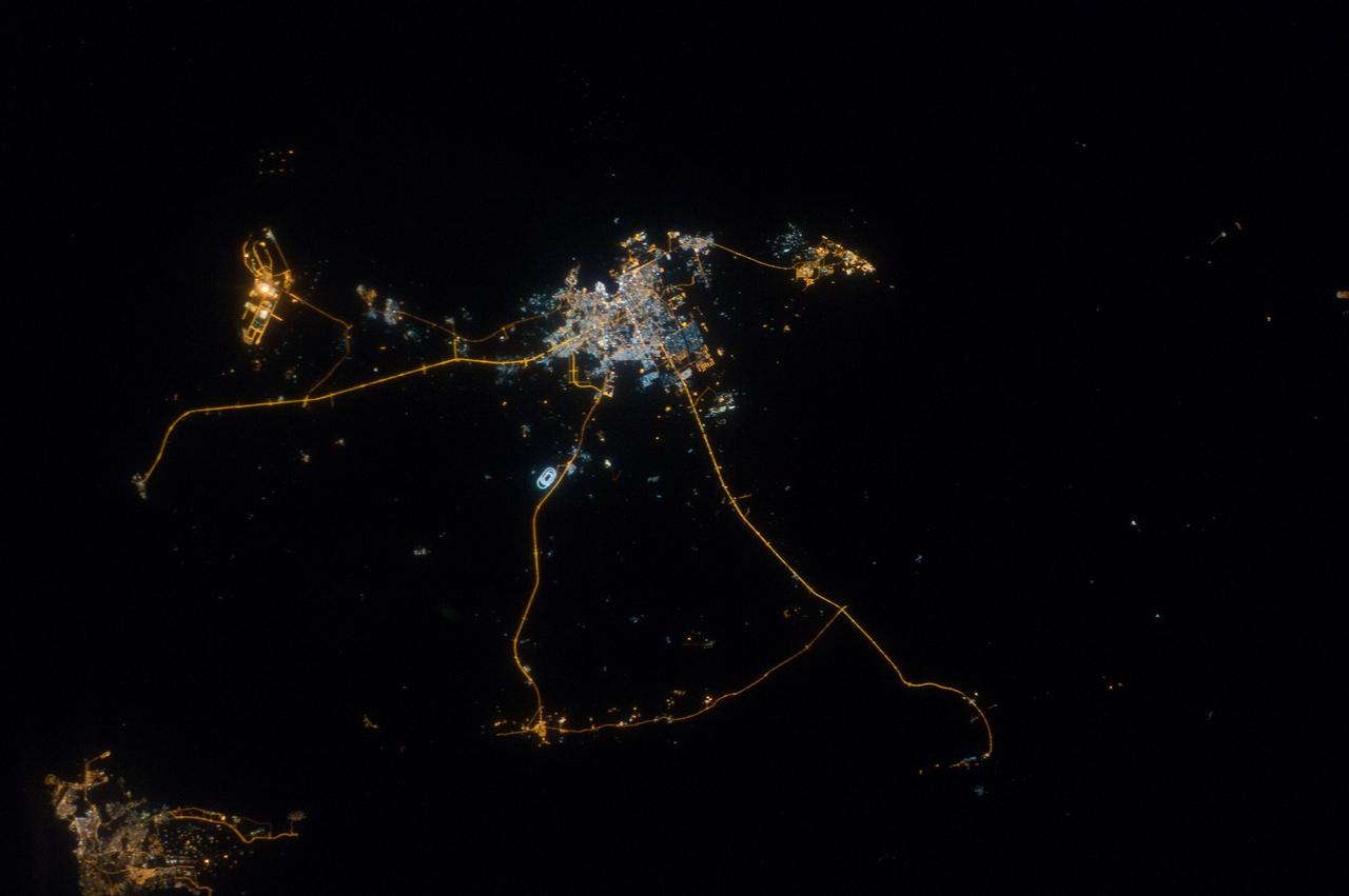
ISS032-E-017635 (9 Aug. 2012) --- A nighttime view of Kuwait City is featured in this image photographed by an Expedition 32 crew member on the International Space Station. Seen at night Kuwait City, the capital of the small Persian Gulf state of Kuwait, contrasts dramatically with the dark surface of the Persian Gulf (top) and the very sparsely populated desert area (bottom). Night views also show at a glance some aspects of urban geography that are difficult to perceive in daylight images. Here the focus of radial traffic arteries and ?ring roads? guide the eye to the financial center of the city?on the cape extending into Kuwait Bay north of the First Ring Road. The numbering of the ring roads shows the progressive southward development of the city, towards the Seventh Ring Road which still lies outside the built-up area at lower right. The striking differences in color of city lighting also provide information on the urban geography. Areas with lighting of a green tinge are, in each case, newer residential districts. The town of Al Ahmadi (lower right), known for its verdant vegetation, was built in 1946 when oil was struck and stands out with its characteristic blue night lights. Kuwait International Airport, like most major airports around the globe, is particularly bright due to the high concentration of lights.
STS099-314-035 (11-22 February 2000) ---Astronaut Kevin R. Kregel, mission commander, works with camera equipment, which was used for the EarthKAM project. The camera stayed busy throughout the 11-day mission taking vertical imagery of the Earth points of opportunity for the project. Students across the United States and in France, Germany and Japan took photos throughout the STS-99 mission. And they are using these new photos, plus all the images already available in the EarthKAM system, to enhance their classroom learning in Earth and space science, social studies, geography, mathematics and more.

S99-E-5267 (13 February 2000) --- City of El Paso, Texas, and Ciudad Juarez, Chihuahua, Mexico and the Rio Grande River, which separates them. An electronic still camera (ESC), mounted in one of Endeavour's aft flight deck windows, is recording imagery of hundreds of Earth targets for the EarthKAM project. Students across the United States and in France, Germany and Japan are taking photos throughout the STS-99 mission. And they are using these new photos, plus all the images already available in the EarthKAM system, to enhance their classroom learning in Earth and space science, social studies, geography, mathematics and more. For general EarthKAM information and more images from this flight, go to http://www.earthkam.ucsd.edu/
NM18-309-018 (28 June 1995) --- The Space Shuttle Atlantis orbits Earth at a point above Iraq as photographed by one of the Mir-18 crew members aboard Russia's Mir Space Station. The image was photographed prior to rendezvous and docking of the two spacecraft. The Spacelab science module and the tunnel connecting it to the crew cabin, as well as the added mechanism for interface with the Mir's docking system can be easily seen. The geography pictured is 60 miles northwest of Baghdad. The Buhayrat Ath Tharthar (reservoir) is the widest body of water visible. Also seen are the Tigris and Euphrates Rivers.
iss074e0349412 (March 3, 2026) --- The Andes mountain range running between Chile and Argentina creates distinct differences in climate and geography between the two South American nations. Chile’s Pacific coastline contributes to its moderate temperatures, with the Atacama Desert in the north being one of the driest places on Earth, while its central and southern regions are cooler and wetter. Argentina’s western side is more arid because the Andes block moisture from the Pacific Ocean, while the country’s Atlantic coastline receives more precipitation than its interior and western regions. Credit: NASA
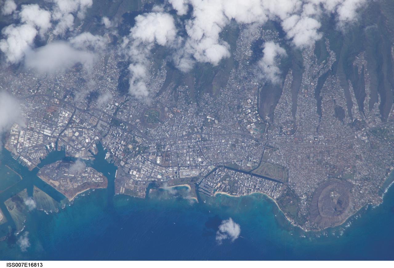
ISS007-E-16813 (8 October 2003) --- This view featuring Honolulu, Hawaii was photographed by an Expedition 7 crewmember onboard the International Space Station (ISS). The city is striking for the way it is bound by surrounding geography. Built-up fingers of the city extend northeast onto the steep volcanic slopes and surround the volcanic craters of Punchbowl crater and Diamond Head, leaving undeveloped only parklands and the steepest ridges. They are both tuff cones that formed as magma from the erupting volcano came in contact with ground water at a time when sea levels were higher than they are now. As the water turned to steam, according to NASA scientists, it caused an explosion that formed a hill of ash with a broad crater in the center.

Laurence Smith, chair of geography at University of California, Los Angeles, deploys an autonomous drift boat equipped with several sensors in a meltwater river on the surface of the Greenland ice sheet on July 19, 2015. “Surface melting in Greenland has increased recently, and we lacked a rigorous estimate of the water volumes being produced and their transport,” said Tom Wagner, the cryosphere program scientist at NASA Headquarters in Washington. “NASA funds fieldwork like Smith’s because it helps us to interpret satellite data, and to extrapolate measurements from the local field sites to the larger ice sheet." Credit: NASA/Goddard/Jefferson Beck

S85-37164 (8-12 July 1985) --- Sharon C. (Christa) McAuliffe of Concord High, Concord, New Hampshire, talks to the media at Johnson Space Center. Christa McAuliffe was eventually chosen as the first Teacher in Space and was a member of the seven-member Challenger shuttle crew which died tragically in the explosion of the spacecraft during the launch of STS-51L from the Kennedy Space Center about 11:40 a.m., EST, on Jan. 28, 1986. The explosion occurred 73 seconds into the flight as a result of a leak in one of two Solid Rocket Boosters that ignited the main liquid fuel tank. The crew members of the Challenger represented a cross-section of the American population in terms of race, gender, geography, background, and religion. The explosion became one of the most significant events of the 1980s, as billions around the world saw the accident on television and empathized with any one of the several crew members killed. Photo credit: NASA
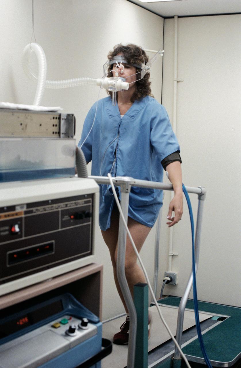
S85-37165 (8-12 July 1985) -- Sharon C. (Christa) McAuliffe of Concord High, Concord, New Hampshire, runs in place on treadmill to test physiological responses at Johnson Space Center. Christa McAuliffe was eventually chosen as the first Teacher in Space and was a member of the seven-member Challenger shuttle crew which died tragically in the explosion of the spacecraft during the launch of STS-51L from the Kennedy Space Center about 11:40 a.m., EST, on Jan. 28, 1986. The explosion occurred 73 seconds into the flight as a result of a leak in one of two Solid Rocket Boosters that ignited the main liquid fuel tank. The crew members of the Challenger represented a cross-section of the American population in terms of race, gender, geography, background, and religion. The explosion became one of the most significant events of the 1980s, as billions around the world saw the accident on television and empathized with any one of the several crew members killed. Photo credit: NASA
STS099-329-019 (11-22 February 2000) --- Astronaut Janet L. Kavandi, mission specialist, appears joyous over the success of the Shuttle Radar Topography Mission (SRTM) and other experiments on the flight deck of the Space Shuttle Endeavour. The Red Team member is standing beneath an electronic still camera (ESC) mounted in Endeavour's overhead windows. The camera stayed busy throughout the ll-day mission taking vertical imagery of Earth points of opportunity for the EarthKAM project. Students across the United States and in France, Germany and Japan took photos throughout the STS-99 mission. And they are using these new photos, plus all the images already available in the EarthKAM system, to enhance their classroom learning in Earth and space science, social studies, geography, mathematics and more.
ISS033-E-014856 (13 Oct. 2012) --- A nighttime view of Qatar is featured in this image photographed by an Expedition 33 crew member on the International Space Station. Night lights can be very revealing regarding the distribution of people on the landscape. Here the lights of Qatar show the precise demographic geography of the country. The brightest group at center shows the capital city Doha with the neighboring smaller ports of Ad-Dahira and Umm Sa?id to the north and south, respectively. Even highways and their relative importance can be discerned. Highways are clearly visible leading from the capital west to the Dukhan oil fields, to Saudi Arabia, and to the north of the country--where, judging by the lack of night lights, the population is very low. The relatively low-traffic coast road between the oil fields and the Saudi frontier also stands out. This kind of highly informative human geographic detail is very difficult to discern in daylight images, in which even larger cities, especially in deserts, are hard to see. Almost the entire island nation of Bahrain appears at lower left, with its capital city Manama nearly as bright as the lights of Doha. The difference in light intensity reflects a difference in population?Doha has 1.45 million inhabitants, while the very dense Manama metro area has a population of 1.2 million. While some night views are highly informative about a landscape, they can also be difficult and confusing to identify. Astronauts learn to recognize where they are at night by flying over populated places repeatedly, even though coastlines?one of their best geographic indicators?are generally lost to view because water surfaces and unpopulated land surfaces look the same without illumination (such as from a full moon). Thus the thumb-shaped Qatari peninsula, so well-known in Middle Eastern geography, cannot be discerned at all in this night image. The inset at top right overlays the coastline as seen in daylight onto the night patterns of the image. It shows the Qatari peninsula, with the long arm of the Gulf of Bahrain separating it from Saudi Arabia.

NASA DC-8 airborne laboratory flying over Mint Canyon near the snow-covered San Gabriel Mountains of California. The mostly white aircraft is silhouetted against the darker mountains in the background.

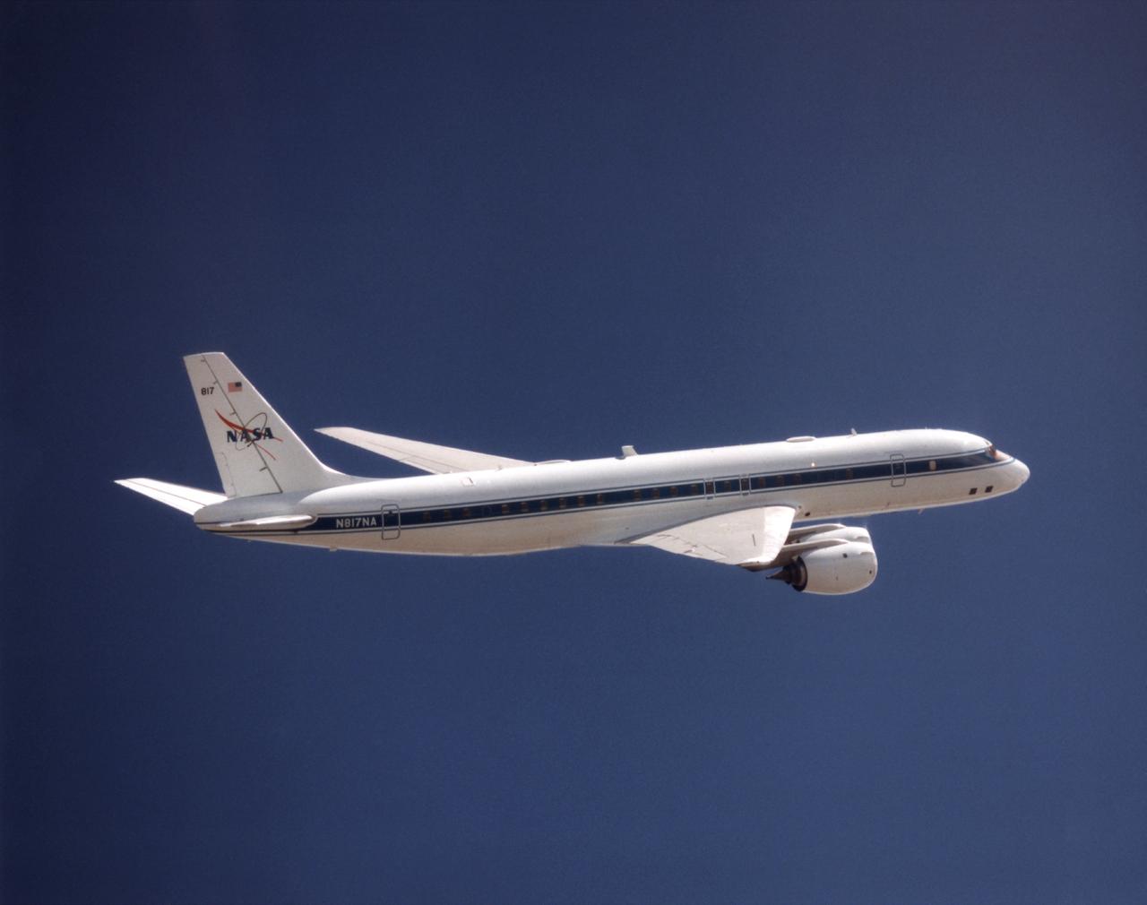
The DC-8 Airborne Laboratory in a left banking turn above the airport at Palmdale, California. The right wing is silhouetted against the blue sky, while the left wing contrasts with the desert terrain. The former airliner is a "dash-72" model and has a range of 5,400 miles. The craft can stay airborne for 12 hours and has an operational speed range between 300 and 500 knots. The research flights are made at between 500 and 41,000 feet. The aircraft can carry up to 30,000 lbs of research/science payload equipment installed in 15 mission-definable spaces.
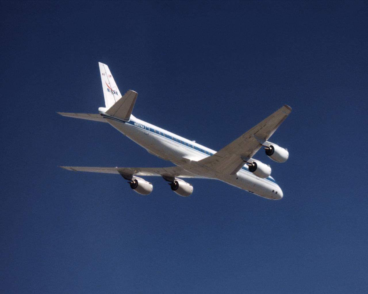
NASA's DC-8 Airborne Science platform shown against a background of a dark blue sky on February 20, 1998. The aircraft is shown from the right rear, slightly above its plane, with the right wing in the foreground and the left wing and horizontal tail in the background. The former airliner is a "dash-72" model and has a range of 5,400 miles. The craft can stay airborne for 12 hours and has an operational speed range between 300 and 500 knots. The research flights are made at between 500 and 41,000 feet. The aircraft can carry up to 30,000 lbs of research/science payload equipment installed in 15 mission-definable spaces.
NASA's DC-8 Airborne Laboratory during a flight over the snow-covered Sierra Nevada Mountains. Over the past several years the DC-8 has conducted research missions in such diverse places as the Pacific in spring and Sweden in winter.
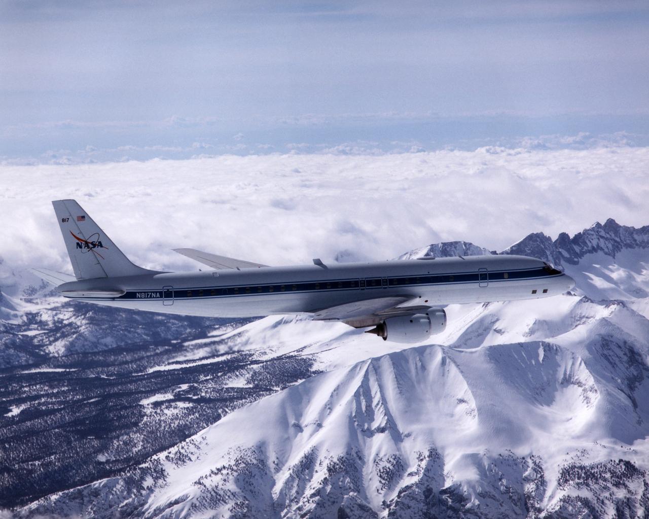
The NASA DC-8 in a right bank over the rugged Sierra Nevada Mountains. The former airliner is a "dash-72" model and has a range of 5,500 miles. The craft can stay airborne for 12 hours and has an operational speed range between 300 and 500 knots. The research flights are made at between 500 and 41,000 feet. The aircraft can carry up to 30,000 lbs of research/science payload equipment installed in 15 mission-definable spaces. In this photo, the aircraft is shown in flight from below, with the DC-8 silhouetted against a blue sky.
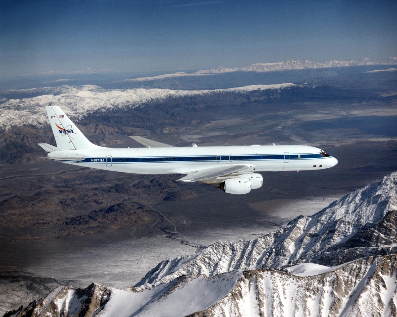
The DC-8 in flight near Lone Pine, Calif. In the foreground are the Sierra Nevada Mountains, covered with winter snow. In the distance are the White Mountains. The DC-8's fuselage is painted white with a dark blue stripe down the side. The wings are silver, while the engine pods are white. In this view of the airplane's right-hand side, only a few of its antennas are visible. The experimental payload can be as great as 30,000 pounds of equipment for gathering data of various sorts.
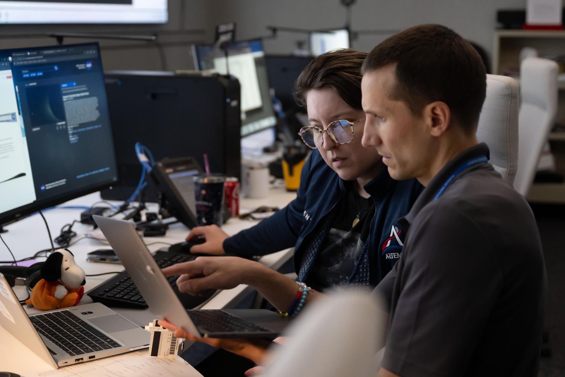
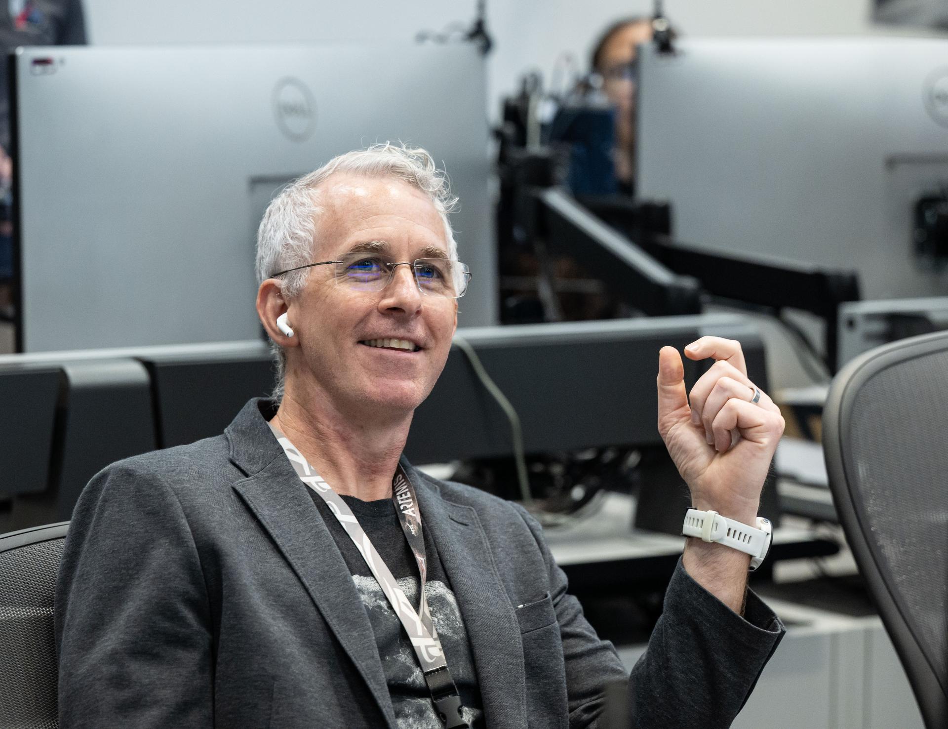
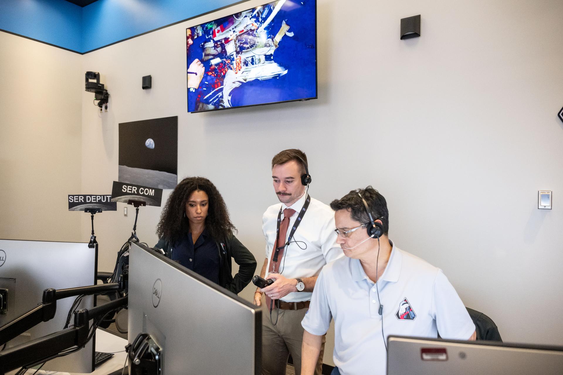
Crew lunar observations team member, Sara Schmidt, left, asset manager, Luke McSherry, and Artemis deputy lunar science lead, Jacob Richardson work in the Science Evaluation Room (SER). Built specifically for Artemis missions with these science priorities in mind, the SER is equipped to support rapid data interpretation, collaborative analysis, real-time decision making, and seamless coordination between the science and operations teams. Credits: NASA/Luna Posadas Nava
Artemis II crew lunar observations team member, David Charney, monitors the mission from the Science Evaluation Room (SER). Built specifically for Artemis missions with these science priorities in mind, the SER is equipped to support rapid data interpretation, collaborative analysis, real-time decision making, and seamless coordination between the science and operations teams. Credits: NASA/Luna Posadas Nava

Artemis II crew lunar observations team member, Alex Stoken, monitors the mission from the Science Evaluation Room (SER). Built specifically for Artemis missions with these science priorities in mind, the SER is equipped to support rapid data interpretation, collaborative analysis, real-time decision making, and seamless coordination between the science and operations teams. Credits: NASA/Luna Posadas Nava

Jared Ralleta, Artemis II lunar science team member, reacts to the lunar flyby crew observations in the Science Evaluation Room (SER). Built specifically for Artemis missions with these science priorities in mind, the SER is equipped to support rapid data interpretation, collaborative analysis, real-time decision making, and seamless coordination between the science and operations teams. Credits: NASA/Luna Posadas Nava

Science evaluation room communicator, Kiarre Dumes, left, and deputy lunar science lead Marie Henderson work in the Science Evaluation Room (SER) during Artemis II. Built specifically for Artemis missions with these science priorities in mind, the SER is equipped to support rapid data interpretation, collaborative analysis, real-time decision making, and seamless coordination between the science and operations teams. Credits: NASA/Luna Posadas Nava
Artemis II lunar science team members, from left, Alexadra Constantinou, David Hollibaugh-Baker, participate in the team’s final preparations for the lunar flyby. NASA Johnson public affairs officer, Victoria Segovia, is seen in the background. The team worked in the Science Evaluation Room (SER) in Mission Control at NASA’s Johnson Space Center in Houston. Built specifically for Artemis missions with these science priorities in mind, the SER is equipped to support rapid data interpretation, collaborative analysis, real-time decision making, and seamless coordination between the science and operations teams. Credits: Credits: NASA/ Robert Markowitz
Artemis II lunar science team members, from left, Cindy Evans, and Wilfredo Garcia Lopez, react to crew observations during the lunar flyby on April 6, 2026. The team worked in the Science Evaluation Room (SER) in Mission Control at NASA’s Johnson Space Center in Houston. Built specifically for Artemis missions with these science priorities in mind, the SER is equipped to support rapid data interpretation, collaborative analysis, real-time decision making, and seamless coordination between the science and operations teams. Credits: NASA/Luna Posadas Nava

Artemis II lunar science team members, from left, Barbara Cohen, Jennifer Heldmann, and Anthony Colaprete, work in the Science Evaluation Room (SER). Built specifically for Artemis missions with these science priorities in mind, the SER is equipped to support rapid data interpretation, collaborative analysis, real-time decision making, and seamless coordination between the science and operations teams. Credits: NASA/Luna Posadas Nava

Artemis II deputy lunar science lead, Jacob Richardson, celebrates with a dance after hearing astronauts describe seeing impact flashes on the Moon during their lunar flyby on April 6, 2026. Richardson was monitoring the flyby from the Science Evaluation Room (SER) in Mission Control at NASA’s Johnson Space Center in Houston. Built specifically for Artemis missions with these science priorities in mind, the SER is equipped to support rapid data interpretation, collaborative analysis, real-time decision making, and seamless coordination between the science and operations teams. Credits: NASA/Luna Posadas Nava
Artemis II deputy lunar science lead Marie Henderson, background, and lunar science team members, Ariel Deutsch, and Ryan Ewing, react to crew observations during the lunar flyby on April 6, 2026. The team worked in the Science Evaluation Room (SER) in Mission Control at NASA’s Johnson Space Center in Houston. Built specifically for Artemis missions with these science priorities in mind, the SER is equipped to support rapid data interpretation, collaborative analysis, real-time decision making, and seamless coordination between the science and operations teams. Credits: NASA/Luna Posadas Nava

Artemis II lunar science team member, foreground, Amber Turner, and David Hollibaugh-Baker, and Cherie Achilles, background, participate in the team’s analysis of crew observations during the lunar flyby on April 6, 2026. The team worked in the Science Evaluation Room (SER) in Mission Control at NASA’s Johnson Space Center in Houston. Built specifically for Artemis missions with these science priorities in mind, the SER is equipped to support rapid data interpretation, collaborative analysis, real-time decision making, and seamless coordination between the science and operations teams. Credits: NASA/ Robert Markowitz

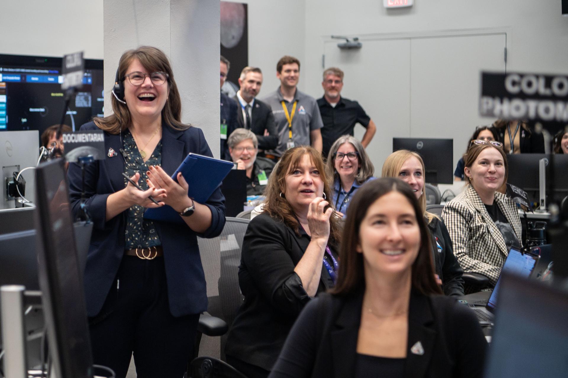
Artemis II lunar science team member, Juliane Gross, center, and the extended lunar science team behind her, celebrates crew observations made during the lunar flyby on April 6. The team worked in the Science Evaluation Room (SER) in Mission Control at NASA’s Johnson Space Center in Houston. Built specifically for Artemis missions with these science priorities in mind, the SER is equipped to support rapid data interpretation, collaborative analysis, real-time decision making, and seamless coordination between the science and operations teams. Credits: NASA/Luna Posadas Nava
Artemis II lunar science team members, from left, Ryan Ewing, and Barbara Cohen, react to crew observations during the lunar flyby on April 6, 2026. The team worked in the Science Evaluation Room (SER) in Mission Control at NASA’s Johnson Space Center in Houston. Built specifically for Artemis missions with these science priorities in mind, the SER is equipped to support rapid data interpretation, collaborative analysis, real-time decision making, and seamless coordination between the science and operations teams. Credits: NASA/Luna Posadas Nava
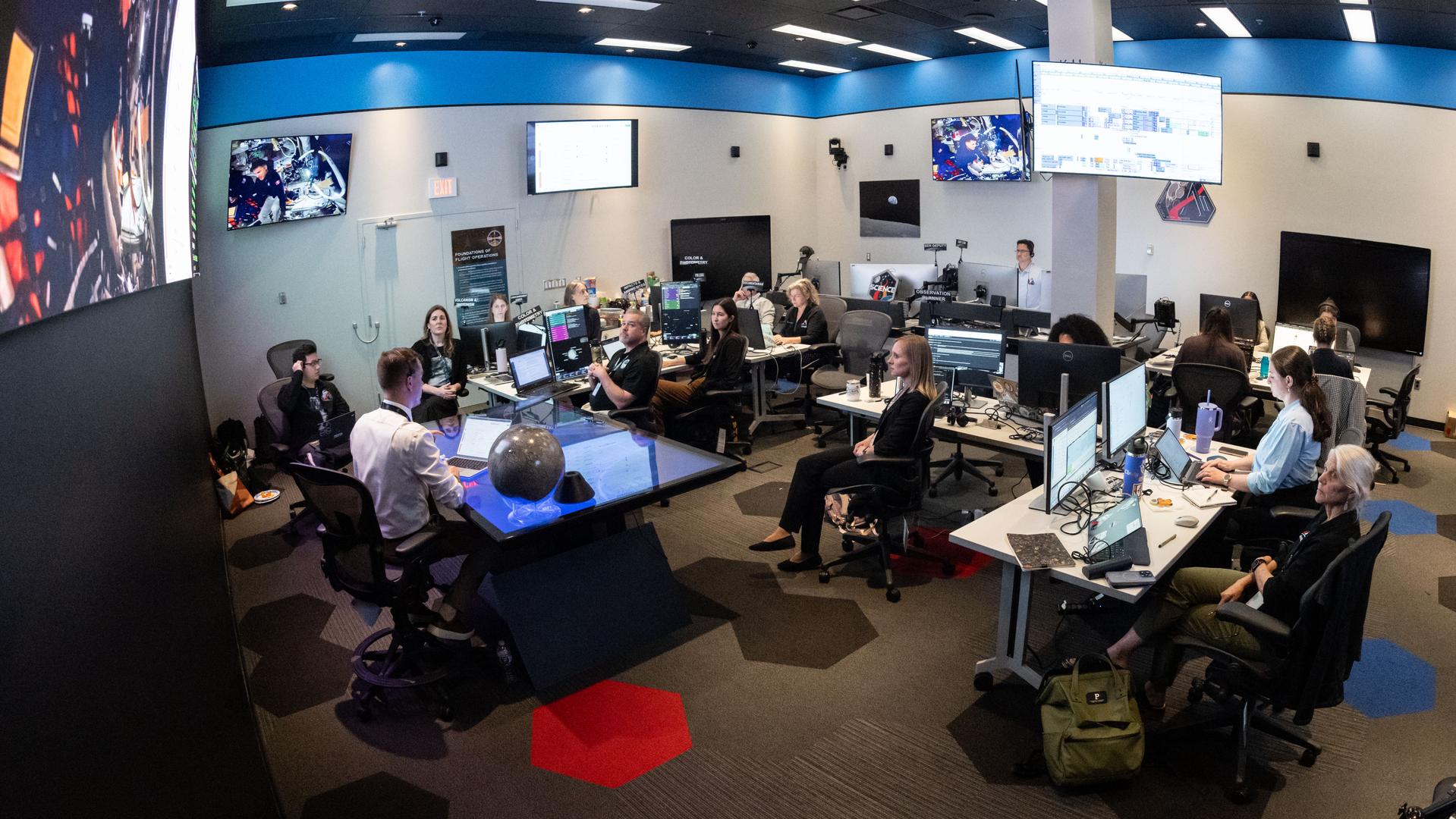
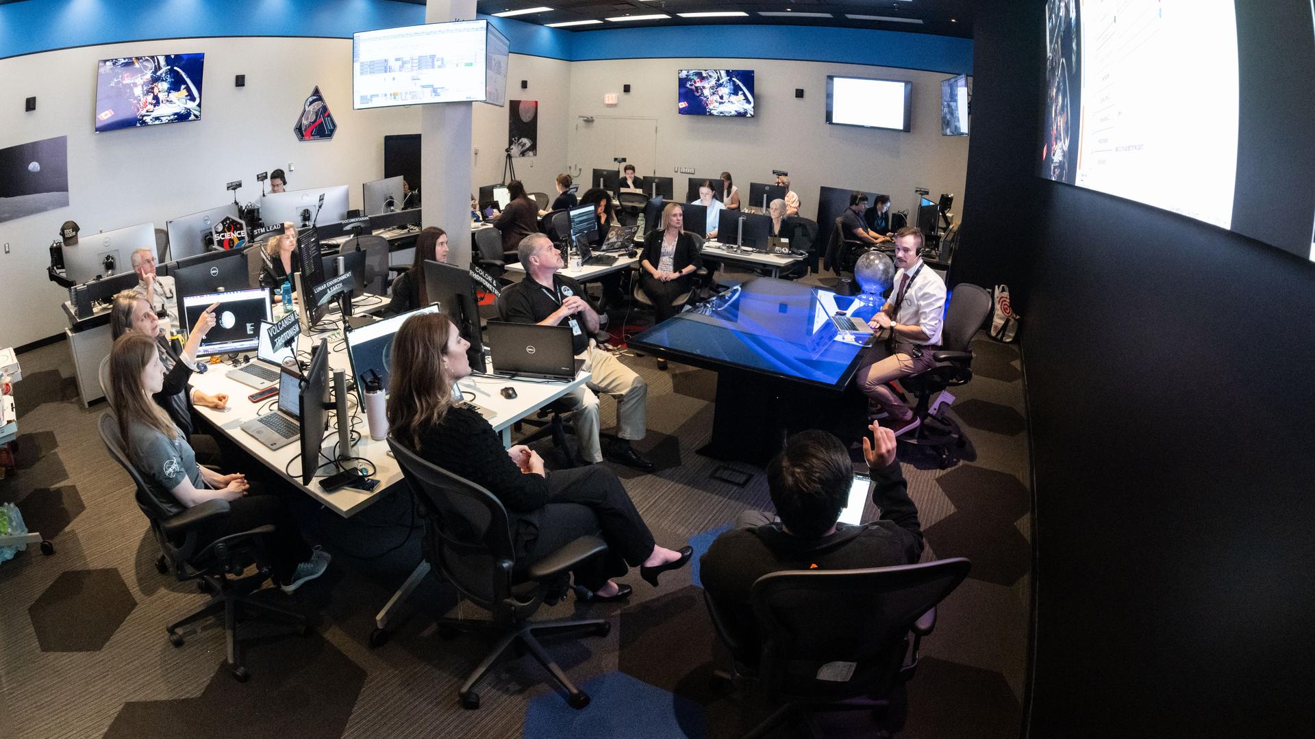
A view inside the Science Evaluation Room (SER) in Mission Control at NASA’s Johnson Space Center in Houston. The SER supports lunar science and planetary observations for the Artemis science officer in the mission’s main flight control room. Built specifically for Artemis missions with these science priorities in mind, the SER is equipped to support rapid data interpretation, collaborative analysis, real-time decision making, and seamless coordination between the science and operations teams. Credits: NASA/Bill Stafford
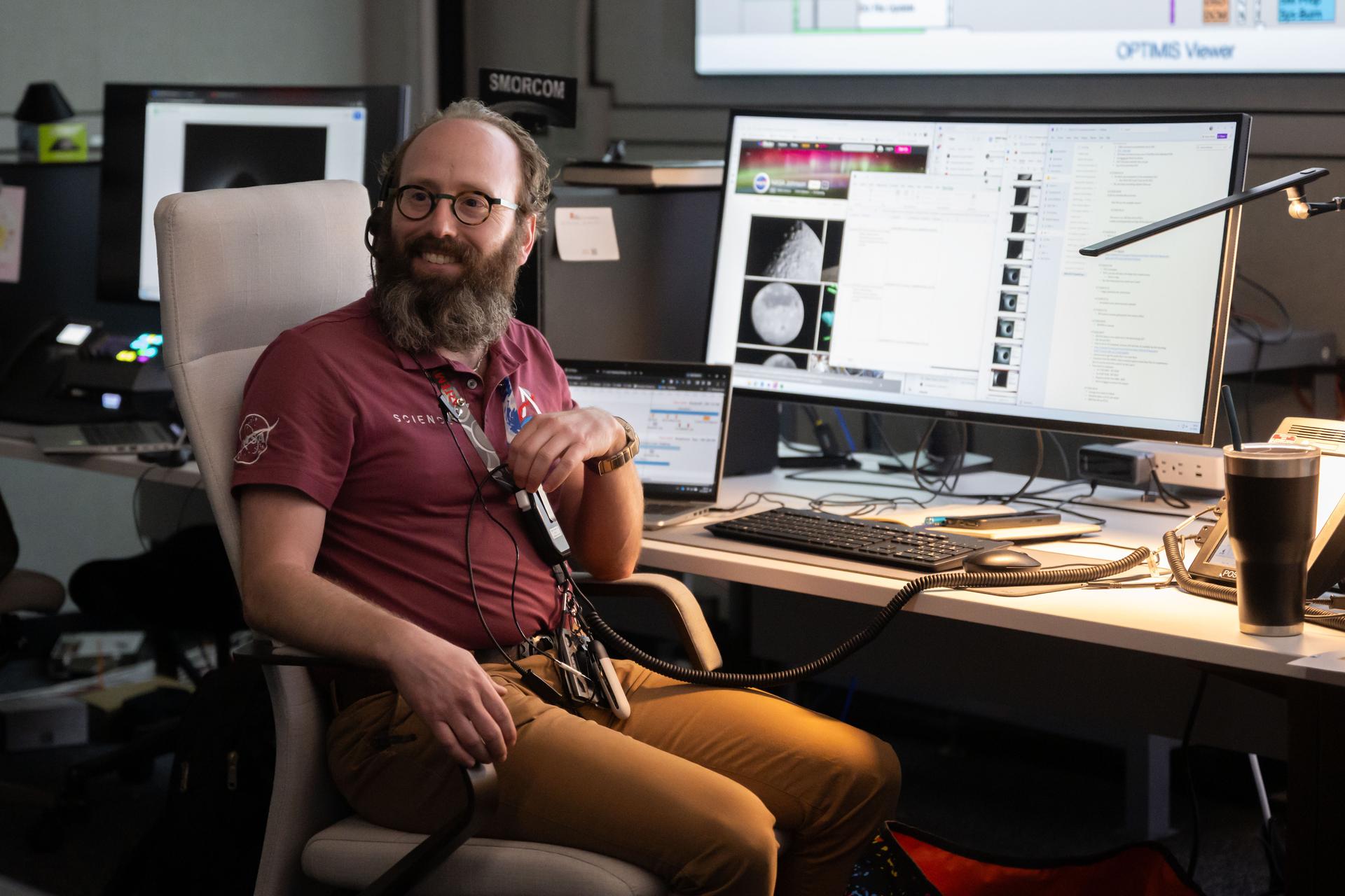
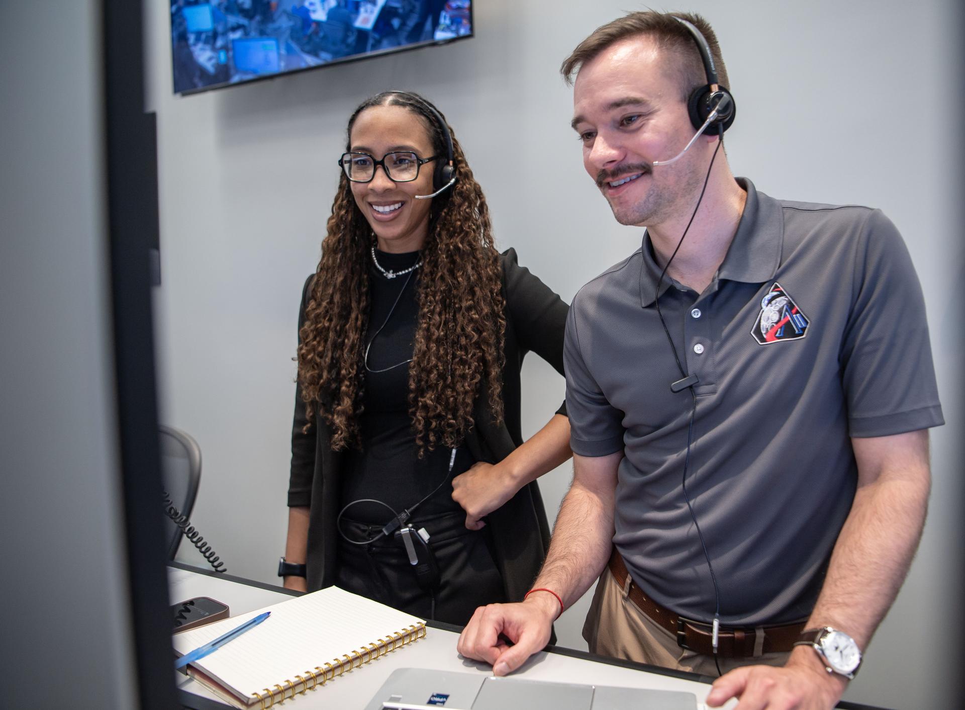
Artemis lunar science team member, Aaron Regberg, works in the Science Mission Operations Room, where scientists analyzed imagery and audio recordings of lunar observations captured by the Artemis II astronauts during their lunar flyby on April 6, 2026.
Artemis lunar science team members, from left, Alexandra Constantinou, and David Hollibaugh-Baker, work in the Science Mission Operations Room at NASA’s Johnson Space Center in Houston. They are analyzing imagery and audio recordings of lunar observations captured by the Artemis II astronauts during their lunar flyby on April 6, 2026.
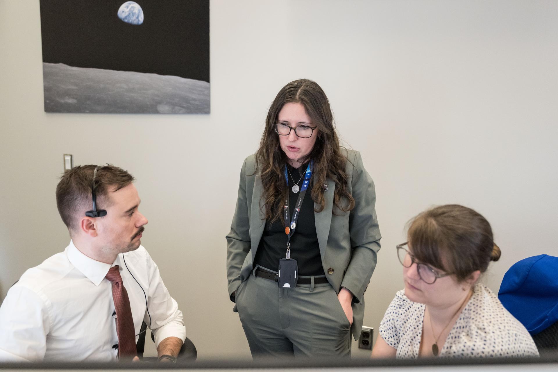
From left, Artemis II deputy lunar science lead, Jacob Richardson, science officer and lunar science lead, Kelsey Young, and deputy lunar science lead, Marie Henderson, discuss the team’s final preparations for the lunar flyby. The team worked in the Science Evaluation Room (SER) in Mission Control at NASA’s Johnson Space Center in Houston. Built specifically for Artemis missions with these science priorities in mind, the SER is equipped to support rapid data interpretation, collaborative analysis, real-time decision making, and seamless coordination between the science and operations teams. Credits: NASA/ Robert Markowitz
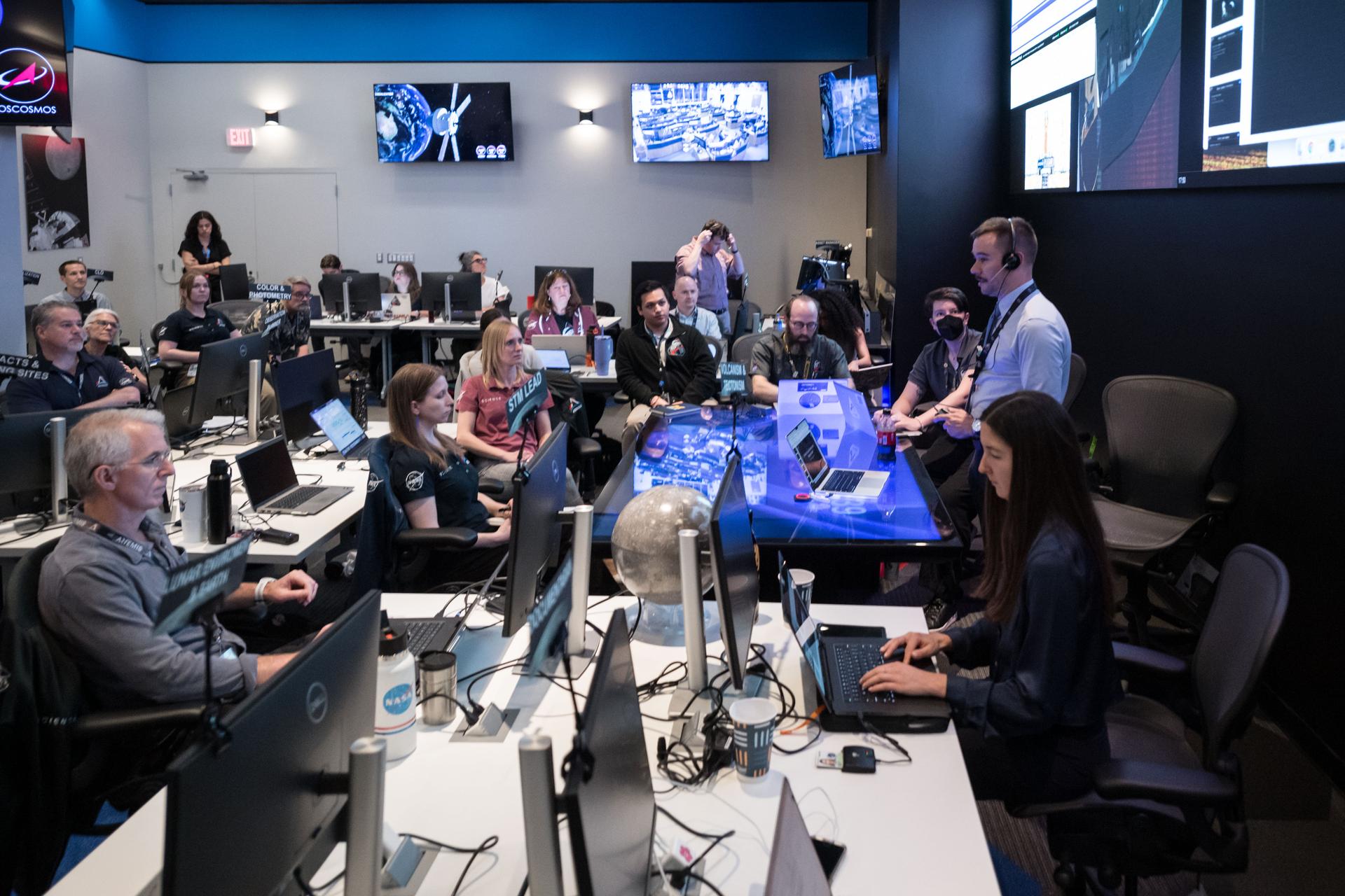
The Artemis II lunar science team gathers for a kickoff meeting before working on the lunar targeting plan for the crew's lunar flyby. The Lunar Targeting Plan is the Artemis II crew's Moon observing assignment, and is fine-tuned to the exact lighting conditions on the Moon’s surface when the Artemis II crew flies by. Like a spacewalk plan, it provides strong, detailed guidance, plus flexibility for the crew to make decisions based on what they’re seeing and experiencing in real time. Targets are prioritized based on both their science value and their visibility at the time of observation. Credits: NASA/Luna Posadas Nava

Artemis science officer, Angela Garcia, left and lunar science team member, Kiarre Dumes discuss science operations in the Science Evaluation Room (SER) in Mission Control at NASA's Johnson Space Center in Houston. The SER supports lunar science and planetary observations for the Artemis science officer in the mission’s main flight control room. Dumes serves as the SERCOMM, or Science Evaluation Room Communicator, acting as the singular voice from the science team in the back room, reporting to the science officer. Credits: NASA/Luna Posadas Nava
Artemis II deputy lunar science lead, Marie Henderson, reacts to the astronauts' verbal observations of the Moon during their flyby on April 6, 2026. Along with other lunar science team members, Henderson helped train the astronauts in geology both in the classroom and in the field. The team also built the lunar targeting plan that, like an International Space Station spacewalk plan, provides strong, detailed observation guidance, plus flexibility for the crew to make decisions based on what they’re seeing and experiencing in real time. The science team had many moments of celebration during the lunar flyby as the astronauts took images of the Moon and provided verbal descriptions of what they were seeing. This type of information reveals the geologic history of an area and will be critical to collect when future Artemis astronauts explore the Moon's surface. Credits: NASA/Luna Posadas Nava

Artemis II lunar science team members, in the foreground from left: Amber Turner and Jared Ralleta in the center. Standing up behind Turner is Jacob Richardson, and sitting behind and to the right, of Ralleta, are Ryan Watkins in the front, and Debra Needham behind her. The SER supports the Artemis science officer in the mission’s main flight control room. Built specifically for Artemis missions with these science priorities in mind, the SER is equipped to support rapid data interpretation, collaborative analysis, real-time decision making, and seamless coordination between the science and operations teams. Credits: NASA/Luna Posadas Nava
Artemis II deputy lunar science lead Marie Henderson, shown standing on the left, and lunar science team members, from the right foreground, Ariel Deutsch, Maria Banks behind her, Ryan Watkins to her right, and Sara Schmidt in the checkered jacket. In this image they are reacting to astronauts' observations of Moon features during their flyby on April 6, 2026. Leading up to the flight, the science team has been training the astronauts in in the classroom and in the field. They also built the lunar targeting plan that, like a spacewalk plan on the International Space Station, provides strong, detailed observation guidance, plus flexibility for the crew to make decisions based on what they’re seeing and experiencing in real time. The science team had many moments of celebration during the lunar flyby as the astronauts took images of the Moon and provided verbal descriptions of what they were seeing. This type of information reveals the geologic history of various lunar areas and will be critical to collect when future Artemis astronauts explore the Moon's surface. Credits: NASA/Luna Posadas Nava

Artemis II deputy lunar science lead, Jacob Richardson, left, and Artemis II lunar science team members, Kiarre Dumes, react to the astronauts' verbal observations of the Moon during their flyby on April 6, 2026. Along with other lunar science team members, Richardson and Dumes helped train the crew in geology both in the classroom and in the field. The science team also built the lunar targeting plan that, like an International Space Station spacewalk plan, provides strong, detailed observation guidance, plus flexibility for the crew to make decisions based on what they’re seeing and experiencing in real time. The science team had many moments of celebration during the lunar flyby as the astronauts took images of the Moon and provided verbal descriptions of what they were seeing. This type of information reveals the geologic history of an area and will be critical to collect when future Artemis astronauts explore the Moon's surface. Credits: NASA/Luna Posadas Nava
Artemis curation lead, Juliane Gross, reacts to the astronauts' verbal observations of the Moon during their flyby on April 6, 2026. Along with other members of the Artemis II lunar science team, Gross helped train the Artemis II crew in geology both in the classroom and in the field. The team also built the lunar targeting plan that, like an International Space Station spacewalk plan, provides strong, detailed observation guidance, plus flexibility for the crew to make decisions based on what they’re seeing and experiencing in real time. The science team had many moments of celebration during the lunar flyby as the astronauts took images of the Moon and provided verbal descriptions of what they were seeing. This type of information reveals the geologic history of an area and will be critical to collect when future Artemis astronauts explore the Moon's surface. Credits: NASA/Luna Posadas Nava
Artemis II lunar science team members, from left, Debra Needham, Juliane Gross, and Ryan Watkins, react to the astronauts' verbal observations of the Moon during their flyby on April 6, 2026. The science team trained the astronauts in geology and observation, both in the classroom and in the field. The team also built the lunar targeting plan that, like an International Space Station spacewalk plan, provides strong, detailed observation guidance, plus flexibility for the crew to make decisions based on what they’re seeing and experiencing in real time. The science team had many moments of celebration during the lunar flyby as the astronauts took images of the Moon and provided verbal descriptions of what they were seeing. This type of information reveals the geologic history of an area and will be critical to collect when future Artemis astronauts explore the Moon's surface. Credits: NASA/Luna Posadas Nava
Artemis II deputy lunar science lead, Marie Henderson, reacts to the astronauts' verbal observations of the Moon during their flyby on April 6, 2026. Along with other lunar science team members, Ewing helped train the crew in geology both in the classroom and in the field. The science team also built the lunar targeting plan that, like an International Space Station spacewalk plan, provides strong, detailed observation guidance, plus flexibility for the crew to make decisions based on what they’re seeing and experiencing in real time. The science team had many moments of celebration during the lunar flyby as the astronauts took images of the Moon and provided verbal descriptions of what they were seeing. This type of information reveals the geologic history of an area and will be critical to collect when future Artemis astronauts explore the Moon's surface. Credits: NASA/Luna Posadas Nava
Artemis II lunar science team member, Ryan Ewing, reacts to the astronauts' verbal observations of the Moon during their flyby on April 6, 2026. Along with other lunar science team members, Ewing helped train the crew in geology both in the classroom and in the field. The science team also built the lunar targeting plan that, like an International Space Station spacewalk plan, provides strong, detailed observation guidance, plus flexibility for the crew to make decisions based on what they’re seeing and experiencing in real time. The science team had many moments of celebration during the lunar flyby as the astronauts took images of the Moon and provided verbal descriptions of what they were seeing. This type of information reveals the geologic history of an area and will be critical to collect when future Artemis astronauts explore the Moon's surface. Credits: NASA/Luna Posadas Nava

Artemis II lunar science team member, Ariel Deutsch, reacts to the astronauts' verbal observations of the Moon during their flyby on April 6. The science team has spent years training the astronauts in geology and observation, both in the classroom and in the field. They also built the lunar targeting plan that, like a spacewalk plan, provides strong, detailed observation guidance, plus flexibility for the crew to make decisions based on what they’re seeing and experiencing in real time. The science team had many moments of celebration during the lunar flyby as the astronauts took pictures of the Moon and provided verbal descriptions of what they were seeing. This type of information reveals the geologic history of an area and will be critical to collect when future Artemis astronauts explore the Moon's surface. Credits: NASA/Luna Posadas Nava

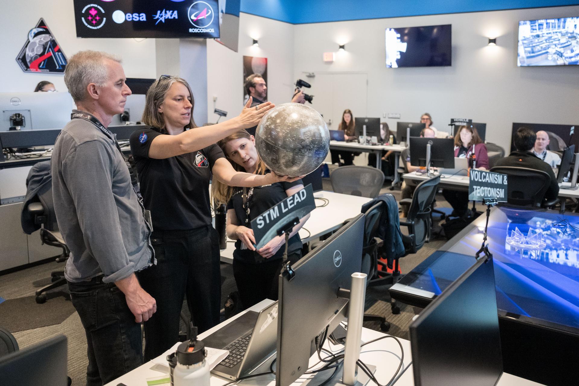
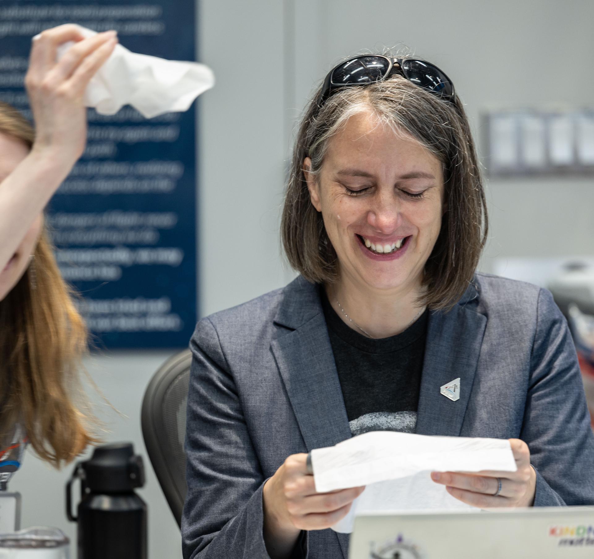
Artemis curation lead, Juliane Gross, holds a lunar globe in the Science Evaluation Room (SER) in Mission Control at Johnson Space Center in Houston. The SER supports lunar science and planetary observations for the Artemis science officer in the mission’s main flight control room. Built specifically for Artemis missions with these science priorities in mind, the SER is equipped to support rapid data interpretation, collaborative analysis, real-time decision making, and seamless coordination between the science and operations teams. Credits: NASA/Luna Posadas Nava
Artemis II Lunar Science Deputy Jacob Richardson and Artemis II Lunar Science Team Member Kiarre Dumes react to the astronauts' verbal observations of the Moon during their flyby on April 6. The science team trained the astronauts in geology both in the classroom and in the field. They also built the lunar targeting plan that, like a spacewalk plan, provides strong, detailed observation guidance, plus flexibility for the crew to make decisions based on what they’re seeing and experiencing in real time. The science team had many moments of celebration during the lunar flyby as the astronauts took pictures of the Moon and provided verbal descriptions of what they were seeing. This type of information reveals the geologic history of an area and will be critical to collect when future Artemis astronauts explore the Moon's surface. Credits: NASA/Luna Posadas Nava

Ernie Wright, Artemis II lunar science visualization lead, reacts to hearing the astronauts describe features of the Moon as they few by on April 6, 2026. To prepare the crew for this mission, the Artemis II lunar science team trained the astronauts in geology, both in the classroom and in the field. They also built the lunar targeting plan that, which, like an International Space Station spacewalk plan, provides strong, detailed observation guidance, plus flexibility for the crew to make decisions based on what they’re seeing and experiencing in real time. The science team had many moments of celebration during the lunar flyby as the astronauts took images of the Moon and provided verbal descriptions of what they were seeing. This type of information reveals the geologic history of an area and will be critical to collect when future Artemis astronauts explore the Moon's surface. Credits: NASA/Luna Posadas Nava
S99-E-5555 (17 February 2000) --- As photographed from the Space Shuttle Endeavour, this oblique electronic still image of Earth's horizon reveals a great deal of cloud cover. In the case of the electronic still camera (ESC), as well as film-bearing instruments, clouds naturally obscure views of recognizable land masses. Much of Earth is heavily cloud covered during the current mission and meteorlogists and oceanographers are interested in studying that aspect. However, the Shuttle Radar Topography Mission's other sensing equipment, X-SAR and C-band antennae, are able to penetrate cloud cover and record important topographic data for mapmakers and scientists of other disciplines. In addition to the sensing equipment mentioned above, this mission is supporting the EarthKAM project which utilizes the services of another electronic still camera mounted in Endeavour's windows. Unlike this oblique view, EarthKAM records strictly vertical or nadir imagery of points all over the world. Students across the United States and in France, Germany and Japan are taking photos throughout the STS-99 mission. And they are using these new photos, plus all the images already available in the EarthKAM system, to enhance their classroom learning in Earth and space science, social studies, geography, mathematics and more.
S85-37677 (8-12 July 1985) --- Sharon C. (Christa) McAuliffe of Concord High, Concord, New Hampshire, talks to nurse during physiological testing on first day at Johnson Space Center (JSC). Christa McAuliffe was eventually chosen as the first Teacher in Space and was a member of the seven-member Challenger shuttle crew which died tragically in the explosion of the spacecraft during the launch of STS-51L from the Kennedy Space Center about 11:40 a.m., EST, on Jan. 28, 1986. The explosion occurred 73 seconds into the flight as a result of a leak in one of two Solid Rocket Boosters that ignited the main liquid fuel tank. The crew members of the Challenger represented a cross-section of the American population in terms of race, gender, geography, background, and religion. The explosion became one of the most significant events of the 1980s, as billions around the world saw the accident on television and empathized with any one of the several crew members killed. Photo credit: NASA
Artemis II lunar science team members, from left, Amber Turner, Jacob Richardson, Jose Hurtado, discuss the team's progress on the lunar targeting plan for the astronauts' six-hour flyby of the Moon, scheduled for April 6. As they pass the Moon, the crew will apply geology skills learned in the classroom and in Moon-like environments on Earth to photograph and describe features including impact craters, ancient lava flows, and surface cracks and ridges formed as the Moon slowly changed over time. They will note differences in color, brightness, and texture, which provide clues that help scientists understand what the surface is made of and how it formed. Credits: NASA/Bill Stafford

Artemis II lunar science team member, Amber Turner, works on the lunar targeting plan for the astronauts' several-hour flyby of the Moon, scheduled for April 6. As they pass the Moon, the crew will apply geology skills learned in the classroom and in Moon-like environments on Earth to photograph and describe features including impact craters, ancient lava flows, and surface cracks and ridges formed as the Moon slowly changed over time. They will note differences in color, brightness, and texture, which provide clues that help scientists understand what the surface is made of and how it formed. Credits: NASA/Bill Stafford

The Artemis II lunar science team works on the lunar targeting plan for the astronauts' several-hour flyby of the Moon, scheduled for April 6. As they pass the Moon, the crew will apply geology skills learned in the classroom and in Moon-like environments on Earth to photograph and describe features including impact craters, ancient lava flows, and surface cracks and ridges formed as the Moon slowly changed over time. They will note differences in color, brightness, and texture, which provide clues that help scientists understand what the surface is made of and how it formed. Credits: NASA/Bill Stafford
The Artemis II lunar science team works on the lunar targeting plan for the astronauts' several-hour flyby of the Moon, scheduled for April 6. As they pass the Moon, the crew will apply geology skills learned in the classroom and in Moon-like environments on Earth to photograph and describe features including impact craters, ancient lava flows, and surface cracks and ridges formed as the Moon slowly changed over time. They will note differences in color, brightness, and texture, which provide clues that help scientists understand what the surface is made of and how it formed. Credits: NASA/Bill Stafford
Artemis II lunar science team members, from left, Megan Borel, and Cindy Evans, discuss the lunar targeting plan for the astronauts' several-hour flyby of the Moon, scheduled for April 6. As they pass the Moon, the crew will apply geology skills learned in the classroom and in Moon-like environments on Earth to photograph and describe features including impact craters, ancient lava flows, and surface cracks and ridges formed as the Moon slowly changed over time. They will note differences in color, brightness, and texture, which provide clues that help scientists understand what the surface is made of and how it formed. Credits: NASA/Bill Stafford
Artemis II science officers, Trevor Graff, background, and Kelsey Young are seen monitoring mission data in real-time from the Science console in the White Flight Control Room in Mission Control at NASA's Johnson Space Center in Houston. Science officers are the senior flight controllers responsible for lunar science and geology objectives during Artemis missions. Credits: NASA/Robert Markowitz
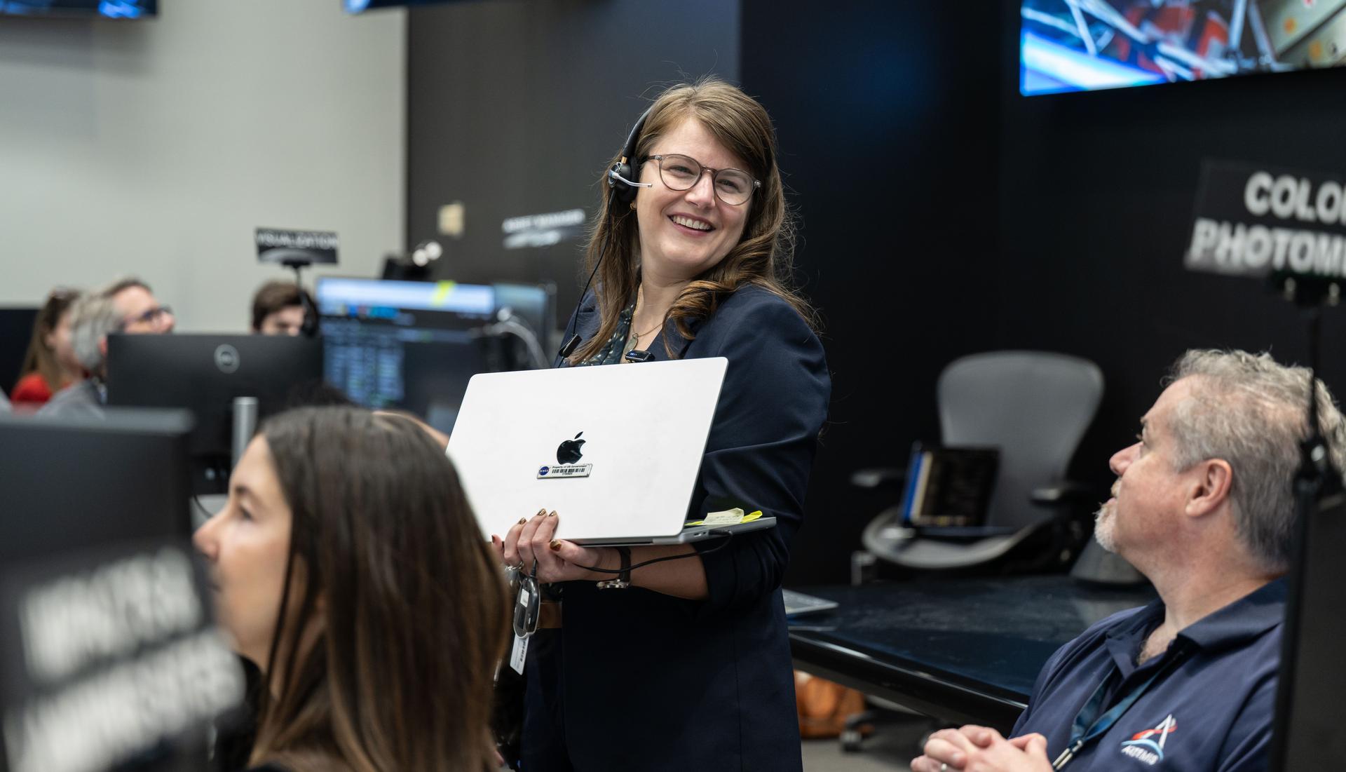
Artemis science officers, from left, Angela Garcia and Kelsey Young, watch the lunar science team celebrating in the Science Evaluation Room (SER) as they hear lunar observations from the Artemis II crew. The science team has spent years training the astronauts in geology and observation, both in the classroom and in the field. They also built the lunar targeting plan that, like a spacewalk plan, provides strong, detailed observation guidance, plus flexibility for the crew to make decisions based on what they’re seeing and experiencing in real time. The science team had many moments of celebration during the lunar flyby as the astronauts took pictures of the Moon and provided verbal descriptions of what they were seeing. This type of information reveals the geologic history of an area and will be critical to collect when future Artemis astronauts explore the Moon's surface. Credits: NASA/Robert Markowitz
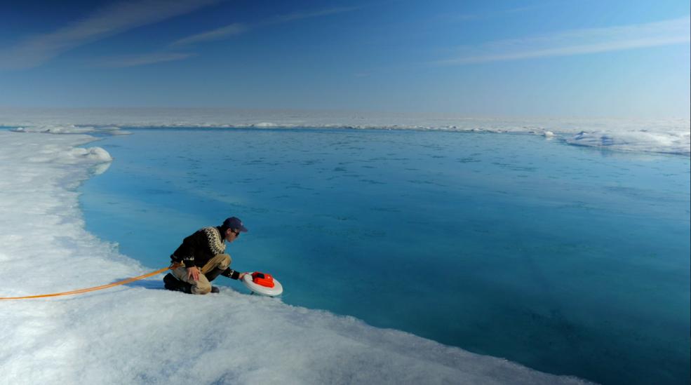
Laurence Smith, chair of geography at University of California, Los Angeles, deploys an autonomous drift boat equipped with several sensors in a meltwater river on the surface of the Greenland ice sheet on July 19, 2015. “Surface melting in Greenland has increased recently, and we lacked a rigorous estimate of the water volumes being produced and their transport,” said Tom Wagner, the cryosphere program scientist at NASA Headquarters in Washington. “NASA funds fieldwork like Smith’s because it helps us to interpret satellite data, and to extrapolate measurements from the local field sites to the larger ice sheet." Credit: NASA/Goddard/Jefferson Beck Read more: <a href="http://www.nasa.gov/feature/a-summer-of-nasa-research-on-sea-level-rise-in-greenland" rel="nofollow">www.nasa.gov/feature/a-summer-of-nasa-research-on-sea-lev...</a> <b><a href="http://www.nasa.gov/audience/formedia/features/MP_Photo_Guidelines.html" rel="nofollow">NASA image use policy.</a></b> <b><a href="http://www.nasa.gov/centers/goddard/home/index.html" rel="nofollow">NASA Goddard Space Flight Center</a></b> enables NASA’s mission through four scientific endeavors: Earth Science, Heliophysics, Solar System Exploration, and Astrophysics. Goddard plays a leading role in NASA’s accomplishments by contributing compelling scientific knowledge to advance the Agency’s mission. <b>Follow us on <a href="http://twitter.com/NASAGoddardPix" rel="nofollow">Twitter</a></b> <b>Like us on <a href="http://www.facebook.com/pages/Greenbelt-MD/NASA-Goddard/395013845897?ref=tsd" rel="nofollow">Facebook</a></b> <b>Find us on <a href="http://instagrid.me/nasagoddard/?vm=grid" rel="nofollow">Instagram</a></b>
At 1 p.m. EDT (10 a.m. PDT) on Friday, Aug. 28, NASA's Goddard Space Flight Center in Greenbelt, Maryland, will host a live TV program about agency research into how and why the massive Greenland ice sheet is changing. The event features scientists actively conducting field work in Greenland, along with extensive video footage of their work performed over this summer. Panelists include: Tom Wagner (cryosphere program scientist with NASA's Earth Science Division), Laurence Smith (chair of the University of California, Los Angeles Department of Geography), Mike Bevis (professor of geodynamics at Ohio State University in Columbus), Sophie Nowicki (physical scientist at Goddard), and Josh Willis (JPL). The Friday program will air live on NASA TV and stream online at: <a href="http://www.nasa.gov/nasatv" rel="nofollow">www.nasa.gov/nasatv</a>. To ask questions via social media during the televised event, use the hashtag #askNASA. <b><a href="http://www.nasa.gov/audience/formedia/features/MP_Photo_Guidelines.html" rel="nofollow">NASA image use policy.</a></b> <b><a href="http://www.nasa.gov/centers/goddard/home/index.html" rel="nofollow">NASA Goddard Space Flight Center</a></b> enables NASA’s mission through four scientific endeavors: Earth Science, Heliophysics, Solar System Exploration, and Astrophysics. Goddard plays a leading role in NASA’s accomplishments by contributing compelling scientific knowledge to advance the Agency’s mission. <b>Follow us on <a href="http://twitter.com/NASAGoddardPix" rel="nofollow">Twitter</a></b> <b>Like us on <a href="http://www.facebook.com/pages/Greenbelt-MD/NASA-Goddard/395013845897?ref=tsd" rel="nofollow">Facebook</a></b> <b>Find us on <a href="http://instagrid.me/nasagoddard/?vm=grid" rel="nofollow">Instagram</a></b>
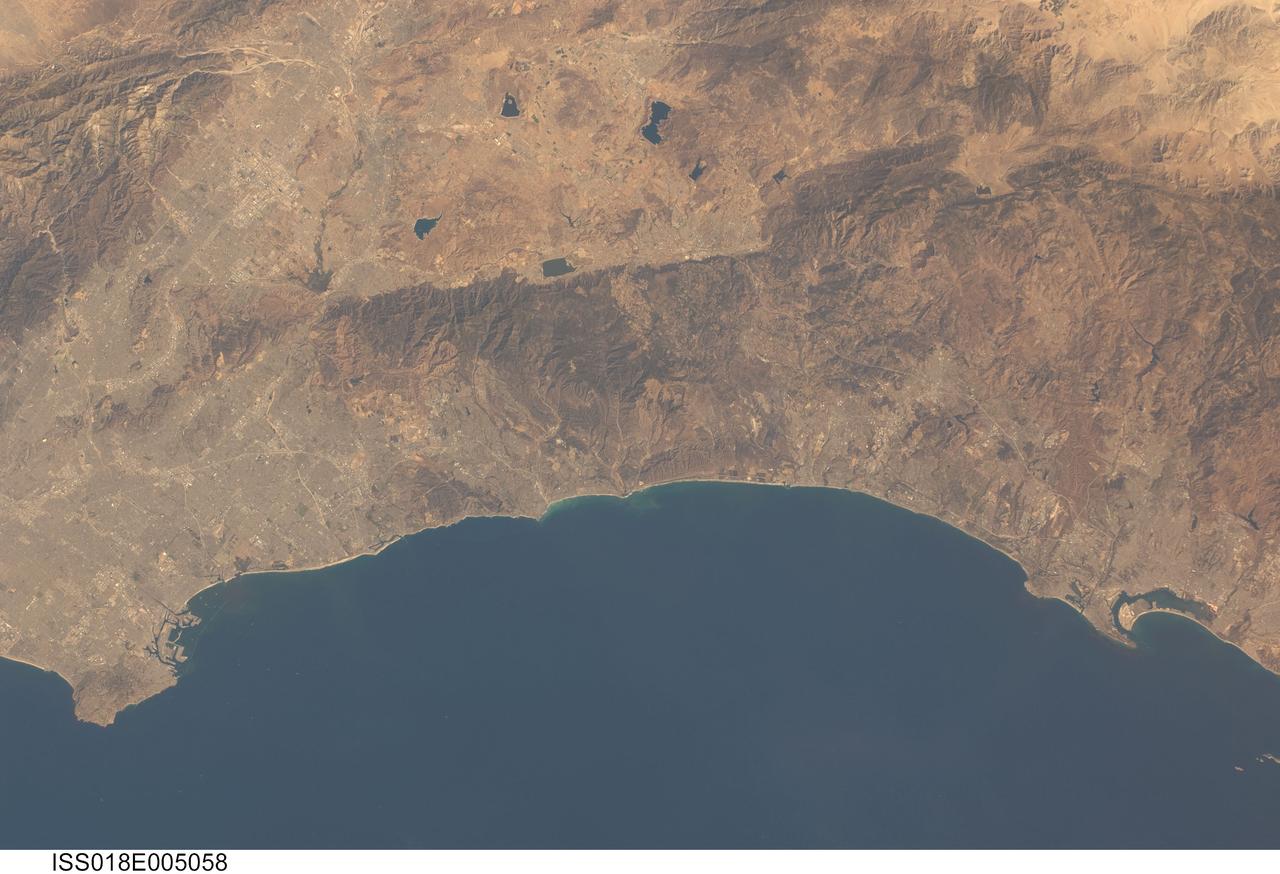
ISS018-E-005058 (24 Oct. 2008) --- Southern California's coastline, from southern Los Angeles to Tijuana in Mexico, a distance of about 225 kilometers, is featured in this image photographed by an Expedition 18 crewmember on the International Space Station. Port facilities of Los Angeles Harbor give much detail to the coastline at the north end and arcuate San Diego Bay is highly recognizable at the south end (right bottom). The image includes much of one of the most densely populated parts of the USA, with approximately 20 million people within the parts of five counties shown here. The dense urban areas appear gray, with the largest conurbation in the north of the view, in the region Long Beach--Los Angeles--San Bernardino. A smaller zone appears around San Diego--Tijuana in the south. Major highways with their associated strip development snake through these dense urban areas. The geography and geomorphology of Southern California is defined by long linear features that are surface traces of large transform faults. These faults, including the Elsinore fault and San Jacinto fault seen here, are generally considered part of the San Andreas system, and make up the broad zone comprising the tectonic plate boundary between North America to the east and the Pacific plate to the west. The Elsinore fault marks the steep eastern scarp of the Santa Ana Mountains, as well as the precipitation boundary between the wetter mountains and the drier deserts to the east. The rainfall difference is reflected in the darker appearance (more vegetation) of the mountains and coastal regions. Inland of the mountains, climates are far drier, and the natural vegetation is scrubby and much less dense which allows brown and yellow soils to show through. However, the entire region is arid; water management is a critical issue for the large urban areas of the state. Several reservoirs that are visible east of the Santa Ana Mountains provide water for both cities and agriculture in southern California.
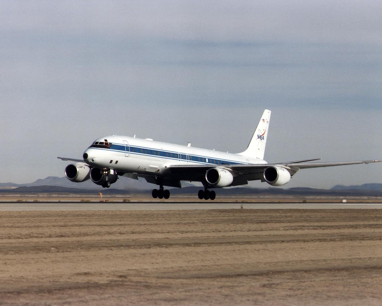
NASA's DC-8 Airborne Science platform landed at Edwards Air Force Base, California, to join the fleet of aircraft at NASA's Dryden Flight Research Center. The white aircraft with a blue stripe running horizontally from the nose to the tail is shown with its main landing gear just above the runway. The former airliner is a "dash-72" model and has a range of 5,400 miles. The craft can stay airborne for 12 hours and has an operational speed range between 300 and 500 knots. The research flights are made at between 500 and 41,000 feet. The aircraft can carry up to 30,000 lbs of research/science payload equipment installed in 15 mission-definable spaces.
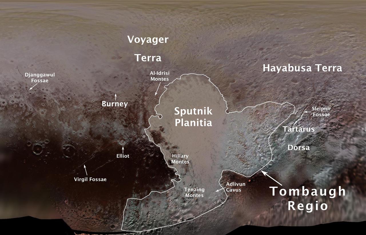
The International Astronomical Union (IAU), the internationally recognized authority for naming celestial bodies and their surface features, approved names of 14 surface features on Pluto in August 2017. The names were proposed by NASA's New Horizons team following the first reconnaissance of Pluto and its moons by the New Horizons spacecraft in 2015. The names, listed below, pay homage to the underworld mythology, pioneering space missions, historic pioneers who crossed new horizons in exploration, and scientists and engineers associated with Pluto and the Kuiper Belt. Tombaugh Regio honors Clyde Tombaugh (1906-1997), the U.S. astronomer who discovered Pluto in 1930 from Lowell Observatory in Arizona. Burney crater honors Venetia Burney (1918-2009), who as an 11-year-old schoolgirl suggested the name "Pluto" for Clyde Tombaugh's newly discovered planet. Later in life she taught mathematics and economics. Sputnik Planitia is a large plain named for Sputnik 1, the first space satellite, launched by the Soviet Union in 1957. Tenzing Montes and Hillary Montes are mountain ranges honoring Tenzing Norgay (1914-1986) and Sir Edmund Hillary (1919-2008), the Indian/Nepali Sherpa and New Zealand mountaineer were the first to reach the summit of Mount Everest and return safely. Al-Idrisi Montes honors Ash-Sharif al-Idrisi (1100-1165/66), a noted Arab mapmaker and geographer whose landmark work of medieval geography is sometimes translated as "The Pleasure of Him Who Longs to Cross the Horizons.†Djanggawul Fossae defines a network of long, narrow depressions named for the Djanggawuls, three ancestral beings in indigenous Australian mythology who traveled between the island of the dead and Australia, creating the landscape and filling it with vegetation. Sleipnir Fossa is named for the powerful, eight-legged horse of Norse mythology that carried the god Odin into the underworld. Virgil Fossae honors Virgil, one of the greatest Roman poets and Dante's fictional guide through hell and purgatory in the Divine Comedy. Adlivun Cavus is a deep depression named for Adlivun, the underworld in Inuit mythology. Hayabusa Terra is a large land mass saluting the Japanese spacecraft and mission (2003-2010) that performed the first asteroid sample return. Voyager Terra honors the pair of NASA spacecraft, launched in 1977, that performed the first "grand tour" of all four giant planets. The Voyager spacecraft are now probing the boundary between the Sun and interstellar space. Tartarus Dorsa is a ridge named for Tartarus, the deepest, darkest pit of the underworld in Greek mythology. Elliot crater recognizes James Elliot (1943-2011), an MIT researcher who pioneered the use of stellar occultations to study the solar system -- leading to discoveries such as the rings of Uranus and the first detection of Pluto's thin atmosphere. https://photojournal.jpl.nasa.gov/catalog/PIA21944
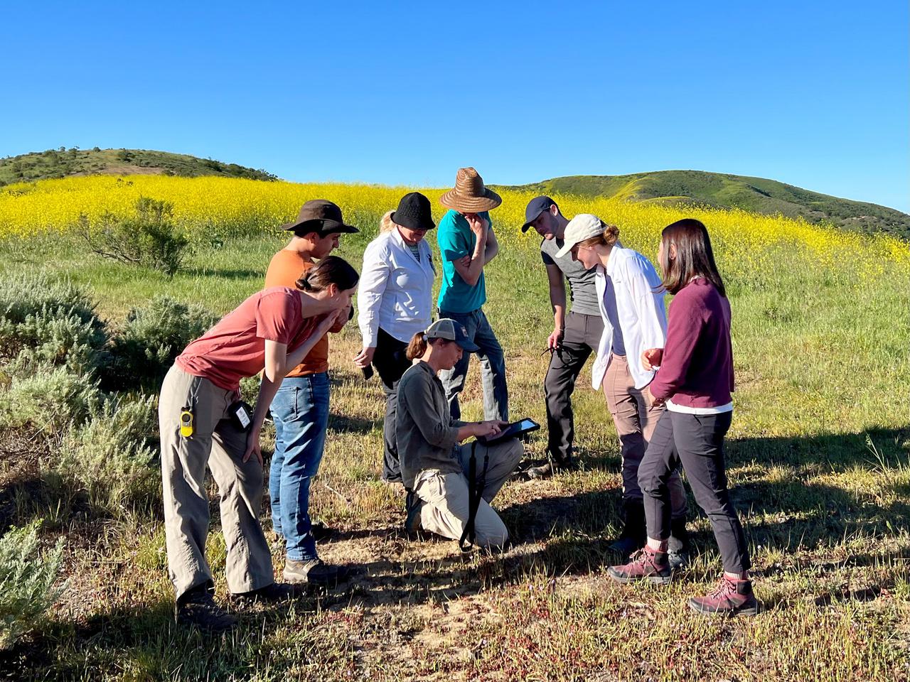
Dana Chadwick, a scientist in the water and ecosystems group at NASA's Jet Propulsion Laboratory, center, advises a field team of researchers from JPL; University of Wisconsin, Madison (UWM); University of California, Los Angeles (UCLA); University of Maryland, Baltimore County (UMBC); and University of California, Santa Barbara (UCSB) on vegetation-sampling locations at the Jack and Laura Dangermond Preserve in Santa Barbara County, California, on March 24, 2022. Chadwick and the team are working on the Surface Biology and Geology High-Frequency Time Series (SHIFT) campaign, which is jointly led by JPL, UCSB, and The Nature Conservancy. Chadwick is surrounded by, from left: Natalie Queally, a forest and wildlife ecology graduate student at UWM; Francisco Ochoa, a geography graduate student at UCLA; Petya Campbell, a research associate professor at UMBC and a research associate at NASA's Goddard Space Flight Center; Brendan Heberlein, a research intern at UWM; Renato Braghiere, a postdoctoral research scientist at JPL; Cassandra Nickles, a postdoctoral fellow at JPL; and Clare Saiki, a doctoral student at UCSB. Operating between late February and late May 2022, SHIFT combines the ability of airborne science instruments to gather data over widespread areas with the more concentrated observations scientists conduct in the field to study the functional characteristics, health, and resilience of plant communities. The sampling and analysis done by researchers on the ground and in the ocean is intended to validate data taken by AVIRIS-NG (Airborne Visible/Infrared Imaging Spectrometer-Next Generation). The instrument, designed at JPL, is collecting spectral data of vegetation it observes during weekly flights in an aircraft over a 640-square-mile (1,656-square-kilometer) study area in Santa Barbara County and coastal Pacific waters. The campaign is a pathfinder for NASA's proposed Surface Biology and Geology (SBG) mission. SHIFT will help scientists design data collection and processing algorithms for that mission, which would launch no earlier than 2028. The SHIFT data is also intended to support the research and conservation objectives of The Nature Conservancy, which owns the Dangermond Preserve, and UCSB, which operates the Sedgwick Reserve, another nature preserve within the study area. More than 60 scientists from institutions around the U.S. have indicated they intend to use the SHIFT data in their research. https://photojournal.jpl.nasa.gov/catalog/PIA25141
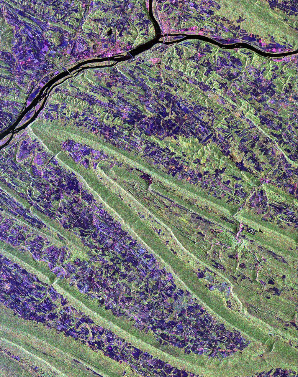
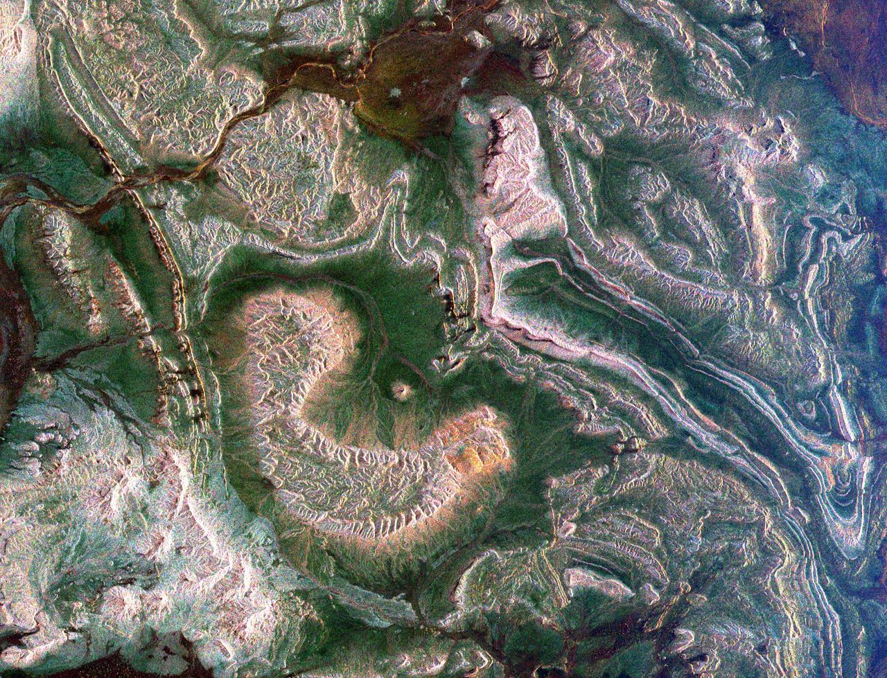
Scientists are using this radar image of the area surrounding Sunbury, Pennsylvania to study the geologic structure and land use patterns in the Appalachian Valley and Ridge province. This image was collected on October 6, 1994 by the Spaceborne Imaging Radar-C/ X-Band Synthetic Aperture Radar (SIR-C/X-SAR) on orbit 102 of the space shuttle Endeavour. The image is centered on latitude 40.85 degrees North latitude and 76.79 degrees West longitude. The area shown is approximately 30.5 km by 38 km. (19 miles by 24 miles). North is towards the upper right of the image. The Valley and Ridge province occurs in the north-central Appalachians, primarily in Pennsylvania, Maryland, and Virginia. It is an area of adjacent valleys and ridges that formed when the Appalachian mountain were created some 370 to 390 million years ago. During the continental collision that formed the Appalachians, the rocks in this area were pushed from the side and buckled much like a rug when pushed from one end. Subsequent erosion has produced the landscape we see in this image. The more resistant rocks, such as sandstone, form the tops of the ridges which appear as forested greenish areas on this image. The less resistant rocks, such as limestone, form the lower valleys which are cleared land and farm fields and are purple in this image. Smaller rivers and streams in the area flow along the valleys and in places cut across the ridges in "water gaps." In addition to defining the geography of this region, the Valley and Ridge province also provides this area with natural resources. The valleys provide fertile farmland and the folded mountains form natural traps for oil and gas accumulation; coal deposits are also found in the mountains. The colors in the image are assigned to different frequencies and polarizations of the SIR-C radar as follows: red is L-band horizontally transmitted, horizontally received; green is L-band horizontally transmitted, vertically received; blue is C-band horizontally transmitted, horizontally received. The river junction near the top of the image is where the West Branch River flows into the Susquehanna River, which then flows to the south-southwest past the state capitol of Harrisburg, 70 km (43 miles) to the south and not visible in this image. The town of Sunbury is shown along the Susquehanna on the east just to the southeast of the junction with West Branch. Three structures that cross the Susquehanna; the northern and southern of these structures are bridges and middle structure is the Shamokin Dam which confines the Susquehanna just south of the junction with West Branch. The prominent S-shaped mountain ridge in the center of the image is, from north to south, Little Mountain (the top of the S), Line Mountain (the middle of the S), and Mahantango Mountain (the bottom of the S). http://photojournal.jpl.nasa.gov/catalog/PIA01306

ISS019-E-005501 (9 April 2009) --- Split Region in Croatia is featured in this image photographed by an Expedition 19 crewmember on the International Space Station. One the world?s most rugged coastlines are located in Croatia along the Adriatic Sea. This view features the Dalmatian coastline of Croatia around the city of Split. Much of the region can be characterized by northwest-southeast oriented linear islands and embayments of the Adriatic Sea. This distinctive coastal geomorphology is the result of faulting caused by tectonic activity in the region and sea level rise. Split has a long history - the Roman Emperor Diocletian retired to Spalatum (the present-day Split) in 305, and his palace constitutes the core of the city today. The city is a popular resort destination for its historic sites, Mediterranean climate, and ready access to the Adriatic islands (such as Brac to the south). Other large cities in the region include Kastela and Trogir; together with Split, these form an almost continuous urban area bordering the coast (visible as pink regions). A thin zone marking a water boundary is visible in this image between Split and the island of Brac. It may represent a local plankton bloom, or a line of convergence between water masses creating rougher water. A unique combination of geography -- including dramatic topography that channels local winds, the complicated coastline, input of fresh water from rivers, and ample nutrients and surface oils -- makes for interesting mesoscale surface dynamics throughout the Adriatic Sea. Over the years, astronauts have taken images of the Split region using sunglint and changes in water color to highlight features like eddies, water boundaries and mixing zones between fresh waters flowing into the saltier (denser) waters of the Adriatic, and wind-driven surface currents. Split is an important transit center connecting islands in the Adriatic Sea to the Italian peninsula, and an important regional manufacturing center of goods such as solar cells, plastics, and paper products. The city was heavily industrialized during the post World War II period as a member state of Yugoslavia. By the 1980s, the marine environment bordered by Split, Kastela, and Trogir (known as Kastela Bay) had been identified as one of the most polluted areas of the Adriatic from both sewage and industrial wastes. Concerted efforts by the Croatian government and international partners to improve waste handling and treatment infrastructure over the past 10 years seem to have been successful ? both marine species and water polo players have returned to the area.