Global Weather
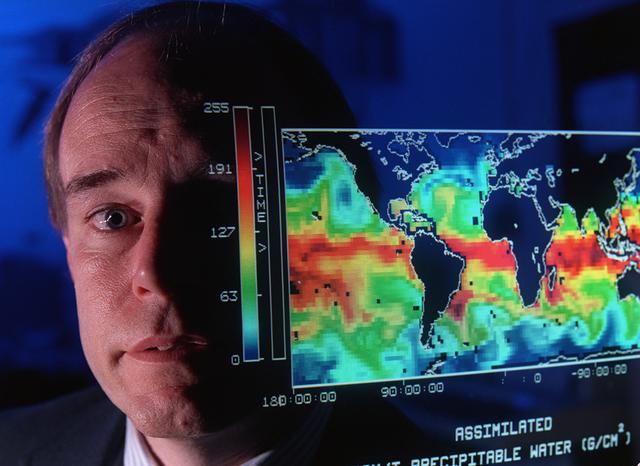
This map shows the presence of water vapor over global oceans. The imagery was produced by combining Special Sensor Microwave Imager measurements and computer models. This data will help scientists better understand how weather systems move water vapor from the tropics toward the poles producing precipitation.
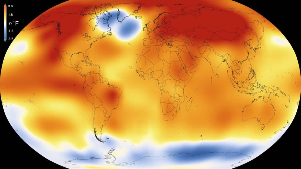
2015 was the warmest year since modern record-keeping began in 1880, according to a new analysis by NASA’s Goddard Institute for Space Studies. The record-breaking year continues a long-term warming trend — 15 of the 16 warmest years on record have now occurred since 2001. Credits: Scientific Visualization Studio/Goddard Space Flight Center Details: Earth’s 2015 surface temperatures were the warmest since modern record keeping began in 1880, according to independent analyses by NASA and the National Oceanic and Atmospheric Administration (NOAA). Globally-averaged temperatures in 2015 shattered the previous mark set in 2014 by 0.23 degrees Fahrenheit (0.13 Celsius). Only once before, in 1998, has the new record been greater than the old record by this much. The 2015 temperatures continue a long-term warming trend, according to analyses by scientists at NASA’s Goddard Institute for Space Studies (GISS) in New York (GISTEMP). NOAA scientists agreed with the finding that 2015 was the warmest year on record based on separate, independent analyses of the data. Because weather station locations and measurements change over time, there is some uncertainty in the individual values in the GISTEMP index. Taking this into account, NASA analysis estimates 2015 was the warmest year with 94 percent certainty.
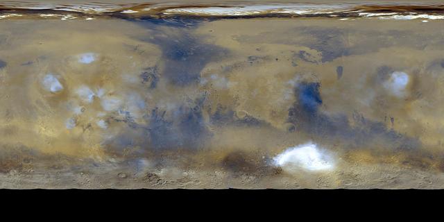
Twelve orbits a day provide NASA Mars Global Surveyor MOC wide angle cameras a global napshot of weather patterns across the planet. Here, bluish-white water ice clouds hang above the Tharsis volcanoes.
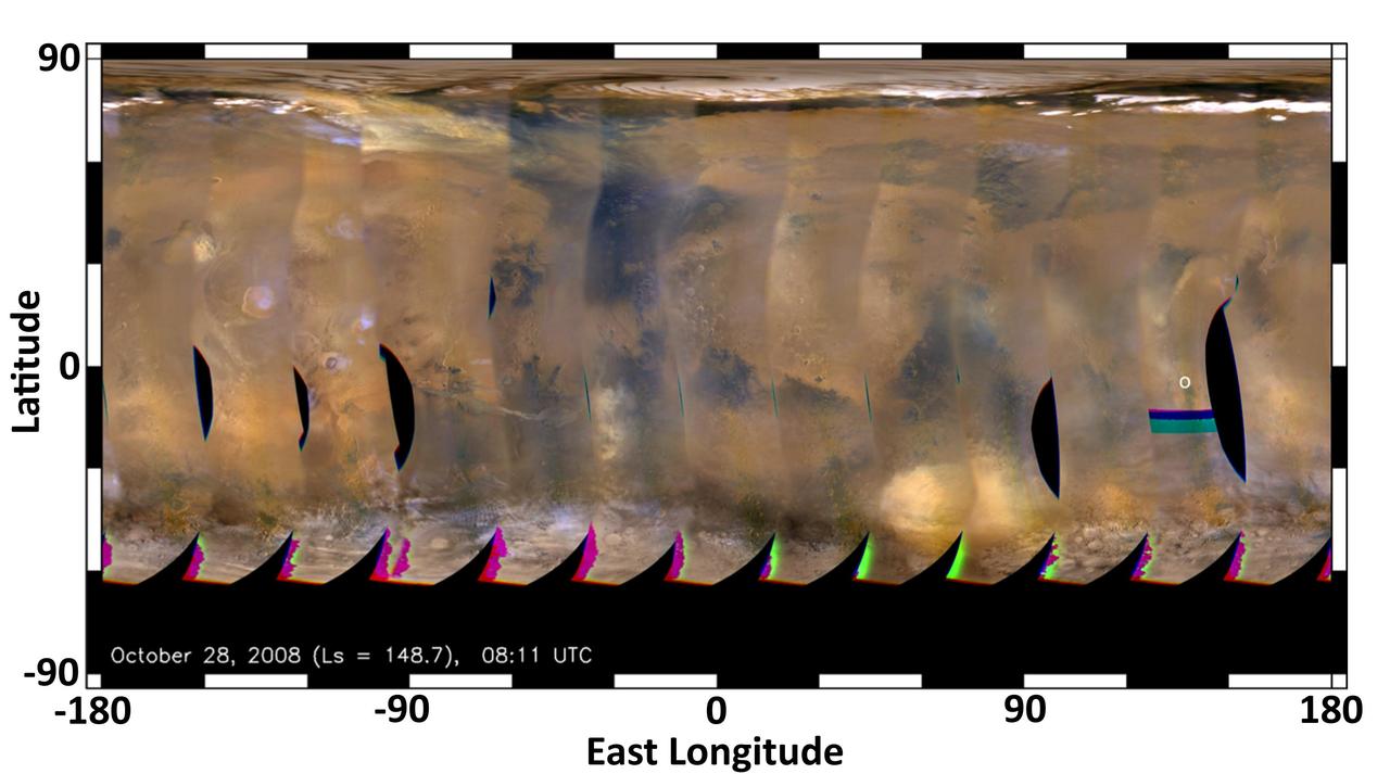
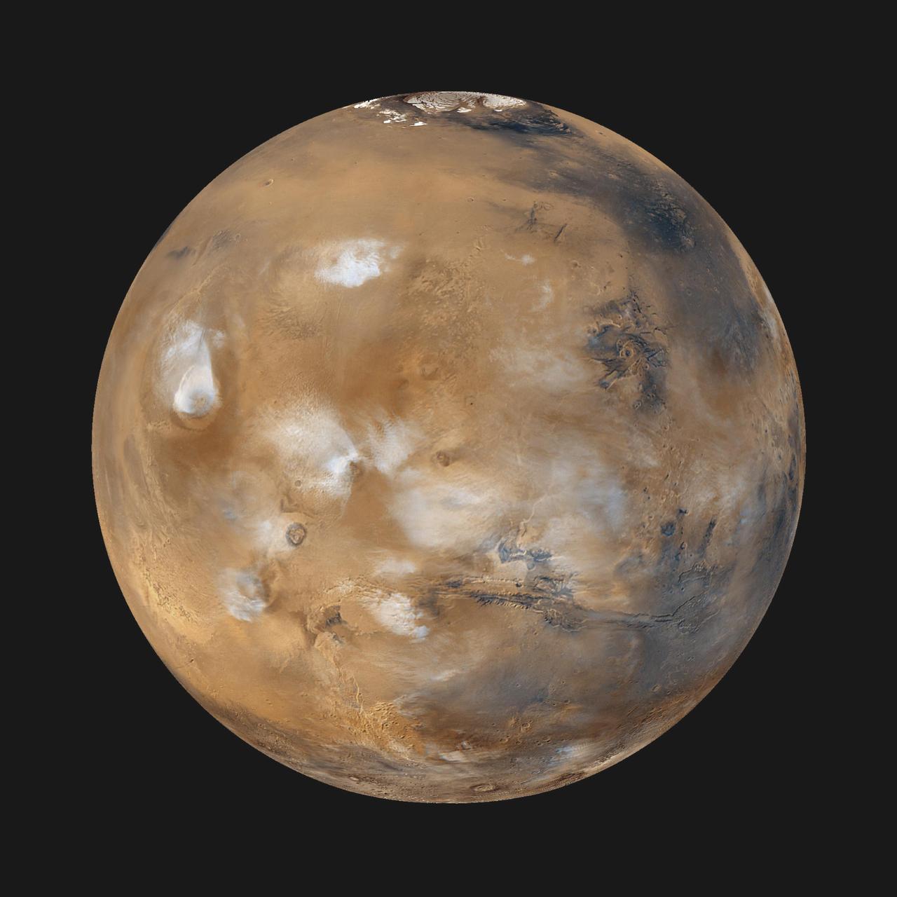
This global map of Mars was acquired on Oct. 28, 2008, by the Mars Color Imager instrument on NASA MRO. One global map is generated each day to forecast weather conditions for the entry, descent and landing of NASA Curiosity rover.
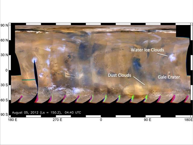
This global map of Mars was acquired on Aug. 5, 2012, by the Mars Color Imager instrument on NASA MRO. One global map is generated each day to forecast weather conditions for the entry, descent and landing of NASA Curiosity rover.
Artist concept of NASA CloudSat spacecraft, which will provide the first global survey of cloud properties to better understand their effects on both weather and climate.
NASA MARCI acquires a global view of the red planet and its weather patterns every day. This image was taken on Nov. 3, 2008 by the Mars Reconnaissance Orbiter.
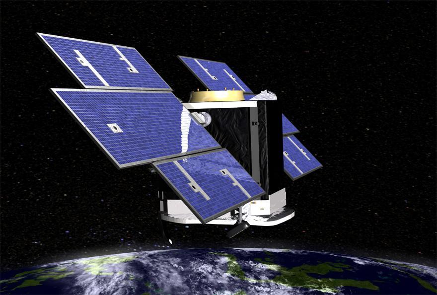
Artist concept of NASA CloudSat spacecraft, which will provide the first global survey of cloud properties to better understand their effects on both weather and climate.
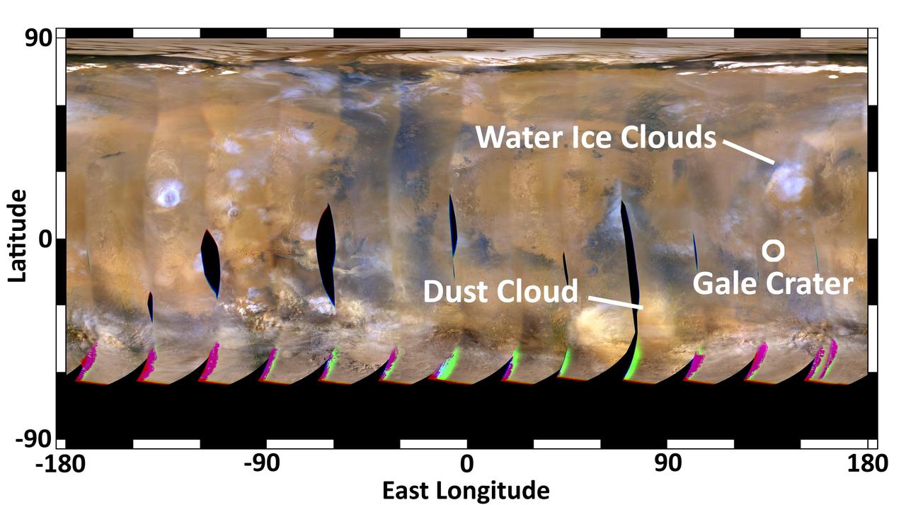
This global map of Mars was acquired on Aug. 2, 2012, by the Mars Color Imager instrument on NASA Mars Reconnaissance Orbiter. One global map is generated each day to forecast weather conditions for the entry, descent and landing of NASA Curiosity.
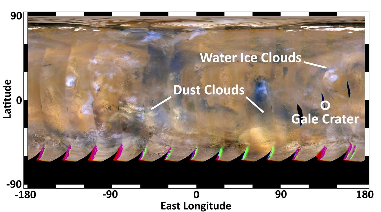
This global map of Mars was acquired on Aug. 4, 2012, by the Mars Color Imager instrument on NASA Mars Reconnaissance Orbiter to forecast weather conditions for the entry, descent and landing of NASA Curiosity rover.
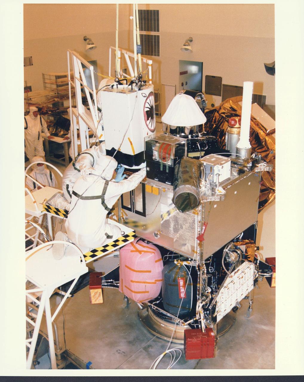
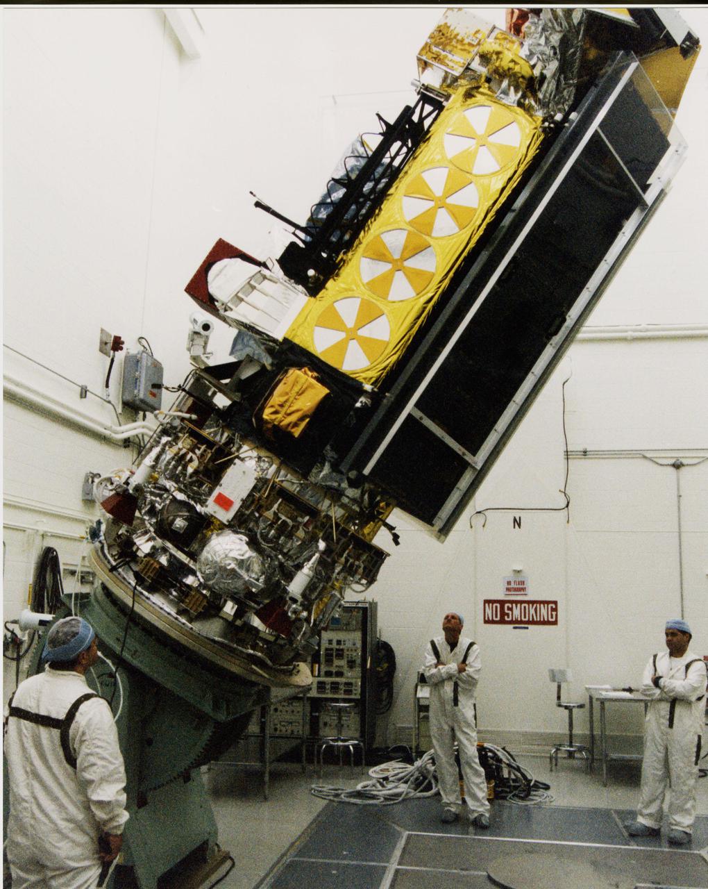
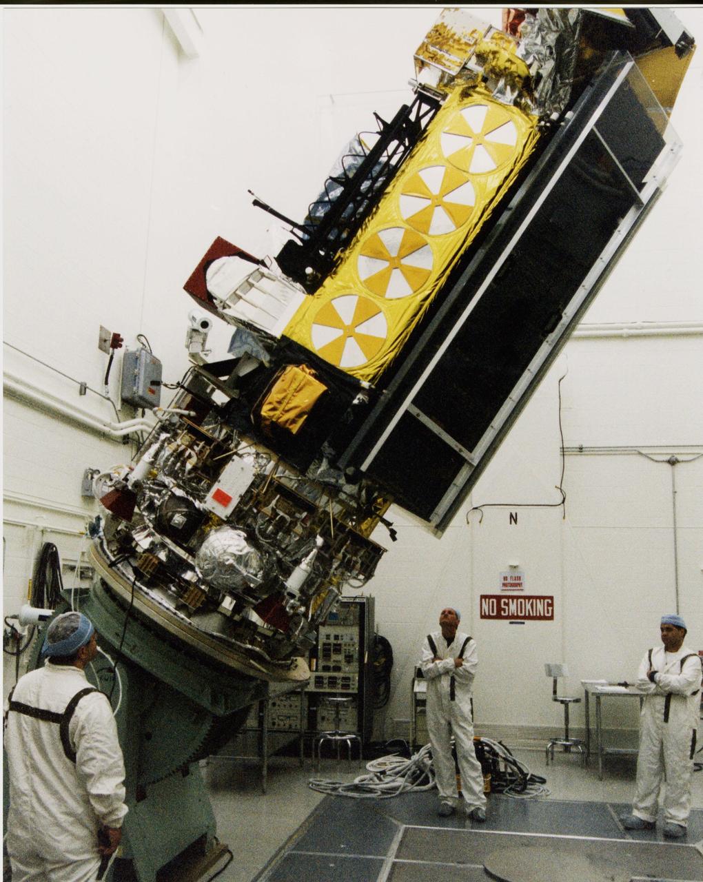
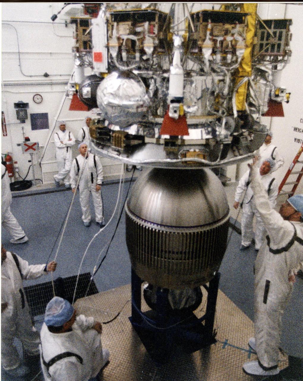
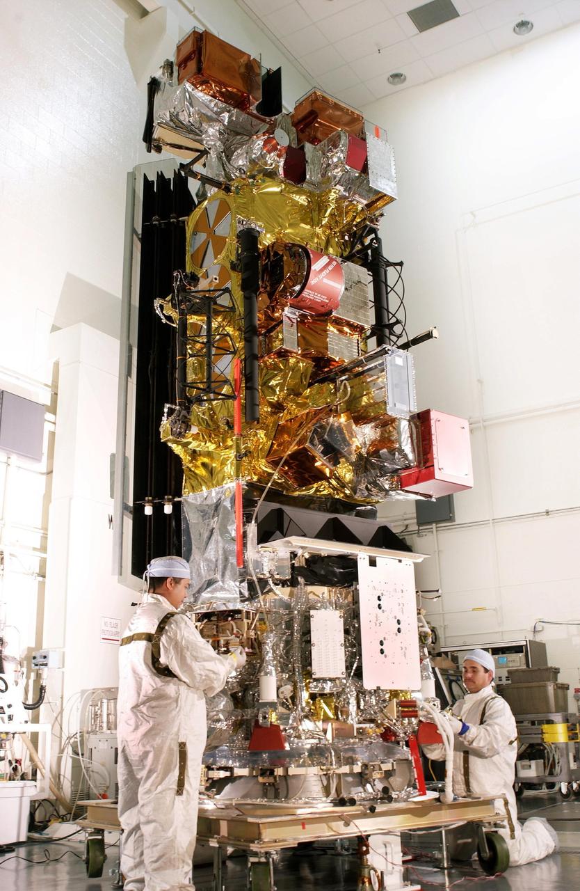
KENNEDY SPACE CENTER, FLA. - In the Payload Hazardous Servicing Facility at KSC, installation is under way of the Mars Orbiter Camera (MOC) on the Mars Global Surveyor spacecraft. The MOC is one of a suite of six scientific instruments that will gather data about Martian topography, mineral distribution and weather during a two-year period. The Mars Global Surveyor is slated for launch aboard a Delta II expendable launch vehicle on Nov. 6, the beginning of a 20-day launch period.
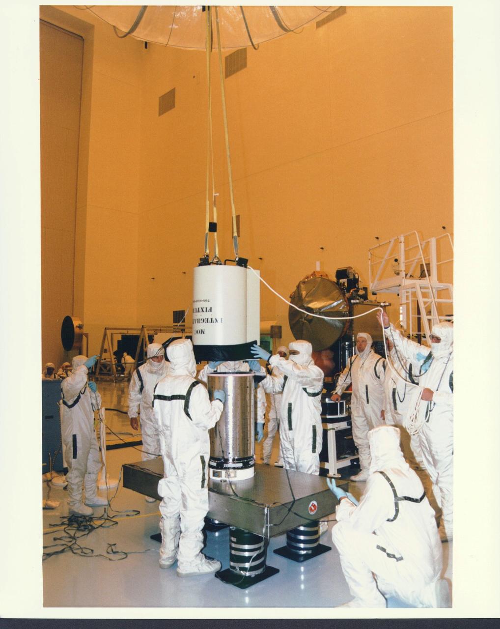
KENNEDY SPACE CENTER, FLA. - In the Payload Hazardous Servicing Facility at KSC, installation is under way of the Mars Orbiter Camera (MOC) on the Mars Global Surveyor spacecraft. The MOC is one of a suite of six scientific instruments that will gather data about Martian topography, mineral distribution and weather during a two-year period. The Mars Global Surveyor is slated for launch aboard a Delta II expendable launch vehicle on Nov. 6, the beginning of a 20-day launch period.
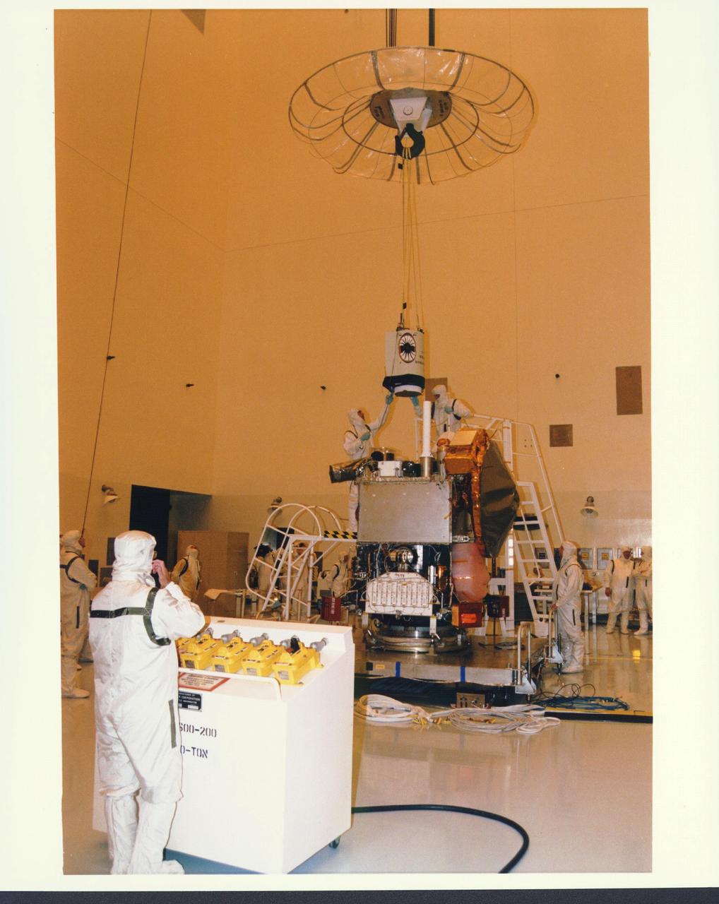
KENNEDY SPACE CENTER, FLA. - In the Payload Hazardous Servicing Facility at KSC, installation is under way of the Mars Orbiter Camera (MOC) on the Mars Global Surveyor spacecraft. The MOC is one of a suite of six scientific instruments that will gather data about Martian topography, mineral distribution and weather during a two-year period. The Mars Global Surveyor is slated for launch aboard a Delta II expendable launch vehicle on Nov. 6, the beginning of a 20-day launch period.
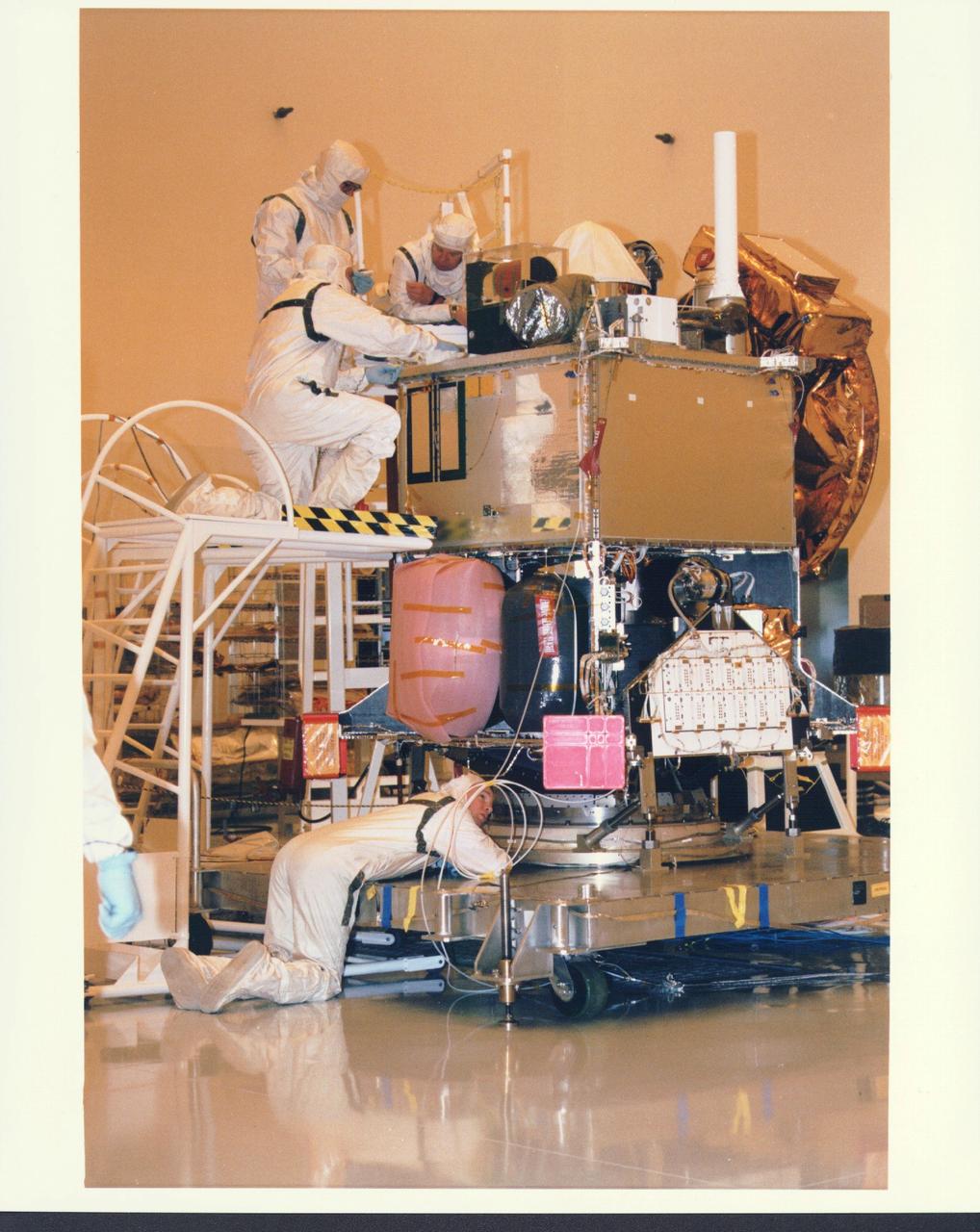
KENNEDY SPACE CENTER, FLA. - In the Payload Hazardous Servicing Facility at KSC, installation is under way of the Mars Orbiter Camera (MOC) on the Mars Global Surveyor spacecraft. The MOC is one of a suite of six scientific instruments that will gather data about Martian topography, mineral distribution and weather during a two-year period. The Mars Global Surveyor is slated for launch aboard a Delta II expendable launch vehicle on Nov. 6, the beginning of a 20-day launch period.
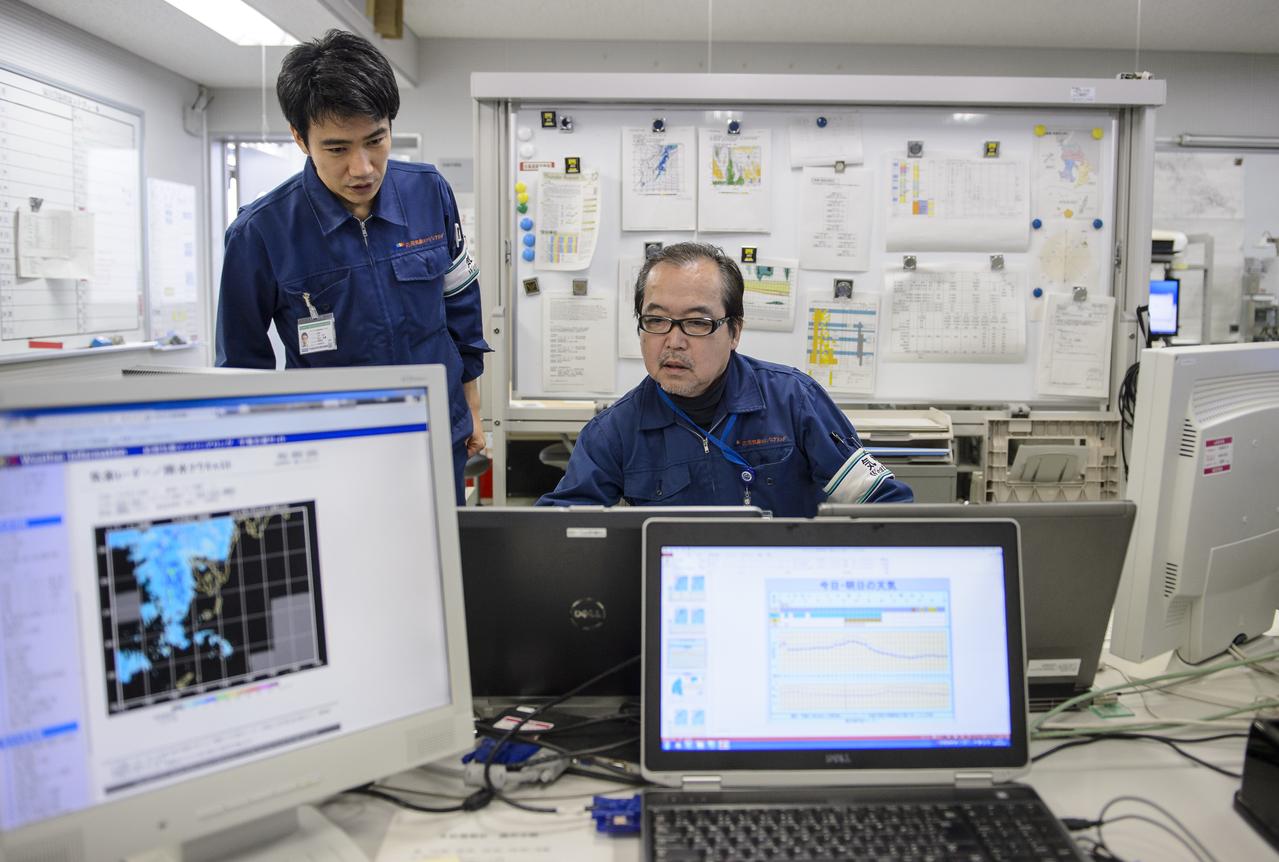
Members of the weather team prepare reports for the Global Precipitation Measurement (GPM) Core Observatory Launch Readiness Review (LRR) with Chief officers from Mitsubishi Heavy Industries, Ltd., the Japan Aerospace Exploration Agency (JAXA), and NASA, on Wednesday, Feb. 26, 2014 at Tanegashima Space Center, Japan. The GPM spacecraft is scheduled to launch aboard an H-IIA rocket early on the morning of Feb. 28 Japan time. At the meeting in the space center's Range Control Center, all preparations to date were reviewed and approval was given to proceed with launch on schedule. Once launched, the GPM spacecraft will collect information that unifies data from an international network of existing and future satellites to map global rainfall and snowfall every three hours. Photo Credit: (NASA/Bill Ingalls)

NASA's Global Precipitation Measurement (GPM) mission wants to see your best photos of winter weather! You can submit your images to the contest here: <a href="http://www.flickr.com/groups/gpm-extreme-weather/">www.flickr.com/groups/gpm-extreme-weather/</a> To read more about this image and or to see the high res file go to: <a href="http://earthobservatory.nasa.gov/IOTD/view.php?id=80082" rel="nofollow">earthobservatory.nasa.gov/IOTD/view.php?id=80082</a>

A light house and weather station is seen at the Japan Aerospace Exploration Agency’s (JAXA) Tanegashima Space Center (TNSC) a week ahead of the planned launch of an H-IIA rocket carrying the Global Precipitation Measurement (GPM) Core Observatory, Friday, Feb. 21, 2014, Tanegashima Island, Japan. The NASA-JAXA GPM spacecraft will collect information that unifies data from an international network of existing and future satellites to map global rainfall and snowfall every three hours. Photo Credit: (NASA/Bill Ingalls)
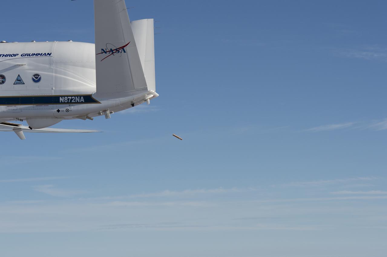
NASA’s Global Hawk aircraft deploys a dropsonde during a test flight over the Dryden Aeronautical Test Range in August 2015. The small, tube-shaped sensor will transmit data on temperature, humidity, and wind speed, which will be used to help improve weather model forecasts
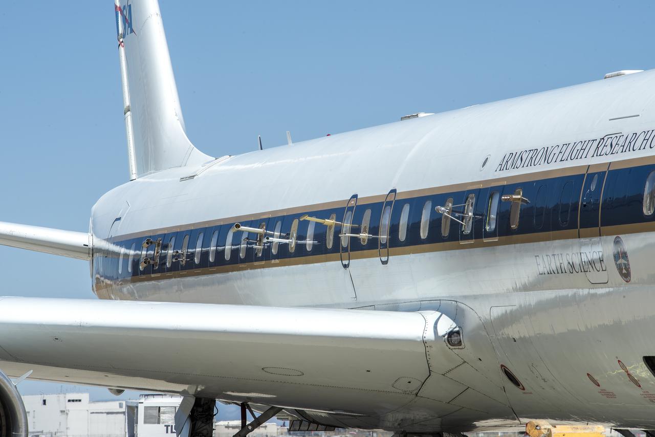
NASA’s DC-8 flying laboratory carried the Fire Influence on Regional to Global Environments and Air Quality, or FIREX-AQ, science team and a suite of state-of-the-art instrumentation to observe different components of fire smoke in varying altitudes and weather. The aircraft is based at NASA’s Armstrong Flight Research Center in California.
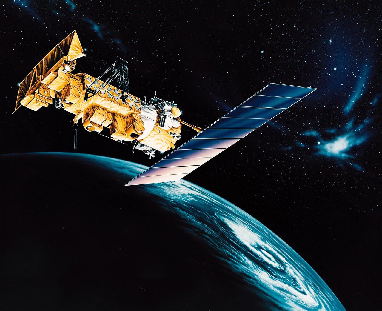
VANDENBERG AFB, CALIF. -- An artist's rendering of the NOAA-M spacecraft, a polar-orbiting Earth environmental observation satellite that will provide global data to NOAA's short- and long-range weather forecasting systems. Launch of the NOAA-M aboard a Titan II rocket is scheduled for June 24, 2002, from VAFB
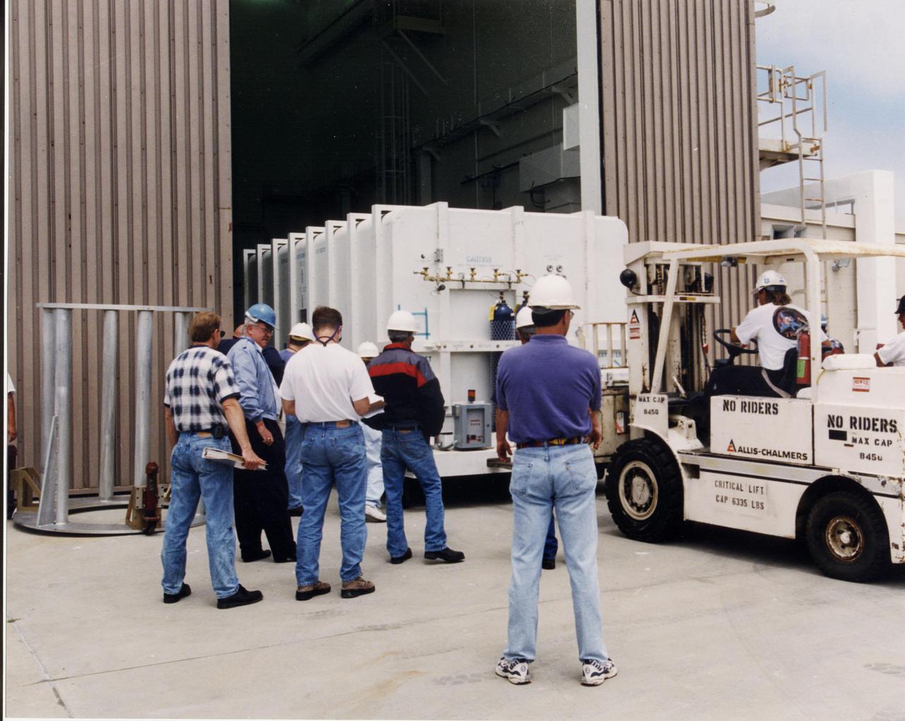
A crated National Oceanic and Atmospheric Administration (NOAA-L) satellite is moved inside the B16-10 spacecraft processing hangar at Vandenberg Air Force Base, Calif. NOAA-L is part of the Polar-Orbiting Operational Environmental Satellite (POES) program that provides atmospheric measurements of temperature, humidity, ozone and cloud images, tracking weather patterns that affect the global weather and climate. The launch of the NOAA-L satellite is scheduled no earlier than Sept. 12 aboard a Lockheed Martin Titan II rocket
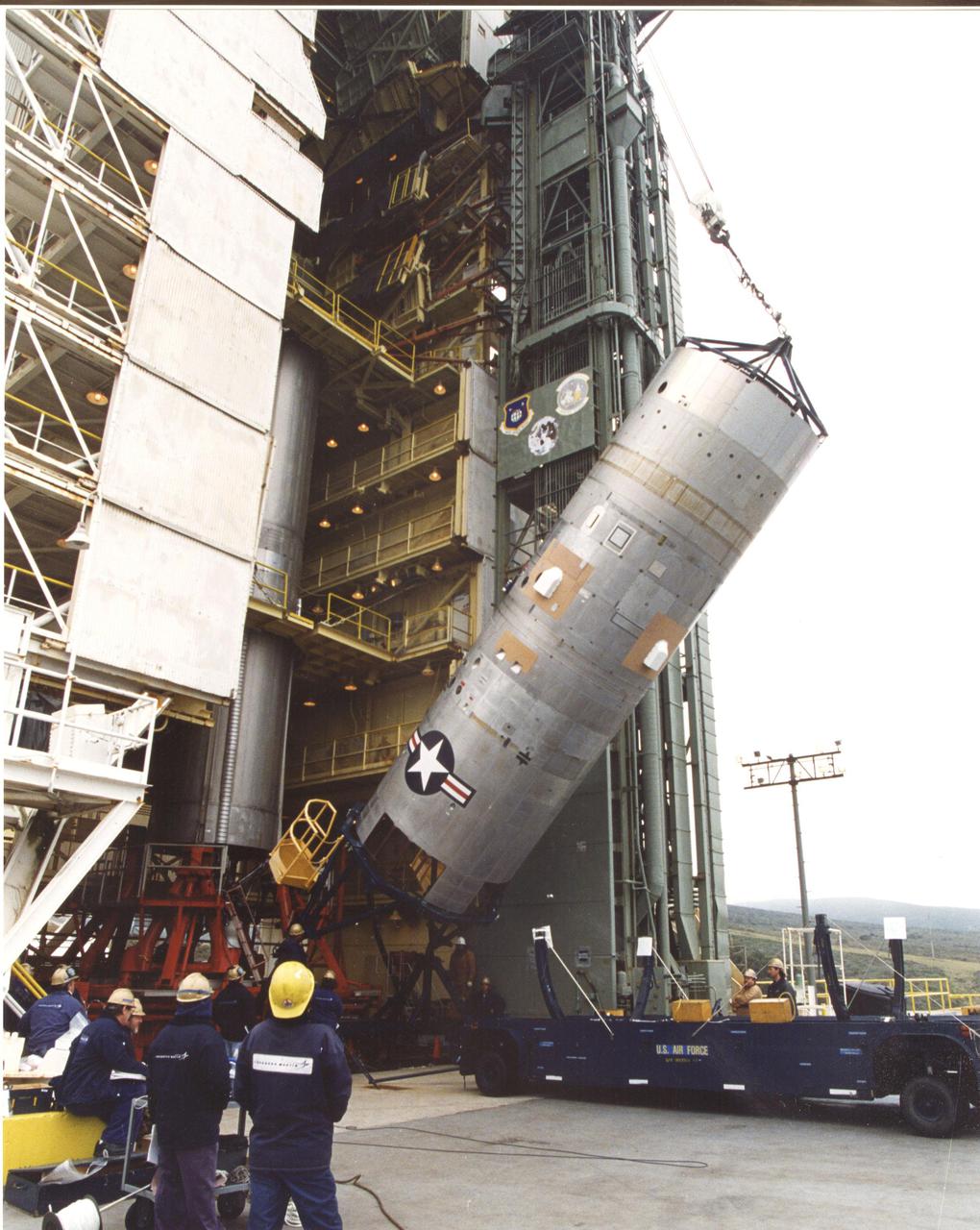
At the launch tower, Vandenberg Air Force Base, Calif., the second stage of a Titan II rocket is lifted to vertical. The Titan will power the launch of a National Oceanic and Atmospheric Administration (NOAA-L) satellite scheduled no earlier than Sept. 12. NOAA-L is part of the Polar-Orbiting Operational Environmental Satellite (POES) program that provides atmospheric measurements of temperature, humidity, ozone and cloud images, tracking weather patterns that affect the global weather and climate
A crated National Oceanic and Atmospheric Administration (NOAA-L) satellite arrives at Vandenberg Air Force Base, Calif.; It is part of the Polar-Orbiting Operational Environmental Satellite (POES) program that provides atmospheric measurements of temperature, humidity, ozone and cloud images, tracking weather patterns that affect the global weather and climate. The launch of the NOAA-L satellite is scheduled no earlier than Sept. 12 aboard a Lockheed Martin Titan II rocket

At the launch tower, Vandenberg Air Force Base, Calif., the second stage of a Titan II rocket is lifted to vertical. The Titan will power the launch of a National Oceanic and Atmospheric Administration (NOAA-L) satellite scheduled no earlier than Sept. 12. NOAA-L is part of the Polar-Orbiting Operational Environmental Satellite (POES) program that provides atmospheric measurements of temperature, humidity, ozone and cloud images, tracking weather patterns that affect the global weather and climate
Inside the B16-10 spacecraft processing hangar at Vandenberg Air Force Base, Calif., workers oversee the uncrating of the National Oceanic and Atmospheric Administration (NOAA-L) satellite. NOAA-L is part of the Polar-Orbiting Operational Environmental Satellite (POES) program that provides atmospheric measurements of temperature, humidity, ozone and cloud images, tracking weather patterns that affect the global weather and climate. The launch of the NOAA-L satellite is scheduled no earlier than Sept. 12 aboard a Lockheed Martin Titan II rocket

Inside the B16-10 spacecraft processing hangar at Vandenberg Air Force Base, Calif., workers oversee the uncrating of the National Oceanic and Atmospheric Administration (NOAA-L) satellite. NOAA-L is part of the Polar-Orbiting Operational Environmental Satellite (POES) program that provides atmospheric measurements of temperature, humidity, ozone and cloud images, tracking weather patterns that affect the global weather and climate. The launch of the NOAA-L satellite is scheduled no earlier than Sept. 12 aboard a Lockheed Martin Titan II rocket
A crated National Oceanic and Atmospheric Administration (NOAA-L) satellite is moved inside the B16-10 spacecraft processing hangar at Vandenberg Air Force Base, Calif. NOAA-L is part of the Polar-Orbiting Operational Environmental Satellite (POES) program that provides atmospheric measurements of temperature, humidity, ozone and cloud images, tracking weather patterns that affect the global weather and climate. The launch of the NOAA-L satellite is scheduled no earlier than Sept. 12 aboard a Lockheed Martin Titan II rocket

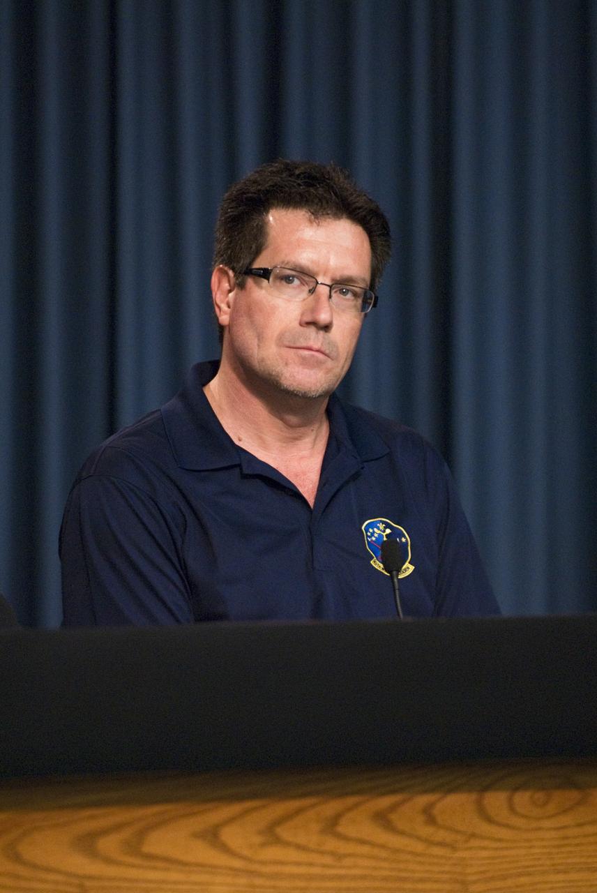
Lt. Joseph Round, launch weather officer, USAF 30th Space Wing Weather Squadron, discusses the weather forecast for launch of NASA’s Orbiting Carbon Observatory-2 (OCO-2) onboard a ULA Delta II rocket, during a press briefing, Sunday, June 29, 2014, at the Vandenberg Air Force Base, Calif. OCO-2 will measure the global distribution of carbon dioxide, the leading human-produced greenhouse gas driving changes in Earth’s climate. OCO-2 is set to launch on July 1, 2014 at 2:59 a.m. PDT. Photo Credit: (NASA/Bill Ingalls)
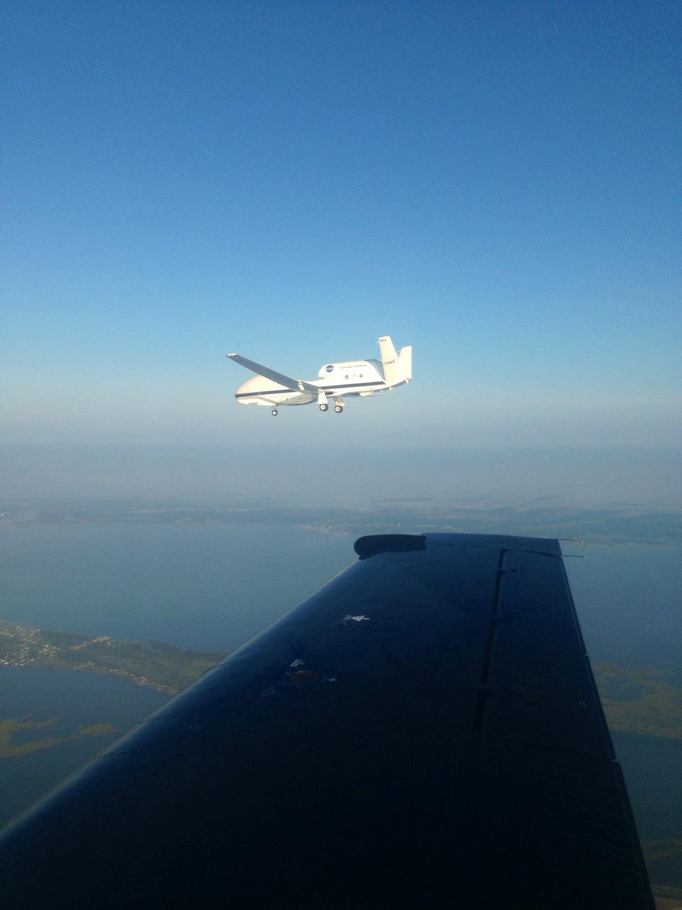
The NASA Wallops T-34 chase aircraft intercepted Global Hawk 872 on its descent to runway 28 at NASA's Wallops Flight Facility in Wallops Island, Va. This photo of the Global Hawk was taken from the chase plane after finishing its third science flight. For more information about NASA's HS3 mission, visit: <a href="http://www.nasa.gov/HS3" rel="nofollow">www.nasa.gov/HS3</a> Credit: NASA/ Brea Reeves <b><a href="http://www.nasa.gov/audience/formedia/features/MP_Photo_Guidelines.html" rel="nofollow">NASA image use policy.</a></b> <b><a href="http://www.nasa.gov/centers/goddard/home/index.html" rel="nofollow">NASA Goddard Space Flight Center</a></b> enables NASA’s mission through four scientific endeavors: Earth Science, Heliophysics, Solar System Exploration, and Astrophysics. Goddard plays a leading role in NASA’s accomplishments by contributing compelling scientific knowledge to advance the Agency’s mission. <b>Follow us on <a href="http://twitter.com/NASA_GoddardPix" rel="nofollow">Twitter</a></b> <b>Like us on <a href="http://www.facebook.com/pages/Greenbelt-MD/NASA-Goddard/395013845897?ref=tsd" rel="nofollow">Facebook</a></b> <b>Find us on <a href="http://instagram.com/nasagoddard?vm=grid" rel="nofollow">Instagram</a></b>

Inside the B16-10 spacecraft processing hangar at Vandenberg Air Force Base, Calif., workers oversee the mating of the Apogee Kick Motor (below) to the National Oceanic and Atmospheric Administration (NOAA-L) satellite above. NOAA-L is part of the Polar-Orbiting Operational Environmental Satellite (POES) program that provides atmospheric measurements of temperature, humidity, ozone and cloud images, tracking weather patterns that affect the global weather and climate. The launch of the NOAA-L satellite is scheduled no earlier than Sept. 12 aboard a Lockheed Martin Titan II rocket
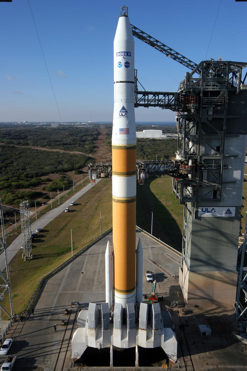
Cape Canaveral AFS, Fla. - A United Launch Alliance Delta IV rocket sits poised on its launch pad with the NASA/NOAA Geostationary Operational Environmental Satellite P (GOES P) at Space Launch Complex-37. GOES P will provide NOAA and NASA scientists with data to support weather, solar and space operations, and will enable future science improvements in weather prediction and remote sensing. Additionally, GOES-P will provide data on global climate changes and capability for search and rescue. Photo credit: Carleton Bailie, The Boeing Company
Inside the B16-10 spacecraft processing hangar at Vandenberg Air Force Base, Calif., workers oversee the lifting and rotating of the National Oceanic and Atmospheric Administration (NOAA-L) satellite to allow for mating of the Apogee Kick Motor (AKM). NOAA-L is part of the Polar-Orbiting Operational Environmental Satellite (POES) program that provides atmospheric measurements of temperature, humidity, ozone and cloud images, tracking weather patterns that affect the global weather and climate. The launch of the NOAA-L satellite is scheduled no earlier than Sept. 12 aboard a Lockheed Martin Titan II rocket

Outside the B16-10 spacecraft processing hangar at Vandenberg Air Force Base, Calif., a crated National Oceanic and Atmospheric Administration (NOAA-L) satellite is lowered to the ground before being moved inside. NOAA-L is part of the Polar-Orbiting Operational Environmental Satellite (POES) program that provides atmospheric measurements of temperature, humidity, ozone and cloud images, tracking weather patterns that affect the global weather and climate. The launch of the NOAA-L satellite is scheduled no earlier than Sept. 12 aboard a Lockheed Martin Titan II rocket
Inside the B16-10 spacecraft processing hangar at Vandenberg Air Force Base, Calif., workers oversee the lifting and rotating of the National Oceanic and Atmospheric Administration (NOAA-L) satellite to allow for mating of the Apogee Kick Motor (AKM). NOAA-L is part of the Polar-Orbiting Operational Environmental Satellite (POES) program that provides atmospheric measurements of temperature, humidity, ozone and cloud images, tracking weather patterns that affect the global weather and climate. The launch of the NOAA-L satellite is scheduled no earlier than Sept. 12 aboard a Lockheed Martin Titan II rocket
Inside the B16-10 spacecraft processing hangar at Vandenberg Air Force Base, Calif., workers oversee the mating of the Apogee Kick Motor (below) to the National Oceanic and Atmospheric Administration (NOAA-L) satellite above. NOAA-L is part of the Polar-Orbiting Operational Environmental Satellite (POES) program that provides atmospheric measurements of temperature, humidity, ozone and cloud images, tracking weather patterns that affect the global weather and climate. The launch of the NOAA-L satellite is scheduled no earlier than Sept. 12 aboard a Lockheed Martin Titan II rocket
Outside the B16-10 spacecraft processing hangar at Vandenberg Air Force Base, Calif., a crated National Oceanic and Atmospheric Administration (NOAA-L) satellite is lowered to the ground before being moved inside. NOAA-L is part of the Polar-Orbiting Operational Environmental Satellite (POES) program that provides atmospheric measurements of temperature, humidity, ozone and cloud images, tracking weather patterns that affect the global weather and climate. The launch of the NOAA-L satellite is scheduled no earlier than Sept. 12 aboard a Lockheed Martin Titan II rocket
KENNEDY SPACE CENTER, FLA. -- Workers in checkout hangar 1610 on North Vandenberg Air Force Base complete final processing on the National Oceanic and Atmospheric Administration (NOAA-M) spacecraft before transportation to Launch Complex 4W. NOAA-M is another in a series of polar-orbiting Earth environmental observation satellites that provide global data to NOAA's short- and long-range weather forecasting systems. Launch aboard a Titan II rocket is scheduled for June 25, 2002
KENNEDY SPACE CENTER, FLA. -- Workers in checkout hangar 1610 on North Vandenberg Air Force Base complete final processing on the National Oceanic and Atmospheric Administration (NOAA-M) spacecraft before transportation to Launch Complex 4W. NOAA-M is another in a series of polar-orbiting Earth environmental observation satellites that provide global data to NOAA's short- and long-range weather forecasting systems. Launch aboard a Titan II rocket is scheduled for June 25, 2002
VANDENBERG AFB, CALIF. --Lockheed Martin Missiles & Space National Oceanic and Atmospheric Administration's NOAA-M satellite during launch preparation at Vandenberg AFB, Calif. NOAA-M is a polar-orbiting Earth environmental observation satellite that will provide global data to NOAA's short- and long-range weather forecasting systems. Launch of the NOAA-M aboard a Titan II rocket is scheduled for June 24, 2002, from VAFB
KENNEDY SPACE CENTER, FLA. -- The National Oceanic and Atmospheric Administration (NOAA-M) spacecraft undergoes end-to-end testing in checkout hangar 1610 on North Vandenberg Air Force Base. The spacecraft is nearing process completion for transportation to Launch Complex 4W. NOAA-M is another in a series of polar-orbiting Earth environmental observation satellites that provide global data to NOAA's short- and long-range weather forecasting systems. Launch aboard a Titan II rocket is scheduled for June 25, 2002
VANDENBERG AIR FORCE BASE, CALIF. -- The National Oceanic and Atmospheric Administration (NOAA) spacecraft (NOAA-M) streaks above a cloud layer after a successful launch at 2:23 p.m. EDT aboard a Titan II rocket from Vandenberg Air Force Base, Calif. NOAA-M is another in a series of polar-orbiting Earth environmental observation satellites that provide global data to NOAA's short- and long-range weather forecasting systems
KENNEDY SPACE CENTER, FLA. - The National Oceanic and Atmospheric Administration (NOAA-M) spacecraft undergoes end-to-end testing in checkout hangar 1610 on North Vandenberg Air Force Base. The spacecraft is nearing process completion for transportation to Launch Complex 4W. NOAA-M is another in a series of polar-orbiting Earth environmental observation satellites that provide global data to NOAA's short- and long-range weather forecasting systems. Launch aboard a Titan II rocket is scheduled for June 25, 2002

jsc2024e016247 (11/27/2023) --- Nanoracks employees Brendan Swanik (background) and Maximillian Brummel (foreground) integrate the Killick-1 satellite into the launch tube. Nanoracks-Killick-1 is a CubeSat that measures sea ice parameters using Global Navigation Satellite System (GNSS) reflectometry or reflected signals. This monitoring system could contribute to a better understanding of important ocean phenomena and improved weather and climate models. Image courtesy of C-CORE and Memorial University.
KENNEDY SPACE CENTER, FLA. -- The National Oceanic and Atmospheric Administration (NOAA-M) spacecraft undergoes end-to-end testing in checkout hangar 1610 on North Vandenberg Air Force Base. The spacecraft is nearing process completion for transportation to Launch Complex 4W. NOAA-M is another in a series of polar-orbiting Earth environmental observation satellites that provide global data to NOAA's short- and long-range weather forecasting systems. Launch aboard a Titan II rocket is scheduled for June 25, 2002
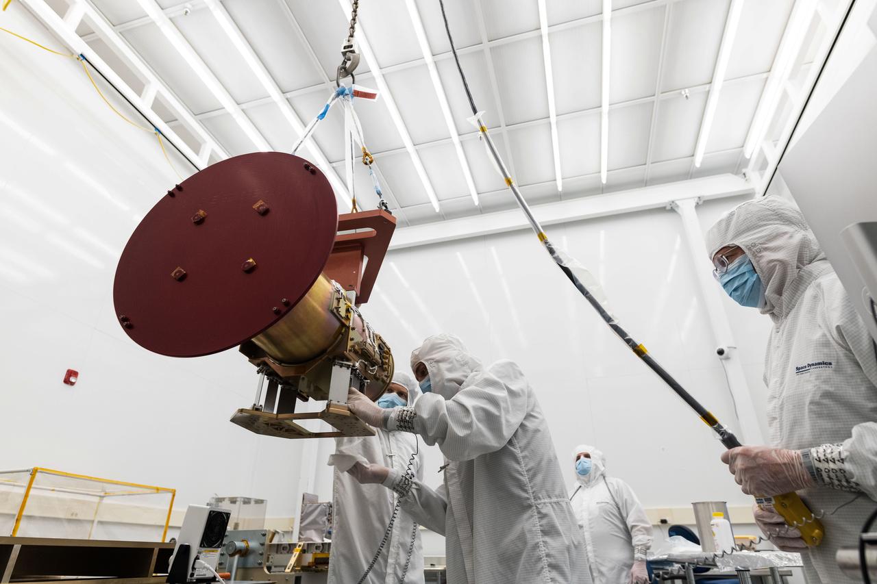
jsc2023e055879 (11/9/2022) --- Space Dynamics Laboratory (SDL) employees ensure the Opto-Mechanical Assembly interface to the flight EXPRESS Payload Adapter is clean before mounting. The Atmospheric Waves Experiment (AWE) examines the global distribution of small-scale atmospheric gravity waves (AGWs) and how they move through the upper atmosphere, vary with season and geographic location, and contribute to space weather. Image courtesy of SDL/Allison Bills.
VANDENBERG AFB, CALIF. -- The Lockheed Martin Missiles & Space National Oceanic and Atmospheric Administration's NOAA-M satellite is prepared for launch at Vandenberg AFB, Calif. NOAA-M is a polar-orbiting Earth environmental observation satellite that will provide global data to NOAA's short- and long-range weather forecasting systems. Launch of the NOAA-M aboard a Titan II rocket is scheduled for June 24, 2002, from VAFB
VANDENBERG AFB, CALIF. -- Workers at Vandenberg AFB, Calif., prepare the Lockheed Martin Missiles & Space National Oceanic and Atmospheric Administration's NOAA-M satellite forlaunch. NOAA-M is a polar-orbiting Earth environmental observation satellite that will provide global data to NOAA's short- and long-range weather forecasting systems. Launch of the NOAA-M aboard a Titan II rocket is scheduled for June 24, 2002, from VAFB
![VANDENBERG AIR FORCE BASE, CALIF. -- A Titan II rocket hurtles above the launch tower at Vandenberg Air Force Base, Calif., with the National Oceanic and Atmospheric Administration (NOAA) spacecraft (NOAA-M) aboard. The rocket lifted off at 2:23 p.m. EDT. NOAA-M is another in a series of polar-orbiting Earth environmental observation satellites that provide global data to NOAA's short- and long-range weather forecasting systems. [Photo by William Hartenstein]](https://images-assets.nasa.gov/image/KSC-02pd1133/KSC-02pd1133~medium.jpg)
VANDENBERG AIR FORCE BASE, CALIF. -- A Titan II rocket hurtles above the launch tower at Vandenberg Air Force Base, Calif., with the National Oceanic and Atmospheric Administration (NOAA) spacecraft (NOAA-M) aboard. The rocket lifted off at 2:23 p.m. EDT. NOAA-M is another in a series of polar-orbiting Earth environmental observation satellites that provide global data to NOAA's short- and long-range weather forecasting systems. [Photo by William Hartenstein]
VANDENBERG AFB, CALIF. --Lockheed Martin Missiles & Space National Oceanic and Atmospheric Administration's NOAA-M satellite during launch preparation at Vandenberg AFB, Calif. NOAA-M is a polar-orbiting Earth environmental observation satellite that will provide global data to NOAA's short- and long-range weather forecasting systems. Launch of the NOAA-M aboard a Titan II rocket is scheduled for June 24, 2002, from VAFB

jsc2024e016248 (11/24/2023) --- The Nanoracks-Killick-1 CubeSat with all components and wiring harnesses connected before button down (final assembly of outside panels). Nanoracks-Killick-1 is a CubeSat that measures sea ice parameters using Global Navigation Satellite System (GNSS) reflectometry or reflected signals. This monitoring system could contribute to a better understanding of important ocean phenomena and improved weather and climate models. Image courtesy of C-CORE and Memorial University.
![VANDENBERG AIR FORCE BASE, CALIF. -- The National Oceanic and Atmospheric Administration (NOAA) spacecraft (NOAA-M) lifts off at 2:23 p.m. EDT aboard a Titan II rocket from Vandenberg Air Force Base, Calif. NOAA-M is another in a series of polar-orbiting Earth environmental observation satellites that provide global data to NOAA's short- and long-range weather forecasting systems. [Photo by William Hartenstein]](https://images-assets.nasa.gov/image/KSC-02pd1132/KSC-02pd1132~medium.jpg)
VANDENBERG AIR FORCE BASE, CALIF. -- The National Oceanic and Atmospheric Administration (NOAA) spacecraft (NOAA-M) lifts off at 2:23 p.m. EDT aboard a Titan II rocket from Vandenberg Air Force Base, Calif. NOAA-M is another in a series of polar-orbiting Earth environmental observation satellites that provide global data to NOAA's short- and long-range weather forecasting systems. [Photo by William Hartenstein]

jsc2024e016249 (11/23/2023) --- Fully assembled Nanoracks-Killick-1 CubeSat with its Global Navigation Satellite System Reflectometry (GNSS-R) antenna deployed. Nanoracks-Killick-1 measures sea ice using GNSS-R. Potential applications of GNSS-R include providing data for weather and climate models and improving understanding of ocean phenomena such as surface winds and storm surge. Image courtesy of C-CORE and Memorial University.
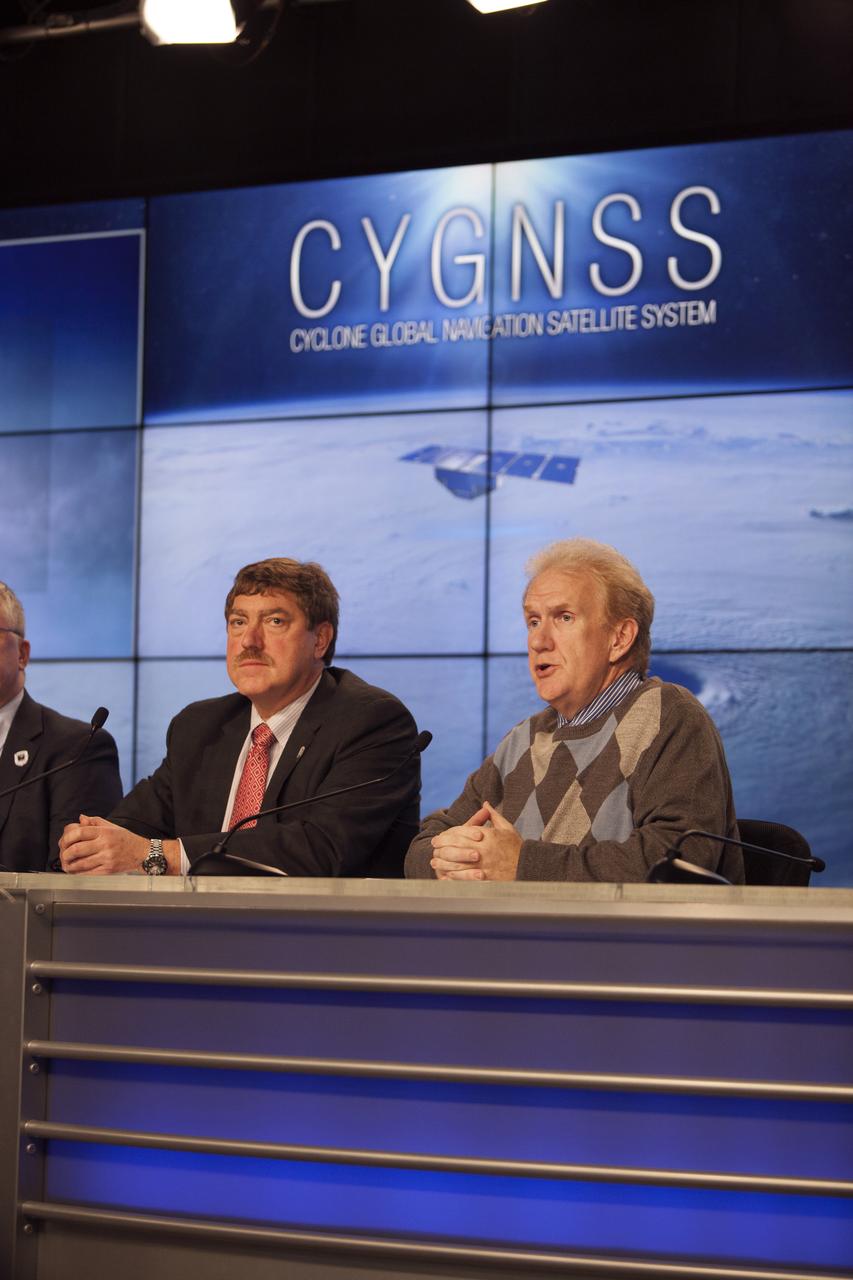
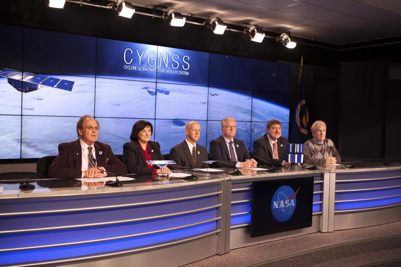
In the Kennedy Space Center’s Press Site auditorium, NASA and industry leaders speak to members of the media during a prelaunch news conference for the agency’s Cyclone Global Navigation Satellite System, or CYGNSS, spacecraft. From left are: John Scherrer, CYGNSS project manager for the Southwest Research Institute in San Antonio, Texas; and Mike Rehbein, launch weather officer for the 45th Weather Squadron at Cape Canaveral Air Force Station, Florida. The eight CYGNSS satellites will make frequent and accurate measurements of ocean surface winds throughout the life cycle of tropical storms and hurricanes. The data will help scientists probe key air-sea interaction processes that take place near the core of storms, which are rapidly changing and play a crucial role in the beginning and intensification of hurricanes.
Vern Thorp, United Launch Alliance program manager, NASA missions,, left, Ralph Basilio, OCO-2 project manager, JPL, and Lt. Joseph Round, launch weather officer, USAF 30th Space Wing Weather Squadron, right, discuss the planned launch of the Orbiting Carbon Observatory-2 (OCO-2), NASA’s first spacecraft dedicated to studying carbon dioxide, during a press briefing, Sunday, June 29, 2014, at the Vandenberg Air Force Base, Calif. OCO-2 will measure the global distribution of carbon dioxide, the leading human-produced greenhouse gas driving changes in Earth’s climate. OCO-2 is set to launch on July 1, 2014 at 2:59 a.m. PDT. Photo Credit: (NASA/Bill Ingalls)
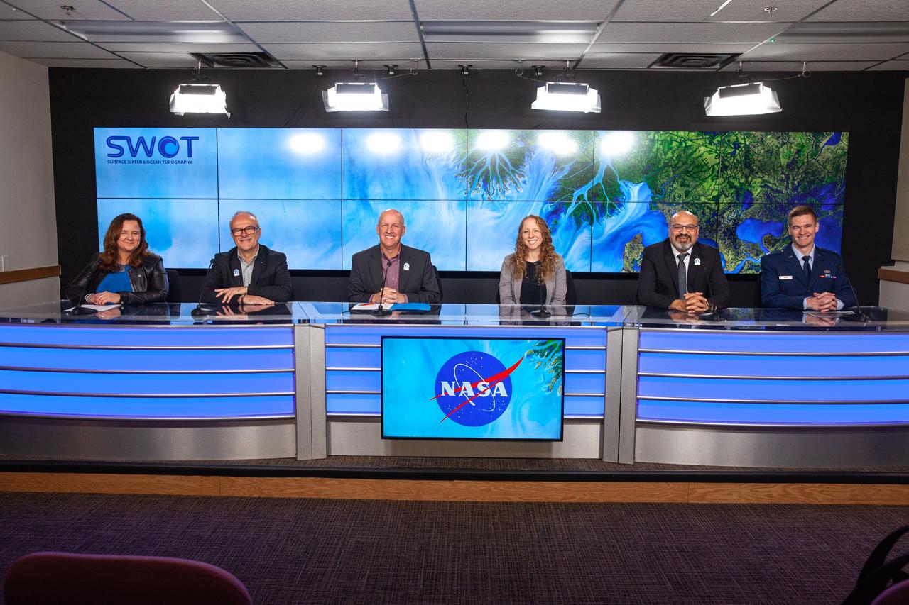
NASA, SpaceX, and the French space agency Centre National d’Études Spatiales (CNES) hold a prelaunch news conference for the Surface Water and Ocean Topography (SWOT) mission on Dec. 14, 2022, at Vandenberg Space Force Base in California. Participating from left are Karen St. Germain, Earth Science Division director, NASA; Thierry Lafon, SWOT project manager, CNES; Tim Dunn, launch director, NASA’s Launch Services Program; Julianna Scheiman, civil satellite missions director, SpaceX; Parag Vaze, SWOT project manager, Jet Propulsion Laboratory; Capt. Max Rush, launch weather officer, U.S. Air Force. SWOT is scheduled to launch on a SpaceX Falcon 9 rocket from Space Launch Complex-4 East at Vandenberg on Dec. 15, 2022, at 3:46 a.m. PST. SWOT will be NASA’s first global survey of nearly all water on Earth’s surface. Scientists plan to use its observations to better understand the global water cycle, furnish insight into the ocean’s role in how climate change unfolds, and provide a global inventory of water resources. The SWOT mission is a collaborative effort between NASA and CNES with contributions from the Canadian Space Agency and the UK Space Agency. NASA’s Launch Services Program, based at the agency’s Kennedy Space Center in Florida, is managing the launch service.

Capt. Max Rush, launch weather officer, U.S. Air Force, participates in a prelaunch news conference held by NASA, SpaceX, and the French space agency Centre National d’Études Spatiales (CNES) for the Surface Water and Ocean Topography (SWOT) mission on Dec. 14, 2022, at Vandenberg Space Force Base in California. SWOT is scheduled to launch on a SpaceX Falcon 9 rocket from Space Launch Complex-4 East at Vandenberg on Dec. 15, 2022, at 3:46 a.m. PST. SWOT will be NASA’s first global survey of nearly all water on Earth’s surface. Scientists plan to use its observations to better understand the global water cycle, furnish insight into the ocean’s role in how climate change unfolds, and provide a global inventory of water resources. The SWOT mission is a collaborative effort between NASA and CNES with contributions from the Canadian Space Agency and the UK Space Agency. NASA’s Launch Services Program, based at the agency’s Kennedy Space Center in Florida, is managing the launch service.
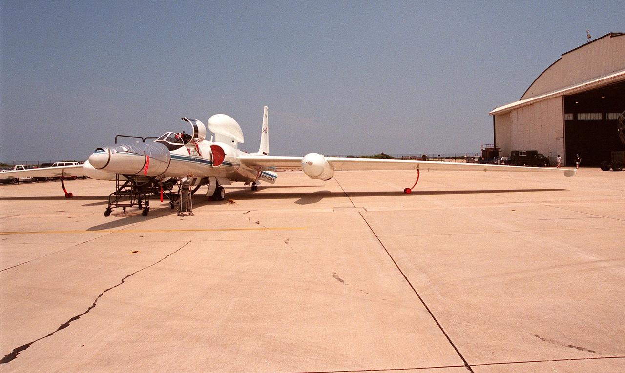
This high-altitude research plane, a specially equipped Dryden Flight Research Center ER-2 (a modified U-2), is readied at Patrick Air Force Base for flight into a hurricane in the Atlantic. The plane is part of the NASA-led Atmospheric Dynamics and Remote Sensing program that includes other government weather researchers and the university community in a study of Atlantic hurricanes and tropical storms. The ER-2, soaring above 65,000 feet, will measure the structure of hurricanes and the surrounding atmosphere that steers the storms’ movement. The hurricane study, which lasts through September 1998, is part of NASA’s Earth Science enterprise to better understand the total Earth system and the effects of natural and human-induced changes on the global environment
jsc2024e016250 (11/27/2023) --- The Nanoracks-Killick-1 CubeSat is pictured during vibration testing conducted by Canadian Space Agency (CSA) personnel. From left to right – Sylvain Mondor (CSA), Maximilian Brummel (Nanoracks), Anton Sura (CSA), and Victoria Vaters (Engineering Student). Nanoracks-Killick-1 measures sea ice using Global Navigation Satellite System Reflectometry (GNSS-R). Potential applications of GNSS-R include providing data for weather and climate models and improving understanding of ocean phenomena such as surface winds and storm surge. Image courtesy of C-CORE and Memorial University.

A specially equipped Dryden Flight Research Center ER-2 (a modified U-2) soars above Patrick Air Force Base enroute to a hurricane in the Atlantic. The plane is part of the NASA-led Atmospheric Dynamics and Remote Sensing program that includes other government weather researchers and the university community in a study of Atlantic hurricanes and tropical storms. Soaring above 65,000 feet, the ER-2 will measure the structure of hurricanes and the surrounding atmosphere that steers the storm’s movement. The hurricane study, which lasts through September 1998, is part of NASA’s Earth Science enterprise to better understand the total Earth system and the effects of natural and human-induced changes on the global environment
CAPE CANAVERAL, Fla. -- Rich MacKenzie, who earned a doctorate in geological sciences at the University of Florida, collects Global Positioning System survey measurements along a restored 1.2 mile stretch of shoreline near Launch Pads 39A and B. Experts from University of Florida are working with NASA scientists to better understand beach erosion. Constant pounding from tropical storms, such as Hurricane Sandy in October of 2012, other weather systems and higher than usual tides, destroyed sand dunes protecting infrastructure at the spaceport. Photo credit: NASA/Dan Casper
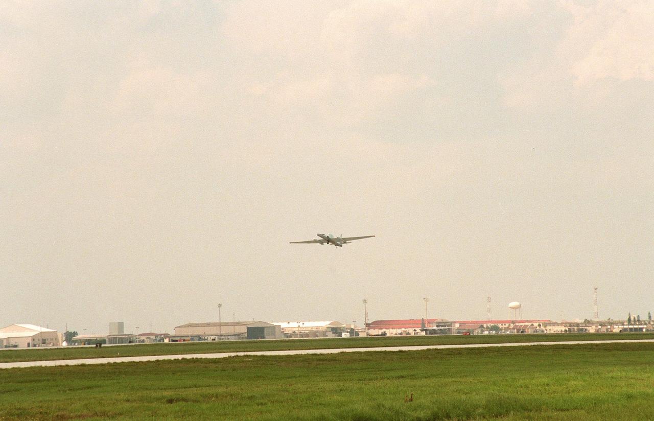
A specially equipped Dryden Flight Research Center ER-2 (a modified U-2) takes off from Patrick Air Force Base enroute to a hurricane in the Atlantic. The plane is part of the NASA-led Atmospheric Dynamics and Remote Sensing program that includes other government weather researchers and the university community in a study of Atlantic hurricanes and tropical storms. Soaring above 65,000 feet, the ER-2 will measure the structure of hurricanes and the surrounding atmosphere that steers the storm’s movement. The hurricane study, which lasts through September 1998, is part of NASA’s Earth Science enterprise to better understand the total Earth system and the effects of natural and human-induced changes on the global environment
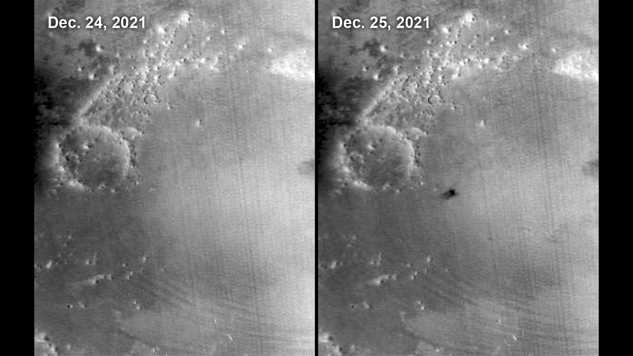
The Mars Color Imager (MARCI) camera aboard NASA's Mars Reconnaissance Orbiter (MRO) captured this before-and-after comparison of a region of Mars called Amazonis Planitia, which was struck by a meteoroid on Dec. 24, 2021. The impact was so large that MARCI can view it from space. As MRO passes over the planet, MARCI takes linear images – essentially strips – of the planet's circumference each day. The images are then stitched together to create a daily global map of the planet, data that's typically used to monitor atmospheric changes and Martian weather. https://photojournal.jpl.nasa.gov/catalog/PIA25585
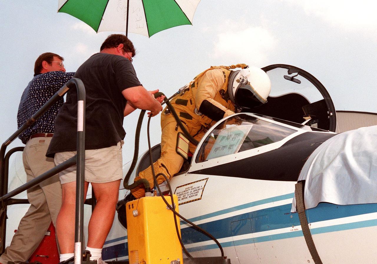
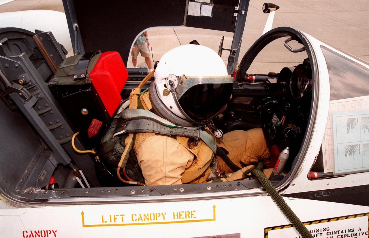
The pilot climbs into the cockpit of a high-altitude research plane, a specially equipped Dryden Flight Research Center ER-2 (a modified U-2), at Patrick Air Force Base. Soaring above 65,000 feet, the ER-2 will measure the structure of hurricanes and the surrounding atmosphere that steers the storm’s movement. The plane is part of the NASA-led Atmospheric Dynamics and Remote Sensing program that includes other government weather researchers and the university community in a study of Atlantic hurricanes and tropical storms. The hurricane study, which lasts through September 1998, is part of NASA’s Earth Science enterprise to better understand the total Earth system and the effects of natural and human-induced changes on the global environment
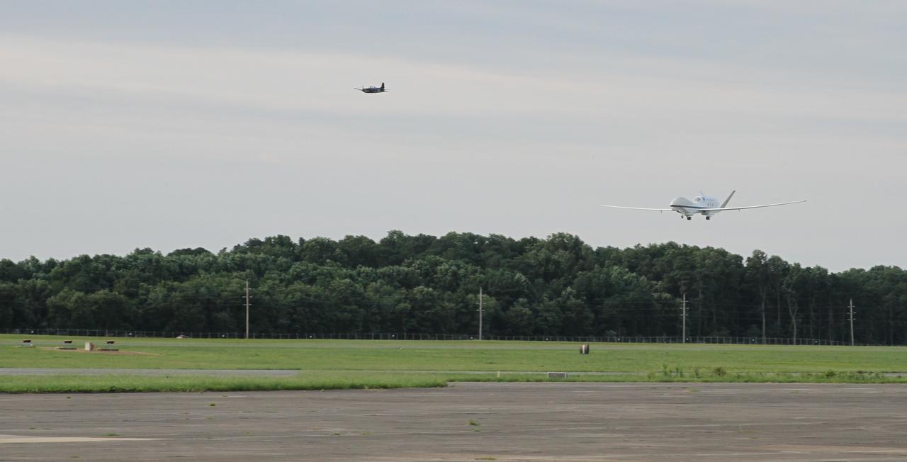
The first of two NASA Global Hawk unmanned aerial vehicles supporting the Hurricane and Severe Storm Sentinel (HS3) mission landed at 7:39 a.m. today, Aug. 14, 2013, at NASA's Wallops Flight Facility, Wallops Island, Va. During August and September, NASA will fly the two Global Hawks over the Atlantic Ocean to study tropical storms and the processes that underlie hurricane formation and intensification. The aircraft are equipped with instruments to survey the overall environment of the storms and peer into the inner core of hurricanes to study their structure and processes. For more information, visit: <a href="http://www.nasa.gov/HS3. " rel="nofollow">www.nasa.gov/HS3. </a> Photo Credit: NASA Wallops Keith Koehler NASA Wallops Flight Facility <b><a href="http://www.nasa.gov/audience/formedia/features/MP_Photo_Guidelines.html" rel="nofollow">NASA image use policy.</a></b> <b><a href="http://www.nasa.gov/centers/goddard/home/index.html" rel="nofollow">NASA Goddard Space Flight Center</a></b> enables NASA’s mission through four scientific endeavors: Earth Science, Heliophysics, Solar System Exploration, and Astrophysics. Goddard plays a leading role in NASA’s accomplishments by contributing compelling scientific knowledge to advance the Agency’s mission. <b>Follow us on <a href="http://twitter.com/NASA_GoddardPix" rel="nofollow">Twitter</a></b> <b>Like us on <a href="http://www.facebook.com/pages/Greenbelt-MD/NASA-Goddard/395013845897?ref=tsd" rel="nofollow">Facebook</a></b> <b>Find us on <a href="http://instagram.com/nasagoddard?vm=grid" rel="nofollow">Instagram</a></b>
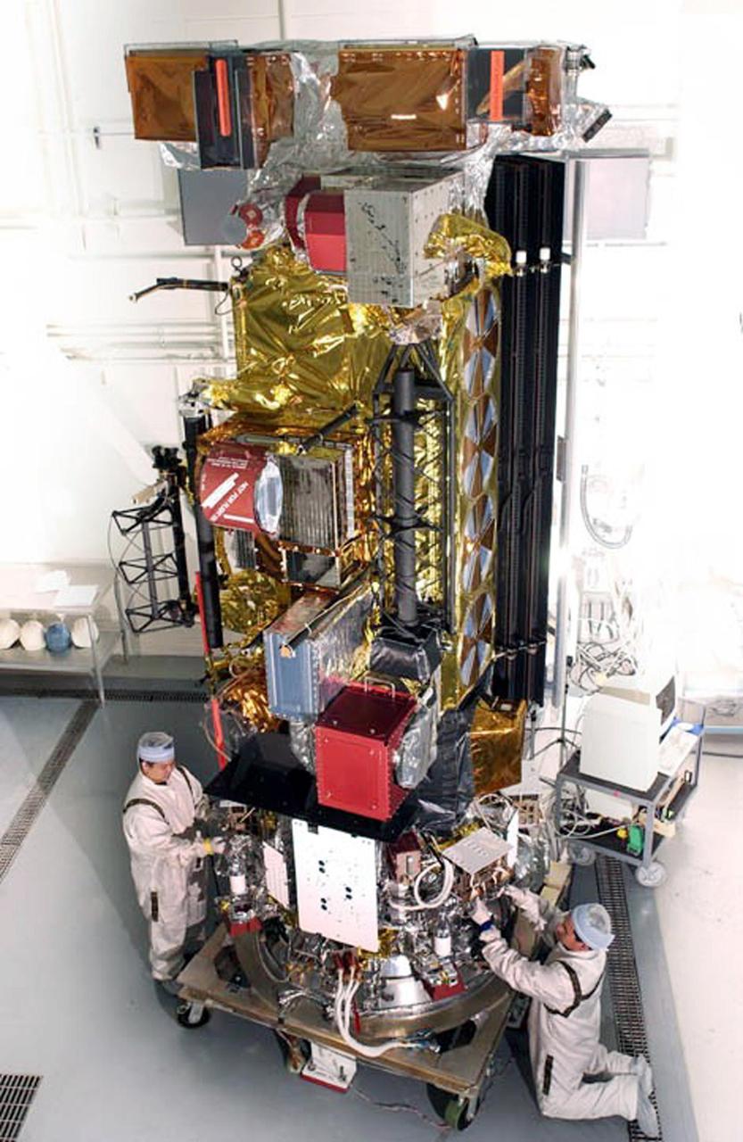
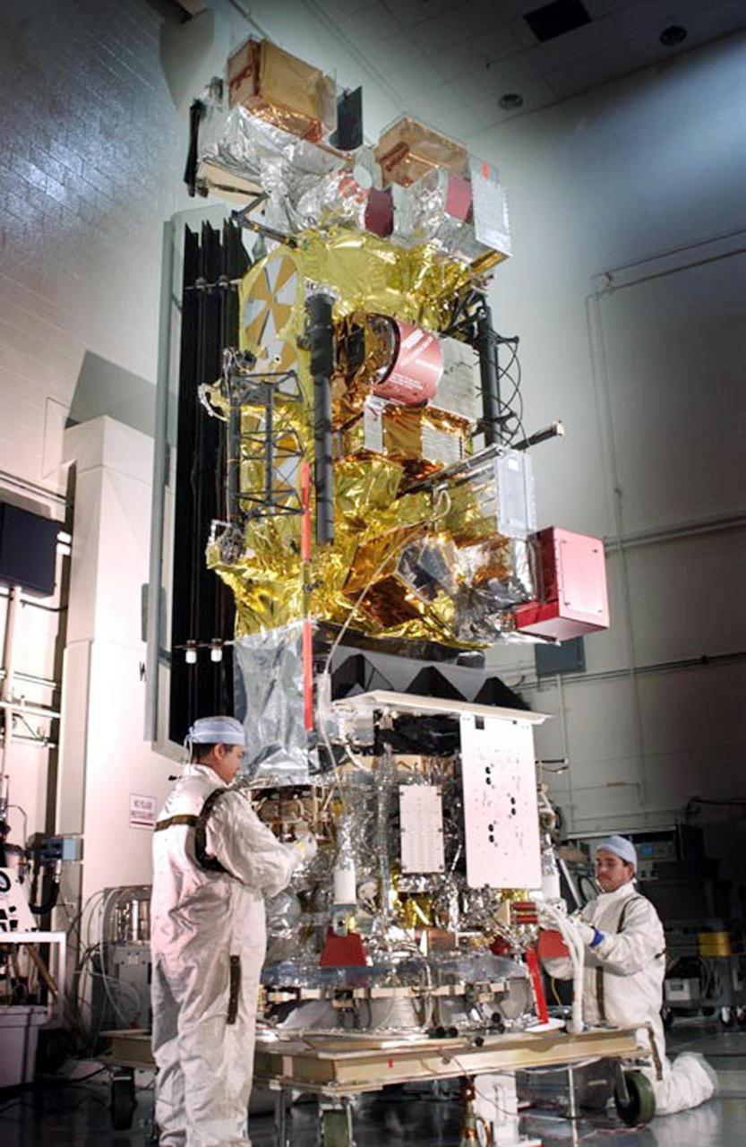
NASA engineers Rob Gallagher (left), Ken Smith (right) and Deneen Ferro (inside the spacecraft, center) work on the Global Precipitation Measurement mission's Core satellite in the clean room at Goddard Space Flight Center, Greenbelt Md. Credit: NASA/GSFC/Rebecca Roth The Global Precipitation Measurement (GPM) mission is an international partnership co-led by NASA and the Japan Aerospace Exploration Agency (JAXA) that will provide next-generation global observations of precipitation from space. GPM will study global rain, snow and ice to better understand our climate, weather, and hydrometeorological processes. As of Novermber 2013 the GPM Core Observatory is in the final stages of testing at NASA Goddard Space Flight Center. The satellite will be flown to Japan in the fall of 2013 and launched into orbit on an HII-A rocket in early 2014. For more on the GPM mission, visit <a href="http://gpm.gsfc.nasa.gov/" rel="nofollow">gpm.gsfc.nasa.gov/</a>. <b><a href="http://www.nasa.gov/audience/formedia/features/MP_Photo_Guidelines.html" rel="nofollow">NASA image use policy.</a></b> <b><a href="http://www.nasa.gov/centers/goddard/home/index.html" rel="nofollow">NASA Goddard Space Flight Center</a></b> enables NASA’s mission through four scientific endeavors: Earth Science, Heliophysics, Solar System Exploration, and Astrophysics. Goddard plays a leading role in NASA’s accomplishments by contributing compelling scientific knowledge to advance the Agency’s mission. <b>Follow us on <a href="http://twitter.com/NASA_GoddardPix" rel="nofollow">Twitter</a></b> <b>Like us on <a href="http://www.facebook.com/pages/Greenbelt-MD/NASA-Goddard/395013845897?ref=tsd" rel="nofollow">Facebook</a></b> <b>Find us on <a href="http://instagram.com/nasagoddard?vm=grid" rel="nofollow">Instagram</a></b>
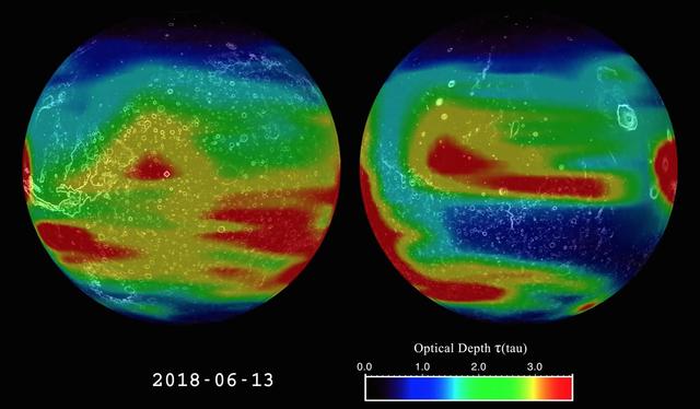
This image is from an animation that shows the evolution of the 2018 Mars global dust storm from late May to September. The animation shows the optical depth tau -- a measure of how much light is being blocked by atmospheric dust as measured by the Mars Climate Sounder instrument onboard NASA's Mars Reconnaissance Orbiter. NASA's Opportunity rover is marked with a red dot. The dust is mapped to two opposite hemispheres of Mars, giving a view of the full globe. Certain features of the Martian terrain, including Olympus Mons, the three volcanoes in the equatorial region, and Vallis Marineris, are also visible. The data shows the daily global column of dust, illustrating how the dust behaves over the course of the storm. The storm has a complex growth affecting most of Mars over the first month. It then remains near the peak for three weeks. Finally, the storm starts a multi-month decay back to regular weather. A color scale in the lower right-hand corner of the animation explains the colors in relation to approximate tau values. A tau of three indicates that only about 5 percent of the sunlight entering the atmosphere directly reaches the surface. Animation is available at https://photojournal.jpl.nasa.gov/catalog/PIA22737

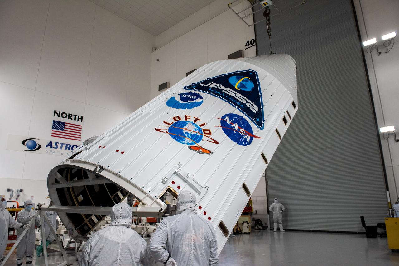
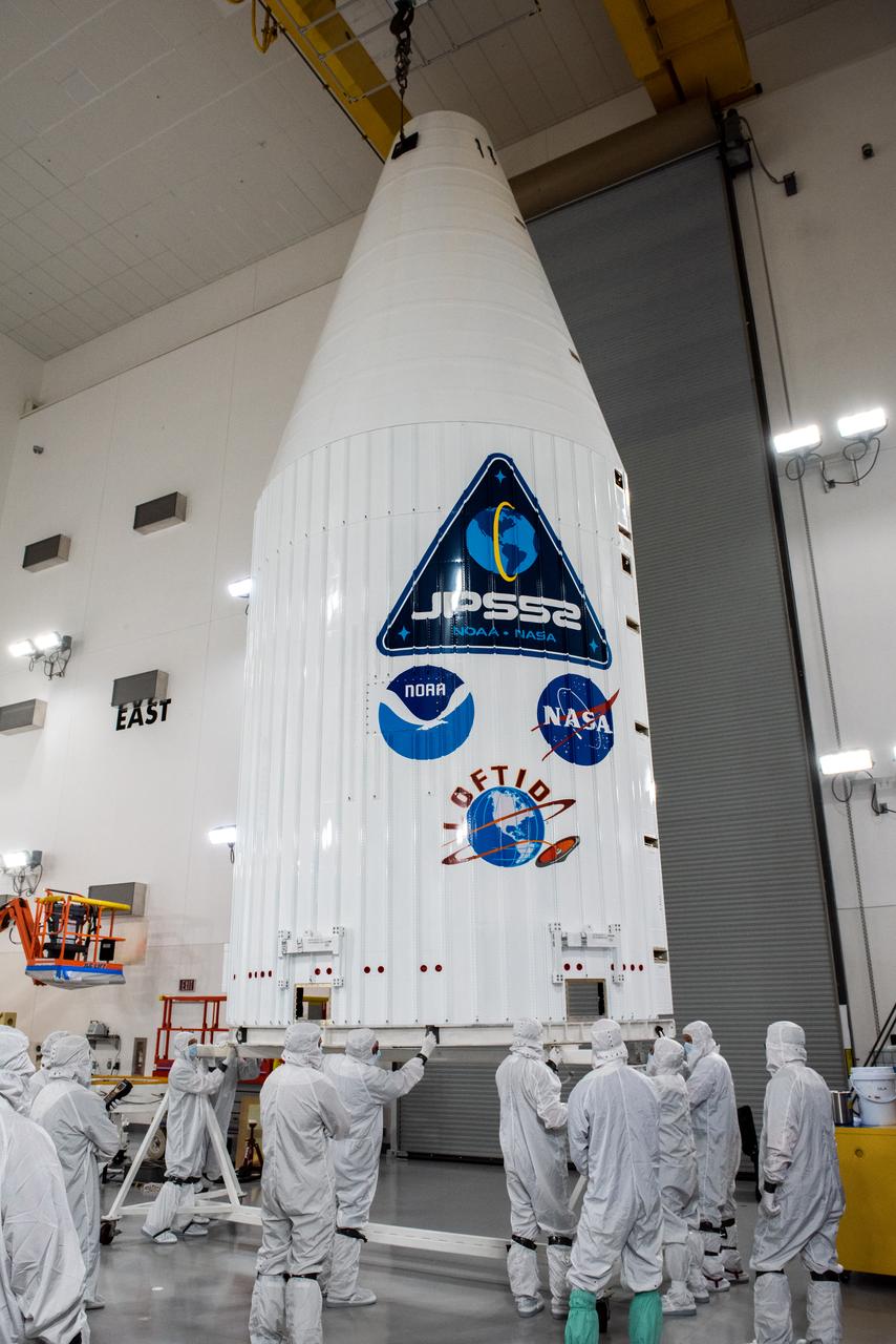
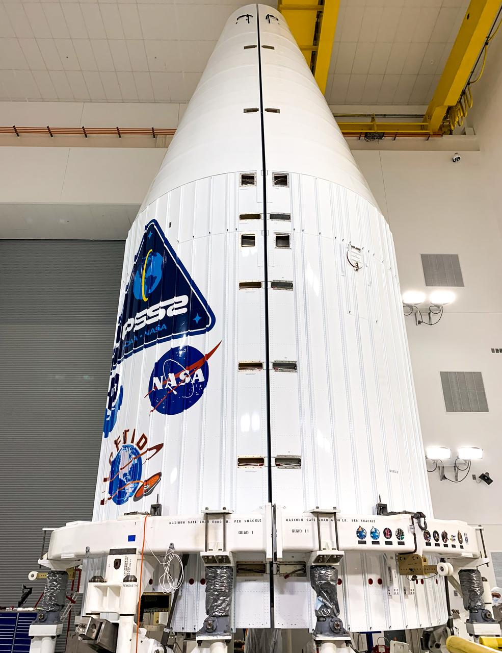
NASA and the National Oceanic and Atmospheric Administration's Joint Polar Satellite System-2 (JPSS-2) satellite is rotated to a vertical position after it was removed from its shipping container inside the airlock of the Astrotech processing facility on Aug. 20, 2022, at Vandenberg Space Force Base (VSFB) in California. JPSS-2 was shipped from the Northrop Grumman facility in Gilbert, Arizona, where it was built and tested. JPSS-2 is the third satellite in the Joint Polar Satellite System series. It is scheduled to lift off from VSFB on Nov. 1 from Space Launch Complex-3 East. JPSS-2 will scan the globe as it orbits from the North to the South Pole, crossing the equator 14 times a day. From 512 miles above Earth, it will capture data that inform weather forecasts, extreme weather events, and climate change. The Visible Infrared Radiometer Suite instrument will collect imagery for global observations of the land, atmosphere, cryosphere, and oceans. Launching as a secondary payload to JPSS-2 is NASA’s Low-Earth Orbit Flight Test of an Inflatable Decelerator (LOFTID), dedicated to the memory of Bernard Kutter. LOFTID is a demonstration of a hypersonic inflatable aerodynamic decelerator, or aeroshell, technology that could one day help land humans on Mars.
A crew offloaded the United Launch Alliance (ULA) Atlas V payload fairing from its transport container in building B7525 at Vandenberg Space Force Base (VSFB) in California on Aug. 8, 2022, for NASA and the National Oceanic and Atmospheric Administration’s (NOAA) Joint Polar Satellite System-2 (JPSS-2) satellite mission. JPSS-2 is the third satellite in the Joint Polar Satellite System series. It is scheduled to lift off from VSFB on Nov. 1 from Space Launch Complex-3 East. JPSS-2 will scan the globe as it orbits from the North to the South Pole, crossing the equator 14 times a day. From 512 miles above Earth, it will capture data that inform weather forecasts, extreme weather events, and climate change. The Visible Infrared Radiometer Suite instrument will collect imagery for global observations of the land, atmosphere, cryosphere, and oceans. Launching as a secondary payload to JPSS-2 is NASA’s Low-Earth Orbit Flight Test of an Inflatable Decelerator (LOFTID), dedicated to the memory of Bernard Kutter. LOFTID is a demonstration of a hypersonic inflatable aerodynamic decelerator, or aeroshell, technology that could one day help land humans on Mars.
The United Launch Alliance (ULA) Atlas V booster is offloaded from its water transport at Vandenberg Space Force Base (VSFB) in California on July 11, 2022, for NASA and NOAA’s Joint Polar Satellite System-2 (JPSS-2) satellite mission. JPSS-2 is the third satellite in the Joint Polar Satellite System series. It is scheduled to lift off from VSFB on the final ULA Atlas V rocket to launch from Vandenberg. JPSS-2 will scan the globe as it orbits from the North to the South Pole, crossing the equator 14 times a day. From 512 miles above Earth, it will capture data that inform weather forecasts, extreme weather events, and climate change. The Visible Infrared Radiometer Suite instrument will collect imagery for global observations of the land, atmosphere, cryosphere, and oceans. Launching as a secondary payload to JPSS-2 is NASA’s Low-Earth Orbit Flight Test of an Inflatable Decelerator (LOFTID), dedicated to the memory of Bernard Kutter. LOFTID is a demonstration of a hypersonic inflatable aerodynamic decelerator, or aeroshell, technology that could one day help land humans on Mars.
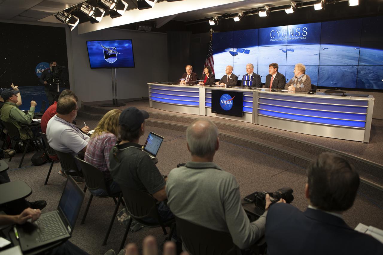
In the Kennedy Space Center’s Press Site auditorium, NASA and industry leaders speak to members of the media during a prelaunch news conference for the agency’s Cyclone Global Navigation Satellite System, or CYGNSS, spacecraft. From left are: George Diller of NASA Communications; Christine Bonniksen, CYGNSS program executive in the Earth Science Division of the Science Mission Directorate at NASA Headquarters in Washington, D.C.; Tim Dunn, NASA launch director at Kennedy; Bryan Baldwin, Pegasus launch vehicle program manager for Orbital ATK, Dulles, Virginia; John Scherrer, CYGNSS project manager for the Southwest Research Institute in San Antonio, Texas; and Mike Rehbein, launch weather officer for the 45th Weather Squadron at Cape Canaveral Air Force Station, Florida. The eight CYGNSS satellites will make frequent and accurate measurements of ocean surface winds throughout the life cycle of tropical storms and hurricanes. The data will help scientists probe key air-sea interaction processes that take place near the core of storms, which are rapidly changing and play a crucial role in the beginning and intensification of hurricanes.

The United Launch Alliance (ULA) Atlas V booster is offloaded from its water transport at Vandenberg Space Force Base (VSFB) in California on July 11, 2022, for NASA and NOAA’s Joint Polar Satellite System-2 (JPSS-2) satellite mission. JPSS-2 is the third satellite in the Joint Polar Satellite System series. It is scheduled to lift off from VSFB on the final ULA Atlas V rocket to launch from Vandenberg. JPSS-2 will scan the globe as it orbits from the North to the South Pole, crossing the equator 14 times a day. From 512 miles above Earth, it will capture data that inform weather forecasts, extreme weather events, and climate change. The Visible Infrared Radiometer Suite instrument will collect imagery for global observations of the land, atmosphere, cryosphere, and oceans. Launching as a secondary payload to JPSS-2 is NASA’s Low-Earth Orbit Flight Test of an Inflatable Decelerator (LOFTID), dedicated to the memory of Bernard Kutter. LOFTID is a demonstration of a hypersonic inflatable aerodynamic decelerator, or aeroshell, technology that could one day help land humans on Mars.
CAPE CANAVERAL, Fla. – Joel Tumbiolo, launch weather officer, 45th Weather Squadron, Cape Canaveral Air Force Station, Fla., participates in the Gravity Recovery and Interior Laboratory (GRAIL) prelaunch news conference in the NASA Press Site auditorium at NASA's Kennedy Space Center in Florida. GRAIL is scheduled to launch Sept. 8 aboard a United Launch Alliance Delta II Heavy rocket from Cape Canaveral Air Force Station in Florida. GRAIL will fly twin spacecraft in tandem around the moon to precisely measure and map variations in the moon's gravitational field. The mission will provide the most accurate global gravity field to date for any planet, including Earth. This detailed information will reveal differences in the density of the moon's crust and mantle and will help answer fundamental questions about the moon's internal structure, thermal evolution, and history of collisions with asteroids. The aim is to map the moon's gravity field so completely that future moon vehicles can safely navigate anywhere on the moon’s surface. For more information, visit http://www.nasa.gov/grail. Photo credit: NASA/Kim Shiflett
On Aug. 11, 2022, teams at the Astrotech facility at Vandenberg Space Force Base (VSFB) in California use a crane to raise to vertical one of the United Launch Alliance (ULA) Atlas V payload fairing halves for NASA and the National Oceanic and Atmospheric Administration’s (NOAA) Joint Polar Satellite System-2 (JPSS-2) satellite mission. The payload fairing protects the spacecraft during launch and flight through the atmosphere. JPSS-2 is the third satellite in the Joint Polar Satellite System series. It is scheduled to lift off from VSFB on Nov. 1 from Space Launch Complex-3 East. JPSS-2 will scan the globe as it orbits from the North to the South Pole, crossing the equator 14 times a day. From 512 miles above Earth, it will capture data that inform weather forecasts, extreme weather events, and climate change. The Visible Infrared Radiometer Suite instrument will collect imagery for global observations of the land, atmosphere, cryosphere, and oceans. Launching as a secondary payload to JPSS-2 is NASA’s Low-Earth Orbit Flight Test of an Inflatable Decelerator (LOFTID), dedicated to the memory of Bernard Kutter. LOFTID is a demonstration of a hypersonic inflatable aerodynamic decelerator, or aeroshell, technology that could one day help land humans on Mars.

On Aug. 11, 2022, teams at the Astrotech facility at Vandenberg Space Force Base (VSFB) in California use a crane to raise to vertical one of the United Launch Alliance (ULA) Atlas V payload fairing halves for NASA and the National Oceanic and Atmospheric Administration’s (NOAA) Joint Polar Satellite System-2 (JPSS-2) satellite mission. The payload fairing protects the spacecraft during launch and flight through the atmosphere. JPSS-2 is the third satellite in the Joint Polar Satellite System series. It is scheduled to lift off from VSFB on Nov. 1 from Space Launch Complex-3 East. JPSS-2 will scan the globe as it orbits from the North to the South Pole, crossing the equator 14 times a day. From 512 miles above Earth, it will capture data that inform weather forecasts, extreme weather events, and climate change. The Visible Infrared Radiometer Suite instrument will collect imagery for global observations of the land, atmosphere, cryosphere, and oceans. Launching as a secondary payload to JPSS-2 is NASA’s Low-Earth Orbit Flight Test of an Inflatable Decelerator (LOFTID), dedicated to the memory of Bernard Kutter. LOFTID is a demonstration of a hypersonic inflatable aerodynamic decelerator, or aeroshell, technology that could one day help land humans on Mars.

The first half of the United Launch Alliance (ULA) Atlas V payload fairing is moved into position for a fit check at the Astrotech Processing Facility at Vandenberg Space Force Base (VSFB) in California on Aug. 13, 2022, for NASA and the National Oceanic and Atmospheric Administration’s (NOAA) Joint Polar Satellite System-2 (JPSS-2) satellite mission. JPSS-2 is the third satellite in the Joint Polar Satellite System series. It is scheduled to lift off from VSFB on Nov. 1 from Space Launch Complex-3 East. JPSS-2 will scan the globe as it orbits from the North to the South Pole, crossing the equator 14 times a day. From 512 miles above Earth, it will capture data that inform weather forecasts, extreme weather events, and climate change. The Visible Infrared Radiometer Suite instrument will collect imagery for global observations of the land, atmosphere, cryosphere, and oceans. Launching as a secondary payload to JPSS-2 is NASA’s Low-Earth Orbit Flight Test of an Inflatable Decelerator (LOFTID), dedicated to the memory of Bernard Kutter. LOFTID is a demonstration of a hypersonic inflatable aerodynamic decelerator, or aeroshell, technology that could one day help land humans on Mars.

On Aug. 11, 2022, teams at the Astrotech facility at Vandenberg Space Force Base (VSFB) in California use a crane to raise to vertical one of the United Launch Alliance (ULA) Atlas V payload fairing halves for NASA and the National Oceanic and Atmospheric Administration’s (NOAA) Joint Polar Satellite System-2 (JPSS-2) satellite mission. The payload fairing protects the spacecraft during launch and flight through the atmosphere. JPSS-2 is the third satellite in the Joint Polar Satellite System series. It is scheduled to lift off from VSFB on Nov. 1 from Space Launch Complex-3 East. JPSS-2 will scan the globe as it orbits from the North to the South Pole, crossing the equator 14 times a day. From 512 miles above Earth, it will capture data that inform weather forecasts, extreme weather events, and climate change. The Visible Infrared Radiometer Suite instrument will collect imagery for global observations of the land, atmosphere, cryosphere, and oceans. Launching as a secondary payload to JPSS-2 is NASA’s Low-Earth Orbit Flight Test of an Inflatable Decelerator (LOFTID), dedicated to the memory of Bernard Kutter. LOFTID is a demonstration of a hypersonic inflatable aerodynamic decelerator, or aeroshell, technology that could one day help land humans on Mars.
On Aug. 11, 2022, teams at the Astrotech facility at Vandenberg Space Force Base (VSFB) in California use a crane to raise to vertical one of the United Launch Alliance (ULA) Atlas V payload fairing halves for NASA and the National Oceanic and Atmospheric Administration’s (NOAA) Joint Polar Satellite System-2 (JPSS-2) satellite mission. The payload fairing protects the spacecraft during launch and flight through the atmosphere. JPSS-2 is the third satellite in the Joint Polar Satellite System series. It is scheduled to lift off from VSFB on Nov. 1 from Space Launch Complex-3 East. JPSS-2 will scan the globe as it orbits from the North to the South Pole, crossing the equator 14 times a day. From 512 miles above Earth, it will capture data that inform weather forecasts, extreme weather events, and climate change. The Visible Infrared Radiometer Suite instrument will collect imagery for global observations of the land, atmosphere, cryosphere, and oceans. Launching as a secondary payload to JPSS-2 is NASA’s Low-Earth Orbit Flight Test of an Inflatable Decelerator (LOFTID), dedicated to the memory of Bernard Kutter. LOFTID is a demonstration of a hypersonic inflatable aerodynamic decelerator, or aeroshell, technology that could one day help land humans on Mars.
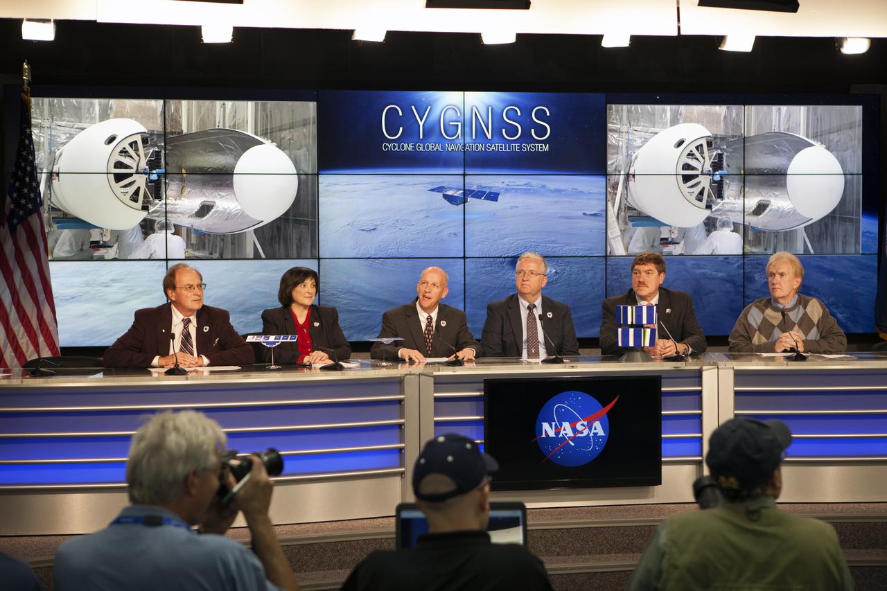
In the Kennedy Space Center’s Press Site auditorium, NASA and industry leaders speak to members of the media during a prelaunch news conference for the agency’s Cyclone Global Navigation Satellite System, or CYGNSS, spacecraft. From left are: George Diller of NASA Communications; Christine Bonniksen, CYGNSS program executive in the Earth Science Division of the Science Mission Directorate at NASA Headquarters in Washington, D.C.; Tim Dunn, NASA launch director at Kennedy; Bryan Baldwin, Pegasus launch vehicle program manager for Orbital ATK, Dulles, Virginia; John Scherrer, CYGNSS project manager for the Southwest Research Institute in San Antonio, Texas; and Mike Rehbein, launch weather officer for the 45th Weather Squadron at Cape Canaveral Air Force Station, Florida. The eight CYGNSS satellites will make frequent and accurate measurements of ocean surface winds throughout the life cycle of tropical storms and hurricanes. The data will help scientists probe key air-sea interaction processes that take place near the core of storms, which are rapidly changing and play a crucial role in the beginning and intensification of hurricanes.
Both halves of the United Launch Alliance (ULA) Atlas V payload fairing are joined together during a fit check at the Astrotech Processing Facility at Vandenberg Space Force Base (VSFB) in California on Aug. 13, 2022, for NASA and the National Oceanic and Atmospheric Administration’s (NOAA) Joint Polar Satellite System-2 (JPSS-2) satellite mission. JPSS-2 is the third satellite in the Joint Polar Satellite System series. It is scheduled to lift off from VSFB on Nov. 1 from Space Launch Complex-3 East. JPSS-2 will scan the globe as it orbits from the North to the South Pole, crossing the equator 14 times a day. From 512 miles above Earth, it will capture data that inform weather forecasts, extreme weather events, and climate change. The Visible Infrared Radiometer Suite instrument will collect imagery for global observations of the land, atmosphere, cryosphere, and oceans. Launching as a secondary payload to JPSS-2 is NASA’s Low-Earth Orbit Flight Test of an Inflatable Decelerator (LOFTID), dedicated to the memory of Bernard Kutter. LOFTID is a demonstration of a hypersonic inflatable aerodynamic decelerator, or aeroshell, technology that could one day help land humans on Mars.
NASA and the National Oceanic and Atmospheric Association's Joint Polar Satellite System-2 (JPSS-2) satellite is removed from its shipping container inside the airlock of the Astrotech processing facility on Aug. 20, 2022, at Vandenberg Space Force Base (VSFB) in California. JPSS-2 was shipped from the Northrop Grumman facility in Gilbert, Arizona, where it was built and tested. JPSS-2 is the third satellite in the Joint Polar Satellite System series. It is scheduled to lift off from VSFB on Nov. 1 from Space Launch Complex-3 East. JPSS-2 will scan the globe as it orbits from the North to the South Pole, crossing the equator 14 times a day. From 512 miles above Earth, it will capture data that inform weather forecasts, extreme weather events, and climate change. The Visible Infrared Radiometer Suite instrument will collect imagery for global observations of the land, atmosphere, cryosphere, and oceans. Launching as a secondary payload to JPSS-2 is NASA’s Low-Earth Orbit Flight Test of an Inflatable Decelerator (LOFTID), dedicated to the memory of Bernard Kutter. LOFTID is a demonstration of a hypersonic inflatable aerodynamic decelerator, or aeroshell, technology that could one day help land humans on Mars.
The United Launch Alliance (ULA) Atlas V booster is offloaded from its water transport at Vandenberg Space Force Base (VSFB) in California on July 11, 2022, for NASA and NOAA’s Joint Polar Satellite System-2 (JPSS-2) satellite mission. JPSS-2 is the third satellite in the Joint Polar Satellite System series. It is scheduled to lift off from VSFB on the final ULA Atlas V rocket to launch from Vandenberg. JPSS-2 will scan the globe as it orbits from the North to the South Pole, crossing the equator 14 times a day. From 512 miles above Earth, it will capture data that inform weather forecasts, extreme weather events, and climate change. The Visible Infrared Radiometer Suite instrument will collect imagery for global observations of the land, atmosphere, cryosphere, and oceans. Launching as a secondary payload to JPSS-2 is NASA’s Low-Earth Orbit Flight Test of an Inflatable Decelerator (LOFTID), dedicated to the memory of Bernard Kutter. LOFTID is a demonstration of a hypersonic inflatable aerodynamic decelerator, or aeroshell, technology that could one day help land humans on Mars.

Both halves of the United Launch Alliance (ULA) Atlas V payload fairing are moved into position for a fit check at the Astrotech Processing Facility at Vandenberg Space Force Base (VSFB) in California on Aug. 13, 2022, for NASA and the National Oceanic and Atmospheric Administration’s (NOAA) Joint Polar Satellite System-2 (JPSS-2) satellite mission. JPSS-2 is the third satellite in the Joint Polar Satellite System series. It is scheduled to lift off from VSFB on Nov. 1 from Space Launch Complex-3 East. JPSS-2 will scan the globe as it orbits from the North to the South Pole, crossing the equator 14 times a day. From 512 miles above Earth, it will capture data that inform weather forecasts, extreme weather events, and climate change. The Visible Infrared Radiometer Suite instrument will collect imagery for global observations of the land, atmosphere, cryosphere, and oceans. Launching as a secondary payload to JPSS-2 is NASA’s Low-Earth Orbit Flight Test of an Inflatable Decelerator (LOFTID), dedicated to the memory of Bernard Kutter. LOFTID is a demonstration of a hypersonic inflatable aerodynamic decelerator, or aeroshell, technology that could one day help land humans on Mars.
In the Kennedy Space Center’s Press Site auditorium, NASA and industry leaders speak to members of the media during a prelaunch news conference for the agency’s Cyclone Global Navigation Satellite System, or CYGNSS, spacecraft. From left are: Christine Bonniksen, CYGNSS program executive in the Earth Science Division of the Science Mission Directorate at NASA Headquarters in Washington, D.C.; Tim Dunn, NASA launch director at Kennedy; Bryan Baldwin, Pegasus launch vehicle program manager for Orbital ATK, Dulles, Virginia; John Scherrer, CYGNSS project manager for the Southwest Research Institute in San Antonio, Texas; and Mike Rehbein, launch weather officer for the 45th Weather Squadron at Cape Canaveral Air Force Station, Florida. The eight CYGNSS satellites will make frequent and accurate measurements of ocean surface winds throughout the life cycle of tropical storms and hurricanes. The data will help scientists probe key air-sea interaction processes that take place near the core of storms, which are rapidly changing and play a crucial role in the beginning and intensification of hurricanes.
In the Kennedy Space Center’s Press Site auditorium, NASA and industry leaders speak to members of the media during a prelaunch news conference for the agency’s Cyclone Global Navigation Satellite System, or CYGNSS, spacecraft. From left are: George Diller of NASA Communications; Christine Bonniksen, CYGNSS program executive in the Earth Science Division of the Science Mission Directorate at NASA Headquarters in Washington, D.C.; Tim Dunn, NASA launch director at Kennedy; Bryan Baldwin, Pegasus launch vehicle program manager for Orbital ATK, Dulles, Virginia; John Scherrer, CYGNSS project manager for the Southwest Research Institute in San Antonio, Texas; and Mike Rehbein, launch weather officer for the 45th Weather Squadron at Cape Canaveral Air Force Station, Florida. The eight CYGNSS satellites will make frequent and accurate measurements of ocean surface winds throughout the life cycle of tropical storms and hurricanes. The data will help scientists probe key air-sea interaction processes that take place near the core of storms, which are rapidly changing and play a crucial role in the beginning and intensification of hurricanes.
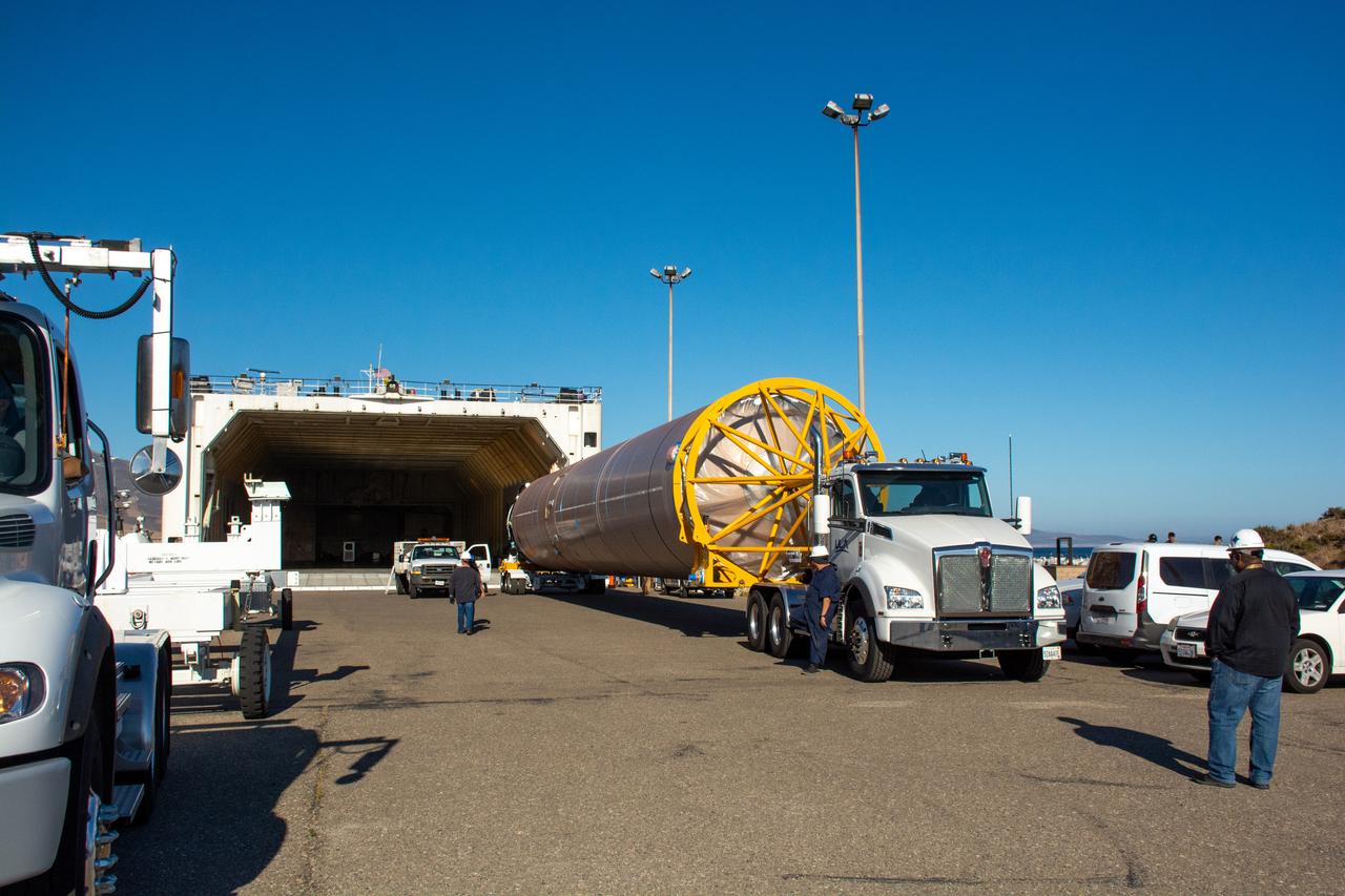
The United Launch Alliance (ULA) Atlas V booster is transported to the Horizontal Integration Facility at Vandenberg Space Force Base (VSFB) in California on July 11, 2022, for NASA and NOAA’s Joint Polar Satellite System-2 (JPSS-2) satellite mission. JPSS-2 is the third satellite in the Joint Polar Satellite System series. It is scheduled to lift off from VSFB on the final ULA Atlas V rocket to launch from Vandenberg. JPSS-2 will scan the globe as it orbits from the North to the South Pole, crossing the equator 14 times a day. From 512 miles above Earth, it will capture data that inform weather forecasts, extreme weather events, and climate change. The Visible Infrared Radiometer Suite instrument will collect imagery for global observations of the land, atmosphere, cryosphere, and oceans. Launching as a secondary payload to JPSS-2 is NASA’s Low-Earth Orbit Flight Test of an Inflatable Decelerator (LOFTID), dedicated to the memory of Bernard Kutter. LOFTID is a demonstration of a hypersonic inflatable aerodynamic decelerator, or aeroshell, technology that could one day help land humans on Mars.
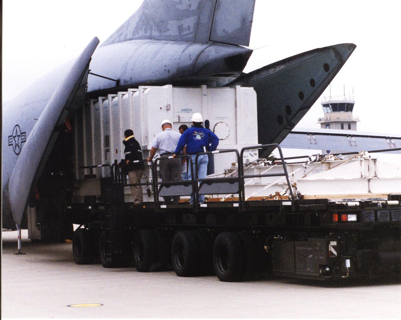
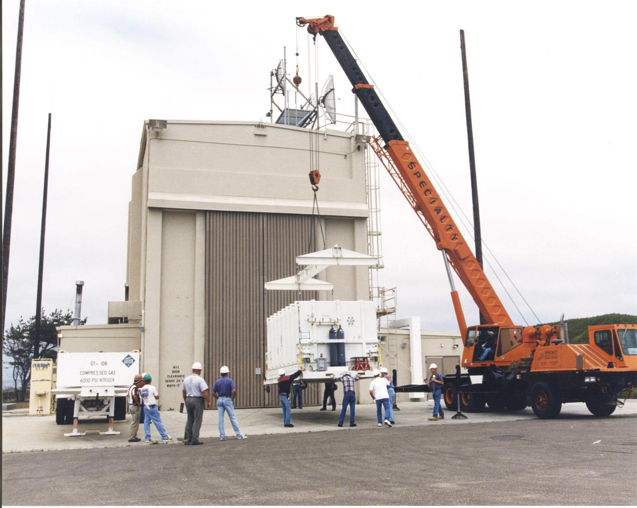
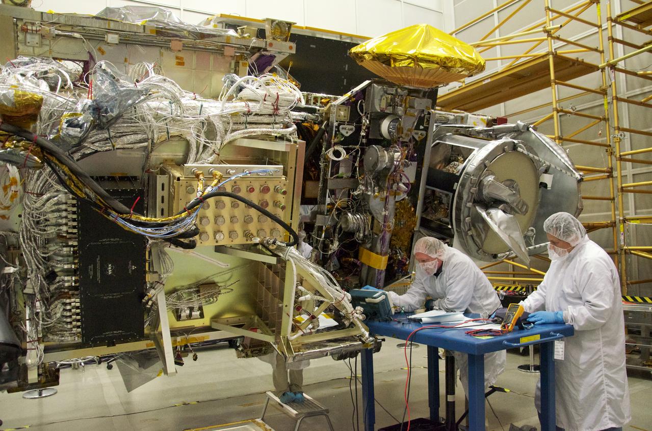
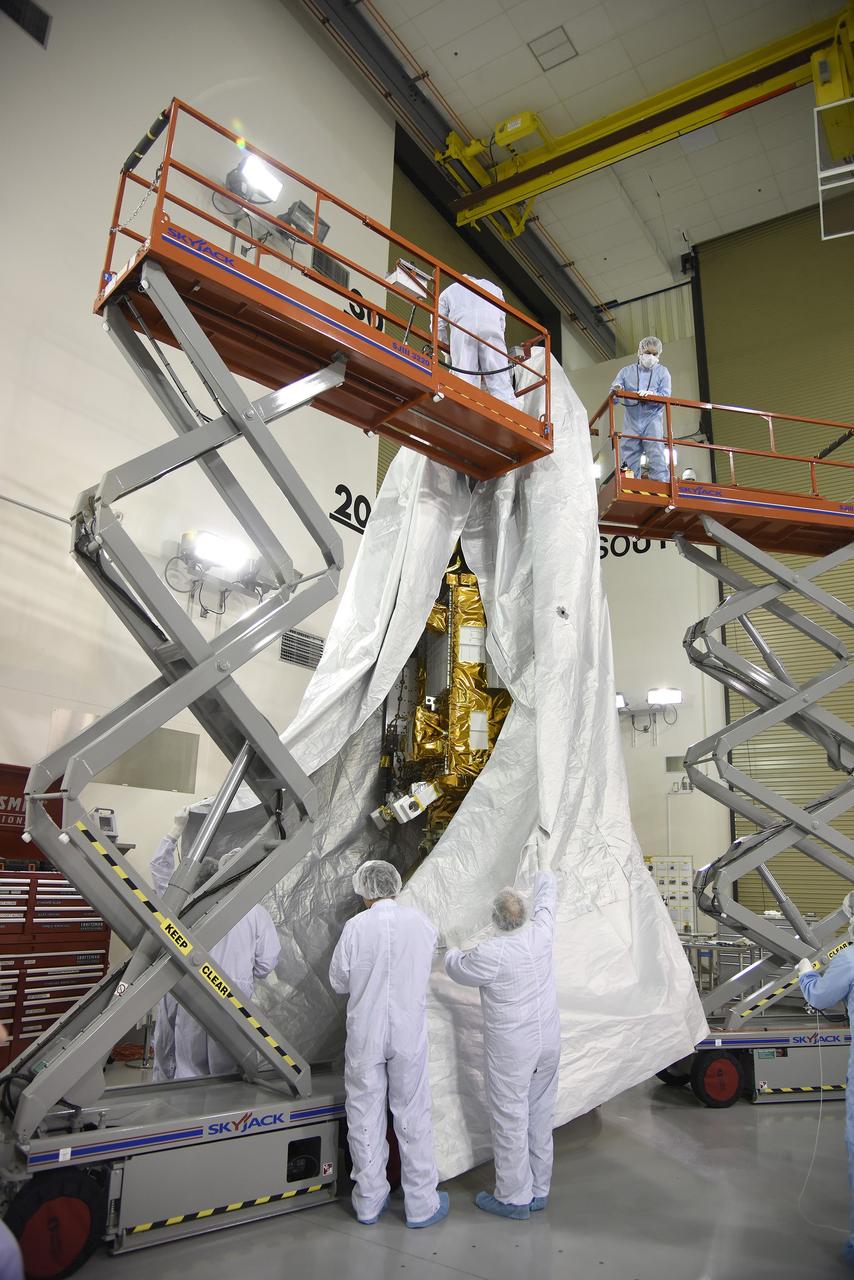
Inside the Astrotech payload processing facility on Vandenberg Air Force Base in California, engineers and technicians remove a protective covering from NASA's Soil Moisture Active Passive, or SMAP, spacecraft. SMAP will launch on a Delta II 7320 configuration vehicle featuring a United Launch Alliance first stage booster powered by an Aerojet Rocketdyne RS-27A main engine and three Alliant Techsystems, or ATK, strap-on solid rocket motors. Once on station in Earth orbit, SMAP will provide global measurements of soil moisture and its freeze/thaw state. These measurements will be used to enhance understanding of processes that link the water, energy and carbon cycles, and to extend the capabilities of weather and climate prediction models. SMAP data also will be used to quantify net carbon flux in boreal landscapes and to develop improved flood prediction and drought monitoring capabilities. Launch from Space Launch Complex 2 is targeted for Jan. 29, 2015.
VANDENBERG AIR FORCE BASE, Calif. – Workers prepare to rotate a section of the fairing for NASA's Soil Moisture Active Passive mission, or SMAP, in a lifting device in the Building 836 high bay on Vandenberg Air Force Base in California. The fairing will protect the SMAP spacecraft from the heat and aerodynamic pressure generated during its ascent to orbit aboard a United Launch Alliance Delta II rocket from Space Launch Complex 2. SMAP will provide global measurements of soil moisture and its freeze/thaw state. These measurements will be used to enhance understanding of processes that link the water, energy and carbon cycles, and to extend the capabilities of weather and climate prediction models. SMAP data will also be used to quantify net carbon flux in boreal landscapes and to develop improved flood prediction and drought monitoring capabilities. Launch is scheduled for November 2014. To learn more about SMAP, visit http://smap.jpl.nasa.gov. Photo credit: NASA/Randy Beaudoin
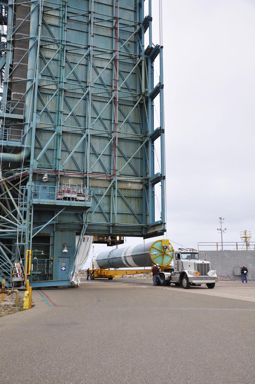
VANDENBERG AIR FORCE BASE, Calif. – The first stage of the United Launch Alliance Delta II rocket for NASA's Soil Moisture Active Passive mission, or SMAP, is delivered to the base of the mobile service tower at Space Launch Complex 2 on Vandenberg Air Force Base in California. SMAP will provide global measurements of soil moisture and its freeze/thaw state. These measurements will be used to enhance understanding of processes that link the water, energy and carbon cycles, and to extend the capabilities of weather and climate prediction models. SMAP data also will be used to quantify net carbon flux in boreal landscapes and to develop improved flood prediction and drought monitoring capabilities. Launch is scheduled for November 2014. To learn more about SMAP, visit http://smap.jpl.nasa.gov. Photo credit: NASA/Randy Beaudoin
VANDENBERG AIR FORCE BASE, Calif. – Workers rotate a section of the fairing for NASA's Soil Moisture Active Passive mission, or SMAP, in a lifting device in the Building 836 high bay on Vandenberg Air Force Base in California. The fairing will protect the SMAP spacecraft from the heat and aerodynamic pressure generated during its ascent to orbit aboard a United Launch Alliance Delta II rocket from Space Launch Complex 2. SMAP will provide global measurements of soil moisture and its freeze/thaw state. These measurements will be used to enhance understanding of processes that link the water, energy and carbon cycles, and to extend the capabilities of weather and climate prediction models. SMAP data will also be used to quantify net carbon flux in boreal landscapes and to develop improved flood prediction and drought monitoring capabilities. Launch is scheduled for November 2014. To learn more about SMAP, visit http://smap.jpl.nasa.gov. Photo credit: NASA/Randy Beaudoin
VANDENBERG AIR FORCE BASE, Calif. – The launch gantry is rolled back to reveal the United Launch Alliance Delta II rocket with the Soil Moisture Active Passive, or SMAP, satellite aboard, at Space Launch Complex 2 on Vandenberg Air Force Base in California. SMAP is a remote sensing mission designed to measure and map the Earth's soil moisture distribution and freeze/thaw stat with unprecedented accuracy, resolution and coverage. SMAP will provide global measurements of soil moisture and its freeze/thaw state. These measurements will be used to enhance understanding of processes that link the water, energy and carbon cycles, and to extend the capabilities of weather and climate prediction models. SMAP data also will be used to quantify net carbon flux in boreal landscapes and to develop improved flood prediction and drought monitoring capabilities. Launch is scheduled for Jan. 29, 2015. To learn more about SMAP, visit http://www.nasa.gov/smap. Photo credit: NASA/Randy Beaudoin
VANDENBERG AIR FORCE BASE, Calif. – A crane is used to offload the first stage of a United Launch Alliance Delta II rocket following its arrival at NASA hangar 836 on Vandenberg Air Force Base in California. The launch vehicle will be used to deliver NASA's Soil Moisture Active Passive mission, or SMAP, into orbit. SMAP will provide global measurements of soil moisture and its freeze/thaw state. These measurements will be used to enhance understanding of processes that link the water, energy and carbon cycles, and to extend the capabilities of weather and climate prediction models. SMAP data also will be used to quantify net carbon flux in boreal landscapes and to develop improved flood prediction and drought monitoring capabilities. Launch is scheduled for November 2014. To learn more about SMAP, visit http://smap.jpl.nasa.gov Photo credit: NASA/Randy Beaudoin
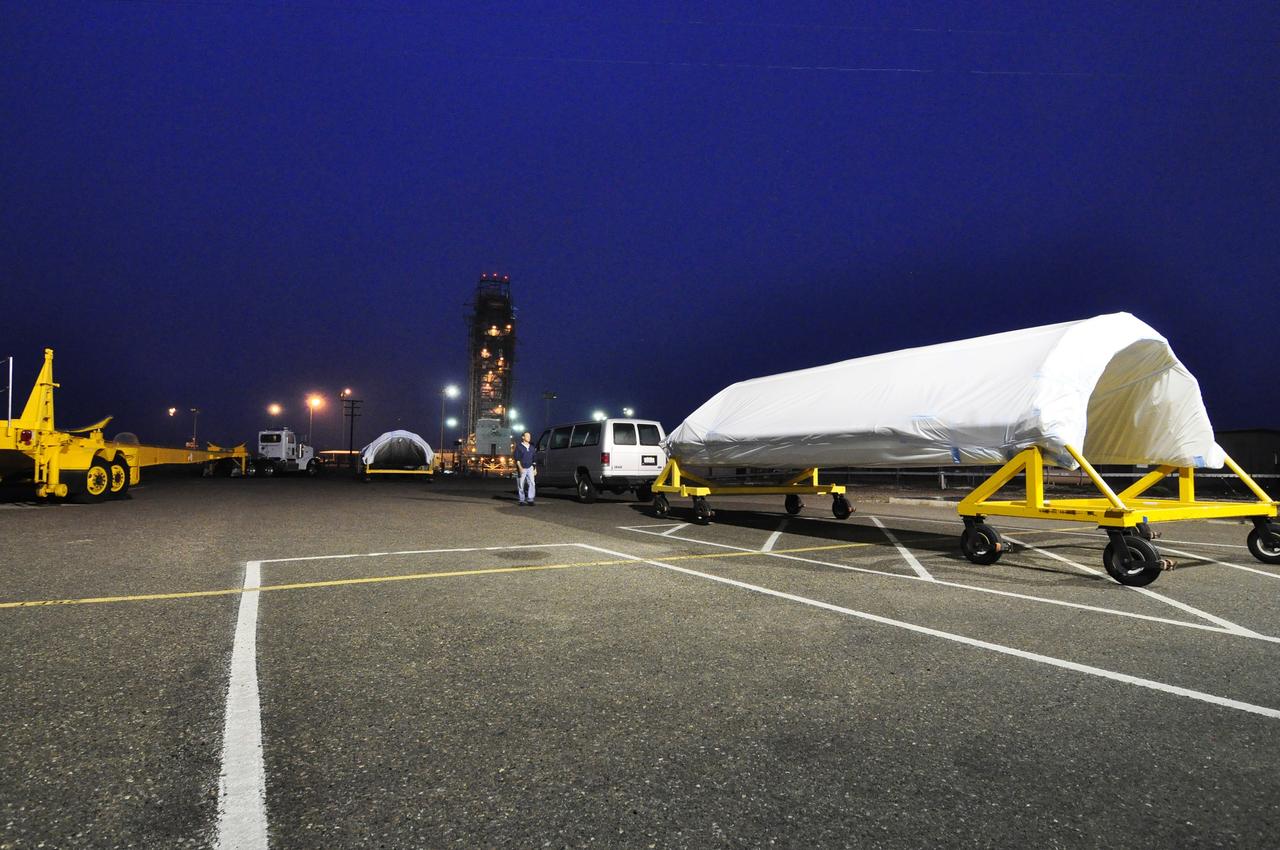
VANDENBERG AIR FORCE BASE, Calif. – Inside the Astrotech payload processing facility at Vandenberg Air Force Base in California, engineers and technicians place a protective cover over NASA's Soil Moisture Active Passive mission, or SMAP, satellite prior the spacecraft being transported to the launch pad. SMAP will provide global measurements of soil moisture and its freeze/thaw state. These measurements will be used to enhance understanding of processes that link the water, energy and carbon cycles, and to extend the capabilities of weather and climate prediction models. SMAP data also will be used to quantify net carbon flux in boreal landscapes and to develop improved flood prediction and drought monitoring capabilities. Launch is scheduled for Jan. 29, 2015. To learn more about SMAP, visit http://smap.jpl.nasa.gov Photo credit: Jeremy Moore, USAF Photo Squadron
VANDENBERG AIR FORCE BASE, Calif. – The half sections of the 10-foot-diameter fairing for NASA's Soil Moisture Active Passive mission, or SMAP, are delivered to the mobile service tower at Space Launch Complex 2 on Vandenberg Air Force Base in California. The fairing will protect the SMAP spacecraft from the heat and aerodynamic pressure generated during its ascent to orbit aboard a United Launch Alliance Delta II rocket. SMAP will provide global measurements of soil moisture and its freeze/thaw state. These measurements will be used to enhance understanding of processes that link the water, energy and carbon cycles, and to extend the capabilities of weather and climate prediction models. SMAP data will also be used to quantify net carbon flux in boreal landscapes and to develop improved flood prediction and drought monitoring capabilities. Launch is scheduled for no earlier than November 2014. To learn more about SMAP, visit http://smap.jpl.nasa.gov. Photo credit: NASA/Randy Beaudoin
VANDENBERG AIR FORCE BASE, Calif. – NASA's Soil Moisture Active Passive mission, or SMAP, is scheduled to launch in November 2014 from Space Launch Complex 2 on Vandenberg Air Force Base in California, seen here on a temperate, fog-free summer's day. A United Launch Alliance Delta II rocket will be used to deliver SMAP into orbit. SMAP will provide global measurements of soil moisture and its freeze/thaw state. These measurements will be used to enhance understanding of processes that link the water, energy and carbon cycles, and to extend the capabilities of weather and climate prediction models. SMAP data also will be used to quantify net carbon flux in boreal landscapes and to develop improved flood prediction and drought monitoring capabilities. To learn more about SMAP, visit http://smap.jpl.nasa.gov. Photo credit: NASA/Randy Beaudoin
VANDENBERG AIR FORCE BASE, Calif. – The first stage of a United Launch Alliance Delta II rocket arrives at NASA hangar 836 on Vandenberg Air Force Base in California. The Delta II rocket will be used to deliver NASA's Soil Moisture Active Passive mission, or SMAP, into orbit. SMAP will provide global measurements of soil moisture and its freeze/thaw state. These measurements will be used to enhance understanding of processes that link the water, energy and carbon cycles, and to extend the capabilities of weather and climate prediction models. SMAP data also will be used to quantify net carbon flux in boreal landscapes and to develop improved flood prediction and drought monitoring capabilities. Launch is scheduled for November 2014. To learn more about SMAP, visit http://smap.jpl.nasa.gov Photo credit: NASA/Randy Beaudoin
The pilot of this high-altitude research plane, a specially equipped Dryden Flight Research Center ER-2 (a modified U-2), settles into the cockpit at Patrick Air Force Base before taking off into a hurricane. The plane is part of the NASA-led Atmospheric Dynamics and Remote Sensing program that includes other government weather researchers and the university community in a study of Atlantic hurricanes and tropical storms. Soaring above 65,000 feet, the ER-2 will measure the structure of hurricanes and the surrounding atmosphere that steers the storm’s movement. The hurricane study, which lasts through September 1998, is part of NASA’s Earth Science enterprise to better understand the total Earth system and the effects of natural and human-induced changes on the global environment
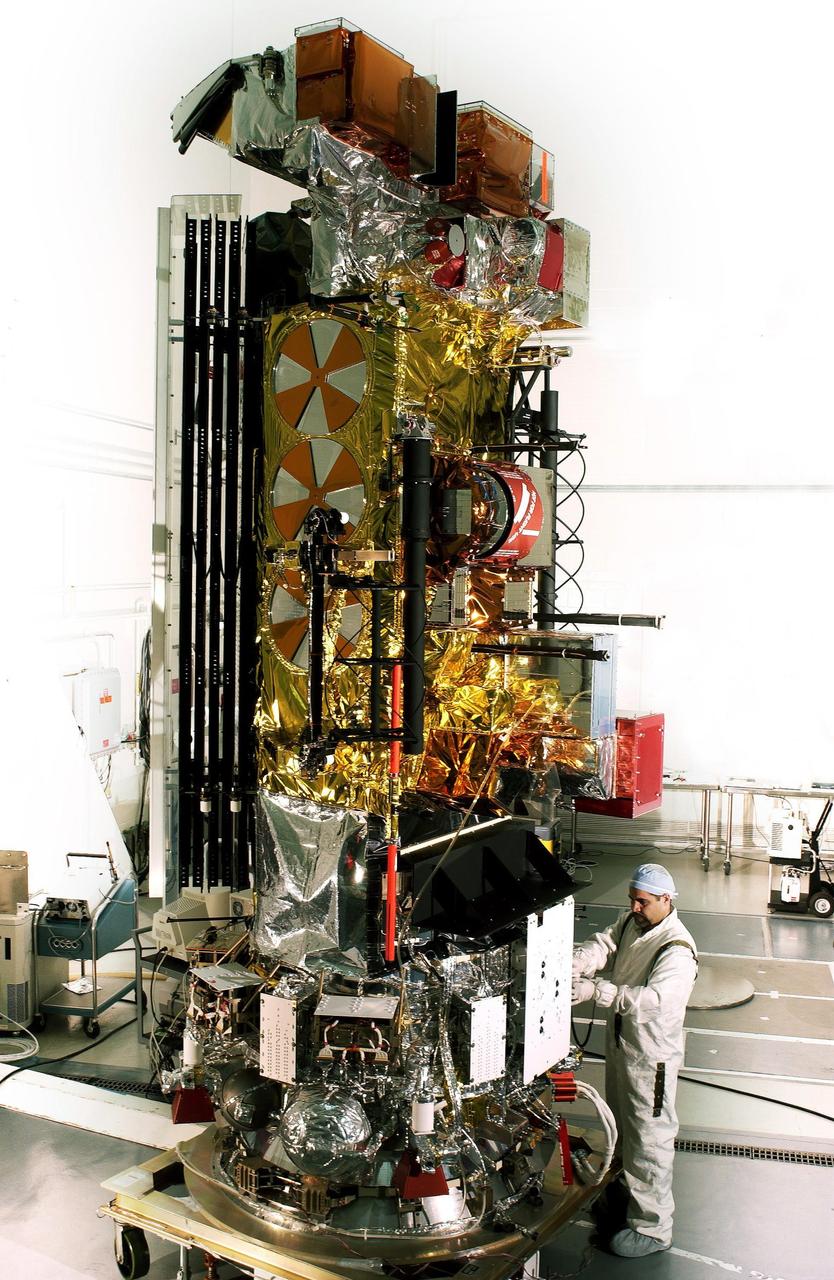
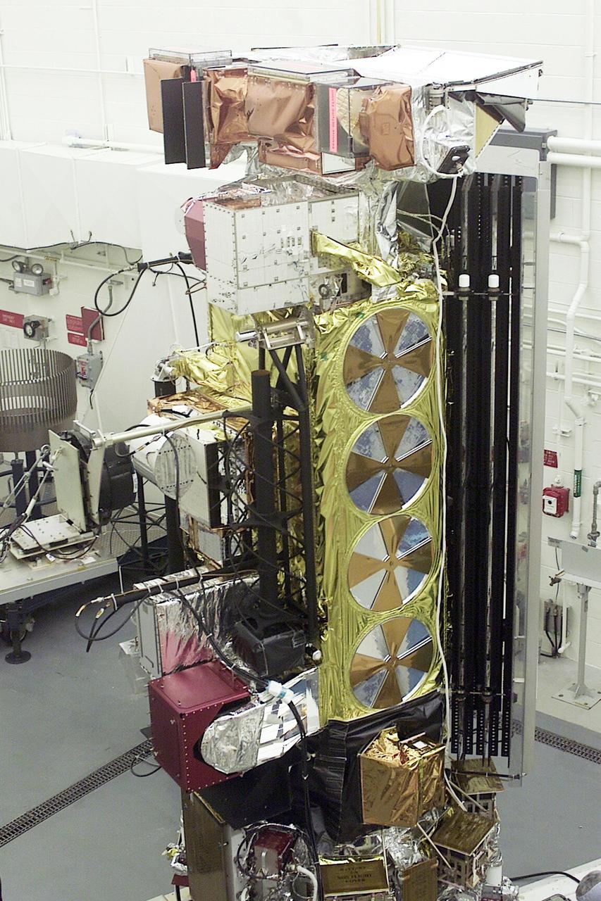
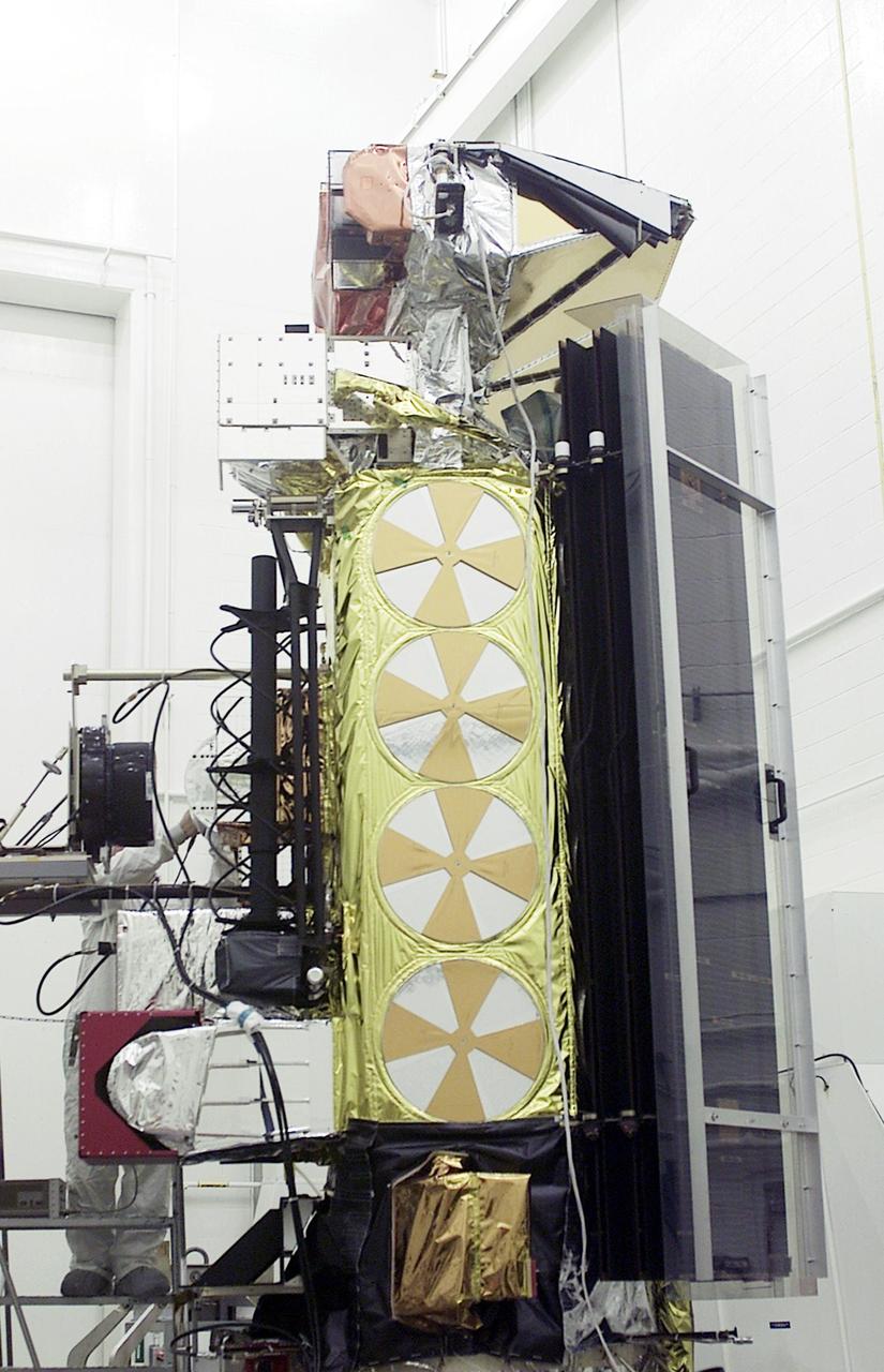
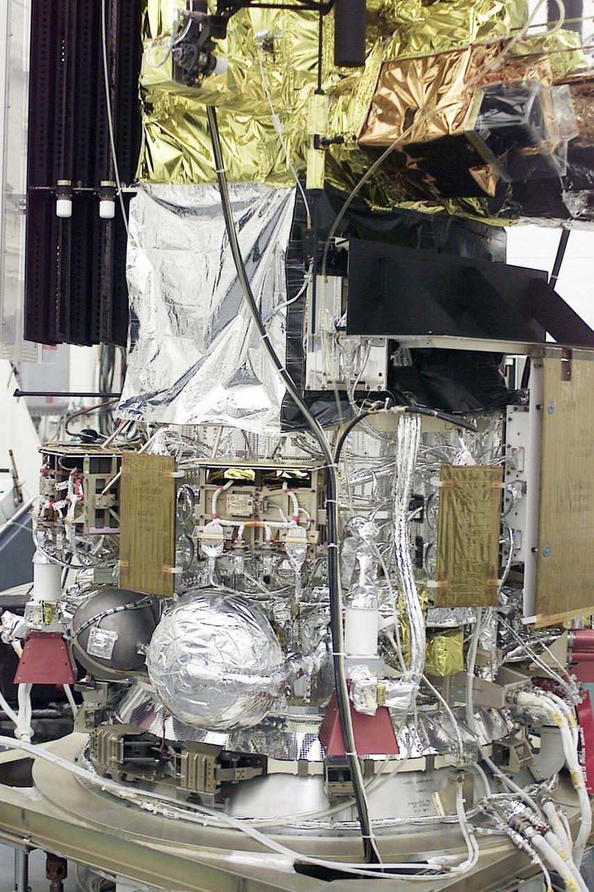
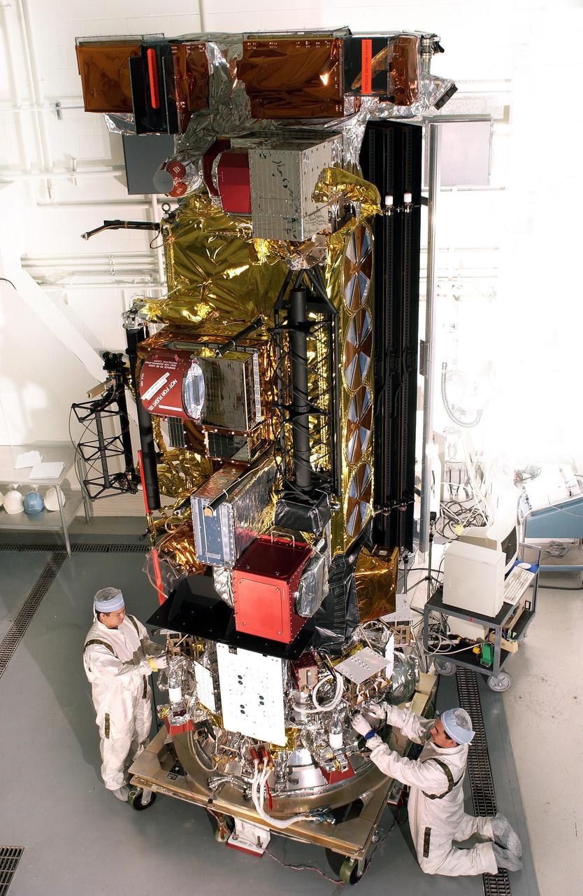
VANDENBERG AFB, CALIF. -- The Aqua-EOS satellite rests on a stand in the Spaceport Systems International (SSI) payload processing facility on South Vandenberg AFB. Aqua will provide a six year chronology of the planet and its processes. Comprehensive measurements taken by its onboard instruments will allow scientists to assess long-term change, identify its human and natural causes and advance the development of models for long-term forecasting. The Focus for the Aqua Project is the multi-disciplinary study of the Earth's Interrelated Processes (atmosphere, oceans, and land surface) and their relationship to earth system changes. The global change research emphasized with the Aqua instrument data sets include: atmospheric temperature and humidity profiles, clouds, precipitation and radiative balance; terrestrial snow and sea ice; sea surface temperature and ocean productivity; soil moisture; and the improvement of numerical weather prediction. Aqua-EOS is scheduled for launch aboard a Delta II 7920-10L vehicle on April 18, 2002
VANDENBERG AIR FORCE BASE, Calif. – The first stage of the United Launch Alliance Delta II rocket for NASA's Soil Moisture Active Passive mission, or SMAP, begins its journey from the Building 836 hangar to the Horizontal Processing Facility at Space Launch Complex 2 on Vandenberg Air Force Base in California. SMAP will provide global measurements of soil moisture and its freeze/thaw state. These measurements will be used to enhance understanding of processes that link the water, energy and carbon cycles, and to extend the capabilities of weather and climate prediction models. SMAP data also will be used to quantify net carbon flux in boreal landscapes and to develop improved flood prediction and drought monitoring capabilities. Launch is scheduled for November 2014. To learn more about SMAP, visit http://smap.jpl.nasa.gov. Photo credit: NASA/Randy Beaudoin
VANDENBERG AIR FORCE BASE, Calif. – At Vandenberg Air Force Base in California, NASA's Soil Moisture Active Passive mission, or SMAP, satellite is mated to its Delta II rocket at Space Launch Complex 2. SMAP will provide global measurements of soil moisture and its freeze/thaw state. These measurements will be used to enhance understanding of processes that link the water, energy and carbon cycles, and to extend the capabilities of weather and climate prediction models. SMAP data also will be used to quantify net carbon flux in boreal landscapes and to develop improved flood prediction and drought monitoring capabilities. Launch is scheduled for Jan. 29, 2015. To learn more about SMAP, visit http://smap.jpl.nasa.gov Photo credit: NASA/Randy Beaudoin