The Painted Globe

Europa Hemispherical Globes
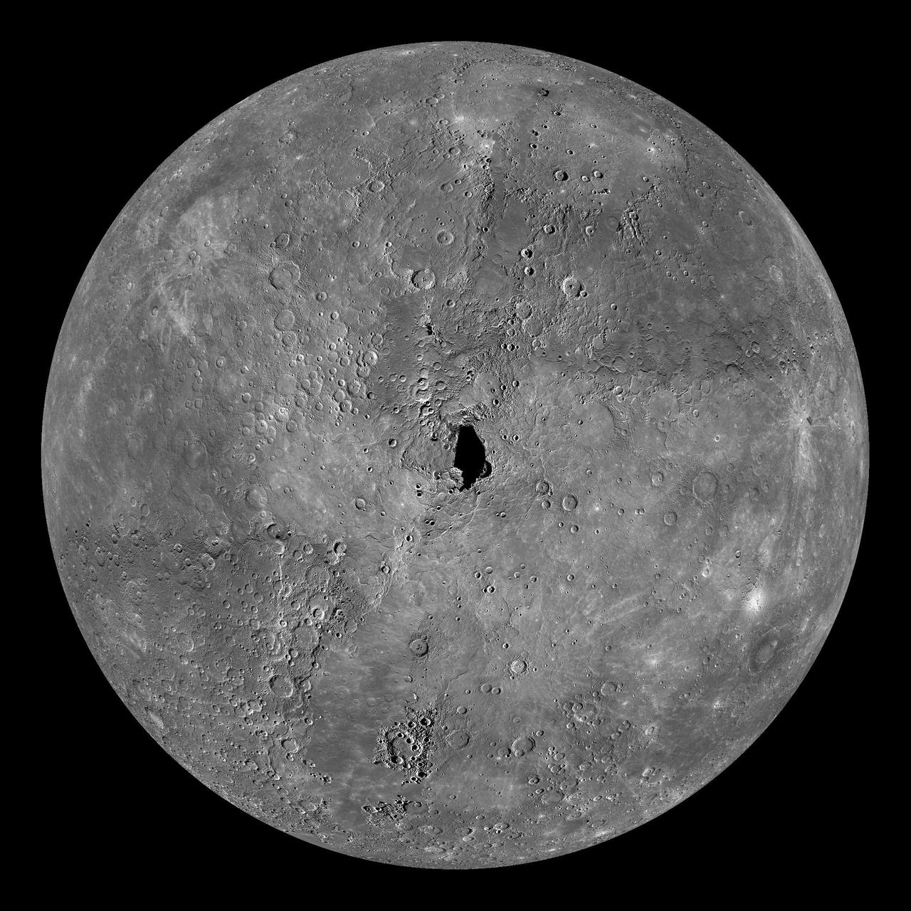
Mercury Globe: North Pole

Mercury Globe: South Pole
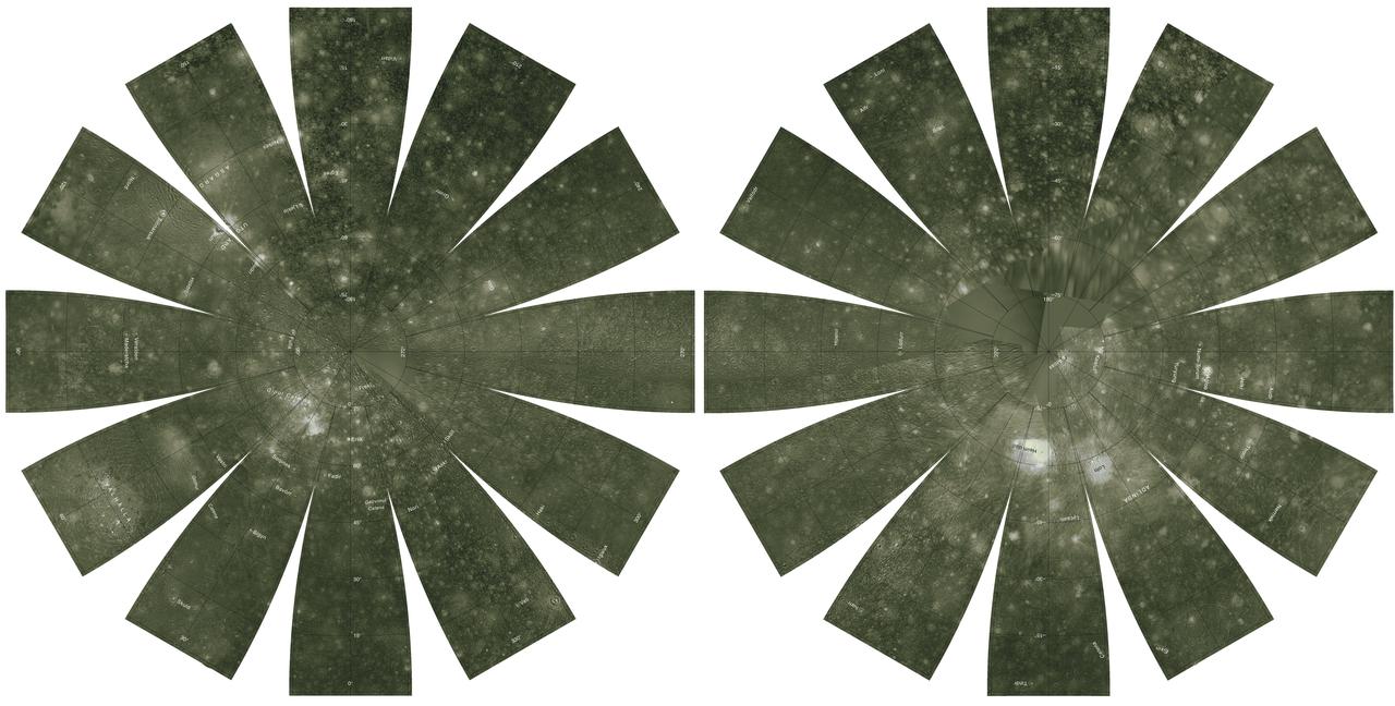
Callisto Hemispherical Globes
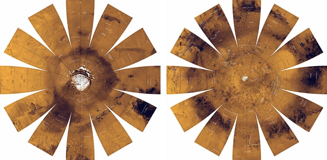
Mars Digital Image Mosaic Globe

Mercury Globe: 0°N, 180°E
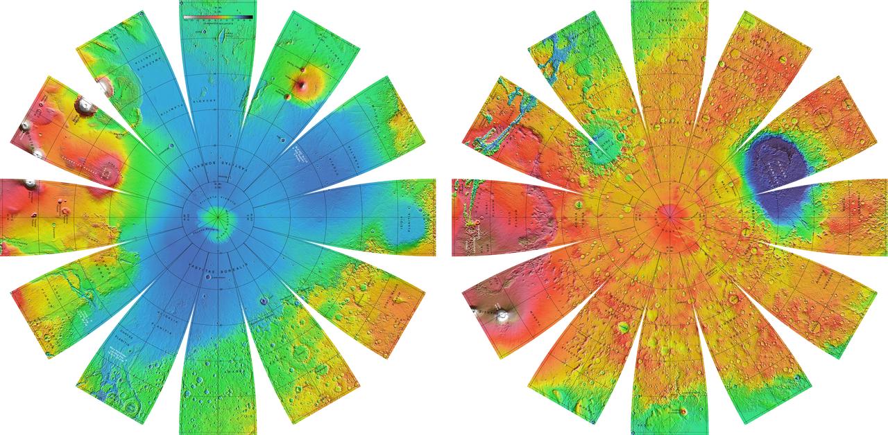
Mars Orbiter Laser Altimiter MOLA Globe

Mercury Globe: 0°N, 0°E

Mercury Globe: 0°N, 270°E

Mercury Globe: 0°N, 90°E
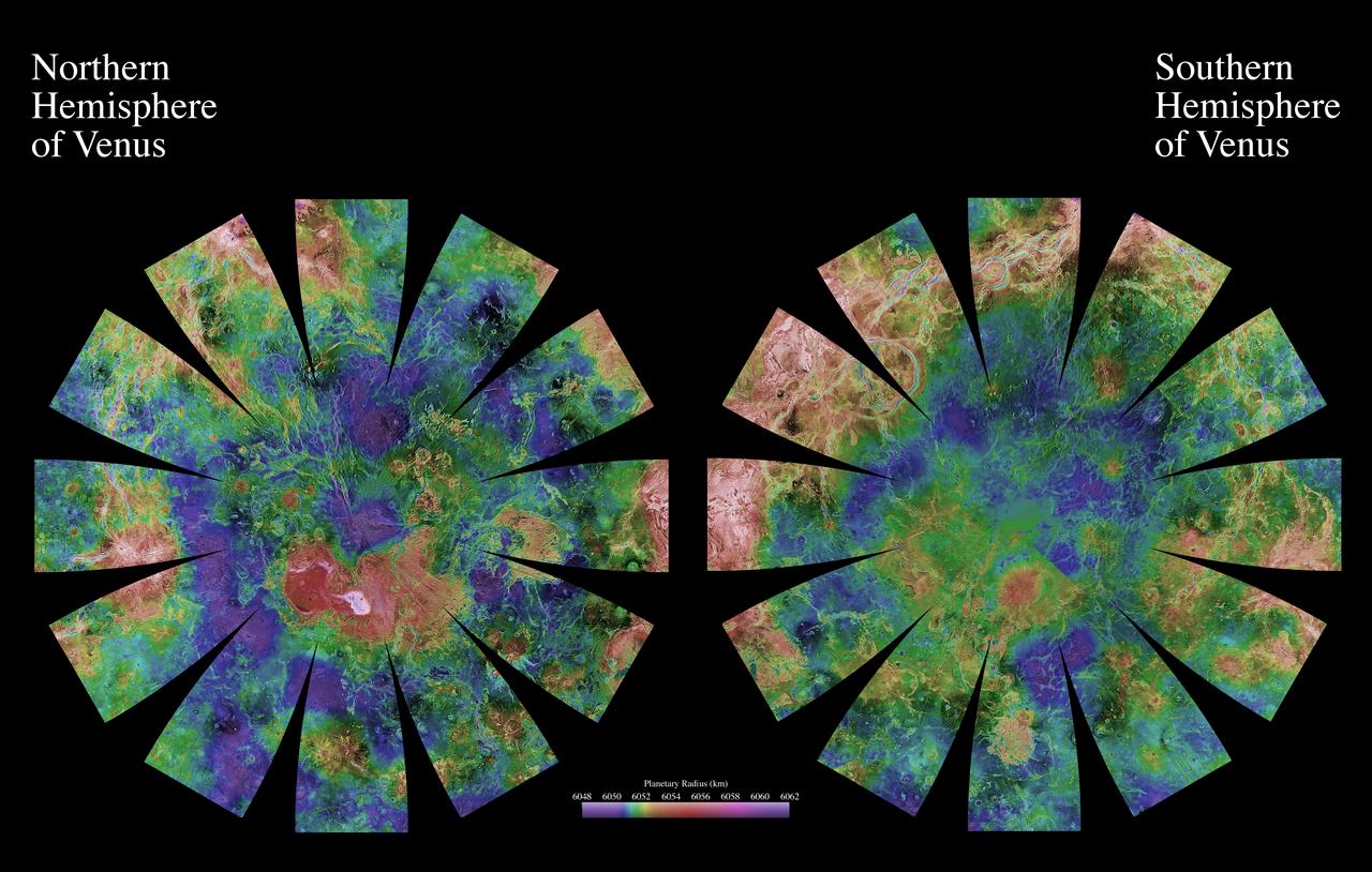
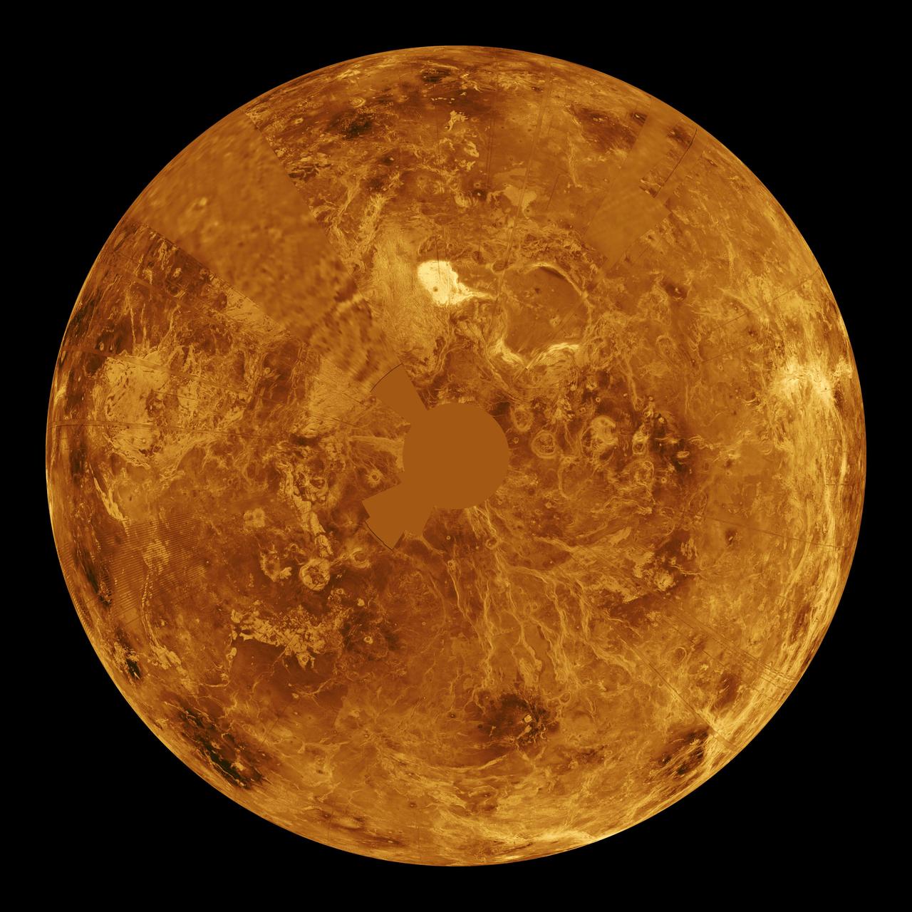
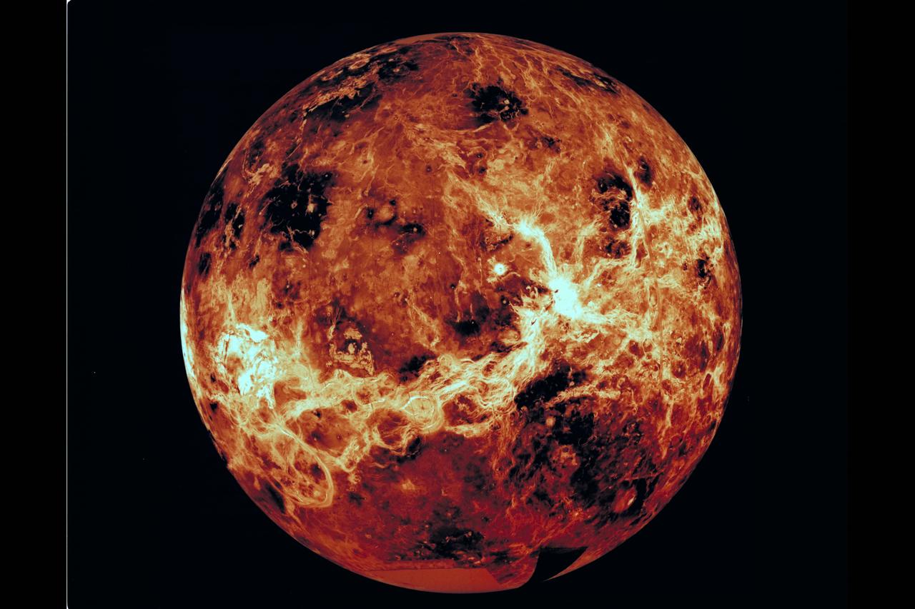
The images used for the base of this globe show the northern and southern hemispheres of Venus as revealed by more than a decade of radar investigations culminating in the 1990-1994 NASA Magellan mission.
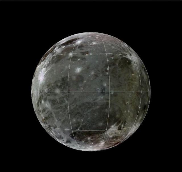
This is a frame from an animation of a rotating globe of Jupiter moon Ganymede, with a geologic map superimposed over a global color mosaic, incorporating the best available imagery from NASA Voyager 1 and 2 spacecraft, and Galileo spacecraft.
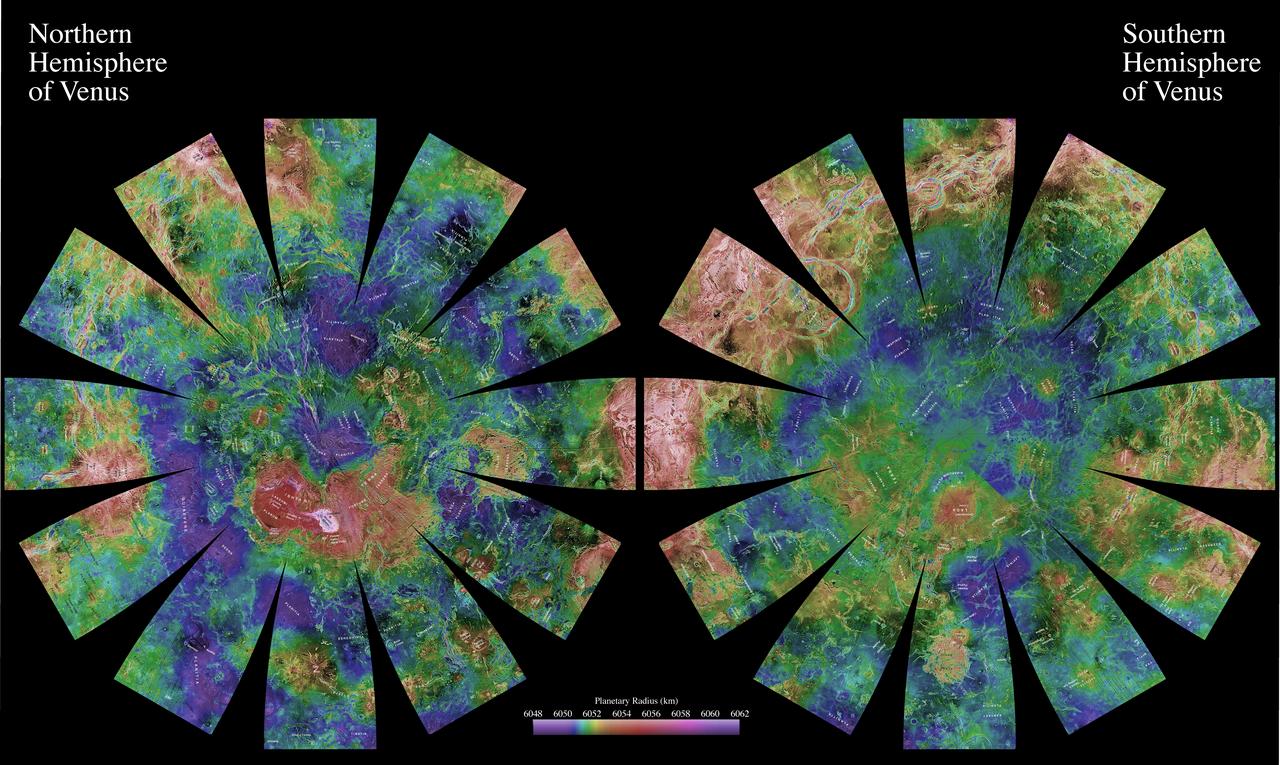
The images used for the base of this globe show the northern and southern hemispheres of Venus as revealed by more than a decade of radar investigations culminating in the 1990-1994 NASA Magellan mission.
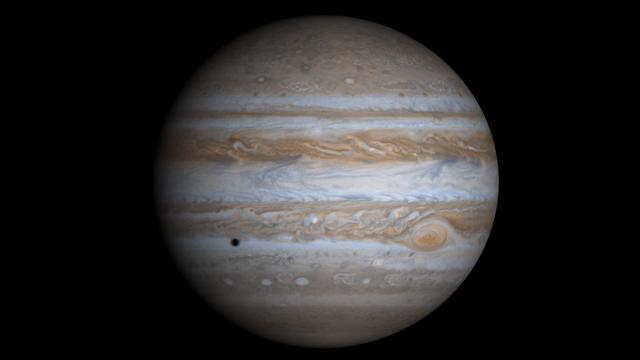
This true-color simulated view of Jupiter is composed of 4 images taken by NASA's Cassini spacecraft on December 7, 2000. To illustrate what Jupiter would have looked like if the cameras had a field-of-view large enough to capture the entire planet, the cylindrical map was projected onto a globe. The resolution is about 144 kilometers (89 miles) per pixel. Jupiter's moon Europa is casting the shadow on the planet. https://photojournal.jpl.nasa.gov/catalog/PIA02873
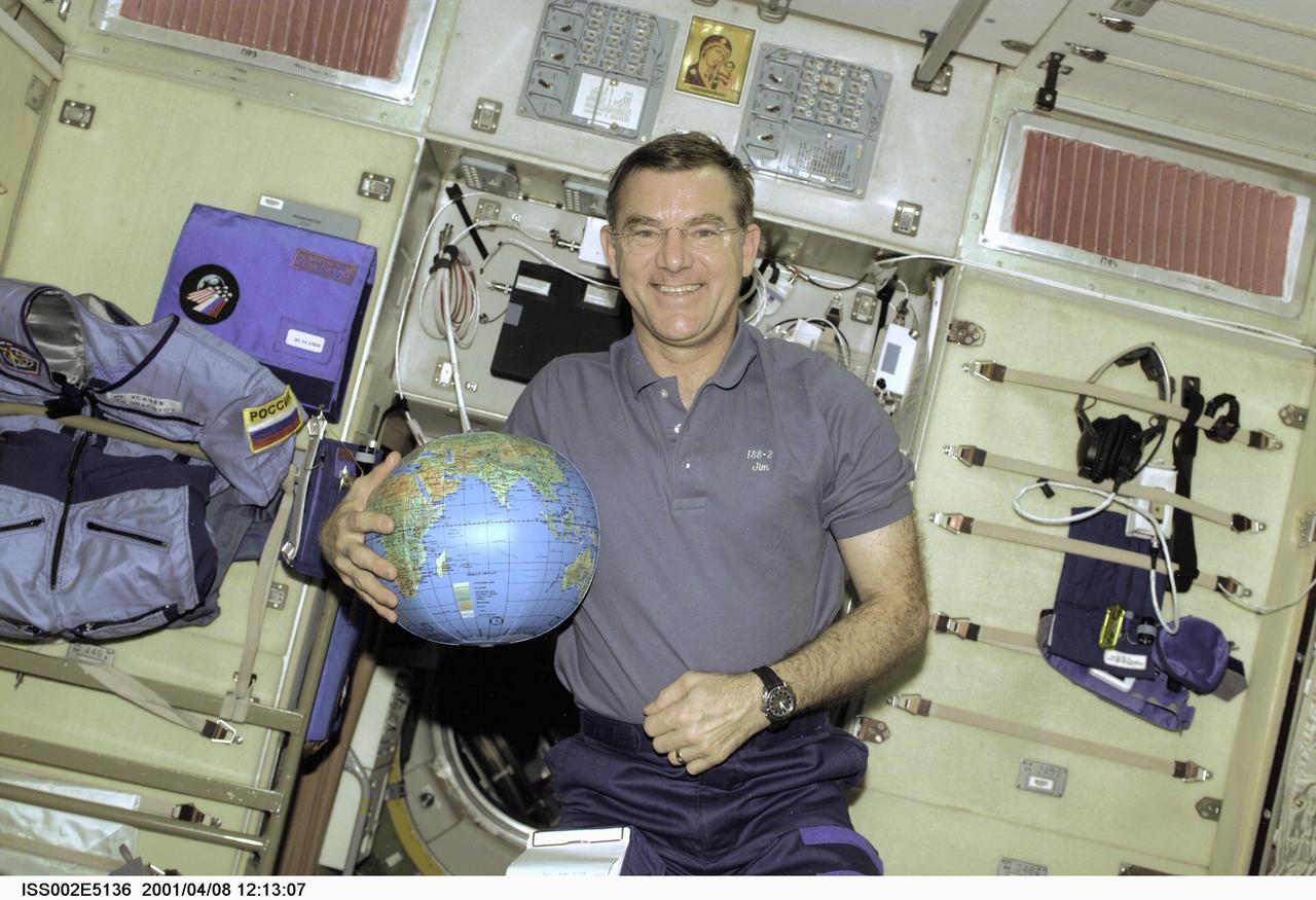
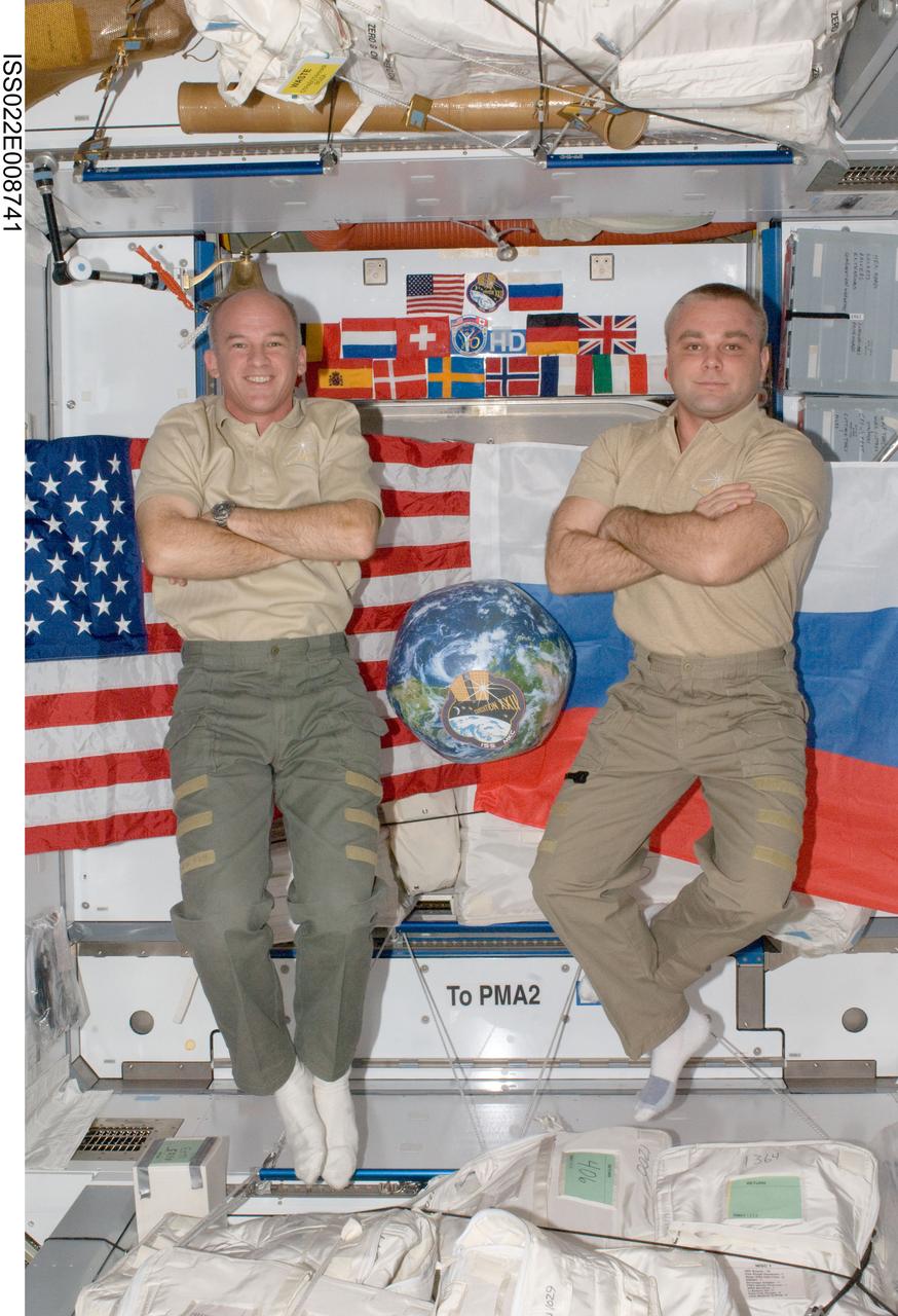
ISS002-E-5136 (8 April 2001) --- Astronaut James S. Voss, Expedition Two flight engineer, holds a globe to be used for assistance in Earth observation duties. Voss is in the Zvezda Service Module aboard the International Space Station (ISS), where's he been working for several weeks along with cosmonaut Yury V. Usachev of Rosaviakosmos and astronaut Susan J. Helms. The image was recorded with a digital still camera.

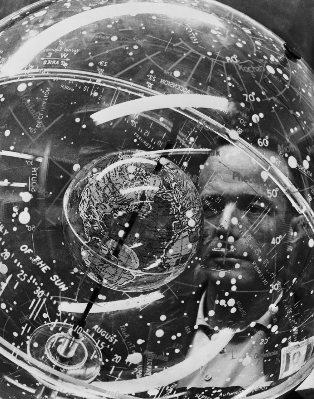
S61-04623 (1961) --- Astronaut John H. Glenn Jr. looks into a Celestial Training Device (globe) during training in the Aeromedical Laboratory at Cape Canaveral, Florida. Photo credit: NASA
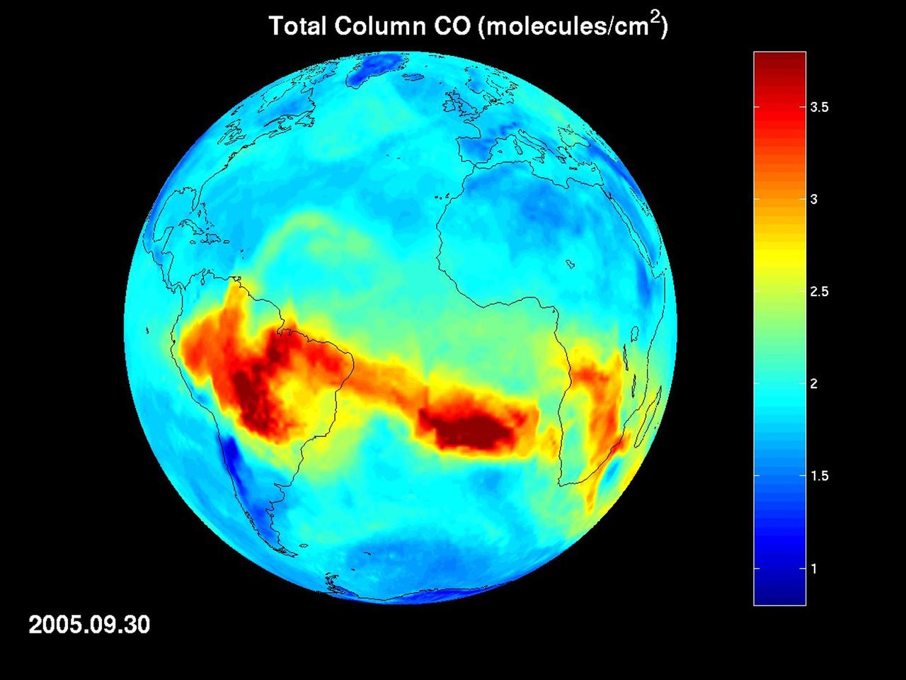
Map of carbon monoxide draped on globe: time Series from 8/1/2005 to 9/30/2005 from the Atmospheric Infrared Sounder AIRS on NASA Aqua satellite.
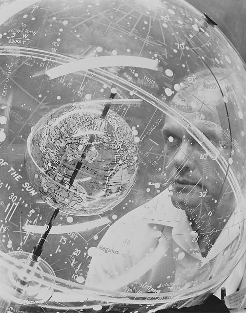
S61-04622 (1961) --- Mercury astronaut John H. Glenn Jr. looks into a Celestial Training Device (globe) during training in the Aeromedical Laboratory at Cape Canaveral, Florida. Photo credit: NASA

STS045-19-032 (24 March-2 April 1992) --- Astronaut Brian Duffy, STS-45 pilot, uses an inflatable globe to demonstrate Earth observations for an educational program to be distributed to classrooms following the mission.
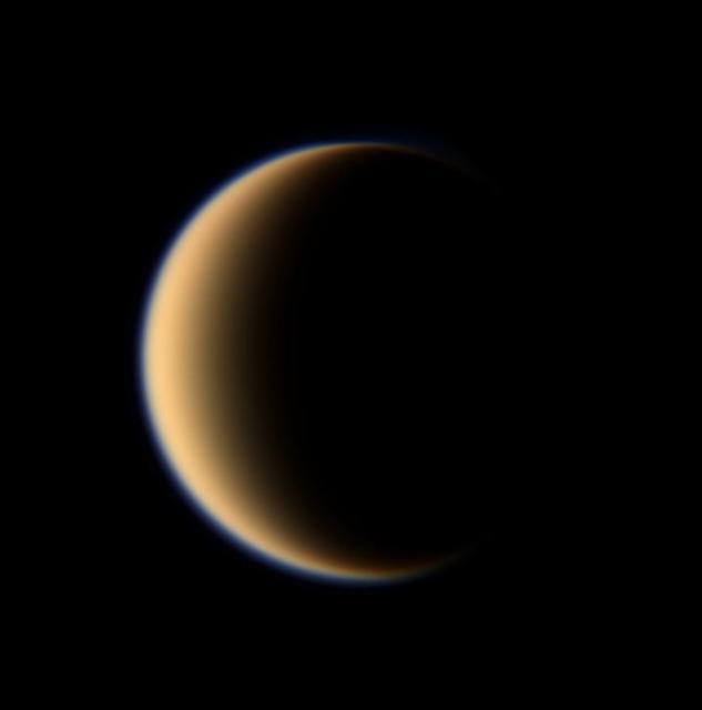
Titan hazy orange globe hangs before the Cassini spacecraft, partly illuminated -- a world with many mysteries yet to be uncovered.
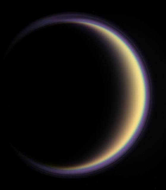
With its thick, distended atmosphere, Titan orange globe shines softly, encircled by a thin halo of purple light-scattering haze
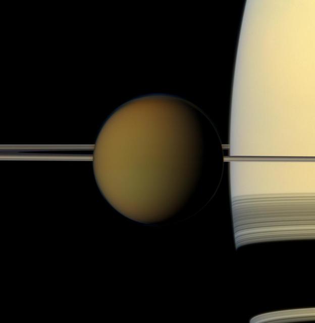
The colorful globe of Saturn largest moon, Titan, passes in front of the planet and its rings in this true color snapshot from NASA Cassini spacecraft.

Global images of Earth from NASA Galileo orbiter on December 11, 1999. In each frame, the continent of Antarctica is visible at the bottom of the globe.
Tethys floats before the massive, golden-hued globe of Saturn in this natural color view. The thin, dark line of the rings curves around the horizon at top
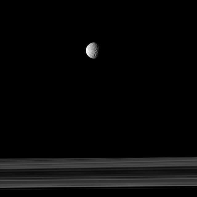
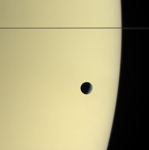
The cratered moon Mimas appears as if it has been hung like an ornament above Saturn rings in this image taken by NASA Cassini spacecraft.
S65-56185 (21 Oct. 1965) --- Gemini-6 astronauts Walter M. Schirra Jr. (left), command pilot; and Thomas P. Stafford, pilot, look at a star globe for celestial pattern recognition for their upcoming flight. The National Aeronautics and Space Administration (NASA) plans a two-day mission for Gemini-6 for the astronauts to develop the ability to rendezvous and dock with an orbiting Agena Target Docking Vehicle. Photo credit: NASA or National Aeronautics and Space Administration

EARTH GLOBE WITH BLUE GLOW
This single frame from a color movie of Jupiter from NASA Cassini spacecraft shows what it would look like to unpeel the entire globe of Jupiter, stretch it out on a wall into the form of a rectangular map.
Scientists produced new global maps of Jupiter using the Wide Field Camera 3 on NASA Hubble Space Telescope. One color map is shown here, projected onto a globe and as a flat image.
NASA MESSENGER shows the thin crescent of Mercury during approach forming the right portion of the globe and the fuller departure view showing Caloris basin forming the left side and majority of the view.
Saturn rings cut across an eerie scene that is ruled by Titan luminous crescent and globe-encircling haze, broken by the small moon Enceladus, whose icy jets are dimly visible at its south pole. North is up
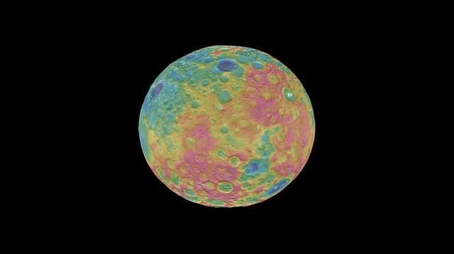
This frame from an animation shows a color-coded map from NASA Dawn mission revealing the highs and lows of topography on the surface of dwarf planet Ceres. The color scale extends 3.7 miles (6 kilometers) below the surface in purple to 3.7 miles (6 kilometers) above the surface in brown. The brightest features (those appearing nearly white) -- including the well-known bright spots within a crater in the northern hemisphere -- are simply reflective areas, and do not represent elevation. The topographic map was constructed from analyzing images from Dawn's framing camera taken from varying sun and viewing angles. The map was combined with an image mosaic of Ceres and projected onto a 3-D shape model of the dwarf planet to create the animation. http://photojournal.jpl.nasa.gov/catalog/PIA19605
This global view of the surface of Venus is centered at 0 degrees east longitude. NASA Magellan synthetic aperture radar mosaics from the first cycle of Magellan mapping were mapped onto a computer-simulated globe to create this image. http://photojournal.jpl.nasa.gov/catalog/PIA00257
The northern hemisphere is displayed in this global view of the surface of Venus. NASA Magellan synthetic aperture radar mosaics from the first cycle of Magellan mapping were mapped onto a computer-simulated globe to create this image. http://photojournal.jpl.nasa.gov/catalog/PIA00252
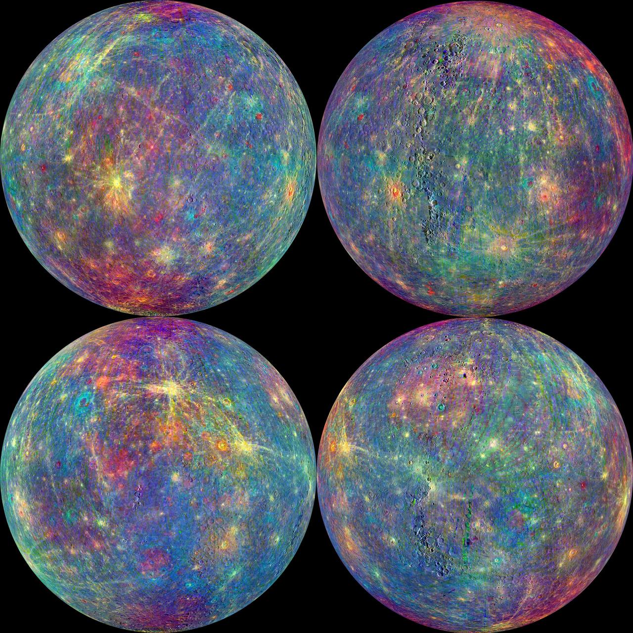
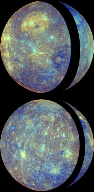
The MASCS instrument onboard NASA MESSENGER spacecraft was designed to study both the exosphere and surface of Mercury. To learn more about the minerals and surface processes on Mercury, the Visual and Infrared Spectrometer (VIRS) portion of MASCS has been diligently collecting single tracks of spectral surface measurements since MESSENGER entered orbit. The track coverage is now extensive enough that the spectral properties of both broad terrains and small, distinct features such as pyroclastic vents and fresh craters can be studied. To accentuate the geological context of the spectral measurements, the MASCS data have been overlain on the MDIS monochrome mosaic. Click on the image to explore the colorful diversity of surface materials in more detail! Instrument: Mercury Atmosphere and Surface Composition Spectrometer (MASCS) Map Projection: Orthographic VIRS Color Composite Wavelengths: 575 nm as red, 415 nm/750 nm as green, 310 nm/390 nm as blue Center Latitude (All Globes): 0° Center Longitude (Top Left Globe): 270° E Center Longitude (Top Right Globe): 0° E Center Longitude (Bottom Left Globe): 90° E Center Longitude (Bottom Right Globe): 180° E http://photojournal.jpl.nasa.gov/catalog/PIA19419

S65-42454 (February 1962) --- Mercury astronaut John H. Glenn, Jr. inside the Mercury Atlas 6 (MA-6) during training at Cape Canaveral, Florida.
S62-00992 (1961) --- Mercury astronaut John Glenn looks into a Celestial Training Device (globe) during training in the Aeromedical Laboratory at Cape Canaveral, Florida.
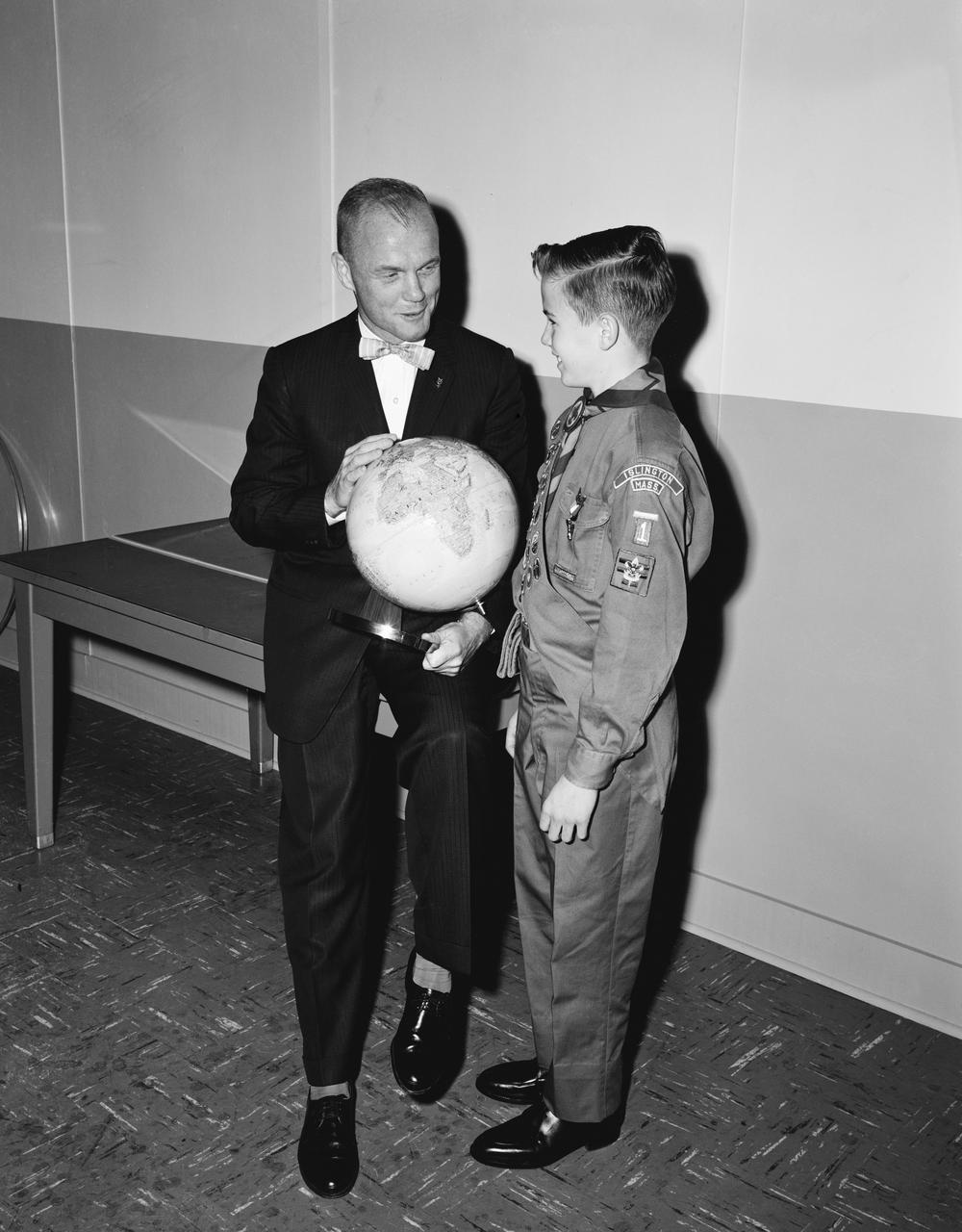
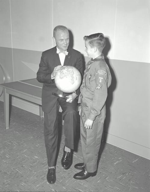
S62-00492 (1962) --- Astronaut John H. Glenn Jr. points out an area on the globe to a Boy Scout. Photo credit: NASA

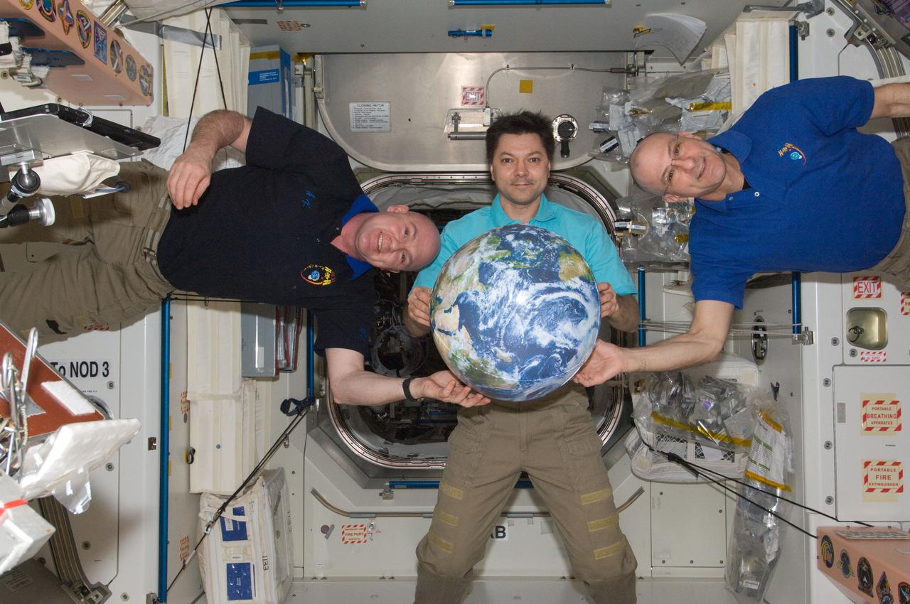
ISS022-E-100390 (17 March 2010) --- NASA astronaut Jeffrey Williams, Expedition 22 commander, poses for a photo near a globe floating freely in the Destiny laboratory of the International Space Station.
S61-04621 (1961) --- Astronaut M. Scott Carpenter looks into a Celestial Training Device (globe) during training in the Aeromedical Laboratory at Cape Canaveral, Florida. Photo credit: NASA
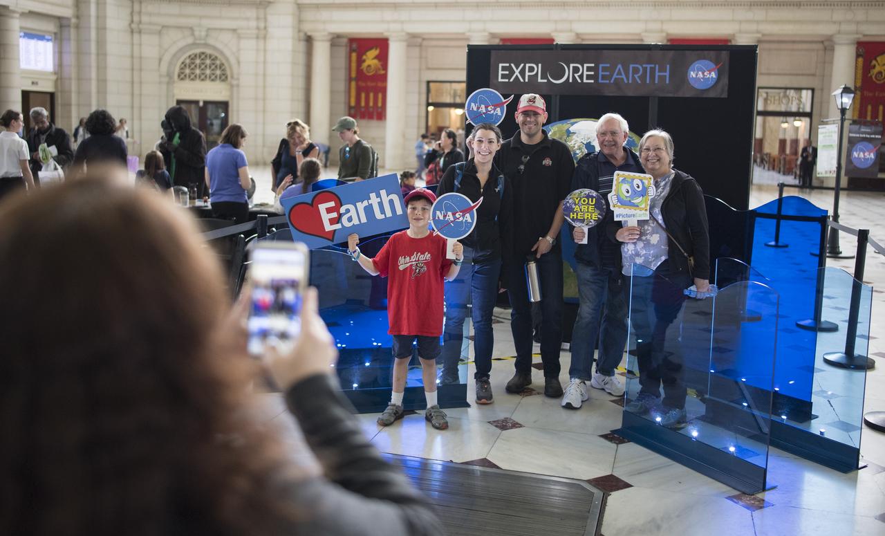
Visitors to NASA's exhibits at the Earth Day event take a picture with a globe, Monday, April 22, 2019, at Union Station in Washington, D.C. Photo Credit: (NASA/Joel Kowsky)
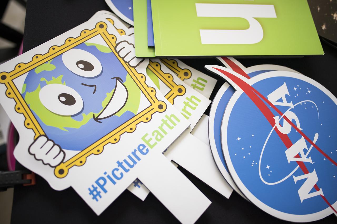
Signs that can be held up in a picture with a large globe are seen on a table at NASA's Earth Day event on Monday, April 22, 2019, at Union Station in Washington, D.C. Photo Credit: (NASA/Joel Kowsky)
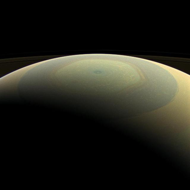
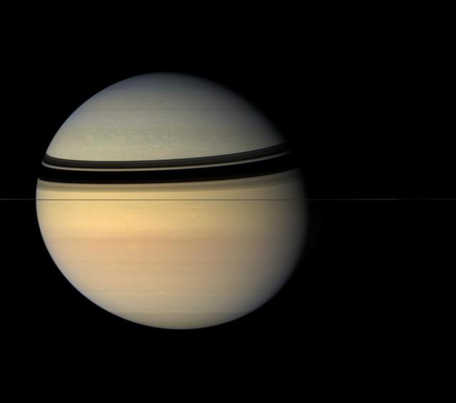
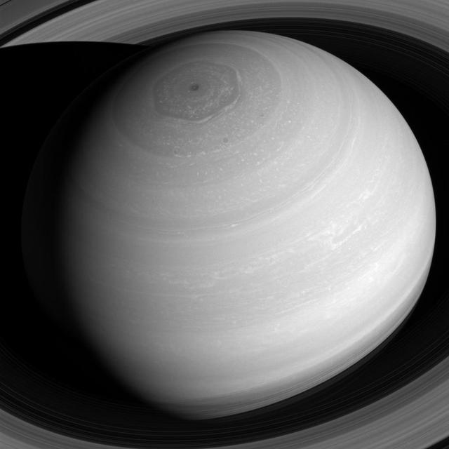
The globe of Saturn, seen here in natural color, is reminiscent of a holiday ornament in this wide-angle view from NASA's Cassini spacecraft. The characteristic hexagonal shape of Saturn's northern jet stream, somewhat yellow here, is visible. At the pole lies a Saturnian version of a high-speed hurricane, eye and all. This view is centered on terrain at 75 degrees north latitude, 120 degrees west longitude. Images taken using red, green and blue spectral filters were combined to create this natural-color view. The images were taken with the Cassini spacecraft wide-angle camera on July 22, 2013. This view was acquired at a distance of approximately 611,000 miles (984,000 kilometers) from Saturn. Image scale is 51 miles (82 kilometers) per pixel. http://photojournal.jpl.nasa.gov/catalog/PIA17175

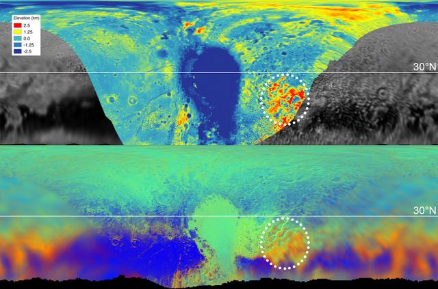
The annotated area of Mars in this illustration holds near-surface water ice that would be easily accessible for astronauts to dig up. The water ice was identified as part of a map using data from NASA orbiters. Animation available at https://photojournal.jpl.nasa.gov/catalog/PIA23515

NASA's Earth Surface Mineral Dust Source Investigation (EMIT) detected a cluster of 12 methane plumes on Sept. 1, 2022, in an approximately 150-square-mile (400-square-kilometer) region of southern Uzbekistan. Methane is a potent greenhouse gas about 80 times more effective at trapping heat than carbon dioxide during the time methane spends in the atmosphere, which is typically about a decade. This an area no NASA airborne imaging spectrometers have covered. Whereas EMIT captured the scene in an instant, an airborne campaign might have taken about 65 hours of flight time to cover the same amount of land. The blue shading covers the area captured by EMIT in one "scene," which is 50 miles by 50 miles (80 kilometers by 80 kilometers). The emissions total about 49,734 pounds (22,559 kilograms) per hour. EMIT uses an imaging spectrometer to detect the unique pattern of reflected and absorbed light – called a spectral fingerprint – from various materials on Earth's surface and in its atmosphere. Perched on the International Space Station, EMIT was originally intended to map the prevalence of minerals in Earth's arid regions, such as the deserts of Africa and Australia. Scientists verified that EMIT could also detect methane and carbon dioxide when they were checking the accuracy of the image spectrometer's mineral data. EMIT was selected from the Earth Venture Instrument-4 solicitation under the Earth Science Division of NASA Science Mission Directorate and was developed at NASA's Jet Propulsion Laboratory, which is managed for the agency by Caltech in Pasadena, California. It launched aboard a SpaceX Dragon resupply spacecraft from NASA's Kennedy Space Center in Florida on July 14, 2022. The instrument's data will be delivered to the NASA Land Processes Distributed Active Archive Center (DAAC) for use by other researchers and the public. https://photojournal.jpl.nasa.gov/catalog/PIA26113

These images of the world were generated with data from the Shuttle Radar Topography Mission (SRTM). The SRTM Project has recently released a new global data set called SRTM30, where the original one arcsecond of latitude and longitude resolution (about 30 meters, or 98 feet, at the equator) was reduced to 30 arcseconds (about 928 meters, or 1496 feet.) These images were created from that data set and show the Earth as it would be viewed from a point in space centered over the Americas, Africa and the western Pacific. Two visualization methods were combined to produce the image: shading and color coding of topographic height. The shade image was derived by computing topographic slope in the northwest-southeast direction, so that northwest slopes appear bright and southeast slopes appear dark. Color coding is directly related to topographic height, with green at the lower elevations, rising through yellow and tan, to white at the highest elevations. Elevation data used in this image were acquired by the Shuttle Radar Topography Mission aboard the Space Shuttle Endeavour, launched on Feb. 11, 2000. http://photojournal.jpl.nasa.gov/catalog/PIA03394
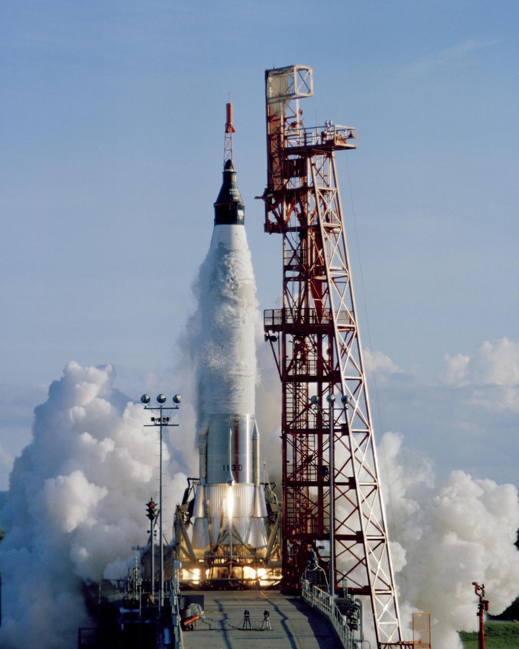
CAPE CANAVERAL, Fla. -- An Atlas launch vehicle lifts off with the Mercury spacecraft Sigma 7 atop with astronaut Walter M. Schirra Jr. aboard. The fifth American into space and the third to orbit the Earth plans to circle the globe six time prior to a planned splashdown in the Pacific Ocean. Photo Credit: NASA
ISS031-E-084657 (15 May 2012) --- Russian cosmonaut Oleg Kononenko (center), Expedition 31 commander; along with European Space Agency astronaut Andre Kuipers (left) and NASA astronaut Don Pettit, both flight engineers, pose for a photo near a globe floating freely in the Unity node of the International Space Station.

In the Operations and Checkout Building, a smiling STS-99 Mission Specialist Janice Voss holds an inflated map globe of the stars after donning her launch and entry suit during final launch preparations. The globe is being signed by the entire crew as a gift for Delores Abraham, with Crew Quarters. STS-99, known as the Shuttle Radar Topography Mission (SRTM), is scheduled for liftoff at 12:30 p.m. EST from Launch Pad 39A. The SRTM will chart a new course to produce unrivaled 3-D images of the Earth's surface. The result of the Shuttle Radar Topography Mission could be close to 1 trillion measurements of the Earth's topography. The mission is expected to last 11days, with Endeavour landing at KSC Tuesday, Feb. 22, at 4:36 p.m. EST. This is the 97th Shuttle flight and 14th for Shuttle Endeavour
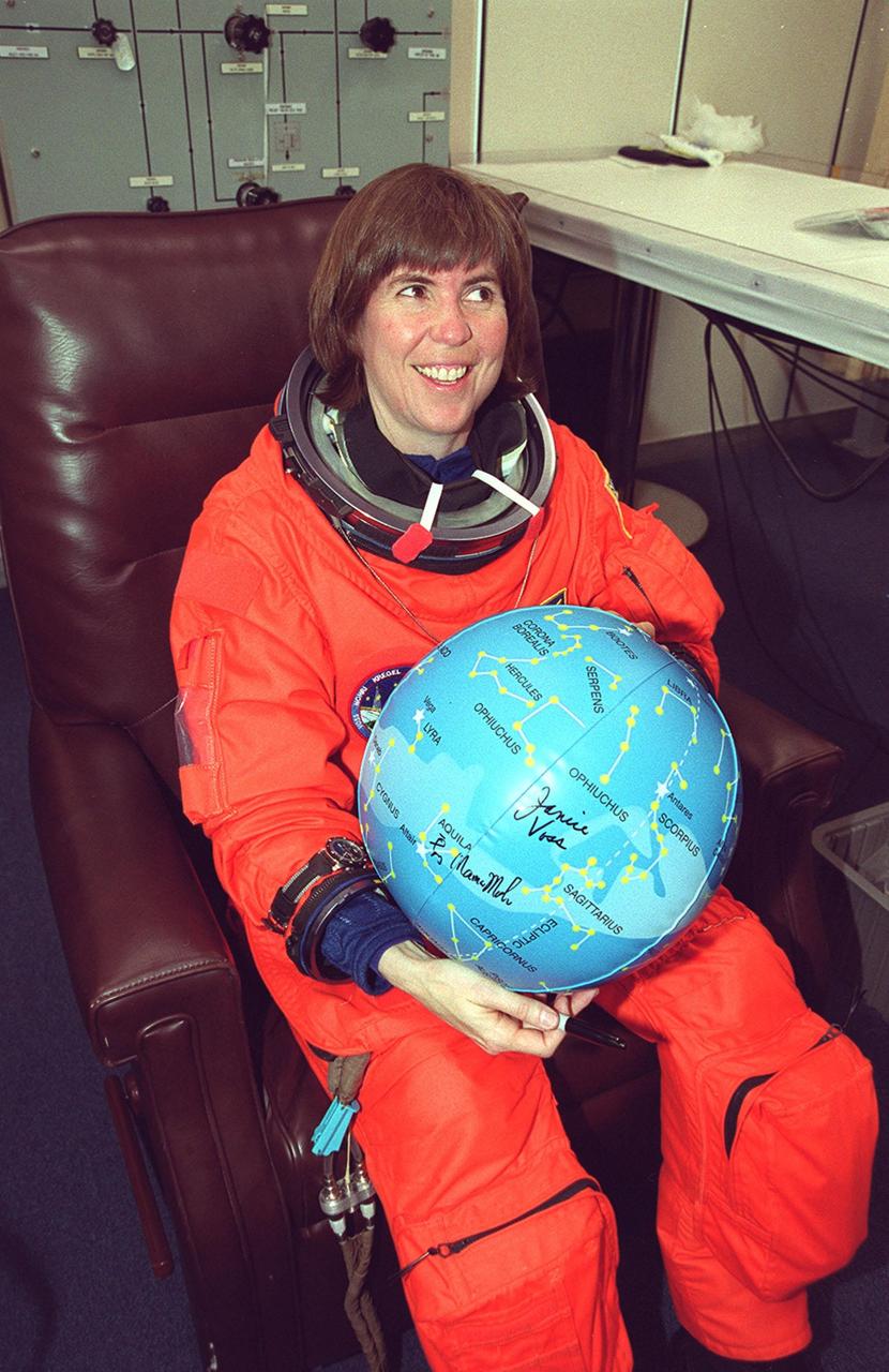
In the Operations and Checkout Building, a smiling STS-99 Mission Specialist Janice Voss holds an inflated map globe of the stars after donning her launch and entry suit during final launch preparations. The globe is being signed by the entire crew as a gift for Delores Abraham, with Crew Quarters. STS-99, known as the Shuttle Radar Topography Mission (SRTM), is scheduled for liftoff at 12:30 p.m. EST from Launch Pad 39A. The SRTM will chart a new course to produce unrivaled 3-D images of the Earth's surface. The result of the Shuttle Radar Topography Mission could be close to 1 trillion measurements of the Earth's topography. The mission is expected to last 11days, with Endeavour landing at KSC Tuesday, Feb. 22, at 4:36 p.m. EST. This is the 97th Shuttle flight and 14th for Shuttle Endeavour
During a prelaunch briefing at Vandenberg Air Force Base in California, Philippe Lognonne, SEIS Investigation Lead at Institut de Physique du Globe de Paris, speaks to members of the media. The presentation focused on NASA's Interior Exploration using Seismic Investigations, Geodesy and Heat Transport, or InSight, Mars lander. InSight is scheduled for liftoff May 5, 2018, atop a United Launch Alliance (ULA) Atlas V rocket from Space Launch Complex 3 at Vandenberg. The spacecraft will be the first mission to look deep beneath the Martian surface studying the planet's interior by measuring its heat output and listen for marsquakes.
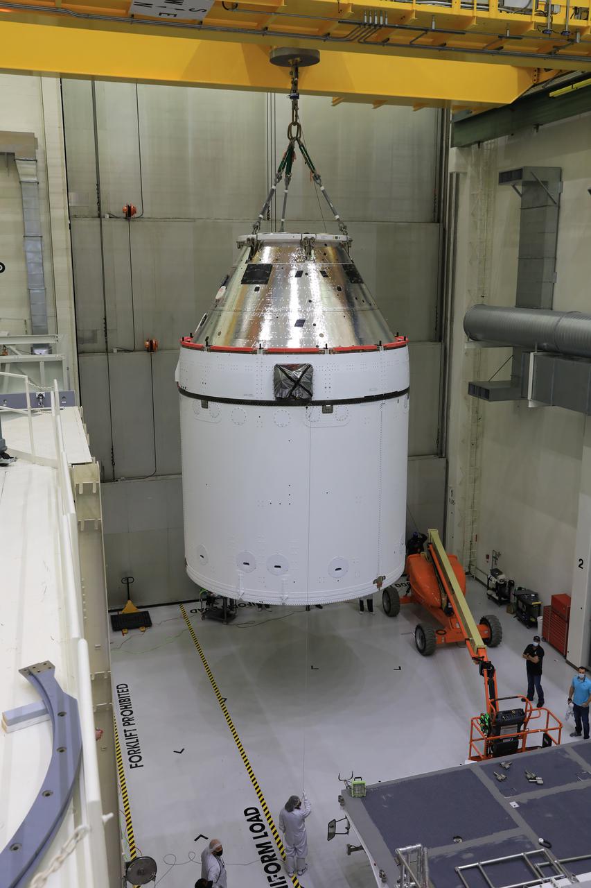
Orion is revealed for one of the final times on Jan. 14, as it is lowered by crane onto its transport pallet inside the Neil Armstrong Operations and Checkout Building at NASA’s Kennedy Space Center in Florida, along its path to the pad ahead of the Artemis I launch. Teams across the globe have worked tirelessly to assemble the spacecraft which will receive a protective covering prior to departing for the Multi-Payload Processing Facility to begin ground processing by the Exploration Ground Systems and Jacobs teams.
These maps are from New Horizons' data on the topography (top) and composition (bottom) of Pluto's surface. In the high-resolution topographical map, the highlighted red region is high in elevation. The map below, showing the composition, indicates the same section also contains methane, color-coded in orange. One can see the orange features spread into the fuzzier, lower-resolution data that covers the rest of the globe, meaning those areas, too, are high in methane, and therefore likely to be high in elevation. https://photojournal.jpl.nasa.gov/catalog/PIA22036
This global view of the surface of Venus is centered at 180 degrees east longitude. Magellan synthetic aperture radar mosaics from the first cycle of Magellan mapping, and a 5 degree latitude-longitude grid, are mapped onto a computer-simulated globe to create this image. Data gaps are filled with Pioneer-Venus Orbiter data, or a constant mid-range value. The image was produced by the Solar System Visualization project and the Magellan Science team at the JPL Multimission Image Processing Laboratory. http://photojournal.jpl.nasa.gov/catalog/PIA00478
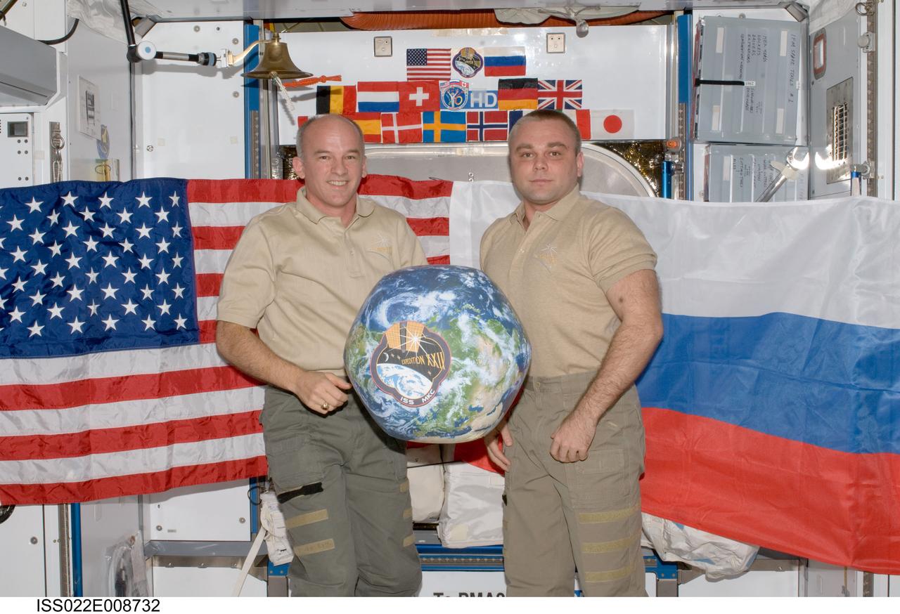
ISS022-E-008732 (13 Dec. 2009) --- NASA astronaut Jeffrey Williams (left), Expedition 22 commander; and Russian cosmonaut Maxim Suraev, flight engineer, hold a globe with the Expedition 22 logo during a segment of Rusalka video footage as part of Suraev?s "Live on ISS" program for the Russian Channel TVTs, via US assets (S-band & Ku-band). The event took place in the Harmony node of the International Space Station.
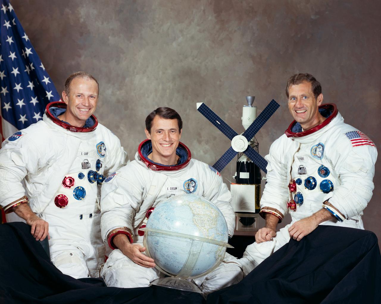
S73-33206 (August 1973) --- These three men are the prime crew for the Skylab 4 mission. Pictured in their Skylab spacesuits with a globe and a model of the Skylab space station are, left to right, astronaut Gerald P. Carr, commander; scientist-astronaut Edward G. Gibson, science pilot; and astronaut William R. Pogue, pilot. Photo credit: NASA

The ASTER instrument has been acquiring images since 2000. Currently the archive contains over 3.7 million images, including day and night thermal infrared data, and stereo pairs of the entire land surface of the Earth. This mosaic was created from thumbnail browse images, using bands 3, 2 and 1 displayed in red, green, and blue, respectively. The mosaic was also warped onto a spinning globe. https://photojournal.jpl.nasa.gov/catalog/PIA22979
Orion is revealed for one of the final times on Jan. 14, as it is moved by crane to its transport pallet inside the Neil Armstrong Operations and Checkout Building at NASA’s Kennedy Space Center in Florida, along its path to the pad ahead of the Artemis I launch. Teams across the globe have worked tirelessly to assemble the spacecraft which will receive a protective covering prior to departing for the Multi-Payload Processing Facility to begin ground processing by the Exploration Ground Systems and Jacobs teams.

Orion is revealed for one of the final times on Jan. 14, as it is moved by crane to its transport pallet inside the Neil Armstrong Operations and Checkout Building at NASA’s Kennedy Space Center in Florida, along its path to the pad ahead of the Artemis I launch. Teams across the globe have worked tirelessly to assemble the spacecraft, which will receive a protective covering prior to departing for the Multi-Payload Processing Facility to begin ground processing by the Exploration Ground Systems and Jacobs teams.
This global view of the surface of Venus is centered at 270 degrees east longitude. Magellan synthetic aperture radar mosaics from the first cycle of Magellan mapping are mapped onto a computer-simulated globe to create this image. Data gaps are filled with Pioneer-Venus orbiter data, or a constant mid-range value. Simulated color is used to inhance small-scale structure. The simulated hues are based on color images recorded by the Soviet Venera 13 and 14 spacecraft.

Orion is revealed for one of the final times on Jan. 14, as it is readied atop its transport pallet from the Neil Armstrong Operations and Checkout Building at NASA’s Kennedy Space Center in Florida, along its path to the pad ahead of the Artemis I launch. Teams across the globe have worked tirelessly to assemble the spacecraft which will receive a protective covering prior to departing for the Multi-Payload Processing Facility to begin ground processing by the Exploration Ground Systems and Jacobs teams.
Students of Xavier University Preparatory School in New Orleans watch clouds shift across the globe in near-real time on 'Science on a Sphere' during a recent visit to StenniSphere, the visitor center at NASA's John C. Stennis Space Center. Four projectors work in sync with the suspended sphere to create a revolving display of a planet's atmosphere, oceans and land; to show documentary movies; or to project models of climate change using satellite data. Pictured are students (l to r) Ashante Snowton, Robriane Larry, Zhane Farbe and Ebony Johnson.
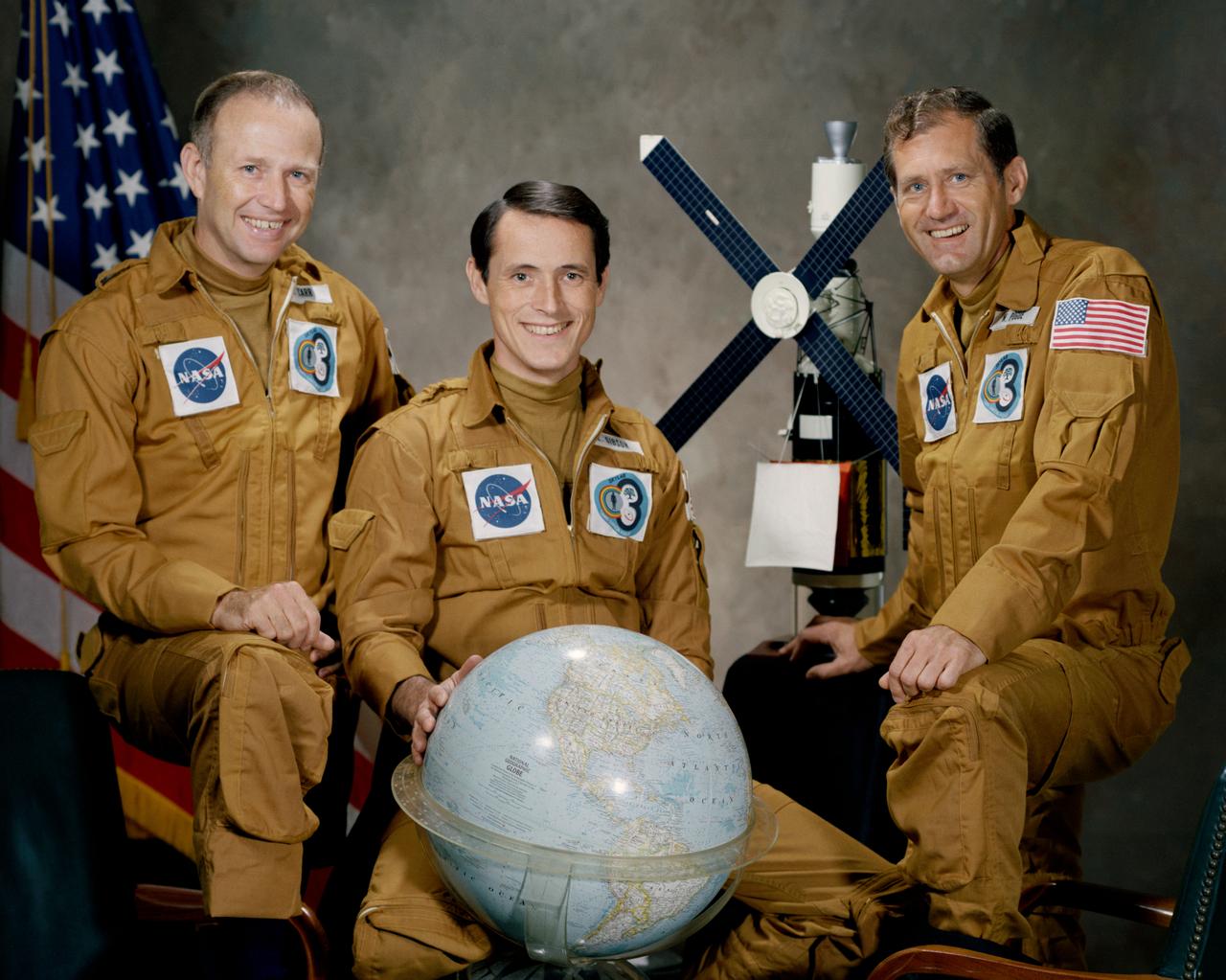
S73-33207 (August 1973) --- These three men are the prime crew for the Skylab 4 mission. Pictured in their Skylab spacesuits with a globe and a model of the Skylab space station are, left to right, astronaut Gerald P. Carr, commander; scientist-astronaut Edward G. Gibson, science pilot; and astronaut William R. Pogue, pilot. Photo credit: NASA
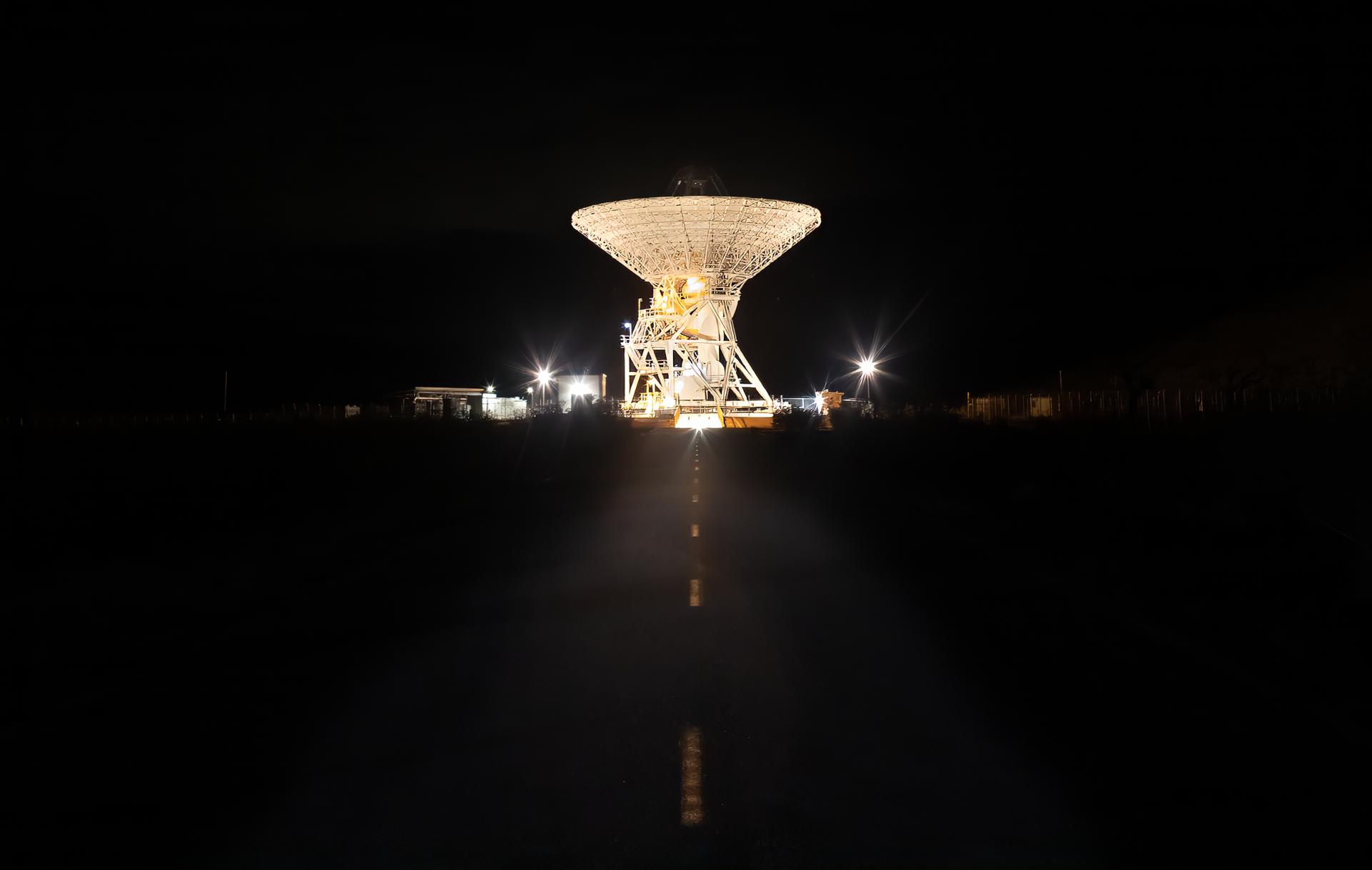
A 112-foot (34-meter) antenna glows from within a nighttime scene at the Goldstone Deep Space Communications Complex near Barstow, California, in September 2025. Goldstone is part of NASA’s Deep Space Network (DSN), which operates three complexes around the globe that support communications with dozens of deep space missions. For more information about the DSN, visit: https://www.nasa.gov/communicating-with-missions/dsn/
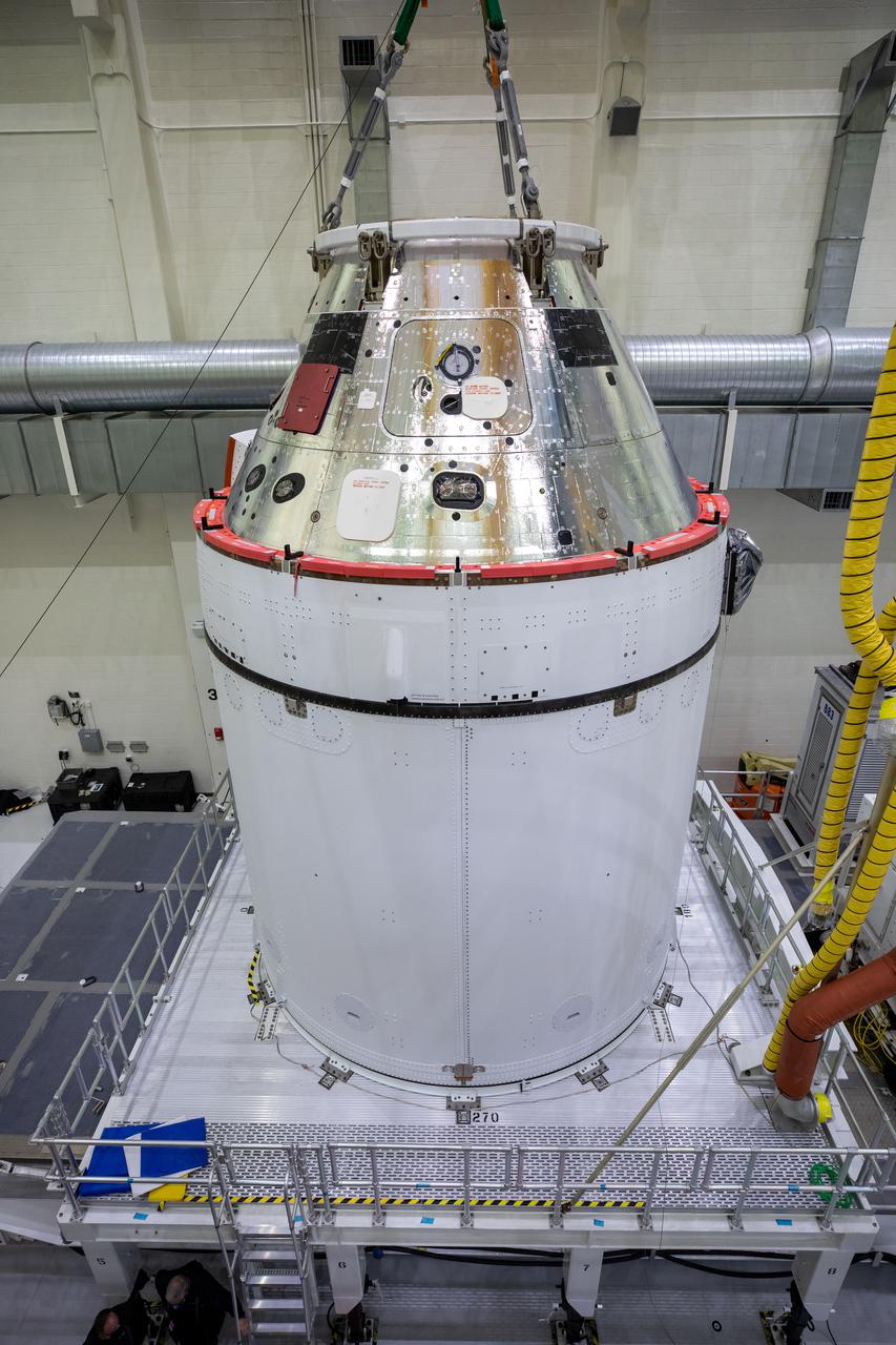
Orion is revealed for one of the final times on Jan. 14, as it is readied atop its transport pallet from the Neil Armstrong Operations and Checkout Building at NASA’s Kennedy Space Center in Florida, along its path to the pad ahead of the Artemis I launch. Teams across the globe have worked tirelessly to assemble the spacecraft, which will receive a protective covering prior to departing for the Multi-Payload Processing Facility to begin ground processing by the Exploration Ground Systems and Jacobs teams.
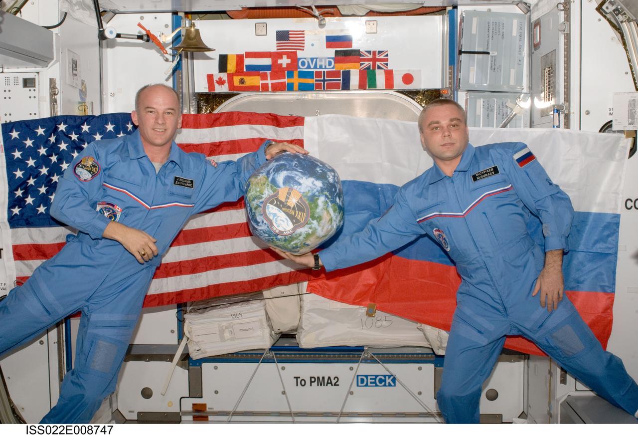
ISS022-E-008747 (13 Dec. 2009) --- NASA astronaut Jeffrey Williams (left), Expedition 22 commander; and Russian cosmonaut Maxim Suraev, flight engineer, hold a globe with the Expedition 22 logo during a segment of Rusalka video footage as part of Suraev’s "Live on ISS" program for the Russian Channel TVTs, via US assets (S-band & Ku-band). The event took place in the Harmony node of the International Space Station.
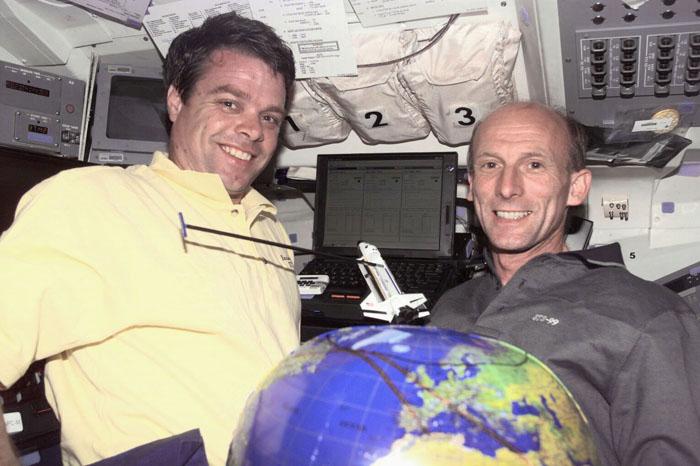
S99-E-5259 (13 February 2000) --- Astronauts Kevin R. Kregel (left), mission commander, and Gerhard P.J. Thiele demonstrate mapping techniques for the Space Radar Topography Mission (SRTM) using a payload-equipped model and a globe on Endeavour's flight deck. The two are joined by astronaut Janet L. Kavandi, mission specialist, on the SRTM's Red Team. Thiele is a mission specialist representing the European Space Agency (ESA).
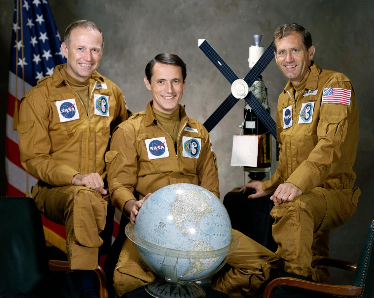
S73-33208 (August 1973) --- These three men are the prime crewmen for the Skylab 4 mission. Pictured in their flight suits with a globe and a model of the Skylab space station are, left to right, astronaut Gerald P. Carr, commander; scientist-astronaut Edward G. Gibson, science pilot; and astronaut William R. Pogue, pilot. Photo credit: NASA
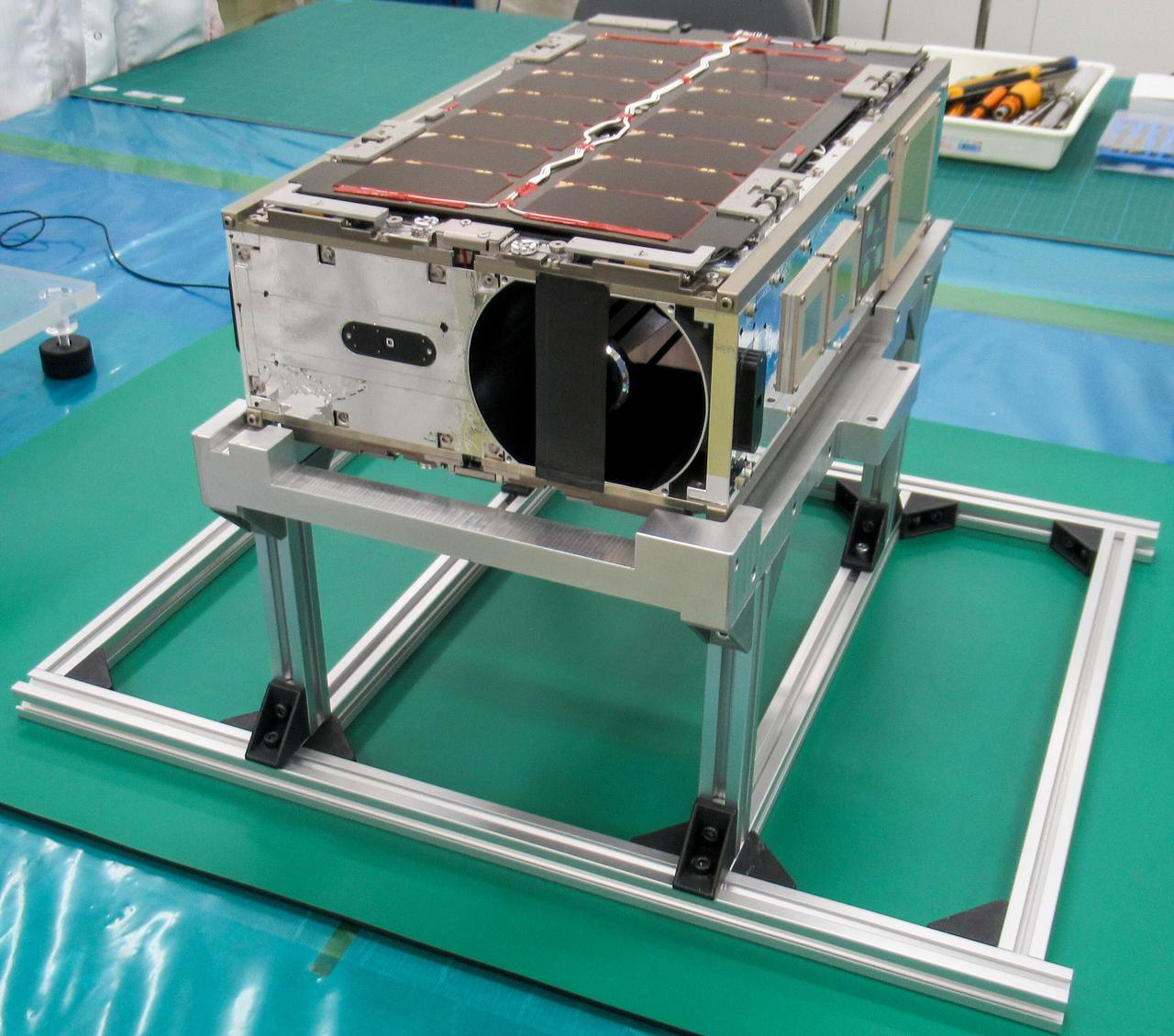
jsc2024e081750 (12/17/2024) --- ONboard Globe-Looking And Imaging Satellite (ONGLAISAT) is a 6U size CubeSat aiming for high signal-to-noise ratio image capture using Time Delay Integration (TDI) technology as its mission. ONGLAISAT is deployed from the International Space Station as part of the JEM Small Satellite Orbital Deployer-30 (J-SSOD-30) CubeSat deployment mission. Image courtesy of Space BD Inc.
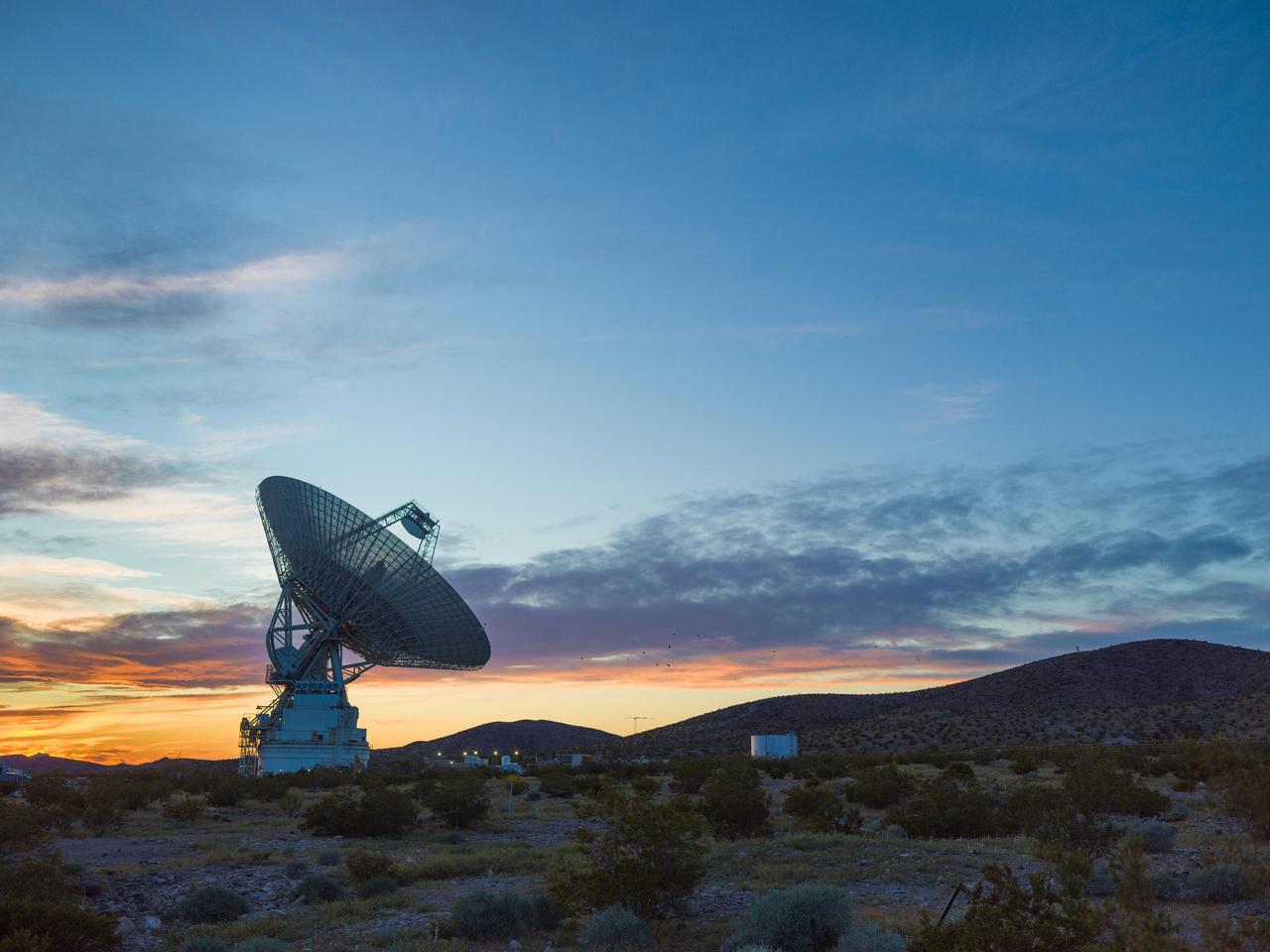
This sunset photo shows Deep Space Station 14 (DSS-14), the 230-foot-wide (70-meter) antenna at the Goldstone Deep Space Communications Complex near Barstow, California, part of NASA's Deep Space Network. The network's three complexes around the globe support communications with dozens of deep space missions. DSS-14 is also the agency's Goldstone Solar System Radar, which is used to observe asteroids that come close to Earth. https://photojournal.jpl.nasa.gov/catalog/PIA26150
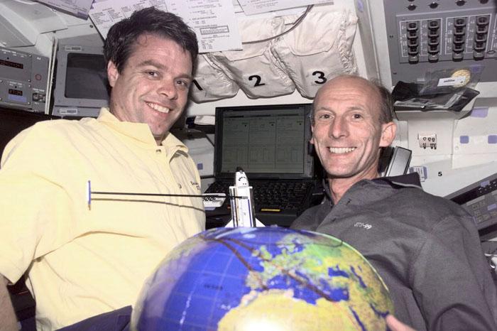
S99-E-5258 (13 February 2000) --- Astronauts Kevin R. Kregel (left), mission commander, and Gerhard P.J. Thiele demonstrate mapping techniques for the Space Radar Topography Mission (SRTM) using a payload-equipped Shuttle and a globe on Endeavour's flight deck. The two are joined by astronaut Janet L. Kavandi, mission specialist, on the SRTM's Red Team. Thiele is a mission specialist representing the European Space Agency (ESA).
Philippe Lognonné, SEIS investigation lead, Institut de Physique du Globe de Paris (IPGP) discusses NASA's InSight mission during a prelaunch media briefing, Thursday, May 3, 2018, at Vandenberg Air Force Base in California. InSight, short for Interior Exploration using Seismic Investigations, Geodesy and Heat Transport, is a Mars lander designed to study the "inner space" of Mars: its crust, mantle, and core. Photo Credit: (NASA/Bill Ingalls)
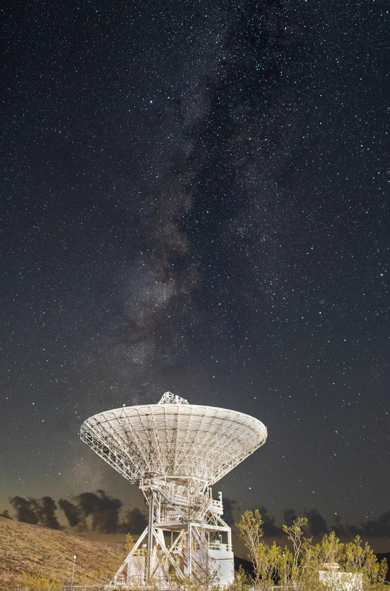
Deep Space Station 15 (DSS-15), one of the 112-foot (34-meter) antennas at the Goldstone Deep Space Communications Complex near Barstow, California, looks skyward, with the stars of the Milky Way overhead, in September 2025. Goldstone is part of NASA’s Deep Space Network (DSN), which operates three complexes around the globe that support communications with dozens of deep space missions. For more information about the DSN, visit: https://www.nasa.gov/communicating-with-missions/dsn/
Orion is revealed for one of the final times on Jan. 14, as it is readied atop its transport pallet from the Neil Armstrong Operations and Checkout Building at NASA’s Kennedy Space Center in Florida, along its path to the pad ahead of the Artemis I launch. Teams across the globe have worked tirelessly to assemble the spacecraft which will receive a protective covering prior to departing for the Multi-Payload Processing Facility to begin ground processing by the Exploration Ground Systems and Jacobs teams.
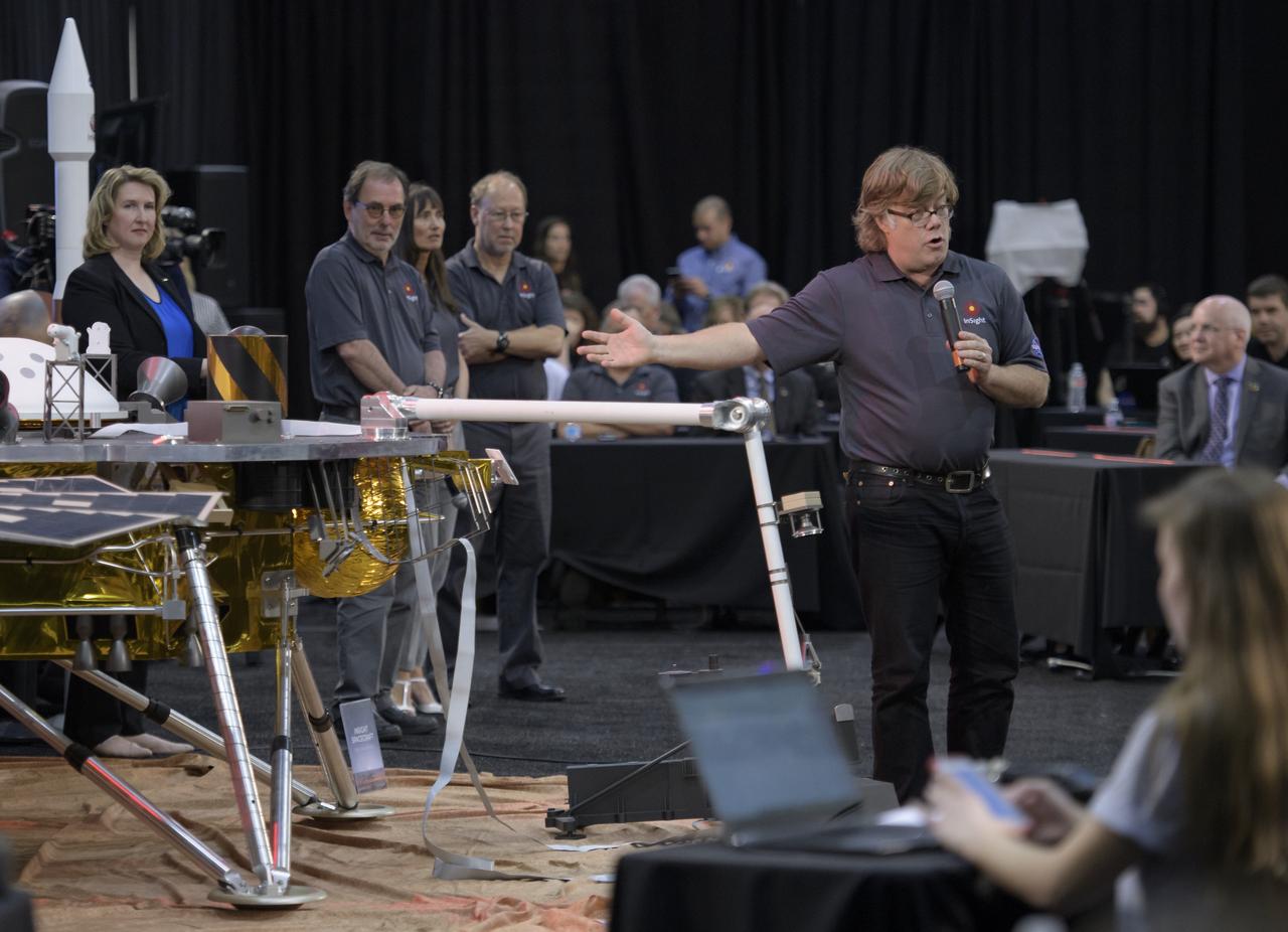
Philippe Lognonné, SEIS investigation lead, Institut de Physique du Globe de Paris (IPGP) discusses NASA's InSight mission during a prelaunch media briefing, Thursday, May 3, 2018, at Vandenberg Air Force Base in California. InSight, short for Interior Exploration using Seismic Investigations, Geodesy and Heat Transport, is a Mars lander designed to study the "inner space" of Mars: its crust, mantle, and core. Photo Credit: (NASA/Bill Ingalls)

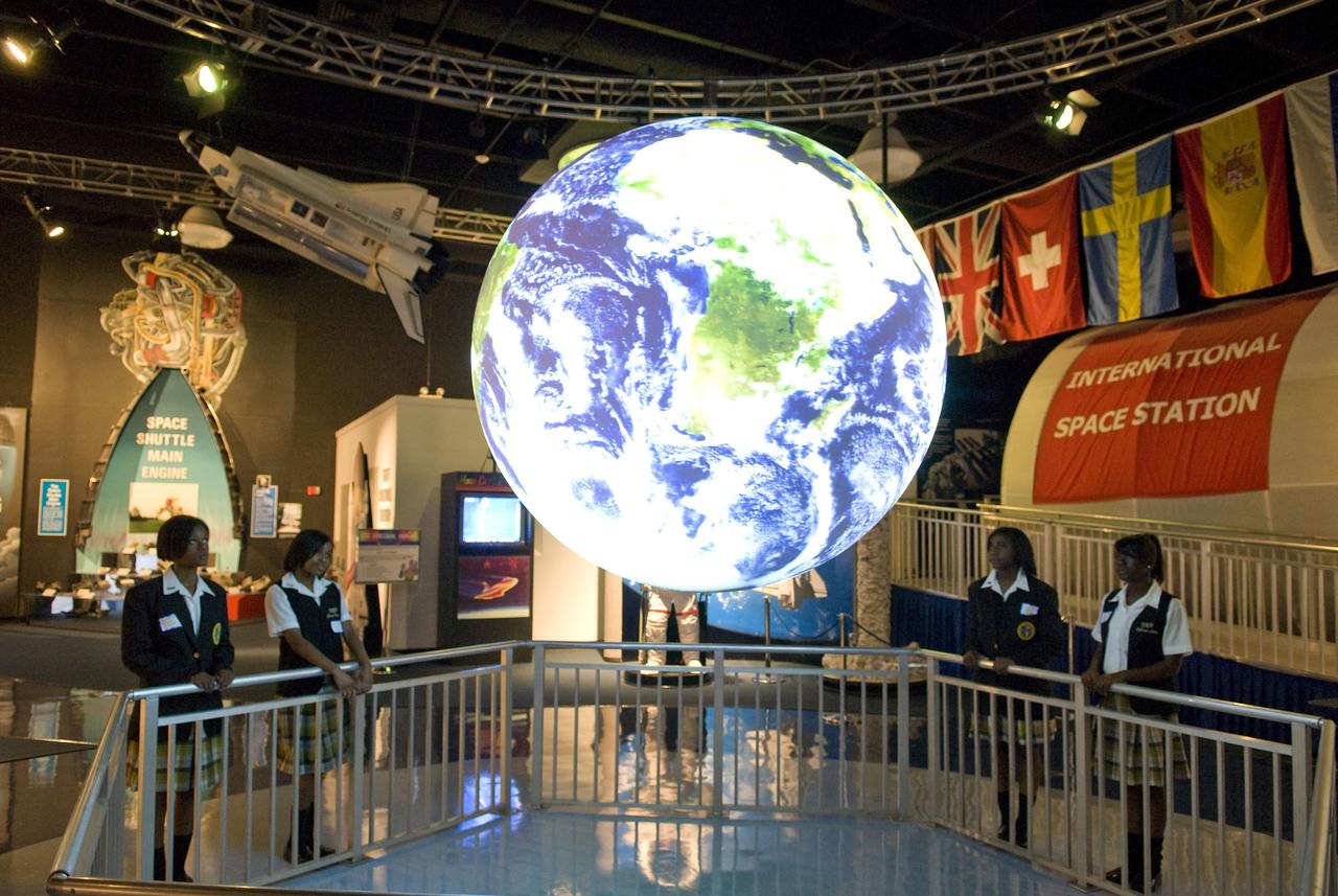
Students from Xavier University Preparatory School in New Orleans view the newest exhibit at StenniSphere, the visitor center at NASA's John C. Stennis Space Center - Science on a Sphere, a 68-inch global presentation of planetary data. StenniSphere is only the third NASA visitor center to offer the computer system, which uses four projectors to display data on a globe and present a dynamic, revolving, animated view of Earth and other planets.
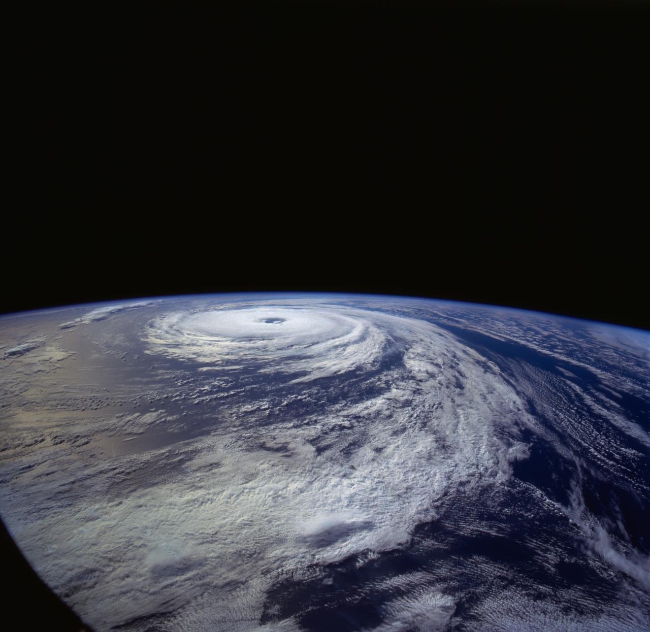
From 165 nautical miles above the earth, the STS-66 astronauts were able to capture detail in a number of storm systems around the globe during their 11-day stay in space aboard the Space Shuttle Atlantis. A 70mm handheld Hasselblad was used to photograph Hurricane Florence in the Atlantic Ocean, about 400 miles from Bermuda.
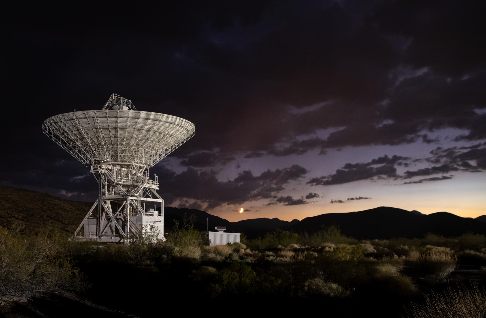
Deep Space Station 15 (DSS-15), one of the 112-foot (34-meter) antennas at the Goldstone Deep Space Communications Complex near Barstow, California, is seen at sunset in September 2025. The crescent Moon hangs just above the horizon. Goldstone is part of NASA’s Deep Space Network (DSN), which operates three complexes around the globe that support communications with dozens of deep space missions. For more information about the DSN, visit: https://www.nasa.gov/communicating-with-missions/dsn/
ISS022-E-008741 (13 Dec. 2009) --- NASA astronaut Jeffrey Williams (left), Expedition 22 commander; and Russian cosmonaut Maxim Suraev, flight engineer, are photographed near a globe, with the Expedition 22 logo, floating freely during a segment of Rusalka video footage as part of Suraev’s "Live on ISS" program for the Russian Channel TVTs, via US assets (S-band & Ku-band). The event took place in the Harmony node of the International Space Station.

Orion is revealed for one of the final times on Jan. 14, as it is moved by crane to its transport pallet inside the Neil Armstrong Operations and Checkout Building at NASA’s Kennedy Space Center in Florida, along its path to the pad ahead of the Artemis I launch. Teams across the globe have worked tirelessly to assemble the spacecraft which will receive a protective covering prior to departing for the Multi-Payload Processing Facility to begin ground processing by the Exploration Ground Systems and Jacobs teams.
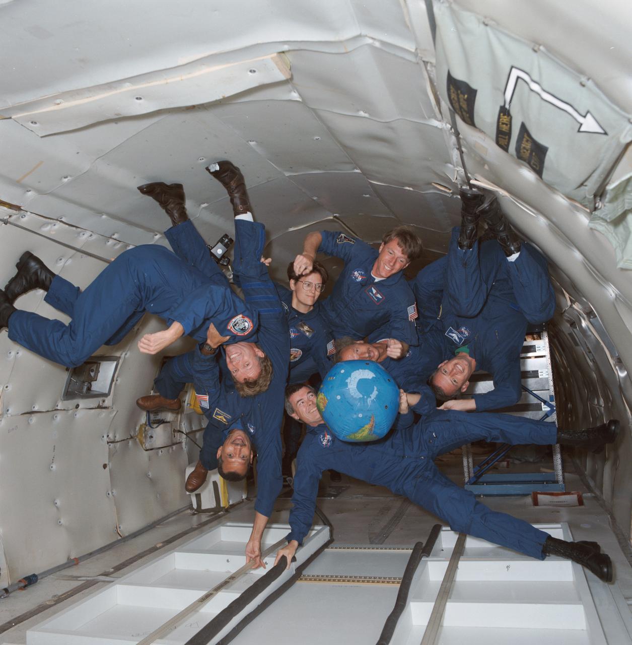
S91-44453 (21 Aug 1991) --- The crew of STS-45 is already training for its March 1992 mission, including stints on the KC-135 zero-gravity-simulating aircraft. Shown with an inflatable globe are, clockwise from the top, C. Michael Foale, mission specialist; Dirk Frimout, payload specialist; Brian Duffy, pilot; Charles R. (Rick) Chappell, backup payload specialist; Charles F. Bolden, mission commander; Byron K. Lichtenberg, payload specialist; and Kathryn D. Sullivan, payload commander.

Artemis curation lead, Juliane Gross, holds a lunar globe in the Science Evaluation Room (SER) in Mission Control at Johnson Space Center in Houston. The SER supports lunar science and planetary observations for the Artemis science officer in the mission’s main flight control room. Built specifically for Artemis missions with these science priorities in mind, the SER is equipped to support rapid data interpretation, collaborative analysis, real-time decision making, and seamless coordination between the science and operations teams. Credits: NASA/Luna Posadas Nava

VANDENBERG AIR FORCE BASE, Calif. – In Hangar 1555 on Vandenberg Air Force Base in California, a worker paints the name “Mercator” on the nose of the Pegasus XL rocket. The rocket is the launch vehicle for NASA’s Interstellar Boundary Explorer, or IBEX, spacecraft. The IBEX satellite will make the first map of the boundary between the Solar System and interstellar space. The name Mercator was chosen in honor of Gerardus Mercator, the Flemish cartographer (or map maker). In addition to the many maps that he made, he also invented a technique to create terrestrial and celestial globes out of paper mache, allowing for greater production than the carved wooden or brass globes that were previously used. IBEX is targeted for launch from the Kwajalein Atoll, a part of the Marshall Islands in the Pacific Ocean, on Oct. 19. IBEX will be launched aboard the Pegasus rocket dropped from under the wing of an L-1011 aircraft flying over the Pacific Ocean. The Pegasus will carry the spacecraft approximately 130 miles above Earth and place it in orbit. Photo credit: NASA/R. Bledsoe, VAFB
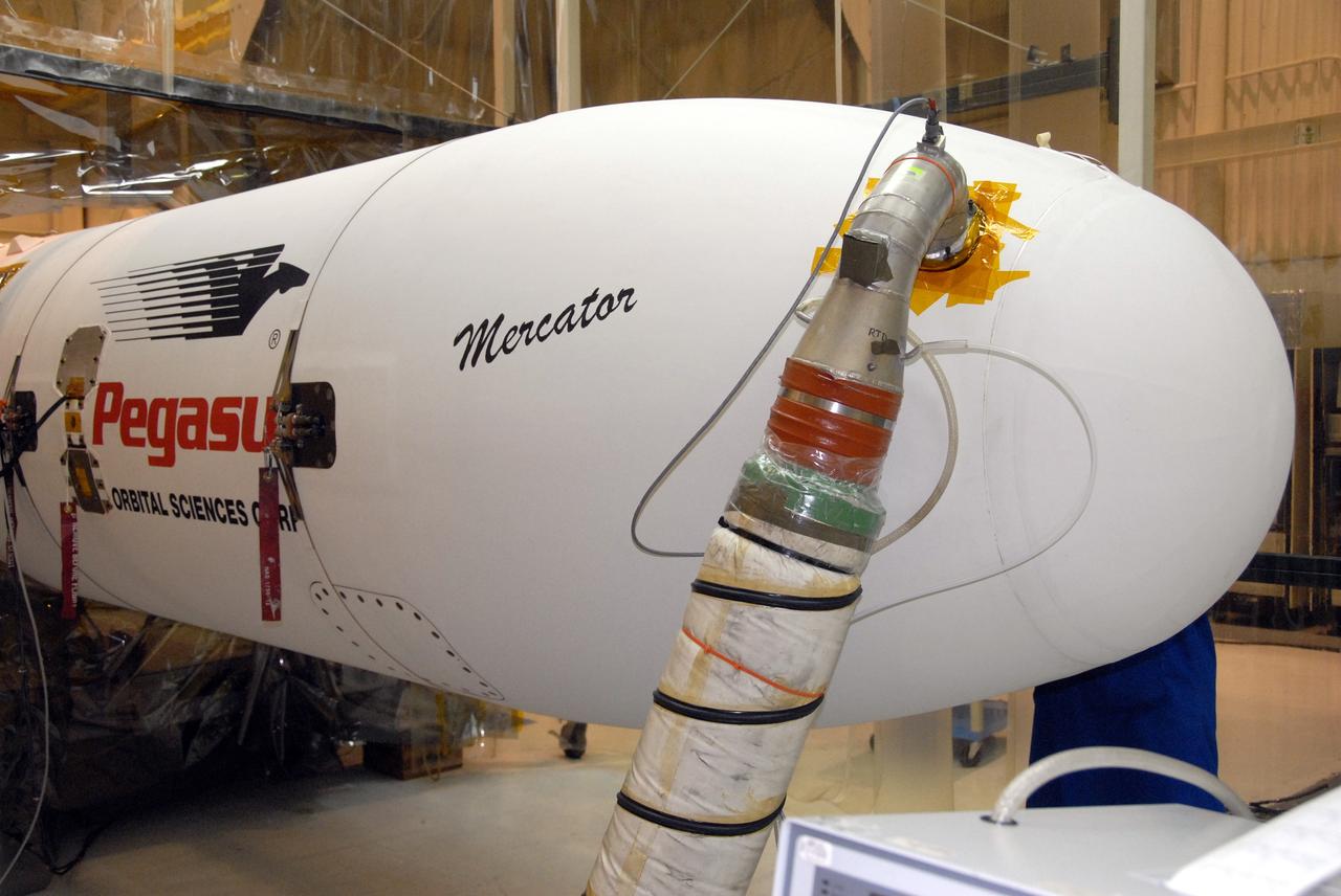
VANDENBERG AIR FORCE BASE, Calif. – In Hangar 1555 on Vandenberg Air Force Base in California, the name “Mercator” is displayed on the nose of the Pegasus XL rocket. The rocket is the launch vehicle for NASA’s Interstellar Boundary Explorer, or IBEX, spacecraft. The IBEX satellite will make the first map of the boundary between the Solar System and interstellar space. The name Mercator was chosen in honor of Gerardus Mercator, the Flemish cartographer (or map maker). In addition to the many maps that he made, he also invented a technique to create terrestrial and celestial globes out of paper mache, allowing for greater production than the carved wooden or brass globes that were previously used. IBEX is targeted for launch from the Kwajalein Atoll, a part of the Marshall Islands in the Pacific Ocean, on Oct. 19. IBEX will be launched aboard the Pegasus rocket dropped from under the wing of an L-1011 aircraft flying over the Pacific Ocean. The Pegasus will carry the spacecraft approximately 130 miles above Earth and place it in orbit. Photo credit: NASA/R. Bledsoe, VAFB

VANDENBERG AIR FORCE BASE, Calif. – The name “Mercator” is boldly displayed on the nose of the Pegasus XL rocket. The rocket is the launch vehicle for NASA’s Interstellar Boundary Explorer, or IBEX, spacecraft. The IBEX satellite will make the first map of the boundary between the Solar System and interstellar space. The name Mercator was chosen in honor of Gerardus Mercator, the Flemish cartographer (or map maker). In addition to the many maps that he made, he also invented a technique to create terrestrial and celestial globes out of paper mache, allowing for greater production than the carved wooden or brass globes that were previously used. IBEX is targeted for launch from the Kwajalein Atoll, a part of the Marshall Islands in the Pacific Ocean, on Oct. 19. IBEX will be launched aboard the Pegasus rocket dropped from under the wing of an L-1011 aircraft flying over the Pacific Ocean. The Pegasus will carry the spacecraft approximately 130 miles above Earth and place it in orbit. Photo credit: NASA/R. Bledsoe, VAFB
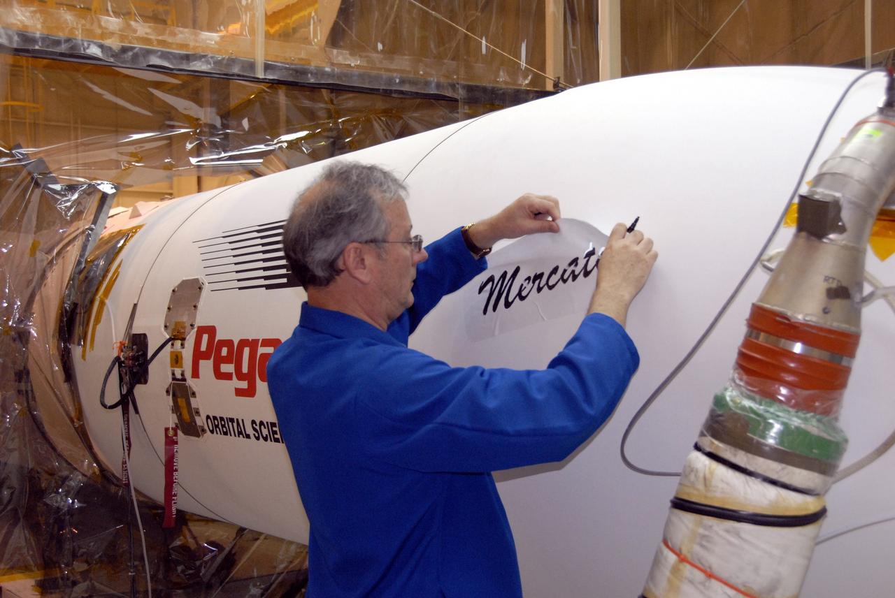
VANDENBERG AIR FORCE BASE, Calif. – In Hangar 1555 on Vandenberg Air Force Base in California, a worker paints the name “Mercator” on the nose of the Pegasus XL rocket. The rocket is the launch vehicle for NASA’s Interstellar Boundary Explorer, or IBEX, spacecraft. The IBEX satellite will make the first map of the boundary between the Solar System and interstellar space. The name Mercator was chosen in honor of Gerardus Mercator, the Flemish cartographer (or map maker). In addition to the many maps that he made, he also invented a technique to create terrestrial and celestial globes out of paper mache, allowing for greater production than the carved wooden or brass globes that were previously used. IBEX is targeted for launch from the Kwajalein Atoll, a part of the Marshall Islands in the Pacific Ocean, on Oct. 19. IBEX will be launched aboard the Pegasus rocket dropped from under the wing of an L-1011 aircraft flying over the Pacific Ocean. The Pegasus will carry the spacecraft approximately 130 miles above Earth and place it in orbit. Photo credit: NASA/R. Bledsoe, VAFB
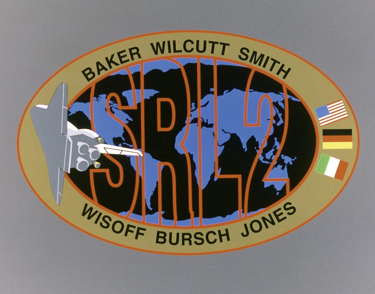
This STS-68 patch was designed by artist Sean Collins. Exploration of Earth from space is the focus of the design of the insignia, the second flight of the Space Radar Laboratory (SRL-2). SRL-2 was part of NASA's Mission to Planet Earth (MTPE) project. The world's land masses and oceans dominate the center field, with the Space Shuttle Endeavour circling the globe. The SRL-2 letters span the width and breadth of planet Earth, symbolizing worldwide coverage of the two prime experiments of STS-68: The Shuttle Imaging Radar-C and X-Band Synthetic Aperture Radar (SIR-C/X-SAR) instruments; and the Measurement of Air Pollution from Satellites (MAPS) sensor. The red, blue, and black colors of the insignia represent the three operating wavelengths of SIR-C/X-SAR, and the gold band surrounding the globe symbolizes the atmospheric envelope examined by MAPS. The flags of international partners Germany and Italy are shown opposite Endeavour. The relationship of the Orbiter to Earth highlights the usefulness of human space flights in understanding Earth's environment, and the monitoring of its changing surface and atmosphere. In the words of the crew members, the soaring Orbiter also typifies the excellence of the NASA team in exploring our own world, using the tools which the Space Program developed to explore the other planets in the solar system.
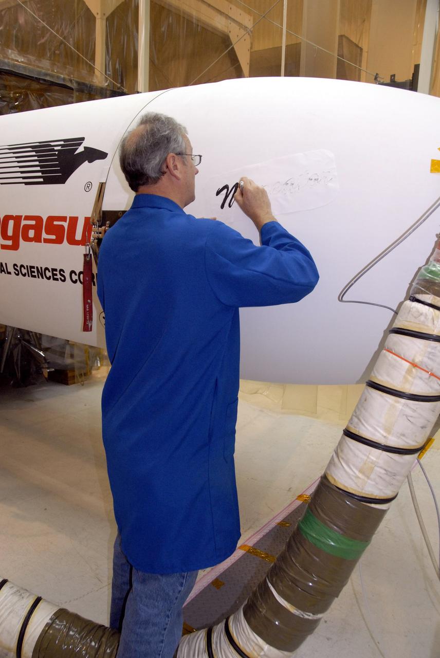
VANDENBERG AIR FORCE BASE, Calif. – In Hangar 1555 on Vandenberg Air Force Base in California, a worker begins painting the name “Mercator” on the nose of the Pegasus XL rocket. The rocket is the launch vehicle for NASA’s Interstellar Boundary Explorer, or IBEX, spacecraft. The IBEX satellite will make the first map of the boundary between the Solar System and interstellar space. The name Mercator was chosen in honor of Gerardus Mercator, the Flemish cartographer (or map maker). In addition to the many maps that he made, he also invented a technique to create terrestrial and celestial globes out of paper mache, allowing for greater production than the carved wooden or brass globes that were previously used. IBEX is targeted for launch from the Kwajalein Atoll, a part of the Marshall Islands in the Pacific Ocean, on Oct. 19. IBEX will be launched aboard the Pegasus rocket dropped from under the wing of an L-1011 aircraft flying over the Pacific Ocean. The Pegasus will carry the spacecraft approximately 130 miles above Earth and place it in orbit. Photo credit: NASA/R. Bledsoe, VAFB
Saturn appears as a serene globe amid tranquil rings in this view from NASA's Cassini spacecraft. In reality, the planet's atmosphere is an ever-changing scene of high-speed winds and evolving weather patterns, punctuated by occasional large storms (see PIA14901). The rings, consist of countless icy particles, which are continually colliding. Such collisions play a key role in the rings' numerous waves and wakes, which are the manifestation of the subtle influence of Saturn's moons and, indeed, the planet itself. The long duration of the Cassini mission has allowed scientists to study how the atmosphere and rings of Saturn change over time, providing much-needed insights into this active planetary system. The view looks toward the sunlit side of the rings from about 41 degrees above the ring plane. The image was taken with the Cassini spacecraft wide-angle camera on July 16, 2016 using a spectral filter which preferentially admits wavelengths of near-infrared light centered at 752 nanometers. The view was acquired at a distance of approximately 1 million miles (2 million kilometers) from Saturn. Image scale is 68 miles (110 kilometers) per pixel. The view was obtained at a distance of approximately 752,000 miles (1.21 million kilometers) from Saturn and at a Sun-Saturn-spacecraft, or phase, angle of 6 degrees. Image scale is 45 miles (72 kilometers) per pixel. http://photojournal.jpl.nasa.gov/catalog/PIA20502

Orion is revealed for one of the final times on Jan. 14, as it is readied atop its transport pallet from the Neil Armstrong Operations and Checkout Building at NASA’s Kennedy Space Center in Florida, along its path to the pad ahead of the Artemis I launch. Orion was officially transferred from the Orion Program to Exploration Ground Systems (EGS) during a handover ceremony. NASA astronaut Randy Bresnik speaks with Kennedy Center Director Bob Cabana inside the high bay. Teams across the globe have worked tirelessly to assemble the spacecraft, which will receive a protective covering prior to departing for the Multi-Payload Processing Facility to begin ground processing by the EGS and Jacobs teams.
Technicians assist as a crane is used to move the National Oceanic and Atmospheric Administration’s Joint Polar Satellite System (JPSS-2) for mating to the spacecraft adapter inside the Astrotech Space Operations facility at Vandenberg Space Force Base (VSFB) in California on Oct. 4, 2022. JPSS-2 is the third satellite in the Joint Polar Satellite System series. It is scheduled to lift off from VSFB on Nov. 1 from Space Launch Complex-3. JPSS-2, which will be renamed NOAA-21 after reaching orbit, will join a constellation of JPSS satellites that orbit from the North to the South pole, circling Earth 14 times a day and providing a full view of the entire globe twice daily.
The National Oceanic and Atmospheric Administration’s Joint Polar Satellite System (JPSS-2) is now secured on the spacecraft adapter inside the Astrotech Space Operations facility at Vandenberg Space Force Base (VSFB) in California on Oct. 4, 2022. JPSS-2 is the third satellite in the Joint Polar Satellite System series. It is scheduled to lift off from VSFB on Nov. 1 from Space Launch Complex-3. JPSS-2, which will be renamed NOAA-21 after reaching orbit, will join a constellation of JPSS satellites that orbit from the North to the South pole, circling Earth 14 times a day and providing a full view of the entire globe twice daily.
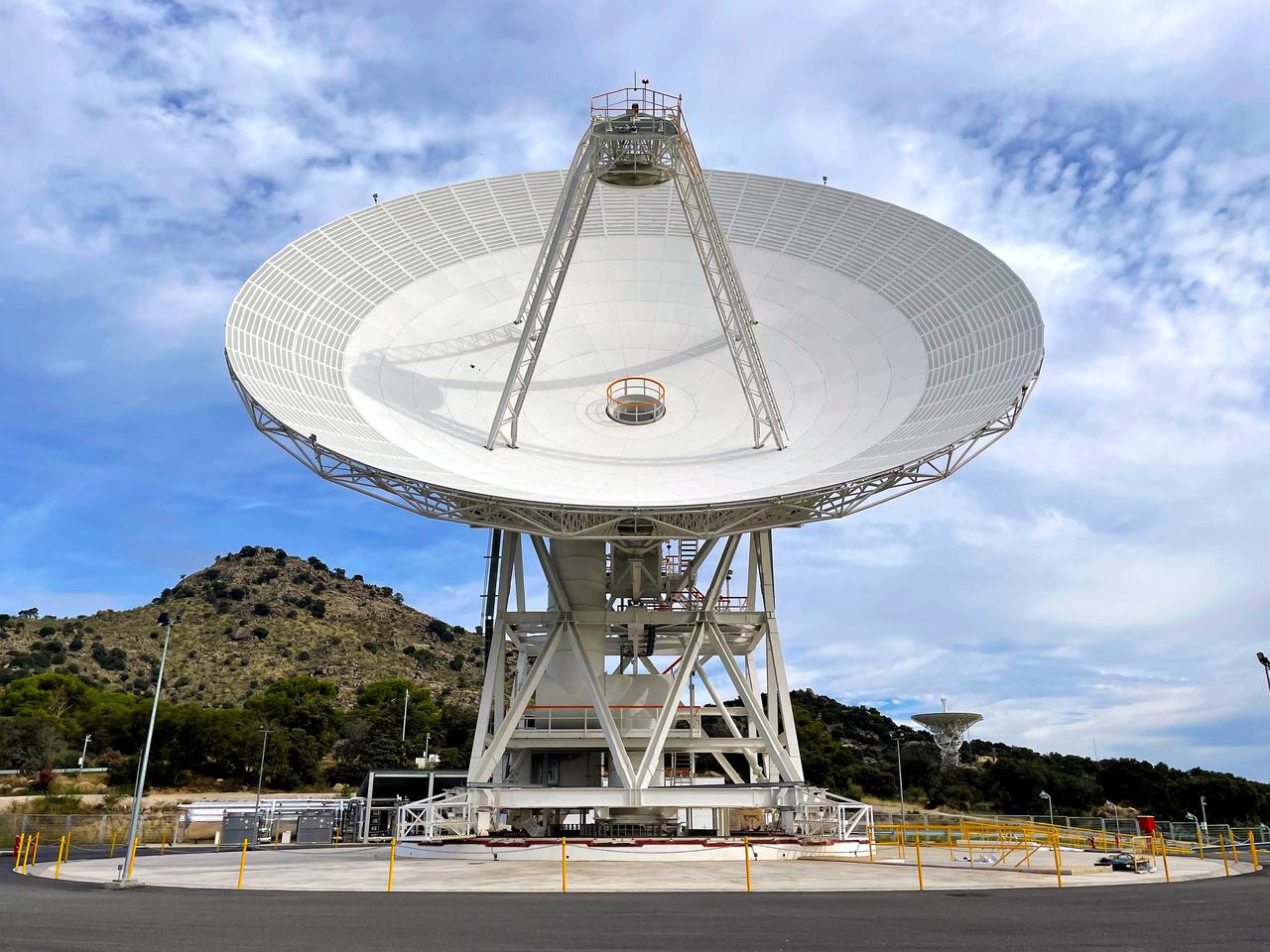
Deep Space Station 53, or DSS-53, is a new 34-meter (111-foot) beam waveguide antenna that went online in February 2022 at NASA's Deep Space Network's ground station in Madrid. DSS-53 is the fourth of six antennas being added to expand the DSN's capacity and meet the needs of a growing number of spacecraft. When the project is complete, each of the network's three ground stations around the globe will have four beam waveguide antennas. The Madrid Deep Space Communications Complex is the first to have completed its build-out as part of project. Construction on DSS-53 began in 2016. https://photojournal.jpl.nasa.gov/catalog/PIA25136

KENNEDY SPACE CENTER, FLA. -- Sandpipers investigate a washed up horseshoe crab on the river bank on Kennedy Space Center. Sandpipers are found on shores and in wetlands around the globe, breeding on the Arctic tundra then returning to more temperate climes. KSC shares a boundary with the Merritt Island Wildlife Nature Refuge. The refuge is a habitat for more than 310 species of birds, 25 mammals, 117 fishes and 65 amphibians and reptiles. In addition, the Refuge supports 19 endangered or threatened wildlife species on Federal or State lists, more than any other single refuge in the U.S. Photo credit: NASA/Dimitri Gerondidakis
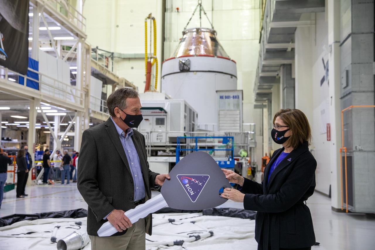
Orion is revealed for one of the final times on Jan. 14, as it is readied atop its transport pallet from the Neil Armstrong Operations and Checkout Building at NASA’s Kennedy Space Center in Florida, along its path to the pad ahead of the Artemis I launch. Mike Bolger, at left, manager of Exploration Ground Systems (EGS), receives the “key” to Orion from Cathy Koerner, Orion Program manager signifying the transfer of the spacecraft from the assembly to the ground system processing team. Teams across the globe have worked tirelessly to assemble the spacecraft, which will receive a protective covering prior to departing for the Multi-Payload Processing Facility to begin ground processing by the EGS and Jacobs teams.

Orion is revealed for one of the final times on Jan. 14, as it is readied atop its transport pallet from the Neil Armstrong Operations and Checkout Building at NASA’s Kennedy Space Center in Florida, along its path to the pad ahead of the Artemis I launch. Kennedy Center Director Bob Cabana speaks to workers in front of Orion in the high bay. Teams across the globe have worked tirelessly to assemble the spacecraft, which will receive a protective covering prior to departing for the Multi-Payload Processing Facility to begin ground processing by the Exploration Ground Systems and Jacobs teams.
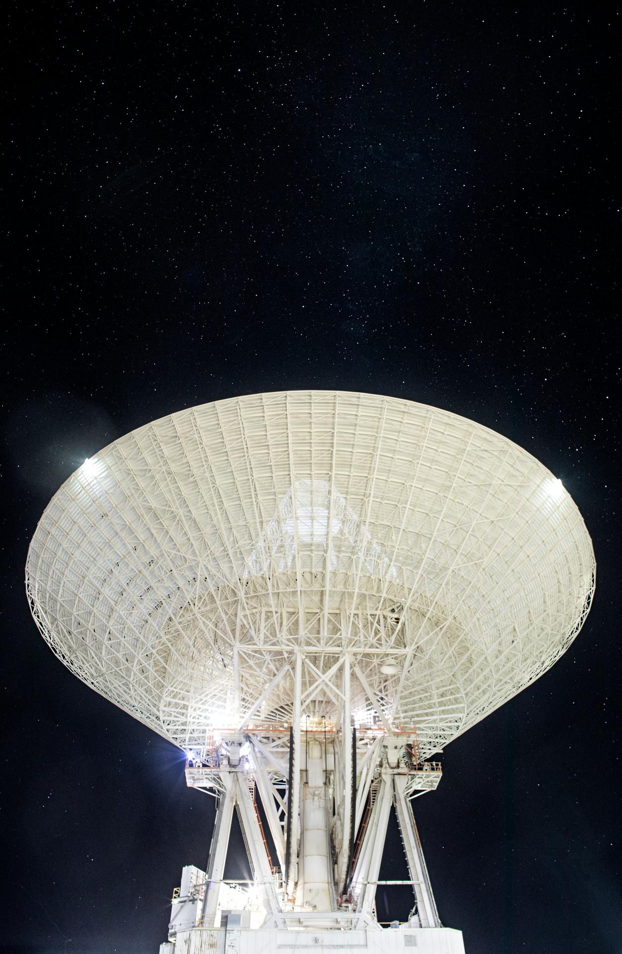
Deep Space Station 14 (DSS-14), the 230-foot-wide (70-meter) antenna at the Goldstone Deep Space Communications Complex near Barstow, California, points up toward a starry sky in September 2025. Goldstone is part of NASA’s Deep Space Network (DSN), which operates three complexes around the globe to support communications with dozens of deep space missions. DSS-14 is also the agency’s Goldstone Solar System Radar, which is used to observe asteroids that come close to Earth. For more information about the DSN, visit: https://www.nasa.gov/communicating-with-missions/dsn/
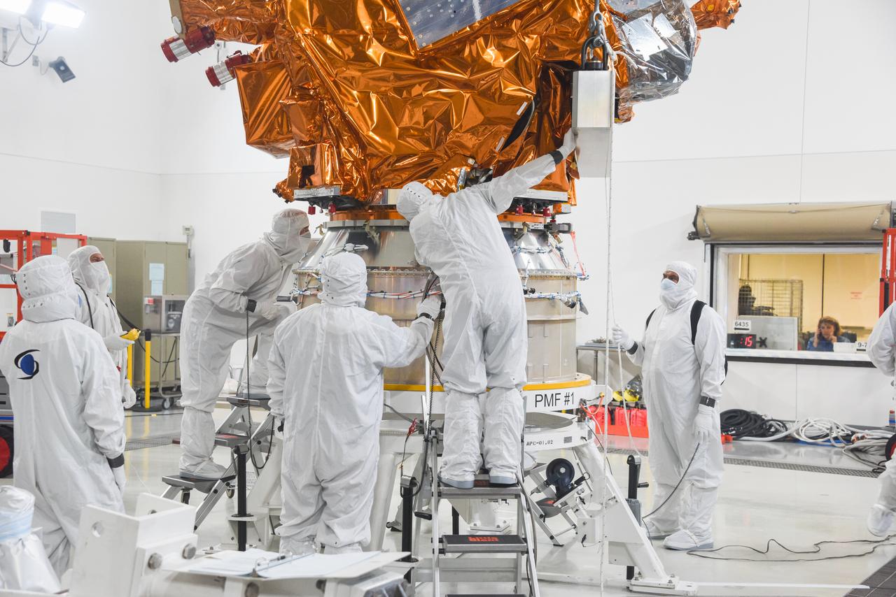
Technicians assist as a crane is used to lower the National Oceanic and Atmospheric Administration’s Joint Polar Satellite System (JPSS-2) onto the spacecraft adapter inside the Astrotech Space Operations facility at Vandenberg Space Force Base (VSFB) in California on Oct. 4, 2022. JPSS-2 is the third satellite in the Joint Polar Satellite System series. It is scheduled to lift off from VSFB on Nov. 1 from Space Launch Complex-3. JPSS-2, which will be renamed NOAA-21 after reaching orbit, will join a constellation of JPSS satellites that orbit from the North to the South pole, circling Earth 14 times a day and providing a full view of the entire globe twice daily.
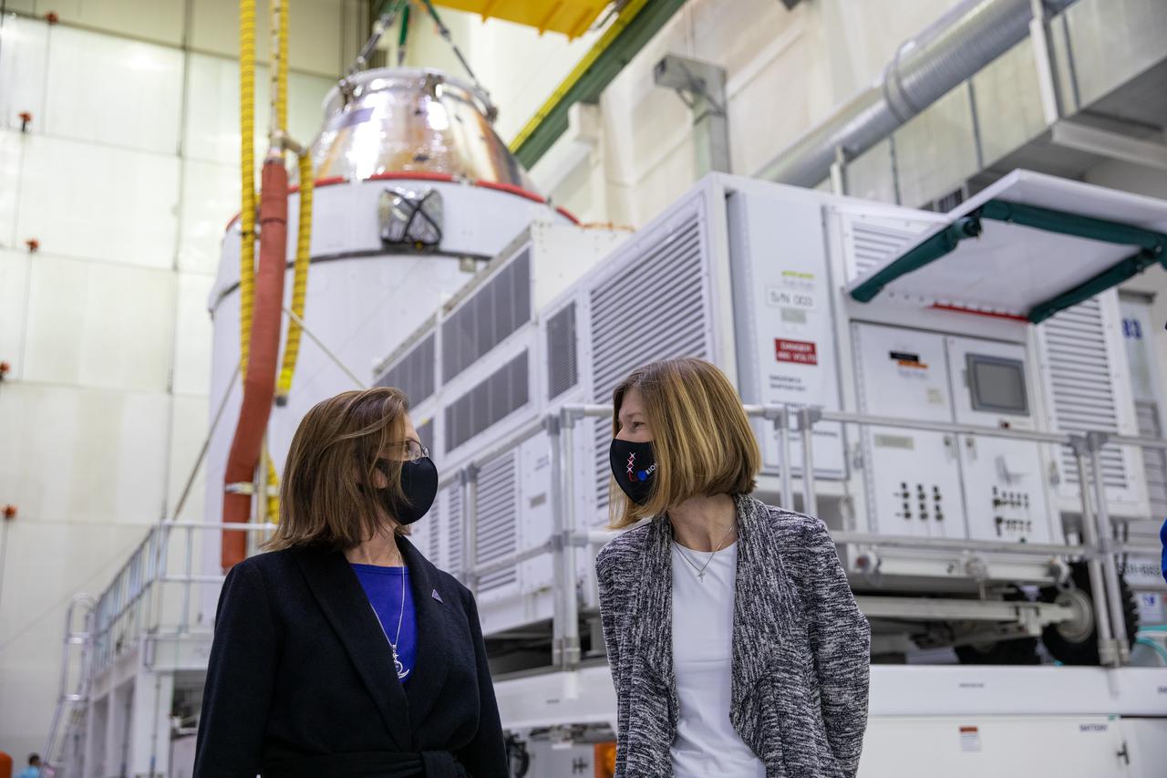
Orion is revealed for one of the final times on Jan. 14, as it is readied atop its transport pallet from the Neil Armstrong Operations and Checkout Building at NASA’s Kennedy Space Center in Florida, along its path to the pad ahead of the Artemis I launch. Viewing Orion in the high bay, from left, are Cathy Koerner, Orion Program Manager, and Kathy Lueders, associated administrator of the Human Exploration and Operations Mission Directorate. Teams across the globe have worked tirelessly to assemble the spacecraft, which will receive a protective covering prior to departing for the Multi-Payload Processing Facility to begin ground processing by the Exploration Ground Systems and Jacobs teams.