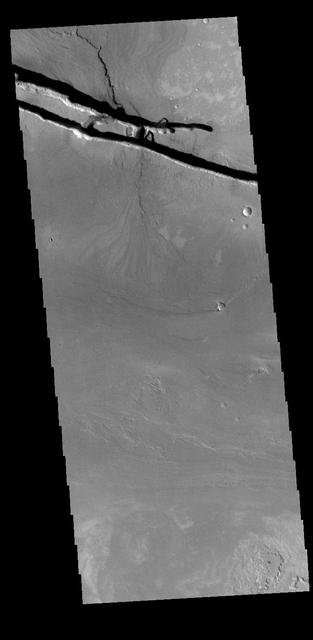
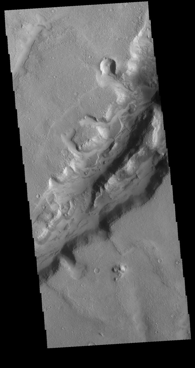
Dunes in Graben
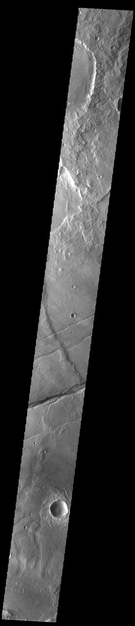
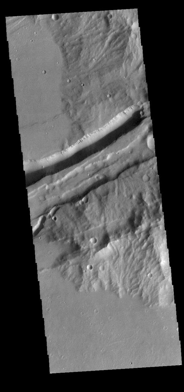
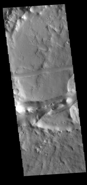
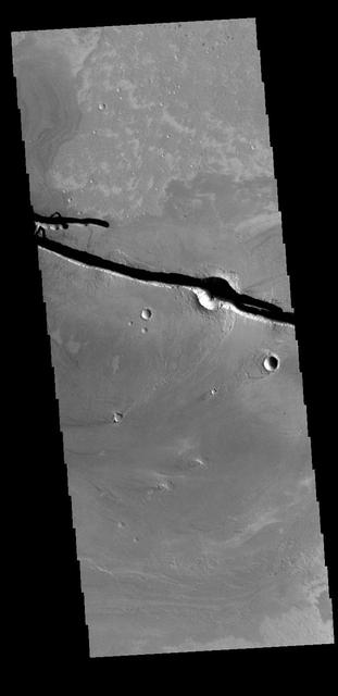
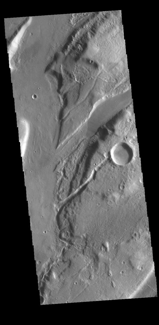
Channel and Graben
Graben in Caloris
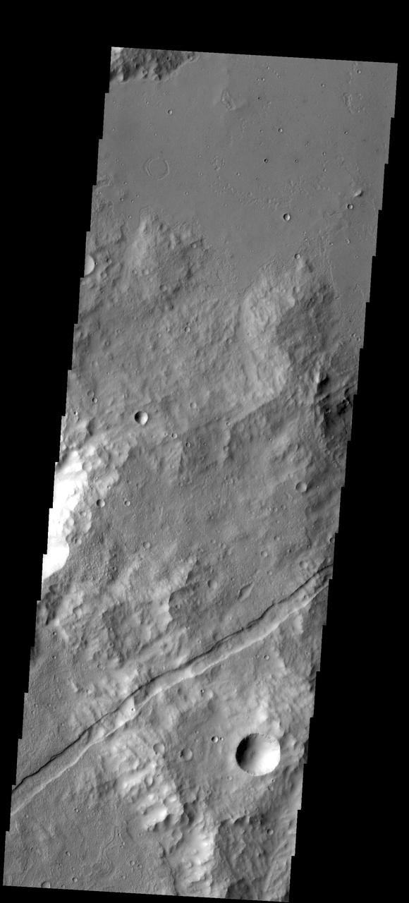
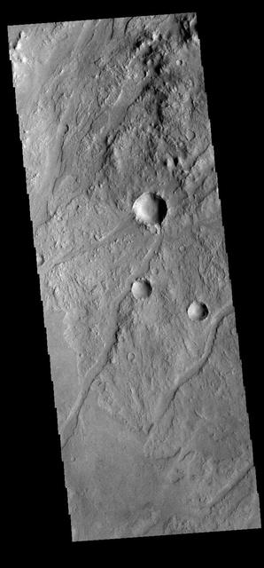
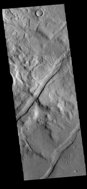
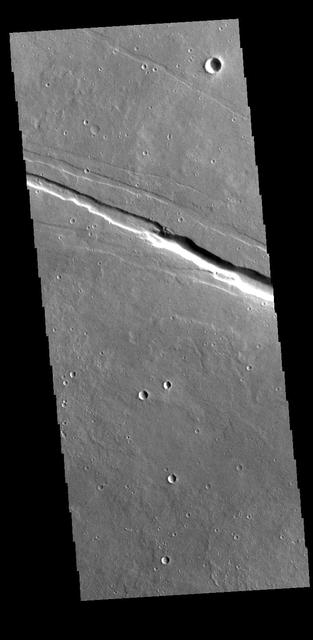
A graben is a downdropped block of material bounded on both sides by faults. The graben in this image from NASA 2001 Mars Odyssey spacecraft follows the trend of the nearby Sirenum Fossae graben.
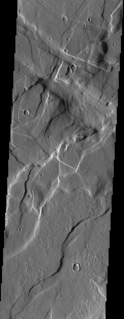
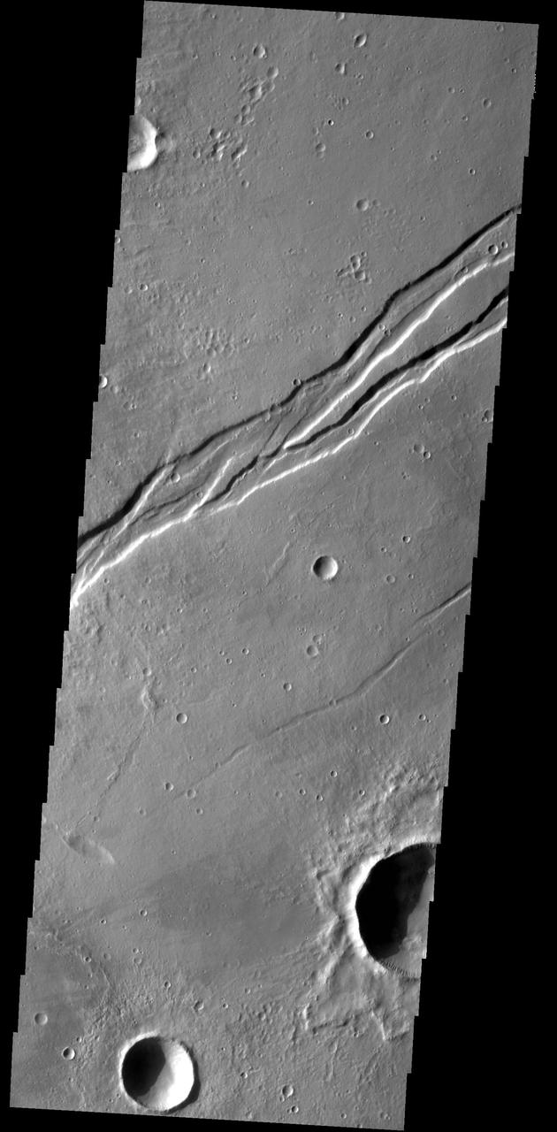
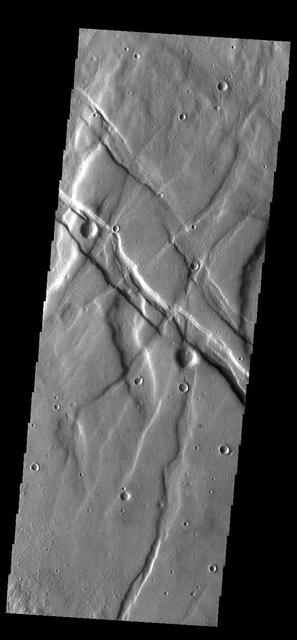
Paired fractures with a downdropped block between them are termed graben. Graben are common on Alba Patera, where this image is located. Image information: VIS instrument. Latitude 43.7N, Longitude 245.8E. 19 meter/pixel resolution. http://photojournal.jpl.nasa.gov/catalog/PIA01772

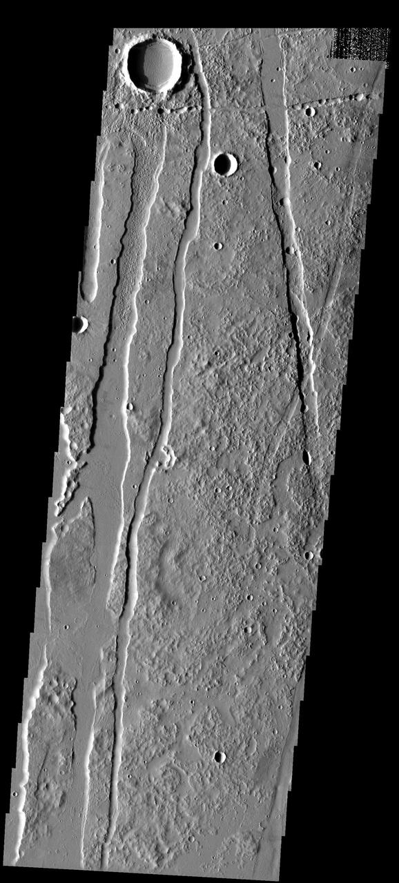
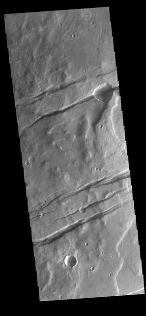
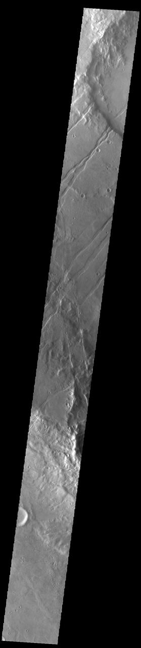
The linear features in this image are called graben and are formed when two parallel faults have a downdropped block of material between them. These graben are located between Syria Planum and Claritas Rupes
The parallel sides and low interior seen in this image from NASA 2001 Mars Odyssey spacecraft are faults and down-dropped material between the faults. This tectonic feature is called a graben. The graben in this image is located in Daedalia Planum.
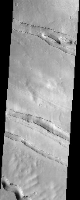
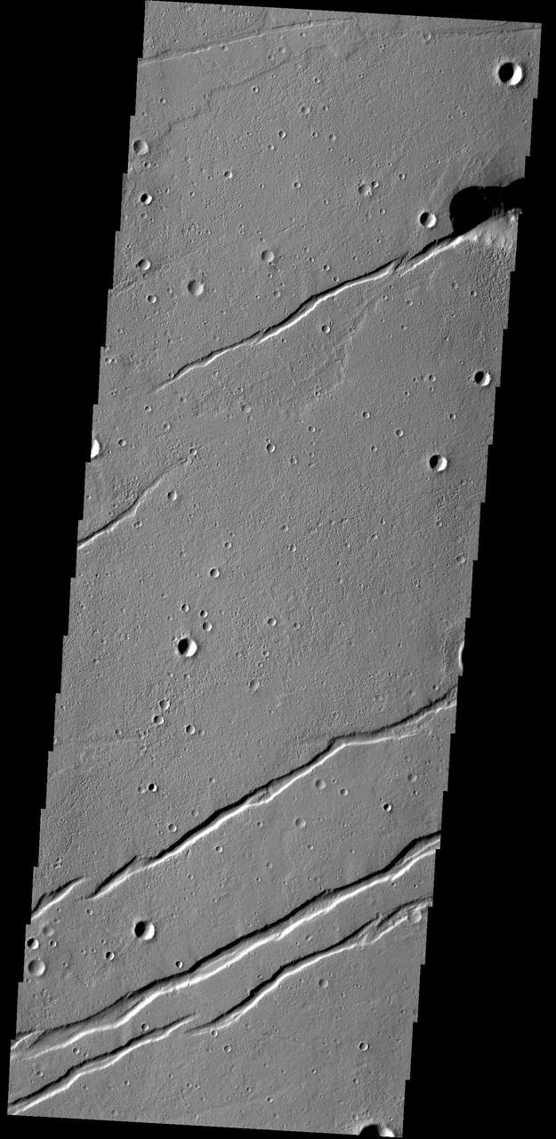
The linear features in the image are tectonic graben. Graben are formed by extension of the crust and faulting. When large amounts of pressure or tension are applied to rocks on timescales that are fast enough that the rock cannot respond by deforming, the rock breaks along faults. In the case of a graben, two parallel faults are formed by extension of the crust and the rock in between the faults drops downward into the space created by the extension. The graben visible in this THEMIS image trend east/west. Because the faults defining the graben are formed perpendicular to the direction of the applied stress, we know that extensional forces were pulling the crust apart in the north/south direction. These unnamed graben are located on the eastern margin of Orcus Patera. Orbit Number: 95005 Latitude: 13.7781 Longitude: 180.931 Instrument: VIS Captured: 2023-05-16 00:25 https://photojournal.jpl.nasa.gov/catalog/PIA26251
Alba Patera Graben
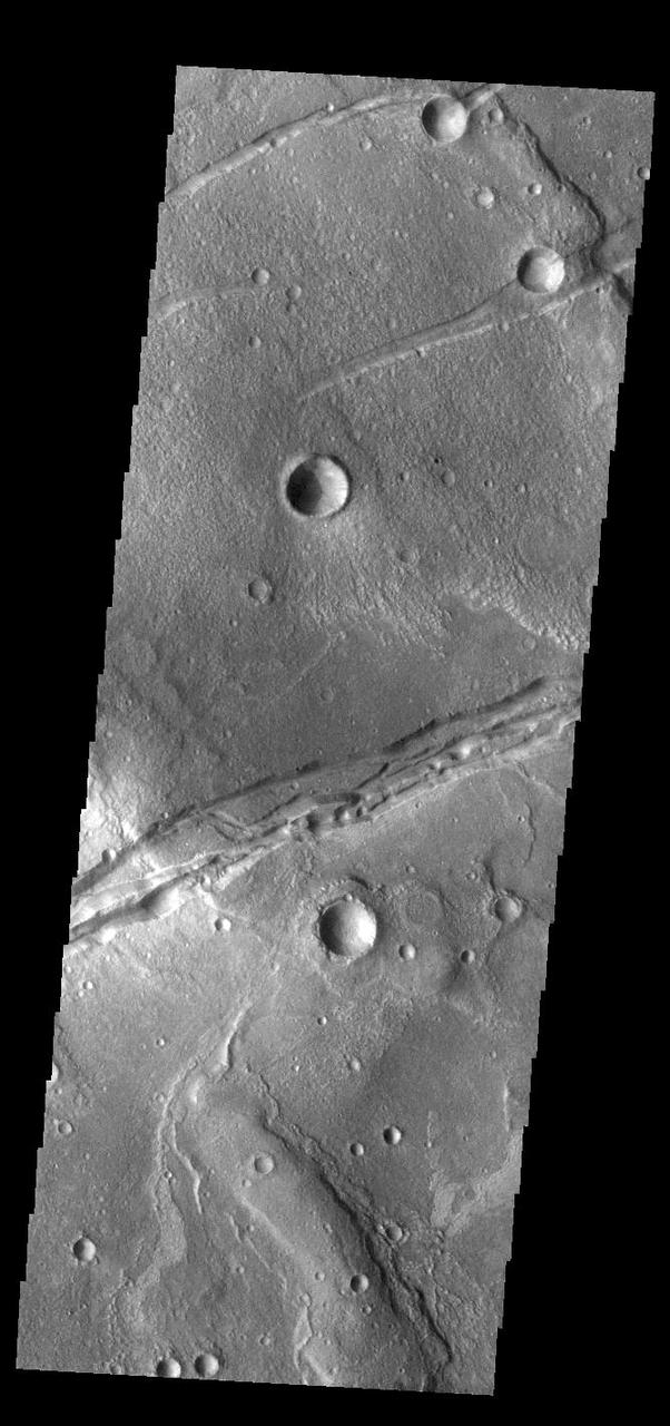
Craters and Grabens: Circles and Lines
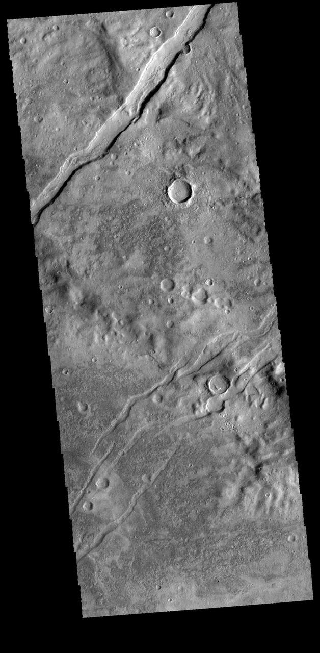
Old and New Graben
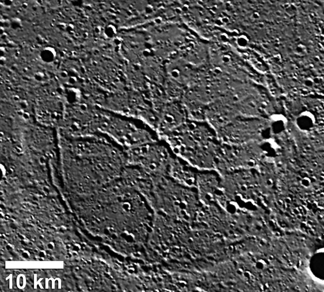
Graben in Goethe Basin
Valles Marineris Graben
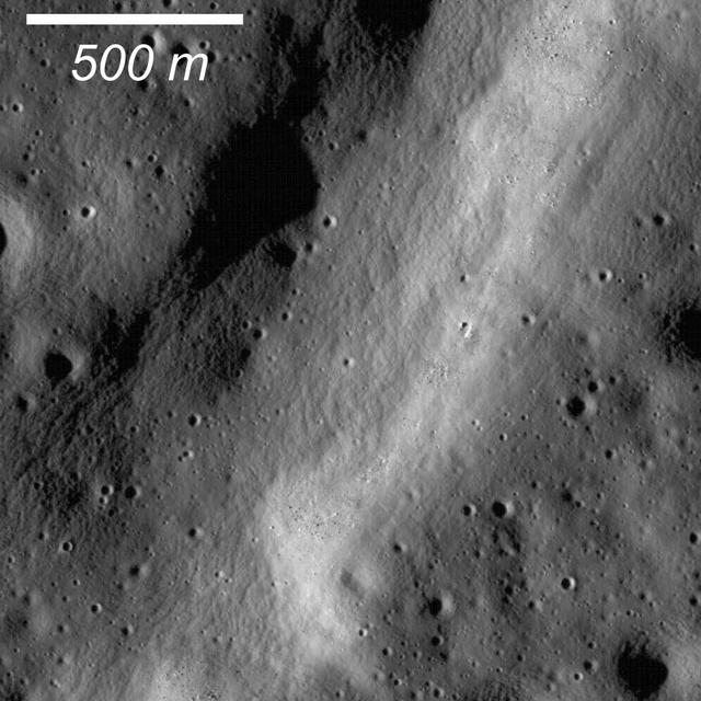
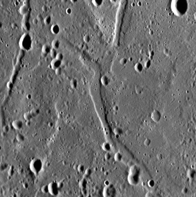
Graben are common extensional features on the Moon as well as the other terrestrial planets and icy satellites. This graben formed within a larger graben as captured by NASA Lunar Reconnaissance Orbiter.
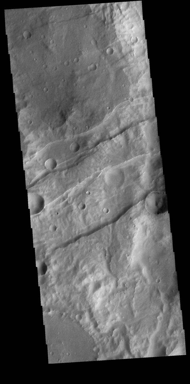
The linear depressions in this VIS image are graben. Graben are formed from tectonic activity with large blocks of material moving downward between paired faults. The crater in the bottom half of the image is oval rather than round, which could have been due to impacting into this region of tectonic deformation. Orbit Number: 66271 Latitude: -29.9918 Longitude: 211.199 Instrument: VIS Captured: 2016-11-21 15:19 http://photojournal.jpl.nasa.gov/catalog/PIA21287
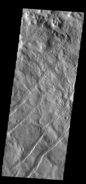
The linear depressions in this VIS image are some of the numerous graben that make up Claritas Fossae. Graben form when two faults cause a block of material to be dropped to a lower elevation. Orbit Number: 65197 Latitude: -35.7709 Longitude: 251.553 Instrument: VIS Captured: 2016-08-25 03:51 http://photojournal.jpl.nasa.gov/catalog/PIA21004
Craters, Pit Chains, and Graben, Oh My!
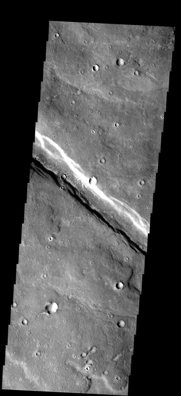
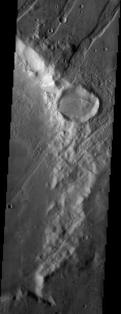
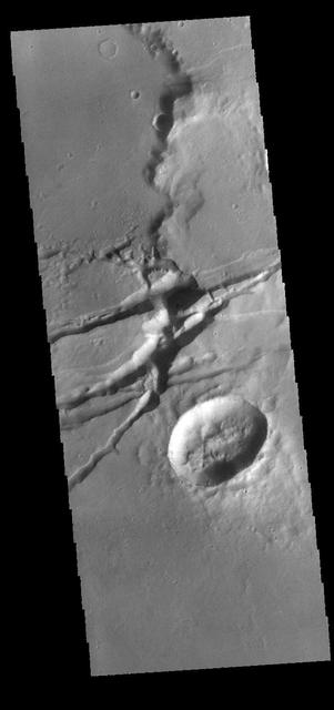
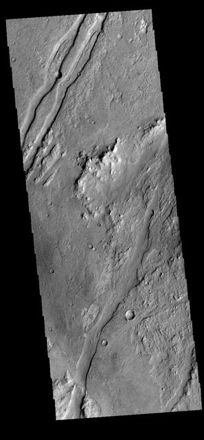
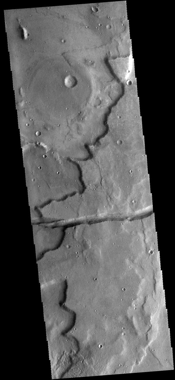
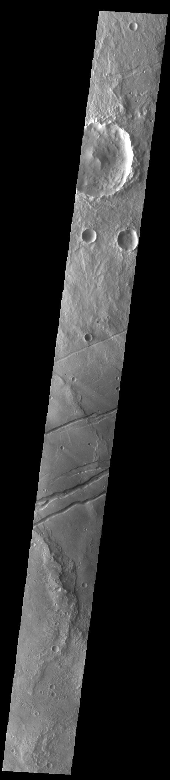
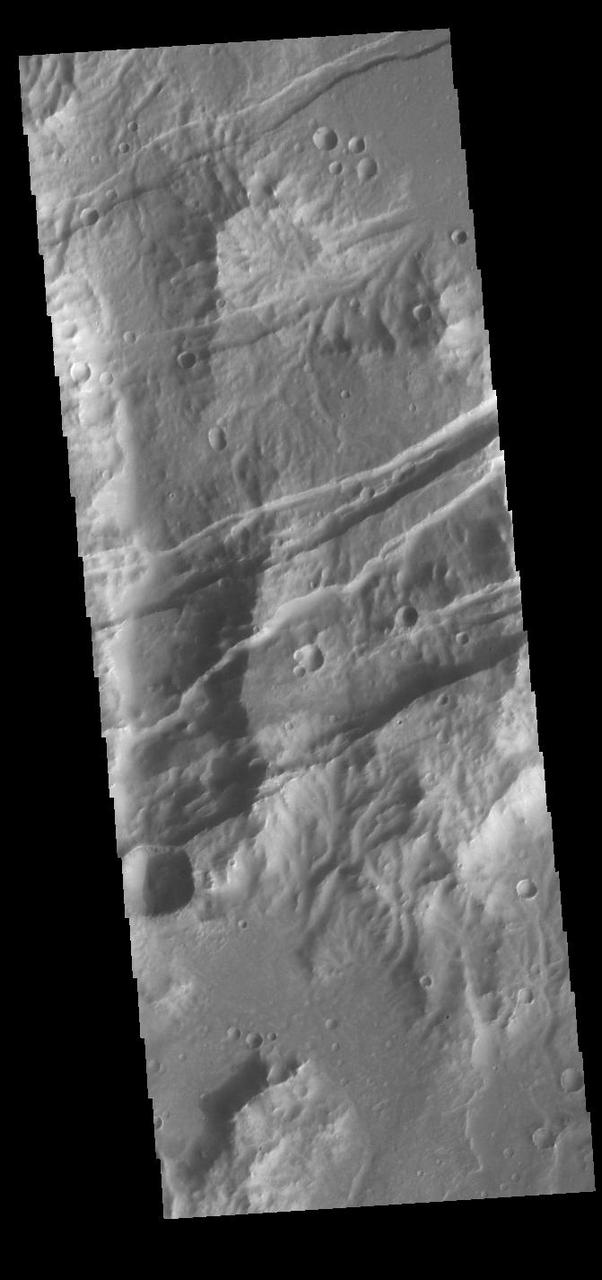
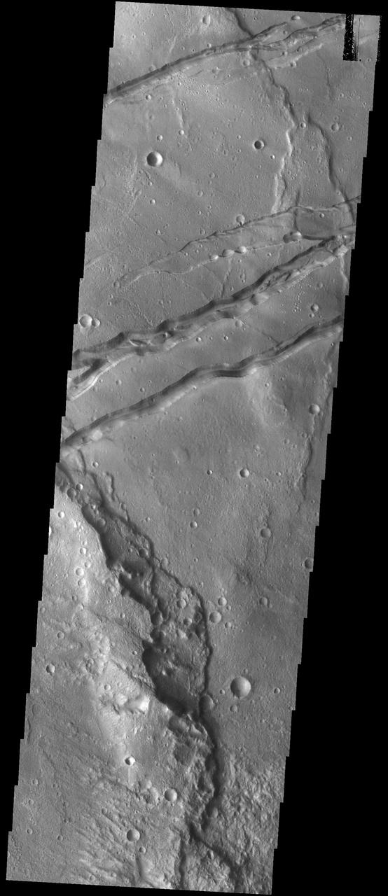
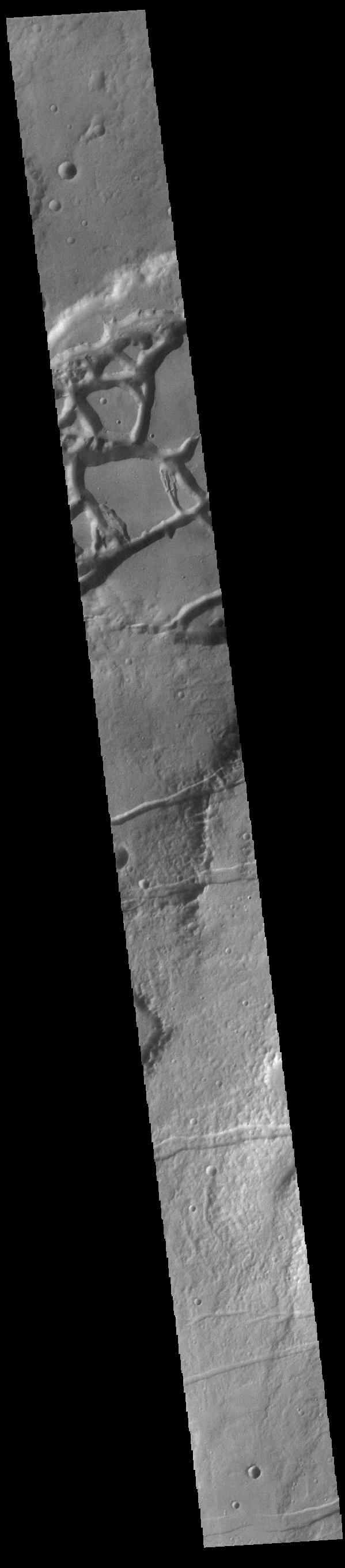
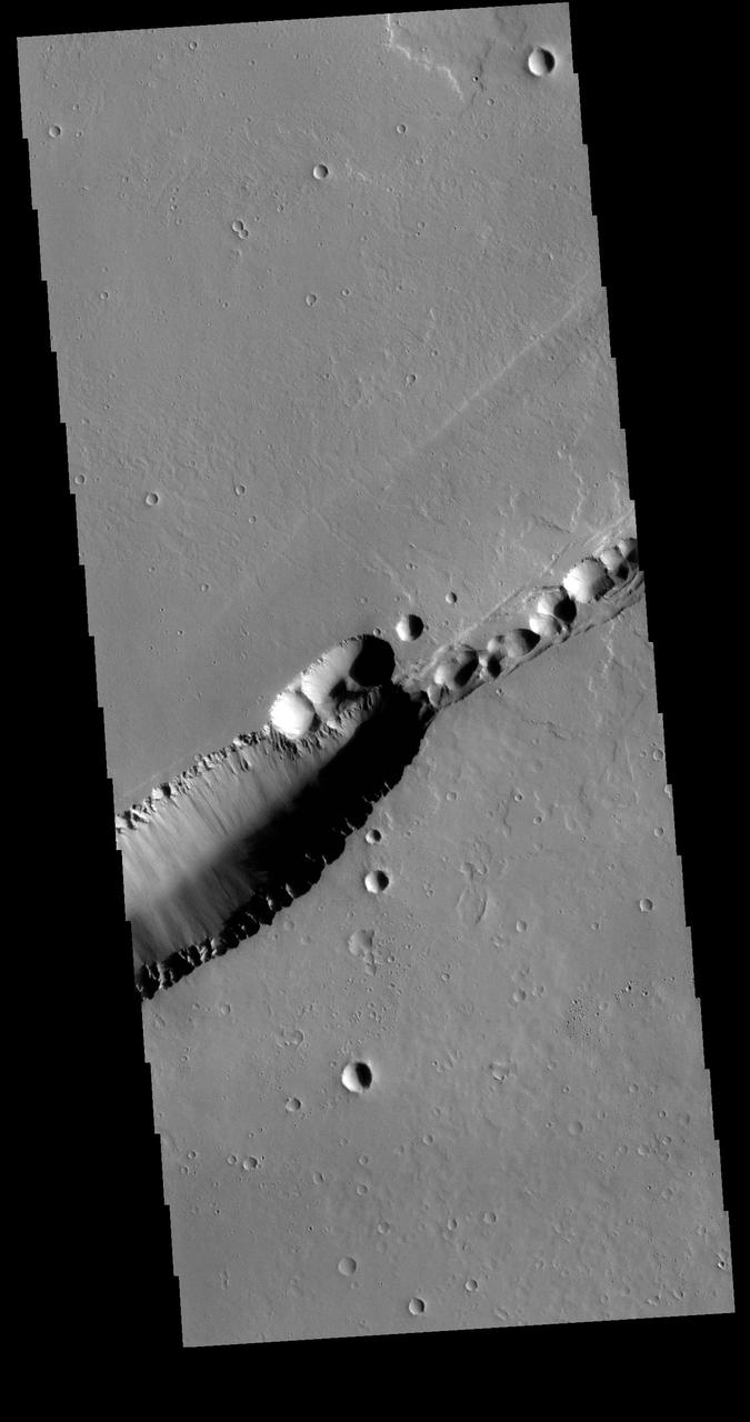
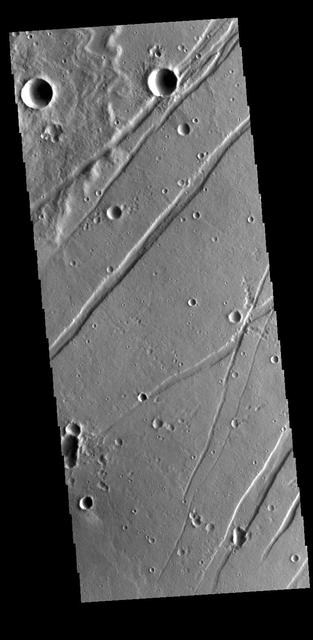
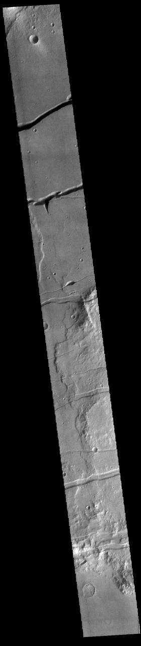
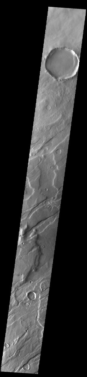
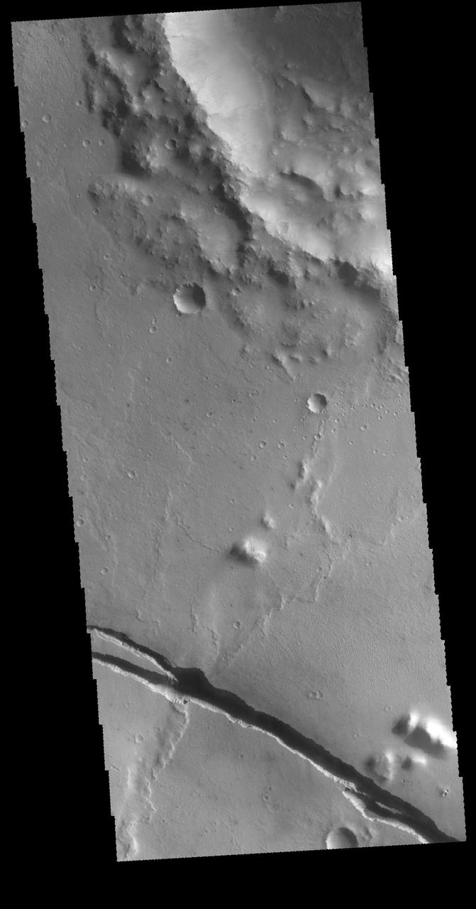
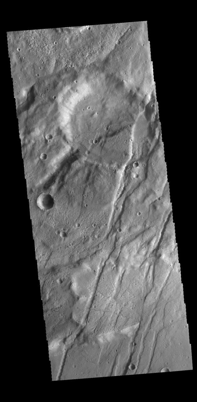
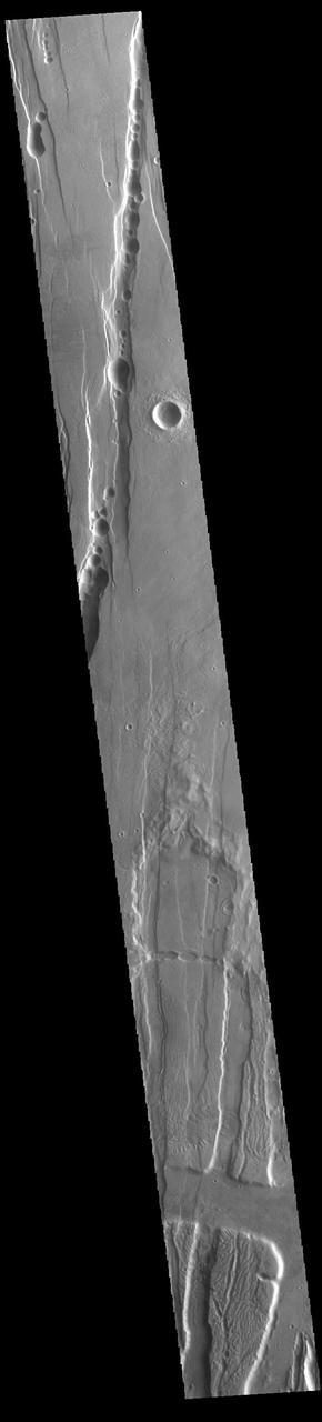
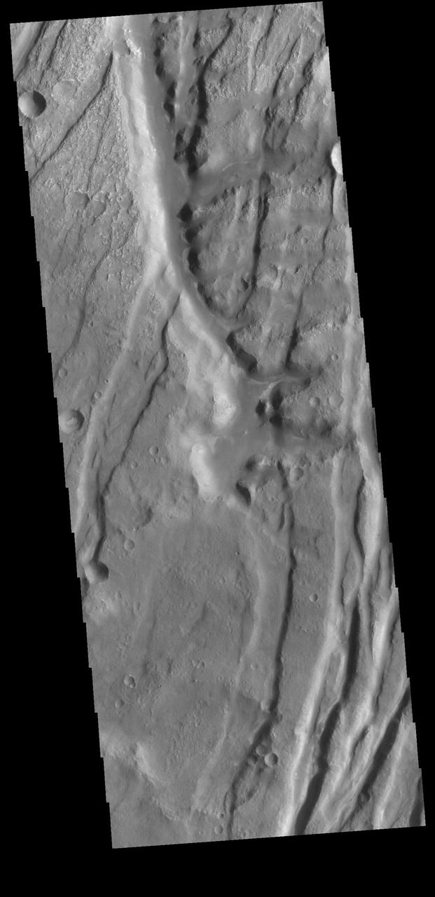
The crosscutting relationships observed in this image from NASA Mars Odyssey spacecraft can be used to determine the relative timing of graben and channel formations.
These graben - a kind of trench that is formed as a surface expands - were imaged near a region of the Moon called Mare Frigoris by NASA's Lunar Reconnaissance Orbiter (LRO). https://photojournal.jpl.nasa.gov/catalog/PIA23237
This image captured by NASA 2001 Mars Odyssey spacecraft shows graben called Claritas Fossae. Orbit Number: 66332 Latitude: -35.5437 Longitude: 251.308 Instrument: VIS Captured: 2016-11-26 15:54 http://photojournal.jpl.nasa.gov/catalog/PIA21288
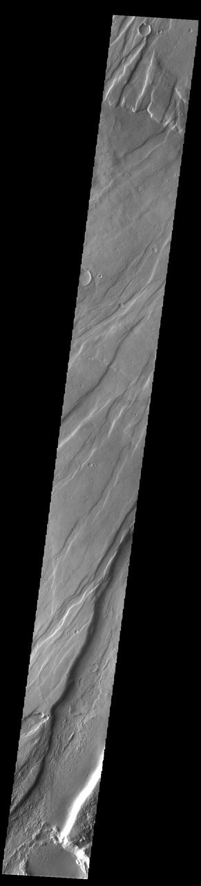
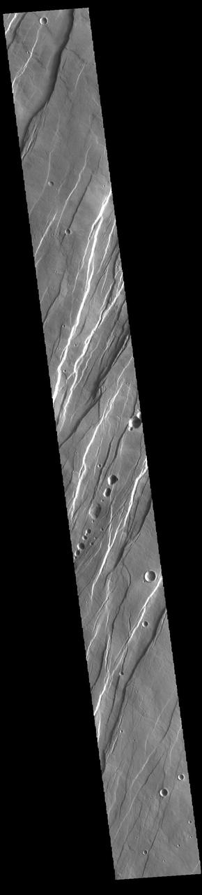
This image of Tharsis Rise from NASA Mars Odyssey shows a series of linear features called graben, which are associated with crustal extension resulting in up and down blocks of crust that run perpendicular to the direction of the extension.
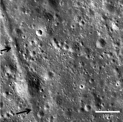
Two small black arrows on today image taken by NASA Lunar Reconnaissance Orbiter show the location of a small graben 28 meters in width in a pyroclastic mantling deposit in the SW portion of Mare Humorum.
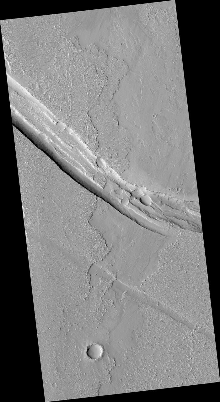
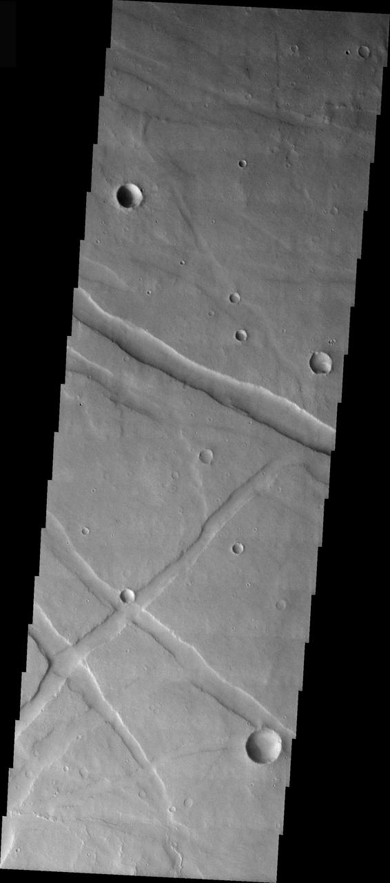
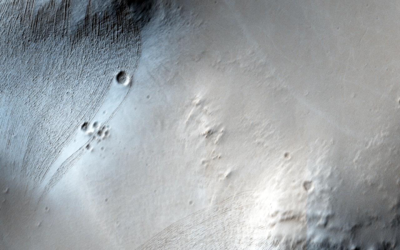
This image from NASA Mars Reconnaissance Orbiter shows a graben a trough formed when the ground drops between two parallel faults and a lava flow in the Tharsis volcanic province of Mars. North is up.
This image captured by NASA 2001 Mars Odyssey spacecraft shows a small portion of Noctis Labyrinthus. Noctis Labyrinthus is a network of tectonic graben and collapse valleys on the western margin of Valles Marineris. Orbit Number: 65633 Latitude: -12.6383 Longitude: 264.142 Instrument: VIS Captured: 2016-09-30 01:59 http://photojournal.jpl.nasa.gov/catalog/PIA21176

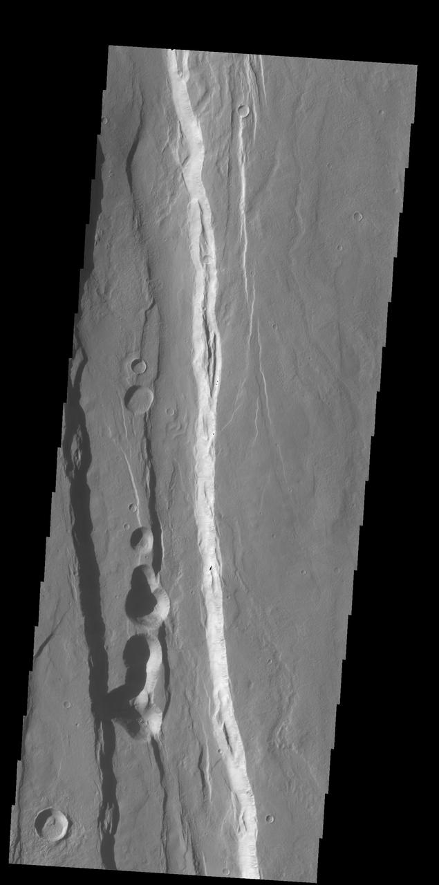
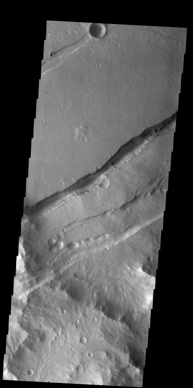
The linear depression in this image from NASA 2001 Mars Odyssey spacecraft is a graben. The graben in this area of Mars are called Sirenum Fossae.
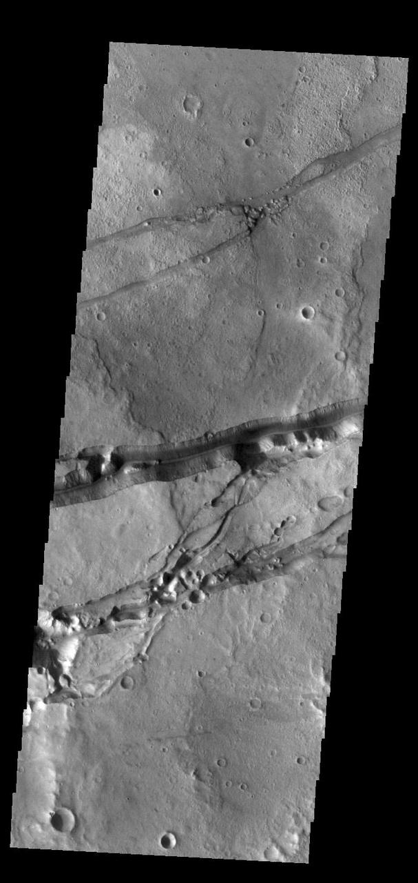
This image captured by NASA 2001 Mars Odyssey spacecraft shows a graben cutting through a plateau. The graben is part of Sirenum Fossae.
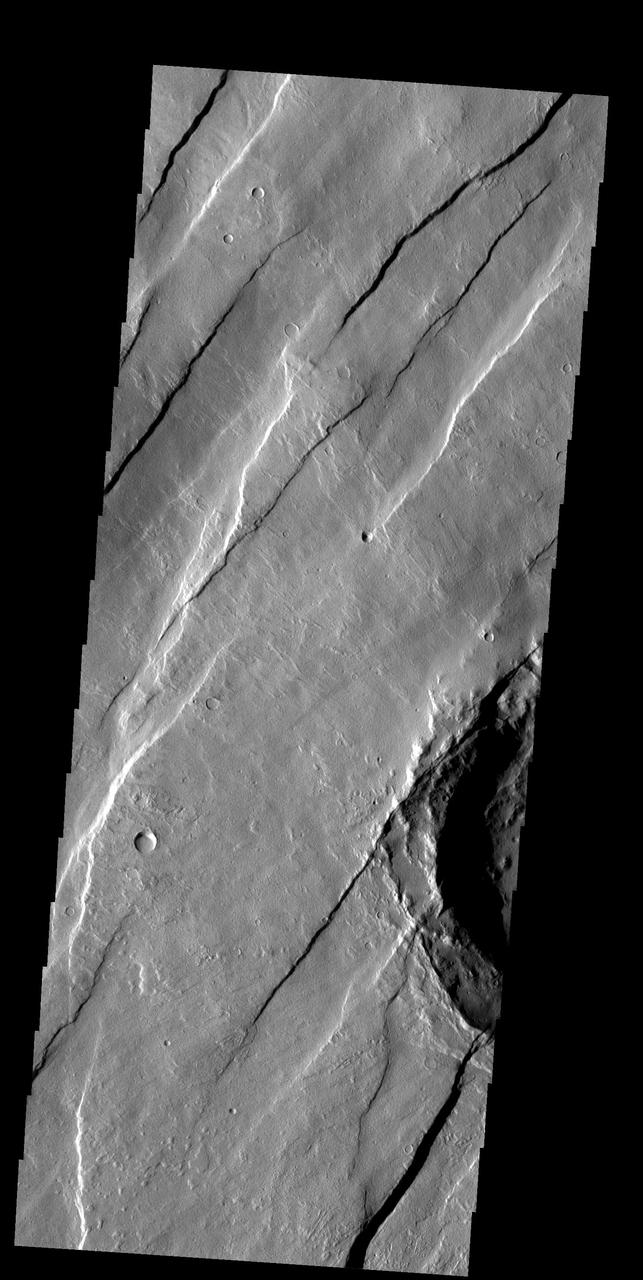
The large graben in this image from NASA 2001 Mars Odyssey spacecraft is part of a series of graben located on the southern flank of Alba Mons. This collection of graben is called Ceraunius Fossae. The term fossae means long, linear depressions.
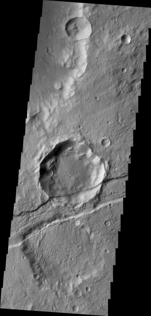
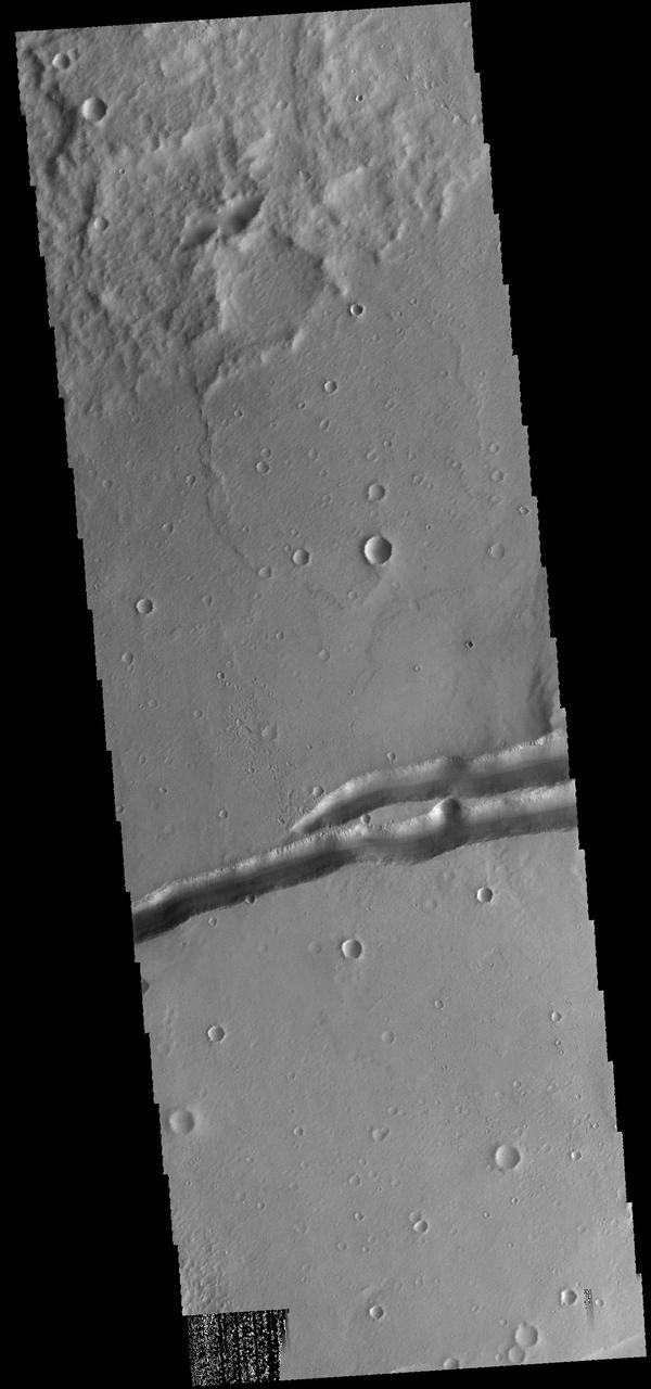
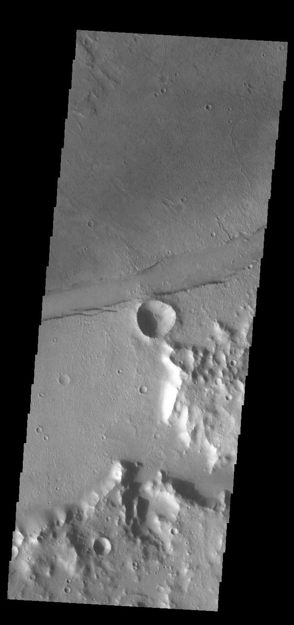
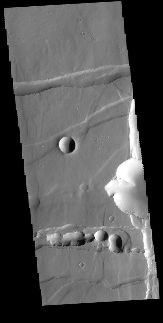
The downdropped block of surface seen in this image captured by NASA 2001 Mars Odyssey spacecraft is called a graben. The graben is younger than the crater, since the crater is cut by the graben.
The channel-like features in this VIS image are tectonic graben. These graben are called Sirenum Fossae. Graben are created in regions of extensional tectonic stress, where the bedrock is faulted and pulled apart, allowing linear sections of the surface to drop downward along paired faults. The Sirenum Fossae graben are 2735km (1700 miles) long. Orbit Number: 84903 Latitude: -30.8518 Longitude: 208.42 Instrument: VIS Captured: 2021-02-03 04:32 https://photojournal.jpl.nasa.gov/catalog/PIA24737
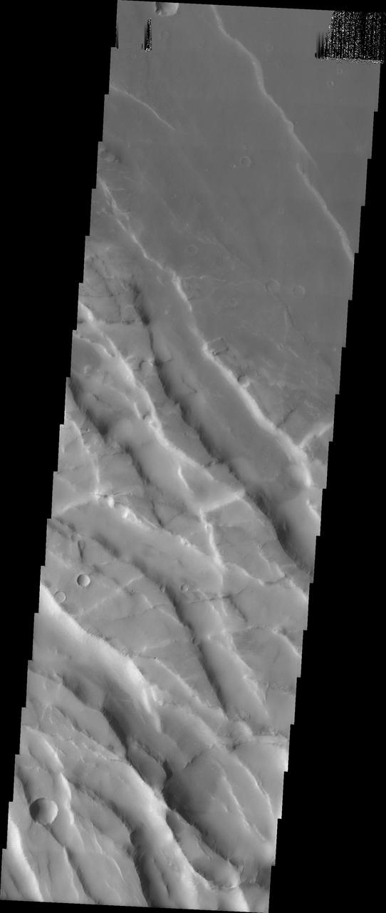
Noctis Labyrinthus is a highly tectonized region immediately to the west of Valles Marineris. It formed when Mars' crust stretched itself apart. In this region, the crust first stretched in a north-south direction (as evidenced by the east-west trending scarp) and then in an east-west direction (as evidenced by the north-south trending smaller scarps). This sort of tectonic stretching creates faults in the crust (cracks along with masses of rock slide. This process is totally unrelated to Earth's plate tectonics.). The lower portions between faults are called "grabens" and the interspersed higher portions are called "horsts." The Basin and Range tectonic province of the western United States is a close Earth analog to Noctis Labyrinthus, which is Latin for "labyrinth of the night." http://photojournal.jpl.nasa.gov/catalog/PIA20740

The linear features in this VIS image are tectonic graben. These graben are called Sirenum Fossae. Graben are formed by extension of the crust and faulting. When large amounts of pressure or tension are applied to rocks on timescales that are fast enough that the rock cannot respond by deforming, the rock breaks along faults. In the case of a graben, two parallel faults are formed by extension of the crust and the rock in between the faults drops downward into the space created by the extension. Several graben are visible in this THEMIS VIS image, trending from east to west. Because the faults defining the graben are formed parallel to the direction of the applied stress, we know that extensional forces were pulling the crust apart in the north/south direction. The majority of the stresses that created Sirenum Fossae are aligned in the in a north-northwest to south-southeast direction. The Sirenum Fossae graben are 2735km (1700 miles) long. Orbit Number: 89864 Latitude: -38.9631 Longitude: 182.869 Instrument: VIS Captured: 2022-03-18 16:46 https://photojournal.jpl.nasa.gov/catalog/PIA25399
The linear features in this VIS image are tectonic graben. These graben are called Sirenum Fossae. Graben are formed by extension of the crust and faulting. When large amounts of pressure or tension are applied to rocks on timescales that are fast enough that the rock cannot respond by deforming, the rock breaks along faults. In the case of a graben, two parallel faults are formed by extension of the crust and the rock in between the faults drops downward into the space created by the extension. Several graben are visible in this THEMIS VIS image, trending from east to west. Because the faults defining the graben are formed parallel to the direction of the applied stress, we know that extensional forces were pulling the crust apart in the north/south direction. The majority of the stresses that created Sirenum Fossae are aligned in the in a north-northwest to south-southeast direction. The Sirenum Fossae graben are 2735km (1700 miles) long. Orbit Number: 91772 Latitude: -27.9695 Longitude: 216.058 Instrument: VIS Captured: 2022-08-22 19:21 https://photojournal.jpl.nasa.gov/catalog/PIA25642
The depression in the center of this image captured by NASA 2001 Mars Odyssey spacecraft is a graben fault bounded block of material. This graben is called Mangala Fossa.
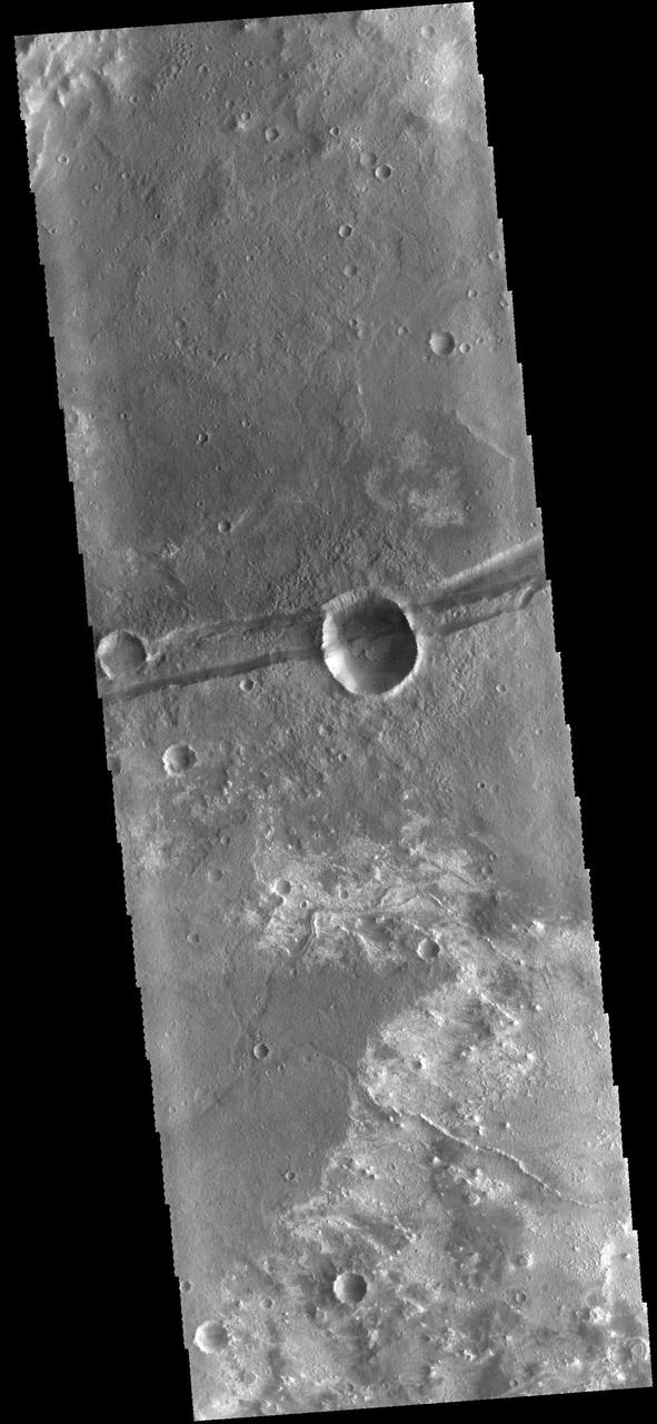
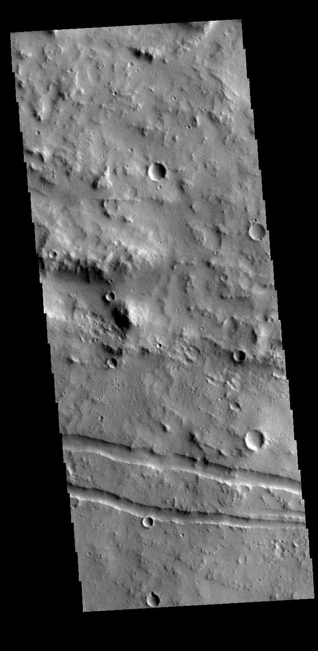
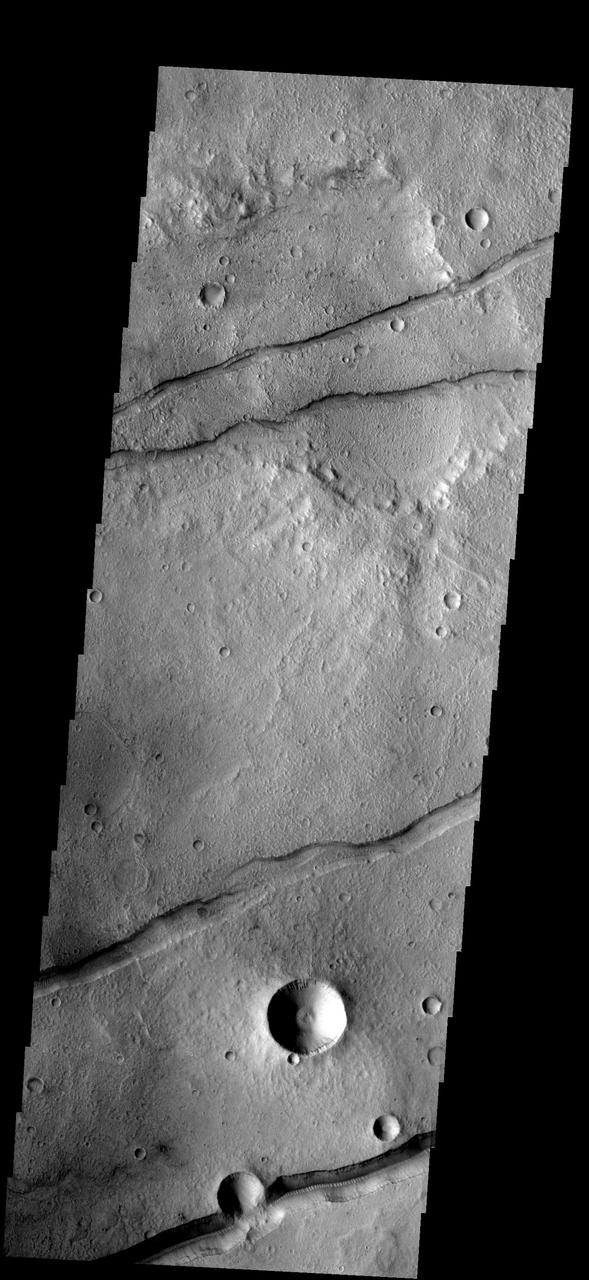
The linear depression in the center of this image captured by NASA Mars Odyssey spacecraft is a graben - a fault bounded block of material. The graben crosses the crater and ejecta in the middle of the image.
The channel-like features in this VIS image are tectonic graben. These graben are called Icaria Fossae and are located in Terra Sirenum. Graben are created in regions of extensional tectonic stress, where the bedrock is faulted and pulled apart, allowing linear sections of the surface to drop downward along paired faults. Orbit Number: 81751 Latitude: -46.5369 Longitude: 236.614 Instrument: VIS Captured: 2020-05-19 16:24 https://photojournal.jpl.nasa.gov/catalog/PIA24010
The linear features in this VIS image are graben called Sirenum Fossae. Graben are formed when blocks of material move downward between parallel faults. The faults were created by tectonic stresses in this region. The ground is pulling apart and breaks into faults, continued stress moves the sides of the faults further apart and form the graben. Orbit Number: 75220 Latitude: -31.3869 Longitude: 208.356 Instrument: VIS Captured: 2018-11-28 20:39 https://photojournal.jpl.nasa.gov/catalog/PIA22989
Today's VIS image shows a portion of Sirenum Fossae. The linear features are tectonic graben. Graben are formed by extension of the crust and faulting. When large amounts of pressure or tension are applied to rocks on timescales that are fast enough that the rock cannot respond by deforming, the rock breaks along faults. In the case of a graben, two parallel faults are formed by extension of the crust and the rock in between the faults drops downward into the space created by the extension. Numerous sets of graben are visible in this THEMIS image, trending from north-northeast to south-southwest. Because the faults defining the graben are formed perpendicular to the direction of the applied stress, we know that extensional forces were pulling the crust apart in the west-northwest/east-southeast direction. The Sirenum Fossae graben are 2735km (1700 miles) long and stretch from eastern Terra Sirenum into western Daedalia Planum. Orbit Number: 92627 Latitude: -27.7786 Longitude: 216.392 Instrument: VIS Captured: 2022-11-01 04:18 https://photojournal.jpl.nasa.gov/catalog/PIA25766
Today's VIS image shows a portion of Sirenum Fossae. The linear features are tectonic graben. Graben are formed by extension of the crust and faulting. When large amounts of pressure or tension are applied to rocks on timescales that are fast enough that the rock cannot respond by deforming, the rock breaks along faults. In the case of a graben, two parallel faults are formed by extension of the crust and the rock in between the faults drops downward into the space created by the extension. Numerous sets of graben are visible in this THEMIS image, trending from north-northeast to south-southwest. Because the faults defining the graben are formed perpendicular to the direction of the applied stress, we know that extensional forces were pulling the crust apart in the west-northwest/east-southeast direction. The Sirenum Fossae graben are 2735km (1700 miles) long and stretch from eastern Terra Sirenum into western Daedalia Planum. Orbit Number: 91816 Latitude: -29.2208 Longitude: 213.139 Instrument: VIS Captured: 2022-08-26 09:39 https://photojournal.jpl.nasa.gov/catalog/PIA25645
Today's VIS image shows a portion of Sirenum Fossae. The linear features are tectonic graben. Graben are formed by extension of the crust and faulting. When large amounts of pressure or tension are applied to rocks on timescales that are fast enough that the rock cannot respond by deforming, the rock breaks along faults. In the case of a graben, two parallel faults are formed by extension of the crust and the rock in between the faults drops downward into the space created by the extension. Numerous sets of graben are visible in this THEMIS image, trending from north-northeast to south-southwest. Because the faults defining the graben are formed perpendicular to the direction of the applied stress, we know that extensional forces were pulling the crust apart in the west-northwest/east-southeast direction. The Sirenum Fossae graben are 2735km (1700 miles) long and stretch from eastern Terra Sirenum into western Daedalia Planum. Orbit Number: 92416 Latitude: -39.2691 Longitude: 181.857 Instrument: VIS Captured: 2022-10-14 19:23 https://photojournal.jpl.nasa.gov/catalog/PIA25758
Today's VIS image shows a portion of Sirenum Fossae. The linear features are tectonic graben. Graben are formed by extension of the crust and faulting. When large amounts of pressure or tension are applied to rocks on timescales that are fast enough that the rock cannot respond by deforming, the rock breaks along faults. In the case of a graben, two parallel faults are formed by extension of the crust and the rock in between the faults drops downward into the space created by the extension. Numerous sets of graben are visible in this THEMIS image, trending from north-northeast to south-southwest. Because the faults defining the graben are formed perpendicular to the direction of the applied stress, we know that extensional forces were pulling the crust apart in the west-northwest/east-southeast direction. The Sirenum Fossae graben are 2735km (1700 miles) long and stretch from eastern Terra Sirenum into western Daedalia Planum. Orbit Number: 92253 Latitude: -32.4503 Longitude: 205.396 Instrument: VIS Captured: 2022-10-01 09:14 https://photojournal.jpl.nasa.gov/catalog/PIA25753
Today's VIS image shows a portion of Sirenum Fossae. The linear features are tectonic graben. Graben are formed by extension of the crust and faulting. When large amounts of pressure or tension are applied to rocks on timescales that are fast enough that the rock cannot respond by deforming, the rock breaks along faults. In the case of a graben, two parallel faults are formed by extension of the crust and the rock in between the faults drops downward into the space created by the extension. Numerous sets of graben are visible in this THEMIS image, trending from north-northeast to south-southwest. Because the faults defining the graben are formed perpendicular to the direction of the applied stress, we know that extensional forces were pulling the crust apart in the west-northwest/east-southeast direction. The Sirenum Fossae graben are 2735km (1700 miles) long and stretch from eastern Terra Sirenum into western Daedalia Planum. Orbit Number: 93139 Latitude: -32.2816 Longitude: 204.773 Instrument: VIS Captured: 2022-12-13 08:06 https://photojournal.jpl.nasa.gov/catalog/PIA25842
The linear depressions at the top of the VIS image are some of the graben that comprise Cerberus Fossae. Graben form where extensional tectonic forces allows blocks of material to subside between paired faults. Cerberus Fossae is located in Elysium Planitia, southeast of the Elysium Mons volcanic complex. These graben were also the source of significant volcanic flows, creating the flow features to the top and the bottom of the graben. These flows are called Athabasca Valles. Water may have also been released from the graben, creating a complex history for channel forms in this region. Orbit Number: 79108 Latitude: 10.0044 Longitude: 157.144 Instrument: VIS Captured: 2019-10-15 01:44 https://photojournal.jpl.nasa.gov/catalog/PIA23568
The channel-like features in this image from NASA 2001 Mars Odyssey spacecraft are tectonic graben. The graben called Icaria Fossae are located in Terra Sirenum. Orbit Number: 65846 Latitude: -41.5696 Longitude: 240.567 Instrument: VIS Captured: 2016-10-17 14:57 http://photojournal.jpl.nasa.gov/catalog/PIA21185
The channel-like features in this VIS image are tectonic graben. These graben are called Sirenum Fossae. Graben are created in regions of extensional tectonic stress, where the bedrock is faulted and pulled apart, allowing linear sections of the surface to drop downward along paired faults. The Sirenum Fossae graben are 2735km (1700 miles) long. Orbit Number: 84111 Latitude: -37.1819 Longitude: 191.303 Instrument: VIS Captured: 2020-11-30 00:06 https://photojournal.jpl.nasa.gov/catalog/PIA24406
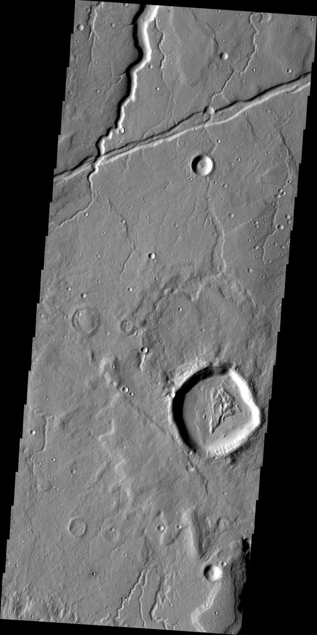
Today's VIS image shows a section of one of the graben that comprise Elysium Fossae. Graben are formed during tectonic activity, where blocks of material slide down between paired faults. Graben are common around volcanic regions on Mars. The rise of magma to the surface bows up the ground, creating the extensive forces that create graben. Orbit Number: 77698 Latitude: 22.948 Longitude: 156.114 Instrument: VIS Captured: 2019-06-20 23:13 https://photojournal.jpl.nasa.gov/catalog/PIA23366

The linear depressions in this image from NASA 2001 Mars Odyssey spacecraft are called graben. Graben are bounded on both sides by faults, and the central material has shifted downward between the faults.
This VIS image shows several linear depressions called graben. Graben are formed due to extensional tectonic stresses, creating linear faults that allow subsidence of blocks of material between paired faults. At the top of the image several graben of Mangala Fossae intersect an impact crater. The other graben in the rest of the image are part of Memnonia Fossae. Both sets of fossae cross between Terra Sirenum and Daedalia Planum. Orbit Number: 83137 Latitude: -19.9645 Longitude: 207.232 Instrument: VIS Captured: 2020-09-10 19:29 https://photojournal.jpl.nasa.gov/catalog/PIA24190
Fossae are long linear depressions called graben and are formed by extension of the crust and faulting. When large amounts of pressure or tension are applied to rocks on timescales that are fast enough that the rock cannot respond by deforming, the rock breaks along faults. In the case of a graben, two parallel faults are formed by extension of the crust and the rock in between the faults drops downward into the space created by the extension. The graben in this VIS image are part of Memnonia Fossae. Memnonia Fossae, Mangala Fossae and Sirenum Fossae are all long graben systems that stretch from eastern Terra Sirenum into western Daedalia Planum. Orbit Number: 92952 Latitude: -20.9228 Longitude: 201.274 Instrument: VIS Captured: 2022-11-27 22:30 https://photojournal.jpl.nasa.gov/catalog/PIA25807
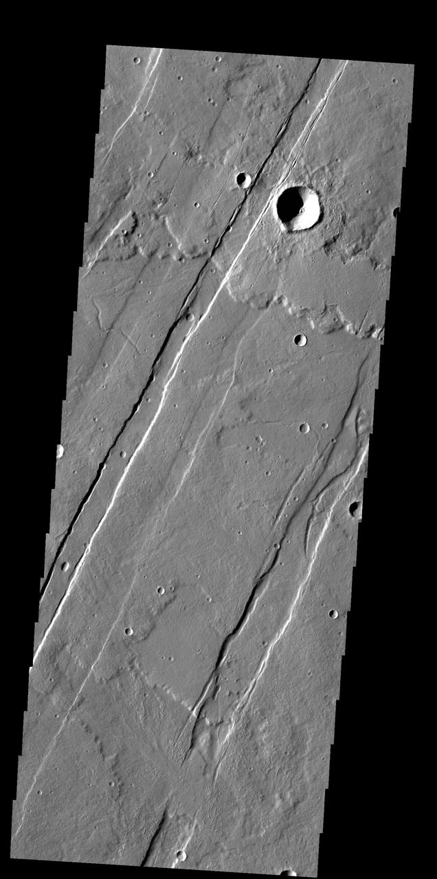
The feature that crosses this VIS image is a graben. Graben are formed by tectonic action, where a block of material moves downward between a pair of faults. The northern part of the Tharsis plateau is full of graben, most notably surrounding Alba Mons. The section of Labeatis Fossae seen in this image is directly south of Uranius Mons. Orbit Number: 71332 Latitude: 23.3233 Longitude: 267.467 Instrument: VIS Captured: 2018-01-12 15:07 https://photojournal.jpl.nasa.gov/catalog/PIA22387
The linear features in this VIS image are tectonic graben called Icaria Fossae and are located in Terra Sirenum. Graben are formed by extension of the crust and faulting. When large amounts of pressure or tension are applied to rocks on timescales that are fast enough that the rock cannot respond by deforming, the rock breaks along faults. In the case of a graben, two parallel faults are formed by extension of the crust and the rock in between the faults drops downward into the space created by the extension. The Icaria Fossae graben are 2115km (1314 miles) long. Orbit Number: 93200 Latitude: -41.7764 Longitude: 243.379 Instrument: VIS Captured: 2022-12-18 08:42 https://photojournal.jpl.nasa.gov/catalog/PIA25847
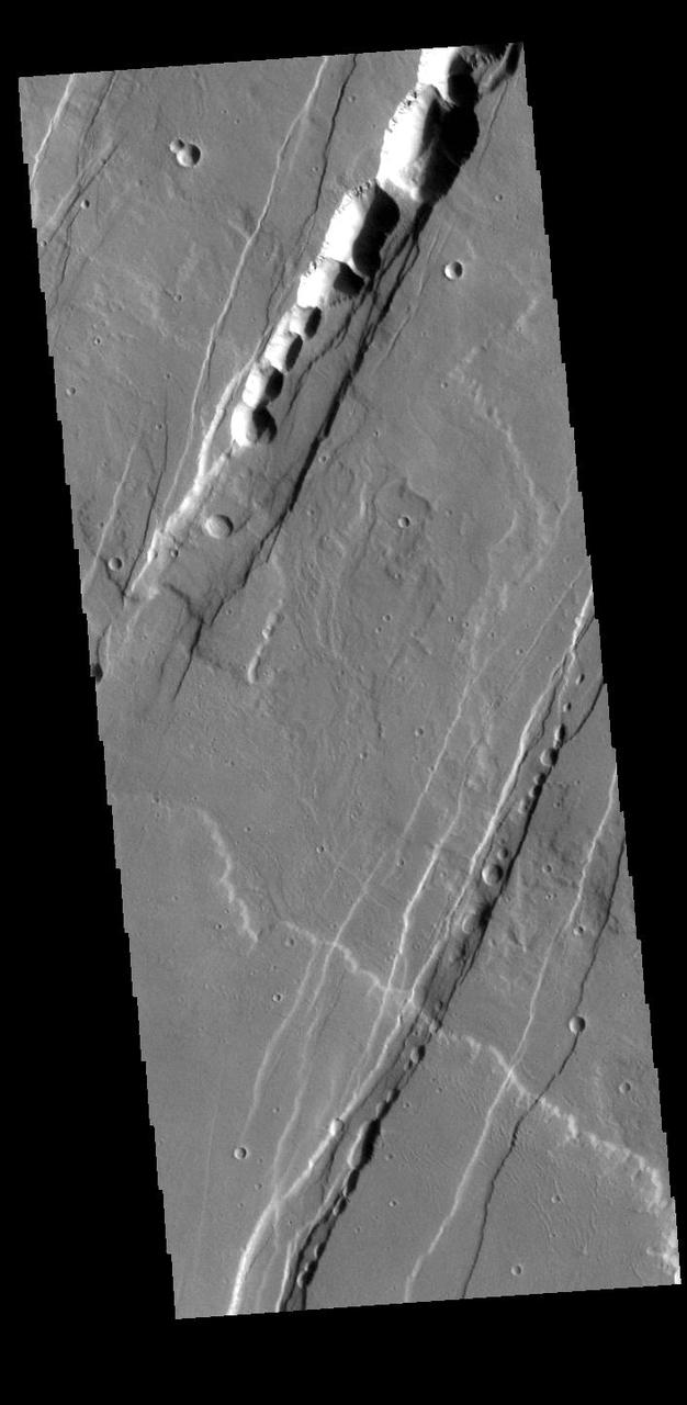
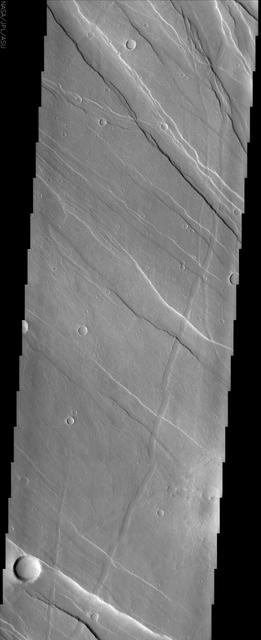
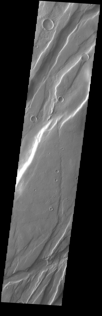
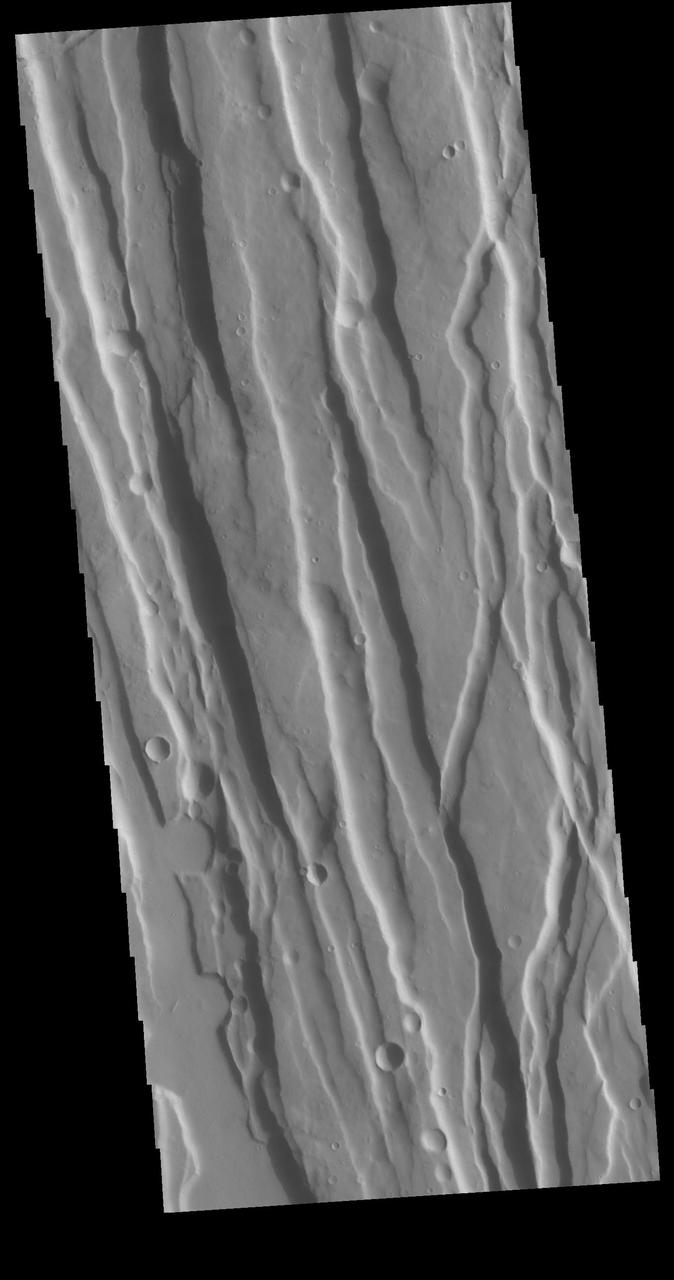
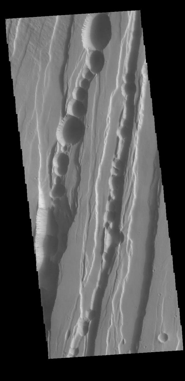
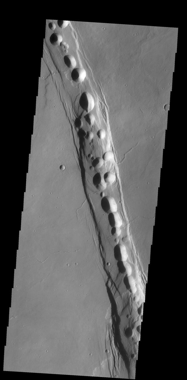
Tantalus Fossae is a set of long valleys on the eastern side of Alba Patera. These valleys are referred to as graben and are formed by extension of the crust and faulting. When large amounts of pressure or tension are applied to rocks on timescales that are fast enough that the rock cannot respond by deforming, the rock breaks along faults. In the case of a graben, two parallel faults are formed by extension of the crust and the rock in between the faults drops downward into the space created by the extension. Numerous sets of graben are visible in this THEMIS image, trending from north-northeast to south-southwest. Because the faults defining the graben are formed parallel to the direction of the applied stress, we know that extensional forces were pulling the crust apart in the west-northwest/east-southeast direction. The large number of graben around Alba Patera is generally believed to be the result of extensional forces associated with the uplift of Alba Patera. The pits within the graben are likely caused by collapse into subsurface voids, perhaps related to roofed lava flows along the floors of the graben. Orbit Number: 88164 Latitude: 34.4431 Longitude: 257.417 Instrument: VIS Captured: 2021-10-29 17:40 https://photojournal.jpl.nasa.gov/catalog/PIA25154
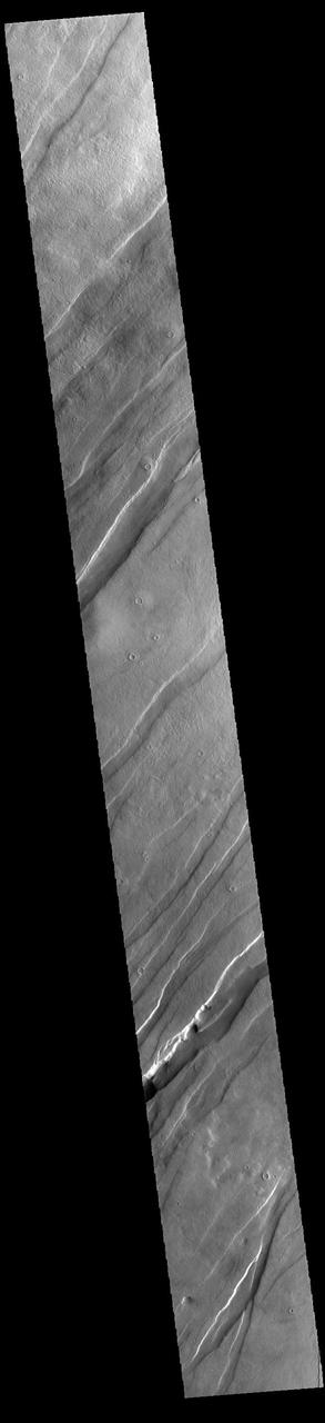
Today's VIS image is shows a small portion of Tempe Fossae. The linear features are tectonic graben. Graben are formed by extension of the crust and faulting. When large amounts of pressure or tension are applied to rocks on timescales that are fast enough that the rock cannot respond by deforming, the rock breaks along faults. In the case of a graben, two parallel faults are formed by extension of the crust and the rock in between the faults drops downward into the space created by the extension. Numerous sets of graben are visible in this THEMIS image, trending from north-northeast to south-southwest. Because the faults defining the graben are formed perpendicular to the direction of the applied stress, we know that extensional forces were pulling the crust apart in the west-northwest/east-southeast direction. The complete fossae system is almost 2000 km (1242 miles) long. Orbit Number: 94159 Latitude: 38.314 Longitude: 279.856 Instrument: VIS Captured: 2023-03-07 09:20 https://photojournal.jpl.nasa.gov/catalog/PIA25979
Today's VIS image is shows a small portion of Tempe Fossae. The linear features are tectonic graben. Graben are formed by extension of the crust and faulting. When large amounts of pressure or tension are applied to rocks on timescales that are fast enough that the rock cannot respond by deforming, the rock breaks along faults. In the case of a graben, two parallel faults are formed by extension of the crust and the rock in between the faults drops downward into the space created by the extension. Numerous sets of graben are visible in this THEMIS image, trending from north-northeast to south-southwest. Because the faults defining the graben are formed perpendicular to the direction of the applied stress, we know that extensional forces were pulling the crust apart in the west-northwest/east-southeast direction. The complete fossae system is almost 2000 km (1242 miles) long. Orbit Number: 94733 Latitude: 38.0943 Longitude: 280.561 Instrument: VIS Captured: 2023-04-23 15:38 https://photojournal.jpl.nasa.gov/catalog/PIA26154
Today's VIS image is shows a small portion of Tempe Fossae. The linear features are tectonic graben. Graben are formed by extension of the crust and faulting. When large amounts of pressure or tension are applied to rocks on timescales that are fast enough that the rock cannot respond by deforming, the rock breaks along faults. In the case of a graben, two parallel faults are formed by extension of the crust and the rock in between the faults drops downward into the space created by the extension. Numerous sets of graben are visible in this THEMIS image, trending from north-northeast to south-southwest. Because the faults defining the graben are formed perpendicular to the direction of the applied stress, we know that extensional forces were pulling the crust apart in the west-northwest/east-southeast direction. The complete fossae system in almost 2000 km (1242 miles) long. Orbit Number: 94209 Latitude: 35.5447 Longitude: 276.941 Instrument: VIS Captured: 2023-03-11 12:09 https://photojournal.jpl.nasa.gov/catalog/PIA25980
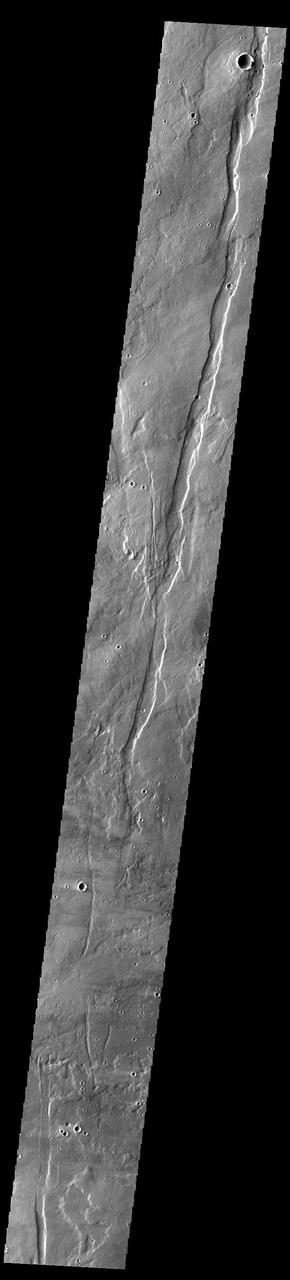
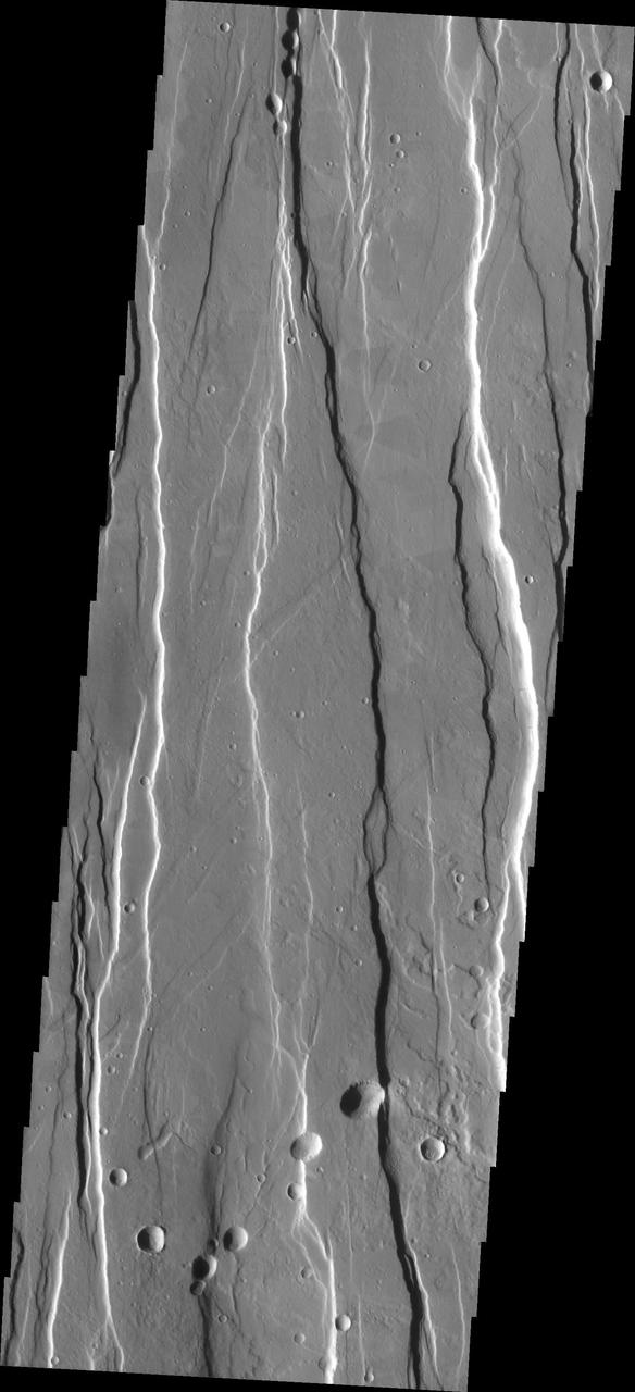
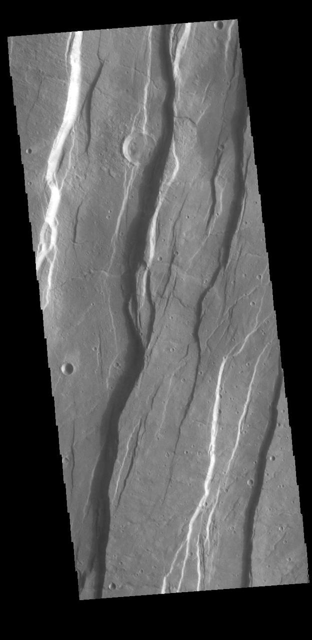
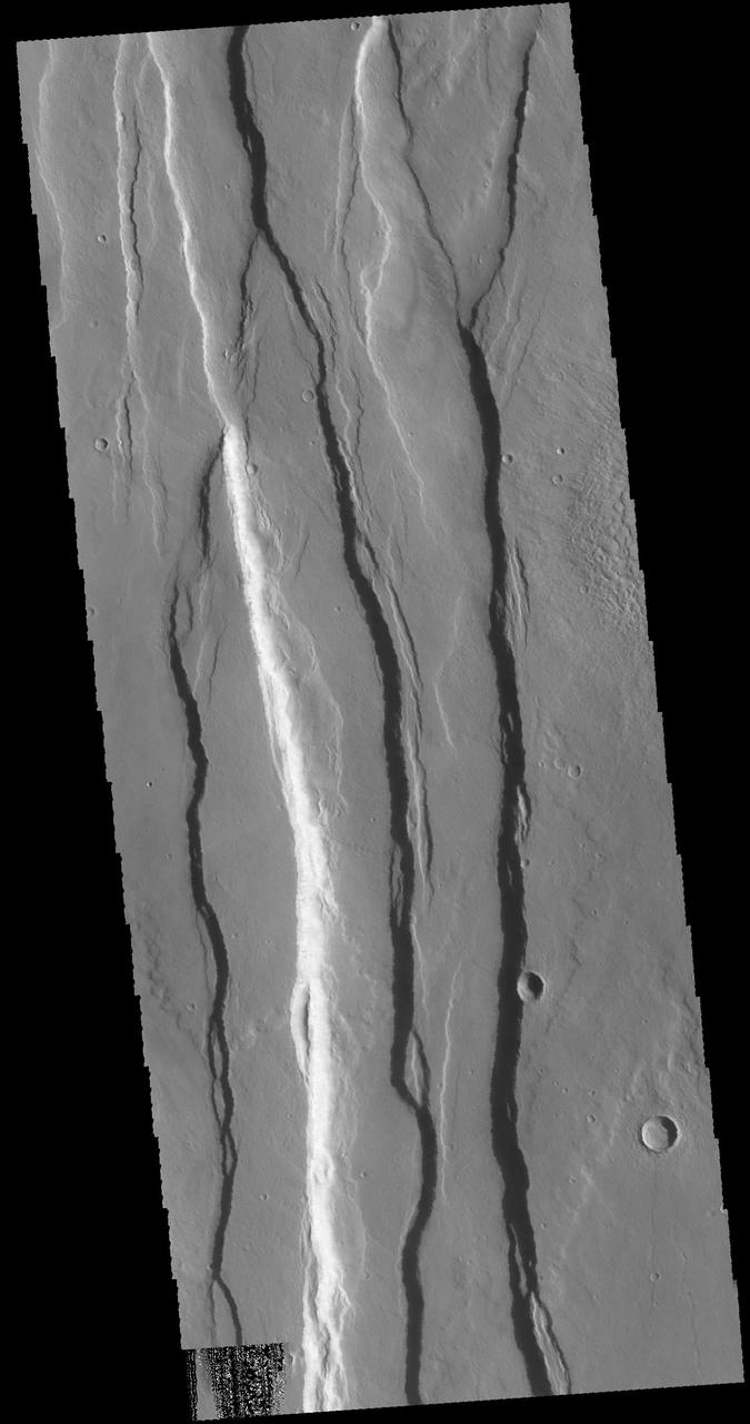
This VIS image shows part of Cerunius Fossae. The linear depressions are fault bounded features called graben. Graben are formed by extension of the crust and faulting. When large amounts of pressure or tension are applied to rocks on timescales that are fast enough that the rock cannot respond by deforming, the rock breaks along faults. In the case of a graben, two parallel faults are formed by extension of the crust and the rock in between the faults drops downward into the space created by the extension. The largest graben in this THEMIS image trends from almost north/south. Because the faults defining the graben are formed perpendicular to the direction of the applied stress, we know that extensional forces were pulling the crust apart in the east/west direction. Ceraunius Fossae is located on the southern part of Alba Mons and is 1166km (724 miles) long. Orbit Number: 94210 Latitude: 32.086 Longitude: 247.58 Instrument: VIS Captured: 2023-03-11 14:09 https://photojournal.jpl.nasa.gov/catalog/PIA25991
This VIS image shows part of Cerunius Fossae. The linear depressions are fault bounded features called graben. Graben are formed by extension of the crust and faulting. When large amounts of pressure or tension are applied to rocks on timescales that are fast enough that the rock cannot respond by deforming, the rock breaks along faults. In the case of a graben, two parallel faults are formed by extension of the crust and the rock in between the faults drops downward into the space created by the extension. Numerous sets of graben are visible in this THEMIS image, trending from north-northeast to south-southwest. Because the faults defining the graben are formed perpendicular to the direction of the applied stress, we know that extensional forces were pulling the crust apart in the north-northeast/south-southwest direction. Orbit Number: 93611 Latitude: 29.5294 Longitude: 247.628 Instrument: VIS Captured: 2023-01-21 06:29 https://photojournal.jpl.nasa.gov/catalog/PIA25854
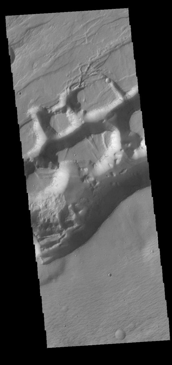
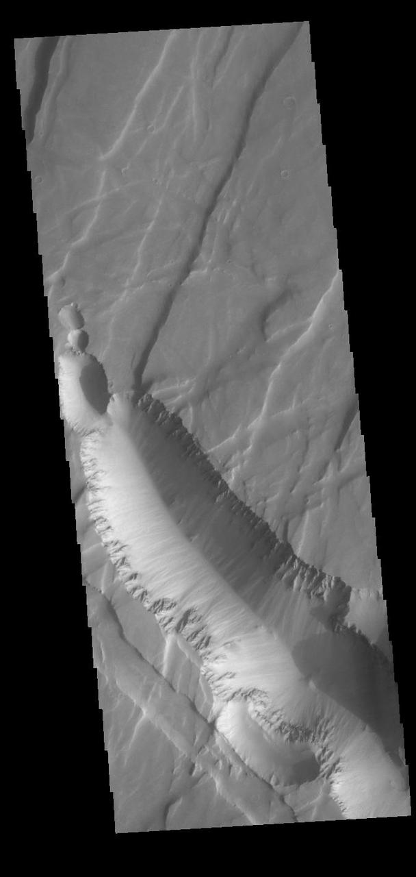
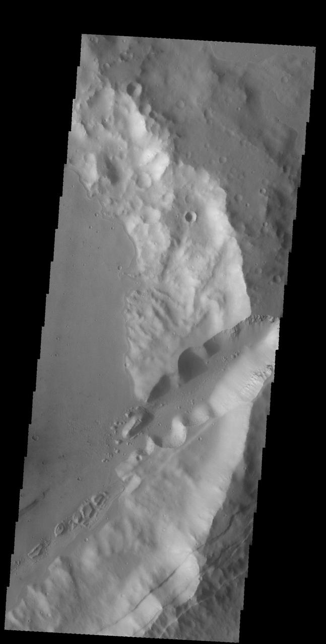
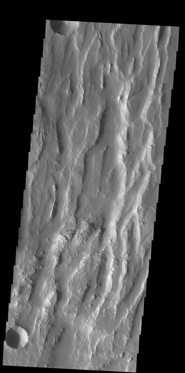
The grabens fractures that dominate this scene from NASA Mars Odyssey spacecraft are located northwest of a large shield volcano called Elysium Mons. Layered rock is evident along the lips of the graben as are ripples on the floors of these features. http://photojournal.jpl.nasa.gov/catalog/PIA04001
This VIS image shows a section of Sirenum Fossae. The linear features are called graben. Graben are formed by blocks of material sliding downward between pairs of faults. Orbit Number: 74365 Latitude: -28.1401 Longitude: 215.795 Instrument: VIS Captured: 2018-09-19 11:11 https://photojournal.jpl.nasa.gov/catalog/PIA22802
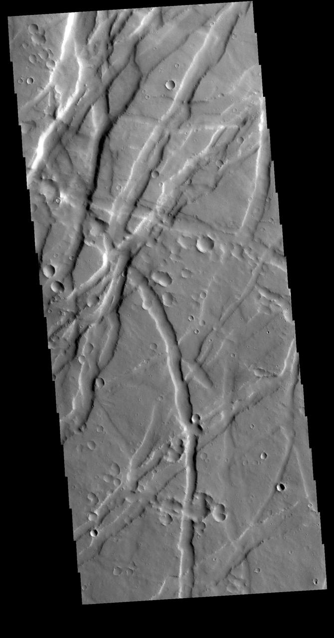
Uranius Fossae is region of multi directional graben. Graben are tectonic features created by extension, where blocks of material move downward between paired faults. This region of graben is located east of Uranius Mons. Orbit Number: 78842 Latitude: 23.1816 Longitude: 269.606 Instrument: VIS Captured: 2019-09-23 04:08 https://photojournal.jpl.nasa.gov/catalog/PIA23505
The linear depressions in this VIS image are tectonic graben. These graben are called Icaria Fossae and are located in Terra Sirenum. Graben are created in regions of extensional tectonic stress, where the bedrock is faulted and pulled apart, allowing linear sections of the surface to drop downward along paired faults. Orbit Number: 83941 Latitude: -43.6426 Longitude: 238.128 Instrument: VIS Captured: 2020-11-15 23:39 https://photojournal.jpl.nasa.gov/catalog/PIA24353
This VIS image shows part of Ceraunius Fossae. The linear depressions are fault bounded features called graben. Graben form from tectonic forces that are pulling apart the surface, created space for material to "slide down" along the fault. Alba Mons is surrounded by extensive regions of closely spaced graben. Ceraunius Fossae is located south of Alba Mons. Orbit Number: 78406 Latitude: 27.7831 Longitude: 248.084 Instrument: VIS Captured: 2019-08-18 06:29 https://photojournal.jpl.nasa.gov/catalog/PIA23484
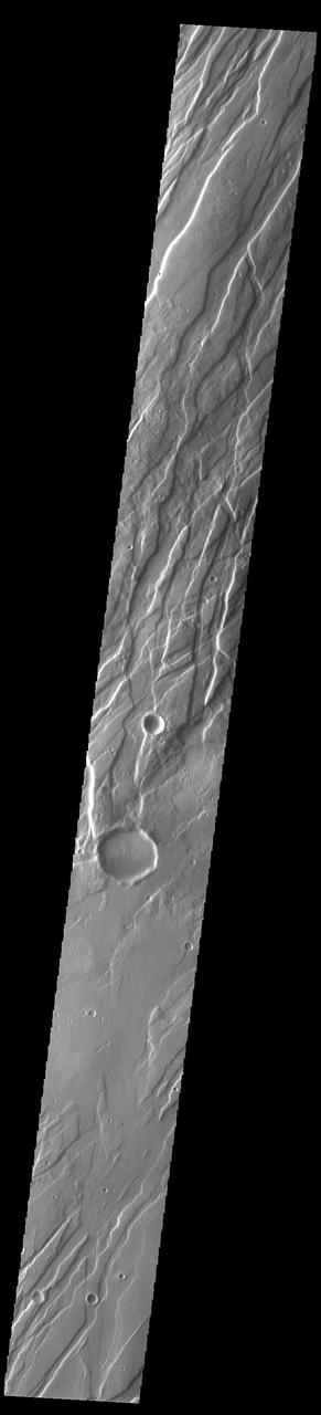
Today's VIS image shows a portion of Tantalus Fossae. The linear features are tectonic graben. Graben are formed by extension of the crust and faulting. When large amounts of pressure or tension are applied to rocks on timescales that are fast enough that the rock cannot respond by deforming, the rock breaks along faults. In the case of a graben, two parallel faults are formed by extension of the crust and the rock in between the faults drops downward into the space created by the extension. Numerous sets of graben are visible in this THEMIS image, trending from north-northeast to south-southwest. Because the faults defining the graben are formed perpendicular to the direction of the applied stress, we know that extensional forces were pulling the crust apart in the west-northwest/east-southeast direction. The large number of graben around Alba Mons is generally believed to be the result of extensional forces associated with the uplift of the volcano. Tantalus Fossae is 2361 km (1467 miles) long. Orbit Number: 94553 Latitude: 41.4418 Longitude: 256.44 Instrument: VIS Captured: 2023-04-08 19:22 https://photojournal.jpl.nasa.gov/catalog/PIA26035
Today's VIS image shows a portion of Tantalus Fossae. The linear features are tectonic graben. Graben are formed by extension of the crust and faulting. When large amounts of pressure or tension are applied to rocks on timescales that are fast enough that the rock cannot respond by deforming, the rock breaks along faults. In the case of a graben, two parallel faults are formed by extension of the crust and the rock in between the faults drops downward into the space created by the extension. Numerous sets of graben are visible in this THEMIS image, trending from north-northeast to south-southwest. Because the faults defining the graben are formed perpendicular to the direction of the applied stress, we know that extensional forces were pulling the crust apart in the west-northwest/east-southeast direction. The large number of graben around Alba Mons is generally believed to be the result of extensional forces associated with the uplift of the volcano. Tantalus Fossae is 2361 km (1467 miles) long. Orbit Number: 93854 Latitude: 44.7334 Longitude: 261.223 Instrument: VIS Captured: 2023-02-10 06:05 https://photojournal.jpl.nasa.gov/catalog/PIA25922
Today's VIS image shows a portion of Sirenum Fossae. The linear features are tectonic graben. Graben are formed by extension of the crust and faulting. When large amounts of pressure or tension are applied to rocks on timescales that are fast enough that the rock cannot respond by deforming, the rock breaks along faults. In the case of a graben, two parallel faults are formed by extension of the crust and the rock in between the faults drops downward into the space created by the extension. Numerous sets of graben are visible in this THEMIS image, trending from north-northeast to south-southwest. Because the faults defining the graben are formed perpendicular to the direction of the applied stress, we know that extensional forces were pulling the crust apart in the west-northwest/east-southeast direction. The Sirenum Fossae graben are 2735km (1700 miles) long and stretch from eastern Terra Sirenum into western Daedalia Planum. Orbit Number: 91436 Latitude: -37.5623 Longitude: 190.938 Instrument: VIS Captured: 2022-07-26 03:19 https://photojournal.jpl.nasa.gov/catalog/PIA25550
Today's VIS image shows a portion of Sirenum Fossae. The linear features are tectonic graben. Graben are formed by extension of the crust and faulting. When large amounts of pressure or tension are applied to rocks on timescales that are fast enough that the rock cannot respond by deforming, the rock breaks along faults. In the case of a graben, two parallel faults are formed by extension of the crust and the rock in between the faults drops downward into the space created by the extension. Numerous sets of graben are visible in this THEMIS image, trending from north-northeast to south-southwest. Because the faults defining the graben are formed perpendicular to the direction of the applied stress, we know that extensional forces were pulling the crust apart in the west-northwest/east-southeast direction. The Sirenum Fossae graben are 2735km (1700 miles) long and stretch from eastern Terra Sirenum into western Daedalia Planum. Orbit Number: 90574 Latitude: -27.0842 Longitude: 217.82 Instrument: VIS Captured: 2022-05-16 03:55 https://photojournal.jpl.nasa.gov/catalog/PIA25477
Today's VIS image shows a portion of Tantalus Fossae. The linear features are tectonic graben. Graben are formed by extension of the crust and faulting. When large amounts of pressure or tension are applied to rocks on timescales that are fast enough that the rock cannot respond by deforming, the rock breaks along faults. In the case of a graben, two parallel faults are formed by extension of the crust and the rock in between the faults drops downward into the space created by the extension. Numerous sets of graben are visible in this THEMIS image, trending from north-northeast to south-southwest. Because the faults defining the graben are formed perpendicular to the direction of the applied stress, we know that extensional forces were pulling the crust apart in the west-northwest/east-southeast direction. The large number of graben around Alba Mons is generally believed to be the result of extensional forces associated with the uplift of the volcano. Tantalus Fossae is 2361 km (1467 miles) long. Orbit Number: 94316 Latitude: 35.6149 Longitude: 254.633 Instrument: VIS Captured: 2023-03-20 07:00 https://photojournal.jpl.nasa.gov/catalog/PIA26003
The linear feature in this VIS image is part of Sirenum Fossae. The linear feature is a tectonic graben. Graben are formed by extension of the crust and faulting. When large amounts of pressure or tension are applied to rocks on timescales that are fast enough that the rock cannot respond by deforming, the rock breaks along faults. In the case of a graben, two parallel faults are formed by extension of the crust and the rock in between the faults drops downward into the space created by the extension. The graben in this THEMIS image is aligned trending from north-northeast to south-southwest. Because the faults defining the graben are formed perpendicular to the direction of the applied stress, we know that extensional forces were pulling the crust apart in the west-northwest/east-southeast direction. The Sirenum Fossae graben are 2735km (1700 miles) long and stretch from eastern Terra Sirenum into western Daedalia Planum. Orbit Number: 91854 Latitude: -35.8913 Longitude: 195.821 Instrument: VIS Captured: 2022-08-29 12:46 https://photojournal.jpl.nasa.gov/catalog/PIA25714
Today's VIS image shows a portion of Sirenum Fossae. The linear features are tectonic graben. Graben are formed by extension of the crust and faulting. When large amounts of pressure or tension are applied to rocks on timescales that are fast enough that the rock cannot respond by deforming, the rock breaks along faults. In the case of a graben, two parallel faults are formed by extension of the crust and the rock in between the faults drops downward into the space created by the extension. Numerous sets of graben are visible in this THEMIS image, trending from north-northeast to south-southwest. Because the faults defining the graben are formed perpendicular to the direction of the applied stress, we know that extensional forces were pulling the crust apart in the west-northwest/east-southeast direction. The Sirenum Fossae graben are 2735km (1700 miles) long and stretch from eastern Terra Sirenum into western Daedalia Planum. Orbit Number: 91410 Latitude: -26.2112 Longitude: 219.344 Instrument: VIS Captured: 2022-07-24 (All day) https://photojournal.jpl.nasa.gov/catalog/PIA25548
The linear depressions in this VIS image are graben called Labeatis Fossae. Graben are formed when extension between paired faults causes the material to move downward. Orbit Number: 77282 Latitude: 26.3831 Longitude: 278.283 Instrument: VIS Captured: 2019-05-17 17:04 https://photojournal.jpl.nasa.gov/catalog/PIA23324
This VIS image shows part of the Memnonia Fossae graben. Memnonia Fossae, Mangala Fossae and Sirenum Fossae are all long graben (tectonic troughs) systems that stretch from eastern Terra Sirenum into western Daedalia Planum. Orbit Number: 80629 Latitude: -21.8719 Longitude: 201.417 Instrument: VIS Captured: 2020-02-17 07:18 https://photojournal.jpl.nasa.gov/catalog/PIA23909
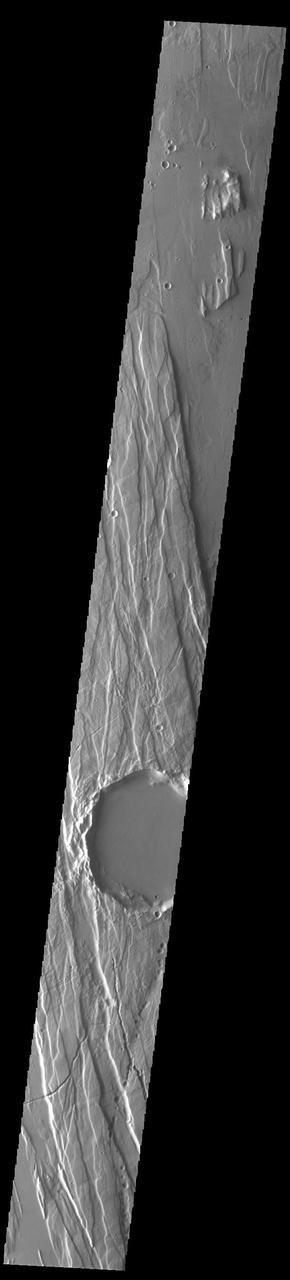
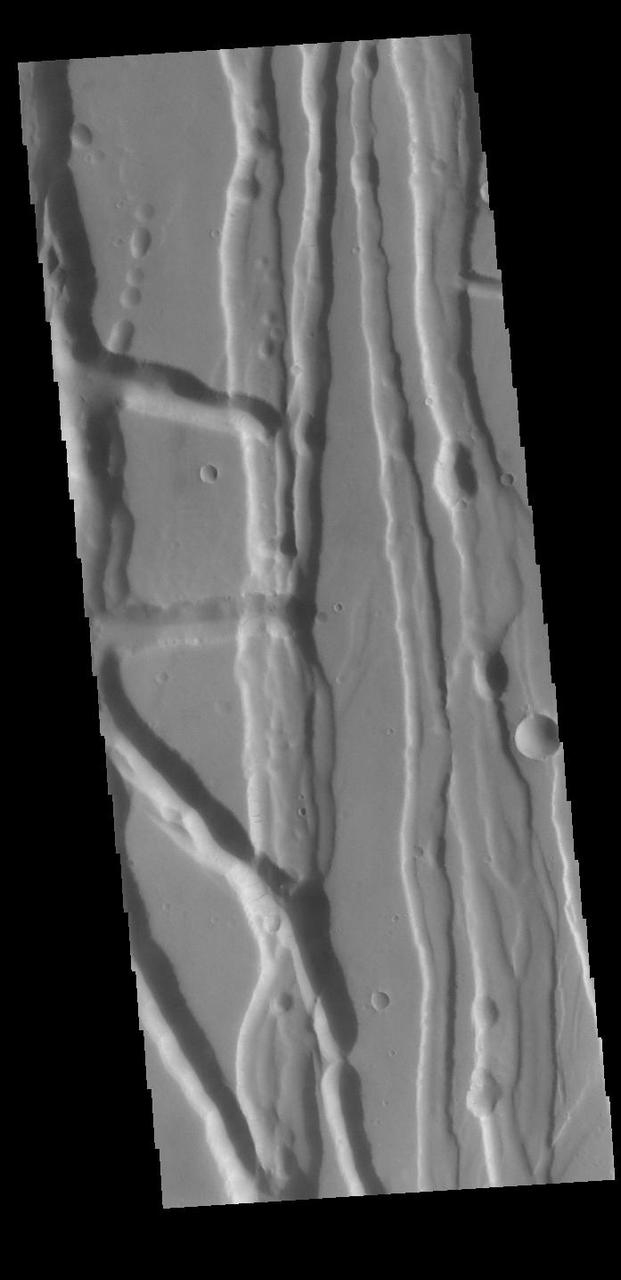
This VIS image shows part of Tractus Catena, just one of many north/south trending tectonic graben located south and east of Alba Mons. The graben with circular pits are part of Tractus Catena. The graben without pits are part of Tractus Fossae. The pits most likely formed as a result of roof collapse into an underlying open space such as a lava tube. Graben are formed by extension of the crust and faulting. When large amounts of pressure or tension are applied to rocks on timescales that are fast enough that the rock cannot respond by deforming, the rock breaks along faults. In the case of a graben, two parallel faults are formed by extension of the crust and the rock in between the faults drops downward into the space created by the extension. Numerous sets of graben are visible in this THEMIS image, trending generally north/south. Because the faults defining the graben are formed perpendicular to the direction of the applied stress, we know that extensional forces were pulling the crust apart in the east/west direction. The large number of graben around Alba Mons is generally believed to be the result of extensional forces associated with the uplift of the volcano. Orbit Number: 94890 Latitude: 25.2421 Longitude: 256.932 Instrument: VIS Captured: 2023-05-06 13:14 https://photojournal.jpl.nasa.gov/catalog/PIA26214
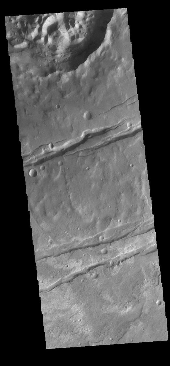
Today's VIS image shows a section of a graben that is part of Nili Fossae. Graben are formed when a block of material drops downward between paired tectonic faults. Graben usually have straight sides with little sinuosity, whereas fluvial channels typically have large amounts of sinuosity along the length of the depression. Nili Fossae is located northeast of the large volcano Syrtis Major and northwest of the ancient impact basin Isidis Planitia. The graben, which can be about 500 meters (1,600 feet) deep, make concentric curves that follow the outline of Isidis Planitia. The faults likely formed as the crust sagged under the weight of lava flows filling Isidis Planitia. Orbit Number: 79198 Latitude: 23.3881 Longitude: 78.7422 Instrument: VIS Captured: 2019-10-22 11:40 https://photojournal.jpl.nasa.gov/catalog/PIA23632
Fossae are long linear depressions called a graben and are formed by extension of the crust and faulting. When large amounts of pressure or tension are applied to rocks on timescales that are fast enough that the rock cannot respond by deforming, the rock breaks along faults. In the case of a graben, two parallel faults are formed by extension of the crust and the rock in between the faults drops downward into the space created by the extension. The graben at the top of the image is Mangala Fossae, the rest are part of Memnonia Fossae. Memnonia Fossae, Mangala Fossae and Sirenum Fossae are all long graben systems that stretch from eastern Terra Sirenum into western Daedalia Planum. Orbit Number: 91373 Latitude: -21.0528 Longitude: 206.009 Instrument: VIS Captured: 2022-07-20 22:54 https://photojournal.jpl.nasa.gov/catalog/PIA25546
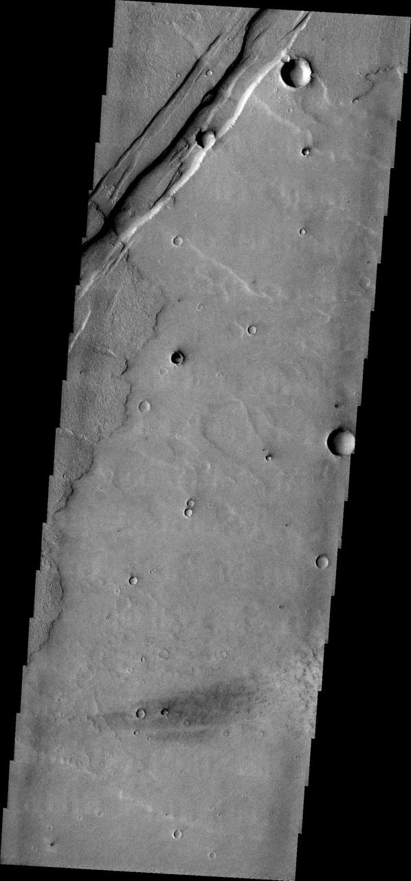
The linear depressions at the top half of this VIS image are graben that are called Cerberus Fossae. Graben form where extensional tectonic forces allows blocks of material to subside between paired faults. Cerberus Fossae are located in Elysium Planitia, southeast of the Elysium Mons volcanic complex. This graben is also the source of significant liquid flows, which created Athabasca Valles. The actual formation liquid proposed include flood water, low viscosity lava, and even glaciers. It is possible that water and lava both played a role in creating the channel system. Orbit Number: 78821 Latitude: 10.1133 Longitude: 157.297 Instrument: VIS Captured: 2019-09-21 10:33 https://photojournal.jpl.nasa.gov/catalog/PIA23503
The linear depressions at the top of the VIS image are some of the graben that comprise Cerberus Fossae. Graben form where extensional tectonic forces allows blocks of material to subside between paired faults. Cerberus Fossae are located in Elysium Planitia, southeast of the Elysium Mons volcanic complex. The graben were also the source of significant volcanic flows, creating the deposits seen at the lower part of the image. Orbit Number: 77985 Latitude: 9.97726 Longitude: 157.285 Instrument: VIS Captured: 2019-07-14 14:21 https://photojournal.jpl.nasa.gov/catalog/PIA23400
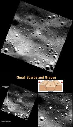
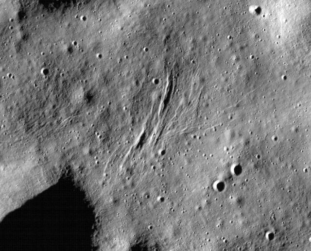
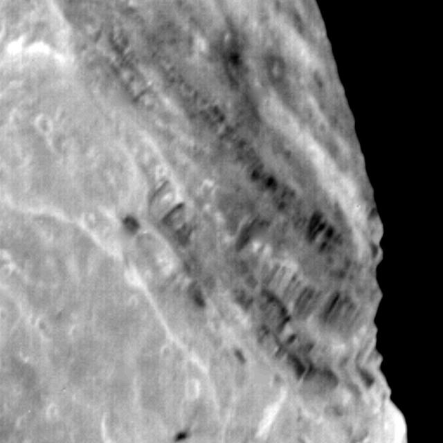
Small graben, narrow linear troughs, have been found associated with small scarps (bottom left, white arrows) on Mercury and the Moon. These graben (bottom right, white arrows) likely resulted from the bending and extension of the upper crust in response to scarp formation (bottom illustration) and are only tens of meters wide. On the basis of the rate of degradation and infilling of small troughs on the Moon by continuous meteoroid bombardment, small lunar graben and their associated scarps are less than 50 Myr old! It is likely that Mercury's small graben and their associated scarps are younger still, because the cratering rate on Mercury is greater than on the Moon. http://photojournal.jpl.nasa.gov/catalog/PIA19254
The linear features in this VIS image are called Mareotis Fossae. They are part of a huge region of graben that comprise Tempe Terra. The graben of Mareotis Fossae trend to the northeast, parallel to the fossae of Alba Mons located just to the west of Tempe Terra. Graben are formed by extension of the crust and faulting. When large amounts of pressure or tension are applied to rocks on timescales that are fast enough that the rock cannot respond by deforming, the rock breaks along faults. In the case of a graben, two parallel faults are formed by extension of the crust and the rock in between the faults drops downward into the space created by the extension. Numerous sets of graben are visible in this THEMIS image, trending from northeast to southwest. Because the faults defining the graben are formed perpendicular to the direction of the applied stress, we know that extensional forces were pulling the crust apart in the northwest/southeast direction. Mareotis Fossae is 1907km long (1185 miles). Orbit Number: 94059 Latitude: 46.0809 Longitude: 286.137 Instrument: VIS Captured: 2023-02-27 03:41 https://photojournal.jpl.nasa.gov/catalog/PIA25977
The linear features in this VIS image are called Mareotis Fossae. They are part of a huge region of graben that comprise Tempe Terra. The graben of Mareotis Fossae trend to the northeast, parallel to the fossae of Alba Mons located just to the west of Tempe Terra. Graben and are formed by extension of the crust and faulting. When large amounts of pressure or tension are applied to rocks on timescales that are fast enough that the rock cannot respond by deforming, the rock breaks along faults. In the case of a graben, two parallel faults are formed by extension of the crust and the rock in between the faults drops downward into the space created by the extension. Numerous sets of graben are visible in this THEMIS image, trending from northeast to southwest. Because the faults defining the graben are formed perpendicular to the direction of the applied stress, we know that extensional forces were pulling the crust apart in the northwest/southeast direction. Mareotis Fossae is 1907km long (1185 miles). Orbit Number: 94877 Latitude: 35.3184 Longitude: 270.43 Instrument: VIS Captured: 2023-05-05 11:36 https://photojournal.jpl.nasa.gov/catalog/PIA26212
This VIS image shows part of Tractus Fossae, a region of north/south trending tectonic graben located south of Alba Mons. Graben are formed by extension of the crust and faulting. When large amounts of pressure or tension are applied to rocks on timescales that are fast enough that the rock cannot respond by deforming, the rock breaks along faults. In the case of a graben, two parallel faults are formed by extension of the crust and the rock in between the faults drops downward into the space created by the extension. Numerous sets of graben are visible in this THEMIS image, trending north/south. Because the faults defining the graben are formed parallel to the direction of the applied stress, we know that extensional forces were pulling the crust apart in the east/west direction. The large number of graben around Alba Mons is generally believed to be the result of extensional forces associated with the uplift of the volcano. Orbit Number: 87590 Latitude: 25.9931 Longitude: 258.163 Instrument: VIS Captured: 2021-09-12 11:18 https://photojournal.jpl.nasa.gov/catalog/PIA25226

Today's VIS image is shows a small portion of Tempe Fossae. The linear features are tectonic graben. Graben are formed by extension of the crust and faulting. When large amounts of pressure or tension are applied to rocks on timescales that are fast enough that the rock cannot respond by deforming, the rock breaks along faults. In the case of a graben, two parallel faults are formed by extension of the crust and the rock in between the faults drops downward into the space created by the extension. Numerous sets of graben are visible in this THEMIS image, trending from north-northeast to south-southwest. Because the faults defining the graben are formed perpendicular to the direction of the applied stress, we know that extensional forces were pulling the crust apart in the west-northwest/east-southeast direction. This image is located in a region of Tempe Terra that is complexly fractured. The complete fossae system in almost 2000 km (1242 miles) long. Orbit Number: 93872 Latitude: 37.5837 Longitude: 279.326 Instrument: VIS Captured: 2023-02-11 18:12 https://photojournal.jpl.nasa.gov/catalog/PIA25921
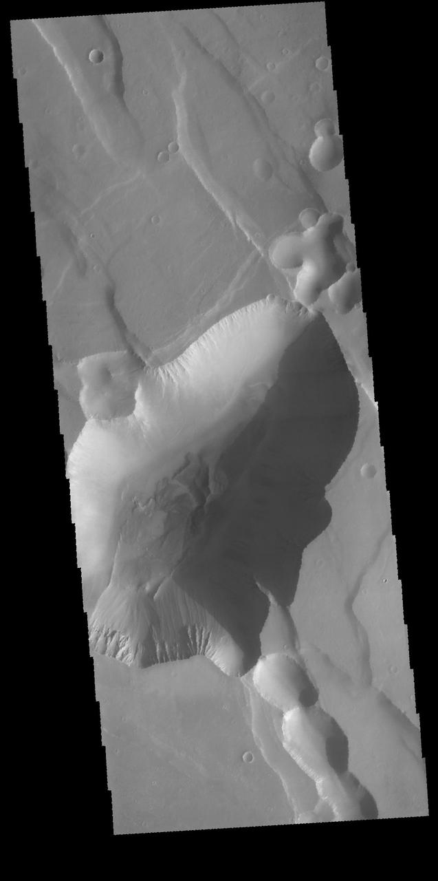
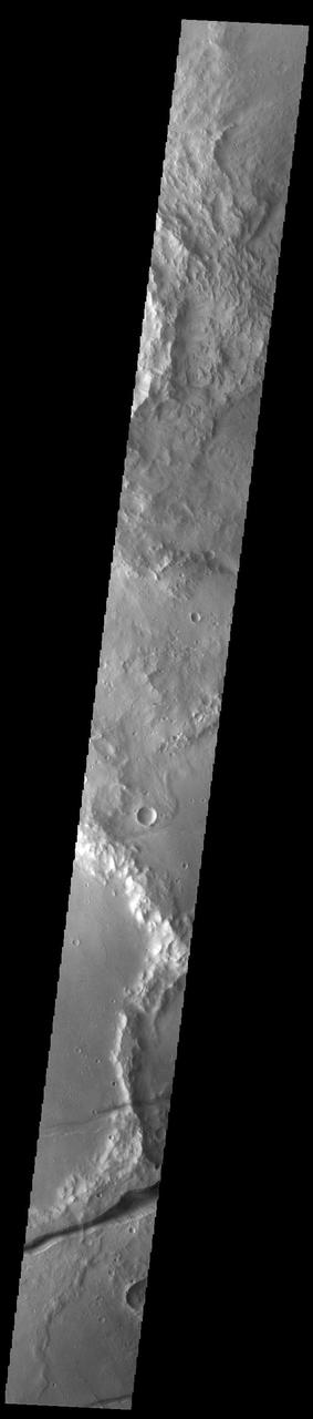
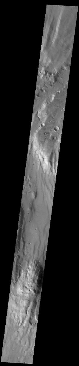
Today's VIS image shows part of Claritas Fossae. The linear features (fossae) are graben, a tectonic feature created when blocks of material subside between paired faults. These graben filled highlands are bounded by Solis Planum to the northeast and Icaria Planum to the southwest. Extensional tectonic forces are responsible for graben formation. While close to the Tharsis region, it is thought that Claritas Fossae formed prior to the large lava flows located north of this image. The large, deepest depression is younger than the other graben of Claritas Fossae. It is not known if it formed just after the other graben, or at a much later time. Orbit Number: 90760 Latitude: -12.0301 Longitude: 249.617 Instrument: VIS Captured: 2022-05-31 11:34 https://photojournal.jpl.nasa.gov/catalog/PIA25506
The complex fracture in this image captured by NASA 2001 Mars Odyssey spacecraft is one of the many graben that surround Alba Mons.
This complex graben is part of Labeatis Fossae. This image was captured by NASA 2001 Mars Odyssey spacecraft.
This image captured by NASA 2001 Mars Odyssey spacecraft shows several of the graben that make up Ceraunius Fossae.
This image captured by NASA 2001 Mars Odyssey spacecraft shows several of the graben fault bounded depression that are part of Acheron Catena.
The depressions in this image captured by NASA 2001 Mars Odyssey spacecraft are graben that make up part of Labeatis Fossae.
This image captured by NASA 2001 Mars Odyssey spacecraft shows a graben that is part of Cerberus Fossae.

The linear depressions termed graben in this image captured by NASA 2001 Mars Odyssey spacecraft are part of Memnonia Fossae.
View of Miranda showing light and dark banded scarps near the boundary of the banded ovoid and a deep graben that bounds the ovoid in this region.
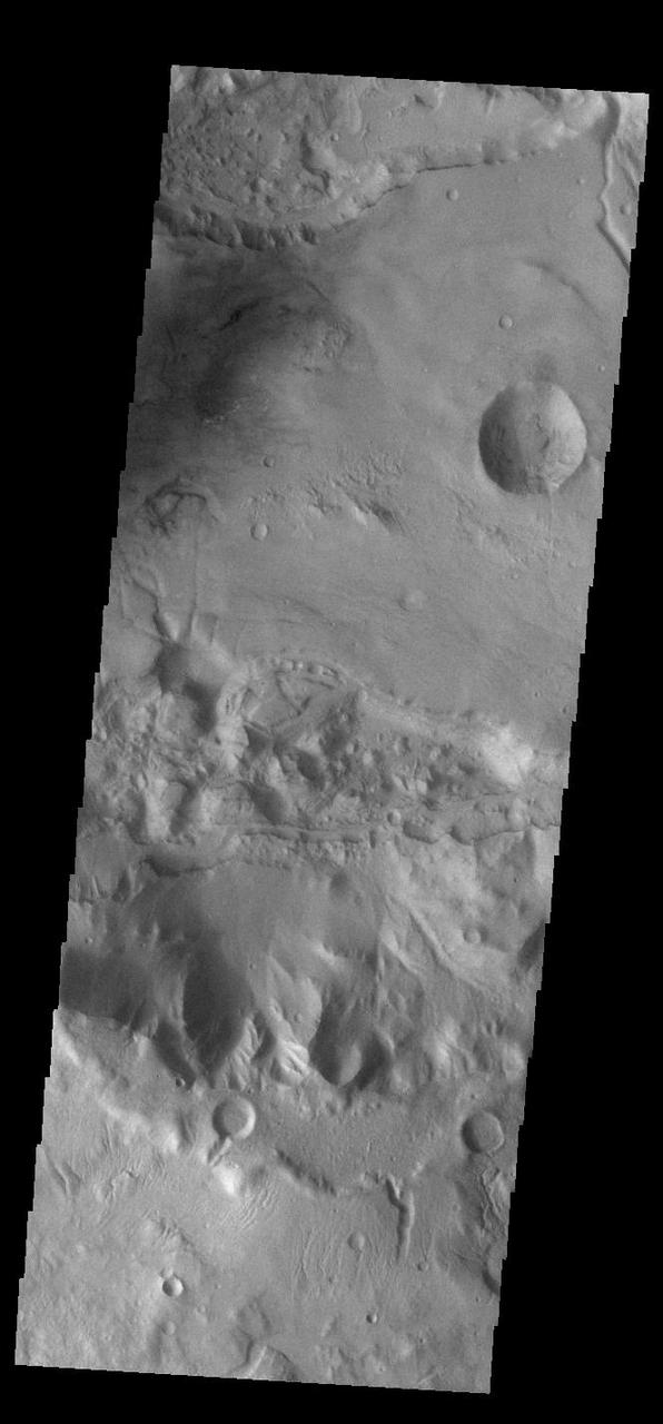
These fractures and graben are part of Sirenum Fossae as seen by NASA 2001 Mars Odyssey spacecraft.
The linear graben in this image from NASA 2001 Mars Odyssey spacecraft are all part of Claritas Fossae.
This image captured by NASA 2001 Mars Odyssey spacecraft shows some of the graben which form Noctis Labyrinthus.
Nili Fossae is a large band of parallel graben located to the northeast of Syrtis Major. The graben in this image from NASA 2001 Mars Odyssey spacecraft were formed by tectonic activity, with faulting that creates the linear depression. Orbit Number: 64105 Latitude: 23.3115 Longitude: 78.6126 Instrument: VIS Captured: 2016-05-27 05:24 http://photojournal.jpl.nasa.gov/catalog/PIA20785
The linear features in this VIS image are faults. Where depressions are formed bounded by faulting the feature is called a graben. These faults and graben are part of a large region of faulting called Sirenum Fossae. Orbit Number: 59353 Latitude: -24.4596 Longitude: 220.937 Instrument: VIS Captured: 2015-05-01 20:03 http://photojournal.jpl.nasa.gov/catalog/PIA19503
This VIS image shows part of Tractus Catena, just one of many north/south trending tectonic graben located south and east of Alba Mons. The graben with circular pits are part of Tractus Catena. The graben without pits are part of Tractus Fossae. The pits most likely formed as a result of roof collapse into an underlying open space such as a lava tube. Orbit Number: 93979 Latitude: 28.6599 Longitude: 257.766 Instrument: VIS Captured: 2023-02-20 13:00 https://photojournal.jpl.nasa.gov/catalog/PIA25940
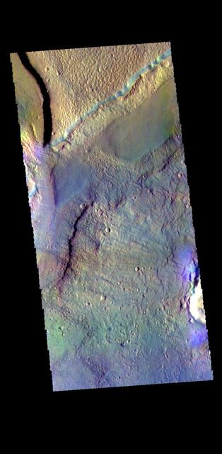
This false color image shows a graben located in Acidalia Planitia. Graben are depressions caused by movement of material downward between paired tectonic faults. The THEMIS VIS camera contains 5 filters. The data from different filters can be combined in multiple ways to create a false color image. These false color images may reveal subtle variations of the surface not easily identified in a single band image. Orbit Number: 63796 Latitude: 38.1105 Longitude: 353.781 Instrument: VIS Captured: 2016-05-01 18:39 https://photojournal.jpl.nasa.gov/catalog/PIA23290
Today's VIS image shows an unnamed region of fractures and graben. Located south of Solis Planum, between Claitas Fossae and Coracis Fossae, this region of fossae has the same appearance and graben orientation of the bordering named Fossae. Fossae are long linear depressions called graben and are formed by extension of the crust and faulting. When large amounts of pressure or tension are applied to rocks on timescales that are fast enough that the rock cannot respond by deforming, the rock breaks along faults. In the case of a graben, two parallel faults are formed by extension of the crust and the rock in between the faults drops downward into the space created by the extension. Orbit Number: 91764 Latitude: -36.7342 Longitude: 272.1 Instrument: VIS Captured: 2022-08-22 02:55 https://photojournal.jpl.nasa.gov/catalog/PIA25635
Located between the lava plains of Daedalia Planum and Solis Planum, Claritas Fossae is a graben filled highland. Graben are formed by tectonic activity, where extensional forces stretch the surface allowing blocks of material to slide down between paired faults. These linear grabens are termed fossae. This region of Mars had very active tectonism and volcanism, resulting in the huge volcanos like Arsia Mons and deep chasmata of Valles Marineris. Claritas Fossae was formed prior to the large lava flows of the Tharsis region. Orbit Number: 92164 Latitude: -26.3031 Longitude: 253.828 Instrument: VIS Captured: 2022-09-24 01:20 https://photojournal.jpl.nasa.gov/catalog/PIA25757
Located between the lava plains of Daedalia Planum and Solis Planum, Claritas Fossae is a graben filled highland. Graben are formed by tectonic activity, where extensional forces stretch the surface allowing blocks of material to slide down between paired faults. These linear grabens are termed fossae. This region of Mars had very active tectonism and volcanism, resulting in the huge volcanos like Arsia Mons and deep chasmata of Valles Marineris. Claritas Fossae was formed prior to the large lava flows of the Tharsis region. Orbit Number: 81376 Latitude: -35.6385 Longitude: 253.121 Instrument: VIS Captured: 2020-04-18 15:46 https://photojournal.jpl.nasa.gov/catalog/PIA23957
Located between the lava plains of Daedalia Planum and Solis Planum, Claritas Fossae is a graben filled highland. Graben are formed by tectonic activity, where extensional forces stretch the surface allowing blocks of material to slide down between paired faults. These linear grabens are termed fossae. This region of Mars had very active tectonism and volcanism, resulting in the huge volcanos like Arsia Mons and deep chasmata of Valles Marineris. Claritas Fossae was formed prior to the large lava flows of the Tharsis region. Orbit Number: 84439 Latitude: -41.4956 Longitude: 272.168 Instrument: VIS Captured: 2020-12-26 23:43 https://photojournal.jpl.nasa.gov/catalog/PIA24402