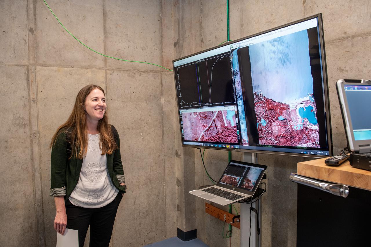
Dr. Katherine Calvin listens to a harmful algal bloom presentation on June 17, 2024. NASA Glenn Research Center conducts aerial remote sensing of harmful algal blooms to warn water filtration plants to enact more stringent filtering when harmful blooms are present. Aerial remote sensing is advantageous to satellite remote sensing that is limited by factors of resolution, on demand performance, cloud cover, and upgrades to instrumentation. Photo Credit: (NASA/Sara Lowthian-Hanna)
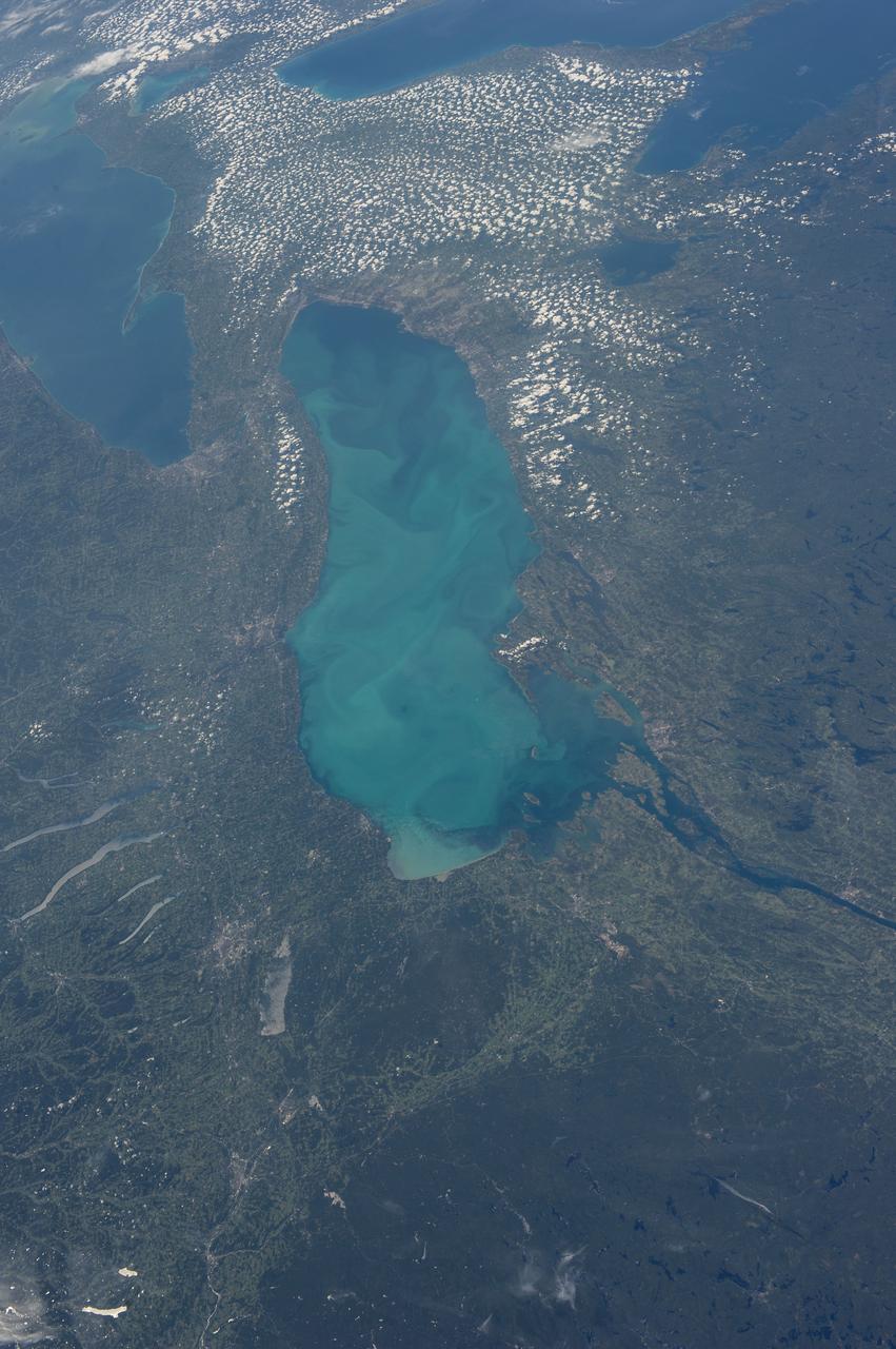
ISS036-E-035635 (24 Aug. 2013) --- Plankton bloom and Lake Ontario are featured in this image photographed by an Expedition 36 crew member on the International Space Station. This photograph highlights a late summer plankton bloom visible throughout much of Lake Ontario (one of the Great Lakes, together with Michigan, Superior, Erie, and Huron). Cyanobacteria, or blue-green algae, can reach such large concentrations that they color the water to such an extent that the change is visible from orbit. Harmful algal blooms, or HABs, have been observed in all of the Great Lakes – particularly Lake Erie - and are associated with a variety of causative factors including changes in precipitation; drought; invasive species (quagga, zebra mussels, Asian carp); nutrient loading from runoff and sewage (nitrogen and phosphorus); and warmer average temperatures. In addition to reduced water quality and human health concerns, algal blooms can also lead to hypoxia (reduction of oxygen in the bottom waters) that kills large numbers of fish and other aquatic life. Lake Ontario, like the other Great Lakes Erie, Huron, and Superior is roughly divided between the USA and Canada. The USA side of Lake Ontario has its shoreline along the state of New York, while its Canadian shoreline lies within the province of Ontario. The city of Kingston, Ontario, is visible near the Saint Lawrence River outflow from the lake. Several other landscape features of New York State are visible in the image, including the Finger Lakes region to the west of Syracuse, NY (upper left). To the northeast of Syracuse, the dark wooded slopes of the Adirondack Mountains are visible at lower right. Patchy white cloud cover obscures much of the land surface to the west of Lake Ontario.
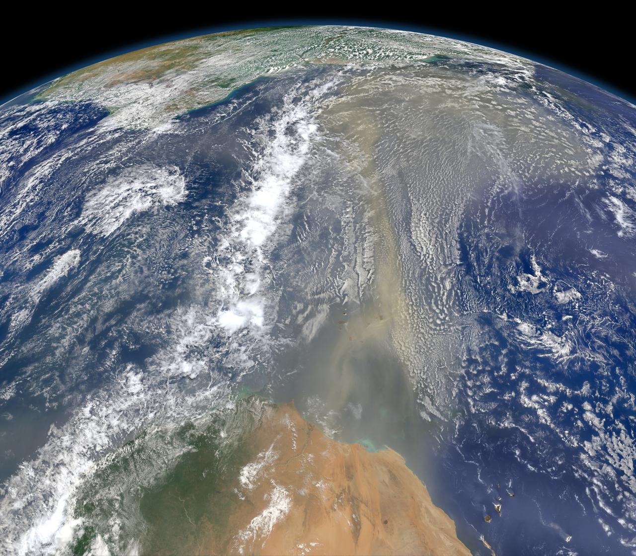
A piece of Africa—actually lots of them—began to arrive in the Americas in June 2014. On June 23, a lengthy river of dust from western Africa began to push across the Atlantic Ocean on easterly winds. A week later, the influx of dust was affecting air quality as far away as the southeastern United States. This composite image, made with data from the Visible Infrared Imaging Radiometer Suite (VIIRS) on Suomi NPP, shows dust heading west toward South America and the Gulf of Mexico on June 25, 2014. The dust flowed roughly parallel to a line of clouds in the intertropical convergence zone, an area near the equator where the trade winds come together and rain and clouds are common. In imagery captured by the Moderate Resolution Imaging Spectroradiometer (MODIS), the dust appeared to be streaming from Mauritania, Senegal, and Western Sahara, though some of it may have originated in countries farther to the east. Saharan dust has a range of impacts on ecosystems downwind. Each year, dust events like the one pictured here deliver about 40 million tons of dust from the Sahara to the Amazon River Basin. The minerals in the dust replenish nutrients in rainforest soils, which are continually depleted by drenching, tropical rains. Research focused on peat soils in the Everglades show that African dust has been arriving regularly in South Florida for thousands of years as well. In some instances, the impacts are harmful. Infusion of Saharan dust, for instance, can have a negative impact on air quality in the Americas. And scientists have linked African dust to outbreaks of certain types of toxic algal blooms in the Gulf of Mexico and southern Florida. Read more: <a href="http://1.usa.gov/1snkzmS" rel="nofollow">1.usa.gov/1snkzmS</a> NASA images by Norman Kuring, NASA’s Ocean Color web. Caption by Adam Voiland. Credit: <b><a href="http://www.earthobservatory.nasa.gov/" rel="nofollow"> NASA Earth Observatory</a></b> <b><a href="http://www.nasa.gov/audience/formedia/features/MP_Photo_Guidelines.html" rel="nofollow">NASA image use policy.</a></b> <b><a href="http://www.nasa.gov/centers/goddard/home/index.html" rel="nofollow">NASA Goddard Space Flight Center</a></b> enables NASA’s mission through four scientific endeavors: Earth Science, Heliophysics, Solar System Exploration, and Astrophysics. Goddard plays a leading role in NASA’s accomplishments by contributing compelling scientific knowledge to advance the Agency’s mission. <b>Follow us on <a href="http://twitter.com/NASAGoddardPix" rel="nofollow">Twitter</a></b> <b>Like us on <a href="http://www.facebook.com/pages/Greenbelt-MD/NASA-Goddard/395013845897?ref=tsd" rel="nofollow">Facebook</a></b> <b>Find us on <a href="http://instagram.com/nasagoddard?vm=grid" rel="nofollow">Instagram</a></b>