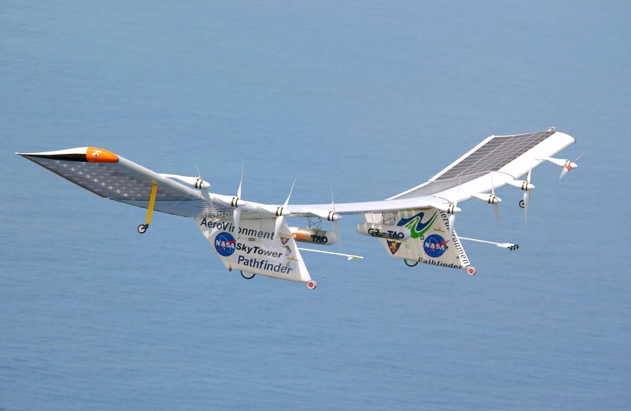
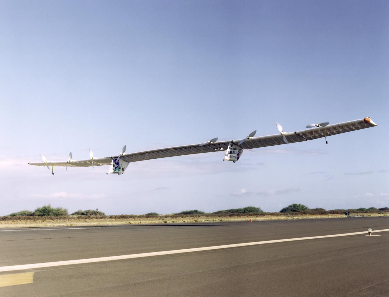
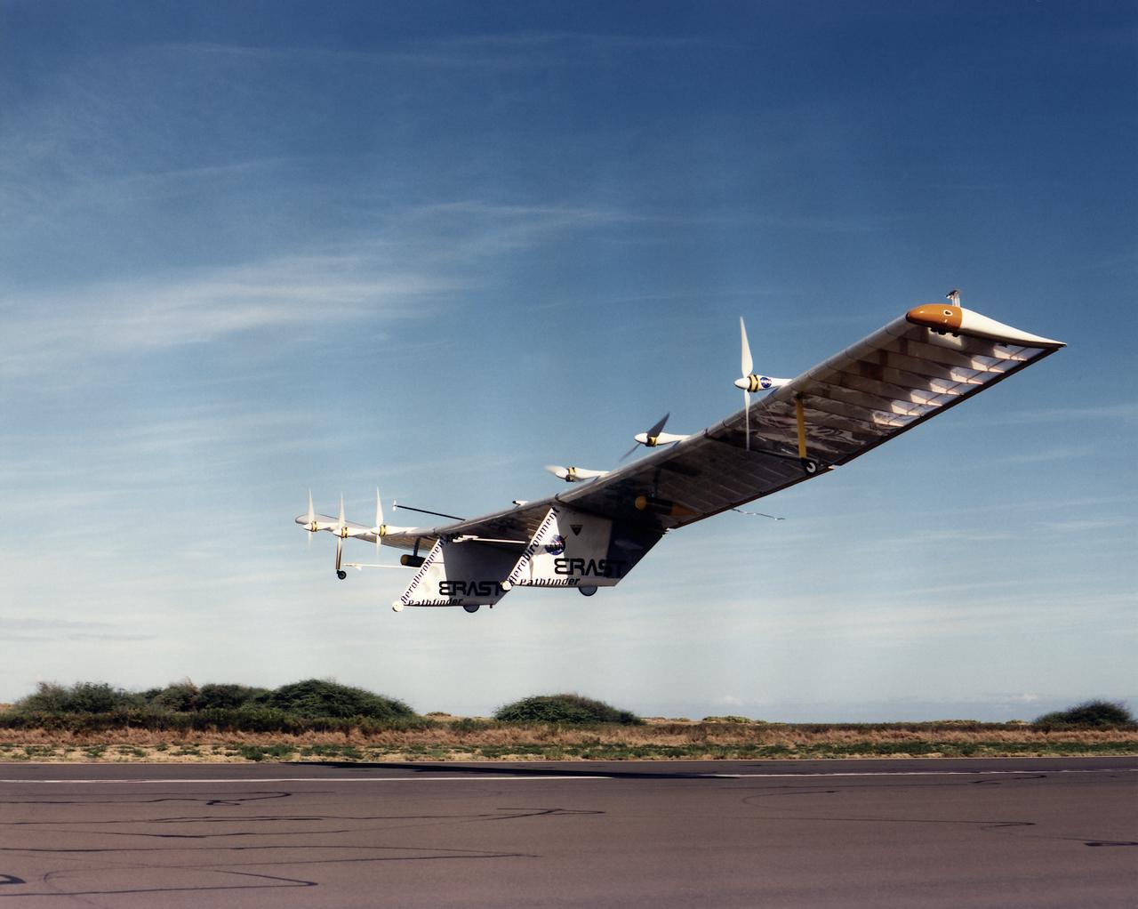
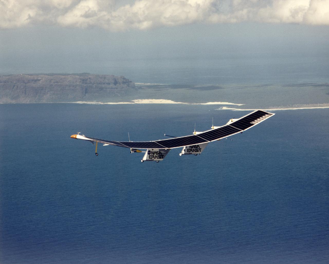
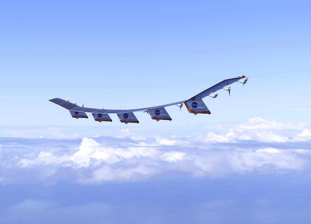
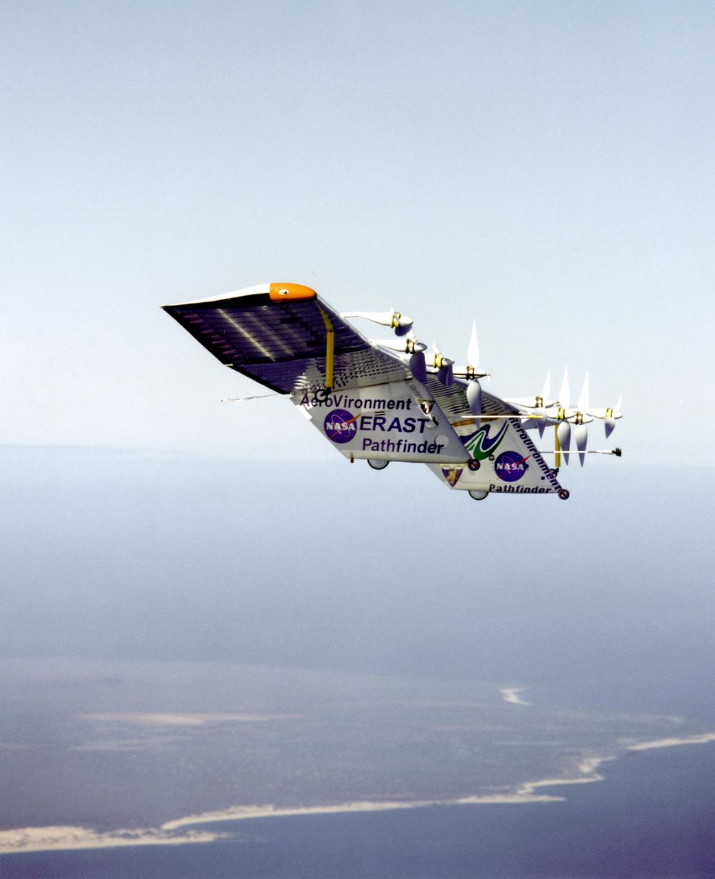
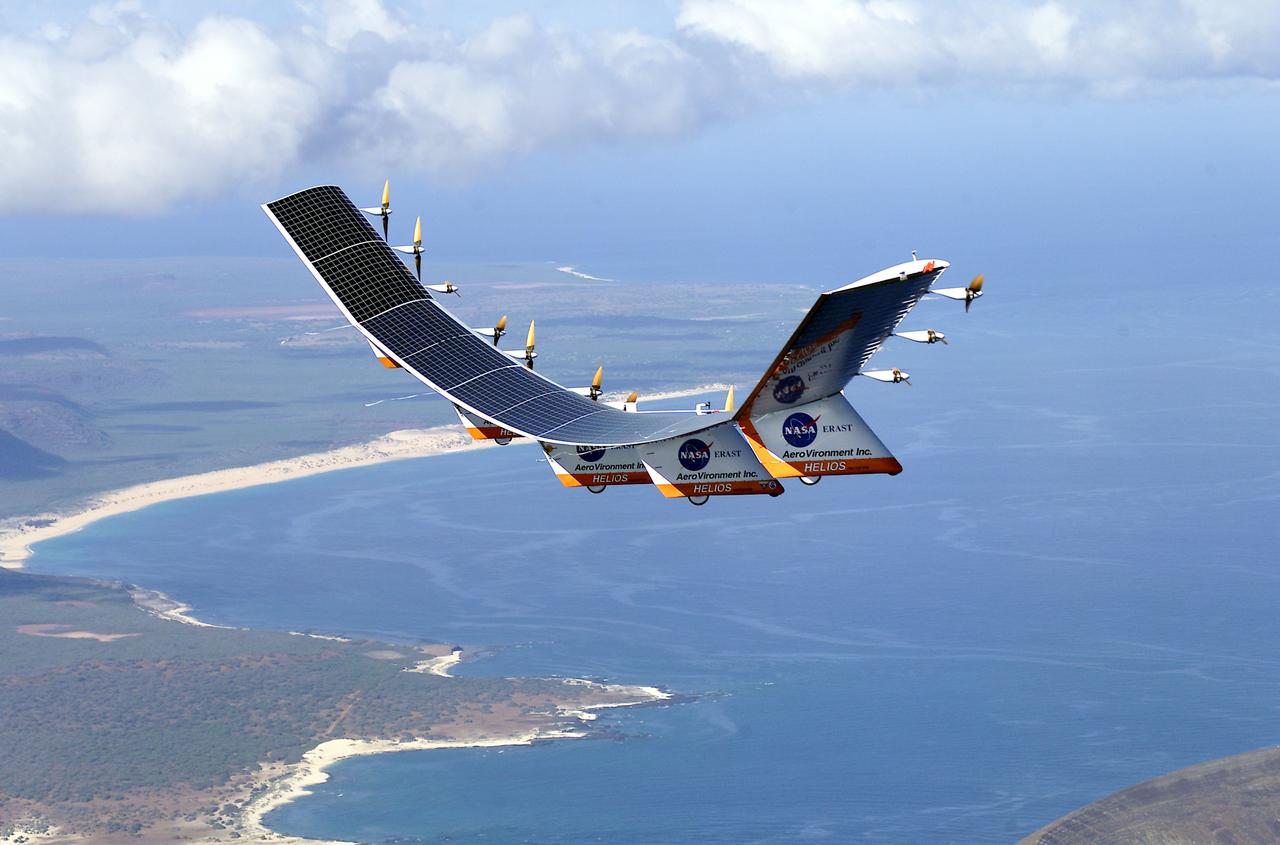
Pathfinder-Plus flight in Hawaii June 2002
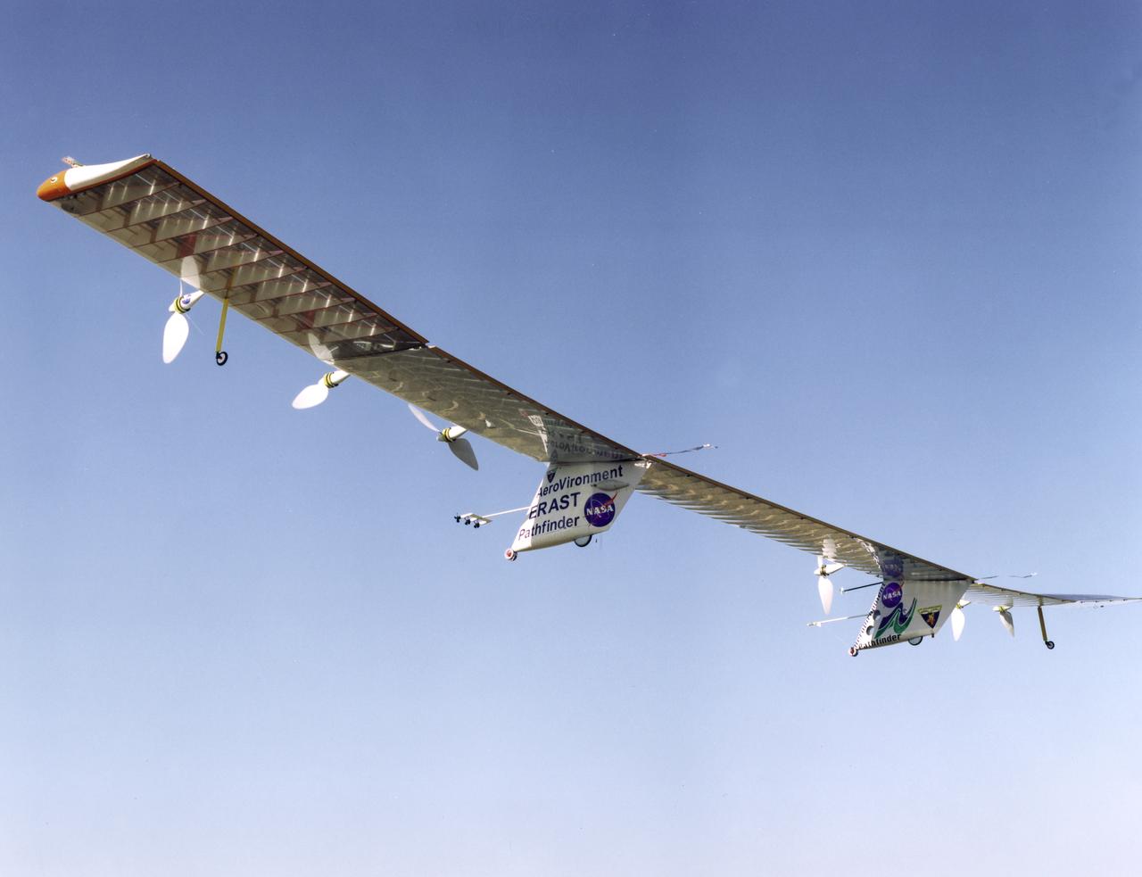
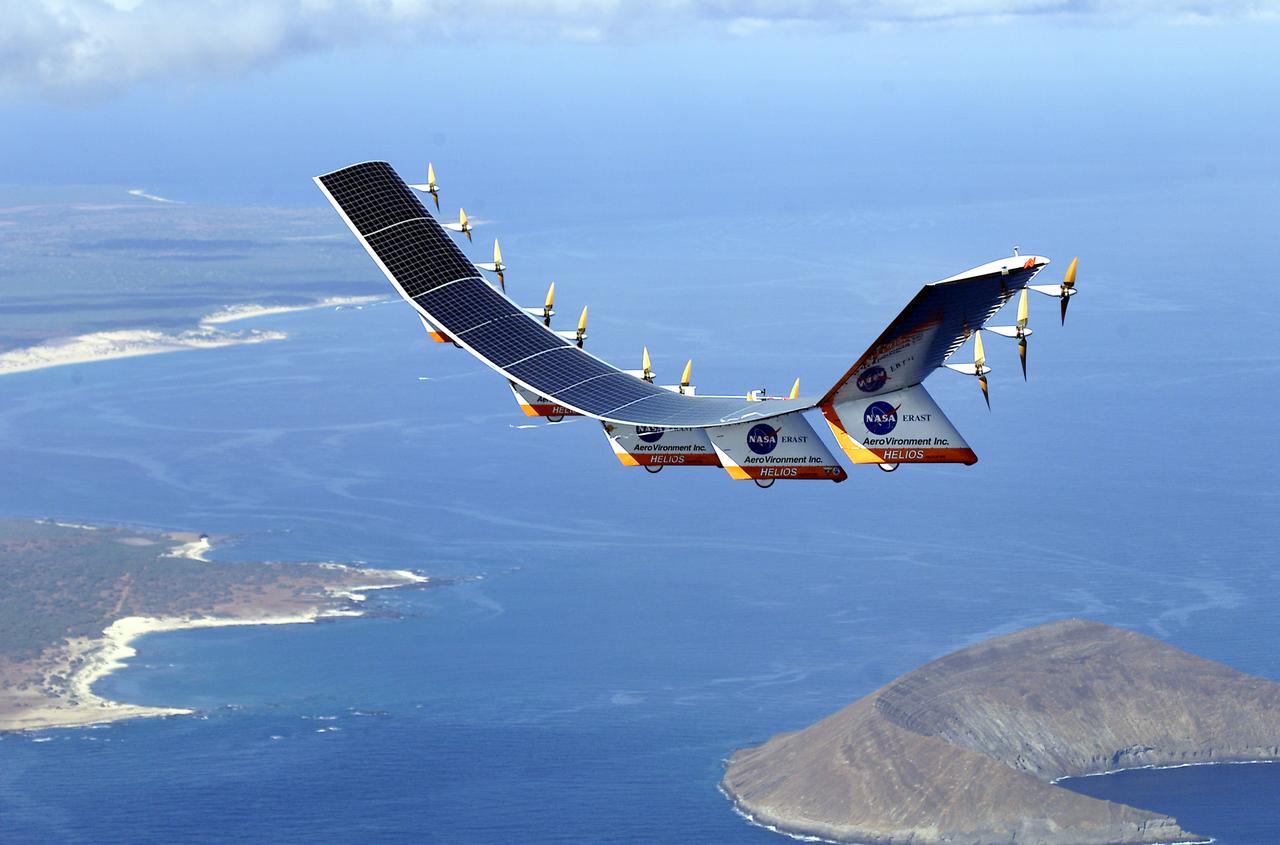
Pathfinder-Plus on a flight over Hawaii in 1998.
Pathfinder-Plus flight in Hawaii June 2002
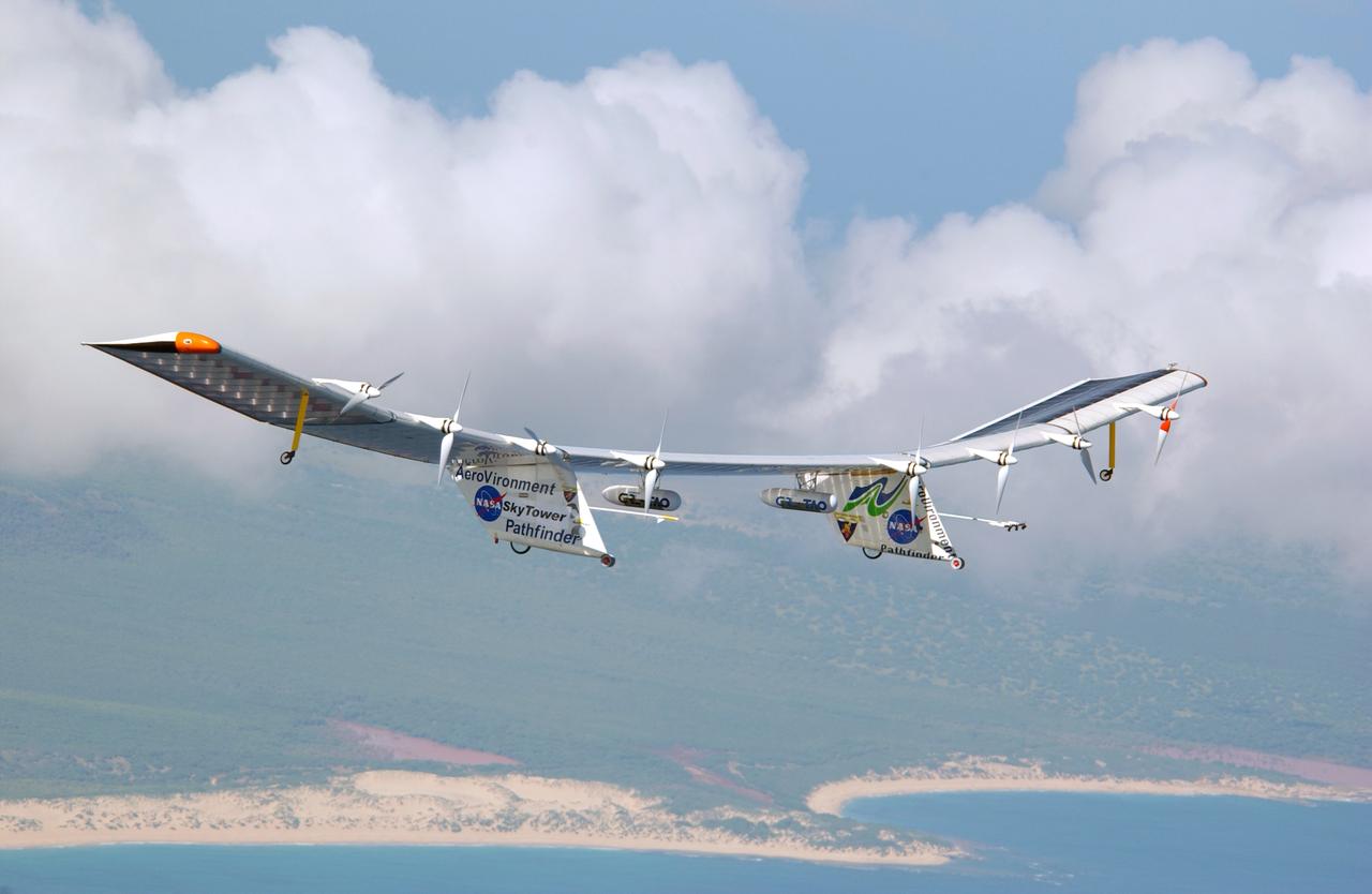
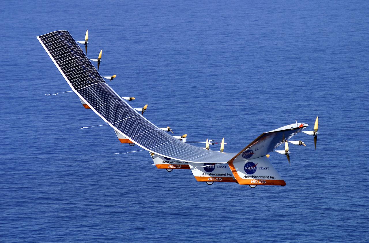
Pathfinder-Plus on flight over Hawaii.
Pathfinder-Plus on a flight over Hawaii in 1998.
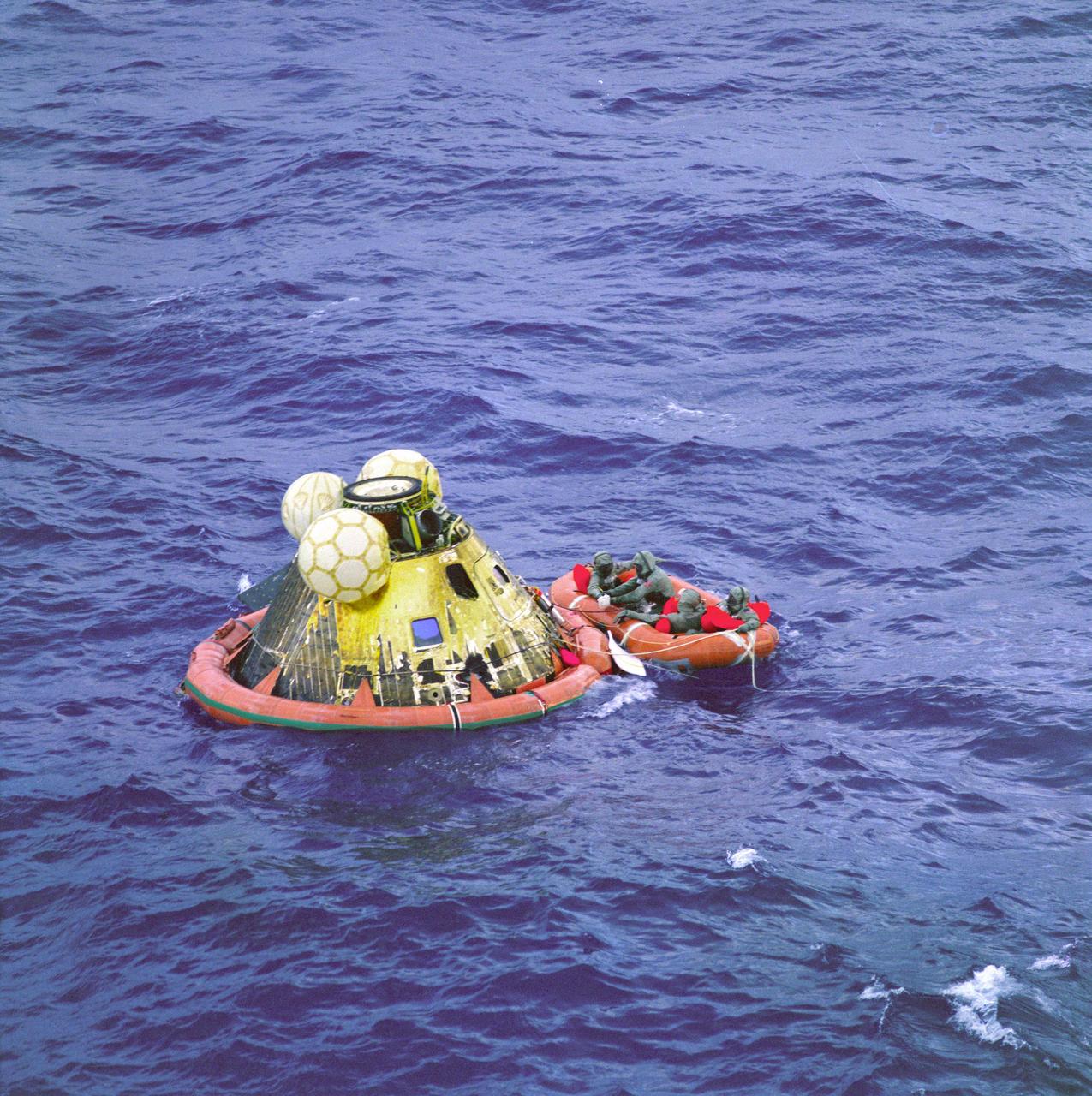
The Apollo 11 command module Columbia with astronauts Neil Armstrong, Michael Collins, and Buzz Aldrin aboard splashed down at 11:49 a.m. CDT, July 24, 1969, about 812 nautical miles southwest of Hawaii and only 12 nautical miles from the USS Hornet.
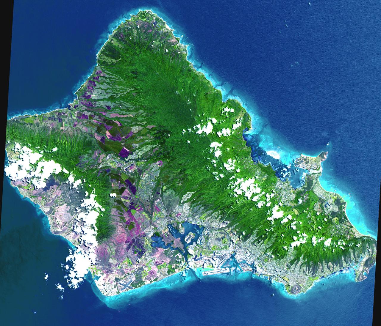
This 60 by 55 km ASTER scene shows almost the entire island of Oahu, Hawaii on June 3, 2000. The data were processed to produce a simulated natural color presentation. Oahu is the commercial center of Hawaii and is important to United States defense in the Pacific. Pearl Harbor naval base is situated here. Tourism also is important to the economy. Among the many popular beaches is the renowned Waikiki Beach, backed by the famous Diamond Head, an extinct volcano. The largest community, Honolulu, is the state capital. The image is located at 21.5 degrees north latitude and 158 degrees west longitude. http://photojournal.jpl.nasa.gov/catalog/PIA02672

This stereo image from NASA Terra satellite show the Mauna Kea and Mauna Loa volcanoes in Hawaii; a southern face of a line of cumulus clouds off the north coast of Hawaii is also visible. 3D glasses are necessary to view this image.
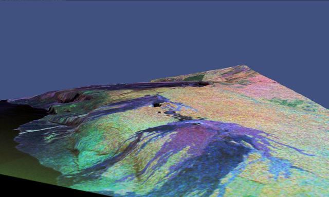
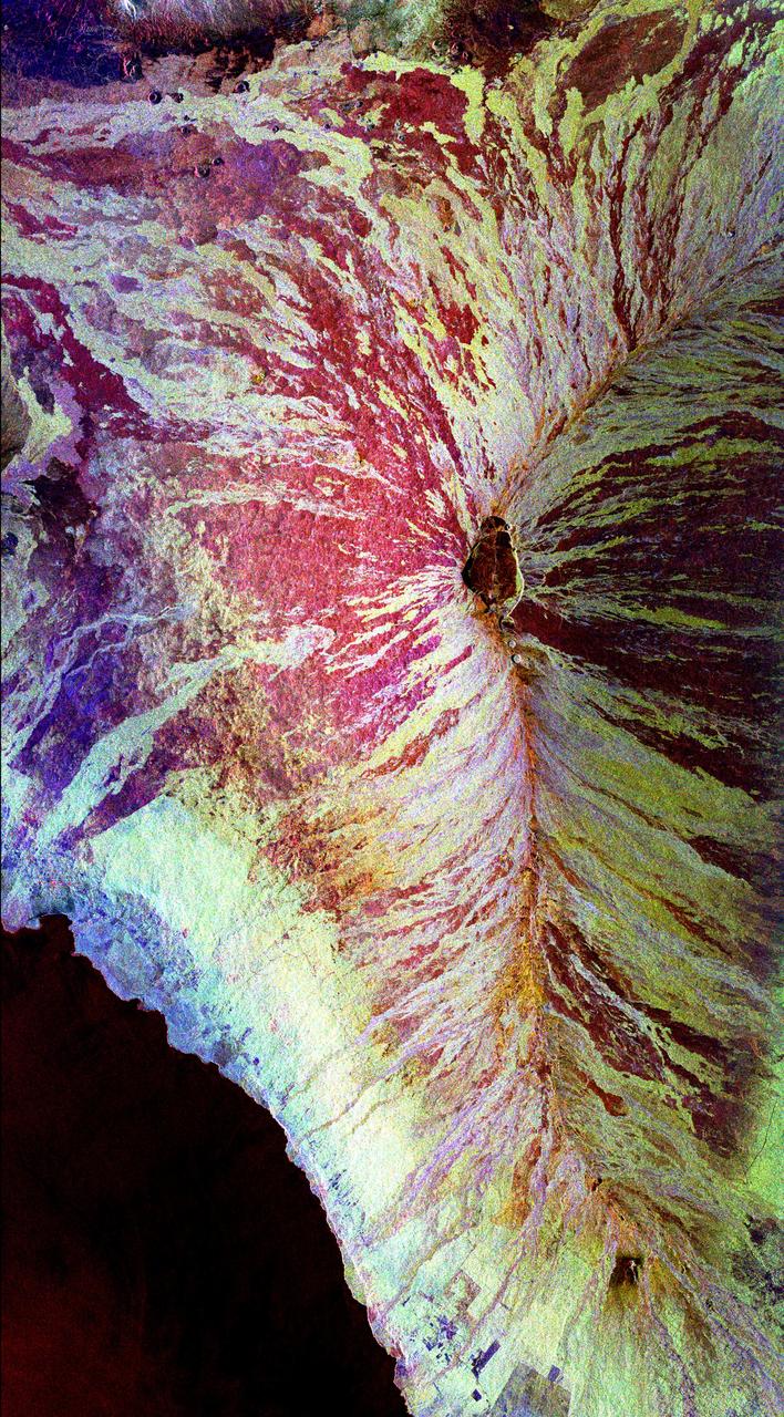
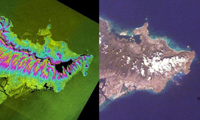
This is a three-dimensional perspective view of a false-color image of the eastern part of the Big Island of Hawaii.
Major Hurricane Kilo is located around 1220 miles west of Honolulu, Hurricane Ignacio is located around 315 miles east of Hilo and Major Hurricane Jimena is located around 1425 miles east of Hilo, Hawaii. This image was taken by GOES West on August 31, 2015. Credit: NASA/NOAA via <b><a href="www.nnvl.noaa.gov/" rel="nofollow"> NOAA Environmental Visualization Laboratory</a></b> <b><a href="http://www.nasa.gov/audience/formedia/features/MP_Photo_Guidelines.html" rel="nofollow">NASA image use policy.</a></b> <b><a href="http://www.nasa.gov/centers/goddard/home/index.html" rel="nofollow">NASA Goddard Space Flight Center</a></b> enables NASA’s mission through four scientific endeavors: Earth Science, Heliophysics, Solar System Exploration, and Astrophysics. Goddard plays a leading role in NASA’s accomplishments by contributing compelling scientific knowledge to advance the Agency’s mission. <b>Follow us on <a href="http://twitter.com/NASAGoddardPix" rel="nofollow">Twitter</a></b> <b>Like us on <a href="http://www.facebook.com/pages/Greenbelt-MD/NASA-Goddard/395013845897?ref=tsd" rel="nofollow">Facebook</a></b> <b>Find us on <a href="http://instagrid.me/nasagoddard/?vm=grid" rel="nofollow">Instagram</a></b>
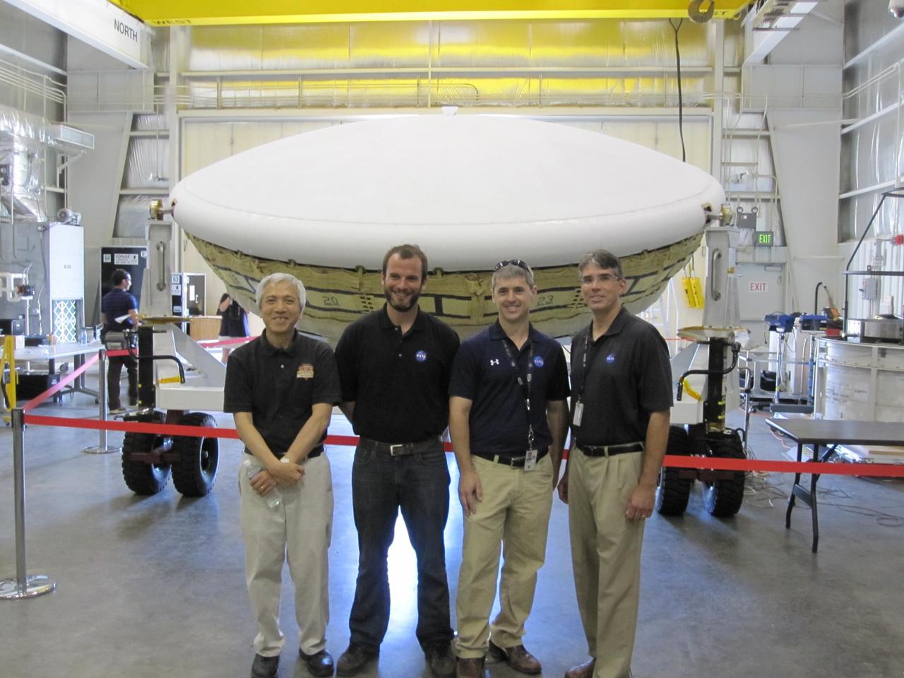
Members of the team for NASA Low-Density Supersonic Decelerator LDSD stand in front of the project saucer-shaped test vehicle at the U.S. Navy Pacific Missile Range Facility in Kauai, Hawaii.
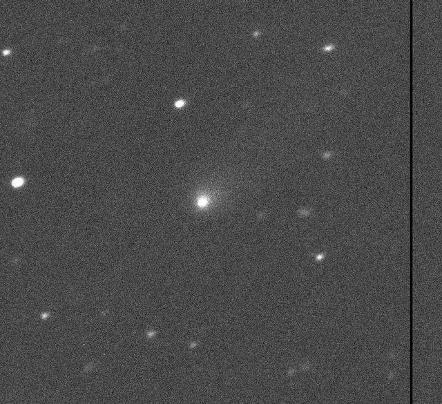
Comet C/2019 Q4 as imaged by the Canada-France-Hawaii Telescope on Hawaii's Big Island on Sept. 10, 2019. https://photojournal.jpl.nasa.gov/catalog/PIA23462
AS7-07-1741 (14 Oct. 1968) --- Island of Oahu, State of Hawaii, as seen from the Apollo 7 spacecraft during its 51st revolution of Earth. Photographed from an altitude of 122 nautical miles, at ground elapsed time of 81 hours. Diamond Head and Pearl Harbor are clearly visible.
Pathfinder, NASA's solar-powered, remotely-piloted aircraft is shown while it was conducting a series of science flights to highlight the aircraft's science capabilities while collecting imagery of forest and coastal zone ecosystems on Kauai, Hawaii. The flights also tested two new scientific instruments, a high-spectral-resolution Digital Array Scanned Interferometer (DASI) and a high-spatial-resolution Airborne Real-Time Imaging System (ARTIS). The remote sensor payloads were designed by NASA's Ames Research Center, Moffett Field, California, to support NASA's Mission to Planet Earth science programs.
On January 18, ASTER captured this image of the continuing eruption of Kilauea volcano, Hawaii. Lava fountains in Halemaumau crater (top center of image) reached 50 m high, with a nearly vertical eruption plume. Winds carried the blue-gray plume to the south to the ocean. The TROPOMI satellite instrument detected this as a huge SO2 plume the day before. Vegetation is displayed in shades of red. The image covers an area of 38.7 by 45.8 km, and is located at 19.4 degrees north, 155.3 degrees west. https://photojournal.jpl.nasa.gov/catalog/PIA26504
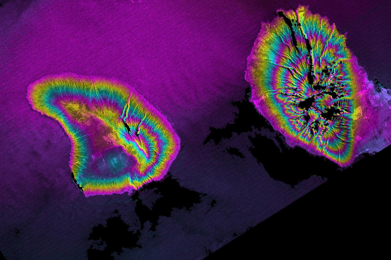
This image of the Mauna Loa volcano on the Big Island of Hawaii shows the capability of imaging radar to map lava flows and other volcanic structures.
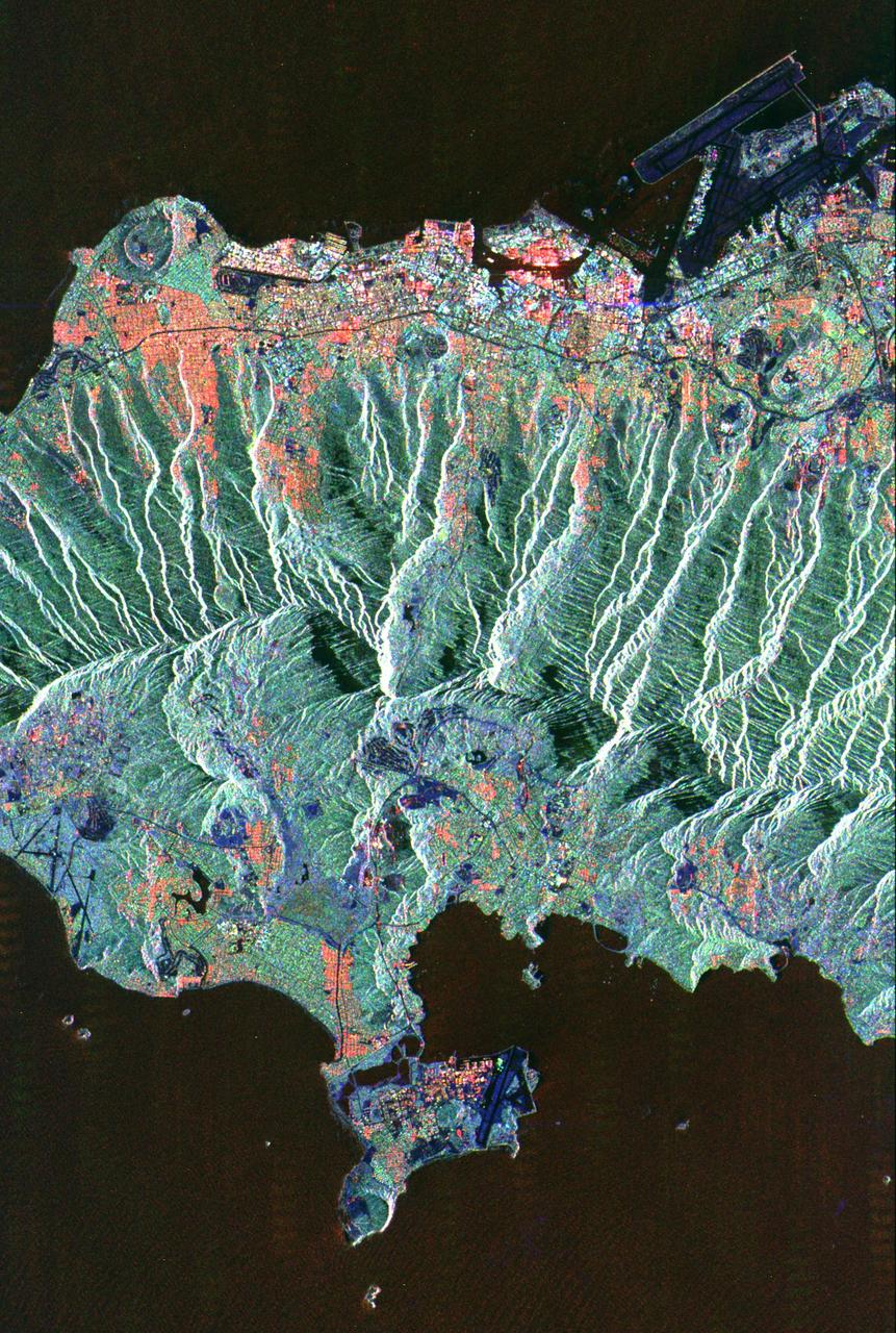
This spaceborne radar image shows the city of Honolulu, Hawaii and adjacent areas on the island of Oahu. Honolulu lies on the south shore of the island, along the bottom of this image.
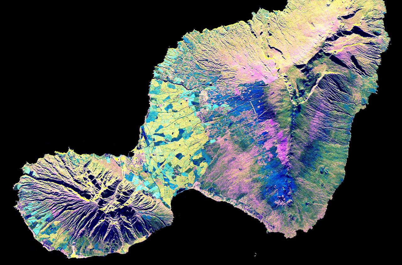
This spaceborne radar image shows the Valley Island of Maui, Hawaii. The cloud-penetrating capabilities of radar provide a rare view of many parts of the island, since the higher elevations are frequently shrouded in clouds.
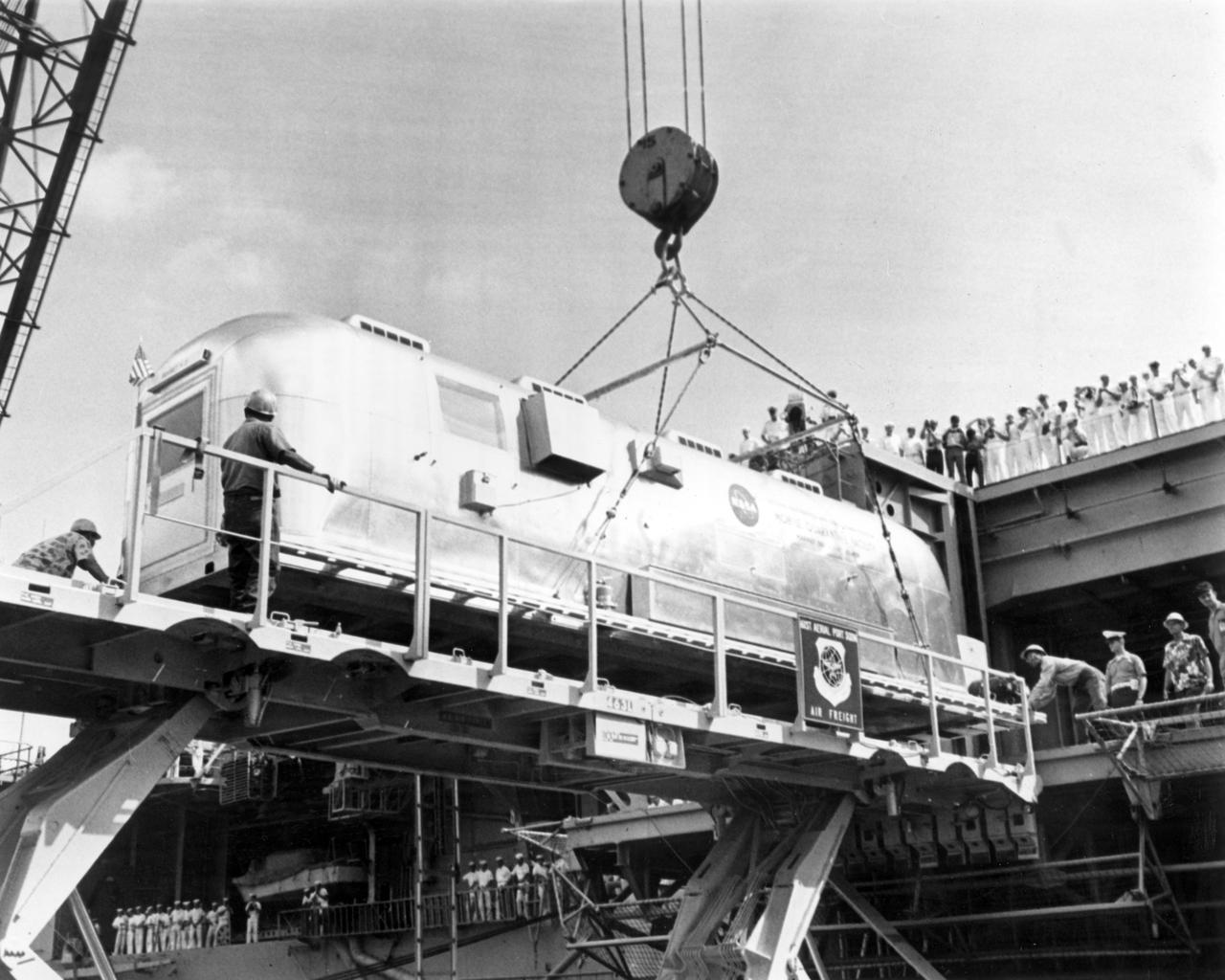
The saucer-shaped test vehicle for NASA Low-Density Supersonic Decelerator LDSD project, packaged in the box shown here, was shipped via plane to the Navy Pacific Missile Range Facility in Kauai, Hawaii on April 17.
On July 21, 2007, the world most active volcano, Kilauea on Hawaii Big Island, produced a fissure eruption from the Puu Oo vent, which fed an open lava channel and lava flows toward the east. This image is from NASA Terra satellite.

Kilauea volcano, Hawaii, began erupting on December 20, 2020, when a lava flow within Halema'uma'u crater interacted with a pool of water, triggering a vigorous eruption, emitting steam, ash, and sulfur dioxide gas. Since then, lava continues to enter the crater, and the lava lake appears to be stable. In the image, the lava feeder is bright red within the crater, gas is coming from the lava; the lava lake is a lighter gray donut, with a cooler lava island in the middle. The image was acquired December 28, 2020, covers an area of 29.7 by 37.2 km, and is located at 19.4 degrees north, 155.3 degrees west. https://photojournal.jpl.nasa.gov/catalog/PIA24284
SL4-139-3997 (8 Jan. 1974) --- A vertical view of the Island of Hawaii, State of Hawaii, as photographed from the Skylab space station in Earth orbit by a Skylab 4 crewman. The camera used was a hand-held Hasselblad camera, with SO-368 medium-speed Ektachrome film. This photograph, taken on Jan. 8, 1974, is very useful in studies of volcanic areas. Prominent volcanic features such as the summit caldera on Mauna Loa, the extinct volcano Mauna Kea, the Kilauea caldera, and the pit crater at Halo mau mau within the caldera are easily identified. (Kilauea was undergoing frequent eruption during the mission). Detailed features such as the extent and delineation of historic lava flows on Mauna Loa can be determined and are important parameters in volcanic studies. Photo credit: NASA
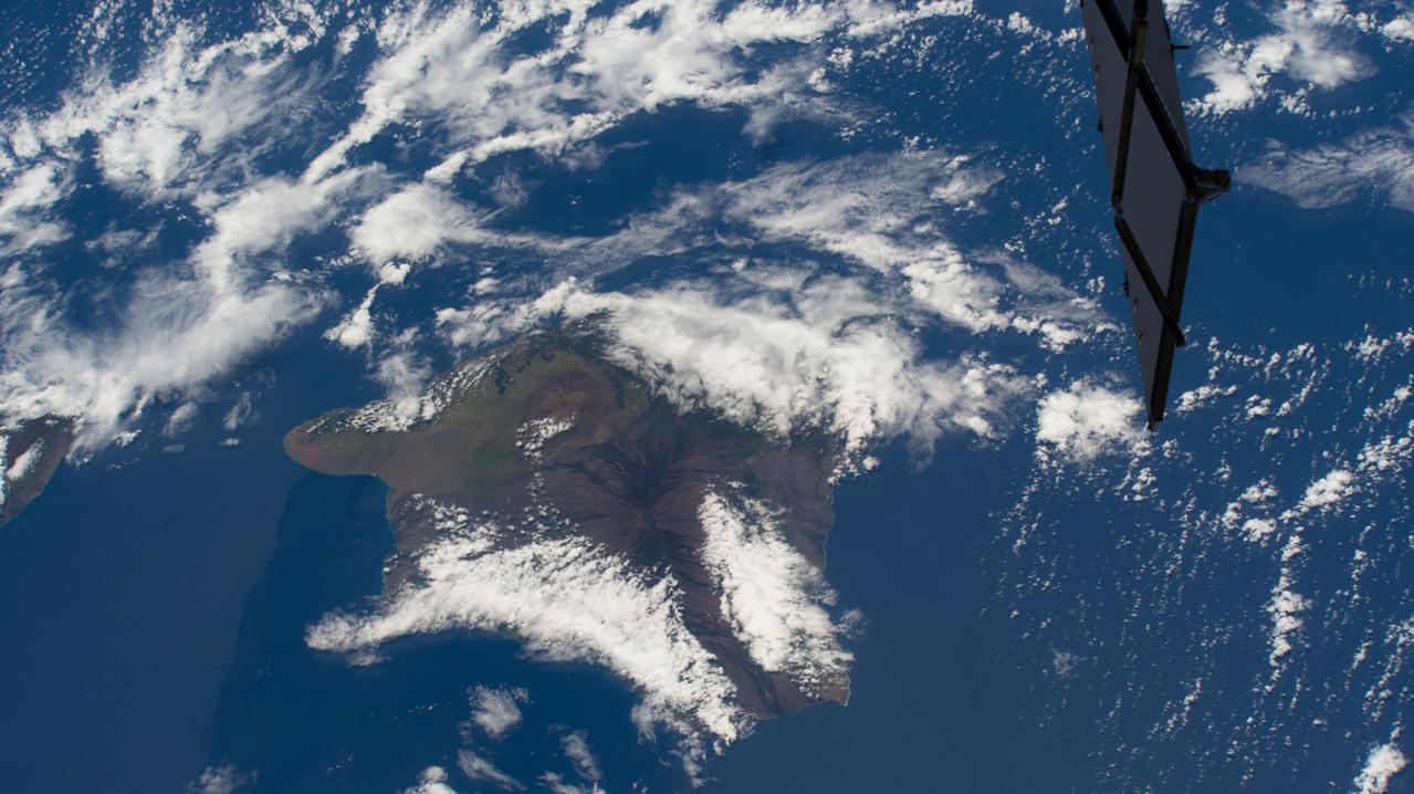
iss069e025331 (June 24, 2023) -- Clouds cover the Island of Hawaii, the youngest and largest of eight islands in the chain, as the International Space Station orbited 258 miles above the Pacific Ocean.
On the night of March 25, 2008, the Advanced Spaceborne Thermal Emission and Reflection Radiometer instrument on NASA Terra satellite captured these thermal infrared images of Kilauea volcano on Hawaii Big Island. Kilauea was active at two locations.
This topographic radar image acquired by NASA Shuttle Radar Topography Mission SRTM in Feb. 2000 shows the city of Honolulu, Hawaii and adjacent areas on the island of Oahu. Honolulu lies on the south shore of the island.
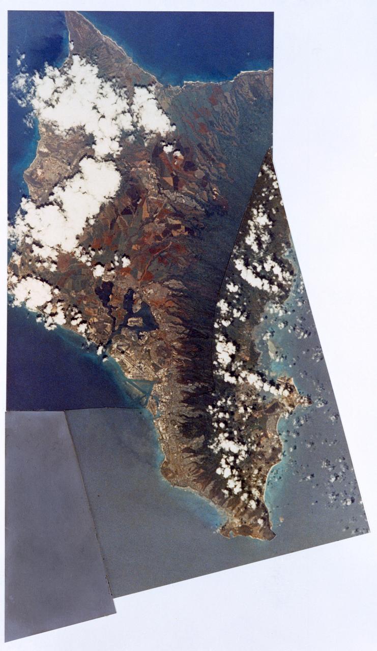
These two images of the eastern part of the island of Oahu, Hawaii provide information on regional topography and show the relationship between urban development and sensitive ecosystems.
This topographic radar image acquired by NASA Shuttle Radar Topography Mission SRTM in Feb. 2000 shows the Lanai left and western Maui right islands of Hawaii.
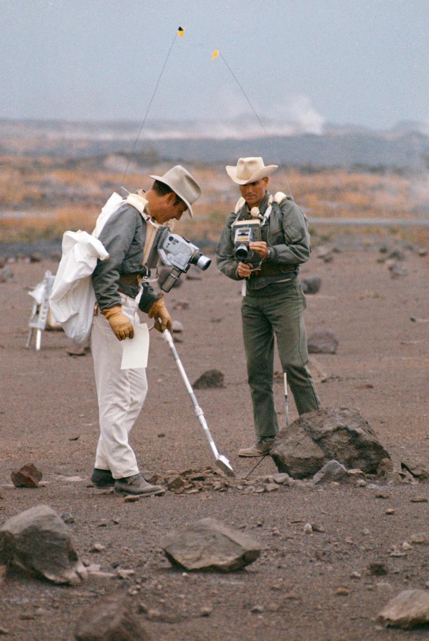
S70-20253 (December 1969) --- Astronauts James A. Lovell Jr. (left) commander, and Fred W. Haise Jr., lunar module pilot, carry out a simulation of a lunar traverse at Kilauea, Hawaii, site. Both crew members of NASA's third team of moon explorers were carrying cameras and communications equipment during the simulated traverse. They maintained contact with men in the roles of spacecraft throughout the traverse. Lovell holds a scoop for the Apollo Lunar Hand Tools (ALHT) and a gnomon, also for the ALHT is deployed in front of Haise. The ALHT carrier is at left background, (almost obscured by Lovell).
Engineers unload ground support equipment for a June engineering test flight above Kauai, Hawaii. The test flight is part of NASA LDSD project, which is investigating cutting-edge landing technologies that could fly on future Mars missions.
This color composite C-band and L-band image of the Kilauea volcano on the Big Island of Hawaii was acquired by NASA Spaceborne Imaging Radar-C/X-band Synthetic Aperture Radar SIR-C/X-SAR flying on space shuttle Endeavour.
Pathfinder, NASA's solar-powered, remotely-piloted aircraft is shown while it was conducting a series of science flights to highlight the aircraft's science capabilities while collecting imagery of forest and coastal zone ecosystems on Kauai, Hawaii. The flights also tested two new scientific instruments, a high spectral resolution Digital Array Scanned Interferometer (DASI) and a high spatial resolution Airborne Real-Time Imaging System (ARTIS). The remote sensor payloads were designed by NASA's Ames Research Center, Moffett Field, California, to support NASA's Mission to Planet Earth science programs.
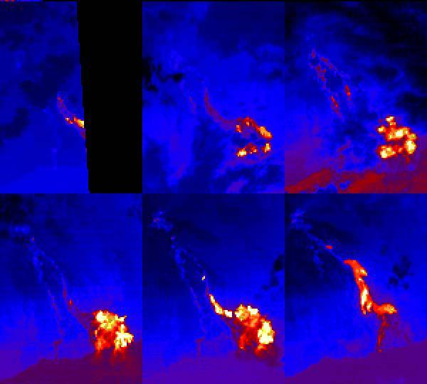
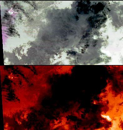
This sequence of ASTER nighttime thermal images shows the Pu'u O'o lava flows entering the sea at Kamokuna on the southeast side of the Island of Hawaii. Each image covers an area of 9 x 12 km. The acquisition dates are April 4 2000, May 13 2000, May 22 2000 (upper row) and June 30 2000, August 1 2000 and January 1 2001 (lower row). Thermal band 14 has been color coded from black (coldest) through blue, red, yellow and white (hottest). The first 5 images show a time sequence of a single eruptive phase; the last image shows flows from a later eruptive phase. The images are located at 19.3 degrees north latitude, 155 degrees west longitude. http://photojournal.jpl.nasa.gov/catalog/PIA11093
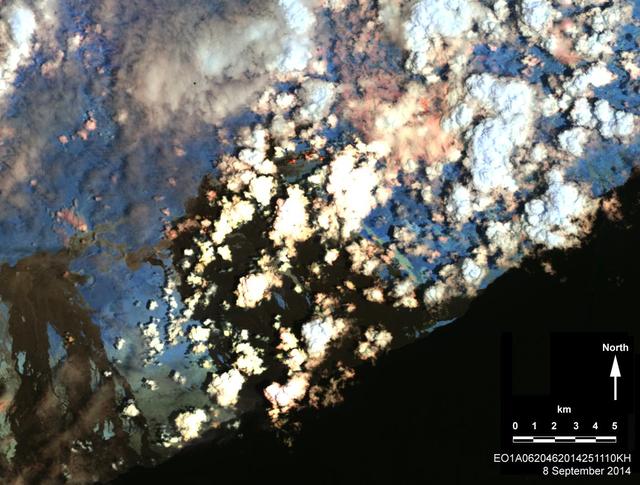
On Sept. 8, 2014, NASA Earth Observing 1 spacecraft obtained this infrared image of Kilauea volcano, Hawaii, which has been in continuous eruption since 1983. New lava flows can be seen.
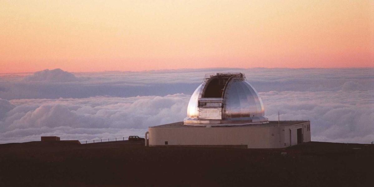
NASA Infrared Telescope Facility atop Mauna Kea, Hawaii. The IRTF is a venerable 30-year-old, 3-meter-diameter 10-foot telescope that ranks 40th among ground-based telescopes.
On June 27, 2014, a new vent opened on Hawaii Puu Oo vent, on the eastern flank of Kilauea volcano. NASA Terra spacecraft shows the hot lava flow in white, extending about 11 miles 17 kilometers from the vent.
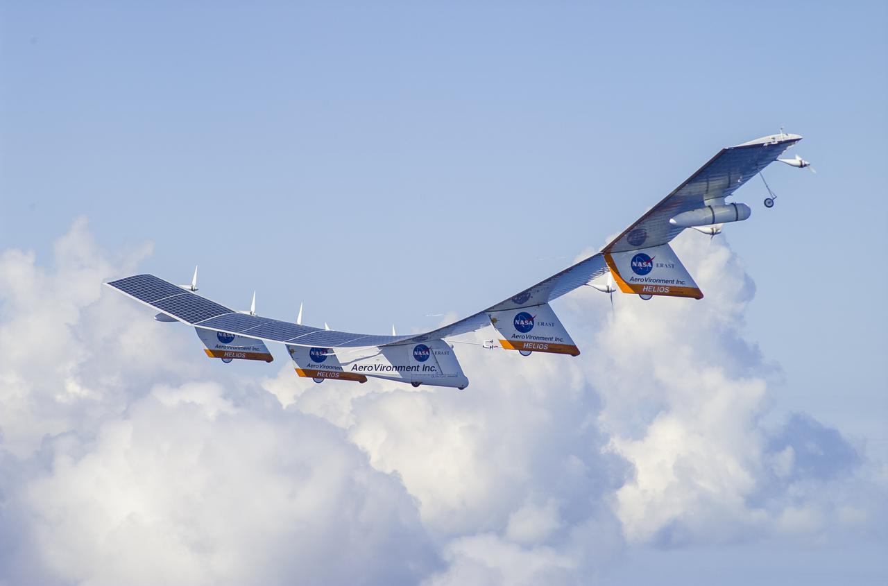
The AeroVironment Helios high-altitude, solar-powered aircraft flies in Kauai, Hawaii. Helios reached 96,300 feet altitude, the record for sustained, level flight for a winged aircraft.
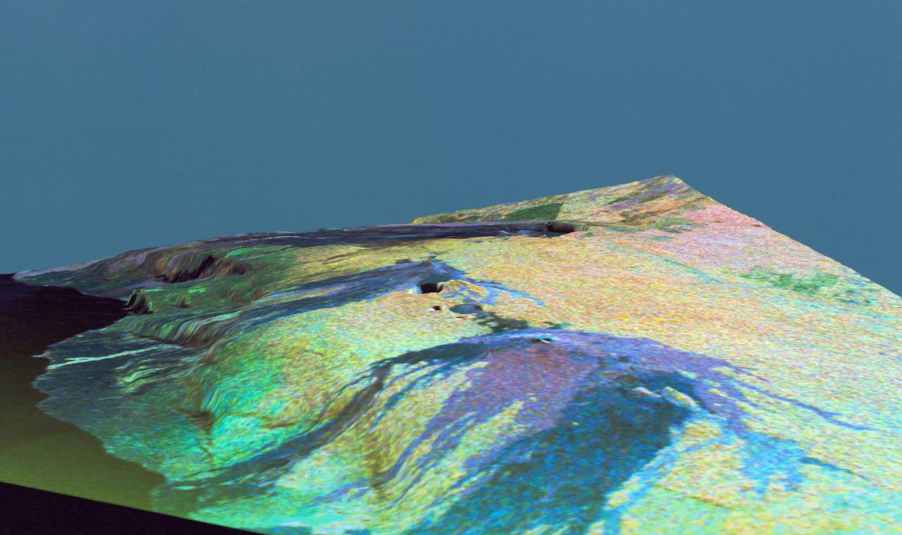
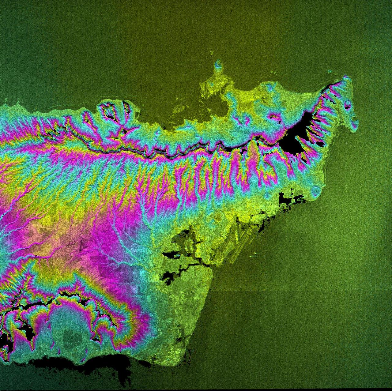
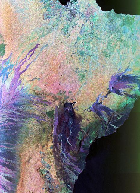
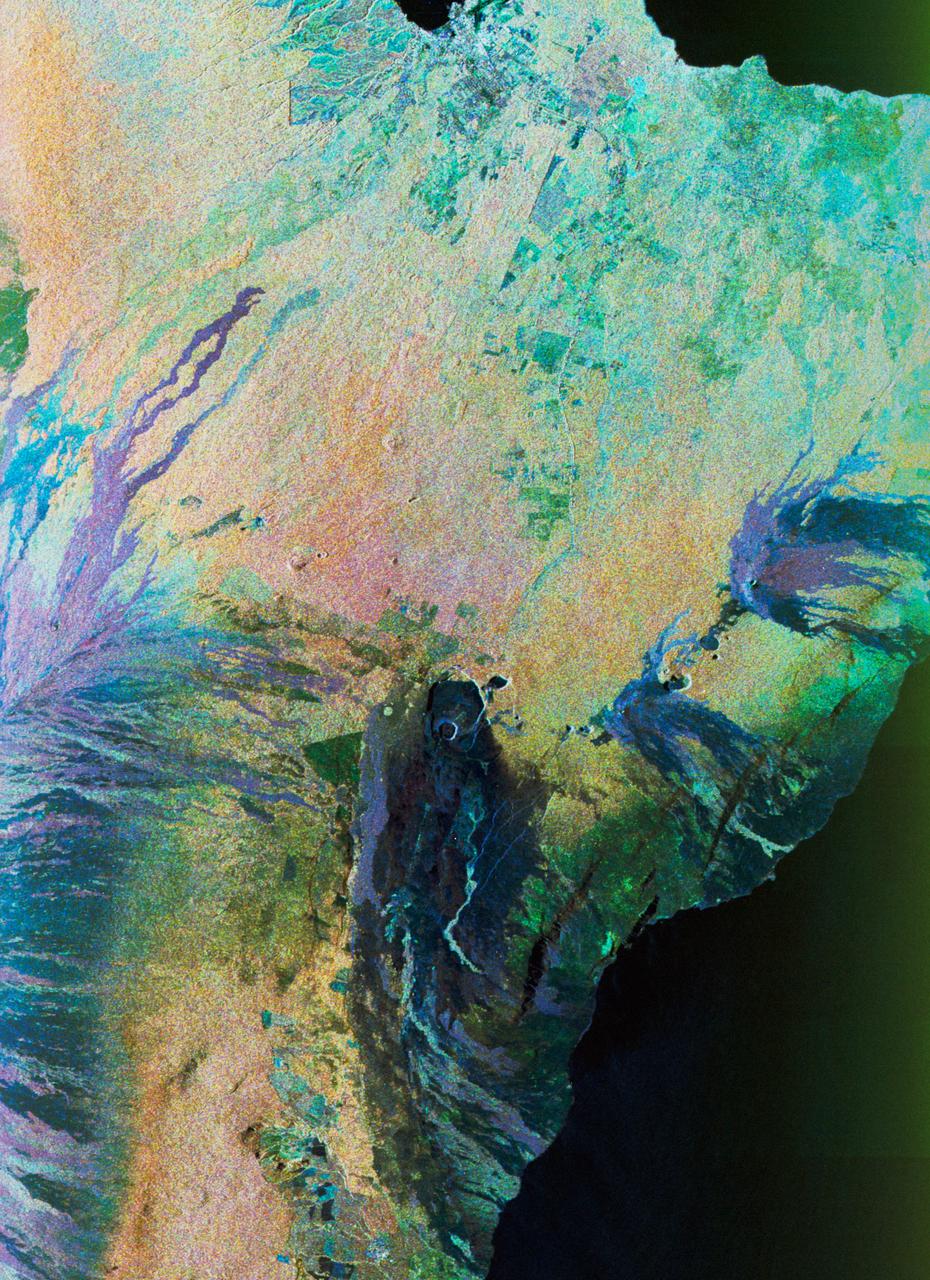
This is a three dimensional perspective view of false-color image of the eastern part of the Big Island of Hawaii. It was produced using all three radar frequencies C-Band and L-Band. This view was constructed by overlaying a SIR-C radar image on a U.S. Geological Survey digital elevation map. The image was acquired on April 12, 1994 during the 52nd orbit of the Shuttle Endeavour by the Spaceborne Imaging Radar-C and X-Band Synthetic Aperture Radar (SIR-C/X-SAR). The area shown is approximately 34 by 57 kilomters with the top of the image pointing toward north-west. The image is centered at about 155.25 degrees west longitude and 19.5 degrees north latitude. Visible in the center of the image in blue are the summit crater (Kilauea Caidera) which contains the smaller Halemaumau Crater, and the line of collapsed craters below them that form the Chain of Craters Road. The rain forest appears bright in the image while green areas correspond to lower vegetation. The lava flows have different colors depending on their types and are easily recognizable due to their shapes. The flows at the top of the image originated from the Muana Loa volcano. The Jet Propulsion Laboratory alternative photo number is P-43932.
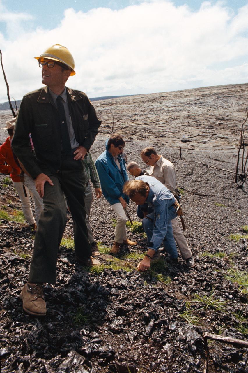
S70-34421 (April 1970) --- Prime crew men and backup crew men, of the Apollo 14 lunar landing mission, look over an area near the site of a volcanic eruption on Dec. 30, 1969. Astronauts Alan B. Shepard Jr. (leaning with left hand on ground) and Edgar D. Mitchell (behind Shepard, wearing dark glasses) are the prime crew men scheduled to walk on the moon. Astronauts Eugene A. Cernan (almost obscured at extreme left) and Joe H. Engle (partially visible, on Cernan's right) are backup crew commander and lunar module pilot, respectively, for the mission. Others in the photograph are Pat Crosland (in hard hat), a geologist and a park ranger in Hawaii Volcanoes State Park; Michael C. McEwen (facing Mitchell) of the Geology Branch, Lunar and Earth Sciences Division, Manned Spacecraft Center (MSC); and astronaut Bruce McCandless II, who made the trip to serve as a spacecraft communicator during simulations of extravehicular activity (EVA) on the lunar surface.
The Helios Prototype aircraft at approximately 10,000 feet flying above cloud cover northwest of Kauai, Hawaii.

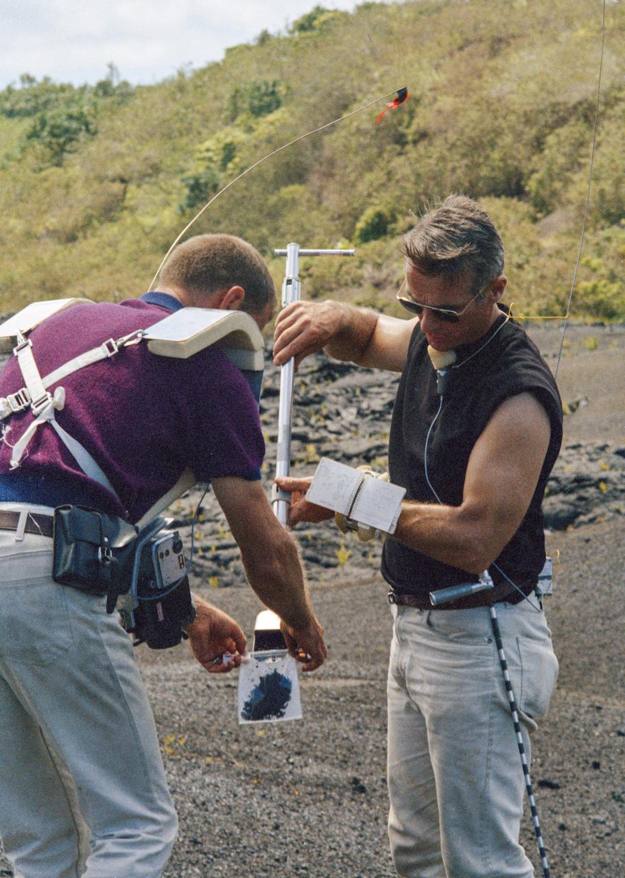
This image shows stone stripes on the side of a volcanic cone on Mauna Kea, Hawaii. The stripes are made of small rock fragments and they are aligned downhill as freeze-thaw cycles have lifted them up and out of the finer-grained regolith, and moved them to the sides, forming stone stripes. This site is at about 13,450-foot (4,100-meter) altitude on the mountain. For scale, the rock cluster toward the bottom right of the image is approximately 1 foot (30 centimeters) wide. The image was taken in 1999 by R. E. Arvidson. Such ground texture has been seen in recent images from NASA's Mars Exploration Rover Opportunity. https://photojournal.jpl.nasa.gov/catalog/PIA22219
S73-34857 (July-September 1973) --- A composite of two photographs of the Island of Oahu, County of Honolulu, State of Hawaii, taken by one of the Skylab 3 crewmen from the Skylab space station in Earth orbit. The two pictures (SL3-128-3009 and SL3-128-3010) were taken with a hand-held 35mm Nikon camera, a 55/300mm lens and so-368 medium-speed Ektacrome film. Pearl Harbor is clearly visible. The city of Honolulu is located next to the triangle-shaped seaplane runway. Photo credit: NASA
S70-20272 (December 1969) --- Astronaut James A. Lovell Jr., commander of the upcoming Apollo 13 lunar landing mission, uses a scoop from the Apollo Lunar Hand Tools (ALHT) during a simulated lunar surface traverse at the Kapoho, Hawaii training site. While at the Hawaii training sites, Lovell and Haise are participating in thorough rehearsals of their extravehicular activity (EVA). Photo credit: NASA
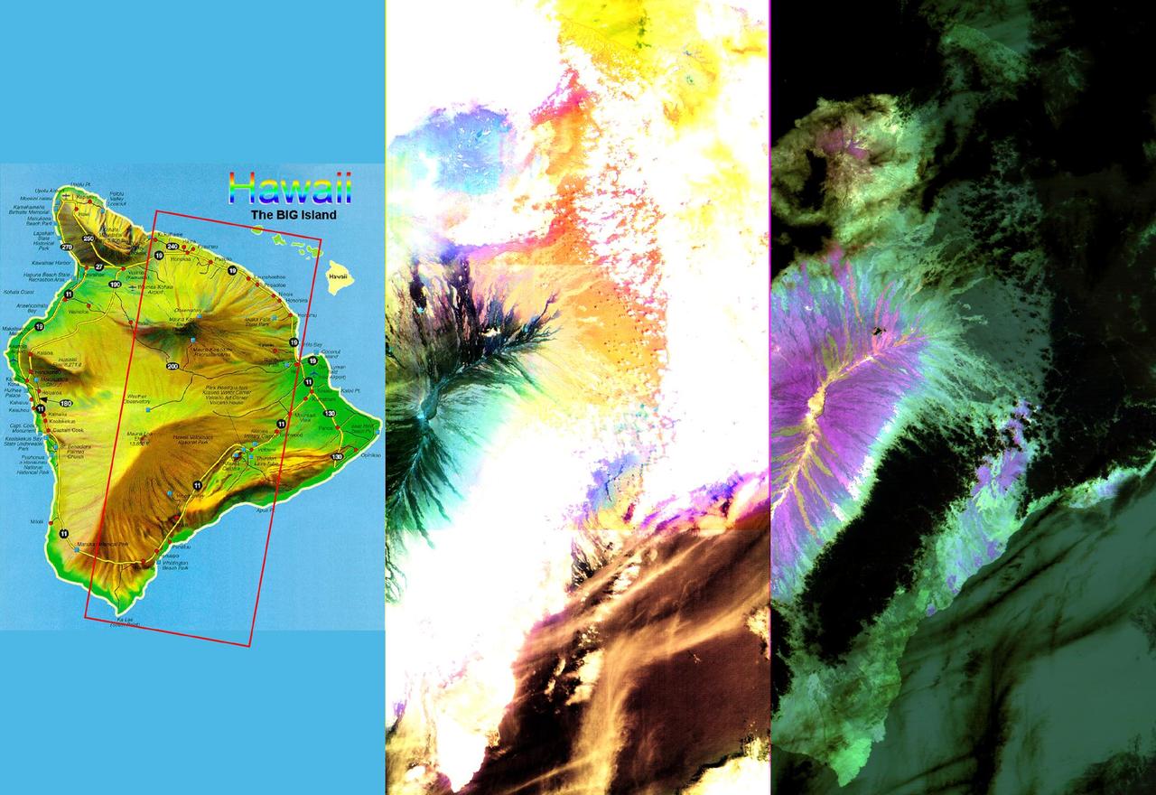
These images of the Island of Hawaii were acquired on March 19, 2000 by the Advanced Spaceborne Thermal Emission and Reflection Radiometer (ASTER) on NASA's Terra satellite. With its 14 spectral bands from the visible to the thermal infrared wavelength region, and its high spatial resolution of 15 to 90 meters (about 50 to 300 feet), ASTER will image Earth for the next 6 years to map and monitor the changing surface of our planet. Data are shown from the short wavelength and thermal infrared spectral regions, illustrating how different and complementary information is contained in different parts of the spectrum. Left image: This false-color image covers an area 60 kilometers (37 miles) wide and 120 kilometers (75 miles) long in three bands of the short wavelength infrared region. While, much of the island was covered in clouds, the dominant central Mauna Loa volcano, rising to an altitude of 4115 meters (13,500 feet), is cloud-free. Lava flows can be seen radiating from the central crater in green and black tones. As they reach lower elevations, the flows become covered with vegetation, and their image color changes to yellow and orange. Mauna Kea volcano to the north of Mauna Loa has a thin cloud-cover, producing a bluish tone on the image. The ocean in the lower right appears brown due to the color processing. Right image: This image is a false-color composite of three thermal infrared bands. The brightness of the colors is proportional to the temperature, and the hues display differences in rock composition. Clouds are black, because they are the coldest objects in the scene. The ocean and thick vegetation appear dark green because they are colder than bare rock surfaces, and have no thermal spectral features. Lava flows are shades of magenta, green, pink and yellow, reflecting chemical changes due to weathering and relative age differences. http://photojournal.jpl.nasa.gov/catalog/PIA02604
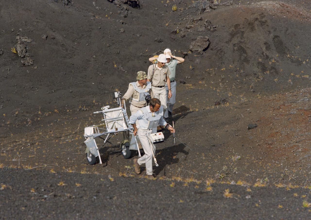
S70-34416 (April 1970) --- At Kapoho, Hawaii, two Apollo 14 prime crew members take part in a simulation of a lunar traverse while two persons from the Manned Spacecraft Center (MSC) observe. The prime and backup crews of the Apollo 14 mission were in Hawaii for several days in April 1970 to visit various sites having features similar to those on the lunar surface. Astronaut Alan B. Shepard Jr. (front), prime crew commander, carries a gnomon (from the Apollo Lunar Hand Tools - ALHT) in his left hand while pulling the Modular Equipment Transporter (MET) with his right hand. He is followed by astronaut Edgar D. Mitchell, prime lunar module pilot, with a Hasselblad lunar surface camera. Michael C. McEwen (second from rear) of the Geology Branch, Lunar and Earth Sciences Division, MSC; and Major William J. Wood of the Lunar Surface Operations Office observe the training activity. Photo credit: NASA
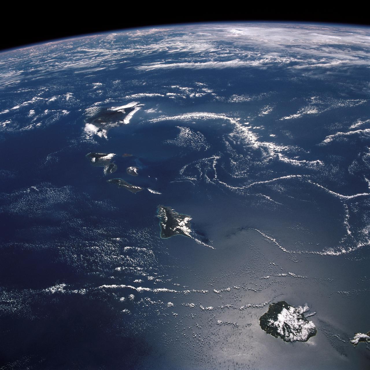
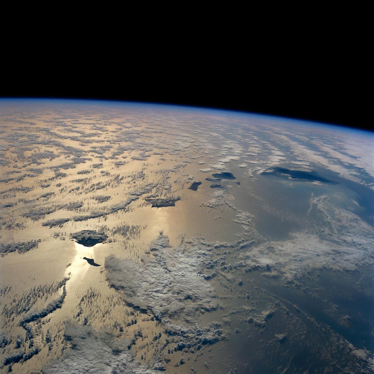
STS026-43-082 (29 Sept. - 3 Oct. 1988) --- This 70mm northerly oriented frame over the Pacific Ocean features the Hawaiian Islands chain. The islands perturb the prevailing northeasterly winds producing extensive cloud wakes in the lee of the islands. Photo experts feel that atmospheric haze in the Hawaii wake is probably a result of the continuing eruptions of Kilauea volcano on the southeast coast. From the lower right corner in a diagonal directed upward to the north are the islands of Nihau, Kauai, Oahu, Molokai, Lanai, Maui, Kahoolawe, and Hawaii. This photo was shown during the post-flight press conference on October 11, 1988 by the STS-26 astronauts, who at one time during the flight wore Hawaiian attire to pay tribute to the working staff of the Hawaii tracking station.

Pathfinder-Plus on a flight in 1998 over Hawaiian waters.
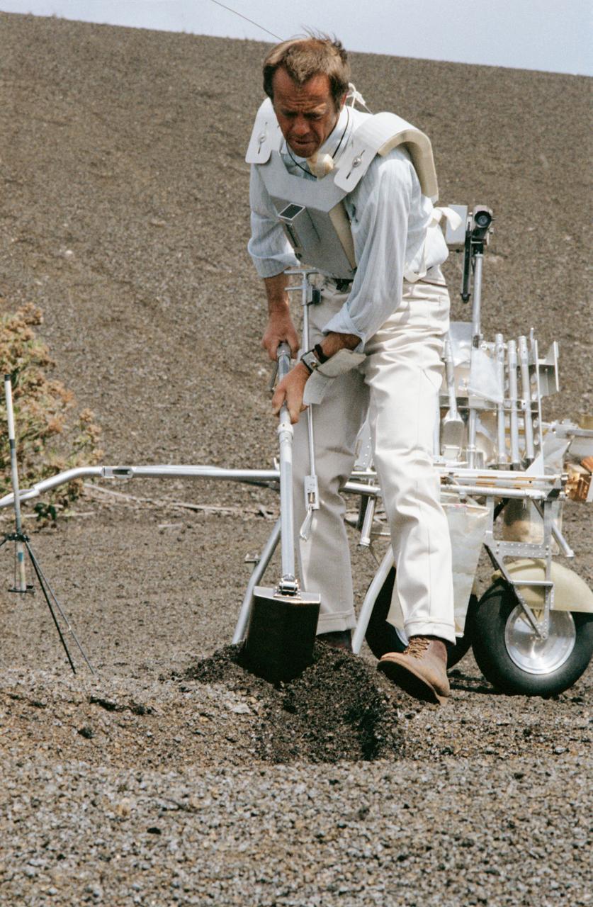
S70-34415 (April 1970) --- Astronaut Alan B. Shepard Jr., prime crew commander of the Apollo 14 mission, uses a trenching tool during a simulation of a traverse on the lunar surface. Members of the Apollo 14 prime and backup crews were in Hawaii to train for the extravehicular activity of their upcoming mission. Features of the terrain at Kapoho and other Hawaiian sites are very similar to those found on the lunar surface. A modular equipment transporter (MET), nicknamed the "Rickshaw" because of its appearance and method of propulsion, is behind Shepard, and a gnomon, one of the Apollo lunar hand tools (ALHT) is at extreme left.
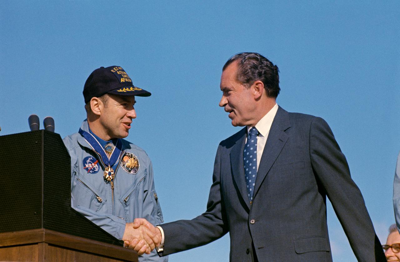
S70-15506 (18 April 1970) --- President Richard M. Nixon and astronaut James A. Lovell Jr., Apollo 13 commander, shake hands at special ceremonies at Hickam Air Force Base, Hawaii. President Nixon was in Hawaii to present the Apollo 13 crew with the Presidential Medal of Freedom, the nation's highest civilian honor. The wives of astronauts Lovell and Fred W. Haise Jr., lunar module pilot; and the parents of astronaut John L. Swigert Jr., command module pilot, flew with the Chief Executive to Hickam Air Force Base. The Apollo 13 splashdown occurred at 12:07:44 p.m. (CST), April 17, 1970, a day and a half prior to the awards ceremony.
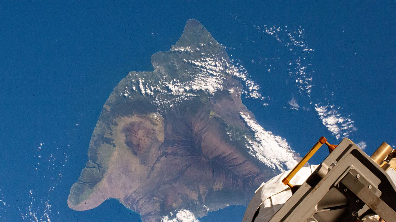
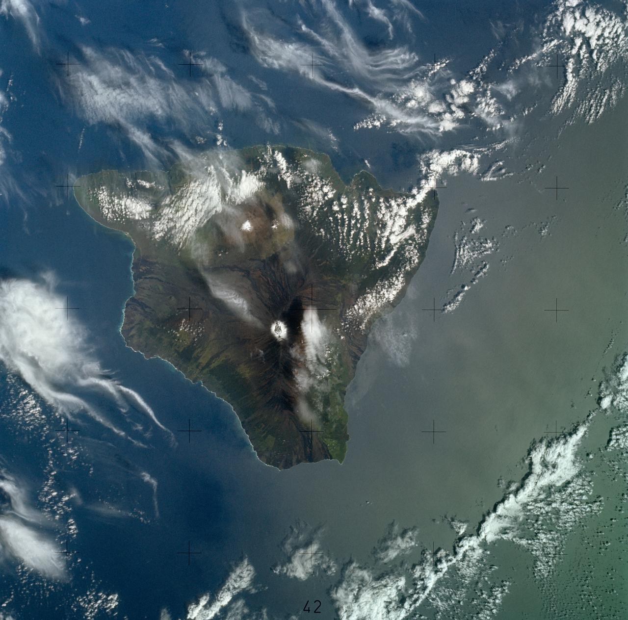
iss072e421839 (Dec. 28, 2024) --- Hawaii, the largest island in the chain of the Hawaiian Islands, hosts Mauna Loa, the world's largest active volcano, and Mauna Kea, a dormant volcano that is also home to the world's largest astronomical observatory, the Mauna Kea Observatories. The International Space Station was orbiting 260 miles above the Pacific Ocean at the time of this photograph.
Hawaii's Kilauea volcano continues to create new land as flows from fissure 8, one of the most active to break ground since the eruption began in early May, reach the ocean. The Advanced Spaceborne Thermal Emission and Reflection (ASTER) radiometer instrument on NASA's Terra satellite detected the lava flow of fissure 8 -- which extends from Leilani Estates to the Pacific Ocean -- on July 25. In the image, vegetation is displayed in red, clouds are white and the hot lava flows, detected by ASTER's thermal infrared channels, are overlaid in yellow. The image covers an area of 9.5 by 11.5 miles (15.3 by 18.6 kilometers). https://photojournal.jpl.nasa.gov/catalog/PIA22489
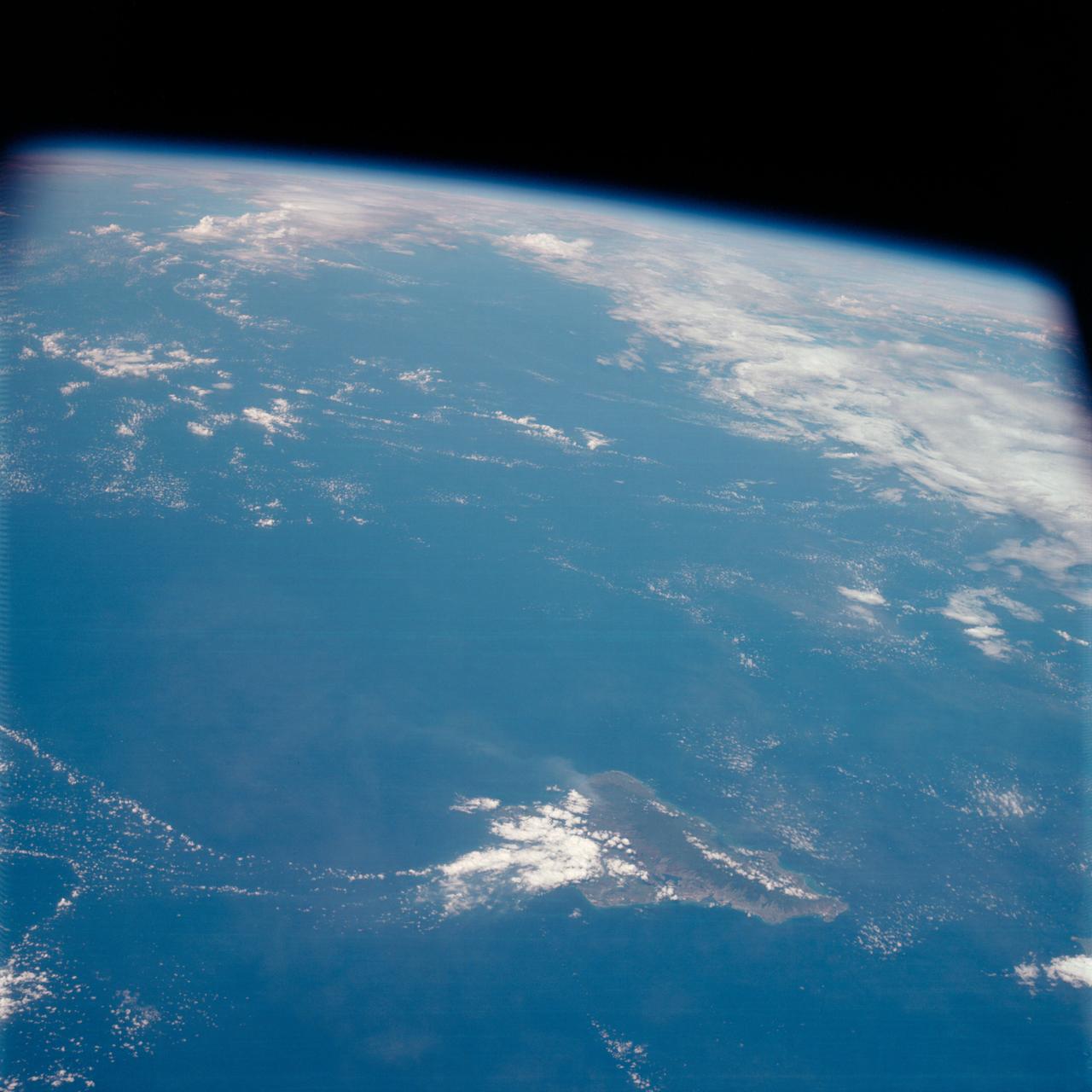
S63-06428 (15-16 May 1963) --- Photograph taken south of Hawaii near 12N. 166W, by astronaut L. Gordon Cooper Jr., during his 22-orbit Mercury-Atlas 9 (MA-9) spaceflight. Photo credit: NASA
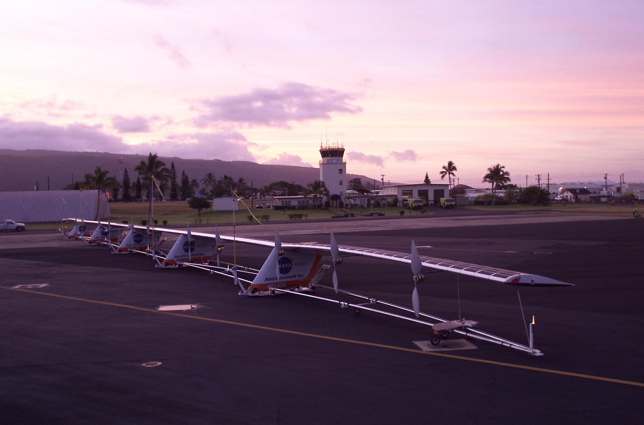
The 247-foot length of the Helios prototype wing is in evidence as the high-altitude, solar-powered flying wing rests on its ground dolly during pre-flight tests at the U.S. Navy's Pacific Missile Range Facility on Kaua'i, Hawaii.
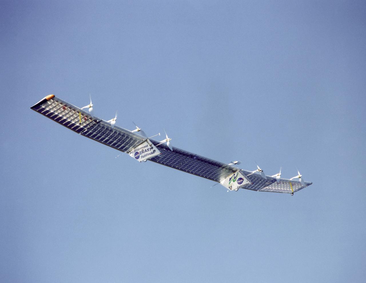
Pathfinder-Plus flying over the Hawaiian Islands in 1998 with Ni'ihau Island in the background.
STS059-S-074 (15 April 1994) --- This color composite C-Band and L-Band image of the Kilauea volcano on the big island of Hawaii was acquired by the Spaceborne Imaging Radar-C and X-Band Synthetic Aperture Radar (SIR-C/X-SAR) flying on the Space Shuttle Endeavour. The city of Hilo can be seen at the top. The image shows the different types of lava flows around the crater Pu'u O'o. Ash deposits which erupted in 1790 from the summit of Kilauea volcano show up as dark in this image, and fine details associated with lava flows which erupted in 1919 and 1974 can be seen to the south of the summit in an area called the Ka'u Desert. In addition, the other historic lava flows created in 1881 and 1984 from Mauna Loa volcano (out of view to the left of this image) can easily be seen despite the fact that the surrounding area is covered by forest. Such information will be used to map the extent of such flows, which can pose a hazard to the subdivisions of Hilo. Highway 11 is the linear feature running from Hilo to the Kilauea volcano. The Kilauea volcano has been almost continuously active for more than the last 11 years. Field teams that were on the ground specifically to support these radar observations report that there was vigorous surface activity about 400 meters (one-quarter mile) inland from the coast. A moving lava flow about 200 meters (660 feet) in length was observed at the time of the Shuttle over flight, raising the possibility that subsequent images taken during this mission will show changes in the landscape. SIR-C/X-SAR is part of NASA's Mission to Planet Earth (MTPE). SIR-C/X-SAR radars illuminate Earth with microwaves allowing detailed observations at any time, regardless of weather or sunlight conditions. SIR-C/X-SAR uses three microwave wavelengths: L-Band (24 cm), C-Band (6 cm), and X-Band (3 cm). The multi-frequency data will be used by the international scientific community to better understand the global environment and how it is changing. The SIR-C/X-SAR data, complemented by aircraft and ground studies, will give scientists clearer insights into those environmental changes which are caused by nature and those changes which are induced by human activity. SIR-C was developed by NASA's Jet Propulsion Laboratory (JPL). X-SAR was developed by the Dornire and Alenia Spazio Companies for the German Space Agency, Deutsche Agentur fuer Raumfahrtangelegenheiten (DARA), and the Italian Space Agency, Agenzia Spaziale Italiana (ASI). JPL Photo ID: P-43918
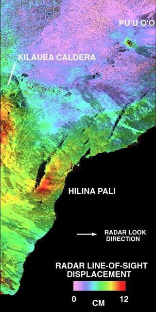
This is a deformation map of the south flank of Kilauea volcano on the big island of Hawaii, centered at 19.5 degrees north latitude and 155.25 degrees west longitude. The map was created by combining interferometric radar data -- that is data acquired on different passes of the space shuttle which are then overlayed to obtain elevation information -- acquired by the Spaceborne Imaging Radar-C/X-band Synthetic Aperture Radar during its first flight in April 1994 and its second flight in October 1994. The area shown is approximately 40 kilometers by 80 kilometers (25 miles by 50 miles). North is toward the upper left of the image. The colors indicate the displacement of the surface in the direction that the radar instrument was pointed (toward the right of the image) in the six months between images. The analysis of ground movement is preliminary, but appears consistent with the motions detected by the Global Positioning System ground receivers that have been used over the past five years. The south flank of the Kilauea volcano is among the most rapidly deforming terrains on Earth. Several regions show motions over the six-month time period. Most obvious is at the base of Hilina Pali, where 10 centimeters (4 inches) or more of crustal deformation can be seen in a concentrated area near the coastline. On a more localized scale, the currently active Pu'u O'o summit also shows about 10 centimeters (4 inches) of change near the vent area. Finally, there are indications of additional movement along the upper southwest rift zone, just below the Kilauea caldera in the image. Deformation of the south flank is believed to be the result of movements along faults deep beneath the surface of the volcano, as well as injections of magma, or molten rock, into the volcano's "plumbing" system. Detection of ground motions from space has proven to be a unique capability of imaging radar technology. Scientists hope to use deformation data acquired by SIR-C/X-SAR and future imaging radar missions to help in better understanding the processes responsible for volcanic eruptions and earthquakes. http://photojournal.jpl.nasa.gov/catalog/PIA01758
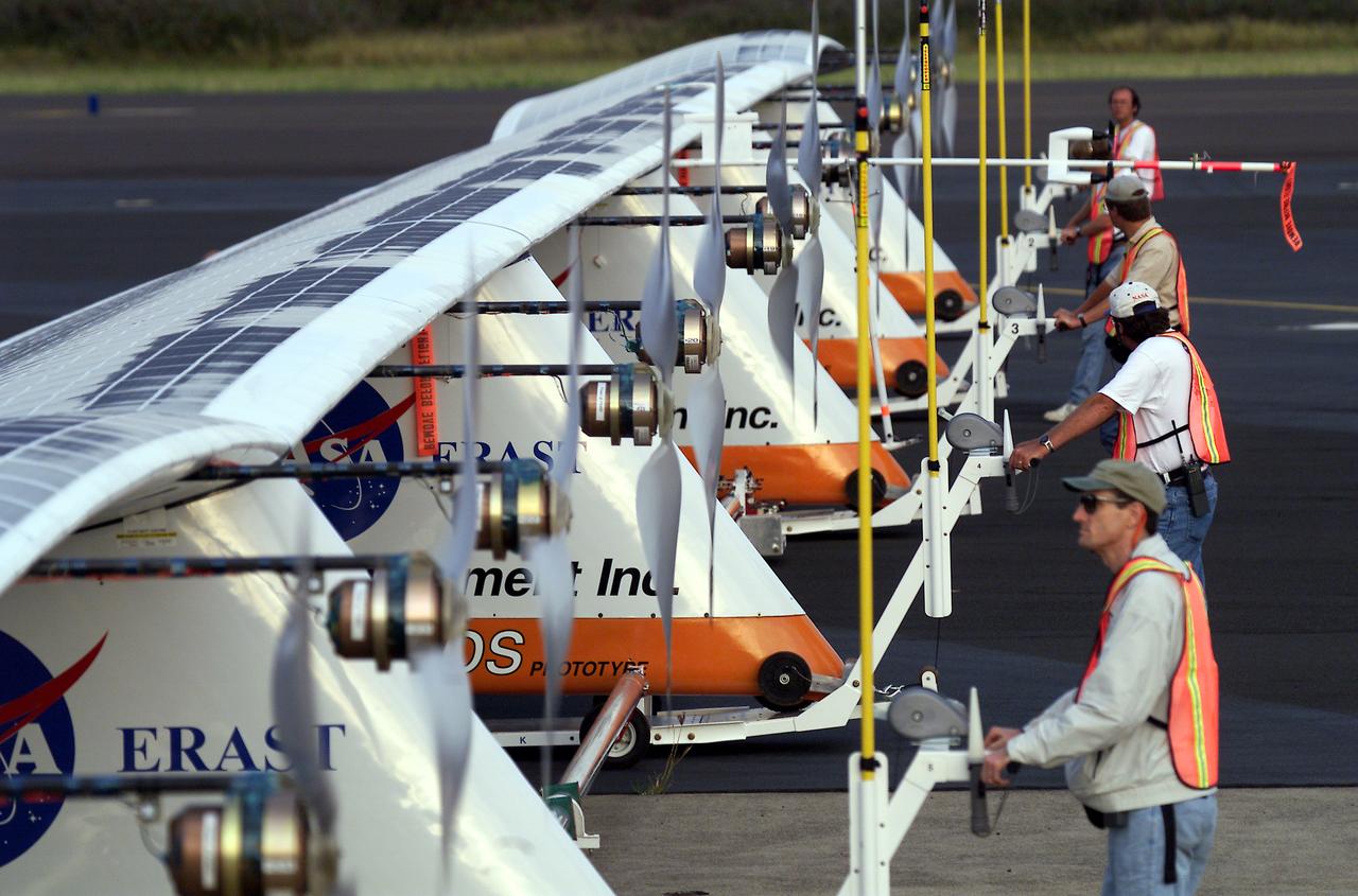
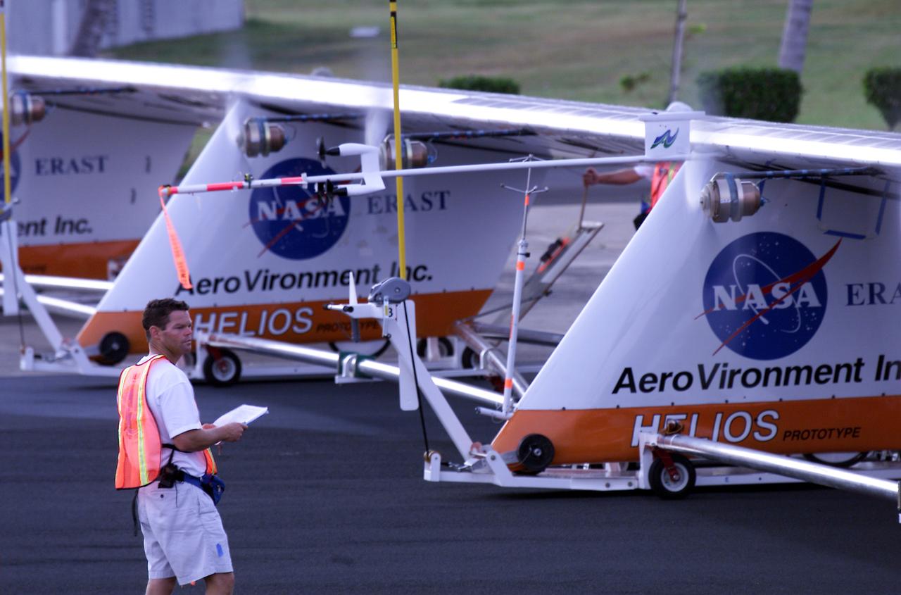
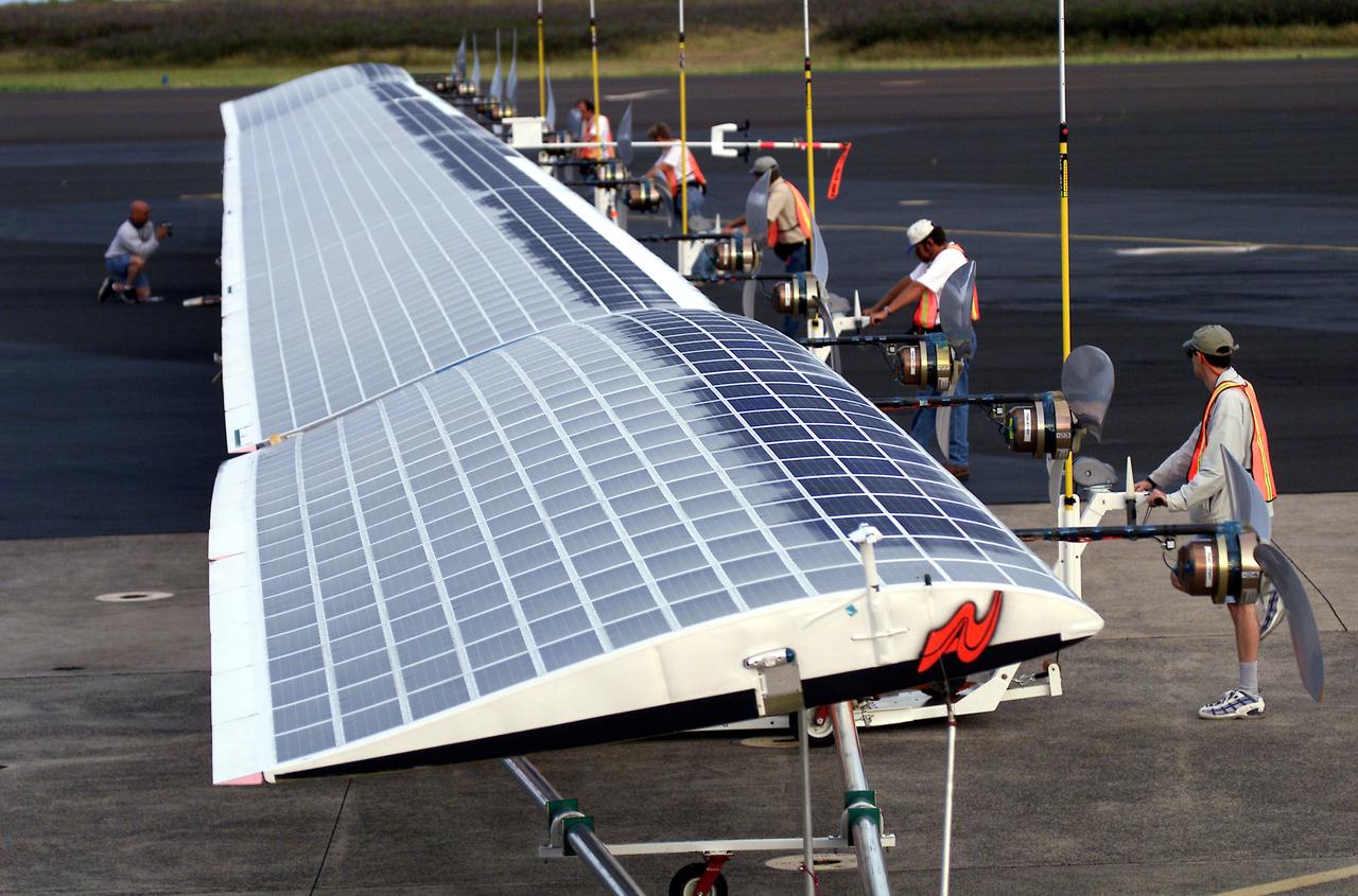
Ground crewmen maneuver AeroVironment's solar-powered Helios Prototype flying wing on its ground support dolly during functional checkouts prior to its first flights under solar power from the U.S. Navy's Pacific Missile Range Facility on Kaua'i, Hawaii.
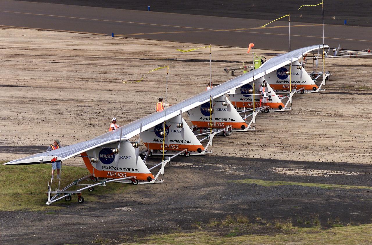
Ground crewmen maneuver AeroVironment's solar-powered Helios Prototype flying wing on its ground support dolly during functional checkouts prior to its first flights under solar power from the U.S. Navy's Pacific Missile Range Facility on Kaua'i, Hawaii.
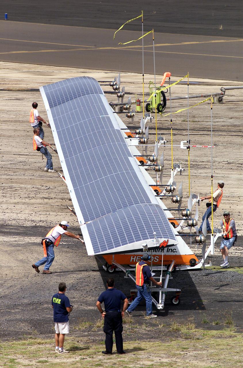
Ground crewmen maneuver AeroVironment's solar-powered Helios Prototype flying wing on its ground support dolly during functional checkouts prior to its first flights under solar power from the U.S. Navy's Pacific Missile Range Facility on Kaua'i, Hawaii.
Helios Prototype crew chief Marshall MacCready of AeroVironment, Inc., carefully monitors motor runs during ground checkout of the solar-powered flying wing prior to its first flight from the U.S. Navy's Pacific Missile Range Facility on Kaua'i, Hawaii.
Ground crewmen maneuver AeroVironment's solar-powered Helios Prototype flying wing on its ground support dolly during functional checkouts prior to its first flights under solar power from the U.S. Navy's Pacific Missile Range Facility on Kaua'i, Hawaii.
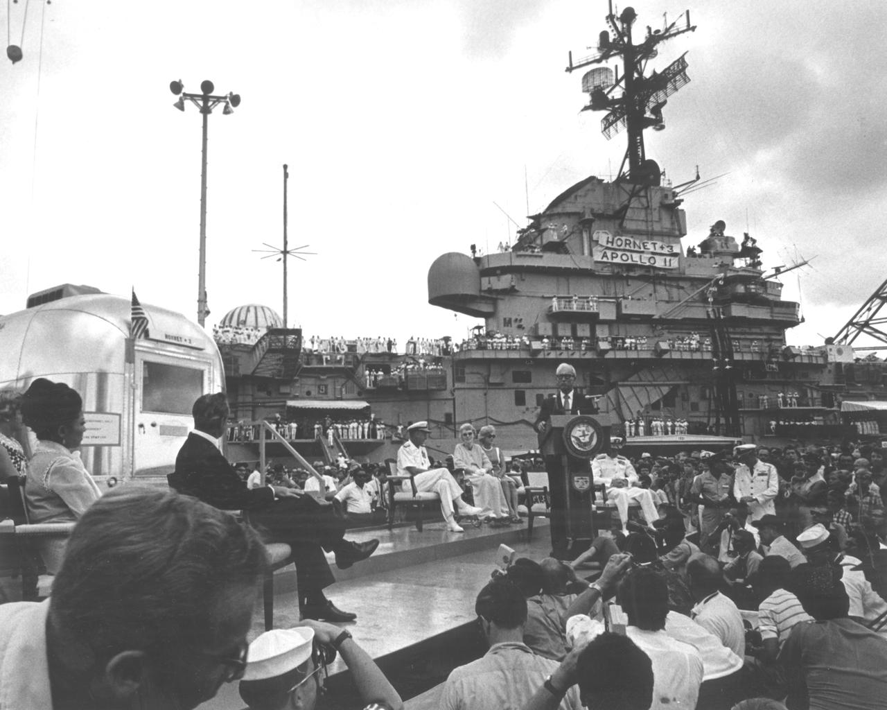
The Apollo 11 mission, the first manned lunar mission, launched from the Kennedy Space Center, Florida via the Marshall Space Flight Center (MSFC) developed Saturn V launch vehicle on July 16, 1969 and safely returned to Earth on July 24, 1969. Aboard the space craft were astronauts Neil A. Armstrong, commander; Michael Collins, Command Module (CM) pilot; and Edwin E. Aldrin Jr., Lunar Module (LM) pilot. The CM, piloted by Michael Collins remained in a parking orbit around the Moon while the LM, named “Eagle’’, carrying astronauts Neil Armstrong and Edwin Aldrin, landed on the Moon. During 2½ hours of surface exploration, the crew collected 47 pounds of lunar surface material for analysis back on Earth. The recovery operation took place in the Pacific Ocean where Navy para-rescue men recovered the capsule housing the 3-man Apollo 11 crew. The crew was airlifted to safety aboard the U.S.S. Hornet recovery ship, where they were quartered in a Mobile Quarantine Facility (MQF) for 21 days. The recovery vessel docked in Pearl Harbor Hawaii, where the occupied MQF was transferred for transport to the to NASA Manned Spacecraft Center (MSC) Lunar Receiving Laboratory in Houston, Texas. In this photo the quarantined astronauts are addressed by Hawaiian Governor John Burns upon their arrival at Pearl Harbor.
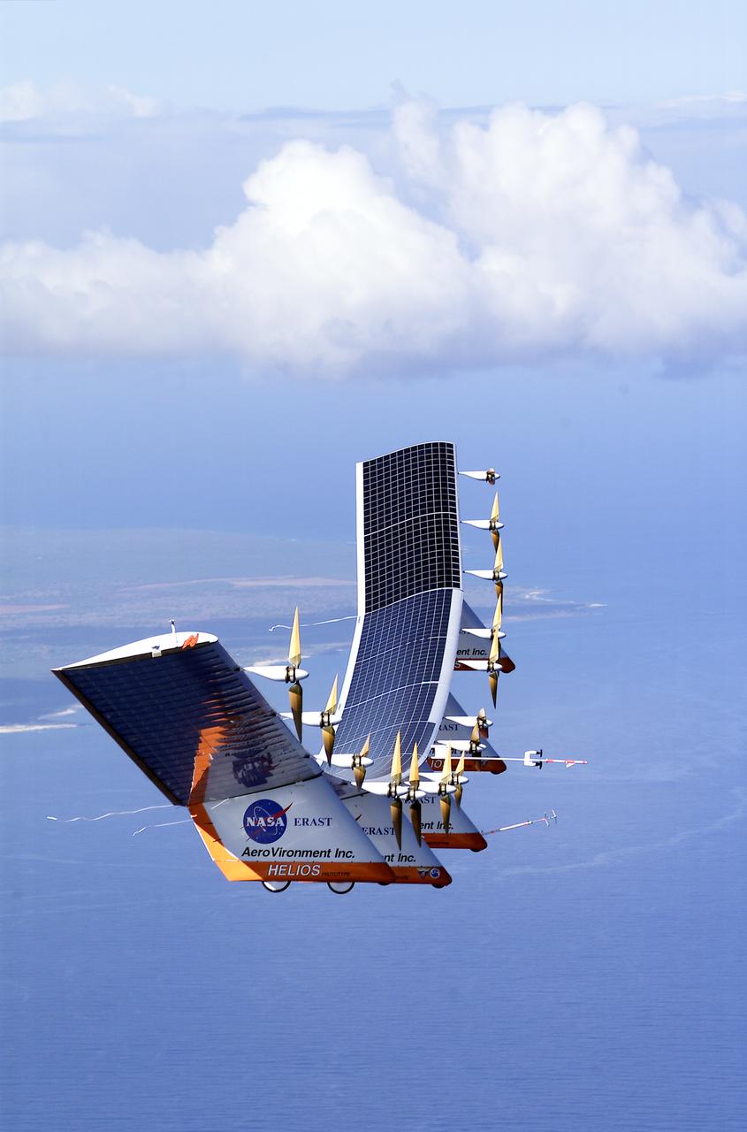
The solar-electric Helios Prototype flying wing is shown near the Hawaiian island of Niihau during its first test flight on solar power from the U.S. Navy's Pacific Missile Range Facility on Kauai, Hawaii, July 14, 2001. The 18-hour flight was a functional checkout of the aircraft's systems and performance in preparation for an attempt to reach sustained flight at 100,000 feet altitude later this summer.
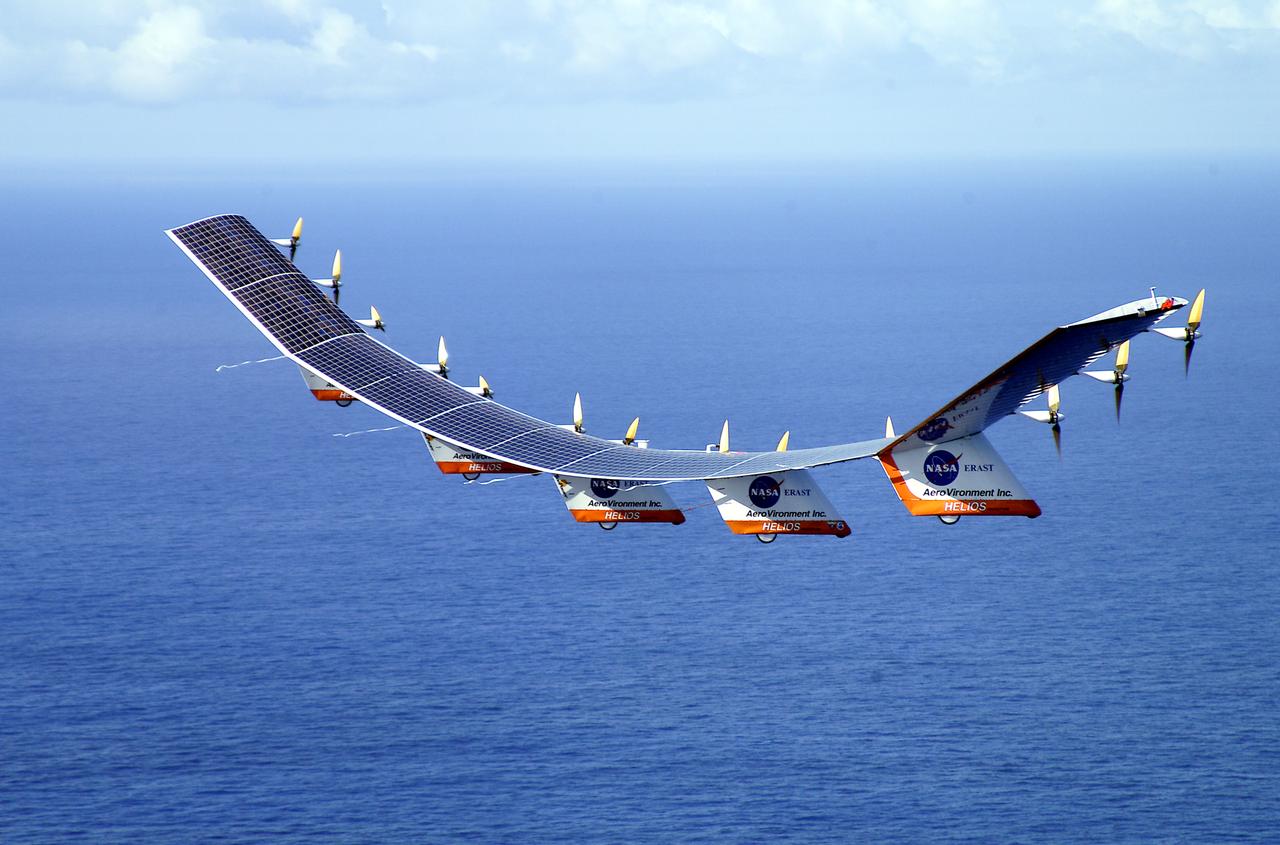
The solar-electric Helios Prototype flying wing is shown over the Pacific Ocean during its first test flight on solar power from the U.S. Navy's Pacific Missile Range Facility on Kauai, Hawaii, July 14, 2001. The 18-hour flight was a functional checkout of the aircraft's systems and performance in preparation for an attempt to reach sustained flight at 100,000 feet altitude later this summer.
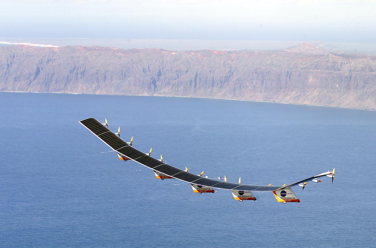
The solar-electric Helios Prototype flying wing is shown near the Hawaiian island of Niihau during its first test flight on solar power from the U.S. Navy's Pacific Missile Range Facility on Kauai, Hawaii, July 14, 2001. The 18-hour flight was a functional checkout of the aircraft's systems and performance in preparation for an attempt to reach sustained flight at 100,000 feet altitude later this summer.
The solar-electric Helios Prototype flying wing is shown near the Hawaiian islands of Niihau and Lehua during its first test flight on solar power from the U.S. Navy's Pacific Missile Range Facility on Kauai, Hawaii, July 14, 2001. The 18-hour flight was a functional checkout of the aircraft's systems and performance in preparation for an attempt to reach sustained flight at 100,000 feet altitude later this summer.
The solar-electric Helios Prototype flying wing is shown near the Hawaiian islands of Niihau and Lehua during its first test flight on solar power from the U.S. Navy's Pacific Missile Range Facility on Kauai, Hawaii, July 14, 2001. The 18-hour flight was a functional checkout of the aircraft's systems and performance in preparation for an attempt to reach sustained flight at 100,000 feet altitude later this summer.
The solar-electric Helios Prototype flying wing is shown over the Pacific Ocean during its first test flight on solar power from the U.S. Navy's Pacific Missile Range Facility on Kauai, Hawaii, July 14, 2001. The 18-hour flight was a functional checkout of the aircraft's systems and performance in preparation for an attempt to reach sustained flight at 100,000 feet altitude later this summer.
The solar-electric Helios Prototype flying wing is shown moments after takeoff, beginning its first test flight on solar power from the U.S. Navy's Pacific Missile Range Facility on Kauai, Hawaii, July 14, 2001. The 18-hour flight was a functional checkout of the aircraft's systems and performance in preparation for an attempt to reach sustained flight at 100,000 feet altitude later this summer.
S70-34413 (April 1970) --- Astronaut Eugene A. Cernan (right), backup crew commander of the Apollo 14 lunar landing mission, pours a scoop-full of sample material into a bag held by astronaut Joe H. Engle, Apollo 14 backup crew lunar module pilot. The two joined the prime crew members and other Manned Spacecraft Center (MSC) personnel on a training trip to various areas of Hawaii. Here in Kapoho, the two backup crew members for NASA?s next lunar landing mission are taking part in a full simulation of a traverse on the lunar surface. Note the check-list on Cernan's left wrist. He carries a penetrometer in his belt. The terrain in this area bears many similarities to that on the lunar surface. Photo credit: NASA
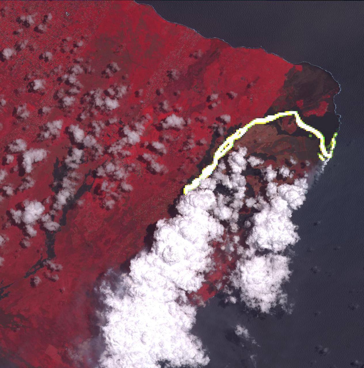
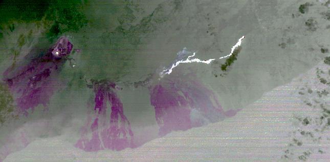
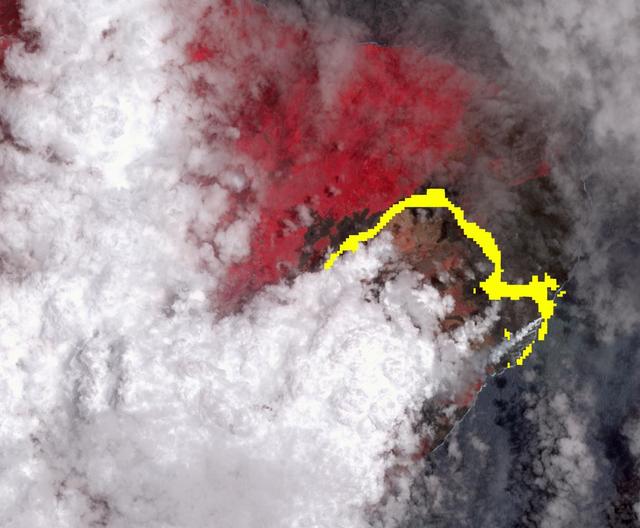
Hawaii's Kilauea volcanic eruption continues after seven weeks of continuous outpouring of lava over the northeastern part of the island. More than 6,100 acres of the Big Island have been covered with new lava, destroying hundreds of homes. At the same time, new land has been created as lava filled Kapoho Bay at the ocean. For some time, the activity has been confined to a leveed channel flow, that starts from the active-most vent, and makes it way 8 miles (13 kilometers) to the ocean. In this image from the Advanced Spaceborne Thermal Emission and Reflection (ASTER) radiometer instrument on NASA's Terra satellite, vegetation is displayed in red, clouds are white and the hot lava flows, detected by ASTER's thermal infrared channels, are overlaid in yellow. The image was acquired June 23, 2018, covers an area of 14.2 by 14.6 miles (23 by 23.3 kilometers), and is located at 19.6 degrees north, 154.9 degrees west. https://photojournal.jpl.nasa.gov/catalog/PIA22553
In this picture, NASA saucer-shaped experimental flight vehicle is prepared for a Range Compatibility Test at the U.S. Navy Pacific Missile Range Facility in Kauai, Hawaii.
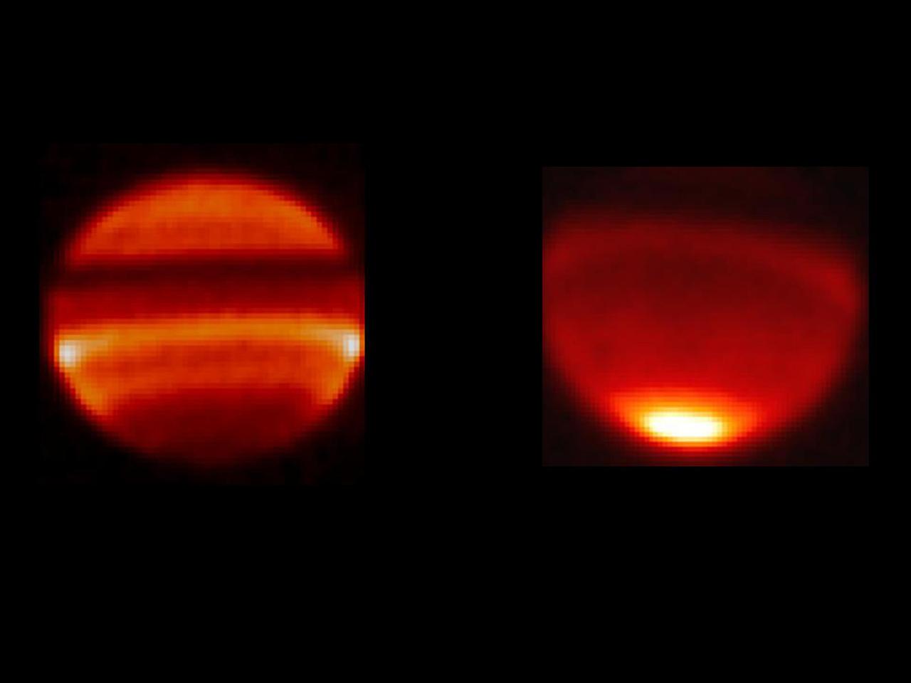
These two images, taken with NASA Infrared Telescope Facility in Mauna Kea, Hawaii, capture two different phases of this wave oscillation at Saturn equator.
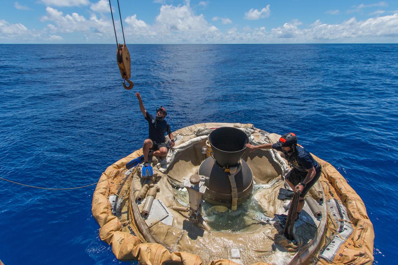
Divers retrieve the test vehicle for NASA Low-Density Supersonic Decelerator off the coast of the U.S. Navy Pacific Missile Range Facility in Kauai, Hawaii.
Pavonis Mons is a giant shield volcano similar to although larger than those on the Big Island of Hawaii. This image is from NASA Mars Reconnaissance Orbiter.
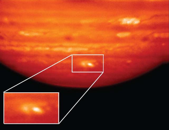
This image shows a large impact on Jupiter south polar region captured on July 20, 2009, by NASA Infrared Telescope Facility in Mauna Kea, Hawaii.
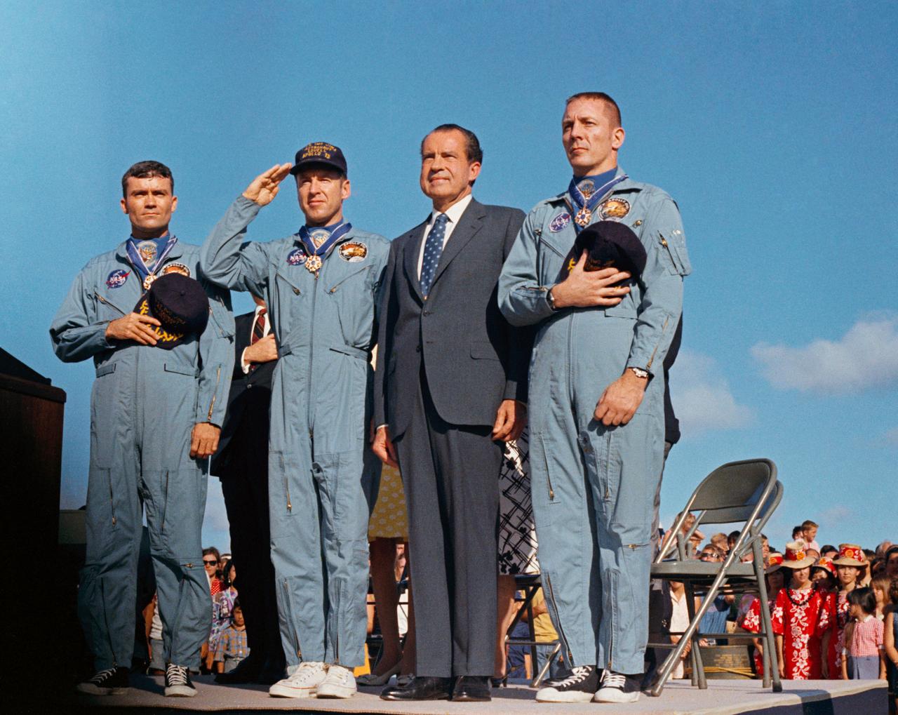
S70-15526 (18 April 1970) --- President Richard M. Nixon and the Apollo 13 crew members pay honor to the United States flag during the post-mission ceremonies at Hickam Air Force Base, Hawaii. Astronauts James A. Lovell Jr., (United States Navy Captain, salutes the flag) commander; John L. Swigert Jr., command module pilot (right); and Fred W. Haise Jr., lunar module pilot (left), were presented the Presidential Medal of Freedom by the Chief Executive. The Apollo 13 splashdown occurred at 12:07:44 p.m. (CST), April 17, 1970, about a day and a half prior to the award presentation.
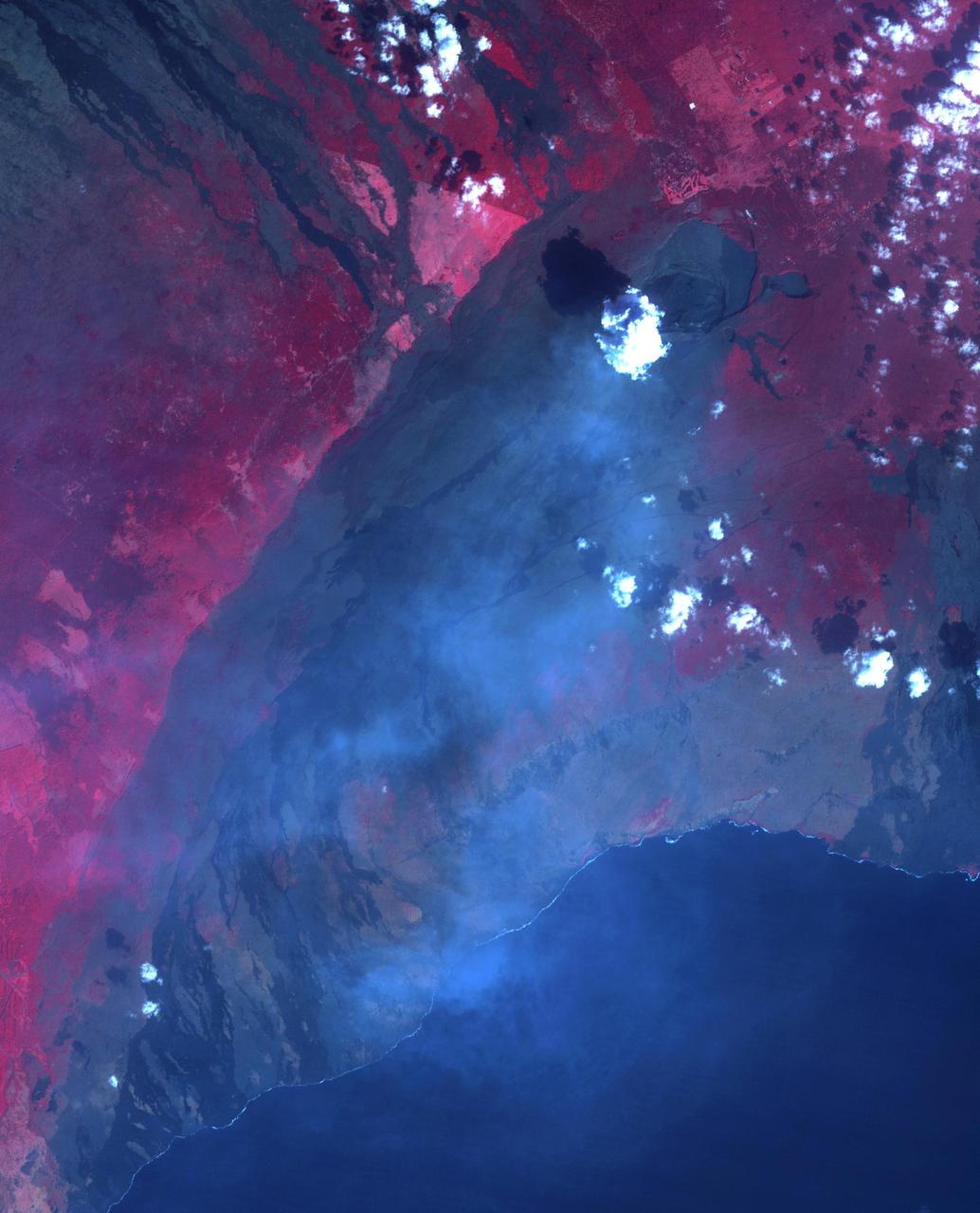
The entire Hawaiian Island Archipelago (21.5N, 158.0W) is seen in this single view. The islands are a favorite international resort and tourist attraction drawing visitors from all over the world to enjoy the tropical climate, year round beaches and lush island flora. Being volcanic in origin, the islands' offer a rugged landscape and on the big island of Hawaii, there is still an occasional volcanic eruption of lava flows and steam vents.
On Oct. 19 at 19:35 UTC (3:35 p.m. EDT) the MODIS instrument aboard NASA's Terra satellite saw Hurricane Olaf moving into the central Pacific Ocean with a visible eye. Powerful thunderstorms circled the eye and extended in a thick band in the eastern quadrant from north to south. At 5 a.m. EDT (0900 UTC) on Oct. 20, Hurricane Olaf's center was located near latitude 10.3 north and longitude 140.4 west. That's about 1,175 miles (1,890 km) east-southeast of Hilo, Hawaii. Despite being so far from Hawaii and because Olaf is a powerful hurricane, large swells generated by Olaf will begin to arrive along east facing shores of the main Hawaiian Islands over the next couple of days. The CPHC said that resultant surf will be large...potentially life-threatening and damaging. Olaf is moving toward the west-northwest near 10 mph (17 kph) and the Central Pacific Hurricane Center (CPHC), who has taken over forecast responsibilities now that Olaf has crossed the 140 degree longitude line, expects Olaf to turn toward the west-northwest and then northwest by October 21. Maximum sustained winds are near 150 mph (240 kph). Olaf is a category four hurricane on the Saffir-Simpson Hurricane wind scale. Some additional strengthening is forecast on Tuesday, Oct. 20 and fluctuations in intensity are possible Tuesday night and Wednesday. The estimated minimum central pressure is 938 millibars. Olaf is expected to remain a major hurricane for the next couple of days and begin curving to the northeast and away from Hawaii by Friday, October 23. For updates, visit: <a href="http://www.prh.noaa.gov/cphc" rel="nofollow">www.prh.noaa.gov/cphc</a>. Credit: NASA Goddard's MODIS Rapid Response Team <b><a href="http://www.nasa.gov/audience/formedia/features/MP_Photo_Guidelines.html" rel="nofollow">NASA image use policy.</a></b> <b><a href="http://www.nasa.gov/centers/goddard/home/index.html" rel="nofollow">NASA Goddard Space Flight Center</a></b> enables NASA’s mission through four scientific endeavors: Earth Science, Heliophysics, Solar System Exploration, and Astrophysics. Goddard plays a leading role in NASA’s accomplishments by contributing compelling scientific knowledge to advance the Agency’s mission. <b>Follow us on <a href="http://twitter.com/NASAGoddardPix" rel="nofollow">Twitter</a></b> <b>Like us on <a href="http://www.facebook.com/pages/Greenbelt-MD/NASA-Goddard/395013845897?ref=tsd" rel="nofollow">Facebook</a></b> <b>Find us on <a href="http://instagrid.me/nasagoddard/?vm=grid" rel="nofollow">Instagram</a></b>
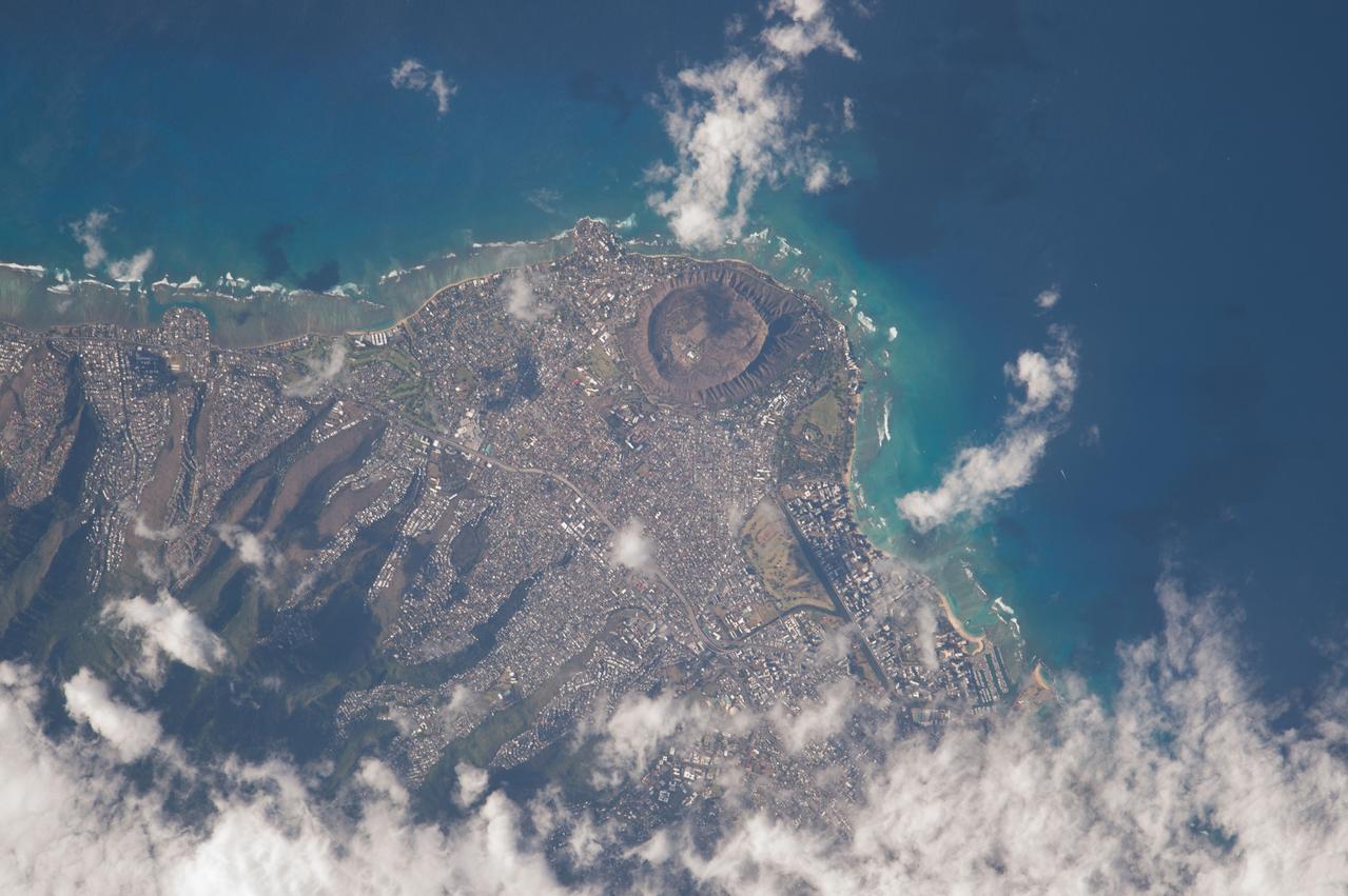
ISS043E249688 (04/24/2015) --- This picture of Hawaii was tweeted out by NASA astronaut Scott Kelly on the International Space Station with this comment: "Just flew over you #Honolulu #Hawaii. Happy #MemorialDay! #YearInSpace ".
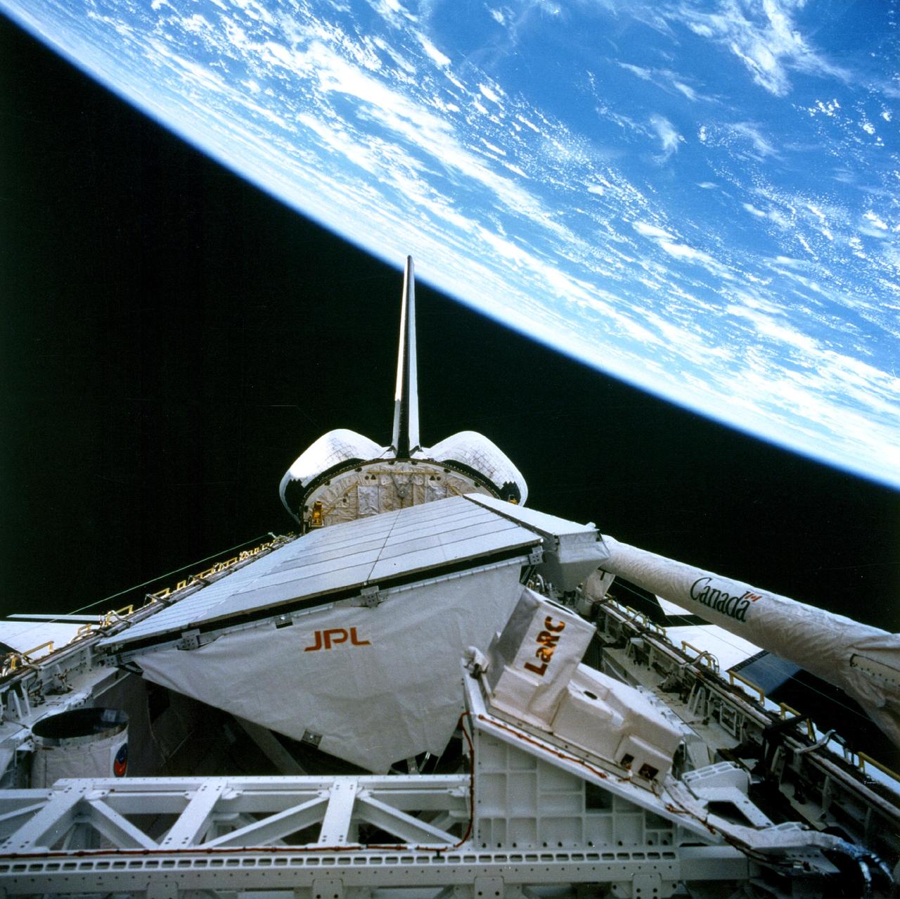
NASA SIR-C/X-SAR is shown here in the payload bay of the orbiting space shuttle Endeavour STS-59, with an area of the Pacific Ocean northeast of Hawaii in the background.

An engineer works on the Parachute Deployment Device of the Low-Density Supersonic Decelerator test vehicle in this image taken at the Missile Assembly Building at the U.S. Navy Pacific Missile Range Facility in Kauai, Hawaii.
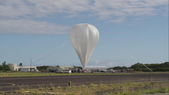
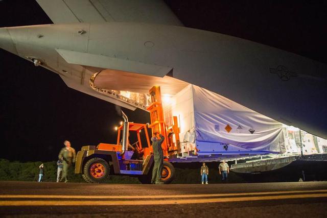
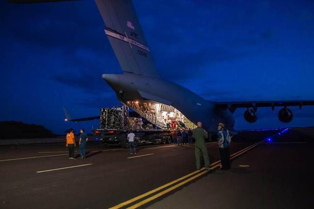
Crews from the Columbia Scientific Balloon Facility prepare the balloon for flight for the 2014 NASA Low-Density Supersonic Decelerator test from the U.S. Navy Pacific Missile Range Facility on Kauai, Hawaii.
This infrared image, showing thermal radiation at a wavelength of 9.7 microns, was obtained by the Gemini North Telescope in Hawaii. The bright white and yellow features at bottom are the aftermath of an impactor hitting Jupiter on July 19, 2009.

Astronomers have discovered a massive cluster of young galaxies forming in the distant universe. The growing galactic metropolis is known as COSMOS-AzTEC3. This image was taken Japan Subaru telescope atop Mauna Kea in Hawaii.
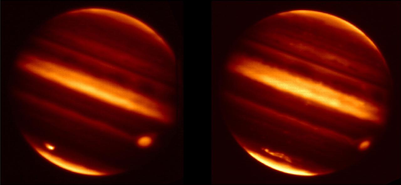
These infrared images obtained from NASA Infrared Telescope Facility in Mauna Kea, Hawaii, show before and aftereffects from particle debris in Jupiter atmosphere after an object hurtled into the atmosphere on July 19, 2009.
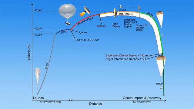
The saucer-shaped test vehicle for NASA Low-Density Supersonic Decelerator LDSD will undergo a series of events in the skies above Hawaii, with the ultimate goal of testing future landing technologies for Mars missions.
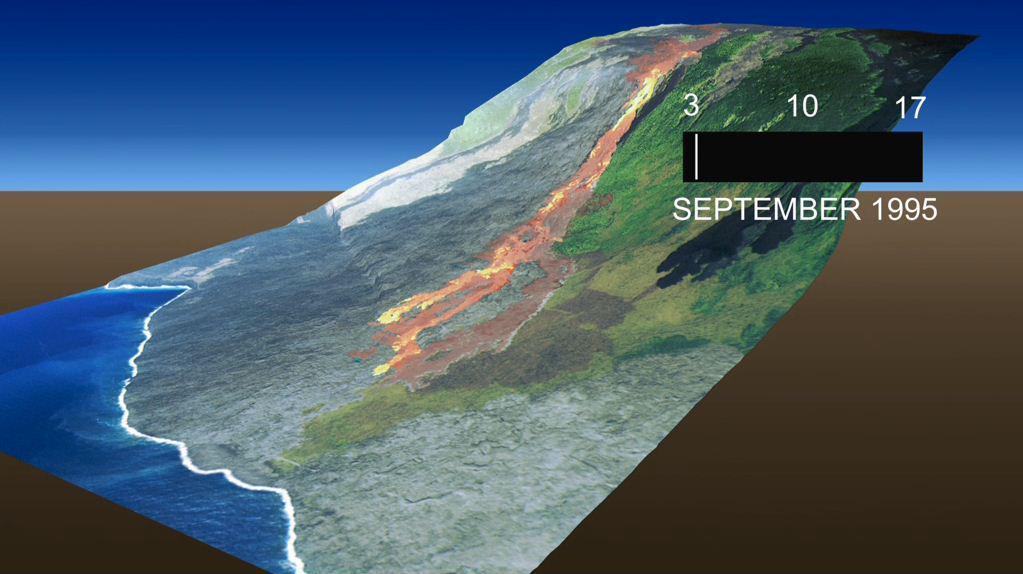
This frame from an animation, which depicts the growth of the Kamoamoa Flow Field, Kilauea Volcano, Hawaii, was generated from a sequence of ten multispectral images acquired between September 3 and 17, 1995.
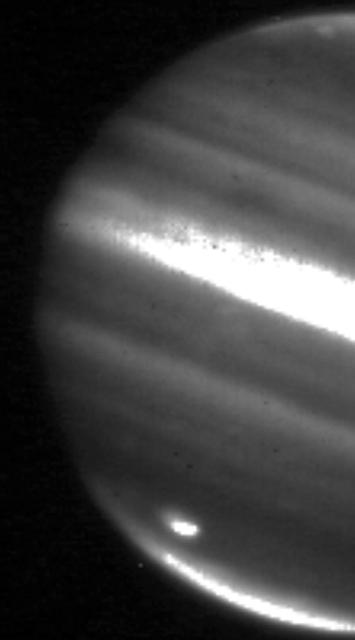
This image shows a large impact shown on the bottom left on Jupiter south polar region captured on July 20, 2009, by NASA Infrared Telescope Facility in Mauna Kea, Hawaii.
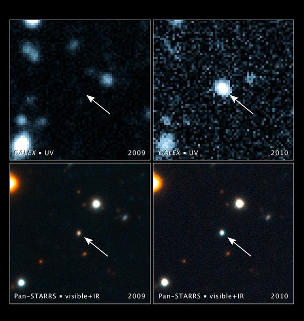
These images, taken with NASA Galaxy Evolution Explorer and the Pan-STARRS1 telescope in Hawaii, show a brightening inside a galaxy caused by a flare from its nucleus. The arrow in each image points to the galaxy.
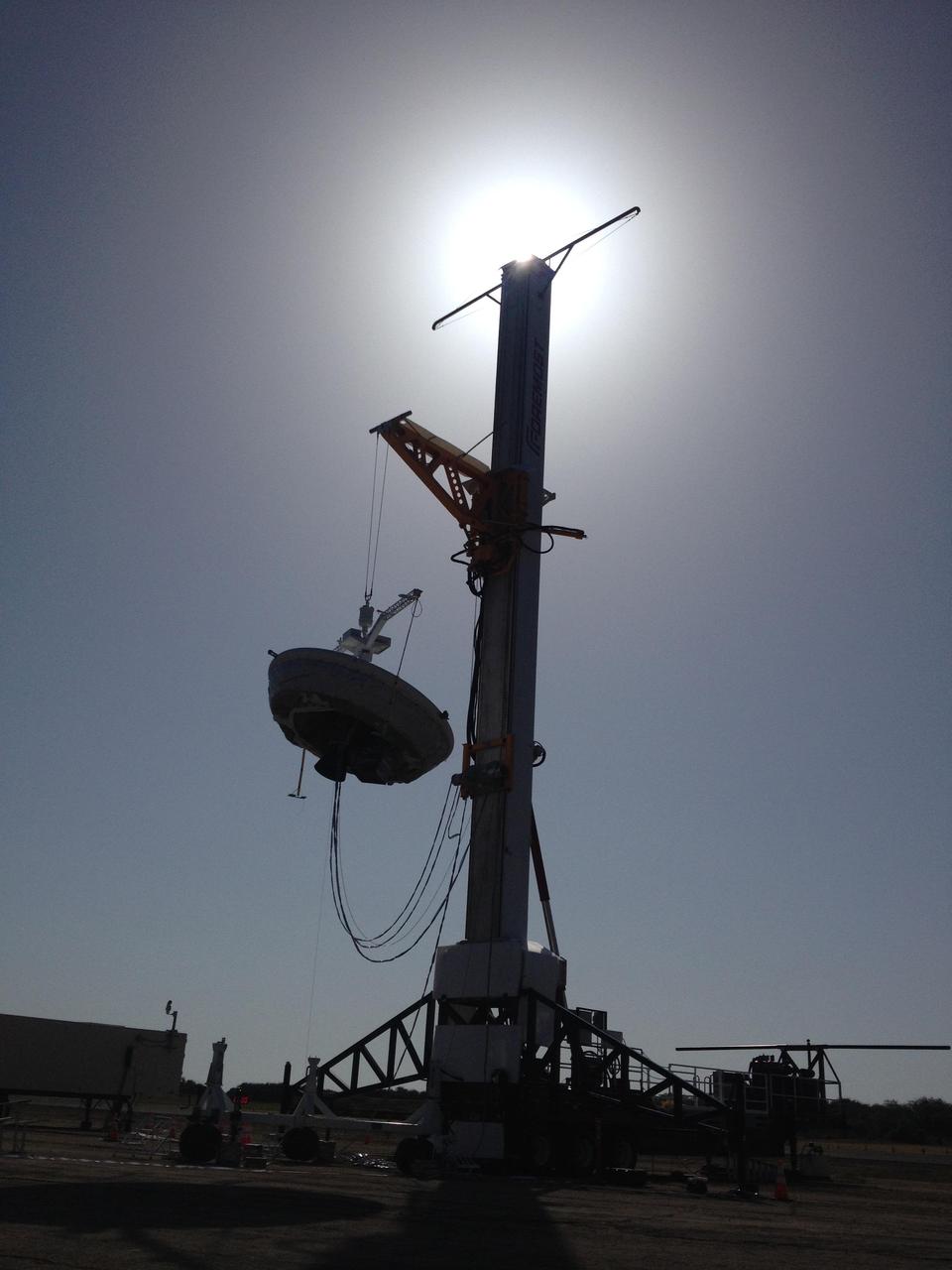
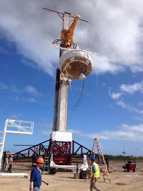
A saucer-shaped vehicle part of NASA Low-Density Supersonic Decelerator LDSD project designed to test interplanetary landing devices hangs on a tower in preparation for launch at the Pacific Missile Range Facility in Kauai, Hawaii.
The Apollo 11 mission, the first manned lunar mission, launched from the Kennedy Space Center, Florida via the Marshall Space Flight Center (MSFC) developed Saturn V launch vehicle on July 16, 1969 and safely returned to Earth on July 24, 1969. Aboard the space craft were astronauts Neil A. Armstrong, commander; Michael Collins, Command Module (CM) pilot; and Edwin E. Aldrin Jr., Lunar Module (LM) pilot. The CM, piloted by Michael Collins remained in a parking orbit around the Moon while the LM, named “Eagle’’, carrying astronauts Neil Armstrong and Edwin Aldrin, landed on the Moon. During 2½ hours of surface exploration, the crew collected 47 pounds of lunar surface material for analysis back on Earth. The recovery operation took place in the Pacific Ocean where Navy para-rescue men recovered the capsule housing the 3-man Apollo 11 crew. The crew was airlifted to safety aboard the U.S.S. Hornet recovery ship, where they were quartered in a Mobile Quarantine Facility (MQF) which served as their home for 21 days. In this photo taken at Pearl Harbor, Hawaii, the quarantined housing facility is being lowered from the U.S.S. Hornet, onto a trailer for transport to Hickam Field. From there, it was loaded aboard an Air Force C-141 jet and flown back to Ellington Air Force Base Texas, and then on to the NASA Manned Spacecraft Center (MSC) Lunar Receiving Laboratory in Houston, Texas.
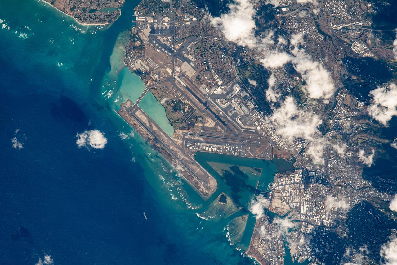
iss069e055069 (August 8, 2023) -- The Daniel K. Inouye International Airport (Honolulu International Airport) pictured as the International Space Station orbited roughly 260 miles above the coasts of Hawaii. The airport is the largest in Hawaii, located on the island of O'ahu.
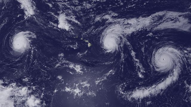
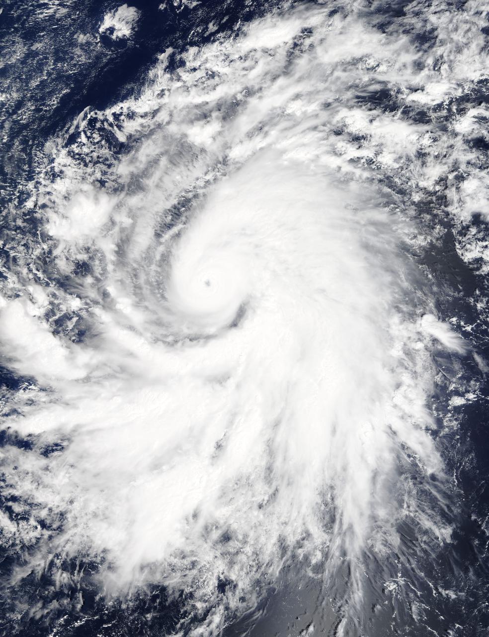
GMT237_21_45_Matthew Dominick_Tropical Storm Hone near Hawaii and Moonsetting 400mm with Suni
The enhanced capabilities of the Suomi NPP satellite's day-night band are really becoming clear, as was seen this week when Tropical Storm Flossie was heading toward Hawaii. On Monday, July 29th, the lack of organization of the system made it difficult to understand the storm’s central circulation. Infrared data, though able to provide cloud imagery during the night, is best at measuring cloud-top properties. Flossie, however, had a lower-level circulation that was evident in visible imagery earlier in the day. At nighttime that information was lost using traditional satellite technology, such as GOES West. The day-night-band on Suomi NPP provides visible-like information during nighttime hours when only moonlight is available. When Suomi NPP passed over the storm around 1:00am (local), the day-night band imagery allowed forecasters to identify a center of circulation that was more north than previously estimated. Two passes from Suomi NPP (at 11 and 12z, respectively) are shown here. The spiral of the lower level clouds and center of circulation can be seen northwest of Hawaii, whereas the more detailed and higher cloud top areas are due east of the Big Island. Also visible are the nighttime lights of Honolulu on Oahu, along with other cities throughout the island chain. Credit NASA/NOAA An unlabeled version may be downloaded here: <a href="http://1.usa.gov/1bOjhN6" rel="nofollow">1.usa.gov/1bOjhN6</a> <b><a href="http://www.nasa.gov/audience/formedia/features/MP_Photo_Guidelines.html" rel="nofollow">NASA image use policy.</a></b> <b><a href="http://www.nasa.gov/centers/goddard/home/index.html" rel="nofollow">NASA Goddard Space Flight Center</a></b> enables NASA’s mission through four scientific endeavors: Earth Science, Heliophysics, Solar System Exploration, and Astrophysics. Goddard plays a leading role in NASA’s accomplishments by contributing compelling scientific knowledge to advance the Agency’s mission. <b>Follow us on <a href="http://twitter.com/NASA_GoddardPix" rel="nofollow">Twitter</a></b> <b>Like us on <a href="http://www.facebook.com/pages/Greenbelt-MD/NASA-Goddard/395013845897?ref=tsd" rel="nofollow">Facebook</a></b> <b>Find us on <a href="http://instagram.com/nasagoddard?vm=grid" rel="nofollow">Instagram</a></b>
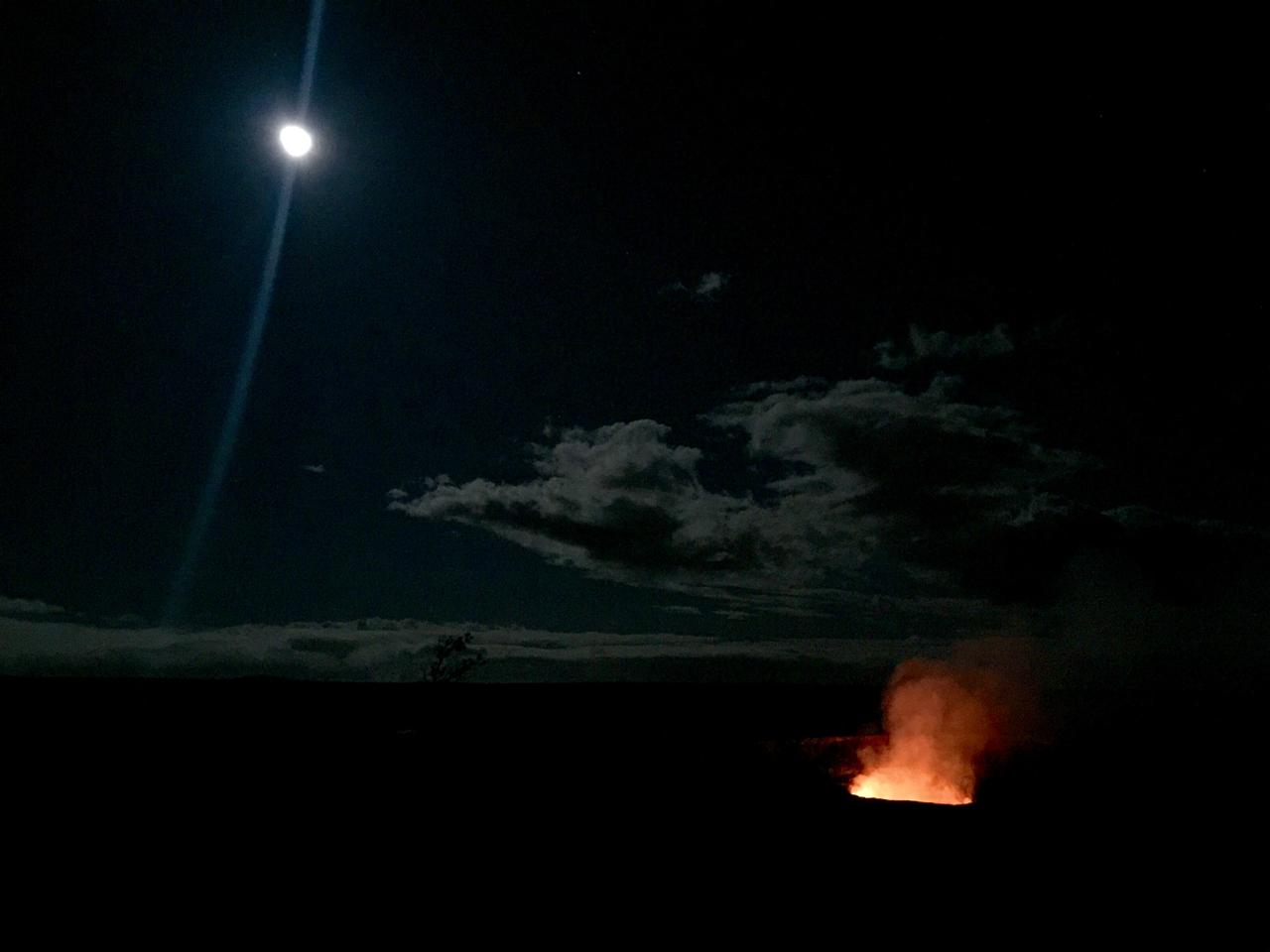
Full moon over lava lake The inspiring views at remote locations, such as Halema’uma’u Crater in Hawaii Volcanoes National Park, are an extra reward for making the trip. Credit: NASA/GSFC/Kelsey Young In June, five student journalists from Stony Brook University packed their hiking boots and hydration packs and joined a NASA-funded science team for 10 days on the lava fields of Kilauea, an active Hawaiian volcano. Kilauea’s lava fields are an ideal place to test equipment designed for use on Earth’s moon or Mars, because volcanic activity shaped so much of those terrains. The trip was part of an interdisciplinary program called RIS4E – short for Remote, In Situ, and Synchrotron Studies for Science and Exploration – which is designed to prepare for future exploration of the moon, near-Earth asteroids and the moons of Mars. To read reports from the RIS4E journalism students about their experiences in Hawaii, visit <a href="http://ReportingRIS4E.com" rel="nofollow">ReportingRIS4E.com</a> <b><a href="http://www.nasa.gov/audience/formedia/features/MP_Photo_Guidelines.html" rel="nofollow">NASA image use policy.</a></b> <b><a href="http://www.nasa.gov/centers/goddard/home/index.html" rel="nofollow">NASA Goddard Space Flight Center</a></b> enables NASA’s mission through four scientific endeavors: Earth Science, Heliophysics, Solar System Exploration, and Astrophysics. Goddard plays a leading role in NASA’s accomplishments by contributing compelling scientific knowledge to advance the Agency’s mission. <b>Follow us on <a href="http://twitter.com/NASAGoddardPix" rel="nofollow">Twitter</a></b> <b>Like us on <a href="http://www.facebook.com/pages/Greenbelt-MD/NASA-Goddard/395013845897?ref=tsd" rel="nofollow">Facebook</a></b> <b>Find us on <a href="http://instagrid.me/nasagoddard/?vm=grid" rel="nofollow">Instagram</a></b>
The Apollo 11 mission, the first manned lunar mission, launched from the Kennedy Space Center, Florida via the Marshall Space Flight Center (MSFC) developed Saturn V launch vehicle on July 16, 1969 and safely returned to Earth on July 24, 1969. Aboard the space craft were astronauts Neil A. Armstrong, commander; Michael Collins, Command Module (CM) pilot; and Edwin E. Aldrin Jr., Lunar Module (LM) pilot. The CM, piloted by Michael Collins remained in a parking orbit around the Moon while the LM, named “Eagle’’, carrying astronauts Neil Armstrong and Edwin Aldrin, landed on the Moon. During 2½ hours of surface exploration, the crew collected 47 pounds of lunar surface material for analysis back on Earth. The recovery operation took place in the Pacific Ocean where Navy para-rescue men recovered the capsule housing the 3-man Apollo 11 crew. The crew was airlifted to safety aboard the U.S.S. Hornet, where they were quartered in a Mobile Quarantine Facility (MQF) which served as their home until they reached the NASA Manned Spacecraft Center (MSC) Lunar Receiving Laboratory in Houston, Texas. In this photo taken at Pearl Harbor, Hawaii, the inhabited MQF is prepared for loading into an Air Force C-141 jet transport for the flight back to Ellington Air Force Base Texas and then on to the MSC.
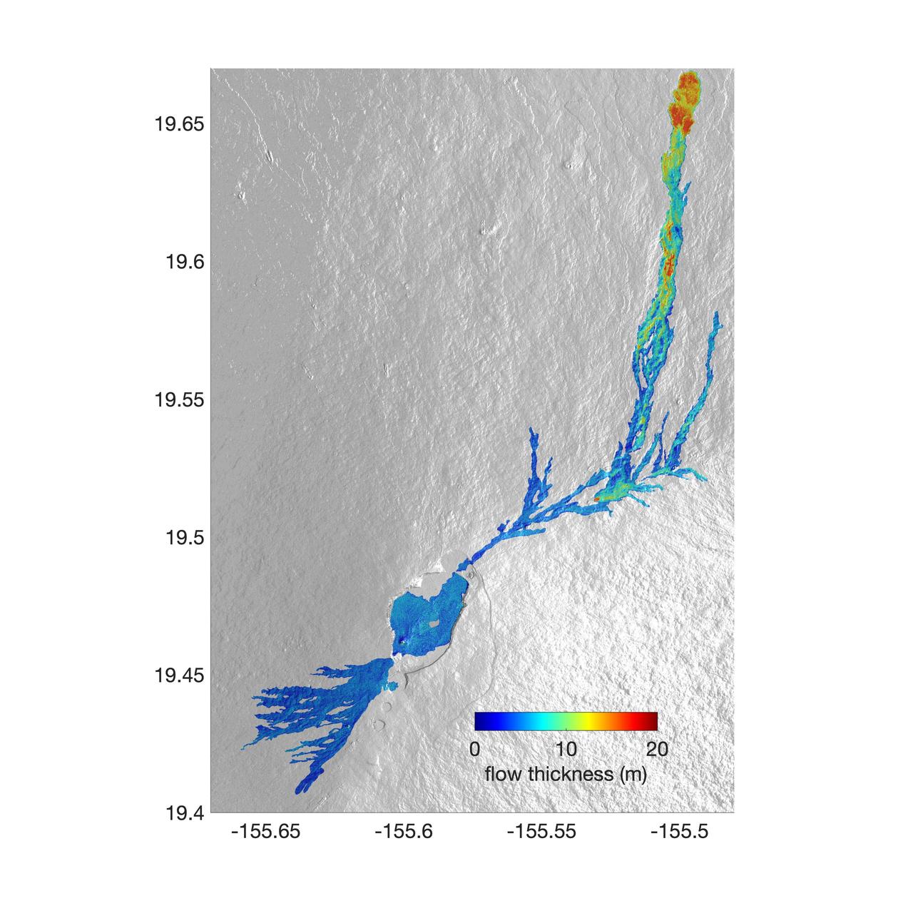
The world's largest active volcano – Hawaii's Mauna Loa – had been quiet for 38 years. But in 2022, the volcano began to stir, showing increased numbers of small earthquakes and subtle swelling of certain land surfaces in September. On November 27, fountains of lava began spurting from the mountain's Northeast Rift Zone and streams of molten rock flowed to the north. Ten days into the eruption, a NASA aircraft conducted its first flight over the erupting volcano. It carried NASA's Uninhabited Aerial Vehicle Synthetic Aperture Radar (UAVSAR) system, which was used to map the volcano's topography in fine detail with a Ka-band instrument called GLISTIN-A. Teams from NASA's Jet Propulsion Laboratory and the United States Geological Survey (USGS) used data from that sensor to map the thickness of those flows during a series of flights on December 7, 8, and 10. The map above shows the thickness of the lava flows during the flight on December 7, the day before USGS scientists noticed a significant decline in the pace of the eruption. A few days later, they declared the eruption had stopped. The map shows the thickness of the lava flows in the summit caldera, where the eruption began, and of lava flows on Mauna Loa's northeastern flank. The color variation from blue to orange indicates increasing lava flow thickness. A maximum thickness of roughly 25 meters (82 feet) is shown, though values exceeding 40 meters (131 feet) were observed in some areas. The thickening at the northern end of the flow is due to lava accumulating away from the vent, along with a flattening of the terrain at the saddle between the Mauna Loa and Mauna Kea volcanoes. By comparing to pre-eruption maps of this area's topography, including GLISTIN-A data collected in 2017, the USGS researchers were able to calculate the size and volume of the lava flow. Over the roughly 14-day eruption, Mauna Loa erupted more than 8.8 billion cubic feet (230 million cubic meters) along a lava flow that extended up to 16.5 miles (19.5 kilometers) from the vent, according to the USGS. The UAVSAR operates from a pod mounted beneath a crewed Gulfstream III jet from NASA's Armstrong Flight Research Center in California. Repeated topographic maps generated with each flight reveal the progression and thickening of lava with time – important information for scientific understanding of volcano processes and for emergency response. For the Mauna Loa science flights, the instrument suite featured an additional state-of-the-art imaging tool: the synthetic aperture radar-fusion optical short-wave infrared (SAR-Fusion Optical/SWIR) camera system. SAR-Fusion collects data over the same ground swath as GLISTIN-A to map land surface changes using optical/SWIR photogrammetry methods. GLISTIN-A was designed to provide all-weather, high-resolution surface topography not available through existing lidar or radar sensors. GLISTIN-A was originally demonstrated as a new radar technique for mapping ice surfaces. Science demonstration flights began in 2013 over alpine glaciers and sea ice in Alaska, and a floodplain in California. Its applications have since expanded to other areas, such as snow accumulation and volcano dynamics. The first time the instrument was deployed for volcano response was in 2018 during the three-month eruption of Kilauea. The success of that operation paved the way for deployment to Mauna Loa. https://photojournal.jpl.nasa.gov/catalog/PIA25526
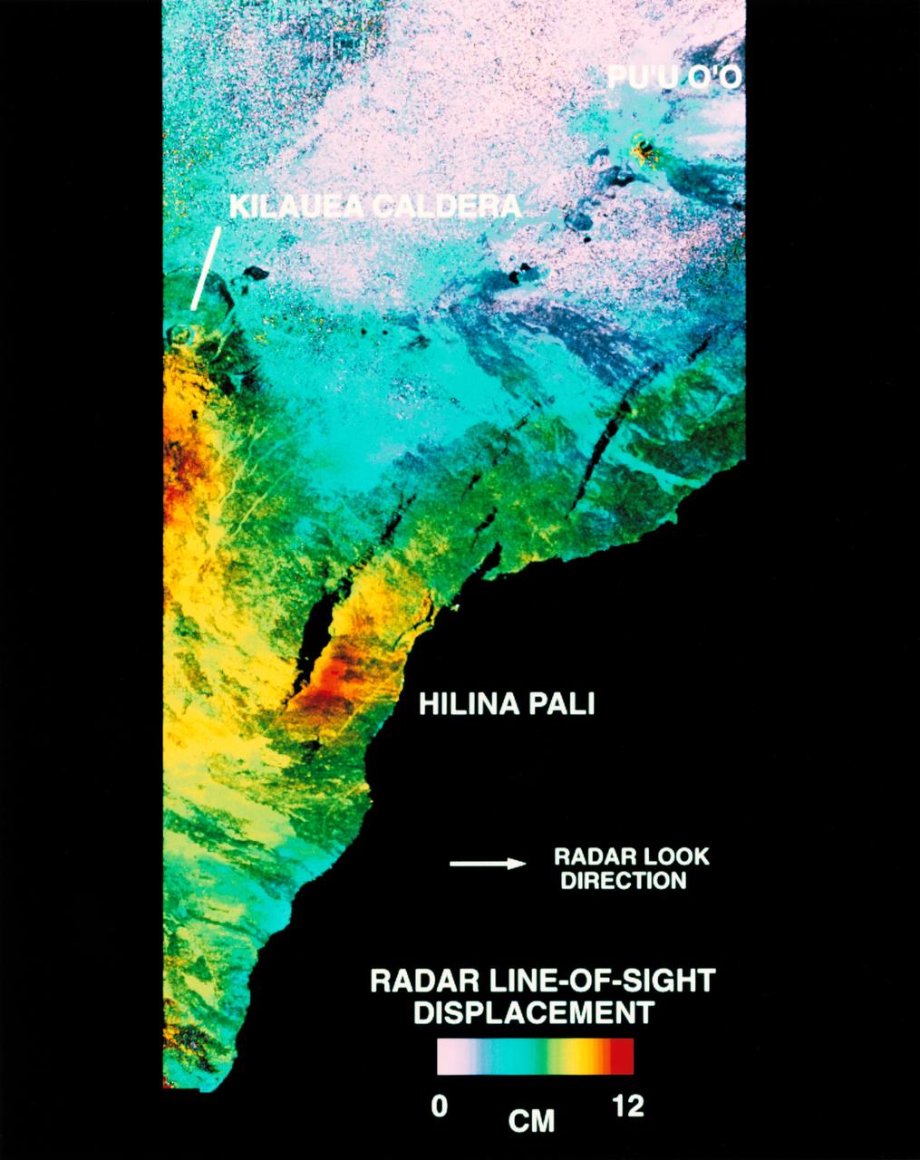
STS068-S-054 (10 October 1994) --- This is a deformation map of the south flank of Kilauea volcano on the big island of Hawaii, centered at 19.5 degrees north latitude and 155.25 degrees west longitude. The map was created by combining interferometric radar data - that is data acquired on different passes of the Space Shuttle Endeavour which are then overlaid to obtain elevation information - acquired by the Spaceborne Imaging Radar-C/X-Band Synthetic Aperture Radar (SIR-C/X-SAR) during its first flight in April 1994 and its second flight in October 1994. The area shown is approximately 40 by 80 kilometers (25 by 50 miles). North is toward the upper left of the image. The colors indicate the displacement of the surface in that direction that the radar instrument was pointed (toward the right of the image) in the six months between images. The analysis of ground movement is preliminary, but appears consistent with the motions detected by the Global Positioning System ground receivers that have been used over the past five years. The south flank of the Kilauea volcano is among the most rapidly deforming terrain's on Earth. Several regions show motion over the six-month time period. Most obvious is at the base of Hilina Pali, where 10 centimeters (4 inches) or more of crustal deformation can be seen in a concentrated area near the coastline. On a more localized scale, the currently active Pu'u O'o summit also shows about 10 centimeters (4 inches) of change near the vent area. Finally, there are indications of additional movement along the upper southwest rift zone, just below the Kilauea caldera in the image. Deformation of the south flank is believed to be the result of movements along faults deep beneath the surface of the volcano, as well as injections of magma, or molten rock, into the volcano's "plumbing" system. Detection of ground motions from space has proven to be a unique capability of imaging radar technology. Scientists hope to use deformation data acquired by SIR-C/X-SAR and future imaging radar missions to help in better understanding the processes responsible for volcanic eruptions and earthquakes. Spaceborne Imaging Radar-C/X-Band Synthetic Aperture Radar (SIR-C/X-SAR) is part of NASA's Mission to Planet Earth. (P-44753)
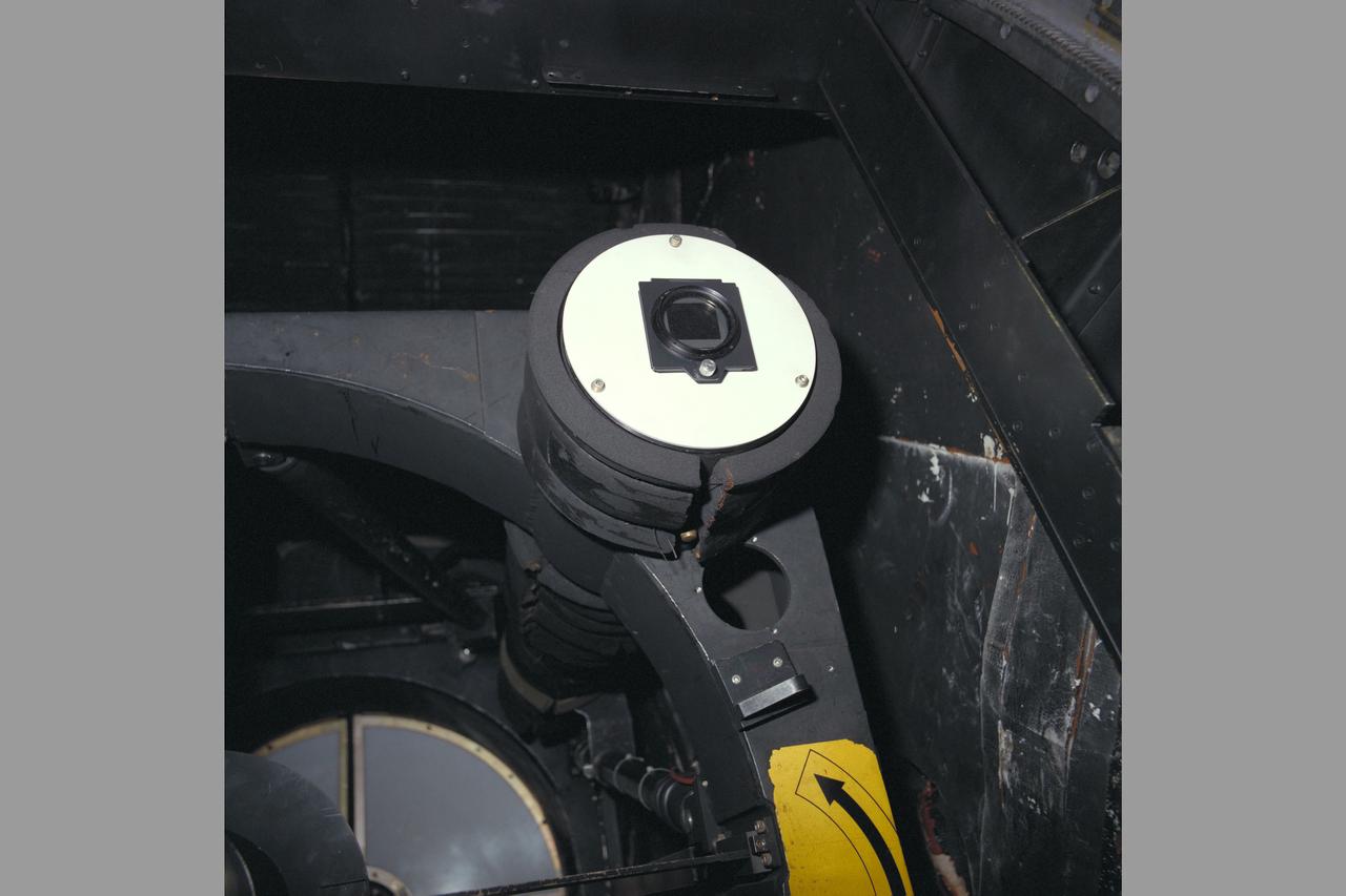
C-141 KAO NASA-714 University of Hawaii Seven-Chan photometer mounted on telescope of the airborne observatory
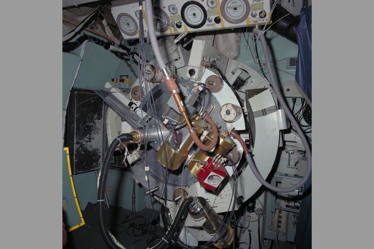
C-141 KAO NASA-714 University of Hawaii Seven-Chan photometer mounted on the rear of the telescope in the airborne observatory