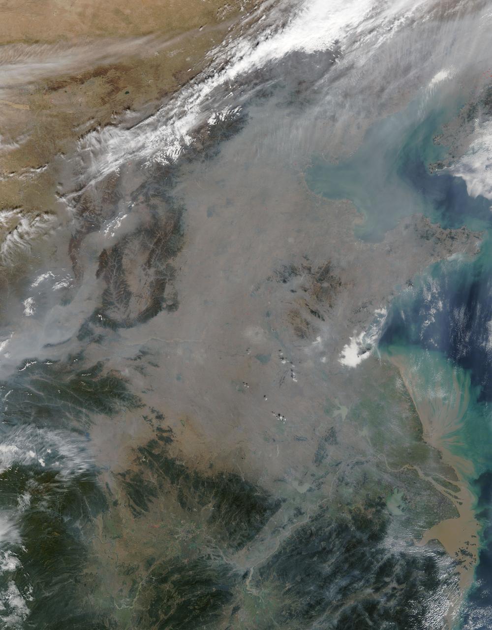
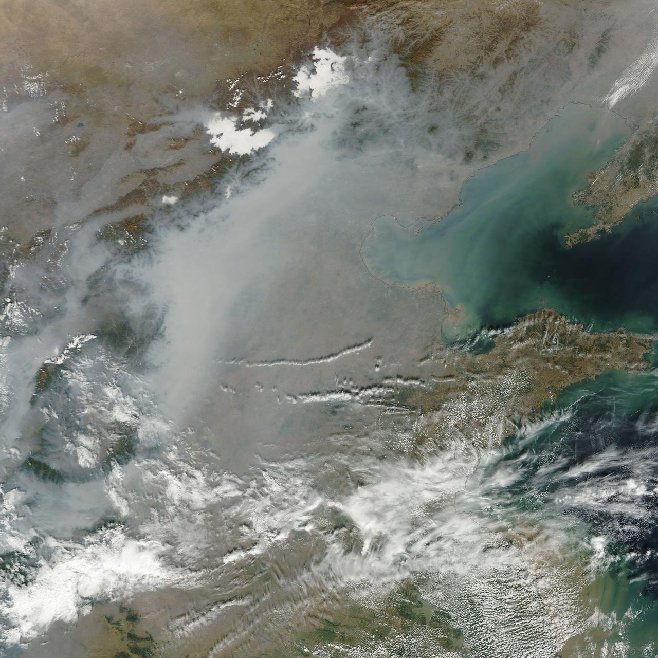
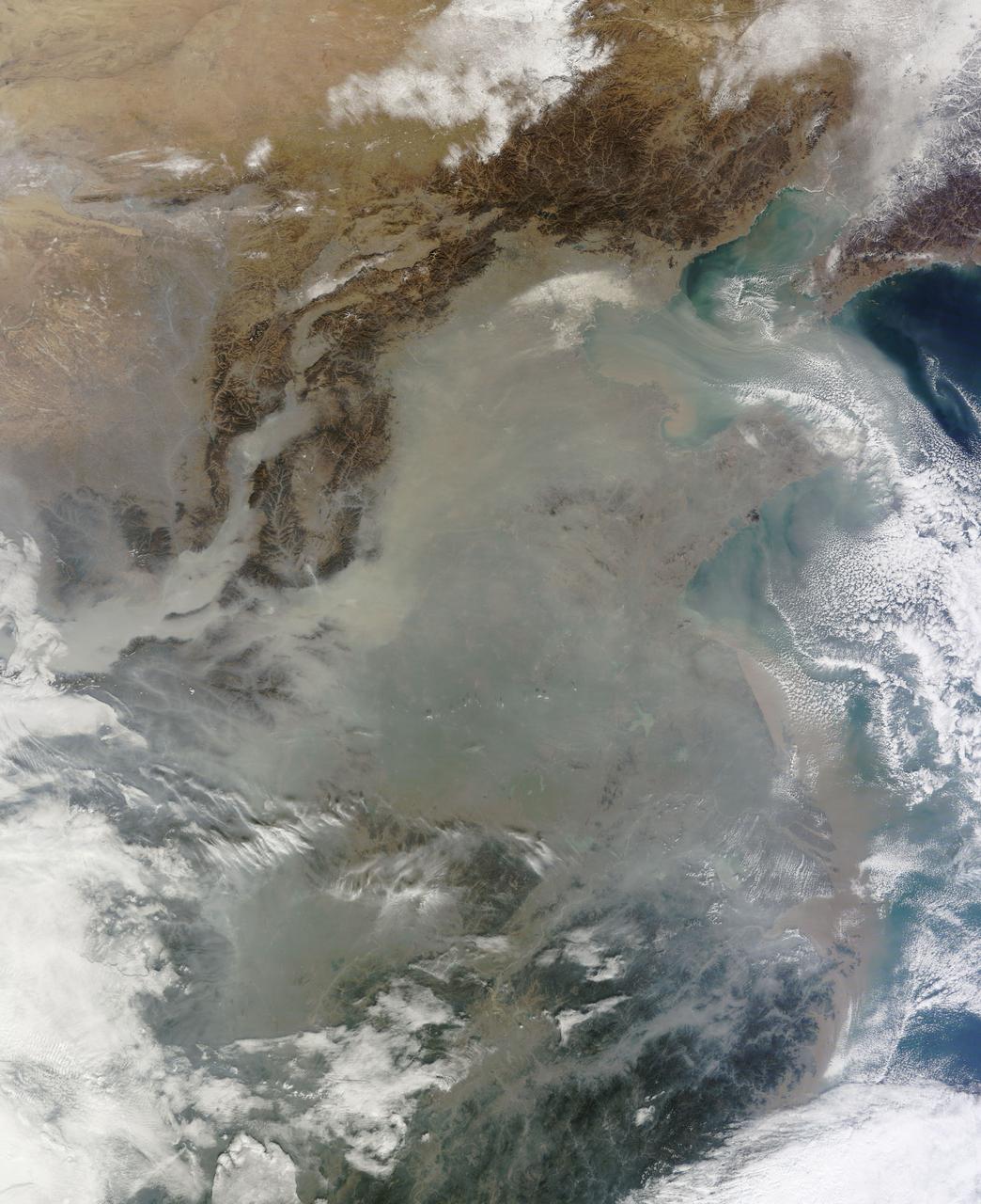
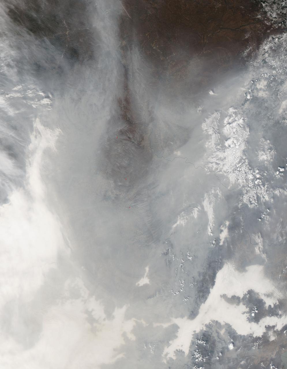
On October 17, 2015, the Moderate Resolution Imaging Spectroradiometer (MODIS) aboard NASA’s Terra satellite captured this true-color image of a thick haze hanging over eastern China. In the north, the large city of Beijing is completely obscured from view, as is much of the landscape. The haze thins slightly over the Bohai Sea. Further south, sediment pours into the East China Sea near the city of Shanghai. Heavy haze is common in this region, and tends to worsen in October through January, when cold, heavy air traps pollutants near the surface of the Earth. It is likely that this scene was caused by such a temperature inversion. Normally, air is warmest near the surface of the Earth. But sometimes a mass of warm air will move the cooler air, so the atmosphere actually warms with the altitude. Cool air does not have energy to rise through the warm air, vertical circulation slows and air becomes trapped near the surface. Any pollution that is emitted into the cooler air will also get trapped, increasing low-level air pollution and haze. Credit: NASA/GSFC/Jeff Schmaltz/MODIS Land Rapid Response Team
Titan Hazes
Beneath the Haze
Amazing Hazes
Purple Haze
Through the Haze
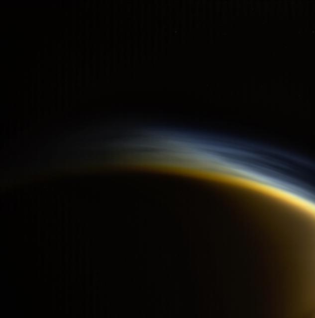
Detached Haze
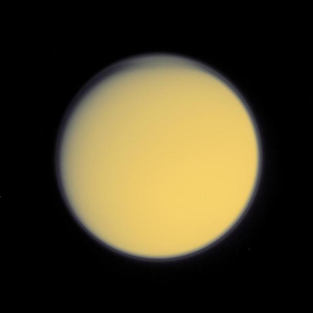
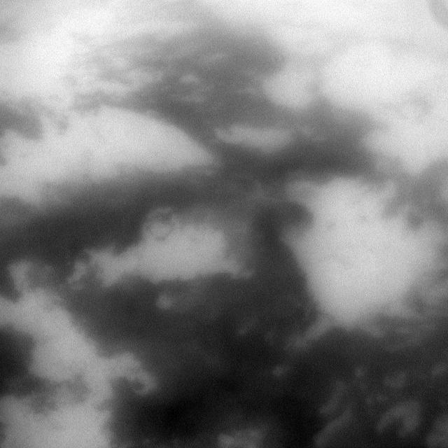
Titan Haze
A thick layer of haze blanketed the North China Plain on October 9, 2014, when the Moderate Resolution Imaging Spectroradiometer (MODIS) on NASA’s Terra satellite acquired this natural-color image at 2:50 Coordinated Universal Time (10:50 a.m. local time). The haze obscured many features usually visible in MODIS imagery of the area, including China’s largest city, Beijing. On the day this image was acquired, measurements from ground-based sensors at the U.S. Consulate in Beijing reported PM2.5 measurements of 334 micrograms per cubic meter of air. Fine, airborne particulate matter (PM) that is smaller than 2.5 microns (about one thirtieth the width of a human hair) is considered dangerous because it is small enough to enter the passages of the human lungs. Most PM2.5 aerosol particles come from the burning of fossil fuels and biomass (wood fires and agricultural burning). The World Health Organization considers PM2.5 to be safe when it is below 25. Haze in this region tends to worsen in the fall and winter, when cold, heavy air traps pollutants near the surface. In this case, the haze was likely trapped by a temperature inversion. Normally, air is warmest near the surface of the Earth. Occasionally, a mass of warm air will move over cooler air so that the atmosphere actually warms with altitude. Since the cool air does not have the energy to rise through the warm air, vertical circulation slows and air becomes trapped near the surface. Any pollutant that enters the air gets trapped as well, and haze builds up over time. Daily satellite images of the North China Plain show that visible haze began to accumulate on October 7, 2014. NASA image courtesy Jeff Schmaltz, LANCE MODIS Rapid Response. Caption by Adam Voiland. Read more: <a href="http://earthobservatory.nasa.gov/NaturalHazards/view.php?id=84530&eocn=home&eoci=nh" rel="nofollow">earthobservatory.nasa.gov/NaturalHazards/view.php?id=8453...</a> Credit: <b><a href="http://www.earthobservatory.nasa.gov/" rel="nofollow"> NASA Earth Observatory</a></b> <b><a href="http://www.nasa.gov/audience/formedia/features/MP_Photo_Guidelines.html" rel="nofollow">NASA image use policy.</a></b> <b><a href="http://www.nasa.gov/centers/goddard/home/index.html" rel="nofollow">NASA Goddard Space Flight Center</a></b> enables NASA’s mission through four scientific endeavors: Earth Science, Heliophysics, Solar System Exploration, and Astrophysics. Goddard plays a leading role in NASA’s accomplishments by contributing compelling scientific knowledge to advance the Agency’s mission. <b>Follow us on <a href="http://twitter.com/NASAGoddardPix" rel="nofollow">Twitter</a></b> <b>Like us on <a href="http://www.facebook.com/pages/Greenbelt-MD/NASA-Goddard/395013845897?ref=tsd" rel="nofollow">Facebook</a></b> <b>Find us on <a href="http://instagram.com/nasagoddard?vm=grid" rel="nofollow">Instagram</a></b>
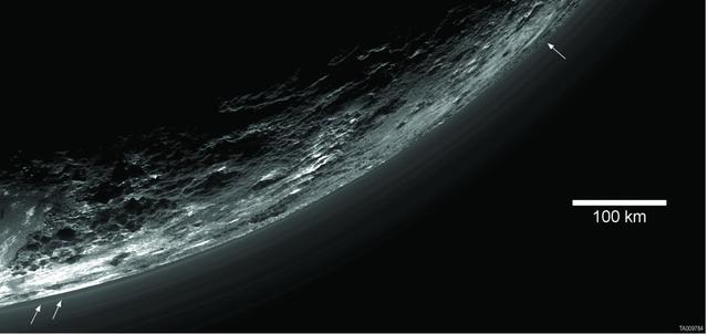
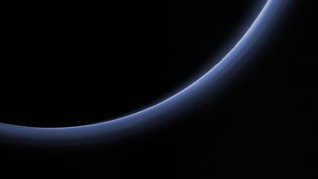
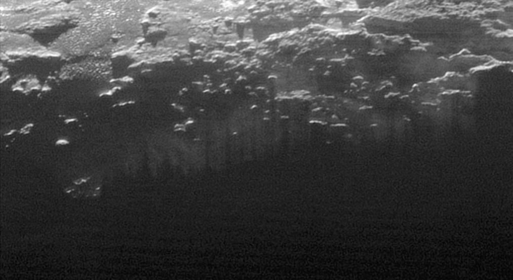
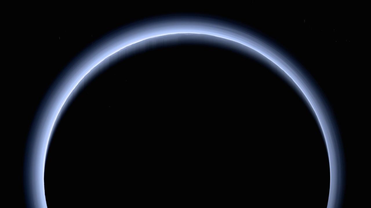
This image of haze layers above Pluto limb was taken by NASA New Horizons spacecraft. About 20 haze layers are seen.
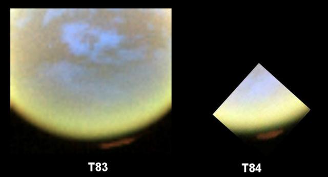
Two Views of Titan Haze
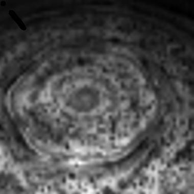
Titan North Polar Haze
High Haze in Color
Titan Shifting Hazes
World Beneath the Haze

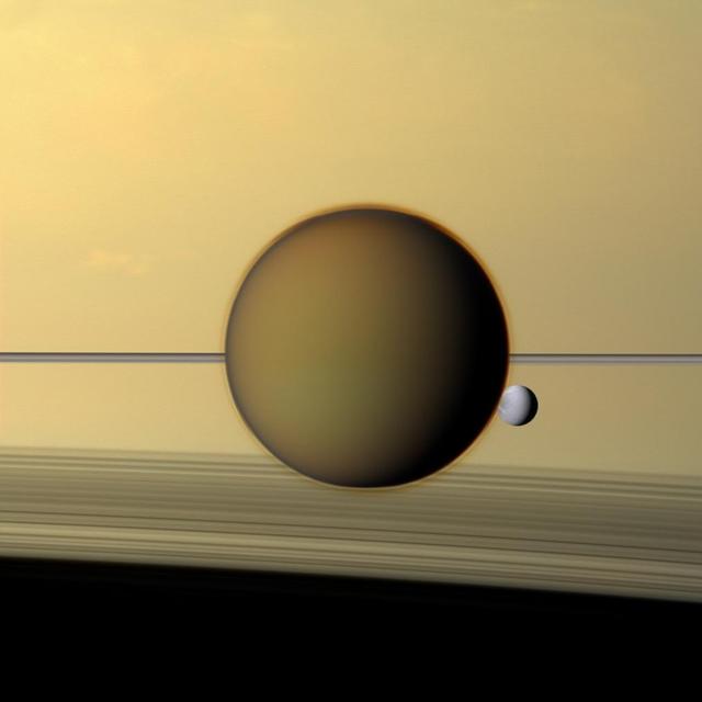
Mimas Above the Haze
Titan High Hazes
Titan Thick Haze Layer
Titan Ultraviolet Haze
Haze Silhouettes Against Titan Glow
High Haze in Color Close-up

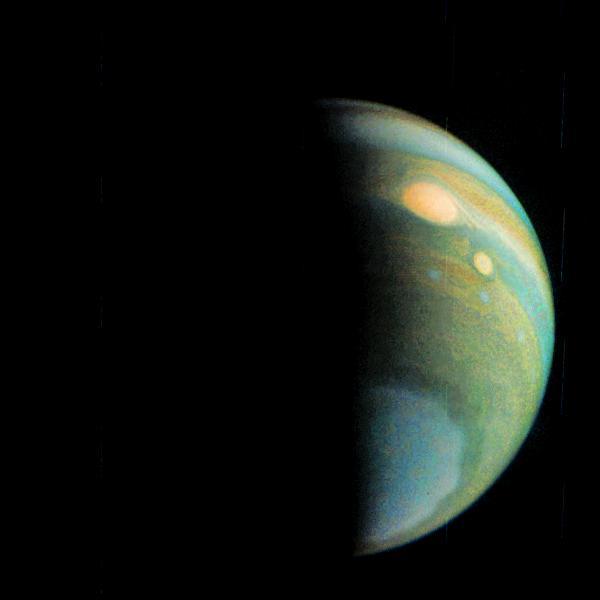
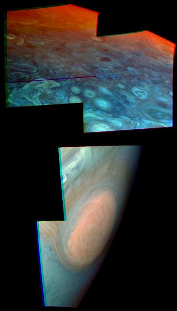
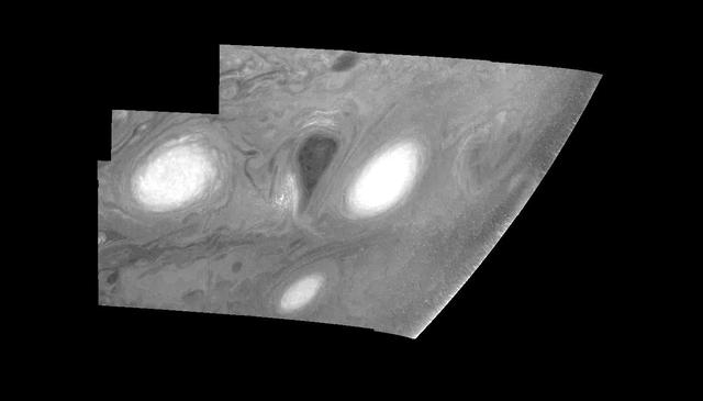
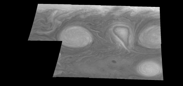
Clouds and Hazes of Jupiter Southern Hemisphere
The skies over northern China were shrouded with a thick haze in late December, 2013. The Moderate Resolution Imaging Spectroradiometer (MODIS) aboard the Terra satellite captured this true-color image on December 23. The dense, gray haze obscures almost all the land and much of the coastal waters from view south and east of the Taihang Mountains. Clearer air covers the region north of the mountains, although fingers of haze roll through most river valleys. The cities of Beijing and Hebei, both west of the Bohai Sea are complete enshrouded. By December 24 the smog levels in some area exceeded World Health Organization-recommended levels by 30 times, according to Bloomberg News. The concentration of PM2.5, which are fine air particulates, were reported at 421 micrograms per cubic meter at 2 p.m. near Tiananmen Square in Beijing, while levels were 795 in Xi’an and 740 in Zhengzhou. The World Health Organization (WHO) recommends 24-hour exposure to PM2.5 concentrations no higher than 25 micrograms per cubic meter. While not the sole cause of haze and pollution, the use of coal as a very cheap energy source adds to the problem, particularly north of the Huai River. Prior to 1980, the government policy provided free coal for fuel boilers for all people living north of the Huai River. The widespread use of coal allows people in the north to stay warm in winter, but they have paid a price in air quality. According to Michael Greenstone, a Professor of Environmental Economics at Massachusetts Institute of Technology (MIT), whose research team published a paper on sustained exposure to air pollution on life expectancy in the region, air pollution, as measured by total suspended particulates, was about 55% higher north of the Huai River than south of it, for a difference of around 184 micrograms of particulate matter per cubic meter. The research, published in Proceedings of the National Academy of Sciences in July, 2013, also noted life expectancies were about 5.5 years lower in the north, owing to an increased incidence of cardiorespiratory mortality. Air pollution is an on-going issue for the government of China, and Beijing’s Five-Year Clean Air Action Plan aims to reduce overall particle density by over 25 percent on the PM2.5 scale by 2017, and also takes aim at shutting down all coal-burning plants. Credit: NASA/GSFC/Jeff Schmaltz/MODIS Land Rapid Response Team <b><a href="http://www.nasa.gov/audience/formedia/features/MP_Photo_Guidelines.html" rel="nofollow">NASA image use policy.</a></b> <b><a href="http://www.nasa.gov/centers/goddard/home/index.html" rel="nofollow">NASA Goddard Space Flight Center</a></b> enables NASA’s mission through four scientific endeavors: Earth Science, Heliophysics, Solar System Exploration, and Astrophysics. Goddard plays a leading role in NASA’s accomplishments by contributing compelling scientific knowledge to advance the Agency’s mission. <b>Follow us on <a href="http://twitter.com/NASA_GoddardPix" rel="nofollow">Twitter</a></b> <b>Like us on <a href="http://www.facebook.com/pages/Greenbelt-MD/NASA-Goddard/395013845897?ref=tsd" rel="nofollow">Facebook</a></b> <b>Find us on <a href="http://instagram.com/nasagoddard?vm=grid" rel="nofollow">Instagram</a></b>
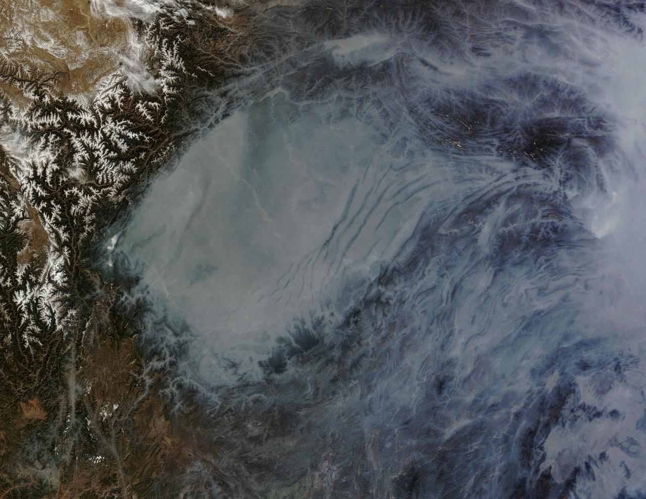
The Moderate Resolution Imaging Spectroradiometer (MODIS) on NASA’s Terra satellite acquired this natural-color image of central China on January 23, 2013 at 04:05 UTC. The image shows extensive haze over the region. In areas where the ground is visible, some of the landscape is covered with lingering snow. Credit: NASA/GSFC/Jeff Schmaltz/MODIS Land Rapid Response Team <b><a href="http://www.nasa.gov/audience/formedia/features/MP_Photo_Guidelines.html" rel="nofollow">NASA image use policy.</a></b> <b><a href="http://www.nasa.gov/centers/goddard/home/index.html" rel="nofollow">NASA Goddard Space Flight Center</a></b> enables NASA’s mission through four scientific endeavors: Earth Science, Heliophysics, Solar System Exploration, and Astrophysics. Goddard plays a leading role in NASA’s accomplishments by contributing compelling scientific knowledge to advance the Agency’s mission. <b>Follow us on <a href="http://twitter.com/NASAGoddardPix" rel="nofollow">Twitter</a></b> <b>Like us on <a href="http://www.facebook.com/pages/Greenbelt-MD/NASA-Goddard/395013845897?ref=tsd" rel="nofollow">Facebook</a></b> <b>Find us on <a href="http://instagram.com/nasagoddard?vm=grid" rel="nofollow">Instagram</a></b>
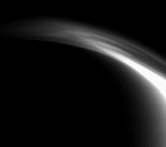
The complex and dynamic atmosphere of Titan displays multiple haze layers near the north pole in this view, which also provides an excellent look at the detached stratospheric haze layer that surrounds the moon at lower latitudes
A 3-D View of Saturn Clouds and Hazes
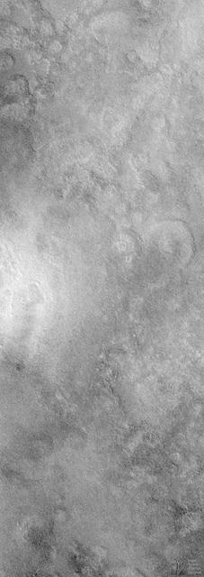
Seeing Mars Northern Plains Through Springtime Haze
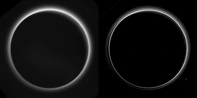
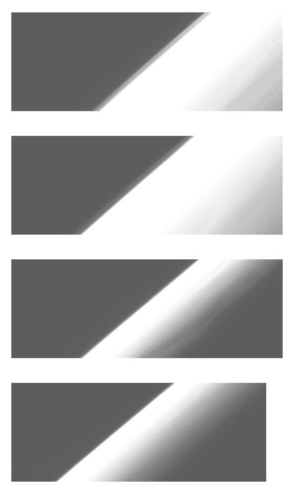
Two different versions of an image of Pluto's haze layers, taken by New Horizons as it looked back at Pluto's dark side nearly 16 hours after close approach, from a distance of 480,000 miles (770,000 kilometers), at a phase angle of 166 degrees. Pluto's north is at the top, and the sun illuminates Pluto from the upper right. These images are much higher quality than the digitally compressed images of Pluto's haze downlinked and released shortly after the July 14 encounter, and allow many new details to be seen. The left version has had only minor processing, while the right version has been specially processed to reveal a large number of discrete haze layers in the atmosphere. In the left version, faint surface details on the narrow sunlit crescent are seen through the haze in the upper right of Pluto's disk, and subtle parallel streaks in the haze may be crepuscular rays- shadows cast on the haze by topography such as mountain ranges on Pluto, similar to the rays sometimes seen in the sky after the sun sets behind mountains on Earth. http://photojournal.jpl.nasa.gov/catalog/PIA19880
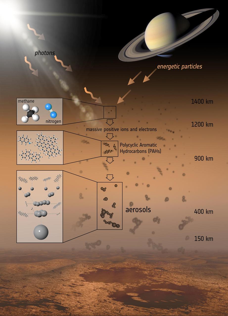
This illustration shows the various steps that lead to the formation of the aerosols that make up the haze on Titan, Saturn largest moon.
Chinese authorities shut down much of Harbin – a city of more than 10 million people – as unusually high levels of pollution shrouded the city and the surrounding region in mid-October, 2013. Measurements taken on October 20, 2013 scored the air quality index in the city at 500, the highest possible reading. Levels above 300 are considered hazardous to human health. The Moderate Resolution Imaging Spectroradiometer (MODIS) on NASA’s Aqua satellite acquired this true-color image of northeastern China on October 21. The brightest areas are fog, which is tinged with gray or yellow due to the air pollution. Other cloud-free areas have a pall of gray and brown smog that blots out the city and surrounding towns. Harbin lies under the Y-shaped patch of fog and smog in the south-central section of the image, completely obscured from view. Some neighborhoods experienced concentrations of fine particulate matter (PM 2.5) as high as 1,000 micrograms per cubic meter. For comparison the U.S. Environmental Protection Agency’s air quality standards state that PM 2.5 should remain below 35 micrograms per cubic meter. It is extremely rare for particulate levels to reach such high levels in the absence of a dust storm or forest fire. Chinese authorities grounded airplanes, shuttered thousands of schools and closed major roads in response to the surge in pollution. A few days after pollution levels started to rise, Harbin hospitals reported a 30 percent increase in admissions related to respiratory problems, and several Harbin pharmacies were sold out of pollution facemasks, according to media reports. Cold weather and lack of wind helped fuel the pollution outbreak, but human factors also played an important role. Wheat and corn farmers in the region light fires in the fall to burn off debris following the harvest. Also, city officials turned on Harbin’s city-wide, coal-powered heating system just prior to the pollution outbreak, according to China’s state-run Xinhua News Agency. Credit: NASA/GSFC/Jeff Schmaltz/MODIS Land Rapid Response Team <b><a href="http://www.nasa.gov/audience/formedia/features/MP_Photo_Guidelines.html" rel="nofollow">NASA image use policy.</a></b> <b><a href="http://www.nasa.gov/centers/goddard/home/index.html" rel="nofollow">NASA Goddard Space Flight Center</a></b> enables NASA’s mission through four scientific endeavors: Earth Science, Heliophysics, Solar System Exploration, and Astrophysics. Goddard plays a leading role in NASA’s accomplishments by contributing compelling scientific knowledge to advance the Agency’s mission. <b>Follow us on <a href="http://twitter.com/NASA_GoddardPix" rel="nofollow">Twitter</a></b> <b>Like us on <a href="http://www.facebook.com/pages/Greenbelt-MD/NASA-Goddard/395013845897?ref=tsd" rel="nofollow">Facebook</a></b> <b>Find us on <a href="http://instagram.com/nasagoddard?vm=grid" rel="nofollow">Instagram</a></b>

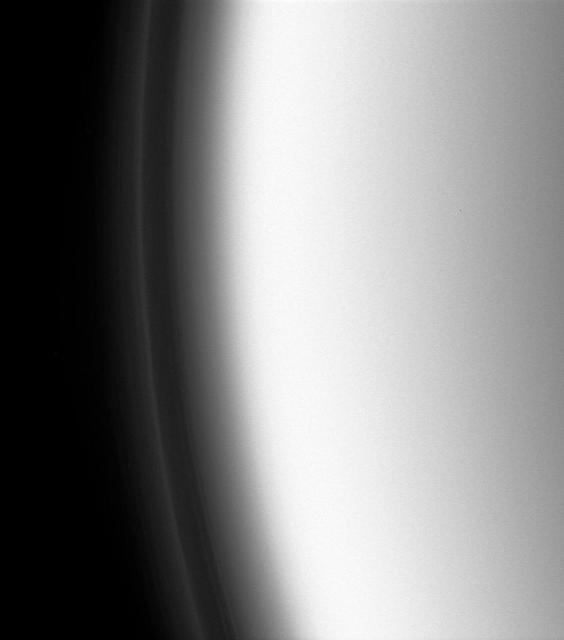
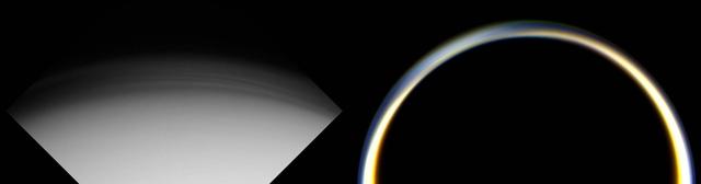
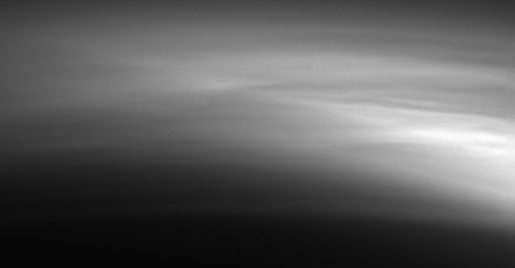
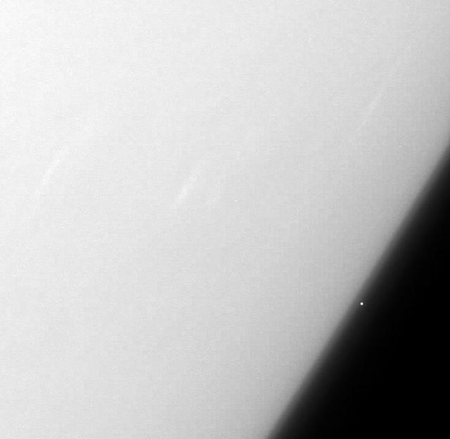
This false-color view from NASA's Cassini spacecraft gazes toward the rings beyond Saturn's sunlit horizon. Along the limb (the planet's edge) at left can be seen a thin, detached haze. This haze vanishes toward the left side of the scene. Cassini will pass through Saturn's upper atmosphere during the final five orbits of the mission, before making a fateful plunge into Saturn on Sept. 15, 2017. The region through which the spacecraft will fly on those last orbits is well above the haze seen here, which is in Saturn's stratosphere. In fact, even when Cassini plunges toward Saturn to meet its fate, contact with the spacecraft is expected to be lost before it reaches the depth of this haze. This view is a false-color composite made using images taken in red, green and ultraviolet spectral filters. The images were obtained using the Cassini spacecraft narrow-angle camera on July 16, 2017, at a distance of about 777,000 miles (1.25 million kilometers) from Saturn. Image scale is about 4 miles (7 kilometers) per pixel on Saturn. https://photojournal.jpl.nasa.gov/catalog/PIA21621
This processed image is the highest-resolution color look yet at the haze layers in Pluto's atmosphere. Shown in approximate true color, the picture was constructed from a mosaic of four panchromatic images from the Long Range Reconnaissance Imager (LORRI) splashed with Ralph/Multispectral Visible Imaging Camera (MVIC) four-color filter data, all acquired by NASA's New Horizons spacecraft on July 14, 2015. The resolution is 1 kilometer (0.6 miles) per pixel; the sun illuminates the scene from the right. Scientists believe the haze is a photochemical smog resulting from the action of sunlight on methane and other molecules in Pluto's atmosphere, producing a complex mixture of hydrocarbons such as acetylene and ethylene. These hydrocarbons accumulate into small particles, a fraction of a micrometer in size, and scatter sunlight to make the bright blue haze seen in this image. As they settle down through the atmosphere, the haze particles form numerous intricate, horizontal layers, some extending for hundreds of miles around Pluto. The haze layers extend to altitudes of over 200 kilometers (120 miles). Adding to the stark beauty of this image are mountains on Pluto's limb (on the right, near the 4 o'clock position), surface features just within the limb to the right, and crepuscular rays (dark finger-like shadows to the left) extending from Pluto's topographic features. http://photojournal.jpl.nasa.gov/catalog/PIA20362
Haze observations near Jupiter Limb at 60 degrees North
Hazes near Jupiter Limb 60 degrees North, 315 degrees West
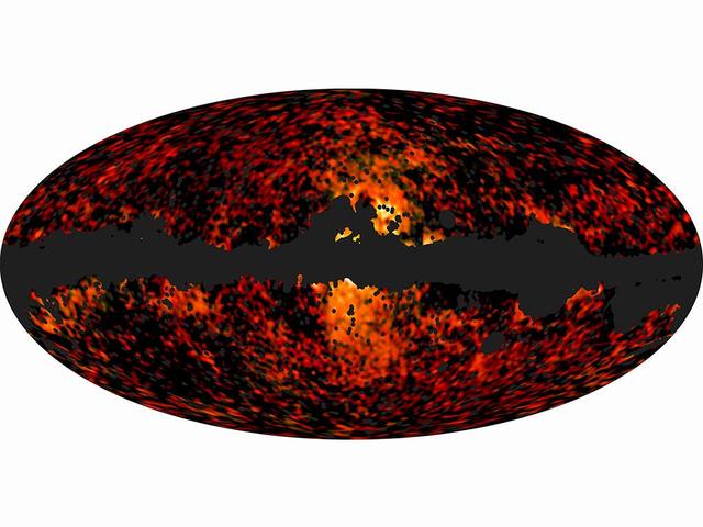
This all-sky image shows the spatial distribution over the whole sky of the galactic haze at 30 and 44 GHz, extracted from the Planck observations.
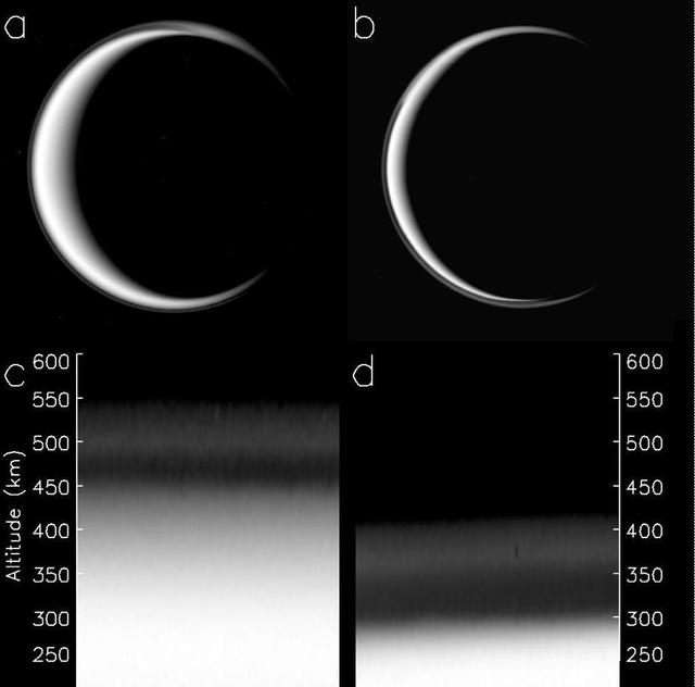
The change in Titan haze layer is illustrated in this figure, derived from data obtained by NASA Cassini spacecraft. The picture of Titan in panel a was taken on May 3, 2006, panel b was taken on April 2, 2010.
This view from NASA Cassini spacecraft look toward the south polar region of Saturn largest moon, Titan, and show a depression within the moon orange and blue haze layers near the south pole.
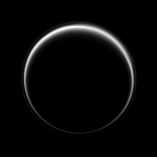
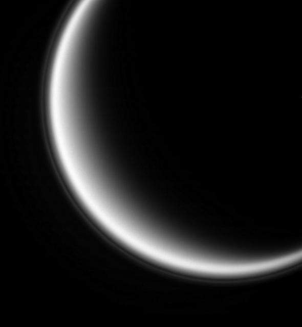
NASA Cassini spacecraft looks toward the dark side of Titan as a circle of light is produced by sunlight scattering through the periphery of the atmosphere of Saturn largest moon. A detached, high-altitude global haze layer encircles the moon.
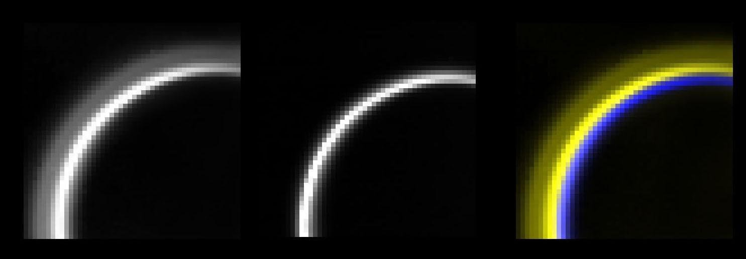
NASA's Cassini spacecraft looks toward the night side of Saturn's moon Titan in a view that highlights the extended, hazy nature of the moon's atmosphere. During its long mission at Saturn, Cassini has frequently observed Titan at viewing angles like this, where the atmosphere is backlit by the Sun, in order to make visible the structure of the hazes. Titan's high-altitude haze layer appears blue here, whereas the main atmospheric haze is orange. The difference in color could be due to particle sizes in the haze. The blue haze likely consists of smaller particles than the orange haze. Images taken using red, green and blue spectral filters were combined to create this natural-color view. The image was taken with the Cassini spacecraft narrow-angle camera on May 29, 2017. The view was acquired at a distance of approximately 1.2 million miles (2 million kilometers) from Titan. Image scale is 5 miles (9 kilometers) per pixel. https://photojournal.jpl.nasa.gov/catalog/PIA21625
In this view, individual layers of haze can be distinguished in the upper atmosphere of Titan, Saturn's largest moon. Titan's atmosphere features a rich and complex chemistry originating from methane and nitrogen and evolving into complex molecules, eventually forming the smog that surrounds the moon. This natural color image was taken in visible light with the Cassini spacecraft wide-angle camera on March 31, 2005, at a distance of approximately 20,556 miles (33,083 kilometers) from Titan. The view looks toward the north polar region on the moon's night side. Part of Titan's sunlit crescent is visible at right. The Cassini spacecraft ended its mission on Sept. 15, 2017. https://photojournal.jpl.nasa.gov/catalog/PIA21902
This false color view of Jupiter's polar haze was created by citizen scientist Gerald Eichstädt using data from the JunoCam instrument on NASA's Juno spacecraft. The image was taken on Dec. 11, 2016 at 2:30 p.m. PST (5:30 p.m. EST), when the spacecraft was 285,000 miles (459,000 kilometers) from Jupiter on the outbound leg of its third close flyby. This image is composited from four images taken through different filters: red, green, blue and methane. When the near-infrared methane image is processed with the others, the result is a false color product that highlights high clouds and high altitude hazes. The Great Red Spot and Oval BA (just below the Great Red Spot) are high in Jupiter's atmosphere, thus bright in this picture. The high-altitude haze layer over the south pole partially obscures our view of the storms below. By combining the methane data with the visible light images, we can learn about the vertical structure of Jupiter's atmosphere. http://photojournal.jpl.nasa.gov/catalog/PIA21379. - Enhanced image by Gerald Eichstädt based on images provided courtesy of NASA/JPL-Caltech/SwRI/MSSS
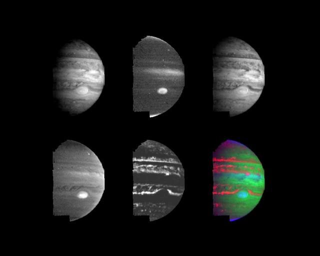
These two views of Jupiter obtained by NASA Galileo spacecraft show evidence of strikingly different stratospheric hazes between the polar regions and low or mid latitudes. The Great Red Spot shows in one mosaic taken on June 26, 1996.
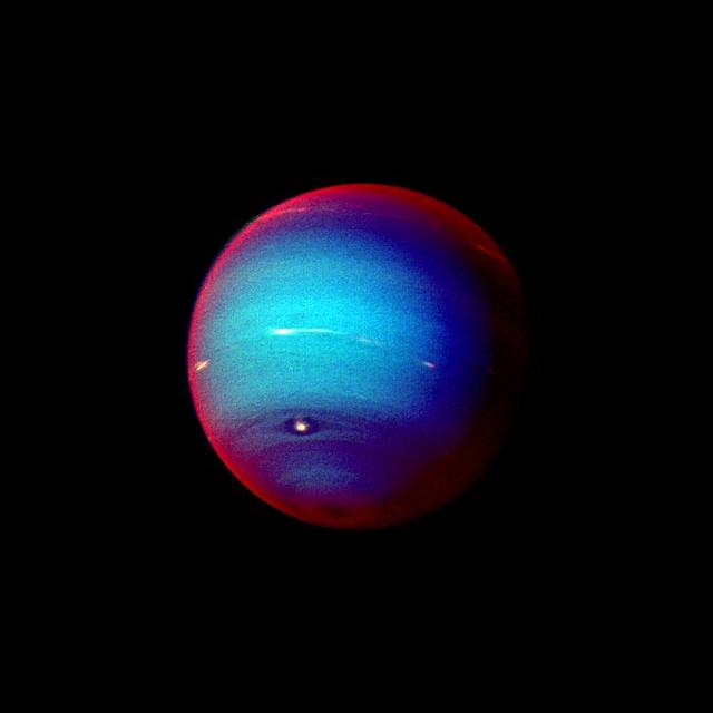
This false color photograph of Neptune was made from NASA's Voyager 2 images taken through three filters: blue, green, and a filter that passes light at a wavelength that is absorbed by methane gas. Thus, regions that appear white or bright red are those that reflect sunlight before it passes through a large quantity of methane. The image reveals the presence of a ubiquitous haze that covers Neptune in a semitransparent layer. Near the center of the disk, sunlight passes through the haze and deeper into the atmosphere, where some wavelengths are absorbed by methane gas, causing the center of the image to appear less red. Near the edge of the planet, the haze scatters sunlight at higher altitude, above most of the methane, causing the bright red edge around the planet. By measuring haze brightness at several wavelengths, scientists are able to estimate the thickness of the haze and its ability to scatter sunlight. The image is among the last full disk photos that Voyager 2 took before beginning its endless journey into interstellar space. http://photojournal.jpl.nasa.gov/catalog/PIA00057
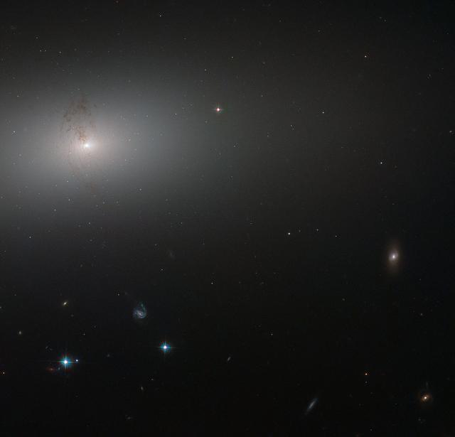
Like a lighthouse in the fog, the luminous core of NGC 2768 slowly fades outwards to a dull white haze in this image taken by the NASA/ESA Hubble Space Telescope. NGC 2768 is an elliptical galaxy in the constellation of Ursa Major (The Great Bear). It is a huge bundle of stars, dominated by a bright central region, where a supermassive black hole feasts on a constant stream of gas and dust being fed to it by its galactic host. The galaxy is also marked by a prominent plume of dust reaching out from the center and lying perpendicular to the galaxy’s plane. This dust conceals a symmetrical, S-shaped pair of jets that are being produced by the supermassive black hole as it feeds. Credit: ESA/Hubble, NASA and S. Smartt (Queen's University Belfast) <b><a href="http://www.nasa.gov/audience/formedia/features/MP_Photo_Guidelines.html" rel="nofollow">NASA image use policy.</a></b> <b><a href="http://www.nasa.gov/centers/goddard/home/index.html" rel="nofollow">NASA Goddard Space Flight Center</a></b> enables NASA’s mission through four scientific endeavors: Earth Science, Heliophysics, Solar System Exploration, and Astrophysics. Goddard plays a leading role in NASA’s accomplishments by contributing compelling scientific knowledge to advance the Agency’s mission. <b>Follow us on <a href="http://twitter.com/NASAGoddardPix" rel="nofollow">Twitter</a></b> <b>Like us on <a href="http://www.facebook.com/pages/Greenbelt-MD/NASA-Goddard/395013845897?ref=tsd" rel="nofollow">Facebook</a></b> <b>Find us on <a href="http://instagrid.me/nasagoddard/?vm=grid" rel="nofollow">Instagram</a></b>
Haze observations near Jupiter Limb 60 degrees North, 295 degrees West
In this small section of the larger crescent image of Pluto, taken by NASA's New Horizons just 15 minutes after the spacecraft's closest approach on July 14, 2015, the setting sun illuminates a fog or near-surface haze, which is cut by the parallel shadows of many local hills and small mountains. The image was taken from a distance of 11,000 miles (18,000 kilometers), and the width of the image is 115 miles (185 kilometers). http://photojournal.jpl.nasa.gov/catalog/PIA19946
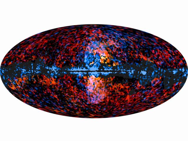
This all-sky image shows the distribution of the galactic haze seen by ESA Planck mission at microwave frequencies superimposed over the high-energy sky, as seen by NASA Fermi Gamma-ray Space Telescope.
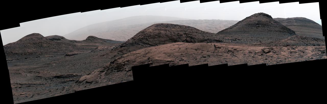
NASA's Curiosity Mars rover captured this image of the sulfate-bearing region and upper Mount Sharp in a dust haze on May 26, 2022, the 3,485th Martian day, or sol, of the mission. The panorama is made up of 46 individual images – captured during an especially dusty time of the Martian year – that were stitched together once the images were sent back to Earth. https://photojournal.jpl.nasa.gov/catalog/PIA25365

Like a lighthouse in the fog the luminous core of NGC 2768 slowly fades outwards to a dull white haze in this image taken by the NASA/ESA Hubble Space Telescope. NGC 2768 is an elliptical galaxy in the constellation of Ursa Major (The Great Bear). It is a huge bundle of stars, dominated by a bright central region, where a supermassive black hole feasts on a constant stream of gas and dust being fed to it by its galactic host. The galaxy is also marked by a prominent plume of dust reaching out from the centre and lying perpendicular to the galaxy’s plane. This dust conceals a symmetrical, s-shaped pair of jets that are being produced by the supermassive black hole as it feeds.
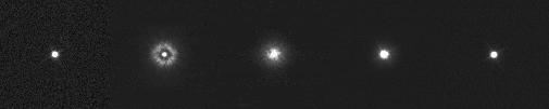
These five images of single stars, taken at different times with the narrow-angle camera on NASA Cassini spacecraft, show the effects of haze collecting on the camera optics, then successful removal of the haze by warming treatments.
This mosaic combines color-enhanced images taken over Jupiter's north pole when the lighting was excellent for detecting high bands of haze. The images were taken in the final hours of Juno's perijove 12 approach on April 1, 2018. Citizen scientists Gerald Eichstädt and John Rogers created this image using data from the spacecraft's JunoCam imager. https://photojournal.jpl.nasa.gov/catalog/PIA22934. - Enhanced image by Gerald Eichstädt and John Rogers based on images provided courtesy of NASA/JPL-Caltech/SwRI/MSSS
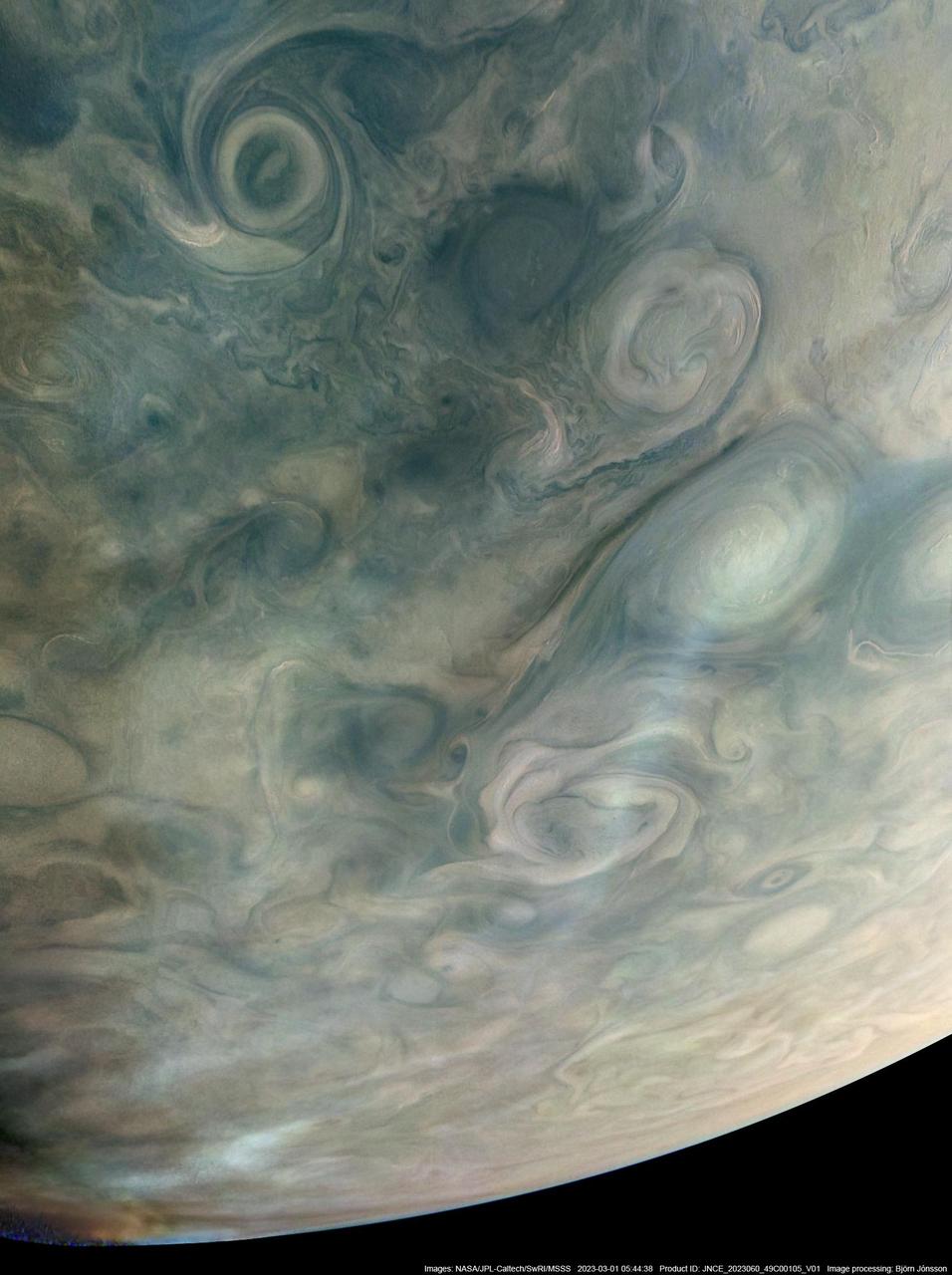
On March 1, 2023, NASA's Juno mission completed its 49th close flyby of Jupiter. As the spacecraft flew low over the giant planet's cloud tops, its JunoCam instrument captured this look at bands of high-altitude haze forming above cyclones in an area known at Jet N7. Citizen scientist Björn Jónsson processed a raw image from the JunoCam instrument, enhancing the contrast and sharpness. At the time the image was taken, Juno was about 5,095 miles (8,200 kilometers) above Jupiter's cloud tops, at a latitude of about 66 degrees. https://photojournal.jpl.nasa.gov/catalog/PIA25725
Pluto's haze layer shows its blue color in this picture taken by the New Horizons Ralph/Multispectral Visible Imaging Camera (MVIC). The high-altitude haze is thought to be similar in nature to that seen at Saturn's moon Titan. The source of both hazes likely involves sunlight-initiated chemical reactions of nitrogen and methane, leading to relatively small, soot-like particles (called tholins) that grow as they settle toward the surface. This image was generated by software that combines information from blue, red and near-infrared images to replicate the color a human eye would perceive as closely as possible. http://photojournal.jpl.nasa.gov/catalog/PIA19964
Sunlight scatters through Titan atmosphere, illuminating high hazes and bathing the entire moon in a soft glow
Storms and cloud bands emerge from beneath Saturn obscuring hazes in this infrared view
Titan atmosphere puts on a display with the detached haze to the north top of image and the polar vortex to the south as seen by NASA Cassini spacecraft.
The low albedo feature known as Senkyo is visible through the haze of Titan atmosphere in this image captured by NASA Cassini spacecraft.
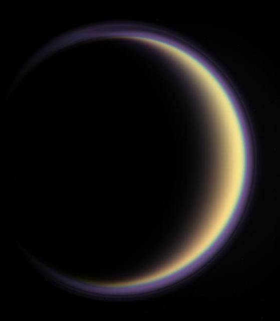
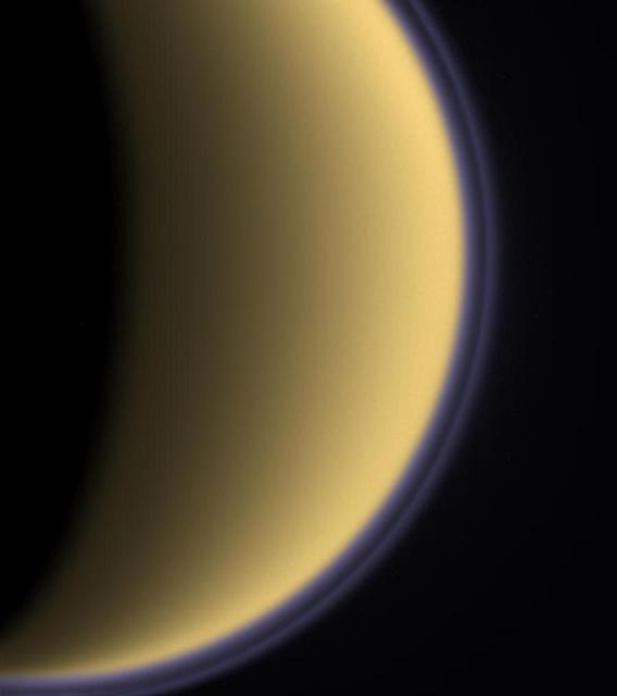
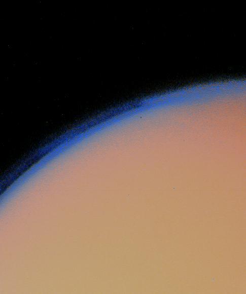
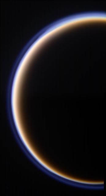
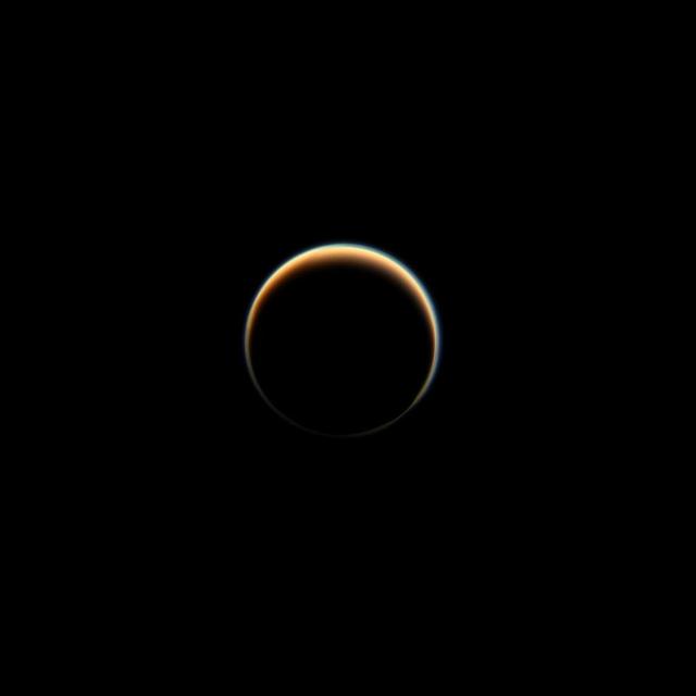
With its thick, distended atmosphere, Titan orange globe shines softly, encircled by a thin halo of purple light-scattering haze
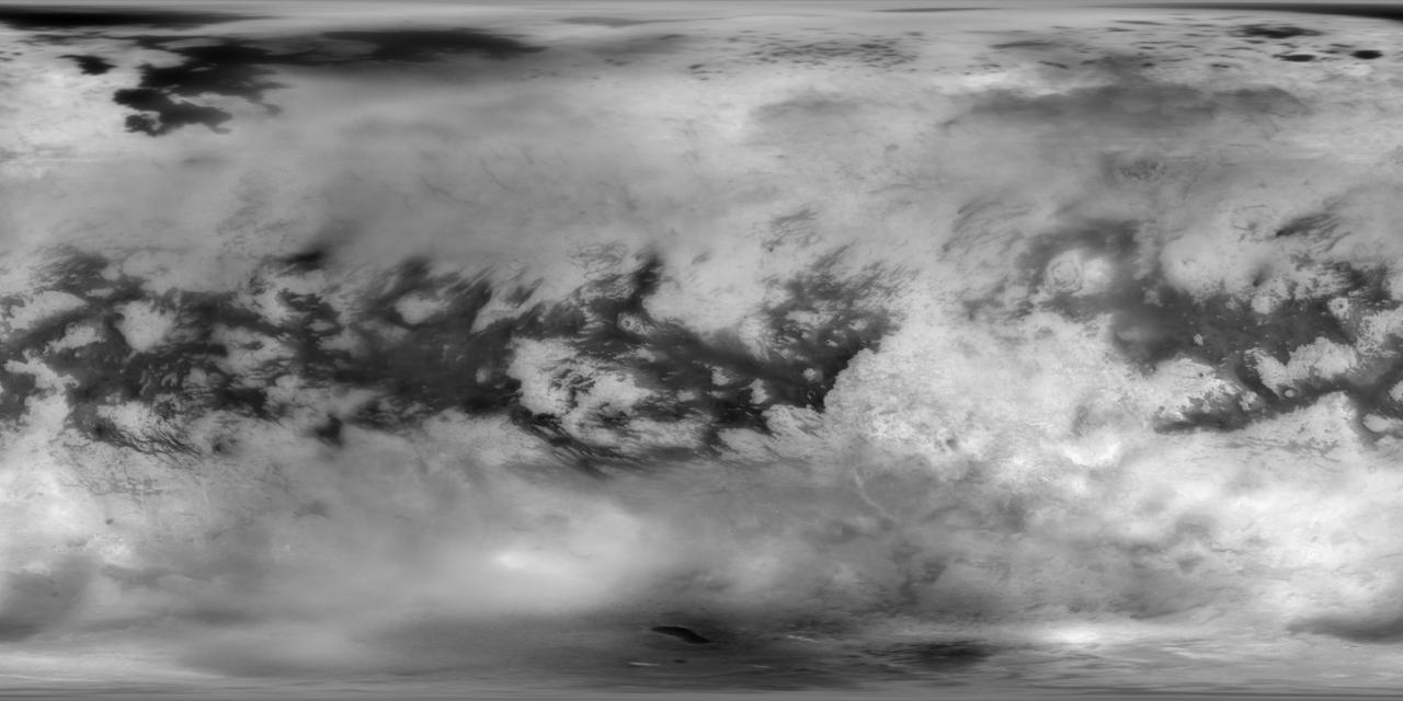
This Cassini Imaging Science Subsystem (ISS) global mosaic of Titan's surface brightness in the near-infrared at 938 nm wavelength shows the distribution of Titan's wide variety of landforms, from the vast equatorial sand seas to the high-latitude lakes and seas of liquid hydrocarbons. To generate this mosaic, 9,873 separate ISS images taken over more than 13 years of NASA's Cassini spacecraft operations at Saturn have been combined. Averaging such a large number of images dramatically improves how well surface features can be seen. A new photometric analysis method, with more accurate radiative transfer models of Titan's haze, allows spatial and temporal atmospheric and instrumental variations to be accounted for. This technique makes it possible to generate a mosaic without image seams that provides calibrated normal albedos. The image scale is 16 pixels per degree or 2.8 km in latitude. The new image is an update to the previous version of the ISS imaging map of Titan. The most recent version was published in 2015. https://photojournal.jpl.nasa.gov/catalog/PIA22770
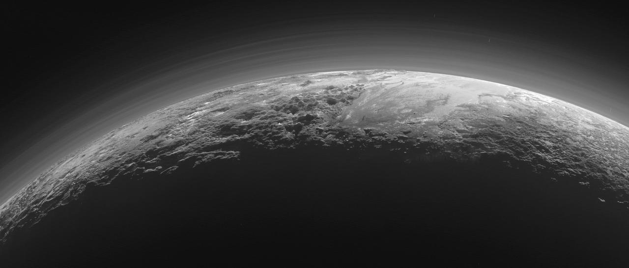
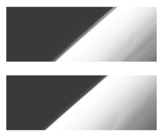
Just 15 minutes after its closest approach to Pluto on July 14, 2015, NASA's New Horizons spacecraft looked back toward the sun and captured this near-sunset view of the rugged, icy mountains and flat ice plains extending to Pluto's horizon. The smooth expanse of the informally named icy plain Sputnik Planum (right) is flanked to the west (left) by rugged mountains up to 11,000 feet (3,500 meters) high, including the informally named Norgay Montes in the foreground and Hillary Montes on the skyline. To the right, east of Sputnik, rougher terrain is cut by apparent glaciers. The backlighting highlights more than a dozen layers of haze in Pluto's tenuous but distended atmosphere. The image was taken from a distance of 11,000 miles (18,000 kilometers) to Pluto; the scene is 780 miles (1,250 kilometers) wide. http://photojournal.jpl.nasa.gov/catalog/PIA19948
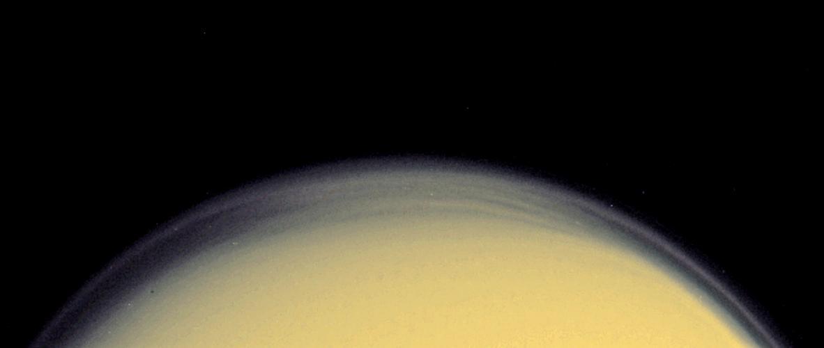
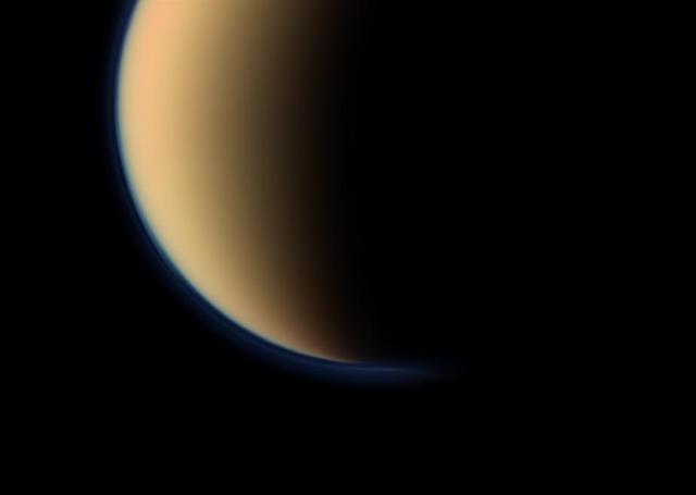
Titan golden, smog-like atmosphere and complex layered hazes appear to NASA Cassini Oribter as a luminous ring around the planet-sized moon.

This NASA Hubble Space Telescope image of the planet Uranus reveals the planet rings and bright clouds and a high altitude haze above the planet south pole.
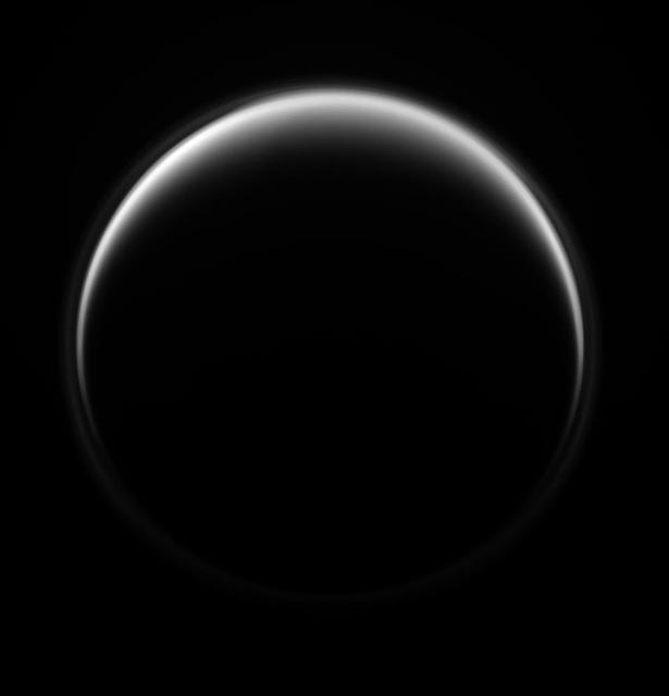
The Cassini spacecraft looks at Saturn largest moon, Titan, revealing its halo-like ring formed in the upper hazes of the moon extensive atmosphere.

The Cassini spacecraft looks down on Titan north pole and unveils the moon upper-most atmospheric hazes, creating the appearance of a halo around Saturn largest moon.

This computer enhancement of a NASA Voyager 2 image, emphasizes the high-level haze in Uranus upper atmosphere. Clouds are obscured by the overlying atmosphere.
Range : 168,694 km (105,000 mi.) Voyager 2 discovered detached limb hazes in the atmosphere of Triton in Pictures that arrived at Earth between 3:30 am and 5:30 am. The principal layer seen here begins about three km (2 miles) above the surface, and is about 3 km thick. Fainter upward extension of the haze has been seen to an altitude of at least 14 km (9 mi.). The haze must be comoposed of tiny particles in order to be supported in Trition's thin atmosphere. Composition of the haze is currently unknown, but may be either condensed atmospheric gases or complex orgainc molecules produced by irradiation of the methane in Triton's atmosphere. The vaguely linear mottling on the surface may be shadows of other haze striations. Other features of the haze layer should be appaarent in images of Triton taken at higher phase angles (including crescent phase). The image shows features as small as 2 km (1.2 mi) wide.

This composite image shows an infrared view of Saturn's moon Titan from NASA's Cassini spacecraft, acquired during the mission's "T-114" flyby on Nov. 13, 2015. The spacecraft's visual and infrared mapping spectrometer (VIMS) instrument made these observations, in which blue represents wavelengths centered at 1.3 microns, green represents 2.0 microns, and red represents 5.0 microns. A view at visible wavelengths (centered around 0.5 microns) would show only Titan's hazy atmosphere (as in PIA14909). The near-infrared wavelengths in this image allow Cassini's vision to penetrate the haze and reveal the moon's surface. During this Titan flyby, the spacecraft's closest-approach altitude was 6,200 miles (10,000 kilometers), which is considerably higher than those of typical flybys, which are around 750 miles (1,200 kilometers). The high flyby allowed VIMS to gather moderate-resolution views over wide areas (typically at a few kilometers per pixel). The view looks toward terrain that is mostly on the Saturn-facing hemisphere of Titan. The scene features the parallel, dark, dune-filled regions named Fensal (to the north) and Aztlan (to the south), which form the shape of a sideways letter "H." Several places on the image show the surface at higher resolution than elsewhere. These areas, called subframes, show more detail because they were acquired near closest approach. They have finer resolution, but cover smaller areas than data obtained when Cassini was farther away from Titan. Near the limb at left, above center, is the best VIMS view so far of Titan's largest confirmed impact crater, Menrva (first seen by the RADAR instrument in PIA07365). Similarly detailed subframes show eastern Xanadu, the basin Hotei Regio, and channels within bright terrains east of Xanadu. (For Titan maps with named features see http://planetarynames.wr.usgs.gov/Page/TITAN/target.) Due to the changing Saturnian seasons, in this late northern spring view, the illumination is significantly changed from that seen by VIMS during the "T-9" flyby on December 26, 2005 (PIA02145). The sun has moved higher in the sky in Titan's northern hemisphere, and lower in the sky in the south, as northern summer approaches. This change in the sun's angle with respect to Titan's surface has made high southern latitudes appear darker, while northern latitudes appear brighter. http://photojournal.jpl.nasa.gov/catalog/PIA20016
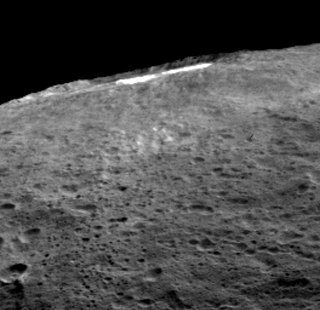
A group of scientists from NASA's Dawn mission suggests that when sunlight reaches Ceres' Occator Crater, a kind of thin haze of dust and evaporating water forms there. This haze only becomes dense enough to be seen by looking at it laterally, as in this image, the scientists wrote in the journal Nature in December 2015. Occator measures about 60 miles (90 kilometers) wide, and contains the brightest material seen on Ceres. http://photojournal.jpl.nasa.gov/catalog/PIA20181
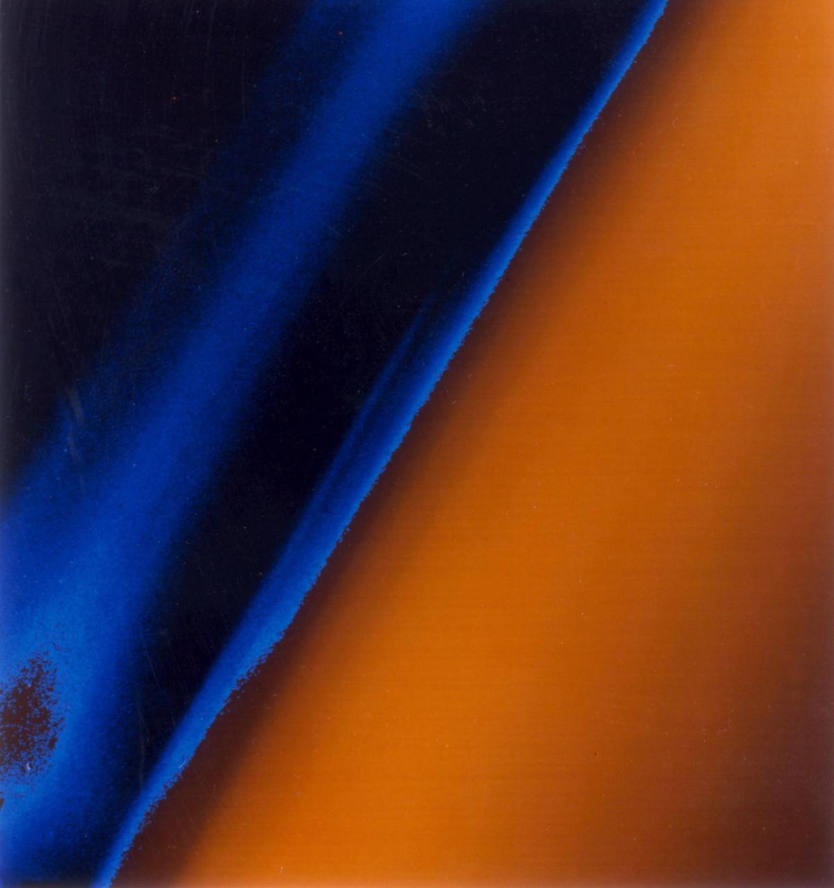
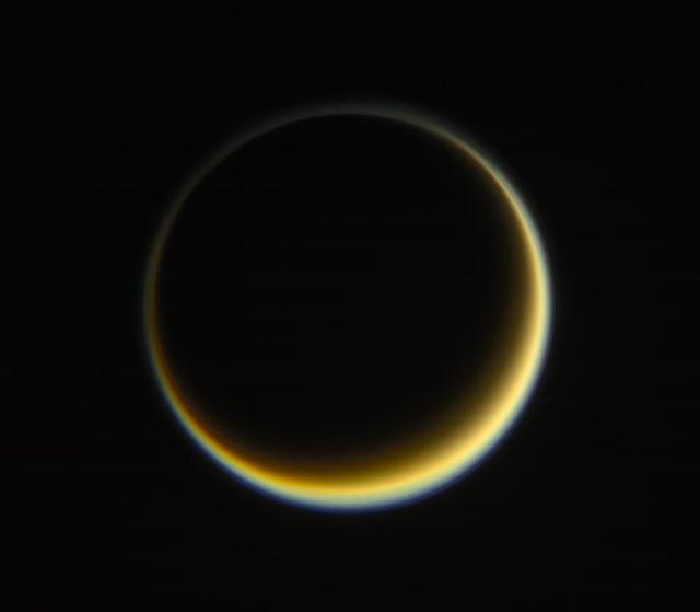
NASA's Cassini spacecraft looks towards the dark side of Saturn's largest moon, Titan, capturing the blue halo caused by a haze layer that hovers high in the moon's atmosphere. The haze that permeates Titan's atmosphere scatters sunlight and produces the orange color seen here. More on Titan's orange and blue hazes can be found at PIA14913. This view looks towards the side of Titan (3,200 miles or 5,150 kilometers across) that leads in its orbit around Saturn. North on Titan is up and rotated 40 degrees to the left. Images taken using red, green and blue spectral filters were combined to create this natural-color view. The images were taken with the Cassini spacecraft narrow-angle camera on Nov. 3, 2013. The view was acquired at a distance of approximately 2.421 million miles (3.896 million kilometers) from Titan. Image scale is 14 miles (23 kilometers) per pixel. http://photojournal.jpl.nasa.gov/catalog/PIA17180

This image was acquired on July 22, 2018 by NASA's Mars Reconnaissance Orbiter. Mars has recently been enveloped in dusty haze, but the sensitivity of HiRISE enabled imaging of surface features through a moderate level of haze. This image shows a fresh impact crater in the northern middle latitudes. A technique called "pixel binning" was needed to improve the signal, but it is still the highest-resolution image ever acquired at this location. Pixel binning combines information of adjacent detectors in a CCD camera sensor to create one single pixel in the recorded image. https://photojournal.jpl.nasa.gov/catalog/PIA22726
The moon Rhea moves behind Saturn largest moon, Titan, in this mutual event imaged by NASA Cassini spacecraft. Part of Rhea southern hemisphere is also visible here through the haze of Titan atmosphere.
This false color image from NASA 2001 Mars Odyssey spacecraft covers part of Noctis Labyrinthus. The bluish tone in the lower elevation depressions may indicate atmospheric haze.
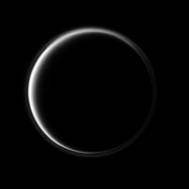
NASA Cassini spacecraft looks toward the dark side of Saturn largest moon as a circle of light is produced by sunlight scattering through the periphery of Titan atmosphere. A detached, high-altitude global haze layer encircles the moon.
This mosaic shows the features of Jupiter main visible cloud deck and upper-tropospheric haze, with higher features enhanced in brightness over lower features as seen by NASA Galileo orbiter on February 19, 1997.
Peering through Titan thick haze, the Cassini spacecraft glimpses boundaries between bright and dark terrain on the moon trailing hemisphere. The bright terrain at bottom is in northwestern Adiri
NASA Cassini spacecraft simultaneously peers through the haze in Titan equatorial region down to its surface and captures the vortex of clouds hovering over its south pole just to the right of the terminator on the moon dark side.
NASA Cassini spacecraft uses special infrared glasses to peer through Titan haze and monitor its surface inequatorial region dubbed Senkyo. The dark features are believed to be vast dunes of hydrocarbon particles.
Cassini peers through the murky orange haze of Titan to spy what are believed to be bodies of liquid hydrocarbons, two of them as large as seas on Earth, near the moon north pole
Clouds and hazes at various altitudes within the dynamic Jovian atmosphere are revealed by multi-color imaging taken during the second orbit G2 on September 5, 1996 by Galileo spacecraft.
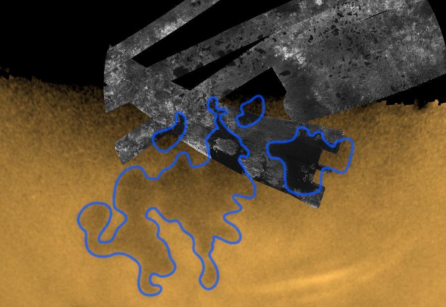
NASA Cassini spacecraft peers down though layers of haze to glimpse the lakes of Titan northern regions. Titan has a hydrological cycle similar to Earth, but instead of water, Titan lakes and seas are filled with liquid methane and ethane.
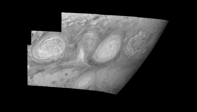
This mosaic shows the features of Jupiter main visible cloud deck and upper-tropospheric haze, with higher features enhanced in brightness over lower features as seen by NASA Galileo orbiter on February 19, 1997.
This nighttime movie of the depths of the north pole of Saturn reveals a dynamic, active planet lurking underneath the ubiquitous cover of upper-level hazes. The defining feature of Saturn north polar regions
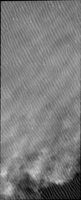
Clouds are common near the north polar caps throughout the spring and summer. The clouds typically cause a haze over the extensive dune fields. This image from NASA Mars Odyssey shows the edge of the cloud front.
The Cassini spacecraft continues to profile the haze structure and opacity in Saturn upper atmosphere with images like this, which captures Rigel, a star in Orion whose brightness is well-known, as it passes behind the planet

These three NASA Hubble Space Telescope images of the planet Uranus reveal the motion of a pair of bright clouds in the planet southern hemisphere, and a high altitude haze that forms a cap above the planet south pole.
This image from NASA 2001 Mars Odyssey spacecraft is a false color image of part of the northern flank of Ascreaus Mons. The bluish section at the top of the image may indicate an atmospheric haze.
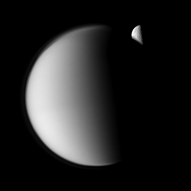
Saturn fourth-largest moon, Dione, can be seen through the haze of the planet largest moon, Titan, in this view of the two posing before the planet and its rings from NASA Cassini spacecraft.
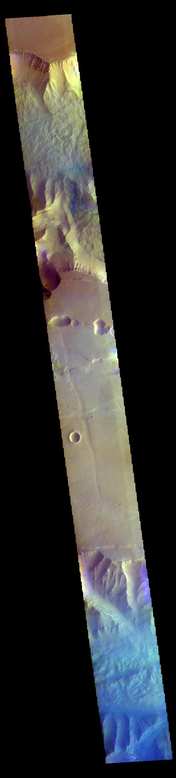
This image from NASA 2001 Mars Odyssey spacecraft shows a false color image of the region including both Tithonium and Ius Chasmata, which includes a bluish region in both canyons. This may indicate an atmospheric haze.

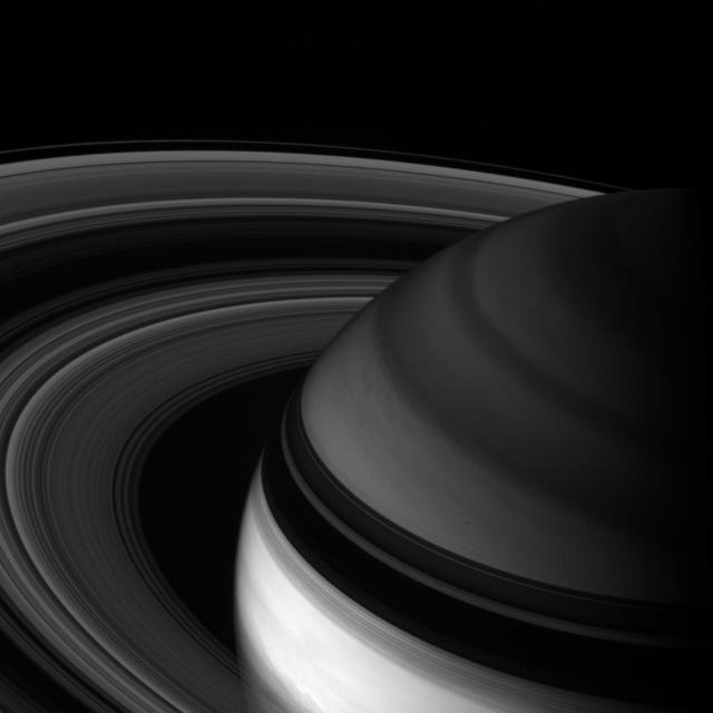
Saturn rings cut across an eerie scene that is ruled by Titan luminous crescent and globe-encircling haze, broken by the small moon Enceladus, whose icy jets are dimly visible at its south pole. North is up
This mosaic shows the features of Jupiter main visible cloud deck and upper-tropospheric haze, with higher features enhanced in brightness over lower features as seen by NASA Galileo orbiter on February 19, 1997.
False-color images from NASA Cassini spacecraft show the development of a hood of high-altitude haze, which appears orange in this image, forming over the south pole of Saturn moon Titan.
Cassini looks toward northern latitudes on Saturn and out across the ringplane. This infrared view probes clouds beneath the hazes that obscure the planet depths in natural color views

Hot Jupiters, exoplanets around the same size as Jupiter that orbit very closely to their stars, often have cloud or haze layers in their atmospheres. This may prevent space telescopes from detecting atmospheric water that lies beneath the clouds, according to a study in the Astrophysical Journal. As much as half of the water in the atmospheres of these exoplanets may be blocked by these clouds or hazes, research suggests. The study, led by researchers at NASA's Jet Propulsion Laboratory, Pasadena, California, examined hot Jupiters that had been observed with the Hubble Space Telescope. http://photojournal.jpl.nasa.gov/catalog/PIA20687
STS031-151-155 (26 April 1990) --- The Florida peninsula and smog over the northeastern U.S. coast are featured in this image photographed by a Space Shuttle Discovery crewmember during STS-31 mission. According to scientists, a mass of aerosol haze stretches across the top of the entire view. Meteorological, visibility and sulfate-content data showed that the haze was indeed industrial smog haze, rather than cloud. The air mass was transported west to east (left to right) around the north limb of a high pressure cell. It moved offshore for at least 1500 kilometers reaching the Atlantic islands of Bermuda. The leading edge of the haze mass can be detected far to the south, near the Bahamas--indicating that aerosols from the industrial Northeast were transported around the high, back directly toward the large population centers of Florida.
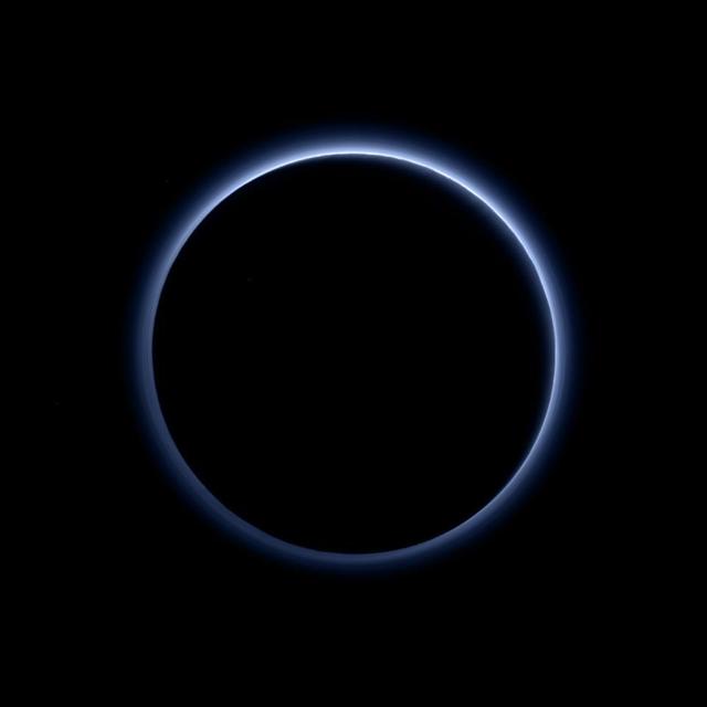
This is the highest-resolution color departure shot of Pluto's receding crescent from NASA's New Horizons spacecraft, taken when the spacecraft was 120,000 miles (200,000 kilometers) away from Pluto. Shown in approximate true color, the picture was constructed from a mosaic of six black-and-white images from the Long Range Reconnaissance Imager (LORRI), with color added from a lower resolution Ralph/Multispectral Visible Imaging Camera (MVIC) color image, all acquired between 15:20 and 15:45 UT -- about 3.5 hours after closest approach to Pluto -- on July 14, 2015. The resolution of the LORRI images is about 0.6 miles (1 kilometer) per pixel; the sun illuminates the scene from the other side of Pluto and somewhat toward the top of this image. The image is dominated by spectacular layers of blue haze in Pluto's atmosphere. Scientists believe the haze is a photochemical smog resulting from the action of sunlight on methane and other molecules in Pluto's atmosphere, producing a complex mixture of hydrocarbons such as acetylene and ethylene. These hydrocarbons accumulate into small haze particles, a fraction of a micrometer in size, which preferentially scatter blue sunlight -- the same process that can make haze appear bluish on Earth. As they settle down through the atmosphere, the haze particles form numerous intricate, horizontal layers, some extending for hundreds of miles around large portions of the limb of Pluto. The haze layers extend to altitudes of over 120 miles (200 kilometers). Pluto's circumference is 4,667 miles (7,466 kilometers). Adding to the beauty of this picture are mountains and other topographic features on Pluto's surface that are silhouetted against the haze near the top of the image. Sunlight casts dramatic and beautiful finger-like shadows from many of these features onto the haze (especially on the left, near the 11 o'clock position), forming crepuscular rays like those often seen in Earth's atmosphere near sunrise or sunset. https://photojournal.jpl.nasa.gov/catalog/PIA21590
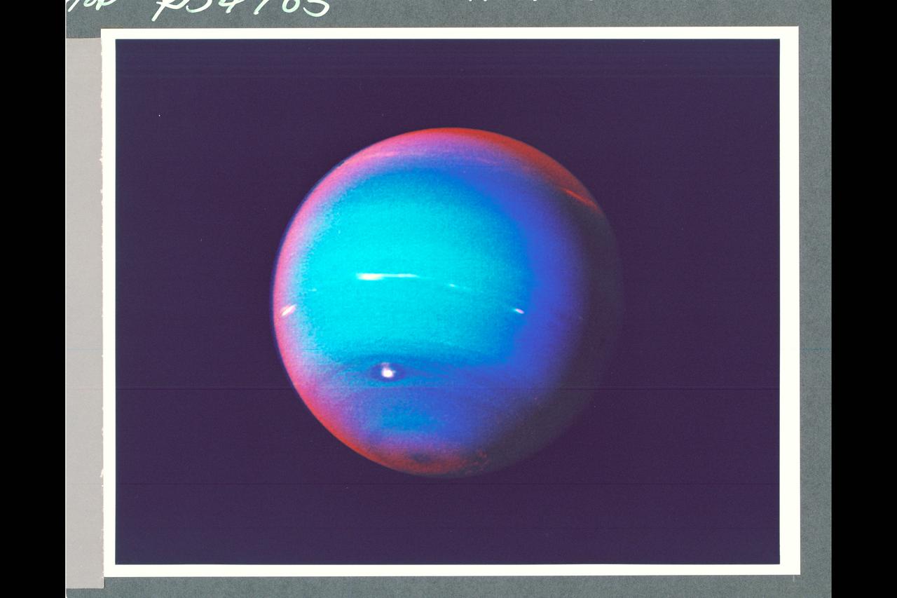
P-34705 This false-color photograph of Neptune was made from Voyager 2 images taken through three filters: blue, green, and a filter that passes light at a wavelength that is absorbed by methane gas. Thus, regions that appear white or bright red are those that reflect sunlight before it passes through a large quantity of methane. The image reveals the presence of a ubiquitous haze that covers Neptune in a semitransparent layer. Near the center of the disk, sunlight passes through the haze and deeper into the atmosphere, where some wavelenghths are absorbed by methane gas, causing the center to appear less red. Near the edge of the planet, the haze scatters sunlight at a higher altitude, above most of the methane, causing the bright red edge around the planet. By measuring haze brightness at several wavelengths, scientists are able to estimate the thickness of the haze and its ability to scatter sunlight. The image is among the last of the full-disk photos that Voyager 2 took before beginning its endless journey into interstellar space.
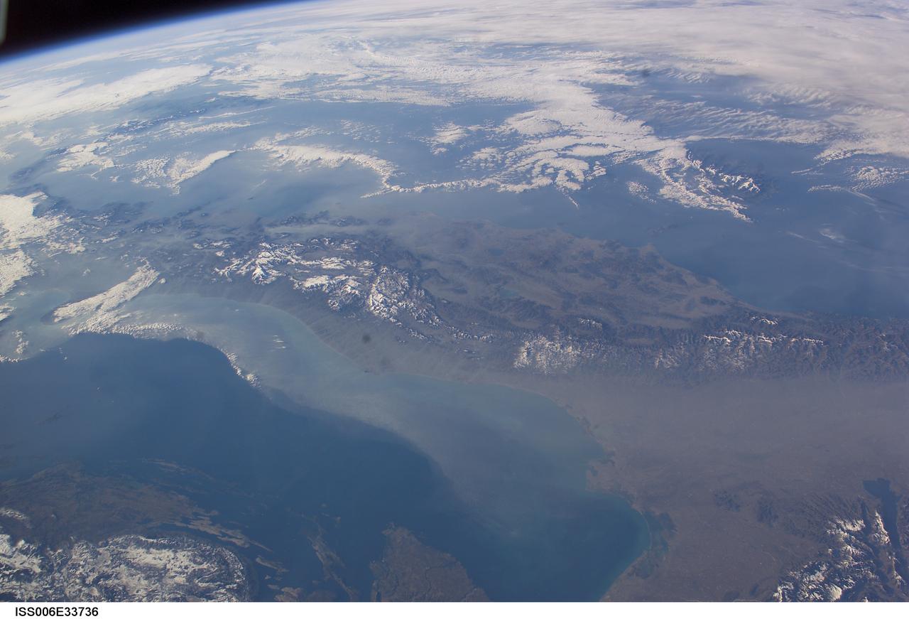
ISS006-E-33736 (25 February 2003) --- The boot of Italy crosses the image in this southwest-looking view taken by an Expedition Six crewmember onboard the International Space Station (ISS). The spine of Italy is highlighted with snow and the largely cloud-covered Mediterranean Sea is at the top. The Adriatic Sea transverses most of the bottom of the image and Sicily appears top left beyond the toe of the boot. The heel lies out of the left side of the image. Corsica and Sardinia appear right of center partly under cloud. The floor of the Po River valley, lower right, is obscured by haze. Experience gained from similar haze events, in which atmospheric pressure, humidity and visibility and atmospheric chemistry were known, suggests that the haze as industrial smog. Industrial haze from the urban region of the central and upper Po valley accumulates to visible concentrations under conditions of high atmospheric pressure and the surrounding mountains prevent easy dispersal. This view illustrates the markedly different color and texture of cloud versus industrial aerosol haze.
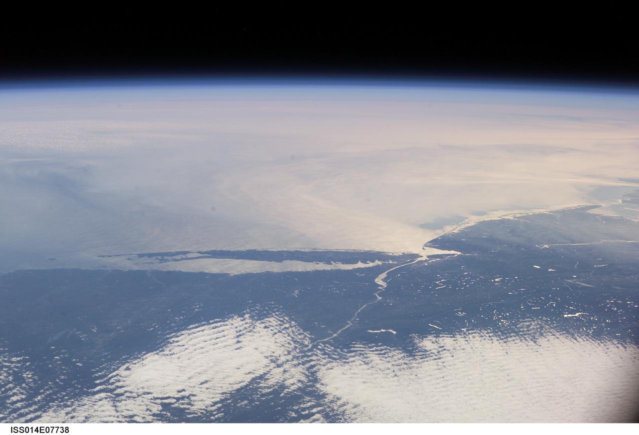
ISS014-E-07738 (10 Nov. 2006) --- This image featuring a southeast-looking view of the Long Island Sound and New Jersey coast, with the lower Hudson River and New York Bay in the area of brightest sunglint was photographed by an Expedition 14 crewmember on the International Space Station. On the far right a gray haze can be seen streaming out to sea offshore of New Jersey, where it becomes harder to see. In fact haze covers most of the visible area offshore, partly obscuring the sea surface. By contrast, clouds look quite different from haze according to scientists. Clouds usually have sharp margins and are pure white, as clouds at the bottom show. Industrial haze is grayer and more diffuse, and is typical of the air over the Northeast. Flow lines show that winds are transporting the haze in clockwise fashion--i.e. bending south--which in turn signifies that a high pressure system was operating on that day, centered roughly over the coast. High pressure systems are notorious for promoting smog events because they bring clear skies, and sunlight promotes smog formation. Highs also concentrate polluted surface layers near the ground.
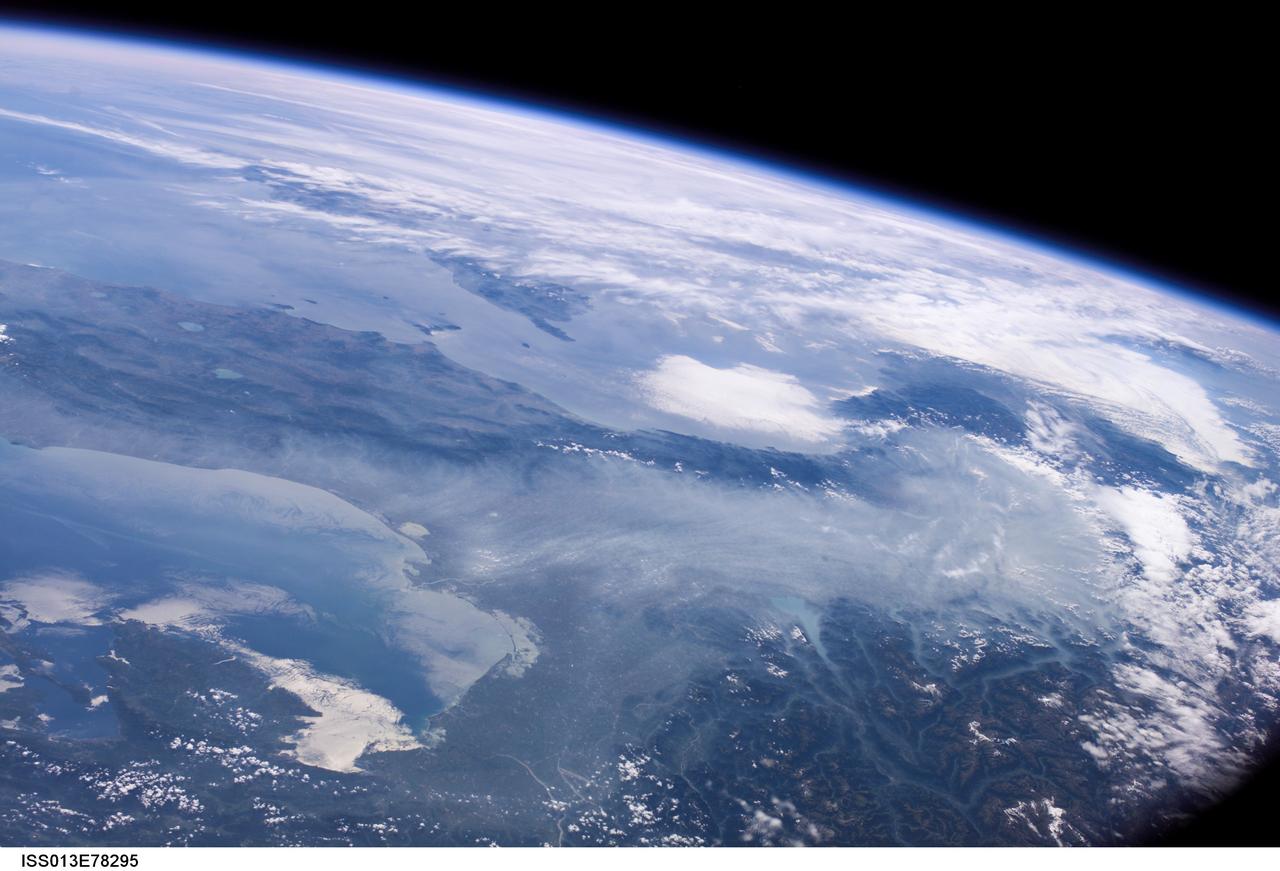
ISS013-E-78295 (6 Sept. 2006) --- Haze in the Po River Valley of Italy is featured in this image photographed by an Expedition 13 crewmember onboard the International Space Station. The valley is visible across the horizontal center of the frame, with the floor obscured by what NASA scientists refer to as frequent atmospheric haze, a mixture of industrial pollutants, dust and smoke. The visual texture of such haze is perceptibly different from that of bright white clouds which stretch across the top of the scene and cover part of the Alps. The Po River Valley is Italy's industrial heartland and one of the most industrialized regions on Earth, according to scientists. Northern Italy is in the foreground of this southwesterly view. The partially cloud-covered Alps are at lower right; the Adriatic Sea at lower left. Corsica is under partial cloud cover at center; and Sardinia, almost totally obscured, is to its south. The island of Elba is visible just to the west of Italy. By contrast with haze accumulation along the axis of the valley, the Alps and the Apennines are clearly visible, and Lake Garda can be seen in the foothills of the Alps. Other visible geographic features are the lagoon at Venice north of the Po River delta, and three small lakes north of Rome. The winds on the day this image was taken are mainly from the north, as shown by the flow lines in the haze near Venice. The haze typically flows south down the Adriatic Sea. Visibility in the Mediterranean basin is often reduced by hazes such as these, deriving from different sources in industrialized Europe.

This view from the Mast Camera (Mastcam) in NASA's Curiosity Mars rover shows a sloping hillside within the "Murray Buttes" region on lower Mount Sharp. The rim of Gale Crater, where the rover has been active since landing in 2012, is visible in the distance, through the dusty haze. The image was taken on Sept. 8, 2016, during the 1454th Martian day, or sol, of Curiosity's work on Mars. http://photojournal.jpl.nasa.gov/catalog/PIA21041