
Retiring MSFC Director Todd May photographed on the front lawn of Building 4200
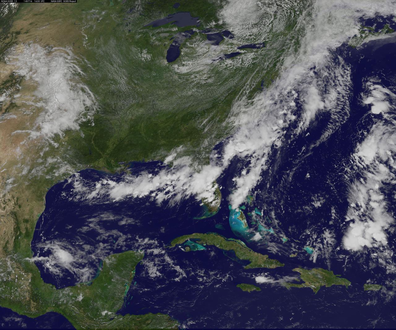
Summertime heat and humidity in the U.S. East Coast is on hold for a couple of days thanks to a cold front and that brought clouds, showers, thunderstorms, and some severe weather on July 16 to the coast. The National Oceanic and Atmospheric Administration (NOAA) noted that the dip in the jet stream will create below normal temperatures for most of the Central and Eastern U.S. for the next couple of days. NOAA's GOES-East satellite captured an image of the clouds associated with the cold front on July 16 at 1630 UTC (12:30 p.m. EDT).The clouds follow the front which stretches from the Florida panhandle, across Florida and up the U.S. East Coast into eastern Canada. Along the front lie two areas of low pressure, one over eastern New England, and the other offshore from South Carolina. Both of those low pressure areas are associated with additional cloudiness along the front. GOES satellites are managed by NOAA. The image was created by the NASA/NOAA GOES Project at NASA's Goddard Space Flight Center in Greenbelt, Maryland. GOES satellites provide the kind of continuous monitoring necessary for intensive data analysis. Geostationary describes an orbit in which a satellite is always in the same position with respect to the rotating Earth. This allows GOES to hover continuously over one position on Earth's surface, appearing stationary. As a result, GOES provide a constant vigil for the atmospheric "triggers" for severe weather conditions such as tornadoes, flash floods, hail storms and hurricanes. For updated information about the storm system, visit NOAA's National Weather Service website: <a href="http://www.weather.gov" rel="nofollow">www.weather.gov</a> For more information about GOES satellites, visit: <a href="http://www.goes.noaa.gov/" rel="nofollow">www.goes.noaa.gov/</a> or <a href="http://goes.gsfc.nasa.gov/" rel="nofollow">goes.gsfc.nasa.gov/</a> Image Credit: NASA/NOAA GOES Project, Text: Rob Gutro <b><a href="http://www.nasa.gov/audience/formedia/features/MP_Photo_Guidelines.html" rel="nofollow">NASA image use policy.</a></b> <b><a href="http://www.nasa.gov/centers/goddard/home/index.html" rel="nofollow">NASA Goddard Space Flight Center</a></b> enables NASA’s mission through four scientific endeavors: Earth Science, Heliophysics, Solar System Exploration, and Astrophysics. Goddard plays a leading role in NASA’s accomplishments by contributing compelling scientific knowledge to advance the Agency’s mission. <b>Follow us on <a href="http://twitter.com/NASAGoddardPix" rel="nofollow">Twitter</a></b> <b>Like us on <a href="http://www.facebook.com/pages/Greenbelt-MD/NASA-Goddard/395013845897?ref=tsd" rel="nofollow">Facebook</a></b> <b>Find us on <a href="http://instagram.com/nasagoddard?vm=grid" rel="nofollow">Instagram</a></b>
Storm Front
Polar Front
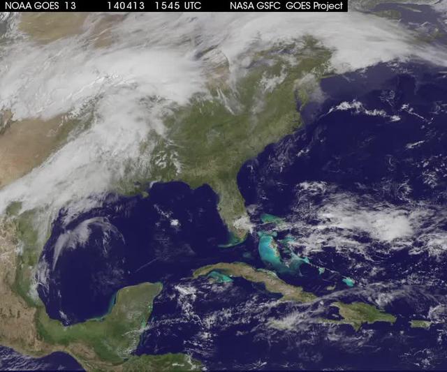
NOAA's GOES-13 satellite saw a large pesky front, one that stretched from Maine to Louisiana on April 13 at 16:15 UTC/12:15 p.m. EDT to April 16 at 12:15 p.m. EDT. This weather pattern did not bode well for people who wanted to see the lunar eclipse on April 15. The GOES-13 satellite images and animations are created at NASA/NOAA's GOES Project at the NASA Goddard Space Flight Center, Greenbelt, Md. <b><a href="http://goes.gsfc.nasa.gov/" rel="nofollow">Credit: NOAA/NASA GOES Project</a></b> <b><a href="http://www.nasa.gov/audience/formedia/features/MP_Photo_Guidelines.html" rel="nofollow">NASA image use policy.</a></b> <b><a href="http://www.nasa.gov/centers/goddard/home/index.html" rel="nofollow">NASA Goddard Space Flight Center</a></b> enables NASA’s mission through four scientific endeavors: Earth Science, Heliophysics, Solar System Exploration, and Astrophysics. Goddard plays a leading role in NASA’s accomplishments by contributing compelling scientific knowledge to advance the Agency’s mission. <b>Follow us on <a href="http://twitter.com/NASAGoddardPix" rel="nofollow">Twitter</a></b> <b>Like us on <a href="http://www.facebook.com/pages/Greenbelt-MD/NASA-Goddard/395013845897?ref=tsd" rel="nofollow">Facebook</a></b> <b>Find us on <a href="http://instagram.com/nasagoddard?vm=grid" rel="nofollow">Instagram</a></b>
All Quiet on the Northern Front
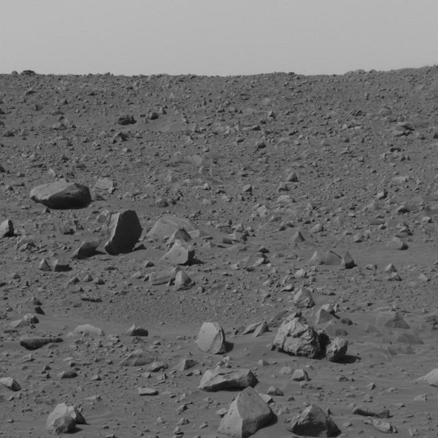
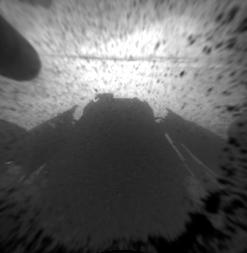
View in Front of Spirit
Lava Flow Front
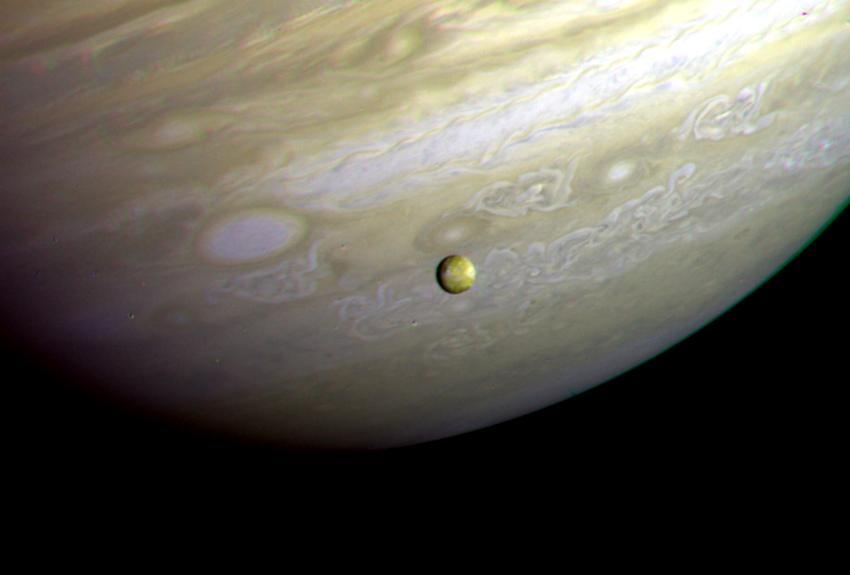
Io in front of Jupiter
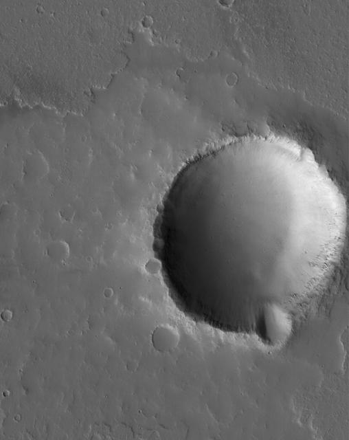
Flow Front and Crater
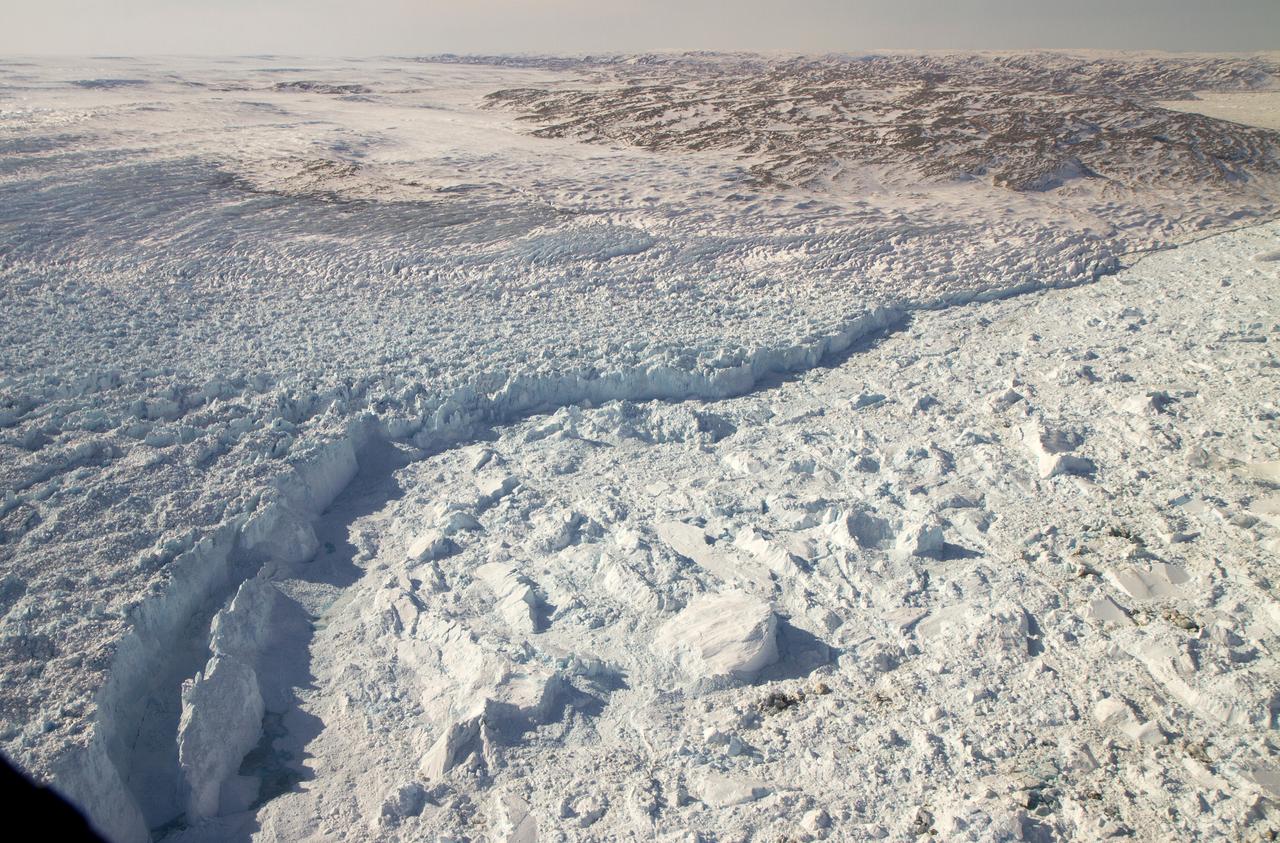
The calving front of the Jakobshavn Glacier in western Greenland, as seen from NASA's P-3B aircraft on April 21, 2012. Credit: NASA/GSFC/Jefferson Beck =========== IceBridge, a six-year NASA mission, is the largest airborne survey of Earth's polar ice ever flown. It will yield an unprecedented three-dimensional view of Arctic and Antarctic ice sheets, ice shelves and sea ice. These flights will provide a yearly, multi-instrument look at the behavior of the rapidly changing features of the Greenland and Antarctic ice. Data collected during IceBridge will help scientists bridge the gap in polar observations between NASA's Ice, Cloud and Land Elevation Satellite (ICESat) -- in orbit since 2003 -- and ICESat-2, planned for early 2016. ICESat stopped collecting science data in 2009, making IceBridge critical for ensuring a continuous series of observations. IceBridge will use airborne instruments to map Arctic and Antarctic areas once a year. IceBridge flights are conducted in March-May over Greenland and in October-November over Antarctica. Other smaller airborne surveys around the world are also part of the IceBridge campaign. To read more about IceBridge - Arctic 2012 go to: <a href="http://www.nasa.gov/mission_pages/icebridge/index.html" rel="nofollow">www.nasa.gov/mission_pages/icebridge/index.html</a> <b><a href="http://www.nasa.gov/audience/formedia/features/MP_Photo_Guidelines.html" rel="nofollow">NASA image use policy.</a></b> <b><a href="http://www.nasa.gov/centers/goddard/home/index.html" rel="nofollow">NASA Goddard Space Flight Center</a></b> enables NASA’s mission through four scientific endeavors: Earth Science, Heliophysics, Solar System Exploration, and Astrophysics. Goddard plays a leading role in NASA’s accomplishments by contributing compelling scientific knowledge to advance the Agency’s mission. <b>Follow us on <a href="http://twitter.com/NASA_GoddardPix" rel="nofollow">Twitter</a></b> <b>Like us on <a href="http://www.facebook.com/pages/Greenbelt-MD/NASA-Goddard/395013845897?ref=tsd" rel="nofollow">Facebook</a></b> <b>Find us on <a href="http://instagrid.me/nasagoddard/?vm=grid" rel="nofollow">Instagram</a></b>
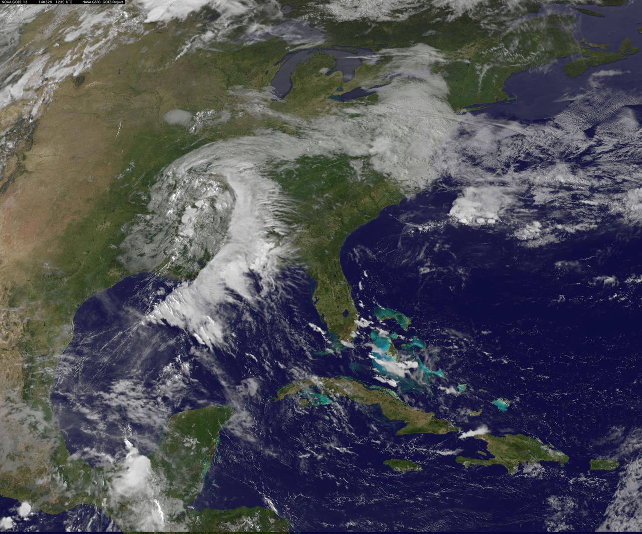
A "backdoor cold front" is bringing April temperatures to the U.S. northeast and Mid-Atlantic today, May 29. The backdoor cold front brings relief to the Mid-Atlantic after temperatures in Washington, D.C. hit 92F on Tuesday, May 27 and 88F on Wednesday, May 28 at Reagan National Airport, according to the National Weather Service (NWS). NWS forecasters expect the high temperature for May 29 to only reach 60F in the District of Columbia. NOAA's GOES-East satellite captured a view of the clouds associated with the backdoor cold front that stretch from southern Illinois to North Carolina. The National Weather Service forecast expects the backdoor cold front to bring showers to the Midwest, Northeast, and Mid-Atlantic today, May 29. According to the National Oceanic and Atmospheric Administration, a backdoor cold front is a cold front moving south or southwest along the Atlantic seaboard and Great Lakes; these are especially common during the spring months. This visible image was taken by NOAA's GOES-East satellite on May 29 at 12:30 UTC (8:30 a.m. EDT). The image was created at NASA/NOAA's GOES Project at NASA's Goddard Space Flight Center in Greenbelt, Maryland. In addition to the backdoor cold front clouds, the GOES-East image shows clouds circling around a low pressure area located in eastern Texas. That low pressure area is expected to bring rain from Texas eastward over the southeastern U.S. According to NOAA's National Weather Service, the slow-moving low pressure area in the Deep South "will bring heavy showers and thunderstorms from Louisiana to Alabama through Thursday. This area is already saturated from previous rainfall, so flash flooding will be possible." Image: NASA/NOAA GOES Project Caption: NASA Goddard/Rob Gutro
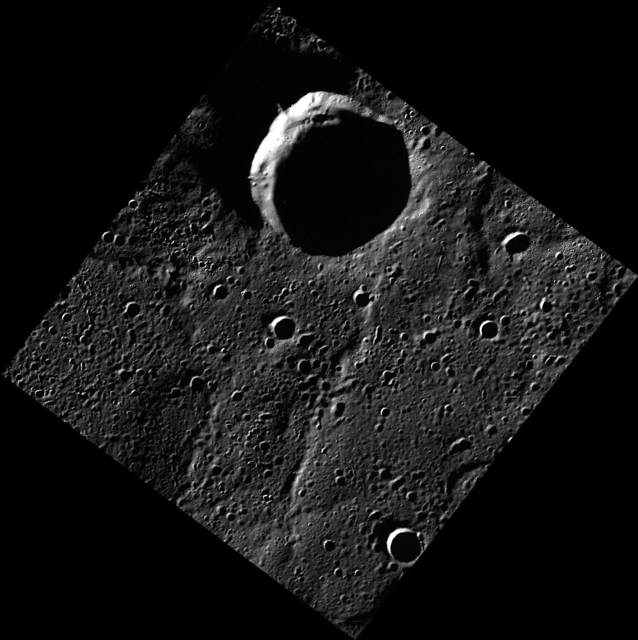
Identifying Lava Flow Fronts on Mercury
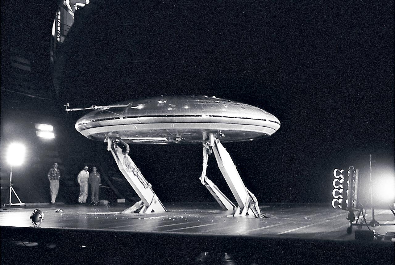
Front 3/4 view of the Avrocar mounted on variable height struts in the Ames 40x80 foot wind tunnel, without tail.
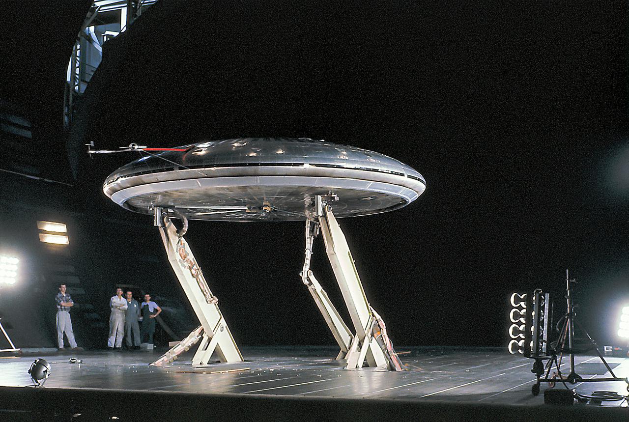
Front 3/4 view of the Avrocar mounted on variable height struts in the Ames 40x80 foot wind tunnel, without tail.
This image captured by NASA 2001 Mars Odyssey spacecraft shows the edge of the clouds in a weather front in the northern latitudes.
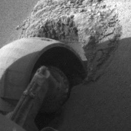
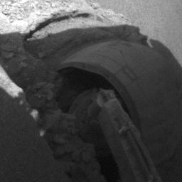
Opportunity Rolls Free Again Right Front Wheel
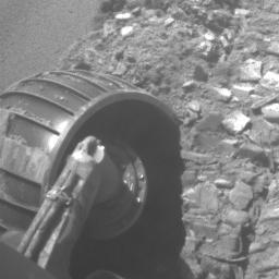
Slow Progress in Dune Left Front Wheel
Front Windshield after Sol 61 Drive
Opportunity Rolls Free Again Left Front Wheel
Slow Progress in Dune Right Front Wheel
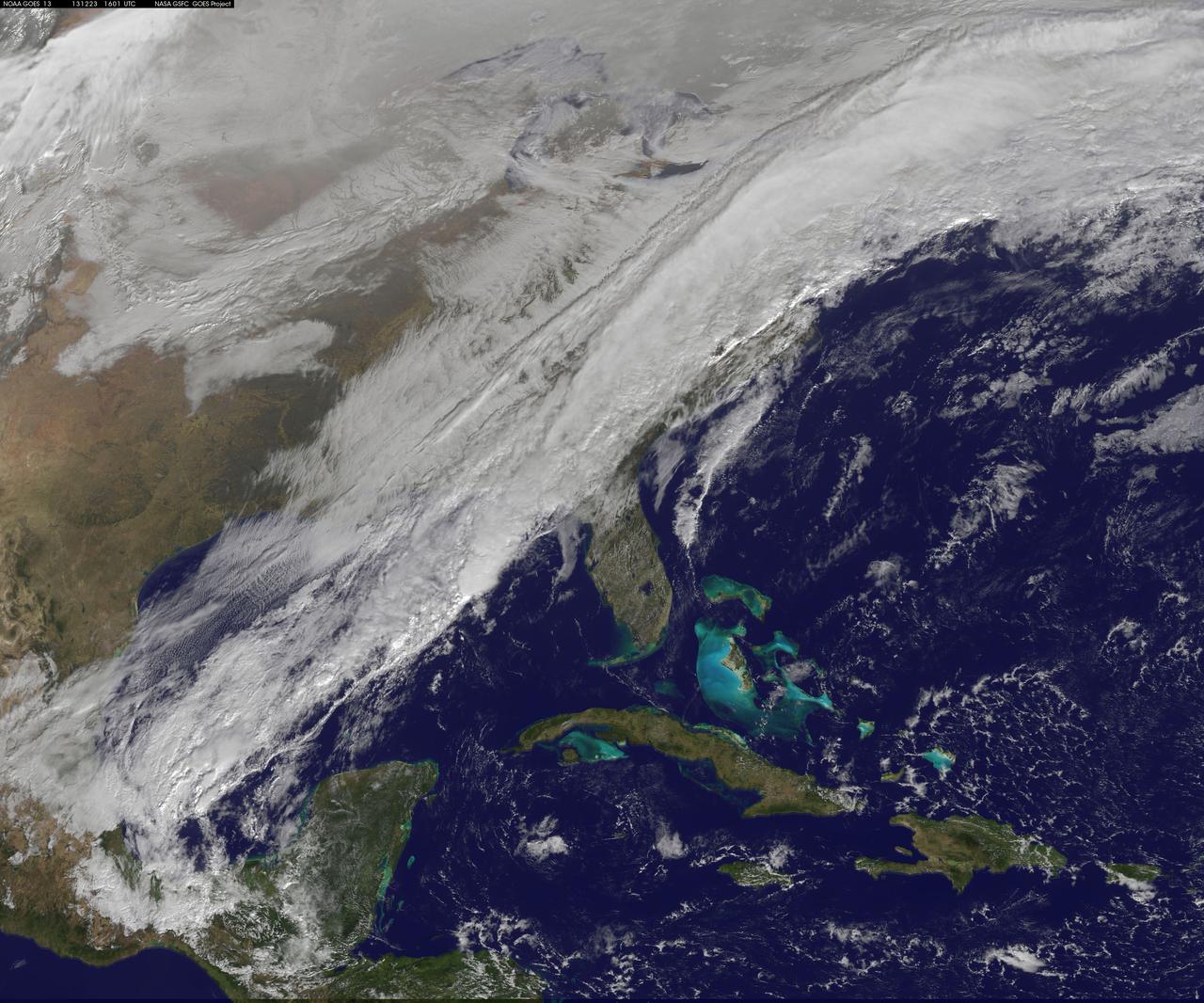
A long, strong, cold front draped over the eastern U.S. is marking a stark change from record-warmth to very cold temperatures. This NOAA GOES-East satellite image from December 23 at 1515 UTC/10:15 a.m. EST shows a powerful cold front covering the U.S. East Coast and stretching into the central and southwestern Gulf of Mexico. According to the National Weather Service, that front is bringing rain and embedded thunderstorms over the Mid-Atlantic and Southeastern U.S. The same system is bringing lingering wintry precipitation to northern New England and upstate New York. Behind the cold front, much colder and dry Canadian air will filter in under high pressure and bring sunshine over the eastern U.S. in time for Christmas. The image was created by the NASA GOES Project at NASA's Goddard Space Flight Center, Greenbelt, Md. Rob Gutro NASA Goddard Space Flight Center <b><a href="http://www.nasa.gov/audience/formedia/features/MP_Photo_Guidelines.html" rel="nofollow">NASA image use policy.</a></b> <b><a href="http://www.nasa.gov/centers/goddard/home/index.html" rel="nofollow">NASA Goddard Space Flight Center</a></b> enables NASA’s mission through four scientific endeavors: Earth Science, Heliophysics, Solar System Exploration, and Astrophysics. Goddard plays a leading role in NASA’s accomplishments by contributing compelling scientific knowledge to advance the Agency’s mission. <b>Follow us on <a href="http://twitter.com/NASA_GoddardPix" rel="nofollow">Twitter</a></b> <b>Like us on <a href="http://www.facebook.com/pages/Greenbelt-MD/NASA-Goddard/395013845897?ref=tsd" rel="nofollow">Facebook</a></b> <b>Find us on <a href="http://instagram.com/nasagoddard?vm=grid" rel="nofollow">Instagram</a></b>

NOAA's GOES-East satellite captured an image of a powerful cold front that triggered flash flood watches and warnings along the U.S. East Coast on May 16. NOAA's National Weather Service noted flash flooding was possible from New England into eastern North Carolina today, May 16. The clouds associated with the long cold front was captured using visible data from NOAA's GOES-East or GOES-13 satellite on at 1900 UTC (3:00 p.m. EDT) and was made into an image by NASA/NOAA's GOES Project at NASA's Goddard Space Flight Center in Greenbelt, Md. The clouds stretched from Maine south through the Mid-Atlantic down to southern Florida with a tail of clouds extending into the western Caribbean Sea. South of Lake Michigan the rounded swirl of clouds indicates another low pressure system. GOES satellites provide the kind of continuous monitoring necessary for intensive data analysis. Geostationary describes an orbit in which a satellite is always in the same position with respect to the rotating Earth. This allows GOES to hover continuously over one position on Earth's surface, appearing stationary. As a result, GOES provide a constant vigil for the atmospheric "triggers" for severe weather conditions such as tornadoes, flash floods, hail storms and hurricanes. For updated information about the storm system, visit NOAA's National Weather Service website: <a href="http://www.weather.gov" rel="nofollow">www.weather.gov</a> For more information about GOES satellites, visit: <a href="http://www.goes.noaa.gov/" rel="nofollow">www.goes.noaa.gov/</a> or <a href="http://goes.gsfc.nasa.gov/" rel="nofollow">goes.gsfc.nasa.gov/</a> Rob Gutro NASA's Goddard Space Flight Center <b><a href="http://www.nasa.gov/audience/formedia/features/MP_Photo_Guidelines.html" rel="nofollow">NASA image use policy.</a></b> <b><a href="http://www.nasa.gov/centers/goddard/home/index.html" rel="nofollow">NASA Goddard Space Flight Center</a></b> enables NASA’s mission through four scientific endeavors: Earth Science, Heliophysics, Solar System Exploration, and Astrophysics. Goddard plays a leading role in NASA’s accomplishments by contributing compelling scientific knowledge to advance the Agency’s mission. <b>Follow us on <a href="http://twitter.com/NASAGoddardPix" rel="nofollow">Twitter</a></b> <b>Like us on <a href="http://www.facebook.com/pages/Greenbelt-MD/NASA-Goddard/395013845897?ref=tsd" rel="nofollow">Facebook</a></b> <b>Find us on <a href="http://instagram.com/nasagoddard?vm=grid" rel="nofollow">Instagram</a></b>

Jupiter four largest satellites, including Io, the golden ornament in front of Jupiter in this image from NASA Cassini spacecraft.

Image acquired December 19, 2011 A strong low pressure area in the southwestern U.S. today is bringing snowfall there as NOAA's GOES-13 satellite captured its associated clouds. Blizzard warnings are already posted for some areas. The image was created on Dec. 19 at 19:10 UTC (2:10 p.m. EST) from the Geostationary Operational Environmental Satellite called GOES-13. GOES-13 is operated by the National Oceanic and Atmospheric Administration. Images and animations are created by NASA's GOES Project, located at NASA's Goddard Space Flight Center, Greenbelt, Md. The low is forecast to move northeast across southeastern New Mexico today and reach southwest the Texas panhandle by early evening. The plains states including portions of Kansas, New Mexico and the Texas and Oklahoma panhandles could all have blizzard warnings later in the day on Dec. 19. Wind gusts to 60mph were recorded in northeastern New Mexico during the afternoon hours today. Kansas City may have a mix of rain, sleet and snow as the front moves past and temperatures fall. At 3 p.m. EST, the National Weather Service forecast indicated that moderate to heavy snow and strong north winds to impact the Texas and Oklahoma panhandles today into Tuesday morning. The low and associated cold front are expected to bring heavy snow to the Oklahoma panhandle and all but the far southeast Texas Panhandle. Behind the cold front, the strong winds will blow snow and lead to poor visibilities and blizzard conditions. The GOES image shows the large bank of clouds along the front stretching from the four corners states east-northeast through the Ohio Valley and into upstate New York. The rounded comma shape of clouds over Texas and stretching into Colorado indicate where the low pressure center is located. Image: NASA/NOAA GOES Project Text: NASA, Rob Gutro <b><a href="http://www.nasa.gov/audience/formedia/features/MP_Photo_Guidelines.html" rel="nofollow">NASA image use policy.</a></b> <b><a href="http://www.nasa.gov/centers/goddard/home/index.html" rel="nofollow">NASA Goddard Space Flight Center</a></b> enables NASA’s mission through four scientific endeavors: Earth Science, Heliophysics, Solar System Exploration, and Astrophysics. Goddard plays a leading role in NASA’s accomplishments by contributing compelling scientific knowledge to advance the Agency’s mission. <b>Follow us on <a href="http://twitter.com/NASA_GoddardPix" rel="nofollow">Twitter</a></b> <b>Like us on <a href="http://www.facebook.com/pages/Greenbelt-MD/NASA-Goddard/395013845897?ref=tsd" rel="nofollow">Facebook</a></b> <b>Find us on <a href="http://instagrid.me/nasagoddard/?vm=grid" rel="nofollow">Instagram</a></b>
Spring time brings storms to the north polar region of Mars. This image captured by NASA 2001 Mars Odyssey spacecraft shows a storm front, as bright clouds shadow and obscure the surface.
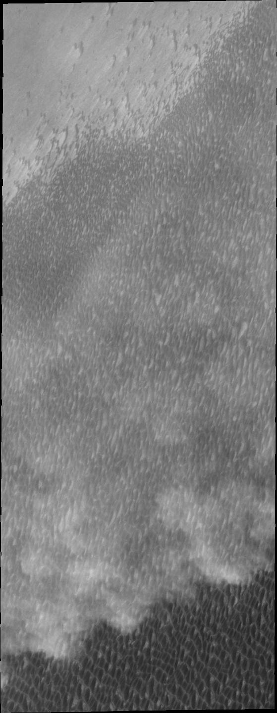
Spring storms are common near the north pole. This image captured by NASA 2001 Mars Odyssey spacecraft shows a storm front over the extensive dune field which surrounds part of the polar cap.
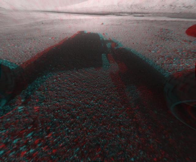
This image is a 3-D view in front of NASA Curiosity rover captured by the rover front left Hazard-Avoidance camera. The image is cropped but part of Mount Sharp is still visible rising above the terrain.
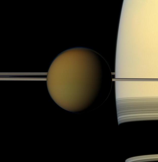
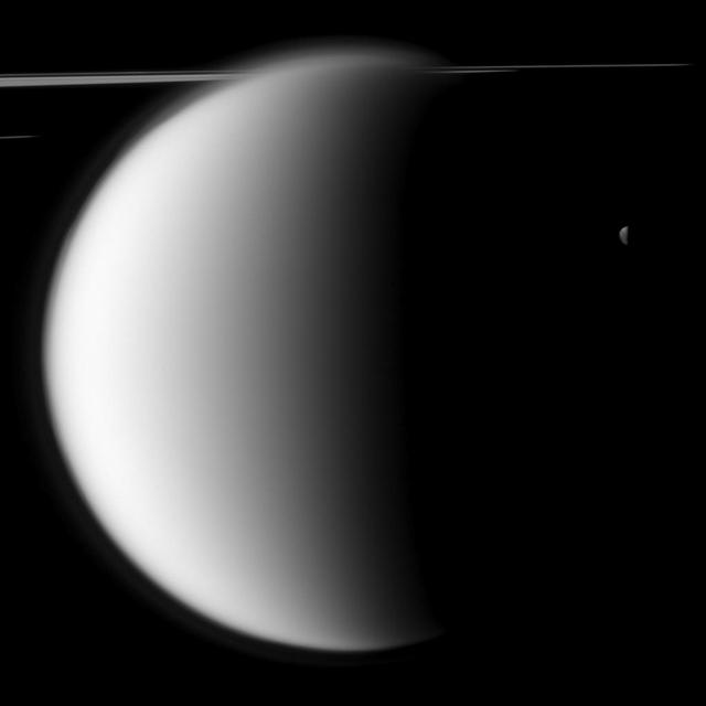
The colorful globe of Saturn largest moon, Titan, passes in front of the planet and its rings in this true color snapshot from NASA Cassini spacecraft.

Front view of the rHEALTH ONE. Image courtesy of rHEALTH.
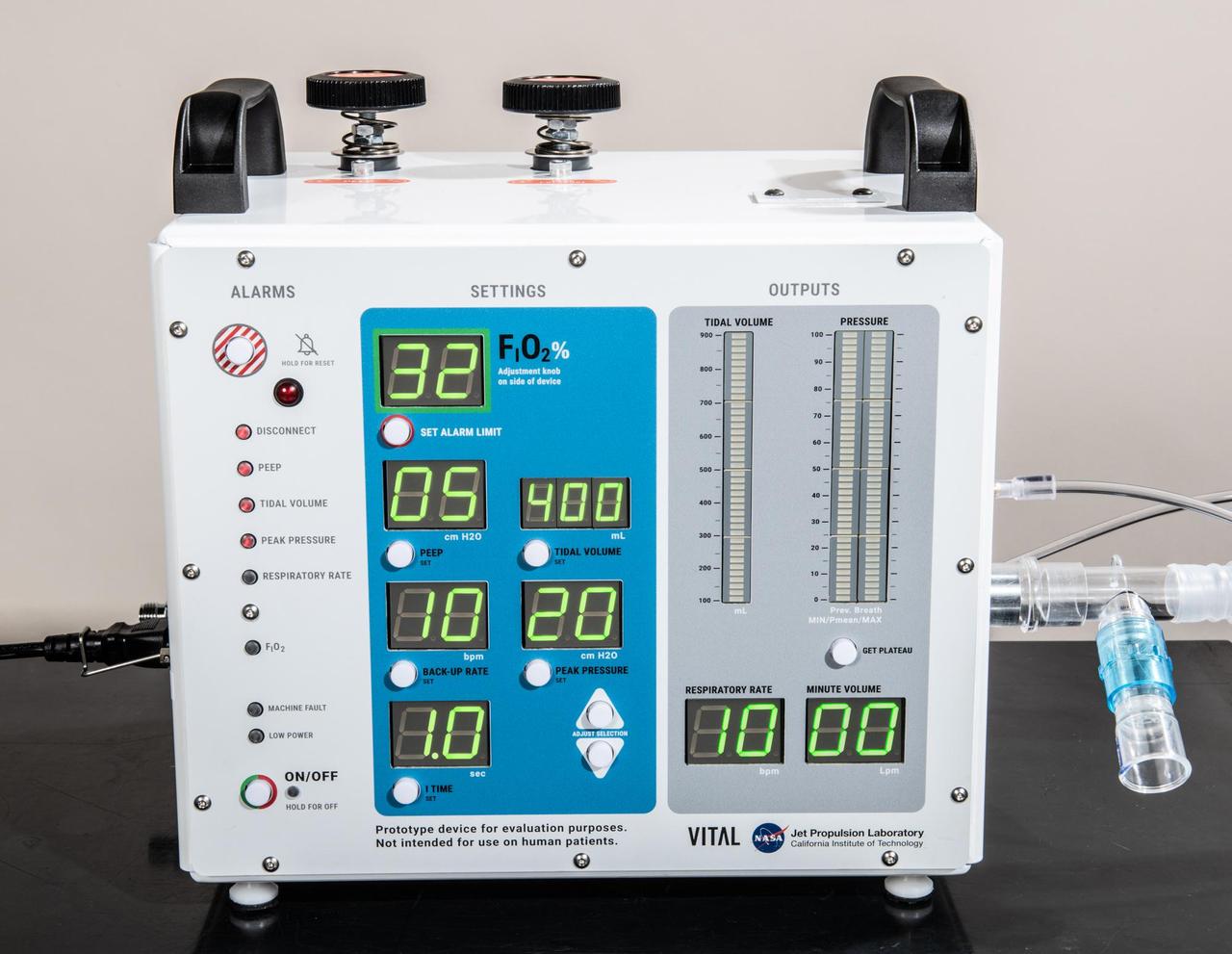
A front-facing portrait of VITAL (Ventilator Intervention Technology Accessible Locally), a ventilator designed and built by NASA's Jet Propulsion Laboratory in Southern California. https://photojournal.jpl.nasa.gov/catalog/PIA23775
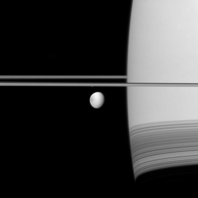
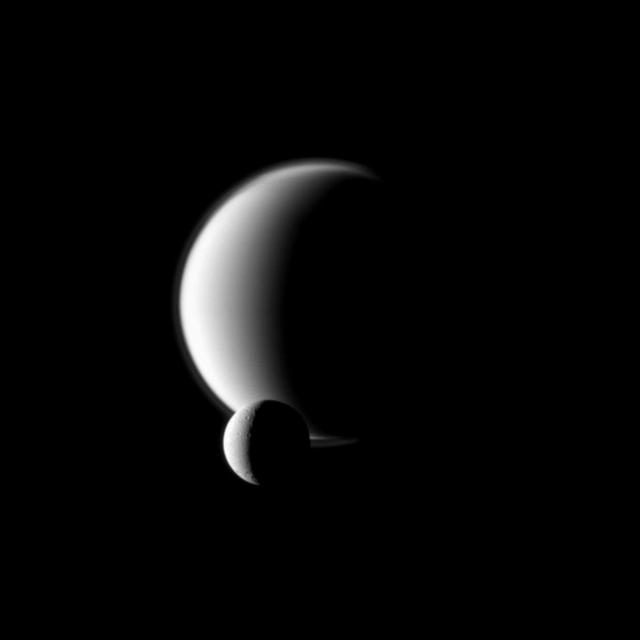
Saturn moon Dione coasts along in its orbit appearing in front of its parent planet in this view from NASA Cassini spacecraft. The wispy terrain on the trailing hemisphere of Dione can be seen on the left of the moon here.

LaRC aircraft in front of hangar, building 1244

This photo, taken onboard the Chilean Navy P3 aircraft, shows the ice front of Venable Ice Shelf, West Antarctica, in October 2008. It is an example of a small-size ice shelf that is a large melt water producer.

This before-and-after pair of images of the same patch of ground in front of NASA Mars Exploration Rover Opportunity 13 days apart documents the arrival of a bright rock onto the scene.
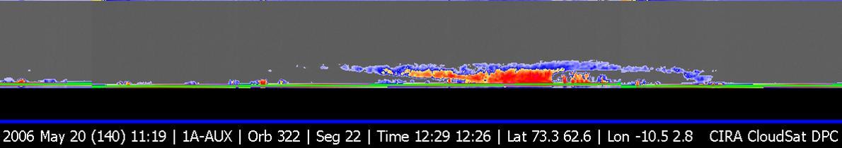
NASA CloudSat first image, of a warm front storm over the Norwegian Sea, was obtained on May 20, 2006.
This is a version of one of the first images taken by a front Hazard-Avoidance camera on NASA Curiosity rover. It was taken through a fisheye wide-angle lens but has been linearized so that the horizon looks flat rather than curved.

This is a version of one of the first images taken by a front Hazard-Avoidance camera on NASA Curiosity rover. It was taken through a fisheye wide-angle lens but has been linearized so that the horizon looks flat rather than curved.

This frame taken from a three-frame animation aids evaluation of performance of the right-front wheel on NASA Mars Exploration Rover Spirit during a drive on the rover 2,117th Martian day, or sol Dec. 16, 2009.
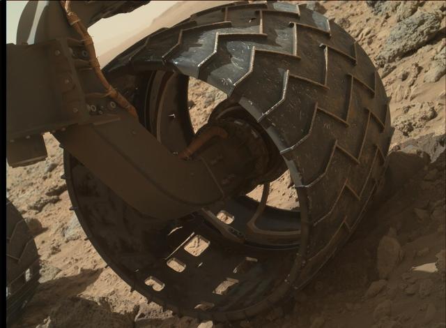
The left-front wheel of NASA Curiosity Mars rover shows dents and holes in this image taken by the MAHLI camera, which is mounted at the end of Curiosity robotic arm.

The larger of the two moons of Mars, Phobos, passes in front of the Sun face in this image from NASA Mars Exploration Rover Opportunity. A movie is available at the Photojournal.
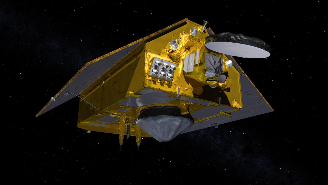
This illustration shows the front of the Sentinel-6 Michael Freilich spacecraft in orbit above Earth with its deployable solar panels extended. As the world's latest ocean-monitoring satellite, it is launching on Nov. 10, 2020, to collect the most accurate data yet on global sea level and how our oceans are rising in response to climate change. The mission will also collect precise data of atmospheric temperature and humidity that will help improve weather forecasts and climate models. The conelike instrument on the bottom (Earth-facing side) of the spacecraft is the satellite's Poseidon-4 radar altimeter. The disklike instrument at the front of the spacecraft is the Advanced Microwave Radiometer (AMR-C). Both instruments will be used together to measure ocean surface height. The gray rectangle with six cones attached at the front-left of the spacecraft is part of the Global Navigation Satellite System - Radio Occultation (GNSS-RO) instrument. Sentinel-6 Michael Freilich extends the near-30-year record of satellite measurements of sea level initiated by the U.S.-European TOPEX/Poseidon mission in 1992 and that continued with the Jason-1, 2, and 3 series of sea level observation satellites. Launched in 2016, Jason-3 is currently providing data. The satellite is named after Dr. Michael Freilich, the former director of NASA's Earth Science Division and an instrumental figure in advancing ocean observations from space. Sentinel-6 Michael Freilich is one of two identical spacecraft that compose the Sentinel-6/Jason-CS (Continuity of Service) mission developed in partnership with ESA (the European Space Agency). Other partners include the National Oceanic and Atmospheric Administration (NOAA), the intergovernmental European Organisation for the Exploitation of Meteorological Satellites (EUMETSAT), and France's National Centre for Space Studies (CNES). ESA is developing the new Sentinel family of missions to support the operational needs of the European Union's Copernicus program, the EU's Earth observation program managed by the European Commission. The spacecraft's twin, Sentinel-6B, will launch in 2025. https://photojournal.jpl.nasa.gov/catalog/PIA24106
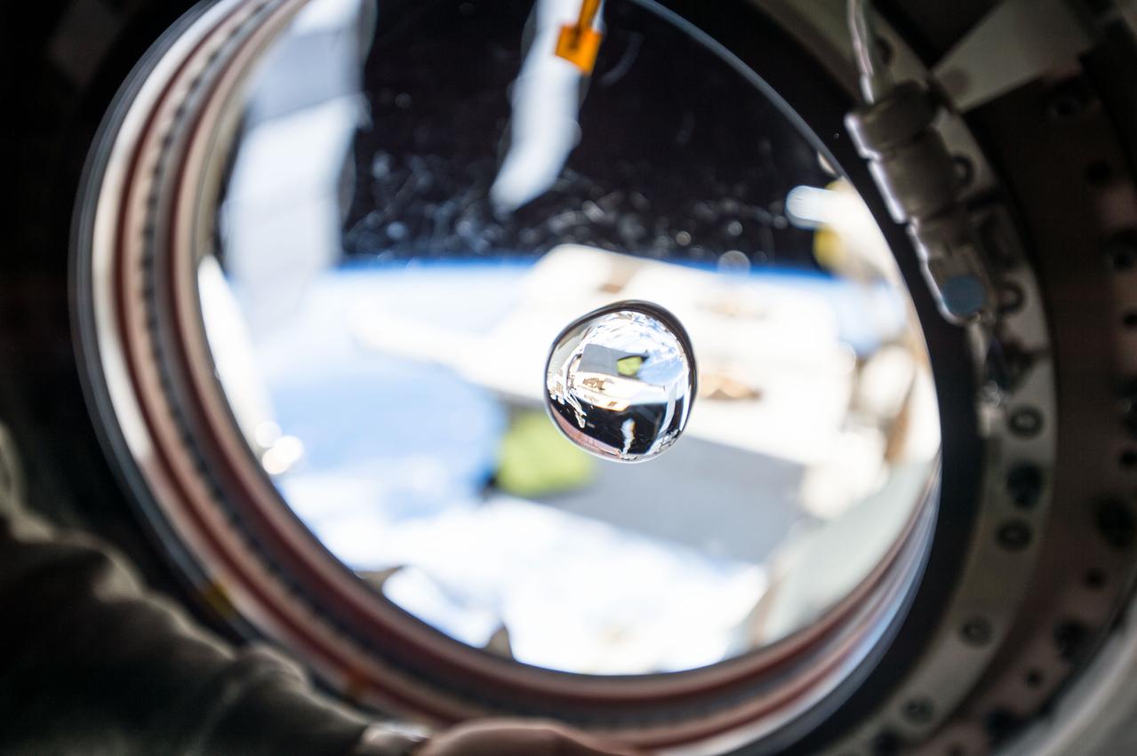
View of water bubble formed in front of the Japanese Experiment Module (JEM) window. The JEM Exposed Facility (JEF) is visible in the background through the window and reflected in the water. Scratches visible on the window.
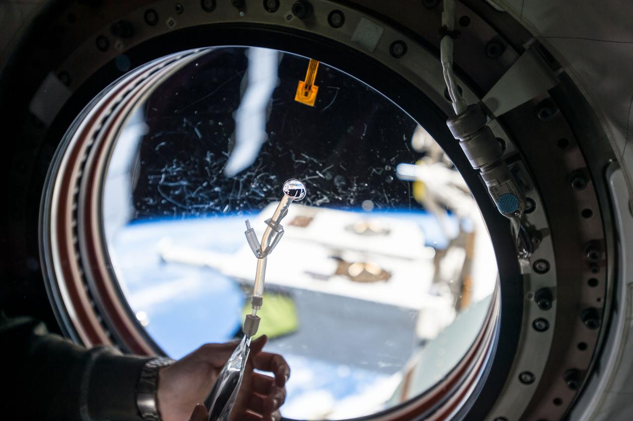
View of water bubble formed in front of the Japanese Experiment Module (JEM) window. The JEM Exposed Facility (JEF) is visible in the background through the window and reflected in the water. Scratches visible on the window.
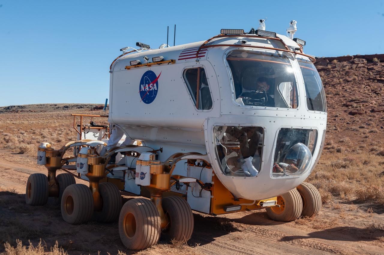
A front view of the Lunar Electric Rover (LER) during the Desert Research and Technology Studies (RATS) remote field test at Black Point Lava Flow, Arizona in 2008.
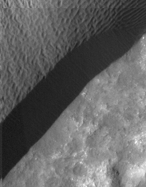
A rippled dune front in Herschel Crater on Mars moved an average of about one meter about one yard between March 3, 2007 and December 1, 2010, as seen in one of two images from NASA Mars Reconnaissance Orbiter.
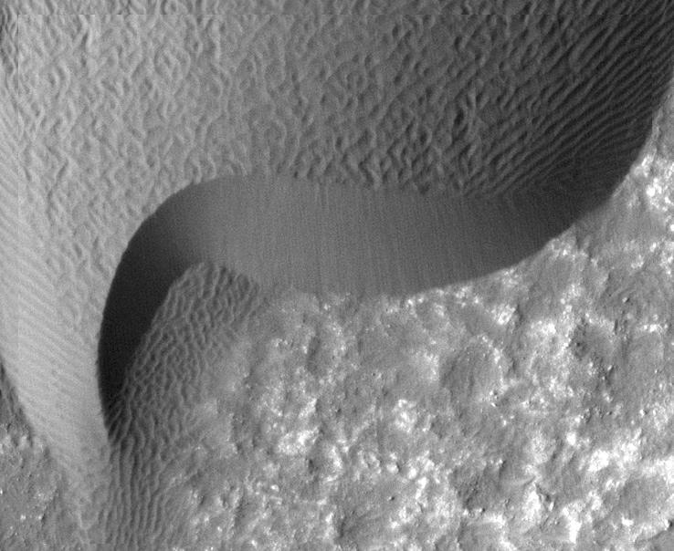
A rippled dune front in Herschel Crater on Mars moved an average of about two meters about two yards between March 3, 2007 and December 1, 2010, as seen in one of two images from NASA Mars Reconnaissance Orbiter.
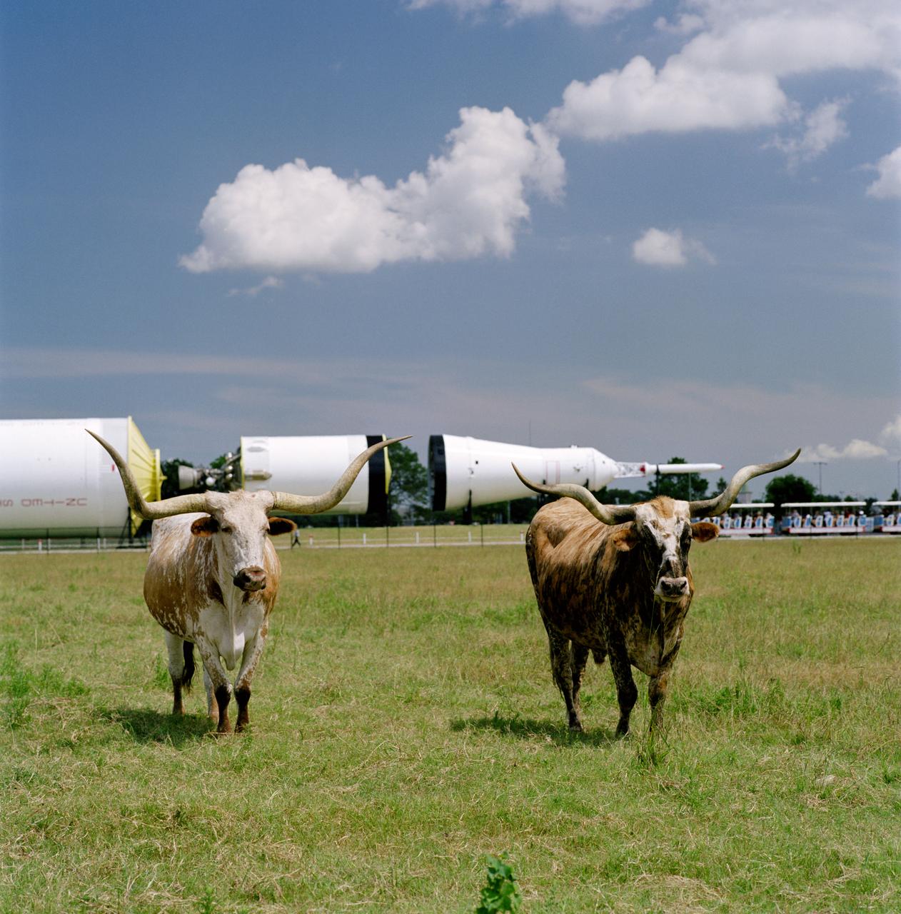
Photographic documentation showing longhorn cattle which belong to the Longhorn Project in front of the Saturn V in JSC's Rocket Park.
Diagnostic tests were run on the right-rear wheel and right-front wheel on NASA Spirit. The right-rear wheel continued to show no motion in the latest tests and exhibited very high resistance in the motor winding.
This NASA Spirit image view is toward the north, looking down at Spirit front wheels. It is one of a series of wide-angle views shown one after the other. Go to the Photojournal to view the animation.
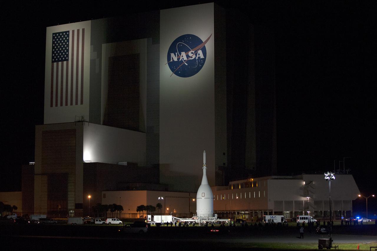
At NASA's Kennedy Space Center in Florida, the agency's Orion spacecraft pauses in front of the spaceport's iconic Vehicle Assembly Building as it is transported to Launch Complex 37 at Cape Canaveral Air Force Station on Nov. 11, 2014. After arrival at the launch pad, United Launch Alliance engineers and technicians lifted Orion and mounted it atop its Delta IV Heavy rocket. Part of Batch image transfer from Flickr.
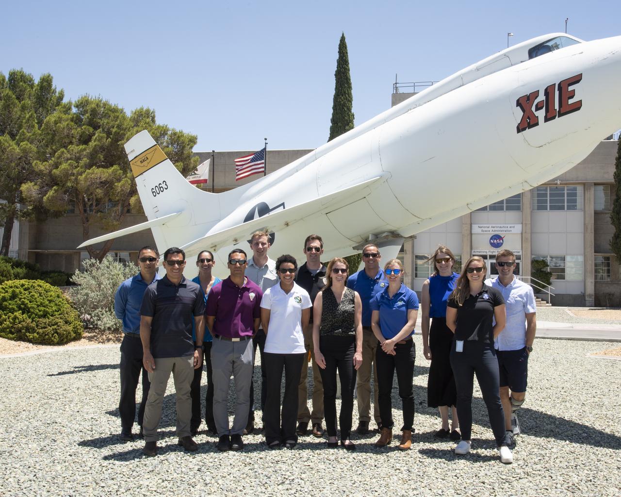
NASA's 2017 astronaut candidates, (L to R) Jonny Kim, Frank Rubio, Jasmin Moghbeli, Raja Chari, Woody Hoburg, Jessica Watkins, Joshua Kutryk, Loral O'Hara, Bob Hines, Zena Cardman, Kayla Barron, Jenni Sidey-Gibbons, Matthew Dominick pose in front of X-1E at the end of their visit to Armstrong Flight Research Center, in Southern California.
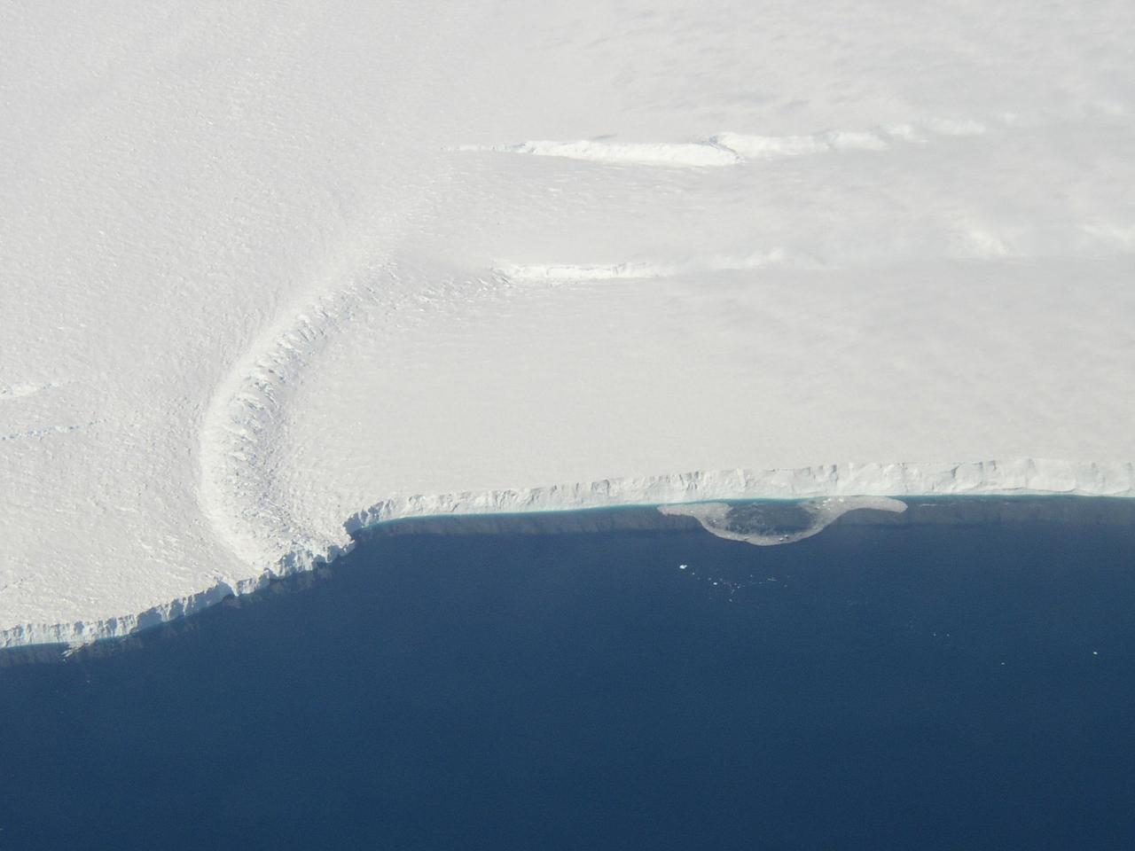
This photo shows the ice front of the ice shelf in front of Pine Island Glacier, a major glacier system of West Antarctica.
This image is a 3-D view in front of NASA Curiosity rover. Mount Sharp is visible rising above the terrain, though in one eye a box on the rover holding the drill bits obscures the view.
This movie is made from images taken by the Mars Perseverance rover's Front Left Hazard Avoidance Camera between Sol 13 (March 4, 2021) and Sol 708 (Feb. 16, 2023), during the first two years of the rover's surface mission. The Mars 2020 Perseverance mission is part of NASA's Moon to Mars exploration approach, which includes Artemis missions to the Moon that will help prepare for human exploration of the Red Planet. Movie available at https://photojournal.jpl.nasa.gov/catalog/PIA25799

(from left to right), Quesst Mission Integration Manager Peter Coen, Chief Engineer Jay Brandon, Low Boom Flight Demonstrator Project Manager Cathy Bahm, and Structures Lead Dr. Walt Silva pose in front of the agency’s X-59 quiet supersonic research aircraft at a January 12, 2024 event at Lockheed Martin Skunk Works in Palmdale, California. The X-59 is the centerpiece of NASA’s Quesst mission, which seeks to solve one of the major barriers to supersonic flight over land, currently banned in the United States, by making sonic booms quieter.

Artemis Flag Flys in Front of the Glenn Research Center Administration Building
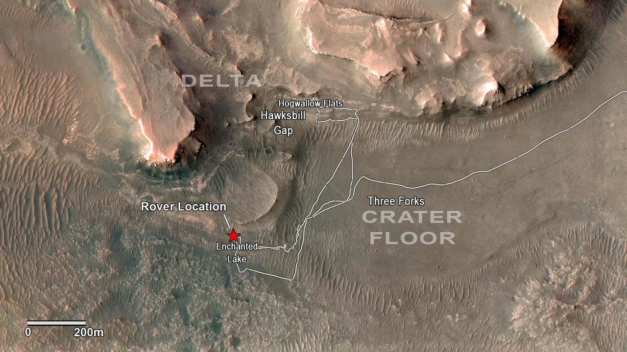
NASA's Perseverance rover has been investigating rocks at the front of the delta in Mars' Jezero Crater along the path indicated in this annotated image taken by the agency's Mars Reconnaissance Orbiter (MRO). The red star indicates the location of the rover in September 2022. Perseverance touched down at "Octavia E. Butler Landing" on the floor of Jezero Crater on Feb. 18, 2021. It reached the delta in April 2022. The delta is a fan-shaped feature where, billions of years ago, a river flowed into a lake and deposited rocks and sediments. Scientists consider the delta one of the best places on Mars to search for potential signs of ancient microbial life. The annotations show the names of some of the key features Perseverance visited, such as "Enchanted Lake" and "Hogwallow Flats." Sample tubes already filled with rock are currently stored in the rover's Sampling and Caching System. Perseverance will deposit select samples in designated locations. MRO took this overhead image with its High Resolution Imaging Science Experiment (HiRISE) camera. A key objective for Perseverance's mission on Mars is astrobiology, including the search for signs of ancient microbial life. The rover will characterize the planet's geology and past climate, pave the way for human exploration of the Red Planet, and be the first mission to collect and cache Martian rock and regolith (broken rock and dust). Subsequent NASA missions, in cooperation with ESA (European Space Agency), would send spacecraft to Mars to collect these sealed samples from the surface and return them to Earth for in-depth analysis. The Mars 2020 Perseverance mission is part of NASA's Moon to Mars exploration approach, which includes Artemis missions to the Moon that will help prepare for human exploration of the Red Planet. https://photojournal.jpl.nasa.gov/catalog/PIA24923

Artist concept of the X-59 front view.
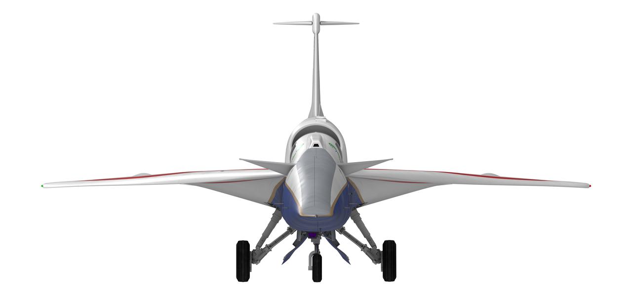
Artist concept of the X-59 front view.
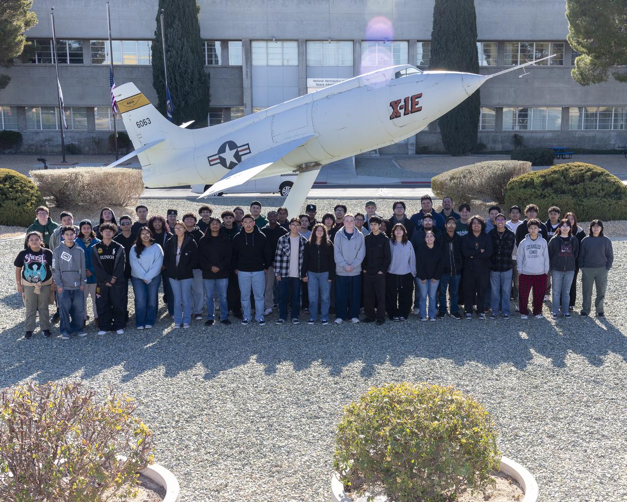
The engineering club from Palmdale High School in Palmdale, California, visits NASA’s Armstrong Research Flight Center in Edwards, California. The students took a group photo in front of the historic X-1E aircraft on display at the center.

Flowering Crab Apple Tree in full Bloom in front of the Propulsion Systems Laboratory, PSL Cooling Tower #6 on a Foggy Day in Early Spring

At the Gagarin Museum in the Gagarin Cosmonaut Training Center in Star City, Russia, Expedition 59 crewmembers Christina Koch of NASA (front, left), Alexey Ovchinin of Roscosmos (front, center) and Nick Hague of NASA (front, right) sign a ceremonial book Feb. 21 as part of their pre-launch activities as their backups in the back row, Drew Morgan of NASA, Alexander Skvortsov of Roscosmos and Luca Parmitano of the European Space Agency look on. Koch, Hague and Ovchinin will launch March 14, U.S. time, on the Soyuz MS-12 spacecraft from the Baikonur Cosmodrome in Kazakhstan for a six-and-a-half month mission on the International Space Station. Irina Spektor/Gagarin Cosmonaut Training Center

STS121-S-061 (17 July 2006) --- The STS-121 crew addresses greeters in front of the Space Shuttle Discovery near the landing facility at Kennedy Space Center following NASA's second Return to Flight mission. From left to right are astronauts Piers J. Sellers, Stephanie D. Wilson, Mark E. Kelly, Steven W. Lindsey, Lisa M. Nowak and Michael E. Fossum.
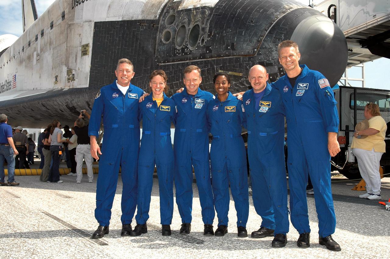
STS121-S-059 (17 July 2006) --- The STS-121 crew poses in front of the Space Shuttle Discovery near the landing facility at Kennedy Space Center following NASA's second Return to Flight mission. From left to right are astronauts Michael E. Fossum, Lisa M. Nowak, Steven W. Lindsey, Stephanie D. Wilson, Mark E. Kelly and Piers J. Sellers.

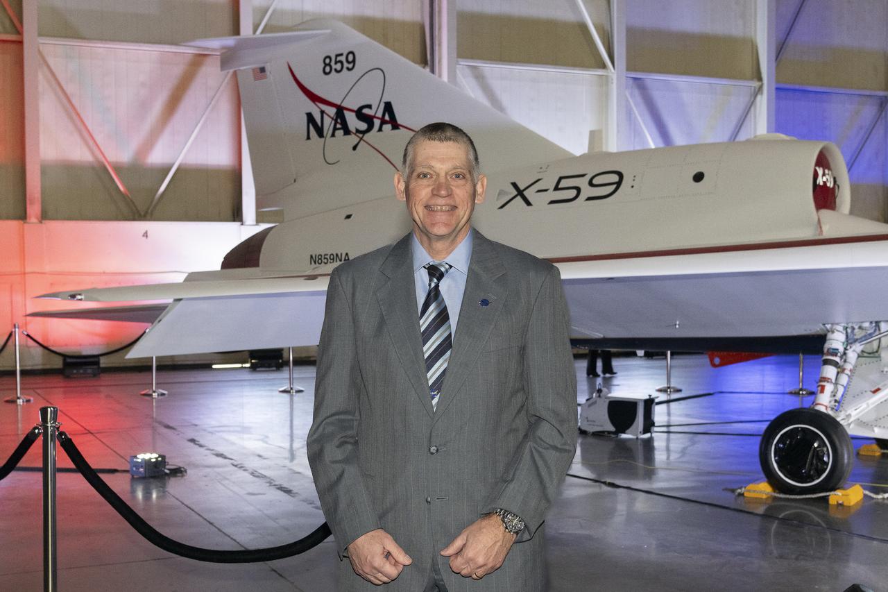
NASA’s structures lead for the X-59, Dr. Walt Silva, poses in front of the agency’s X-59 quiet supersonic research aircraft at a January 12, 2024 event at Lockheed Martin Skunk Works in Palmdale, California. The X-59 is the centerpiece of NASA’s Quesst mission, which seeks to solve one of the major barriers to supersonic flight over land, currently banned in the United States, by making sonic booms quieter.
NASA’s chief engineer for the Low Boom Flight Demonstrator project, Jay Brandon, poses in front of the agency’s X-59 quiet supersonic research aircraft at a January 12, 2024 event at Lockheed Martin Skunk Works in Palmdale, California. The X-59 is the centerpiece of NASA’s Quesst mission, which seeks to solve one of the major barriers to supersonic flight over land, currently banned in the United States, by making sonic booms quieter.
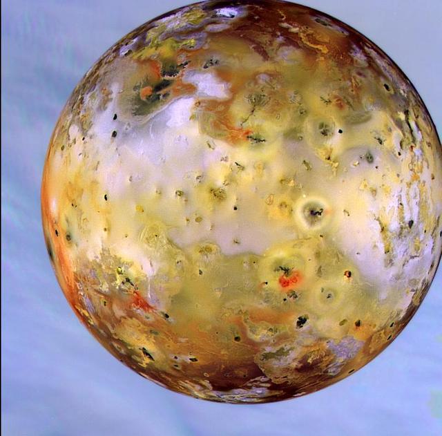
This photograph of the southern hemisphere of Jupiter was obtained by Voyager 2 on June 25, 1979, at a distance of 12 million kilometers (8 million miles). The Voyager spacecraft is rapidly nearing the giant planet, with closest approach to occur at 4:23 pm PDT on July 9. Seen in front of the turbulent clouds of the planet is Io, the innermost of the large Galilean satellites of Jupiter. Io is the size of our moon. Voyager discovered in early March that Io is the most volcanically active planetary body known in the solar system, with continuous eruptions much larger than any that take place on the Earth. The red, orange, and yellow colors of Io are thought to be deposits of sulfur and sulfur compounds produced in these eruptions. The smallest features in either Jupiter or Io that can be distinguished in this picture are about 200 kilometers (125 miles) across; this resolution, it is not yet possible to identify individual volcanic eruptions. Monitoring of the erupture activity of Io by Voyager 2 will begin about July 5 and will extend past the encounter July 9. http://photojournal.jpl.nasa.gov/catalog/PIA00371
jsc2024e050146 (May 13, 2024) --- NASA's Crew-9 members stand in front of NASA’s worm logo on the launch tower at Launch Complex 39A at NASA's Kennedy Space Center in Florida. From left are, Mission Spedialist Alexsandr Gorbunov from Roscosmos; Pilot Nick Hague from NASA; Commander Zena Cardman from NASA; and Mission Specialist Stephanie Wilson from NASA. Credit: SpaceX
S104-E-5078 (15 July 2001) --- Cosmonaut Yury V. Usachev, Expedition Two mission commander, and Janet L. Kavandi, STS-104 mission specialist, pose in front of the crewlock endcone of the newly installed Quest Airlock. Usachev represents Rosaviakosmos.
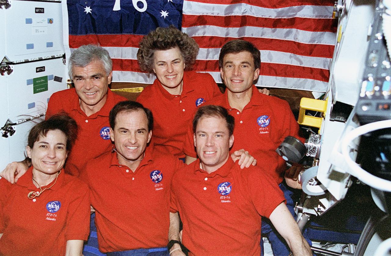
STS076-371-002 (25 March 1996) --- The crew of the Space Shuttle Atlantis poses for a traditional inflight portrait on the mid deck. Shannon W. Lucid (rear center) later joined the Mir-21 crew to begin the first leg of her five-month stay aboard Russia's Mir Space Station. From the left on front row are astronauts Linda M. Godwin, mission specialist; Kevin P. Chilton, mission commander; and Richard A. Searfoss, pilot. Left to right on the back row are astronauts Michael R. (Rich) Clifford, Lucid and payload commander Ronald M. Sega, all mission specialists.
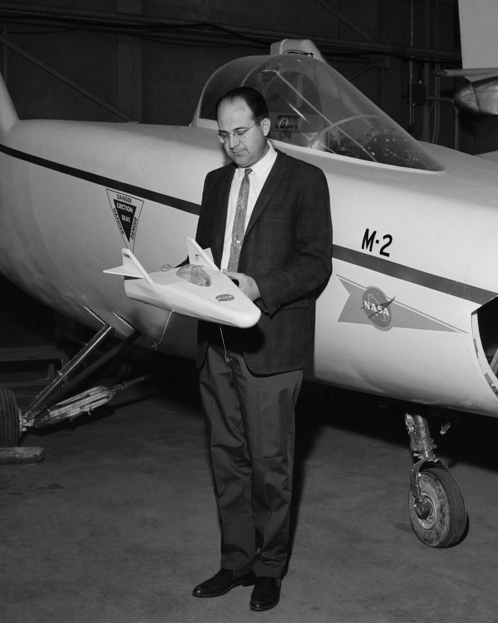
Dale Reed with a model of the M2-F1 in front of the actual lifting body. Reed used the model to show the potential of the lifting bodies. He first flew it into tall grass to test stability and trim, then hand-launched it from buildings for longer flights. Finally, he towed the lifting-body model aloft using a powered model airplane known as the "Mothership." A timer released the model and it glided to a landing. Dale's wife Donna used a 9 mm. camera to film the flights of the model. Its stability as it glided--despite its lack of wings--convinced Milt Thompson and some Flight Research Center engineers including the center director, Paul Bikle, that a piloted lifting body was possible.

(from left to right) NASA Associate Administrator Jim Free, California Senior Economic Advisor to the Governor Dee Dee Myers, Lockheed Martin Executive Vice President of Aeronautics Greg Ulmer, NASA Deputy Administrator Pam Melroy, Low Boom Flight Demonstrator Project Manager Cathy Bahm, Lockheed Martin X-59 Project Manager David Richardson, Lockheed Martin Skunk Works Vice President and General Manager John Clark, and NASA Associate Administrator for the Aeronautics Research Mission Directorate Bob Pearce pose in front of the agency’s X-59 quiet supersonic research aircraft at a January 12, 2024 event at Lockheed Martin Skunk Works in Palmdale, California. The X-59 is the centerpiece of NASA’s Quesst mission, which seeks to solve one of the major barriers to supersonic flight over land, currently banned in the United States, by making sonic booms quieter.
Saturn moon Rhea passes in front of Dione, as seen from NASA Cassini spacecraft. These images are part of a mutual event sequence in which one moon passes close to, or in front of, another.
The twin rovers sit side-by-side in different stages of deployment. NASA Rover 2 left front wheels are stowed, while NASA Rover 1 front wheels are deployed.
NASA Cassini spacecraft captures a mutual event between Titan and Mimas in front of a backdrop of the planet rings. This image was snapped shortly before Saturn largest moon passed in front of and occulted the small moon Mimas.

This view of the lower front and underbelly areas of NASA Mars rover Curiosity was taken by the rover MAHLI camera during Sept. 9, 2012. Also visible are the hazard avoidance cameras on the front of the rover.
Saturn moon Dione passes in front of the larger moon Titan, as seen from NASA Cassini spacecraft. This image is part of a mutual event sequence in which one moon passes close to or in front of another.
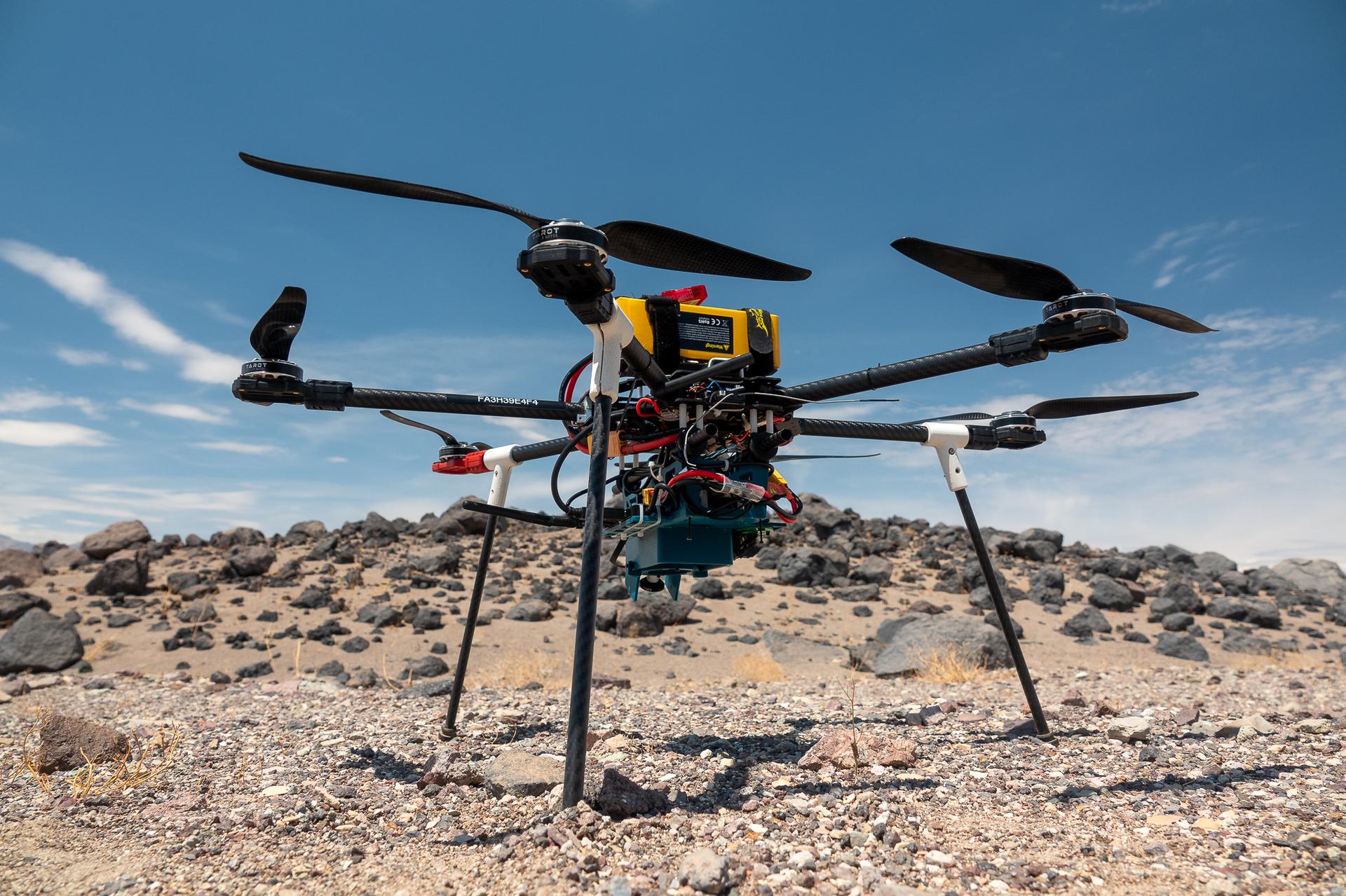
This is one of three research drones that NASA’s Jet Propulsion Laboratory in Southern California used in September 2025 to test navigation software that could be used by future rotorcraft on Mars. The drone is sitting in front of a location within Death Valley National Park called Mars Hill, which is littered with rubbly volcanic rocks and has been used by NASA’s Mars researchers since the 1970s, during preparations for the Viking lander missions. The work was among 25 projects funded by NASA’s Mars Exploration Program this past year to push the limits of future technologies. Sand dunes confused the navigation algorithm of the Ingenuity Mars helicopter during several of its last flights, including its 72nd and final flight on the Red Planet in January 2024. The navigation software in development would help future rotorcraft to track the surface of especially bland, featureless terrain similar to the barren sand dunes seen in parts of Death Valley and to land safely in cluttered environments like Mars Hill.
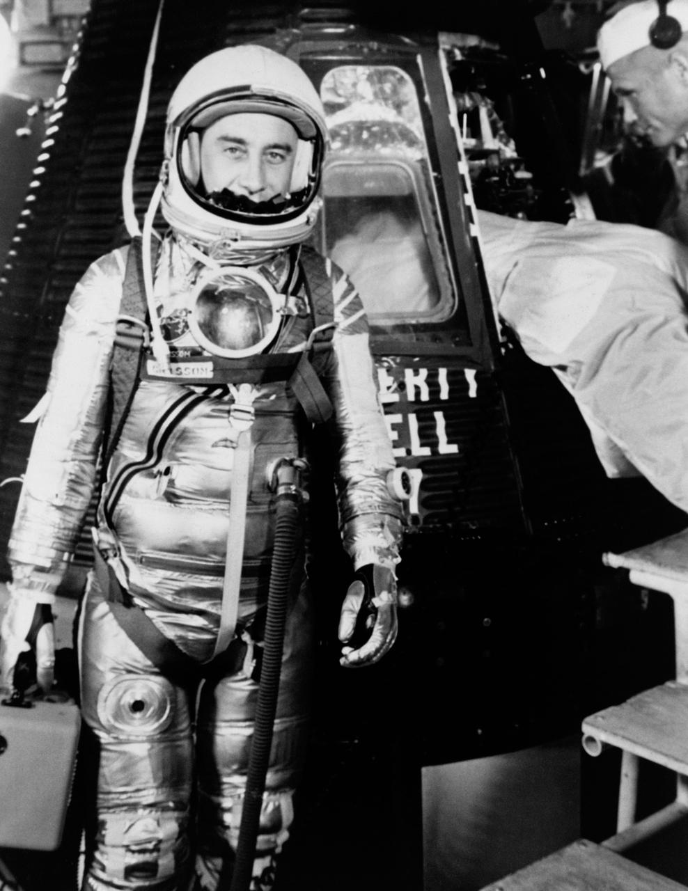
S61-02888 (1961) --- Astronaut Virgil I. (Gus) Grissom, suited up and ready to climb into Liberty Bell 7 spacecraft, stands in front of the capsule for a picture. Backup pilot John Glenn is in the right corner of the view behind Grissom. The Mercury-Redstone 4 (MR-4) mission was scrubbed a few hours later due to unfavorable weather over the launch pad. Photo credit: NASA

iss066e155896 (3/1/2022) --- DreamStar dolls float in front of Astrobee and Minus Eighty Laboratory Freezer for ISS (MELFI) aboard the International Space Station. The DreamStar science, technology, engineering, and mathematics (STEM) education project creates videos and educational materials highlighting women in space and reinforcing the message, “if you can see it, you can be it.”

S61-03698 (1961) --- Astronaut Virgil I. (Gus) Grissom, suited up and ready to climb into Liberty Bell 7 spacecraft, sits in front of his capsule for a picture. Behind him technicians work inside the capsule. The Mercury-Redstone 4 (MR-4) mission was scrubbed a few hours later due to unfavorable weather over the launch pad. Photo credit: NASA

NASA’s project manager for the Low Boom Flight Demonstrator project, Cathy Bahm, poses in front of the agency’s X-59 quiet supersonic research aircraft at a January 12, 2024 event at Lockheed Martin Skunk Works in Palmdale, California. The X-59 is the centerpiece of NASA’s Quesst mission, which seeks to solve one of the major barriers to supersonic flight over land, currently banned in the United States, by making sonic booms quieter.

NASA’s mission integration manager for the Quesst mission, Peter Coen, poses in front of the agency’s X-59 quiet supersonic research aircraft at a January 12, 2024 event at Lockheed Martin Skunk Works in Palmdale, California. The X-59 is the centerpiece of NASA’s Quesst mission, which seeks to solve one of the major barriers to supersonic flight over land, currently banned in the United States, by making sonic booms quieter.

iss066e155892 (3/1/2022) --- DreamStar dolls float in front of Astrobee and Minus Eighty Laboratory Freezer for ISS (MELFI) aboard the International Space Station. The DreamStar science, technology, engineering, and mathematics (STEM) education project creates videos and educational materials highlighting women in space and reinforcing the message, “if you can see it, you can be it.”
iss073e0606547 (Sept. 4, 2025) --- NASA astronaut and Expedition 73 Flight Engineer Mike Fincke poses for a portrait in front of the Microgravity Science Glovebox (MSG) inside the International Space Station’s Destiny laboratory. Fincke installed the Colloidal Solids research hardware in the MSG to explore pharmaceutical manufacturing and 3D printing techniques in microgravity—research that could advance human health both in space and on Earth.
These clouds formed in the south polar region. The faintness of the cloud system likely indicates that these are mainly ice clouds, with relatively little dust content
This image from NASA 2001 Mars Odyssey captures storm clouds that are moving towards the crater in the bottom of this image. Storms like this are common during the spring and early summer near the north pole.
This image shows the edge of a storm
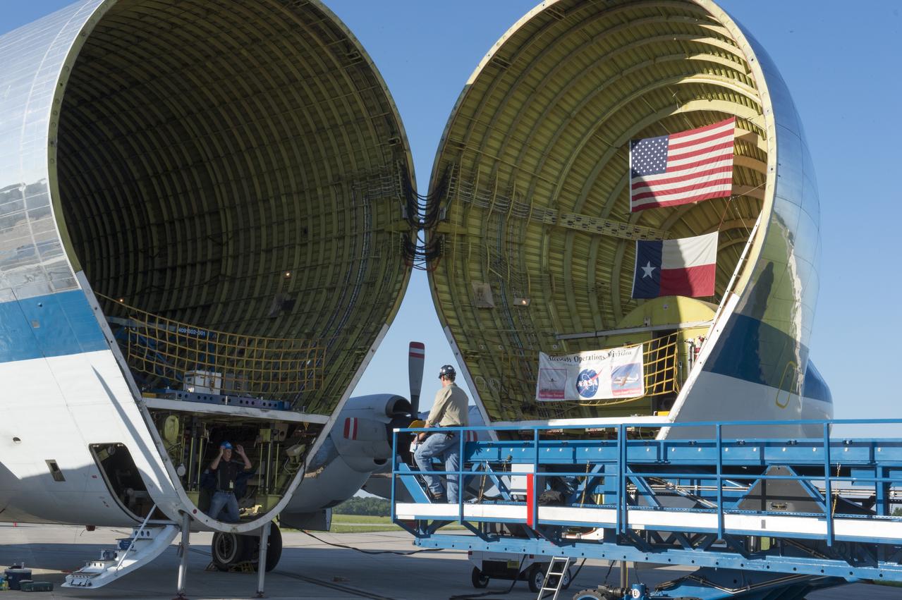
The platform which will be used to load the Orion stage adapter is shown being positioned in front of NASA's Super Guppie. After being tested at Marshall Space Flight Center the stage adapter will be flown to Denver, Colorado for further testing.
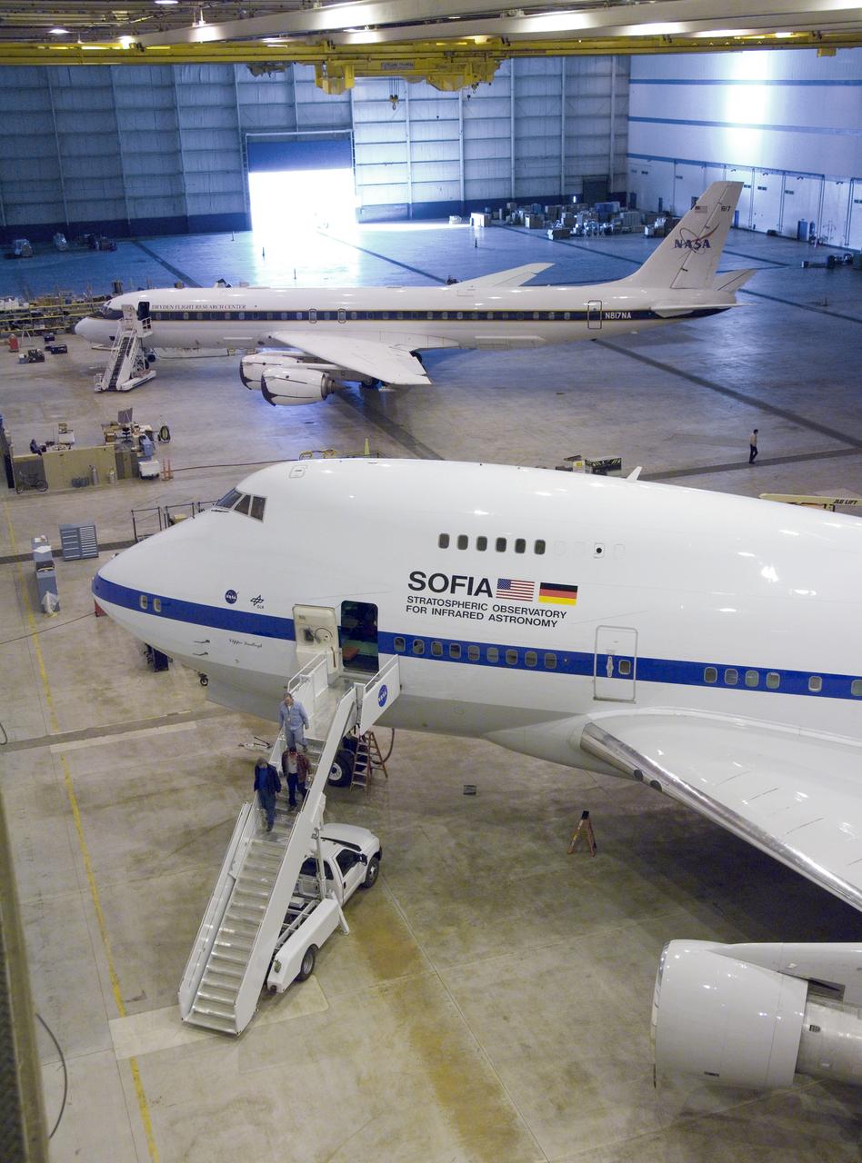
NASA'S SOFIA infrared observatory 747SP (front) and DC-8 flying laboratory (rear) are now housed at the Dryden Aircraft Operations Facility in Palmdale, Calif.
AS16-116-18607 (23 April 1972) --- Astronaut Charles M. Duke Jr. works at the front of the Lunar Roving Vehicle (LRV) parked in this rock field at a North Ray Crater geological site during the mission's third extravehicular activity (EVA) on April 23, 1972. Astronaut John W. Young took this picture with a 70mm Hasselblad camera. While astronauts Young, commander; and Duke, lunar module pilot; descended in the Apollo 16 Lunar Module (LM) "Orion" to explore the Descartes highlands landing site on the moon, astronaut Thomas K. Mattingly II, command module pilot, remained with the Command and Service Modules (CSM) "Casper" in lunar orbit.
S89-47966 (23 Oct. 1989) --- STS-36 crew members, wearing launch and entry suits, take a break from their emergency egress training to pose for an informal crew portrait in front of the Crew Compartment Trainer (CCT) at the Johnson Space Center. Left to right are Pilot John H. Casper, Commander John O. Creighton, Mission Specialists Pierre J. Thuot, Richard M. Mullane and David C. Hilmers. The crew members were practicing egress procedures necessary in the event of an emergency aboard the space shuttle. The CCT is located in JSC's Space Vehicle Mock-up Facility. Photo credit: NASA
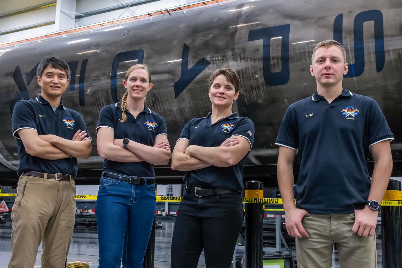
jsc2024e080752 (Nov. 18, 2024) --- NASA’s SpaceX Crew-10 members stand in front of a Falcon 9 first-stage booster at SpaceX’s HangarX facility at NASA's Kennedy Space Center in Florida. From left are Mission Specialist Takuya Onishi of JAXA (Japan Aerospace Exploration Agency), Commander Anne McClain of NASA, Pilot Nichole Ayers of NASA, and Mission Specialist Kirill Peskov of Roscosmos. Credit: SpaceX
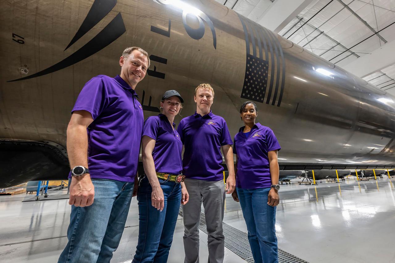
jsc2024e050140 (May 13, 2024) --- NASA’s SpaceX Crew-9 members stand in front of a Falcon 9 first-stage booster at SpaceX’s HangarX facility at NASA's Kennedy Space Center in Florida. From left are, Pilot Nick Hague from NASA; Commander Zena Cardman from NASA; Mission Spedialist Alexsandr Gorbunov from Roscosmos; and Mission Specialist Stephanie Wilson from NASA. Credit: SpaceX
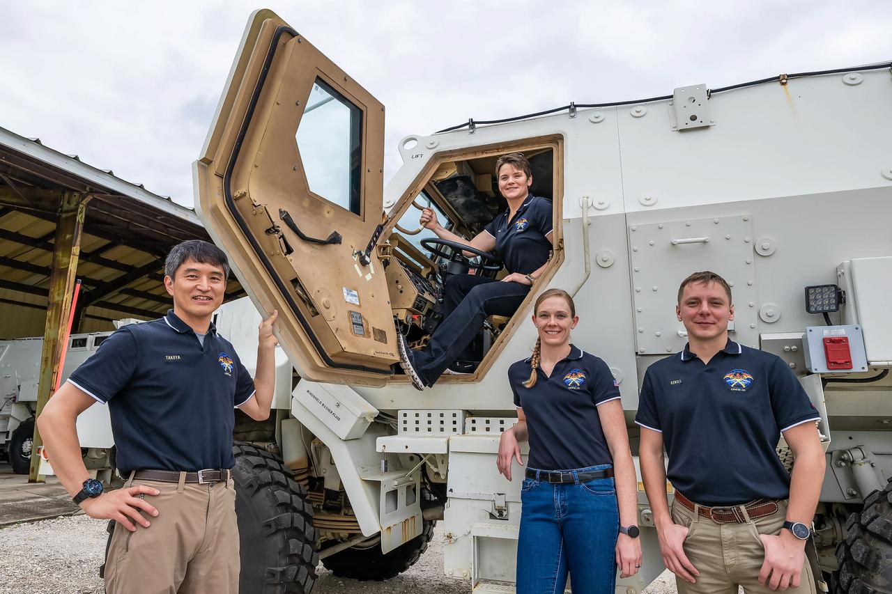
jsc2024e080753 (Nov. 18, 2024) --- NASA’s SpaceX Crew-10 members pose in front of their Mine Resistant Ambush Protected (MRAP) vehicle as part of their SpaceX crew training at Launch Complex 39A at NASA's Kennedy Space Center in Florida. From left are Mission Specialist Takuya Onishi of JAXA (Japan Aerospace Exploration Agency), Commander Anne McClain of NASA, Pilot Nichole Ayers of NASA, and Mission Specialist Kirill Peskov of Roscosmos. Credit: SpaceX

Members of past science missions pose together in front of the DC-8 aircraft’s left engine turbine at NASA’s Armstrong Flight Research Center Building 703 in Palmdale, California. From left are avionics lead Kelly Jellison, chemical scientist Katherine Ball, DC-8 Deputy Program Manager Kirsten Boogaard, and DC-8 safety engineer Garry Moors. On May 2, 2024, NASA personnel, friends, and family celebrated the DC-8 staff, aircraft, and science campaigns.

iss066e155976 (3/1/2022) --- DreamStar dolls float in front of the International Space Station’s cupola window. The DreamStar science, technology, engineering, and mathematics (STEM) education project creates videos and educational materials highlighting women in space and reinforcing the message, “if you can see it, you can be it.”

iss066e155927 (3/1/2022) --- DreamStar dolls float in front of the International Space Station’s cupola window. The DreamStar science, technology, engineering, and mathematics (STEM) education project creates videos and educational materials highlighting women in space and reinforcing the message, “if you can see it, you can be it.”

iss066e155956 (3/1/2022) --- DreamStar dolls float in front of the International Space Station’s cupola window. The DreamStar science, technology, engineering, and mathematics (STEM) education project creates videos and educational materials highlighting women in space and reinforcing the message, “if you can see it, you can be it.”