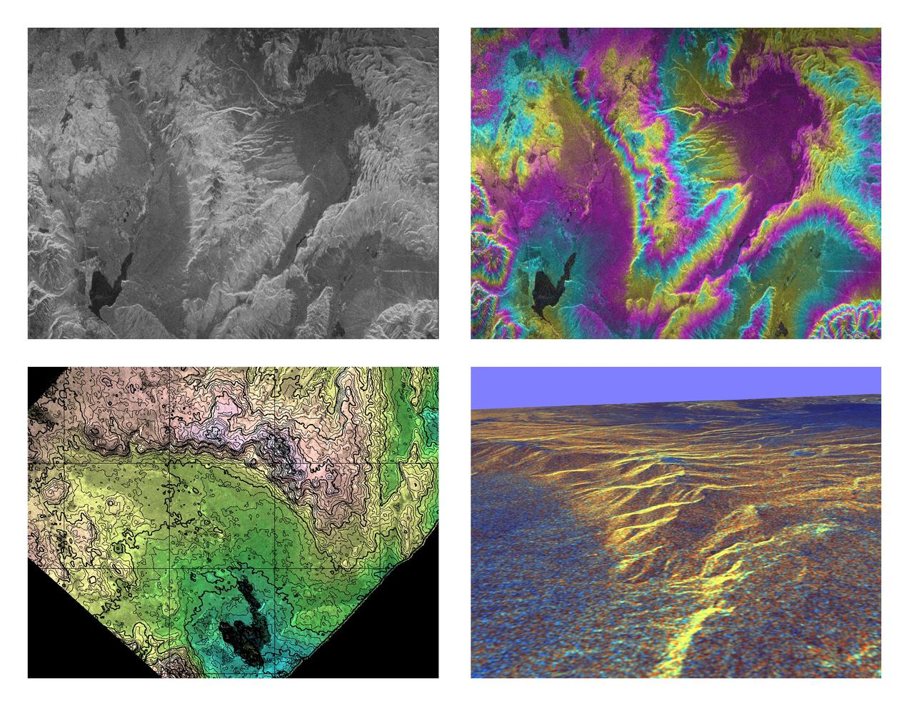
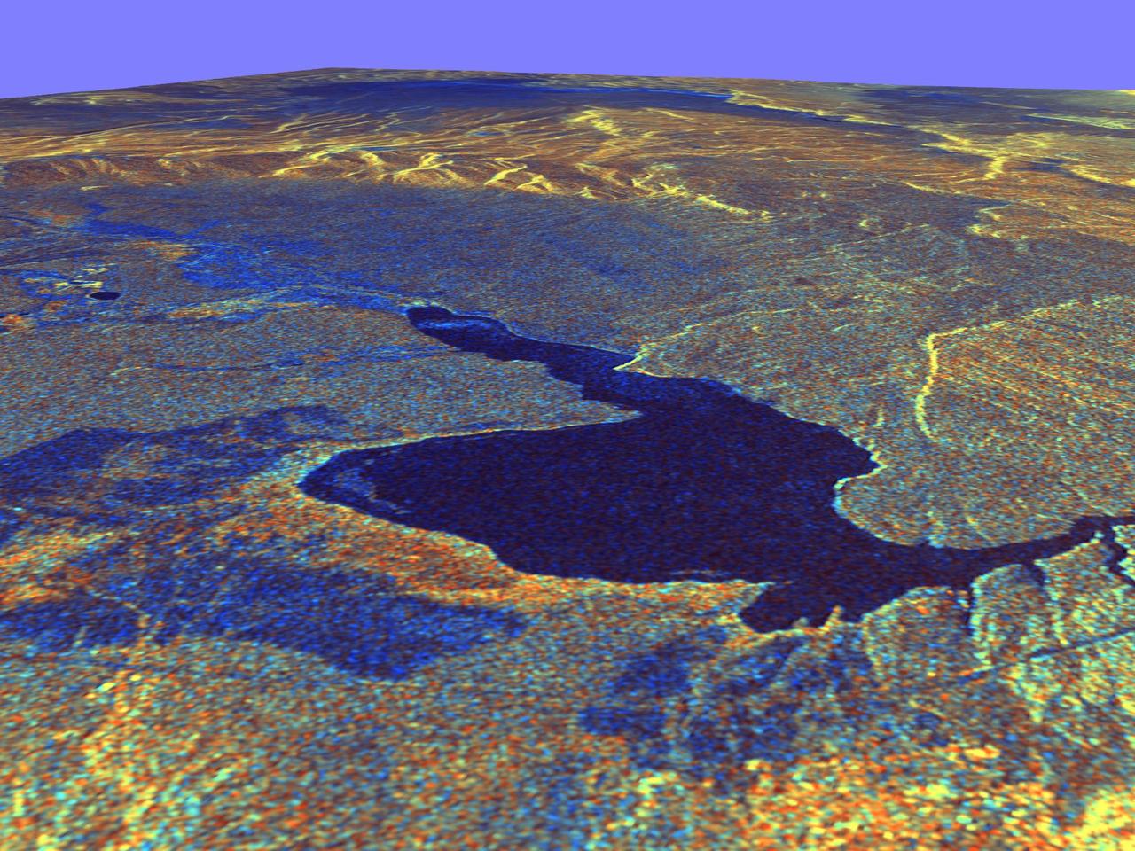
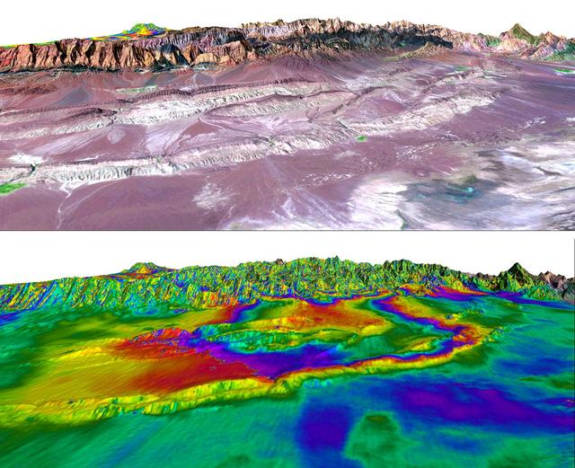
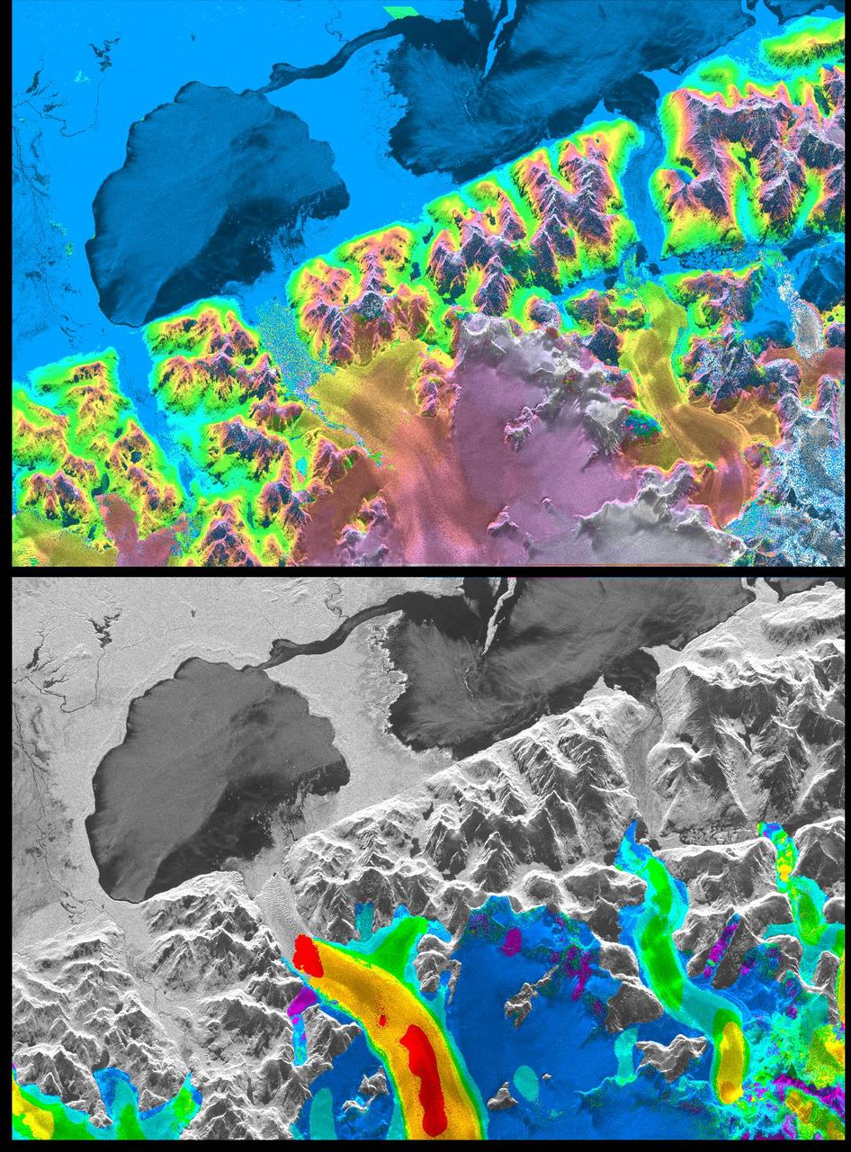
These four images of the Long Valley region of east-central California illustrate the steps required to produced three dimensional data and topographics maps from radar interferometry. All data displayed in these images were acquired by the Spaceborne Imaging Radar-C/X-band Synthetic Aperture Radar (SIR-C/X-SAR) aboard the space shuttle Endeavour during its two flights in April and October, 1994. The image in the upper left shows L-band (horizontally transmitted and received) SIR-C radar image data for an area 34 by 59 kilometers (21 by 37 miles). North is toward the upper right; the radar illumination is from the top of the image. The bright areas are hilly regions that contain exposed bedrock and pine forest. The darker gray areas are the relatively smooth, sparsely vegetated valley floors. The dark irregular patch near the lower left is Lake Crowley. The curving ridge that runs across the center of the image from top to bottom is the northeast rim of the Long Valley Caldera, a remnant crater from a massive volcanic eruption that occurred about 750,000 years ago. The image in the upper right is an interferogram of the same area, made by combining SIR-C L-band data from the April and October flights. The colors in this image represent the difference in the phase of the radar echoes obtained on the two flights. Variations in the phase difference are caused by elevation differences. Formation of continuous bands of phase differences, known as interferometric "fringes," is only possible if the two observations were acquired from nearly the same position in space. For these April and October data takes, the shuttle tracks were less than 100 meters (328 feet) apart. The image in the lower left shows a topographic map derived from the interferometric data. The colors represent increments of elevation, as do the thin black contour lines, which are spaced at 50-meter (164-foot) elevation intervals. Heavy contour lines show 250-meter intervals (820-foot). Total relief in this area is about 1,320 meters (4,330 feet). Brightness variations come from the radar image, which has been geometrically corrected to remove radar distortions and rotated to have north toward the top. The image in the lower right is a three-dimensional perspective view of the northeast rim of the Long Valley caldera, looking toward the northwest. SIR-C C-band radar image data are draped over topographic data derived from the interferometry processing. No vertical exaggeration has been applied. Combining topographic and radar image data allows scientists to examine relationships between geologic structures and landforms, and other properties of the land cover, such as soil type, vegetation distribution and hydrologic characteristics. http://photojournal.jpl.nasa.gov/catalog/PIA01770
This is a three-dimensional perspective view of Missoula, Montana, created by combining two spaceborne radar images using a technique known as interferometry.
This is a three-dimensional perspective view of Owens Valley, near the town of Bishop, California that was created by combining two spaceborne radar images using a technique known as interferometry.
This is a three-dimensional perspective view of Saline Valley, about 30 km 19 miles east of the town of Independence, California created by combining two spaceborne radar images using a technique known as interferometry.
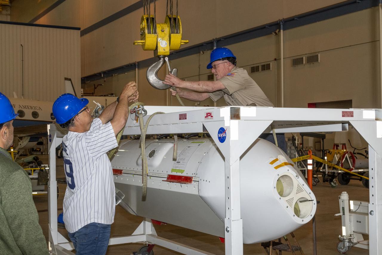
The Uninhabited Aerial Vehicle Synthetic Aperture Radar, UAVSAR, is prepared for installation onto NASA’s C-20A aircraft. THE UAVSAR uses a technique called interferometry to detect and measure very subtle deformations in the Earth’s surface, and the pod is specially designed to be interoperable with unmanned aircraft in the future. It will gather data from Gabon, Africa in September of 2023.
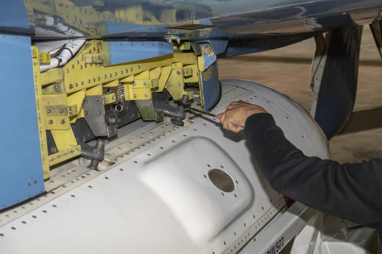
The Uninhabited Aerial Vehicle Synthetic Aperture Radar, UAVSAR, is prepared for installation onto NASA’s C-20A aircraft. THE UAVSAR uses a technique called interferometry to detect and measure very subtle deformations in the Earth’s surface, and the pod is specially designed to be interoperable with unmanned aircraft in the future. It will gather data from Gabon, Africa in September of 2023.
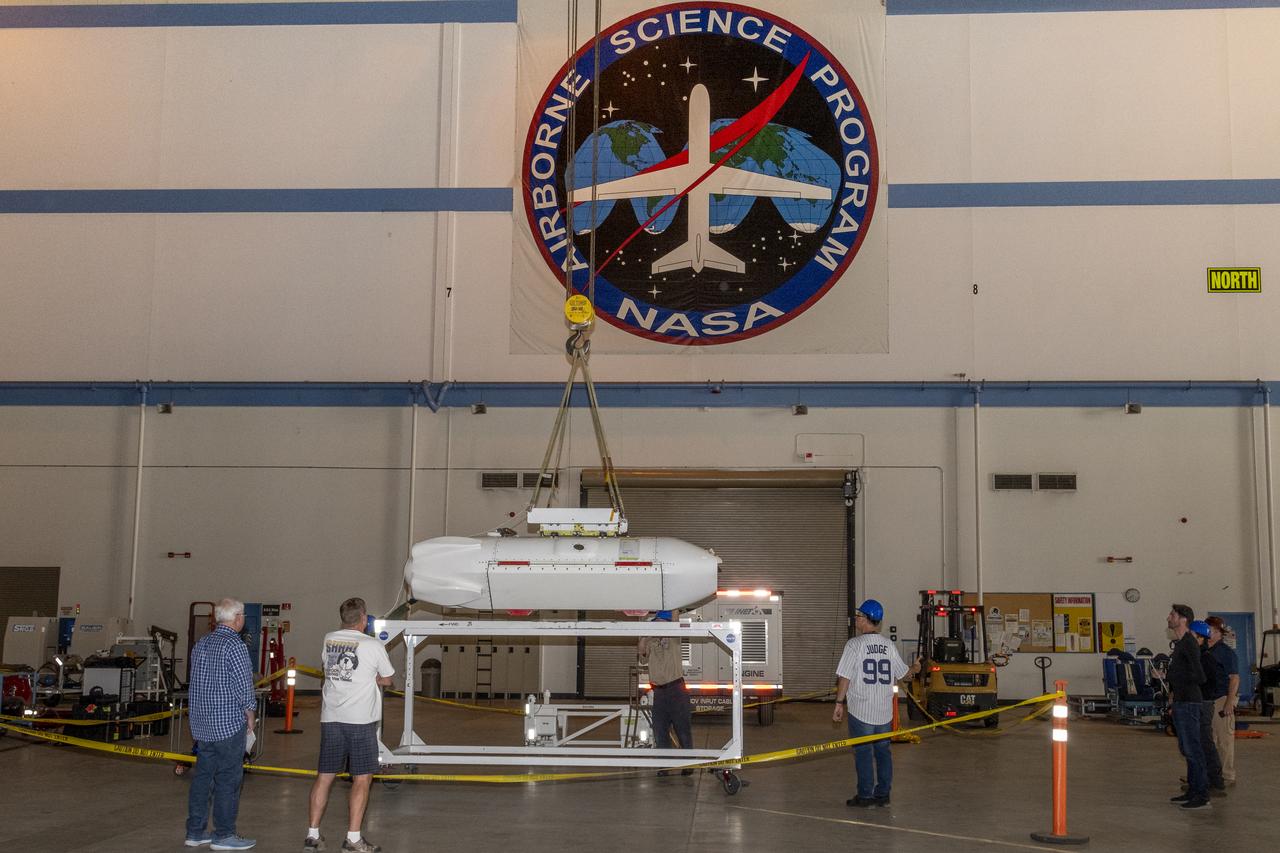
The Uninhabited Aerial Vehicle Synthetic Aperture Radar, UAVSAR, is prepared for installation onto NASA’s C-20A aircraft. THE UAVSAR uses a technique called interferometry to detect and measure very subtle deformations in the Earth’s surface, and the pod is specially designed to be interoperable with unmanned aircraft in the future. It will gather data from Gabon, Africa in September of 2023.

The Uninhabited Aerial Vehicle Synthetic Aperture Radar, UAVSAR, is prepared for installation onto NASA’s C-20A aircraft. THE UAVSAR uses a technique called interferometry to detect and measure very subtle deformations in the Earth’s surface, and the pod is specially designed to be interoperable with unmanned aircraft in the future. It will gather data from Gabon, Africa in September of 2023.
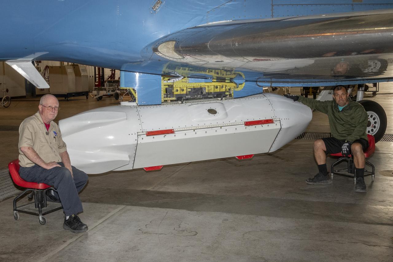
The Uninhabited Aerial Vehicle Synthetic Aperture Radar, UAVSAR, is prepared for installation onto NASA’s C-20A aircraft. THE UAVSAR uses a technique called interferometry to detect and measure very subtle deformations in the Earth’s surface, and the pod is specially designed to be interoperable with unmanned aircraft in the future. It will gather data from Gabon, Africa in September of 2023.

Dr. Mark Kasevich, Professor of Physics and Applied Physics at Stanford University presents a Director's Colloquium to Ames staff on 'Atom Interferometry'
Dr. Mark Kasevich, Professor of Physics and Applied Physics at Stanford University presents a Director's Colloquium to Ames staff on 'Atom Interferometry'
Dr. Mark Kasevich, Professor of Physics and Applied Physics at Stanford University presents a Director's Colloquium to Ames staff on 'Atom Interferometry'
A magnitude 6.5 earthquake devastated the small city of Bam in southeast Iran on December 26, 2003. The two images from ESA Envisat show similar measures of the radar interferometric correlation in grayscale on the left and in false colors on the right.
This X-band image of the volcano Kilauea was taken on October 4, 1994, by the Spaceborne Imaging Radar-C/X-band Synthetic Aperture Radar. The area shown is about 9 kilometers by 13 kilometers (5.5 miles by 8 miles) and is centered at about 19.58 degrees north latitude and 155.55 degrees west longitude. This image and a similar image taken during the first flight of the radar instrument on April 13, 1994 were combined to produce the topographic information by means of an interferometric process. This is a process by which radar data acquired on different passes of the space shuttle is overlaid to obtain elevation information. Three additional images are provided showing an overlay of radar data with interferometric fringes; a three-dimensional image based on altitude lines; and, finally, a topographic view of the region. http://photojournal.jpl.nasa.gov/catalog/PIA01763
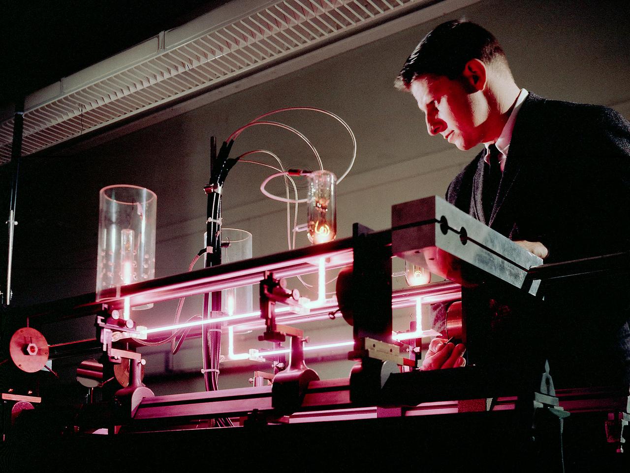
Richard Lancashire operates a gas laser interferometer in the Electric Conversion Laboratory at the National Aeronautics and Space Administration (NASA) Lewis Research Center. Lewis was in the midst of a long-term effort to develop methods of delivering electrical power to spacecraft using nuclear, solar, or electrochemical technologies. Lancashire was measuring the thermionic diode’s plasma particle density. The thermionic diodes were being studied for possible use in radioisotope thermoelectric generators for use in space. Microwave interferometry was one method of measuring transient plasmas. The interferometer measured the difference between the frequencies of two laser beams, one of which passed through the diode. The electron density was measured by revealing the phase shift of the transmitted microwave beam brought about by a change in the plasma refraction. Microwave interferometry, however, offers poor spatial resolution and has limited range of applicability.
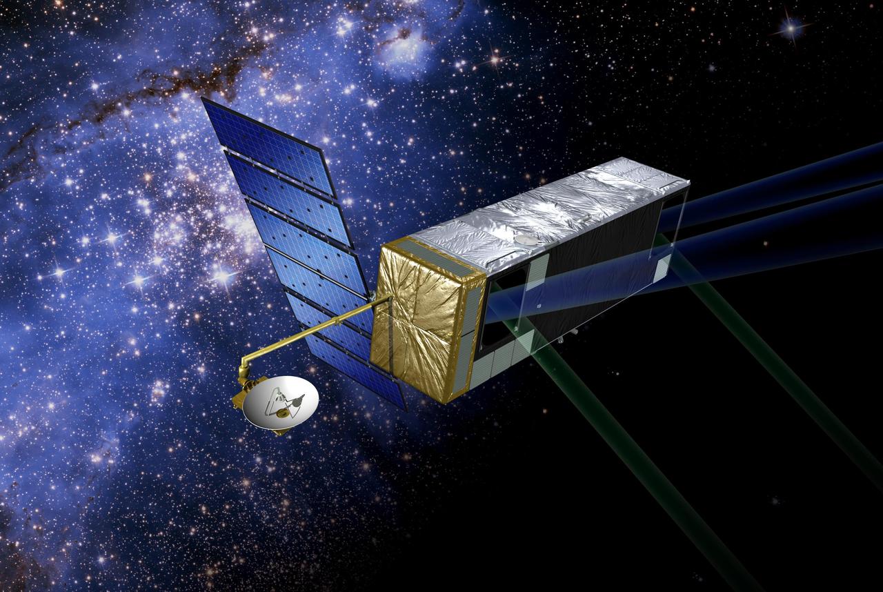
Artist's concept of the current mission configuration. SIM PlanetQuest (formerly called Space Interferometry Mission), currently under development, will determine the positions and distances of stars several hundred times more accurately than any previous program. This accuracy will allow SIM to determine the distances to stars throughout the galaxy and to probe nearby stars for Earth-sized planets. SIM will open a window to a new world of discoveries. http://photojournal.jpl.nasa.gov/catalog/PIA04248
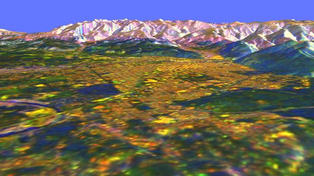
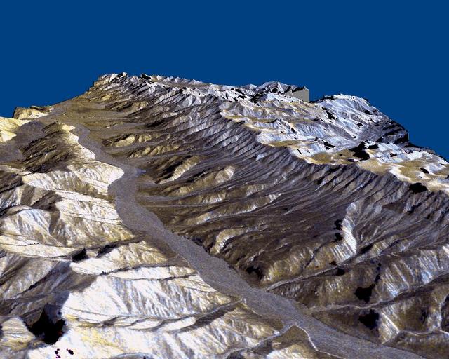
This three-dimensional perspective view of Long Valley, California was created from data taken by the Spaceborne Imaging Radar-C/X-band Synthetic Aperture Radar on board the space shuttle Endeavour. This image was constructed by overlaying a color composite SIR-C radar image on a digital elevation map. The digital elevation map was produced using radar interferometry, a process by which radar data are acquired on different passes of the space shuttle. The two data passes are compared to obtain elevation information. The interferometry data were acquired on April 13,1994 and on October 3, 1994, during the first and second flights of the SIR-C/X-SAR instrument. The color composite radar image was taken in October and was produced by assigning red to the C-band (horizontally transmitted and vertically received) polarization; green to the C-band (vertically transmitted and received) polarization; and blue to the ratio of the two data sets. Blue areas in the image are smooth and yellow areas are rock outcrops with varying amounts of snow and vegetation. The view is looking north along the northeastern edge of the Long Valley caldera, a volcanic collapse feature created 750,000 years ago and the site of continued subsurface activity. Crowley Lake is the large dark feature in the foreground. http://photojournal.jpl.nasa.gov/catalog/PIA01769
A magnitude 6.6 earthquake struck a sparsely inhabited area of southeast Iran on March 14, 1998, at 11:10 p.m. local time.
This three-dimensional perspective of the remote Karakax Valley in the northern Tibetan Plateau of western China was created by combining two spaceborne radar images using a technique known as interferometry. Visualizations like this are helpful to scientists because they reveal where the slopes of the valley are cut by erosion, as well as the accumulations of gravel deposits at the base of the mountains. These gravel deposits, called alluvial fans, are a common landform in desert regions that scientists are mapping in order to learn more about Earth's past climate changes. Higher up the valley side is a clear break in the slope, running straight, just below the ridge line. This is the trace of the Altyn Tagh fault, which is much longer than California's San Andreas fault. Geophysicists are studying this fault for clues it may be able to give them about large faults. Elevations range from 4000 m (13,100 ft) in the valley to over 6000 m (19,700 ft) at the peaks of the glaciated Kun Lun mountains running from the front right towards the back. Scale varies in this perspective view, but the area is about 20 km (12 miles) wide in the middle of the image, and there is no vertical exaggeration. http://photojournal.jpl.nasa.gov/catalog/PIA01800
KENNEDY SPACE CENTER, FLA. -- A crane is lowered over the payload canister with the Shuttle Radar Topography Mission (SRTM) inside in Orbiter Processing Facility (OPF) bay 2. The primary payload on STS-99, the SRTM will soon be lifted out of the canister and installed into the payload bay of the orbiter Endeavour. The SRTM consists of a specially modified radar system that will gather data for the most accurate and complete topographic map of the Earth's surface that has ever been assembled. SRTM will make use of radar interferometry, wherein two radar images are taken from slightly different locations. Differences between these images allow for the calculation of surface elevation. The SRTM hardware includes one radar antenna in the Shuttle payload bay and a second radar antenna attached to the end of a mast extended 60 meters (195 feet) from the shuttle. STS-99 is scheduled to launch Sept. 16 at 8:47 a.m. from Launch Pad 39A
KENNEDY SPACE CENTER, FLA. -- In the Space Station Processing Facility, the Shuttle Radar Topography Mission (SRTM) is lifted for its move to a payload bay canister on the floor. The canister will then be moved to the Orbiter Processing Facility and placed in the bay of the orbiter Endeavour. The SRTM consists of a specially modified radar system that will gather data for the most accurate and complete topographic map of the Earth's surface that has ever been assembled. SRTM will make use of radar interferometry, wherein two radar images are taken from slightly different locations. Differences between these images allow for the calculation of surface elevation, or change. The SRTM hardware will consist of one radar antenna in the shuttle payload bay and a second radar antenna attached to the end of a mast extended 60 meters (195 feet) out from the shuttle. STS-99 is scheduled to launch Sept. 16 at 8:47 a.m. from Launch Pad 39A
KENNEDY SPACE CENTER, FLA. -- In the Space Station Processing Facility, the Shuttle Radar Topography Mission (SRTM) clears the railing on the right as a crane moves it toward the open payload bay canister in the background (left). The canister will then be moved to the Orbiter Processing Facility and placed in the bay of the orbiter Endeavour. The SRTM consists of a specially modified radar system that will gather data for the most accurate and complete topographic map of the Earth's surface that has ever been assembled. SRTM will make use of radar interferometry, wherein two radar images are taken from slightly different locations. Differences between these images allow for the calculation of surface elevation, or change. The SRTM hardware will consist of one radar antenna in the shuttle payload bay and a second radar antenna attached to the end of a mast extended 60 meters (195 feet) out from the shuttle. STS-99 is scheduled to launch Sept. 16 at 8:47 a.m. from Launch Pad 39A
KENNEDY SPACE CENTER, FLA. -- A crane lifts the Shuttle Radar Topography Mission (SRTM), the primary payload on STS-99, from a payload canister used to transport it to Orbiter Processing Facility (OPF) bay 2 to the payload bay of the orbiter Endeavour. The SRTM consists of a specially modified radar system that will gather data for the most accurate and complete topographic map of the Earth's surface that has ever been assembled. SRTM will make use of radar interferometry, wherein two radar images are taken from slightly different locations. Differences between these images allow for the calculation of surface elevation. The SRTM hardware includes one radar antenna in the Shuttle payload bay and a second radar antenna attached to the end of a mast extended 60 meters (195 feet) from the shuttle. STS-99 is scheduled to launch Sept. 16 at 8:47 a.m. from Launch Pad 39A
KENNEDY SPACE CENTER, FLA. -- A crane lowers the Shuttle Radar Topography Mission (SRTM), the primary payload on STS-99, into the payload bay of the orbiter Endeavour in Orbiter Processing Facility bay 2. The SRTM consists of a specially modified radar system that will gather data for the most accurate and complete topographic map of the Earth's surface that has ever been assembled. SRTM will make use of radar interferometry, wherein two radar images are taken from slightly different locations. Differences between these images allow for the calculation of surface elevation. The SRTM hardware includes one radar antenna in the Shuttle payload bay and a second radar antenna attached to the end of a mast extended 60 meters (195 feet) from the shuttle. STS-99 is scheduled to launch Sept. 16 at 8:47 a.m. from Launch Pad 39A
KENNEDY SPACE CENTER, FLA. -- In the Space Station Processing Facility, a crane lowers the Shuttle Radar Topography Mission (SRTM) toward the opening of the payload bay canister below. The canister will then be moved to the Orbiter Processing Facility and placed in the bay of the orbiter Endeavour. The SRTM consists of a specially modified radar system that will gather data for the most accurate and complete topographic map of the Earth's surface that has ever been assembled. SRTM will make use of radar interferometry, wherein two radar images are taken from slightly different locations. Differences between these images allow for the calculation of surface elevation, or change. The SRTM hardware will consist of one radar antenna in the shuttle payload bay and a second radar antenna attached to the end of a mast extended 60 meters (195 feet) out from the shuttle. STS-99 is scheduled to launch Sept. 16 at 8:47 a.m. from Launch Pad 39A
KENNEDY SPACE CENTER, FLA. -- A crane lifts the Shuttle Radar Topography Mission (SRTM), the primary payload on STS-99, from a payload canister used to transport it to Orbiter Processing Facility (OPF) bay 2. The SRTM will soon be installed into the payload bay of the orbiter Endeavour. The SRTM consists of a specially modified radar system that will gather data for the most accurate and complete topographic map of the Earth's surface that has ever been assembled. SRTM will make use of radar interferometry, wherein two radar images are taken from slightly different locations. Differences between these images allow for the calculation of surface elevation. The SRTM hardware includes one radar antenna in the Shuttle payload bay and a second radar antenna attached to the end of a mast extended 60 meters (195 feet) from the shuttle. STS-99 is scheduled to launch Sept. 16 at 8:47 a.m. from Launch Pad 39A
KENNEDY SPACE CENTER, FLA. -- A payload transporter, carrying a payload canister with the Shuttle Radar Topography Mission (SRTM) inside, pulls into Orbiter Processing Facility (OPF) bay 2. The SRTM, the primary payload on STS-99, will soon be installed into the payload bay of the orbiter Endeavour already undergoing processing in bay 2. The SRTM consists of a specially modified radar system that will gather data for the most accurate and complete topographic map of the Earth's surface that has ever been assembled. SRTM will make use of radar interferometry, wherein two radar images are taken from slightly different locations. Differences between these images allow for the calculation of surface elevation. The SRTM hardware includes one radar antenna in the Shuttle payload bay and a second radar antenna attached to the end of a mast extended 60 meters (195 feet) from the shuttle. STS-99 is scheduled to launch Sept. 16 at 8:47 a.m. from Launch Pad 39A
KENNEDY SPACE CENTER, FLA. -- A crane lowers the Shuttle Radar Topography Mission (SRTM), the primary payload on STS-99, into the payload bay of the orbiter Endeavour in Orbiter Processing Facility (OPF) bay 2. The SRTM consists of a specially modified radar system that will gather data for the most accurate and complete topographic map of the Earth's surface that has ever been assembled. SRTM will make use of radar interferometry, wherein two radar images are taken from slightly different locations. Differences between these images allow for the calculation of surface elevation. The SRTM hardware includes one radar antenna in the Shuttle payload bay and a second radar antenna attached to the end of a mast extended 60 meters (195 feet) from the shuttle. STS-99 is scheduled to launch Sept. 16 at 8:47 a.m. from Launch Pad 39A
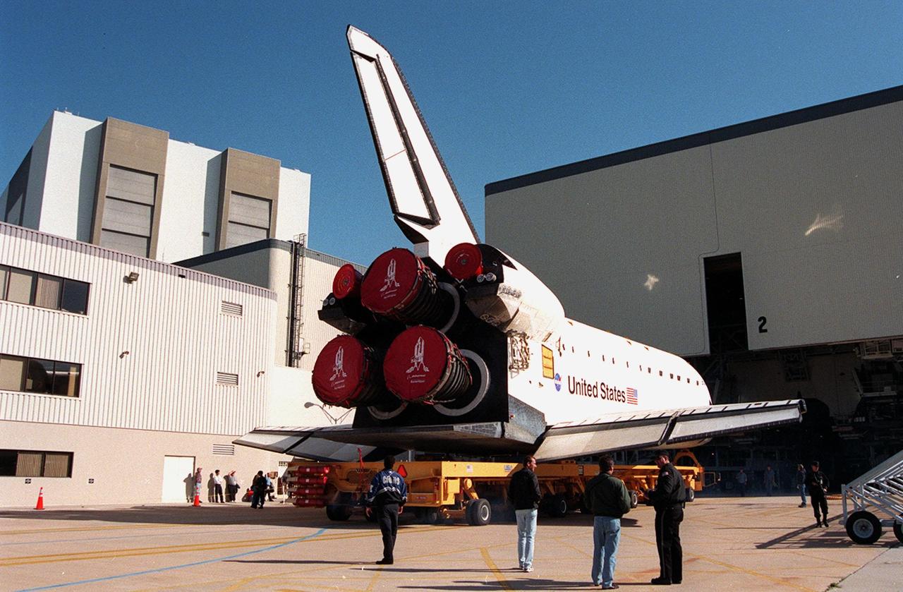
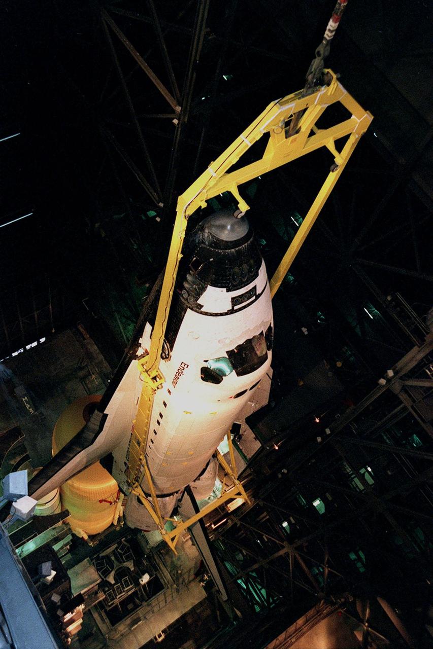
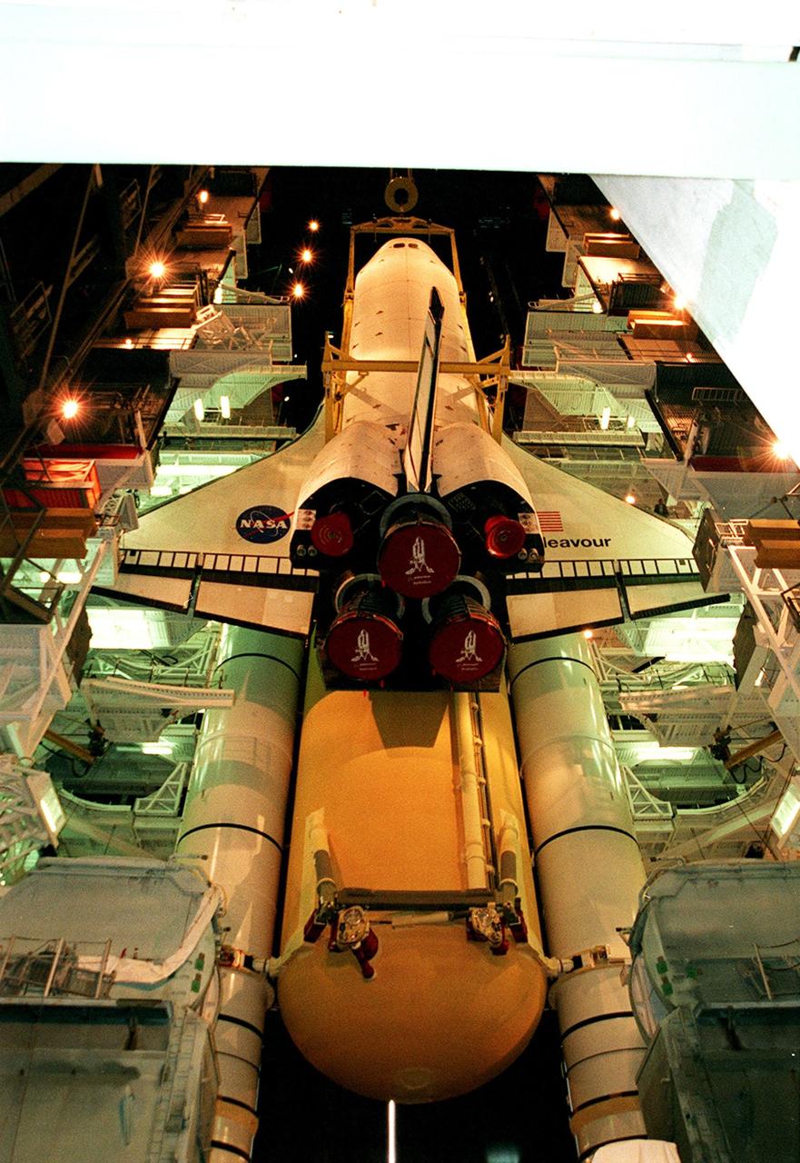
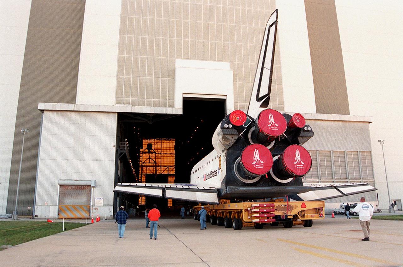
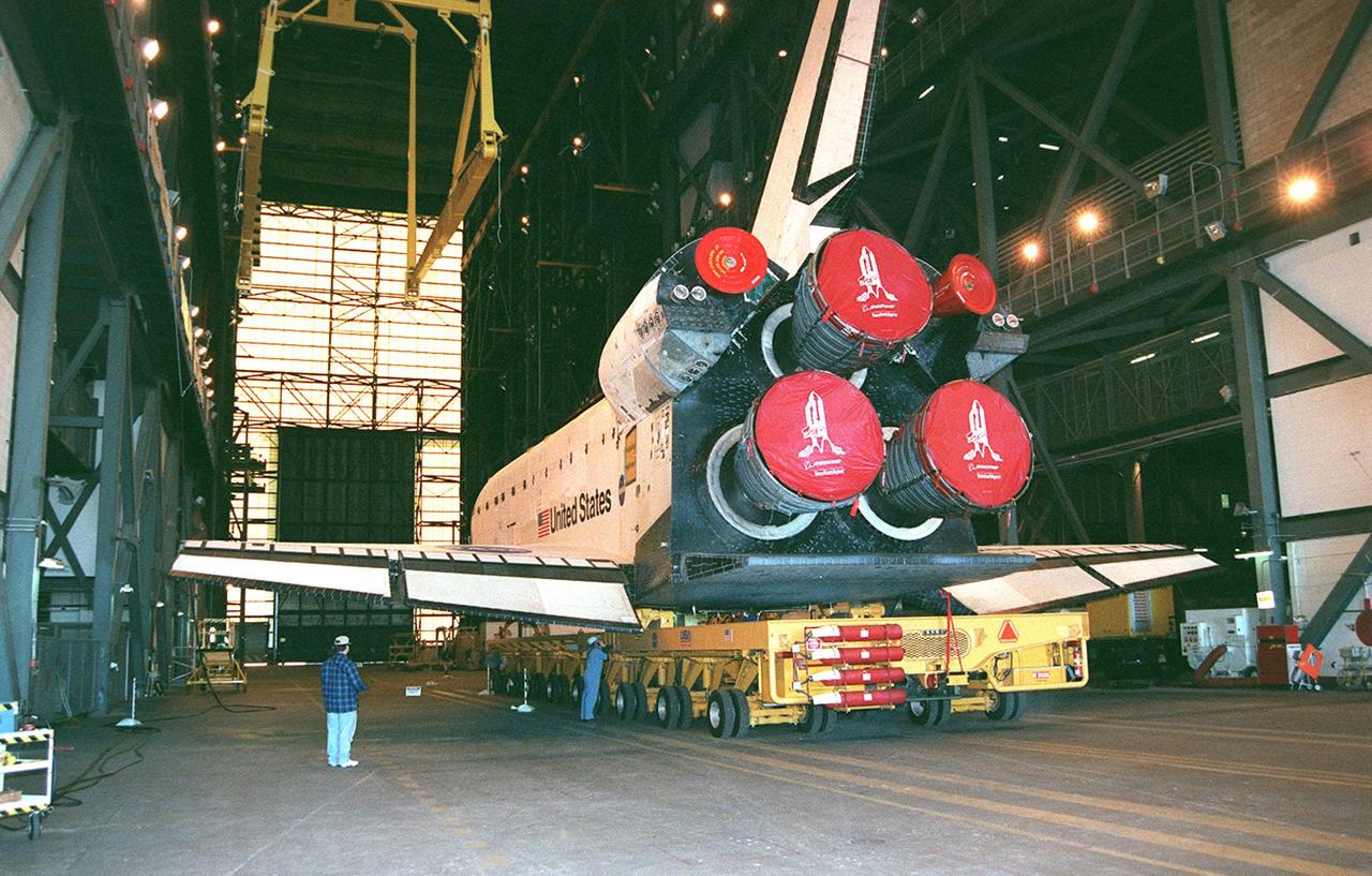
KENNEDY SPACE CENTER, FLA. -- Orbiter Endeavour rolls out of the Orbiter Processing Facility bay 2 for transfer to the Vehicle Assembly Building. There it will be mated to the external tank and solid rocket boosters in high bay 1. Space Shuttle Endeavour is targeted for launch on mission STS-99 Jan. 13, 2000 at 1:11 p.m. EST. STS-99 is the Shuttle Radar Topography Mission, an international project spearheaded by the National Imagery and Mapping Agency and NASA, with participation of the German Aerospace Center DLR. The SRTM consists of a specially modified radar system that will gather data for the most accurate and complete topographic map of the Earth's surface that has ever been assembled. SRTM will make use of radar interferometry, wherein two radar images are taken from slightly different locations. Differences between these images allow for the calculation of surface elevation, or change. The SRTM hardware will consist of one radar antenna in the shuttle payload bay and a second radar antenna attached to the end of a mast extended 60 meters (195 feet) out from the shuttle
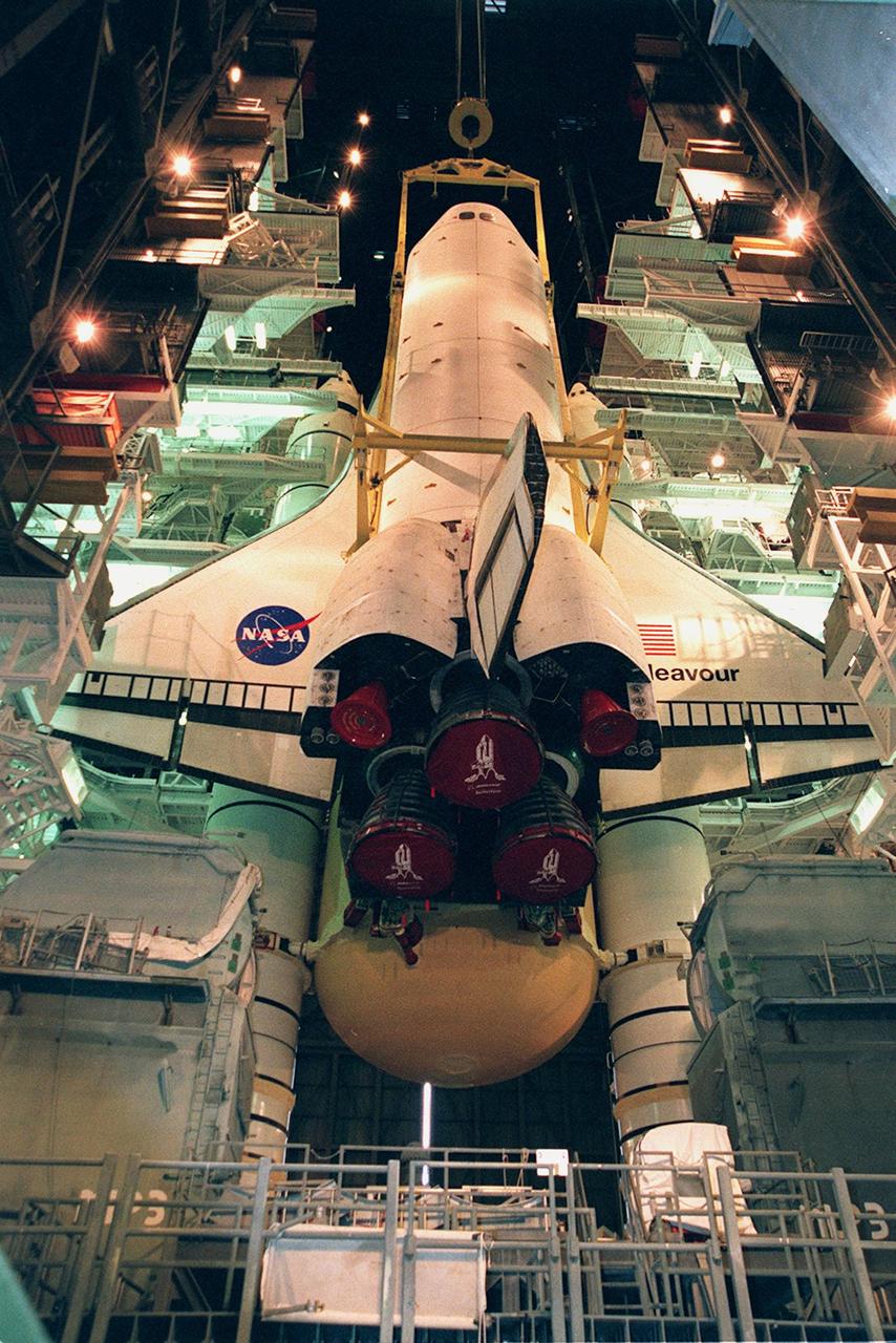
KENNEDY SPACE CENTER, FLA. -- Lights frame the orbiter Endeavour as it is lowered onto the platform for mating with the external tank and solid rocket boosters. Space Shuttle Endeavour is targeted for launch on mission STS-99 Jan. 13, 2000, at 1:11 p.m. EST. STS-99 is the Shuttle Radar Topography Mission, an international project spearheaded by the National Imagery and Mapping Agency and NASA, with participation of the German Aerospace Center DLR. The SRTM consists of a specially modified radar system that will gather data for the most accurate and complete topographic map of the Earth's surface that has ever been assembled. SRTM will make use of radar interferometry, wherein two radar images are taken from slightly different locations. Differences between these images allow for the calculation of surface elevation, or change. The SRTM hardware will consist of one radar antenna in the shuttle payload bay and a second radar antenna attached to the end of a mast extended 60 meters (195 feet) out from the shuttle
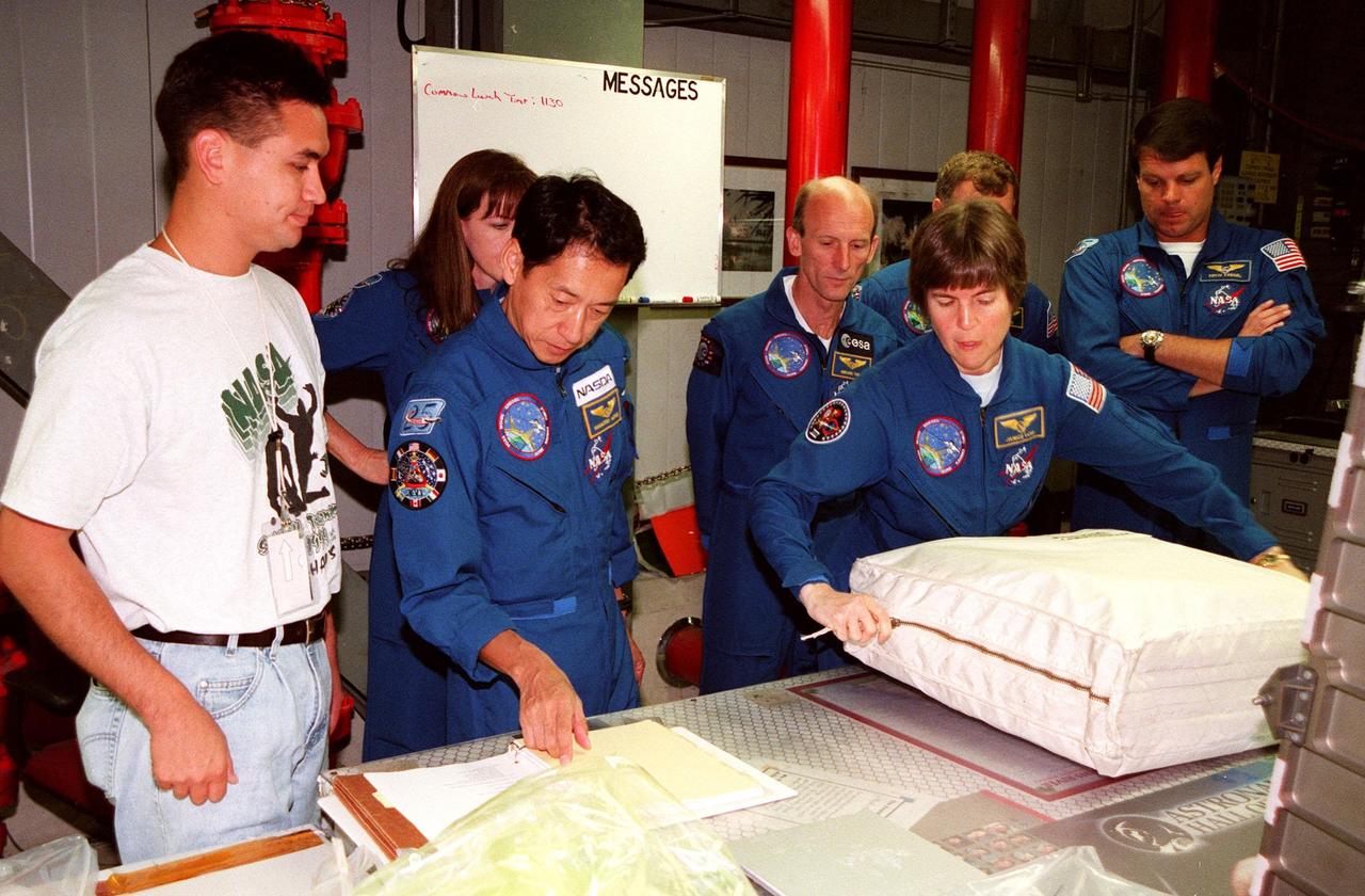
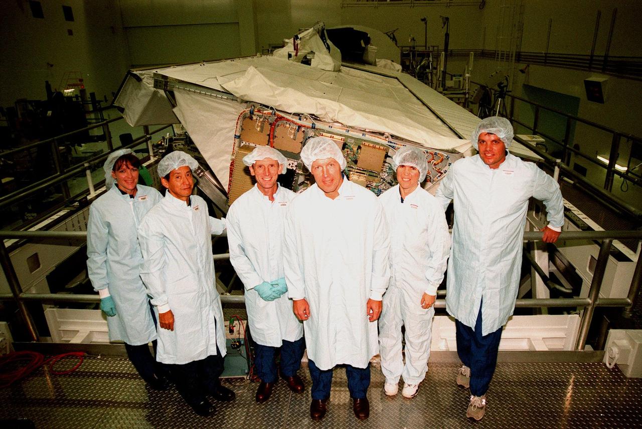
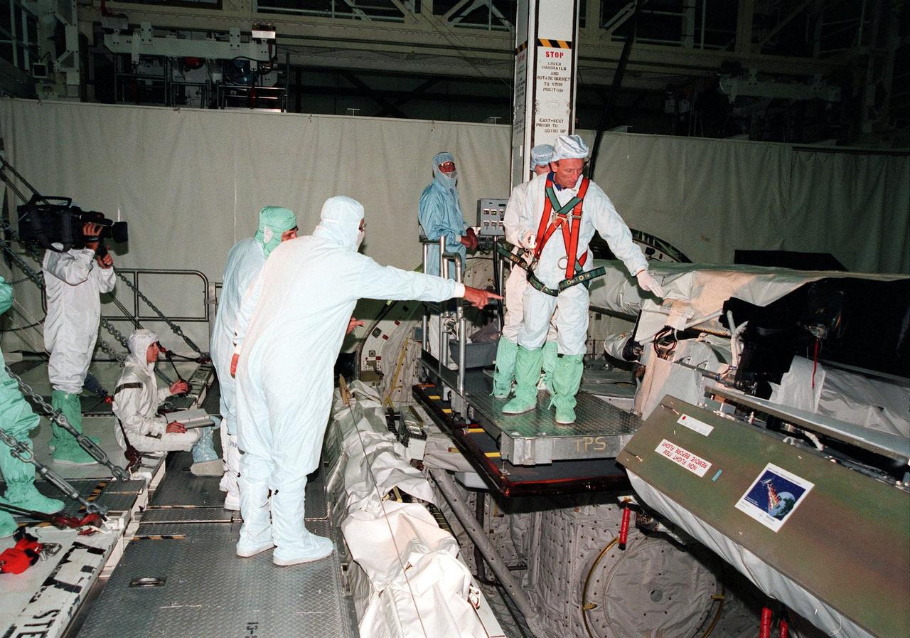
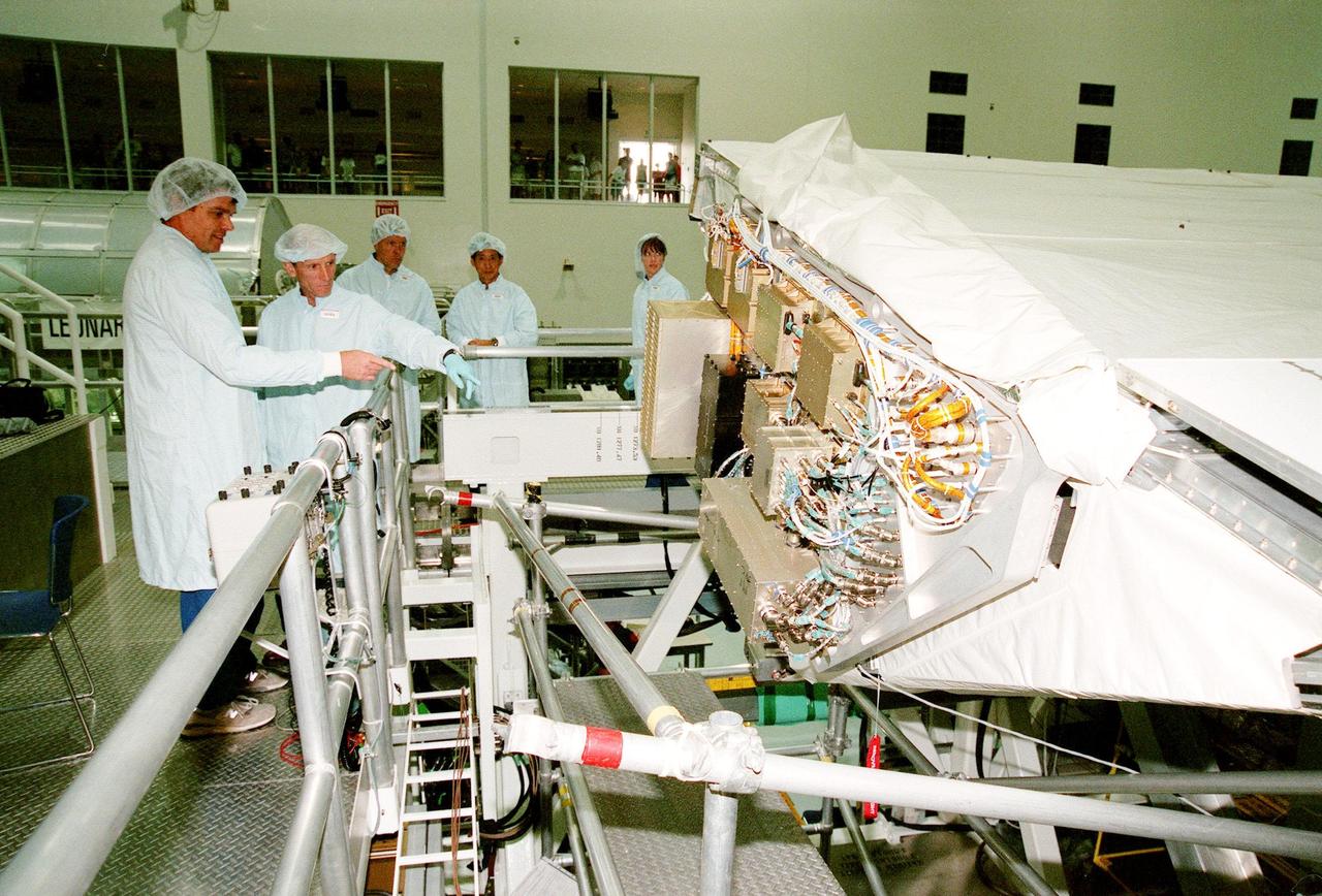
In the Orbiter Processing Facility (OPF) Bay 2, under the watchful eyes of a KSC worker (far left) the STS-99 crew look over equipment as part of a Crew Equipment Interface Test (CEIT). From left (second from right) are Mission Specialists Janet Lynn Kavandi (Ph.D.), Mamoru Mohri, Gerhard P.J. Thiele, and Janice Voss (Ph.D.); behind Voss are Pilot Dominic L. Pudwill Gorie and Commander Kevin R. Kregel. Mohri is with the National Space Development Agency (NASDA) of Japan, and Thiele is with the European Space Agency. The CEIT provides an opportunity for crew members to check equipment and facilities that will be aboard the orbiter during their mission. The STS-99 mission is the Shuttle Radar Topography Mission (SRTM), a specially modified radar system that will gather data for the most accurate and complete topographic map of the Earth's surface that has ever been assembled. SRTM will make use of radar interferometry, wherein two radar images are taken from slightly different locations. Differences between these images allow for the calculation of surface elevation, or change. The SRTM hardware will consist of one radar antenna in the shuttle payload bay and a second radar antenna attached to the end of a mast extended 60 meters (195 feet) out from the shuttle. STS-99 is scheduled to launch Sept. 16 at 8:47 a.m. from Launch Pad 39A
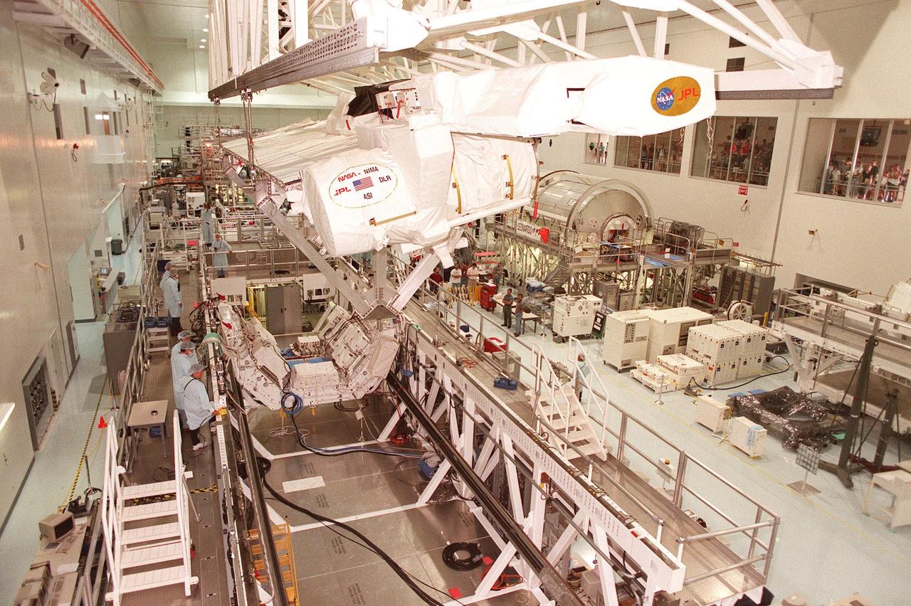
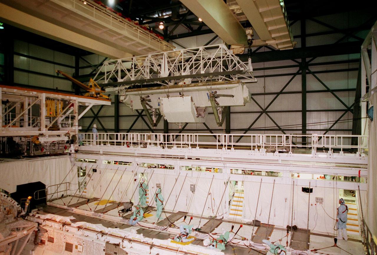
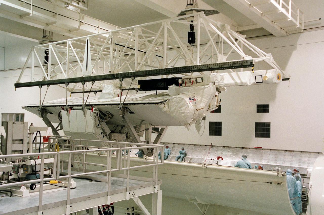
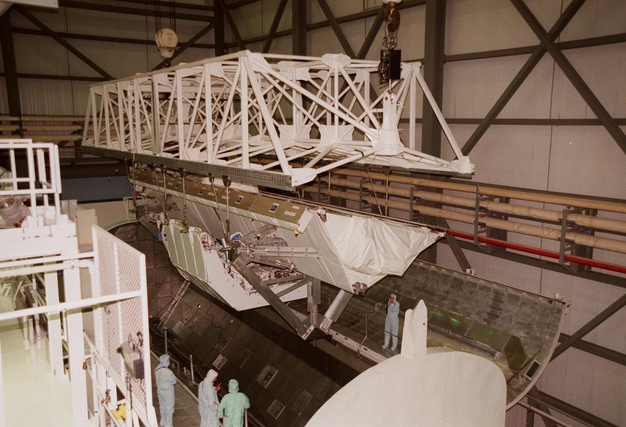
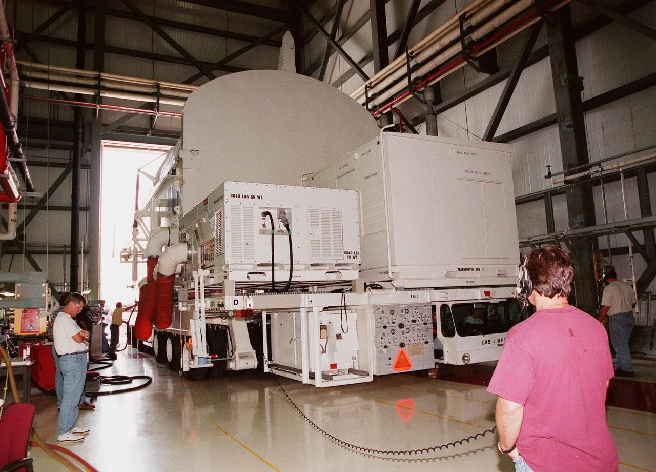
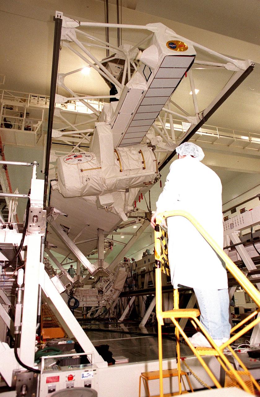
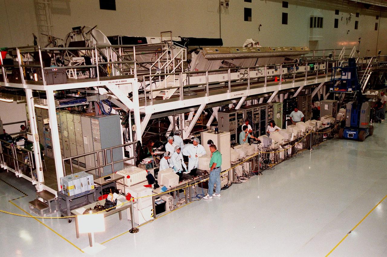
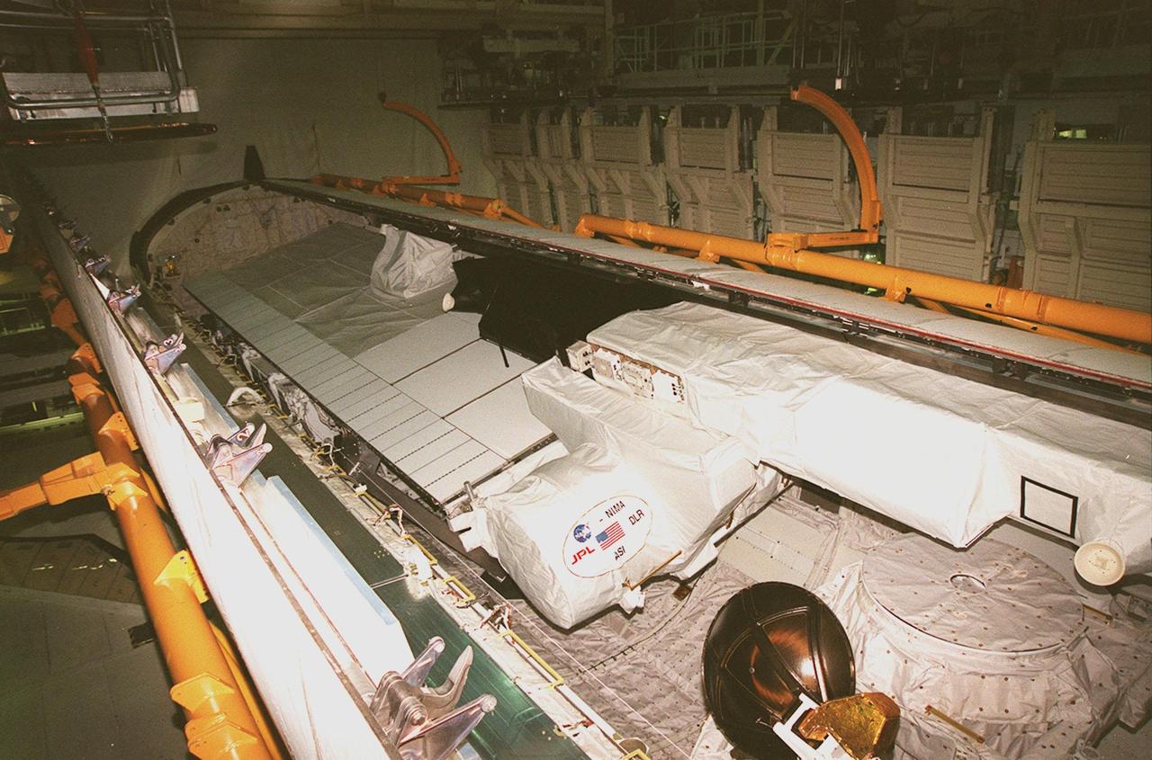
Inside the Space Station Processing Facility, the Shuttle Radar Topography Mission (SRTM) is maneuvered by an overhead crane toward a workstand below. The SRTM, which is the primary payload on mission STS-99, consists of a specially modified radar system that will fly onboard the Space Shuttle during the 11-day mission scheduled for launch in September 1999. The objective of this radar system is to obtain the most complete high-resolution digital topographic database of the Earth. It will gather data that will result in the most accurate and complete topographic map of the Earth's surface that has ever been assembled. SRTM is an international project spearheaded by the National Imagery and Mapping Agency and NASA, with participation of the German Aerospace Center DLR. SRTM will be making use of a technique called radar interferometry, wherein two radar images are taken from slightly different locations. Differences between these images allow for the calculation of surface elevation, or change. To get two radar images taken from different locations, the SRTM hardware will consist of one radar antenna in the shuttle payload bay and a second radar antenna attached to the end of a mast extended 60 meters (195 feet) out from the shuttle
KENNEDY SPACE CENTER, FLA. -- In the Orbiter Processing Facility, members of the STS-99 crew look over the Shuttle Radar Topography Mission (SRTM), primary payload for their mission, as part of a Crew Equipment Interface Test (CEIT). Participating are Commander Kevin R. Kregel, Pilot Dominic L. Pudwill Gorie, and Mission Specialists Janet Lynn Kavandi (Ph.D.), Janice Voss (Ph.D), Mamoru Mohri, and Gerhard P.J. Thiele. Mohri is with the National Space Development Agency (NASDA) of Japan, and Thiele is with the European Space Agency. The CEIT provides an opportunity for crew members to check equipment and facilities that will be aboard the orbiter during their mission. The SRTM is a specially modified radar system that will gather data for the most accurate and complete topographic map of the Earth's surface that has ever been assembled. SRTM will make use of radar interferometry, wherein two radar images are taken from slightly different locations. Differences between these images allow for the calculation of surface elevation, or change. The SRTM hardware will consist of one radar antenna in the shuttle payload bay and a second radar antenna attached to the end of a mast extended 60 meters (195 feet) out from the shuttle. STS-99 is scheduled to launch Sept. 16 at 8:47 a.m. from Launch Pad 39A
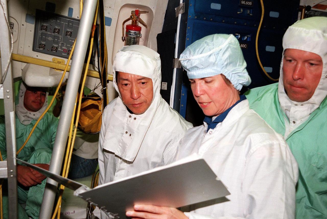
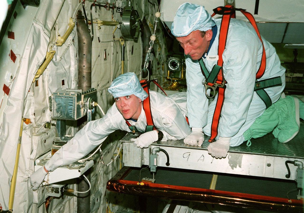
KENNEDY SPACE CENTER, FLA. -- In the Orbiter Processing Facility, STS-99 Mission Specialists Mamoru Mohri (left center), who is with the National Space Development Agency (NASDA) of Japan, and Janice Voss (Ph.D.) look over equipment during a Crew Equipment Interface Test (CEIT). The CEIT provides an opportunity for crew members to check equipment and facilities that will be aboard the orbiter during their mission. Others taking part are Commander Kevin R. Kregel, Pilot Dominic L. Pudwill Gorie, and Mission Specialists Janet Lynn Kavandi (Ph.D.) and Gerhard P.J. Thiele, who is with the European Space Agency. The SRTM is a specially modified radar system that will gather data for the most accurate and complete topographic map of the Earth's surface that has ever been assembled. SRTM will make use of radar interferometry, wherein two radar images are taken from slightly different locations. Differences between these images allow for the calculation of surface elevation, or change. The SRTM hardware will consist of one radar antenna in the shuttle payload bay and a second radar antenna attached to the end of a mast extended 60 meters (195 feet) out from the shuttle. STS-99 is scheduled to launch Sept. 16 at 8:47 a.m. from Launch Pad 39A
KENNEDY SPACE CENTER, FLA. -- In this dizzying view from overhead in high bay 1 of the VAB, the orbiter Endeavour is lowered for mating with the external tank below (on left), and the solid rocket boosters. Space Shuttle Endeavour is targeted for launch on mission STS-99 Jan. 13, 2000, at 1:11 p.m. EST. STS-99 is the Shuttle Radar Topography Mission, an international project spearheaded by the National Imagery and Mapping Agency and NASA, with participation of the German Aerospace Center DLR. The SRTM consists of a specially modified radar system that will gather data for the most accurate and complete topographic map of the Earth's surface that has ever been assembled. SRTM will make use of radar interferometry, wherein two radar images are taken from slightly different locations. Differences between these images allow for the calculation of surface elevation, or change. The SRTM hardware will consist of one radar antenna in the shuttle payload bay and a second radar antenna attached to the end of a mast extended 60 meters (195 feet) out from the shuttle
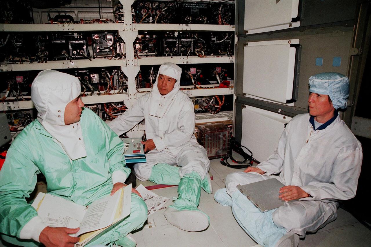
KENNEDY SPACE CENTER, FLA. -- In the Orbiter Processing Facility, STS-99 Mission Specialists Mamoru Mohri (center), who is with the National Space Development Agency (NASDA) of Japan, and Janice Voss (Ph.D.) (right) talk with a KSC worker (left) during a Crew Equipment Interface Test (CEIT). The CEIT provides an opportunity for crew members to check equipment and facilities that will be aboard the orbiter during their mission. Others taking part are Commander Kevin R. Kregel, Pilot Dominic L. Pudwill Gorie, and Mission Specialists Janet Lynn Kavandi (Ph.D.) and Gerhard P.J. Thiele, who is with the European Space Agency. The SRTM is a specially modified radar system that will gather data for the most accurate and complete topographic map of the Earth's surface that has ever been assembled. SRTM will make use of radar interferometry, wherein two radar images are taken from slightly different locations. Differences between these images allow for the calculation of surface elevation, or change. The SRTM hardware will consist of one radar antenna in the shuttle payload bay and a second radar antenna attached to the end of a mast extended 60 meters (195 feet) out from the shuttle. STS-99 is scheduled to launch Sept. 16 at 8:47 a.m. from Launch Pad 39A
The STS-99 crew poses in front of the Shuttle Radar Topography Mission (SRTM) in the Space Station Processing Facility. The crew has been checking out the SRTM, which is the payload for their mission. From left are Mission Specialists Janet Lynn Kavandi (Ph.D.), Mamoru Mohri of Japan, and Gerhard Thiele of Germany; Pilot Dominic L. Pudwill Gorie; Mission Specialist Janice Voss (Ph.D.); and Commander Kevin R. Kregel. Mohri represents the National Space Development Agency of Japan and Thiele represents the European Space Agency. An international project spearheaded by the National Imagery and Mapping Agency and NASA, with participation of the German Aerospace Center DLR, the SRTM consists of a specially modified radar system that will gather data for the most accurate and complete topographic map of the Earth's surface that has ever been assembled. SRTM will make use of radar interferometry, wherein two radar images are taken from slightly different locations. Differences between these images allow for the calculation of surface elevation, or change. The SRTM hardware will consist of one radar antenna in the shuttle payload bay and a second radar antenna attached to the end of a mast extended 60 meters (195 feet) out from the shuttle. STS-99 is scheduled to launch Sept. 16 at 8:47 a.m. from Launch Pad 39A
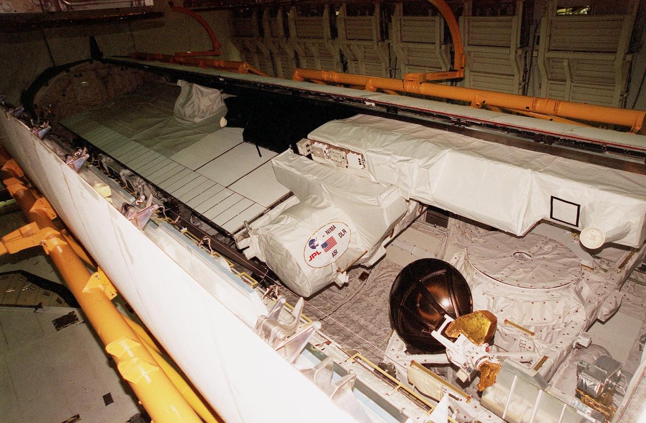
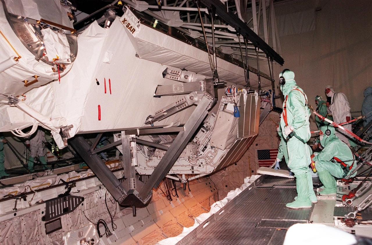
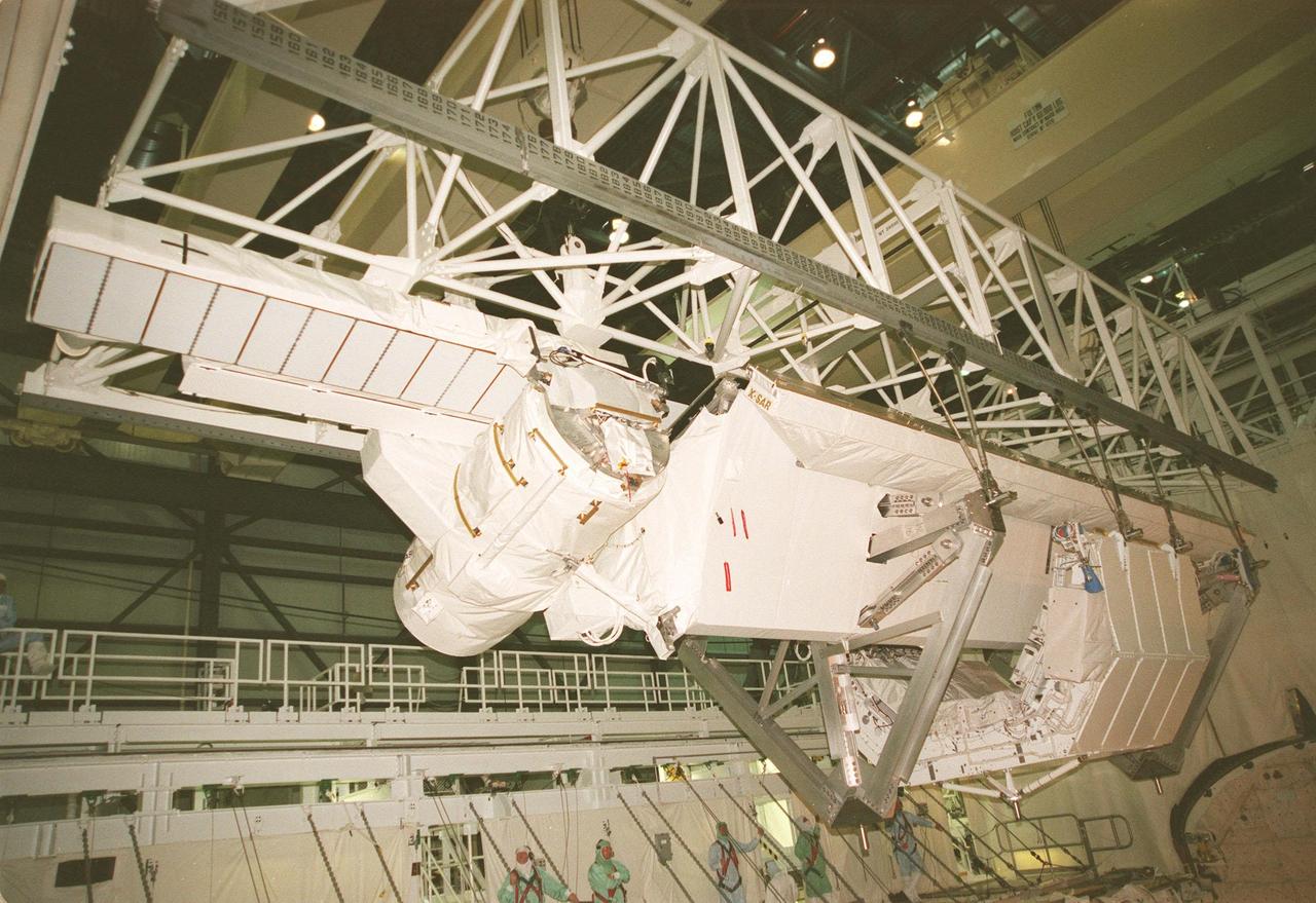
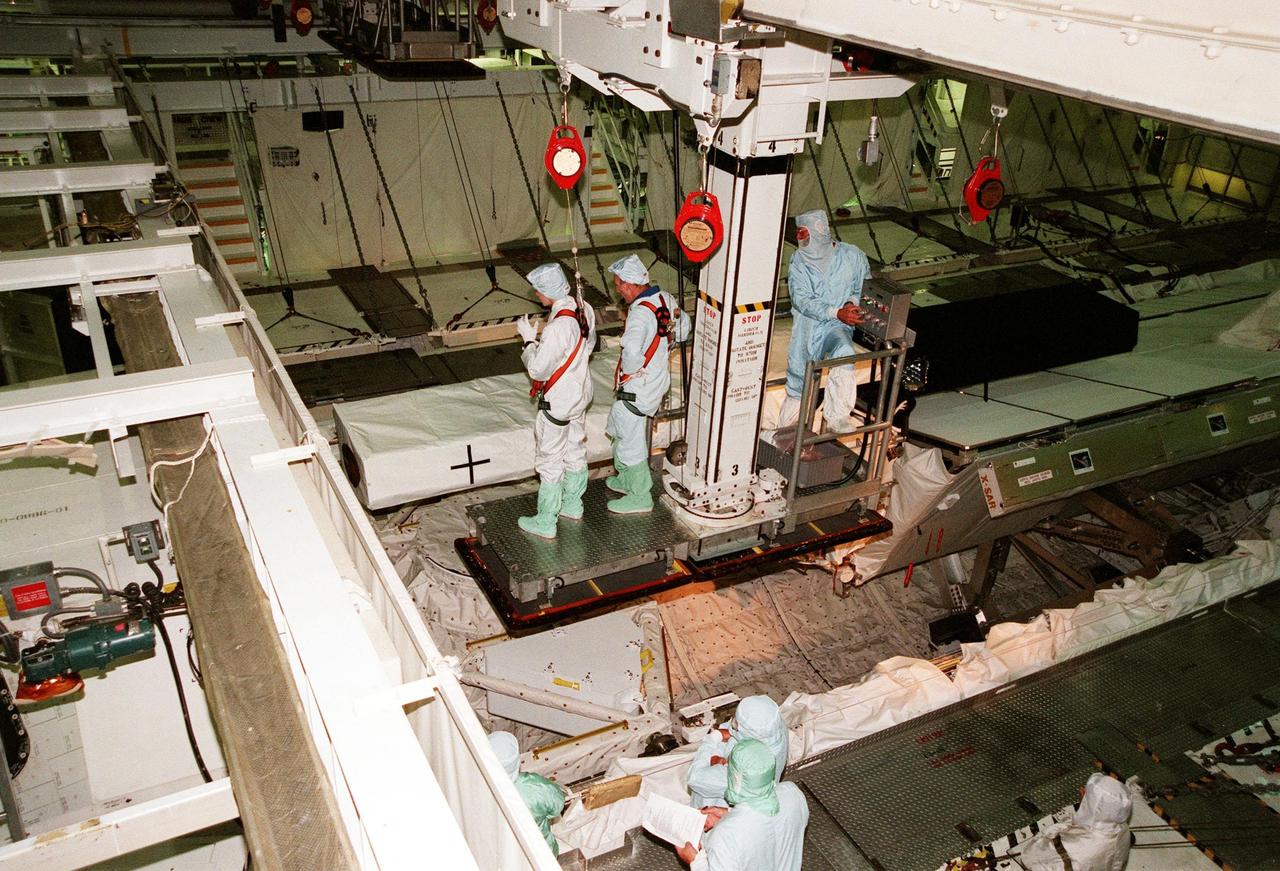
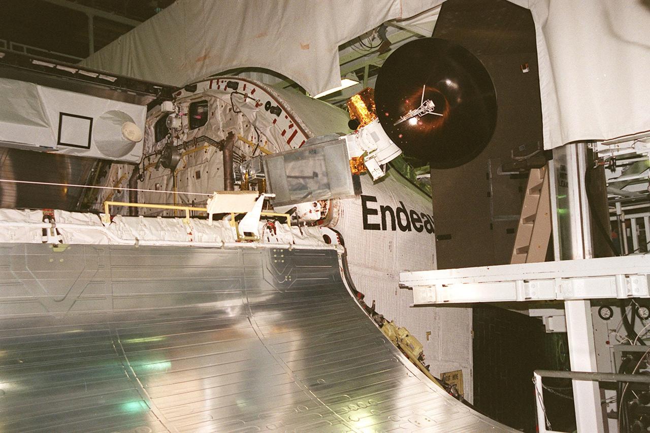
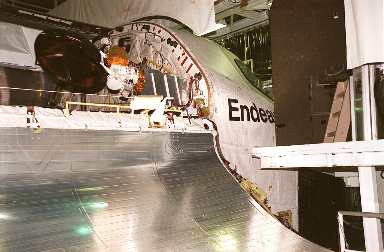
KENNEDY SPACE CENTER, FLA. -- In the Orbiter Processing Facility, a radar antenna, part of the Shuttle Radar Topography Mission (SRTM), is stored in the payload bay of the orbiter Endeavour before door closure. SRTM is the primary payload on mission STS-99, scheduled to launch Sept. 16 at 8:47 a.m. EDT from Launch Pad 39A. A specially modified radar system, the SRTM will gather data for the most accurate and complete topographic map of the Earth's surface that has ever been assembled. SRTM will make use of radar interferometry, wherein two radar images are taken from slightly different locations. Differences between these images allow for the calculation of surface elevation, or change. The SRTM hardware consists of one radar antenna in the shuttle payload bay and a second radar antenna attached to the end of a mast extended 60 meters (195 feet) out from the shuttle. SRTM is an international project spearheaded by the National Imagery and Mapping Agency and NASA, with participation of the German Aerospace Center DLR
KENNEDY SPACE CENTER, FLA. -- Viewed from the ground level in high bay 1 of the VAB, the orbiter Endeavour seems to float in mid-air as it is lowered for mating with the external tank and solid rocket boosters behind and below it. Space Shuttle Endeavour is targeted for launch on mission STS-99 Jan. 13, 2000, at 1:11 p.m. EST. STS-99 is the Shuttle Radar Topography Mission, an international project spearheaded by the National Imagery and Mapping Agency and NASA, with participation of the German Aerospace Center DLR. The SRTM consists of a specially modified radar system that will gather data for the most accurate and complete topographic map of the Earth's surface that has ever been assembled. SRTM will make use of radar interferometry, wherein two radar images are taken from slightly different locations. Differences between these images allow for the calculation of surface elevation, or change. The SRTM hardware will consist of one radar antenna in the shuttle payload bay and a second radar antenna attached to the end of a mast extended 60 meters (195 feet) out from the shuttle

After being lifted off the transporter (lower right) in the Space Station Processing Facility, the Shuttle Radar Topography Mission (SRTM) moves across the floor toward a workstand. The SRTM, which is the primary payload on mission STS-99, consists of a specially modified radar system that will fly onboard the Space Shuttle during the 11-day mission scheduled for launch in September 1999. The objective of this radar system is to obtain the most complete high-resolution digital topographic database of the Earth. It will gather data that will result in the most accurate and complete topographic map of the Earth's surface that has ever been assembled. SRTM is an international project spearheaded by the National Imagery and Mapping Agency and NASA, with participation of the German Aerospace Center DLR. SRTM will be making use of a technique called radar interferometry, wherein two radar images are taken from slightly different locations. Differences between these images allow for the calculation of surface elevation, or change. To get two radar images taken from different locations, the SRTM hardware will consist of one radar antenna in the shuttle payload bay and a second radar antenna attached to the end of a mast extended 60 meters (195 feet) out from the shuttle
KENNEDY SPACE CENTER, FLA. -- In the Orbiter Processing Facility, STS-99 Mission Specialists Janet Lynn Kavandi (Ph.D.) and Gerhard P.J. Thiele look over part of the Shuttle Radar Topography Mission (SRTM), primary payload for their mission, as part of a Crew Equipment Interface Test (CEIT). Also taking part in the CEIT are Commander Kevin R. Kregel, Pilot Dominic L. Pudwill Gorie, and Mission Specialists Janice Voss (Ph.D.) and Mamoru Mohri. Mohri is with the National Space Development Agency (NASDA) of Japan, and Thiele is with the European Space Agency. The CEIT provides an opportunity for crew members to check equipment and facilities that will be aboard the orbiter during their mission. The SRTM is a specially modified radar system that will gather data for the most accurate and complete topographic map of the Earth's surface that has ever been assembled. SRTM will make use of radar interferometry, wherein two radar images are taken from slightly different locations. Differences between these images allow for the calculation of surface elevation, or change. The SRTM hardware will consist of one radar antenna in the shuttle payload bay and a second radar antenna attached to the end of a mast extended 60 meters (195 feet) out from the shuttle. STS-99 is scheduled to launch Sept. 16 at 8:47 a.m. from Launch Pad 39A
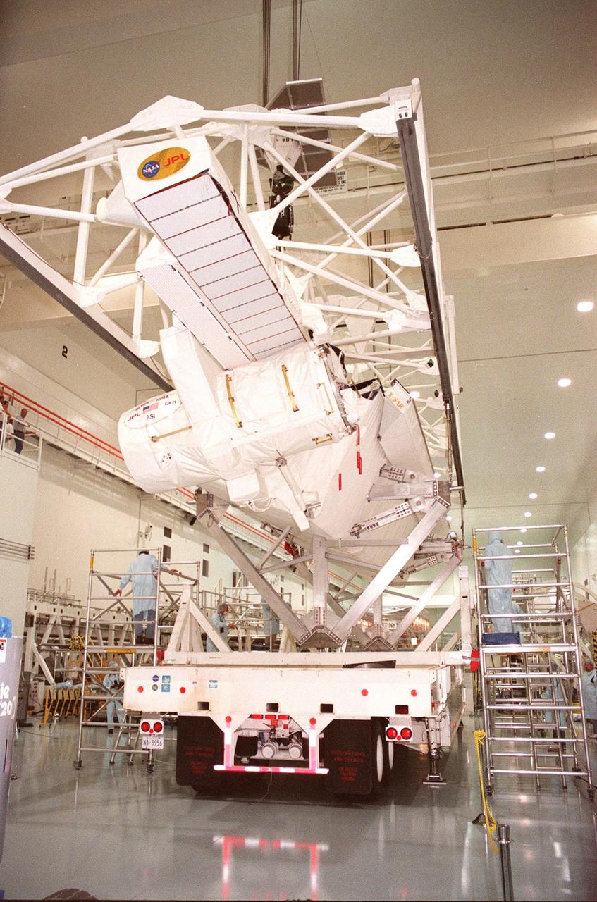
Workers inside the Space Station Processing Facility keep watch as an overhead crane begins lifting the Shuttle Radar Topography Mission (SRTM) from the transporter below. The SRTM is being moved to a workstand. The primary payload on mission STS-99, the SRTM consists of a specially modified radar system that will fly onboard the Space Shuttle during the 11-day mission scheduled for launch in September 1999. The objective of this radar system is to obtain the most complete high-resolution digital topographic database of the Earth. It will gather data that will result in the most accurate and complete topographic map of the Earth's surface that has ever been assembled. SRTM is an international project spearheaded by the National Imagery and Mapping Agency and NASA, with participation of the German Aerospace Center DLR. SRTM will be making use of a technique called radar interferometry, wherein two radar images are taken from slightly different locations. Differences between these images allow for the calculation of surface elevation, or change. To get two radar images taken from different locations, the SRTM hardware will consist of one radar antenna in the shuttle payload bay and a second radar antenna attached to the end of a mast extended 60 meters (195 feet) out from the shuttle
KENNEDY SPACE CENTER, FLA. -- Orbiter Endeavour rolls into the Vehicle Assembly Building on its orbiter transfer vehicle. In high bay 1 it will be mated to the external tank and solid rocket boosters. Space Shuttle Endeavour is targeted for launch on mission STS-99 Jan. 13, 2000 at 1:11 p.m. EST. STS-99 is the Shuttle Radar Topography Mission, an international project spearheaded by the National Imagery and Mapping Agency and NASA, with participation of the German Aerospace Center DLR. The SRTM consists of a specially modified radar system that will gather data for the most accurate and complete topographic map of the Earth's surface that has ever been assembled. SRTM will make use of radar interferometry, wherein two radar images are taken from slightly different locations. Differences between these images allow for the calculation of surface elevation, or change. The SRTM hardware will consist of one radar antenna in the shuttle payload bay and a second radar antenna attached to the end of a mast extended 60 meters (195 feet) out from the shuttle
KENNEDY SPACE CENTER, FLA. -- In the Orbiter Processing Facility (OPF), the STS-99 crew take part in a Crew Equipment Interface Test (CEIT). Facing the camera and pointing is Mission Specialist Gerhard P.J. Thiele, who is with the European Space Agency. Other crew members in the OPF are Commander Kevin R. Kregel, Pilot Dominic L. Pudwill Gorie, and Mission Specialists Janet Lynn Kavandi (Ph.D.), Janice Voss (Ph.D.), and Mamoru Mohri, who is with the National Space Development Agency (NASDA) of Japan. The CEIT provides an opportunity for crew members to check equipment and facilities that will be aboard the orbiter during their mission. The STS-99 mission is the Shuttle Radar Topography Mission (SRTM), a specially modified radar system that will gather data for the most accurate and complete topographic map of the Earth's surface that has ever been assembled. SRTM will make use of radar interferometry, wherein two radar images are taken from slightly different locations. Differences between these images allow for the calculation of surface elevation, or change. The SRTM hardware will consist of one radar antenna in the shuttle payload bay and a second radar antenna attached to the end of a mast extended 60 meters (195 feet) out from the shuttle. STS-99 is scheduled to launch Sept. 16 at 8:47 a.m. from Launch Pad 39A
In the Space Station Processing Facility, the STS-99 crew looks over the payload for their mission, the Shuttle Radar Topography Mission (SRTM). Pointing to the SRTM are Commander Kevin R. Kregel and Mission Specialist Gerhard Thiele of Germany. Behind them are (left to right) Pilot Dominic L. Pudwill Gorie and Mission Specialists Mamoru Mohri of Japan and Janet Lynn Kavandi (Ph.D.) The remaining crew member (not shown) is Mission Specialist Janice Voss (Ph.D.) Mohri represents the National Space Development Agency of Japan and Thiele represents the European Space Agency. An international project spearheaded by the National Imagery and Mapping Agency and NASA, with participation of the German Aerospace Center DLR, the SRTM consists of a specially modified radar system that will gather data for the most accurate and complete topographic map of the Earth's surface that has ever been assembled. SRTM will make use of radar interferometry, wherein two radar images are taken from slightly different locations. Differences between these images allow for the calculation of surface elevation, or change. The SRTM hardware will consist of one radar antenna in the shuttle payload bay and a second radar antenna attached to the end of a mast extended 60 meters (195 feet) out from the shuttle. STS-99 is scheduled to launch Sept. 16 at 8:47 a.m. from Launch Pad 39A
KENNEDY SPACE CENTER, FLA. -- In high bay 1 of the VAB, the orbiter Endeavour is lowered for mating with the external tank below (on right), and the solid rocket boosters. Space Shuttle Endeavour is targeted for launch on mission STS-99 Jan. 13, 2000, at 1:11 p.m. EST. STS-99 is the Shuttle Radar Topography Mission, an international project spearheaded by the National Imagery and Mapping Agency and NASA, with participation of the German Aerospace Center DLR. The SRTM consists of a specially modified radar system that will gather data for the most accurate and complete topographic map of the Earth's surface that has ever been assembled. SRTM will make use of radar interferometry, wherein two radar images are taken from slightly different locations. Differences between these images allow for the calculation of surface elevation, or change. The SRTM hardware will consist of one radar antenna in the shuttle payload bay and a second radar antenna attached to the end of a mast extended 60 meters (195 feet) out from the shuttle
KENNEDY SPACE CENTER, FLA. -- Orbiter Endeavour rolls inside the Vehicle Assembly Building where it will be lifted to vertical and mated to the external tank and solid rocket boosters in high bay 1. Space Shuttle Endeavour is targeted for launch on mission STS-99 Jan. 13, 2000 at 1:11 p.m. EST. STS-99 is the Shuttle Radar Topography Mission, an international project spearheaded by the National Imagery and Mapping Agency and NASA, with participation of the German Aerospace Center DLR. The SRTM consists of a specially modified radar system that will gather data for the most accurate and complete topographic map of the Earth's surface that has ever been assembled. SRTM will make use of radar interferometry, wherein two radar images are taken from slightly different locations. Differences between these images allow for the calculation of surface elevation, or change. The SRTM hardware will consist of one radar antenna in the shuttle payload bay and a second radar antenna attached to the end of a mast extended 60 meters (195 feet) out from the shuttle
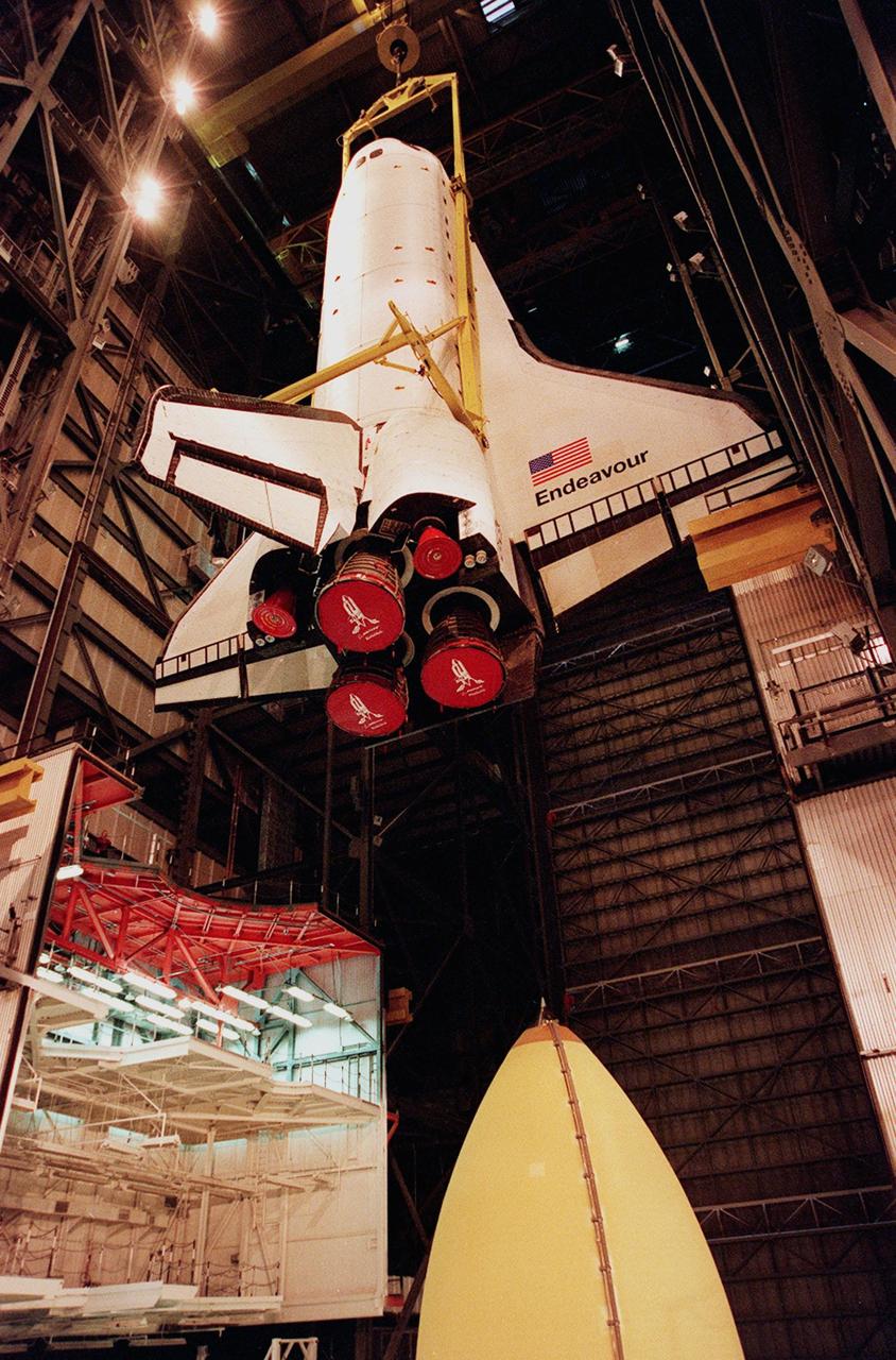
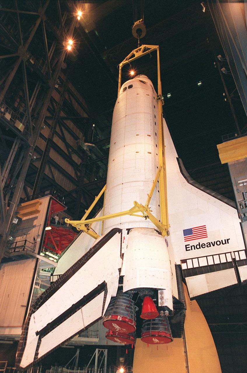
KENNEDY SPACE CENTER, FLA. -- Inside the VAB, orbiter Endeavour is lifted to a vertical position before being mated to the external tank (bottom of photo) and solid rocket boosters in high bay 1. Space Shuttle Endeavour is targeted for launch on mission STS-99 Jan. 13, 2000, at 1:11 p.m. EST. STS-99 is the Shuttle Radar Topography Mission, an international project spearheaded by the National Imagery and Mapping Agency and NASA, with participation of the German Aerospace Center DLR. The SRTM consists of a specially modified radar system that will gather data for the most accurate and complete topographic map of the Earth's surface that has ever been assembled. SRTM will make use of radar interferometry, wherein two radar images are taken from slightly different locations. Differences between these images allow for the calculation of surface elevation, or change. The SRTM hardware will consist of one radar antenna in the shuttle payload bay and a second radar antenna attached to the end of a mast extended 60 meters (195 feet) out from the shuttle
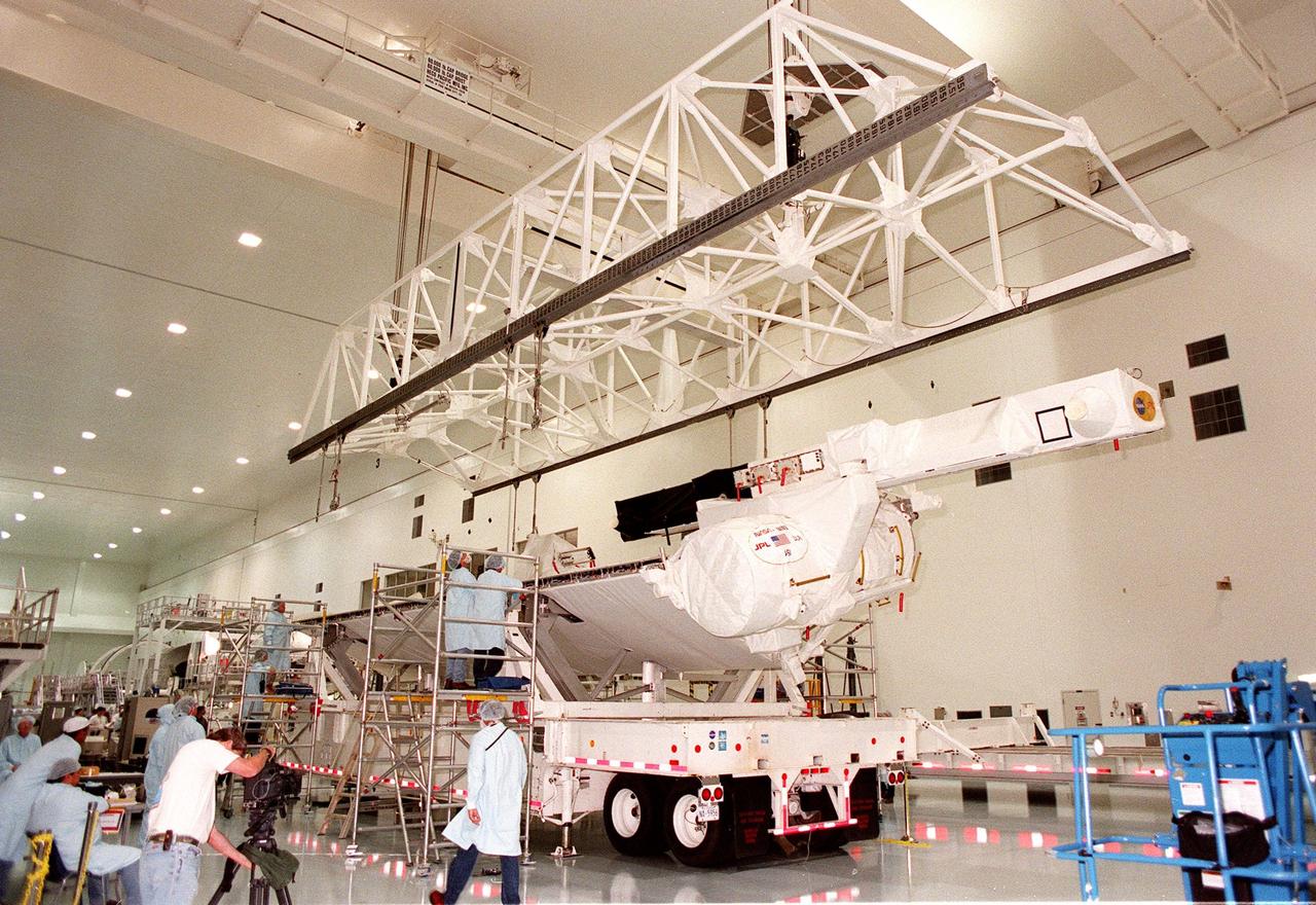
Inside the Space Station Processing Facility, workers watch as an overhead crane is lowered for lifting the Shuttle Radar Topography Mission (SRTM) from the transporter it is resting on. The SRTM is being moved to a workstand. The primary payload on mission STS-99, the SRTM consists of a specially modified radar system that will fly onboard the Space Shuttle during the 11-day mission scheduled for launch in September 1999. The objective of this radar system is to obtain the most complete high-resolution digital topographic database of the Earth. It will gather data that will result in the most accurate and complete topographic map of the Earth's surface that has ever been assembled. SRTM is an international project spearheaded by the National Imagery and Mapping Agency and NASA, with participation of the German Aerospace Center DLR. SRTM will be making use of a technique called radar interferometry, wherein two radar images are taken from slightly different locations. Differences between these images allow for the calculation of surface elevation, or change. To get two radar images taken from different locations, the SRTM hardware will consist of one radar antenna in the shuttle payload bay and a second radar antenna attached to the end of a mast extended 60 meters (195 feet) out from the shuttle
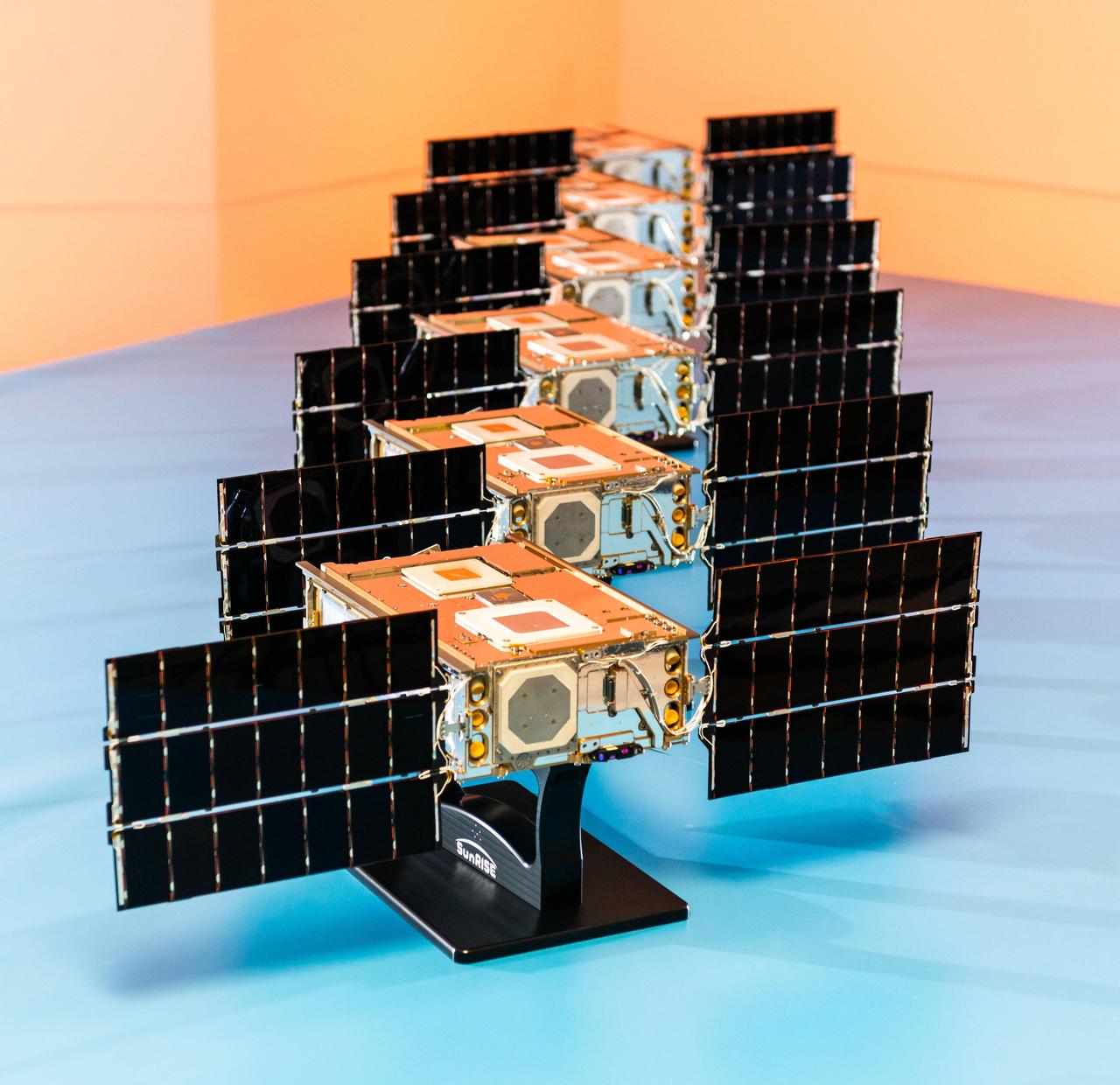
Shown here at Utah State University's Space Dynamics Laboratory in Logan, Utah, in November, 2023, the six satellites that make up NASA's Sun Radio Interferometer Space Experiment (SunRISE) mission are each only about the size of a cereal box, flanked by small solar panels. Once in space, the six SmallSats fly about 6 miles (10 kilometers) apart and each deploy four radio antennas that extend 10 feet (2.5 meters). Using a technique called interferometry, the six satellites will effectively act like one big radio receiver and detect solar radio bursts, or eruptions of radio waves in the outer atmosphere of the Sun. In the places where these radio bursts arise, scientists also see eruptions of accelerated particles, which can damage spacecraft electronics, including on communications satellites in Earth orbit, and pose a health threat to astronauts. Keeping track of solar radio bursts and pinpointing their location could help warn humans of approaching accelerated particles. https://photojournal.jpl.nasa.gov/catalog/PIA25789
This is a three-dimensional perspective view of Long Valley, California by the Spaceborne Imaging Radar-C/X-band Synthetic Aperture Radar on board the space shuttle Endeavour. This view was constructed by overlaying a color composite SIR-C image on a digital elevation map. The digital elevation map was produced using radar interferometry, a process by which radar data are acquired on different passes of the space shuttle and, which then, are compared to obtain elevation information. The data were acquired on April 13, 1994 and on October 3, 1994, during the first and second flights of the SIR-C/X-SAR radar instrument. The color composite radar image was produced by assigning red to the C-band (horizontally transmitted and vertically received) polarization; green to the C-band (vertically transmitted and received) polarization; and blue to the ratio of the two data sets. Blue areas in the image are smooth and yellow areas are rock outcrops with varying amounts of snow and vegetation. The view is looking north along the northeastern edge of the Long Valley caldera, a volcanic collapse feature created 750,000 years ago and the site of continued subsurface activity. Crowley Lake is off the image to the left. http://photojournal.jpl.nasa.gov/catalog/PIA01757
Inside the Space Station Processing Facility, workers at each end of a workstand watch as the Shuttle Radar Topography Mission (SRTM) begins its descent onto it. The SRTM, which is the primary payload on mission STS-99, consists of a specially modified radar system that will fly onboard the Space Shuttle during the 11-day mission scheduled for launch in September 1999. The objective of this radar system is to obtain the most complete high-resolution digital topographic database of the Earth. It will gather data that will result in the most accurate and complete topographic map of the Earth's surface that has ever been assembled. SRTM is an international project spearheaded by the National Imagery and Mapping Agency and NASA, with participation of the German Aerospace Center DLR. SRTM will be making use of a technique called radar interferometry, wherein two radar images are taken from slightly different locations. Differences between these images allow for the calculation of surface elevation, or change. To get two radar images taken from different locations, the SRTM hardware will consist of one radar antenna in the shuttle payload bay and a second radar antenna attached to the end of a mast extended 60 meters (195 feet) out from the shuttle

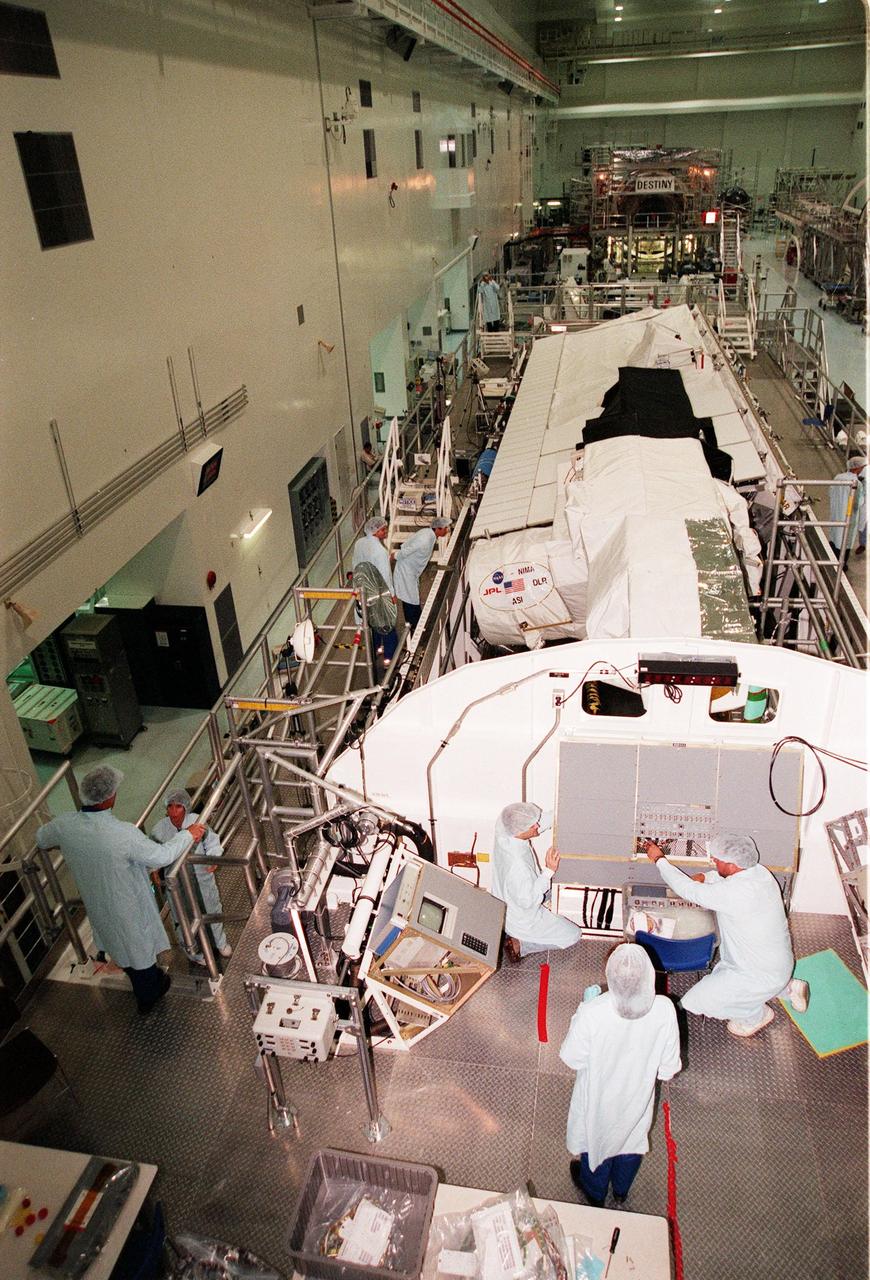
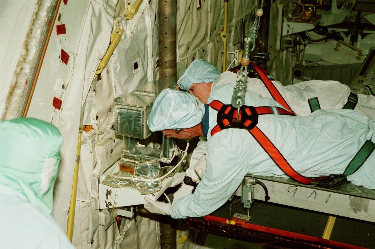
STS-99 Mission Specialist Janice Voss conducts a system verification test on the Shuttle Radar Topography Mission in the Space Station Processing Facility. The primary payload on mission STS-99, the SRTM consists of a specially modified radar system that will fly onboard the Space Shuttle during the 11-day mission targeted for launch Sept. 16, 1999. This radar system will gather data for the most accurate and complete topographic map of the Earth's surface that has ever been assembled. SRTM is an international project spearheaded by the National Imagery and Mapping Agency and NASA, with participation of the German Aerospace Center DLR. SRTM will make use of radar interferometry, wherein two radar images are taken from slightly different locations. Differences between these images allow for the calculation of surface elevation, or change. The SRTM hardware will consist of one radar antenna in the shuttle payload bay and a second radar antenna attached to the end of a mast extended 60 meters (195 feet) out from the shuttle
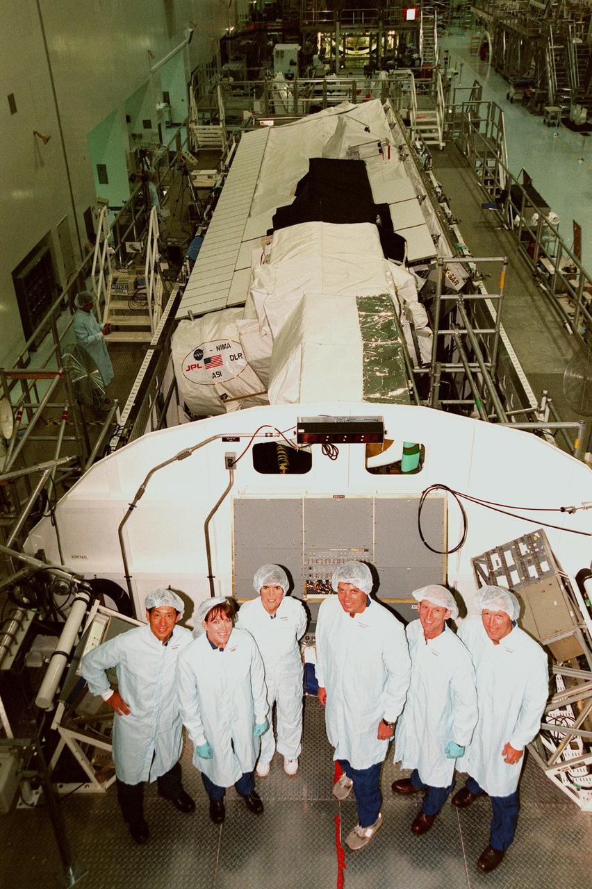
In the Space Station Processing Facility, the STS-99 crew pose in front of the Shuttle Radar Topography Mission, the payload for their mission. From left are Mission Specialists Mamoru Mohri of Japan, Janet Lynn Kavandi (Ph.D.), and Janice Voss (Ph.D.); Commander Kevin R. Kregel; Mission Specialist Gerhard Thiele of Germany; and Pilot Dominic L. Pudwill Gorie. Mohri represents the National Space Development Agency of Japan and Thiele represents the European Space Agency. An international project spearheaded by the National Imagery and Mapping Agency and NASA, with participation of the German Aerospace Center DLR, the SRTM consists of a specially modified radar system that will gather data for the most accurate and complete topographic map of the Earth's surface that has ever been assembled. SRTM will make use of radar interferometry, wherein two radar images are taken from slightly different locations. Differences between these images allow for the calculation of surface elevation, or change. The SRTM hardware will consist of one radar antenna in the shuttle payload bay and a second radar antenna attached to the end of a mast extended 60 meters (195 feet) out from the shuttle. STS-99 is scheduled to launch Sept. 16 at 8:47 a.m. from Launch Pad 39A
In the Space Station Processing Facility, STS-99 crew members inspect the Shuttle Radar Topography Mission (SRTM), the payload for their mission. At left is Commander Kevin R. Kregel talking to Mission Specialist Janice Voss (Ph.D.); and Mission Specialists Gerhard Thiele of Germany and Mamoru Mohri of Japan farther back. In the foreground (back to camera) is Mission Specialist Janet Lynn Kavandi (Ph.D.). The final crew member (not shown) is Pilot Dominic L. Pudwill Gorie. Thiele represents the European Space Agency and Mohri represents the National Space Agency of Japan. An international project spearheaded by the National Imagery and Mapping Agency and NASA, with participation of the German Aerospace Center DLR, the SRTM consists of a specially modified radar system that will gather data for the most accurate and complete topographic map of the Earth's surface that has ever been assembled. SRTM will make use of radar interferometry, wherein two radar images are taken from slightly different locations. Differences between these images allow for the calculation of surface elevation, or change. The SRTM hardware will consist of one radar antenna in the shuttle payload bay and a second radar antenna attached to the end of a mast extended 60 meters (195 feet) out from the shuttle. STS-99 is scheduled to launch Sept. 16 at 8:47 a.m. from Launch Pad 39A
KENNEDY SPACE CENTER, FLA. -- Orbiter Endeavour waits in the Orbiter Processing Facility bay 2 for the closing of its payload bay doors. The Ku-band antenna (upper right) is still in the open position, outside the payload bay. Endeavour is expected to roll over to the Vehicle Assembly Building in three days for mating to the external tank and solid rocket boosters in high bay 1. Space Shuttle Endeavour is targeted for launch on mission STS-99 Jan. 13, 2000 at 1:11 p.m. EST. STS-99 is the Shuttle Radar Topography Mission, an international project spearheaded by the National Imagery and Mapping Agency and NASA, with participation of the German Aerospace Center DLR. The SRTM consists of a specially modified radar system that will gather data for the most accurate and complete topographic map of the Earth's surface that has ever been assembled. SRTM will make use of radar interferometry, wherein two radar images are taken from slightly different locations. Differences between these images allow for the calculation of surface elevation, or change. The SRTM hardware will consist of one radar antenna in the shuttle payload bay and a second radar antenna attached to the end of a mast extended 60 meters (195 feet) out from the shuttle
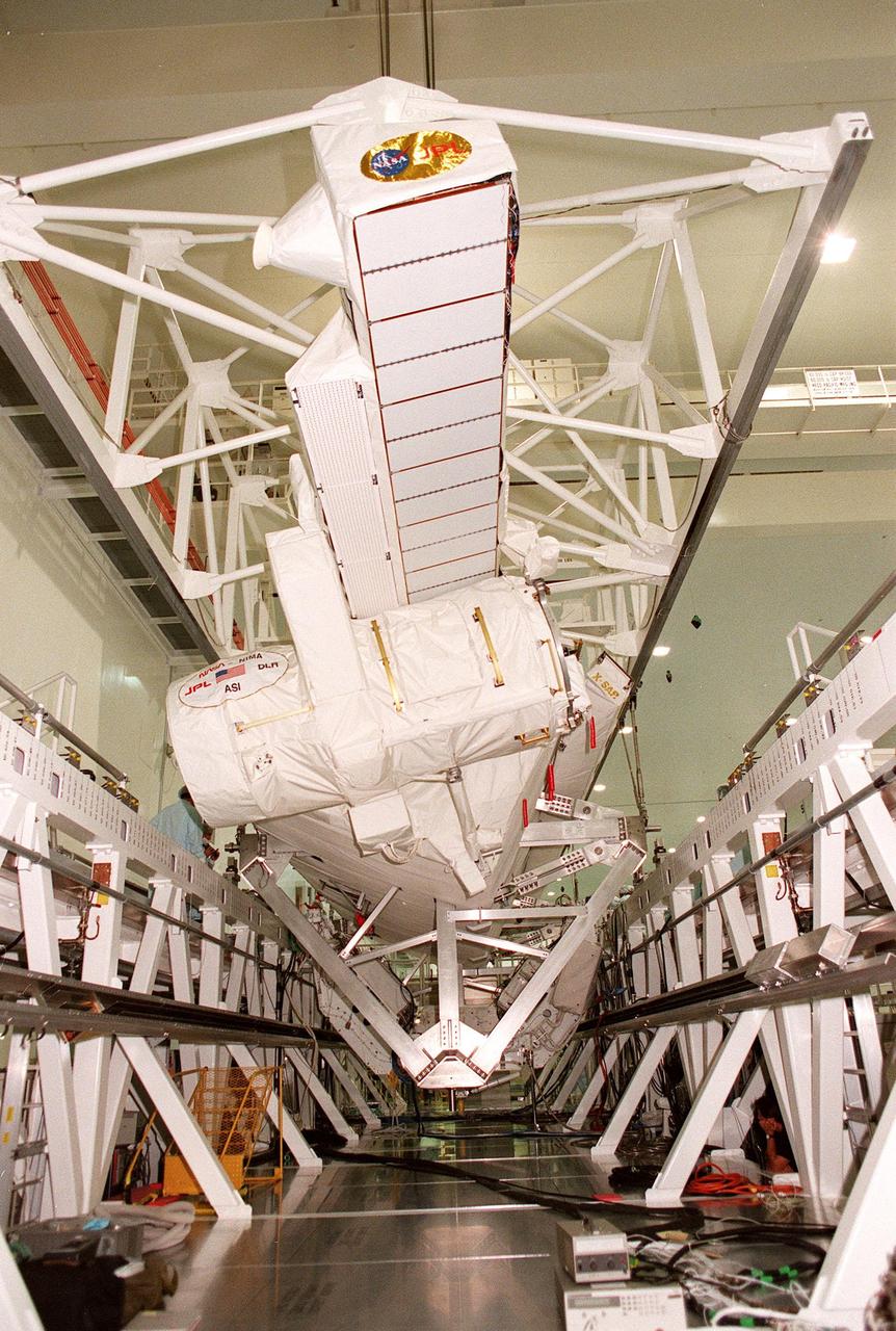
The move of the Shuttle Radar Topography Mission (SRTM) is nearly complete as it is lowered onto the workstand in the Space Station Processing Facility. The SRTM, which is the primary payload on mission STS-99, consists of a specially modified radar system that will fly onboard the Space Shuttle during the 11-day mission scheduled for launch in September 1999. The objective of this radar system is to obtain the most complete high-resolution digital topographic database of the Earth. It will gather data that will result in the most accurate and complete topographic map of the Earth's surface that has ever been assembled. SRTM is an international project spearheaded by the National Imagery and Mapping Agency and NASA, with participation of the German Aerospace Center DLR. SRTM will be making use of a technique called radar interferometry, wherein two radar images are taken from slightly different locations. Differences between these images allow for the calculation of surface elevation, or change. To get two radar images taken from different locations, the SRTM hardware will consist of one radar antenna in the shuttle payload bay and a second radar antenna attached to the end of a mast extended 60 meters (195 feet) out from the shuttle
KENNEDY SPACE CENTER, FLA. -- In the Orbiter Processing Facility, STS-99 Mission Specialists Gerhard P.J. Thiele and Janet Lynn Kavandi (Ph.D.) look over part of the Shuttle Radar Topography Mission (SRTM), primary payload for their mission, as part of a Crew Equipment Interface Test (CEIT). Also taking part in the CEIT are Commander Kevin R. Kregel, Pilot Dominic L. Pudwill Gorie, and Mission Specialists Janice Voss (Ph.D.) and Mamoru Mohri. Mohri is with the National Space Development Agency (NASDA) of Japan, and Thiele is with the European Space Agency. The CEIT provides an opportunity for crew members to check equipment and facilities that will be aboard the orbiter during their mission. The SRTM is a specially modified radar system that will gather data for the most accurate and complete topographic map of the Earth's surface that has ever been assembled. SRTM will make use of radar interferometry, wherein two radar images are taken from slightly different locations. Differences between these images allow for the calculation of surface elevation, or change. The SRTM hardware will consist of one radar antenna in the shuttle payload bay and a second radar antenna attached to the end of a mast extended 60 meters (195 feet) out from the shuttle. STS-99 is scheduled to launch Sept. 16 at 8:47 a.m. from Launch Pad 39A
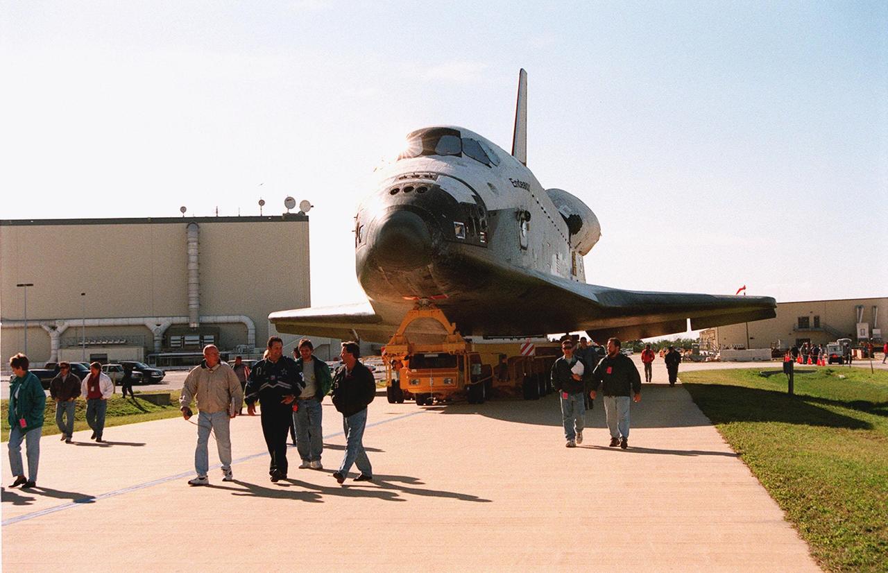
KENNEDY SPACE CENTER, FLA. -- Workers at KSC lead the way as Orbiter Endeavour, on an orbiter transfer vehicle, rolls from the Orbiter Processing Facility to the Vehicle Assembly Building, where it will be mated to the external tank and solid rocket boosters in high bay 1. Space Shuttle Endeavour is targeted for launch on mission STS-99 Jan. 13, 2000 at 1:11 p.m. EST. STS-99 is the Shuttle Radar Topography Mission, an international project spearheaded by the National Imagery and Mapping Agency and NASA, with participation of the German Aerospace Center DLR. The SRTM consists of a specially modified radar system that will gather data for the most accurate and complete topographic map of the Earth's surface that has ever been assembled. SRTM will make use of radar interferometry, wherein two radar images are taken from slightly different locations. Differences between these images allow for the calculation of surface elevation, or change. The SRTM hardware will consist of one radar antenna in the shuttle payload bay and a second radar antenna attached to the end of a mast extended 60 meters (195 feet) out from the shuttle
In the Space Station Processing Facility, STS-99 crew members take part in a simulated flight check of the Shuttle Radar Topography Mission (SRTM), above and behind them. The SRTM is the payload for their mission. The crew members are Commander Kevin R. Kregel, Pilot Dominic L. Pudwill Gorie, and Mission Specialists Janet Lynn kavandi (Ph.D.), Janice Voss (Ph.D.), Mamoru Mohri of Japan and Gerhard Thiele of Germany. Mohri represents the National Space Development Agency of Japan and Thiele represents the European Space Agency. An international project spearheaded by the National Imagery and Mapping Agency and NASA, with participation of the German Aerospace Center DLR, the SRTM consists of a specially modified radar system that will gather data for the most accurate and complete topographic map of the Earth's surface that has ever been assembled. SRTM will make use of radar interferometry, wherein two radar images are taken from slightly different locations. Differences between these images allow for the calculation of surface elevation, or change. The SRTM hardware will consist of one radar antenna in the shuttle payload bay and a second radar antenna attached to the end of a mast extended 60 meters (195 feet) out from the shuttle. STS-99 is scheduled to launch Sept. 16 at 8:47 a.m. from Launch Pad 39A
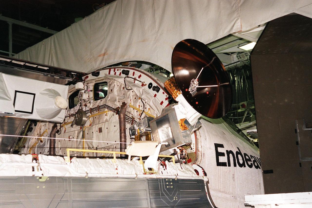
KENNEDY SPACE CENTER, FLA. -- In the Orbiter Processing Facility, a radar antenna, part of the Shuttle Radar Topography Mission (SRTM), is ready to be stored in the payload bay of the orbiter Endeavour before door closure. SRTM is the primary payload on mission STS-99, scheduled to launch Sept. 16 at 8:47 a.m. EDT from Launch Pad 39A. A specially modified radar system, the SRTM will gather data for the most accurate and complete topographic map of the Earth's surface that has ever been assembled. SRTM will make use of radar interferometry, wherein two radar images are taken from slightly different locations. Differences between these images allow for the calculation of surface elevation, or change. The SRTM hardware consists of one radar antenna in the shuttle payload bay and a second radar antenna attached to the end of a mast extended 60 meters (195 feet) out from the shuttle. SRTM is an international project spearheaded by the National Imagery and Mapping Agency and NASA, with participation of the German Aerospace Center DLR
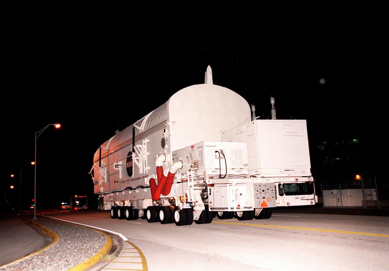
KENNEDY SPACE CENTER, FLA. -- A payload canister containing the Shuttle Radar Topography Mission (SRTM), riding atop a payload transporter, is moved from the Space Station Processing Facility to Orbiter Processing Facility (OPF) bay 2. Once there, the SRTM, the primary payload on STS-99, will be installed into the payload bay of the orbiter Endeavour. The SRTM consists of a specially modified radar system that will gather data for the most accurate and complete topographic map of the Earth's surface that has ever been assembled. SRTM will make use of radar interferometry, wherein two radar images are taken from slightly different locations. Differences between these images allow for the calculation of surface elevation. The SRTM hardware includes one radar antenna in the Shuttle payload bay and a second radar antenna attached to the end of a mast extended 60 meters (195 feet) from the shuttle. STS-99 is scheduled to launch Sept. 16 at 8:47 a.m. from Launch Pad 39A
KENNEDY SPACE CENTER, FLA. -- Viewed end to end, the interior of orbiter Endeavour's payload bay can be seen with its cargo (center and right) in place, before the close of its payload bay doors. The Ku-band antenna (lower right) is now in its closed position inside the payload bay. Endeavour is expected to roll over to the Vehicle Assembly Building in three days for mating to the external tank and solid rocket boosters in high bay 1. Space Shuttle Endeavour is targeted for launch on mission STS-99 Jan. 13, 2000 at 1:11 p.m. EST. STS-99 is the Shuttle Radar Topography Mission, an international project spearheaded by the National Imagery and Mapping Agency and NASA, with participation of the German Aerospace Center DLR. The SRTM consists of a specially modified radar system that will gather data for the most accurate and complete topographic map of the Earth's surface that has ever been assembled. SRTM will make use of radar interferometry, wherein two radar images are taken from slightly different locations. Differences between these images allow for the calculation of surface elevation, or change. The SRTM hardware will consist of one radar antenna in the shuttle payload bay and a second radar antenna attached to the end of a mast extended 60 meters (195 feet) out from the shuttle
KENNEDY SPACE CENTER, FLA. -- Orbiter Endeavour waits in the Orbiter Processing Facility bay 2 for the closing of its payload bay doors. The Ku-band antenna (upper right) is now in its closed position inside the payload bay. Endeavour is expected to roll over to the Vehicle Assembly Building in three days for mating to the external tank and solid rocket boosters in high bay 1. Space Shuttle Endeavour is targeted for launch on mission STS-99 Jan. 13, 2000 at 1:11 p.m. EST. STS-99 is the Shuttle Radar Topography Mission, an international project spearheaded by the National Imagery and Mapping Agency and NASA, with participation of the German Aerospace Center DLR. The SRTM consists of a specially modified radar system that will gather data for the most accurate and complete topographic map of the Earth's surface that has ever been assembled. SRTM will make use of radar interferometry, wherein two radar images are taken from slightly different locations. Differences between these images allow for the calculation of surface elevation, or change. The SRTM hardware will consist of one radar antenna in the shuttle payload bay and a second radar antenna attached to the end of a mast extended 60 meters (195 feet) out from the shuttle

KENNEDY SPACE CENTER, FLA. -- In the Orbiter Processing Facility, a radar antenna, part of the Shuttle Radar Topography Mission (SRTM), is nestled in the cargo bay of the orbiter Endeavour just before door closure. SRTM is the primary payload on mission STS-99, scheduled to launch Sept. 16 at 8:47 a.m. EDT from Launch Pad 39A. A specially modified radar system, the SRTM will gather data for the most accurate and complete topographic map of the Earth's surface that has ever been assembled. SRTM will make use of radar interferometry, wherein two radar images are taken from slightly different locations. Differences between these images allow for the calculation of surface elevation, or change. The SRTM hardware consists of one radar antenna in the shuttle payload bay and a second radar antenna attached to the end of a mast extended 60 meters (195 feet) out from the shuttle. SRTM is an international project spearheaded by the National Imagery and Mapping Agency and NASA, with participation of the German Aerospace Center DLR
A NASA radar instrument has been successfully used to measure some of the fastest moving and most inaccessible glaciers in the world -- in Chile's huge, remote Patagonia ice fields -- demonstrating a technique that could produce more accurate predictions of glacial response to climate change and corresponding sea level changes. This image, produced with interferometric measurements made by the Spaceborne Imaging Radar-C and X-band Synthetic Aperture Radar (SIR-C/X-SAR) flown on the Space Shuttle last fall, has provided the first detailed measurements of the mass and motion of the San Rafael Glacier. Very few measurements have been made of the Patagonian ice fields, which are the world's largest mid-latitude ice masses and account for more than 60 percent of the Southern Hemisphere's glacial area outside of Antarctica. These features make the area essential for climatologists attempting to understand the response of glaciers on a global scale to changes in climate, but the region's inaccessibility and inhospitable climate have made it nearly impossible for scientists to study its glacial topography, meteorology and changes over time. Currently, topographic data exist for only a few glaciers while no data exist for the vast interior of the ice fields. Velocity has been measured on only five of the more than 100 glaciers, and the data consist of only a few single-point measurements. The interferometry performed by the SIR-C/X-SAR was used to generate both a digital elevation model of the glaciers and a map of their ice motion on a pixel-per-pixel basis at very high resolution for the first time. The data were acquired from nearly the same position in space on October 9, 10 and 11, 1994, at L-band frequency (24-cm wavelength), vertically transmitted and received polarization, as the Space Shuttle Endeavor flew over several Patagonian outlet glaciers of the San Rafael Laguna. The area shown in these two images is 50 kilometers by 30 kilometers (30 miles by 18 miles) in size and is centered at 46.6 degrees south latitude, 73.8 degrees west longitude. North is toward the upper right. The top image is a digital elevation model of the scene, where color and saturation represent terrain height (between 0 meters and 2,000 meters or up to 6,500 feet) and brightness represents radar backscatter. Low elevations are shown in blue and high elevations are shown in pink. The digital elevation map of the glacier surface has a horizontal resolution of 15 meters (50 feet) and a vertical resolution of 10 meters (30 feet). High-resolution maps like these acquired over several years would allow scientists to calculate directly long-term changes in the mass of the glacier. The bottom image is a map of ice motion parallel to the radar look direction only, which is from the top of the image. Purple indicates ice motion away from the radar at more than 6 centimeters per day; dark blue is ice motion toward or away at less than 6 cm per day; light blue is motion toward the radar of 6 cm to 20 cm (about 2 to 8 inches) per day; green is motion toward the radar of 20 cm to 45 cm (about 8 to 18 inches) per day; yellow is 45 cm to 85 cm (about 18 to 33 inches) per day; orange is 85 cm to 180 cm (about 33 to 71 inches) per day; red is greater than 180 cm (71 inches) per day. The velocity estimates are accurate to within 5 millimeters per day. The largest velocities are recorded on the San Rafael Glacier in agreement with previous work. Other outlet glaciers exhibit ice velocities of less than 1 meter per day. Several kilometers before its terminus, (left of center) the velocity of the San Rafael Glacier exceeds 10 meters (32 feet) per day, and ice motion cannot be estimated from the data. There, a revisit time interval of less than 12 hours would have been necessary to estimate ice motion from interferometry data. The results however demonstrate that the radar interferometry technique permits the monitoring of glacier characteristics unattainable by any other means. http://photojournal.jpl.nasa.gov/catalog/PIA01781
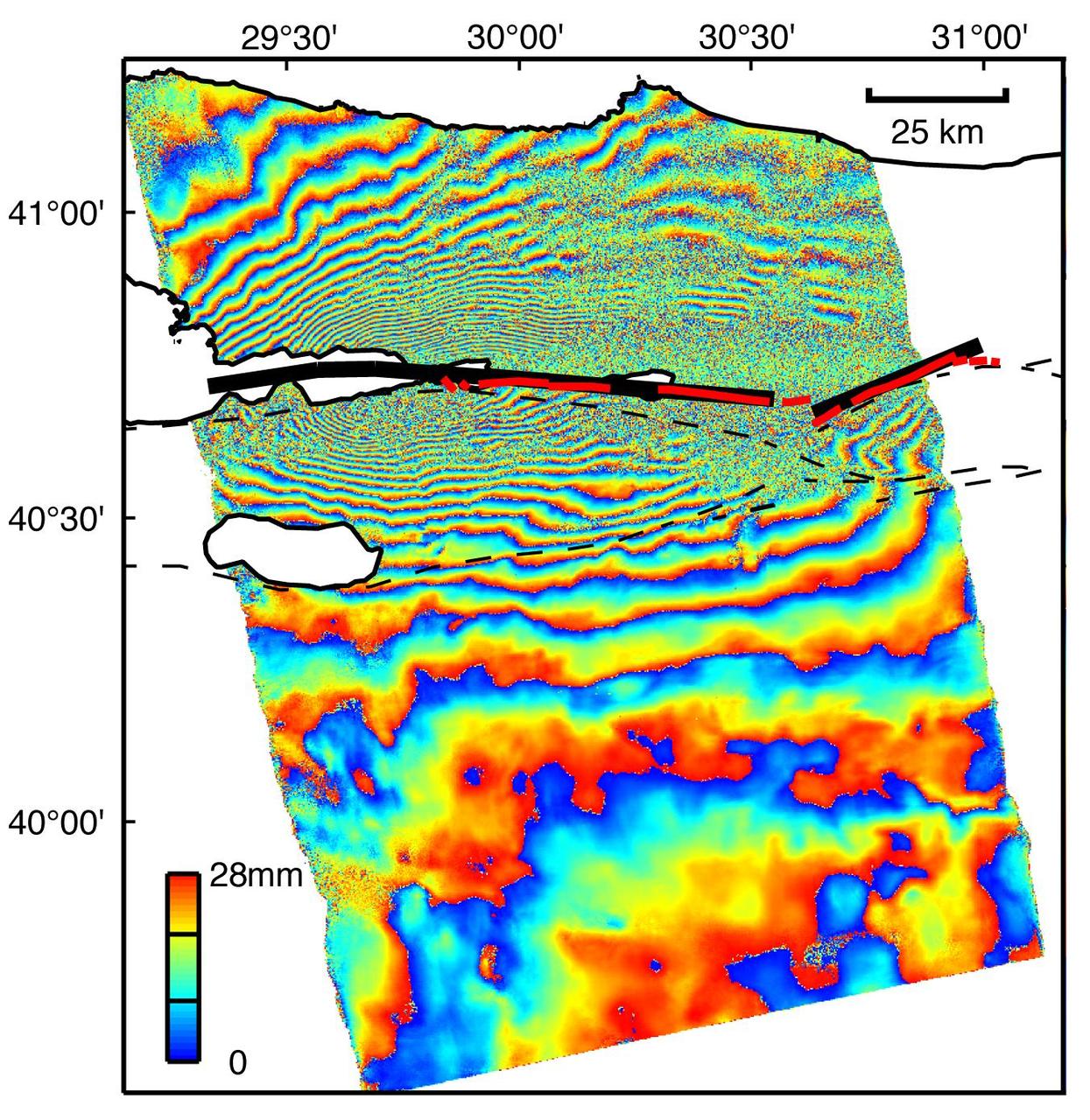
This image is an interferogram that was created using pairs of images taken by Synthetic Aperture Radar (SAR). The images, acquired at two different times, have been combined to measure surface deformation or changes that may have occurred during the time between data acquisition. The images were collected by the European Space Agency's Remote Sensing satellite (ERS-2) on 13 August 1999 and 17 September 1999 and were combined to produce these image maps of the apparent surface deformation, or changes, during and after the 17 August 1999 Izmit, Turkey earthquake. This magnitude 7.6 earthquake was the largest in 60 years in Turkey and caused extensive damage and loss of life. Each of the color contours of the interferogram represents 28 mm (1.1 inches) of motion towards the satellite, or about 70 mm (2.8 inches) of horizontal motion. White areas are outside the SAR image or water of seas and lakes. The North Anatolian Fault that broke during the Izmit earthquake moved more than 2.5 meters (8.1 feet) to produce the pattern measured by the interferogram. Thin red lines show the locations of fault breaks mapped on the surface. The SAR interferogram shows that the deformation and fault slip extended west of the surface faults, underneath the Gulf of Izmit. Thick black lines mark the fault rupture inferred from the SAR data. Scientists are using the SAR interferometry along with other data collected on the ground to estimate the pattern of slip that occurred during the Izmit earthquake. This then used to improve computer models that predict how this deformation transferred stress to other faults and to the continuation of the North Anatolian Fault, which extends to the west past the large city of Istanbul. These models show that the Izmit earthquake further increased the already high probability of a major earthquake near Istanbul. http://photojournal.jpl.nasa.gov/catalog/PIA00557
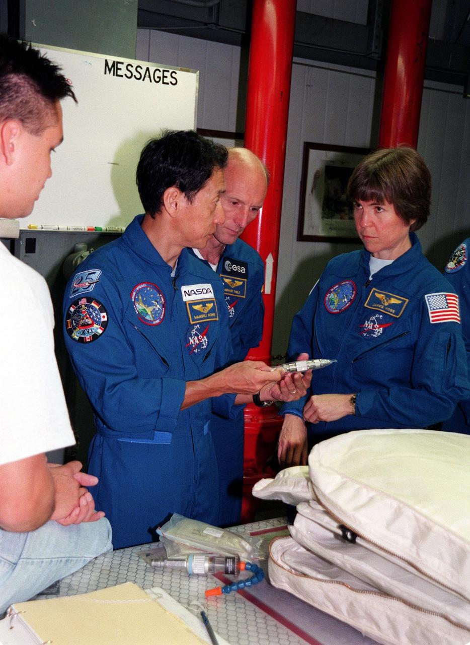
Under the watchful eyes of a KSC worker (far left), members of the STS-99 crew check out equipment in the Orbiter Processing Facility (OPF) Bay 2. From left are Mission Specialists Mamoru Mohri, Gerhard P.J. Thiele, and Janice Voss (Ph.D.). Mohri represents the National Space Development Agency (NASDA) of Japan, and Thiele the European Space Agency. Other crew members (not shown) are Commander Kevin R. Kregel, Pilot Dominic L. Pudwill Gorie, and Mission Specialist Janet Lynn Kavandi (Ph.D.). The crew are at KSC to take part in a Crew Equipment Interface Test (CEIT), which provides an opportunity for crew members to check equipment and facilities that will be aboard the orbiter during their mission. The STS-99 mission is the Shuttle Radar Topography Mission (SRTM), a specially modified radar system that will gather data for the most accurate and complete topographic map of the Earth's surface that has ever been assembled. SRTM will make use of radar interferometry, wherein two radar images are taken from slightly different locations. Differences between these images allow for the calculation of surface elevation, or change. The SRTM hardware will consist of one radar antenna in the shuttle payload bay and a second radar antenna attached to the end of a mast extended 60 meters (195 feet) out from the shuttle. STS-99 is scheduled to launch Sept. 16 at 8:47 a.m. from Launch Pad 39A
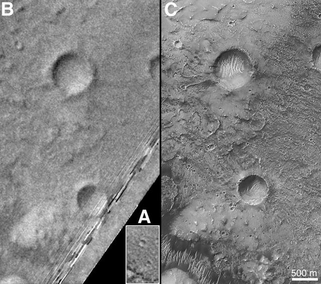
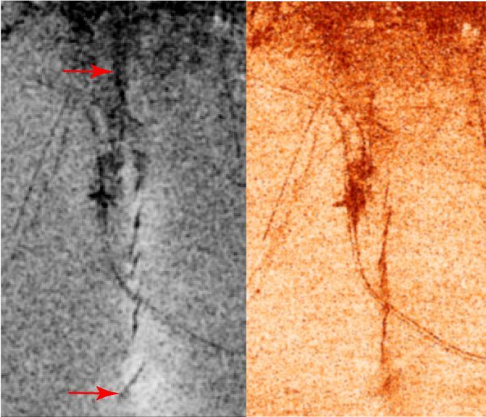
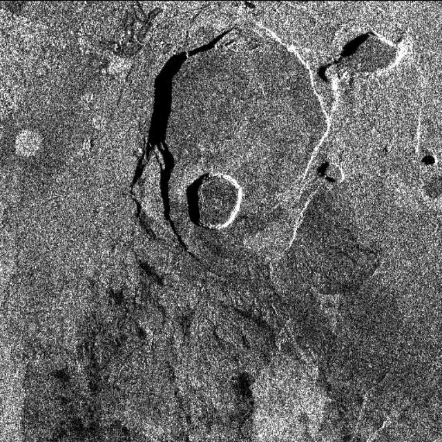
On Earth, the longitude of the Royal Observatory in Greenwich, England is defined as the "prime meridian," or the zero point of longitude. Locations on Earth are measured in degrees east or west from this position. The prime meridian was defined by international agreement in 1884 as the position of the large "transit circle," a telescope in the Observatory's Meridian Building. The transit circle was built by Sir George Biddell Airy, the 7th Astronomer Royal, in 1850. (While visual observations with transits were the basis of navigation until the space age, it is interesting to note that the current definition of the prime meridian is in reference to orbiting satellites and Very Long Baseline Interferometry (VLBI) measurements of distant radio sources such as quasars. This "International Reference Meridian" is now about 100 meters east of the Airy Transit at Greenwich.) For Mars, the prime meridian was first defined by the German astronomers W. Beer and J. H. Mädler in 1830-32. They used a small circular feature, which they designated "a," as a reference point to determine the rotation period of the planet. The Italian astronomer G. V. Schiaparelli, in his 1877 map of Mars, used this feature as the zero point of longitude. It was subsequently named Sinus Meridiani ("Middle Bay") by Camille Flammarion. When Mariner 9 mapped the planet at about 1 kilometer (0.62 mile) resolution in 1972, an extensive "control net" of locations was computed by Merton Davies of the RAND Corporation. Davies designated a 0.5-kilometer-wide crater (0.3 miles wide), subsequently named "Airy-0" (within the large crater Airy in Sinus Meridiani) as the longitude zero point. (Airy, of course, was named to commemorate the builder of the Greenwich transit.) This crater was imaged once by Mariner 9 (the 3rd picture taken on its 533rd orbit, 533B03) and once by the Viking 1 orbiter in 1978 (the 46th image on that spacecraft's 746th orbit, 746A46), and these two images were the basis of the martian longitude system for the rest of the 20th Century. The Mars Global Surveyor (MGS) Mars Orbiter Camera (MOC) has attempted to take a picture of Airy-0 on every close overflight since the beginning of the MGS mapping mission. It is a measure of the difficulty of hitting such a small target that nine attempts were required, since the spacecraft did not pass directly over Airy-0 until almost the end of the MGS primary mission, on orbit 8280 (January 13, 2001). In the left figure above, the outlines of the Mariner 9, Viking, and Mars Global Surveyor images are shown on a MOC wide angle context image, M23-00924. In the right figure, sections of each of the three images showing the crater Airy-0 are presented. A is a piece of the Mariner 9 image, B is from the Viking image, and C is from the MGS image. Airy-0 is the larger crater toward the top-center in each frame. The MOC observations of Airy-0 not only provide a detailed geological close-up of this historic reference feature, they will be used to improve our knowledge of the locations of all features on Mars, which will in turn enable more precise landings on the Red Planet by future spacecraft and explorers. http://photojournal.jpl.nasa.gov/catalog/PIA03207