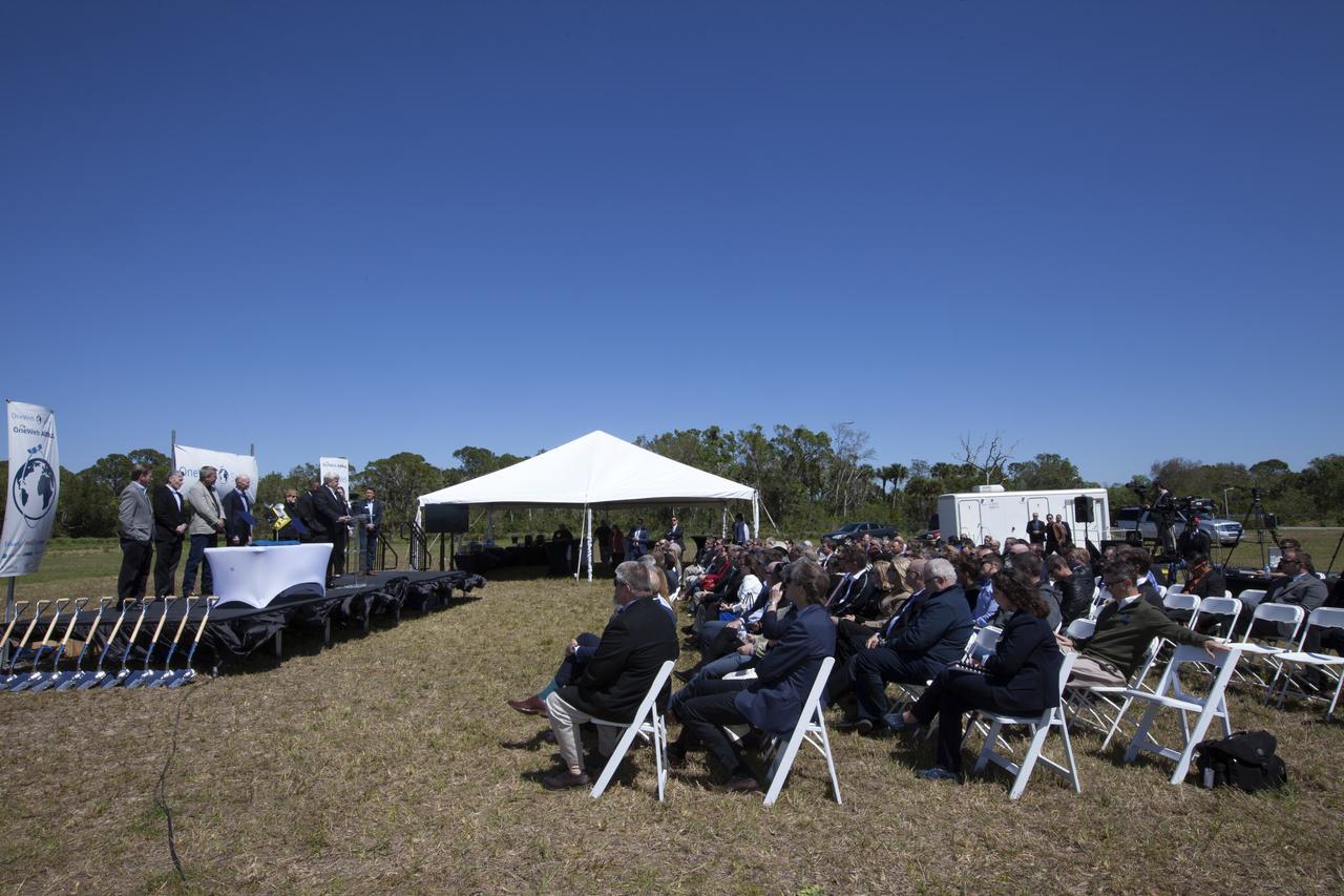
Jim Kuzma, COO of Space Florida, speaks during the groundbreaking ceremony at Kennedy's Exploration Park for OneWeb. The company, in partnership with Airbus, is building a 150,000-square-foot factory to manufacture satellites that will connect all areas of the world to the Internet wirelessly. Photo credit: NASA/Kim Shiflett
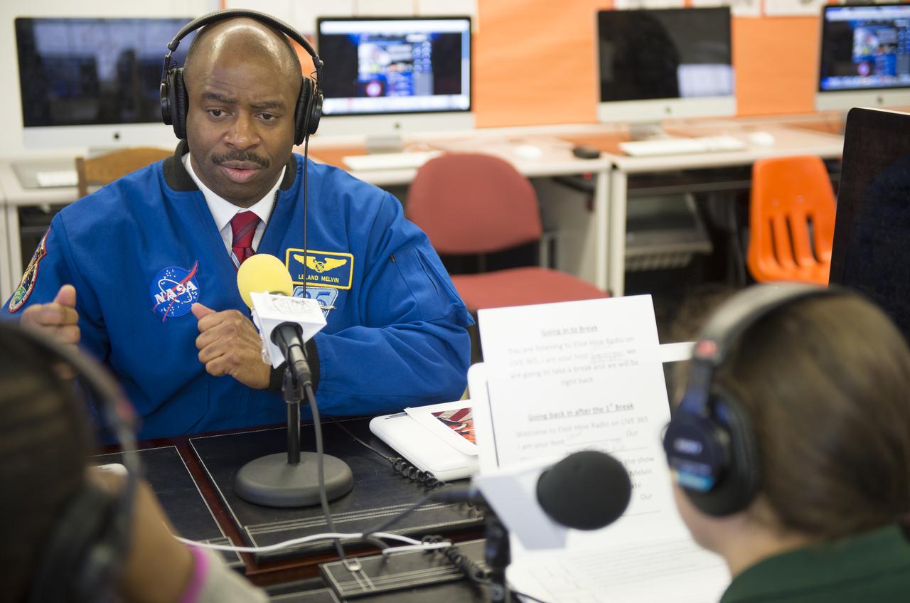
Leland Melvin, NASA Associate Administrator for Education and former astronaut, is interviewed by sixth grade students from the Broadcast Media Class at Eliot Hine Middle School on Friday, March 1, 2013 in Washington. The radio club program, Eliot Hine Radio, is broadcast live on the internet. Photo Credit: (NASA/Carla Cioffi)

Brian Holz, CEO of OneWeb Satellites, speaks during the groundbreaking ceremony at Kennedy's Exploration Park for OneWeb. The company, in partnership with Airbus, is building a 150,000-square-foot factory to manufacture satellites that will connect all areas of the world to the Internet wirelessly. Photo credit: NASA/Kim Shiflett

Cissy Procter, executive director of the Florida Department of Economic Activity, speaks during the groundbreaking ceremony at Kennedy's Exploration Park for OneWeb. The company, in partnership with Airbus, is building a 150,000-square-foot factory to manufacture satellites that will connect all areas of the world to the Internet wirelessly. Photo credit: NASA/Kim Shiflett

Florida Governor Rick Scott speaks during the groundbreaking ceremony at Kennedy's Exploration Park for OneWeb. The company, in partnership with Airbus, is building a 150,000-square-foot factory to manufacture satellites that will connect all areas of the world to the Internet wirelessly. Photo credit: NASA/Kim Shiflett

Leland Melvin, NASA Associate Administrator for Education and former astronaut, is interviewed by sixth grade students from the Broadcast Media Class at Eliot Hine Middle School on Friday, March 1, 2013 in Washington. The radio club program, Eliot Hine Radio, is broadcast live on the internet. Photo Credit: (NASA/Carla Cioffi)
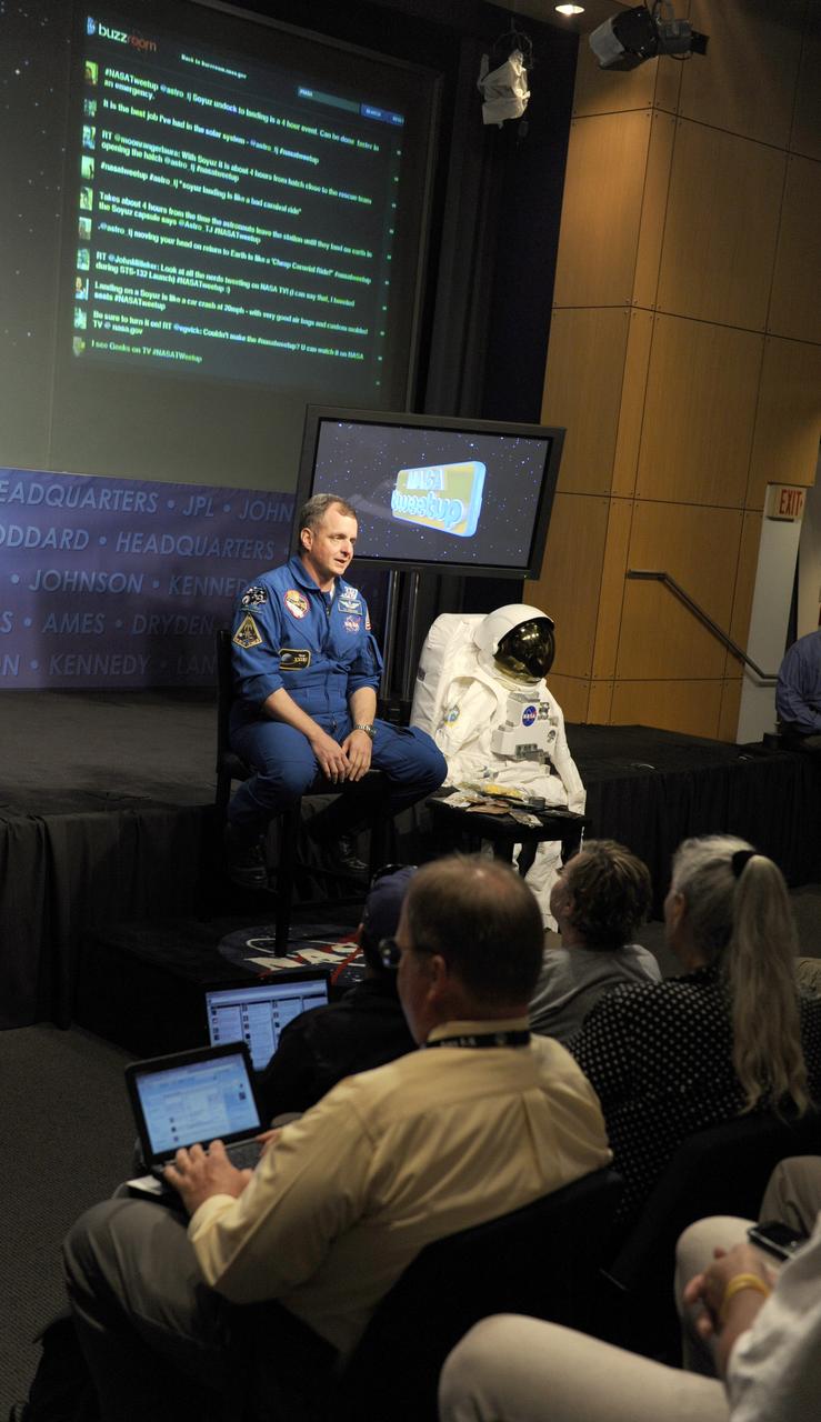
NASA astronaut TJ Creamer talks about his experience in space during a "Tweetup" at NASA Headquarters, Thursday, July 29, 2010, in Washington. Creamer, who spent 161 days living aboard the International Space Station as part of the Expedition 22/23 crew, set up the orbiting outpost's live Internet connection and posted updates about the mission to his Twitter account, sending the first live tweet from orbit. Photo Credit: (NASA/Paul E. Alers)

jsc2023e038727 (6/22/2023) --- Principal Investigator Yamanaka Tsutomu conducted online and in-person lectures for students. I-Space Essay provides students and teachers the online opportunity to create wishes, which are delivered to the International Space Station's Japanese Experimental Module Kibo. In 2022, about 8,000 students from 35 elementary, junior high and high schools in 7 countries (Japan, USA, Australia, Germany, UK, Spain, and South Africa) joined this internet-based project. Image courtesy of Mitsumura-Tosho and IHI Corporation.
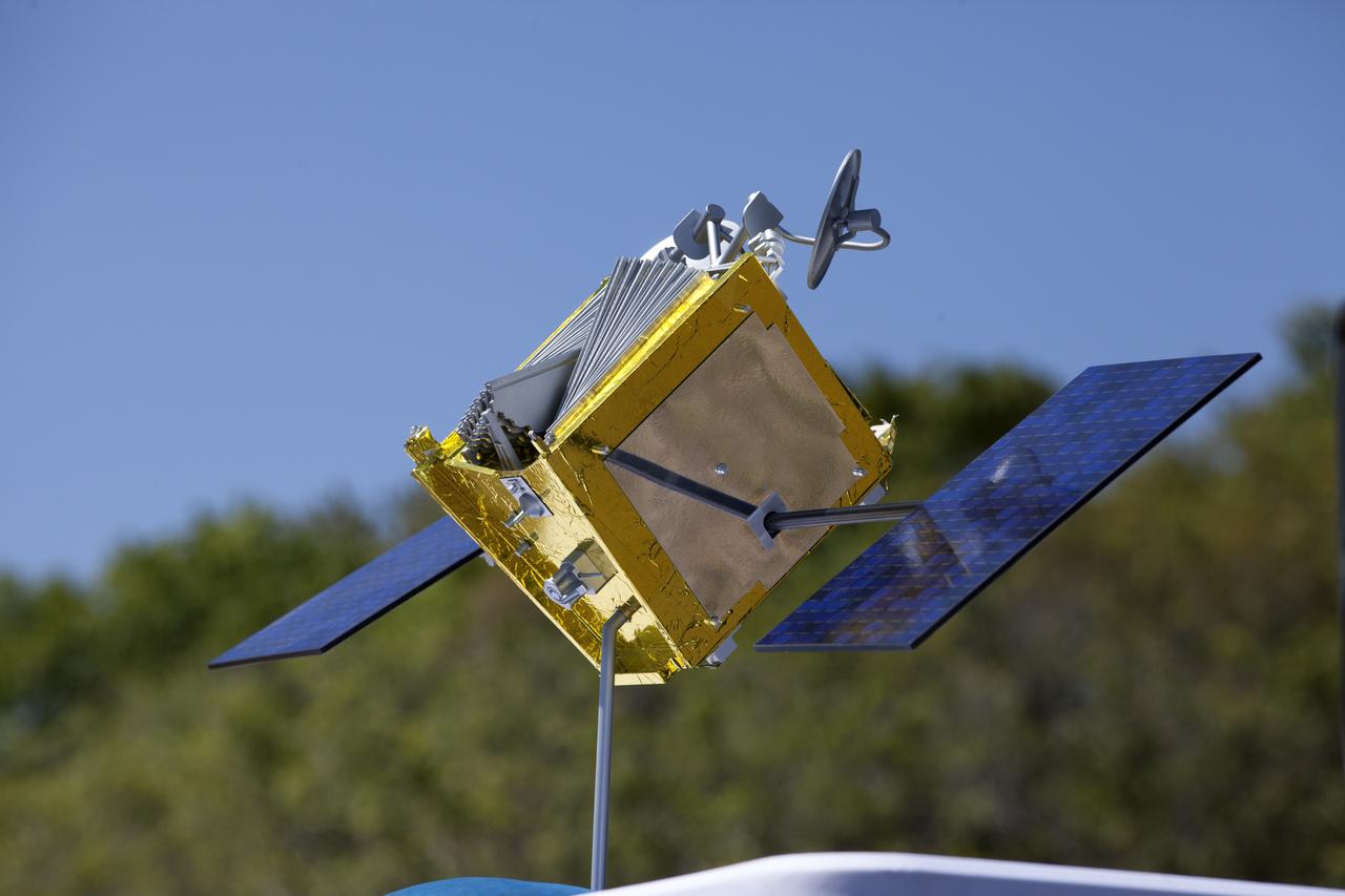
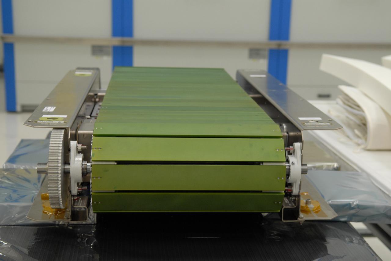
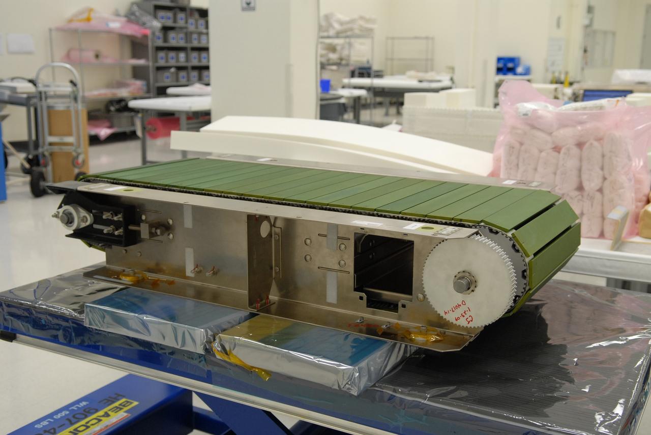
A model of a OneWeb satellite like those the company will build to will connect all areas of the world to the Internet wirelessly. The company plans to launch 2,000 of the satellites as part of its constellation. The satellites will be built at a new factory at Exploration Park at NASA's Kennedy Space Center. The company held a groundbreaking ceremony for the factory. Photo credit: NASA/Kim Shiflett
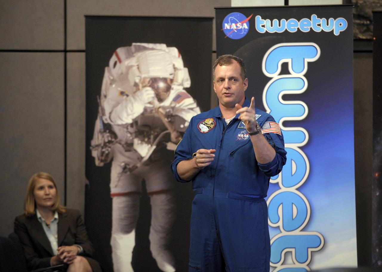
NASA astronaut TJ Creamer talks about his experience in space during a "Tweetup" at NASA Headquarters, Thursday, July 29, 2010, in Washington. Creamer, who spent 161 days living aboard the International Space Station as part of the Expedition 22/23 crew, set up the orbiting outpost's live Internet connection and posted updates about the mission to his Twitter account, sending the first live tweet from orbit. Photo Credit: (NASA/Paul E. Alers)
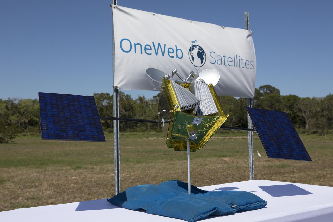
A model of a OneWeb satellite like those the company will build to will connect all areas of the world to the Internet wirelessly. The company plans to launch 2,000 of the satellites as part of its constellation. The satellites will be built at a new factory at Exploration Park at NASA's Kennedy Space Center. The company held a groundbreaking ceremony for the factory. Photo credit: NASA/Kim Shiflett
jsc2025e000002 (1/2/2025) --- YODAKA, a 6U size CubeSat, performs the “tanka” (short Japanese poems) mission with the Internet of Things (IoT) communication device and the Earth observation mission with the multi-spectral cameras. YODAKA is deployed as part of the JEM Small Satellite Orbital Deployer-30 (J-SSOD-30) CubeSat deployment mission from the International Space Station. Image courtesy of ArkEdge Space Inc.
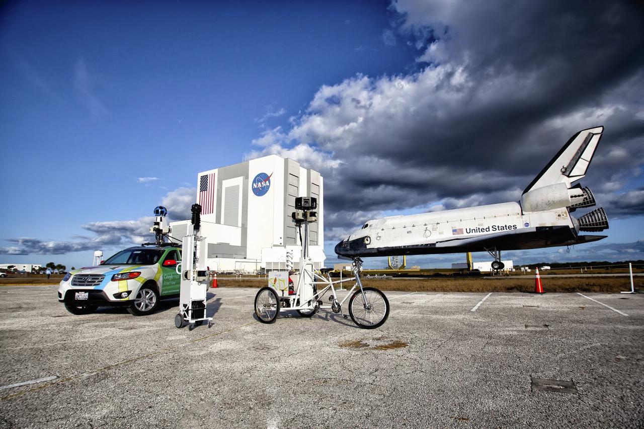
CAPE CANAVERAL, Fla. – Google used an assortment of vehicles to precisely map NASA's Kennedy Space Center in Florida to be featured on the company's map page. The work allows Internet users to see inside buildings at Kennedy as they were used during the space shuttle era. Google used a car, tricycle and pushcart to maneuver around the center and through some of its facilities. Photo credit: Google/Wendy Wang
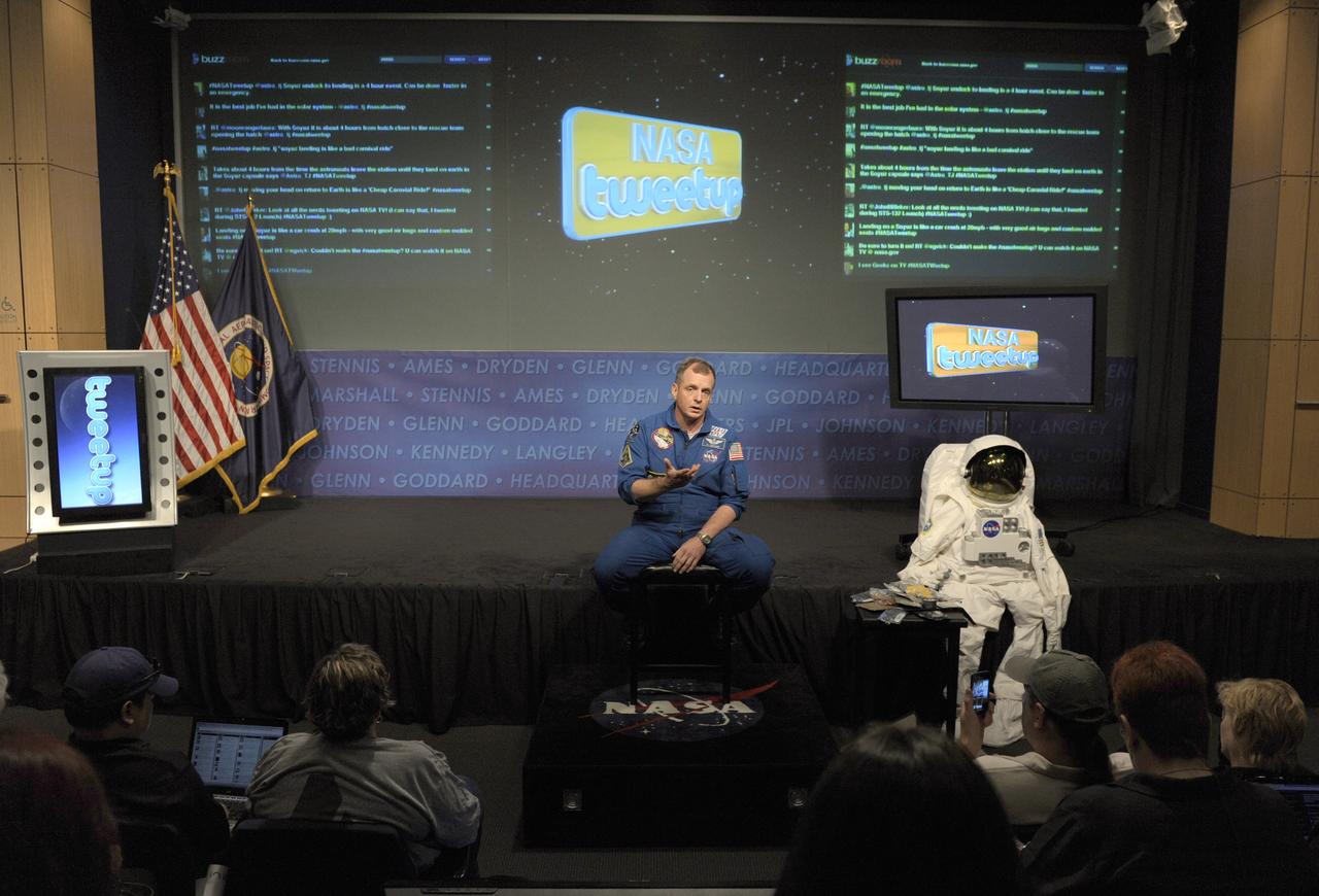
NASA astronaut TJ Creamer talks about his experience in space during a "Tweetup" at NASA Headquarters, Thursday, July 29, 2010, in Washington. Creamer, who spent 161 days living aboard the International Space Station as part of the Expedition 22/23 crew, set up the orbiting outpost's live Internet connection and posted updates about the mission to his Twitter account, sending the first live tweet from orbit. Photo Credit: (NASA/Paul E. Alers)

Lynda Weatherman, president and CEO of the Economic Development Council of the Space Coast, talks with Kelvin Manning, associate director of NASA's Kennedy Space Center, and Gen. Wayne Monteith, commander of the 45th Space Wing of the U.S. Air Force, prior to a groundbreaking ceremony at Kennedy's Exploration Park for OneWeb. The company, in partnership with Airbus, is building a 150,000-square-foot factory to manufacture satellites that will connect all areas of the world to the Internet wirelessly. Photo credit: NASA/Kim Shiflett
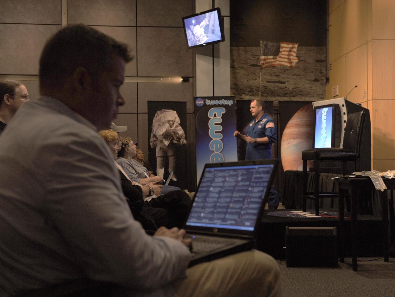
NASA astronaut TJ Creamer talks about his experience in space during a "Tweetup" at NASA Headquarters, Thursday, July 29, 2010, in Washington as Twitter followers looks on. Creamer, who spent 161 days living aboard the International Space Station as part of the Expedition 22/23 crew, set up the orbiting outpost's live Internet connection and posted updates about the mission to his Twitter account, sending the first live tweet from orbit. Photo Credit: (NASA/Paul E. Alers)
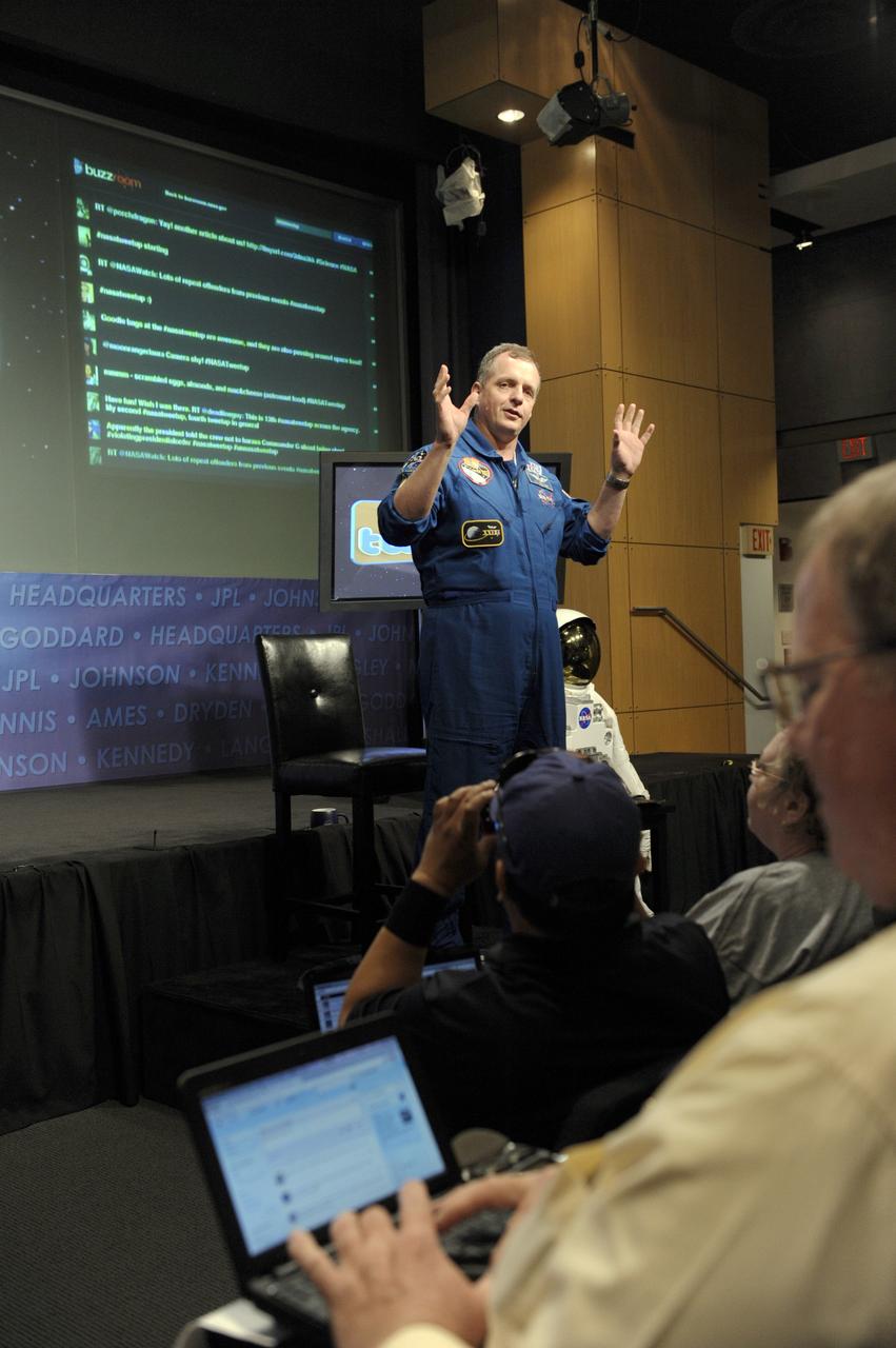
NASA astronaut TJ Creamer talks about his experience in space during a "Tweetup" at NASA Headquarters, Thursday, July 29, 2010, in Washington. Creamer, who spent 161 days living aboard the International Space Station as part of the Expedition 22/23 crew, set up the orbiting outpost's live Internet connection and posted updates about the mission to his Twitter account, sending the first live tweet from orbit. Photo Credit: (NASA/Paul E. Alers)
Project DaVinci is a student-led team at North Idaho STEM Charter Academy. Their spacecraft, the DaVinci satellite, has been constructed with the intent to connect with students worldwide to help reignite a passion for space. When launched, the DaVinci satellite will begin broadcasting messages across the globe using amateur radio uplink and downlink frequencies. Students in nearly every country will be able to receive these messages using a USB receiver dongle, open source software, and a yagi antenna in locations where the signal may be weaker. All messages will be education-related, and messages received will be in Morse Code requiring students to download a translating app or to translate it themselves. The DaVinci satellite will use the internet as a redundancy communication channel while in orbit. It is one of the few CubeSat to have a GlobalStar modem onboard, and will allow team members to upload digital messages to internet through the satellite. DaVinci satellite has an onboard Arducam as well, and will provide photos of Earth from its position in orbit. These pictures can be retrieved by the team using the GlobalStar modem and its corresponding server. To Learn more about the DaVinci satellite, visit www.projectdavincicubesat.org/
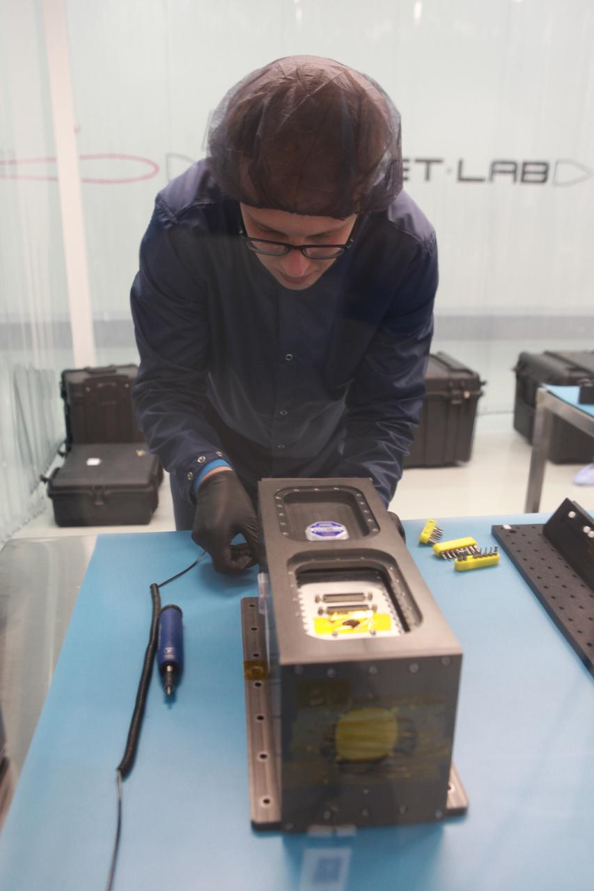
Project DaVinci is a student-led team at North Idaho STEM Charter Academy. Their spacecraft, the DaVinci satellite, has been constructed with the intent to connect with students worldwide to help reignite a passion for space. When launched, the DaVinci satellite will begin broadcasting messages across the globe using amateur radio uplink and downlink frequencies. Students in nearly every country will be able to receive these messages using a USB receiver dongle, open source software, and a yagi antenna in locations where the signal may be weaker. All messages will be education-related, and messages received will be in Morse Code requiring students to download a translating app or to translate it themselves. The DaVinci satellite will use the internet as a redundancy communication channel while in orbit. It is one of the few CubeSat to have a GlobalStar modem onboard, and will allow team members to upload digital messages to internet through the satellite. DaVinci satellite has an onboard Arducam as well, and will provide photos of Earth from its position in orbit. These pictures can be retrieved by the team using the GlobalStar modem and its corresponding server. To Learn more about the DaVinci satellite, visit www.projectdavincicubesat.org/
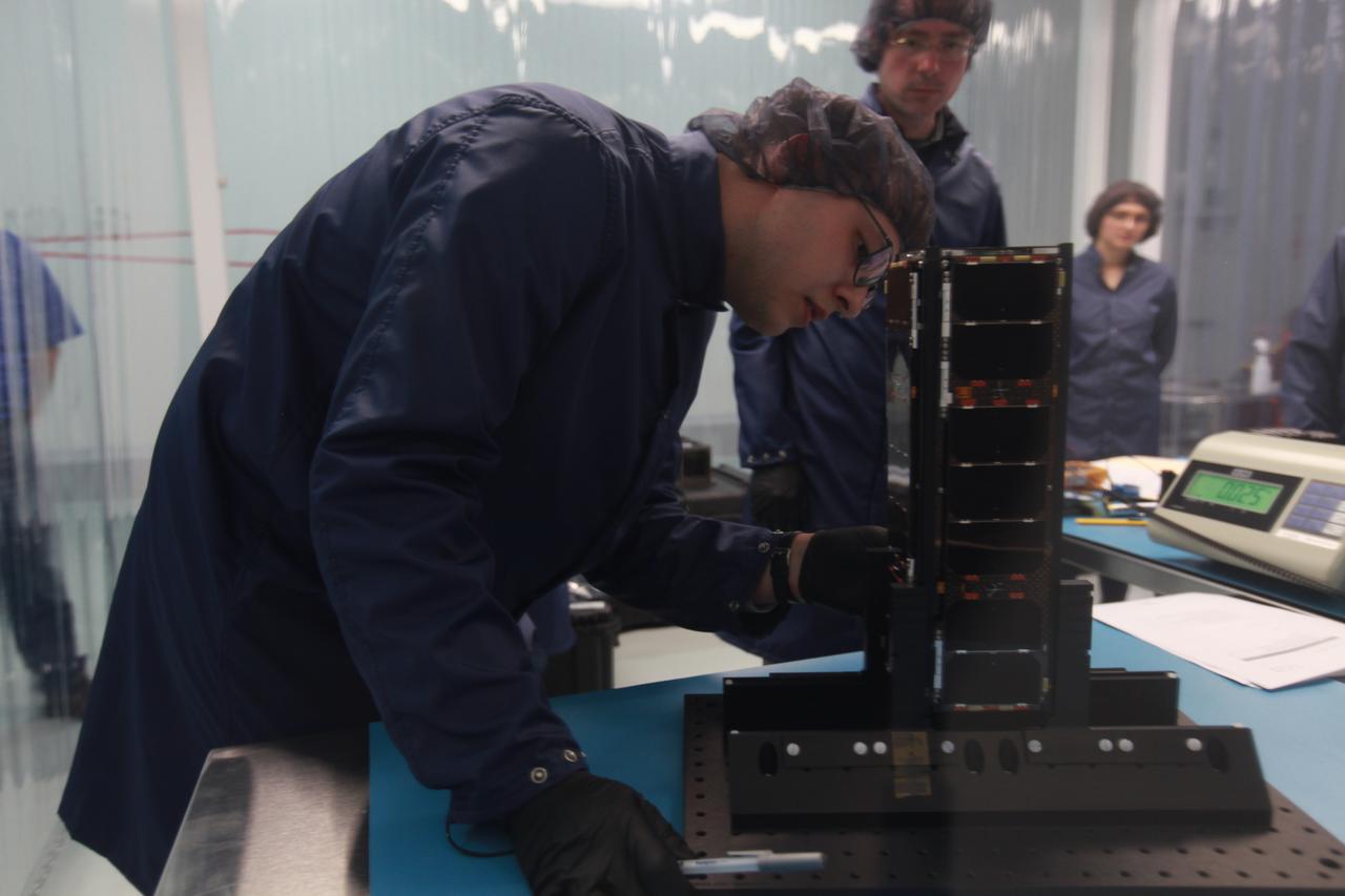
Project DaVinci is a student-led team at North Idaho STEM Charter Academy. Their spacecraft, the DaVinci satellite, has been constructed with the intent to connect with students worldwide to help reignite a passion for space. When launched, the DaVinci satellite will begin broadcasting messages across the globe using amateur radio uplink and downlink frequencies. Students in nearly every country will be able to receive these messages using a USB receiver dongle, open source software, and a yagi antenna in locations where the signal may be weaker. All messages will be education-related, and messages received will be in Morse Code requiring students to download a translating app or to translate it themselves. The DaVinci satellite will use the internet as a redundancy communication channel while in orbit. It is one of the few CubeSat to have a GlobalStar modem onboard, and will allow team members to upload digital messages to internet through the satellite. DaVinci satellite has an onboard Arducam as well, and will provide photos of Earth from its position in orbit. These pictures can be retrieved by the team using the GlobalStar modem and its corresponding server. To Learn more about the DaVinci satellite, visit www.projectdavincicubesat.org/

A SpaceX Falcon 9 rocket carrying a batch of the company's Starlink internet satellites lifts off from Launch Complex 40 at Cape Canaveral Space Force Station in Florida, on April 21, 2022. On the right, NASA’s Space Launch System rocket with the Orion spacecraft aboard sits atop a mobile launcher at Launch Complex 39B at Kennedy Space Center, while on the left at Kennedy’s Launch Complex 39A is a SpaceX Falcon 9 rocket with the company's Crew Dragon spacecraft, as preparations continue for the agency’s Crew-4 mission to the International Space Station.

A SpaceX Falcon 9 rocket carrying a batch of the company's Starlink internet satellites lifts off from Launch Complex 40 at Cape Canaveral Space Force Station in Florida, on April 21, 2022. On the right, NASA’s Space Launch System rocket with the Orion spacecraft aboard sits atop a mobile launcher at Launch Complex 39B at Kennedy Space Center, while on the left at Kennedy’s Launch Complex 39A is a SpaceX Falcon 9 rocket with the company's Crew Dragon spacecraft, as preparations continue for the agency’s Crew-4 mission to the International Space Station.
CAPE CANAVERAL, Fla. – As seen on Google Maps, a Space Shuttle Main Engine, or SSME, stands inside the Engine Shop at Orbiter Processing Facility 3 at NASA's Kennedy Space Center. Each orbiter used three of the engines during launch and ascent into orbit. The engines burn super-cold liquid hydrogen and liquid oxygen and each one produces 155,000 pounds of thrust. The engines, known in the industry as RS-25s, could be reused on multiple shuttle missions. They will be used again later this decade for NASA's Space Launch System rocket. Google precisely mapped the space center and some of its historical facilities for the company's map page. The work allows Internet users to see inside buildings at Kennedy as they were used during the space shuttle era. Photo credit: Google/Wendy Wang
CAPE CANAVERAL, Fla. – As seen on Google Maps, the Rotating Service Structure at Launch Complex 39A at NASA's Kennedy Space Center housed space shuttle payloads temporarily so they could be loaded inside the 60-foot-long cargo bay of a shuttle before launch. The RSS, as the structure was known, was hinged to the Fixed Service Structure on one side and rolled on a rail on the other. As its name suggests, the enclosed facility would rotate into place around the shuttle as it stood at the launch pad. Once in place, the RSS protected the shuttle and its cargo. Google precisely mapped the space center and some of its historical facilities for the company's map page. The work allows Internet users to see inside buildings at Kennedy as they were used during the space shuttle era. Photo credit: Google/Wendy Wang
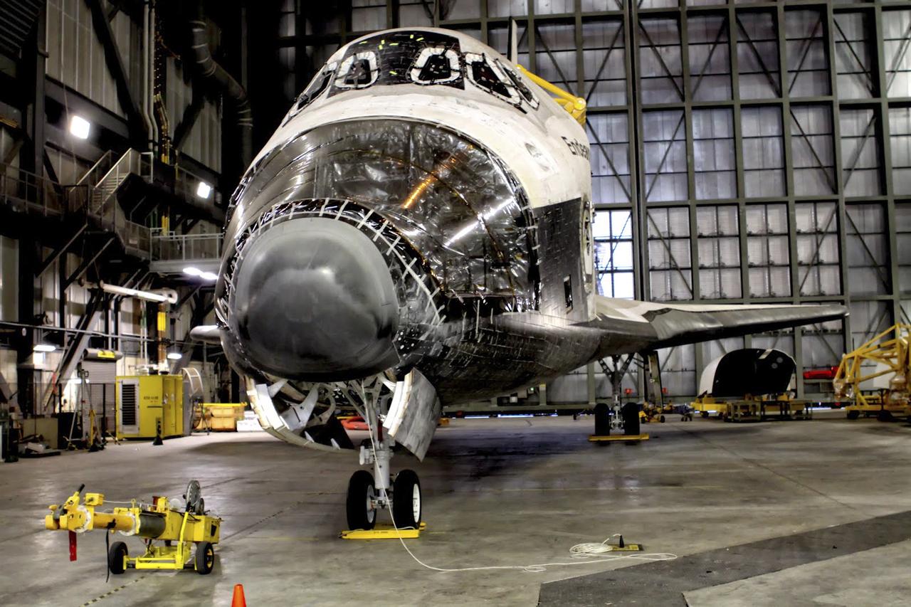
CAPE CANAVERAL, Fla. – As seen on Google Maps, space shuttle Endeavour goes through transition and retirement processing in high bay 4 of the Vehicle Assembly Building at NASA's Kennedy Space Center. The spacecraft completed 25 missions beginning with its first flight, STS-49, in May 1992, and ending with STS-134 in May 2011. It helped construct the International Space Station in orbit and travelled more than 122 million miles in orbit during its career. The reaction control system pods in the shuttle's nose and aft section were removed for processing before Endeavour was put on public display at the California Science Center in Los Angeles. Google precisely mapped the space center and some of its historical facilities for the company's map page. The work allows Internet users to see inside buildings at Kennedy as they were used during the space shuttle era. Photo credit: Google/Wendy Wang
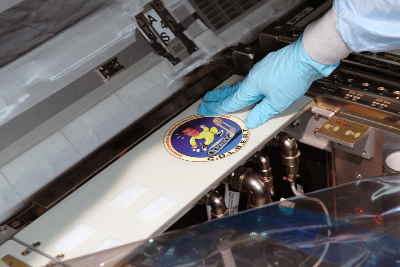
CAPE CANAVERAL, Fla. – The C.O.L.B.E.R.T decal is placed on the Combined Operational Load Bearing External Resistance Treadmill. The treadmill shares space in the Leonardo multi-purpose logistics module in the Space Station Processing Facility at NASA's Kennedy Space Center in Florida. The module is part of the payload for the STS-128 mission to the International Space Station aboard space shuttle Discovery. The treadmill is named after comedian Stephen Colbert, the host of Comedy Central’s “The Colbert Report.” Colbert urged his viewers to suggest the name “Colbert” as the name for the station’s Node 3 module. Although his name did receive the most entries in an Internet polling contest, NASA chose the name “Tranquility” to honor the accomplishments of the Apollo 11 mission. COLBERT will be installed in Tranquility after the node arrives at the station next year. Launch of STS-128 is targeted for Aug. 7, 2009. Photo credit: NASA/Jim Grossmann
CAPE CANAVERAL, Fla. –– In the Space Station Processing Facility at NASA's Kennedy Space Center in Florida, a worker prepares to pack the Combined Operational Load Bearing External Resistance Treadmill, or COLBERT, for launch to the International Space Station on the space shuttle Discovery STS-128 mission. The treadmill is named after comedian Stephen Colbert, the host of Comedy Central’s “The Colbert Report.” Colbert urged his viewers to suggest the name “Colbert” as the name for the station’s Node 3 module. Although his name did receive the most entries in an Internet polling contest, NASA chose the name “Tranquility” to honor the accomplishments of the Apollo 11 mission. COLBERT will be installed in Tranquility after the node arrives at the station next year. Launch of STS-128 is targeted for Aug. 6, 2009. Photo credit: NASA/Jack Pfaller
CAPE CANAVERAL, Fla. –– In the Space Station Processing Facility at NASA's Kennedy Space Center in Florida, a worker prepares to pack a component of the Combined Operational Load Bearing External Resistance Treadmill, or COLBERT, for launch to the International Space Station on the space shuttle Discovery STS-128 mission. The treadmill is named after comedian Stephen Colbert, the host of Comedy Central’s “The Colbert Report.” Colbert urged his viewers to suggest the name “Colbert” as the name for the station’s Node 3 module. Although his name did receive the most entries in an Internet polling contest, NASA chose the name “Tranquility” to honor the accomplishments of the Apollo 11 mission. COLBERT will be installed in Tranquility after the node arrives at the station next year. Launch of STS-128 is targeted for Aug. 6, 2009. Photo credit: NASA/Jack Pfaller
CAPE CANAVERAL, Fla. –– In the Space Station Processing Facility at NASA's Kennedy Space Center in Florida, preparations are under way to pack the Combined Operational Load Bearing External Resistance Treadmill, or COLBERT, for launch to the International Space Station on the space shuttle Discovery STS-128 mission. The treadmill is named after comedian Stephen Colbert, the host of Comedy Central’s “The Colbert Report.” Colbert urged his viewers to suggest the name “Colbert” as the name for the station’s Node 3 module. Although his name did receive the most entries in an Internet polling contest, NASA chose the name “Tranquility” to honor the accomplishments of the Apollo 11 mission. COLBERT will be installed in Tranquility after the node arrives at the station next year. Launch of STS-128 is targeted for Aug. 6, 2009. Photo credit: NASA/Jack Pfaller
CAPE CANAVERAL, Fla. – During NASA's Innovation Expo at the Kennedy Space Center in Florida, William Merrill, of NASA's Communications Infrastructure Services Division, proposes an innovation that would make mission audio available by way of an Internet radio stream. Kennedy Kick-Start Chair Mike Conroy looks on from the left. As Kennedy continues developing programs and infrastructure to become a 21st century spaceport, many employees are devising ways to do their jobs better and more efficiently. On Sept. 6, 2012, 16 Kennedy employees pitched their innovative ideas for improving the center at the Kennedy Kick-Start event. The competition was part of a center-wide effort designed to increase exposure for innovative ideas and encourage their implementation. For more information, visit http://www.nasa.gov/centers/kennedy/news/kick-start_competition.html Photo credit: NASA/Gianni Woods

Dale Ketchum of Space Florida opens the groundbreaking ceremony at Kennedy's Exploration Park for OneWeb. The company, in partnership with Airbus, is building a 150,000-square-foot factory to manufacture satellites that will connect all areas of the world to the Internet wirelessly. Behind him are, from left, Jim Kuzma, COO of Space Florida; Mike Cosentino, president, Airbus Defense and Space; Brian Holz, CEO of OneWeb Satellites; Rick Scott, governor of Florida; Lynda Weatherman, president and CEO of the Economic Development Council of the Space Coast; Kelvin Manning, associate director of NASA's Kennedy Space Center; Gen. Wayne Monteith, commander of the 45th Space Wing of the U.S. Air Force; Cissy Procter, executive director of the Florida Department of Economic Activity; and John Saul, operations manager of Hensell-Phelps. Photo credit: NASA/Kim Shiflett
CAPE CANAVERAL, Fla. – As seen on Google Maps, the view from the top of the Fixed Service Structure at Launch Complex 39A at NASA's Kennedy Space Center. The FSS, as the structure is known, is 285 feet high and overlooks the Rotating Service Structure that was rolled into place when a space shuttle was at the pad. The path taken by NASA's massive crawler-transporters that carried the shuttle stack 3 miles from Vehicle Assembly Building are also visible leading up to the launch pad. In the distance are seen the launch pads and support structures at Cape Canaveral Air Force Station for the Atlas V, Delta IV and Falcon 9 rockets. Google precisely mapped the space center and some of its historical facilities for the company's map page. The work allows Internet users to see inside buildings at Kennedy as they were used during the space shuttle era. Photo credit: Google/Wendy Wang

CAPE CANAVERAL, Fla. – This decal will be placed on the Combined Operational Load Bearing External Resistance Treadmill, or C.O.L.B.E.R.T., that will be carried to the International Space Station aboard space shuttle Discovery on the STS-128 mission. The treadmill is in the Space Station Processing Facility at NASA's Kennedy Space Center in Florida and will be placed in the Leonardo multi-purpose logistics module with science and storage racks. The treadmill is named after comedian Stephen Colbert, the host of Comedy Central’s “The Colbert Report.” Colbert urged his viewers to suggest the name “Colbert” as the name for the station’s Node 3 module. Although his name did receive the most entries in an Internet polling contest, NASA chose the name “Tranquility” to honor the accomplishments of the Apollo 11 mission. COLBERT will be installed in Tranquility after the node arrives at the station next year. Launch of STS-128 is targeted for Aug. 7, 2009. Photo credit: NASA/Jim Grossmann

Officials break ground for a 150,000-square-foot manufacturing facility for OneWeb Satellites at Exploration Park at NASA's Kennedy Space Center. The company, in partnership with Airbus, is building a 150,000-square-foot factory to manufacture satellites that will connect all areas of the world to the Internet wirelessly. The officials are, from left, John Saul, operations manager of Hensell-Phelps; Kelvin Manning, associate director of NASA's Kennedy Space Center; Brian Holz, CEO of OneWeb Satellites; Rick Scott, governor of Florida; Lynda Weatherman, president and CEO of the Economic Development Council of the Space Coast; Mike Cosentino, president, Airbus Defense and Space; Cissy Procter, executive director of the Florida Department of Economic Activity; Gen. Wayne Monteith, commander of the 45th Space Wing of the U.S. Air Force; and Jim Kuzma, COO of Space Florida. Photo credit: NASA/Kim Shiflett
CAPE CANAVERAL, Fla. –– In the Space Station Processing Facility at NASA's Kennedy Space Center in Florida, preparations are under way to pack the Combined Operational Load Bearing External Resistance Treadmill, or COLBERT, for launch to the International Space Station on the space shuttle Discovery STS-128 mission. The treadmill is named after comedian Stephen Colbert, the host of Comedy Central’s “The Colbert Report.” Colbert urged his viewers to suggest the name “Colbert” as the name for the station’s Node 3 module. Although his name did receive the most entries in an Internet polling contest, NASA chose the name “Tranquility” to honor the accomplishments of the Apollo 11 mission. COLBERT will be installed in Tranquility after the node arrives at the station next year. Launch of STS-128 is targeted for Aug. 6, 2009. Photo credit: NASA/Jack Pfaller
CAPE CANAVERAL, Fla. –– In the Space Station Processing Facility at NASA's Kennedy Space Center in Florida, preparations are under way to pack the Combined Operational Load Bearing External Resistance Treadmill, or COLBERT, for launch to the International Space Station on the space shuttle Discovery STS-128 mission. The treadmill is named after comedian Stephen Colbert, the host of Comedy Central’s “The Colbert Report.” Colbert urged his viewers to suggest the name “Colbert” as the name for the station’s Node 3 module. Although his name did receive the most entries in an Internet polling contest, NASA chose the name “Tranquility” to honor the accomplishments of the Apollo 11 mission. COLBERT will be installed in Tranquility after the node arrives at the station next year. Launch of STS-128 is targeted for Aug. 6, 2009. Photo credit: NASA/Jack Pfaller
![ISS007-E-18087 (26 October 2003) --- The fires in the San Bernardino Mountains, fueled by Santa Ana winds, burned out of control on the morning of Oct. 26, 2003, when this image and several others were taken from the International Space Station. This frame and image numbers 18086 and 18088 were taken at approximately 19:54 GMT, October 26, 2003 with a digital still camera equipped with a 400mm lens. Silverwood Lake is visible at the bottom of the image. Content was provided by JSC’s Earth Observation Lab. The International Space Station Program {link to http://spaceflight.nasa.gov} supports the laboratory to help astronauts take pictures of Earth that will be of the greatest value to scientists and the public, and to make those images freely available on the Internet. Additional images taken by astronauts and cosmonauts can be viewed at the NASA/JSC Gateway to Astronaut Photography of Earth [link to http://eol.jsc.nasa.gov/].](https://images-assets.nasa.gov/image/iss007e18087/iss007e18087~medium.jpg)
ISS007-E-18087 (26 October 2003) --- The fires in the San Bernardino Mountains, fueled by Santa Ana winds, burned out of control on the morning of Oct. 26, 2003, when this image and several others were taken from the International Space Station. This frame and image numbers 18086 and 18088 were taken at approximately 19:54 GMT, October 26, 2003 with a digital still camera equipped with a 400mm lens. Silverwood Lake is visible at the bottom of the image. Content was provided by JSC’s Earth Observation Lab. The International Space Station Program {link to http://spaceflight.nasa.gov} supports the laboratory to help astronauts take pictures of Earth that will be of the greatest value to scientists and the public, and to make those images freely available on the Internet. Additional images taken by astronauts and cosmonauts can be viewed at the NASA/JSC Gateway to Astronaut Photography of Earth [link to http://eol.jsc.nasa.gov/].
CAPE CANAVERAL, Fla. – In the Space Station Processing Facility at NASA's Kennedy Space Center in Florida, the Leonardo multi-purpose logistics module is being prepared for the STS-128 mission to the International Space Station aboard space shuttle Discovery. The module will carry among its science and storage racks the Combined Operational Load Bearing External Resistance Treadmill, or C.O.L.B.E.R.T. The treadmill is named after comedian Stephen Colbert, the host of Comedy Central’s “The Colbert Report.” Colbert urged his viewers to suggest the name “Colbert” as the name for the station’s Node 3 module. Although his name did receive the most entries in an Internet polling contest, NASA chose the name “Tranquility” to honor the accomplishments of the Apollo 11 mission. COLBERT will be installed in Tranquility after the node arrives at the station next year. Launch of STS-128 is targeted for Aug. 7, 2009. Photo credit: NASA/Jim Grossmann
![ISS007-E-18086 (26 October 2003) --- The fires in the San Bernardino Mountains, fueled by Santa Ana winds, burned out of control on the morning of Oct. 26, 2003, when this image and several others were taken from the International Space Station. This frame and image numbers 18087 and 18088 were taken at approximately 19:54 GMT, October 26, 2003 with a digital still camera equipped with a 400mm lens. Lake Arrowhead and Silverwood Lake are just out of frame. Content was provided by JSC’s Earth Observation Lab. The International Space Station Program {link to http://spaceflight.nasa.gov} supports the laboratory to help astronauts take pictures of Earth that will be of the greatest value to scientists and the public, and to make those images freely available on the Internet. Additional images taken by astronauts and cosmonauts can be viewed at the NASA/JSC Gateway to Astronaut Photography of Earth [link to http://eol.jsc.nasa.gov/].](https://images-assets.nasa.gov/image/iss007e18086/iss007e18086~medium.jpg)
ISS007-E-18086 (26 October 2003) --- The fires in the San Bernardino Mountains, fueled by Santa Ana winds, burned out of control on the morning of Oct. 26, 2003, when this image and several others were taken from the International Space Station. This frame and image numbers 18087 and 18088 were taken at approximately 19:54 GMT, October 26, 2003 with a digital still camera equipped with a 400mm lens. Lake Arrowhead and Silverwood Lake are just out of frame. Content was provided by JSC’s Earth Observation Lab. The International Space Station Program {link to http://spaceflight.nasa.gov} supports the laboratory to help astronauts take pictures of Earth that will be of the greatest value to scientists and the public, and to make those images freely available on the Internet. Additional images taken by astronauts and cosmonauts can be viewed at the NASA/JSC Gateway to Astronaut Photography of Earth [link to http://eol.jsc.nasa.gov/].
![ISS007-E-18088 (26 October 2003) --- The fires in the San Bernardino Mountains, fueled by Santa Ana winds, burned out of control on the morning of Oct. 26, 2003, when this image and several others were taken from the International Space Station. This frame and image numbers 18086 and 18087 were taken at approximately 19:54 GMT, October 26, 2003 with a digital still camera equipped with a 400mm lens. Lake Arrowhead and Silverwood Lake are left and right, respectively, at bottom frame. Content was provided by JSC’s Earth Observation Lab. The International Space Station Program {link to http://spaceflight.nasa.gov} supports the laboratory to help astronauts take pictures of Earth that will be of the greatest value to scientists and the public, and to make those images freely available on the Internet. Additional images taken by astronauts and cosmonauts can be viewed at the NASA/JSC Gateway to Astronaut Photography of Earth [link to http://eol.jsc.nasa.gov/] .](https://images-assets.nasa.gov/image/iss007e18088/iss007e18088~medium.jpg)
ISS007-E-18088 (26 October 2003) --- The fires in the San Bernardino Mountains, fueled by Santa Ana winds, burned out of control on the morning of Oct. 26, 2003, when this image and several others were taken from the International Space Station. This frame and image numbers 18086 and 18087 were taken at approximately 19:54 GMT, October 26, 2003 with a digital still camera equipped with a 400mm lens. Lake Arrowhead and Silverwood Lake are left and right, respectively, at bottom frame. Content was provided by JSC’s Earth Observation Lab. The International Space Station Program {link to http://spaceflight.nasa.gov} supports the laboratory to help astronauts take pictures of Earth that will be of the greatest value to scientists and the public, and to make those images freely available on the Internet. Additional images taken by astronauts and cosmonauts can be viewed at the NASA/JSC Gateway to Astronaut Photography of Earth [link to http://eol.jsc.nasa.gov/] .
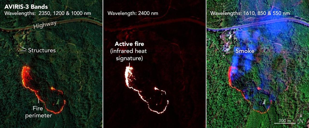
NASA's AVIRIS-3 sensor, an airborne imaging spectrometer built and operated by the agency's Jet Propulsion Laboratory in Southern California, captured infrared data on a wildfire about 3 miles (5 kilometers) west of the town of Mount Vernon, Alabama, on March 21, 2025. Within minutes of flying over, real-time maps of the fire were sent via satellite internet to firefighters with the Alabama Forestry Commission, who used it to contain the fire, preventing it from reaching four buildings. The first image in the series combines reflection data from AVIRIS-3 (Airborne Visible Infrared Imaging Spectrometer 3) at three infrared wavelengths that are invisible to the human eye – 2,350 nanometers, 1,200 nanometers, and 1,000 nanometers. In the resulting composite image, the colors indicate where the fire was burning most intensely. Orange and red areas show cooler-burning areas, while yellow indicates the most intense flames. Burned areas show up as dark red or brown. The second image in the series looks solely at the 2,400 nanometers wavelength. This wavelength is particularly useful for seeing hot spots and the perimeters of fires, which show brightly against a red background. The third image in the series combines light at 1,610 nanometers, 850 nanometers, and 550 nanometers. This view shows burn areas and smoke. The AVIRIS-3 sensor belongs to a line of imaging spectrometers built at JPL since 1986. The instruments have been used to study a wide range of phenomena – including fire – by measuring sunlight reflecting from the planet's surface. Data from imaging spectrometers like AVIRIS-3 typically takes days or weeks to be processed into highly detailed, multilayer image products used for research. By simplifying the calibration algorithms, researchers were able to process data on a computer aboard the plane in a sliver of the time it otherwise would have taken, and airborne satellite internet connectivity enabled the images to be distributed almost immediately, while the plane was still in flight, rather than after it landed. Flying about 9,000 feet (3,000 meters) in altitude aboard a NASA King Air B200 research plane, AVIRIS-3 collected data on the Castleberry Fire while preparing for prescribed burn experiments that took place in the Geneva State Forest in Alabama on March 28 and at Fort Stewart-Hunter Army Airfield in Georgia from April 14 to 20. The burns were part of a NASA 2025 FireSense Airborne Campaign. https://photojournal.jpl.nasa.gov/catalog/PIA26499
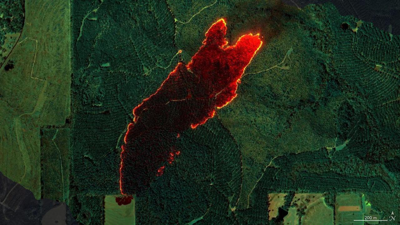
NASA's AVIRIS-3 sensor, an airborne imaging spectrometer built and operated by the agency's Jet Propulsion Laboratory in Southern California, captured infrared data of a roughly 120-acre wildfire about 3 miles (5 kilometers) east of the town of Castleberry, Alabama, on March 19, 2025. Within minutes of flying over the Castleberry Fire, which had not previously been reported to authorities, real-time maps of where burning was most intense were sent via satellite internet to firefighters with the Alabama Forestry Commission, who used it to decide how to deploy their personnel and firefighting equipment. The image combines reflection data from AVIRIS-3 (Airborne Visible Infrared Imaging Spectrometer 3) at three infrared wavelengths that are invisible to the human eye: 2,350 nanometers, 1,200 nanometers, and 1,000 nanometers. In the resulting composite image, the colors indicate where the fire was burning most intensely. Orange and red areas show cooler-burning areas, while yellow indicates the most intense flames. Burned areas show up as dark red or brown. The AVIRIS-3 sensor belongs to a line of imaging spectrometers built at JPL since 1986. The instruments have been used to study a wide range of phenomena – including fire – by measuring sunlight reflecting from the planet's surface. Data from imaging spectrometers like AVIRIS-3 typically takes days or weeks to be processed into highly detailed, multilayer image products used for research. By simplifying the calibration algorithms, researchers were able to process data on a computer aboard the plane in a sliver of the time it otherwise would have taken, and airborne satellite internet connectivity enabled the images to be distributed almost immediately, while the plane was still in flight, rather than after it landed. Flying about 9,000 feet (3,000 meters) in altitude aboard a NASA King Air B200 research plane, AVIRIS-3 collected data on the Castleberry Fire while preparing for prescribed burn experiments that took place in the Geneva State Forest in Alabama on March 28 and at Fort Stewart-Hunter Army Airfield in Georgia from April 14 to 20. The burns were part of a NASA 2025 FireSense Airborne Campaign. https://photojournal.jpl.nasa.gov/catalog/PIA26497
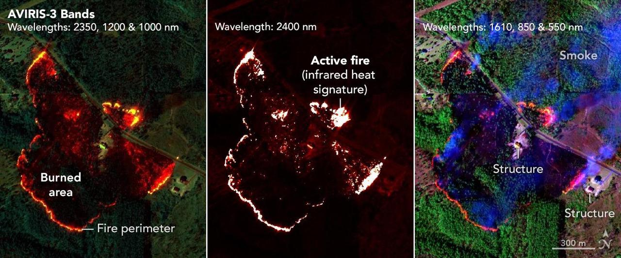
NASA's AVIRIS-3 sensor, an airborne imaging spectrometer built and operated by the agency's Jet Propulsion Laboratory in Southern California, captured infrared data of a wildfire 4 miles (2.5 kilometers) southwest of the unincorporated community of Perdido, Alabama, on March 21, 2025. Within minutes of flying over, real-time maps of the fire were sent via satellite internet to firefighters with the Alabama Forestry Commission, who used it to contain the fire, preventing it from reaching six buildings. The first image in the series combines reflection data from AVIRIS-3 (Airborne Visible Infrared Imaging Spectrometer 3) at three infrared wavelengths that are invisible to the human eye – 2,350 nanometers, 1,200 nanometers, and 1,000 nanometers. In the resulting composite image, the colors indicate where the fire was burning most intensely. Orange and red areas show cooler-burning areas, while yellow indicates the most intense flames. Burned areas show up as dark red or brown. The second image in the series looks solely at the 2,400 nanometers wavelength. The images are particularly useful for seeing hot spots and the perimeters of fires, which show brightly against a red background. The third image in the series combines light at 1,610 nanometers, 850 nanometers, and 550 nanometers. This view shows burn areas and smoke. The AVIRIS-3 sensor belongs to a line of imaging spectrometers built at JPL since 1986. The instruments have been used to study a wide range of phenomena – including fire – by measuring sunlight reflecting from the planet's surface. Data from imaging spectrometers like AVIRIS-3 typically takes days or weeks to be processed into highly detailed, multilayer image products used for research. By simplifying the calibration algorithms, researchers were able to process data on a computer aboard the plane in a sliver of the time it otherwise would have taken, and airborne satellite internet connectivity enabled the images to be distributed almost immediately, while the plane was still in flight, rather than after it landed. Flying about 9,000 feet (3,000 meters) in altitude aboard a NASA King Air B200 research plane, AVIRIS-3 collected data on the Castleberry Fire while preparing for prescribed burn experiments that took place in the Geneva State Forest in Alabama on March 28 and at Fort Stewart-Hunter Army Airfield in Georgia from April 14 to 20. The burns were part of a NASA 2025 FireSense Airborne Campaign. https://photojournal.jpl.nasa.gov/catalog/PIA26498
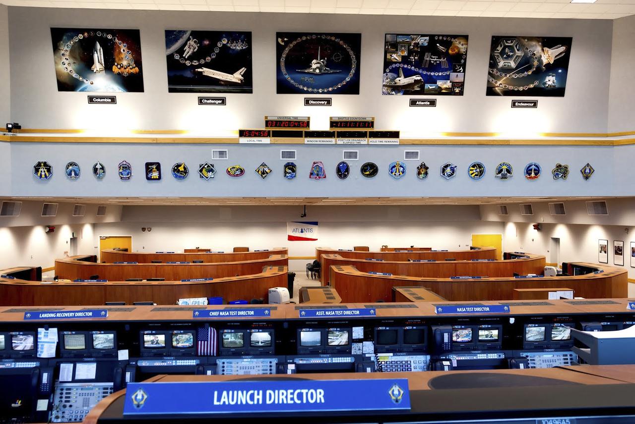
CAPE CANAVERAL, Fla. – As seen on Google Maps, Firing Room 4 inside the Launch Control Center at NASA's Kennedy Space Center was one of the four control rooms used by NASA and contractor launch teams to oversee a space shuttle countdown. This firing room was the most advanced of the control rooms used for shuttle missions and was the primary firing room for the shuttle's final series of launches before retirement. It is furnished in a more contemporary style with wood cabinets and other features, although it retains many of the computer systems the shuttle counted on to operate safely. Specialized operators worked at consoles tailored to keep track of the status of shuttle systems while the spacecraft was processed in the Orbiter Processing Facility, being stacked inside the Vehicle Assembly Building and standing at the launch pad before liftoff. The firing rooms, including 3, were also used during NASA's Apollo Program. Google precisely mapped the space center and some of its historical facilities for the company's map page. The work allows Internet users to see inside buildings at Kennedy as they were used during the space shuttle era. Photo credit: Google/Wendy Wang
![ISS007-E-18078 (26 October 2003) --- The fires in the San Bernardino Mountains, fueled by Santa Ana winds, burned out of control on the morning of Oct. 26, 2003, when these images were taken from the International Space Station at roughly 11 a.m. (PST). Thick yellow smoke blows south, blanketing the valley below. This image and ISS007-E-18082, looking southeast, capture the smoke pall as the ISS approached and passed over the region. Image numbers 18078 and 18082 were taken roughly a minute apart. A small break in the smoke marks Cajon pass. Content was provided by JSC’s Earth Observation Lab. The International Space Station Program {link to http://spaceflight.nasa.gov} supports the laboratory to help crew members take pictures of Earth that will be of the greatest value to scientists and the public, and to make those images freely available on the Internet. Additional images taken by astronauts and cosmonauts can be viewed at the NASA/JSC Gateway to Astronaut Photography of Earth [link to http://eol.jsc.nasa.gov/].](https://images-assets.nasa.gov/image/iss007e18078/iss007e18078~medium.jpg)
ISS007-E-18078 (26 October 2003) --- The fires in the San Bernardino Mountains, fueled by Santa Ana winds, burned out of control on the morning of Oct. 26, 2003, when these images were taken from the International Space Station at roughly 11 a.m. (PST). Thick yellow smoke blows south, blanketing the valley below. This image and ISS007-E-18082, looking southeast, capture the smoke pall as the ISS approached and passed over the region. Image numbers 18078 and 18082 were taken roughly a minute apart. A small break in the smoke marks Cajon pass. Content was provided by JSC’s Earth Observation Lab. The International Space Station Program {link to http://spaceflight.nasa.gov} supports the laboratory to help crew members take pictures of Earth that will be of the greatest value to scientists and the public, and to make those images freely available on the Internet. Additional images taken by astronauts and cosmonauts can be viewed at the NASA/JSC Gateway to Astronaut Photography of Earth [link to http://eol.jsc.nasa.gov/].
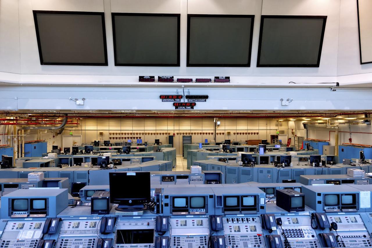
CAPE CANAVERAL, Fla. – As seen on Google Maps, Firing Room 3 inside the Launch Control Center at NASA's Kennedy Space Center was one of the four control rooms used by NASA and contractor launch teams to oversee a space shuttle countdown. This firing room is furnished in the classic style with the same metal computer cabinets and some of the same monitors in place when the first shuttle mission launched April 12, 1981. Specialized operators worked at consoles tailored to keep track of the status of shuttle systems while the spacecraft was processed in the Orbiter Processing Facility, being stacked inside the Vehicle Assembly Building and standing at the launch pad before liftoff. The firing rooms, including 3, were also used during NASA's Apollo Program. Google precisely mapped the space center and some of its historical facilities for the company's map page. The work allows Internet users to see inside buildings at Kennedy as they were used during the space shuttle era. Photo credit: Google/Wendy Wang
![ISS007-E-18082 (26 October 2003) --- The fires in the San Bernardino Mountains, fueled by Santa Ana winds, burned out of control on the morning of Oct. 26, 2003, when these images were taken from the International Space Station at roughly 11 a.m. (PST). Thick yellow smoke blows south, blanketing the valley below. This image and ISS007-E-18078, looking southeast, capture the smoke pall as the ISS approached and passed over the region. Image numbers 18078 and 18082 were taken roughly a minute apart. A small break in the smoke marks Cajon pass. Content was provided by JSC’s Earth Observation Lab. The International Space Station Program {link to http://spaceflight.nasa.gov} supports the laboratory to help crew members take pictures of Earth that will be of the greatest value to scientists and the public, and to make those images freely available on the Internet. Additional images taken by astronauts and cosmonauts can be viewed at the NASA/JSC Gateway to Astronaut Photography of Earth [link to http://eol.jsc.nasa.gov/].](https://images-assets.nasa.gov/image/iss007e18082/iss007e18082~medium.jpg)
ISS007-E-18082 (26 October 2003) --- The fires in the San Bernardino Mountains, fueled by Santa Ana winds, burned out of control on the morning of Oct. 26, 2003, when these images were taken from the International Space Station at roughly 11 a.m. (PST). Thick yellow smoke blows south, blanketing the valley below. This image and ISS007-E-18078, looking southeast, capture the smoke pall as the ISS approached and passed over the region. Image numbers 18078 and 18082 were taken roughly a minute apart. A small break in the smoke marks Cajon pass. Content was provided by JSC’s Earth Observation Lab. The International Space Station Program {link to http://spaceflight.nasa.gov} supports the laboratory to help crew members take pictures of Earth that will be of the greatest value to scientists and the public, and to make those images freely available on the Internet. Additional images taken by astronauts and cosmonauts can be viewed at the NASA/JSC Gateway to Astronaut Photography of Earth [link to http://eol.jsc.nasa.gov/].
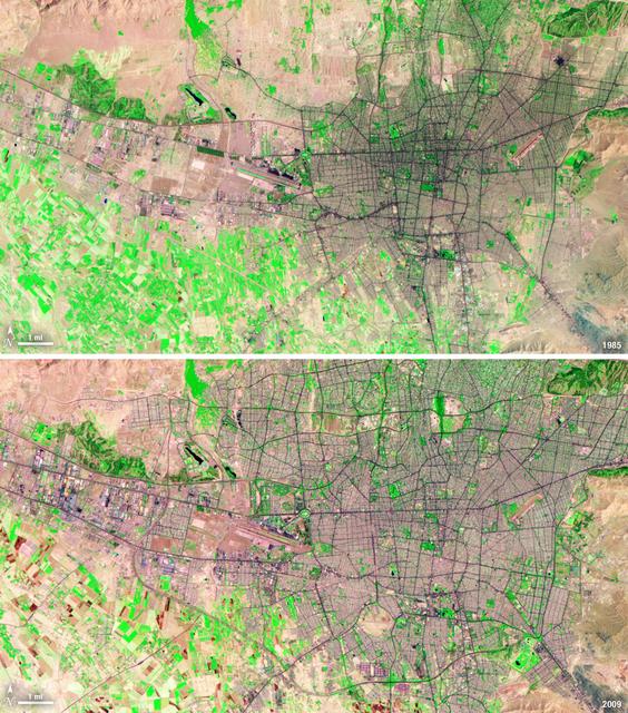
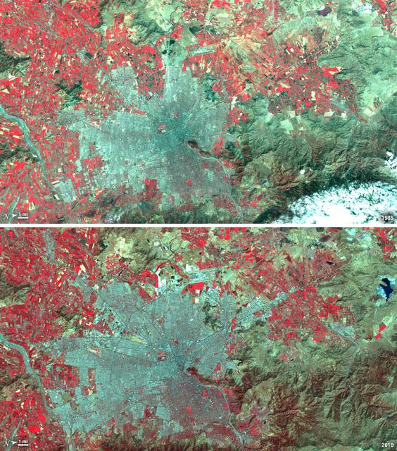
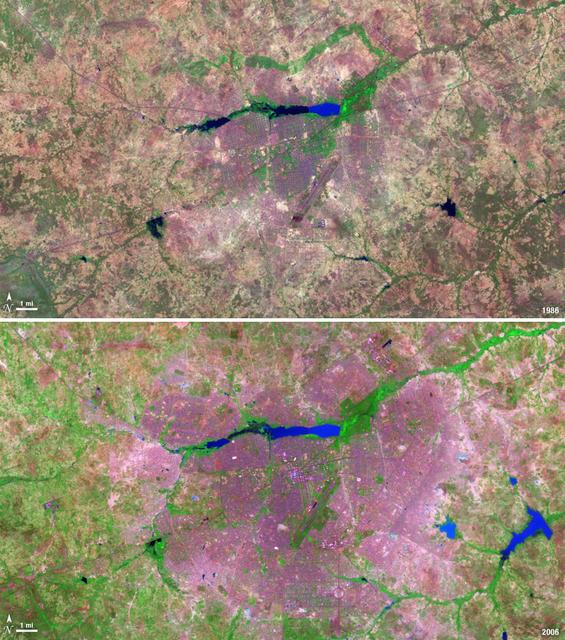
Between 1985 and 2009, the population of Tehran, Iran, grew from six million to just over seven million. The city's growth was spurred largely by migration from other parts of the country. In addition to being the hub of government and associated public sector jobs, Tehran houses more than half of Iran's industry. Landsat 5 acquired these false-color images of Tehran on August 2, 1985, and July 19, 2009. The city is a web of dark purple lines, vegetation is green and bare ground is pink and tan. The images were created using both infrared and visible light (band combination 7, 4, and 2) to distinguish urban areas from the surrounding desert. ---- NASA and the U.S. Department of the Interior through the U.S. Geological Survey (USGS) jointly manage Landsat, and the USGS preserves a 40-year archive of Landsat images that is freely available over the Internet. The next Landsat satellite, now known as the Landsat Data Continuity Mission (LDCM) and later to be called Landsat 8, is scheduled for launch in 2013. In honor of Landsat’s 40th anniversary in July 2012, the USGS released the LandsatLook viewer – a quick, simple way to go forward and backward in time, pulling images of anywhere in the world out of the Landsat archive. <b><a href="http://www.nasa.gov/audience/formedia/features/MP_Photo_Guidelines.html" rel="nofollow">NASA image use policy.</a></b> <b><a href="http://www.nasa.gov/centers/goddard/home/index.html" rel="nofollow">NASA Goddard Space Flight Center</a></b> enables NASA’s mission through four scientific endeavors: Earth Science, Heliophysics, Solar System Exploration, and Astrophysics. Goddard plays a leading role in NASA’s accomplishments by contributing compelling scientific knowledge to advance the Agency’s mission. <b>Follow us on <a href="http://twitter.com/NASA_GoddardPix" rel="nofollow">Twitter</a></b> <b>Like us on <a href="http://www.facebook.com/pages/Greenbelt-MD/NASA-Goddard/395013845897?ref=tsd" rel="nofollow">Facebook</a></b> <b>Find us on <a href="http://instagrid.me/nasagoddard/?vm=grid" rel="nofollow">Instagram</a></b>
Santiago, Chile, ranks among the world's fastest growing cities. Chile is South America's fifth largest economy with strong export and tourism markets. More than a third of Chile's population lives in Santiago as of 2009. Taken on January 9, 1985, and January 30, 2010, this pair of images from the Landsat 5 satellite illustrates the city's steady growth. The images were made with infrared and visible light (Landsat bands 4, 3, and 2) so that plant-covered land is red. Bare or sparsely vegetated land is tan, and the city is dark silver. In the fifteen years that elapsed between 1985 and 2010, the city expanded away from the Andes Mountains along spoke-like lines, which are major roads. ---- NASA and the U.S. Department of the Interior through the U.S. Geological Survey (USGS) jointly manage Landsat, and the USGS preserves a 40-year archive of Landsat images that is freely available over the Internet. The next Landsat satellite, now known as the Landsat Data Continuity Mission (LDCM) and later to be called Landsat 8, is scheduled for launch in 2013. In honor of Landsat’s 40th anniversary in July 2012, the USGS released the LandsatLook viewer – a quick, simple way to go forward and backward in time, pulling images of anywhere in the world out of the Landsat archive. <b><a href="http://www.nasa.gov/audience/formedia/features/MP_Photo_Guidelines.html" rel="nofollow">NASA image use policy.</a></b> <b><a href="http://www.nasa.gov/centers/goddard/home/index.html" rel="nofollow">NASA Goddard Space Flight Center</a></b> enables NASA’s mission through four scientific endeavors: Earth Science, Heliophysics, Solar System Exploration, and Astrophysics. Goddard plays a leading role in NASA’s accomplishments by contributing compelling scientific knowledge to advance the Agency’s mission. <b>Follow us on <a href="http://twitter.com/NASA_GoddardPix" rel="nofollow">Twitter</a></b> <b>Like us on <a href="http://www.facebook.com/pages/Greenbelt-MD/NASA-Goddard/395013845897?ref=tsd" rel="nofollow">Facebook</a></b> <b>Find us on <a href="http://instagrid.me/nasagoddard/?vm=grid" rel="nofollow">Instagram</a></b>
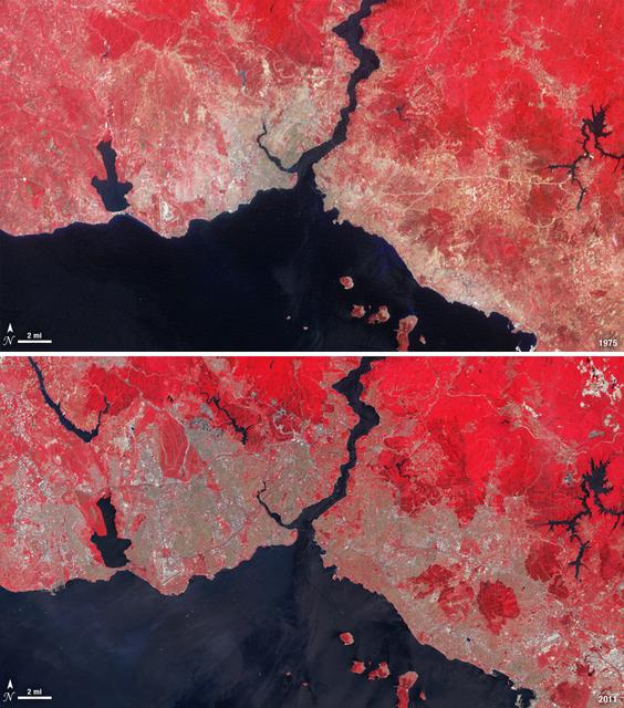
Istanbul has been a bustling trade city for thousands of years. In this 1975 image, taken by Landsat, the city centers on the Golden Horn the estuary that flows into the Bosporus Straight at the center of the scene. Shown in false color, vegetation is red, urban areas are gray, and water appears black. A bridge built in 1973 to connect the Asian and European sides of Istanbul is barely visible. By 2011, Istanbul's population had exploded from 2 to 13 million people, and the city has gone through a dramatic expansion. This Landsat 5 image shows densely packed urban areas stretching along the Sea of Marmara and up the Bosporus Straight where a second bridge built in 1988 now crosses the water. ---- NASA and the U.S. Department of the Interior through the U.S. Geological Survey (USGS) jointly manage Landsat, and the USGS preserves a 40-year archive of Landsat images that is freely available over the Internet. The next Landsat satellite, now known as the Landsat Data Continuity Mission (LDCM) and later to be called Landsat 8, is scheduled for launch in 2013. In honor of Landsat’s 40th anniversary in July 2012, the USGS released the LandsatLook viewer – a quick, simple way to go forward and backward in time, pulling images of anywhere in the world out of the Landsat archive. <b><a href="http://www.nasa.gov/audience/formedia/features/MP_Photo_Guidelines.html" rel="nofollow">NASA image use policy.</a></b> <b><a href="http://www.nasa.gov/centers/goddard/home/index.html" rel="nofollow">NASA Goddard Space Flight Center</a></b> enables NASA’s mission through four scientific endeavors: Earth Science, Heliophysics, Solar System Exploration, and Astrophysics. Goddard plays a leading role in NASA’s accomplishments by contributing compelling scientific knowledge to advance the Agency’s mission. <b>Follow us on <a href="http://twitter.com/NASA_GoddardPix" rel="nofollow">Twitter</a></b> <b>Like us on <a href="http://www.facebook.com/pages/Greenbelt-MD/NASA-Goddard/395013845897?ref=tsd" rel="nofollow">Facebook</a></b> <b>Find us on <a href="http://instagrid.me/nasagoddard/?vm=grid" rel="nofollow">Instagram</a></b>
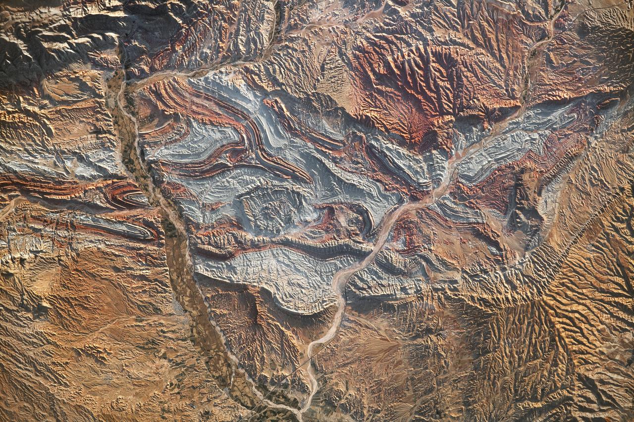
iss069-e-089946_lrg (09/19/2023) --- An astronaut aboard the International Space Station took this photograph of the rugged landscape of the Aladaghlar Mountains in northwestern Iran. Ridges cast shadows in the valleys and other low elevation areas, creating a three-dimensional appearance. Human alterations to the landscape are most evident in riverbeds, where the even topography is easier to build on and navigate. Natural processes over millions of years have folded rock layers of various compositions and colors into the curved patterns seen here. These folds are produced by tectonic forces operating along the convergent plate boundary of the Arabia and Eurasia plates. The convergence of these tectonic plates causes uplift, folding, and deformation of the colorful rock layers, and subsequent erosion exposes them. On the left side of this photo, the Qezel Ozan River, a major river in northern Iran, cuts across the landscape. Agricultural fields are visible along the riverbanks tucked between the mountains. The Qezel Ozan also intersects the Zanjan-Tabriz freeway (Freeway 2), a major thoroughfare built on a dried riverbed connecting the cities of Tehran and Tabriz. Astronaut photograph ISS069-E-89946 was acquired on September 19, 2023, with a Nikon D5 digital camera using a focal length of 400 millimeters. The image was provided by the ISS Crew Earth Observations Facility and the Earth Science and Remote Sensing Unit at Johnson Space Center. The image was taken by a member of the Expedition 69 crew. It has been cropped and enhanced to improve contrast, and lens artifacts have been removed. The International Space Station Program supports the laboratory as part of the ISS National Lab to help astronauts take pictures of Earth that will be of the greatest value to scientists and the public and to make those images freely available on the Internet. Additional images taken by astronauts and cosmonauts can be viewed at the NASA/JSC Gateway to Astronaut Photography of Earth. Caption by Sara Schmidt, GeoControl Systems, JETS II Contract at NASA-JSC and Andrea Wenzel, Jacobs-JETS II Contract at NASA-JSC.

Over the last 25 years, Chandler, Arizona has traded its grid of fields for a grid of streets. Founded in 1912 on cotton, grains, alfalfa, and ostrich farms, brown and green irrigated fields still dominate the region southeast of Phoenix in this 1985 natural color image taken by Landsat 5. By 2011, the blue gray city streets in this Landsat 5 image have taken over. Chandler's economy has shifted from agriculture to manufacturing and electronics, and its population boomed from 30,000 people in 1980 to 236,000 in 2010. ---- Survey (USGS) jointly manage Landsat, and the USGS preserves a 40-year archive of Landsat images that is freely available over the Internet. The next Landsat satellite, now known as the Landsat Data Continuity Mission (LDCM) and later to be called Landsat 8, is scheduled for launch in 2013. In honor of Landsat’s 40th anniversary in July 2012, the USGS released the LandsatLook viewer – a quick, simple way to go forward and backward in time, pulling images of anywhere in the world out of the Landsat archive. <b><a href="http://www.nasa.gov/audience/formedia/features/MP_Photo_Guidelines.html" rel="nofollow">NASA image use policy.</a></b> <b><a href="http://www.nasa.gov/centers/goddard/home/index.html" rel="nofollow">NASA Goddard Space Flight Center</a></b> enables NASA’s mission through four scientific endeavors: Earth Science, Heliophysics, Solar System Exploration, and Astrophysics. Goddard plays a leading role in NASA’s accomplishments by contributing compelling scientific knowledge to advance the Agency’s mission. <b>Follow us on <a href="http://twitter.com/NASA_GoddardPix" rel="nofollow">Twitter</a></b> <b>Like us on <a href="http://www.facebook.com/pages/Greenbelt-MD/NASA-Goddard/395013845897?ref=tsd" rel="nofollow">Facebook</a></b> <b>Find us on <a href="http://instagrid.me/nasagoddard/?vm=grid" rel="nofollow">Instagram</a></b>
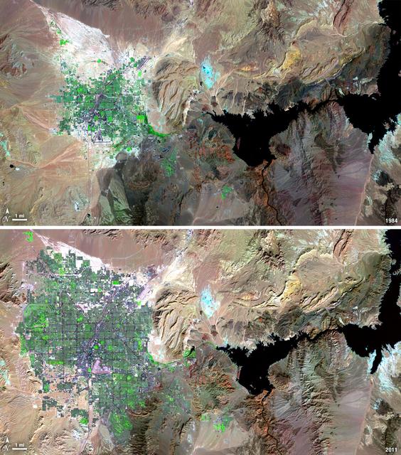
Over the years of the Landsat program, the desert city of Las Vegas has gone through a massive growth spurt. The outward expansion of the city over the last quarter of a century is shown here with two false-color Landsat 5 images (August 3, 1984, and November 2, 2011). The dark purple grid of city streets and the green of irrigated vegetation grow out in every direction into the surrounding desert. These images were created using reflected light from the shortwave infrared, near-infrared, and green portions of the electromagnetic spectrum (Landsat 5 TM bands 7,4,2). ---- NASA and the U.S. Department of the Interior through the U.S. Geological Survey (USGS) jointly manage Landsat, and the USGS preserves a 40-year archive of Landsat images that is freely available over the Internet. The next Landsat satellite, now known as the Landsat Data Continuity Mission (LDCM) and later to be called Landsat 8, is scheduled for launch in 2013. In honor of Landsat’s 40th anniversary in July 2012, the USGS released the LandsatLook viewer – a quick, simple way to go forward and backward in time, pulling images of anywhere in the world out of the Landsat archive. <b><a href="http://www.nasa.gov/audience/formedia/features/MP_Photo_Guidelines.html" rel="nofollow">NASA image use policy.</a></b> <b><a href="http://www.nasa.gov/centers/goddard/home/index.html" rel="nofollow">NASA Goddard Space Flight Center</a></b> enables NASA’s mission through four scientific endeavors: Earth Science, Heliophysics, Solar System Exploration, and Astrophysics. Goddard plays a leading role in NASA’s accomplishments by contributing compelling scientific knowledge to advance the Agency’s mission. <b>Follow us on <a href="http://twitter.com/NASA_GoddardPix" rel="nofollow">Twitter</a></b> <b>Like us on <a href="http://www.facebook.com/pages/Greenbelt-MD/NASA-Goddard/395013845897?ref=tsd" rel="nofollow">Facebook</a></b> <b>Find us on <a href="http://instagrid.me/nasagoddard/?vm=grid" rel="nofollow">Instagram</a></b>
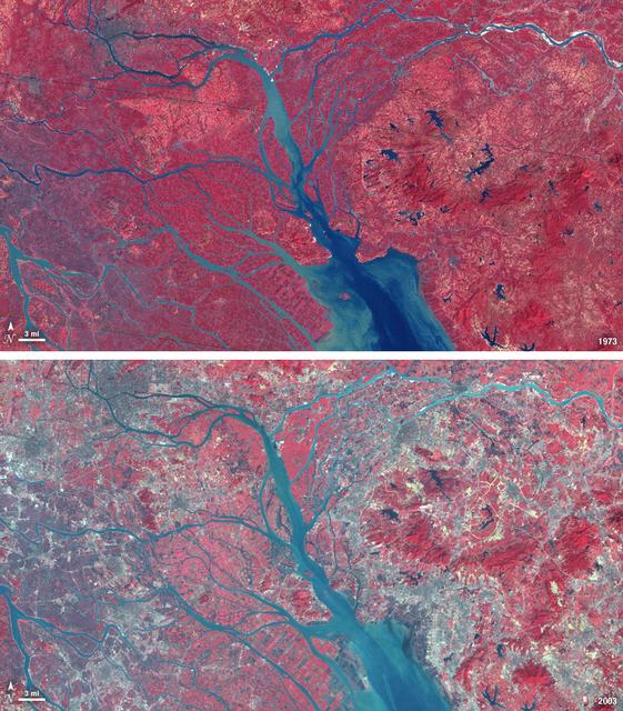
In 1979, China established two special economic zones around the Pearl River Delta, north of Hong Kong. This image, taken by Landsat 3 on October 19, 1973, shows that the region was rural when the zone was established. Plant-covered land, which is red in this false-color image, dominates the scene. Square grids are agriculture. By January 10, 2003, when Landsat 7 took this image, the Pearl River Delta was a densely populated urban corridor with several large cities. The urban areas are gray in this image. The region is a major manufacturing center with an economy the size of Taiwan’s. As of 2010, the Pearl River Economic Zone had a population of 36 million people. ---- NASA and the U.S. Department of the Interior through the U.S. Geological Survey (USGS) jointly manage Landsat, and the USGS preserves a 40-year archive of Landsat images that is freely available over the Internet. The next Landsat satellite, now known as the Landsat Data Continuity Mission (LDCM) and later to be called Landsat 8, is scheduled for launch in 2013. In honor of Landsat’s 40th anniversary in July 2012, the USGS released the LandsatLook viewer – a quick, simple way to go forward and backward in time, pulling images of anywhere in the world out of the Landsat archive. <b><a href="http://www.nasa.gov/audience/formedia/features/MP_Photo_Guidelines.html" rel="nofollow">NASA image use policy.</a></b> <b><a href="http://www.nasa.gov/centers/goddard/home/index.html" rel="nofollow">NASA Goddard Space Flight Center</a></b> enables NASA’s mission through four scientific endeavors: Earth Science, Heliophysics, Solar System Exploration, and Astrophysics. Goddard plays a leading role in NASA’s accomplishments by contributing compelling scientific knowledge to advance the Agency’s mission. <b>Follow us on <a href="http://twitter.com/NASA_GoddardPix" rel="nofollow">Twitter</a></b> <b>Like us on <a href="http://www.facebook.com/pages/Greenbelt-MD/NASA-Goddard/395013845897?ref=tsd" rel="nofollow">Facebook</a></b> <b>Find us on <a href="http://instagrid.me/nasagoddard/?vm=grid" rel="nofollow">Instagram</a></b>

This photograph shows the Compton Gamma-Ray Observatory being released from the Remote Manipulator System (RMS) arm aboard the Space Shuttle Atlantis during the STS-35 mission in April 1991. The GRO reentered the Earth's atmosphere and ended its successful mission in June 2000. For nearly 9 years, GRO's Burst and Transient Source Experiment (BATSE), designed and built by the Marshall Space Flight Center, kept an unblinking watch on the universe to alert scientist to the invisible, mysterious gamma-ray bursts that had puzzled them for decades. By studying gamma-rays from objects like black holes, pulsars, quasars, neutron stars, and other exotic objects, scientists could discover clues to the birth, evolution, and death of star, galaxies, and the universe. The gamma-ray instrument was one of four major science instruments aboard the Compton. It consisted of eight detectors, or modules, located at each corner of the rectangular satellite to simultaneously scan the entire universe for bursts of gamma-rays ranging in duration from fractions of a second to minutes. In January 1999, the instrument, via the Internet, cued a computer-controlled telescope at Las Alamos National Laboratory in Los Alamos, New Mexico, within 20 seconds of registering a burst. With this capability, the gamma-ray experiment came to serve as a gamma-ray burst alert for the Hubble Space Telescope, the Chandra X-Ray Observatory, and major gound-based observatories around the world. Thirty-seven universities, observatories, and NASA centers in 19 states, and 11 more institutions in Europe and Russia, participated in BATSE's science program.

This photograph shows the Compton Gamma-Ray Observatory (GRO) being deployed by the Remote Manipulator System (RMS) arm aboard the Space Shuttle Atlantis during the STS-37 mission in April 1991. The GRO reentered Earth atmosphere and ended its successful mission in June 2000. For nearly 9 years, the GRO Burst and Transient Source Experiment (BATSE), designed and built by the Marshall Space Flight Center (MSFC), kept an unblinking watch on the universe to alert scientists to the invisible, mysterious gamma-ray bursts that had puzzled them for decades. By studying gamma-rays from objects like black holes, pulsars, quasars, neutron stars, and other exotic objects, scientists could discover clues to the birth, evolution, and death of stars, galaxies, and the universe. The gamma-ray instrument was one of four major science instruments aboard the Compton. It consisted of eight detectors, or modules, located at each corner of the rectangular satellite to simultaneously scan the entire universe for bursts of gamma-rays ranging in duration from fractions of a second to minutes. In January 1999, the instrument, via the Internet, cued a computer-controlled telescope at Las Alamos National Laboratory in Los Alamos, New Mexico, within 20 seconds of registering a burst. With this capability, the gamma-ray experiment came to serve as a gamma-ray burst alert for the Hubble Space Telescope, the Chandra X-Ray Observatory, and major gound-based observatories around the world. Thirty-seven universities, observatories, and NASA centers in 19 states, and 11 more institutions in Europe and Russia, participated in the BATSE science program.

jsc2022e062020 (6/30/2022) --- Space Health will create a digital twin of the astronaut from the data collected by the Bio-Monitor and demonstrate how this could be used for autonomous health monitoring on future space missions. (Image courtesy of CSA)
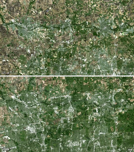
Forty miles west of downtown Chicago, the Fox River meanders its way through what has become the westernmost reaches of metropolitan Chicago, where the sprawling metropolis meets the hinterlands. While Chicago itself has seen a seven percent population decline during the last decade, the population of its metropolitan region, "Chicagoland," has steadily increased. These two natural-color Landsat 5 images acquired a quarter-century apart (on May 2, 1985, and May 23, 2010), stand witness to the soaring growth of this region. Aurora, Illinois’ second largest city, is the silvery-green region to the left hugging the Fox River, just south of the I-88 (North is to the right in this image); Carpentersville is found on the rightmost side, north of the I-90. From 1985 to 2010 a development explosion can been seen as the browns of pasture lands give way to silvery-green suburban areas and large white-colored business districts spring up along and east of the river. A major expansion of Dupage Airport appears in the middle of the 2010 image, and the circular-shaped region north of the I-88 and east of the Fox River, visible on both images, is the Department of Energy’s Fermilab. ---- NASA and the U.S. Department of the Interior through the U.S. Geological Survey (USGS) jointly manage Landsat, and the USGS preserves a 40-year archive of Landsat images that is freely available over the Internet. The next Landsat satellite, now known as the Landsat Data Continuity Mission (LDCM) and later to be called Landsat 8, is scheduled for launch in 2013. In honor of Landsat’s 40th anniversary in July 2012, the USGS released the LandsatLook viewer – a quick, simple way to go forward and backward in time, pulling images of anywhere in the world out of the Landsat archive. <b><a href="http://www.nasa.gov/audience/formedia/features/MP_Photo_Guidelines.html" rel="nofollow">NASA image use policy.</a></b> <b><a href="http://www.nasa.gov/centers/goddard/home/index.html" rel="nofollow">NASA Goddard Space Flight Center</a></b> enables NASA’s mission through four scientific endeavors: Earth Science, Heliophysics, Solar System Exploration, and Astrophysics. Goddard plays a leading role in NASA’s accomplishments by contributing compelling scientific knowledge to advance the Agency’s mission. <b>Follow us on <a href="http://twitter.com/NASA_GoddardPix" rel="nofollow">Twitter</a></b> <b>Like us on <a href="http://www.facebook.com/pages/Greenbelt-MD/NASA-Goddard/395013845897?ref=tsd" rel="nofollow">Facebook</a></b> <b>Find us on <a href="http://instagrid.me/nasagoddard/?vm=grid" rel="nofollow">Instagram</a></b>
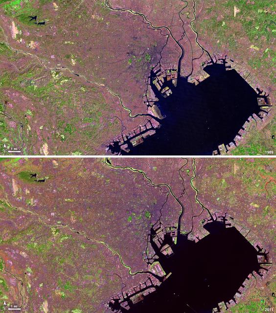
Tokyo is the world’s largest metropolitan region, home to nearly 37 million people. During the past two decades, Tokyo’s population has grown by more than 7 million. The city’s growth has continued despite Japan’s overall stagnating population, mainly due to a continued trend of centralization—citizens moving out of the country and into the city. Landsat 4 collected this first false-color image of Tokyo on Feb. 2, 1989. The upper half of Tokyo Bay is the large water body visible in a dark blue. In the middle of the image, central Tokyo appears a deep purple just north of the bay. Twenty-two years later, Landsat 5, captured this second image of Tokyo on April 5, 2011. The urban reaches of metropolitan Tokyo have grown in both distance and density, as seen where the green color of vegetation has turned to pink and purple shades of urbanization. A major expansion of Tokyo’s Haneda Airport, can be seen south of the city, on land built out into the bay. The constant circular spot of green in the dense city-center, visible on both images, is the Tokyo Imperial Palace and its gardens. (Landsat 5 TM Bands 7,4,2) ---- NASA and the U.S. Department of the Interior through the U.S. Geological Survey (USGS) jointly manage Landsat, and the USGS preserves a 40-year archive of Landsat images that is freely available over the Internet. The next Landsat satellite, now known as the Landsat Data Continuity Mission (LDCM) and later to be called Landsat 8, is scheduled for launch in 2013. In honor of Landsat’s 40th anniversary in July 2012, the USGS released the LandsatLook viewer – a quick, simple way to go forward and backward in time, pulling images of anywhere in the world out of the Landsat archive. <b><a href="http://www.nasa.gov/audience/formedia/features/MP_Photo_Guidelines.html" rel="nofollow">NASA image use policy.</a></b> <b><a href="http://www.nasa.gov/centers/goddard/home/index.html" rel="nofollow">NASA Goddard Space Flight Center</a></b> enables NASA’s mission through four scientific endeavors: Earth Science, Heliophysics, Solar System Exploration, and Astrophysics. Goddard plays a leading role in NASA’s accomplishments by contributing compelling scientific knowledge to advance the Agency’s mission. <b>Follow us on <a href="http://twitter.com/NASA_GoddardPix" rel="nofollow">Twitter</a></b> <b>Like us on <a href="http://www.facebook.com/pages/Greenbelt-MD/NASA-Goddard/395013845897?ref=tsd" rel="nofollow">Facebook</a></b> <b>Find us on <a href="http://instagrid.me/nasagoddard/?vm=grid" rel="nofollow">Instagram</a></b>
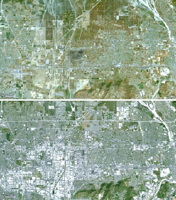
Thirty-five miles due east of downtown Los Angeles lies the city of Ontario, California. In 1881 two Canadian brothers established the town, naming it after their native city. By 1891 Ontario, Calif., was incorporated as a city. The farming-based economy (olives, citrus, dairy) of the city helped it grow to 20,000 by the 1960s. Subsequently, warehousing and freight trafficking took over as the major industry and the city’s population was over 160,000 by 2010. The L.A./Ontario International Airport is now America’s 15th busiest cargo airport. In these natural color Landsat 5 images, the massive growth of the city between 1985 and 2010 can be seen. The airport, found in the southwest portion of the images, added a number of runways and large warehousing structures now dominate the once rural areas surrounding the airport. In these images vegetation is green and brown and urban structures are bright white and gray. (Note there is a large dry riverbed in the northeast corner that is also bright white, but its nonlinear appearance sets it apart visually). ---- NASA and the U.S. Department of the Interior through the U.S. Geological Survey (USGS) jointly manage Landsat, and the USGS preserves a 40-year archive of Landsat images that is freely available over the Internet. The next Landsat satellite, now known as the Landsat Data Continuity Mission (LDCM) and later to be called Landsat 8, is scheduled for launch in 2013. In honor of Landsat’s 40th anniversary in July 2012, the USGS released the LandsatLook viewer – a quick, simple way to go forward and backward in time, pulling images of anywhere in the world out of the Landsat archive. <b><a href="http://www.nasa.gov/audience/formedia/features/MP_Photo_Guidelines.html" rel="nofollow">NASA image use policy.</a></b> <b><a href="http://www.nasa.gov/centers/goddard/home/index.html" rel="nofollow">NASA Goddard Space Flight Center</a></b> enables NASA’s mission through four scientific endeavors: Earth Science, Heliophysics, Solar System Exploration, and Astrophysics. Goddard plays a leading role in NASA’s accomplishments by contributing compelling scientific knowledge to advance the Agency’s mission. <b>Follow us on <a href="http://twitter.com/NASA_GoddardPix" rel="nofollow">Twitter</a></b> <b>Like us on <a href="http://www.facebook.com/pages/Greenbelt-MD/NASA-Goddard/395013845897?ref=tsd" rel="nofollow">Facebook</a></b> <b>Find us on <a href="http://instagrid.me/nasagoddard/?vm=grid" rel="nofollow">Instagram</a></b>
The landlocked western African nation of Burkina Faso experienced a 200 percent increase in urban population between 1975 and 2000. As a result, the area of the capital city Ouagadougou grew 14-fold during this period. These Landsat images show the city expanding outward from its center in the two decades between 1986 and 2006. On Nov. 18, 1986, the Landsat 5 satellite acquired this image of the capital. This false-color image shows vegetation in shades of green and gray, water in various shades of blue, and urban areas in pink and purple. The runway of the city’s airport can be seen as a long straight line that extends from southwest to northeast south of the large lake, Bois de Boulogne. Two decades later, on Oct. 16, 2006 Landsat 7 acquired this image of Ouagadougou. Growth radiated from the city center in all directions. The green strip of vegetation north of Bois de Boulogne has been paved over and a massive new development including a large thoroughfare and traffic circle can be seen south of the airport. ---- NASA and the U.S. Department of the Interior through the U.S. Geological Survey (USGS) jointly manage Landsat, and the USGS preserves a 40-year archive of Landsat images that is freely available over the Internet. The next Landsat satellite, now known as the Landsat Data Continuity Mission (LDCM) and later to be called Landsat 8, is scheduled for launch in 2013. In honor of Landsat’s 40th anniversary in July 2012, the USGS released the LandsatLook viewer – a quick, simple way to go forward and backward in time, pulling images of anywhere in the world out of the Landsat archive. <b><a href="http://www.nasa.gov/audience/formedia/features/MP_Photo_Guidelines.html" rel="nofollow">NASA image use policy.</a></b> <b><a href="http://www.nasa.gov/centers/goddard/home/index.html" rel="nofollow">NASA Goddard Space Flight Center</a></b> enables NASA’s mission through four scientific endeavors: Earth Science, Heliophysics, Solar System Exploration, and Astrophysics. Goddard plays a leading role in NASA’s accomplishments by contributing compelling scientific knowledge to advance the Agency’s mission. <b>Follow us on <a href="http://twitter.com/NASA_GoddardPix" rel="nofollow">Twitter</a></b> <b>Like us on <a href="http://www.facebook.com/pages/Greenbelt-MD/NASA-Goddard/395013845897?ref=tsd" rel="nofollow">Facebook</a></b> <b>Find us on <a href="http://instagrid.me/nasagoddard/?vm=grid" rel="nofollow">Instagram</a></b>
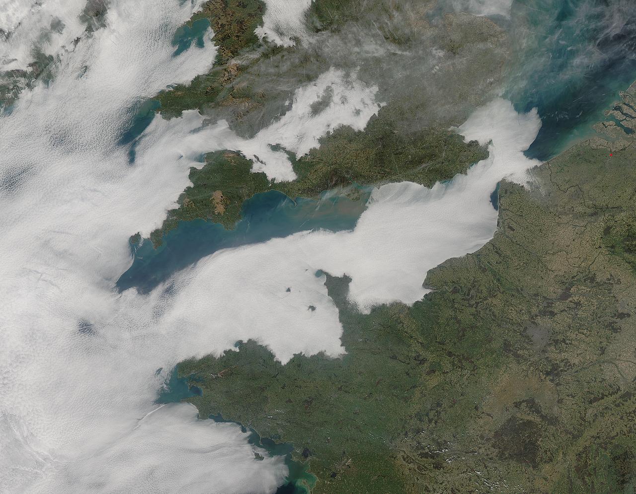
A thick blanket of low clouds covered the English Channel, Celtic Sea and Irish Sea on March 13, 2014. The fog also crept over major cities in the United Kingdom and Ireland. While citizens living in parts of Ireland, England, Wales, Scotland and Northern Ireland were posting ground-based photos of fog-shrouded landscape on social media, the internet and news outlets, the scene was also captured from space. The Moderate Resolution Imaging Spectroradiometer (MODIS) aboard NASA’s Aqua captured this true-color image of the cloudy day at 13:00 UTC (1:00 p.m. in London) on that same day. The dense fog (low clouds) affected air travel, causing the cancellation of hundreds of flights going through London City Airport, where visibility was reported at less than 100 meters (328 ft) – less than the length of an American football field. Flights were also cancelled at Heathrow, Gatwick and Manchester. A private helicopter flying to Northern Ireland went down in by the fog near the Norfolk-Suffolk border, with loss of four lives. Driving was little better in many areas, causing the Met Office to issue a yellow weather warning and to caution drivers of difficult conditions. The lowest visibility of the day was reported at Roches Point weather station. Located at the southeastern tip of Cork Harbor, Ireland, the station reported visibility of less than 50 meters (164 ft) – the length of an Olympic size swimming pool. In this image, the fog-covered Celtic Sea is located in the southwest. Ireland lies under tendrils of low cloud in the northwest corner of the image. Banks of clouds part around England, near the center of the image, and southern Wales (top and center) completely under the foggy blanket. Fog also creeps over the coasts of France, Belgium and the Netherlands on the east side of the English Channel. Credit: NASA/GSFC/Jeff Schmaltz/MODIS Land Rapid Response Team <b><a href="http://www.nasa.gov/audience/formedia/features/MP_Photo_Guidelines.html" rel="nofollow">NASA image use policy.</a></b> <b><a href="http://www.nasa.gov/centers/goddard/home/index.html" rel="nofollow">NASA Goddard Space Flight Center</a></b> enables NASA’s mission through four scientific endeavors: Earth Science, Heliophysics, Solar System Exploration, and Astrophysics. Goddard plays a leading role in NASA’s accomplishments by contributing compelling scientific knowledge to advance the Agency’s mission. <b>Follow us on <a href="http://twitter.com/NASAGoddardPix" rel="nofollow">Twitter</a></b> <b>Like us on <a href="http://www.facebook.com/pages/Greenbelt-MD/NASA-Goddard/395013845897?ref=tsd" rel="nofollow">Facebook</a></b> <b>Find us on <a href="http://instagram.com/nasagoddard?vm=grid" rel="nofollow">Instagram</a></b>
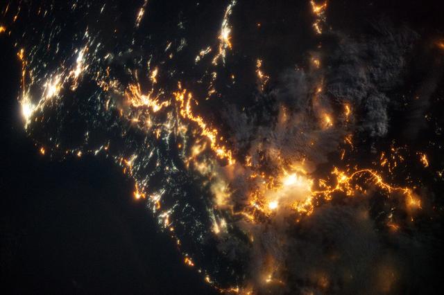
This striking image of the coastline of southwestern Saudi Arabia was taken by astronauts on the International Space Station. Patchy cloud cover partially obscures and blurs the city lights, especially in the vicinity of Khamis Mushait and Abha. While much of the country is lightly populated desert—and relatively dark at night due to lack of city and roadway lights—the southwestern coastal region has a more moderate climate and several large cities. Three brightly lit urban centers are visible at image top left: Jeddah, Mecca, and Taif. Jeddah is the gateway city for Islamic pilgrims going to nearby Mecca, a religious journey known as the Hajj. Taif is located on the slopes of the Sarawat Mountains and provides a summer retreat for the Saudi government from the desert heat of the capital, Riyadh. Bright yellow-orange lighting marks highways that parallel the trend of the Asir Mountains (image center), connecting Mecca to the resort cities of Al Bahah and Abha. Smaller roadways, lit with blue lights, extend to the west to small cities along the Red Sea coastline. The bright yellow-orange glow of the city of Abha is matched by that of Khamis Mushait (or Khamis Mushayt) to the northeast. The brightly lit ribbon of highway continues towards other large cities to the south (Jazan, not shown) and southeast (Najran, not shown). Astronaut photograph ISS036-E-25802 was acquired on July 26, 2013, with a Nikon D3S digital camera using a 50 millimeter lens, and is provided by the ISS Crew Earth Observations experiment and Image Science & Analysis Laboratory, Johnson Space Center. The image was taken by the Expedition 36 crew. It has been cropped and enhanced to improve contrast, and lens artifacts have been removed. The International Space Station Program supports the laboratory as part of the ISS National Lab to help astronauts take pictures of Earth that will be of the greatest value to scientists and the public, and to make those images freely available on the Internet. Additional images taken by astronauts and cosmonauts can be viewed at the NASA/JSC Gateway to Astronaut Photography of Earth. Caption by William L. Stefanov, Jacobs/JETS at NASA-JSC. Instrument: ISS - Digital Camera More info: <a href="http://1.usa.gov/13TqPcr" rel="nofollow">1.usa.gov/13TqPcr</a> Credit: <b><a href="http://www.earthobservatory.nasa.gov/" rel="nofollow"> NASA Earth Observatory</a></b> <b><a href="http://www.nasa.gov/audience/formedia/features/MP_Photo_Guidelines.html" rel="nofollow">NASA image use policy.</a></b> <b><a href="http://www.nasa.gov/centers/goddard/home/index.html" rel="nofollow">NASA Goddard Space Flight Center</a></b> enables NASA’s mission through four scientific endeavors: Earth Science, Heliophysics, Solar System Exploration, and Astrophysics. Goddard plays a leading role in NASA’s accomplishments by contributing compelling scientific knowledge to advance the Agency’s mission. <b>Follow us on <a href="http://twitter.com/NASA_GoddardPix" rel="nofollow">Twitter</a></b> <b>Like us on <a href="http://www.facebook.com/pages/Greenbelt-MD/NASA-Goddard/395013845897?ref=tsd" rel="nofollow">Facebook</a></b> <b>Find us on <a href="http://instagram.com/nasagoddard?vm=grid" rel="nofollow">Instagram</a></b>