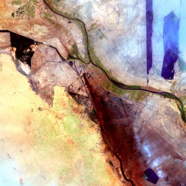
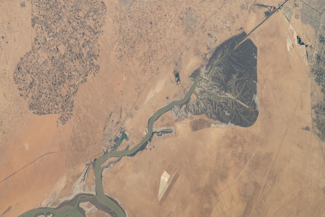
Al Basrah, Iraq Sensor: L7 ETM+ Acquisition Date: April 4, 2003 Path/Row: 166/39 Lat/Long: 30.486/47.811 Smoke drifts south in this image of Al Basrah, located in southeastern Iraq. The green circles from the center to the left of the image represent irrigated crops.
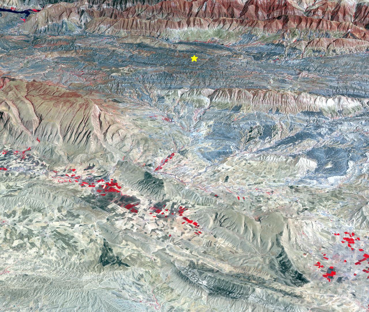
On Sunday, Nov. 12, 2017, a magnitude 7.3 earthquake struck along the Iran-Iraq border near Halabjah, Iraq. The earthquake was felt as far away as Kuwait, Qatar, Turkey, Lebanon and Israel. Extensive damage and numerous casualties were reported in the area near the epicenter (yellow star on image). The earthquake occurred along the boundary between the Arabian and Eurasian tectonic plates. This is an earthquake-prone area, and has experienced many deadly earthquakes in the past. In this perspective-view image, bright red areas are crops in fields, pale red on mountain ridges are shrubs and trees, dark gray areas are traces of earlier brush fires, and gray and tan colors are different rock types. The image was acquired Sept. 8, 2017, and the star marks the earthquake epicenter at 34.9 degrees north, 45.9 degrees east. https://photojournal.jpl.nasa.gov/catalog/PIA22112
This image, acquired by NASA Terra spacecraft, is of the ancient city of Uruk is located in present-day Iraq, on an abandoned channel of the Euphrates River.

NASA Terra spacecraft captured this image north of the present town of Al Hillal, Iraq, in the fertile plain between the Tigris and the Euphrates Rivers, where the site of the legendary city of Babylon lies.
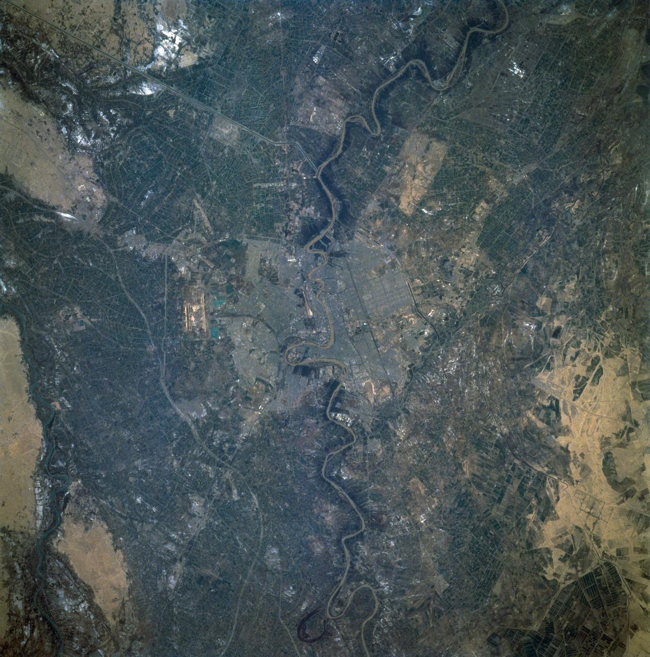
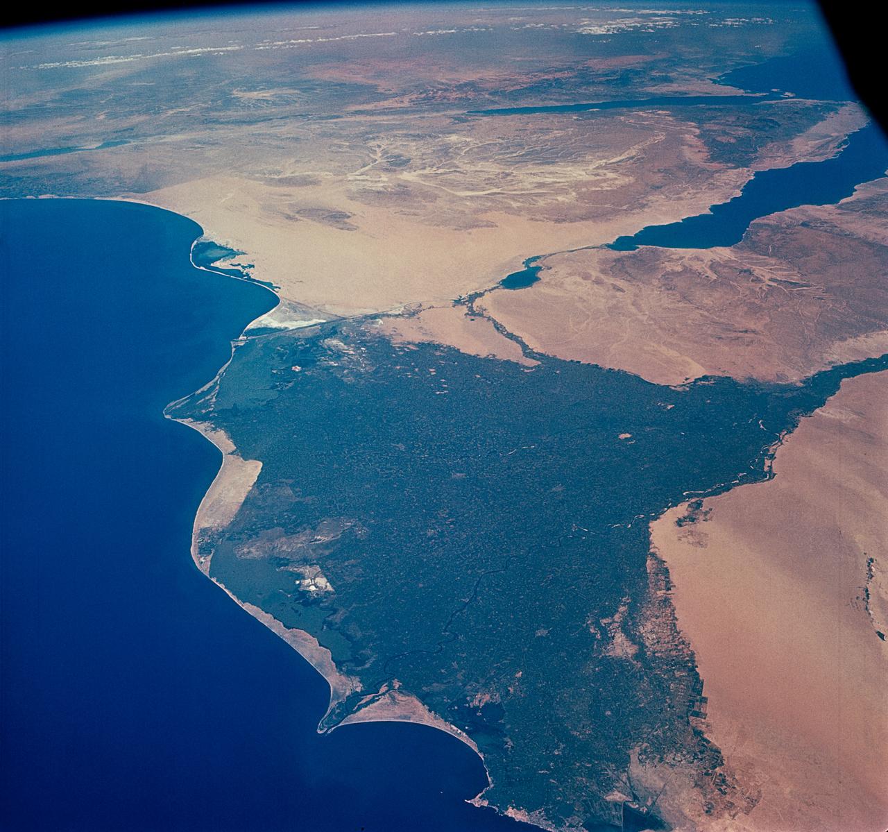
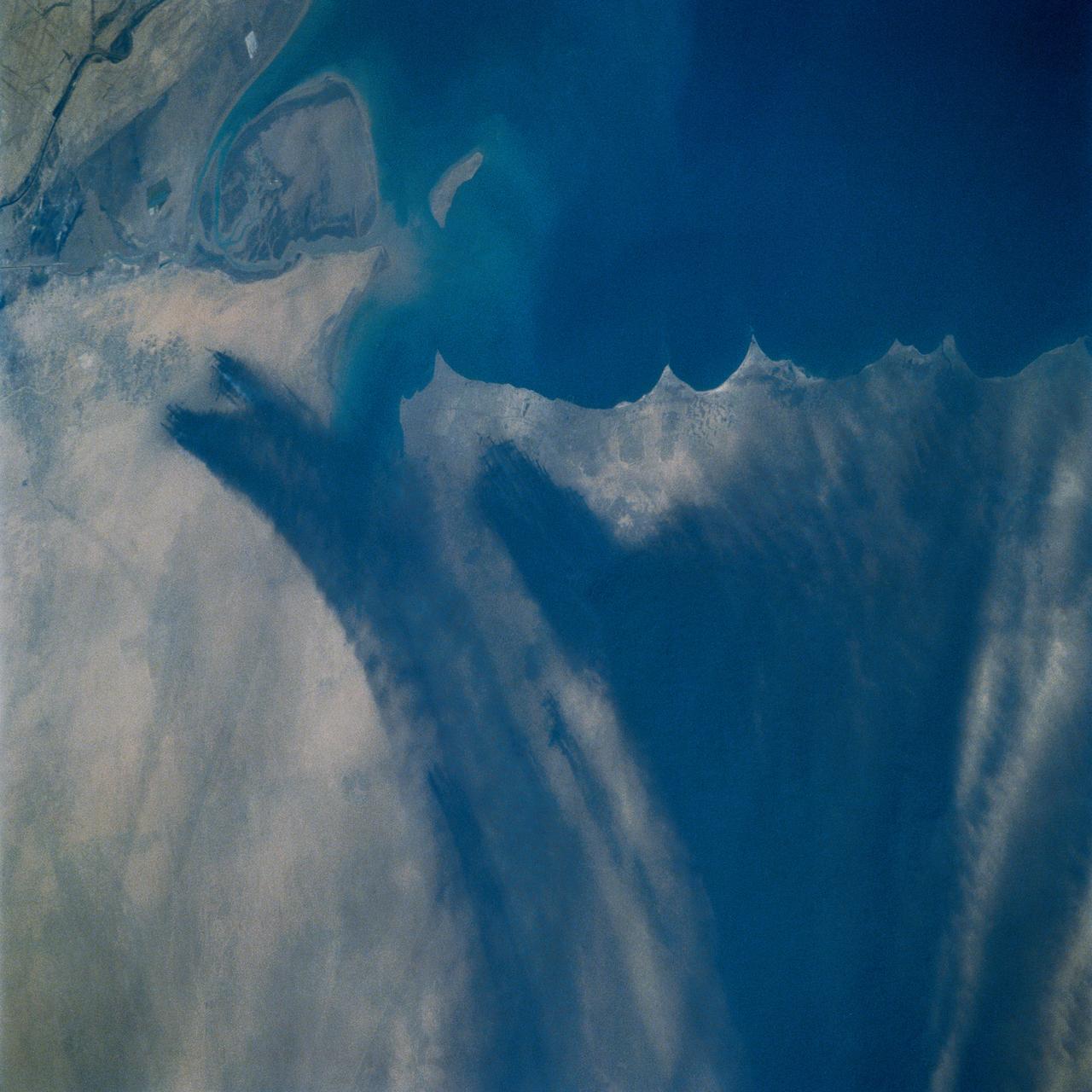
STS059-82-010 (9-20 April 1994) --- View northwestward of a small part of southeastern Iraq. The city of Basra can be seen in the lower left corner, and the former junction of the Tigris and Euphrates Rivers in the upper right. The streams have been channelized, in part to dewater and burn an extensive marsh. Hasselblad camera, 250mm lens.
STS060-92-082 (3-11 Feb 1994) --- This cloud-free view is centered on the city of Baghdad, Iraq. Baghdad has had a reputation for scholarship and learning from ancient times in the Islamic world. Modern Baghdad is a city with a typical urban land use patterns. The color of Tigris river flowing through the city indicates the heavily sediment laden waters of the river. Agricultural land uses are evident in the surrounding areas of the city.
The world's largest cemetery is located in the holy city of Najaf, Iraq, west of the Euphrates River, and along the Najaf Sea. The Wadi-al-Salam cemetery, Arabic for "Peace Valley", covers an area of about 10 square kilometers, and has over 6 million graves. Daily burials have been going on for over 1400 years. The image was acquired May 5, 2021, covers an area of 18 by 21.5 km, and is located at 32 degrees north, 44.3 degrees east. https://photojournal.jpl.nasa.gov/catalog/PIA25896
iss072e518159 (Jan. 21, 2025) --- The Tigris River flows through the temperate landscape of northern Iraq in this photograph from the International Space Station as it orbited 260 miles above.

SL3-115-1924 (July-September 1973) --- Skylab 3 Earth view of Israel, Jordan, Lebanon, Syria, Iraq and the Dead Sea. Photo credit: NASA
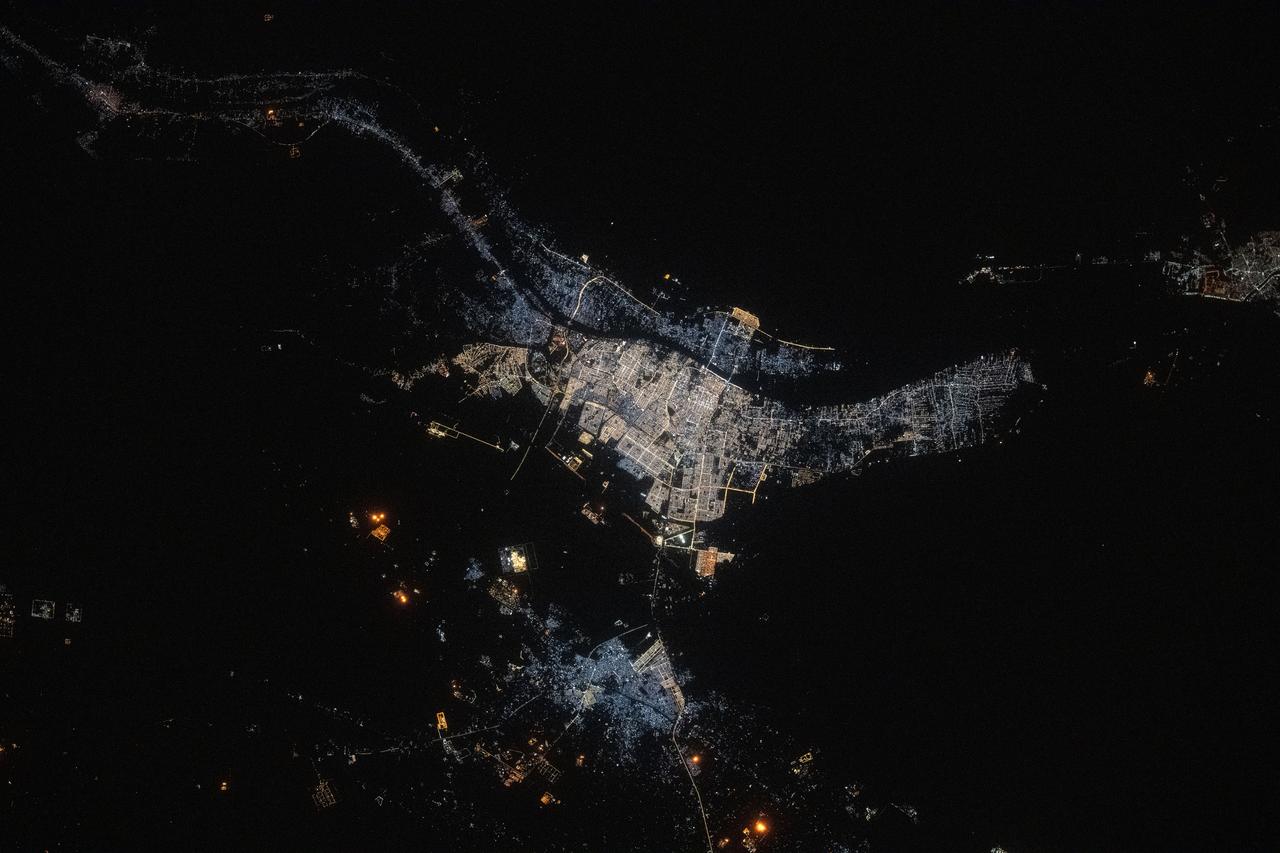
iss073e0134545 (May 22, 2025) --- The port city of Basrah, Iraq, with a population of about 1.49 million near the Persian Gulf and split by the Shatt Al Arab river, is pictured at approximately 10:42 p.m. local time from the International Space Station as it orbited 260 miles above the Middle East.

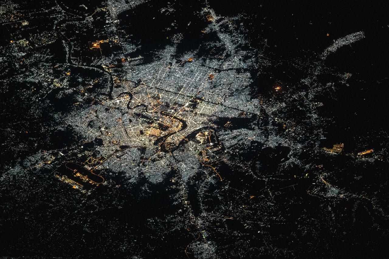
iss073e0134535 (May 22, 2025) --- Baghdad, the capital and largest city in Iraq with a population of about 7.92 million split by the Tigris River, is pictured at approximately 10:41 p.m. local from the International Space Station as it orbited 260 miles above the Middle Eastern nation.

iss073e0515117 (Aug. 23, 2025) --- Baghdad, Iraq, split by the Tigris River and with a population of about 7.92 million, is pictured at approximately 1:58 a.m. local time from the International Space Station as it orbited 261 miles above. The dark, oval area toward the top is Baghdad International Airport hosting both civilian airlines and military aircraft. Credit: JAXA (Japan Aerospace Exploration Agency)
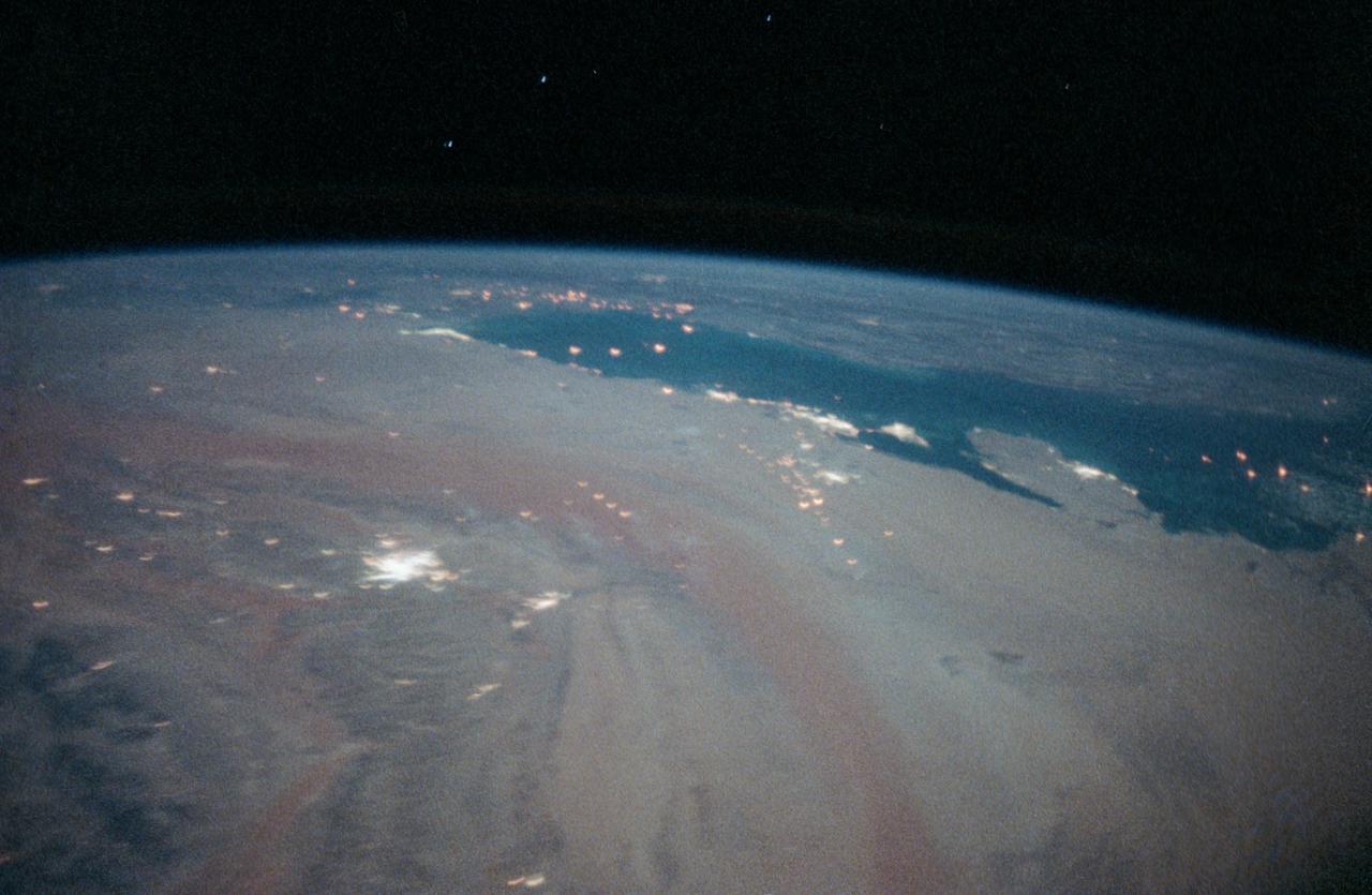
STS-35 Earth observation taken aboard Columbia, Orbiter Vehicle (OV) 102, is of the Persian Gulf area. Major cities and oilfields of the countries of Saudi Arabia (foreground), Iraq (top left), Iran (top center and top right), Kuwait, Bahrain, Qatar, and a portion of the United Arab Emirates are visible in this scene. The cities are the large whitish areas of city lights. Flares characteristic of the Mid-East oil field practices are visible both onshore and offshore throughout the scene. Major cities identifiable are in Iraq - Baghdad, Basra, and Faw; in Qatar - Ab Dawhah; in Kuwait - Kuwait City; in Saudi Arabia - Riyadh, Al Jubayl, Dharan, Al Huf, Ad Dilam and Al Hariq; and Bahrain and its associated causeway to the mainland.
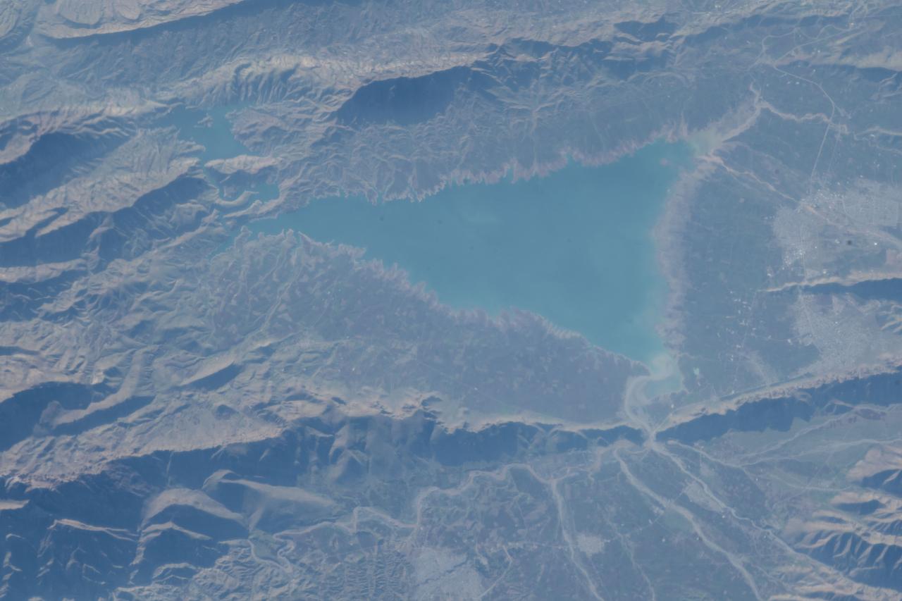
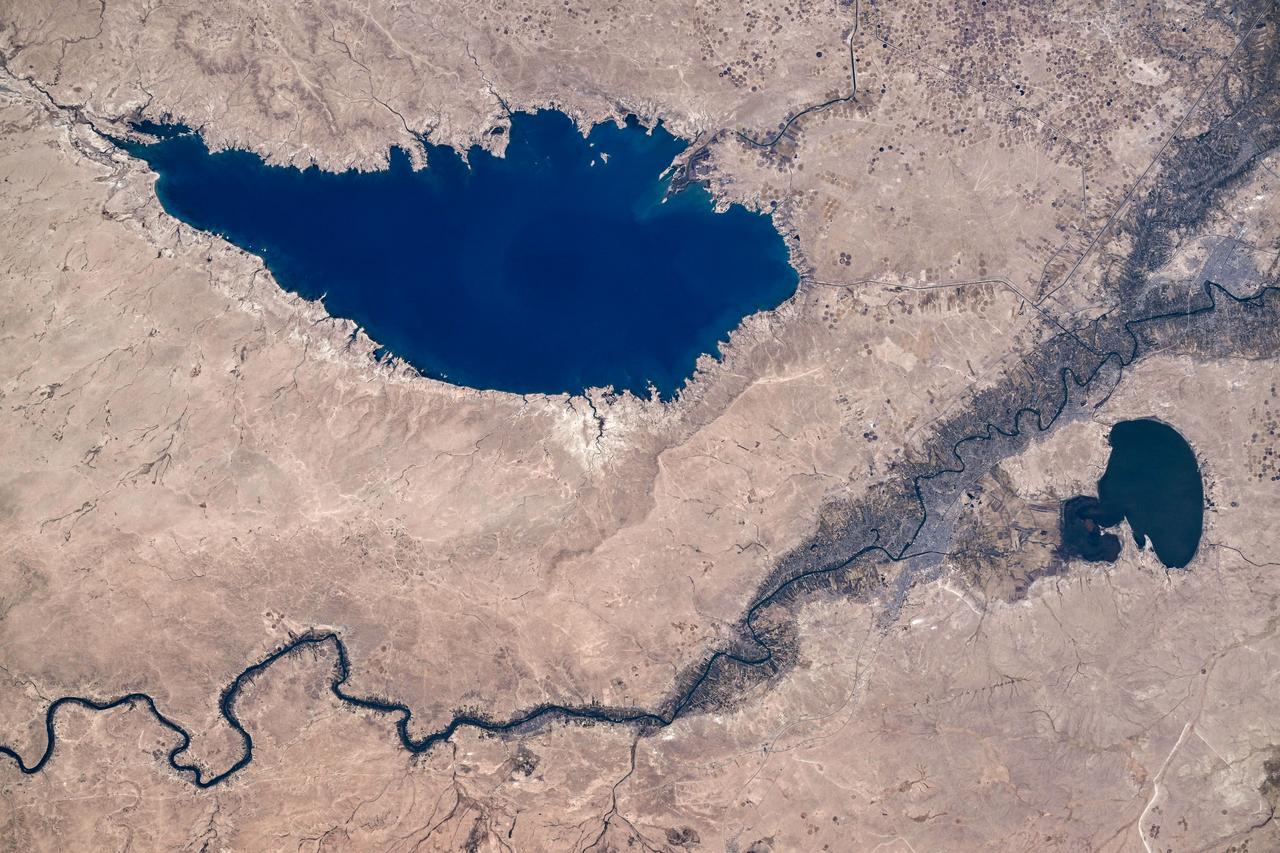
iss057e111325 (Dec. 3, 2018) --- Lake Dukan in northern Iraq near the border with Iraq is pictured as the International Space Station orbited 252 miles of above the Middle Eastern nations.
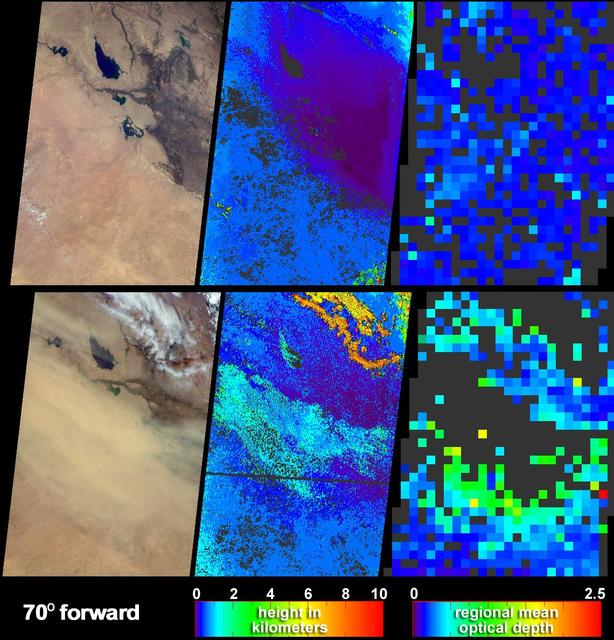
Clear skies on April 11, 2004 top panels contrast strongly with the dust storm that swept across Iraq and Saudi Arabia on May 13 bottom panels as seen by NASA Terra spacecraft.

iss061e118088 (Jan. 4, 2020) --- The International Space Station was orbiting 260 miles above northeastern Syria at the time this photograph of Baghdad, Iraq was taken.
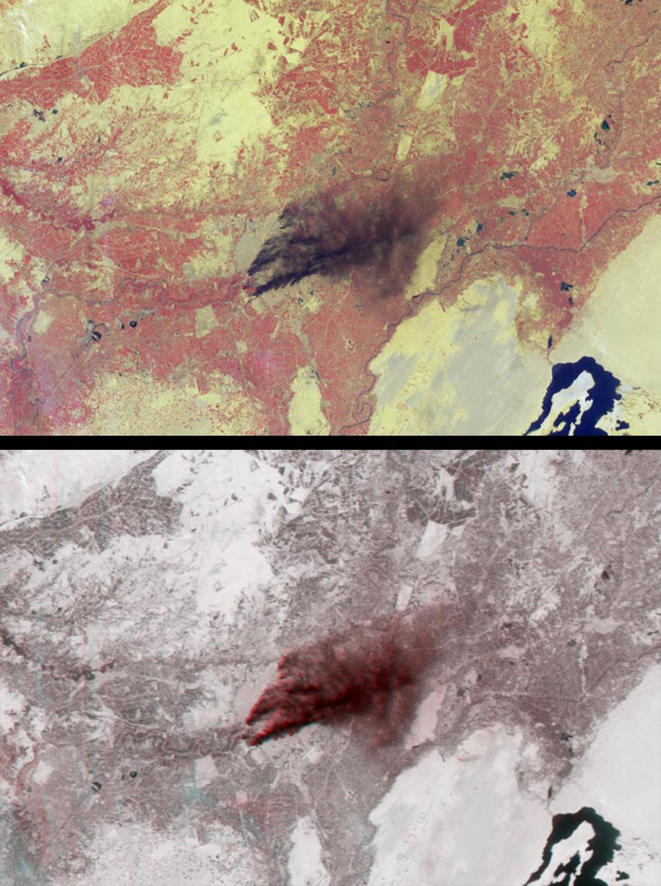
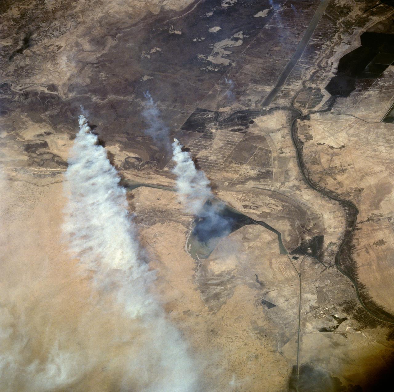
Dark smoke from oil fires extend for about 60 kilometers south of Iraq capital city of Baghdad in this anaglyph acquired by the MISR instrument aboard NASA Terra spacecraft on April 2, 2003. 3D glasses are necessary to view this image.
iss067e169965 (July 1, 2022) --- The Khawr az-Zubayr Waterway (at bottom) separates the Middle Eastern nations of Kuwait and Iraq on the Persian Gulf coast. At top left, is the desert town of Abdali, Kuwait. At right, is the fertile, agricultural town of Abu Al-Khaseeb, Iraq. The International Space Station was orbiting 262 miles above Saudi Arabia near the island nation of Bahrain at the time this photograph was taken.
ISS008-E-18935 (24 March 2004) --- This photo of a large black smoke plume from an oil fire was taken by an Expedition 8 crewmember on the International Space Station as the Station orbited northeastward across Saudi Arabia. According to a front-page story in the New York Times, an oil pipeline near the channel of Shatt al Arab in southeastern Iraq on the Persian Gulf ruptured the day before. The resulting oil spill ignited and its smoke can here be seen to extend over 100 miles northwestward into southern Iraq.
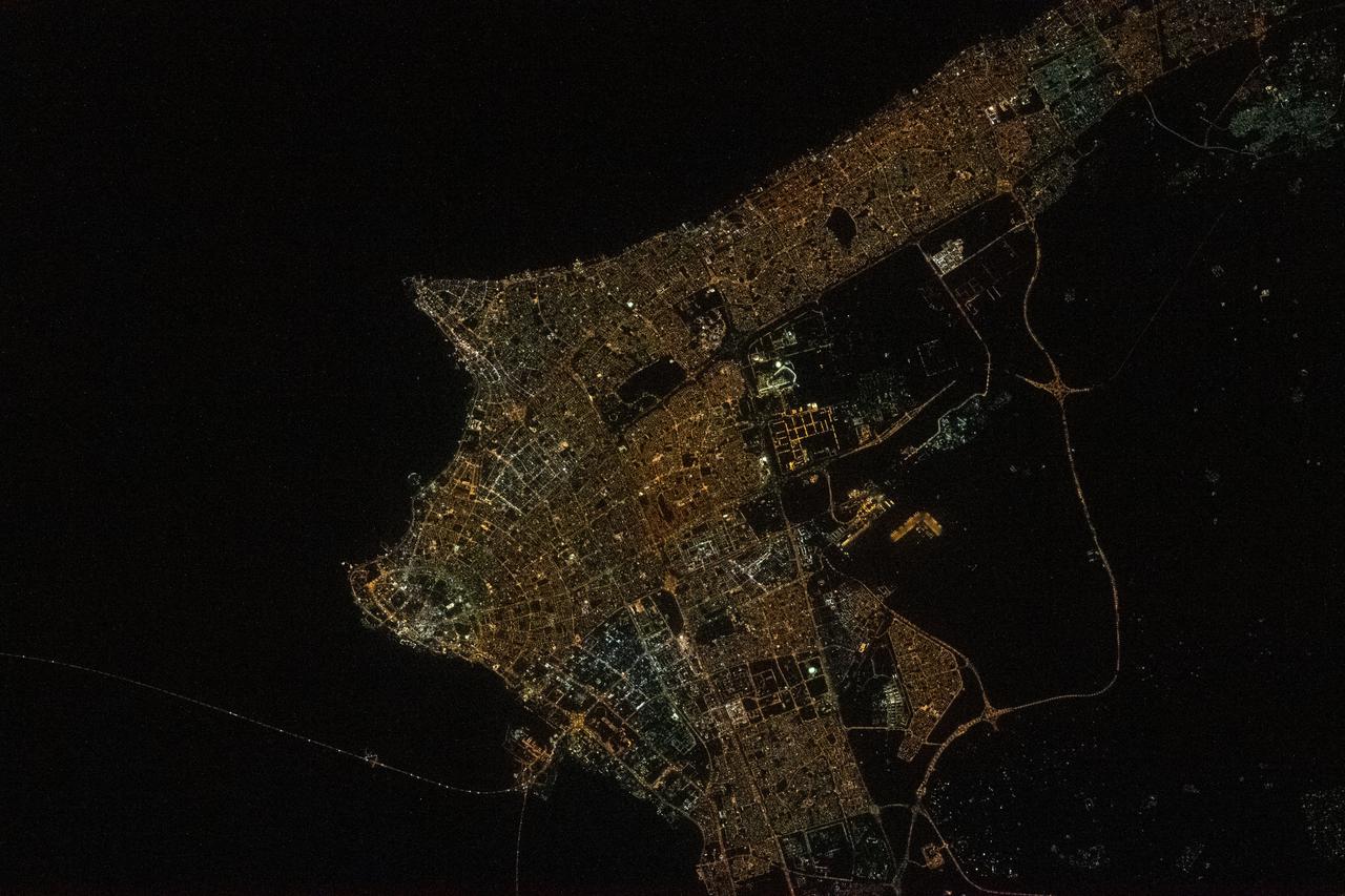
iss069e032946 (July 18, 2023) --- The city lights of Baghdad, Iraq, split by the Tigris River, are pictured from the International Space Station as it orbited 261 miles above the Middle Eastern nation.

iss063e025865 (June 10, 2020) --- Russia's Progress 74 cargo craft is pictured docked to the International Space Station's Pirs docking compartment as the orbital complex was orbiting over northern Iraq.
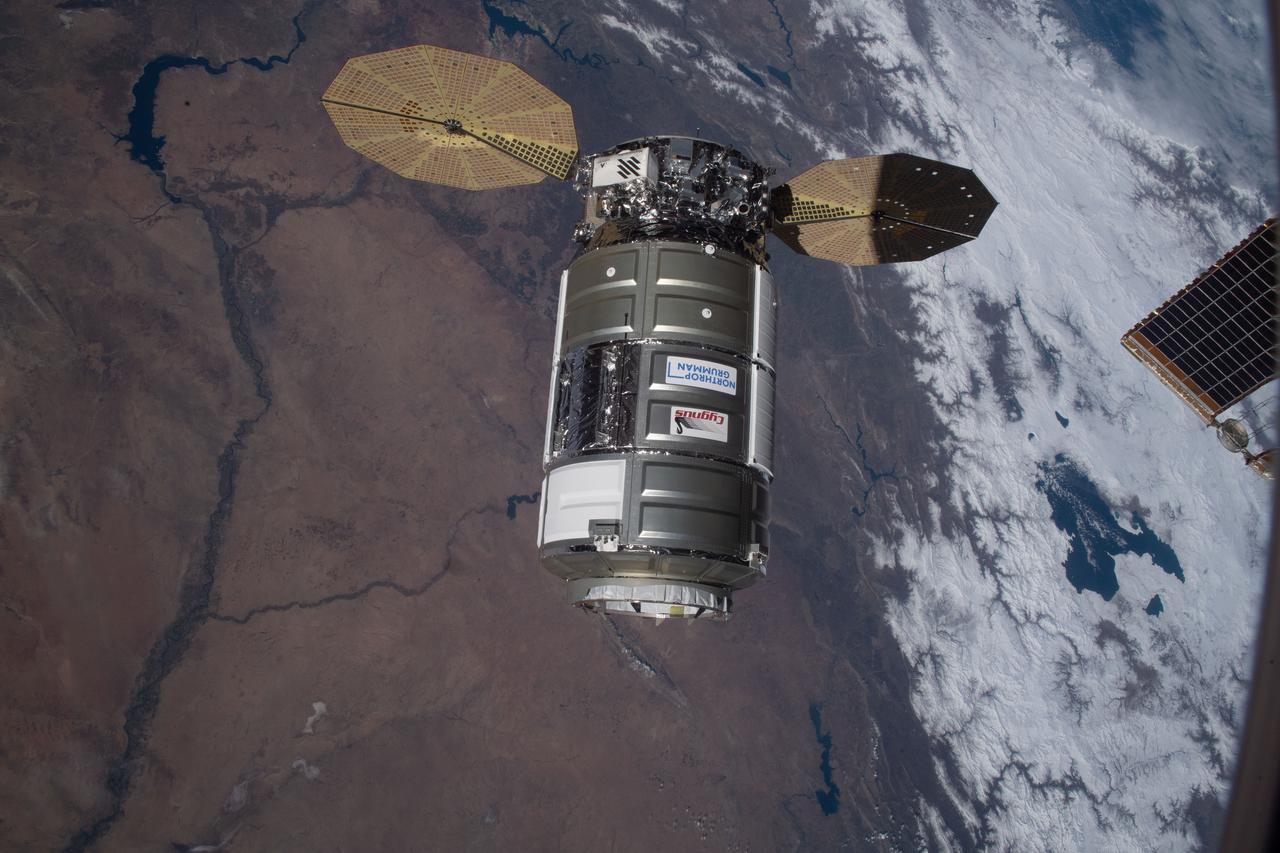
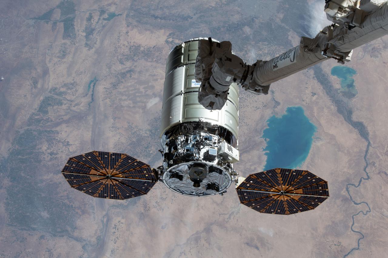
iss064e035951 (Feb. 22, 2021) --- The Cygnus space freighter from Northrop Grumman approaches the International Space Station as both spacecraft were orbiting 262 miles above the Syria-Iraq border.

iss069e053879 (Aug. 4, 2023) --- Northrop Grumman's Cygnus cargo craft is pictured from the International Space Station as it approaches while orbiting 260 miles above the Euphrates River in Iraq.

iss066e125410 (Jan. 24, 2022) --- The Soyuz MS-19 crew ship and the Prichal docking module (in the background) are pictured as the International Space Station orbited 258 miles above the Saudi Arabia-Iraq border.
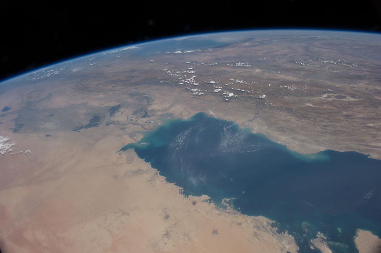
iss064e029028 (Feb. 2, 2021) --- The northern coast of the Persian Gulf, pictured from the International Space Station at an altitude of 262 miles, leads to the Middle Eastern nations of Kuwait, Iraq and Iran.
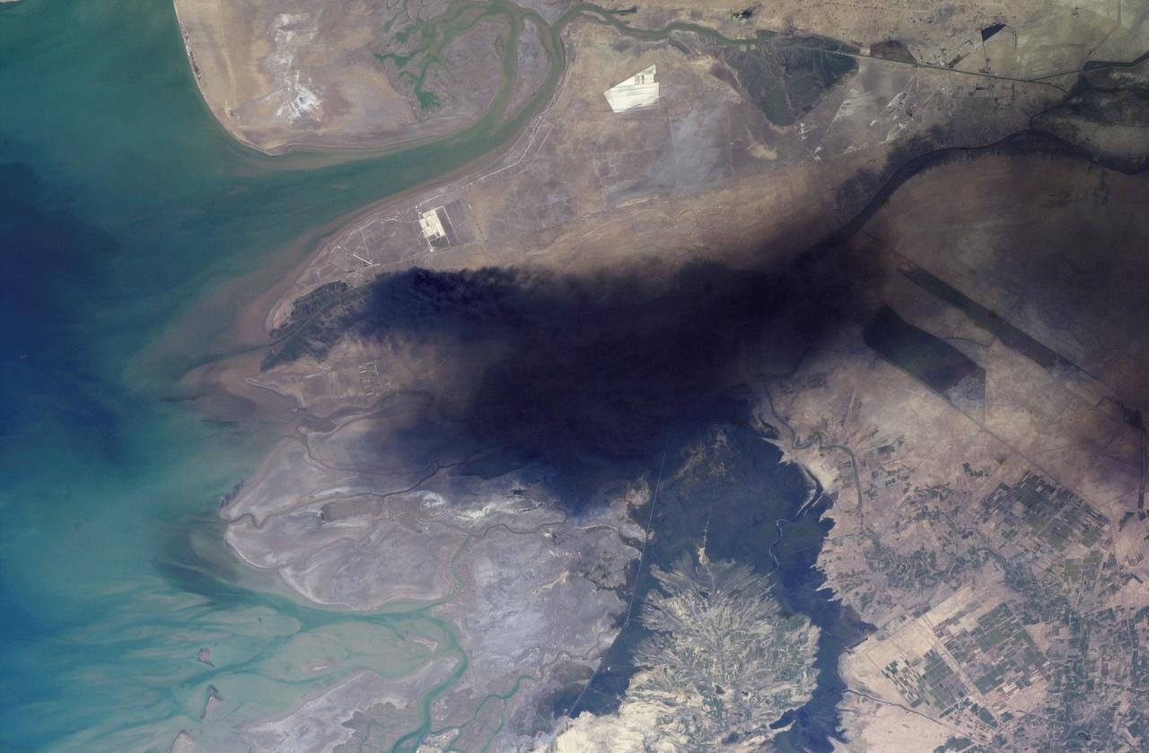
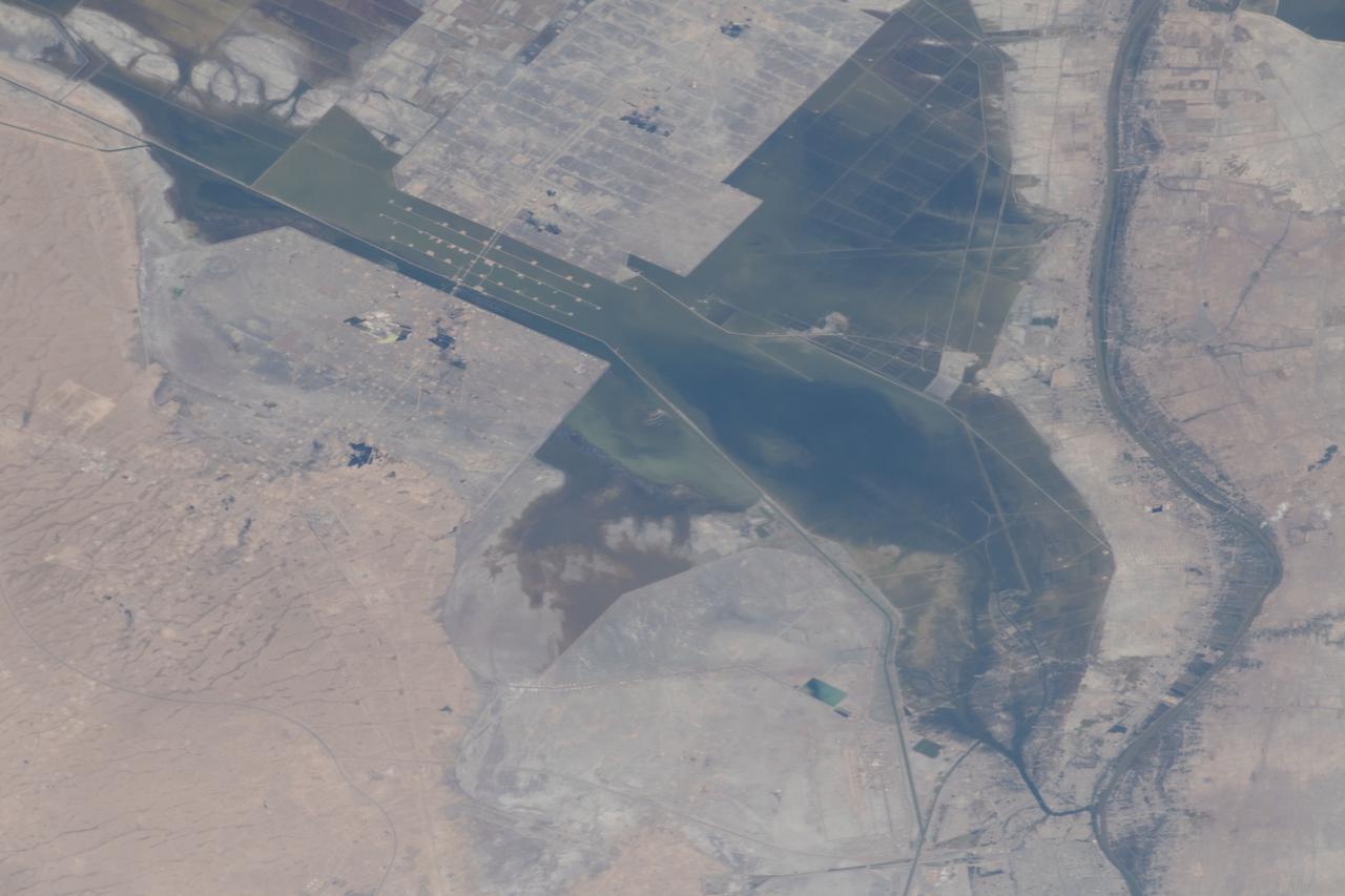
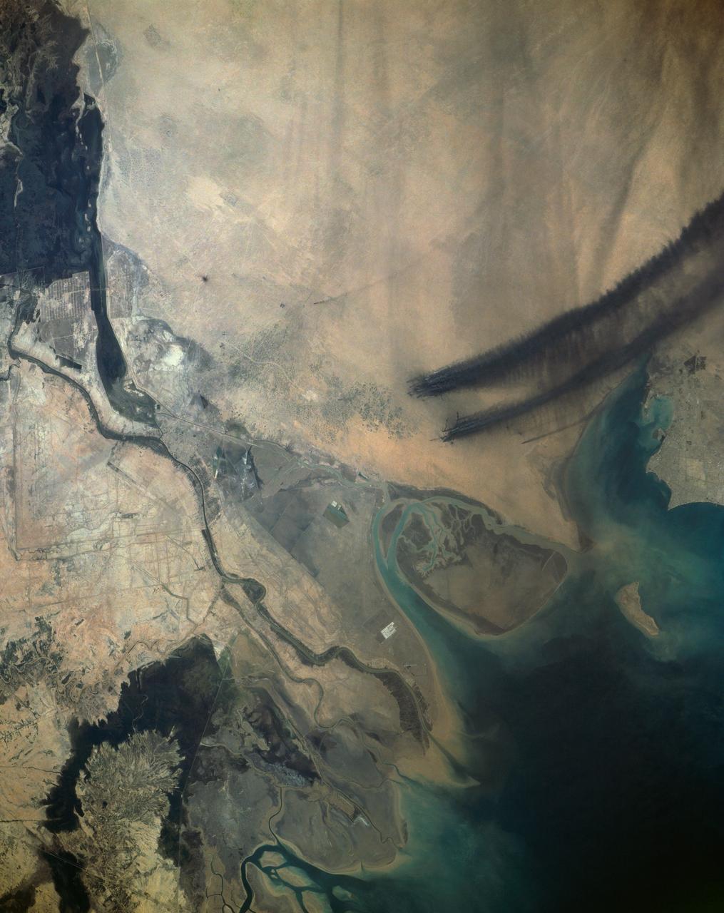
ISS008-E-18938 (24 March 2004) --- This photo of a large black smoke plume over southeastern Iraq was taken by an Expedition 8 crewmember on the International Space Station. The oil that is burning spilled from a ruptured pipeline on March 23, 2004. This photo was taken the next afternoon and shows details of land use near the fire. The delta of the Shatt al Arab has numerous channels, estuaries, and tidal flats. Near the top of the photo (southwest) are two large white salt evaporator operations while to the lower right are wetlands and irrigated agricultural fields. Iraq’s only oil terminal on the Persian Gulf is near the left edge of the plume.
iss073e0379780 (July 20, 2025) --- The Euphrates River runs in between the large, artificial Lake Tharthar and the small Lake Habbaniyah to the northwest of Baghdad, Iraq, in this photograph from the International Space Station as it orbited 260 miles above the Middle Eastern nation. Credit: Roscosmos

iss067e169952 (July 1, 2022) --- The Arvand Roud (center) is a river that separates the southern borders of Iraq and Iran on the Persian Gulf coast. At right, is the Bahmanshir River in Iran that drains into the Persian Gulf. The International Space Station was orbiting 262 miles above Saudi Arabia near the island nation of Bahrain at the time this photograph was taken.
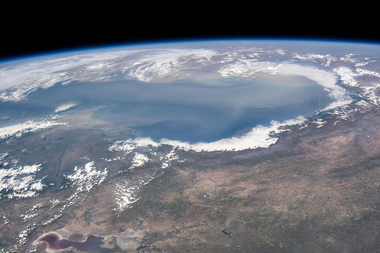
iss071e139662 (May 27, 2024) --- The world's largest inland body of water, the Caspian Sea rests in between Europe and Asia and is bordered by the nations of Russia, Kazakhstan, Turkmenistan, Iran, and Azerbaijan. The International Space Station was orbiting 262 miles above Erbil, Iraq, at the time of this photograph.

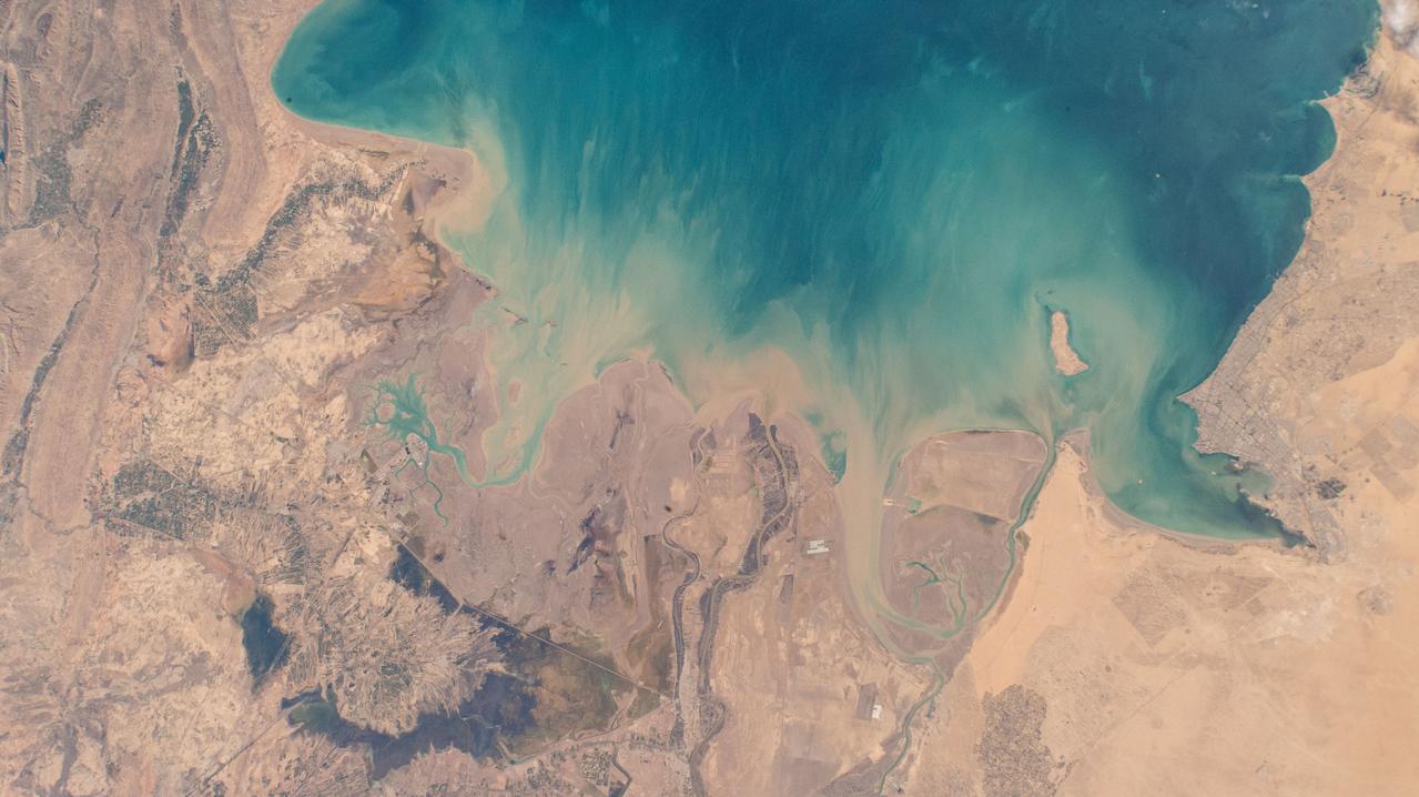
iss059e034612 (April 23, 2019) --- Severe flooding is seen near Basrah, Iraq, as unusually heavy and persistent rain doused several Middle Eastern countries in late March and early April 2019. At the same time, mountains were beginning to lose their snow cover to melting.
S65-34776 (3-7 June 1965) --- This photograph shows the Nile Delta, Egypt, the Suez Canal, Israel, Jordan, Syria, Saudi Arabia, and Iraq as seen from the Gemini-Titan 4 (GT-4) spacecraft during its 12th revolution of Earth.
iss059e034570 (April 23, 2019) --- Severe flooding is seen near Basrah, Iraq, as unusually heavy and persistent rain doused several Middle Eastern countries in late March and early April 2019. At the same time, mountains were beginning to lose their snow cover to melting.
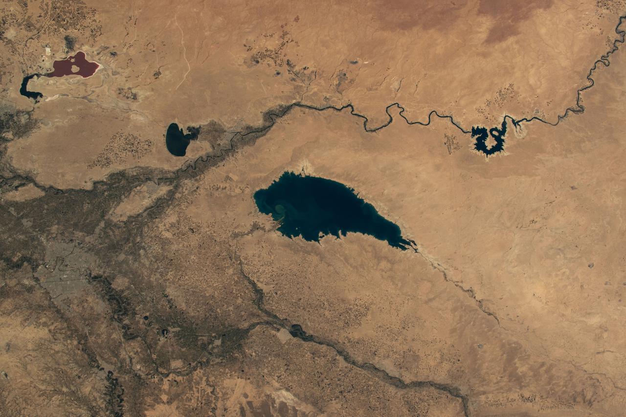
iss071e163367 (June 4, 2024) --- Baghdad, Iraq (lower left), is pictured near several bodies of water including (from left) Razazza Lake, Habbaniyah Lake, Therthar Lake, the Euphrates River, and Lake Qadisiyah created by the damming of the Euphrates. The International Space Station was orbiting 260 miles above the Middle East at the time of this photograph.
iss066e147543 (Feb. 21, 2022) --- Northrop Grumman's Cygnus space freighter is pictured moments away from being captured with the Canadarm2 robotic arm being commanded by NASA astronaut Raja Chari as the International Space Station orbited 259 miles above northern Iraq. This is Northrop Grumman’s 17th contracted resupply mission under the second Commercial Resupply Services contract with NASA.
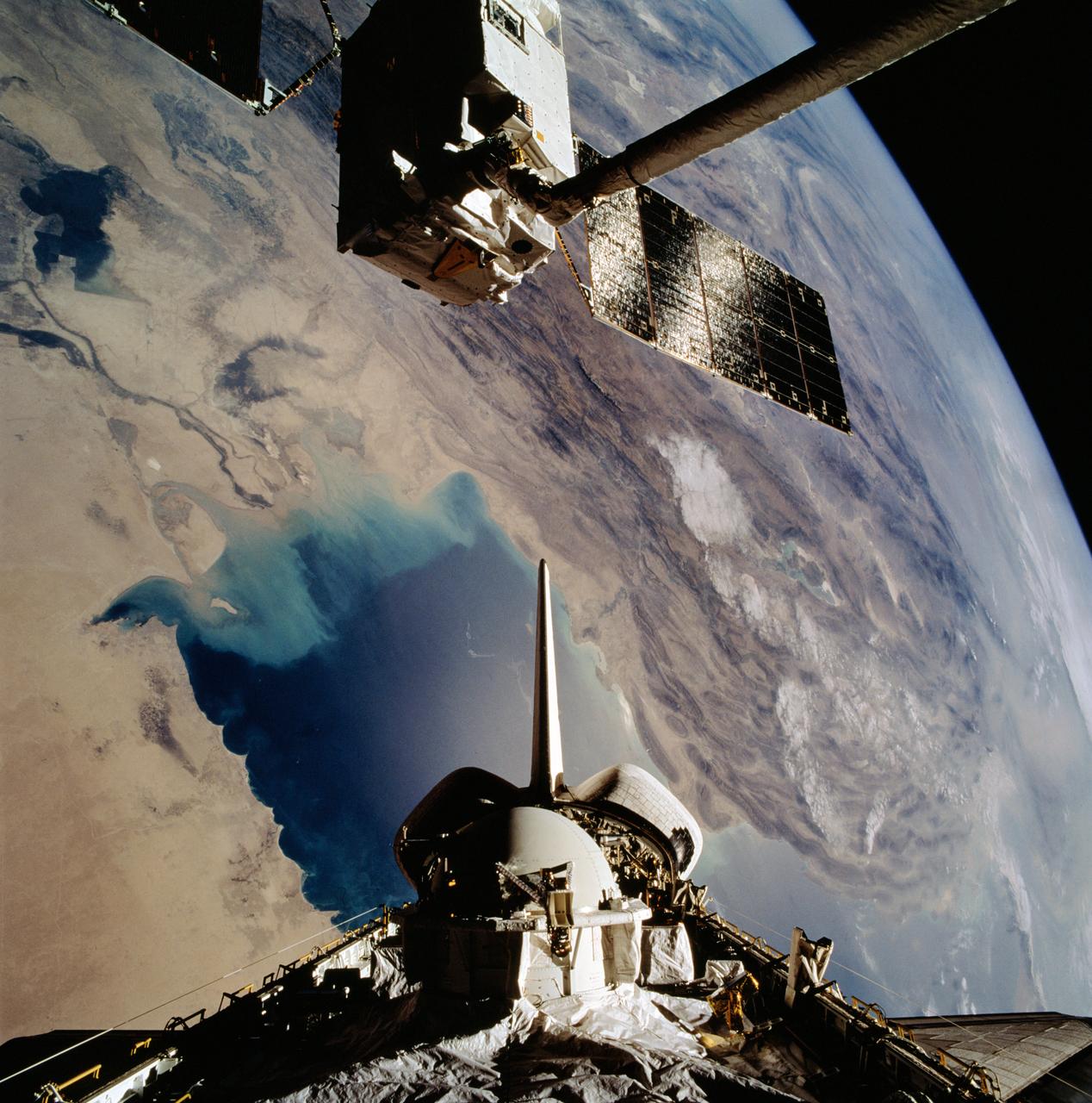
STS046-102-021 (1 Aug 1992) --- The European Space Agency's (ESA) EURECA satellite remains in the grasp of the Space Shuttle Atlantis' Remote Manipulator System (RMS) as the Space Shuttle passes over the Persian Gulf. Most of the theater of the recent war is visible in the frame. Parts of Kuwait, Iraq, Iran and Saudi Arabia can be delineated. The Tethered Satellite System (TSS) remains stowed in the aft cargo bay of Atlantis.
ISS040-E-106243 (25 Aug. 2014) --- This panorama view, photographed by an Expedition 40 crew member on the International Space Station, shows the tropical blue waters of the Persian Gulf. Strong north winds often blow in summer, churning up dust from the entire length of the desert surfaces of the Tigris and Euphrates valleys (top left). Dust partly obscures the hundreds of kilometers of Iraq?s light-green agricultural lands along these rivers (left). The Caspian Sea cuts the horizon.
Smoke from the burning oil fields to the north of Kuwait City, seen on the south shore of Kuwayt Bay, almost totally obscures the view of the tiny, but oil rich, nation of Kuwait (30.0N, 48.0E). During the brief war between Iraq and the Allied forces, many of the oil wells in Kuwait were destroyed and set afire. For several months, those fires burned out of control, spewing wind borne smoke and ash for hundreds of miles.

STS080-733-021 (19 Nov.-7 Dec. 1996) --- The crewmembers of the Earth-orbiting space shuttle Columbia took this view that shows Kuwait City (mid-center right and along the coastal area), most of Kuwait, portions of Saudi Arabia, and Iraq. Faylakah Awhah Island is seen in the Persian Gulf to the bottom right. Most of the darkened areas represent the residual from oil well fires during the Gulf War of the early 1990?s.
iss064e021961 (Jan. 9, 2021) --- Kuwait City is pictured during a night time pass from the International Space Station as it orbited 261 miles above the Iraq-Saudi Arabia border. Towards the bottom left, is the Sheikh Jaber Al-Ahmad Al-Sabah Causeway, the world's fourth longest road bridge at 24.5 miles, that crosses Kuwait Bay.
Smoke from the burning oil fields to the north and south of Kuwait City, seen on the south shore of Kuwayt Bay almost totally obscures the view of the tiny, but oil rich, nation of Kuwait (29.0N, 48.0E). During the brief war between Iraq and the Allied forces, many of the oil wells in Kuwait were destroyed and set afire. For several months, those fires burned out of control, spewing wind borne smoke and ash for hundreds of miles.
NM18-309-018 (28 June 1995) --- The Space Shuttle Atlantis orbits Earth at a point above Iraq as photographed by one of the Mir-18 crew members aboard Russia's Mir Space Station. The image was photographed prior to rendezvous and docking of the two spacecraft. The Spacelab science module and the tunnel connecting it to the crew cabin, as well as the added mechanism for interface with the Mir's docking system can be easily seen. The geography pictured is 60 miles northwest of Baghdad. The Buhayrat Ath Tharthar (reservoir) is the widest body of water visible. Also seen are the Tigris and Euphrates Rivers.

This image from NASA EarthKAM is of the northern end of the Persian Gulf and the broad delta complex of the Tigris, Euphrates, Shatt al Arab, and Karun rivers has captured the arid-looking wetlands of northeast Kuwait Bubiyan Island,
ISS040-E-113700 (31 Aug. 2014) --- This panorama view, photographed by an Expedition 40 crew member on the International Space Station, shows tan-colored dust of a major dust storm obscuring the Persian Gulf and the its northern shoreline. Strong north winds often blow in summer, churning up dust from the entire length of the desert surfaces of the Tigris and Euphrates valleys (top left). Dust partly obscures the hundreds of kilometers of Iraq’s light-green agricultural lands along these rivers (left). A line of thunderstorms is being set off by the Zagros Mountains of Iran (right), with the setting sun casting long shadows from the thunderheads. Space station crews see sixteen sunrises and sunsets every day from low Earth orbit. Here the crew captured dusk in a darkening Iranian landscape (right).
S66-54893 (14 Sept. 1966) --- Near East area as seen from the orbiting Gemini-11 spacecraft during its 26th revolution of Earth. The United Arab Republic (Egypt) is in foreground. Triangular-shaped area is the Sinai Peninsula. Saudi Arabia is at upper right. The Mediterranean Sea is at upper left. The Gulf of Suez separates Egypt from the Sinai Peninsula. The Red Sea is at bottom right. The Gulf of Aqaba is the body of water in right center of photograph separating the Sinai Peninsula and the Arabian Peninsula. The Dead Sea, Sea of Galilee, Jordan and Israel are in top center of picture. Iraq is at top right edge of photograph. Taken with a J. A. Maurer 70mm camera, using Eastman Kodak, Ektachrome, MS (S.O. 368) color film. Photo credit: NASA

AS17-148-22718 (7-19 Dec. 1972) --- This excellent view of Saudi Arabia and the north eastern portion of the African continent was photographed by the Apollo 17 astronauts with a hand-held camera on their trans-lunar coast toward man's last lunar visit. Egypt, Sudan, Ethiopia are some of the African nations are visible. Iran, Iraq, Jordan are not so clearly visible because of cloud cover and their particular location in the picture. India is dimly visible at right of frame. The Red Sea is seen entirely in this one single frame, a rare occurrence in Apollo photography or any photography taken from manned spacecraft. The Gulf of Suez, the Dead Sea, Gulf of Aden, Persian Gulf and Gulf of Oman are also visible. This frame is one of 169 frames on film magazine NN carried aboard Apollo 17, all of which are SO368 (color) film. A 250mm lens on a 70mm Hasselblad camera recorded the image, one of 92 taken during the trans-lunar coast. Note AS17-148-22727 (also magazine NN) for an excellent full Earth picture showing the entire African continent.
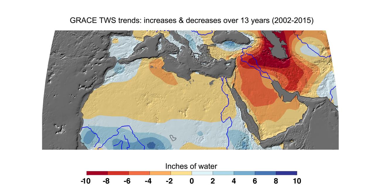
Cumulative total freshwater losses in North Africa and the Middle East from 2002 to 2015 (in inches) observed by NASA's Gravity Recovery and Climate Experiment (GRACE) mission. Total water refers to all of the snow, surface water, soil water and groundwater combined. Groundwater depletion in Turkey, Syria, Iraq and Iran, and along the Arabian Peninsula, are leading to large changes in total water storage in the region. Likewise, drought and groundwater pumping is contributing to the drying of the Caspian Sea Region. The Northwest Sahara Aquifer System, which underlies Tunisia and Libya, is also experiencing increasing water stress as shown in the map. Image updated from Voss et al., 2013. Citation of Record: Voss, K. A., J. S. Famiglietti, M. Lo, C. R. de Linage, M. Rodell and S. C. Swenson, Groundwater depletion in the Middle East from GRACE with Implications for Transboundary Water Management in the Tigris-Euphrates-Western Iran Region, Wat. Resour. Res., 49(2), 904-914, DOI: 10.1002/wrcr.20078. http://photojournal.jpl.nasa.gov/catalog/PIA20207
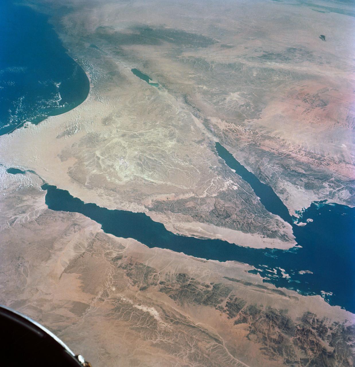
STS062-151-220 (4-18 March 1994) --- Great numbers of circular, center-pivot irrigation plots appear in this west-looking view of the northern Saudi Arabia (center to lower left). So many plots now exist that the face of Saudi Arabia as seen from low earth orbit has changed. Until a few years ago, there were only a few scattered center-pivots. Now the entire swath of country between the shifting sands of the Ad Dahna Sand Sea (light colors center and right) and the almost soilless Nejd Plateau (left) has been darkened by thousands of these agricultural fields. The Nejd Plateau is a mass of dark rocks, some volcanic, in NW Saudi Arabia. Water from this higher country flows east towards the agricultural region where it is pumped up from underground aquifers. The weep of the Ad Dahna Sand Sea is one of the major features of Saudi Arabia (center and right) as seen from the orbiter. The dunes follow the trend of regional winds (northwesterly in the center of the view) which circulate around the Nejd plateau. The north end of the Red Sea can be seen top left with the Sinai Peninsula and Mediterranean are just visible center top. Iraq is under cloud top right.
David A. Wright is associate director for Center Operations at the NASA Dryden Flight Research Center, Edwards, Calif. He was formerly director of Flight Operations. He is also a research pilot, flying NASA's ER-2 and T-38. The ER-2s are civilian variants of the military U-2S reconnaissance aircraft and carry scientific instruments to study the Earth during worldwide deployments. Wright has more than 4,500 hours in six different aircraft. He held the position of deputy director of the Airborne Science Program at Dryden from 2002 until 2004. Wright came to Dryden after retiring from the U.S. Air Force as a lieutenant colonel. His final assignment was to the Joint Staff J3, Directorate of Operations at the Pentagon from November 1996 until August 1999. Prior to the Pentagon assignment, he served as commander of the 1st Reconnaissance Squadron at Beale Air Force Base near Marysville, Calif., the unit responsible for training all U-2 pilots. He was the operations officer for one the largest U-2 operations in history, flying combat missions against Iraq and managing an unprecedented U-2 flying schedule during the 1991 Desert Storm conflict. He was selected for the Air Force U-2 program in 1987 following duty as an aircraft commander in the E-3A AWACS (Airborne Warning and Control System) aircraft. Wright was a T-38 instructor for three years at Reese Air Force Base, Lubbock, Texas, following completion of pilot training in 1978. He graduated from the U.S. Air Force Academy in 1977 with a Bachelor of Science in mathematics and computer science. Wright earned a Master of Arts in Adult Education from Troy State University, Montgomery, Ala., in 1987, and a Master of Science in National Security and Strategic Studies from the Naval War College, Newport, R.I., in 1995.
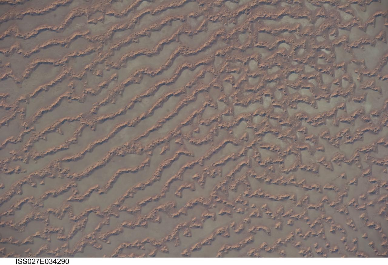
ISS027-E-034290 (16 May 2011) --- Ar Rub al Khali Sand Sea, Arabian Peninsula is featured in this image photographed by an Expedition 27 crew member on the International Space Station. The Ar Rub al Khali, also known as the “Empty Quarter”, is a large region of sand dunes and interdune flats known as a sand sea (or erg). This photograph highlights a part of the Ar Rub al Khali located close to its southeastern margin in the Sultanate of Oman. Reddish-brown, large linear sand dunes alternate with blue-gray interdune salt flats known as sabkhas at left. The major trend of the linear dunes is transverse to northwesterly trade winds that originate in Iraq (known as the Shamal winds). Formation of secondary barchan (crescent-shaped) and star dunes (dune crests in several directions originating from a single point, looking somewhat like a starfish from above) on the linear dunes is supported by southwesterly winds that occur during the monsoon season (Kharif winds). The long linear dunes begin to break up into isolated large star dunes to the northeast and east (right). This is likely a result of both wind pattern interactions and changes in the sand supply to the dunes. The Empty Quarter covers much of the south-central portion of the Arabian Peninsula, and with an area of approximately 660,000 square kilometers it is the largest continuous sand desert on Earth. The Empty Quarter is so called as the dominantly hyperarid climate and difficulty of travel through the dunes has not encouraged permanent settlement within the region. There is geological and archeological evidence to support cooler and wetter past climates in the region together with human settlement. This evidence includes exposed lakebed sediments, scattered stone tools, and the fossils of hippopotamus, water buffalo, and long-horned cattle.

Kelly Latimer is a research pilot in the Flight Crew Branch of NASA's Dryden Flight Research Center, Edwards, Calif. Latimer joined NASA in March 2007 and will fly the T38, T-34, G-III, C-17 and the "Ikhana" Predator B. Latimer is Dryden's first female research test pilot. Prior to joining NASA, Latimer was on active duty with the U.S. Air Force. She has accumulated more than 5,000 hours of military and civilian flight experience in 30 aircraft. Latimer's first association with NASA was while attending graduate school at George Washington University, Washington, D.C. Her studies included work with the Joint Institute for the Advancement of Flight Sciences at NASA's Langley Research Center, Hampton, Va. She flew an Air Force C-17 during a 2005 NASA study to reduce aircraft noise. A team of California Polytechnic State University students and Northrop Grumman personnel were stationed on Rogers Dry Lake located at Edwards Air Force Base, Calif., to record the noise footprint of the aircraft as it made various landing approaches to Edwards' runway. Latimer completed undergraduate pilot training at Reese Air Force Base, Texas, in 1990. She remained at Reese as a T-38 instructor pilot until 1993. She was assigned as a C-141 aircraft commander at McCord Air Force Base, Tacoma, Wash., until 1996. Latimer graduated from the U.S. Air Force Test Pilot School at Edwards in Class 96B. She served as a C-17 and C-141 experimental test pilot at Edwards until 2000. She then became the chief of the Performance Branch and a T-38 instructor pilot at The Air Force Test Pilot School. She returned to McCord in 2002, where she was a C-17 aircraft commander and the operations officer for the 62nd Operations Support Squadron. In 2004, Latimer became the commander of Edwards' 418th Flight Test Squadron and director of the Global Reach Combined Test Force. Following that assignment, she deployed to Iraq as an advisor to the Iraqi Air Force. Her last active duty tour was as an instructor a
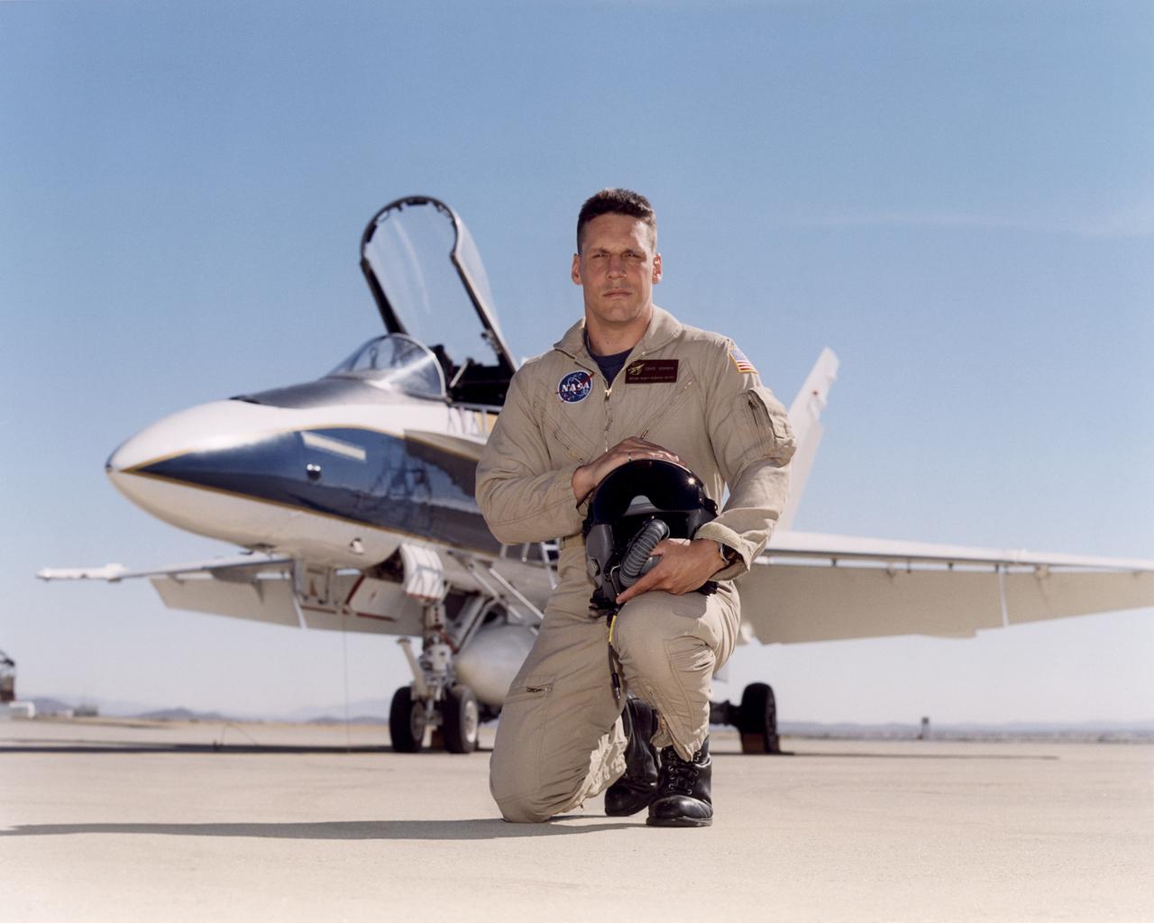
Craig R. Bomben became a pilot in the Flight Crew Branch of NASA's Dryden Flight Research Center, Edwards, Calif., in June 2001. His flying duties include a variety of research and support activities while piloting the F/A-18, DC-8, T-34C and King Air aircraft. He has more than 17 years and 3,800 hours of military and civilian flight experience in over 50 different aircraft types. Bomben came to NASA Dryden from a U.S. Navy assignment to the Personnel Exchange Program, Canada. He served as a test pilot in the Canadian Armed Forces located in Cold Lake, Alberta. He participated in numerous developmental programs to include CT-133 airborne ejection seat testing, F/A-18 weapons flutter testing and F/A-18 night vision goggles integration. Bomben performed U.S. Navy fleet service in 1995 as a strike-fighter department head. He completed two overseas deployments onboard the USS George Washington and USS Stennis. As a combat strike leader, he headed numerous multi-national missions over Iraq in support of Operation Southern Watch. Bomben graduated from the U.S. Naval Test Pilot School in 1992 and was subsequently assigned to the Naval Weapons Test Squadron at Pt. Mugu, Calif. During this tour he developed the F-14D bombsight and worked on various other F-14D and F/A-18 weapon systems developmental programs. Bomben is a 1985 graduate of Washington State University with a bachelor of science degree in electrical engineering. He graduated from naval flight training in 1987 and was recognized as a Commodore List graduate. His first assignment was to Naval Air Station Pensacola, Fla., where he was an instructor in the T-2B Buckeye. When selected to fly the F/A-18 in 1989, he joined a fleet squadron and deployed aboard the USS Forrestal. Bomben is married to the former Aissa Asuncion. They live in Lancaster, Calif., with their 3 children.