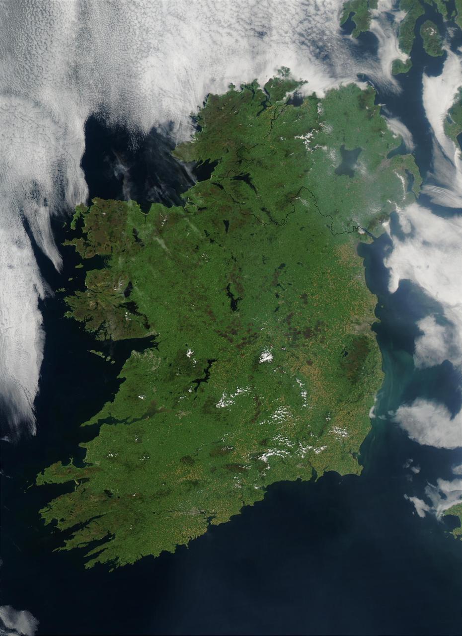
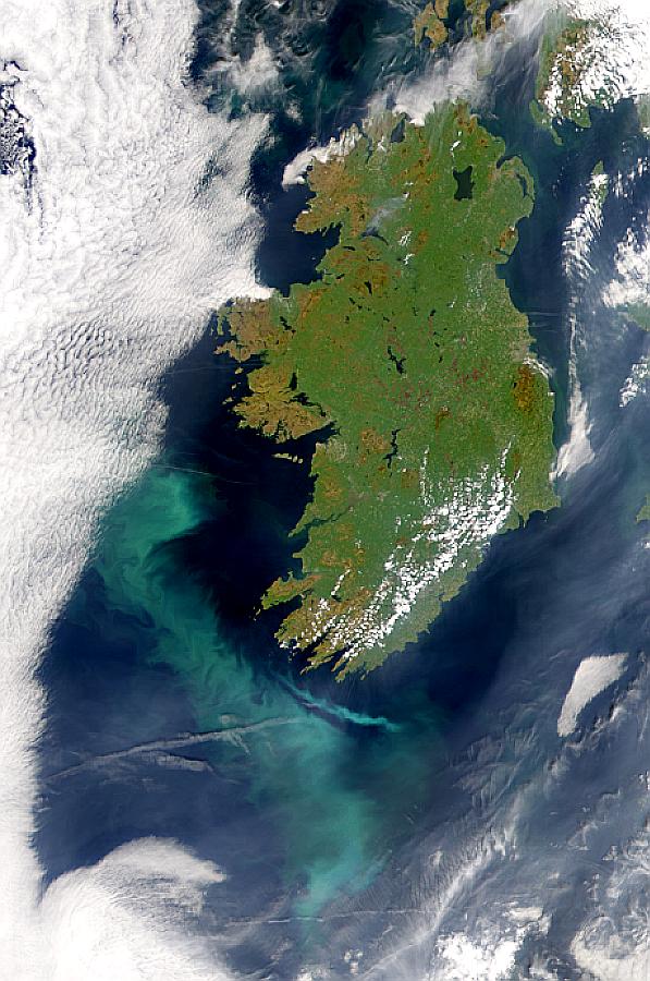
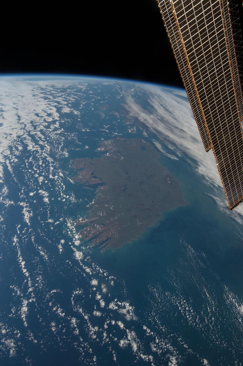
On August 7, 2003, the NASA Aqua MODIS instrument acquired this image of Ireland on the first day this summer that most of the island hasn´t been completely obscured by cloud cover. Called the Emerald Isle for a good reason, Ireland is draped in vibrant shades of green amidst the blue Atlantic Ocean and Celtic (south) and Irish (east) Seas. Faint ribbons of blue-green phytoplankton drift in the waters of the Celtic Sea, just south of Dublin. Dublin itself appears as a large grayish-brown spot on the Republic of Ireland´s northeastern coast. This large capital city (population 1.12 million) sits on the River Liffey, effectively splitting the city in half. Northern Ireland´s capital city, Belfast, also sits on a river: the River Lagan. This city, though its population is only a fifth of the size of Dublin´s, is also clearly visible in the image as a grayish-brown spot on the coast of the Irish Sea. Sensor Aqua/MODIS Credit Jeff Schmaltz, MODIS Rapid Response Team, NASA/GSFC For more information go to: <a href="http://visibleearth.nasa.gov/view_rec.php?id=5744" rel="nofollow">visibleearth.nasa.gov/view_rec.php?id=5744</a> <b><a href="http://www.nasa.gov/centers/goddard/home/index.html" rel="nofollow">NASA Goddard Space Flight Center</a></b> is home to the nation's largest organization of combined scientists, engineers and technologists that build spacecraft, instruments and new technology to study the Earth, the sun, our solar system, and the universe. <b>Follow us on <a href="http://twitter.com/NASAGoddardPix" rel="nofollow">Twitter</a></b> <b>Join us on <a href="http://www.facebook.com/pages/Greenbelt-MD/NASA-Goddard/395013845897?ref=tsd" rel="nofollow">Facebook</a><b> </b></b>
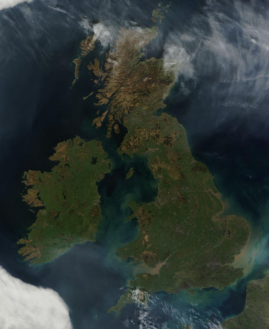
NASA image acquired March 26, 2012 This nearly cloud-free view of Great Britain and Ireland was acquired by the Moderate Resolution Imaging Spectroradiometer (MODIS) aboard NASA’s Terra satellite on March 26, 2012. Just a few days into spring, most of the land appears green, although not quite as brilliant as the summertime hues that give Ireland the nickname “the Emerald Island”. The islands of Ireland (west) and Great Britain (east) are separated by the Irish Sea, which is filled with the turquoise, green and tan swirls typical of sediment, although blooming algae could also contribute some color to the waters. To the southeast, the English Channel separates the island of Great Britain from France (south) and Belgium (north). London can be seen as a gray circle situated inland on the tan-colored River Thames. The sediment from the Thames flows into the English Channel due east of London. The United Kingdom is made up of Wales, Scotland and England, all located primarily on the island of Great Britain, and of Northern Ireland, which comprises the northern section of the island of Ireland. Dublin, in the Republic of Ireland, can be seen as a gray smudge on the eastern coast of the island. Almost due west Galway can be seen as a linear gray streak on the northern coast of Galway Bay, with the blue waters of Loch Corrib to the north. Most of the United Kingdom and Ireland are part of the Celtic broadleaf forest ecoregion, where acid-loving oak and mixed oak forests abound, along with fen and swamp forests and ombrotrophic mires. A portion of the Scottish Highlands, in the north of Great Britain, are covered by the Caledon conifer forest ecoregion. The Caledonia conifers once covered a large area of Scotland, but now only about 1% of the original forest survives, mostly high in the cooler areas of the Highlands. NASA/GSFC/Jeff Schmaltz/MODIS Land Rapid Response Team <b><a href="http://www.nasa.gov/audience/formedia/features/MP_Photo_Guidelines.html" rel="nofollow">NASA image use policy.</a></b> <b><a href="http://www.nasa.gov/centers/goddard/home/index.html" rel="nofollow">NASA Goddard Space Flight Center</a></b> enables NASA’s mission through four scientific endeavors: Earth Science, Heliophysics, Solar System Exploration, and Astrophysics. Goddard plays a leading role in NASA’s accomplishments by contributing compelling scientific knowledge to advance the Agency’s mission. <b>Follow us on <a href="http://twitter.com/NASA_GoddardPix" rel="nofollow">Twitter</a></b> <b>Like us on <a href="http://www.facebook.com/pages/Greenbelt-MD/NASA-Goddard/395013845897?ref=tsd" rel="nofollow">Facebook</a></b> <b>Find us on <a href="http://instagrid.me/nasagoddard/?vm=grid" rel="nofollow">Instagram</a></b>
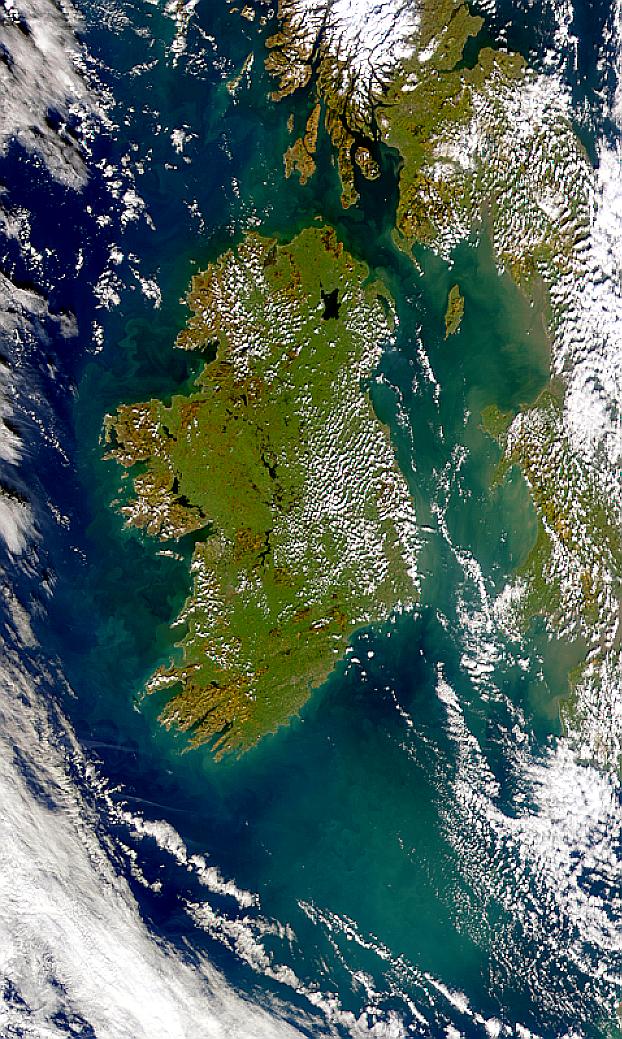
Visualization Date 2000-02-19 Possible coccolithophore blooms are visible in this SeaWiFS image of Ireland. Sensor OrbView-2/SeaWiFS Credit Provided by the SeaWiFS Project, NASA/Goddard Space Flight Center, and ORBIMAGE For more information go to: <a href="http://visibleearth.nasa.gov/view_rec.php?id=920" rel="nofollow">visibleearth.nasa.gov/view_rec.php?id=920</a> <b><a href="http://www.nasa.gov/centers/goddard/home/index.html" rel="nofollow">NASA Goddard Space Flight Center</a></b> enables NASA’s mission through four scientific endeavors: Earth Science, Heliophysics, Solar System Exploration, and Astrophysics. Goddard plays a leading role in NASA’s accomplishments by contributing compelling scientific knowledge to advance the Agency’s mission. <b>Follow us on <a href="http://twitter.com/NASA_GoddardPix" rel="nofollow">Twitter</a></b> <b>Join us on <a href="http://www.facebook.com/pages/Greenbelt-MD/NASA-Goddard/395013845897?ref=tsd" rel="nofollow">Facebook</a></b>
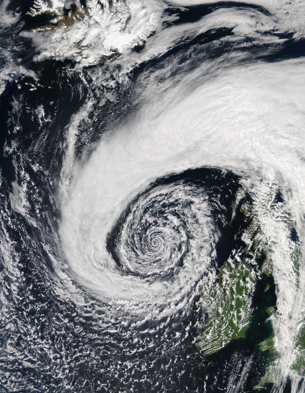
In early June, 2015 a strong low pressure system over the North Atlantic Ocean brought rain and gusty winds to Ireland and the United Kingdom. The Moderate Resolution Imaging Spectroradiometer (MODIS) aboard NASA’s Aqua satellite captured this true-color image of the spiraling system on June 5. A very deep low pressure area lies in the center of the spiral, just off the northwestern shore of emerald-green Ireland. Bands of cloud, containing rain and thunderstorms, swirl into the center of the low, and extend over the British Isles. A low pressure system will pull in air from the surrounding area, creating spiraling winds. Winds around the center of a low pressure spiral counterclockwise in the Northern Hemisphere, as we see here (clockwise in the Southern Hemisphere) and towards the center of the system. Although the system was impressive on June 5, it intensified over the next several days. According to MarkVoganWeather.com, by June 7 the pressure in the unusually deep Atlantic low, which had been hanging around 980mb, was expected to drop lower to about 978mb off of Anglesey, brining northwest gales along the Atlantic west and south coasts of Ireland, England and Wales. Winds gust of up to 80 mph were possible, along with heavy rains. Credit: Jeff Schmaltz, MODIS Land Rapid Response Team, NASA GSFC <b><a href="http://www.nasa.gov/audience/formedia/features/MP_Photo_Guidelines.html" rel="nofollow">NASA image use policy.</a></b> <b><a href="http://www.nasa.gov/centers/goddard/home/index.html" rel="nofollow">NASA Goddard Space Flight Center</a></b> enables NASA’s mission through four scientific endeavors: Earth Science, Heliophysics, Solar System Exploration, and Astrophysics. Goddard plays a leading role in NASA’s accomplishments by contributing compelling scientific knowledge to advance the Agency’s mission. <b>Follow us on <a href="http://twitter.com/NASAGoddardPix" rel="nofollow">Twitter</a></b> <b>Like us on <a href="http://www.facebook.com/pages/Greenbelt-MD/NASA-Goddard/395013845897?ref=tsd" rel="nofollow">Facebook</a></b> <b>Find us on <a href="http://instagrid.me/nasagoddard/?vm=grid" rel="nofollow">Instagram</a></b>
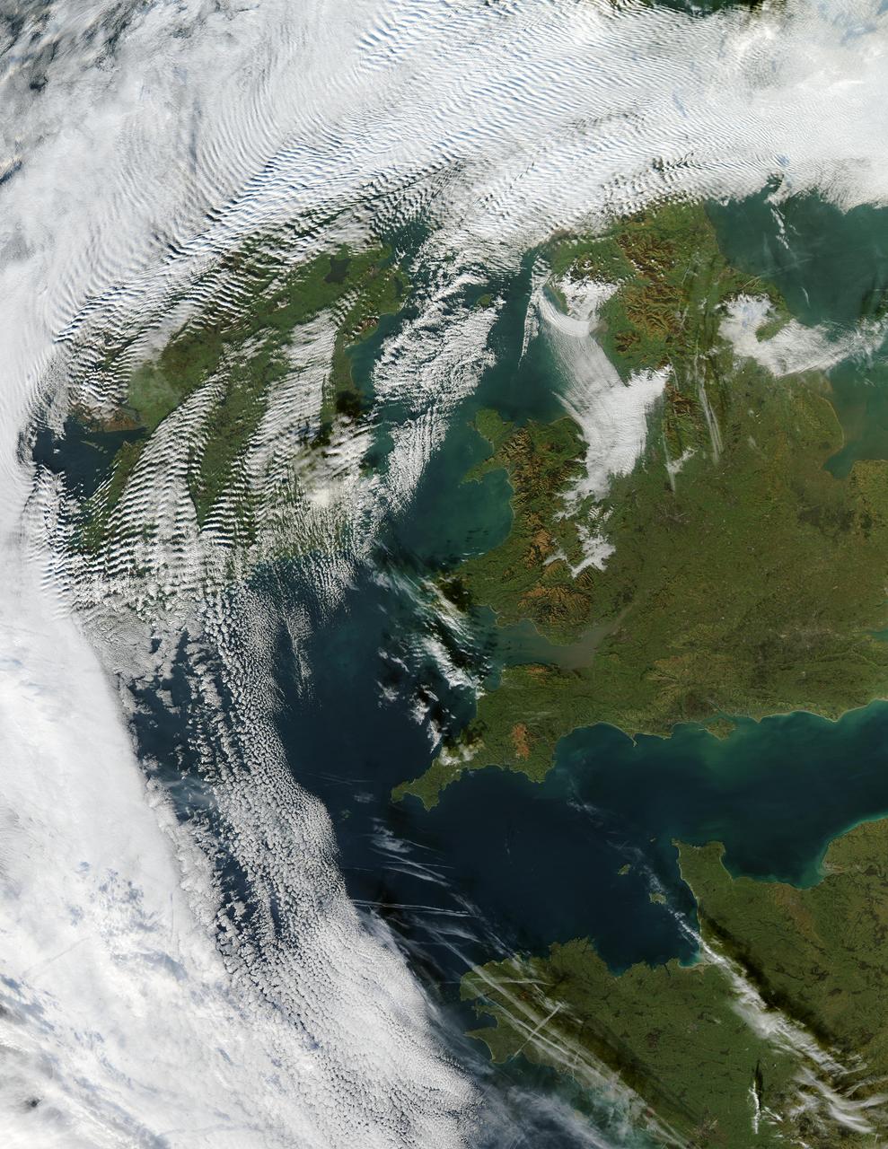
Visualization Date 2003-12-18 Clouds ripple over Ireland and Scotland in a wave pattern, similar to the pattern of waves along a seashore. The similarity is not coincidental — the atmosphere behaves like a fluid, so when it encounters an obstacle, it must move around it. This movement forms a wave, and the wave movement can continue for long distances. In this case, the waves were caused by the air moving over and around the mountains of Scotland and Ireland. As the air crested a wave, it cooled, and clouds formed. Then, as the air sank into the trough, the air warmed, and clouds did not form. This pattern repeated itself, with clouds appearing at the peak of every wave. Other types of clouds are also visible in the scene. Along the northwestern and southwestern edges of this true-color image from December 17, 2003, are normal mid-altitude clouds with fairly uniform appearances. High altitude cirrus-clouds float over these, casting their shadows on the lower clouds. Open- and closed-cell clouds formed off the coast of northwestern France, and thin contrail clouds are visible just east of these. Contrail clouds form around the particles carried in airplane exhaust. Fog is also visible in the valleys east of the Cambrian Mountains, along the border between northern/central Wales and England. This is an Aqua MODIS image. Sensor Aqua/MODIS Credit Jacques Descloitres, MODIS Rapid Response Team, NASA/GSFC For more information go to: <a href="http://visibleearth.nasa.gov/view_rec.php?id=6146" rel="nofollow">visibleearth.nasa.gov/view_rec.php?id=6146</a>

Visualization Date 1994-04-11 This radar image of Dublin, Ireland, shows how the radar distingishes between densely populated urban areas and nearby areas that are relatively unsettled. In the center of the image is the city's natural harbor along the Irish Sea. The pinkish areas in the center are the densely populated parts of the city and the blue/green areas are the suburbs. The two ends of the Dublin Bay are Howth Point, the circular peninsula near the upper right side of the image, and Dun Laoghaire, the point to the south. The small island just north of Howth is called "Ireland's Eye," and the larger island, near the upper right corner of the image is Lambay Island. The yellow/green mountains in the lower left of the image (south) are the Wicklow Mountains. The large lake in the lower left, nestled within these mountains, is the Poulaphouca Reservoir along River Liffey. The River Liffey, the River Dodder and the Tolka River are the three rivers that flow into Dublin. The straight features west of the city are the Grand Canal and the three rivers are the faint lines above and below these structures. The dark X-shaped feature just to the north of the city is the Dublin International Airport. The image was acquired by the Spaceborne Imaging Radar-C/X-band Synthetic Aperture (SIR-C/X-SAR) when it flew aboard the space shuttle Endeavour on April 11, 1994. This area is centered at 53.3 degrees north latitude, 6.2 degrees west longitude. The area shown is approximately 55 kilometers by 42 kilometers (34 miles by 26 miles). The colors are assigned to different frequencies and polarizations of the radar as follows: Red is L-band horizontally transmitted, horizontally received; green is L-band vertically transmitted, vertically received; and blue is C-band vertically transmitted, vertically received. SIR-C/X-SAR, a joint mission of the German, Italian, and the United States space agencies, is part of NASA's Mission to Planet Earth. Credit: NASA/GSFC For more information go to: <a href="http://visibleearth.nasa.gov/view_rec.php?id=467" rel="nofollow">visibleearth.nasa.gov/view_rec.php?id=467</a>
Visualization Date 2000-05-10 A possible coccolithophore bloom is seen to the southwest of Ireland in this SeaWiFS image. Sensor OrbView-2/SeaWiFS Credit Provided by the SeaWiFS Project, NASA/Goddard Space Flight Center, and ORBIMAGE For more information go to: <a href="http://visibleearth.nasa.gov/view_rec.php?id=785" rel="nofollow">visibleearth.nasa.gov/view_rec.php?id=785</a> <b><a href="http://www.nasa.gov/centers/goddard/home/index.html" rel="nofollow">NASA Goddard Space Flight Center</a></b> enables NASA’s mission through four scientific endeavors: Earth Science, Heliophysics, Solar System Exploration, and Astrophysics. Goddard plays a leading role in NASA’s accomplishments by contributing compelling scientific knowledge to advance the Agency’s mission. <b>Follow us on <a href="http://twitter.com/NASA_GoddardPix" rel="nofollow">Twitter</a></b> <b>Join us on <a href="http://www.facebook.com/pages/Greenbelt-MD/NASA-Goddard/395013845897?ref=tsd" rel="nofollow">Facebook</a></b>
Clew Bay is in County Mayo, Republic of Ireland. It contains Ireland's best example of sunken glacial drumlins. Clew Bay is associated with Grace O'Malley, the Pirate Queen during Elizabethan times; and Dorinish, a private island purchased by John Lennon. The drumlins are low hills formed from glacial sediment deposited at the end of the last Ice Age. The image was acquired May 31, 2016, covers an area of 22.5 by 26.2 km, and is located at 53.9 degrees north, 9.6 degrees west. http://photojournal.jpl.nasa.gov/catalog/PIA18670
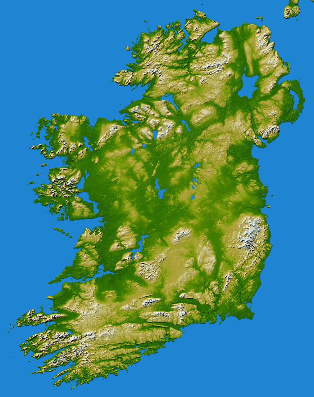
The island of Ireland comprises a large central lowland of limestone with a relief of hills surrounded by a discontinuous border of coastal mountains which vary greatly in geological structure.
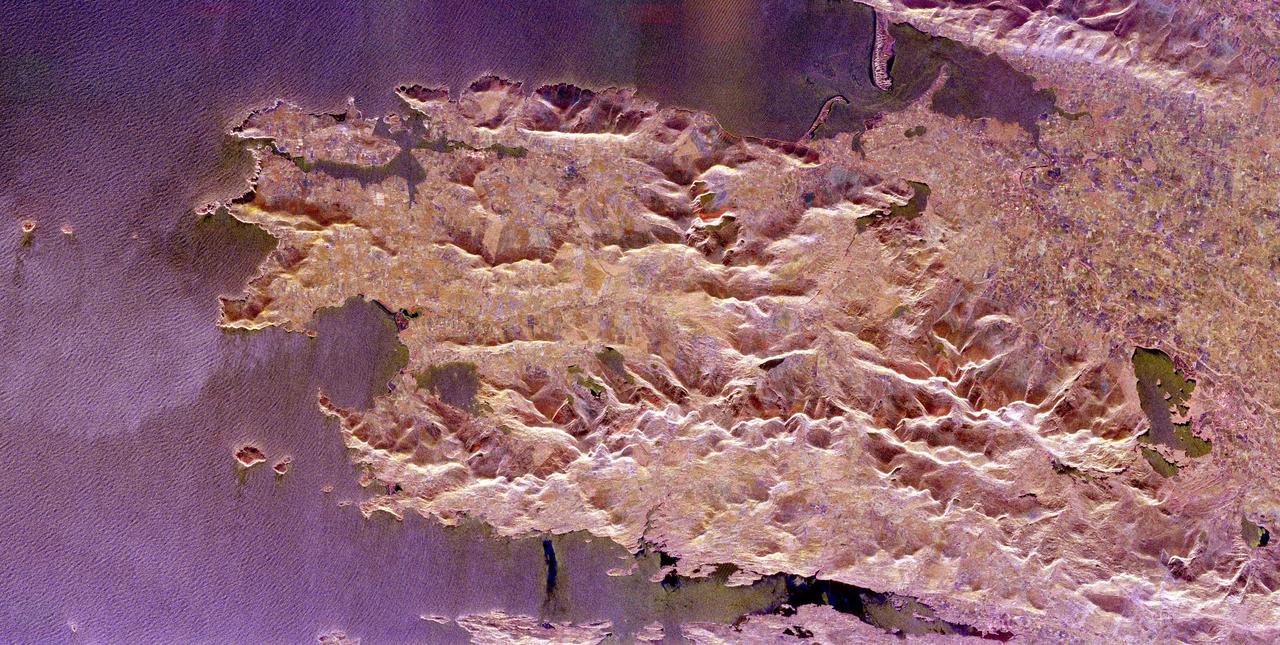
The Iveragh Peninsula, one of the four peninsulas in southwestern Ireland, is shown in this spaceborne radar image. The lakes of Killarney National Park are the green patches on the left side of the image.
This radar image of Dublin, Ireland, shows how the radar distinguishes between densely populated urban areas and nearby areas that are relatively unsettled. In the center of the image is the city natural harbor along the Irish Sea.
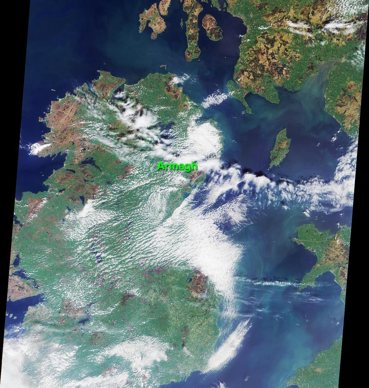
This image was acquired on May 5, 2000 during NASA Terra orbit 2026. The location of the town of Armagh in Northern Ireland is marked.
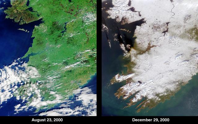
The contrast between summer and winter is apparent in this pair of images of southwestern Ireland acquired by NASA Terra satellite August 23, 2000 left and December 29, 2000 right.

This image from NASA Terra spacecraft is of the Isle of Man also known as Mann, a self-governing British Crown Dependency in the Irish Sea between Great Britain and Ireland.

iss069e004825 (April 21, 2023) --- The Cygnus space freighter from Northrop Grumman is poised for release from the Canadarm2 robotic arm as the International Space Station orbited 263 miles above the Atlantic Ocean off the coast of Ireland.
NASA Terra spacecraft captured this pair of images of Iceland Eyjafyallajökull volcano on May 3, 2010. On this day, Ireland closed its airspace for several hours due to presence of ash over the country.
Earth observation taken during a day pass by the Expedition 43 crew aboard the International Space Station (ISS). Folder lists this as Ireland.

The Prime Minister of Ireland Bian Cowan on a stop over during a conference & visit with San Jose-Dublin Sister Cities Stephen T. 'Tim' Quigley, Jr. to dedicate/open the Irish Innovation Center in San Jose, CA. Pete Worden, Ames Center Director, Tim Quigley greet Brian Cowen Prime Minister of Ireland.
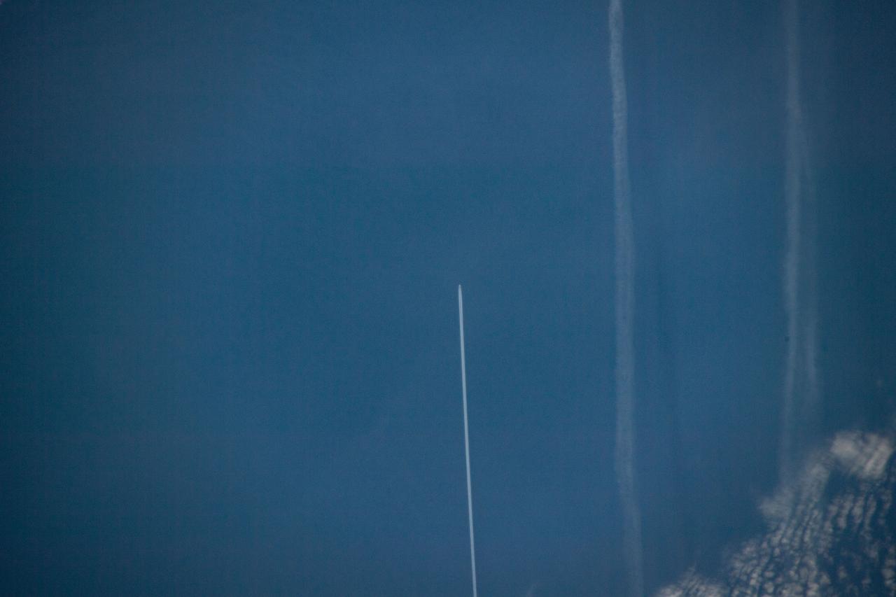
iss059e042046 (May 3, 2019) --- 258 miles above the North Atlantic Ocean an Expedition 59 crewmember photographed the contrail of an aircraft flying below as the International Space Station approached the coast of Ireland.

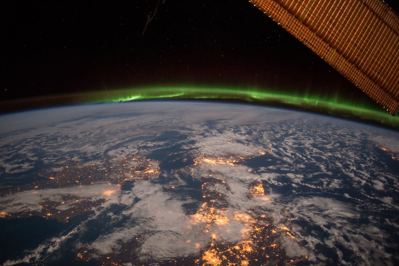
iss066e118171 (Jan. 17, 2022) --- A faint aurora and the Earth's atmospheric glow crown this night time photograph of Ireland, Great Britain, and a portion of Northern Europe, as the International Space Station orbited 262 miles above the Atlantic Ocean.
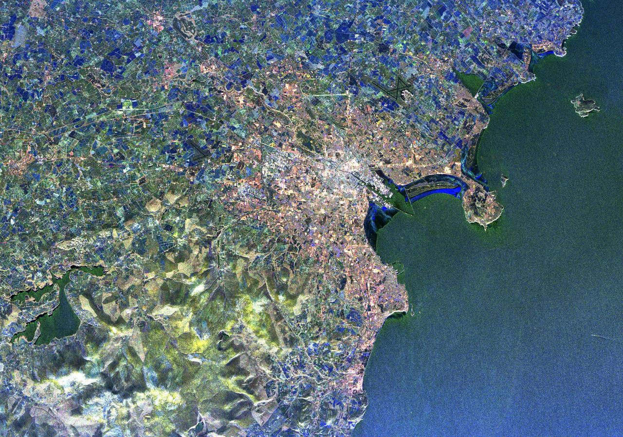
iss056e084626 (June 27, 2018) --- The Irish city of Cork, the River Lee and surrounding areas are pictured as the International Space Station was orbiting over the Celtic Sea off the southern coast of Ireland.
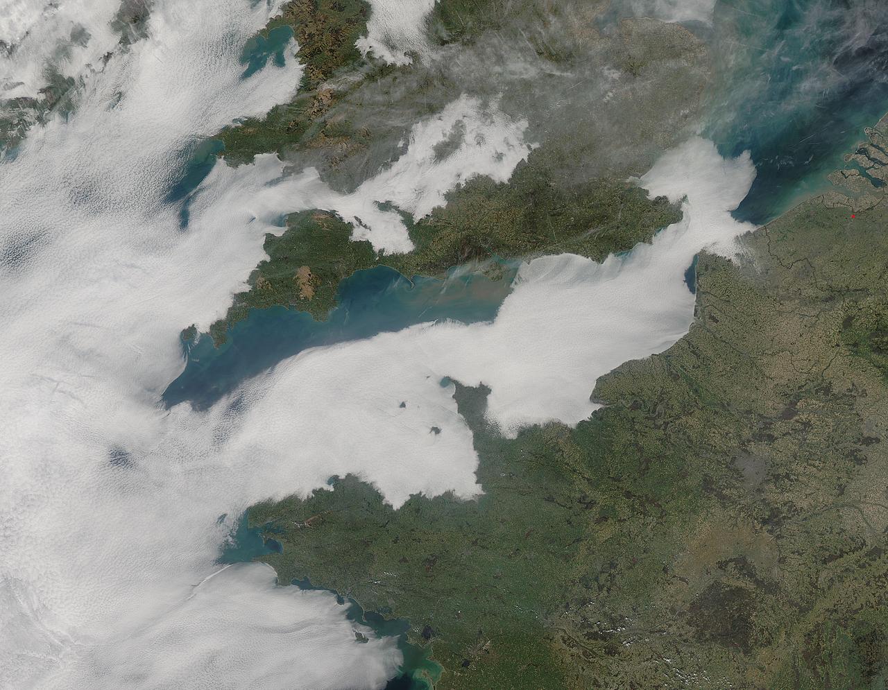
A thick blanket of low clouds covered the English Channel, Celtic Sea and Irish Sea on March 13, 2014. The fog also crept over major cities in the United Kingdom and Ireland. While citizens living in parts of Ireland, England, Wales, Scotland and Northern Ireland were posting ground-based photos of fog-shrouded landscape on social media, the internet and news outlets, the scene was also captured from space. The Moderate Resolution Imaging Spectroradiometer (MODIS) aboard NASA’s Aqua captured this true-color image of the cloudy day at 13:00 UTC (1:00 p.m. in London) on that same day. The dense fog (low clouds) affected air travel, causing the cancellation of hundreds of flights going through London City Airport, where visibility was reported at less than 100 meters (328 ft) – less than the length of an American football field. Flights were also cancelled at Heathrow, Gatwick and Manchester. A private helicopter flying to Northern Ireland went down in by the fog near the Norfolk-Suffolk border, with loss of four lives. Driving was little better in many areas, causing the Met Office to issue a yellow weather warning and to caution drivers of difficult conditions. The lowest visibility of the day was reported at Roches Point weather station. Located at the southeastern tip of Cork Harbor, Ireland, the station reported visibility of less than 50 meters (164 ft) – the length of an Olympic size swimming pool. In this image, the fog-covered Celtic Sea is located in the southwest. Ireland lies under tendrils of low cloud in the northwest corner of the image. Banks of clouds part around England, near the center of the image, and southern Wales (top and center) completely under the foggy blanket. Fog also creeps over the coasts of France, Belgium and the Netherlands on the east side of the English Channel. Credit: NASA/GSFC/Jeff Schmaltz/MODIS Land Rapid Response Team <b><a href="http://www.nasa.gov/audience/formedia/features/MP_Photo_Guidelines.html" rel="nofollow">NASA image use policy.</a></b> <b><a href="http://www.nasa.gov/centers/goddard/home/index.html" rel="nofollow">NASA Goddard Space Flight Center</a></b> enables NASA’s mission through four scientific endeavors: Earth Science, Heliophysics, Solar System Exploration, and Astrophysics. Goddard plays a leading role in NASA’s accomplishments by contributing compelling scientific knowledge to advance the Agency’s mission. <b>Follow us on <a href="http://twitter.com/NASAGoddardPix" rel="nofollow">Twitter</a></b> <b>Like us on <a href="http://www.facebook.com/pages/Greenbelt-MD/NASA-Goddard/395013845897?ref=tsd" rel="nofollow">Facebook</a></b> <b>Find us on <a href="http://instagram.com/nasagoddard?vm=grid" rel="nofollow">Instagram</a></b>
ISS042E215971 (02/06/2015) --- NASA US Astronaut Terry Virts on Feb. 6, 2015 captured this Earth observation of Ireland, United Kingdom and Scandinavia on a moonlit night under an amazing and ever-changing aurora. Terry is a flight engineer on the international Space Station with Expedition 42.

iss070e095147 (Feb. 18, 2024) --- A set of the International Space Station's main solar arrays, a pair of smaller rollout solar arrays, and the Canadarm2 robotic arm with the latching end eeffector on its tip, are pictured as the orbital complex soared 263 miles above the Atlantic Ocean near the coast of Ireland.
iss064e025506 (Jan. 21, 2021) --- The SpaceX Crew Dragon spaceship, with its two lit crew windows, is pictured docked to the Harmony module's international docking adapter as the International Space Station orbited 264 miles above the North Atlantic off the coast of Ireland.
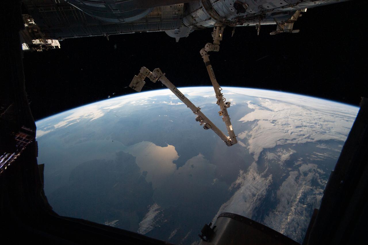
iss066e153504 (Feb. 27, 2022) --- The 57.7-foot-long Canadarm2 robotic arm is pictured extending from the Harmony module as the International Space Station orbited 264 miles above the Atlantic Ocean off the coast of Ireland and the United Kingdom.

Guest speaker Sinead Burke, from Ireland, gave a presentation on “Breaking the Mould – A Lesson in Equity,” to Kennedy Space Center employees on Nov. 30, 2022, and to employees at other NASA centers via live stream on YouTube. The event was sponsored by the center’s Disability Awareness and Action Working Group (DAAWG) and the Spaceport Integration Directorate. Burke, who is an advocate for the inclusion of all, amplifies the voices who are often not considered.

jsc2023e065220 (10/19/2023) --- Pinecrest Academy Space Coast students Liam Hauser, Connor Santore, Eric Distasi, Evan Ireland, and Luke Costa work on their experiment, E-coli and Endotoxin Detection in Microgravity via LAL-Horseshoe Crab Blood Testing, which will be included in the Nanoracks-National Center for Earth and Space Science Education-Orbiter-Student Spaceflight Experiments Program Mission 17 to ISS (Nanoracks-NCESSE-Orbiter-SSEP).

ISS030-E-177670 (28 March 2012) --- One of the Expedition 30 crew members photographed this nighttime scene while the International Space Station was flying at an altitude approximately 240 miles over the eastern North Atlantic. The view looks northeastward. Center point coordinates are 46.8 degrees north latitude and 14.3 degrees west longitude. The night lights of the cities of Ireland, in the foreground, and the United Kingdom, in the back and to the right, are contrasted by the bright sunrise in the background. The greens and purples of the Aurora Borealis are seen along the rest of the horizon.

Guest speaker Sinead Burke, from Ireland, gave a presentation on “Breaking the Mould – A Lesson in Equity,” to Kennedy Space Center employees on Nov. 30, 2022, and to employees at other NASA centers via live stream on YouTube. The event was sponsored by the center’s Disability Awareness and Action Working Group (DAAWG) and the Spaceport Integration Directorate. Burke, who is an advocate for the inclusion of all, amplifies the voices who are often not considered.

Guest speaker Sinead Burke, from Ireland, gave a presentation on “Breaking the Mould – A Lesson in Equity,” to Kennedy Space Center employees on Nov. 30, 2022, and to employees at other NASA centers via live stream on YouTube. The event was sponsored by the center’s Disability Awareness and Action Working Group (DAAWG) and the Spaceport Integration Directorate. Burke, who is an advocate for the inclusion of all, amplifies the voices who are often not considered.
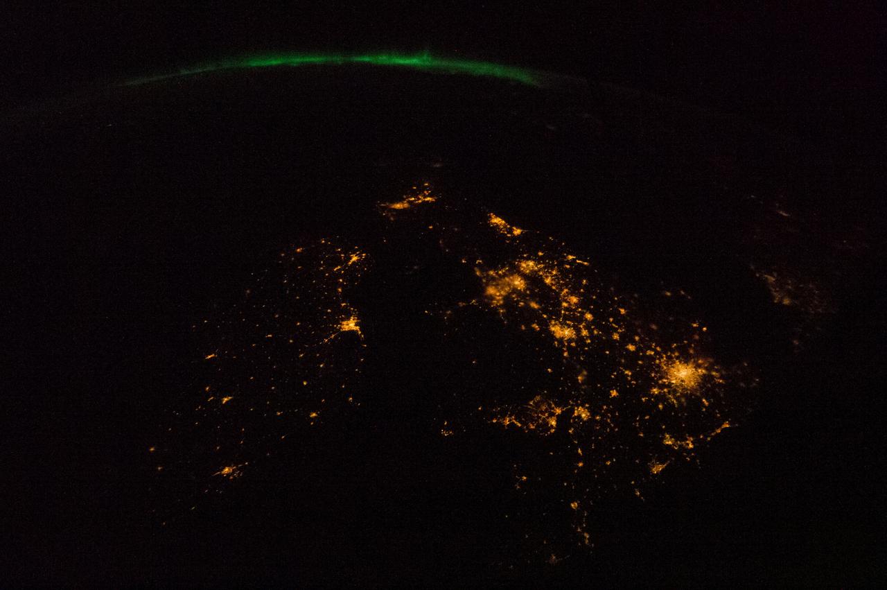
ISS034-E-050137 (14 Feb. 2013) --- One of the Expedition 34 crew members aboard the International Space Station recorded this night image of the British Isles. The view is to the north with Dublin, Ireland left of center. London appears as the bright cluster of lights centered in the lower right quadrant. The green appearance along the horizon is the Aurora Borealis or Northern Lights.

KENNEDY SPACE CENTER, FLA. - In the Space Station Processing Facility, Center Director Jim Kennedy (second from left) presents a framed photo to Mary Harney , Tanaiste (deputy prime minister) and Minister for Enterprise, Trade and Employment of Ireland. Harney is visiting KSC to support a Memorandum of Understanding between Florida Spaceport Authority and the Irish government’s training and employment authority (FAS). The joint initiative enables Irish students to work with science and engineering experts during a six-week program in Florida. At far left is FSA Director Capt. Winston Scott. Next to Harney is Paul Haran, secretary to the deputy prime minister.

Guest speaker Sinead Burke, in front, from Ireland, gave a presentation on “Breaking the Mould – A Lesson in Equity,” to Kennedy Space Center employees on Nov. 30, 2022, and to employees at other NASA centers via live stream on YouTube. Members of the Diversity, Equity, Inclusion, and Accessibility Roundtable and the Disability Awareness Action Working Group (DAAWG), standing from left are Nicole Delvesco, Lisa Williams, Willie Gainey, Annie Williams, and Glenn Semmel. The event was sponsored by Kennedy’s DAAWG and the Spaceport Integration Directorate. Burke, who is an advocate for the inclusion of all, amplifies the voices who are often not considered.

KENNEDY SPACE CENTER, FLA. - In the Space Station Processing Facility, Center Director Jim Kennedy holds a framed photo to be presented to Mary Harney , Tanaiste (Deputy Prime Minister) and Minister for Enterprise, Trade and Employment of Ireland (at his left). Harney is visiting KSC to support a Memorandum of Understanding between Florida Spaceport Authority and the Irish government’s training and employment authority (FAS). The joint initiative enables Irish students to work with science and engineering experts during a six-week program in Florida. On Kennedy’s right is FSA Director Capt. Winston Scott. Next to Harney is Paul Haran, secretary to the deputy prime minister. Gathered here with Harney, Haran, Kennedy and Scott are Bridget Flynn, assistant to Harney; Brian Joseph Geoghegan, director of FAS; Roderick Peter Molloy, director general of FAS, and Noreen Molloy, his wife; Caitriona White, FAS public relations manager; Anne Haran; and Roisin McCann, Dept. of Enterprise, Trade and Employment.
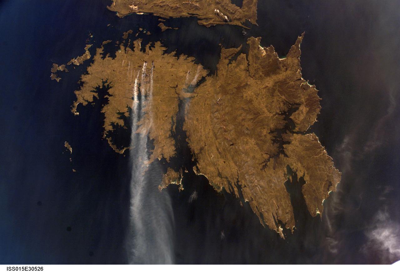
ISS015-E-30526 (25 Sept. 2007) --- Fires in East Falkland Island in the South Atlantic Ocean are featured in this image photographed by an Expedition 15 crewmember on the International Space Station. The Falkland Islands are an overseas territory of the United Kingdom, referred to by Argentina (which also claims the islands) as the Islas Malvinas. The main islands of East Falkland and West Falkland are separated by Falkland Sound (12 kilometers) wide at the narrow point. Together they total about the same area as the State of Connecticut or Northern Ireland. The islands lie almost 500 kilometers from the Argentine coast and less than 1,000 kilometers from Antarctica. The first air links to these remote islands were only put in place in 1971. The capital city of Stanley lies on the eastern tip of East Falkland. The local inhabitants are mainly English speakers, and interestingly, the islands have become a center of English-language learning for students from South America. The windy and relatively dry climate has given rise to natural vegetation comprised of treeless grassland with scattered bogs. The grasslands are ideal for sheep rearing which was the dominant occupation until recent decades, when fishing (mainly squid to Spain) and tourism became the mainstay of the economy. These expanses of grassland provide ready fuel for fires, as indicated by the several long smoke plumes visible in this image.
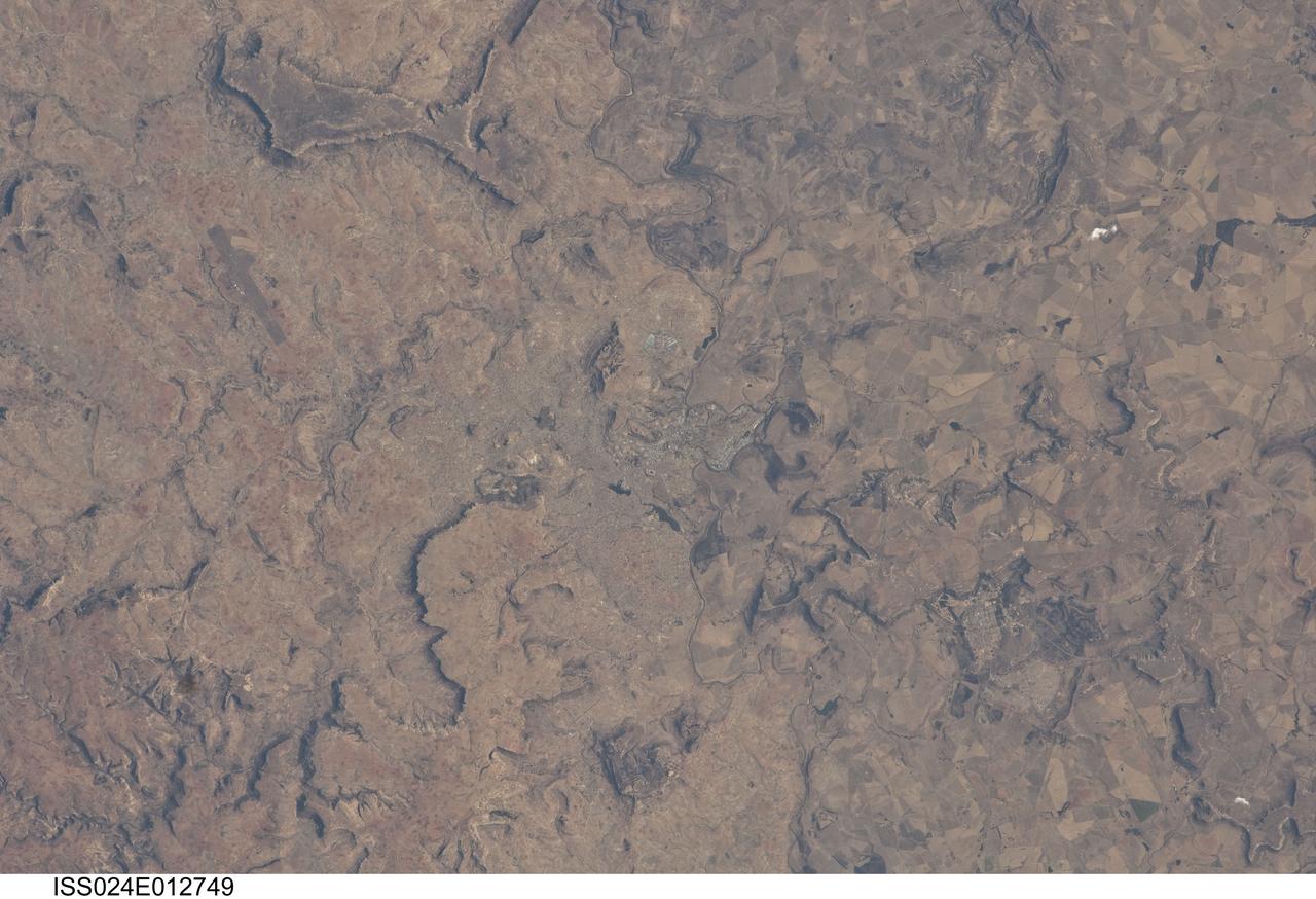
ISS024-E-012749 (28 Aug. 2010) --- Maseru, Lesotho is featured in this image photographed by an Expedition 24 crew member on the International Space Station. Maseru is the capital city of the Kingdom of Lesotho and is located along the northwestern border of the country with the Republic of South Africa. The footprint of the urban area, recognizable by street grids and distinctive blue-roofed industrial buildings at center, is only just visible against the surrounding landscape. The city has expanded eightfold (to 230,000 today) since independence from the United Kingdom of Great Britain and Northern Ireland in 1966, and is now home to one in five inhabitants in the country. The Caledon (or Mohokare) River flows adjacent to Maseru and forms a part of the border between Lesotho and South Africa. Locally, the border extends from approximately top center left to bottom center right, with the cities of Ladybrand and Manyatseng located in South Africa. Moshoeshoe I International Airport (left) provides access to the capital. Major industries in the city include flour mills, and footwear and textile companies. Tourism is also a growing part of the local economy. The Kingdom of Lesotho is completely landlocked by the surrounding Republic of South Africa. Major landforms visible in the image near Maseru include the Qeme and Berea Plateaus to the south and east respectively; these are erosional remnants of widespread horizontally layered sedimentary rocks that formed in the Karoo Basin during the Upper Triassic Period (approximately 200–229 million years ago), according to scientists.
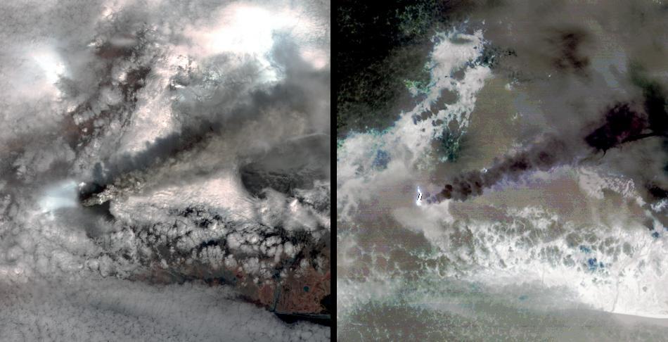
STS064-116-064 (20 Sept. 1994) --- Near the end of the mission, the crew aboard space shuttle Discovery was able to document the beginning of the second day of activity of the Rabaul volcano, on the east end of New Britain. On the morning of Sept. 19, 1994, two volcanic cones on the opposite sides of the 6-kilometer sea crater had begun to erupt with very little warning. Discovery flew just east of the eruption roughly 24 hours after it started and near the peak of its activity. New Ireland, the cloud-covered area in the foreground, lies just east of Rabaul harbor. The eruption, which sent a plume up to over 60,000 feet into the atmosphere, caused over 50,000 people to evacuate the area. Because winds were light at the time of the eruption, most of the ash was deposited in a region within 20 kilometers of the eruption zone. This photo shows the large white billowing eruption plume is carried in a westerly direction by the weak prevailing winds. At the base of the eruption column is a layer of yellow-brown ash being distributed by lower level winds. A sharp boundary moving outward from the center of the eruption in the lower cloud is a pulse of laterally-moving ash which results from a volcanic explosion. Geologists theorize that the large white column and the lower gray cloud are likely from the two main vents on each side of the harbor. The bay and harbor of Rabaul are covered with a layer of ash, possibly partly infilled with volcanic material. Matupit Island and the airport runway have disappeared into the bay. More than a meter of ash has fallen upon the city of Rabaul. Up to five vents were reported to have erupted at once, including the two cones Vulcan and Tavurvur, which are opposites of the harbor as well as new vents below the bay. Half of the Vulcan cone has collapsed into the sea. The extra day in space due to bad weather at the landing site afforded the crew the opportunity for both still and video coverage of the event. Photo credit: NASA or National Aeronautics and Space Administration
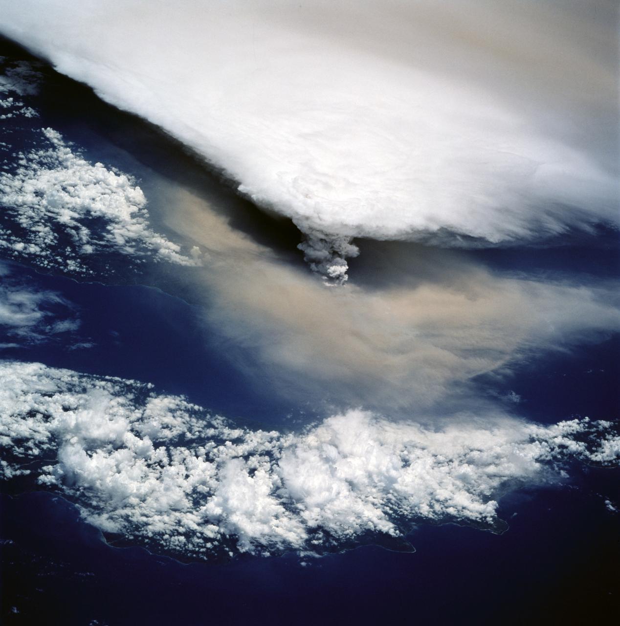
STS064-116-055 (20 Sept. 1994) --- Near the end of its mission, the crew aboard space shuttle Discovery was able to document the beginning of the second day of activity of the Rabaul volcano, on the east end of New Britain. On the morning of Sept. 19, 1994, two volcanic cones on the opposite sides of the 6-kilometer sea crater had begun to erupt with very little warning. Discovery flew just east of the eruption roughly 24 hours after it started and near the peak of its activity. The eruption, which sent a plume up to over 60,000 feet into the atmosphere, caused over 50,000 people to evacuate the area. Because winds were light at the time of the eruption, most of the ash was deposited in a region within 20 kilometers of the eruption zone. This photo shows the large white billowing eruption plume is carried in a westerly direction by the weak prevailing winds. At the base of the eruption column is a layer of yellow-brown ash being distributed by lower level winds. A sharp boundary moving outward from the center of the eruption in the lower cloud is a pulse of laterally-moving ash which results from a volcanic explosion. Geologists theorize that the large white column and the lower gray cloud are likely from the two main vents on each side of the harbor. The cloud-covered island in the foreground is New Ireland. The bay and harbor of Rabaul are covered with a layer of ash, possibly partly infilled with volcanic material. Matupit Island and the airport runway have disappeared into the bay. More than a meter of ash has fallen upon the city of Rabaul. Up to five vents were reported to have erupted at once, including the cones Vulcan and Tavurvur, which are opposites of the harbor as well as new vents below the bay. Half of the Vulcan cone has collapsed into the sea. The extra day in space due to bad weather at the landing site afforded the crew the opportunity for both still and video coverage of the event. Photo credit: NASA or National Aeronautics and Space Administration
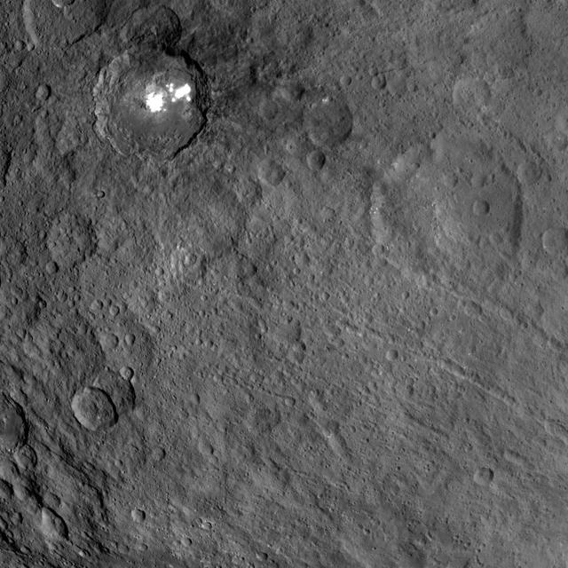
This view obtained by NASA's Dawn spacecraft during its Survey orbit illustrates the diversity and complexity of Ceres' geology. It shows familiar features: Occator Crater with its bright deposits (called faculae) of carbonates and other salts, a series of linear features (at right) called Samhain Catenae, and another large crater on the right side of the image called Kirnis. A relatively fresh crater called Lociyo, superimposed on an older crater, can be seen toward the bottom left of the picture. Studying the morphologies and relationships between various types of geological features can help scientists reconstruct Ceres' history. Occator appears to be one of the youngest features in this picture, except for a couple of smaller craters. The 71-mile-wide (115-kilometer-wide) Kirnis Crater on the other hand is an old, eroded crater. It owes its peculiar polygonal shape in part to its overlap with one of the Samhain Catenae. This illustrates the role of fractures in driving the geometry of some of Ceres' craters. The origin of these particular catenae is not understood yet, and is not necessarily related to the Pongal Catena. Kirnis Crater is named after a Lithuanian spirit-guardian of cherry trees, whereas the Samhain Catenae refer to a Gaelic festival organized at the end of the harvest season. It was observed in Ireland and Scotland during seven days in October and November, nearly halfway between the autumn equinox and the winter solstice. This picture was obtained on June 25, 2015, from an altitude of 2,700 miles (4,400 kilometers). It is centered at 1.7 degrees north latitude, and 249 degrees east longitude. https://photojournal.jpl.nasa.gov/catalog/PIA21409
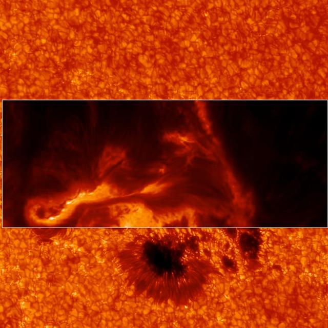
IBIS can focus in on different wavelengths of light, and so reveal different layers at different heights in the sun's lower atmosphere, the chromosphere. This image shows a region slightly higher than the former one. Credit: Lucia Kleint (BAER Institute), Paul Higgins (Trinity College Dublin, Ireland) -- On March 29, 2014 the sun released an X-class flare. It was observed by NASA's Interface Region Imaging Spectrograph, or IRIS; NASA's Solar Dynamics Observatory, or SDO; NASA's Reuven Ramaty High Energy Solar Spectroscopic Imager, or RHESSI; the Japanese Aerospace Exploration Agency's Hinode; and the National Solar Observatory's Dunn Solar Telescope located at Sacramento Peak in New Mexico. To have a record of such an intense flare from so many observatories is unprecedented. Such research can help scientists better understand what catalyst sets off these large explosions on the sun. Perhaps we may even some day be able to predict their onset and forewarn of the radio blackouts solar flares can cause near Earth - blackouts that can interfere with airplane, ship and military communications. Read more: <a href="http://1.usa.gov/1kMDQbO" rel="nofollow">1.usa.gov/1kMDQbO</a> Join our Google+ Hangout on May 8 at 2:30pm EST: <a href="http://go.nasa.gov/1mwbBEZ" rel="nofollow">go.nasa.gov/1mwbBEZ</a> Credit: NASA Goddard <b><a href="http://www.nasa.gov/audience/formedia/features/MP_Photo_Guidelines.html" rel="nofollow">NASA image use policy.</a></b> <b><a href="http://www.nasa.gov/centers/goddard/home/index.html" rel="nofollow">NASA Goddard Space Flight Center</a></b> enables NASA’s mission through four scientific endeavors: Earth Science, Heliophysics, Solar System Exploration, and Astrophysics. Goddard plays a leading role in NASA’s accomplishments by contributing compelling scientific knowledge to advance the Agency’s mission. <b>Follow us on <a href="http://twitter.com/NASAGoddardPix" rel="nofollow">Twitter</a></b> <b>Like us on <a href="http://www.facebook.com/pages/Greenbelt-MD/NASA-Goddard/395013845897?ref=tsd" rel="nofollow">Facebook</a></b> <b>Find us on <a href="http://instagram.com/nasagoddard?vm=grid" rel="nofollow">Instagram</a></b>