
NASA Terra spacecraft passed over Hurricane Irene while it was just north of the Bahamas on Aug. 25, 2011. At the time, Irene was a category three hurricane making landfall in North Carolina on the morning of Aug. 27 as a category one hurricane.
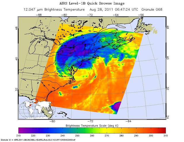
This infrared image of Hurricane Irene from the AIRS instrument on NASA Aqua spacecraft, was taken at 2:47 a.m. EDT on Aug. 28. The storm coldest cloud top temperatures and intense rains are shown in purples and blues.
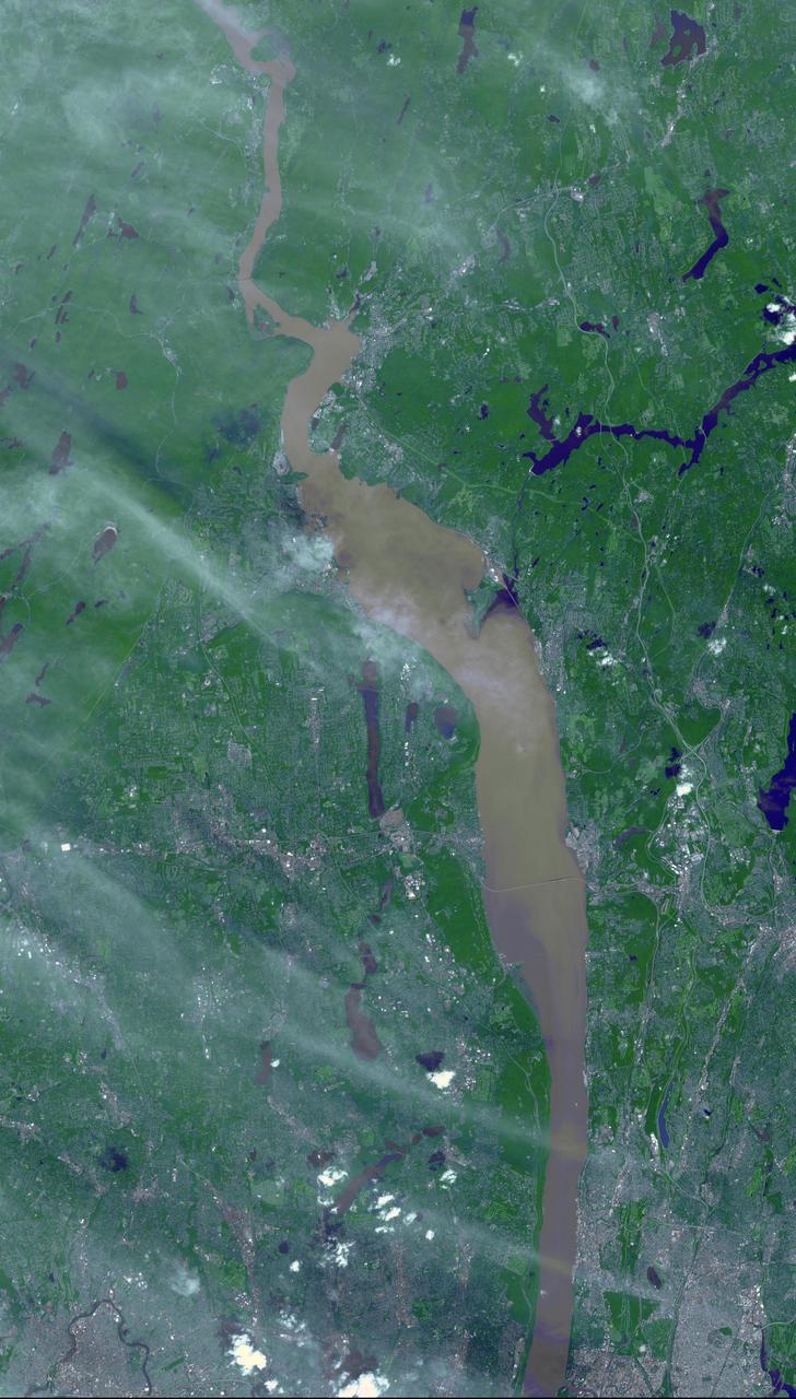
Brown and tan muddy water flows down the Hudson River are seen in this image acquired by NASA Terra spacecraft on Sept. 1, 2011. After the torrential rains from Hurricane Irene, many rivers in the eastern United States were filled with sediment.
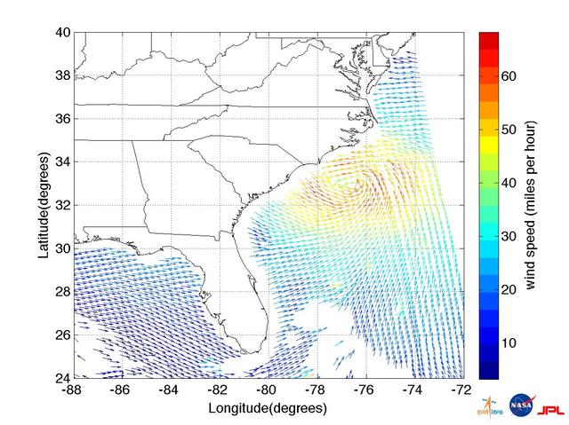
This ISRO-NASA-JPL-Caltech collaborative image shows ocean wind vector data from ISRO OceanSat 2 spacecraft of Hurricane Irene which made landfall early Saturday morning, Aug. 27, just west of Cape Lookout, NC.
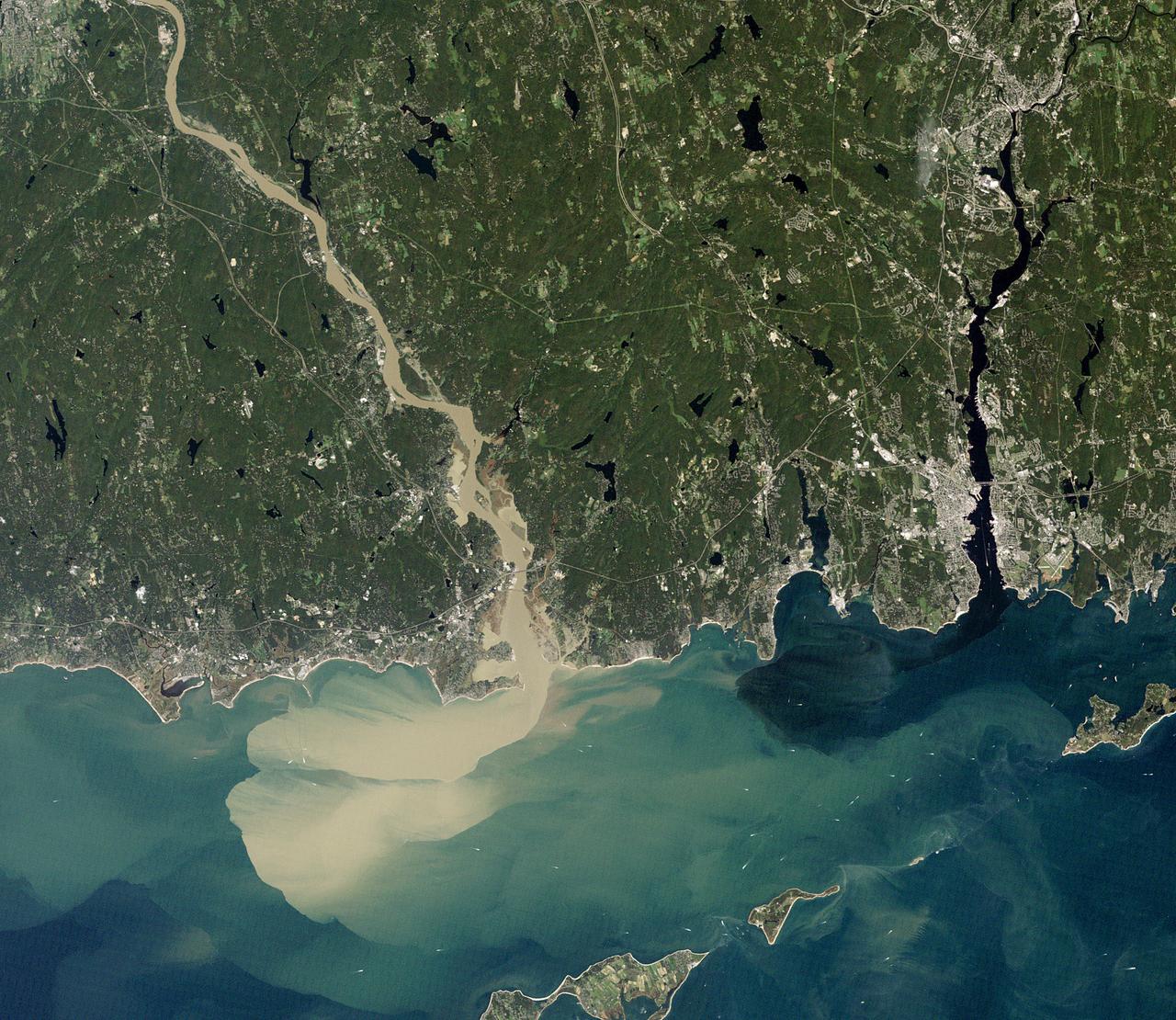
NASA image acquired September 2, 2011 To download the full high res go to: <a href="http://earthobservatory.nasa.gov/IOTD/view.php?id=52059" rel="nofollow">earthobservatory.nasa.gov/IOTD/view.php?id=52059</a> Nearly a week after Hurricane Irene drenched New England with rainfall in late August 2011, the Connecticut River was spewing muddy sediment into Long Island Sound and wrecking the region's farmland just before harvest. The Thematic Mapper on the Landsat 5 satellite acquired this true-color satellite image on September 2, 2011. With its headwaters near the Canadian border, the Connecticut River drains nearly 11,000 square miles (28,500 square kilometers) and receives water from at least 33 tributaries in Vermont, New Hampshire, Massachusetts, and Connecticut. The 410-mile river—New England's longest—enters Long Island Sound near Old Lyme, Connecticut, and is estimated to provide 70 percent of the fresh water entering the Sound. When Irene blew through the region on August 27-28, substantial portions of the Connecticut River watershed received more than 6 to 8 inches (15-20 centimeters) of rainfall, and several locations received more than 10 inches (25 centimeters). Whole towns were cut off from overland transportation—particularly upstream in Vermont, which suffered its worst flooding in 80 years. Thousands of people saw their homes flooded, if not washed off their foundations, at a time of year when rivers are usually at their lowest. Preliminary estimates of river flow at Thompsonville, Connecticut, (not shown in this image) reached 128,000 cubic feet per second (cfs) on August 30, nearly 64 times the usual flow (2,000 cfs) for early fall and the highest flow rate since May 1984. At the mouth of the river—where flow is tidal, and therefore not gauged—the peak water height reached 6.9 feet (2.1 meters) above sea level, almost a foot higher than at any time in the past 10 years. According to Suzanne O'Connell, an environmental scientist working along the Connecticut River at Wesleyan University, the torrent of water coursing through New England picked up silt and clay from the river valleys, giving it the tan color shown in the image above. At Essex, Connecticut, the turbidity (muddiness) of the water was 50 times higher than pre-Irene values. To the east, the Thames River appears to be carrying very little sediment at all on September 2. According to O'Connell, the Thames "drains glaciated terrain, so fine sediment was removed long ago." Most of the land surface in the Thames basin is "just bedrock, till, and glacial erratics." Unlike the Connecticut, areas within the Thames watershed only received 2 to 4 inches of rain in most locations. The flooding that occurred in the aftermath of Hurricane Irene inundated farmland in Massachusetts and Connecticut just before harvest time, the Associated Press noted. Crops were drowned under inches to feet of water. The substantial amounts of soil, sediment, and water deposited on land during the flood could also pose trouble for farmers in coming seasons. "It's notable that whole segments of river bank are just gone," said Andrew Fisk of the Connecticut River Watershed Council. "That's not just loss of sediment. That's land disappearing down river." <b>NASA Earth Observatory image by Robert Simmon, using Landsat 5 data from the U.S. Geological Survey Global Visualization Viewer. Caption by Michael Carlowicz, with interpretation help from Suzanne O'Connell, Wesleyan University, and Andrew Fisk, Connecticut River Watershed Council.</b> Instrument: Landsat 5 - TM Credit: <b><a href="http://www.earthobservatory.nasa.gov/" rel="nofollow"> NASA Earth Observatory</a></b> <b><a href="http://www.nasa.gov/centers/goddard/home/index.html" rel="nofollow">NASA Goddard Space Flight Center</a></b> enables NASA’s mission through four scientific endeavors: Earth Science, Heliophysics, Solar System Exploration, and Astrophysics. Goddard plays a leading role in NASA’s accomplishments by contributing compelling scientific knowledge to advance the Agency’s mission. <b>Follow us on <a href="http://twitter.com/NASA_GoddardPix" rel="nofollow">Twitter</a></b> <b>Like us on <a href="http://www.facebook.com/pages/Greenbelt-MD/NASA-Goddard/395013845897?ref=tsd" rel="nofollow">Facebook</a></b> <b>Find us on <a href="http://web.stagram.com/n/nasagoddard/?vm=grid" rel="nofollow">Instagram</a></b>
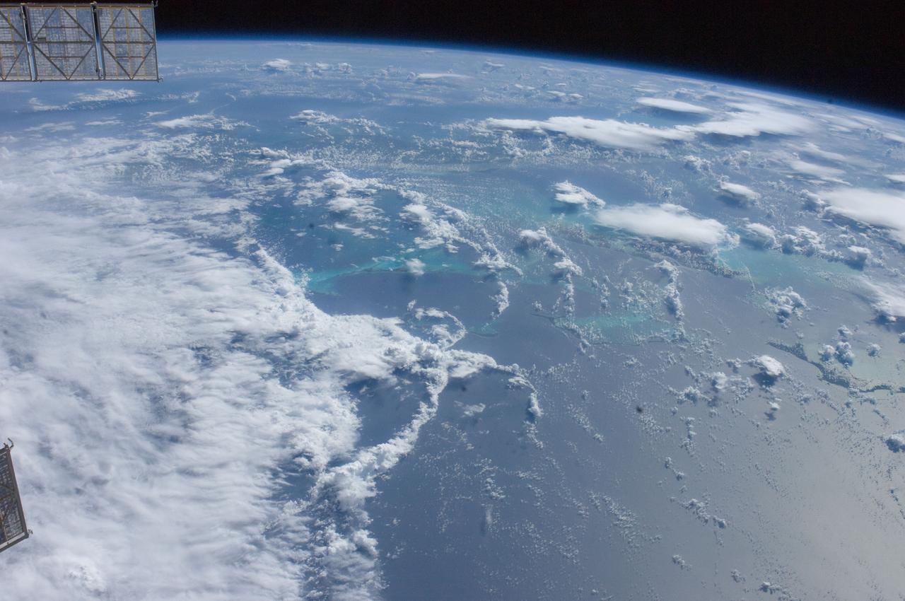
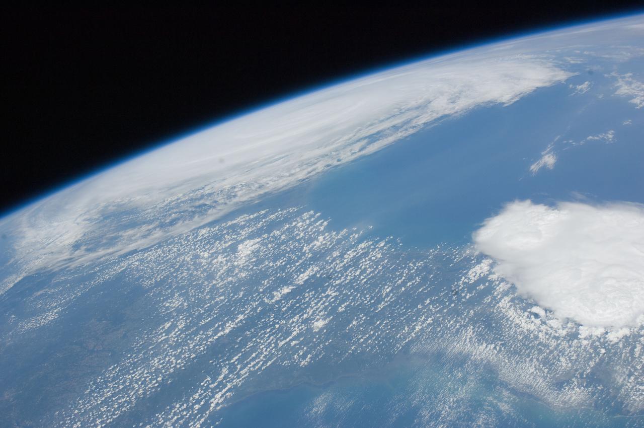
ISS028-E-030243 (23 Aug. 2011) --- A digital photo from the International Space Station from Aug. 23, 2011, allows the viewer to look toward the southwest at part of Hurricane Irene churning near the northern Bahamas, including Great Abaco Island (lower right), Andros Island under a thunderstorm (center right) and a ?fair? Cuba from left to right (upper center). The outflow and some of the banding of the northwest side of Irene are visible on the lower left. Meteorologists say Irene probably was centered over Acklins Island packing 120 mile per hour winds when the photo was taken.

KENNEDY SPACE CENTER, FLA. -- Official portrait, Dr. Irene D. Long, director, Biomedical Office.
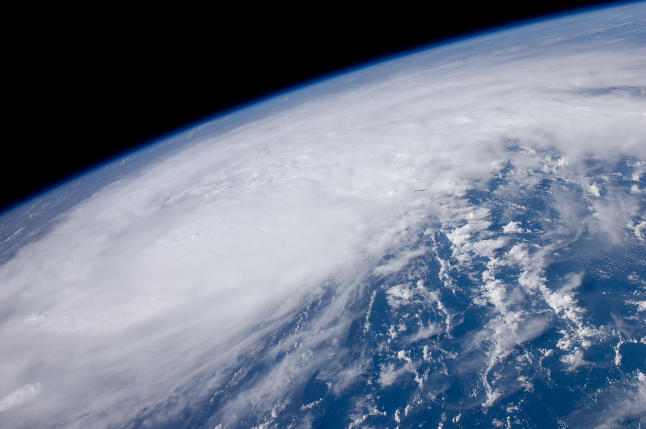
ISS028-E-028782 (22 Aug. 2011) --- This panoramic view of recently-formed Hurricane Irene was acquired by the crew of the International Space Station early Monday afternoon from a point over the coastal waters of Venezuela. At the time Irene was packing winds of 80mph and was just north of the Mona Passage between Hispaniola and Puerto Rico. Although no eye was visible at this time, the storm was strengthening and exhibited the size and structure of a classic ?Cape Verde? hurricane as it tracked west-northwestward towards the southern Bahamas.
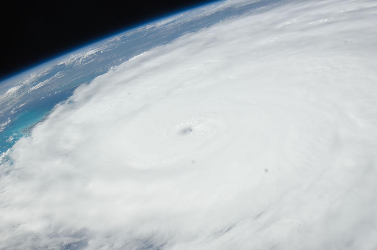
ISS028-E-034022 (27 Aug. 2011) --? One of the Expedition 28 crew members aboard the International Space Station photographed this panoramic view of Hurricane Irene looking northeastward from Florida over the open Atlantic on the afternoon of the day before it struck the Cape Hatteras, North Carolina area as a Category 2 storm.
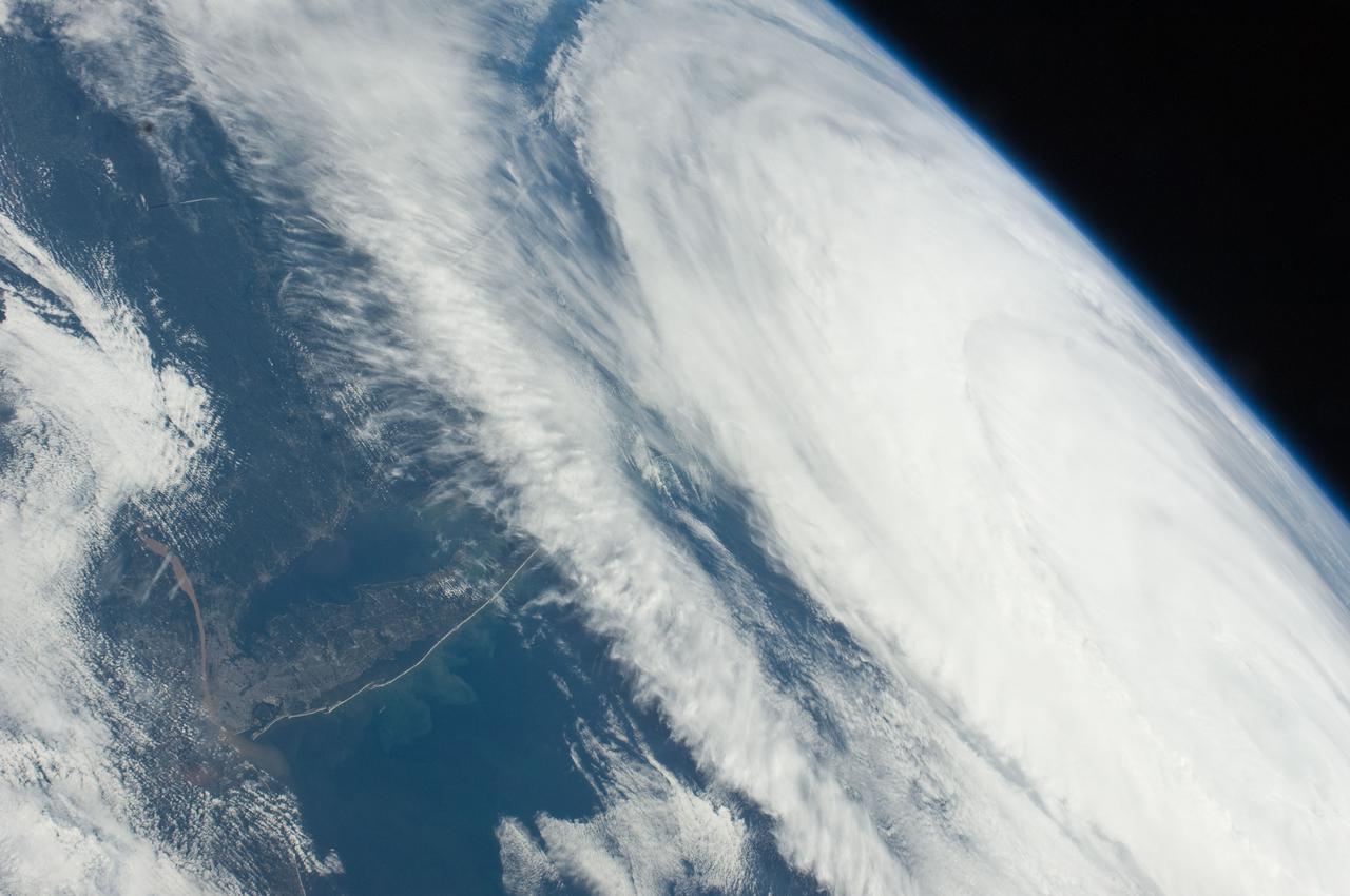
ISS028-E-034008 (27 Aug. 2011) --- Some seven hours after Hurricane Irene?s initial landfall at Cape Hatteras, NC, one of the Expedition 28 crew members aboard the International Space Station photographed this image, one of a series following the hurricane?s destructive path along the east coast.
ISS028-E-034018 (27 Aug. 2011) --- Some seven hours after Hurricane Irene?s initial landfall at Cape Hatteras, NC, one of the Expedition 28 crew members aboard the International Space Station photographed this image, one of a series following the hurricane?s destructive path along the east coast.
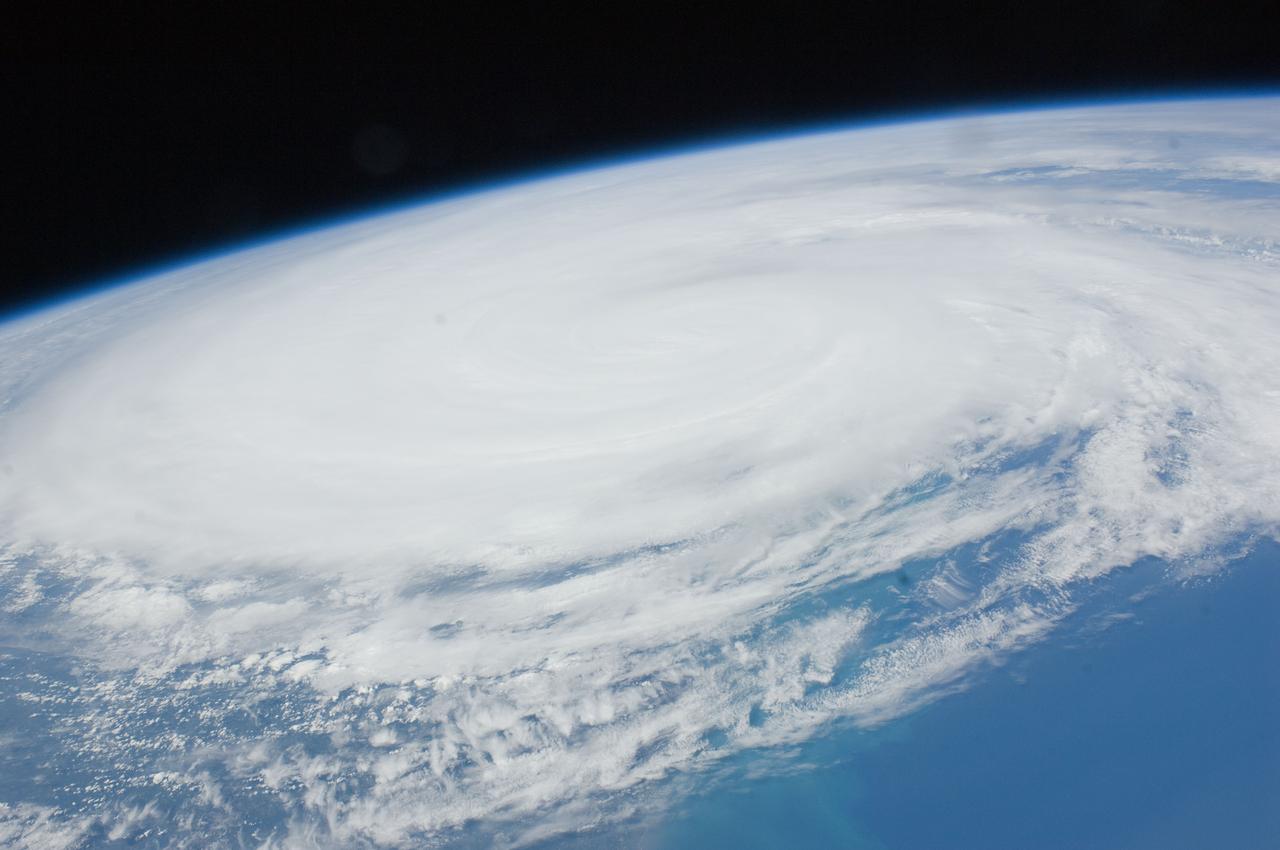
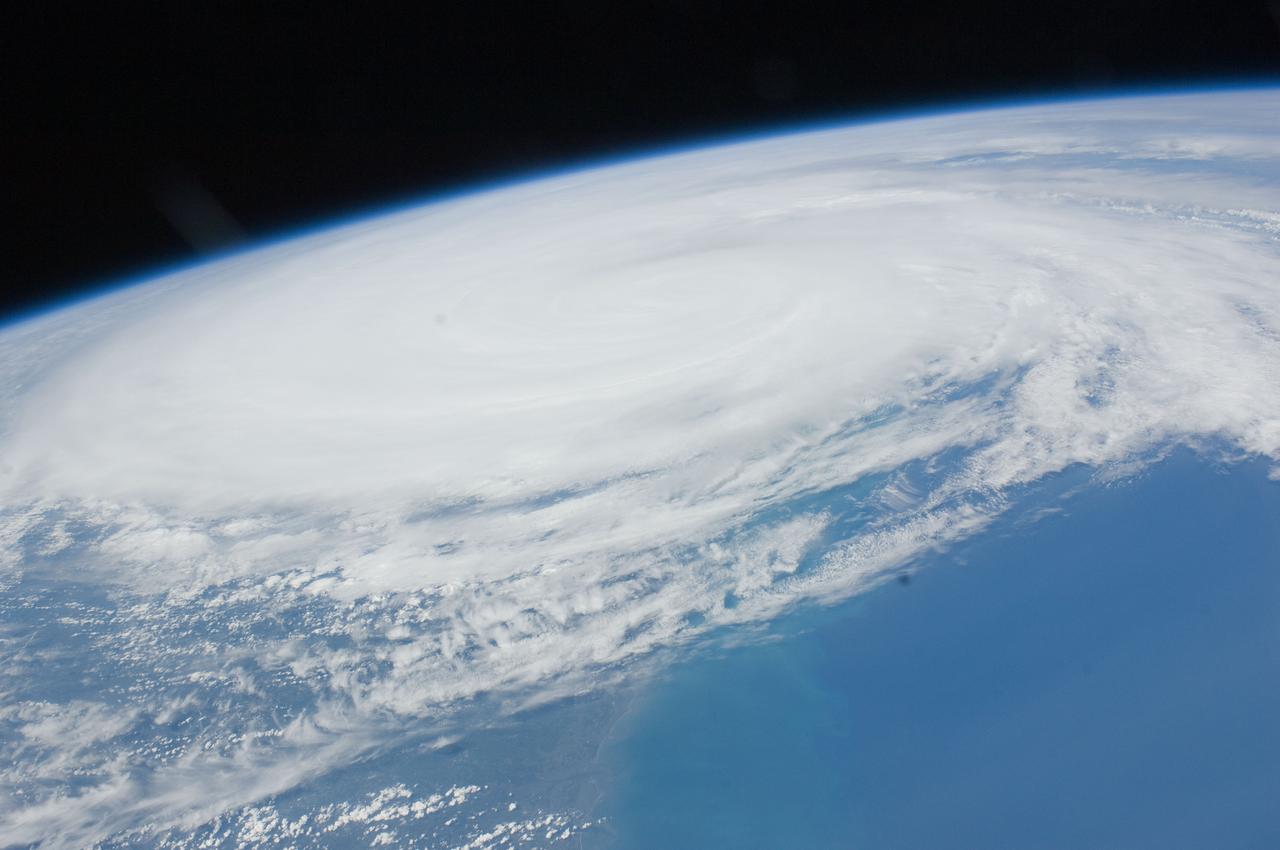
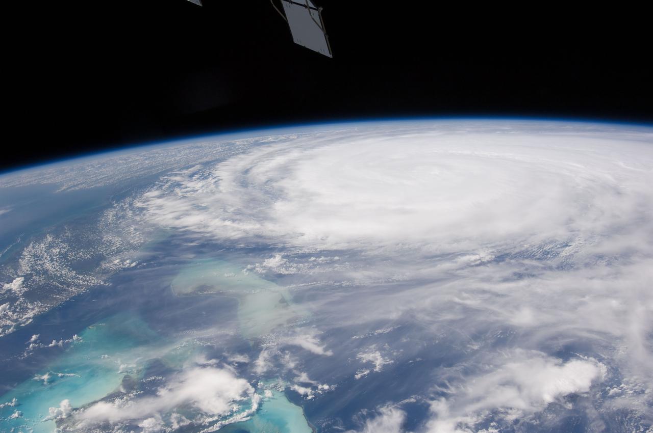
ISS028-E-031904 (24 Aug. 2011) --- This photo of Hurricane Irene was photographed from onboard the International Space station at 19:14:14 GMT on Aug. 24, 20ll. The image, captured with the aid of a 70?mm lens, reveals the eye at center frame.
ISS028-E-031903 (24 Aug. 2011) --- This photo of Hurricane Irene was photographed from onboard the International Space station at 19:14:14 GMT on Aug. 24, 20ll. The image, captured with a 38?mm lens, reveals the eye at center frame.

KENNEDY SPACE CENTER, FLA. -- Dr. Irene Duhart Long is the director, Biomedical Operations and Research Office, at the Kennedy Space Center effective July 24, 1994. She is responsible for the program management of the center's aerospace and occupational medicine, life sciences research, environmental health programs and the operations management of the life sciences support facilities. Dr. Long also is responsible for providing the coordinating medical, environmental monitoring and environmental health support to launch and landing activities and day-to-day institutional functions.
New Employees A Kujaneck, B Baeza, S Cahill, J Carolino, D Chang, E Czech, A Davila, R Everroad, R Fisher, A Ging, J Haglage, B Hooey, K Kwan, C Fung, P Ung-Joon Lee, M Mahzari, L Martin, K McMillin, S Monheim, A Nguyen, B Nikaido, T Perez, V Salazar, K Sato, D Shaw, Irene Smith, Melanie Smith, Lindsay Sturre, E Uribe Jr. with Tom Edwards, Ames Deputy Director.
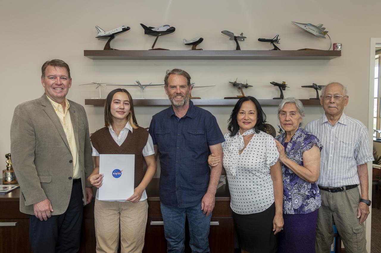
The Employee Exchange Council at NASA’s Armstrong Flight Research Center, Edwards, California, recently awarded its 2023 scholarship to Samantha Redifer. NASA Armstrong Center Director Brad Flick presented Redifer with the 2023 Harold W. Walker Memorial Scholarship Award on July 26. From left are Flick, Redifer, Matt and Saynne Redifer, and Irene and Tim Htut.
ISS028-E-034004 (27 Aug. 2011) --- Some five and a half hours after Hurricane Irene?s initial landfall at Cape Hatteras, NC, one of the Expedition 28 crew members aboard the International Space Station photographed this image, one of a series following the hurricane?s destructive path along the east coast. At this time, the Hurricane was at 35.5 degrees north latitude and 76.3 degrees west longitude over Cape Hatteras, moving 15 degrees at 13 miles per hour. Winds were at 81 miles per hour, gusting to 98 miles per hour.

Views of Image Sciences Division activities in bldg 8 and 424 for use in presentation by George Abbey, Deputy Center Director. Views include Taft Broadcasting employee Dexter Herbert in television editing suite in bldg 8 (26624); RMS Photographic Services employee Kelly St. Germaine at IAMS viewing station in the lobby of bldg 8 (26625); RMS employee Irene Jenkins standing in front of automated files used for negative storage in bldg 424 (26626); RMS employee Irma Rodriguez at barcoding and checkout station in bldg 424 (26627).
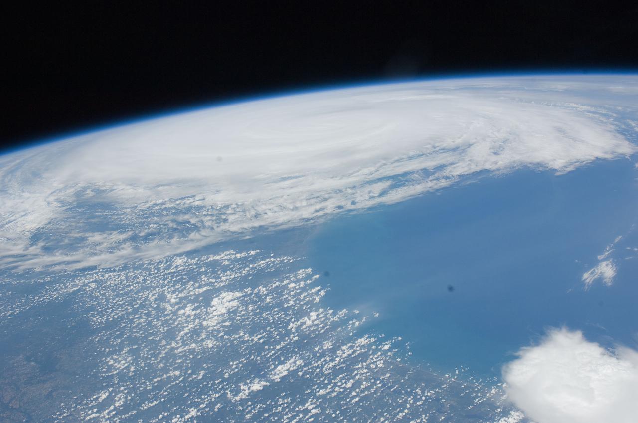
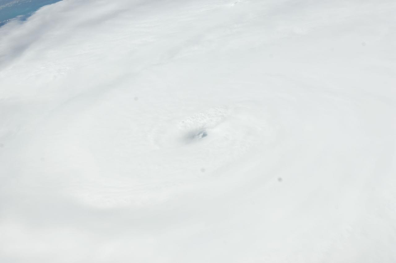
ISS028-E-034423 (26 Aug. 2011) --- This image of Hurricane Irene on Aug. 26 was photographed by one of the Expedition 28 crew members on board the International Space Station. The eye was at 31.2 degrees north latitude and 77.5 degrees west longitude moving due north 360 degrees at 14 miles per hour. Winds were 98 miles per hour, gusting to 120.8 miles per hour. Part of Florida's peninsula can be seen on the left and the northwest Bahamas are in lower left. One of the station?s trusses? radiator panels is at the upper center edge of the frame.

Irene Parker, deputy assistant administrator for Systems for NOAA’s National Environmental Satellite, Data, and Information Service, participates in a prelaunch news conference on Sunday, Sept. 21, 2025, at the agency’s Kennedy Space Center in Florida for NASA's IMAP (Interstellar Mapping and Acceleration Probe) mission. NASA’s IMAP will use 10 science instruments to study and map the heliosphere, a vast magnetic bubble surrounding the Sun protecting our solar system from radiation incoming from interstellar space. This mission and its two rideshares – NASA’s exosphere-studying Carruthers Geocorona Observatory and National Oceanic and Atmospheric Administration’s (NOAA) Space Weather Follow On–Lagrange 1 (SWFO-L1) observatory – will orbit the Sun near Lagrange point 1, about one million miles from Earth. Launch is targeting 7:32 a.m. EDT, Tuesday, Sept. 23, from Launch Complex 39A at NASA Kennedy.
ISS028-E-045516 (9 Sept. 2011) --- Hurricane Katia off the northeastern USA coastline is featured in this image photographed by an Expedition 28 crew member on the International Space Station. Hurricane Katia had diminished to Category 1 strength on the Saffir-Simpson scale at the time this photograph was taken, but it still presented an impressive cloud circulation as its center passed by the northeastern USA coastline on Sept. 9, 2011. The storm had reached Category 4 strength earlier on Sept. 5, making it the second major hurricane of the 2011 Atlantic hurricane season. Katia remained over open waters of the Atlantic Ocean during its lifetime, unlike two preceding storms of the season ? Hurricane Irene and Tropical Storm Lee ? both of which made landfall on the continental USA. The approximate center of Hurricane Katia is visible at lower right, with its outer cloud bands extending across the center of the view. A small part of the State of New York ? including Long Island and the Hudson River ? is visible through a gap in the cloud cover at lower left. The Hudson River has a chocolate brown coloration due to heavy loading with sediment, a consequence of flooding and erosion of the upstream watershed from the heavy precipitation of Hurricane Irene and Tropical Storm Lee. A plume of sediment is just visible entering the Atlantic Ocean on the southern coastline of Long Island, directly to the south of the New York City metropolitan area (partially obscured by clouds). Crew members on the International Space Station have the opportunity to take images like this one by looking outwards at an angle through space station windows, much like taking photographs of the ground from a commercial airliner window ? albeit from an average altitude of approximately 400 kilometers.

NASA, mission, and partner leaders participate in prelaunch news conference on Sunday, Sept. 21, 2025, at the agency’s Kennedy Space Center in Florida for NASA’s IMAP (Interstellar Mapping and Acceleration Probe) mission. From left are: Derrol Nail, NASA Communications; Nicky Fox, associate administrator, Science Mission Directorate, NASA Headquarters in Washington; Brad Williams, IMAP program executive, NASA Headquarters; Irene Parker, deputy assistant administrator for Systems for NOAA’s National Environmental Satellite, Data, and Information Service; Denton Gibson, launch director, NASA’s Launch Services Program, NASA Kennedy; Julianna Scheiman, director, NASA Science Missions, SpaceX; Arlena Moses, launch weather officer, 45th Weather Squadron, U.S. Space Force. The IMAP mission and its two rideshares – NASA’s exosphere-studying Carruthers Geocorona Observatory and National Oceanic and Atmospheric Administration’s (NOAA) Space Weather Follow On–Lagrange 1 (SWFO-L1) observatory – will orbit the Sun near Lagrange point 1, about one million miles from Earth, where it will scan the heliosphere, analyze the composition of charged particles, and investigate how those particles move through the solar system. Launch is targeted for 7:32 a.m. EDT, Tuesday, Sept. 23, from Launch Complex 39A at NASA Kennedy.

Irene Parker, deputy assistant administrator, NOAA Systems, National Environmental Satellite, Data, and Services, participates in a prelaunch news conference for the National Oceanic and Atmospheric Administration’s (NOAA) Joint Polar Satellite System-2 (JPSS-2) and NASA Low-Earth Orbit Flight Test of an Inflatable Decelerator (LOFTID) technology demonstration at Vandenberg Space Force Base in California on Oct. 28, 2022. JPSS-2 is the third satellite in the polar satellite series and is expected to capture data to improve weather forecasts, helping scientists predict and prepare for extreme weather events and climate change. JPSS-2 is scheduled to launch at 2:25 a.m. PDT Tuesday, Nov. 1, on a United Launch Alliance (ULA) Atlas V 401 rocket from Space Launch Complex 3 at Vandenberg Space Force Base in California. Launching with JPSS-2 is NASA’s LOFTID technology demonstration. After JPSS-2 safely reaches orbit, LOFTID will follow a re-entry trajectory from low-Earth orbit to demonstrate the inflatable heat shield’s ability to slow down and survive re-entry. LOFTID is a partnership with ULA and is dedicated to the memory of Bernard Kutter, one of the company’s engineers who played a key role in developing the technology. LOFTID will demonstrate how the inflatable aeroshell, or heat shield, can slow down and survive re-entry in conditions relevant to many potential applications, whether landing humans on Mars, new missions to Venus and Titan, or returning heavier payloads and samples from low-Earth orbit.

NASA held a prelaunch news conference for the National Oceanic and Atmospheric Administration’s (NOAA) Joint Polar Satellite System-2 (JPSS-2) and the agency’s Low-Earth Orbit Flight Test of an Inflatable Decelerator (LOFTID) technology demonstration at Vandenberg Space Force Base in California on Oct. 28, 2022. Participants from left are: John Gagosian, director, NASA’s Joint Agency Satellite Division; Omar Baez, launch director, NASA’s Launch Services Program; Gary Wentz, vice president, Government and Commercial Programs, ULA; Irene Parker, deputy assistant administrator, NOAA Systems, National Environmental Satellite, Data, and Services; Tim Walsh, director, NOAA’s JPSS Program Office, NOAA; Jim Reuter, associate administrator for NASA’s Space Technology Mission Directorate; Capt. Zack Zounes, launch weather officer, U.S. Space Force. JPSS-2 is the third satellite in the polar satellite series and is expected to capture data to improve weather forecasts, helping scientists predict and prepare for extreme weather events and climate change. JPSS-2 is scheduled to launch at 2:25 a.m. PDT Tuesday, Nov. 1, on a United Launch Alliance (ULA) Atlas V 401 rocket from Space Launch Complex 3 at Vandenberg Space Force Base in California. Launching with JPSS-2 is NASA’s LOFTID technology demonstration. After JPSS-2 safely reaches orbit, LOFTID will follow a re-entry trajectory from low-Earth orbit to demonstrate the inflatable heat shield’s ability to slow down and survive re-entry. LOFTID is a partnership with ULA and is dedicated to the memory of Bernard Kutter, one of the company’s engineers who played a key role in developing the technology. LOFTID will demonstrate how the inflatable aeroshell, or heat shield, can slow down and survive re-entry in conditions relevant to many potential applications, whether landing humans on Mars, new missions to Venus and Titan, or returning heavier payloads and samples from low-Earth orbit.

NASA held a prelaunch news conference for the National Oceanic and Atmospheric Administration’s (NOAA) Joint Polar Satellite System-2 (JPSS-2) and the agency’s Low-Earth Orbit Flight Test of an Inflatable Decelerator (LOFTID) technology demonstration at Vandenberg Space Force Base in California on Oct. 28, 2022. Participants from left are: Megan Cruz, NASA Communications; John Gagosian, director, NASA’s Joint Agency Satellite Division; Omar Baez, launch director, NASA’s Launch Services Program; Gary Wentz, vice president, Government and Commercial Programs, ULA; Irene Parker, deputy assistant administrator, NOAA Systems, National Environmental Satellite, Data, and Services; Tim Walsh, director, NOAA’s JPSS Program Office, NOAA; Jim Reuter, associate administrator for NASA’s Space Technology Mission Directorate; Capt. Zack Zounes, launch weather officer, U.S. Space Force. JPSS-2 is the third satellite in the polar satellite series and is expected to capture data to improve weather forecasts, helping scientists predict and prepare for extreme weather events and climate change. JPSS-2 is scheduled to launch at 2:25 a.m. PDT Tuesday, Nov. 1, on a United Launch Alliance (ULA) Atlas V 401 rocket from Space Launch Complex 3 at Vandenberg Space Force Base in California. Launching with JPSS-2 is NASA’s LOFTID technology demonstration. After JPSS-2 safely reaches orbit, LOFTID will follow a re-entry trajectory from low-Earth orbit to demonstrate the inflatable heat shield’s ability to slow down and survive re-entry. LOFTID is a partnership with ULA and is dedicated to the memory of Bernard Kutter, one of the company’s engineers who played a key role in developing the technology. LOFTID will demonstrate how the inflatable aeroshell, or heat shield, can slow down and survive re-entry in conditions relevant to many potential applications, whether landing humans on Mars, new missions to Venus and Titan, or returning heavier payloads and samples from low-Earth or