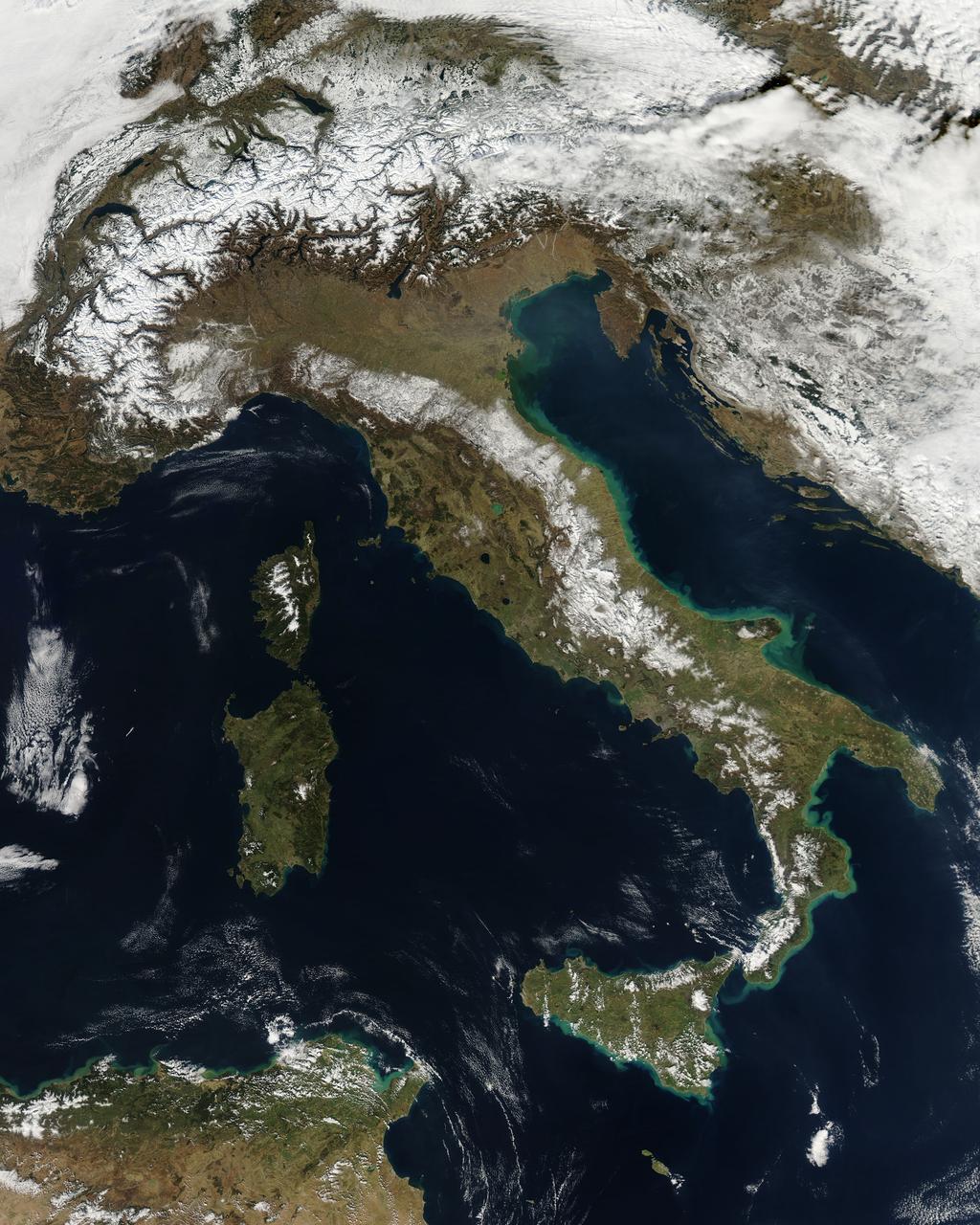
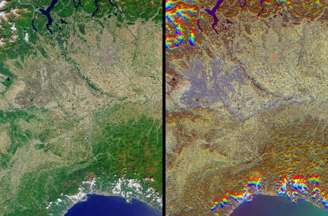
NASA image acquired February 24, 2012 By late February, 2012, the great European cold wave had begun to loosen its frigid grip, but significant snow still remained in the region. The Moderate Resolution Imaging Spectroradiometer (MODIS) aboard the Aqua satellite captured this true-color image of snow in Italy on February 24 at 12:35 UTC (1:30 p.m. local time). In the north of the image, bright white clouds blanket the region in a broad arc. Snow, which tends to be generally less bright that clouds, covers the Alps in the north of Italy. The Apennine Mountains, which form the backbone of the Italian peninsula, also carry a blanket of snow. Although clouds and snow can, at times, be distinguished visually in a true-color image, sometimes they can appear very similar. When it is important to clearly define snow from cloud, false color images are often helpful. Rome, which can be seen as a gray smudge on the southwestern coast of the peninsula, recorded highs of a spring-like 50°F the day this image was captured, but earlier in the month the temperatures dove as low as 26°F on February 5. During that cold snap a rare intense snowfall blanketed Rome, causing the closure of the Colosseum, the Roman Forum and the Palatine Hill due to concerns of the risk of icy footing for tourists, and roads became impassible. Further north, temperatures plummeted to −21 °C (−6 °F) on 7 February. On February 11, news media reported over 2 meters (6.5 feet) of snow had fallen in Urbino, a walled town situated on a high sloping hillside on the eastern side of the Apennine Mountains. That same snowfall cut access to many remote towns in the Apennines, blocking roads and trapping some people in the homes. Credit: NASA/GSFC/Jeff Schmaltz/MODIS Land Rapid Response Team <b><a href="http://www.nasa.gov/centers/goddard/home/index.html" rel="nofollow">NASA Goddard Space Flight Center</a></b> enables NASA’s mission through four scientific endeavors: Earth Science, Heliophysics, Solar System Exploration, and Astrophysics. Goddard plays a leading role in NASA’s accomplishments by contributing compelling scientific knowledge to advance the Agency’s mission. <b>Follow us on <a href="http://twitter.com/NASA_GoddardPix" rel="nofollow">Twitter</a></b> <b>Like us on <a href="http://www.facebook.com/pages/Greenbelt-MD/NASA-Goddard/395013845897?ref=tsd" rel="nofollow">Facebook</a></b> <b>Find us on <a href="http://instagrid.me/nasagoddard/?vm=grid" rel="nofollow">Instagram</a></b>
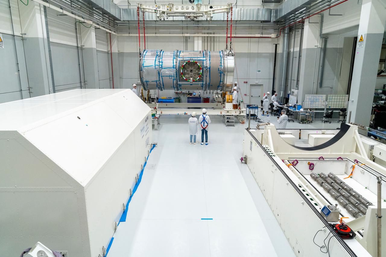
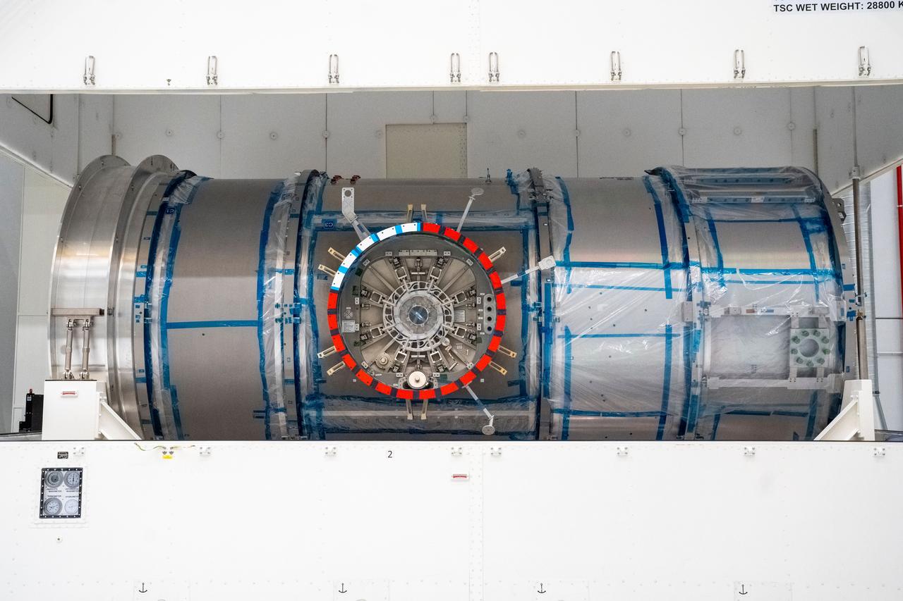
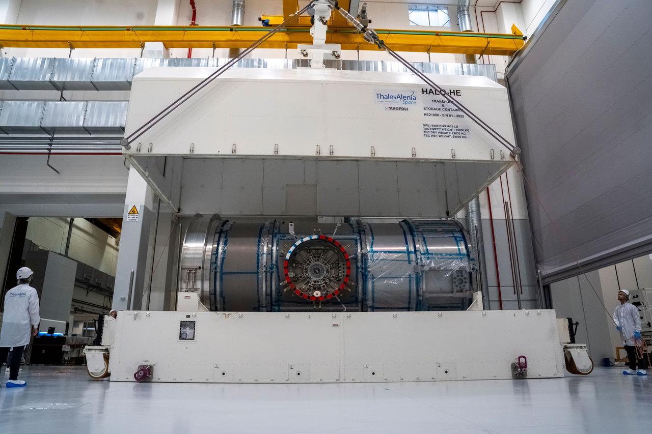
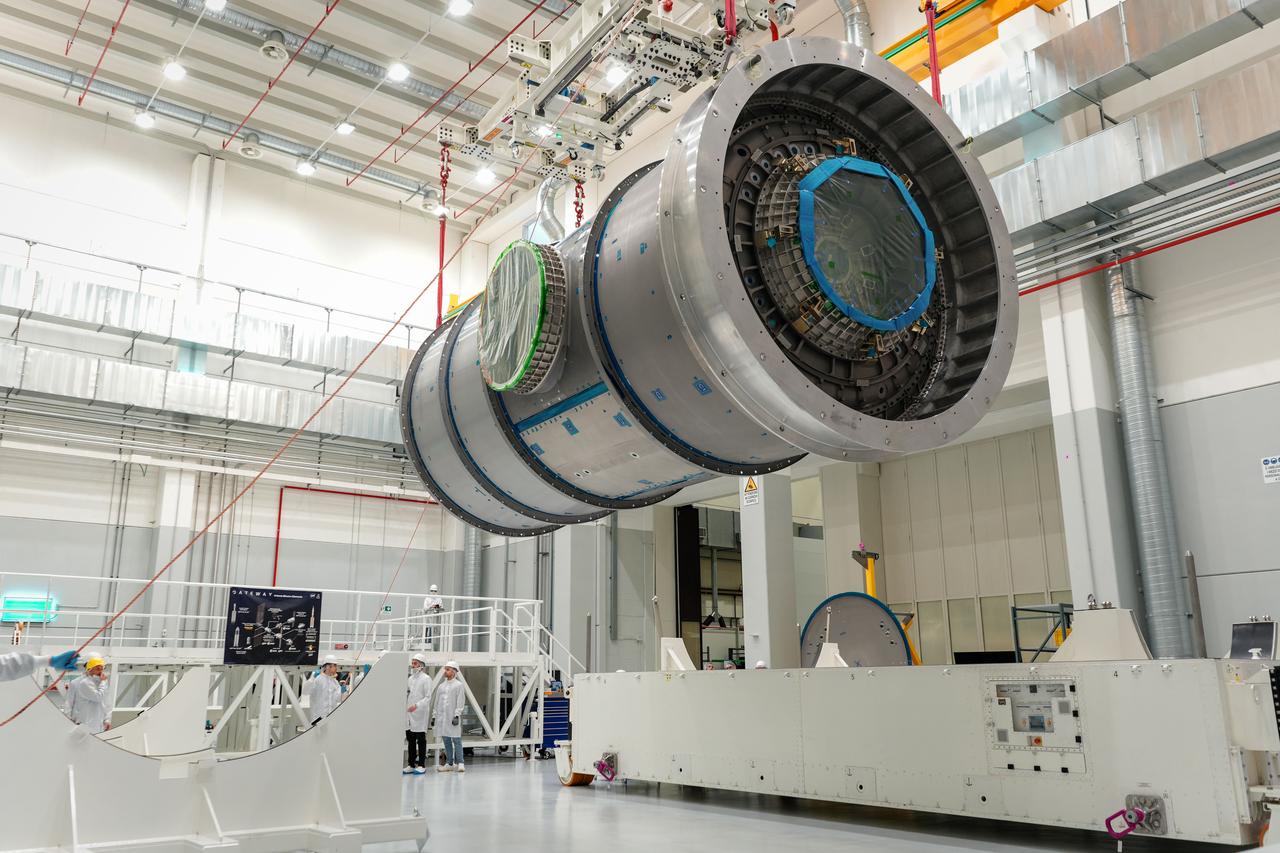
Gateway’s HALO (Habitation and Logistics Outpost) departs Italy en route to Arizona, where it will undergo final outfitting at Northrop Grumman’s facility in Gilbert ahead of its launch to lunar orbit. The module’s primary structure was fabricated by Thales Alenia Space in Turin.
Gateway’s HALO (Habitation and Logistics Outpost) departs Italy en route to Arizona, where it will undergo final outfitting at Northrop Grumman’s facility in Gilbert ahead of its launch to lunar orbit. The module’s primary structure was fabricated by Thales Alenia Space in Turin.
Gateway’s HALO (Habitation and Logistics Outpost) departs Italy en route to Arizona, where it will undergo final outfitting at Northrop Grumman’s facility in Gilbert ahead of its launch to lunar orbit. The module’s primary structure was fabricated by Thales Alenia Space in Turin.
Gateway’s HALO (Habitation and Logistics Outpost) departs Italy en route to Arizona, where it will undergo final outfitting at Northrop Grumman’s facility in Gilbert ahead of its launch to lunar orbit. The module’s primary structure was fabricated by Thales Alenia Space in Turin.

Gateway’s HALO (Habitation and Logistics Outpost) departs Italy en route to Arizona, where it will undergo final outfitting at Northrop Grumman’s facility in Gilbert ahead of its launch to lunar orbit. The module’s primary structure was fabricated by Thales Alenia Space in Turin.

Gateway’s HALO (Habitation and Logistics Outpost) departs Italy en route to Arizona, where it will undergo final outfitting at Northrop Grumman’s facility in Gilbert ahead of its launch to lunar orbit. The module’s primary structure was fabricated by Thales Alenia Space in Turin.
SL2-05-359 (22 June 1973) --- This rare cloud free view of southern Italy (41.0N, 16.0E) shows almost all of the famous `boot' configuration of the peninsula up to just north of Naples and Mount Vesuvius. The land mass of this historic peninsula contrasts sharply with the sparkling blue waters of the Mediterranean Sea. Photo credit: NASA
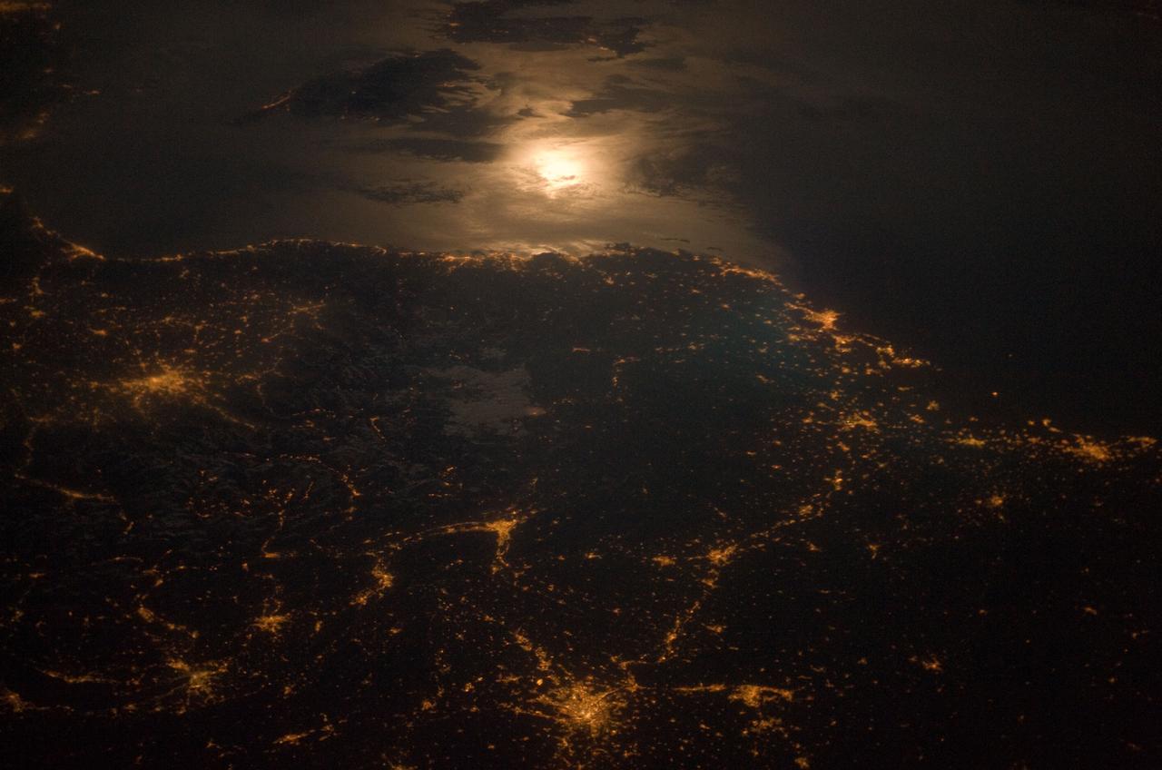
City lights at night along the France-Italy border, Europe are featured in this image photographed by an Expedition 23 crew member on the International Space Station (ISS). The brightly lit metropolitan areas of Torino (Italy), Lyon, and Marseille (both in France) stand out amidst numerous smaller urban areas in this dramatic photograph. The image captures the night time appearance of the France-Italy border area between the mountainous Alps to the north (not shown) and the island of Corsica in the Ligurian Sea to the south (top). The full moon reflects brightly on the water surface and also illuminates the tops of low patchy clouds over the border (center). This image was taken by an ISS crew member at approximately 11:55 p.m. local time when the station was located over the France-Belgium border near Luxembourg. Crew members orbiting Earth frequently collect images that include sunglint, or sunlight that reflects off a water surface at such an angle that it travels directly back towards the observer. Sunglint typically lends a mirror-like appearance to the water surface. During clear sky conditions reflected light from the moon can produce the same effect (moon glint) as illustrated in this view. The observer was looking towards the southeast at an oblique viewing angle at the time the image was taken; in other words, looking outwards from the ISS, not straight down towards Earth. Credit: NASA <b><a href="http://www.nasa.gov/audience/formedia/features/MP_Photo_Guidelines.html" rel="nofollow">NASA image use policy.</a></b> <b><a href="http://www.nasa.gov/centers/goddard/home/index.html" rel="nofollow">NASA Goddard Space Flight Center</a></b> enables NASA’s mission through four scientific endeavors: Earth Science, Heliophysics, Solar System Exploration, and Astrophysics. Goddard plays a leading role in NASA’s accomplishments by contributing compelling scientific knowledge to advance the Agency’s mission. <b>Follow us on <a href="http://twitter.com/NASAGoddardPix" rel="nofollow">Twitter</a></b> <b>Like us on <a href="http://www.facebook.com/pages/Greenbelt-MD/NASA-Goddard/395013845897?ref=tsd" rel="nofollow">Facebook</a></b> <b>Find us on <a href="http://instagram.com/nasagoddard?vm=grid" rel="nofollow">Instagram</a></b>
STS001-13-442 (14 April 1981) --- This photograph showing much of Italy was taken with a handheld 70mm camera from 276 kilometers above Earth as the NASA space shuttle Columbia and its crew were marking their last few hours in space on the historic first space mission utilizing a reusable vehicle. Included in the area of the frame are Golfo de Napoli, Napoli (Naples), Castellammare, Amalfi, Capri, Sorrento, Mt. Vesuvius and the ruins of Pompei. Astronauts John W. Young and Robert L. Crippen exposed eight magazines of color 70mm film during their two and one-third days in Earth orbit. Photo credit: NASA
51F-32-024 (29 July - 6 August 1985) --- Italy's “boot heel" surrounded by waters of the Ionian Sea/Golfo di Taranto and the Adriatic Sea is very clearly visible in this scene made with a handheld 70mm camera. Spacelab 2's versatile instrument pointing system (IPS) protrudes from the cargo bay.
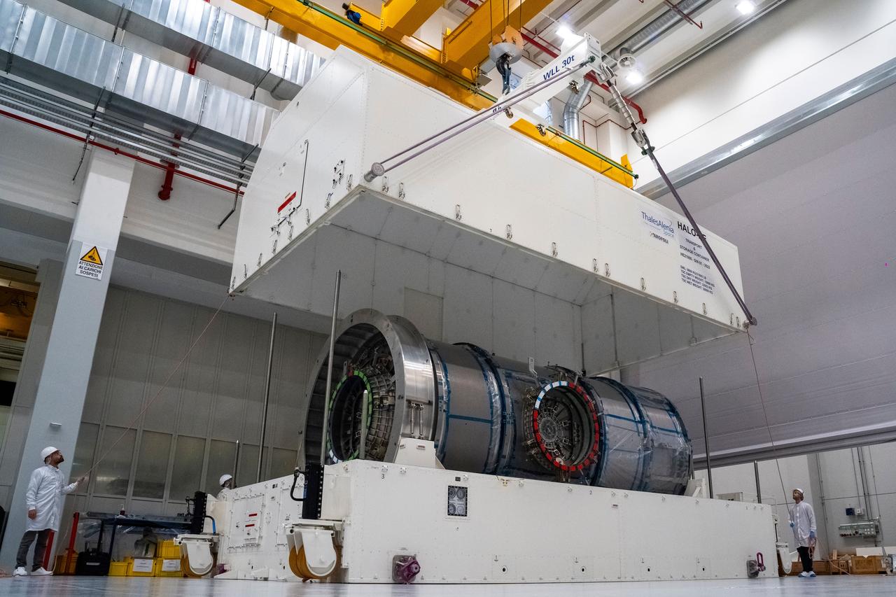
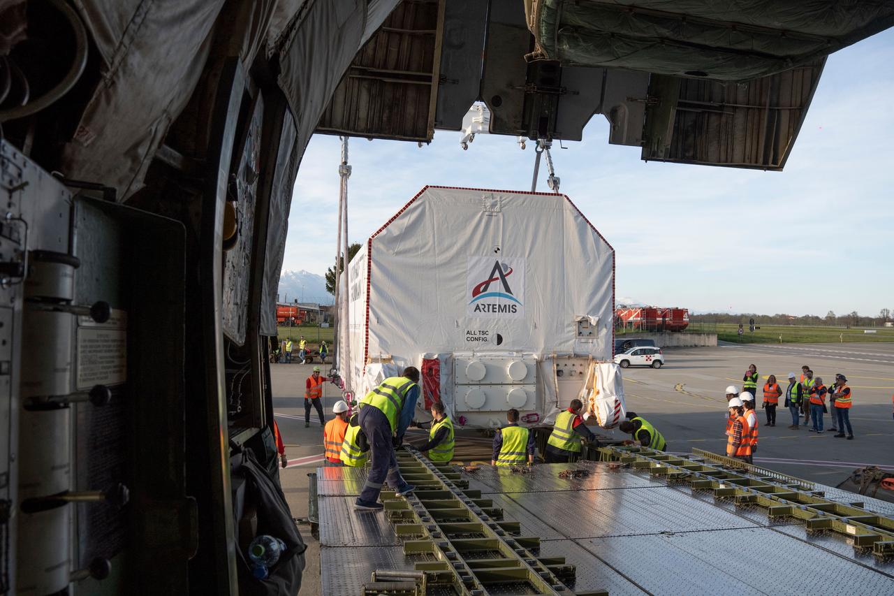
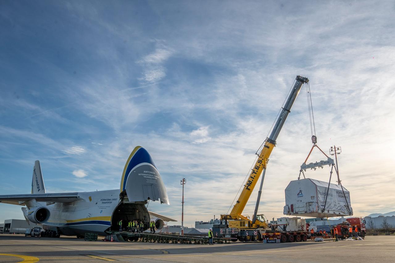
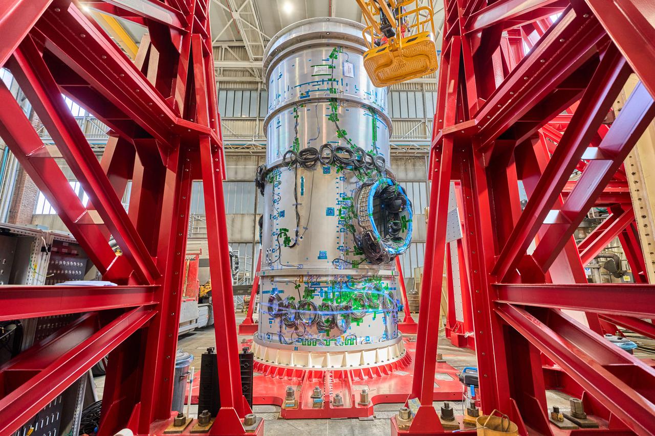
At the Thales Alenia Space facility in Turin, Italy, technicians prepare Gateway’s HALO (Habitation and Logistics Outpost) for transport. The module’s primary structure, fabricated by Thales Alenia Space, will travel to Northrop Grumman’s facility in Gilbert, Arizona, for final outfitting ahead of its launch to lunar orbit.

At the Thales Alenia Space facility in Turin, Italy, technicians prepare Gateway’s HALO (Habitation and Logistics Outpost) for transport. The module’s primary structure, fabricated by Thales Alenia Space, will travel to Northrop Grumman’s facility in Gilbert, Arizona, for final outfitting ahead of its launch to lunar orbit.

At the Thales Alenia Space facility in Turin, Italy, technicians prepare Gateway’s HALO (Habitation and Logistics Outpost) for transport. The module’s primary structure, fabricated by Thales Alenia Space, will travel to Northrop Grumman’s facility in Gilbert, Arizona, for final outfitting ahead of its launch to lunar orbit.

At the Thales Alenia Space facility in Turin, Italy, technicians prepare Gateway’s HALO (Habitation and Logistics Outpost) for transport. The module’s primary structure, fabricated by Thales Alenia Space, will travel to Northrop Grumman’s facility in Gilbert, Arizona, for final outfitting ahead of its launch to lunar orbit.
At a Thales Alenia Space facility in Turin, Italy, technicians prepare Gateway’s HALO (Habitation and Logistics Outpost) for transport. The module’s primary structure, fabricated by Thales Alenia Space, will travel to Northrop Grumman’s facility in Gilbert, Arizona, for final outfitting ahead of its launch to lunar orbit.
At the Thales Alenia Space facility in Turin, Italy, technicians prepare Gateway’s HALO (Habitation and Logistics Outpost) for transport. The module’s primary structure, fabricated by Thales Alenia Space, will travel to Northrop Grumman’s facility in Gilbert, Arizona, for final outfitting ahead of its launch to lunar orbit.
At the Thales Alenia Space facility in Turin, Italy, technicians prepare Gateway’s HALO (Habitation and Logistics Outpost) for transport. The module’s primary structure, fabricated by Thales Alenia Space, will travel to Northrop Grumman’s facility in Gilbert, Arizona, for final outfitting ahead of its launch to lunar orbit.
At the Thales Alenia Space facility in Turin, Italy, technicians prepare Gateway’s HALO (Habitation and Logistics Outpost) for transport. The module’s primary structure, fabricated by Thales Alenia Space, will travel to Northrop Grumman’s facility in Gilbert, Arizona, for final outfitting ahead of its launch to lunar orbit.
At a Thales Alenia Space facility in Turin, Italy, technicians prepare Gateway’s HALO (Habitation and Logistics Outpost) for transport. The module’s primary structure, fabricated by Thales Alenia Space, will travel to Northrop Grumman’s facility in Gilbert, Arizona, for final outfitting ahead of its launch to lunar orbit.
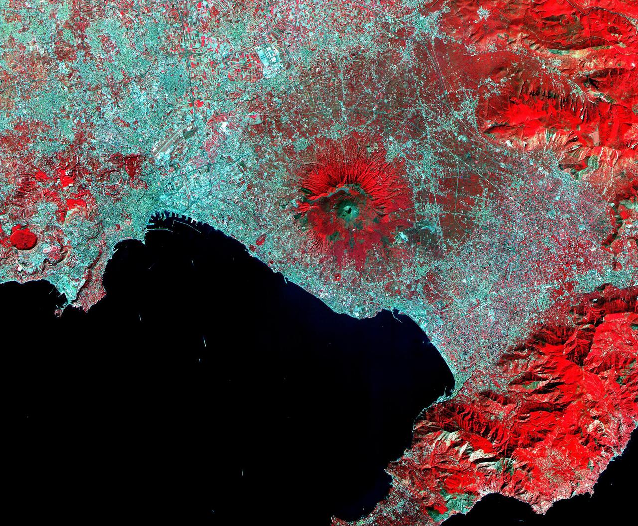
This ASTER image of Mt. Vesuvius Italy was acquired September 26, 2000, and covers an area of 36 by 45 km. Vesuvius overlooks the city of Naples and the Bay of Naples in central Italy. In 79 AD, Vesuvius erupted cataclysmically, burying all of the surrounding cites with up to 30 m of ash. The towns of Pompeii and Herculanaeum were rediscovered in the 18th century, and excavated in the 20th century. They provide a snapshot of Roman life from 2000 years ago: perfectly preserved are wooden objects, food items, and the casts of hundreds of victims. Vesuvius is intensively monitored for potential signs of unrest that could signal the beginning of another eruption. The image is centered at 40.8 degrees north latitude, 14.4 degrees east longitude. http://photojournal.jpl.nasa.gov/catalog/PIA11091
The lowlands of Lombardy and Piedmont in northwest Italy are some of the most highly developed irrigation areas in the world. These views of the region were acquired on May 8, 2005, by NASA Terra spacecraft.
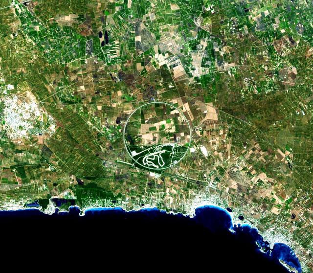
The Nardò Ring is a striking visual feature from space, and astronauts have photographed it several times. The Ring is a race car test track in Italy. This image was acquired by NASA Terra satellite on August 17. 2007.

Giovanni Castellaneta, Ambassador of Italy, makes comments about the STS-125 mission to the Hubble Space Telescope during a visit by the crew to the Embassy of Italy in Washington, Thursday, July 23, 2009. Photo Credit: (NASA/Bill Ingalls)

Four hundred bridges cross the labyrinth of canals that form the 120 islands of Venice, situated in a saltwater lagoon between the mouths of the Po and Piave rivers in northeast Italy. All traffic in the city moves by boat. Venice is connected to the mainland, 4 kilometers (2.5 miles) away, by ferries as well as a causeway for road and rail traffic. The Grand Canal winds through the city for about 3 kilometers (about 2 miles), dividing it into two nearly equal sections. According to tradition, Venice was founded in 452, when the inhabitants of Aquileia, Padua, and several other northern Italian cities took refuge on the islands of the lagoon from the Teutonic tribes invading Italy at that time. This image was acquired on December 9, 2001 by the Advanced Spaceborne Thermal Emission and Reflection Radiometer (ASTER) on NASA's Terra satellite. With its 14 spectral bands from the visible to the thermal infrared wavelength region, and its high spatial resolution of 15 to 90 meters (about 50 to 300 feet), ASTER will image Earth for the next 6 years to map and monitor the changing surface of our planet. http://photojournal.jpl.nasa.gov/catalog/PIA03860

Giovanni Castellaneta, Ambassador of Italy, left, shakes hands with STS-125 Mission Specialist Mike Massimino during a visit by the crew of STS-125 to the Embassy of Italy in Washington, Thursday, July 23, 2009. Photo Credit: (NASA/Bill Ingalls)

NASA Administrator Charles F. Bolden Jr., left, speaks with Giovanni Castellaneta, Ambassador of Italy, during a visit with the crew of STS-125 to the Embassy of Italy in Washington, Thursday, July 23, 2009. Photo Credit: (NASA/Bill Ingalls)
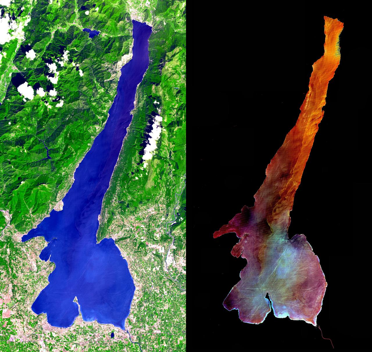
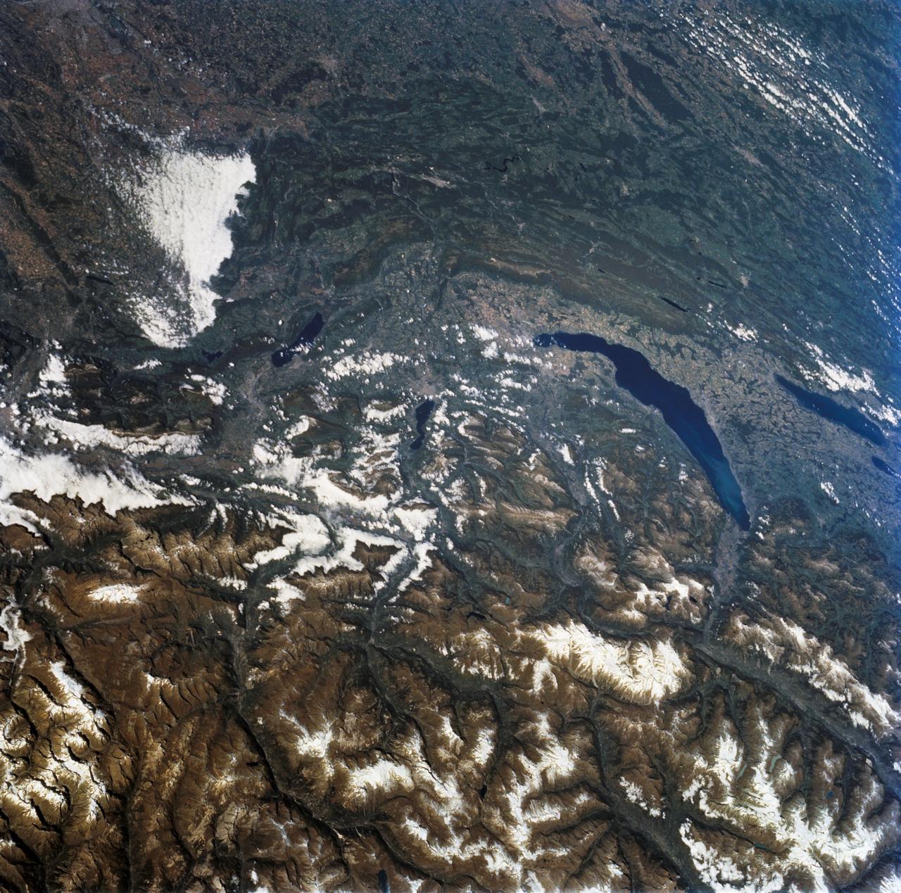
This ASTER image was acquired on July 29, 2000 and covers an area of 30 by 57 km in northern Italy. Lake Garda was formed by glaciers during the last Ice Age, and is Italy's largest lake. Lago di Garda lies in the provinces of Verona, Brescia, and Trento, and is 51 kilometers (32 miles) long and from 3 to 18 kilometers (2 to 11 miles) wide. The Sarca is its chief affluent, and the lake is drained southward by the Mincio, which discharges into the Po River. Many villas are situated on its shores. On the peninsula of Sirmione, at the southern end of the lake, are the ruins of a Roman villa and a castle of the Scaligers, an Italian family of the 16th century. The RIGHT image has the land area masked out, and a harsh stretch was applied to the lake values to display variations in sediment load. Also visible are hundreds of boats and their wakes, criss-crossing the lake. The image is centered at 45.6 degrees north latitude, 10.6 degrees east longitude. http://photojournal.jpl.nasa.gov/catalog/PIA02671

NASA Administrator Charles F. Bolden Jr. makes comments about the STS-125 mission to the Hubble Space Telescope during a visit by the crew to the Embassy of Italy in Washington, Thursday, July 23, 2009. Photo Credit: (NASA/Bill Ingalls)
This image from NASA KidSat spans the region of Venetia from the city of Venice, Italy, on the coast of the Adriatic Sea north to the snow-capped Alps. Venice appears in the lower left part of the image, and the Alps appear in the lower right.

SL3-33-156 (July-September 1973) --- A near vertical view of the Florence, Italy area as photographed from Earth orbit by one of the Itek-furnished S190-A Multispectral Photographic Facility Experiment aboard the Skylab space station. The view extends from the Ligurian Sea, an extension of the Mediterranean Sea, across the Apennine Mountains to the Po River Valley. Florence (Firenze) is near the center of the land mass. The mouth of the Arno River is at the center of the coastline. The city of Leghorn (Livorno) is on the coast just south of the Arno River. This picture was taken with type 2443 infrared color film. The S190-A experiment is part of the Skylab Earth Resources Experiments Package. Federal agencies participating with NASA on the EREP project are the Department of Agriculture, Commerce, Interior, the Environmental Protection Agency and the Corps of Engineers. All EREP photography is available to the public through the Department of Interior?s Earth Resources Observations Systems Data Center, Sioux Falls, South Dakota, 57198. Photo credit: NASA
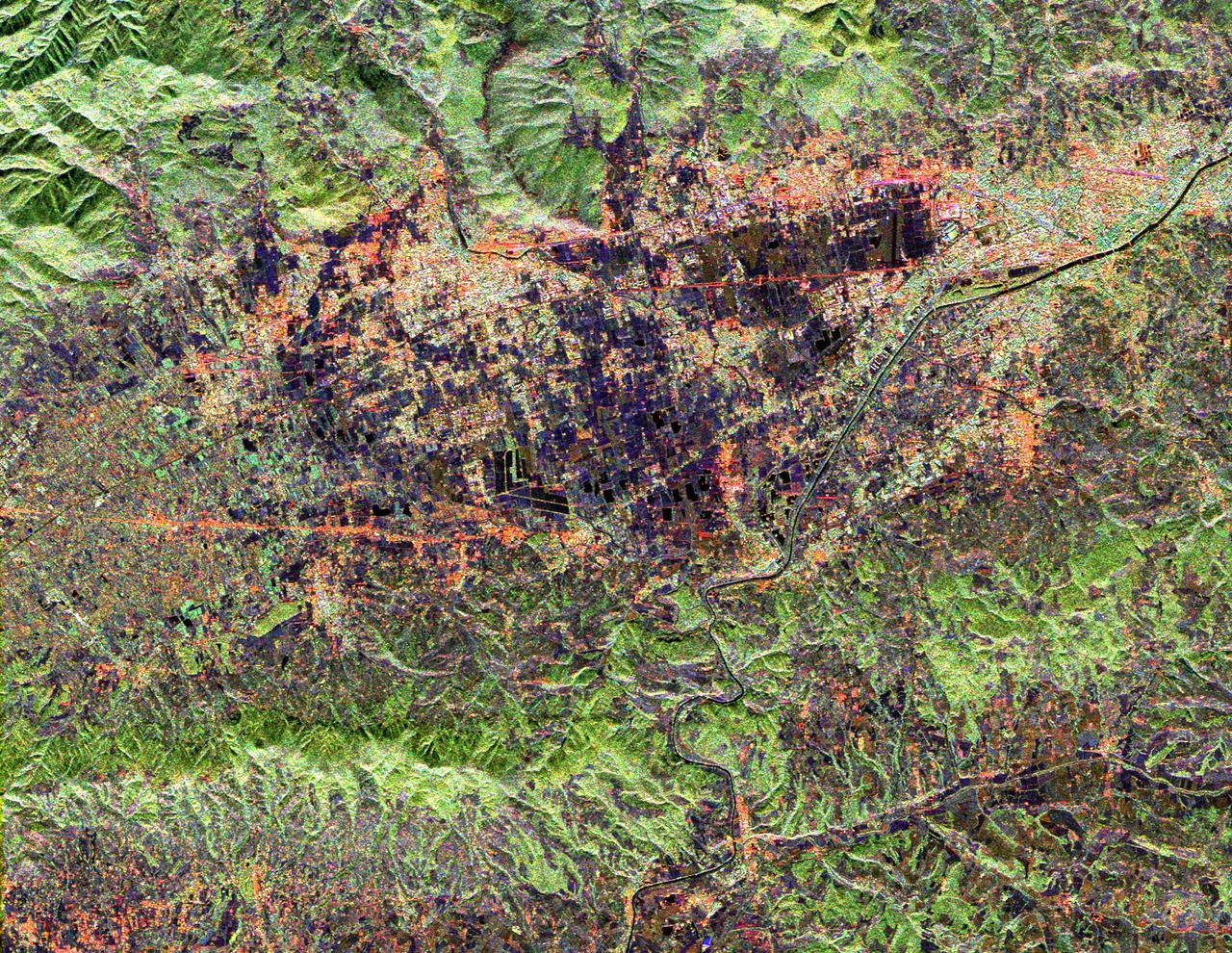
This radar image shows land use patterns in and around the city of Florence, Italy, shown here in the center of the image. Florence is situated on a plain in the Chianti Hill region of Central Italy. The Arno River flows through town and is visible as the dark line running from the upper right to the bottom center of the image. The city is home to some of the world's most famous art museums. The bridges seen crossing the Arno, shown as faint red lines in the upper right portion of the image, were all sacked during World War II with the exception of the Ponte Vecchio, which remains as Florence's only covered bridge. The large, black V-shaped feature near the center of the image is the Florence Railroad Station. This image was acquired by the Spaceborne Imaging Radar-C/X-band Synthetic Aperture Radar (SIR-C/X-SAR) onboard the Space Shuttle Endeavour on April 14, 1994. SIR-C/X-SAR, a joint mission of the German, Italian, and United States space agencies, is part of NASA's Mission to Planet Earth. This image is centered at 43.7 degrees north latitude and 11.15 degrees east longitude with North toward the upper left of the image. The area shown measures 20 kilometers by 17 kilometers (12.4 miles by 10.6 miles). The colors in the image are assigned to different frequencies and polarizations of the radar as follows: red is L-band horizontally transmitted, horizontally received; green is L-band horizontally transmitted, vertically received; blue is C-band horizontally transmitted, vertically received. http://photojournal.jpl.nasa.gov/catalog/PIA01795

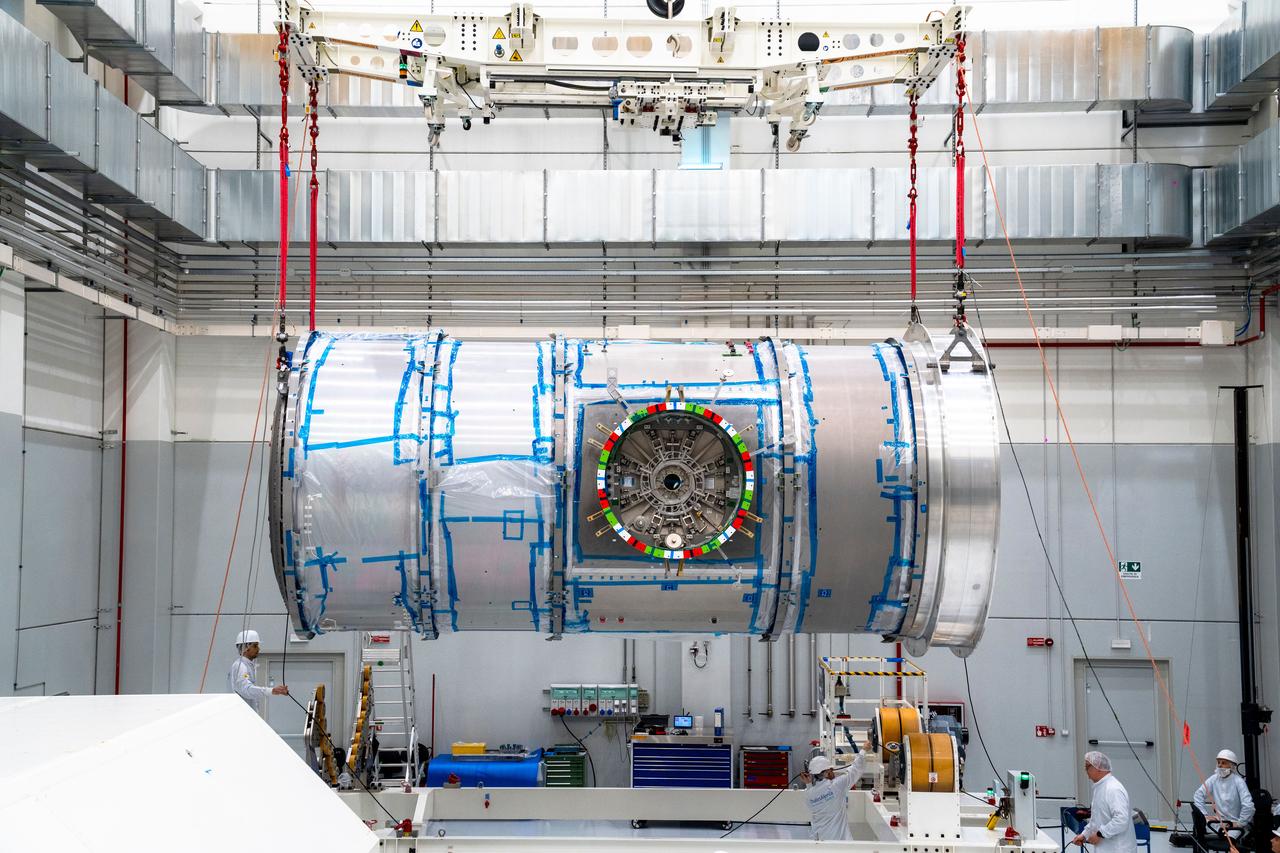
Gateway's HALO (Habitation and Logistics Outpost) floats through the Thales Alenia Space industrial facility in Turin, Italy for stress testing to ensure its safety.
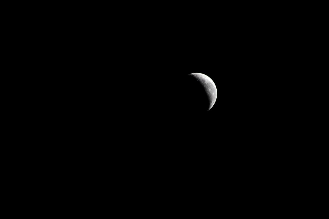
iss071e256627 (June 30, 2024) -- A waning crescent moon hangs against the black of space as the International Space Station orbited 258 miles above Italy.

STS-125 Mission Specialist Mike Massimino makes comments about the STS-125 mission to the Hubble Space Telescope during a visit by the crew to the Embassy of Italy in Washington, Thursday, July 23, 2009. Photo Credit: (NASA/Bill Ingalls)

STS-125 Mission Specialist Mike Massimino, left, an American of Italian descent, makes comments about the STS-125 mission to the Hubble Space Telescope during a visit by the crew to the Embassy of Italy in Washington, Thursday, July 23, 2009. Photo Credit: (NASA/Bill Ingalls)
STS068-243-076 (30 September-11 October 1994) --- Parts of the Swiss Cantons of Vaud and Valois, the French province of Chablis and parts of northwestern Italy are seen in this widely stretching image photographed from the Space Shuttle Endeavour. Pennine Alps, said to have been created 50 million years ago, have been reshaped by glaciers during Pleistocene. The glaciers created the wide valley of the Rhone River by scourting a pre-existing seam. The fertile Swiss Plateau runs northwest from the shore of Lake Geneva and is visible in lower left. The Franco-Swiss border is located in the center of the lake and follows a mountain divide east of Rhone Valley. Italy lies south of the Rhone.

The most recent eruption of Mt. Etna, Italy, began May 30, 2019. New fissure vents opened on the New Southeast Crater, feeding two lava flows that moved down into the Valle del Bove, accompanied by loud explosions. By June 4, when this nighttime ASTER thermal image was acquired, eruption activity had ended. https://photojournal.jpl.nasa.gov/catalog/PIA23235

iss074e0162703 (Dec. 30, 2025) --- City lights outline the boot of Italy and shine through the cloud‑covered central and southern European nightscape in this photograph, taken at approximately 11:17 p.m. local time from the International Space Station as it orbited 261 miles above the Mediterranean Sea. Credit: NASA/Chris Williams
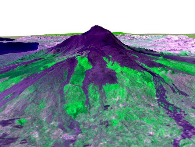
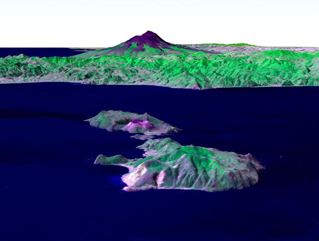
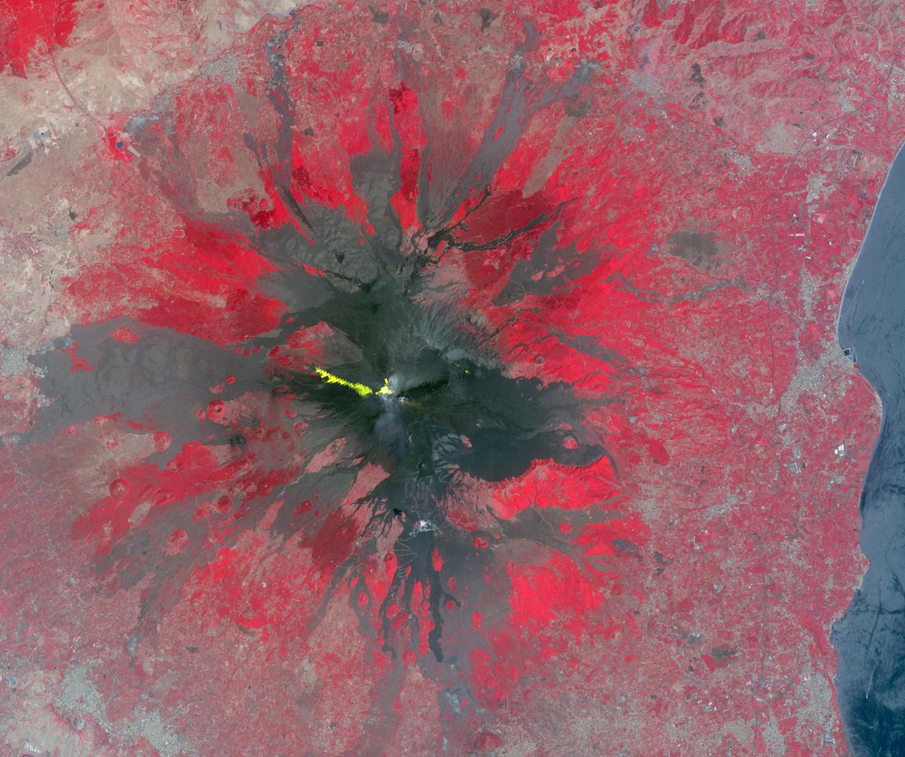
Italy's Mount Etna is the focus of this perspective view made from an Advanced Spaceborne Thermal and Emission Radiometer (ASTER) image from NASA's Terra spacecraft overlaid on Shuttle Radar Topography Mission (SRTM) topography. The image is looking south with dark lava flows from the 1600's (center) to 1981 (long flow at lower right) visible in the foreground and the summit of Etna above. The city of Catania is barely visible behind Etna on the bay at the upper left. In late October 2002, Etna erupted again, sending lava flows down the north and south sides of the volcano. The north flows are near the center of this view, but the ASTER image is from before the eruption. In addition to the terrestrial applications of these data for understanding active volcanoes and hazards associated with them such as lava flows and explosive eruptions, geologists studying Mars find these data useful as an analog to martian landforms and geologic processes. In late September 2002, a field conference with the theme of Terrestrial Analogs to Mars focused on Mount Etna, allowing Mars geologists to see in person the types of features they can only sample remotely. http://photojournal.jpl.nasa.gov/catalog/PIA03371

Italian European Space Agency Astronaut Paolo Nespoli makes comments about the STS-125 mission to the Hubble Space Telescope during a visit by the crew to the Embassy of Italy in Washington, Thursday, July 23, 2009. Nespoli was assigned to the crew of STS-120, an International Space Station (ISS) assembly mission. Photo Credit: (NASA/Bill Ingalls)
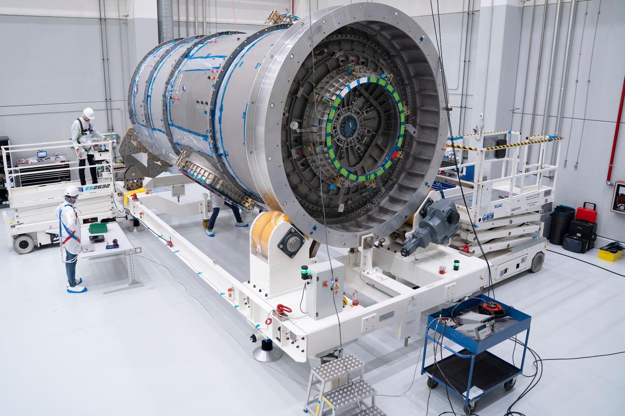
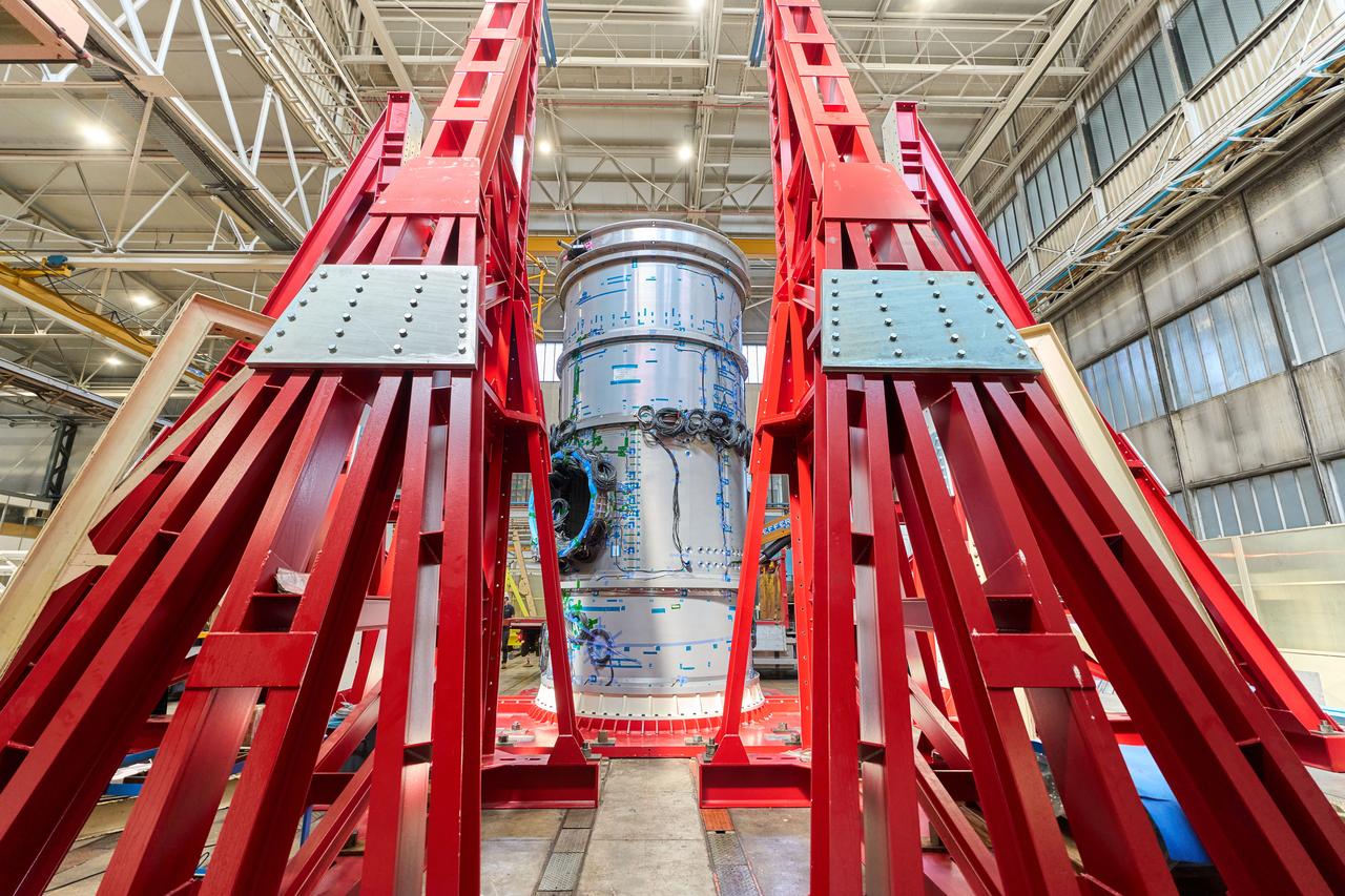
The primary structure of the Gateway space station's HALO (Habitation and Logistics Outpost) module is one step closer to launch following welding completion in Turin, Italy. HALO is one of four Gateway modules where astronauts will live, conduct science, and prepare for lunar surface missions. NASA is partnering with Northrop Grumman and their subcontractor Thales Alenia Space to develop HALO.

iss073e0343840 (July 15, 2025) --- Rome, Italy, the nation's capital and largest city nearly 3,000 years old with a metropolitan population of about 4.22 million, is pictured at approximately 1:16 a.m. local time from the International Space Station as it orbited 260 miles above.
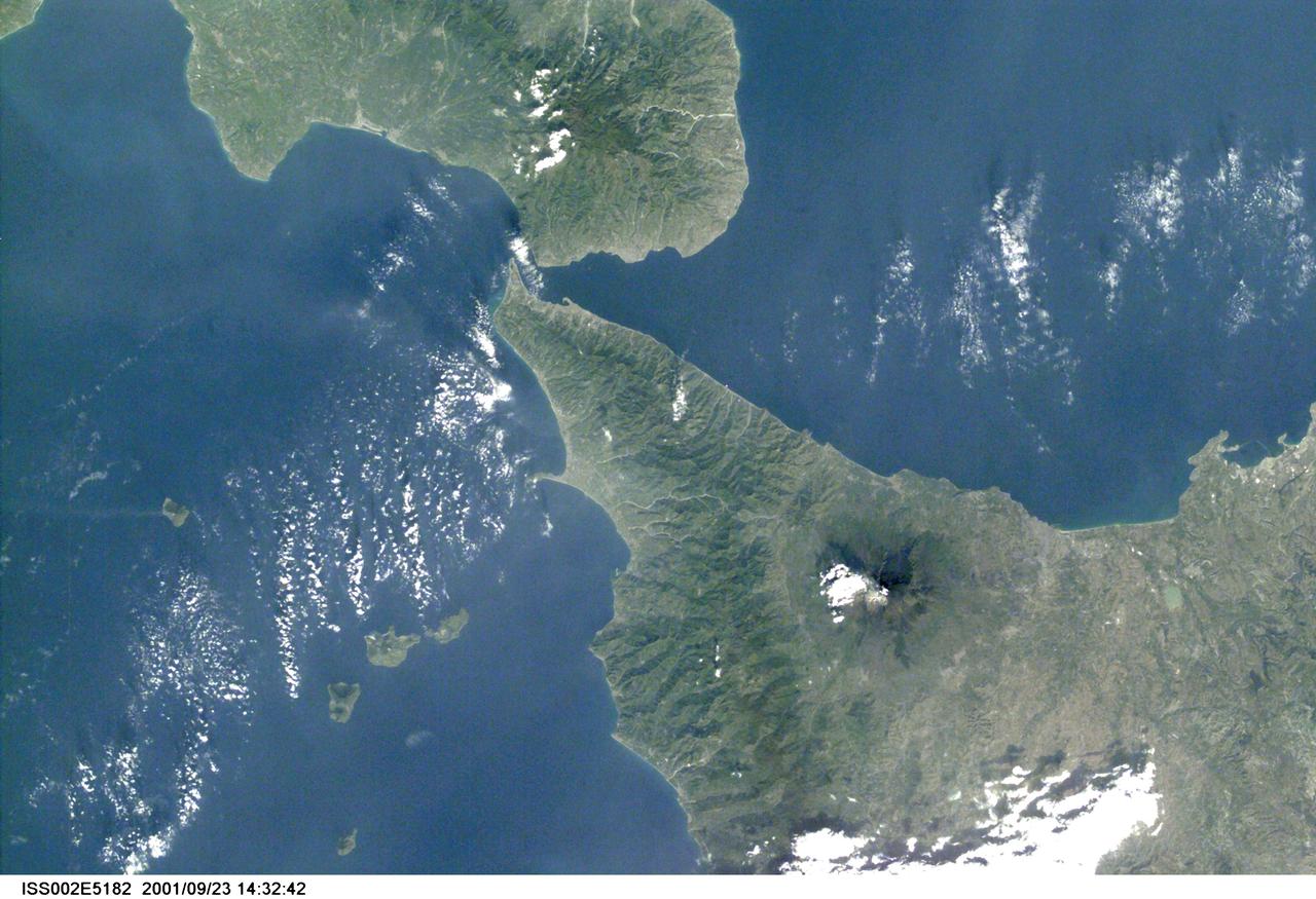
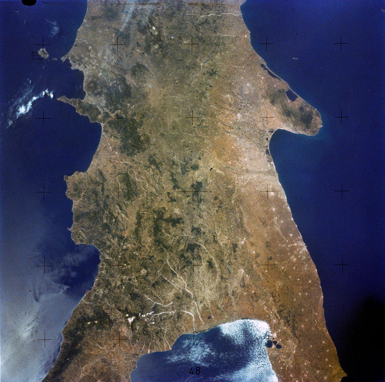
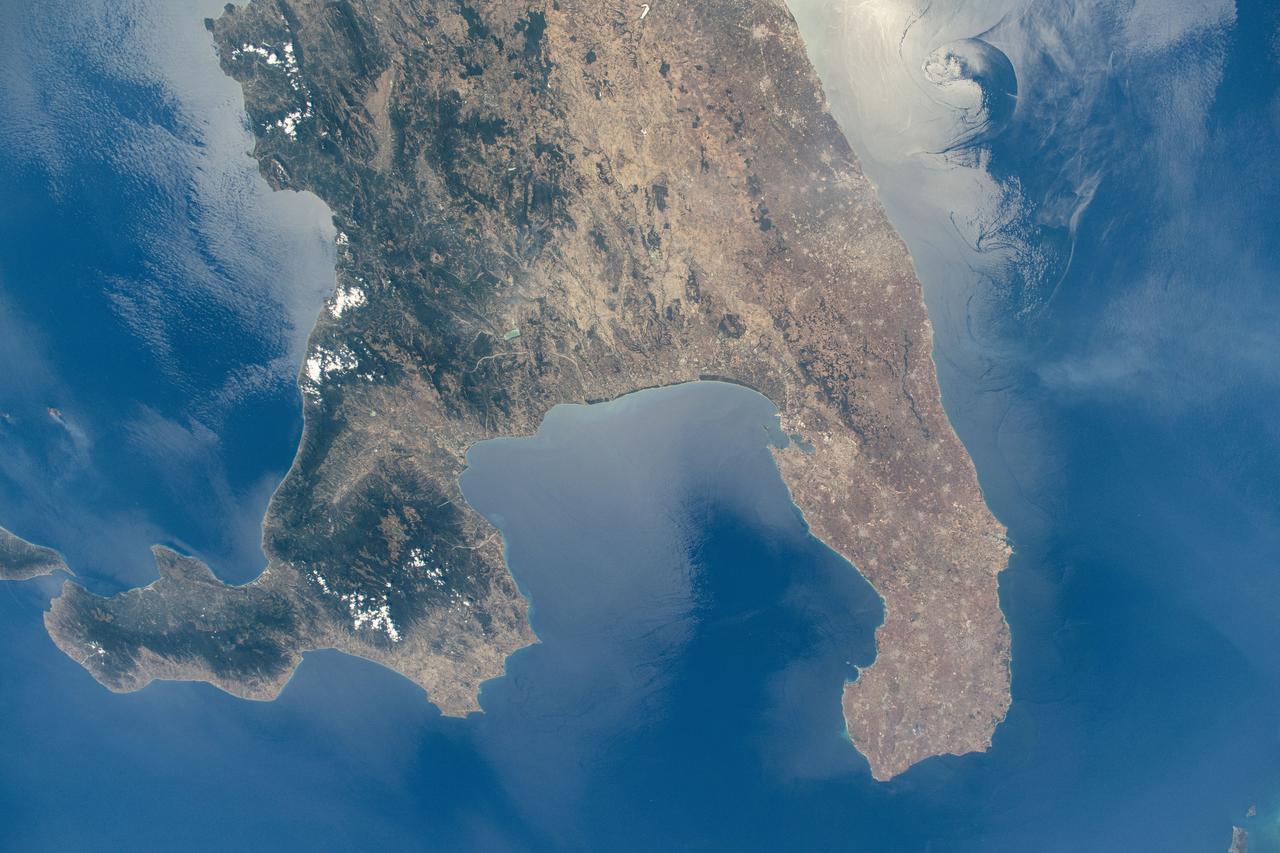
ISS002-E-5182 (March 2001) --- Part of the "toe" of Italy and Sicily are visible in this Expedition Two digital still camera's image.
The summit of the Mount Etna volcano on the island of Sicily, Italy, one of the most active volcanoes in the world, is shown near the center of this radar image. Lava flows of different ages and surface roughness appear in shades of purple, green, yellow and pink surrounding the four small craters at the summit. Etna is one of the best-studied volcanoes in the world and scientists are using this radar image to identify and distinguish a variety of volcanic features. Etna has erupted hundreds of times in recorded history, with the most recent significant eruption in 1991-1993. Scientists are studying Etna as part of the international "Decade Volcanoes" project, because of its high level of activity and potential threat to local populations. This image was acquired on October 11, 1994 by the Spaceborne Imaging Radar-C/X-Band Synthetic Aperture Radar (SIR-C/X-SAR) aboard the space shuttle Endeavour. SIR-C/X-SAR, a joint mission of the German, Italian and the United States space agencies, is part of NASA's Mission to Planet Earth. The image is centered at 37.8 degrees North latitude and 15.1 degrees East longitude and covers an area of 51.2 kilometers by 22.6 kilometers (31.7 miles by 14.0 miles). http://photojournal.jpl.nasa.gov/catalog/PIA01776
SL3-86-272 (July-September 1973) --- A near vertical view of northeastern Italy including the Venice (Venezia) area is seen in this Skylab 3 Earth Resources Experiments Package S190-B (five-inch earth terrain camera) infrared photograph taken from the Skylab space station in Earth orbit. The mountainous area is the Dolomite Alps. The most conspicuous stream northeast of Venice is the Piave River. The city near the center of the picture on the Brenta River is Bassano del Grappa. The large city of Padua (Padova) is on the western bank of the Grenta near the clock. Photo credit: NASA

iss074e0079747 (Dec. 26, 2025) --- The city lights of Italy sparkle from Naples to Genoa along the western coast and from Bari to Venice along the eastern coast in this photograph taken at approximately 12:53 a.m. local time from the International Space Station as it orbited 262 miles above the Mediterranean Sea. Credit: JAXA/Kimiya Yui
iss073e1047143 (Nov. 2, 2025) --- The city lights of Bari, Italy, and its surrounding suburbs dot the nation's Adriatic Sea coast in this photograph taken from the International Space Station at approximately 10:13 p.m. local time as it orbited 260 miles above the Mediterranean Sea. Founded around 2,700 years ago, Bari is known for its olive groves, vineyards, spectacular caves, and rugged coastal cliffs.
iss072e904970 (March 22, 2025) --- The boot of Italy well-defined by the nation's city lights stands in contrast to the Tyrrhenian Sea (left) and the Adriatic Sea (right) with the Balkans at far right underneath an atmospheric glow blanketing Earth's horizon. The International Space Station was orbiting 262 miles above southern Europe at 10:57 p.m. local time when this photograph was taken.
iss073e1047080 (Nov. 2, 2025) --- Palermo, Italy—a 2,700-year-old city on the Sicilian coast of the Tyrrhenian Sea—is pictured at approximately 10:12 p.m. local time from the International Space Station as it orbited 260 miles above the Mediterranean Sea. The city’s lights reveal a transition from older, amber-hued sodium-vapor lamps in the historic center to cooler, white LED lighting in the surrounding suburbs.
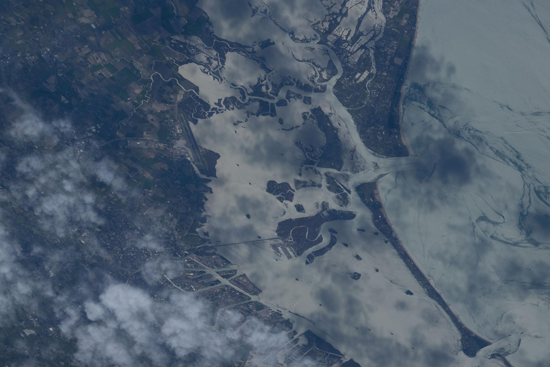
iss074e0437657 (April 4, 2026) --- Venice, Italy, a 1,600‑year‑old city with a metropolitan population of about 640,000, is pictured from the International Space Station as it orbited 267 miles above Central Europe. Built on more than 100 small islands and connected by over 400 bridges, Venice sits within a lagoon of the Adriatic Sea. Credit: NASA/Chris Williams
Italy's Mount Etna and the Aeolian Islands are the focus of this perspective view made from an Advanced Spaceborne Thermal and Emission Radiometer (ASTER) image from NASA's Terra spacecraft overlaid on Shuttle Radar Topography Mission (SRTM) topography. The image is looking south with the islands of Lipari and Vulcano in the foreground and Etna with its dark lava flows on the skyline. Vulcano also hosts an active volcano, the cone of which is prominent. In late October 2002, Etna erupted again, sending lava flows down the north and south sides of the volcano. The north flows are near the center of this view, but the ASTER image is from before the eruption. In addition to the terrestrial applications of these data for understanding active volcanoes and hazards associated with them such as lava flows and explosive eruptions, geologists studying Mars find these data useful as an analog to martian landforms and geologic processes. In late September 2002, a field conference with the theme of Terrestrial Analogs to Mars focused on Mount Etna allowing Mars geologists to see in person the types of features they can only sample remotely. http://photojournal.jpl.nasa.gov/catalog/PIA03370
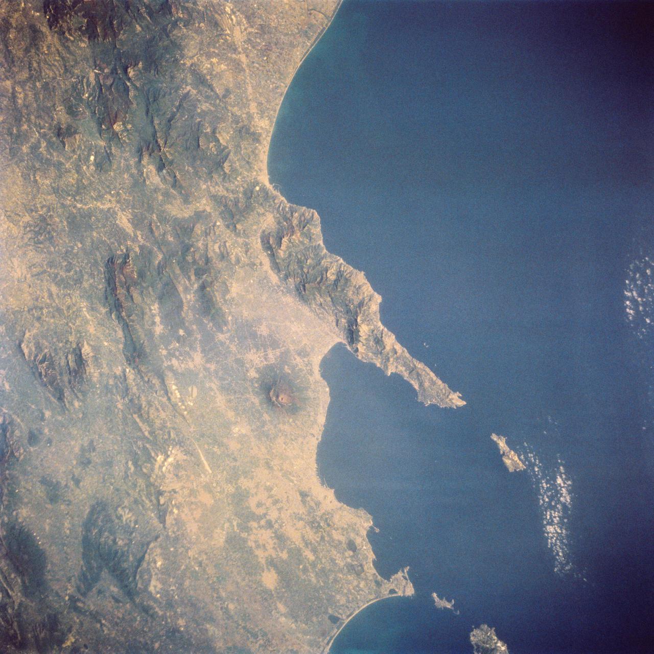
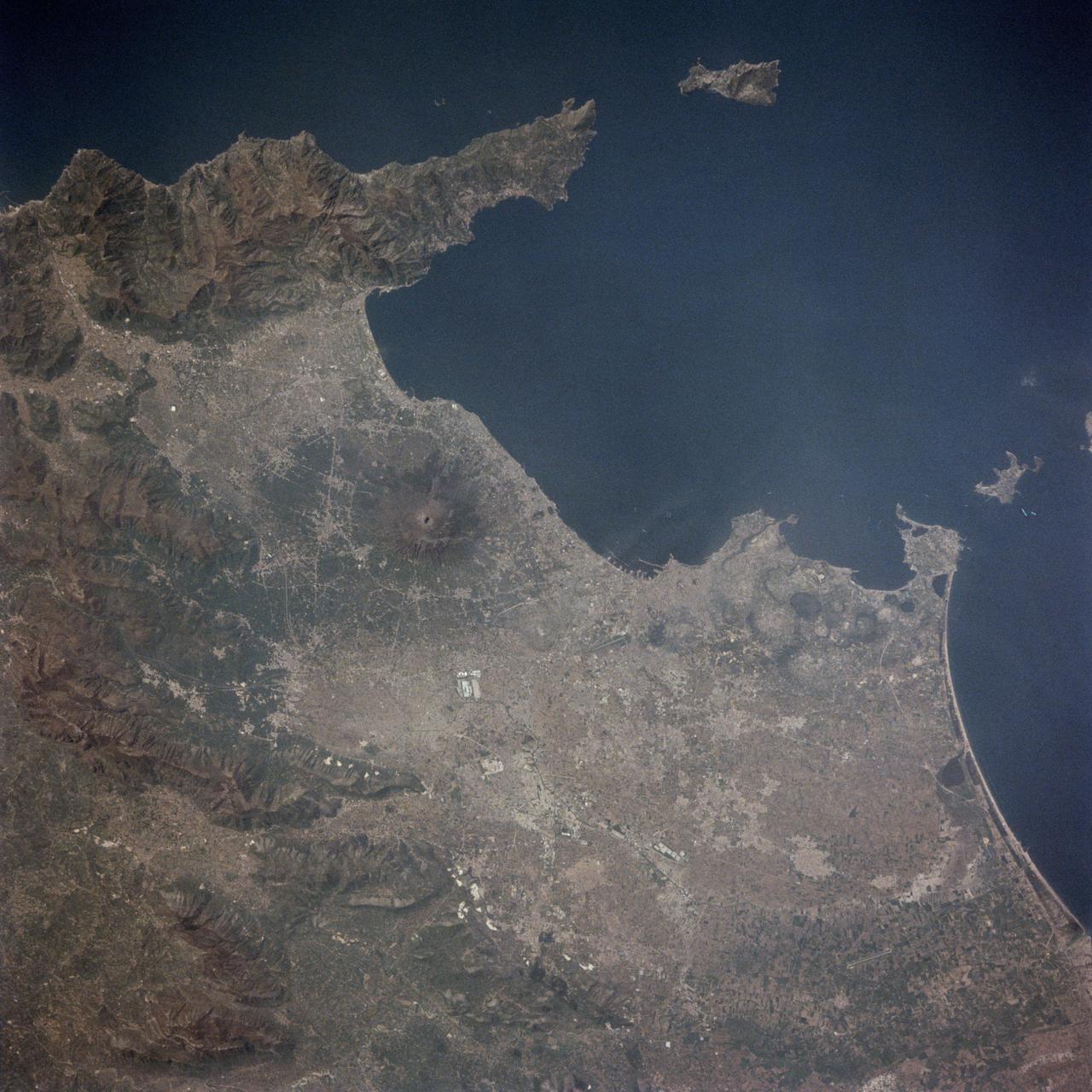
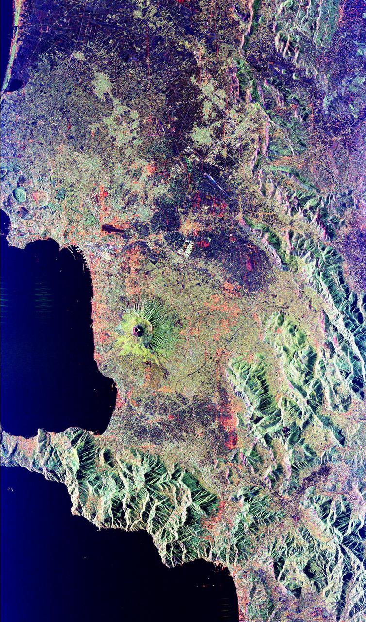
STS058-73-024 (18 Oct-1 Nov 1993) --- The ancient eruption of Vesuvius (the volcano near the center of the frame) destroyed the town of Pompeii located on its southeast flank. But the larger town of Naples, between Vesuvius (to the south) and the large, circular, lake-filled caldera of Campi Flegrei (to the west) also lives with the constant threat of volcanic hazards. In this view, Naples is the gray urban area with substantial coastal development just northwest of Vesuvius. Other landmarks marking the Italian coast include the small island of Capri, just off the west-pointing peninsula, and the city of Salerno on the coast just south of the same peninsula.

Members of the crew of STS-125, from left, Mission Specialists Andrew Feustel, Michael Good, Commander Scott Altman and Mission Specialist John Grunsfeld share a laugh with about the STS-125 mission to the Hubble Space Telescope during a visit by the crew to the Embassy of Italy in Washington, Thursday, July 23, 2009. Photo Credit: (NASA/Bill Ingalls)
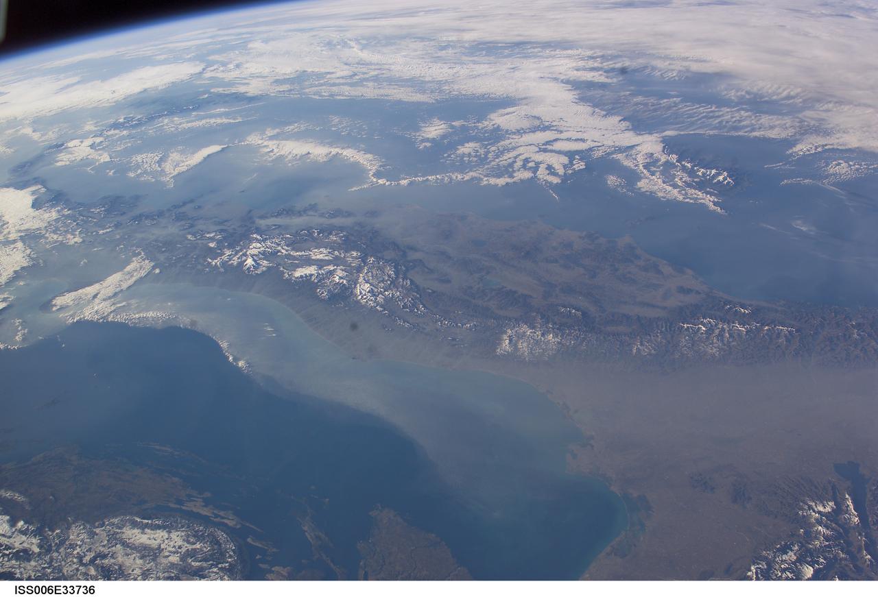
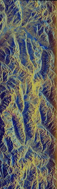
ISS006-E-33736 (25 February 2003) --- The boot of Italy crosses the image in this southwest-looking view taken by an Expedition Six crewmember onboard the International Space Station (ISS). The spine of Italy is highlighted with snow and the largely cloud-covered Mediterranean Sea is at the top. The Adriatic Sea transverses most of the bottom of the image and Sicily appears top left beyond the toe of the boot. The heel lies out of the left side of the image. Corsica and Sardinia appear right of center partly under cloud. The floor of the Po River valley, lower right, is obscured by haze. Experience gained from similar haze events, in which atmospheric pressure, humidity and visibility and atmospheric chemistry were known, suggests that the haze as industrial smog. Industrial haze from the urban region of the central and upper Po valley accumulates to visible concentrations under conditions of high atmospheric pressure and the surrounding mountains prevent easy dispersal. This view illustrates the markedly different color and texture of cloud versus industrial aerosol haze.

iss073e0254866 (June 5, 2025) --- The sun's glint beams off the Adriatic Sea contrasting with the "boot" of Italy in this photograph from the International Space Station as it orbited 261 miles above Southern Europe. In the right foreground, is the Soyuz MS-27 crew ship docked to the orbital outpost's Prichal module.

iss073e0698372 (Sept. 13, 2025) --- The boot of Italy, with the island of Sicily at its "toe," glitters in contrast to the surrounding dark blue seas of southern Europe. The International Space Station was orbiting 262 miles above the Mediterranean Sea when this photograph was taken at approximately 1:43 a.m. local time.
At the Thales Alenia Space facility in Turin, Italy, technicians prepare Gateway’s HALO (Habitation and Logistics Outpost) for transport. The module’s primary structure, fabricated by Thales Alenia Space, will travel to Northrop Grumman’s facility in Gilbert, Arizona, for final outfitting ahead of its launch to lunar orbit.
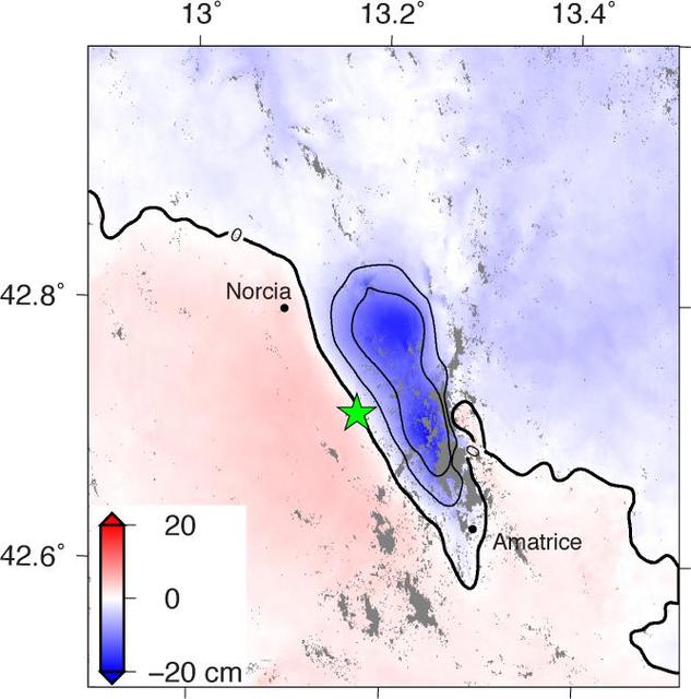
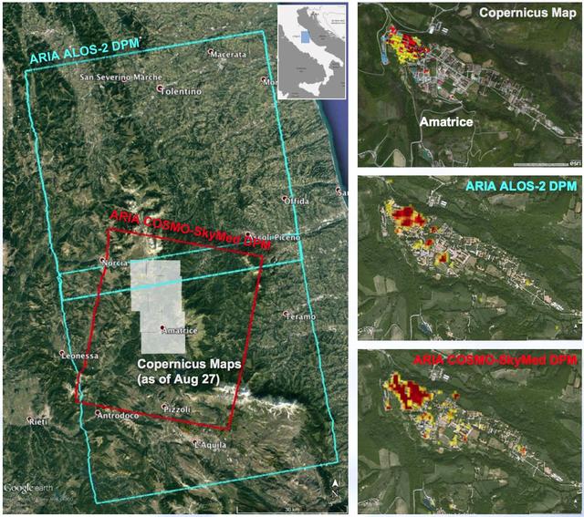
Amatrice earthquake in central Italy, which caused widespread building damage to several towns throughout the region. This earthquake was the strongest in that area since the 2009 earthquake that destroyed the city of L'Aquila. The Advanced Rapid Imaging and Analysis (ARIA) data system, a collaborative project between NASA's Jet Propulsion Laboratory, Pasadena, California, and the California Institute of Technology in Pasadena, automatically generated interferometric synthetic aperture radar images from the Copernicus Sentinel 1A satellite operated by the European Space Agency (ESA) for the European Commission to calculate a map of the deformation of Earth's surface caused by the quake. This false-color map shows the amount of permanent surface movement, as viewed by the satellite, during a 12-day interval between two Sentinel 1 images acquired on Aug. 15, 2016, and Aug. 27, 2016. The movement was caused almost entirely by the earthquake. In this map, the colors of the surface displacements are proportional to the surface motion. The red and pink tones show the areas where the land moved toward the satellite by up to 2 inches (5 centimeters). The area with various shades of blue moved away from the satellite, mostly downward, by as much as 8 inches (20 centimeters). Contours on the surface motion are 2 inches (5 centimeters) The green star shows the epicenter where the earthquake started as located by the U.S. Geological Survey National Earthquake Information Center. Black dots show town locations. Scientists use these maps to build detailed models of the fault slip at depth and associated land movements to better understand the impact on future earthquake activity. The map shows the fault or faults that moved in the earthquake is about 14 miles (22 kilometers) long between Amatrice and Norcia and slopes to the west beneath the area that moved downward. http://photojournal.jpl.nasa.gov/catalog/PIA20896
SL3-121-2438 (July-September 1973) --- The Alps of Switzerland, France and Italy are featured in this exceptional photograph taken by a hand-held camera from the Skylab space station during the second manned Skylab mission. Also visible in the out-the-window 70mm Hasselblad view are Lake Geneva, Lake of Lucerne, Rhone River and many other features. The Skylab 3 crewmen, astronauts Alan L. Bean, Owen K. Garriott and Jack R. Lousma completed a 59-day mission with a successful splashdown on Sept. 25, 1973. Photo credit: NASA

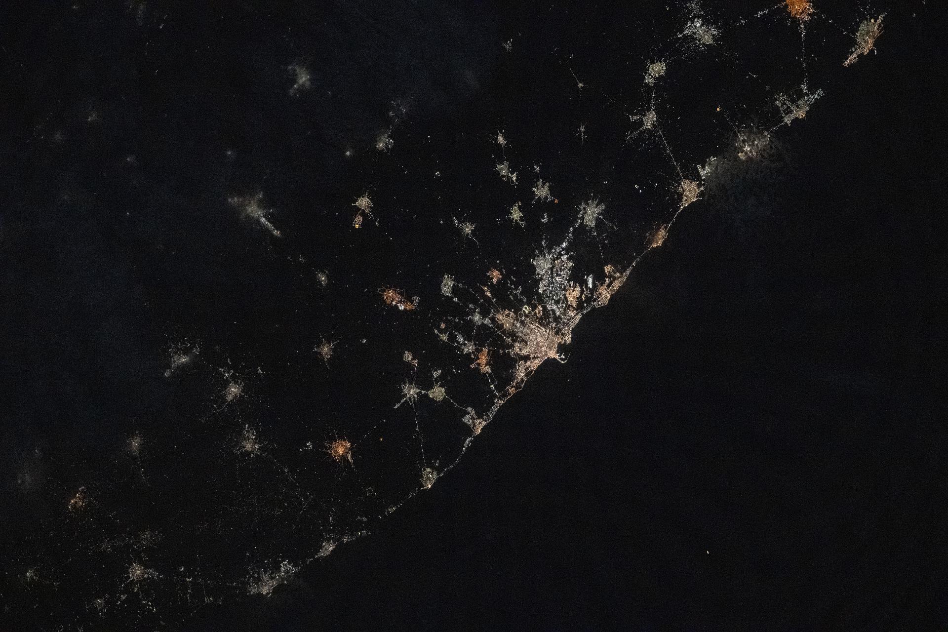
iss073e0705168 (Sept. 18, 2025) --- A faint blue-green airglow blankets Earth’s horizon as city lights define northern Italy's luminous urban corridor (center) from Turin, to Milan, and Venice. At upper right, Rome is visible along the Tyrrhenian coastline. The International Space Station was orbiting 262 miles above Southern Europe when this image was captured at approximately 11:14 p.m. local time.
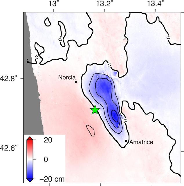
NASA and its partners are contributing observations and expertise to the ongoing response to the Aug. 23, 2016, magnitude 6.2 Amatrice earthquake in central Italy caused widespread building damage to several towns throughout the region. This earthquake was the strongest in that area since the 2009 earthquake that destroyed the city of L'Aquila. Scientists with the Advanced Rapid Imaging and Analysis project (ARIA), a collaboration between NASA's Jet Propulsion Laboratory, Pasadena, California, and the California Institute of Technology in Pasadena, analyzed interferometric synthetic aperture radar images from the PALSAR-2 instrument on the ALOS-2 satellite operated by the Japan Aerospace Exploration Agency (JAXA) to calculate a map of the deformation of Earth's surface caused by the quake. This false-color map shows the amount of permanent surface movement, as viewed by the satellite, during a seven-month interval between two ALOS-2 images acquired on Sept. 9, 2015 and Aug. 24, 2016. The movement was caused almost entirely by the earthquake. In this map, the colors of the surface displacements are proportional to the surface motion. The red and pink tones show the areas where the land moved toward the satellite by up to 2 inches (5 centimeters). The area with various shades of blue moved away from the satellite, mostly downward, by as much as 8 inches (20 centimeters). Contours on the surface motion are 2 inches (5 centimeters) The green star shows the epicenter where the earthquake started as located by the U.S. Geological Survey National Earthquake Information Center. Black dots show town locations. Scientists use these maps to build detailed models of the fault slip at depth and associated land movements to better understand the impact on future earthquake activity. The map shows the fault or faults that moved in the earthquake is about 14 miles (22 kilometers) long between Amatrice and Norcia and slopes to the west beneath the area that moved downward. The PALSAR-2 data were provided by JAXA through a science project. http://photojournal.jpl.nasa.gov/catalog/PIA20893
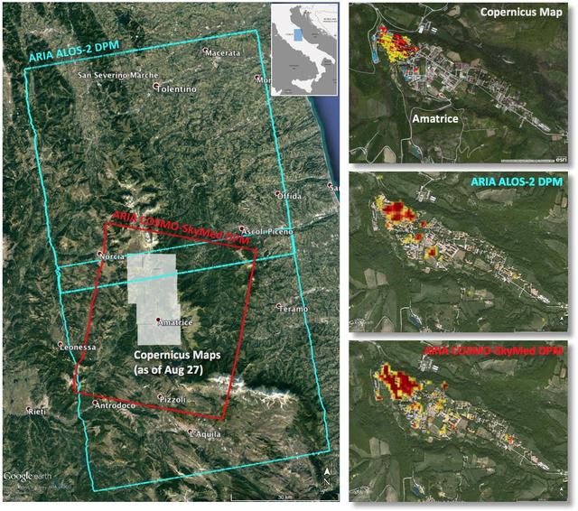
Italy earthquake. The quake has caused significant damage in the historic town of Amatrice. To assist in the disaster response efforts, scientists at NASA's Jet Propulsion Laboratory, Pasadena, California, and the California Institute of Technology in Pasadena, in collaboration with the Italian Space Agency (ASI), generated this image of the earthquake's hardest-hit region. The 40-by-75 mile (65-by-120 kilometer) Damage Proxy Map (DPM) was derived from two consecutive frames of the Japan Aerospace Exploration Agency's (JAXA's) L-band interferometric synthetic aperture radar (InSAR) data from the ALOS-2 satellite (cyan rectangles), and the 25-by-31 mile (40-by-50 kilometer) DPM was derived from InSAR data from the Agenzia Spaciale Italiana's (ASI's) X-band COSMO-SkyMed satellite (red rectangle). Both DPMs cover the historic town of Amatrice, revealing severe damage in the western side of the town (right panels). The time span of the data for the change is Jan. 27, 2016 to Aug. 24, 2016 for ALOS-2 and Aug. 20, 2016 to Aug. 28, 2016 for COSMO-SkyMed. Each pixel in the damage proxy map is about 100 feet (30 meters) across. The SAR data were processed by the Advanced Rapid Imaging and Analysis (ARIA) team at JPL and Caltech. The technique uses a prototype algorithm to rapidly detect surface changes caused by natural or human-produced damage. The assessment technique is most sensitive to destruction of the built environment. When the radar images areas with little to no destruction, its image pixels are transparent. Increased opacity of the radar image pixels reflects damage, with areas in red reflecting the heaviest damage to cities and towns. The color variations from yellow to red indicate increasingly more significant ground surface change. Preliminary validation was done by comparing the DPMs to a damage assessment map produced by the Copernicus Emergency Management Service, which is based on visual inspection of before and after high-resolution aerial imagery -- the extent indicated with gray boxes in the left panel. http://photojournal.jpl.nasa.gov/catalog/PIA20897
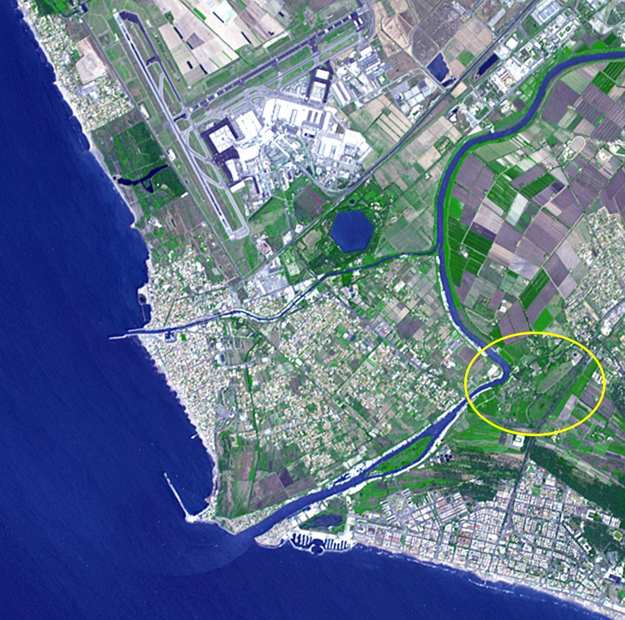
Thirty kilometers southwest of Rome lies what may be ancient Rome's greatest engineering achievement: Portus. Built in the first century A.D., Portus was Rome's principal maritime harbor, replacing the port city of Ostia on the Tiber River (circled area) that had become inadequate to handle the hundreds of ships loaded with food stuffs to feed Rome's 1 million+ inhabitants. The hexagonal Trajanic Basin and the outer Claudian Basin (now silted up) formed a port complex without equal. In 2000 years, the coastline has moved seaward, and the Trajanic Basin is now a private lake. The image was acquired June 29, 2014, covers an area of 10 by 10 km, and is located at 41.7 degrees north, 12.3 degrees east. http://photojournal.jpl.nasa.gov/catalog/PIA19209
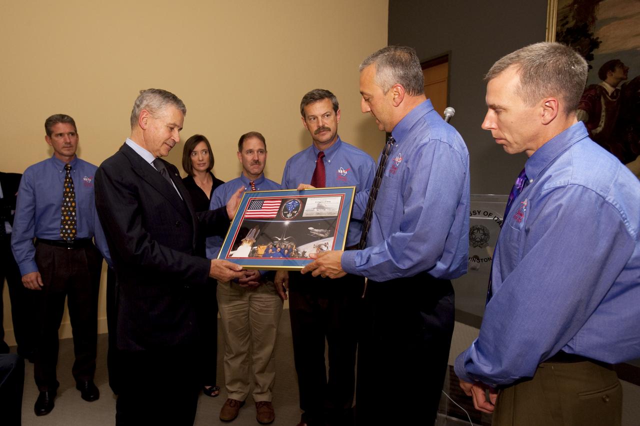
Italian Ambassador Giovanni Castellaneta, second from left, is presented with a montage by STS-125 Mission Specialist Mike Massimino, second from right, during a visit by the crew of STS-125 to the Embassy of Italy in Washington, Thursday, July 23, 2009. Other crew members, from left are Mission Specialists, Michael Good, Megan McArthur, John Grunsfeld, Commander Scott Altman and Andrew Feustel, far right. Photo Credit: (NASA/Bill Ingalls)
A NASA-funded program provided valuable information for responders and groups supporting the recovery efforts for the Aug. 24, 2016, magnitude 6.2 earthquake that struck central Italy. The earthquake caused significant loss of life and property damage in the town of Amatrice. To assist in the disaster response efforts, scientists at NASA's Jet Propulsion Laboratory and Caltech, both in Pasadena, California, obtained and used radar imagery of the earthquake's hardest-hit region to discriminate areas of damage from that event. The views indicate the extent of damage caused by the earthquake and subsequent aftershocks in and around Amatrice, based on changes to the ground surface detected by radar. The color variations from yellow to red indicate increasingly more significant ground surface change. The damage maps were created from data obtained before and after the earthquake by satellites belonging to the Italian Space Agency (ASI) and the Japan Aerospace Exploration Agency (JAXA). The radar-derived damage maps compare well with a damage map produced by the European Commission Copernicus Emergency Management Service based upon visual inspection of high-resolution pre-earthquake aerial photographs and post-earthquake satellite optical imagery, and provide broader geographic coverage of the earthquake's impact in the region. The X-band COSMO-SkyMed (CSK) data were provided through a research collaboration with ASI and were acquired on July 3, August 20, and August 28, 2016. The L-band ALOS/PALSAR-2 data were provided by JAXA through its science research program and were acquired on September 9, 2015, January 27, 2016, and August 24, 2016. The radar data were processed by the Advanced Rapid Imaging and Analysis (ARIA) team at JPL and Caltech. ARIA is a NASA-funded project that is building an automated system for demonstrating the ability to rapidly and reliably provide GPS and satellite data to support the local, national and international hazard monitoring and response communities. Using space-based imagery of disasters, ARIA data products can provide rapid assessments of the geographic region impacted by a disaster, as well as detailed imaging of the locations where damage occurred. Radar can "see" through clouds day and night and measure centimeter-level ground movements. NASA is partnering with the Indian Space Research Organization (ISRO) to develop the NASA ISRO Synthetic Aperture Radar (NISAR) mission that will routinely provide systematic SAR observations of Earth's land and ice-covered surfaces at least twice every 12 days, enabling greater scientific understanding of the dynamic processes that drive the Earth system and natural hazards, as well as providing actionable support for disaster response and recovery. http://photojournal.jpl.nasa.gov/catalog/PIA21091
This image is a false-color composite of Oetzal, Austria located in the Central Alps centered at 46.8 degrees north latitude, 10.70 degrees east longitude, at the border between Switzerland top, Italy left and Austria right and bottom.
GMT354_18_35_Terry Virts_sahara italy wide_123

GMT354_18_35_Terry Virts_sahara italy wide_123

GMT353_22_10_Terry Virts_Senegal Algiers Italy UNESCO_123

GMT353_22_10_Terry Virts_Senegal Algiers Italy UNESCO_123
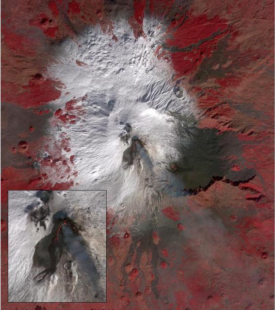
Starting December 13, 2020, a strong eruptive episode began at Mt. Etna's New SE summit crater. Lava fountains produced a new lava flow, traveling to the SW. The fresh lava is hot enough to be incandescent, and appears as a red "snake" issuing from the crater's flank. The lava fountain appears as a separate red area at the crater's summit. A faint gray plume streams southeastward from the crater. Analysis of the thermal infrared data reveals that the plume's composition is dominated by SO2. The image was acquired December 15, 2020, covers an area of 12 by 13.5 km, and is located at 37.7 degrees north, 15 degrees east. https://photojournal.jpl.nasa.gov/catalog/PIA24283
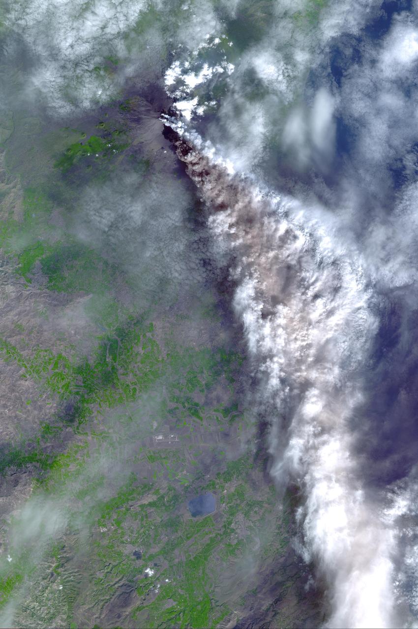
On Sunday, November 3, 2002, Mt. Etna's ash-laden plume was imaged by the Advanced Spaceborne Thermal Emission and Reflection Radiometer (ASTER) on NASA's Terra satellite. The plume is seen blowing toward the south-southeast, over the city and airport of Catania, Sicily. The previous day, the plume was blowing toward the northwest, and posed no hazard to Catania. The current eruption of Mt. Etna, Europe's most active volcano, began on October 27. These sorts of observations from space may help civil defense authorities mitigate hazards from active eruptions. Space data may also help scientists evaluate the behavior and effects volcanic eruptions have on our global climate system. http://photojournal.jpl.nasa.gov/catalog/PIA03881

S92-30926 (12 March 1992) --- Astronaut Franco Malerba, STS-46 Italian Payload Specialist.
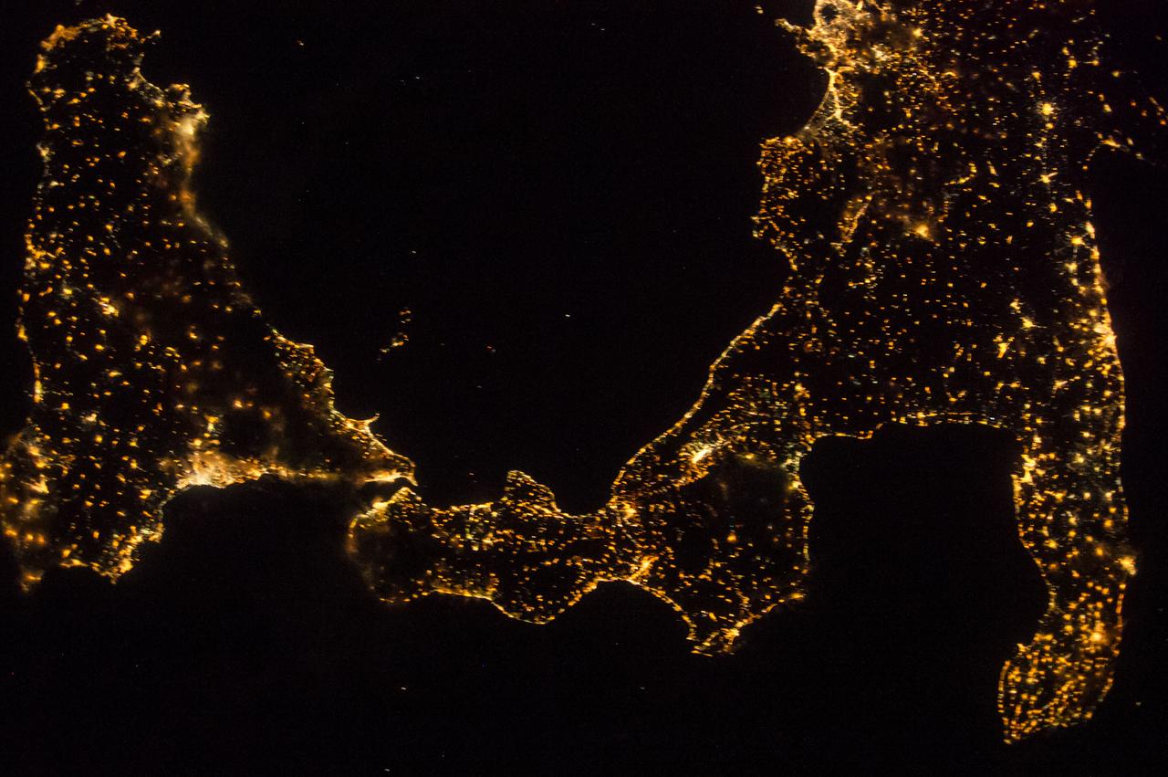
ISS041-E-045376 (27 Sept. 2014) --- One of the Expedition 41 crew members aboard the International Space Station, flying 221 nautical miles above Earth, recorded this night view over southern Italy on Sept. 27, 2014. South is at the bottom of the picture. Italy's "boot" (right) and Sicily are featured in the 28mm image.
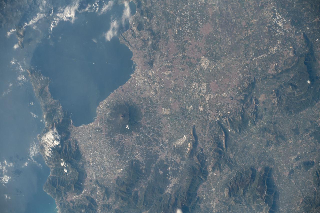
iss061e006435 (Oct. 15, 2019) --- Mount Vesuvius rests in between the Italian cities of Naples and Pompei on the southwest coast of Italy with three million people living in the region. The International Space Station was orbiting 255 miles above the Tyrrhenian Sea between Italy and its island of Sardegna when an Expedition 61 crewmember took this photograph.

ISS040-E-092470 (13 Aug. 2014) --- One of the Expedition 40 crew members aboard the International Space Station, flying 225 nautical miles above Earth, recorded this image over southern Italy on Aug. 13, 2014. South is on the left side of the picture. Italy's "boot" and Sicily are featured in the 28mm image.
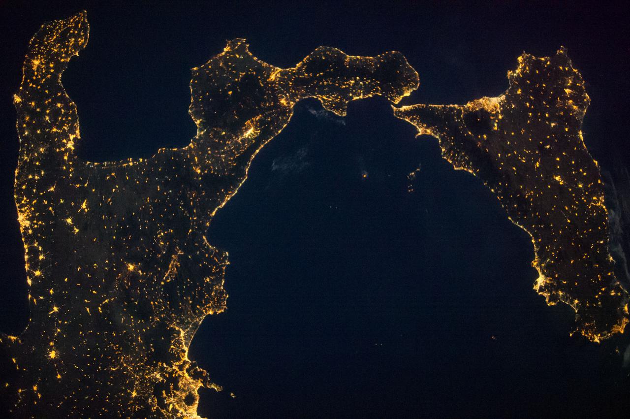
ISS040-E-090718 (9 Aug. 2014) --- One of the Expedition 40 crew members aboard the International Space Station, flying 225 nautical miles above Earth, recorded this night view over southern Italy on Aug. 9, 2014. South is at the top of the picture. Italy's "boot" and Sicily are featured in the 28mm image.
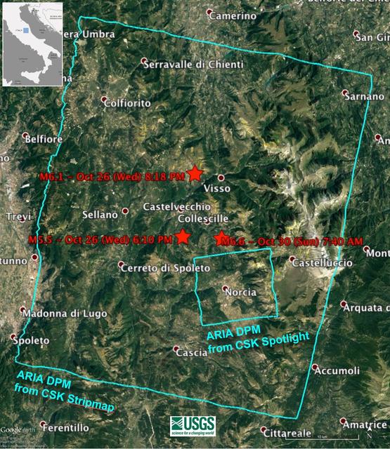
Damage Proxy Map (DPM) v0.5, derived from the Italian Space Agency's COSMO-SkyMed Spotlight synthetic aperture radar (SAR) data acquired from an ascending orbit, covering an area of 6.2-by-6.2 miles (10-by-10 kilometers), centered at Norcia, Italy. Red pixels (pixel size about 16 feet, or 5 meters)represent areas of potential damage due to the Magnitude 6.6 Oct 30, 2016, Central Italy earthquakes, as well as ground surface change during the time period Oct. 30, 2016 -- Oct. 31, 2016. The color variation from yellow to red indicate increasingly more significant ground surface change. Preliminary validation was carried out by comparing with high-resolution pre- and post-event optical imagery acquired by DigitalGlobe's WorldView satellites, and a damage map produced by the European Commission Copernicus Emergency Management Service based upon visual inspection of high-resolution pre- (Orthophoto) and post-event (Pleiades-1) optical imagery. This DPM provides broad geographic coverage of the earthquake's impact in the region. Areas that fall in radar shadow and layover were masked out. The DPM should be used as guidance to identify damaged areas, and may be less reliable over vegetated areas. http://photojournal.jpl.nasa.gov/catalog/PIA15374
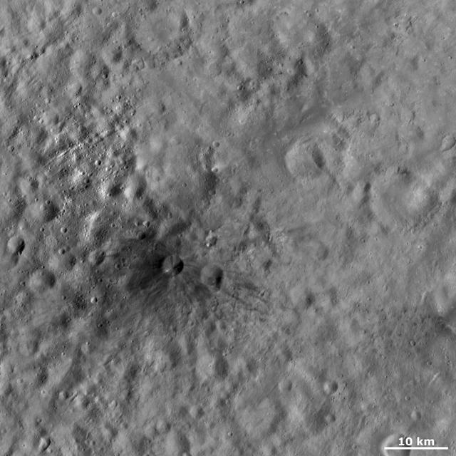
This image from NASA Dawn spacecraft shows Aricia Tholus, a dark hill located in asteroid Vesta Marcia quadrangle. Tholus is a word used to describe a small dome-like mountain or hill. Aricia was the name of a city in ancient Italy.
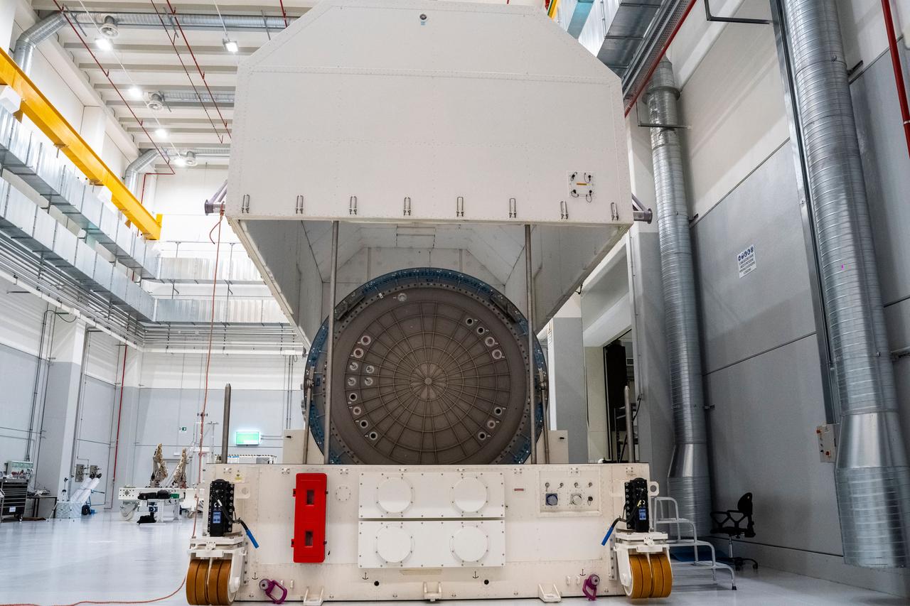
jsc2024e055349 (July 9, 2024) -- Gateway’s Habitation and Logistics Outpost stands vertically inside a Thales Alenia Space facility in Turin, Italy, after completing static load testing. With this phase of stress testing complete, the module is one step closer to final outfitting ahead of launch to lunar orbit.
Mt. Etna, Sicily, Italy, is Europe most active volcano. In mid-May 2016, Mt. Etna put on a display of lava fountaining, ash clouds and lava flows. Three of the four summit craters were active. NASA Terra spacecraft acquired this image on May 26, 2016.
jsc2024e055348 (July 9, 2024) -- Gateway’s Habitation and Logistics Outpost stands vertically inside a Thales Alenia Space facility in Turin, Italy, after completing static load testing. With this phase of stress testing complete, the module is one step closer to final outfitting ahead of launch to lunar orbit.

Northrop Grumman and subcontractor Thales Alenia Space complete fabrication work on the Habitation and Logistics Outpost (HALO) module, one of two of the Gateway Space Station's habitation elements where astronauts will live and work in lunar orbit during deep space Artemis missions.

Northrop Grumman and subcontractor Thales Alenia Space complete fabrication work on the Habitation and Logistics Outpost (HALO) module, one of two of the Gateway Space Station's habitation elements where astronauts will live and work in lunar orbit during deep space Artemis missions.

Gateway's HALO (Habitation and Logistics Outpost) module is one of four of Gateway's pressurized modules where international teams of astronauts will live, conduct science, and prepare for missions to the lunar South Pole region from Gateway. HALO is provided by Northrop Grumman.
Mt. Vesuvius, one of the best known volcanoes in the world primarily for the eruption that buried the Roman city of Pompeii, is shown in the center of this radar image. The central cone of Vesuvius is the dark purple feature in the center of the volcano. This cone is surrounded on the northern and eastern sides by the old crater rim, called Mt. Somma. Recent lava flows are the pale yellow areas on the southern and western sides of the cone. Vesuvius is part of a large volcanic zone which includes the Phalagrean Fields, the cluster of craters seen along the left side of the image. The Bay of Naples, on the left side of the image, is separated from the Gulf of Salerno, in the lower left, by the Sorrento Peninsula. Dense urban settlement can be seen around the volcano. The city of Naples is above and to the left of Vesuvius; the seaport of the city can be seen in the top of the bay. Pompeii is located just below the volcano on this image. The rapid eruption in 79 A.D. buried the victims and buildings of Pompeii under several meters of debris and killed more than 2,000 people. Due to the violent eruptive style and proximity to populated areas, Vesuvius has been named by the international scientific community as one of fifteen Decade Volcanoes which are being intensively studied during the 1990s. The image is centered at 40.83 degrees North latitude, 14.53 degrees East longitude. It shows an area 100 kilometers by 55 kilometers (62 miles by 34 miles.) This image was acquired on April 15, 1994 by the Spaceborne Imaging Radar-C/X-Band Synthetic Aperture Radar (SIR-C/X-SAR) aboard the Space Shuttle Endeavour. SIR-C/X-SAR, a joint mission of the German, Italian and the United States space agencies, is part of NASA's Mission to Planet Earth. http://photojournal.jpl.nasa.gov/catalog/PIA01780

iss065e045974 (May 13, 2021) --- The night lights of Italy are prominent as the International Space Station soared 262 miles above southern Europe during an orbital twilight.
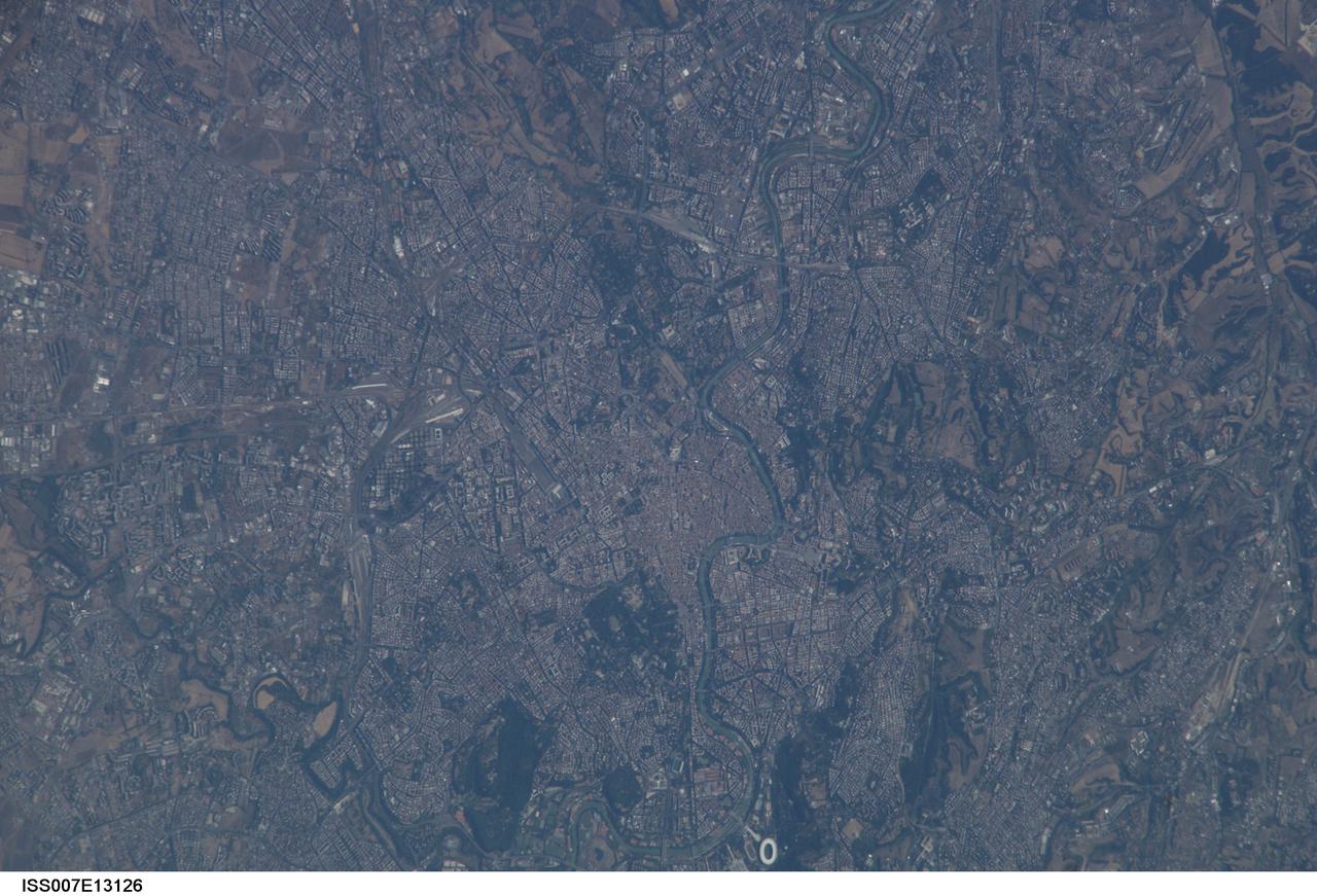
ISS007-E-13126 (21 August 2003) --- This view of Rome, Italy was taken by one of the Expedition 7 crewmembers onboard the International Space Station (ISS).

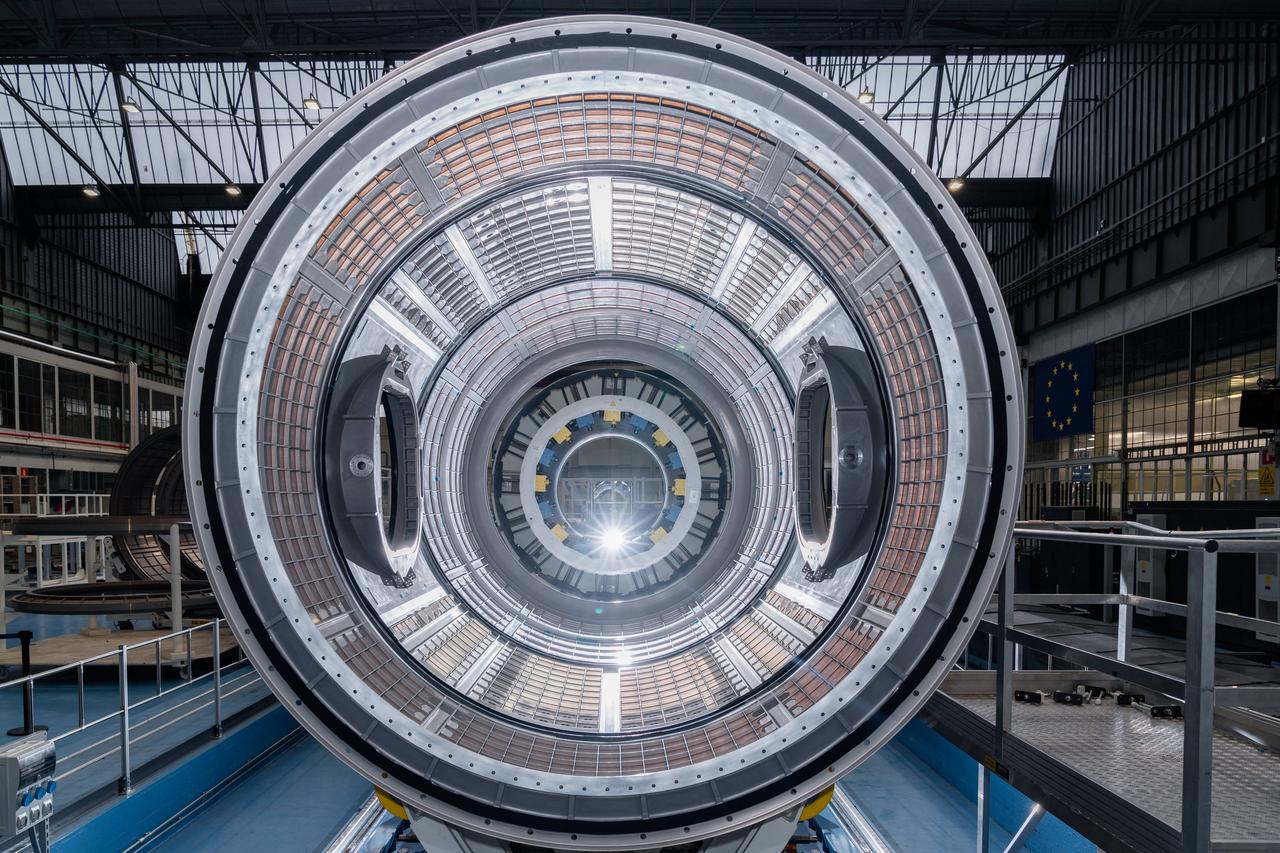
Photo Date: 11/14/2023 Location: Turin, Italy Subject: ESA International Habitat (I-HAB) Photo Credit: ESA/Stephane Corvaja
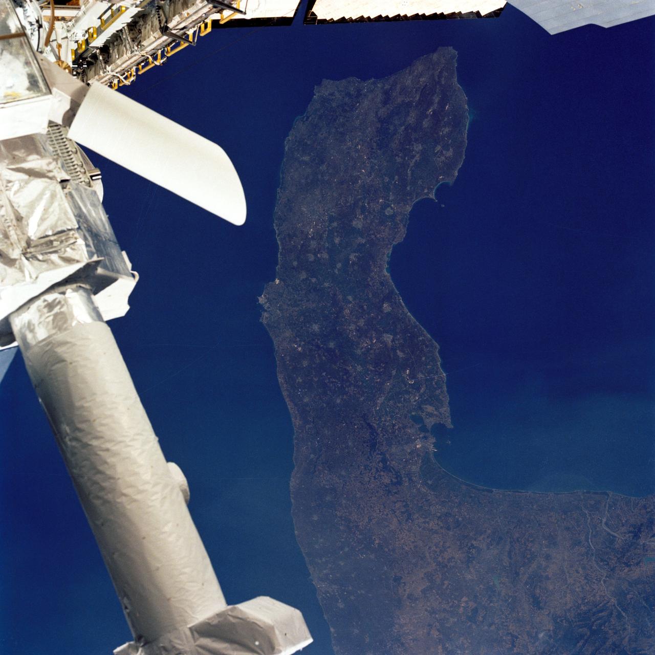
iss071e413856 (Aug. 1, 2024) -- The Italian Peninsula, or "the boot" of Italy is pictured from the International Space Station as it orbited nearly 260 miles above.

Photo Date: 11/14/2023 Location: Turin, Italy Subject: ESA International Habitat (I-HAB) Photo Credit: ESA/Stephane Corvaja

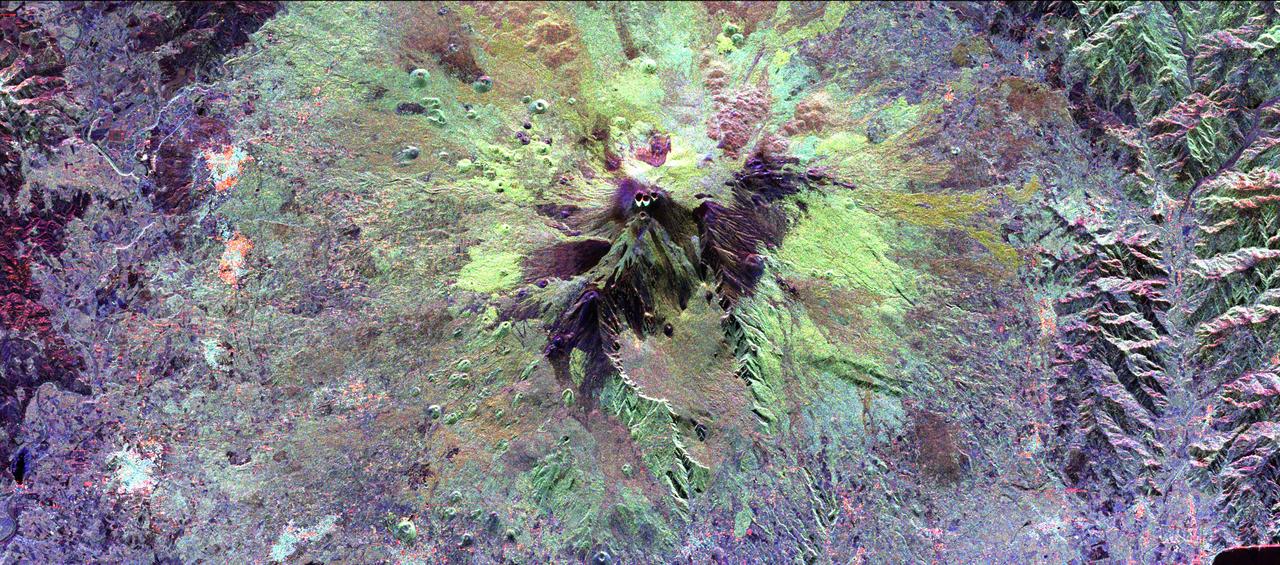
Earth Observation taken during a day pass by the Expedition 40 crew aboard the International Space Station (ISS). Folder lists this as: Italy, Mt. Etna.
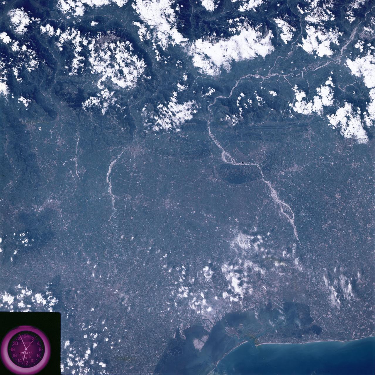
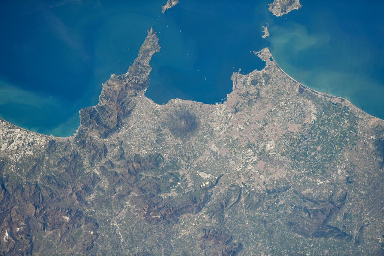
Earth Observation taken by the Expedition 40 crew aboard the International Space Station (ISS). Folder lists this as: Alps & Italy (Naples coast).

Gateway - HALO Static Test Complete. Location: Turin, Italy Date: July 9, 2024 Photo Credit: Thales Alenia Space
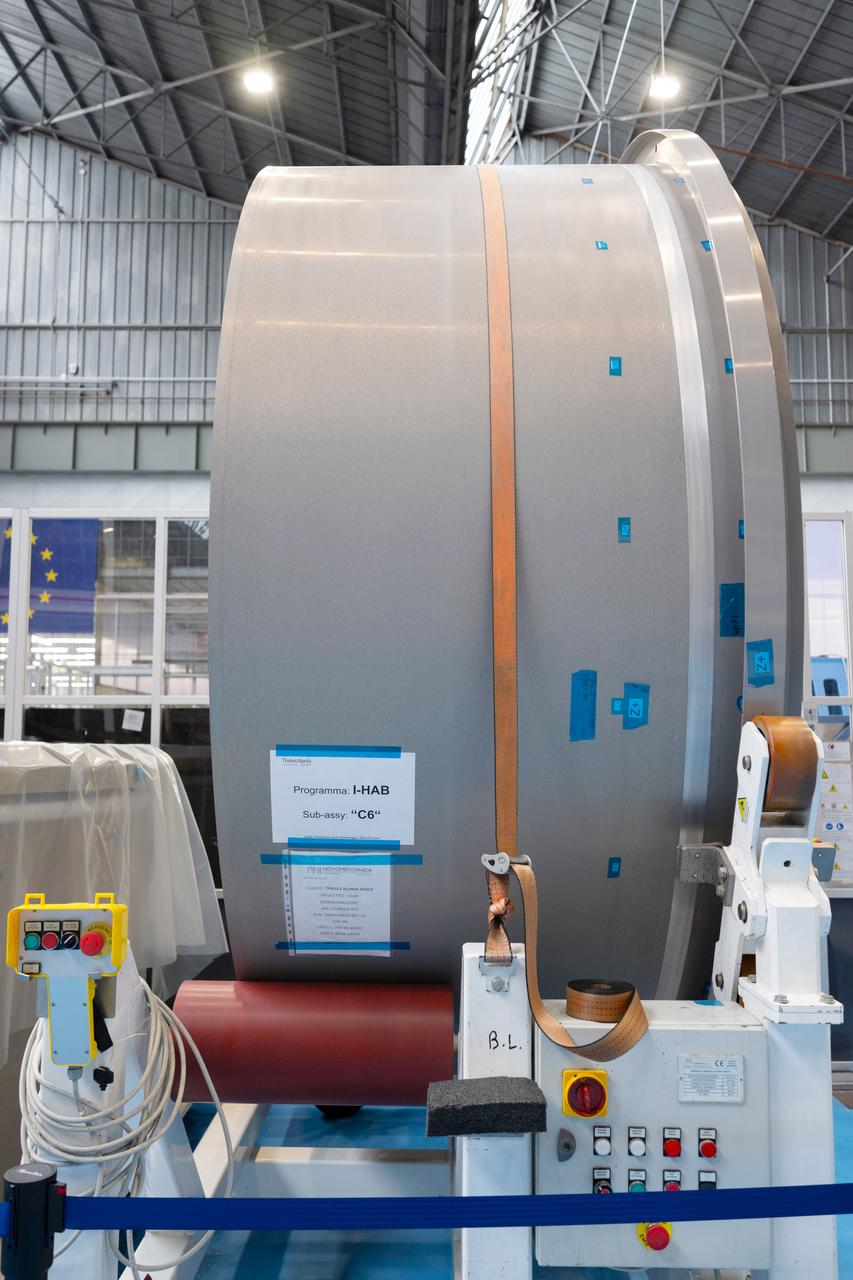
Photo Date: 11/14/2023 Location: Turin, Italy Subject: ESA International Habitat (I-HAB) Photo Credit: ESA/Stephane Corvaja

Photo Date: 11/14/2023 Location: Turin, Italy Subject: ESA International Habitat (I-HAB) Photo Credit: ESA/Stephane Corvaja
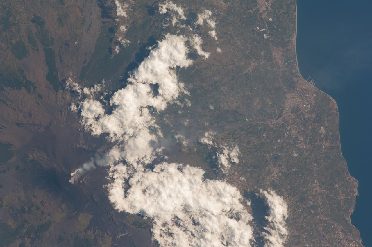
Earth Observation taken during a day pass by the Expedition 40 crew aboard the International Space Station (ISS). Folder lists this as: Italy, Mt. Etna.
iss067e010622 (April 12, 2022) --- Mount Vesuvius on the Gulf of Naples in Italy is pictured from the International Space Station as it orbited 260 miles above