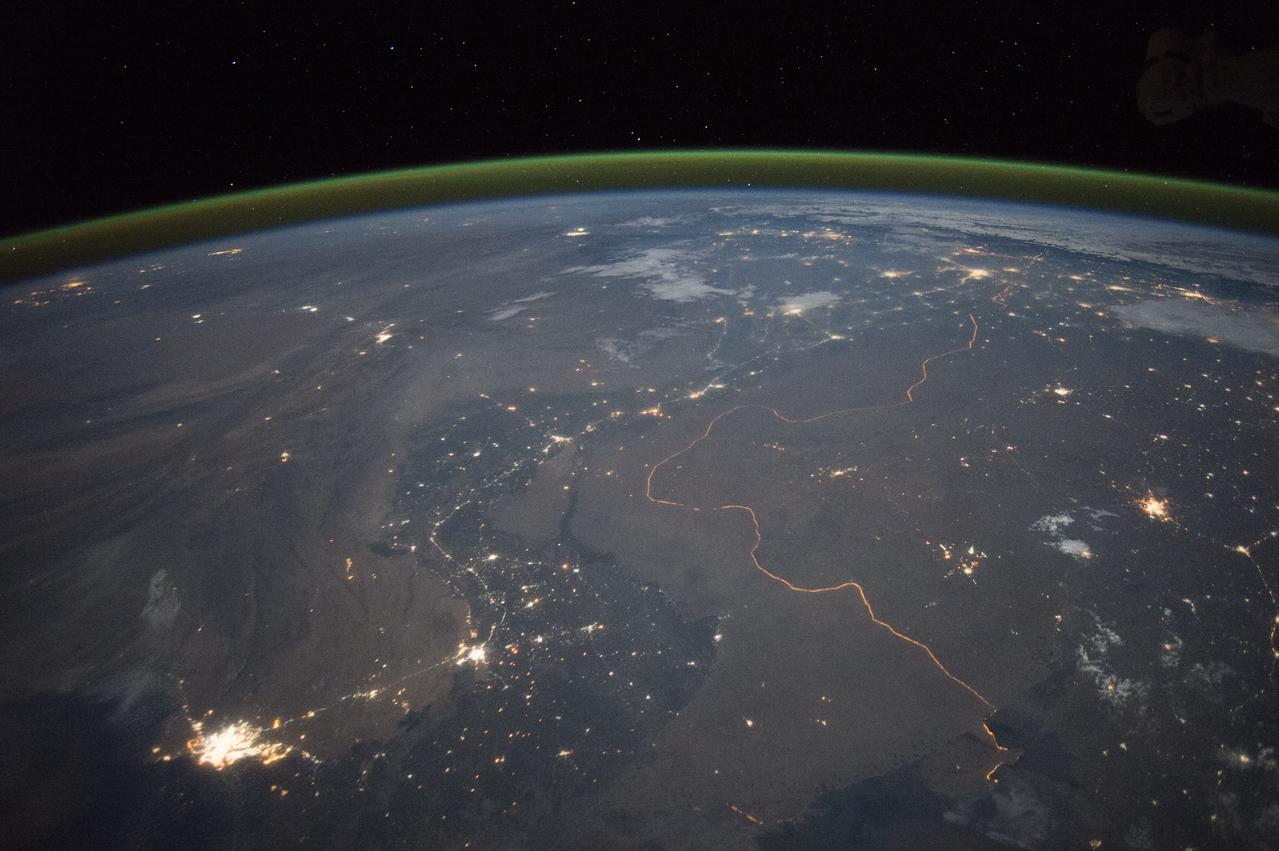
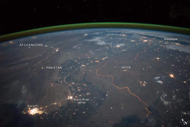
An astronaut aboard the International Space Station took this nighttime panorama while looking north across Pakistan’s Indus River valley. The port city of Karachi is the bright cluster of lights facing the Arabian Sea, which appears completely black. City lights and the dark color of dense agriculture closely track with the great curves of the Indus valley. For scale, the distance from Karachi to the foothills of the Himalaya Mountains is 1,160 kilometers (720 miles). This photograph shows one of the few places on Earth where an international boundary can be seen at night. The winding border between Pakistan and India is lit by security lights that have a distinct orange tone. Astronaut photograph ISS045-E-27869 was acquired on September 23, 2015, with a Nikon D4 digital camera using a 28 millimeter lens, and is provided by the ISS Crew Earth Observations Facility and the Earth Science and Remote Sensing Unit, Johnson Space Center. via NASA Earth Observatory Read more: <a href="http://earthobservatory.nasa.gov/IOTD/view.php?id=86725&eocn=home&eoci=iotd_title" rel="nofollow">earthobservatory.nasa.gov/IOTD/view.php?id=86725&eocn...</a>
An astronaut aboard the International Space Station took this nighttime panorama while looking north across Pakistan’s Indus River valley. The port city of Karachi is the bright cluster of lights facing the Arabian Sea, which appears completely black. City lights and the dark color of dense agriculture closely track with the great curves of the Indus valley. For scale, the distance from Karachi to the foothills of the Himalaya Mountains is 1,160 kilometers (720 miles). This photograph shows one of the few places on Earth where an international boundary can be seen at night. The winding border between Pakistan and India is lit by security lights that have a distinct orange tone. Astronaut photograph ISS045-E-27869 was acquired on September 23, 2015, with a Nikon D4 digital camera using a 28 millimeter lens, and is provided by the ISS Crew Earth Observations Facility and the Earth Science and Remote Sensing Unit, Johnson Space Center. via NASA Earth Observatory Read more: <a href="http://earthobservatory.nasa.gov/IOTD/view.php?id=86725&eocn=home&eoci=iotd_title" rel="nofollow">earthobservatory.nasa.gov/IOTD/view.php?id=86725&eocn...</a>

32 GMT047 S Africa to Karachi & Himalayas_336
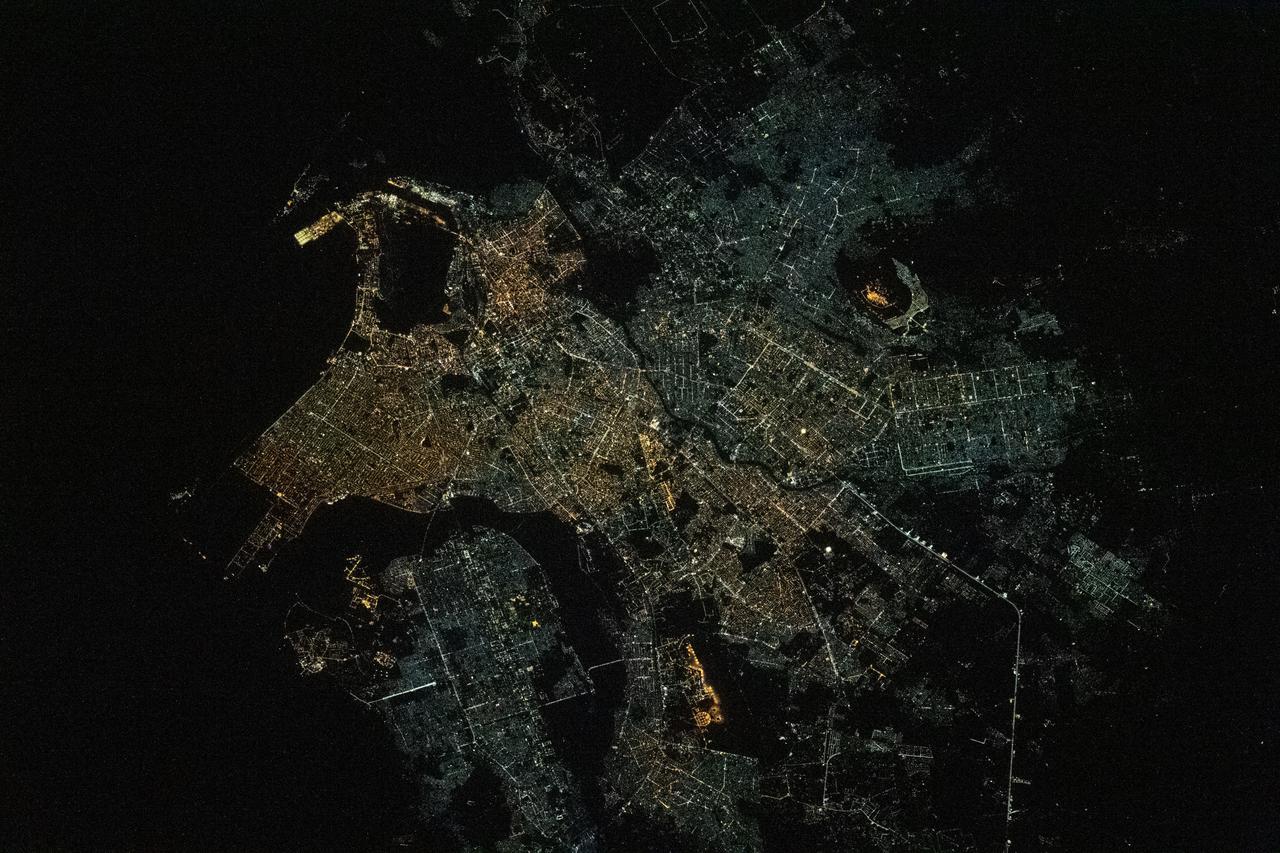
iss064e021873 (Jan. 9, 2021) --- The International Space Station was flying 261 miles above the Arabian Sea just off the coast of Karachi, the largest city in Pakistan with a population of about 16.1 million, when this photograph was taken during a night pass.
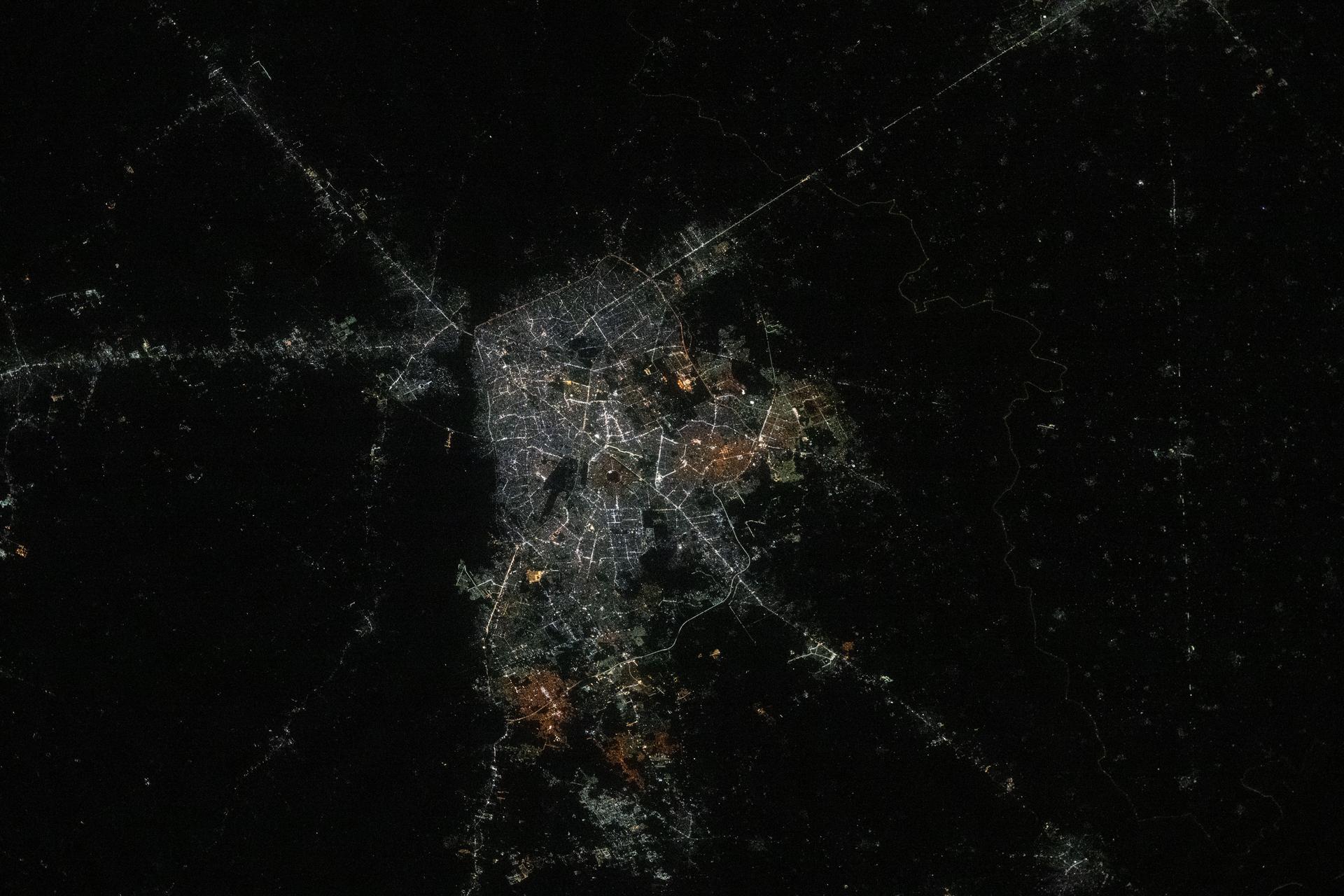
iss073e0763605 (Sept. 21, 2025) --- Lahore, Pakistan, home to approximately 14.8 million people and the country’s second-most populous metropolitan area after Karachi, is pictured from the International Space Station as it orbited 261 miles above Earth at approximately 10:23 p.m. local time.
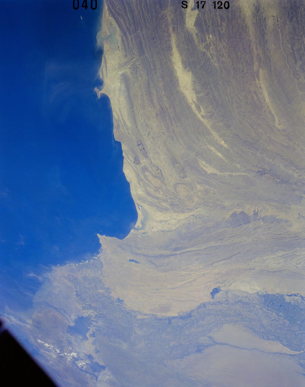
41G-120-040 (5-13 Oct. 1984) --- Pakistan, featuring the city of Karachi, the Makran mountain range, the mouth of the Indus River and the North Arabian Sea were photographed with a medium format camera aboard the space shuttle Challenger during the 41-G mission. Photo credit: NASA
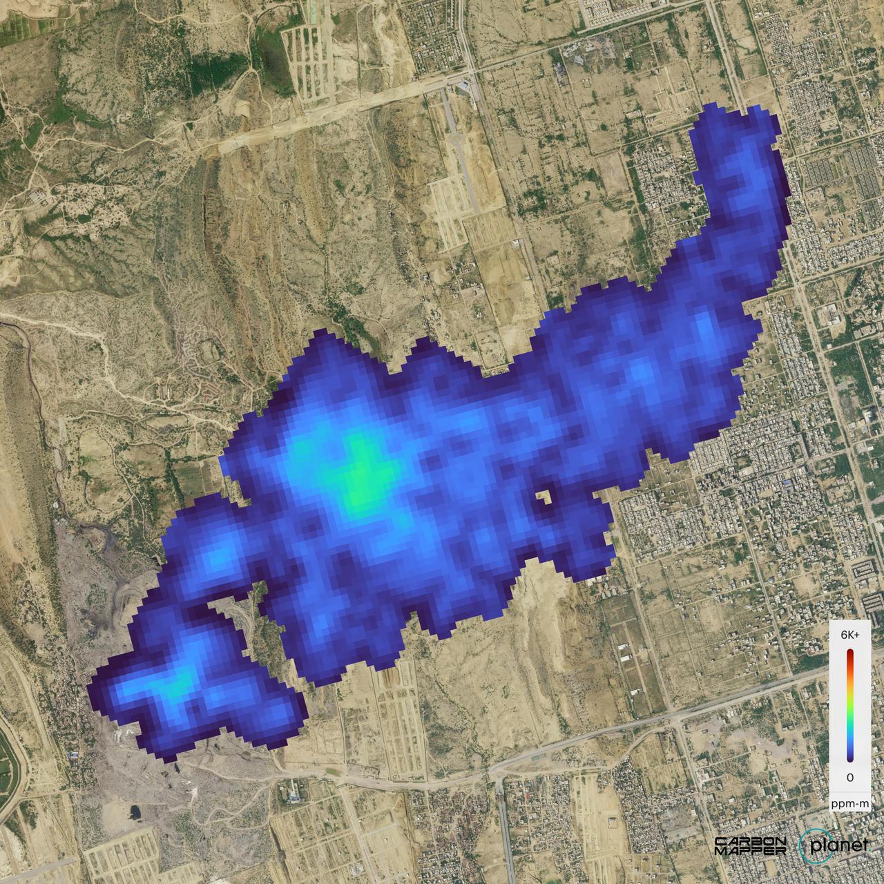
The Carbon Mapper Coalition's Tanager-1 satellite on Sept. 19, 2024, captured data over Karachi, Pakistan, showing the location and concentration of a methane plume measuring about 2½ miles (4 kilometers) long, emanating from a landfill. Enabled by the nonprofit Carbon Mapper and built by Planet Labs PBC, Tanager-1 uses an imaging spectrometer designed by NASA's Jet Propulsion Laboratory in Southern California. Carbon Mapper's preliminary estimate of the source emissions rate is about 2,600 pounds (1,200 kilograms) of methane released per hour. Launched from Vandenberg Space Force Base in California on Aug. 16, 2024, Tanager-1 is part of a broader effort by the nonprofit Carbon Mapper to identify and measure greenhouse gas point-source emissions on a global scale. Both Planet and JPL are members of the philanthropically funded Carbon Mapper Coalition. https://photojournal.jpl.nasa.gov/catalog/PIA26416
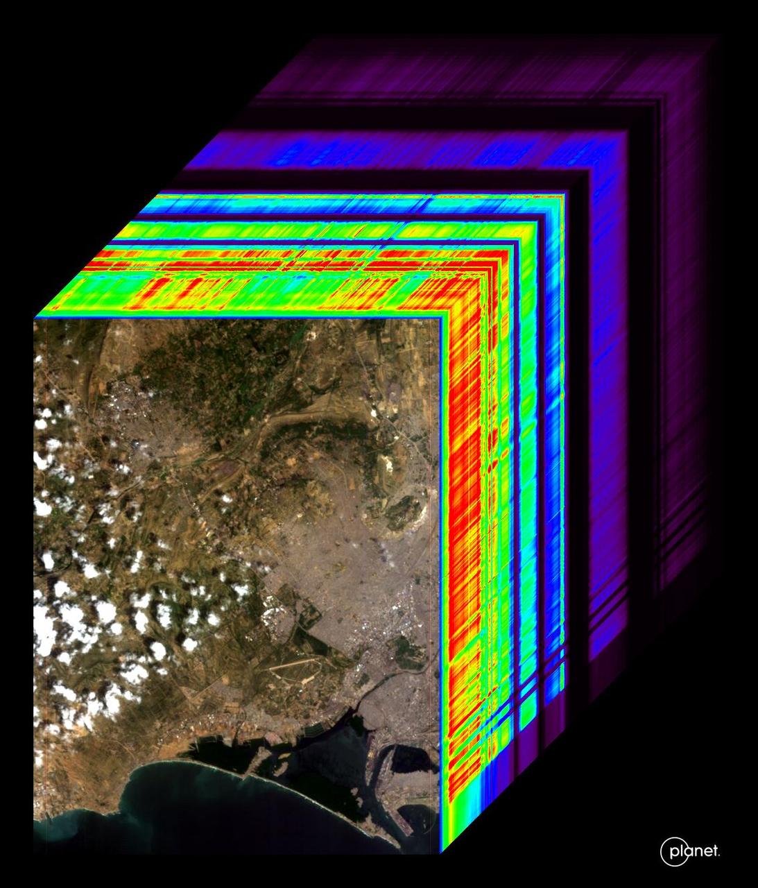
An imaging spectrometer designed by NASA's Jet Propulsion Laboratory captured its first data over Karachi, Pakistan, on Sept. 19, 2024. The instrument is aboard the Carbon Mapper Coalition's Tanager-1 satellite, which was built by Planet Labs PBC. An imaging spectrometer can measure hundreds of wavelengths of light that are reflected by Earth's surface. Different compounds in the planet's atmosphere and on the ground absorb different wavelengths of light, leaving spectral "fingerprints" that researchers can identify. The imaging spectrometer aboard Tanager-1 will enable the satellite to measure methane and carbon dioxide point-source emissions, down to the level of individual facilities and equipment, on a global scale. The image at the front of the cube shows a mix of information on land cover and water in the city and surrounding area, including exposed soil (brown), vegetation (green), and clouds. The rainbow colors extending through the main part of the cube are the wavelengths of light from corresponding spots in the front image. Tanager-1, which launched on Aug. 16, 2024, was developed as part of a philanthropically funded public-private coalition led by the nonprofit Carbon Mapper. Planet Labs and JPL are both members of the Carbon Mapper Coalition. https://photojournal.jpl.nasa.gov/catalog/PIA26412
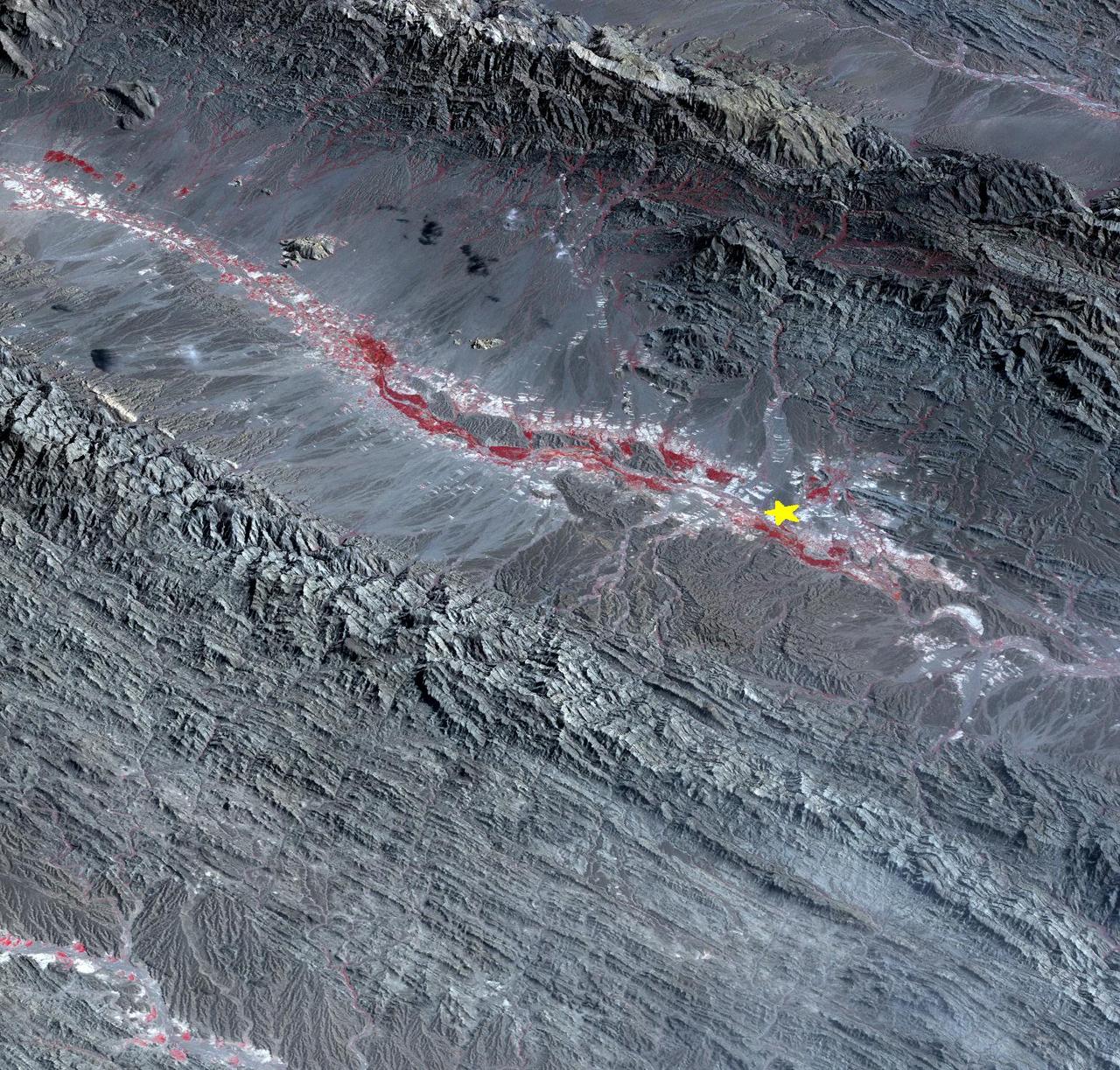
On September 24 at 11:29 GMT, a magnitude 7.7 earthquake struck in south-central Pakistan at a relatively shallow depth of 20 kilometers. The earthquake occurred as the result of oblique strike-slip motion, consistent with rupture within the Eurasian tectonic plate. Tremors were felt as far away as New Delhi as well as Karachi in Pakistan. Even though the immediate area to the epicenter is sparsely populated, the majority of houses are of mud brick construction and damage is expected to be extensive. The perspective view, looking to the east, shows the location of the epicenter in Pakistan's Makran fold belt. The image is centered near 27 degrees north latitude, 65.5 degrees east longitude, and was acquired December 13, 2012. With its 14 spectral bands from the visible to the thermal infrared wavelength region and its high spatial resolution of 15 to 90 meters (about 50 to 300 feet), ASTER images Earth to map and monitor the changing surface of our planet. ASTER is one of five Earth-observing instruments launched Dec. 18, 1999, on Terra. The instrument was built by Japan's Ministry of Economy, Trade and Industry. A joint U.S./Japan science team is responsible for validation and calibration of the instrument and data products. The broad spectral coverage and high spectral resolution of ASTER provides scientists in numerous disciplines with critical information for surface mapping and monitoring of dynamic conditions and temporal change. Example applications are: monitoring glacial advances and retreats; monitoring potentially active volcanoes; identifying crop stress; determining cloud morphology and physical properties; wetlands evaluation; thermal pollution monitoring; coral reef degradation; surface temperature mapping of soils and geology; and measuring surface heat balance. The U.S. science team is located at NASA's Jet Propulsion Laboratory, Pasadena, Calif. The Terra mission is part of NASA's Science Mission Directorate, Washington, D.C. More information about ASTER is available at <a href="http://asterweb.jpl.nasa.gov/" rel="nofollow">asterweb.jpl.nasa.gov/</a>. Image Credit: NASA/GSFC/METI/ERSDAC/JAROS, and U.S./Japan ASTER Science Team Image Addition Date: 2013-09-24 <b><a href="http://www.nasa.gov/audience/formedia/features/MP_Photo_Guidelines.html" rel="nofollow">NASA image use policy.</a></b> <b><a href="http://www.nasa.gov/centers/goddard/home/index.html" rel="nofollow">NASA Goddard Space Flight Center</a></b> enables NASA’s mission through four scientific endeavors: Earth Science, Heliophysics, Solar System Exploration, and Astrophysics. Goddard plays a leading role in NASA’s accomplishments by contributing compelling scientific knowledge to advance the Agency’s mission. <b>Follow us on <a href="http://twitter.com/NASA_GoddardPix" rel="nofollow">Twitter</a></b> <b>Like us on <a href="http://www.facebook.com/pages/Greenbelt-MD/NASA-Goddard/395013845897?ref=tsd" rel="nofollow">Facebook</a></b> <b>Find us on <a href="http://instagram.com/nasagoddard?vm=grid" rel="nofollow">Instagram</a></b>