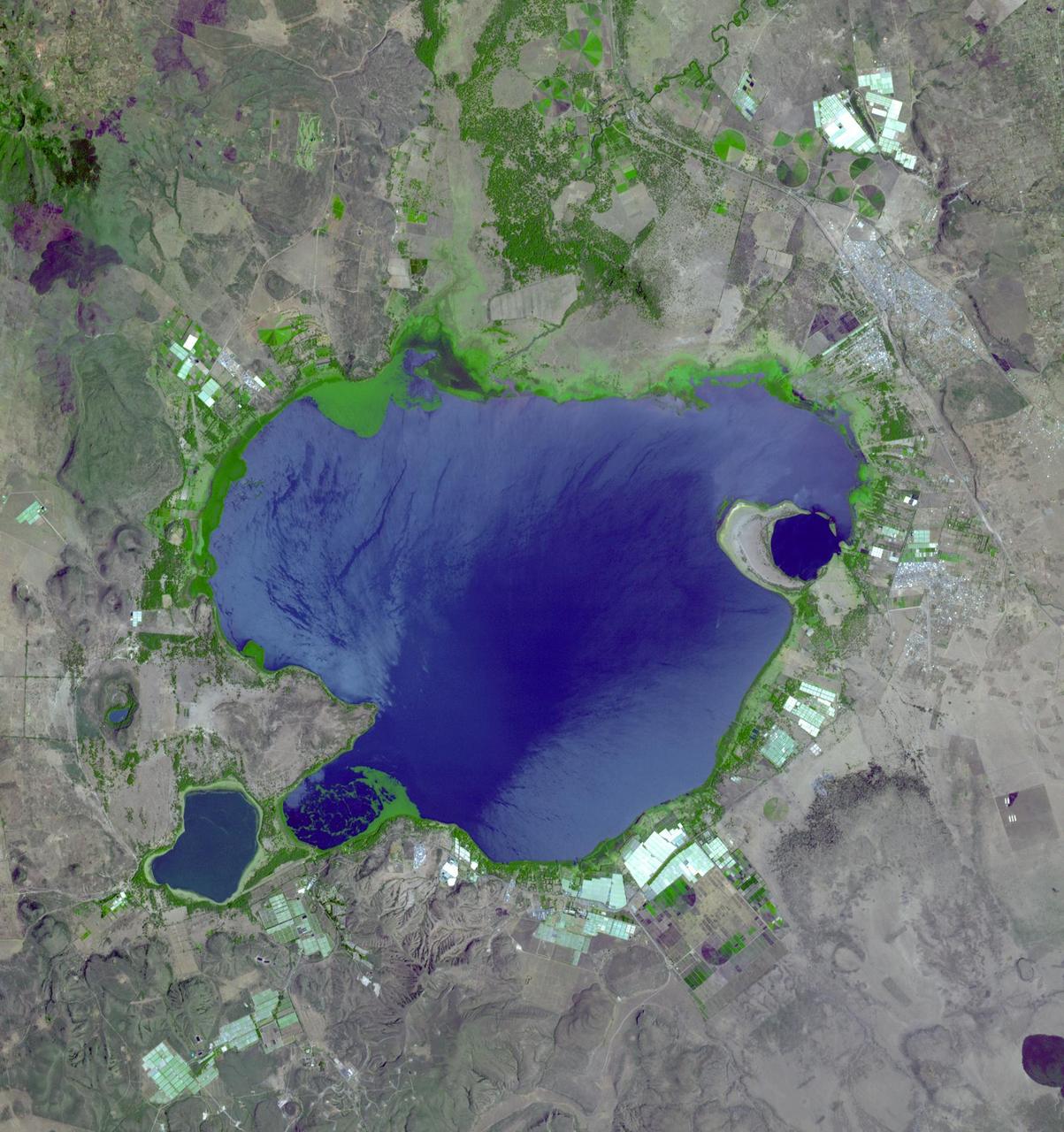
If you live in Europe and buy roses, the chance is good that they were grown in Kenya -- specifically, in one of the colossal greenhouses that blot out the once wild shores of Lake Naivasha, 90km north-west of Nairobi. Image from NASA Terra satellite.
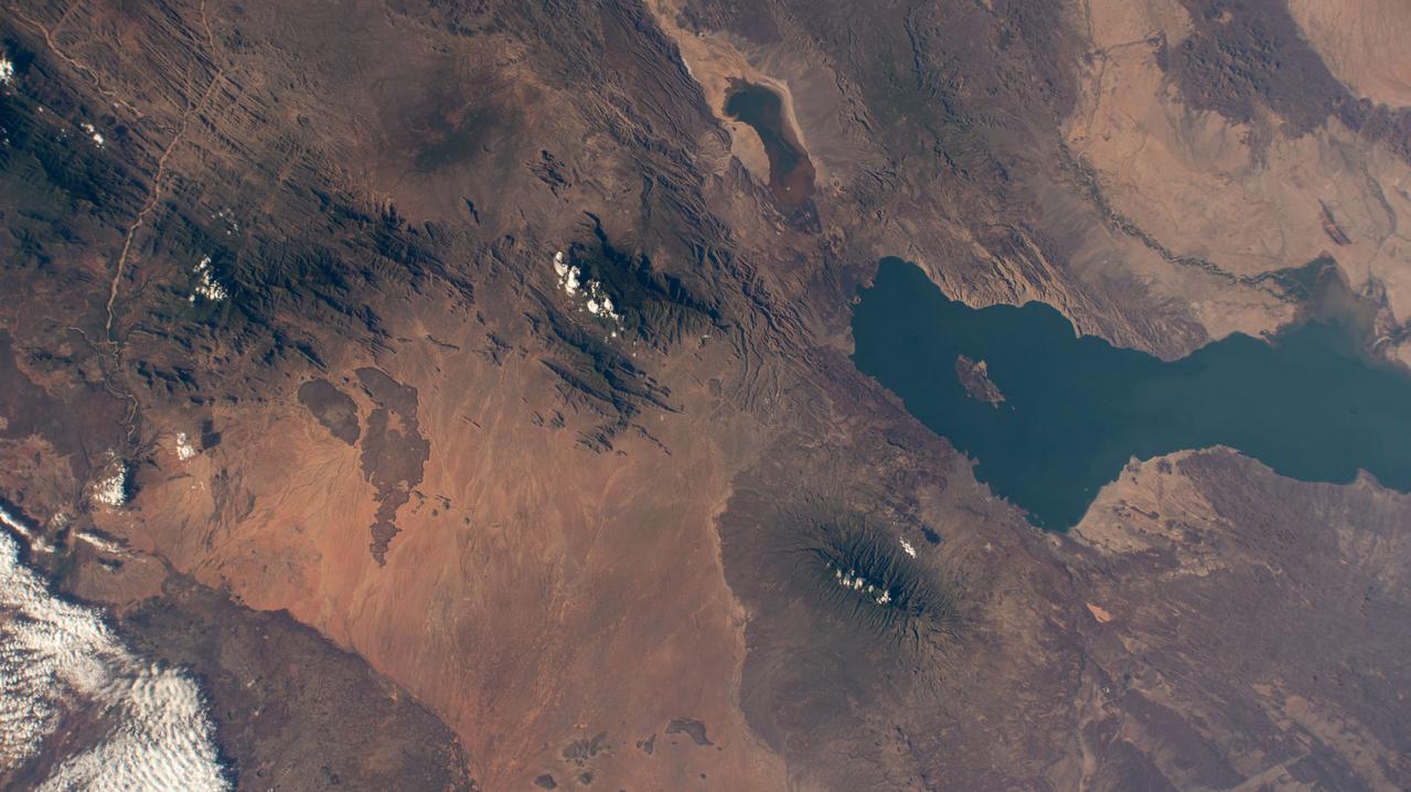
iss072e421838 (Jan. 3, 2025) --- Lake Turkana and Mount Kulal Biosphere Reserve in Kenya are pictured from the International Space Station as it orbited 260 miles above the African nation.
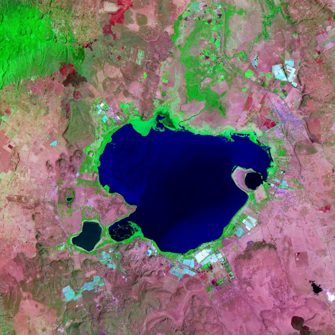
NASA satellite image acquired February 2, 2008. Outside the ground is frozen, quite possibly covered in snow and ice, and yet, stroll through a supermarket in North America or Europe in February, and you’ll be confronted with large displays of roses. We expect flowers in winter, and equatorial countries meet those expectations. A quarter of the cut flowers sold in Europe are grown in Kenya. Straddling the equator, Kenya gets steady sunlight dealt out in days that vary little in length. It’s the perfect climate for flowers year-round. The center of Kenya’s flower industry is Lake Naivasha, shown here. The Advanced Spaceborne Thermal Emission and Reflection Radiometer (ASTER) flying on NASA’s Terra satellite captured this image of Lake Naivasha on February 2, 2008. Bright white squares mix with fields of green, tan, and purple along the shores of the lake. Sunlight glints off the long rows of glass greenhouses, turning them silvery blue and white in this view from space. Fallow fields are tan and pink, while growing plants turn the ground bright green. Roses, lilies, and carnations are the most common flowers grown in the greenhouses and fields scattered around the lake. The large-scale industry shown here extends into small-scale rural farms elsewhere in Kenya, where smaller filler flowers are grown. The flowers provide an important source of income to Kenya, but the industry comes with a price. Flowers are not held to the same standards for chemical residues as food products, which are tightly regulated. Strong chemical pesticides can be used on the flowers to produce the perfect, pest-free bloom, and this could pose a health risk to workers and local wildlife, including hippos, environmental groups told the Food and Agriculture Organization of the United Nations in 2002. The chemicals may also have threatened the water quality of Lake Naivasha, one of Kenya’s few freshwater lakes. The Kenya Flower Council instituted a code of conduct establishing guidelines for pesticide that phases out the use of one of the most toxic pesticides. NASA image created by Jesse Allen, using data provided courtesy of NASA/GSFC/METI/ERSDAC/JAROS, and U.S./Japan ASTER Science Team. Caption by Holli Riebeek. Instrument: Terra - ASTER <b><a href="http://www.nasa.gov/centers/goddard/home/index.html" rel="nofollow">NASA Goddard Space Flight Center</a></b> is home to the nation's largest organization of combined scientists, engineers and technologists that build spacecraft, instruments and new technology to study the Earth, the sun, our solar system, and the universe.
Earth Observation taken during a day pass by the Expedition 40 crew aboard the International Space Station (ISS). Folder lists this as: Tanzania Kenya.
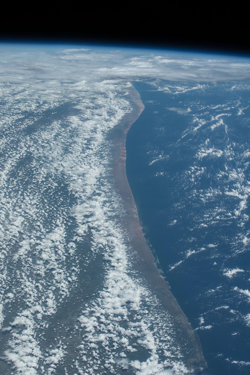
iss057e106506 (Nov. 30, 2018) --- The Indian Ocean coastline of Kenya and Somalia is pictured as the International Space Station orbited 253 miles above the African continent.
Earth Observation taken during a day pass by the Expedition 40 crew aboard the International Space Station (ISS). Folder lists this as: Tanzania Kenya.

iss056e098062 (July 22, 2018) --- Mount Kilimanjaro is pictured in the northeastern region of Tanzania near the border of Kenya as the International Space Station orbited nearly 251 miles above the African continent.
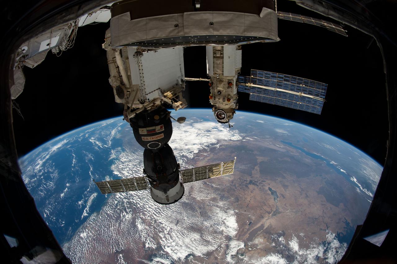
iss065e214029 (Aug. 2, 2021) --- Russia's "Nauka" Multipurpose Laboratory Module is pictured docked to the Zvezda service module's Earth-facing port as the International Space Station orbited 262 miles above the Kenya-Tanzania border on Africa's Indian Ocean coast. In the foreground, is the Soyuz MS-18 crew ship docked to the Rassvet module.

iss073e0982679 (Oct. 25, 2025) --- The Milky Way spans the night sky above a bright orange-yellow airglow that blankets the city lights along the east coast of Africa, from Kenya to Somalia. The International Space Station was orbiting 259 miles above the Indian Ocean, north of Madagascar, at approximately 10:29 p.m. local time when this photograph was taken.
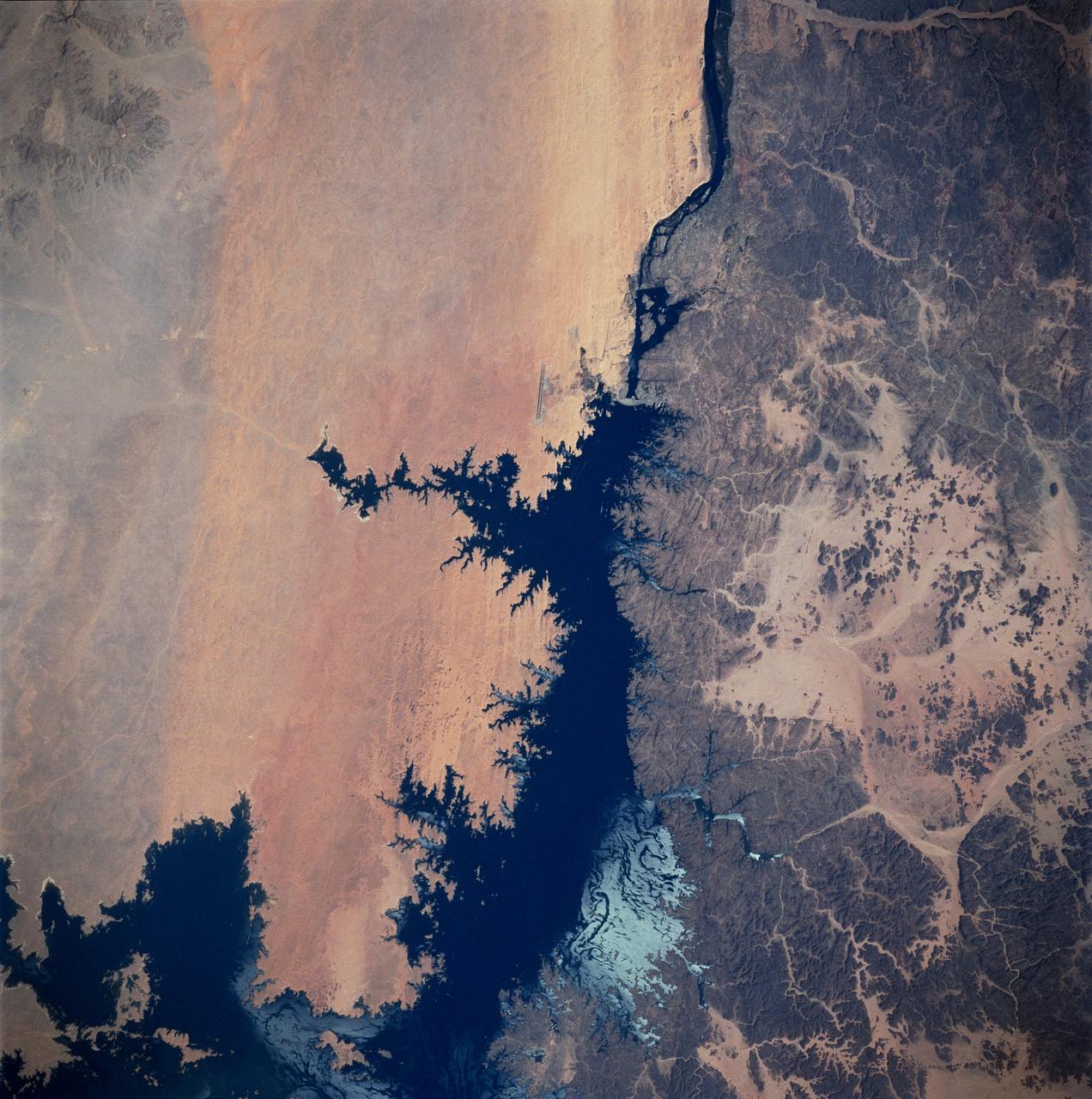
STS083-747-026 (4-8 April 1997) --- Aswan Dam and Lake Nasser along the Nile River, Egypt. The Aswan Dam controls the flow of the Nile River forming Lake Nasser. Lake Nasser is reaching relatively high water levels due to the plentiful rains since December 1996 in Kenya, near the headwaters of the Nile river. The light colored areas in the Lake are where the sun is reflecting off the surface of the water. These areas are fairly calm and not disturbed by wind gusts enabling the sunglint to show water current patterns on the surface. The Aswan runway is seen as a dark set of lines west of the Aswan Dam.
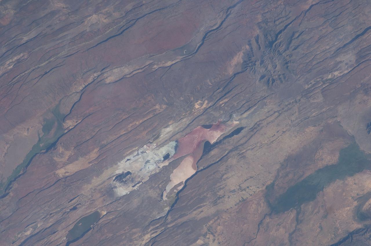
ISS030-E-035487 (14 Jan. 2012) --- The East African Rift Valley in Kenya is featured in this image photographed by an Expedition 30 crew member on the International Space Station. This photograph highlights classical geological structures associated with a tectonic rift valley, in this case the Eastern Branch of the East African Rift near Kenya’s southern border with Tanzania and just south of the Equator. The East African Rift is one of the great tectonic features of Africa, caused by fracturing of Earth’s crust. The Nubian (or African) plate includes the older continental crust of Africa to the west, while the Somalian plate that is moving away includes the Horn of Africa to the northeast; the tectonic boundary stretches from the southern Red Sea to central Mozambique. Landscapes in the rift valley can appear confusing. The most striking features in this view are the numerous, nearly parallel, linear fault lines that occupy the floor of the valley (most of the image). Shadows cast by the late afternoon sun make the fault scarps (steps in the landscape caused by slip motion along individual faults) more prominent. The faults are aligned with the north-south axis of the valley (lower left to top right). A secondary trend of less linear faults cuts the main fault trend at an acute angle, the fault steps throwing large shadows. The Eastern Branch of the East African Rift is arid (compared with the Western Branch which lies on the border of the Congolese rainforest). Evidence of this can be seen in the red, salt-loving algae of the shallow and salty Lake Magadi (center). A neighboring small lake to the north has deeper water and appears dark in the image. The white salt deposits of the dry part of the Lake Magadi floor (center) host a few small commercial salt pans. The lakes appear to be located where the main and secondary fault trends intersect. The East African rift system is marked by substantial volcanic activity, including lavas erupted from fissures along the rift in the region. Much of the faulting observed in this image cuts through such lavas. Elsewhere along the rift system individual volcanoes form. Some of those volcanoes are very large, including Mt. Kilimanjaro and Mt. Kenya. In this image, rising 400 meters above the valley floor, a volcano appears to be superimposed on the faults—indicating that the volcano is younger than the faults it covers. Deeply eroded slopes also suggest that the volcano has not been active for a long time. The largest vegetated area (lower left)—in an desert zone with no vegetation visible to the naked eye from space—is the green floor of a valley which drains an area large enough for water to exist near the surface so that plants can thrive. For a sense of scale, the vegetated valley floor is 17 kilometers long (10.5 miles).
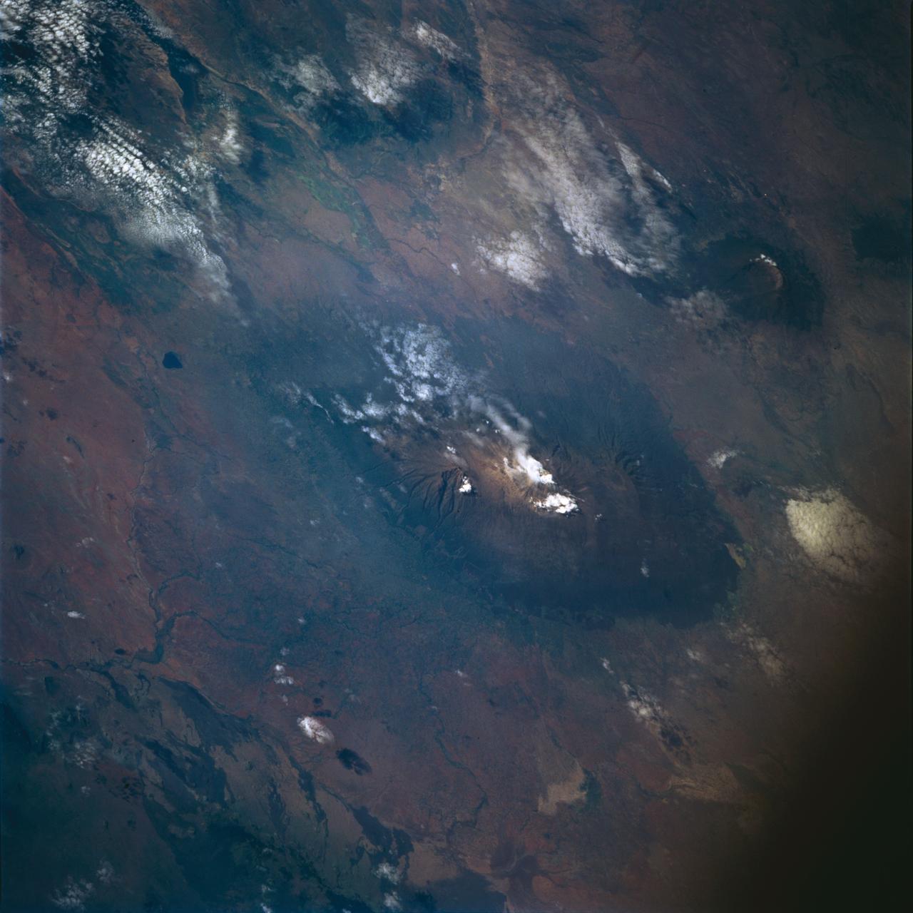
STS072-722-004 (11-20 Jan. 1996) --- Mount Kilimanjaro in Tanzania is featured in this 70mm frame exposed from the Earth-orbiting Space Shuttle Endeavour. Orient with the clouds trailing to the left; then the view is southwest from Kenya past Kilimanjaro to Mount Meru, in Tanzania. Mount Kilimanjaro is about three degrees south of the Equator, but at nearly 6,000 meters has a permanent snowfield. The mountain displays a classic zonation of vegetation types from seasonally dry savannah on the plains at 1,000 meters, to the cloud forest near the top. The mountain is being managed experimentally as an international biosphere reserve. A buffer zone of "traditional" agriculture and pastoral land use is designated around the closed-canopy forest reserve. Specialists familiar with this area say management is partially successful so far, but cleared areas of the forest can be seen on this photograph as light green "nibbles" or "cookie cuts" extending into the dark forest region.
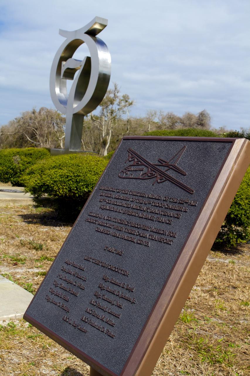
CAPE CANAVERAL, Fla. -- At Launch Complex-14 LC-14 at Cape Canaveral Air Force Station in Florida, a memorial honors the 13 crew members of the U.S. Air Force's 32nd Air Division, 40th Troop Carrier and 317th Consolidated Aircraft Maintenance Squadron, who were killed in a C-130A transport plane crash near Nairobi, Kenya, during a contingency mission for NASA's Project Mercury in 1962. The crash happened 50 years ago, after John Glenn's orbital flight on Feb. 20, 1962, and before Scott Carpenter's on May 24, 1962. Glenn and Carpenter participated in 50th anniversary commemorative events at the Cape and NASA's Kennedy Space Center and stopped by the memorial to honor the Airmen who made the ultimate sacrifice making a distinctive service to their country.
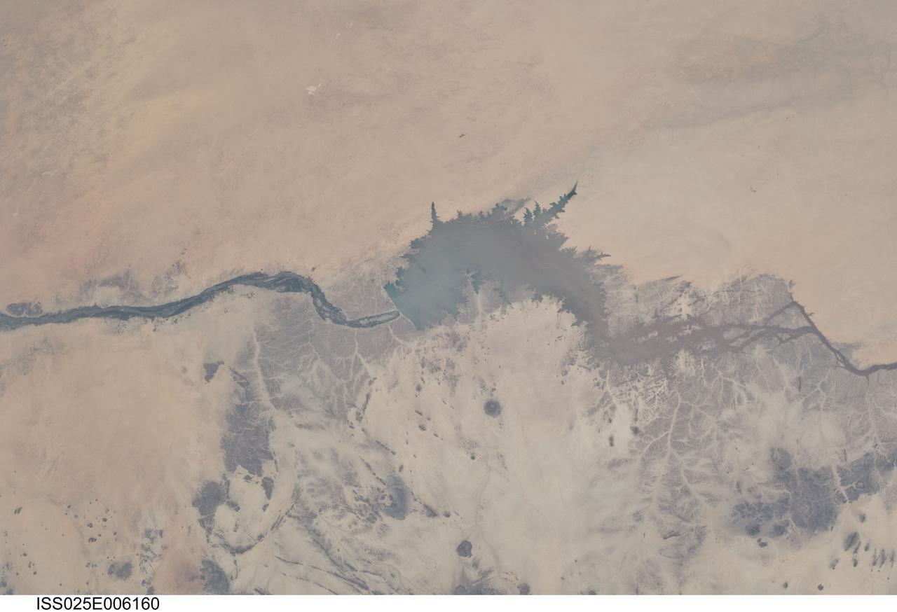
ISS025-E-006160 (5 Oct. 2010) --- Merowe Dam, Nile River and the Republic of the Sudan are featured in this image photographed by an Expedition 25 crew member on the International Space Station. The Merowe Dam is located near the 4th cataract of the Nile River, in the Nubian Desert of the northeastern Republic of the Sudan (also known as Sudan). The dam was built to generate hydroelectric power—electricity intended to further industrial and agricultural development of the country. This photograph illustrates the current extent of the reservoir filling behind the dam; the final spill gate was closed in 2008. The Merowe Dam is located approximately 350 kilometers (215 miles) to the northwest of Sudan’s capital, Khartoum. The nearest settlement downstream of the dam is Karima. Following Sudan’s independence from Egypt and the United Kingdom in 1956, allocation and control of Nile River water was divided between Egypt and Sudan by the Nile Waters Treaty signed in 1959. Today, other countries within the Nile basin—including Ethiopia, Kenya, Rwanda, Tanzania, and Uganda—are seeking more equitable allocation and utilization of the water and recently (2010) signed a new water use pact challenging the 1959 treaty. Beyond the issues of water rights, several local tribes will be displaced by the planned 170 kilometer-long reservoir, and the flooded region contains significant but little-studied archeological sites. The Sudanese government has a resettlement program in place for the tribes. A variety of international institutions have been conducting “salvage” or “rescue” archeological surveys since 1999. Such rescue surveys seek to preserve as much information as possible from sites that will be destroyed or otherwise made inaccessible (in this case by flooding).
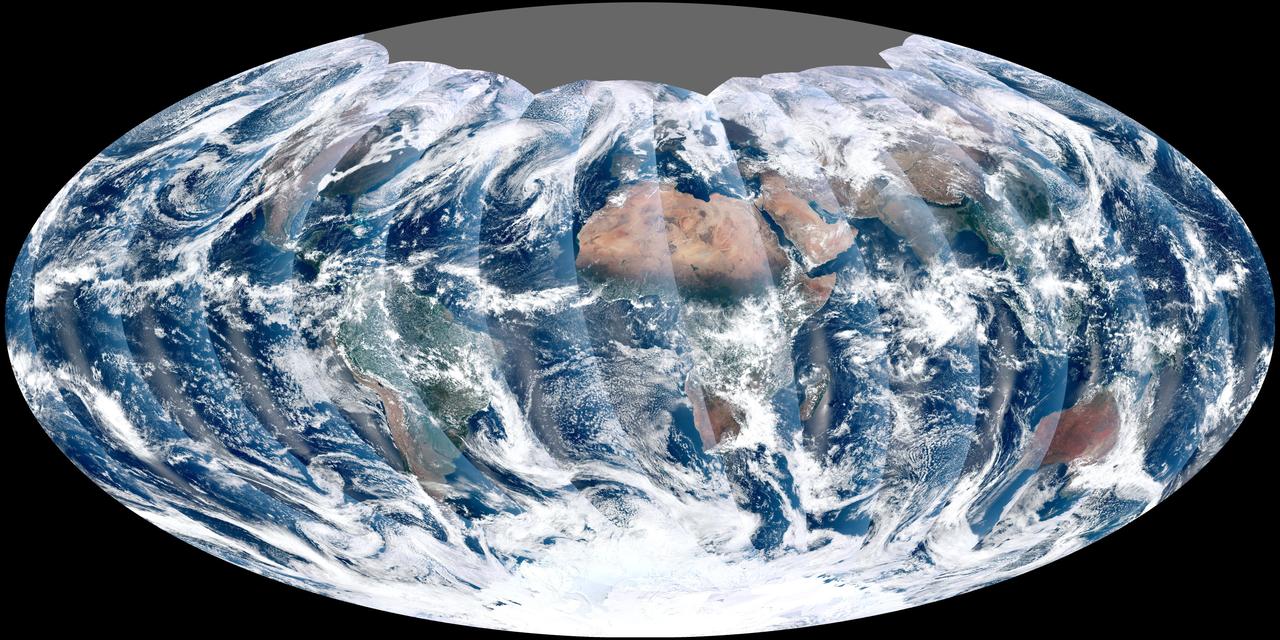
NASA acquired November 24, 2011 From its vantage 824 kilometers (512 miles) above Earth, the Visible Infrared Imager Radiometer Suite (VIIRS) on the NPOESS Preparatory Project (NPP) satellite gets a complete view of our planet every day. This image from November 24, 2011, is the first complete global image from VIIRS. The NPP satellite launched on October 28, 2011, and VIIRS acquired its first measurements on November 21. To date, the images are preliminary, used to gauge the health of the sensor as engineers continue to power it up for full operation. Rising from the south and setting in the north on the daylight side of Earth, VIIRS images the surface in long wedges measuring 3,000 kilometers (1,900 miles) across. The swaths from each successive orbit overlap one another, so that at the end of the day, the sensor has a complete view of the globe. The Arctic is missing because it is too dark to view in visible light during the winter. The NPP satellite was placed in a Sun-synchronous orbit, a unique path that takes the satellite over the equator at the same local (ground) time in every orbit. So, when NPP flies over Kenya, it is about 1:30 p.m. on the ground. When NPP reaches Gabon—about 3,000 kilometers to the west—on the next orbit, it is close to 1:30 p.m. on the ground. This orbit allows the satellite to maintain the same angle between the Earth and the Sun so that all images have similar lighting. The consistent lighting is evident in the daily global image. Stripes of sunlight (sunglint) reflect off the ocean in the same place on the left side of every swath. The consistent angle is important because it allows scientists to compare images from year to year without worrying about extreme changes in shadows and lighting. The image also shows a band of haze along the right side of every orbit swath. When light travels through the atmosphere, it bounces off particles or scatters, making the atmosphere look hazy. The scattering effect is most pronounced along the edge of the swath, where the sensor is looking at an angle through more of the atmosphere. Scientists can correct for this scattering effect, but need measurements from a range of wavelengths to do so. The degree to which light scatters depends partly on the wavelength of the light. Blue light scatters more than red light, for example, which is why the sky is blue. VIIRS measures 22 different wavelengths of light, but not all of the sensor’s detectors are operating at peak performance yet. Those measuring thermal infrared light are not yet cold enough to collect reliable measurements. Once VIIRS begins full operations, it will produce a range of measurements from ocean temperature to clouds to the locations of fires. These measurements will help extend the record from earlier sensors like the Moderate Resolution Imaging Spectroradiometer (MODIS). VIIRS is very similar to MODIS, but flies at a higher altitude to measure the whole planet without gaps. (MODIS daily measurements have gaps at the equator. See the MODIS image from November 24.) VIIRS also sees the Earth in less detail, 375 meters per pixel, compared to 250 meters per pixel for MODIS. Image by NASA’s NPP Land Product Evaluation and Testing Element. Caption by Holli Riebeek. Credit: <b><a href="http://www.earthobservatory.nasa.gov/" rel="nofollow"> NASA Earth Observatory</a></b> <b><a href="http://www.nasa.gov/audience/formedia/features/MP_Photo_Guidelines.html" rel="nofollow">NASA image use policy.</a></b> <b><a href="http://www.nasa.gov/centers/goddard/home/index.html" rel="nofollow">NASA Goddard Space Flight Center</a></b> enables NASA’s mission through four scientific endeavors: Earth Science, Heliophysics, Solar System Exploration, and Astrophysics. Goddard plays a leading role in NASA’s accomplishments by contributing compelling scientific knowledge to advance the Agency’s mission. <b>Follow us on <a href="http://twitter.com/NASA_GoddardPix" rel="nofollow">Twitter</a></b> <b>Like us on <a href="http://www.facebook.com/pages/Greenbelt-MD/NASA-Goddard/395013845897?ref=tsd" rel="nofollow">Facebook</a></b> <b>Find us on <a href="http://instagrid.me/nasagoddard/?vm=grid" rel="nofollow">Instagram</a></b>