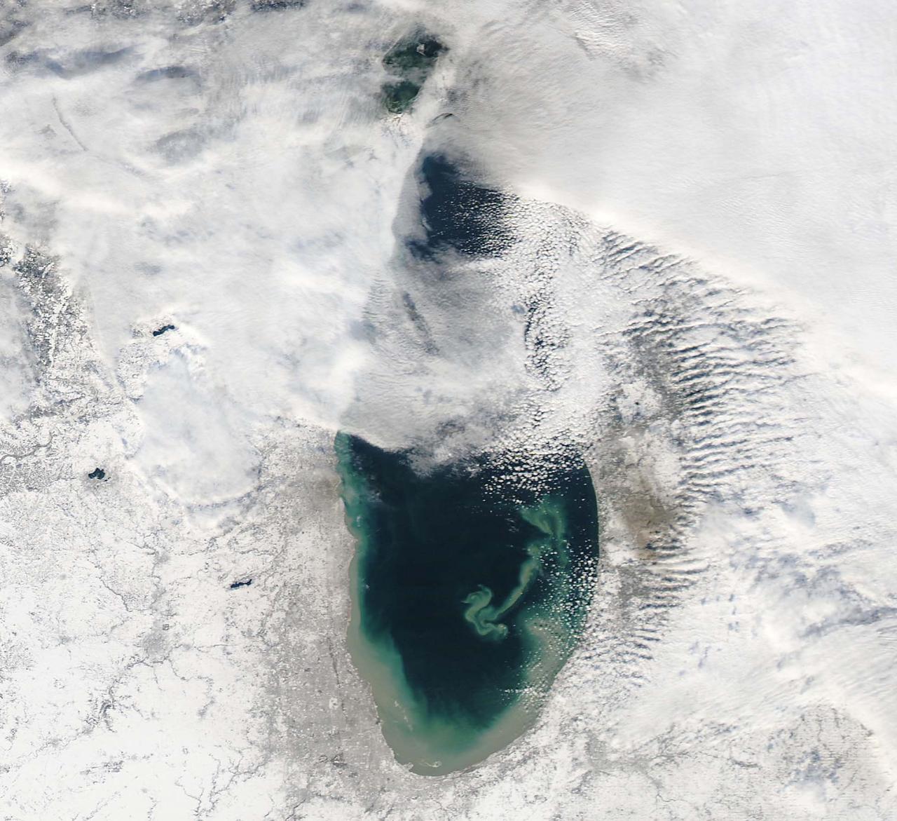
NASA image acquired December 17, 2010 In mid-December 2010, suspended sediments transformed the southern end of Lake Michigan. Ranging in color from brown to green, the sediment filled the surface waters along the southern coastline and formed a long, curving tendril extending toward the middle of the lake. The Moderate Resolution Imaging Spectroradiometer (MODIS) on NASA’s Aqua satellite captured these natural-color images on December 17, 2010 (top), and December 10, 2010 (bottom). Such sediment clouds are not uncommon in Lake Michigan, where winds influence lake circulation patterns. A scientificpaper published in 2007 described a model of the circulation, noting that while the suspended particles mostly arise from lake-bottom sediments along the western shoreline, they tend to accumulate on the eastern side. When northerly winds blow, two circulation gyres, rotating in opposite directions, transport sediment along the southern shoreline. As the northerly winds die down, the counterclockwise gyre predominates, and the smaller, clockwise gyre dissipates. Clear water—an apparent remnant of the small clockwise gyre—continues to interrupt the sediment plume. George Leshkevich, a researcher with the U.S. National Oceanic and Atmospheric Administration, explains that the wind-driven gyres erode lacustrine clay (very fine lakebed sediment) on the western shore before transporting it, along with re-suspended lake sediments, to the eastern shore. On the eastern side, the gyre encounters a shoreline bulge that pushes it toward the lake’s central southern basin, where it deposits the sediments. The sediment plume on December 17 followed a windy weather front in the region on December 16. NASA image courtesy MODIS Rapid Response Team at NASA GSFC. Caption by Michon Scott. Instrument: Aqua - MODIS <b><a href="http://www.nasa.gov/centers/goddard/home/index.html" rel="nofollow">NASA Goddard Space Flight Center</a></b> enables NASA’s mission through four scientific endeavors: Earth Science, Heliophysics, Solar System Exploration, and Astrophysics. Goddard plays a leading role in NASA’s accomplishments by contributing compelling scientific knowledge to advance the Agency’s mission. <b>Follow us on <a href="http://twitter.com/NASA_GoddardPix" rel="nofollow">Twitter</a></b> <b>Join us on <a href="http://www.facebook.com/pages/Greenbelt-MD/NASA-Goddard/395013845897?ref=tsd" rel="nofollow">Facebook</a></b> To read more about this image go to: <a href="http://earthobservatory.nasa.gov/IOTD/view.php?id=48511" rel="nofollow">earthobservatory.nasa.gov/IOTD/view.php?id=48511</a>
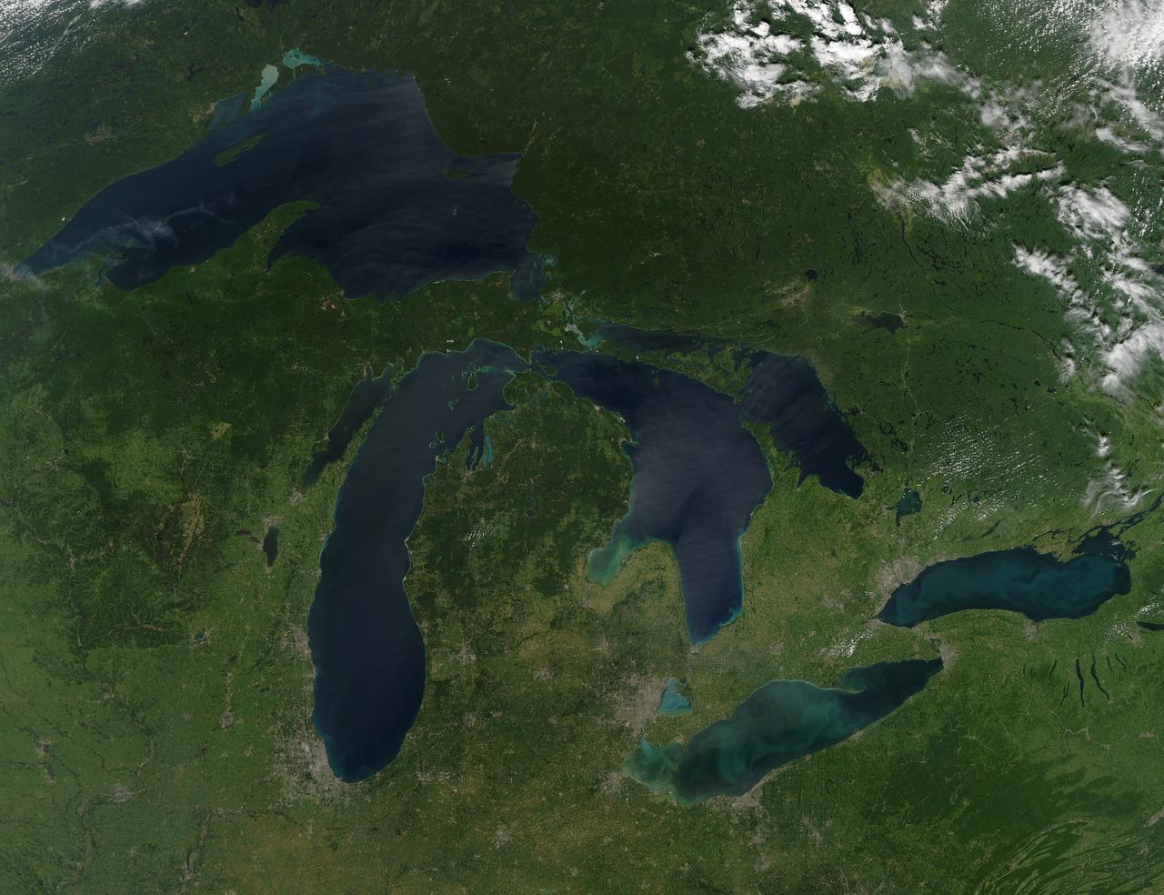
NASA image acquired August 28, 2010 Late August 2010 provided a rare satellite view of a cloudless summer day over the entire Great Lakes region. North Americans trying to sneak in a Labor Day weekend getaway on the lakes were hoping for more of the same. The Great Lakes comprise the largest collective body of fresh water on the planet, containing roughly 18 percent of Earth's supply. Only the polar ice caps contain more fresh water. The region around the Great Lakes basin is home to more than 10 percent of the population of the United States and 25 percent of the population of Canada. Many of those people have tried to escape record heat this summer by visiting the lakes. What they found, according to The Hamilton Spectator, was record-breaking water temperatures fueled by record-breaking air temperatures in the spring and summer. By mid-August, the waters of Lake Superior were 6 to 8°C (11 to 14°F) above normal. Lake Michigan set records at about 4°C (7°F) above normal. The other three Great Lakes – Huron, Erie, and Ontario -- were above normal temperatures, though no records were set. The image was gathered by the Moderate Resolution Imaging Spectroradiometer (MODIS) on NASA’s Aqua satellite at 1:30 p.m. Central Daylight Time (18:30 UTC) on August 28. Open water appears blue or nearly black. The pale blue and green swirls near the coasts are likely caused by algae or phytoplankton blooms, or by calcium carbonate (chalk) from the lake floor. The sweltering summer temperatures have produced an unprecedented bloom of toxic blue-green algae in western Lake Erie, according to the Cleveland Plain Dealer. NASA image by Jeff Schmaltz, MODIS Rapid Response Team, Goddard Space Flight Center. Caption by Mike Carlowicz. Instrument: Aqua - MODIS Click here to see more images from <b><a href="#//earthobservatory.nasa.gov/" rel="nofollow"> NASA Goddard’s Earth Observatory</a></b> <b><a href="http://www.nasa.gov/centers/goddard/home/index.html" rel="nofollow">NASA Goddard Space Flight Center</a></b> is home to the nation's largest organization of combined scientists, engineers and technologists that build spacecraft, instruments and new technology to study the Earth, the sun, our solar system, and the universe. <b>Follow us on <a href="http://twitter.com/NASA_GoddardPix" rel="nofollow">Twitter</a></b> <b>Join us on <a href="http://www.facebook.com/pages/Greenbelt-MD/NASA-Goddard/395013845897?ref=tsd" rel="nofollow">Facebook</a></b>