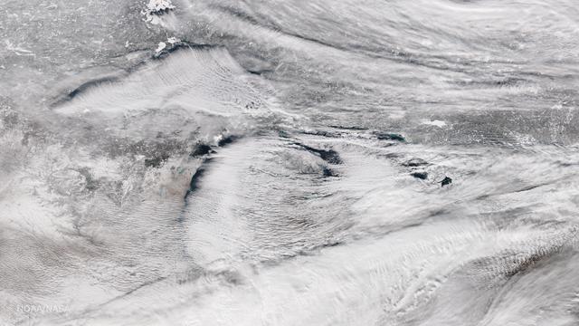
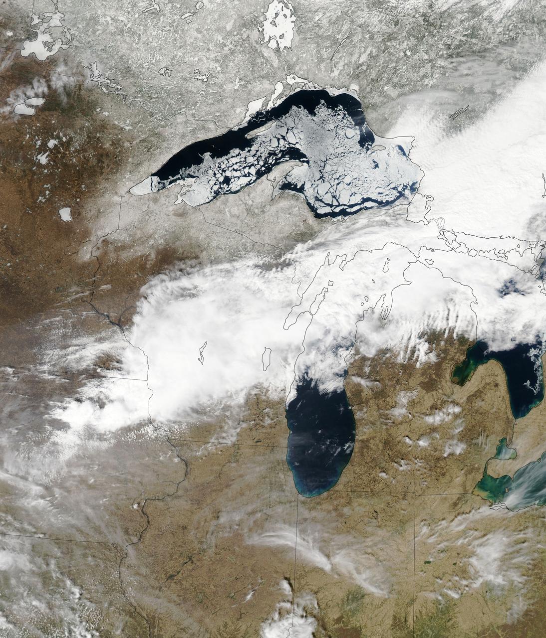
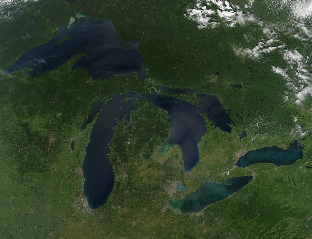
Bands of lake effect snow drift eastward from the western Great Lakes in this true-color image captured by the NOAA/NASA Suomi NPP satellite's Visible Infrared Imaging Radiometer Suite (VIIRS) instrument on January 5, 2017. National Weather Service forecasters expect light to moderate lake effect snow showers to continue throughout the day today and into Saturday (1/7). Lake-effect snow forms when cold air passes over the warmer waters of a lake. This causes some lake water to evaporate into the air and warm it. This warmer, wetter air rises and cools as it moves away from the lake. When it cools, it releases that moisture and, if it’s cold enough, that moisture turns into snow. Although true-color images like this may appear to be photographs of Earth, they aren't. They are created by combining data from the three color channels on the VIIRS instrument sensitive to the red, green and blue (or RGB) wavelengths of light into one composite image. In addition, data from several other channels are often also included to cancel out or correct atmospheric interference that may blur parts of the image. Credit: NOAA/NASA/Suomi NPP via NOAA's Environmental Visualization Laboratory
Land of Lakes?
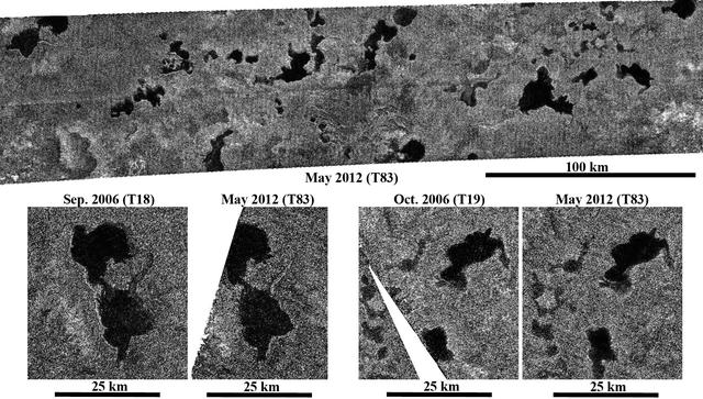
Disappearing Lakes
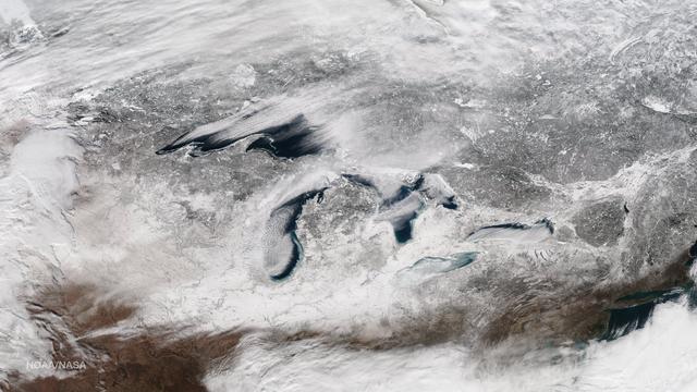
This image taken on January 13, 2015 from the Suomi NPP satellite's VIIRS instrument shows the Great Lakes and surrounding areas. The latest Great Lakes Surface Environmental Analysis (GLSEA) from the NOAA Great Lakes Environmental Research Laboratory shows total ice cover of 29.3% as of January 13th. Credit: NOAA/NASA/NPP Via <b><a href="www.nnvl.noaa.gov/" rel="nofollow"> NOAA Environmental Visualization Laboratory</a></b>
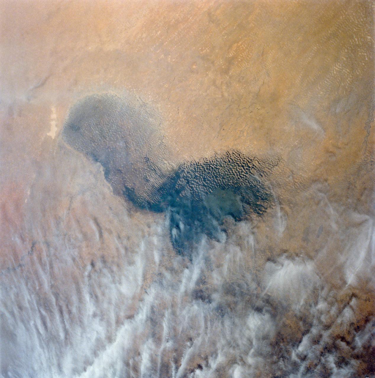
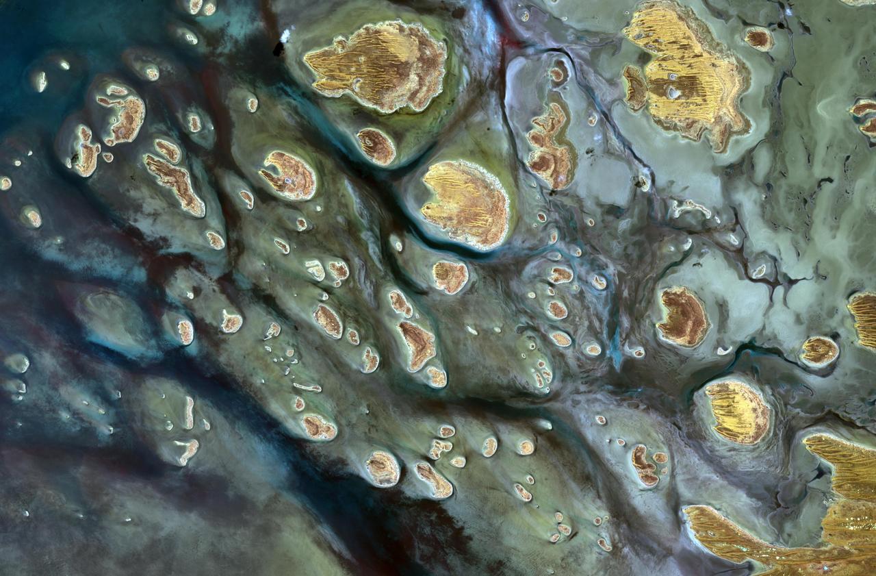
Africa's Lake Chad where the borders of Chad, Niger, Nigeria and Cameroon merge (13.0N, 14.0E) has been undergoing change for the past 25 to 30 years when it was first noticed that the lake is drying up. Since then, astronauts have been photographing it on a regular basis to record the diminishing lake bed. This lake was once the aproximate size of Lake Erie but is now only about half that size and is still receeding.
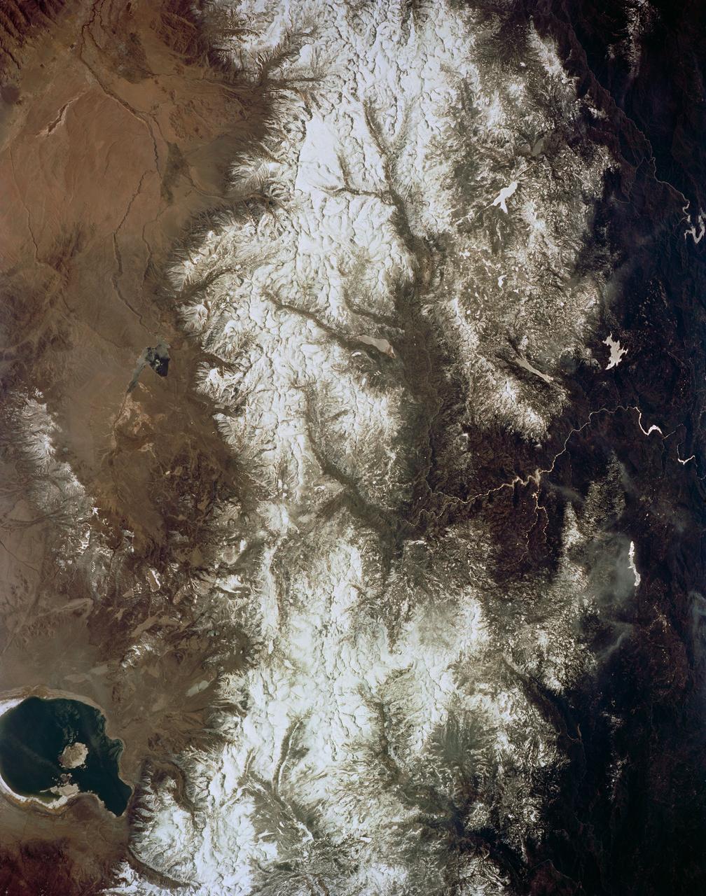
As seen from space, the Great Salt Lake, Utah, USA (41.5N, 112.5W) appears as two separate bodies of water with a narrow divider in the middle. At the turn of the century, a railroad bridge without culverts, was built across the lake and ever since, the water and salinity levels have been uneqal on either side. Fed by snowmelt from the nearby Wasatch Mountains, the lake in recent years has had record high water levels, threatening to flood the local areas.
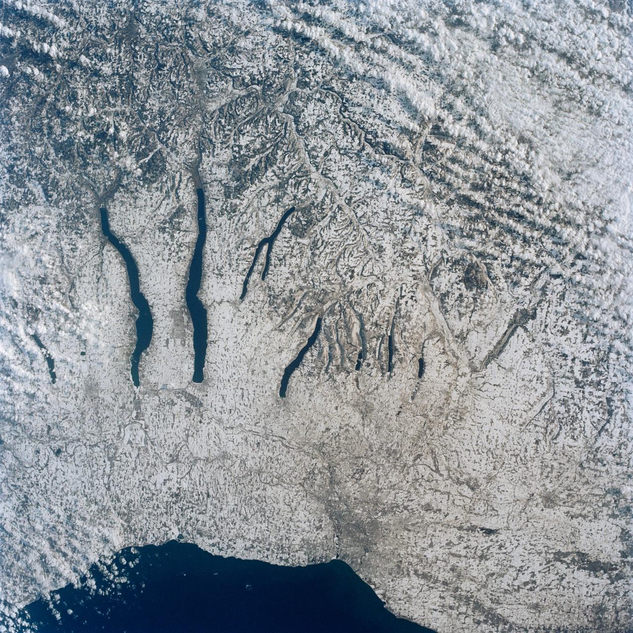
This view of the central portion of upstate New York, centers on the Finger Lakes. The large city on the shore of Lake Ontario, is Rochester. Although the city, being a business, educational and technical center, has no heavy industry, the outline of the city shows fairly well in the snow, but not as well as the outlines of industrial cities elsewhere in the world. The Finger Lakes are large linear lakes carved out by glaciers during the last ice age.
In orbit above the semi-desert grasslands in Kazakhstan, an astronaut aboard the International Space Station spotted one of the few features that stand out. Lake Tengiz is the only large lake (1590 square kilometers, 615 square miles) in northern Kazakhstan. Through white wisps of cloud, the crew member photographed the 50 kilometer-long eastern shore of the lake, with its thin, winding islands and white beaches. The islands and intervening waterways make a rich habitat for birds in this part of Asia. At least 318 species of birds have been identified at the lake; 22 of them are endangered. It is the northernmost habitat of the pink flamingo. The lake system is Kazakhstan’s first UNESCO World Heritage Site, and it has been declared a RAMSAR wetland site of international importance. Part of the richness of area is its complex hydrology. Fresh water enters the system via the Kulanutpes River, so there are small lakes (lower right) full of fresh water. But in this closed basin, the water in the main lake (top) slowly evaporates, becoming salty. Winds stir up bigger waves on the main lake, dispersing sediment and salt and making the water a cloudier and lighter blue-green. (Another astronaut photograph shows the entire lake system, while this story provides more information.) The strange shape of the islands is not easy to interpret. They may be drowned remnants of delta distributaries of the Kulanutpes River. Westerly winds probably have had a smoothing effect on the shorelines, especially in a shallow lake like Tengiz, which is only about 6 meters (20 feet) deep. The lake has an exciting history for people who follow space exploration. In 1976, a Soyuz spacecraft landed in the lake near the north shore (top right). The capsule crashed through the ice and sank during an October snowstorm when temperatures were -22°C (-8°F). Because of low power, the capsule was unheated and the crew was feared lost. It was many hours before the airtight capsule was located and divers could attach flotation tanks to get the capsule to the surface. It was then dragged ashore across the ice by helicopter. The rescue effort took nine hours before the crew was able to safely exit the capsule. Credit: <b><a href="http://www.earthobservatory.nasa.gov/" rel="nofollow"> NASA Earth Observatory</a></b> <b><a href="http://www.nasa.gov/audience/formedia/features/MP_Photo_Guidelines.html" rel="nofollow">NASA image use policy.</a></b> <b><a href="http://www.nasa.gov/centers/goddard/home/index.html" rel="nofollow">NASA Goddard Space Flight Center</a></b> enables NASA’s mission through four scientific endeavors: Earth Science, Heliophysics, Solar System Exploration, and Astrophysics. Goddard plays a leading role in NASA’s accomplishments by contributing compelling scientific knowledge to advance the Agency’s mission. <b>Follow us on <a href="http://twitter.com/NASAGoddardPix" rel="nofollow">Twitter</a></b> <b>Like us on <a href="http://www.facebook.com/pages/Greenbelt-MD/NASA-Goddard/395013845897?ref=tsd" rel="nofollow">Facebook</a></b> <b>Find us on <a href="http://instagrid.me/nasagoddard/?vm=grid" rel="nofollow">Instagram</a></b>
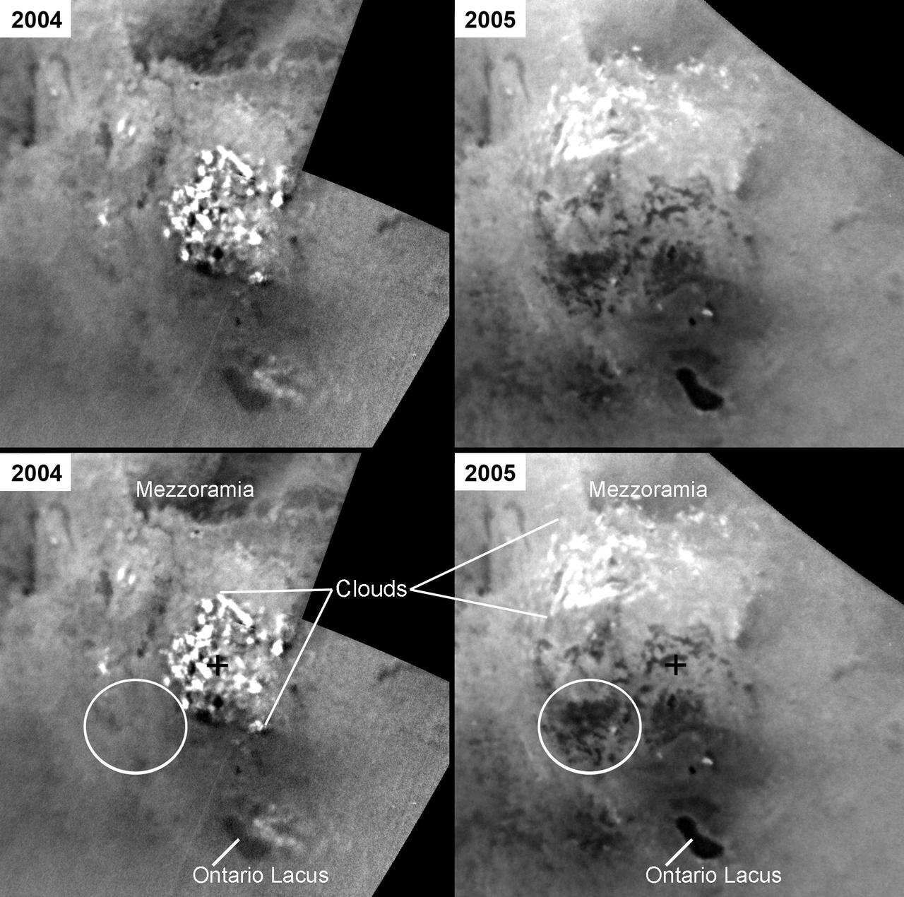
Changes in Titan Lakes
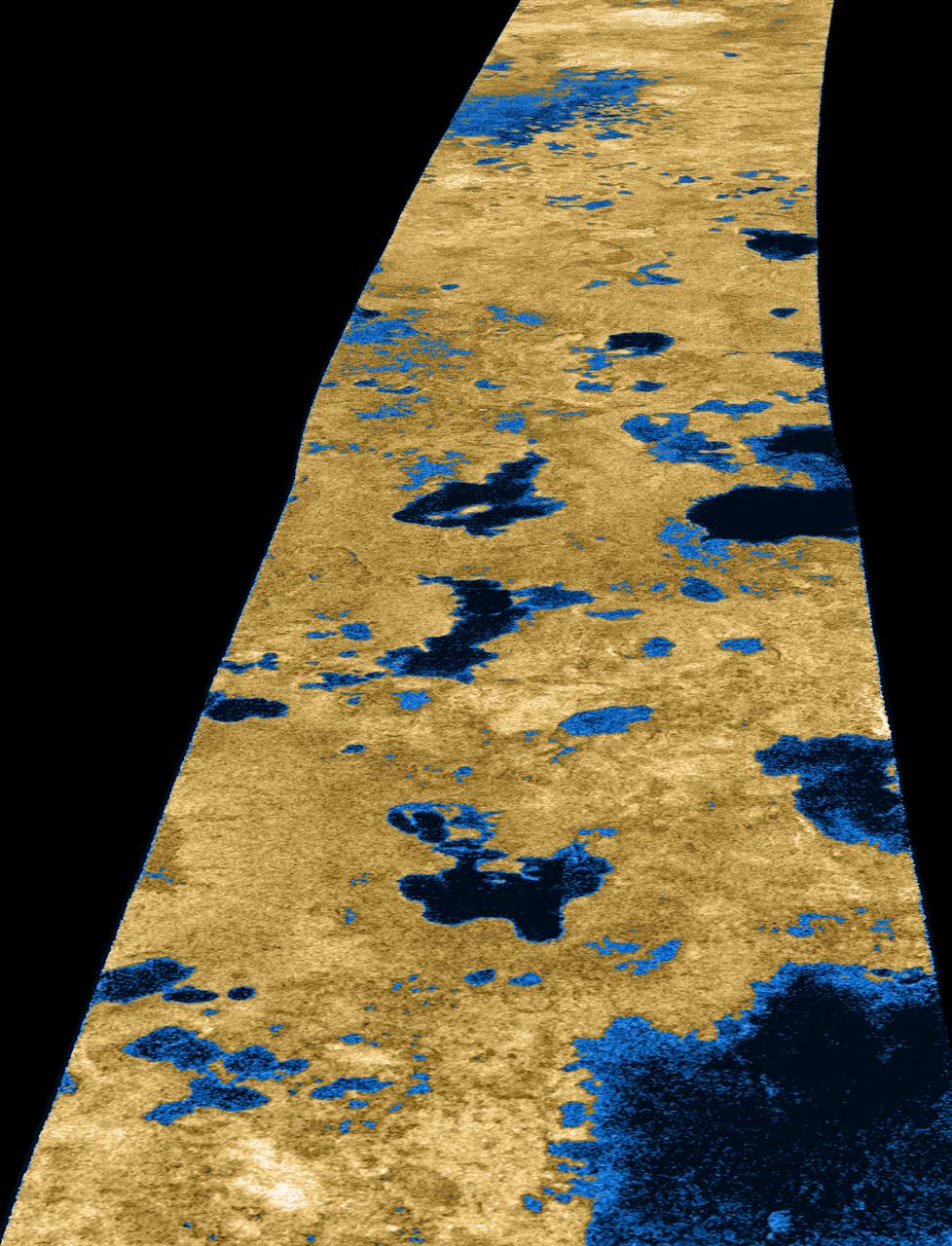
Liquid Lakes on Titan
Titan: Larger and Larger Lakes
Titan Ethane Lake
Titan Land-o-Lakes
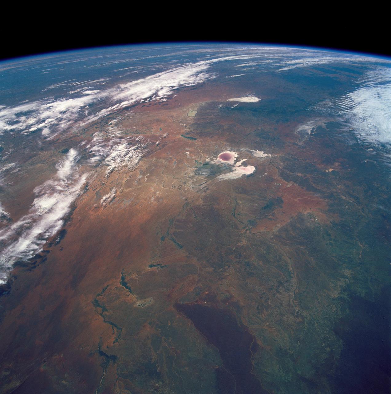
STS035-501-007 (2-10 Dec. 1990) --- The STS-35 crewmembers aboard the Earth-orbiting Space Shuttle Columbia photographed this view of the Arid Simpson Desert of Australia with a handheld Rolleiflex camera. Lake Eyre is normally dry; however, the STS-35 crew was able to recognize water in the lowest parts of the lake (dark pink area) and possibly in Lake Blanche east of Lake Eyre. Lake Frome lies in the distance separated from Lake Torrens (top right) by dark hills of Flinders Range. The Finke River (bottom left to middle) flows into the Eyre basin from the northwest. Although it is the largest river entering the basin, Finke's floods seldom reach Lake Eyre. The dark brown patch in the foreground is an area of ancient, brown lateritic soils partly covered by dunes.
iss071e462185 (Aug. 9, 2024) --- Lake Balkhash in Kazakhstan is pictured from the International Space Station as it orbited 262 miles above the Central Asian nation.
After 14 years of drought, Lake Powell was at 42 percent of its capacity as of May 20, 2014. The low water levels are evident in these images, which were acquired by the Landsat 8 satellite on May 13, 2014. White bleached rock show where Lake Powell’s shore is when the reservoir is at capacity. It is normal for water levels to fluctuate in the reservoir depending on how much water flows in from snow and rain and how much flows out to meet needs. However, it has been dry in all but three of the past 14 years. At the beginning of 2000, Lake Powell was at 94 percent of capacity. By October 2013 (the beginning of the 2014 water year), water levels had dropped to a low of 50 percent capacity, according to the Bureau of Reclamation, the agency that manages the reservoir. The Earth Observatory’s World of Change shows this annual fluctuation and overall decline. With slightly above average snowpack in the basin that feeds the lake, water levels are expected to rebound to about 51 percent of capacity by October 2014, the end of the water year. While the drop in water levels are worrying for those who generate electricity or use the water for agriculture, the lower water levels may be a draw for recreation. Boaters coming to Lake Powell in the spring of 2014 will find beaches and rock formations that are usually underwater. Bullfrog Bay is the starting point for many boat rentals. The popularity of the spot is evident in the lower image: boats dot the surface of the water, just tiny white flecks at this scale. NASA Earth Observatory image by Robert Simmon, using Landsat data from the U.S. Geological Survey. Caption by Holli Riebeek. Instrument(s): Landsat 8 - OLI Read more: <a href="http://1.usa.gov/1hck6NX" rel="nofollow">1.usa.gov/1hck6NX</a> Credit: <b><a href="http://www.earthobservatory.nasa.gov/" rel="nofollow"> NASA Earth Observatory</a></b> <b><a href="http://www.nasa.gov/audience/formedia/features/MP_Photo_Guidelines.html" rel="nofollow">NASA image use policy.</a></b> <b><a href="http://www.nasa.gov/centers/goddard/home/index.html" rel="nofollow">NASA Goddard Space Flight Center</a></b> enables NASA’s mission through four scientific endeavors: Earth Science, Heliophysics, Solar System Exploration, and Astrophysics. Goddard plays a leading role in NASA’s accomplishments by contributing compelling scientific knowledge to advance the Agency’s mission. <b>Follow us on <a href="http://twitter.com/NASAGoddardPix" rel="nofollow">Twitter</a></b> <b>Like us on <a href="http://www.facebook.com/pages/Greenbelt-MD/NASA-Goddard/395013845897?ref=tsd" rel="nofollow">Facebook</a></b> <b>Find us on <a href="http://instagram.com/nasagoddard?vm=grid" rel="nofollow">Instagram</a></b>
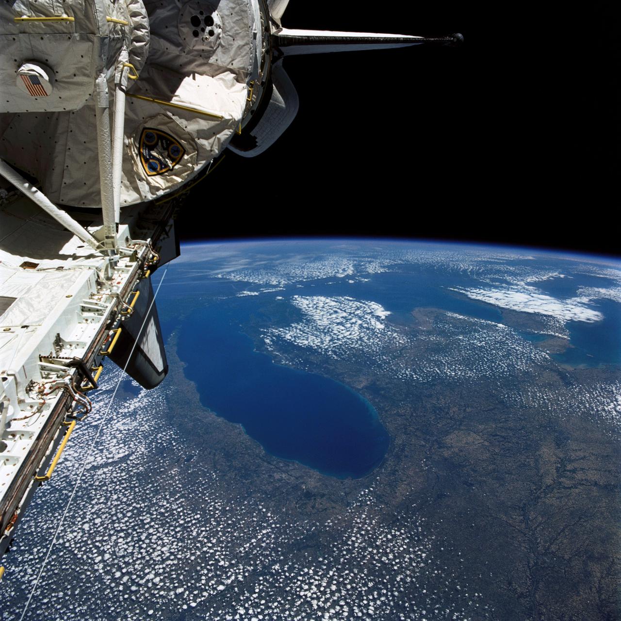
STS040-77-045 (6 June 1991) --- This image, photographed on June 6, 1991, is an oblique view looking north-northeast and shows most of the Great Lakes region. Part of Columbia's cargo bay and the Spacelab Life Sciences (SLS-1) module are in the foreground. In the center of the image is Lake Michigan with Chicago clearly visible along the southwest shore. According to NASA photo experts studying the STS-40 imagery, this image shows several interesting meteorological phenomena. The difference in temperature between the warming land and the cold lake waters is illustrated by the low level clouds. The warming land surface results in rising air and the formation of clouds, while the lake waters are cold and result in the lakes remaining cloud free. Also visible is evidence of lake breezes developing around several of the lakes. This phenomena is also driven by the difference in temperature between the land and the water. Winds blowing off the lakes must travel 25 - 30 miles inland before it warms sufficiently to create clouds.
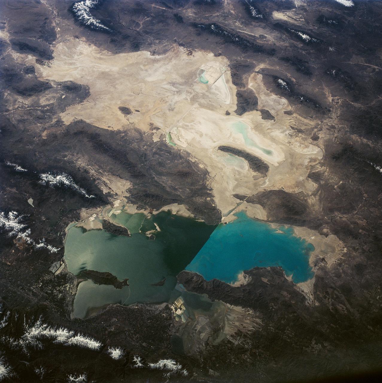
This is a view of the Great Salt Lake and nearby Bonneville Salt Flats, UT, (41.0N, 112.5W). A railroad causeway divides the lake with a stark straight line changing the water level and chemistry of the lake as a result. Fresh water runoff enters from the south adding to the depth and reducing the salinity. The north half receives little frsh water and is more saline and shallow. The Bonnieville Salt Flats is the lakebed of a onetime larger lake.
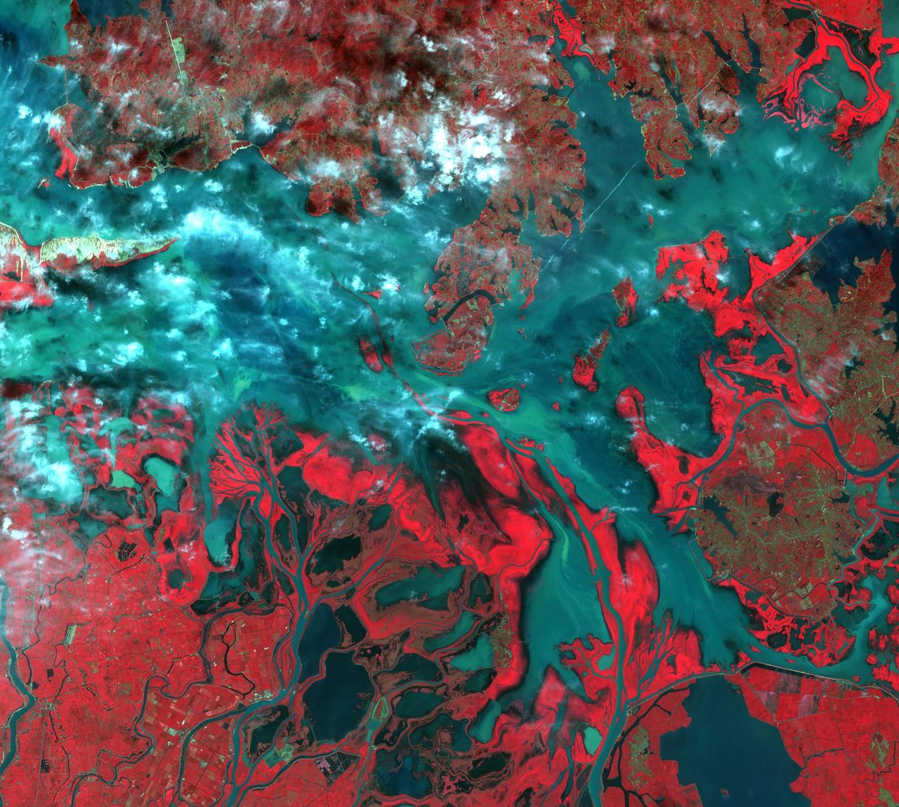
NASA image acquired December 17, 2010 In mid-December 2010, suspended sediments transformed the southern end of Lake Michigan. Ranging in color from brown to green, the sediment filled the surface waters along the southern coastline and formed a long, curving tendril extending toward the middle of the lake. The Moderate Resolution Imaging Spectroradiometer (MODIS) on NASA’s Aqua satellite captured these natural-color images on December 17, 2010 (top), and December 10, 2010 (bottom). Such sediment clouds are not uncommon in Lake Michigan, where winds influence lake circulation patterns. A scientificpaper published in 2007 described a model of the circulation, noting that while the suspended particles mostly arise from lake-bottom sediments along the western shoreline, they tend to accumulate on the eastern side. When northerly winds blow, two circulation gyres, rotating in opposite directions, transport sediment along the southern shoreline. As the northerly winds die down, the counterclockwise gyre predominates, and the smaller, clockwise gyre dissipates. Clear water—an apparent remnant of the small clockwise gyre—continues to interrupt the sediment plume. George Leshkevich, a researcher with the U.S. National Oceanic and Atmospheric Administration, explains that the wind-driven gyres erode lacustrine clay (very fine lakebed sediment) on the western shore before transporting it, along with re-suspended lake sediments, to the eastern shore. On the eastern side, the gyre encounters a shoreline bulge that pushes it toward the lake’s central southern basin, where it deposits the sediments. The sediment plume on December 17 followed a windy weather front in the region on December 16. NASA image courtesy MODIS Rapid Response Team at NASA GSFC. Caption by Michon Scott. Instrument: Aqua - MODIS <b><a href="http://www.nasa.gov/centers/goddard/home/index.html" rel="nofollow">NASA Goddard Space Flight Center</a></b> enables NASA’s mission through four scientific endeavors: Earth Science, Heliophysics, Solar System Exploration, and Astrophysics. Goddard plays a leading role in NASA’s accomplishments by contributing compelling scientific knowledge to advance the Agency’s mission. <b>Follow us on <a href="http://twitter.com/NASA_GoddardPix" rel="nofollow">Twitter</a></b> <b>Join us on <a href="http://www.facebook.com/pages/Greenbelt-MD/NASA-Goddard/395013845897?ref=tsd" rel="nofollow">Facebook</a></b> To read more about this image go to: <a href="http://earthobservatory.nasa.gov/IOTD/view.php?id=48511" rel="nofollow">earthobservatory.nasa.gov/IOTD/view.php?id=48511</a>
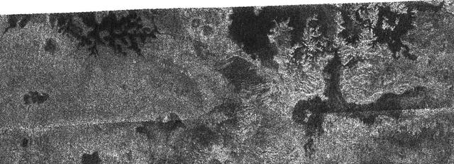
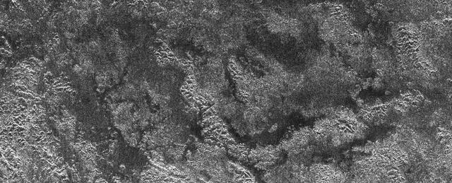
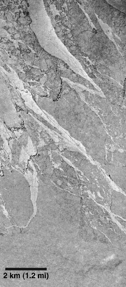
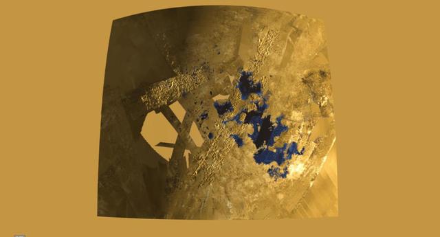
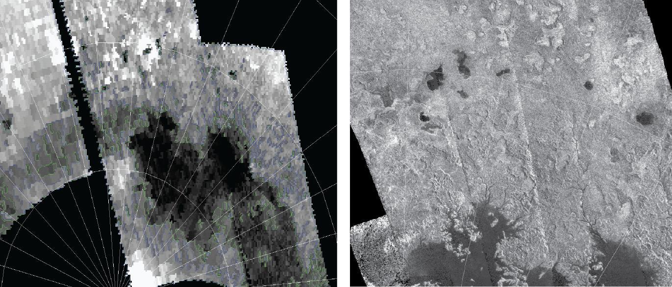
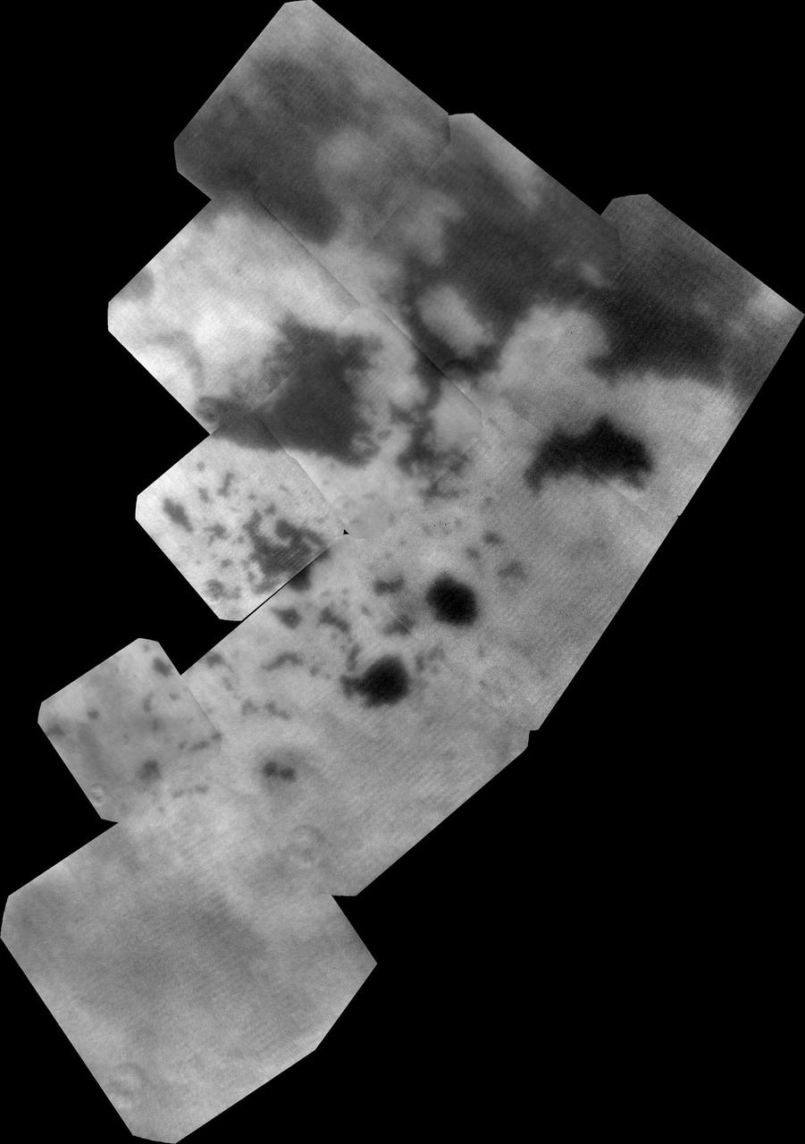
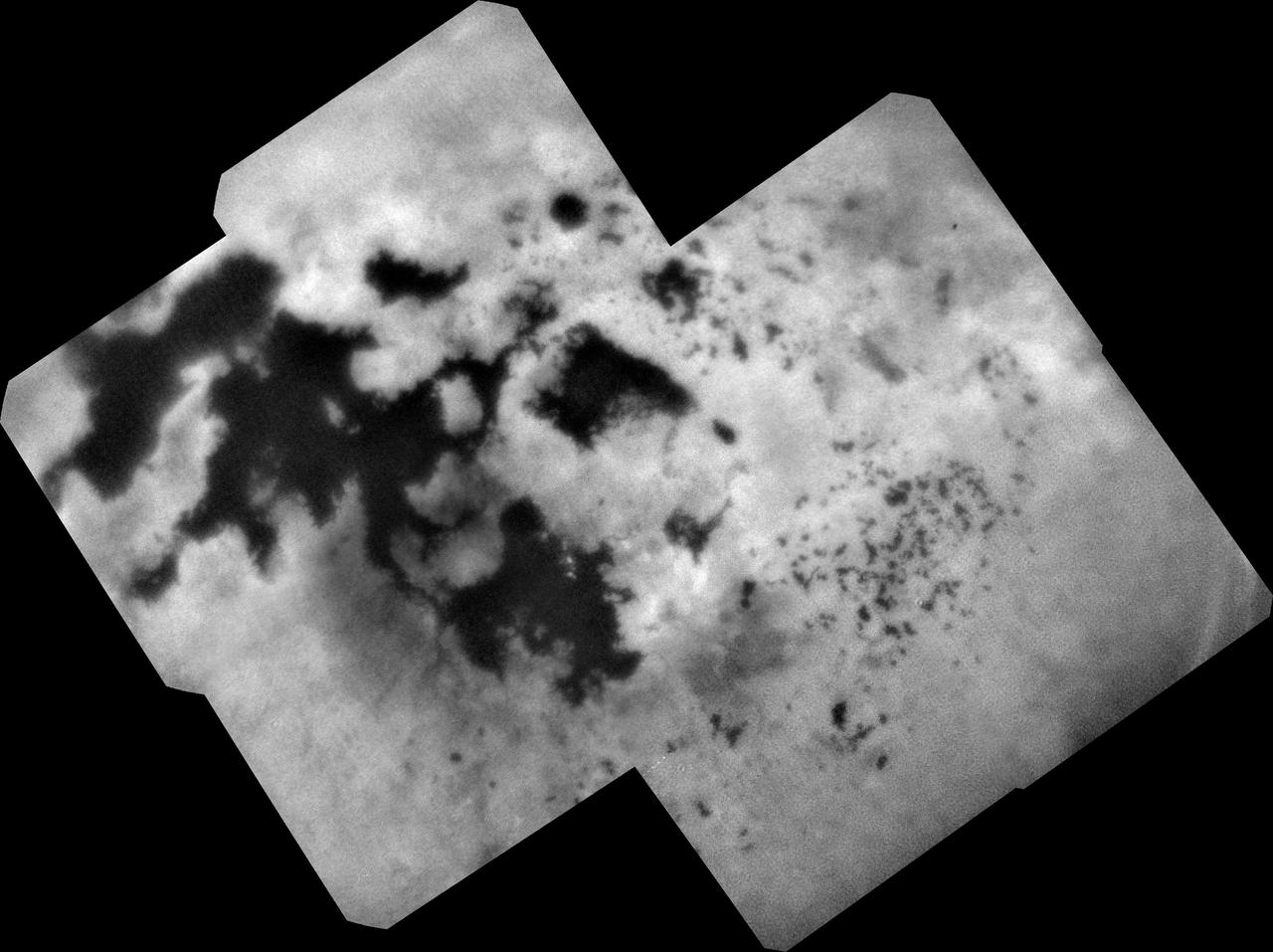
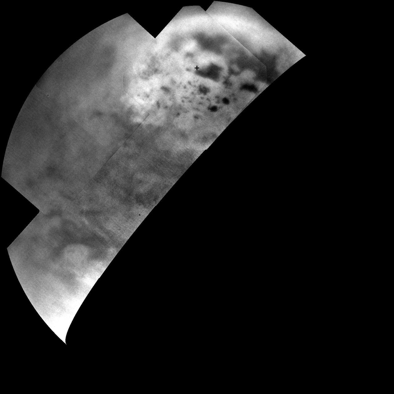
In this image taken by NASA Cassini radar system, a previously unseen style of lakes is revealed. The lakes here assume complex shapes and are among the darkest seen so far on Titan.
Lake Mackay is the largest of hundreds of ephemeral lakes scattered throughout Western Australia and the Northern Territory, and is the second largest lake in Australia. The darker areas indicate some form of desert vegetation or algae, moisture within the soils, and lowest elevations where water pools. The image was acquired on September 19, 2010 and covers an area of 27 x 41 km. With its 14 spectral bands from the visible to the thermal infrared wavelength region and its high spatial resolution of 15 to 90 meters (about 50 to 300 feet), ASTER images Earth to map and monitor the changing surface of our planet. ASTER is one of five Earth-observing instruments launched Dec. 18, 1999, on Terra. The instrument was built by Japan's Ministry of Economy, Trade and Industry. A joint U.S./Japan science team is responsible for validation and calibration of the instrument and data products. The broad spectral coverage and high spectral resolution of ASTER provides scientists in numerous disciplines with critical information for surface mapping and monitoring of dynamic conditions and temporal change. Example applications are: monitoring glacial advances and retreats; monitoring potentially active volcanoes; identifying crop stress; determining cloud morphology and physical properties; wetlands evaluation; thermal pollution monitoring; coral reef degradation; surface temperature mapping of soils and geology; and measuring surface heat balance. The U.S. science team is located at NASA's Jet Propulsion Laboratory, Pasadena, Calif. The Terra mission is part of NASA's Science Mission Directorate, Washington, D.C. More information about ASTER is available at <a href="http://asterweb.jpl.nasa.gov/" rel="nofollow">asterweb.jpl.nasa.gov/</a>. Image Credit: NASA/GSFC/METI/ERSDAC/JAROS, and U.S./Japan ASTER Science Team
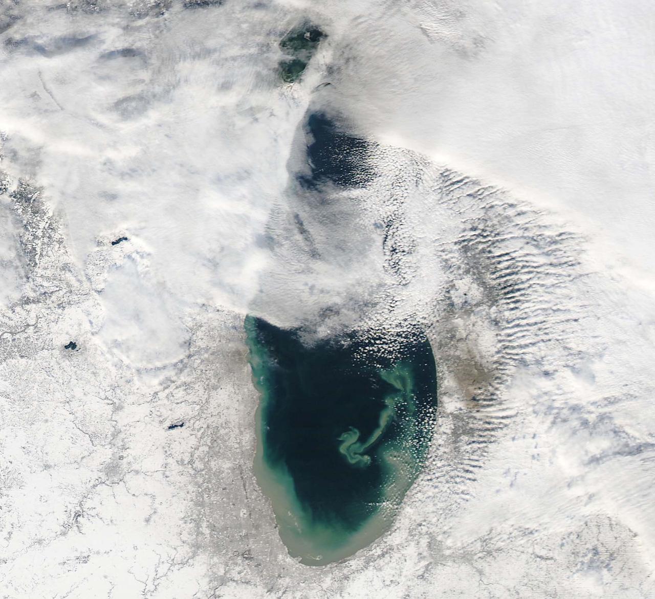
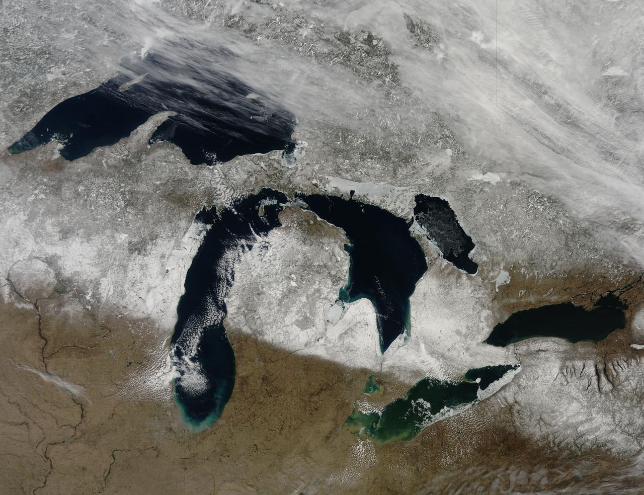
Though North America is a full month into astronomical spring, the Great Lakes have been slow to give up on winter. As of April 22, 2014, the Great Lakes were 33.9 percent ice covered. The lake they call Superior dominated the pack. In the early afternoon on April 20, 2014, the Moderate Resolution Imaging Spectroradiometer (MODIS) on NASA’s Aqua satellite captured this natural-color image of Lake Superior, which straddles the United States–Canada border. At the time Aqua passed over, the lake was 63.5 percent ice covered, according to the NOAA Great Lakes Environmental Research Lab (GLERL). Averaged across Lake Superior, ice was 22.6 centimeters (8.9 inches) thick; it was as much as twice that thickness in some locations. GLERL researcher George Leshkevich affirmed that ice cover this spring is significantly above normal. For comparison, Lake Superior had 3.6 percent ice cover on April 20, 2013; in 2012, ice was completely gone by April 12. In the last winter that ice cover grew so thick on Lake Superior (2009), it reached 93.7 percent on March 2 but was down to 6.7 percent by April 21. Average water temperatures on all of the Great Lakes have been rising over the past 30 to 40 years and ice cover has generally been shrinking. (Lake Superior ice was down about 79 percent since the 1970s.) But chilled by persistent polar air masses throughout the 2013-14 winter, ice cover reached 88.4 percent on February 13 and 92.2 percent on March 6, 2014, the second highest level in four decades of record-keeping. Air temperatures in the Great Lakes region were well below normal for March, and the cool pattern is being reinforced along the coasts because the water is absorbing less sunlight and warming less than in typical spring conditions. The graph below, based on data from Environment Canada, shows the 2014 conditions for all of the Great Lakes in mid-April compared to the past 33 years. Lake Superior ice cover got as high as 95.3 percent on March 19. By April 22, it was reported at 59.9 percent; Lake Huron was nearly 30.4 percent. News outlets noted that as many as 70 ships have been backed up in Lakes Michigan, Huron, and Erie, waiting for passage into ports on Lake Superior. The U.S. Coast Guard has been grouping ships together into small convoys after they pass through locks at Sault Ste. Marie, in order to maximize ice-breaking efficiency and to protect ships from damage. Superior is the world’s largest freshwater lake by area (82,100 square kilometers or 31,700 square miles) and the third largest by volume. The waters average 147 meters (483 feet) in depth, and the basin is believed to hold about 10 percent of the world’s liquid fresh water. NASA image courtesy Jeff Schmaltz LANCE/EOSDIS MODIS Rapid Response Team, GSFC. Caption by Mike Carlowicz. Read more: <a href="http://earthobservatory.nasa.gov/IOTD/view.php?id=83541&eocn=home&eoci=iotd_title" rel="nofollow">earthobservatory.nasa.gov/IOTD/view.php?id=83541&eocn...</a> Credit: <b><a href="http://www.earthobservatory.nasa.gov/" rel="nofollow"> NASA Earth Observatory</a></b> <b><a href="http://www.nasa.gov/audience/formedia/features/MP_Photo_Guidelines.html" rel="nofollow">NASA image use policy.</a></b> <b><a href="http://www.nasa.gov/centers/goddard/home/index.html" rel="nofollow">NASA Goddard Space Flight Center</a></b> enables NASA’s mission through four scientific endeavors: Earth Science, Heliophysics, Solar System Exploration, and Astrophysics. Goddard plays a leading role in NASA’s accomplishments by contributing compelling scientific knowledge to advance the Agency’s mission. <b>Follow us on <a href="http://twitter.com/NASAGoddardPix" rel="nofollow">Twitter</a></b> <b>Like us on <a href="http://www.facebook.com/pages/Greenbelt-MD/NASA-Goddard/395013845897?ref=tsd" rel="nofollow">Facebook</a></b> <b>Find us on <a href="http://instagram.com/nasagoddard?vm=grid" rel="nofollow">Instagram</a></b>
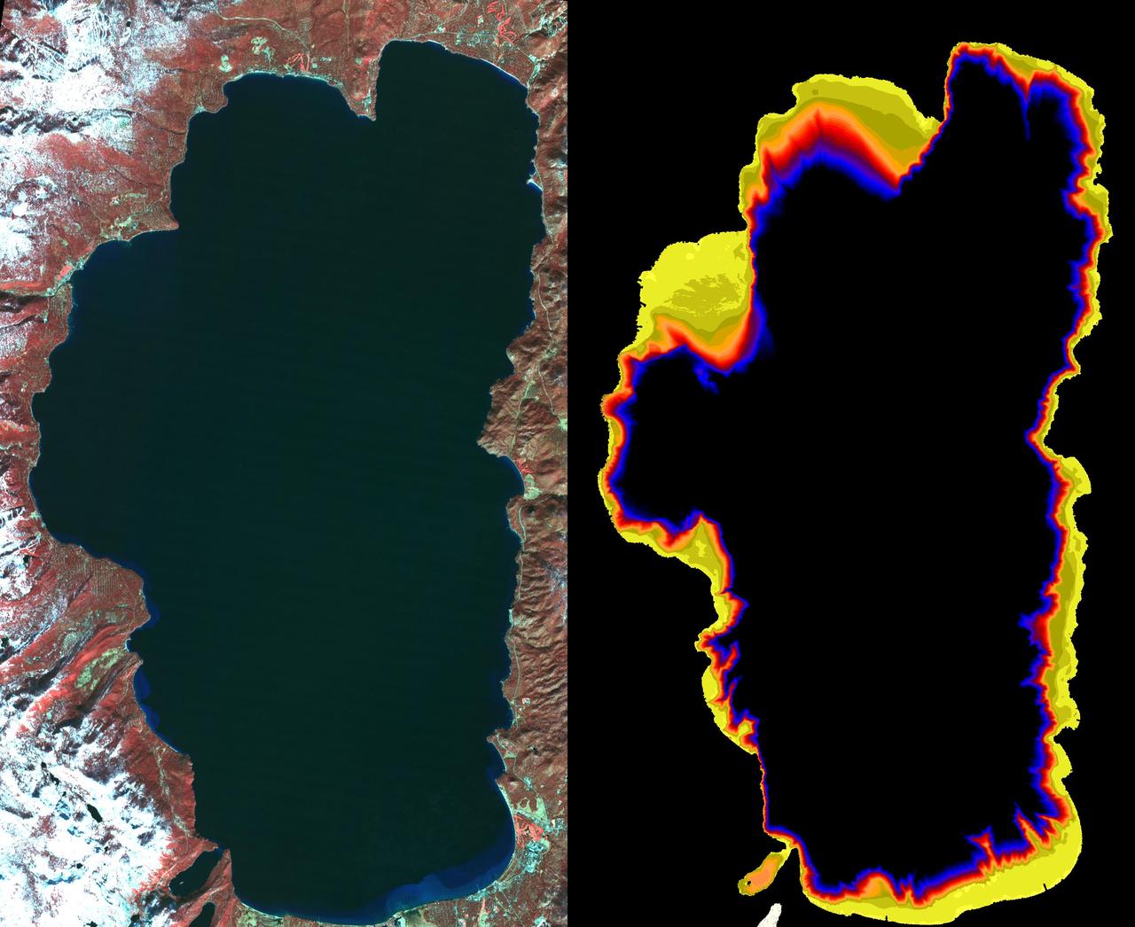
Lake Enriquillo is a hypersaline lake in the Dominican Republic. In 2004, the lake covered an area of 164 square kilometers; by 2011, it had doubled in size and grown to 350 km2, inundating farmland and homes. Various reasons for the flooding include increases in rainfall; increase of sediments going into the lake, raising the lakebed; and milder temperatures, reducing surface evaporation. The lake is home to the largest population of American crocodiles in the Caribbean. The images were acquired October 26, 2003 and June 10, 2017, cover an area of 22.7 by 45.4 km, and are located at 18.5 degrees north, 71.6 degrees west. An image of Lake Enriquillo taken in 2003 is available at https://photojournal.jpl.nasa.gov/catalog/PIA21815
This image from NASA Terra spacecraft shows Lake Urmia, a saline lake in northwestern Iran.
This image from NASA Terra spacecraft shows Poyang Lake, which was once China largest freshwater lake.

This image from NASA Terra spacecraft shows Lake Mackay, the largest of hundreds of ephemeral lakes scattered throughout Western Australia and the Northern Territory, and is the second largest lake in Australia.
NASA image captured March 28, 2011 The Great Lakes Satellite: Terra <b><a href="http://www.nasa.gov/centers/goddard/home/index.html" rel="nofollow">NASA Goddard Space Flight Center</a></b> enables NASA’s mission through four scientific endeavors: Earth Science, Heliophysics, Solar System Exploration, and Astrophysics. Goddard plays a leading role in NASA’s accomplishments by contributing compelling scientific knowledge to advance the Agency’s mission. <b>Follow us on <a href="http://twitter.com/NASA_GoddardPix" rel="nofollow">Twitter</a></b> <b>Join us on <a href="http://www.facebook.com/pages/Greenbelt-MD/NASA-Goddard/395013845897?ref=tsd" rel="nofollow">Facebook</a></b>
NASA Terra satellite presents this false color view of portions of Wisconsin and Michigan, including Devil Lake, Druid Lake, Ghost Lake, Spider Lake, and Witches Lake in Wisconsin; and Bat Lake, Corpse Pond and Witch Lake in Michigan.
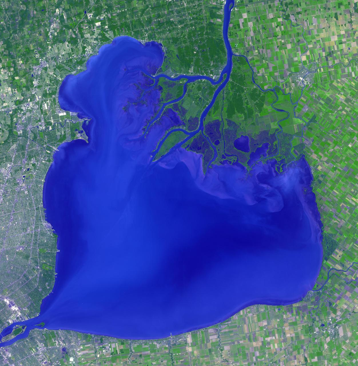
Lake St. Clair connects Lake Huron, via the St. Clair River, to Lake Erie, via the Detroit River. It is named after Claire of Assisi, on whose feast day it was first navigated by French explorers in 1679. The lake covers an area of about 1100 square kilometers, with an average depth of 3.5 meters. Both the U.S. and Canada maintain a deep shipping channel through the lake. The image was acquired September 9, 2002, covers an area of 51.4 by 52.5 kilometers, and is located at 42.5 degrees north, 82.7 degrees west. https://photojournal.jpl.nasa.gov/catalog/PIA23234
Japan's Lake Mashu on Hokkaido Island is one of the clearest lakes in the world. It was formed about 2,000 years ago due to a volcanic eruption that resulted in the formation of a caldera. Because of its remoteness and inaccessibility, few visitors come to admire the pristine lake. The image was acquired August 28, 2011, and is located at 43.6 degrees north, 144.5 degrees east. https://photojournal.jpl.nasa.gov/catalog/PIA23679

STS060-87-087 (3-11 Feb 1994) --- Lake Baikal, in southeastern Siberia, is the largest freshwater lake in the world by volume, holding nearly 20 per cent of the world's fresh water. Lake Baikal is a biospheric reserve of high international interest to the global scientific community. It is home to some 600 endemic species, many found in no other location. This view shows the northern end of the lake, and was taken in the early morning with low sun highlighting the mountain ranges rimming the lake basin. Pristine forests surround the lake, although heavy logging is evident in other photography of the central and southern portions of the lake. Another unique aspect of Lake Baikal is the existence of the world's only known freshwater hydrothermal springs. The fault system which bounds the lake allows fluids to circulate deep into the Earth and resurface as hot springs around and in the lake. Russian and American scientists are using the Shuttle photography to examine the relationship of the lake's ice cover to areas of known hydrothermal activity. Thus Lake Baikal has been and continues to be a high-priority site for photography from space from both the Space Shuttle and the Russian Space Station MIR.
Lake Karakul in northeast Tajikistan is a hypersaline lake with no external drainage, receiving less than 3 cm precipitation per year. It is on the highest part of the fabled Pamir highway at 3900 m. In the local Kyrgyz language, the lake is called "The Black Lake". Recently, Russian scientists have suggested that the lake occupies a 200 million year old meteor impact crater. The image was acquired October 16, 2016, covers an area of 48 by 55 km, and is located at 39 degrees north, 73.4 degrees east. https://photojournal.jpl.nasa.gov/catalog/PIA23102
The white ring around Lake Powell tells the story. The surface is down 98 feet. This is critical, because Powell, Lake Mead, and other lakes along the Colorado River provide water for millions of people in five states. We are in the eighth year of a drought on the Colorado River. This year was the driest year ever reported in Southern California, and there is a severe drought in Northern California, down to less than 30-percent of snow pack. This ASTER image of part of Lake Powell was acquired in 2001. The gray area depicts the shrunken, reduced 2007 lake extent compared to the extended, larger black area in 2001. The image covers an area of 24 x 30 km, and is centered near 37.1 degrees north latitude, 111.3 degrees west longitude. This image from NASA Terra satellite. http://photojournal.jpl.nasa.gov/catalog/PIA10614
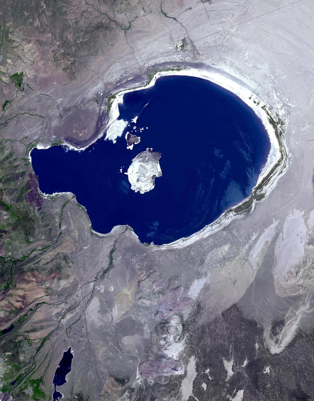
In eastern California, along the western edge of the Great Basin, sits Mono Lake. This is a salty remnant of a wetter era. Estimates are that the lake existed for at least 760,000 years. Now surrounded by mountain ranges, however, Mono Lake has no outlet; water entering the lake can only evaporate away, so Mono Lake is saltier than the ocean. South of the lake appear some of the geologic features known as Mono Craters. Geologists estimate that the Mono Craters last erupted about 650 years ago. The image was acquired July 7, 2016, covers an area of 22.6 by 34 km, and is located at 37.9 degrees north, 119 degrees west. http://photojournal.jpl.nasa.gov/catalog/PIA21518
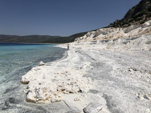
The eastern shore of Lake Salda in Turkey is a good analog for what an ancient lake may have looked like at Jezero Carter on Mars. The white sands and rocks are carbonate minerals that precipitated in the lake. The terraces on the right are old shorelines from when the lake levels were higher, where dried-out sediments have now cemented. These types of deposits might be present along the former shorelines at Jezero. What's more, these deposits might contain signs of microbes, if they ever existed on the Red Planet. NASA's Mars 2020 Perseverance mission will search for signs of ancient life in an dried-up lakebed on the surface of Mars. https://photojournal.jpl.nasa.gov/catalog/PIA24375

Oroville Dam in Northern California is an earth fill embankment dam, and is the tallest dam in the U.S. Lake Oroville is the second largest man-made lake in the state of California. The lake's capacity reflects the large swings in California's annual rainfall accumulation. With the reality of a very dry 2020-21 rain year, the 2014 data may anticipate this year's water shortage. On May 7, 2012, the lake held 3.5 million acre-feet of water, and was at maximum capacity. Two years later, on August 1, 2014, the lake held 1.2 million acre-feet of water, threatening the water supply to users of its water. The images cover an area of 22.5 by 23.4 km, and are located at 39.6 degrees north, 121.5 degrees west. https://photojournal.jpl.nasa.gov/catalog/PIA24555
n Jammu and Kashmir, India, along the Jhelum River, Dal and Wular Lakes are remnants of a much larger pre-glacial lake. Wular (in the northwest) is one of the largest freshwater lakes in Asia. Dal Lake (southeast) is an urban lake in Srinagar. It is famous for its Mughal gardens and luxury houseboats. Impressive restoration projects are ongoing to reverse eutrophication. The image was acquired July 3, 2015, covers an area of 39.7 by 43.6 km, and is located at 34.2 degrees north, 74.7 degrees east. https://photojournal.jpl.nasa.gov/catalog/PIA25123

SL2-05-390 (22 June 1973) --- Greater Detroit (42.0N, 82.5W) is located at the southeastern border of Michigan on the Detroit River across from Windsor, Ontario, Canada and Lake Huron to the north. The river connecting Lake Erie is a channel left over from the Ice Age Glaciers. The land use pattern in this scene is typical of this part of the upper Midwest. The once extensive forests have been cleared for farmland and pasture, but narrow rows of trees still line farm boundaries. Photo credit: NASA
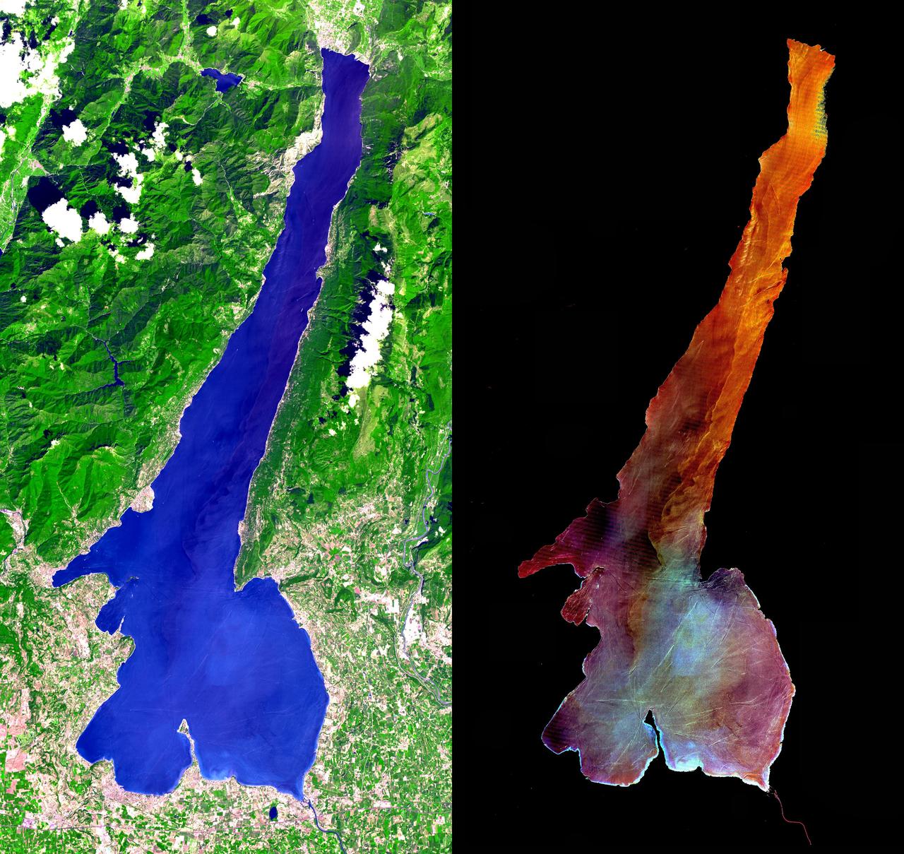
This ASTER image was acquired on July 29, 2000 and covers an area of 30 by 57 km in northern Italy. Lake Garda was formed by glaciers during the last Ice Age, and is Italy's largest lake. Lago di Garda lies in the provinces of Verona, Brescia, and Trento, and is 51 kilometers (32 miles) long and from 3 to 18 kilometers (2 to 11 miles) wide. The Sarca is its chief affluent, and the lake is drained southward by the Mincio, which discharges into the Po River. Many villas are situated on its shores. On the peninsula of Sirmione, at the southern end of the lake, are the ruins of a Roman villa and a castle of the Scaligers, an Italian family of the 16th century. The RIGHT image has the land area masked out, and a harsh stretch was applied to the lake values to display variations in sediment load. Also visible are hundreds of boats and their wakes, criss-crossing the lake. The image is centered at 45.6 degrees north latitude, 10.6 degrees east longitude. http://photojournal.jpl.nasa.gov/catalog/PIA02671
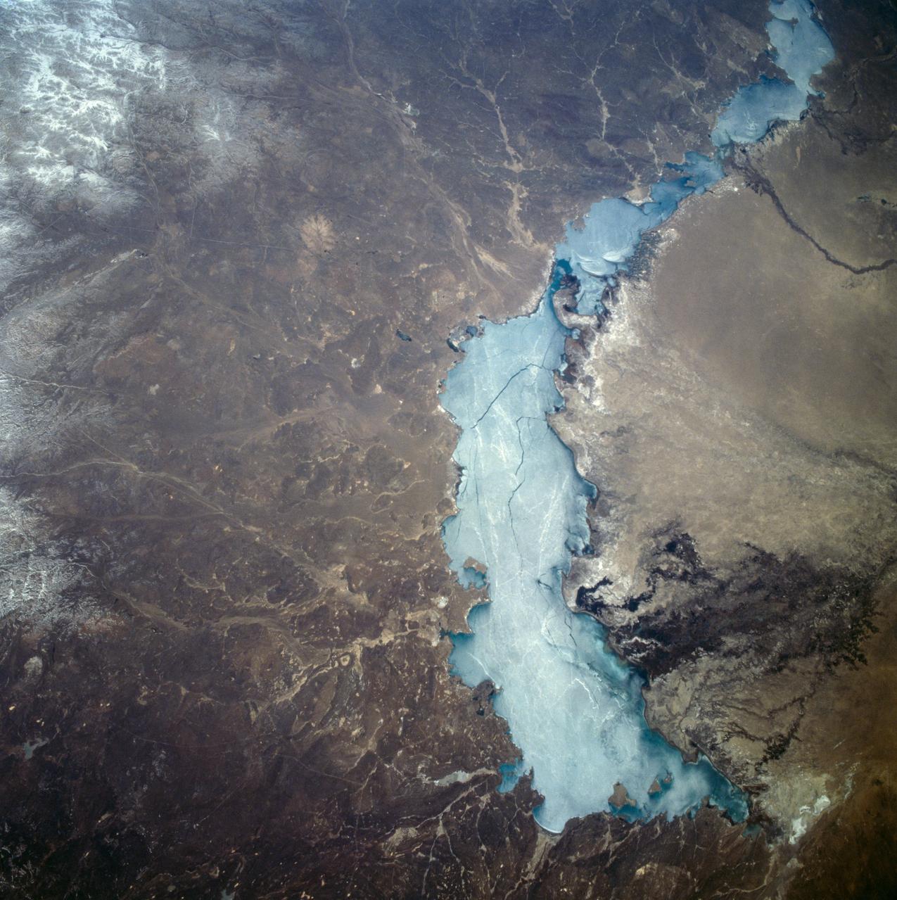
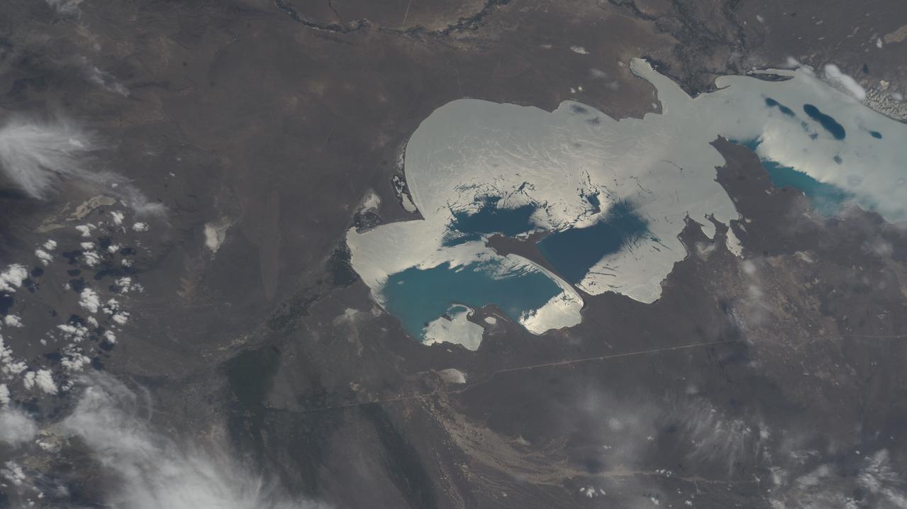
STS059-209-081 (9-20 April 1994) --- Lake Balkhash, in eastern Kazakhstan, is some 300 miles long. The lake, frozen in this scene, thawed noticeably during the mission. The shape of the lake is controlled by the delta of the Ili River, which flows from the Tien Shan Mountains in western China across this arid steppe. SRL scientists will use radar data to study the microwave effects of differences in soil moisture, and in freezing or thawing, on the deltaic sediments. Hasselblad camera.
STS059-154-160 (9-20 April 1994) --- Orient with Mono Lake, California at the lower right; then the view is westward across the Sierra Nevada into the San Joaquin River drainage. A tiny network of ski trails can be seen on the Mono Lake side of the Sierras, on a line between Mono Lake and the snow-free San Joaquin headwaters. The ski trails mark Mammoth Mountain, where SRL investigators are studying microwave measurements of the water content of snowpacks. Linhof camera.
Lakes on Saturn moon Titan reflect radio waves in varying ways in this image from NASA Cassini spacecraft. If a lake is fully liquid, it looks dark, but if it is only partially liquid, it looks brighter.
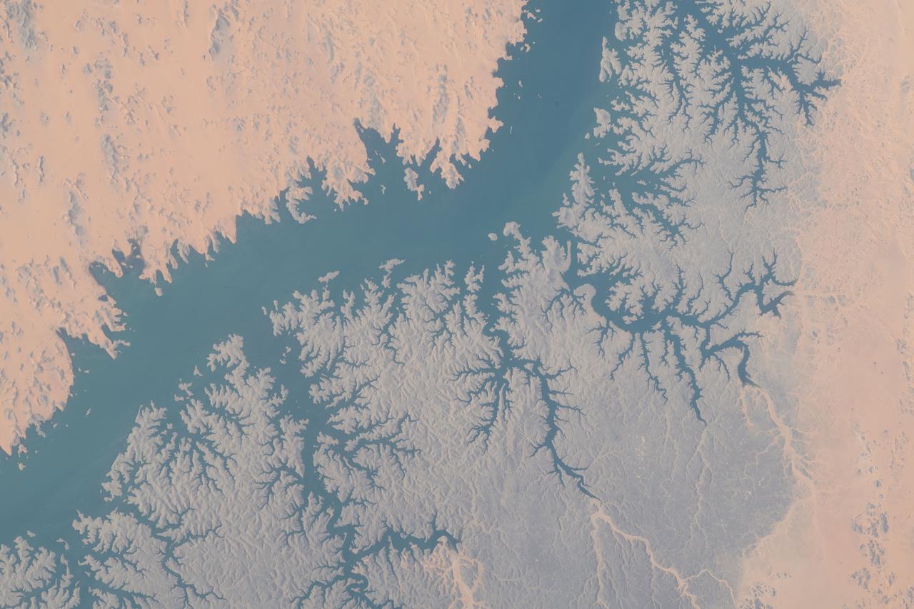
iss071e413340 (Aug. 1, 2024) --- At top left, is Lake Markakol, and at lower right, is the Irtysh River flowing into Lake Zayson in this photograph from the International Space Station as it orbited 259 miles above Kazakhstan.
NASA Cassini spacecraft peers down though layers of haze to glimpse the lakes of Titan northern regions. Titan has a hydrological cycle similar to Earth, but instead of water, Titan lakes and seas are filled with liquid methane and ethane.
Lake Afrera is a hypersaline lake located in the Danakil Depression in northern Ethiopia where rock salt has been mined for centuries. This image was acquired by NASA Terra spacecraft.
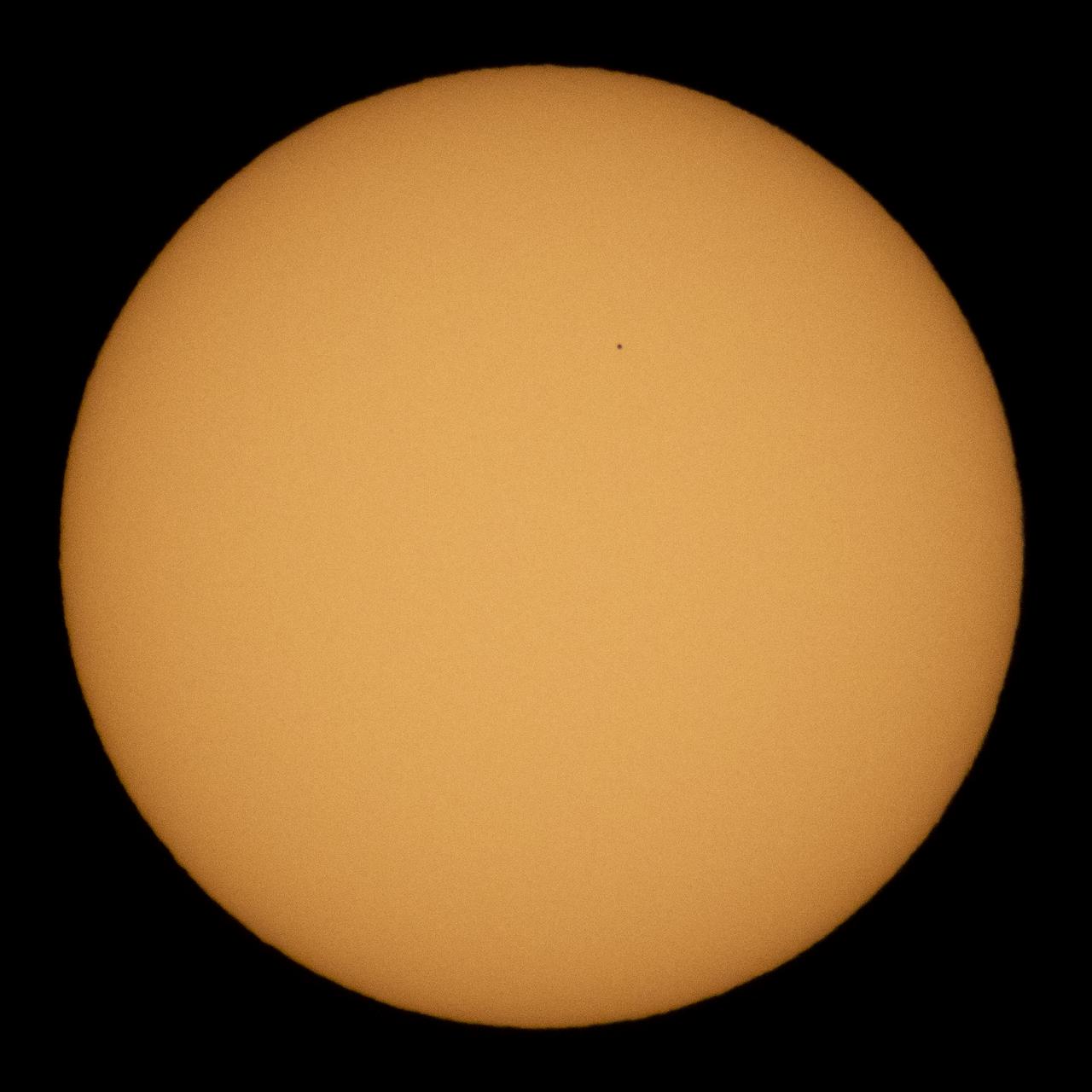
The planet Mercury is seen in silhouette as it transits across the face of the sun, Monday, Nov. 11, 2019 in Salt Lake City, Utah. Mercury’s last transit was in 2016. the next won't happen again until 2032. Photo Credit: (NASA/Joel Kowsky)
The Cassini spacecraft, using its radar system, has discovered very strong evidence for hydrocarbon lakes on Titan. Dark patches, which resemble terrestrial lakes, seem to be sprinkled all over the high latitudes surrounding Titan north pole

iss071e439835 (Aug. 7, 2024) --- Wildfires just northwest of California's Eagle Lake and Honey Lake (far left) are pictured from the International Space Station as it orbited 260 miles above The Golden State.
Proposed MSL site in Meridiani Crater Lake
Ancient Lakes on Mars? Results for Elysium Basin
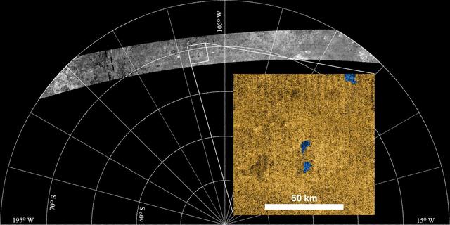
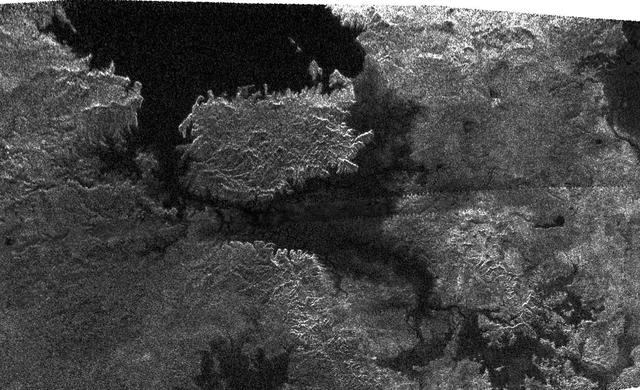
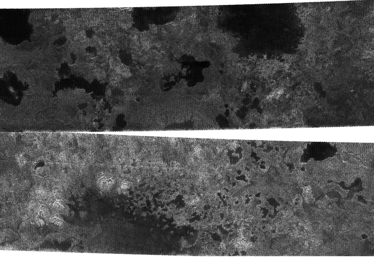
Radar Sees Lakes in Titan Southern Hemisphere

Lake Fitri is located in the center of Chad. It is fed by seasonal rainfall, so its area can triple in wet years. In extreme drought years, the lake may dry out completely. Wadi Batha empties into the lake from the east, and has created a large delta. Inundated linear sand dunes are found in the western and southwestern part of the image. The image was acquired May 19, 2017, covers an area of 48.9 by 48.9 km, and is located at 12.7 degrees north, 17.5 degrees east. https://photojournal.jpl.nasa.gov/catalog/PIA24018
Loktak Lake is the largest freshwater lake in northeast India, and is famous for the floating "phudmis," masses of vegetation, soil and organic material. The lake is a source of water for hydropower, irrigation, drinking water, and livelihood for fish farmers. The image was acquired March 19, 2018, covers an area of 20.5 by 27.3 kilometers, and is located at 24.5 degrees north, 93.8 degrees east. https://photojournal.jpl.nasa.gov/catalog/PIA22369
Yamzho Yumco (Sacred Swan) Lake in Tibet is surrounded by snow-capped mountains and is one of the three largest sacred lakes. It is highly crenellated with many bays and inlets. The lake is home to Samding Monastery, headed by a female re-incarnation (Wikipedia). The image was acquired March 6, 2014, covers an area of 49.8 by 60 km, and is centered at 28.9 degrees north, 90.6 degrees east. http://photojournal.jpl.nasa.gov/catalog/PIA21304
NASA image acquired August 28, 2010 Late August 2010 provided a rare satellite view of a cloudless summer day over the entire Great Lakes region. North Americans trying to sneak in a Labor Day weekend getaway on the lakes were hoping for more of the same. The Great Lakes comprise the largest collective body of fresh water on the planet, containing roughly 18 percent of Earth's supply. Only the polar ice caps contain more fresh water. The region around the Great Lakes basin is home to more than 10 percent of the population of the United States and 25 percent of the population of Canada. Many of those people have tried to escape record heat this summer by visiting the lakes. What they found, according to The Hamilton Spectator, was record-breaking water temperatures fueled by record-breaking air temperatures in the spring and summer. By mid-August, the waters of Lake Superior were 6 to 8°C (11 to 14°F) above normal. Lake Michigan set records at about 4°C (7°F) above normal. The other three Great Lakes – Huron, Erie, and Ontario -- were above normal temperatures, though no records were set. The image was gathered by the Moderate Resolution Imaging Spectroradiometer (MODIS) on NASA’s Aqua satellite at 1:30 p.m. Central Daylight Time (18:30 UTC) on August 28. Open water appears blue or nearly black. The pale blue and green swirls near the coasts are likely caused by algae or phytoplankton blooms, or by calcium carbonate (chalk) from the lake floor. The sweltering summer temperatures have produced an unprecedented bloom of toxic blue-green algae in western Lake Erie, according to the Cleveland Plain Dealer. NASA image by Jeff Schmaltz, MODIS Rapid Response Team, Goddard Space Flight Center. Caption by Mike Carlowicz. Instrument: Aqua - MODIS Click here to see more images from <b><a href="#//earthobservatory.nasa.gov/" rel="nofollow"> NASA Goddard’s Earth Observatory</a></b> <b><a href="http://www.nasa.gov/centers/goddard/home/index.html" rel="nofollow">NASA Goddard Space Flight Center</a></b> is home to the nation's largest organization of combined scientists, engineers and technologists that build spacecraft, instruments and new technology to study the Earth, the sun, our solar system, and the universe. <b>Follow us on <a href="http://twitter.com/NASA_GoddardPix" rel="nofollow">Twitter</a></b> <b>Join us on <a href="http://www.facebook.com/pages/Greenbelt-MD/NASA-Goddard/395013845897?ref=tsd" rel="nofollow">Facebook</a></b>
This oblique view of Lake Chad was taken by the STS-66 crew in November 1994. This lake lies mainly in the Republic of Chad and partly in Nigeria, Cameroon and Niger. The size of Lake Chad varies seasonally and is actually divided into north and south basins; neither of which is generally more than 25 feet (7.6 meters) deep. In this photograph, all the water appears to be located in the southern basin with the northern and eastern edges of both basins covered with sand dunes which have invaded the area where the water once stood. The prevailing wind direction can be seen from the agriculture burning in both basins to be from the east.
iss071e462180 (Aug. 9, 2024) --- Lake Assad in Syria (upper right) and lakes created by hydroelectric dams in Turkiye, all along the Euphrates River, are pictured from the International Space Station as it orbited 263 miles above the Turkish nation that connects Europe with Asia.
SL3-22-0322 (July-September 1973) --- An oblique view of the Salt Lake City, Utah area as photographed from Earth orbit by one of the six lenses of the Itek-furnished S190-A Multispectral Photographic Facility Experiment aboard the Skylab space station. Approximately two-thirds of the Great Salt Lake is in view. The smaller body of water south of Salt Lake City is Utah Lake. The Wasatch Range is on the east side of the Great Salt Lake. Federal agencies participating with NASA on the EREP project are the Departments of Agriculture, Commerce, Interior, the Environmental Protection Agency and the Corps of Engineers. All EREP photography is available to the public through the Department of Interior?s Earth Resources Observations Systems Data Center, Sioux Falls, South Dakota, 57198. Photo credit: NASA
Lake Mead, the largest reservoir in the US, has fallen to its lowest level ever. The water is a major source for such cities as Los Angeles and Las Vegas. With the predicted drought through this summer, the lake's water supply is expected to further shrink. In 2000, the lake was at its highest, and has declined ever since. The images were acquired June 14, 2021 and July 6, 2000, cover an area of 25.5 by 30 km, and are located at 36 degrees north, 114.7 degrees west. https://photojournal.jpl.nasa.gov/catalog/PIA24696

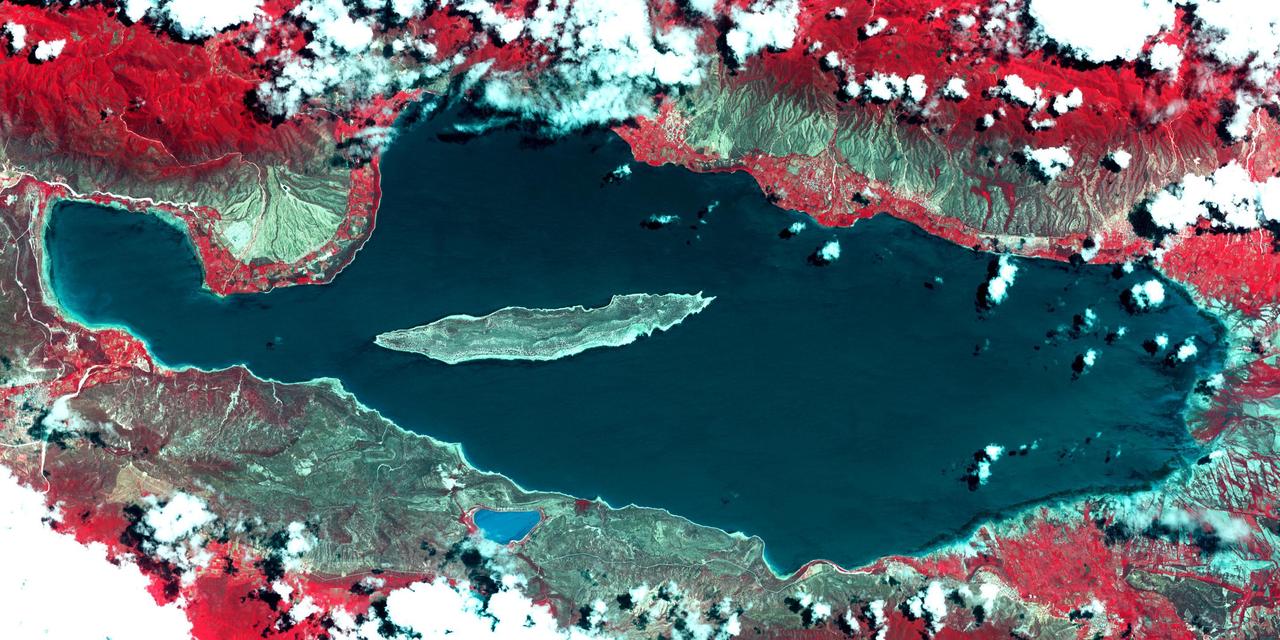
Lake Ohrid straddles the border between North Macedonia and Albania. It is one of Europe's oldest (3-5 million years old) and deepest (almost 300 m) lakes, with more than 200 endemic species. The lake is a UNESCO World Heritage Site and a Wetland of International Importance under the Ramsar Convention. The image was acquired September 15, 2017, covers an area of 30.7 by 39.8 km, and is located at 41.1 degrees north, 20.7 degrees east. https://photojournal.jpl.nasa.gov/catalog/PIA25306

Lake Ilopango is a crater lake which fills a volcanic caldera in central El Salvador, immediately east of the capital city San Salvador. The caldera collapsed most recently in about 500 AD, producing 20 times as much ash as the Mount St. Helens eruption, and blanketing an area of at least 10,000 square kilometers waist-deep in ash. The only historical eruption occurred in 1879, forming lava domes, now islets in the lake. Quetzaltepec is the stratovolcano just west of the city. Its last eruption in 1917 produced lavas flowing down the northwest flank, and evaporated the crater lake. The image was acquired March 5, 2006, covers an area of 27 by 42 km, and is located at 13.7 degrees north, 89.1 degrees west. http://photojournal.jpl.nasa.gov/catalog/PIA19237
NASA Terra spacecraft acquired this image of the region north of Lake Baikal on Aug. 22, 2015. For weeks, forest fires have been raging in Siberia around Russia Lake Baikal.
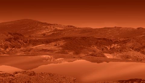
This frame from a colorized flyover movie from NASA Cassini mission shows the two largest seas on Saturn moon Titan and nearby lakes. The liquid in Titan lakes and seas is mostly methane and ethane.
Lake Eyre is a large salt lake situated between two deserts in one of Australia driest regions. These four images from NASA Terra spacecraft austral summers of 2000 and 2002.
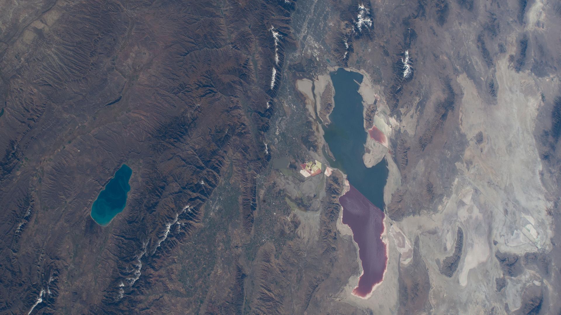
iss073e0865636 (Oct. 7, 2025) --- Bear Lake (left) is a freshwater lake spanning Idaho and Utah, and is smaller and much deeper than Utah's Great Salt Lake—averaging 208 feet compared to just 14 feet. The distinct color differences in the Great Salt Lake are caused by a railroad causeway: the red portion has much higher salinity than the blue, less saline section.
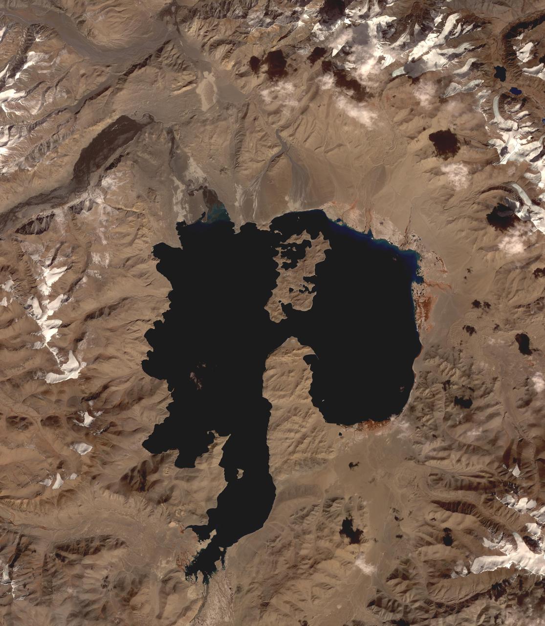
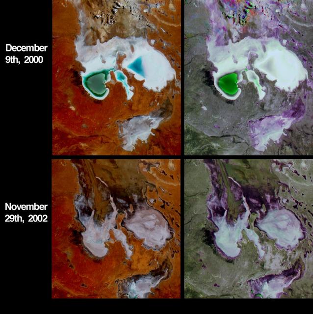
In the high plains of the Andes in Bolivia, Lake Poopo has virtually vanished, as shown in this image from NASA Terra spacecraft. Once covering over 3,000 square kilometers, the lake essentially dried up in 2015. What led to Lake Poopo's demise? Water diversions upstream, weather extremes and recurrent droughts are thought to blame. The images cover an area of 48.9 by 55.1 km, were acquired February 14, 2001 and November 6, 2016, and are located near 18.7 degrees south, 67.1 degrees west. https://photojournal.jpl.nasa.gov/catalog/PIA21546
An image of the Comet C/2020 F3 NEOWISE (Comet NEOWISE) captured above the tree line of Lone Pine Lake, located on the Mount Whitney Trail in the Eastern Sierra Nevada Mountains in California. The photo was taken at 4:59 am on July 14, 2020. Visiting from the distant parts of the solar system, it’s characterized by a glowing tail and is visible during the month of July. The comet returns in 6,800 years.

One of NASA's two F-15 research aircraft gets refueled in mid-air over Lake Isabella from a USAF KC-135 tanker while NASA's other F-15 flies chase alongside.
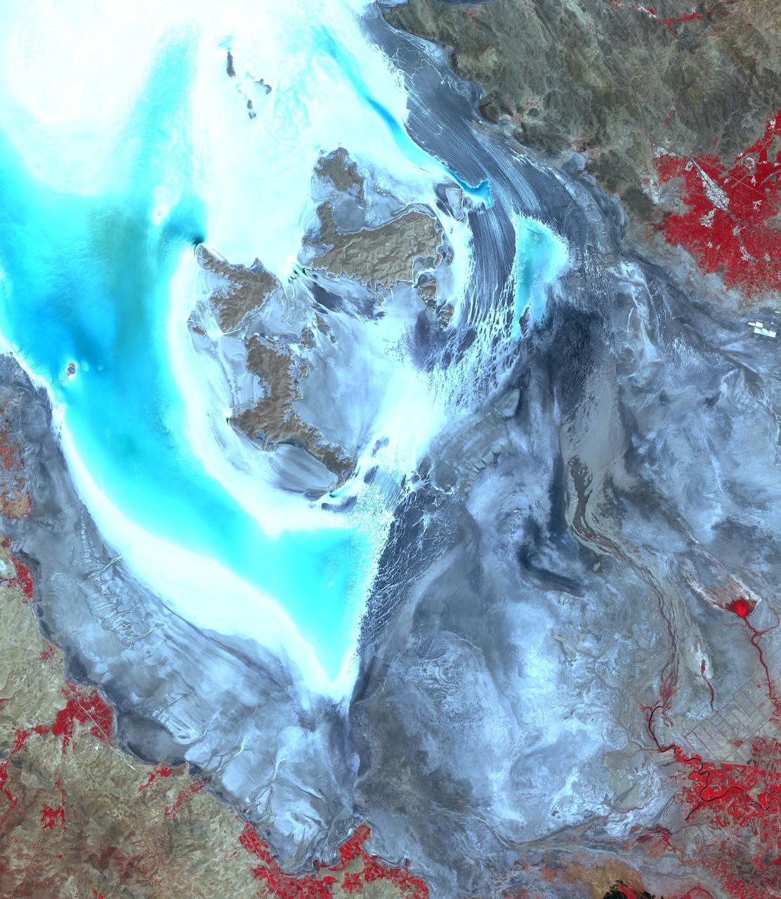
iss071e615200 (Sept. 9, 2024) -- The ephemeral Lake Carnegie, one of Western Australia's largest lakes, displays its mixture of water and mud as the International Space Station orbited 263 miles above. The lake fills with water only during periods of heavy rainfall, while in dry years, the lake is mostly a muddy marsh.

Alexis Harry, assistant director of Astro Camp at NASA's John C. Stennis Space Center, talks with students at Lake Cormorant (Miss.) Elementary School during a 'Living and Working in Space' presentation March 30. Stennis hosted the school presentation during a visit to the Oxford area. Harry, who also is a high school biology teacher in Slidell, La., spent time discussing space travel with students and answering questions they had about the experience, including queries about how astronauts eat, sleep and drink in space. The presentation was sponsored by the NASA Office of External Affairs and Education at Stennis. For more information about NASA education initiatives, visit: http://education.ssc.nasa.gov/.
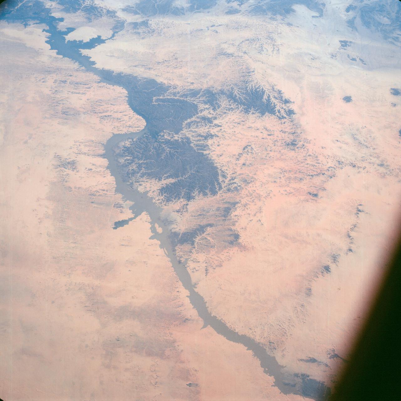
Lake Nasser on the Nile River in southeastern United Arab Republic (Egypt) as seen from the Apollo 7 spacecraft during its 10th revolution of the earth. Photographed from an altitude of 130 nautical miles, at ground elapsed time of 14 hours and 56 minutes. Lake Nasser was created by the contruction of the Aswan Dam on the Nile.
These images from NASA Cassini spacecraft show one of the large seas and a bounty of smaller lakes on Saturn moon Titan.
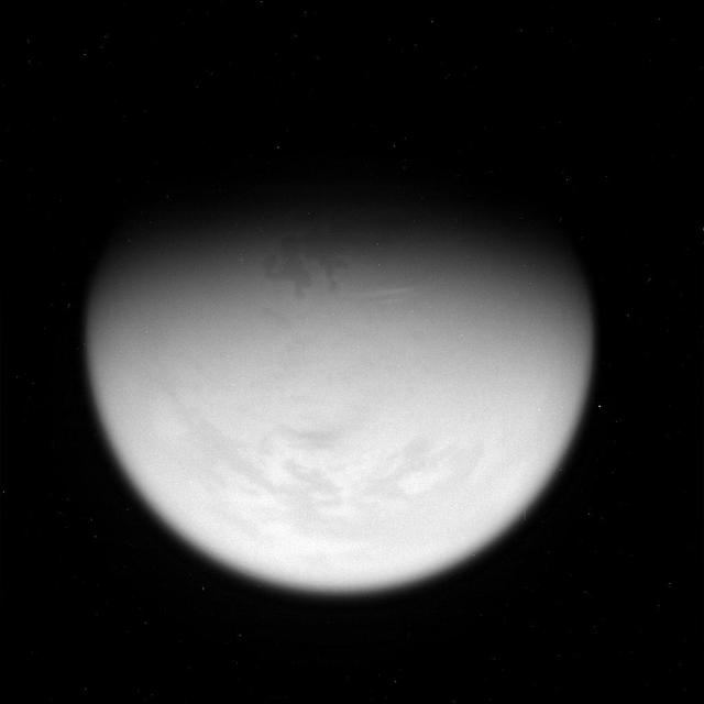
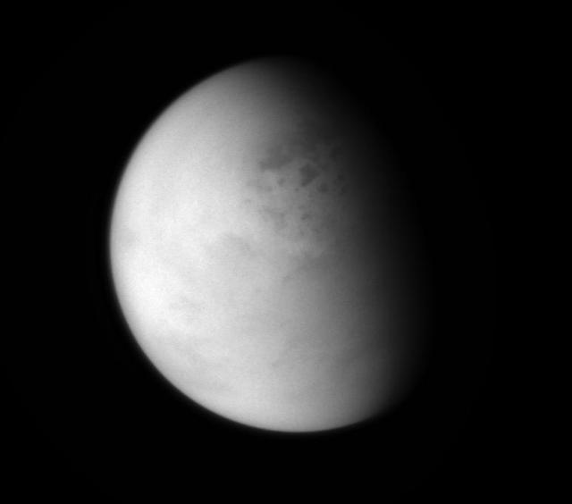
This view of Titan taken on Feb. 25, 2007, reveals a giant lake-like feature in Titan North Polar Region
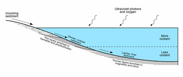
This diagram presents some of the processes and clues related to a long-ago lake on Mars that became stratified, with the shallow water richer in oxidants than deeper water was. The sedimentary rocks deposited within a lake in Mars' Gale Crater more than three billion years ago differ from each other in a pattern that matches what is seen in lakes on Earth. As sediment-bearing water flows into a lake, bedding thickness and particle size progressively decrease as sediment is deposited in deeper and deeper water as seen in examples of thick beds (PIA19074) from shallowest water, thin beds (PIA19075) from deeper water and even thinner beds (PIA19828) from deepest water. At sites on lower Mount Sharp, inside the crater, measurements of chemical and mineral composition by NASA's Curiosity Mars rover reveal a clear correspondence between the physical characteristics of sedimentary rock from different parts of the lake and how strongly oxidized the sediments were. Rocks with textures indicating that the sediments were deposited near the edge of a lake have more strongly oxidized composition than rocks with textures indicating sedimentation in deep water. For example, the iron mineral hematite is more oxidized than the iron mineral magnetite. An explanation for why such chemical stratification occurs in a lake is that the water closer to the surface is more exposed to oxidizing effects of oxygen in the atmosphere and ultraviolet light. On Earth, a stratified lake with a distinct boundary between oxidant-rich shallows and oxidant-poor depths provides a diversity of environments suited to different types of microbes. If Mars has ever hosted microbial live, the stratified lake at Gale Crater may have similarly provided a range of different habitats for life. https://photojournal.jpl.nasa.gov/catalog/PIA21500
iss072e005520 (Sept. 29, 2024) -- One of the largest lakes in Central Asia, Lake Balkhash, was pictured from the International Space Station as it orbited 260 miles above.
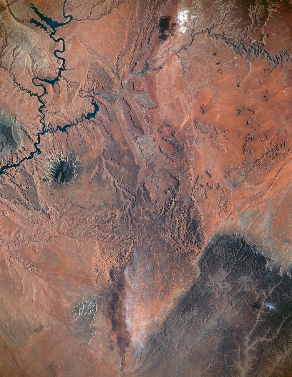
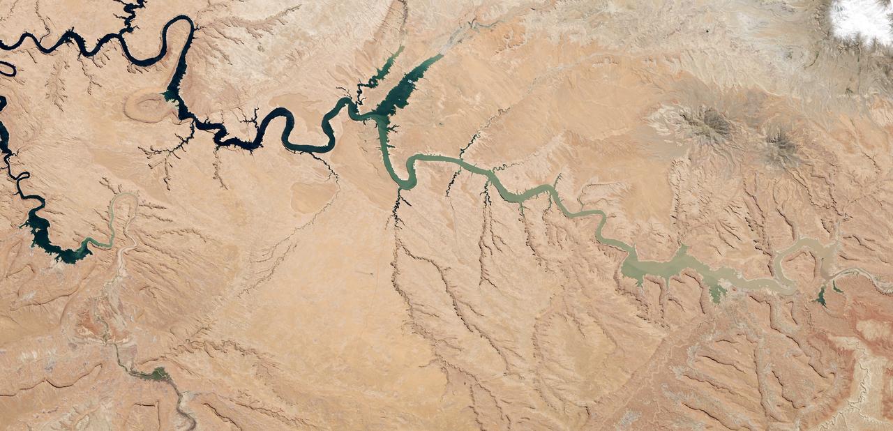
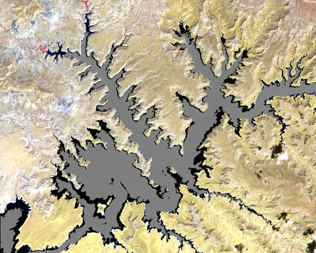
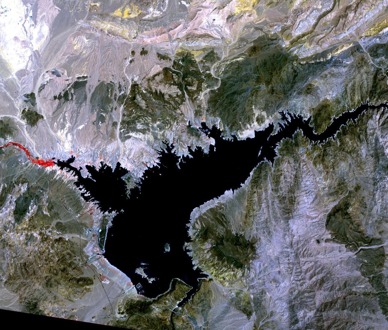
STS040-151-123 (5-14 June 1991) --- This large format view shows parts of northern Arizona and southern Utah. San Juan River, Lake Powell and Monument Valley are visible. Water of Lake Powell can be seen filling the valleys of the Colorado and San Juan Rivers at the top of the image. The darker green areas indicate high, forested country of the lone Navajo Mountain (center left) and Black Mesa (bottom right). Strip mines can be seen south of the rim of Black Mesa. Monument Valley lies between the San Juan River and Black Mesa. Shadows thrown by the individual steep-sided hills make them stand out in the scene.
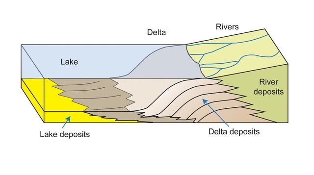
This diagram depicts rivers entering a lake. Where the water flow decelerates, sediments drop out, and a delta forms, depositing a prism of sediment that tapers out toward the lake interior.
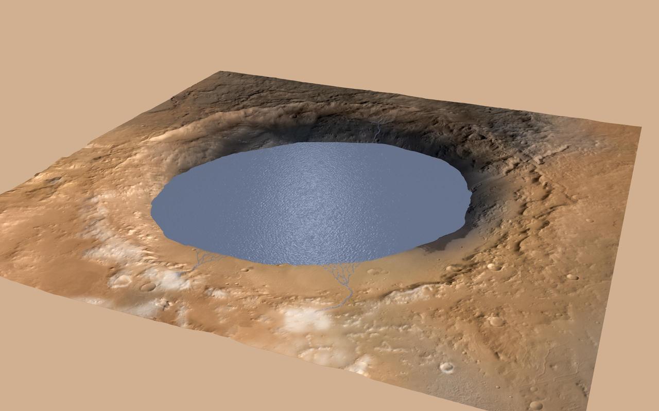
This simulation depicts a lake partially filling Mars Gale Crater, receiving runoff from snow melting on the crater rim, showing evidence that NASA Curiosity rover has found ancient streams, deltas and lakes.
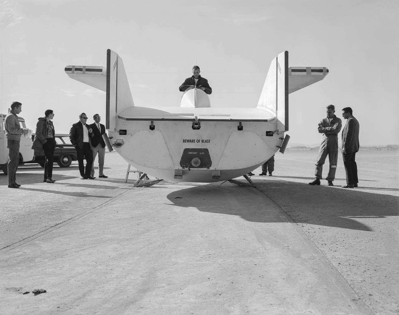
The M2-F1 following a hard landing on Rogers Dry Lake in 1963. It hit the lakebed so hard the rolling gear completely separated.
The vast hydrocarbon seas and lakes dark shapes near the north pole of Saturn moon Titan sprawl out beneath the watchful eye of NASA Cassini spacecraft. Scientists are studying images like these for clues about how Titan hydrocarbon lakes formed.
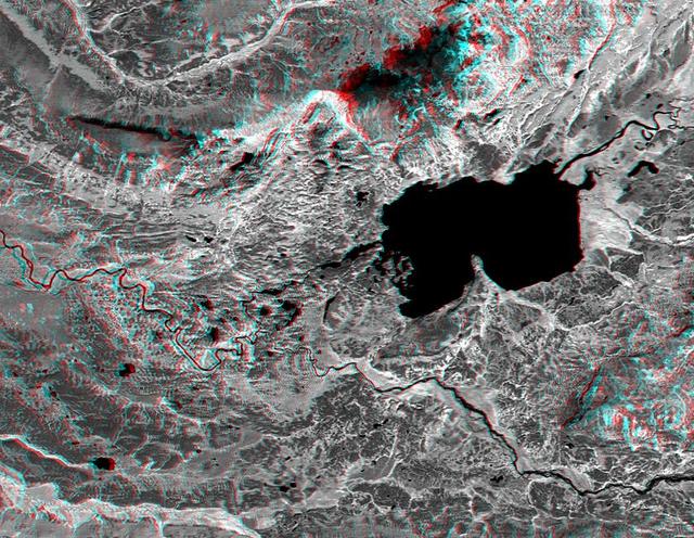
This anaglyph, from NASA Shuttle Radar Topography Mission, is of Salt Lake City, Utah. 3D glasses are necessary to view this image.
STS068-155-011 (30 September-11 October 1994) --- (Okanagan Lake, British Columbia) View southward down the lake; Vernon is in the foreground, Kelowna just before the bend in the lake, and Penticton at the far end of the lake. Green crops are still vigorous despite the season (early October); clear-cuts dot the forested hillsides.
Images from the Advanced Spaceborne Thermal Emission and Reflection Radiometer aboard NASA's Terra satellite, launched in 1999, illustrate the state of gradually decreasing water clarity at Lake Tahoe, one of the clearest lakes in the world. The images are available at: http://asterweb.jpl.nasa.gov/default.htm. In the image on the left, acquired in November 2000, vegetation can be seen in red. The image on the right, acquired at the same time by a different spectral band of the instrument, is color-coded to show the bottom of the lake around the shoreline. Where the data are black, the bottom cannot be seen. Scientists monitoring the lake's water clarity from boat measurements obtained since 1965 have discovered that the lake along the California-Nevada border has lost more than one foot of visibility each year, according to the Lake Tahoe Watershed Assessment, a review of scientific information about the lake undertaken at the request of President Clinton and published in February 2000. The most likely causes are increases in algal growth, sediment washed in from surrounding areas and urban growth and development. http://photojournal.jpl.nasa.gov/catalog/PIA03854
In the top right of NASA Cassini image, the southern end of Titan huge lake of liquid hydrocarbons called Kraken Mare is visible near the moon north pole.
This image of Teshekpuk Lake on Alaska North Slope, within the National Petroleum Reserve, was acquired on August 15, 2000 by NASA Terra spacecraft.

iss069e060346 (August 15, 2023) -- Lake Mansarovar, fed by Kailash glaciers, sits at an altitude of over 15,000 feet (~4590 meters). The freshwater lake neighbors saltwater Lake Rakshastal (to the left of the image) in the Tibetan region of East Asia. As the International Space Station soared roughly 260 miles above, UAE (United Arab Emirates) Flight Engineer Sultan Alneyaedi captured this photo.

iss058e013234 (Feb. 13, 2019) --- The International Space Station was flying 256 miles above Canada when an Expedition 58 crew member, looking north to south, photographed Lake Superior and Lake Michigan surrounded by the cloudy and frozen terrain of the North American continent.
Prior to 1913, Owens Lake in eastern California had water up to a depth of 15 m, and covered an area of 280 km2. With the construction of the Los Angeles Aqueduct, all of the water from the Owens River was diverted to Los Angeles, and the lake dessicated, leading to dust storms that caused the worst air pollution in the state. Starting in 2002, various mitigation efforts were undertaken, including re-vegetation, flooding to create shallow ponds, and surface saturation to rehydrate the top layers. The ASTER image was acquired on September 29, 2020. It covers an area of 25.6 by 32.3 km, and is located at 36.4 degrees north, 117.9 degrees west. https://photojournal.jpl.nasa.gov/catalog/PIA24733
/iss071e414494 (1)~medium.jpg)
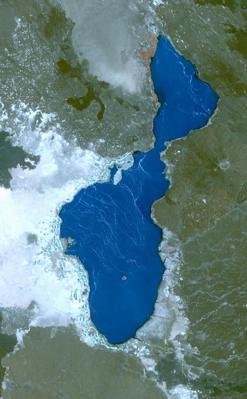
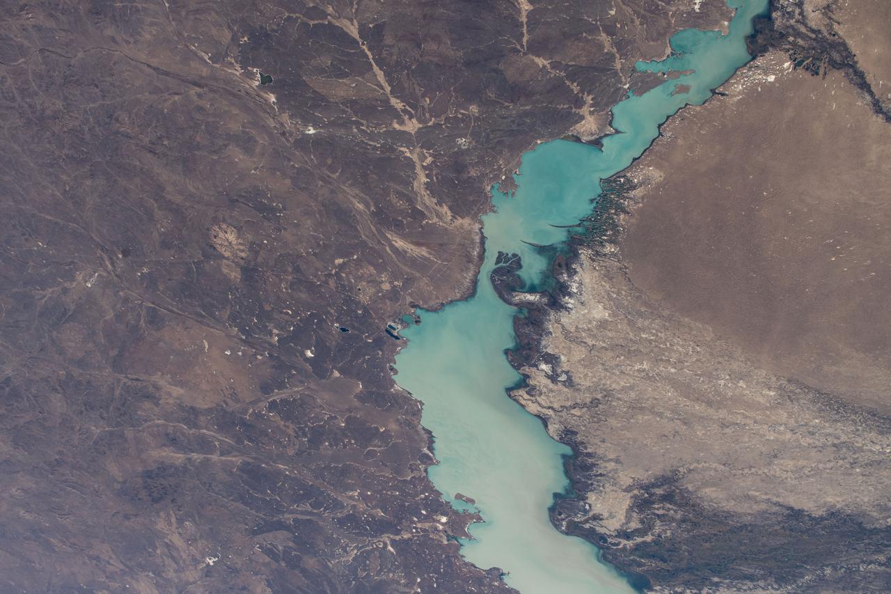
iss071e414494 (Aug. 2, 2024) -- The rich red saltwater of Lake Urmia is pictured from the International Space Station as it orbited 260 miles above. Over the past few decades, the lake has shrunk, causing higher salt concentrations in the water, resulting in microscopic organisms turning the water shades of red and orange.
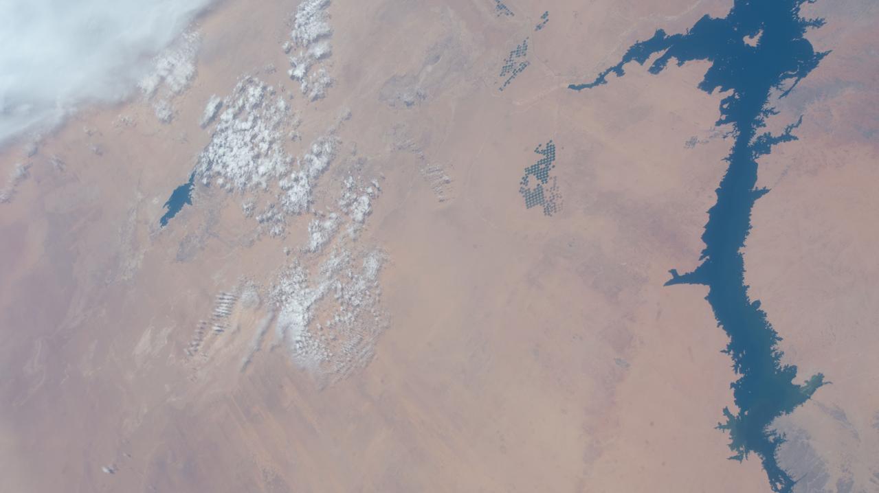
iss058e010623 (Feb. 5, 2019) --- Lake Nasser in Egypt, which leads to the Nile River, is pictured as the International Space Station orbited 251 miles above the Western Desert in the African nation.
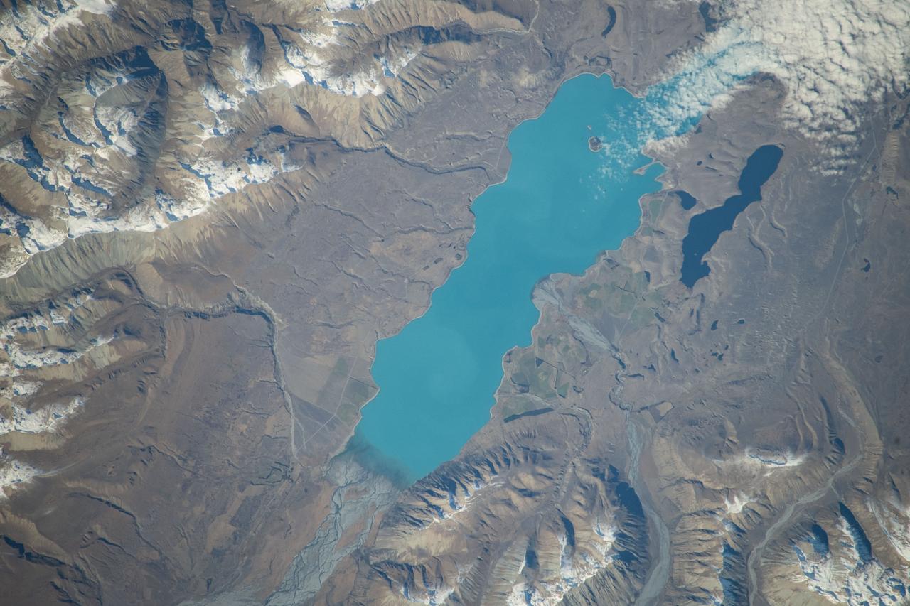
iss071e051532 (May 5, 2024) -- Lake Tekapo's turquoise color contrasts against the surrounding mountains as the International Space Station orbited 266 miles above New Zealand's South Island. Fed by the Godley River, it's one of three nearly parallel lakes in the Mackenzie Basin. Next to it lies Lake Alexandria.
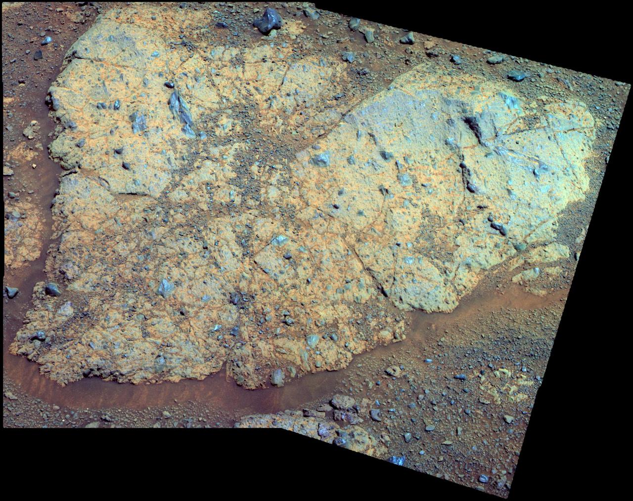
An outcrop informally named Chester Lake is the second rock on the rim of Endeavour crater to be approached by NASA Mars Exploration Rover Opportunity for close inspection. Chester Lake is about 3 feet 1 meter across.
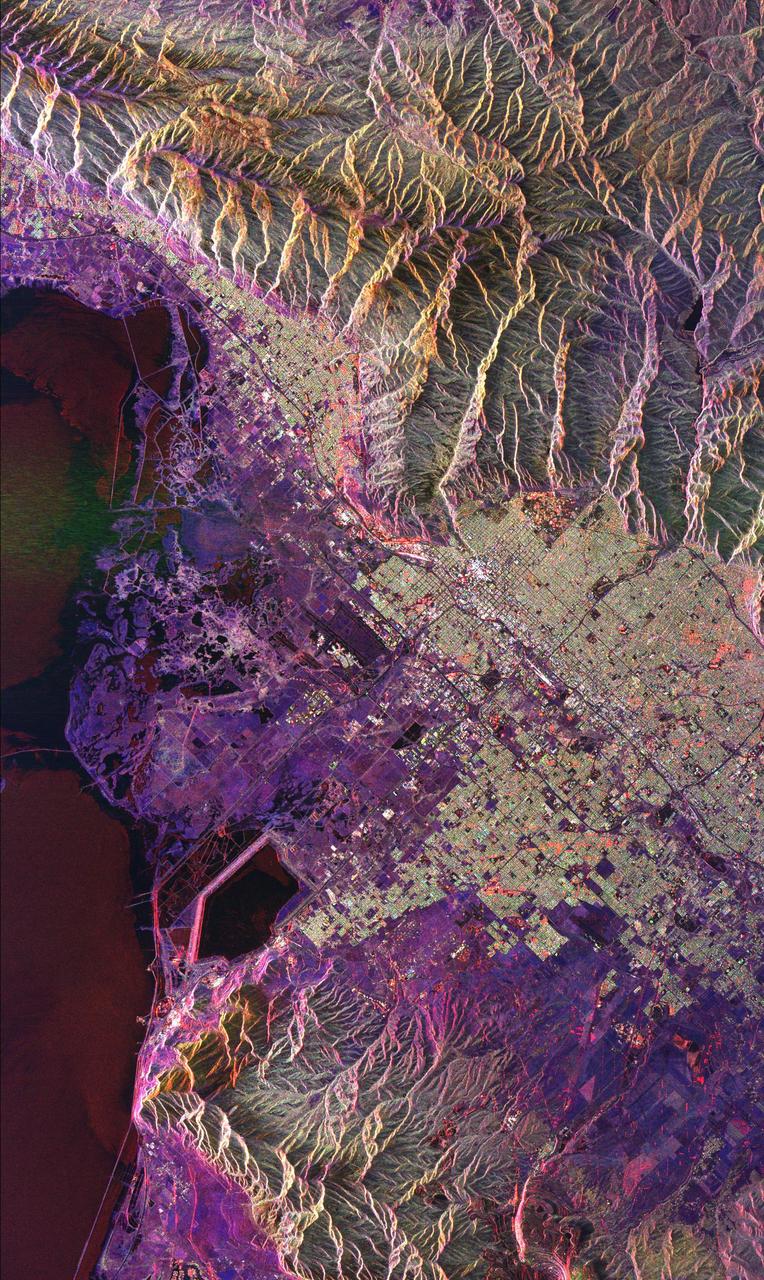
This radar image of Salt Lake City, Utah, illustrates the different land use patterns that are present in the Utah Valley. Salt Lake City lies between the shores of the Great Salt Lake (the dark area on the left side of the image) and the Wasatch Front Range (the mountains in the upper half of the image). The Salt Lake City area is of great interest to urban planners because of the combination of lake, valley and alpine environments that coexist in the region. Much of the southern shore of the Great Salt Lake is a waterfowl management area. The green grid pattern in the right center of the image is Salt Lake City and its surrounding communities. The Salt Lake City airport is visible as the brown rectangle near the center of the image. Interstate Highway 15 runs from the middle right edge to the upper left of the image. The bright white patch east of Interstate 15 is the downtown area, including Temple Square and the state capitol. The University of Utah campus is the yellowish area that lies at the base of the mountains, east of Temple Square. The large reservoir in the lower left center is a mine tailings pond. The semi-circular feature in the mountains at the bottom edge of the image is the Kennecott Copper Mine. The area shown is 60 kilometers by 40 kilometers (37 miles by 25 miles) and is centered at 40.6 degrees north latitude, 112.0 degrees west longitude. North is toward the upper left. This image was acquired by the Spaceborne Imaging Radar-C/X-Band Synthetic Aperture Radar (SIR-C/X-SAR) aboard the space shuttle Endeavour on April 10, 1994. The colors in this image represent the following radar channels and polarizations: red is L-band, horizontally transmitted and received; green is L-band, horizontally transmitted and vertically received; and blue is C-band, horizontally transmitted and vertically received. SIR-C/X-SAR, a joint mission of the German, Italian and United States space agencies, is part of NASA's Mission to Planet Earth program. http://photojournal.jpl.nasa.gov/catalog/PIA01798
During NASA's Cassini mission's final distant encounter with Saturn's giant moon Titan, the spacecraft captured this view of the enigmatic moon's north polar landscape of lakes and seas, which are filled with liquid methane and ethane. Punga Mare (240 miles, or 390 kilometers, across) is seen just above the center of the mosaic, with Ligeia Mare (300 miles, or 500 kilometers, wide) below center and vast Kraken Mare stretching off 730 miles (1,200 kilometers) to the left of the mosaic. Titan's numerous smaller lakes can be seen around the seas and scattered around the right side of the mosaic. Among the ongoing mysteries about Titan is how these lakes are formed. Another mystery at Titan has been the weather. With its dense atmosphere, Titan has a methane cycle much like Earth's water cycle of evaporation, cloud formation, rainfall, surface runoff into rivers, and collection in lakes and seas. During Titan's southern summer, Cassini observed cloud activity over the south pole (see PIA06112 and PIA06109). However, typical of observations taken during northern spring and summer, the view here reveals only a few small clouds. They appear as bright features just below the center of the mosaic, including a few above Ligeia Mare. The images in this mosaic were taken with the ISS narrow-angle camera, using a spectral filter sensitive to wavelengths of near-infrared light centered at 938 nanometers. They were captured on Sept. 11, 2017, during Cassini's last encounter with Titan. Four days later, Cassini was deliberately plunged into the atmosphere of Saturn. The view was obtained at a distance of approximately 87,000 miles (140,000 kilometers) from Titan. Image scale is about 0.5 miles (800 meters) per pixel. The image is an orthographic projection centered on 67.19 degrees north latitude, 212.67 degrees west longitude. An orthographic view is most like the view seen by a distant observer looking through a telescope. The Cassini spacecraft ended its mission on Sept. 15, 2017. https://photojournal.jpl.nasa.gov/catalog/PIA22481
SL2-05-397 (22 June 1973) --- New Orleans, Louisiana, Mississippi River, and Lake Pontchartrain (31.0N, 91.0W) can all be seen in this single detailed view. The marshlands of the Atchafalaya Basin, previously the main drainage way for the Mississippi River, can be seen to be partially silted as a result of sediments. The long narrow field patterns fronting on the river is called the "Long Lot" system of equal land distribution based on the French Napoleonic Civil Code. Photo credit: NASA
These images obtained by NASA Cassini spacecraft show Titan stable northern lake district.
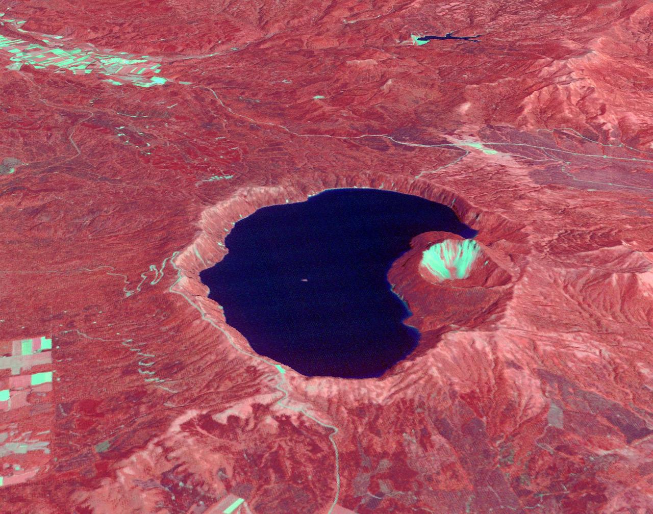
This anaglyph, from NASA Shuttle Radar Topography Mission, is of Lake Palanskoye in northern Kamchatka. 3D glasses are necessary to view this image.
Ultracold hydrocarbon lakes and seas dark shapes near the north pole of Saturn moon Titan can be seen embedded in some kind of bright surface material in this infrared mosaic from NASA Cassini mission.
iss069e004011 (April 18, 2023) --- This portion of Lake Nasser in southern Egypt was pictured by NASA astronaut and Expedition 69 Flight Engineer Woody Hoburg as the International Space Station orbited 258 miles above.
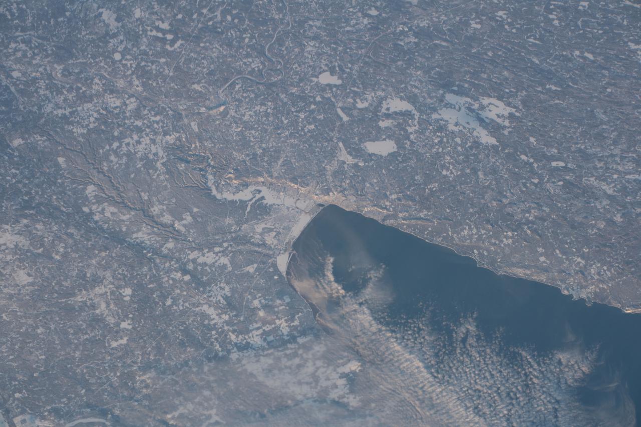
iss058e001857 (Jan. 1, 2019) --- The western tip of Lake Superior and the cities of Duluth, Minnesota and Superior, Wisconsin separated by the frozen St. Louis River, are pictured from the International Space Station on New Year's Day 2019.