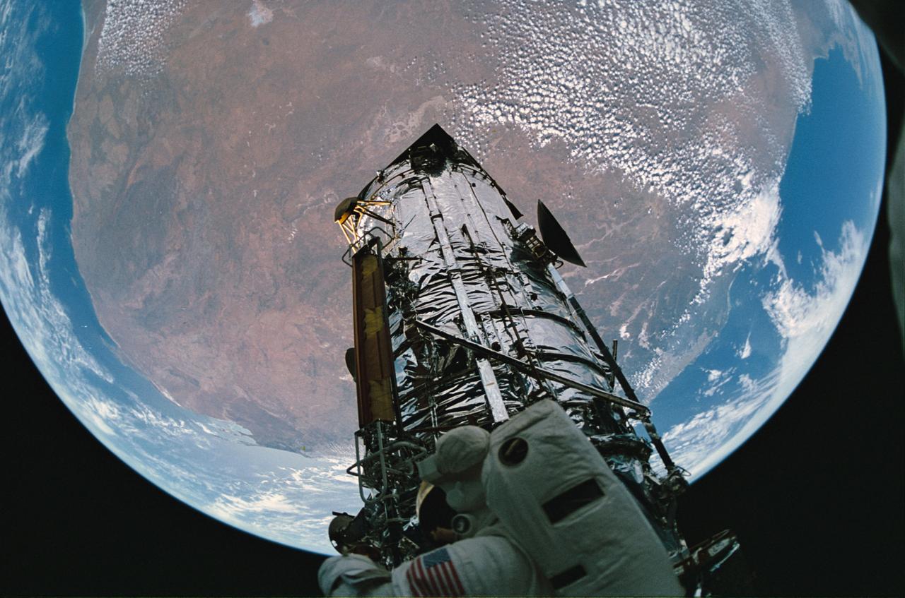
STS061-65-015 (9 Dec 1993) --- A fish-eye lens was used to capture the Hubble Space Telescope (HST), a spherical Earth and Australian landmass with a bit of distortion during the final extravehicular activity (EVA) on the STS-61 HST-servicing mission. Astronaut F. Story Musgrave can be seen at bottom of the frame.
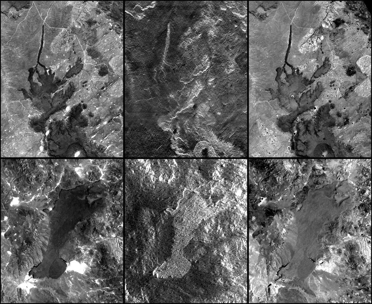
In addition to an elevation model of most of Earth landmass, NASA Shuttle Radar Topography Mission will produce C-band radar imagery of the same area.
NASA Shuttle Radar Topography Mission SRTM, flown aboard Space Shuttle Endeavour in February 2000, acquired elevation measurements for nearly all of Earth landmass between 60°N and 56°S latitudes.

This unique photo offers a view of the Florida peninsula, western Bahamas, north central Cuba and the deep blue waters of the Gulf Stream, that hugs the east coast of Florida (27.0N, 82.0W). In addition to being an excellent photograph for showing the geographical relationships between the variety of landforms in this scene, the typical effect of the land-sea breeze is very much in evidence as few clouds over water, cumulus build up over landmass.
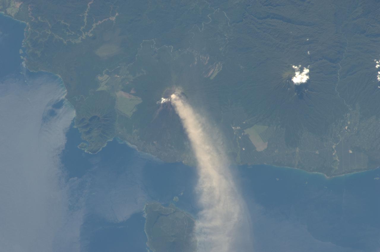
ISS034-E-005496 (30 Nov. 2012) --- An eruption at the Ulawun volcano, New Britain Island, Papua New Guinea is featured in this image photographed by an Expedition 34 crew member on the International Space Station. Numerous volcanoes contribute to the landmass of the island of New Britain, the largest in the Bismarck Archipelago of Papua New Guinea. One of the most active of these volcanoes, Ulawun, is also the highest with a summit elevation of 2,334 meters. This photograph was taken during the most recent phase of volcanic activity at Ulawun. A white steam and ash plume extends from the summit crater of the stratovolcano towards the northwest (center; note the image is oriented such that north is towards the lower left). The plume begins to broaden as it passes the southwestern coast of Lolobau Island approximately 23 kilometers downwind from its source. Ulawun volcano is also known as “the Father”, with the Bamus volcano to the southwest also known as “the South Son”. The summit of Bamus is obscured by white cumulus clouds (not of volcanic origin) in this image. While Ulawun has been active since at least 1700, the most recent eruptive activity at Bamus occurred in the late 19th century. A large region of ocean surface highlighted by sunglint – sunlight reflecting off the water surface, lending it a mirror-like appearance– is visible to the north-northeast of Ulawun (lower left).

This image shows a bright, rectangular-looking landform surrounded by a dark floor. How did this feature get here if it looks so different than its surroundings? The feature resembles a plateau. Dark streaks mark steep slopes on its sides while the top appears flat. The slope streaks are not all the same age, as we see a variation in colors from faint to dark. Craters in a variety of sizes and ages pepper the entire rectangle, but the dark, textured floor has very few noticeable craters. The evidence suggests that this rectangular feature is a high-standing "island" of older land surrounded by one or more younger lava flows. This landmass is located in Amazonis Planitia, a smooth plains area potentially formed by large-scale lava floods between the Tharsis and Elysium volcanic regions. As lava flowed into this area, the rectangular plateau was too high to cover completely, leaving a bright spot sticking out of the dark basalt floor for us to find. https://photojournal.jpl.nasa.gov/catalog/PIA22725
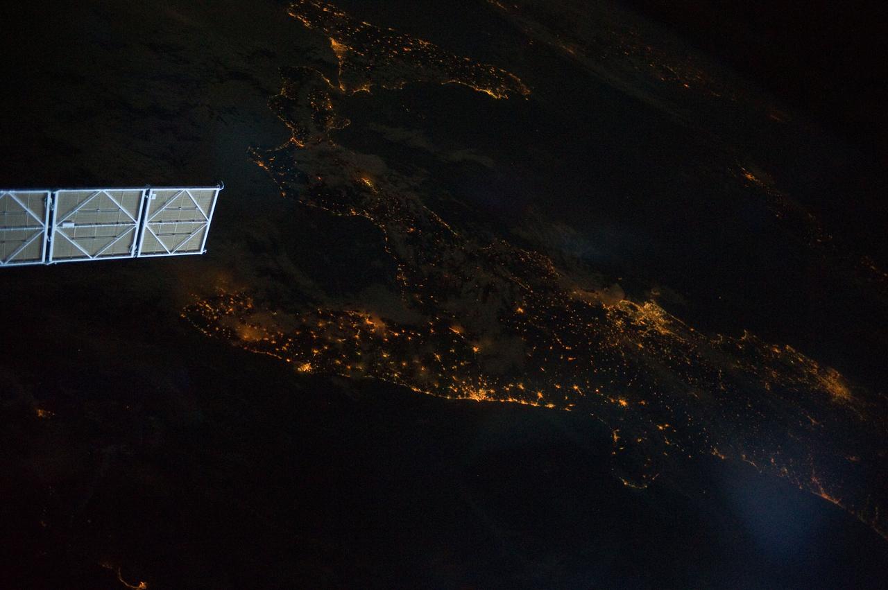
ISS028-E-008604 (11 June 2011) --- A night view of the southern Italian Peninsula is featured in this image photographed by an Expedition 28 crew member on the International Space Station. The Earth’s surface at night is covered with a delicate tracery of lights, particularly in regions – such as Europe – that have a long history of urban development. Large urban areas are recognizable from orbit due to extensive electric lighting and distinct street patterns; with smaller urban areas spread across the land surface and coastlines, the outlines of continental landmasses are easily discernable at night. This photograph highlights the night time appearance of the southern Italian Peninsula; the toe and heel of Italy’s “boot” are clearly defined by the lights of large cities such as Naples, Bari, and Brindisi as well as numerous smaller urban areas. The bordering Adriatic, Tyrrhenian, and Ionian Seas appear as dark regions to the east, west, and south of the boot. The city lights of Palermo and Catania on the island of Sicily are visible at image bottom center. The space station was located over an area of Romania close to the capital city of Bucharest – approximately 945 kilometers to the northeast—at the time this image was taken. Part of a docked Russian spacecraft solar panel array is visible in the foreground at left. The distance between the image subject area and the position of the photographer, as well as the viewing angle looking outwards from the space station, contributes to the distorted appearance of the Italian Peninsula and Sicily in the image.
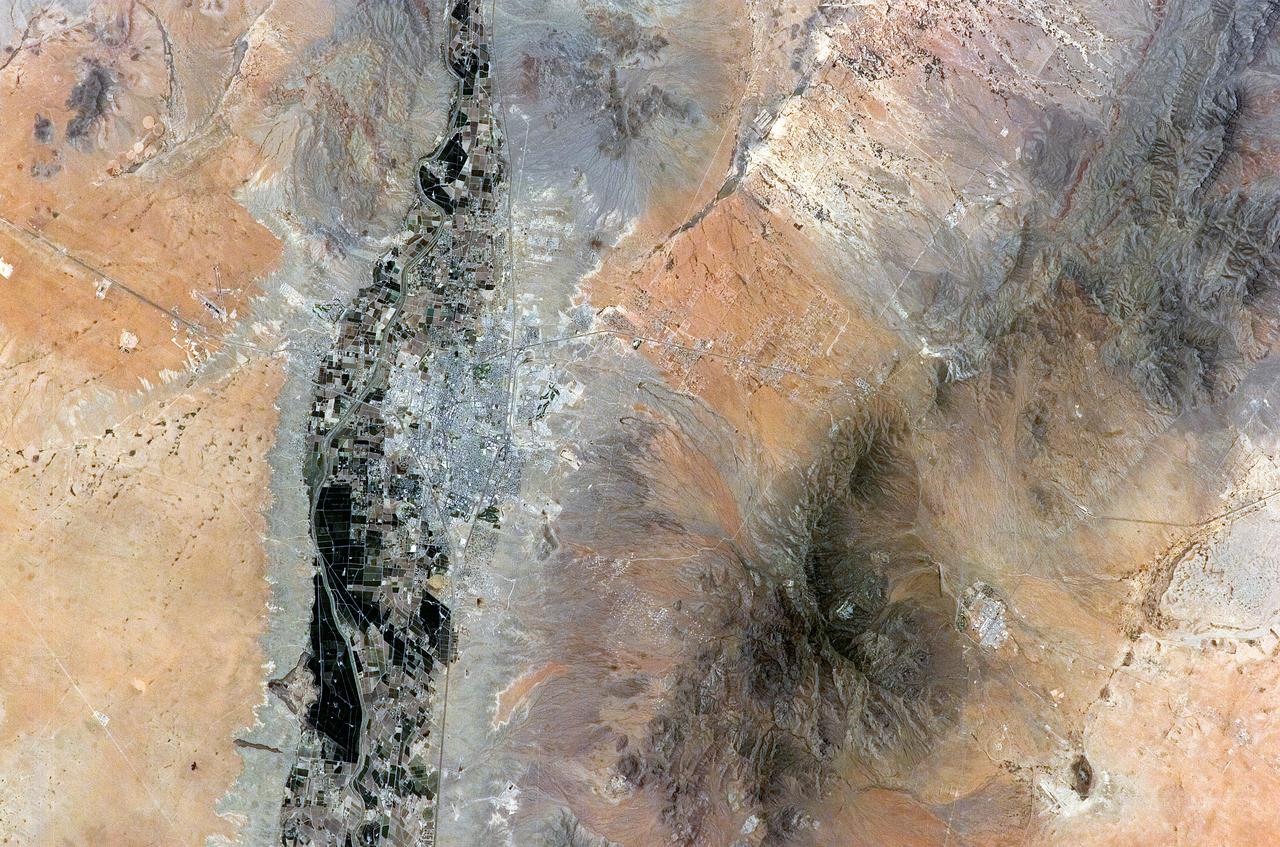
ISS011-E-08410 (9 June 2005) --- Las Cruces, New Mexico is featured in this image photographed by an Expedition 11 crewmember on the International Space Station. The city of Las Cruces is located within the Rio Grande Rift, a large geological feature that extends from Colorado southward into Mexico. According to NASA geologists, rifting usually heralds the breakup of continental landmasses, such as the separation of South America and Africa to form the southern Atlantic Ocean during the Mesozoic Era. The Rift is marked by a series of depressions (known as graben) caused by the subsidence of crustal blocks between parallel faults as the continental crust is pulled apart by tectonic forces. These graben are frequently marked by uplifted rocks along bounding faults — the striking Organ Mountains to the east of Las Cruces are one such uplifted fault block. While separation of the continental crust is no longer occurring, the Rio Grande Rift is still considered active as evidenced by frequent low-intensity earthquakes and hot springs to the north of Las Cruces. The modern city of Las Cruces — the seat of Doña Ana County and home to New Mexico State University — is undergoing rapid urban expansion due to influx of new residents attracted to the climate and landscape. The current urban area (gray to white region at image center) contrasts sharply with agricultural lands (dark green and grey brown) located along the Rio Grande River and the surrounding desert valley floor to the northeast and southwest (brown, blue gray and tan areas).
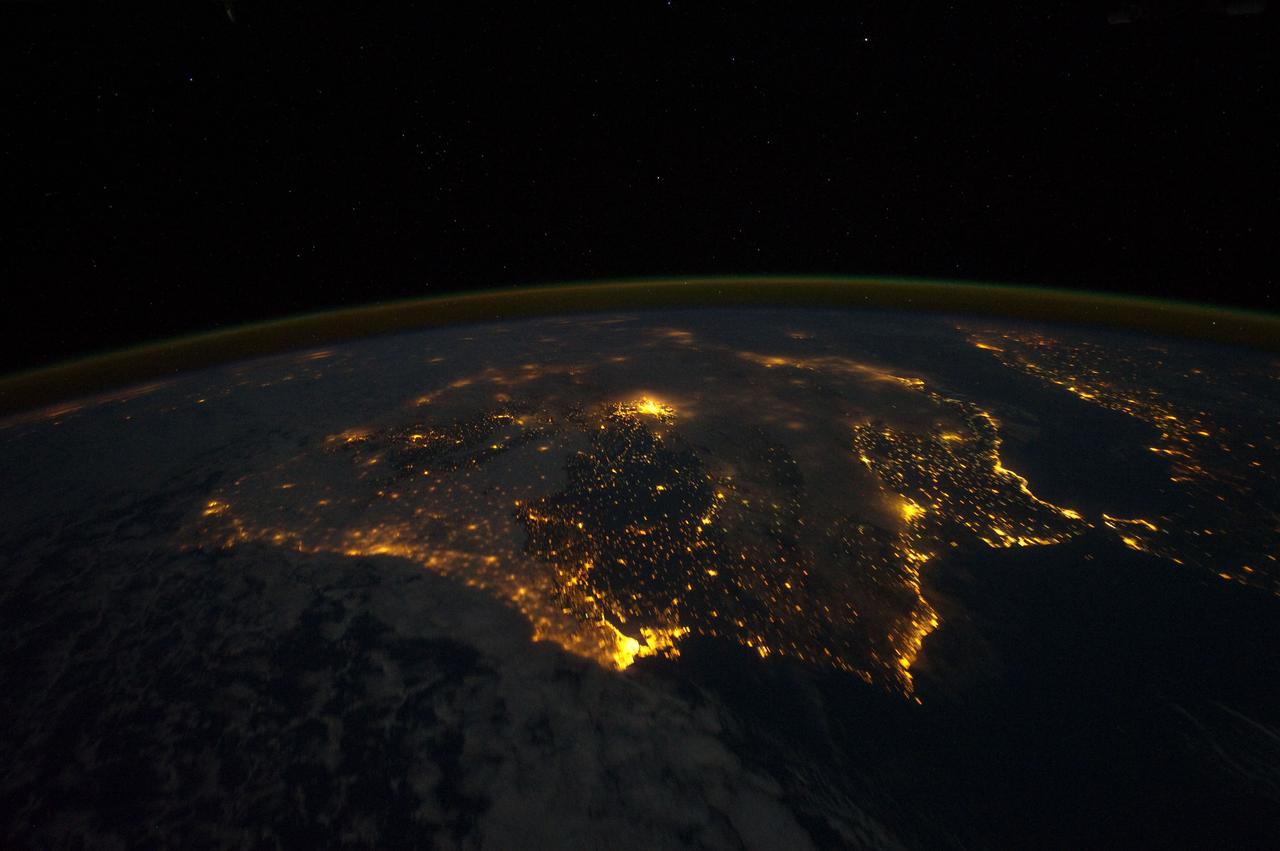
ISS030-E-010008 (4 Dec. 2011) --- One of the Expedition 30 crew members aboard the Earth-orbiting International Space Station photographed this night time scene of the Iberian Peninsula on Dec. 4, 2011. The city lights of Spain and Portugal define the peninsula. Several large metropolitan areas are visible, marked by their relatively large and brightly lit areas, such as two capital cities -- Madrid, Spain, located near the center of the peninsula?s interior, and Lisbon, Portugal, located along the southwestern coastline. Ancient Seville, visible at image right to the north of the approximately 14 kilometer-wide Strait of Gibraltar, is one of the largest cities in Spain. All together, the Principality of Andorra, the Kingdom of Spain and the Portuguese Republic total approximately 590,000 square kilometers of landmass. The peninsula is bounded by the Atlantic Ocean to the northwest, west, and southwest and the Mediterranean Sea to the east. Its northeastern boundary with the rest of continental Europe is marked by the Pyrenees mountain range. The view is looking outwards from the orbital outpost toward the east. The network of smaller cities and towns in the interior and along the coastline attest to the large extent of human presence on the Iberian landscape. Blurring of the city lights is caused by thin cloud cover (image left and center), while the cloud tops are dimly illuminated by moonlight. Though obscured, the lights of France are visible near the horizon line at image upper left, while the lights of northern Africa are more clearly discernable at image right. The gold to green line of airglow, caused by excitation of upper atmosphere gas molecules by ultraviolet radiation, parallels the horizon line (or Earth limb).
STS057-73-075 (21 June-1 July 1993) --- Eastern Mediterranean from an unusually high vantage point over the Nile River, this north-looking view shows not only the eastern Mediterranean but also the entire landmass of Asia Minor, with the Black Sea dimly visible at the horizon. Many of the Greek islands can be seen in the Aegean Sea (top left), off the coast of Asia Minor. Cyprus is visible under atmospheric dust in the northeast corner of the Mediterranean. The dust cloud covers the east end of the Mediterranean, its western edge demarcated by a line that cuts the center of the Nile Delta. This dust cloud originated far to the west, in Algeria, and moved northeast over Sicily, southern Italy, and Greece. Part of the cloud then moved on over the Black Sea, but another part swerved southward back towards Egypt. A gyre of clouds in the southeast corner of the Mediterranean indicates a complementary counterclockwise (cyclonic) circulation of air. The Euphrates River appears as a thin green line (upper right) in the yellow Syrian Desert just south of the blue-green mountains of Turkey. The Dead Sea (lower right) lies in a rift valley which extends north into Turkey and south thousands of miles down the Gulf of Aqaba, the Red Sea, and on through East Africa. The straight international boundary between Israel and Egypt (where the coastline angles) is particularly clear in this view, marked by the thicker vegetation on the Israeli side of the border. The green delta of the Nile River appears in the foreground, with the great conurbation of Cairo seen as a gray area at the apex of the triangle. Most of Egypt's 52 million inhabitants live in the delta. On the east side of the delta, the Suez Canal is visible. On the western corner of the delta lies the ancient city of Alexandria, beside the orange and white salt pans. The World War II battlesite El Alamein lies on the coast.

STS050-S-001 (January 1992) --- Designed by the flight crew, the insignia for the United States Microgravity Laboratory (USML-1), captures a space shuttle traveling above Earth while trailing the USML banner. The orbiter is oriented vertically in a typical attitude for microgravity science and in this position represents the numeral 1 in the mission's abbreviated title. This flight represents the first in a series of USML flights on which the primary objective is microgravity science, planned and executed through the combined efforts of the United States of America's government, industry and academia. Visible in the payload bay are the Spacelab module, and the extended duration orbiter "cryo" pallet which will be making its first flight. The small g and Greek letter mu on the Spacelab module symbolize the microgravity environment being used for research in the areas of materials science and fluid physics. The large block letter U extends outside the patch perimeter, symbolizing the potential for the experiments on this flight to expand the current boundaries of knowledge in microgravity science. The Stars and Stripes of the USML block letters and the United States landmass in the Earth scene below reflect the crew's pride in the United States origin of all onboard experiments. The NASA insignia design for space shuttle flights is reserved for use by the astronauts and for other official use as the NASA Administrator may authorize. Public availability has been approved only in the forms of illustrations by the various news media. When and if there is any change in this policy, which is not anticipated, the change will be publicly announced. Photo credit: NASA
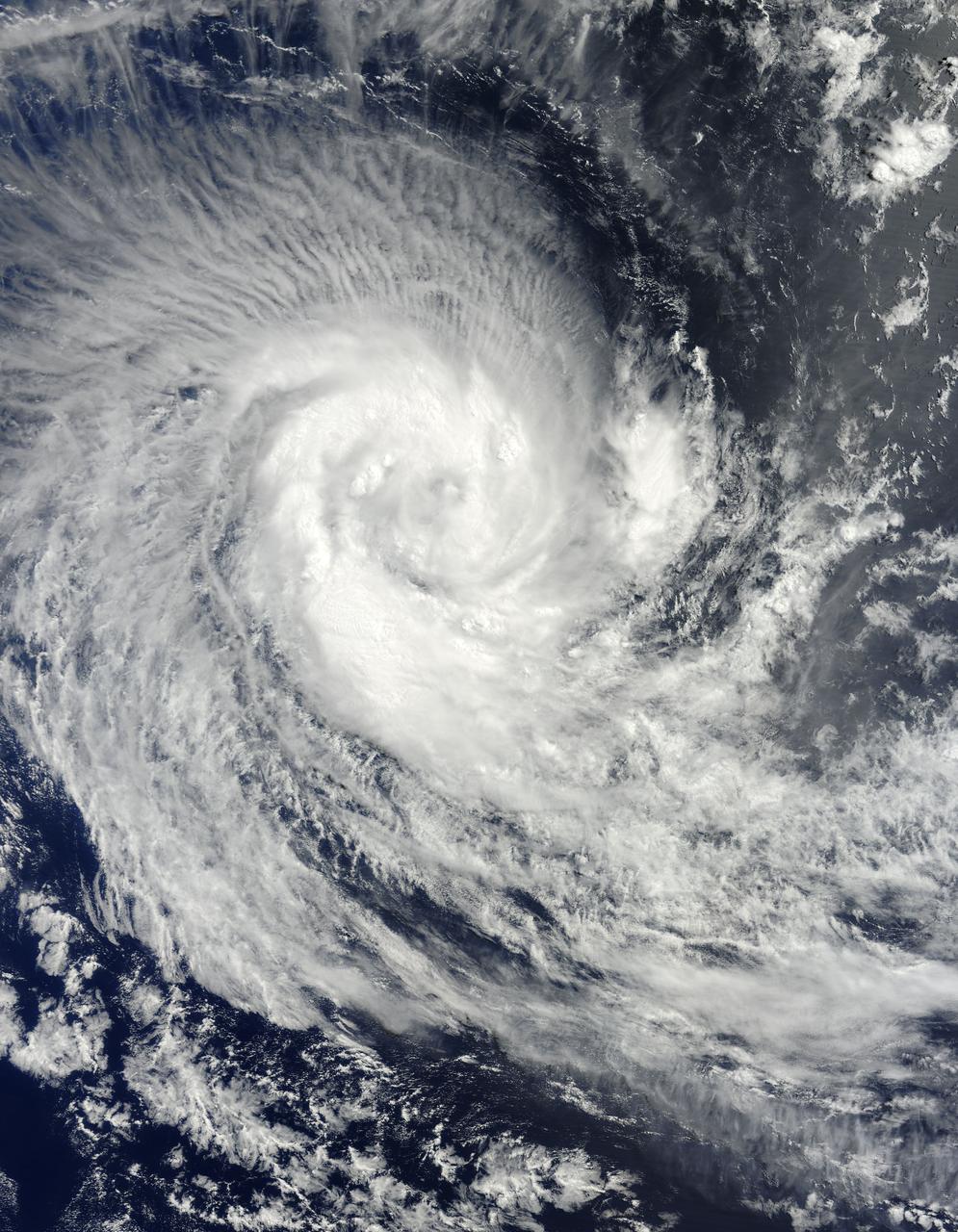
NASA image acquired March 24, 2010. Tropical Cyclone Imani swirled over the Southern Indian Ocean on March 24, 2010. The same day, the U.S. Navy’s Joint Typhoon Warning Center (JTWC) reported that the storm had maximum sustained winds of 55 knots (100 kilometers per hour) and gusts up to 70 knots (130 kilometers per hour). The storm was located roughly 745 nautical miles (1,380 kilometers) west-southwest of Cocos Island, having traveled toward the south-southwest for several hours. The Moderate Resolution Imaging Spectroradiometer (MODIS) on NASA’s Terra satellite captured this natural-color image of the storm on March 24, 2010. Imani spans several hundred kilometers over the Southern Indian Ocean, producing thin, radial clouds on its northern margin. The storm occurs far from any major landmass. The JTWC forecast that Imani would continue traveling toward the south-southwest until reaching mid-latitude. The storm was expected to eventually turn southward and weaken. NASA image courtesy Jeff Schmaltz, MODIS Rapid Response Team at NASA GSFC. Caption by Michon Scott. Instrument: Terra - MODIS To learn more about this image go to: <a href="http://earthobservatory.nasa.gov/NaturalHazards/view.php?id=43225" rel="nofollow">earthobservatory.nasa.gov/NaturalHazards/view.php?id=43225</a> For more information about Goddard Space Flight Center go here: <a href="http://www.nasa.gov/centers/goddard/home/index.html" rel="nofollow">www.nasa.gov/centers/goddard/home/index.html</a>

Artist concept of the X-59 in flight overland and water.
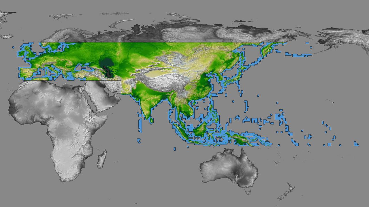
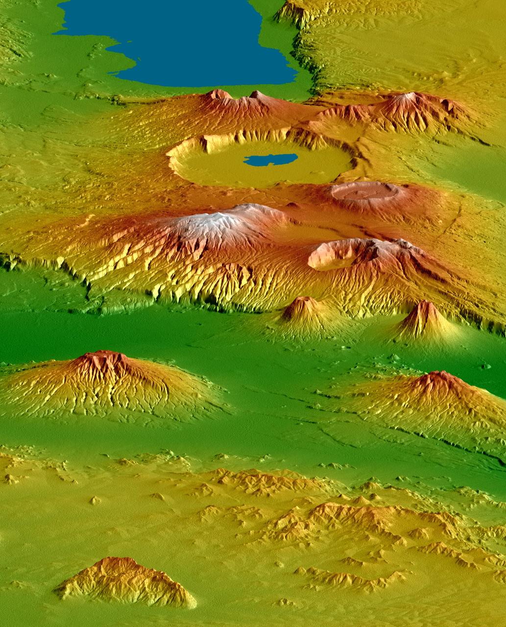
inal Caption Released with Image: The colored regions of this map show the extent of digital elevation data recently released by the Shuttle Radar Topography Mission (SRTM). This release includes data for most of Europe and Asia plus numerous islands in the Indian and Pacific Oceans. SRTM flew on board the Space Shuttle Endeavour in February 2000 and used an interferometric radar system to map the topography of Earth's landmass between latitudes 56 degrees south and 60 degrees north. The data were processed into geographic "tiles," each of which represents one by one degree of latitude and longitude. A degree of latitude measures 111 kilometers (69 miles) north-south, and a degree of longitude measures 111 kilometers or less east-west, decreasing away from the equator. The data are being released to the public on a continent-by-continent basis. This Eurasia segment includes 5,940 tiles, more than a third of the total data set. Previous releases covered North America and South America. Forthcoming releases will include Africa-Arabia and Australia plus an "Islands" release for those islands not included in the continental releases. Together these data releases constitute the world's first high-resolution, near-global elevation model. The resolution of the publicly released data is three arcseconds (1/1,200 of a degree of latitude and longitude), which is about 90 meters (295 feet). European coverage in the current data release stretches eastward from the British Isles and the Iberian Peninsula in the west, across the Alps and Carpathian Mountains, as well as the Northern European Plain, to the Ural and Caucasus Mountains bordering Asia. The Asian coverage includes a great diversity of landforms, including the Tibetan Plateau, Tarin Basin, Mongolian Plateau, and the mountains surrounding Lake Baikal, the world's deepest lake. Mt. Everest in the Himalayas, at 8,848 meters (29,029 feet) is the world's highest mountain. From India's Deccan Plateau, to Southeast Asia, coastal China, and Korea, various landforms place constraints upon land use planning for a great population. Volcanoes in the East Indies, the Philippines, Japan, and the Kamchatka Peninsula form the western part of the "Ring of Fire" around the Pacific Ocean. Many of these regions were previously very poorly mapped due to persistent cloud cover or the inaccessibility of the terrain. Digital elevation data, such as provided by SRTM, are particularly in high demand by scientists studying earthquakes, volcanism, and erosion patterns for use in mapping and modeling hazards to human habitation. But the shape of Earth's surface affects nearly every natural process and human endeavor that occurs there, so elevation data are used in a wide range of applications. In this index map color-coding is directly related to topographic height, with green at the lower elevations, rising through yellow and tan, to white at the highest elevations. The large, very dark green feature in western Asia is the Caspian Sea, which is below sea level. Blue areas on the map represent water within the mapped tiles, each of which includes shorelines or islands. http://photojournal.jpl.nasa.gov/catalog/PIA03398