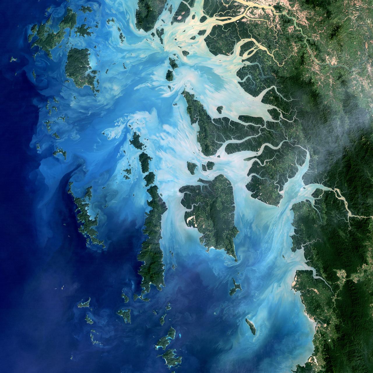
NASA image acquired December 14, 2004 In the southernmost reaches of Burma (Myanmar), along the border with Thailand, lies the Mergui Archipelago. The archipelago in the Andaman Sea is made up of more than 800 islands surrounded by extensive coral reefs. This natural color image acquired by Landsat 5 on Dec. 14, 2004, shows the middle portion of the archipelago, including Auckland and Whale Bays. Swirling patterns are visible in the near-shore waters as sediments carried by rivers slowly settle out and are deposited on the seafloor. The heavy sediment loads make the river appear nearly white. As those sediments settle out, the seawater appears deeper shades of blue. The tropical rainforests of the region appear deep green. Captain Thomas Forrest of the East India Company first described the region to Europeans after a 1782 expedition in search of potential sugar-growing lands. At that time, the islands were mainly inhabited by a nomadic fishing culture. These people, known as the Moken, still call the archipelago home and mostly live a hunter-gatherer lifestyle. As of 2006, 2,000 Moken were known to inhabit the Burmese portion of Mergui. The small population of the archipelago has helped preserve its high diversity of plants and animals. In 1997, Burma opened the region to foreign tourism and in the years since it has become a major diving destination. A valued species of pearl oyster (Pinctada maxima) are found in nearby waters. Today, overfishing is emerging as a regional problem. Landsat image created by Michael Taylor, Landsat Project Science Office. Caption by Laura Rocchio. Instrument: Landsat 5 - TM To read more go to: <a href="http://1.usa.gov/TDmjsk" rel="nofollow">1.usa.gov/TDmjsk</a> Credit: <b><a href="http://www.earthobservatory.nasa.gov/" rel="nofollow"> NASA Earth Observatory</a></b> <b><a href="http://www.nasa.gov/audience/formedia/features/MP_Photo_Guidelines.html" rel="nofollow">NASA image use policy.</a></b> <b><a href="http://www.nasa.gov/centers/goddard/home/index.html" rel="nofollow">NASA Goddard Space Flight Center</a></b> enables NASA’s mission through four scientific endeavors: Earth Science, Heliophysics, Solar System Exploration, and Astrophysics. Goddard plays a leading role in NASA’s accomplishments by contributing compelling scientific knowledge to advance the Agency’s mission. <b>Follow us on <a href="http://twitter.com/NASA_GoddardPix" rel="nofollow">Twitter</a></b> <b>Like us on <a href="http://www.facebook.com/pages/Greenbelt-MD/NASA-Goddard/395013845897?ref=tsd" rel="nofollow">Facebook</a></b> <b>Find us on <a href="http://instagram.com/nasagoddard?vm=grid" rel="nofollow">Instagram</a></b>
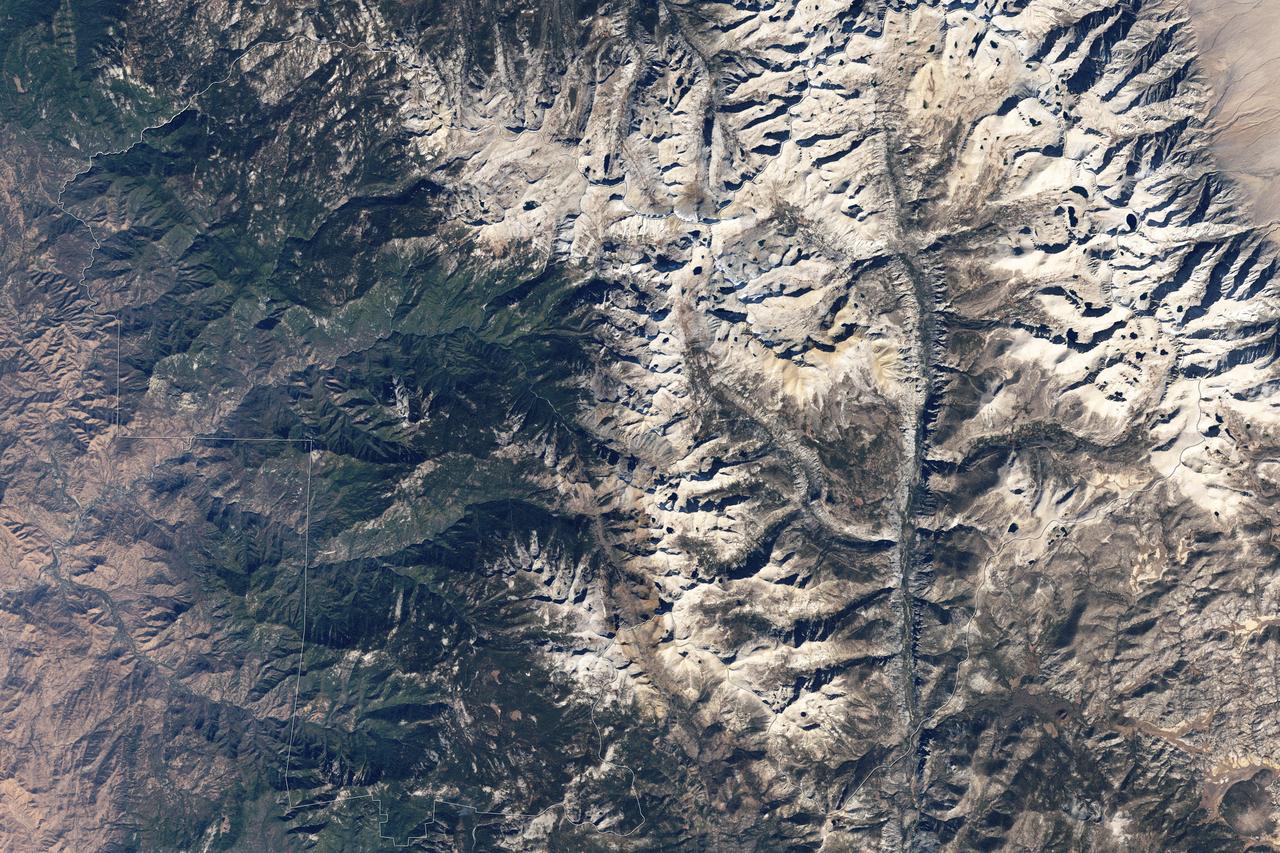
Naked peaks, sheltered valleys, snowfields, towering trees, and alpine meadows make up the varied landscape of Sequoia National Park in California. Established as a National Park by Congress on September 25, 1890, Sequoia National Park is the second-oldest U.S. National Park, after Yellowstone. This national park borders Kings Canyon National Park. The Thematic Mapper sensor on NASA’s Landsat 5 satellite captured this true-color image of Sequoia National Park, outlined in white, on October 22, 2008. Sunlight illuminates southern slopes, leaving northern faces in shadow in this autumn image. In the west, deep green conifers carpet most of the land. These forested mountains are home to the park’s most famous giant sequoia trees. Sequoia National Park sits at the southern end of the Sierra Nevada mountains. Terrain alternates between extremes, from peaks such as Mt. Whitney—the highest peak in the contiguous United States—to deep caverns. The rivers and lakes in this region are part of a watershed valuable not only to the plants and animals of the park, but also to farms and cities in California’s Central Valley. Read more: <a href="http://go.nasa.gov/2bzGOXr" rel="nofollow">go.nasa.gov/2bzGOXr</a> Credit: NASA/Landsat5 <b><a href="http://www.nasa.gov/audience/formedia/features/MP_Photo_Guidelines.html" rel="nofollow">NASA image use policy.</a></b> <b><a href="http://www.nasa.gov/centers/goddard/home/index.html" rel="nofollow">NASA Goddard Space Flight Center</a></b> enables NASA’s mission through four scientific endeavors: Earth Science, Heliophysics, Solar System Exploration, and Astrophysics. Goddard plays a leading role in NASA’s accomplishments by contributing compelling scientific knowledge to advance the Agency’s mission. <b>Follow us on <a href="http://twitter.com/NASAGoddardPix" rel="nofollow">Twitter</a></b> <b>Like us on <a href="http://www.facebook.com/pages/Greenbelt-MD/NASA-Goddard/395013845897?ref=tsd" rel="nofollow">Facebook</a></b> <b>Find us on <a href="http://instagrid.me/nasagoddard/?vm=grid" rel="nofollow">Instagram</a></b>
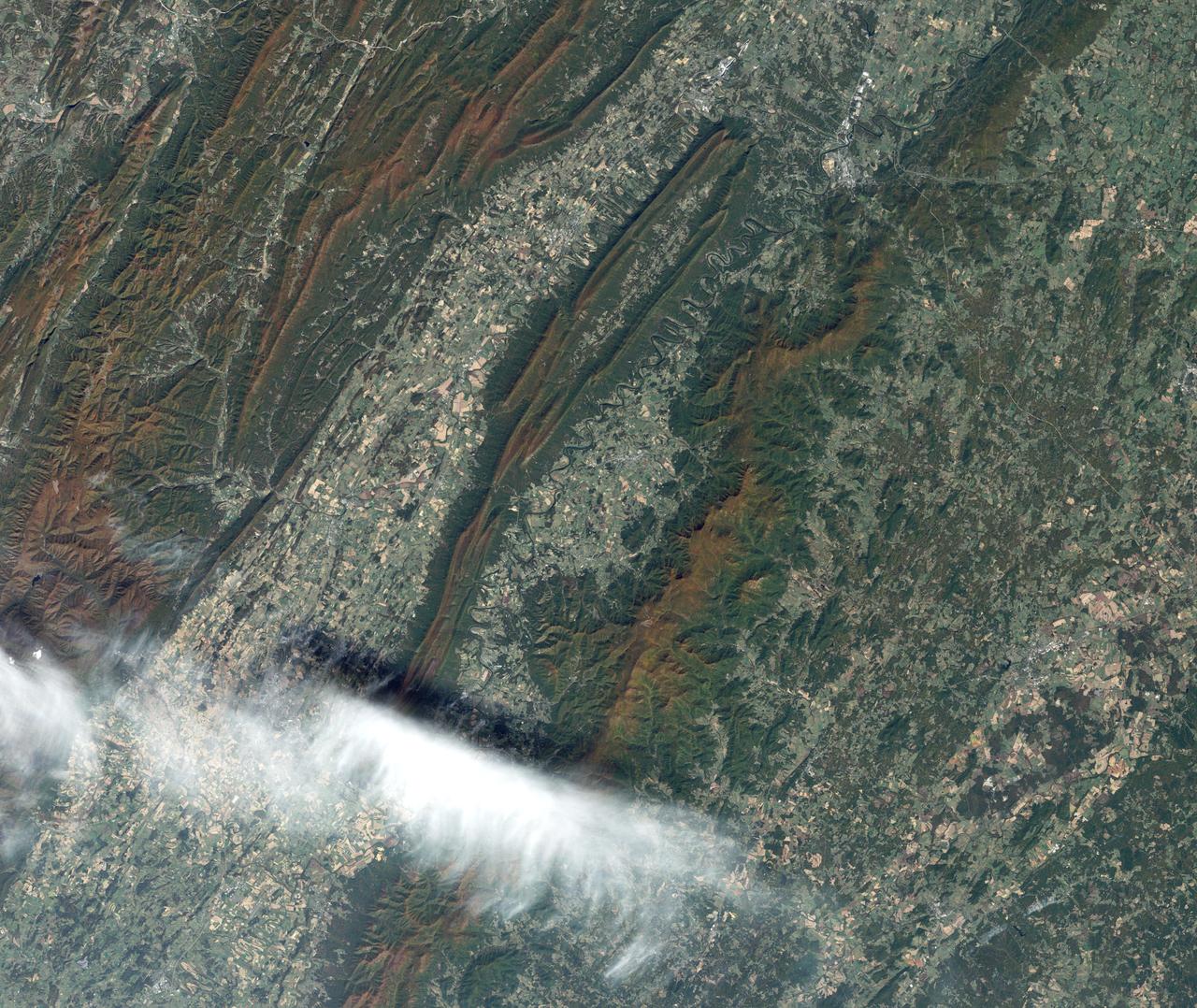
On July 3, 1936, President Franklin Delano Roosevelt stood amidst the crowd in Big Meadows and officially dedicated Shenandoah National Park in Virginia. The Thematic Mapper on the Landsat satellite captured this view of the heart of Shenandoah National Park on October 10, 2010, at the height of the fall “leaf-peeping” season. The orange and brown swath across the image highlights the hilly backbone of the park, where leaves had turned to their fall colors. The 169-kilometer (105-mile) Skyline Drive that meanders across the crest of the ridge is often jammed with tourists in autumn. The park includes more than 518 miles of hiking trails, including more than 100 miles of the Appalachian Trail. The highest peak is Hawksbill Mountain at 4,051 feet (1,235 m), but the most popular with hikers is Old Rag Mountain. A circuitous eight-mile (13 kilometer) trail leads to an exposed, rocky summit 3,291 feet (1,003 meters) above sea level. The 2,200 foot elevation change from base to summit, combined with several rock scrambles, make Old Rag not only the most popular but also the most dangerous hike. Read more: <a href="http://go.nasa.gov/2bRnFxH" rel="nofollow">go.nasa.gov/2bRnFxH</a> Credit: NASA/Landsat5 <b><a href="http://www.nasa.gov/audience/formedia/features/MP_Photo_Guidelines.html" rel="nofollow">NASA image use policy.</a></b> <b><a href="http://www.nasa.gov/centers/goddard/home/index.html" rel="nofollow">NASA Goddard Space Flight Center</a></b> enables NASA’s mission through four scientific endeavors: Earth Science, Heliophysics, Solar System Exploration, and Astrophysics. Goddard plays a leading role in NASA’s accomplishments by contributing compelling scientific knowledge to advance the Agency’s mission. <b>Follow us on <a href="http://twitter.com/NASAGoddardPix" rel="nofollow">Twitter</a></b> <b>Like us on <a href="http://www.facebook.com/pages/Greenbelt-MD/NASA-Goddard/395013845897?ref=tsd" rel="nofollow">Facebook</a></b> <b>Find us on <a href="http://instagrid.me/nasagoddard/?vm=grid" rel="nofollow">Instagram</a></b>