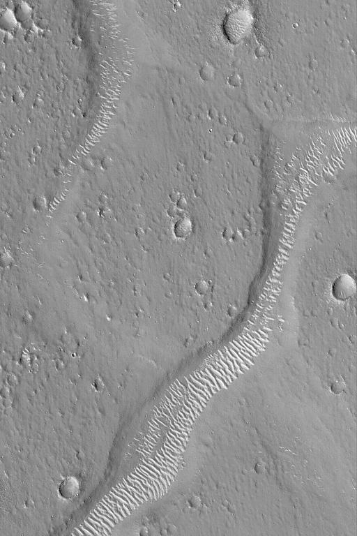
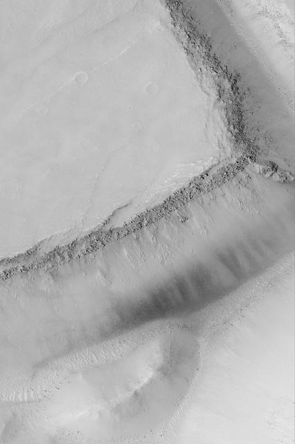
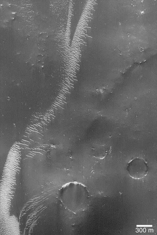
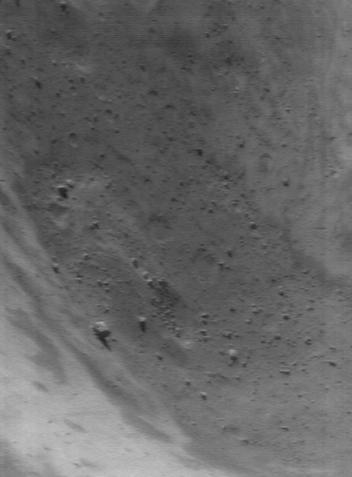
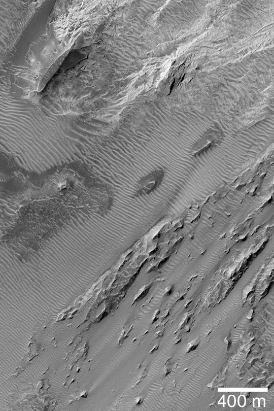
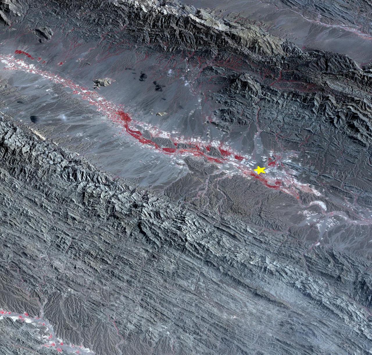
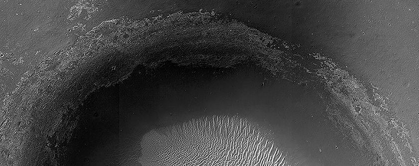
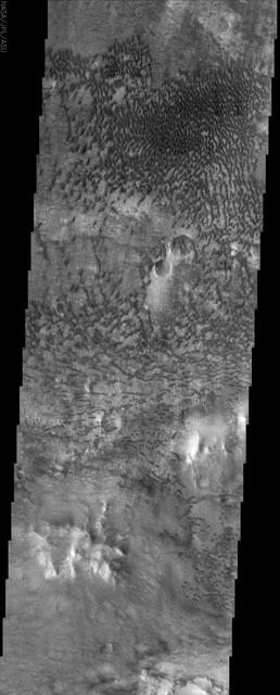
Large Landslide
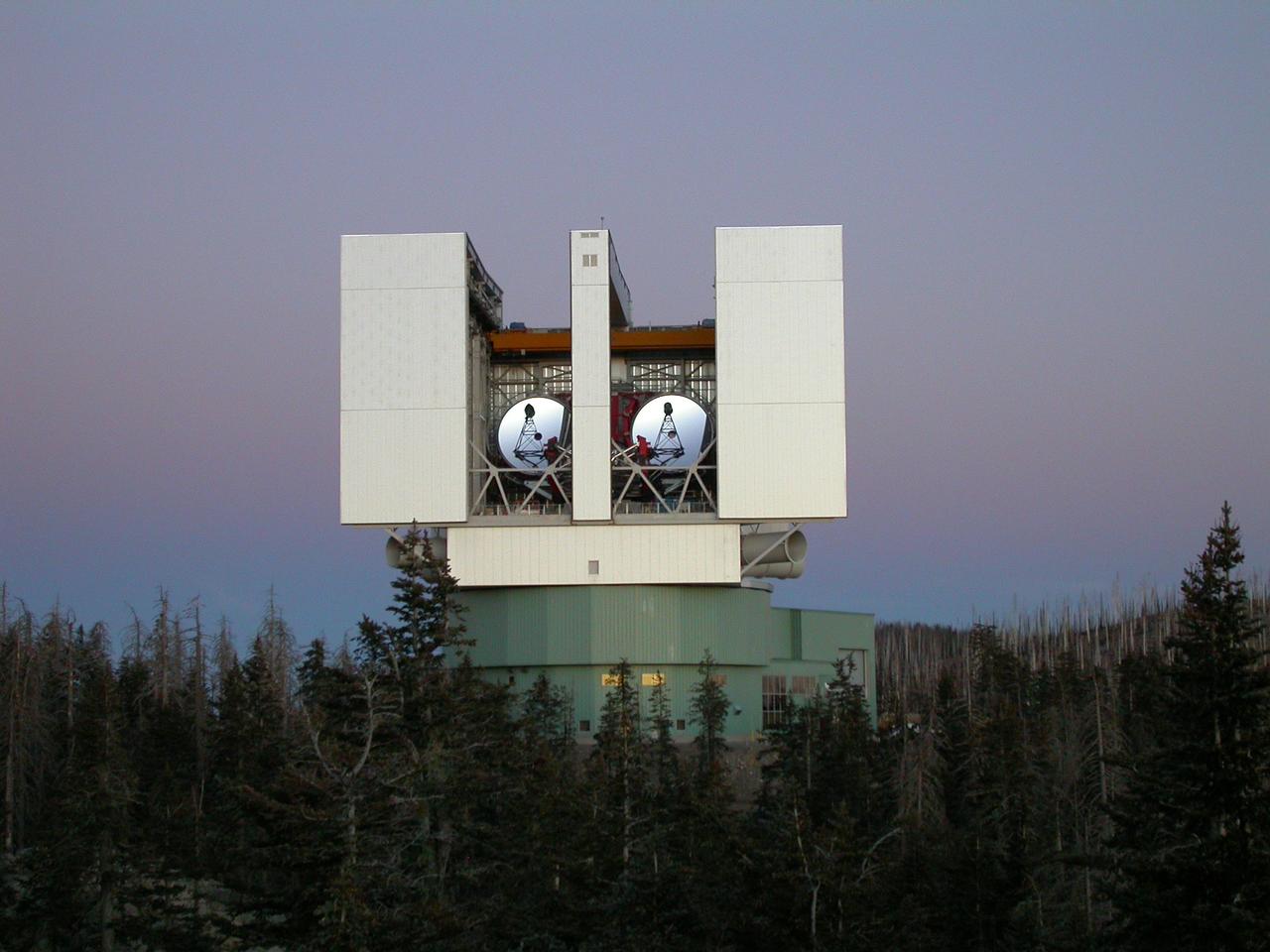
The Large Binocular Telescope Interferometer, or LBTI, is a ground-based instrument connecting two 8-meter class telescopes on Mount Graham in Arizona to form the largest single-mount telescope in the world. The interferometer is designed to detect and study stars and planets outside our solar system. https://photojournal.jpl.nasa.gov/catalog/PIA22354
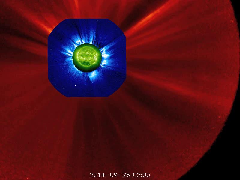
The STEREO (Behind) spacecraft captured this large prominence and corona mass ejection as they erupted into space (Sept. 26, 2014). By combining images from three instruments, scientists can see the eruption itself (in extreme UV light) as well as follow its progression over the period of about 13 hours with its two coronagraphs. Credit: NASA/Goddard/STEREO The STEREO (Behind) spacecraft captured this large prominence and corona mass ejection as they erupted into space (Sept. 26, 2014). By combining images from three instruments, scientists can see the eruption itself (in extreme UV light) as well as follow its progression over the period of about 13 hours with its two coronagraphs.
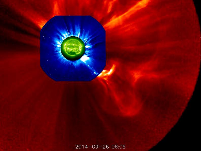
The STEREO (Behind) spacecraft captured this large prominence and corona mass ejection as they erupted into space (Sept. 26, 2014). By combining images from three instruments, scientists can see the eruption itself (in extreme UV light) as well as follow its progression over the period of about 13 hours with its two coronagraphs. Credit: NASA/Goddard/STEREO The STEREO (Behind) spacecraft captured this large prominence and corona mass ejection as they erupted into space (Sept. 26, 2014). By combining images from three instruments, scientists can see the eruption itself (in extreme UV light) as well as follow its progression over the period of about 13 hours with its two coronagraphs.
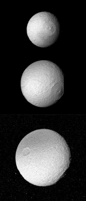
Pictures of Tethys Large Crater
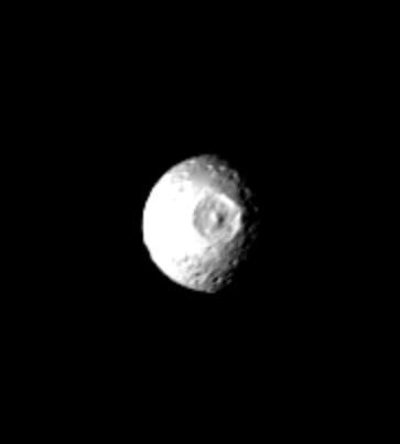
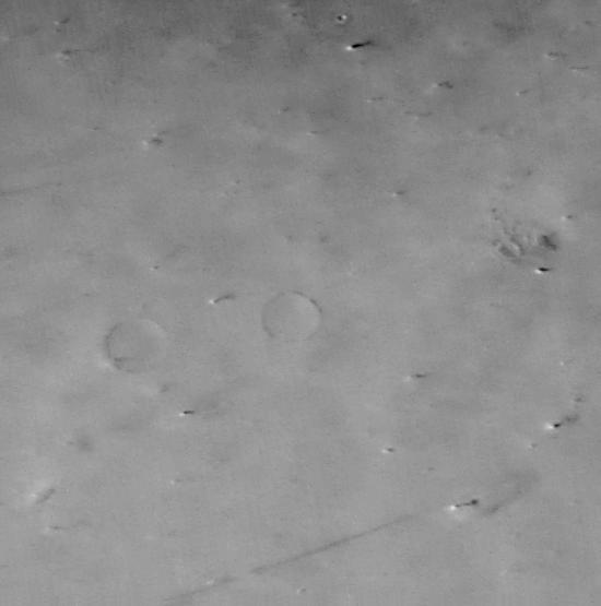
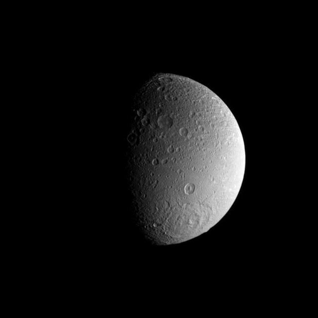
Mimas - Large Impact Structure
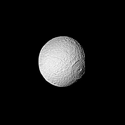
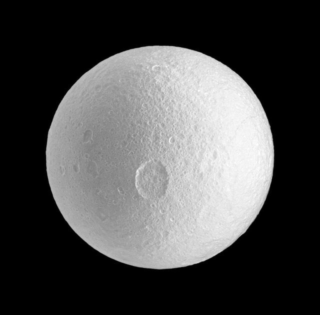
Saturn - Large Crater on Tethys
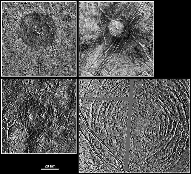
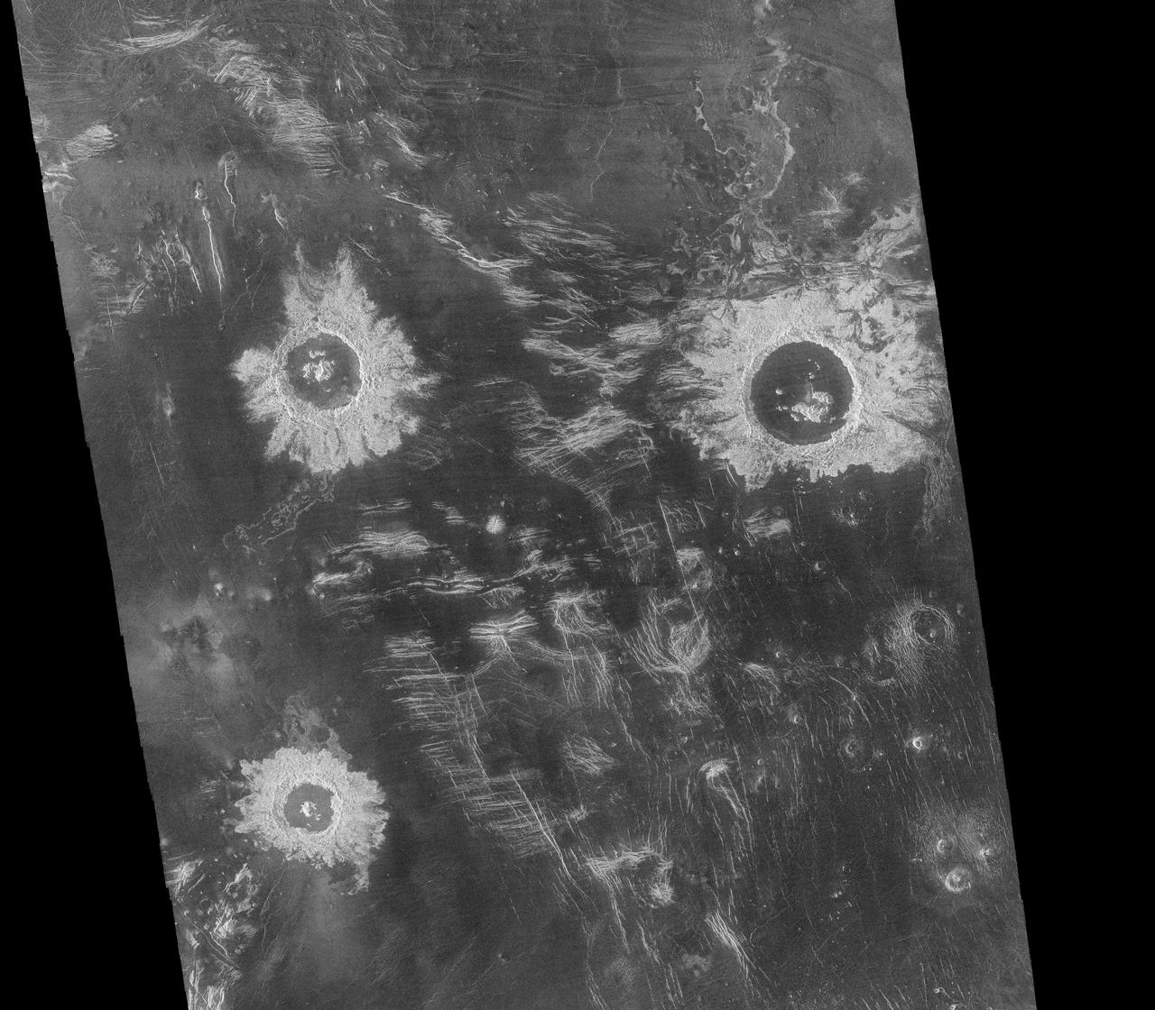
Large Impacts Ring Twice
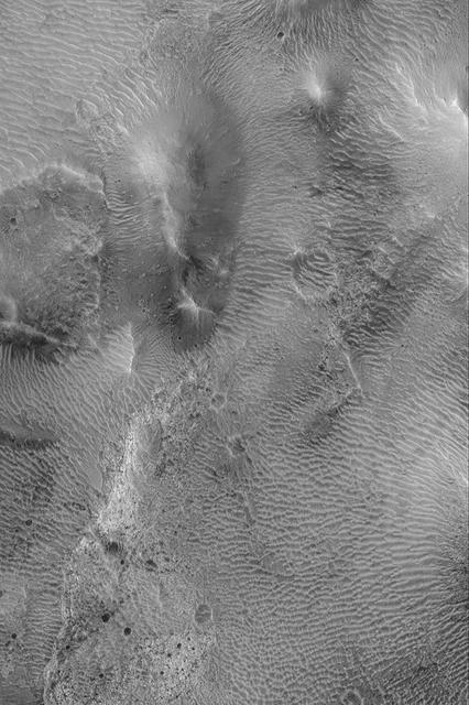
Large Bright Ripples
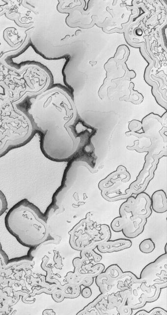
Large Boulders in a Trough
Large Crater on Eros

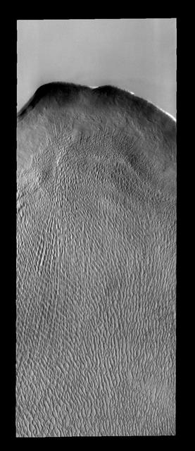
Large Windblown Ripples
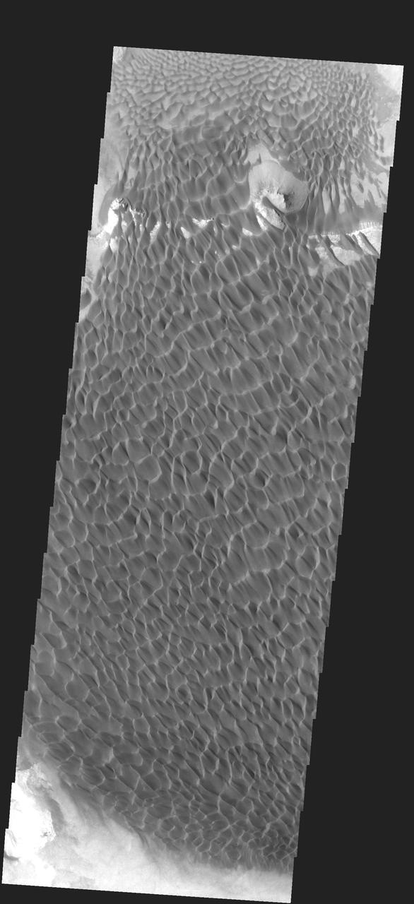
Large, Bright Wind Ripples
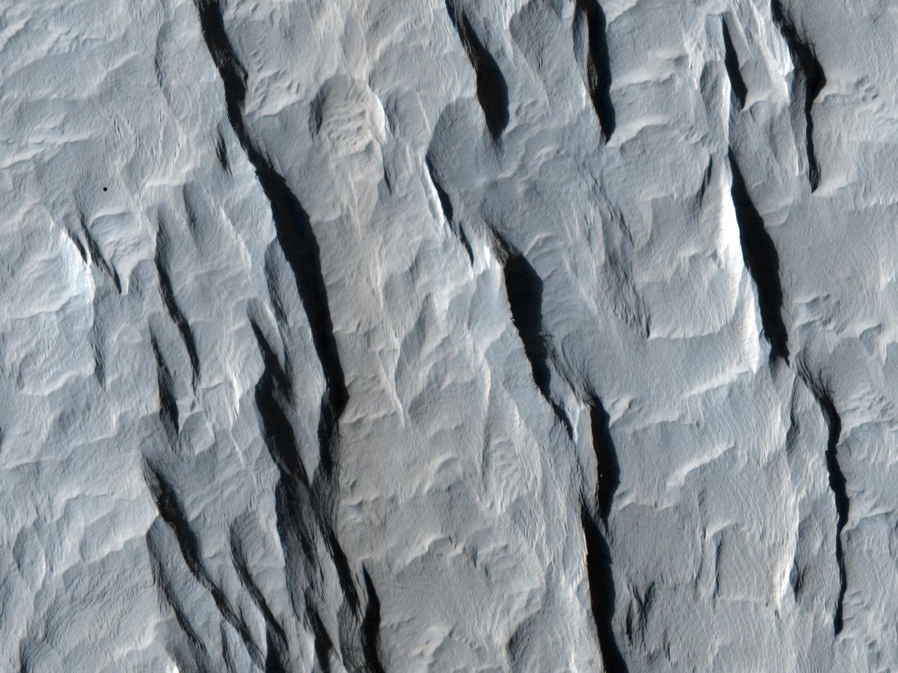
Large Ripples in Cerberus
Large Impact Structures on Europa
Inside Eros Large Crater
Yardangs within a Large Crater
Large, Windblown Ripples
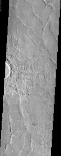
Large Tectonic Complex

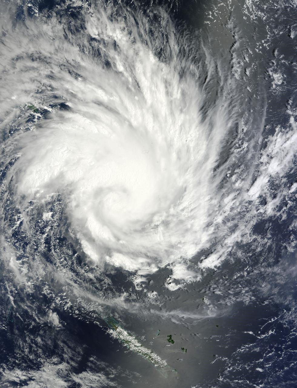
NASA's Terra satellite captured this image of Typhoon Phanfone and its large eye in the western Pacific Ocean on Friday, Oct. 3 at 1:55 UTC. On Oct. 3 at 0900 UTC (5 a.m. EDT), Typhoon Phanfone's maximum sustained winds were near 110 knots (126.6 mph/203.7 kph). It was centered near 23.6 north longitude and 134.4 east latitude, about 374 nautical miles west-southwest of the island of Iwo To. Phanfone has tracked northwestward at 12 knots (13.8 mph/22.2 kph). Read more: <a href="http://1.usa.gov/1vjS1vs" rel="nofollow">1.usa.gov/1vjS1vs</a> Credit: NASA Goddard MODIS Rapid Response Team <b><a href="http://www.nasa.gov/audience/formedia/features/MP_Photo_Guidelines.html" rel="nofollow">NASA image use policy.</a></b> <b><a href="http://www.nasa.gov/centers/goddard/home/index.html" rel="nofollow">NASA Goddard Space Flight Center</a></b> enables NASA’s mission through four scientific endeavors: Earth Science, Heliophysics, Solar System Exploration, and Astrophysics. Goddard plays a leading role in NASA’s accomplishments by contributing compelling scientific knowledge to advance the Agency’s mission. <b>Follow us on <a href="http://twitter.com/NASAGoddardPix" rel="nofollow">Twitter</a></b> <b>Like us on <a href="http://www.facebook.com/pages/Greenbelt-MD/NASA-Goddard/395013845897?ref=tsd" rel="nofollow">Facebook</a></b> <b>Find us on <a href="http://instagram.com/nasagoddard?vm=grid" rel="nofollow">Instagram</a></b>
Large impact on Callisto Southern Hemisphere
Large Craters in Callisto Southern Hemisphere
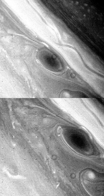
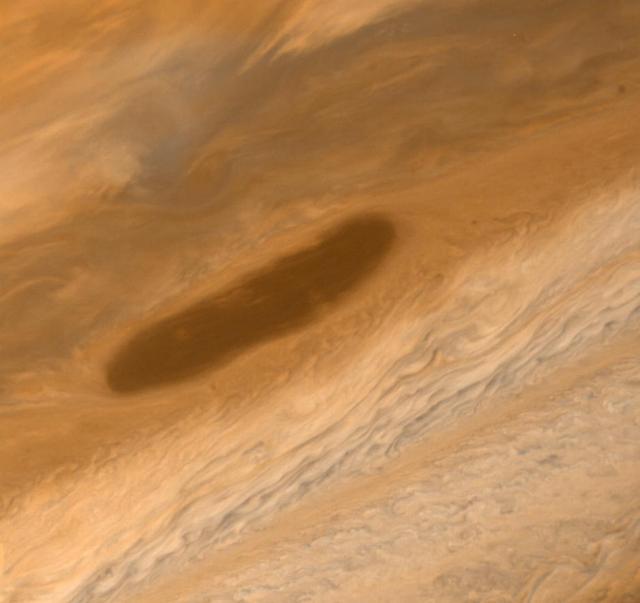
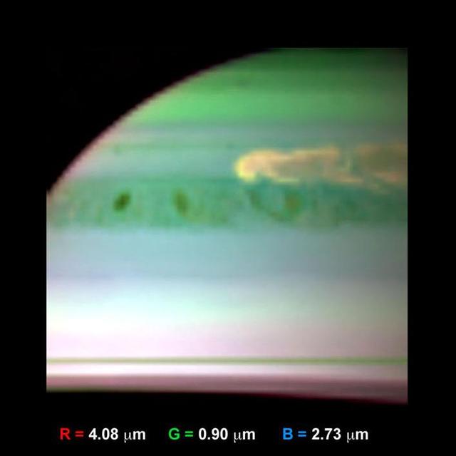
Large Brown Spot in Saturn Atmosphere
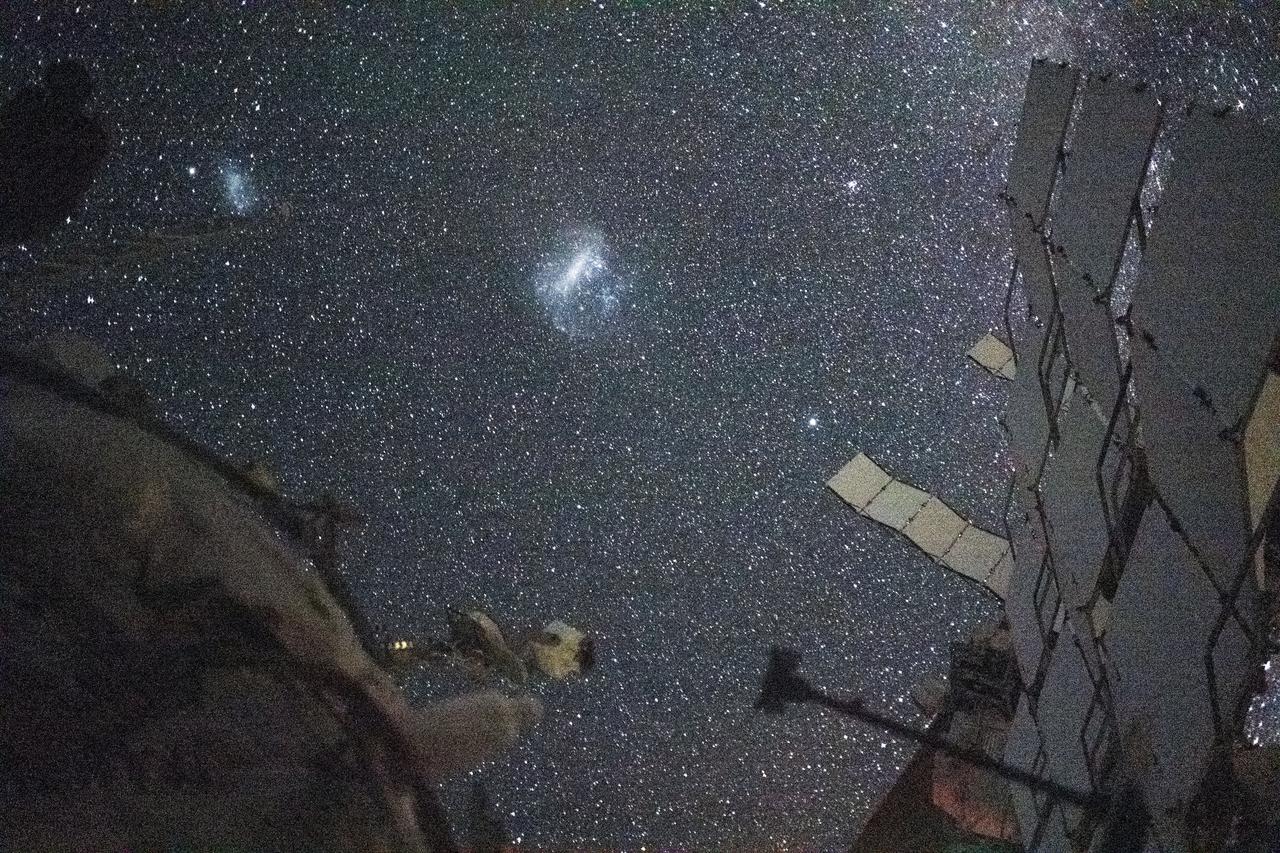
iss071e418742 (Aug. 6, 2024) --- The Large Magellanic Cloud (center) and the Small Magellanic Cloud (upper left), dwarf galaxies in close proximity with the Milky Way galaxy, are pictured from the International Space Station. NASA astronaut and Expedition 71 Flight Engineer Matthew Dominick took this long-duration photograph with a station camera increasing its sensitivity to account for low light conditions.
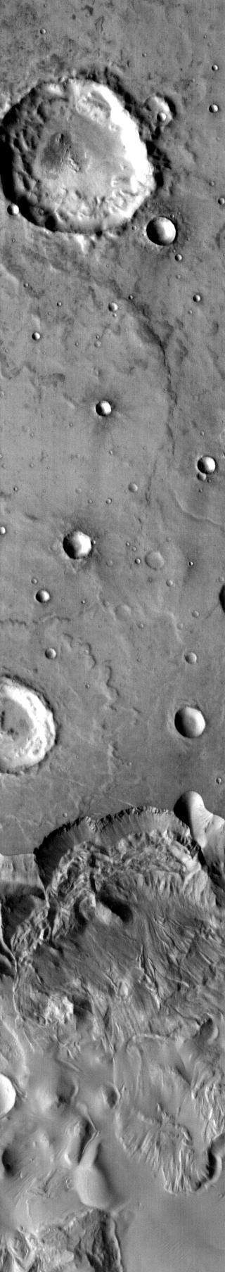
This image shows part of the large unnamed crater located on Acheron Fossae. Numerous channels dissect the crater rim and the crater floor has a rugged texture
Large Lava Fan on the Northwestern Flank of Olympus Mons
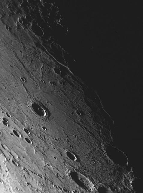
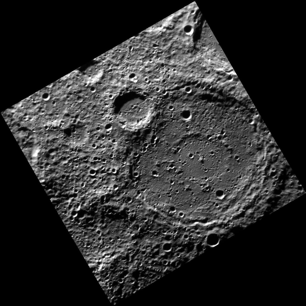
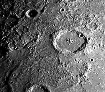
MESSENGER Discovers an Unusual Large Basin on Mercury
Large Martian Dust Devils Caught in the Act

Mars Volcanism: Large, Fluid Lava Flows
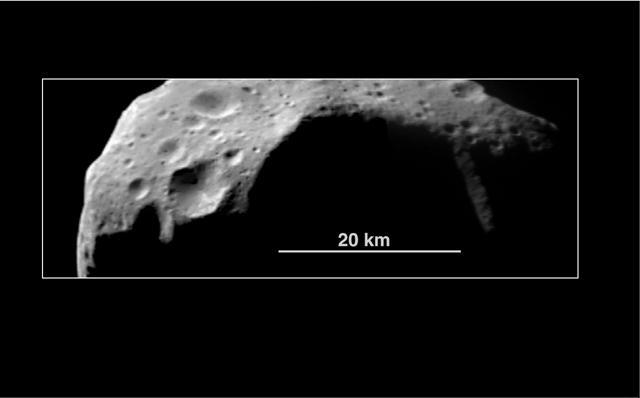
Abundance of Very Large Impact Craters on Mathilde
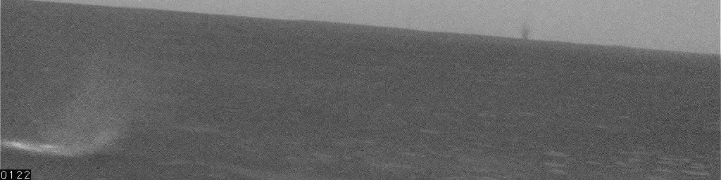
Large Dust Devil on Horizon, Sol 468
Sand Dunes And Large Rocks Revealed By Camera 1 http://photojournal.jpl.nasa.gov/catalog/PIA00391
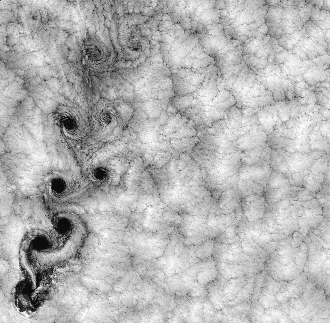
NASA image acquired September 15, 1999 This Landsat 7 image of clouds off the Chilean coast near the Juan Fernandez Islands (also known as the Robinson Crusoe Islands) on September 15, 1999, shows a unique pattern called a “von Karman vortex street.” This pattern has long been studied in the laboratory, where the vortices are created by oil flowing past a cylindrical obstacle, making a string of vortices only several tens of centimeters long. Study of this classic “flow past a circular cylinder” has been very important in the understanding of laminar and turbulent fluid flow that controls a wide variety of phenomena, from the lift under an aircraft wing to Earth’s weather. Here, the cylinder is replaced by Alejandro Selkirk Island (named after the true “Robinson Crusoe,” who was stranded here for many months in the early 1700s). The island is about 1.5 km in diameter, and rises 1.6 km into a layer of marine stratocumulus clouds. This type of cloud is important for its strong cooling of the Earth’s surface, partially counteracting the Greenhouse warming. An extended, steady equatorward wind creates vortices with clockwise flow off the eastern edge and counterclockwise flow off the western edge of the island. The vortices grow as they advect hundreds of kilometers downwind, making a street 10,000 times longer than those made in the laboratory. Observing the same phenomenon extended over such a wide range of sizes dramatizes the “fractal” nature of atmospheric convection and clouds. Fractals are characteristic of fluid flow and other dynamic systems that exhibit “chaotic” motions. Both clockwise and counter-clockwise vortices are generated by flow around the island. As the flow separates from the island’s leeward (away from the source of the wind) side, the vortices “swallow” some of the clear air over the island. (Much of the island air is cloudless due to a local “land breeze” circulation set up by the larger heat capacity of the waters surrounding the island.) The “swallowed” gulps of clear island air get carried along within the vortices, but these are soon mixed into the surrounding clouds. Landsat is unique in its ability to image both the small-scale eddies that mix clear and cloudy air, down to the 30 meter pixel size of Landsat, but also having a wide enough field-of-view, 180 km, to reveal the connection of the turbulence to large-scale flows such as the subtropical oceanic gyres. Landsat 7, with its new onboard digital recorder, has extended this capability away from the few Landsat ground stations to remote areas such as Alejandro Island, and thus is gradually providing a global dynamic picture of evolving human-scale phenomena. For more details on von Karman vortices, refer to <a href="http://climate.gsfc.nasa.gov/~cahalan" rel="nofollow">climate.gsfc.nasa.gov/~cahalan</a>. Image and caption courtesy Bob Cahalan, NASA GSFC Instrument: Landsat 7 - ETM+ Credit: NASA/GSFC/Landsat <b><a href="http://www.nasa.gov/centers/goddard/home/index.html" rel="nofollow">NASA Goddard Space Flight Center</a></b> enables NASA’s mission through four scientific endeavors: Earth Science, Heliophysics, Solar System Exploration, and Astrophysics. Goddard plays a leading role in NASA’s accomplishments by contributing compelling scientific knowledge to advance the Agency’s mission. <b>Follow us on <a href="http://twitter.com/NASA_GoddardPix" rel="nofollow">Twitter</a></b> <b>Join us on <a href="http://www.facebook.com/pages/Greenbelt-MD/NASA-Goddard/395013845897?ref=tsd" rel="nofollow">Facebook</a></b>
Large Isothermal Furnace (LIF) was flown on a mission in cooperation with the National Space Development Agency (NASDA) of Japan. LIF is a vacuum-heating furnace designed to heat large samples uniformly. The furnace consists of a sample container and heating element surrounded by a vacuum chamber. A crewmemeber will insert a sample cartridge into the furnace. The furnace will be activated and operations will be controlled automatically by a computer in response to an experiment number entered on the control panel. At the end of operations, helium will be discharged into the furnace, allowing cooling to start. Cooling will occur through the use of a water jacket while rapid cooling of samples can be accomplished through a controlled flow of helium. Data from experiments will help scientists better understand this important process which is vital to the production of high-quality semiconductor crystals.
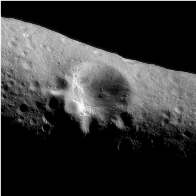
This image from NASA Dawn spacecraft shows many large subdued craters that have smaller, younger craters on top of them on asteroid Vesta. There are two large subdued craters in the center of the image, which have very degraded and rounded rims.
This mosaic from NASA Magellan data is in the Lavinia region of Venus. Three large impact craters can be seen located in a region of fractured plains. http://photojournal.jpl.nasa.gov/catalog/PIA00086

NASA image release January 23, 2013 Nearly 200 000 light-years from Earth, the Large Magellanic Cloud, a satellite galaxy of the Milky Way, floats in space, in a long and slow dance around our galaxy. As the Milky Way’s gravity gently tugs on its neighbour’s gas clouds, they collapse to form new stars. In turn, these light up the gas clouds in a kaleidoscope of colours, visible in this image from the NASA/ESA Hubble Space Telescope. To read more go to: <a href="http://1.usa.gov/10vcJIi" rel="nofollow">1.usa.gov/10vcJIi</a> <b><a href="http://www.nasa.gov/audience/formedia/features/MP_Photo_Guidelines.html" rel="nofollow">NASA image use policy.</a></b> <b><a href="http://www.nasa.gov/centers/goddard/home/index.html" rel="nofollow">NASA Goddard Space Flight Center</a></b> enables NASA’s mission through four scientific endeavors: Earth Science, Heliophysics, Solar System Exploration, and Astrophysics. Goddard plays a leading role in NASA’s accomplishments by contributing compelling scientific knowledge to advance the Agency’s mission. <b>Follow us on <a href="http://twitter.com/NASA_GoddardPix" rel="nofollow">Twitter</a></b> <b>Like us on <a href="http://www.facebook.com/pages/Greenbelt-MD/NASA-Goddard/395013845897?ref=tsd" rel="nofollow">Facebook</a></b> <b>Find us on <a href="http://instagram.com/nasagoddard?vm=grid" rel="nofollow">Instagram</a></b>
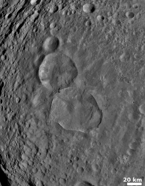
NASA Dawn spacecraft obtained this image of two large, young craters on Vesta with its framing camera on August 6, 2011. This image was taken through the framing camera clear filter aboard the spacecraft.
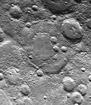
Taken about 40 minutes before NASA Mariner 10 made its close approach to Mercury on Sept. 21,1974, this picture shows a large double-ringed basin center of picture located in the planet south polar region
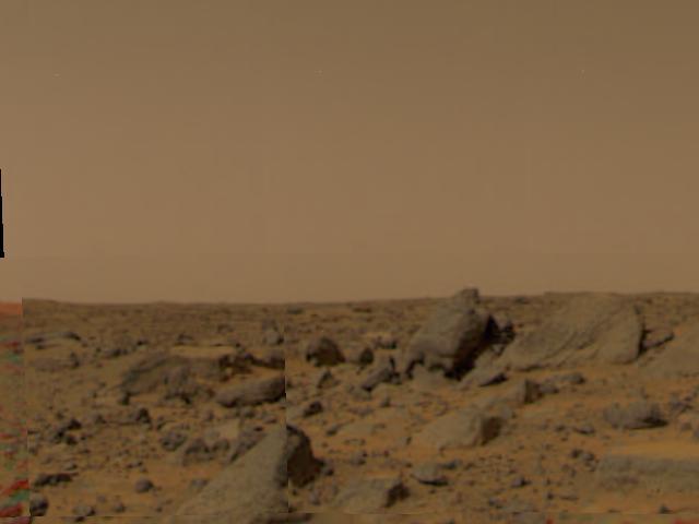
Large boulders are visible in this enlargement of pictures taken by the Imager for Mars Pathfinder (IMP) lander camera on July 4, 1997. The landing site is in the dry flood channel named Ares Valles. The boulders probably represent deposits from one of the catastrophic floods that carved the ancient channel. Between the rocks is brownish windblown soil. The gray-tan sky results from dust particles in the atmosphere. http://photojournal.jpl.nasa.gov/catalog/PIA00609
This large brown oval, photographed on Mar. 2, 1979 by NASA Voyager 1. Features of this sort are not rare on Jupiter and have an average lifetime of one to two years. Above the feature is the pale orange North Temperate Belt. http://photojournal.jpl.nasa.gov/catalog/PIA00015

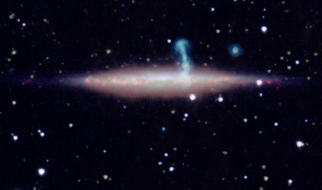
This is a composite image of N49, the brightest supernova remnant in optical light in the Large Magellanic Cloud; the image combines data from the Chandra X-ray Telescope blue and NASA Spitzer Space Telescope red.
As NASA Mariner 10 passed by Mercury on its second encounter with the planet on Sept. 21, 1974, this picture of a large circular 350 kilometer, 220 mile diameter basin was obtained near the morning terminator.
NASA image acquired January 30, 2011 at 23:20 UTC. Satellite: Terra <b> Click here to see the most recent image captured Feb. 1: <a href="http://www.flickr.com/photos/gsfc/5407540724/">www.flickr.com/photos/gsfc/5407540724/</a></b> Tropical Storm Anthony made landfall in Queensland, Australia this past weekend, and now the residents are watching a larger, more powerful cyclone headed their way. NASA's Terra satellite captured a visible image of the large Tropical Cyclone Yasi late yesterday as it makes its way west through the Coral Sea toward Queensland. The Moderate Resolution Imaging Spectroradiometer (MODIS) instrument that flies aboard NASA's Terra satellite captured an image of Cyclone Yasi on Jan. 30 at 23:20 UTC (6:20 p.m. EST/09:20 a.m., Monday, January 31 in Australia/Brisbane local time). Although the image did not reveal a visible eye, the storm appears to be well-formed and also appears to be strengthening. Warnings and watches are already in effect throughout the Coral Sea. The Solomon Islands currently have a Tropical Cyclone warning for the provinces of Temotu, Rennell & Bellona, Makira and Guadalcanal. The Australian Bureau of Meteorology has already posted a Tropical Cyclone Watch from Cooktown to Yeppoon and inland to between Georgetown and Moranbah in Queensland, Australia. The Australian Bureau of Meteorology expects damaging winds to develop in coastal and island communities between Cooktown and Yeppoon Wednesday morning, and inland areas on Wednesday afternoon. Updates from the Australian Bureau of Meteorology can be monitored at the Bureau's website at <a href="http://www.bom.gov.au" rel="nofollow">www.bom.gov.au</a>. On January 31 at 1500 UTC (10 a.m. EST/ 1:00 a.m. Tuesday February 1, 2011 in Australia/Brisbane local time), Tropical Cyclone Yasi had maximum sustained winds near 90 knots (103 mph/166 kmh). Yasi is a Category Two Cyclone on the Saffir-Simpson Scale. It was centered about 875 miles E of Cairns, Australia, near 13.4 South latitude and 160.4 East longitude. It was moving west near 19 knots (22 mph/35 kmh). Cyclone-force winds extend out to 30 miles (48 km) from the center. Animated infrared satellite imagery, such as that from the Atmospheric Infrared Sounder (AIRS) that flies on NASA's Aqua satellite, showed deep convective (thunderstorm) bands wrapping tighter into the low level circulation center. Wrapping bands of thunderstorms indicate strengthening. Yasi is forecast to move west then southwestward into an area of low vertical wind shear (strong wind shear can weaken a storm). Forecasters at the Joint Typhoon Warning Center (JTWC) expect Yasi to continue strengthening over the next 36 hours. JTWC forecasts a landfall just south of Cairns as a large 100-plus knot (115 mph/185 kmh)n system by Wednesday. Residents along the Queensland coast should now be making preparations now for the storm's arrival. Rob Gutro NASA's Goddard Space Flight Center Credit: NASA/GSFC/Jeff Schmaltz/MODIS Land Rapid Response Team Click here to see more images from <b><a href="http://rapidfire.sci.gsfc.nasa.gov/gallery/?latest" rel="nofollow">MODIS</a></b> <b><a href="http://www.nasa.gov/centers/goddard/home/index.html" rel="nofollow">NASA Goddard Space Flight Center</a></b> enables NASA’s mission through four scientific endeavors: Earth Science, Heliophysics, Solar System Exploration, and Astrophysics. Goddard plays a leading role in NASA’s accomplishments by contributing compelling scientific knowledge to advance the Agency’s mission. <b>Follow us on <a href="http://twitter.com/NASA_GoddardPix" rel="nofollow">Twitter</a></b> <b>Join us on <a href="http://www.facebook.com/pages/Greenbelt-MD/NASA-Goddard/395013845897?ref=tsd" rel="nofollow">Facebook</a></b>

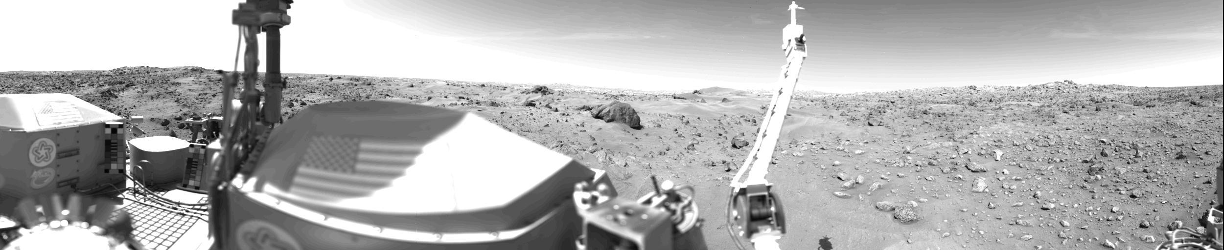
Observations at large scales, such as panoramas of Martian landscapes, help researchers identify smaller-scale features of special interest for examination in more detail.
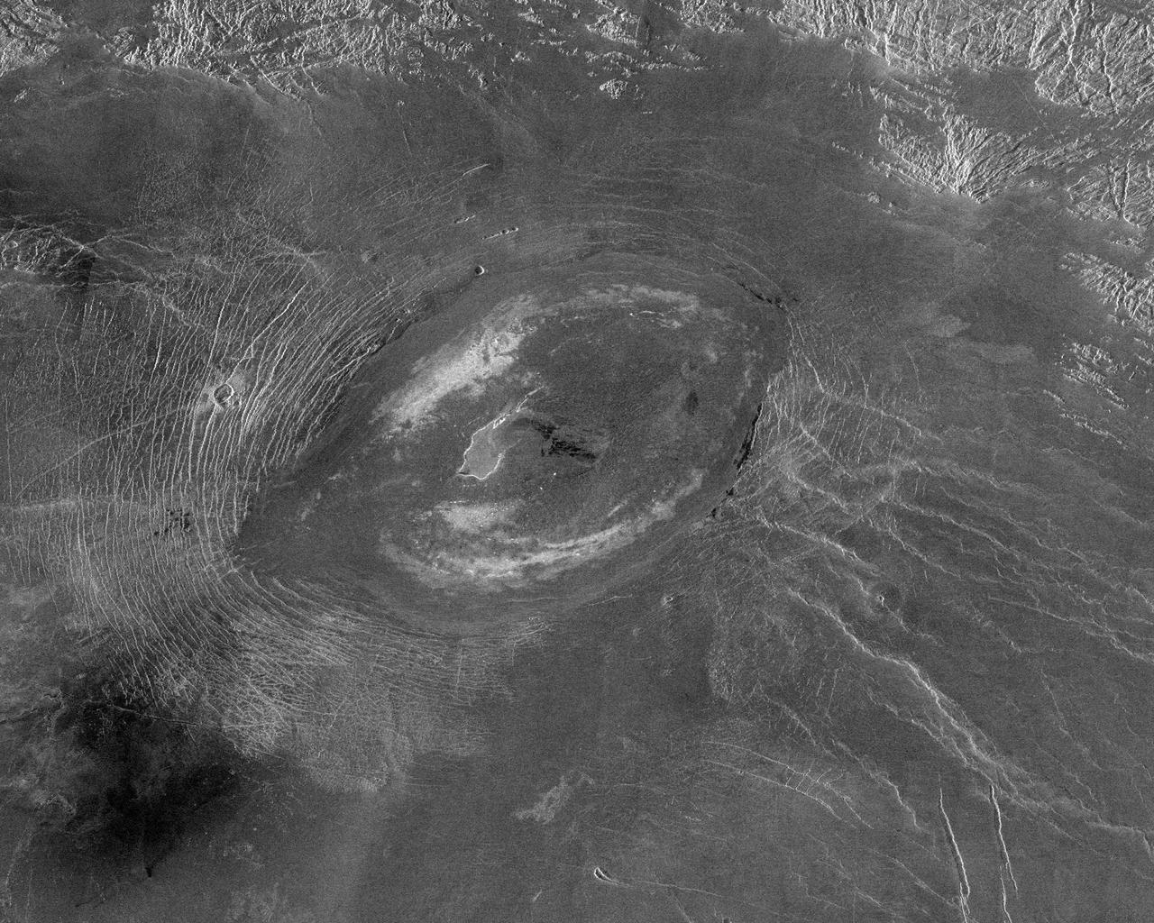
This image from NASA Magellan spacecraft reveals Sacajawea Patera, a large, elongate caldera located in Western Ishtar Terra on the smooth plateau of Lakshmi Planum.
The brightly glowing plumes seen in this image are reminiscent of an underwater scene, with turquoise-tinted currents and nebulous strands reaching out into the surroundings. However, this is no ocean. This image actually shows part of the Large Magellanic Cloud (LMC), a small nearby galaxy that orbits our galaxy, the Milky Way, and appears as a blurred blob in our skies. The NASA/European Space Agency (ESA) Hubble Space Telescope has peeked many times into this galaxy, releasing stunning images of the whirling clouds of gas and sparkling stars (opo9944a, heic1301, potw1408a). This image shows part of the Tarantula Nebula's outskirts. This famously beautiful nebula, located within the LMC, is a frequent target for Hubble (heic1206, heic1402). In most images of the LMC the color is completely different to that seen here. This is because, in this new image, a different set of filters was used. The customary R filter, which selects the red light, was replaced by a filter letting through the near-infrared light. In traditional images, the hydrogen gas appears pink because it shines most brightly in the red. Here however, other less prominent emission lines dominate in the blue and green filters. This data is part of the Archival Pure Parallel Project (APPP), a project that gathered together and processed over 1,000 images taken using Hubble’s Wide Field Planetary Camera 2, obtained in parallel with other Hubble instruments. Much of the data in the project could be used to study a wide range of astronomical topics, including gravitational lensing and cosmic shear, exploring distant star-forming galaxies, supplementing observations in other wavelength ranges with optical data, and examining star populations from stellar heavyweights all the way down to solar-mass stars. Image Credit: ESA/Hubble & NASA: acknowledgement: Josh Barrington <b><a href="http://www.nasa.gov/audience/formedia/features/MP_Photo_Guidelines.html" rel="nofollow">NASA image use policy.</a></b> <b><a href="http://www.nasa.gov/centers/goddard/home/index.html" rel="nofollow">NASA Goddard Space Flight Center</a></b> enables NASA’s mission through four scientific endeavors: Earth Science, Heliophysics, Solar System Exploration, and Astrophysics. Goddard plays a leading role in NASA’s accomplishments by contributing compelling scientific knowledge to advance the Agency’s mission. <b>Follow us on <a href="http://twitter.com/NASAGoddardPix" rel="nofollow">Twitter</a></b> <b>Like us on <a href="http://www.facebook.com/pages/Greenbelt-MD/NASA-Goddard/395013845897?ref=tsd" rel="nofollow">Facebook</a></b> <b>Find us on <a href="http://instagram.com/nasagoddard?vm=grid" rel="nofollow">Instagram</a></b>
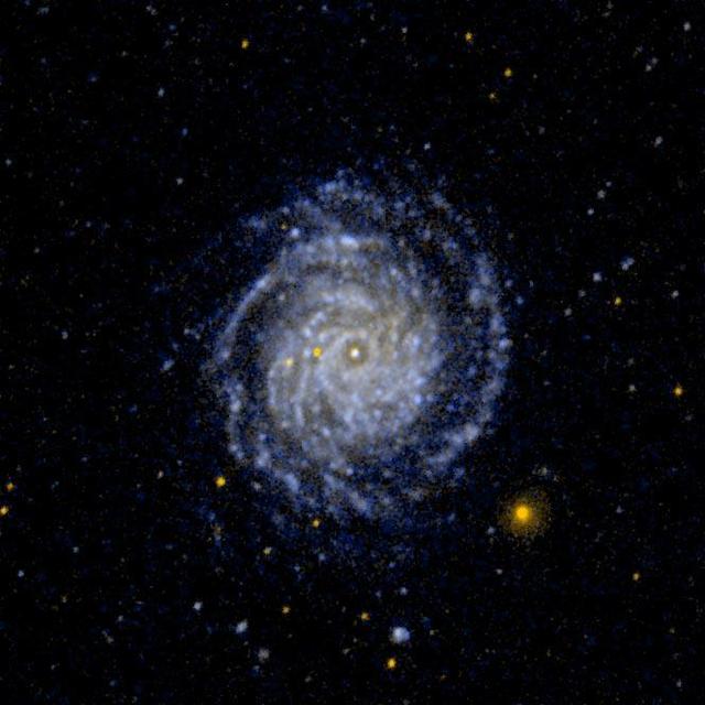
This ultraviolet image from NASA Galaxy Evolution Explorer is of the large face on spiral galaxy NGC 3344. The inner spiral arms are wrapped so tightly that they are difficult to distinguish. http://photojournal.jpl.nasa.gov/catalog/PIA07904
This false-color infrared image, obtained by NASA Cassini spacecraft, shows clouds of large ammonia ice particles dredged up by a powerful storm in Saturn northern hemisphere.
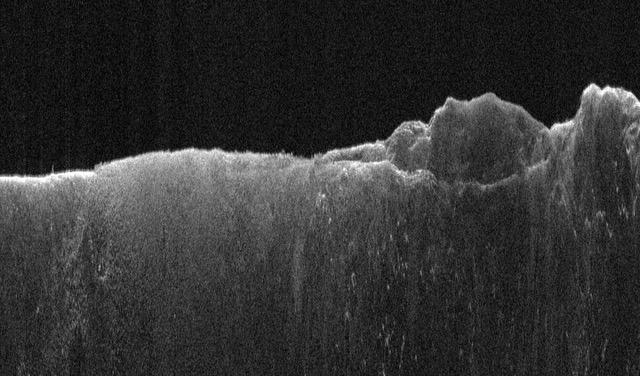
This radargram shows data collected by the Shallow Radar, or SHARAD, on NASA's Mars Reconnaissance Orbiter (MRO) on May 2, 2023, as it performed a 120-degree roll maneuver called a "very large roll" over a formation named Medusae Fossae. Scientists used SHARAD to look for ice beneath the surface of this region. Designed to peer from about a half-mile to a little over a mile (1 to 2 kilometers) below ground, SHARAD emits radio waves that are reflected off materials in the subsurface, measuring how long it takes for those waves to bounce back to the instrument. The longer it takes, the deeper the subsurface layer is. Because different materials reflect radio waves differently, SHARAD allows scientists to distinguish between rock, sand, and ice. While MRO often performs a standard 28-degree roll to give SHARAD's antenna a more direct view of Martian terrain, the 120-degree very large roll rotates the antenna even farther, providing its radio waves an unobstructed path to the surface. This boosts the radar's signals by 10 times or more, giving SHARAD a clearer, deeper view of the Martian underground than ever before. Scientists hope the very large rolls will help them look for frozen and liquid water, among other things. https://photojournal.jpl.nasa.gov/catalog/PIA26555
On September 24 at 11:29 GMT, a magnitude 7.7 earthquake struck in south-central Pakistan at a relatively shallow depth of 20 kilometers. The earthquake occurred as the result of oblique strike-slip motion, consistent with rupture within the Eurasian tectonic plate. Tremors were felt as far away as New Delhi as well as Karachi in Pakistan. Even though the immediate area to the epicenter is sparsely populated, the majority of houses are of mud brick construction and damage is expected to be extensive. The perspective view, looking to the east, shows the location of the epicenter in Pakistan's Makran fold belt. The image is centered near 27 degrees north latitude, 65.5 degrees east longitude, and was acquired December 13, 2012. With its 14 spectral bands from the visible to the thermal infrared wavelength region and its high spatial resolution of 15 to 90 meters (about 50 to 300 feet), ASTER images Earth to map and monitor the changing surface of our planet. ASTER is one of five Earth-observing instruments launched Dec. 18, 1999, on Terra. The instrument was built by Japan's Ministry of Economy, Trade and Industry. A joint U.S./Japan science team is responsible for validation and calibration of the instrument and data products. The broad spectral coverage and high spectral resolution of ASTER provides scientists in numerous disciplines with critical information for surface mapping and monitoring of dynamic conditions and temporal change. Example applications are: monitoring glacial advances and retreats; monitoring potentially active volcanoes; identifying crop stress; determining cloud morphology and physical properties; wetlands evaluation; thermal pollution monitoring; coral reef degradation; surface temperature mapping of soils and geology; and measuring surface heat balance. The U.S. science team is located at NASA's Jet Propulsion Laboratory, Pasadena, Calif. The Terra mission is part of NASA's Science Mission Directorate, Washington, D.C. More information about ASTER is available at <a href="http://asterweb.jpl.nasa.gov/" rel="nofollow">asterweb.jpl.nasa.gov/</a>. Image Credit: NASA/GSFC/METI/ERSDAC/JAROS, and U.S./Japan ASTER Science Team Image Addition Date: 2013-09-24 <b><a href="http://www.nasa.gov/audience/formedia/features/MP_Photo_Guidelines.html" rel="nofollow">NASA image use policy.</a></b> <b><a href="http://www.nasa.gov/centers/goddard/home/index.html" rel="nofollow">NASA Goddard Space Flight Center</a></b> enables NASA’s mission through four scientific endeavors: Earth Science, Heliophysics, Solar System Exploration, and Astrophysics. Goddard plays a leading role in NASA’s accomplishments by contributing compelling scientific knowledge to advance the Agency’s mission. <b>Follow us on <a href="http://twitter.com/NASA_GoddardPix" rel="nofollow">Twitter</a></b> <b>Like us on <a href="http://www.facebook.com/pages/Greenbelt-MD/NASA-Goddard/395013845897?ref=tsd" rel="nofollow">Facebook</a></b> <b>Find us on <a href="http://instagram.com/nasagoddard?vm=grid" rel="nofollow">Instagram</a></b>

This large tabular iceberg, broken off from the Antarctic Ice Sheet, was spotted in the South Atlantic Ocean (57.0S, 57.0W) southeast of the tip of South America as it was slowly being moved north and east by wind, current and tidal influences. This type of iceberg, never to be seen in the northern hemisphere, is typical for Antarctica. Although some such icebergs are as large as 100 km in length, this one measures about 35 by 69 km.
This images, acquired on March 12, 2011 by NASA Terra spacecraft, shows a large smoke plume that appears to be associated either with the Shiogama incident or Sendai port fires. 3D glasses are necessary to view this image.
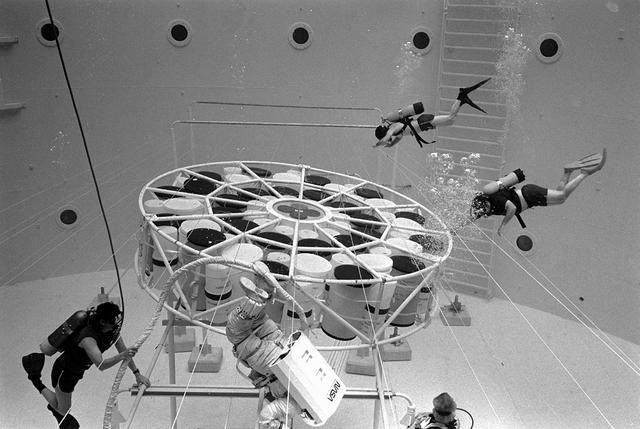
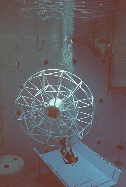
Once the United States' space program had progressed from Earth's orbit into outerspace, the prospect of building and maintaining a permanent presence in space was realized. To accomplish this feat, NASA launched a temporary workstation, Skylab, to discover the effects of low gravity and weightlessness on the human body, and also to develop tools and equipment that would be needed in the future to build and maintain a more permanent space station. The structures, techniques, and work schedules had to be carefully designed to fit this unique construction site. The components had to be lightweight for transport into orbit, yet durable. The station also had to be made with removable parts for easy servicing and repairs by astronauts. All of the tools necessary for service and repairs had to be designed for easy manipulation by a suited astronaut. And construction methods had to be efficient due to limited time the astronauts could remain outside their controlled environment. In lieu of all the specific needs for this project, an environment on Earth had to be developed that could simulate a low gravity atmosphere. A Neutral Buoyancy Simulator (NBS) was constructed by NASA Marshall Space Flight Center (MSFC) in 1968. Since then, NASA scientists have used this facility to understand how humans work best in low gravity and also provide information about the different kinds of structures that can be built.Pictured is an experiment where the astronaut is required to move a large object which weighed 19,000 pounds. It was moved with realitive ease once the astronaut became familiar with his environment and his near weightless condition. Experiments of this nature provided scientists with the information needed regarding weight and mass allowances astronauts could manage in preparation for building a permanent space station in the future.
Once the United States' space program had progressed from Earth's orbit into outerspace, the prospect of building and maintaining a permanent presence in space was realized. To accomplish this feat, NASA launched a temporary workstation, Skylab, to discover the effects of low gravity and weightlessness on the human body, and also to develop tools and equipment that would be needed in the future to build and maintain a more permanent space station. The structures, techniques, and work schedules had to be carefully designed to fit this unique construction site. The components had to be lightweight for transport into orbit, yet durable. The station also had to be made with removable parts for easy servicing and repairs by astronauts. All of the tools necessary for service and repairs had to be designed for easy manipulation by a suited astronaut. And construction methods had to be efficient due to limited time the astronauts could remain outside their controlled environment. In lieu of all the specific needs for this project, an environment on Earth had to be developed that could simulate a low gravity atmosphere. A Neutral Buoyancy Simulator (NBS) was constructed by NASA Marshall Space Flight Center (MSFC) in 1968. Since then, NASA scientists have used this facility to understand how humans work best in low gravity and also provide information about the different kinds of structures that can be built. Included in the plans for the space station was a space telescope. This telescope would be attached to the space station and directed towards outerspace. Astronomers hoped that the space telescope would provide a look at space that is impossible to see from Earth because of Earth's atmosphere and other man made influences. Pictured is a large structure that is being used as the antenna base for the space telescope.
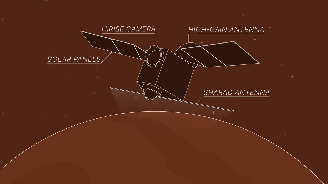
This animation depicts NASA's Mars Reconnaissance Orbiter (MRO) performing what's called a "very large roll": a 120-degree roll that can increase the capabilities of the spacecraft's subsurface radar instrument, called Shallow Radar, or SHARAD. Very large rolls boost SHARAD's signal by 10 times or more, giving scientists a clearer and deeper look below the Martian surface than MRO has ever had before. The orbiter was designed to roll up to 30 degrees in any direction so that it can point its instruments at surface targets. These standard rolls give cameras like the High-Resolution Imaging Science Experiment (HiRISE) prime viewing at the front of MRO at the expense of SHARAD, which has an antenna mounted at the back of the orbiter. While this setup helps the cameras, it also means that radio signals SHARAD pings onto the surface below encounter parts of the spacecraft, interfering with the signals and resulting in images that are less clear. In 2023, the team decided to try developing 120-degree rolls – the very large rolls – that rotate SHARAD's antenna toward the planet and provide the radio waves an unobstructed path to the surface. That lets the radar's signals reach deeper and get a clearer picture of rocks, sand, and geologic layers underground. It also helps SHARAD look for water ice in the near-subsurface that could be accessed by astronauts to produce rocket propellant for the trip home and is important for learning more about the climate, geology, and potential for life at Mars. Animation available at https://photojournal.jpl.nasa.gov/catalog/PIA26478
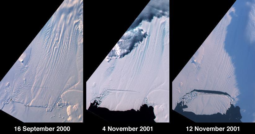
A large tabular iceberg (42 kilometers x 17 kilometers) broke off Pine Island Glacier, West Antarctica (75ºS latitude, 102ºW longitude) sometime between November 4 and 12, 2001. Images of the glacier were acquired by the Multi-angle Imaging SpectroRadiometer (MISR) instrument aboard NASA's Terra spacecraft. This event was preceded by the formation of a large crack across the glacier in mid 2000. Data gathered by other imaging instruments revealed the crack to be propagating through the shelf ice at a rate averaging 15 meters per day, accompanied by a slight rotation of about one percent per year at the seaward margin of the rift. The image set shows three views of Pine Island Glacier acquired by MISR's vertical-viewing (nadir) camera. The first was captured in late 2000, early in the development of the crack. The second and third views were acquired in November 2001, just before and just after the new iceberg broke off. The existence of the crack took the glaciological community by surprise, and the rapid rate at which the crack propagated was also not anticipated. Glaciologists predicted that the rift would reach the other side of the glacier sometime in 2002. However, the iceberg detached much sooner than anticipated, and the last 10-kilometer segment that was still attached to the ice shelf snapped off in a matter of days. http://photojournal.jpl.nasa.gov/catalog/PIA03431
A mixture of terrains studded with a large impact crater is shown in this view of the Uruk Sulcus region of Jupiter moon Ganymede taken by NASA Galileo spacecraft during its first flyby of the planet-sized moon on June 27, 1996. http://photojournal.jpl.nasa.gov/catalog/PIA00280
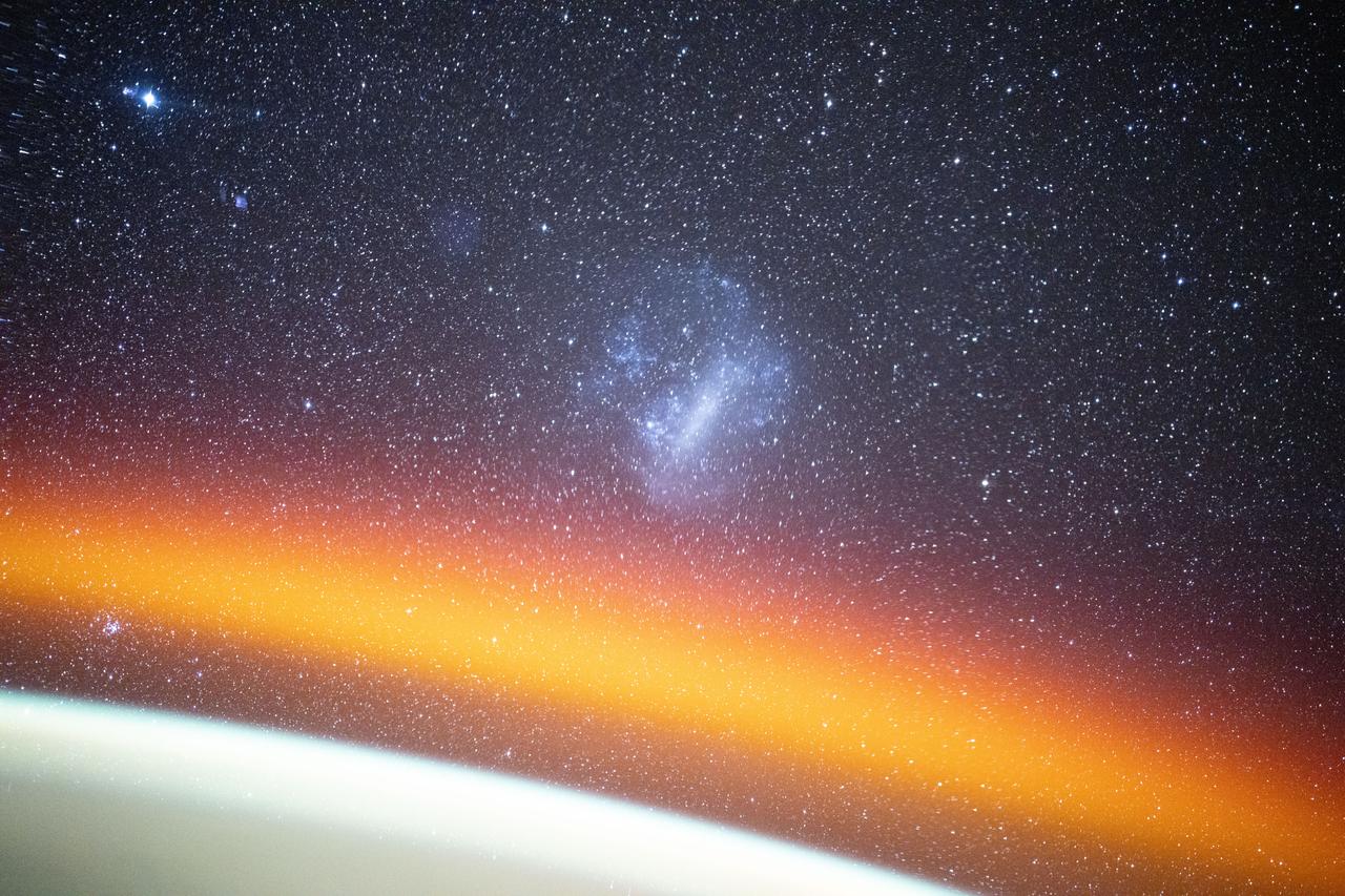
iss072e278609 (Nov. 26, 2024) --- The Large Magellanic Cloud among a starry backdrop above Earth's atmospheric glow highlights this long duration photograph from the International Space Station as it orbited 260 miles above the Pacific Ocean off the coast of Mexico. Credit: NASA/Don Pettit
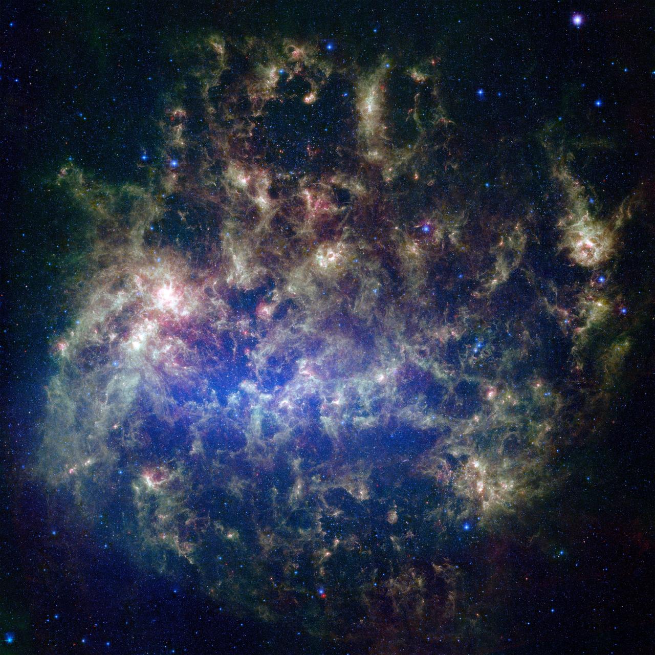
This vibrant image from NASA's Spitzer Space Telescope shows the Large Magellanic Cloud, a satellite galaxy to our own Milky Way galaxy. The infrared image, a mosaic of 300,000 individual tiles, offers astronomers a unique chance to study the lifecycle of stars and dust in a single galaxy. Nearly one million objects are revealed for the first time in this Spitzer view, which represents about a 1,000-fold improvement in sensitivity over previous space-based missions. Most of the new objects are dusty stars of various ages populating the Large Magellanic Cloud; the rest are thought to be background galaxies. The blue color in the picture, seen most prominently in the central bar, represents starlight from older stars. The chaotic, bright regions outside this bar are filled with hot, massive stars buried in thick blankets of dust. The red color around these bright regions is from dust heated by stars, while the red dots scattered throughout the picture are either dusty, old stars or more distant galaxies. The greenish clouds contain cooler interstellar gas and molecular-sized dust grains illuminated by ambient starlight. Astronomers say this image allows them to quantify the process by which space dust -- the same stuff that makes up planets and even people -- is recycled in a galaxy. The picture shows dust at its three main cosmic hangouts: around the young stars, where it is being consumed (red-tinted, bright clouds); scattered about in the space between stars (greenish clouds); and in expelled shells of material from old stars (randomly-spaced red dots). The Large Magellanic Cloud, located 160,000 light-years from Earth, is one of a handful of dwarf galaxies that orbit our own Milky Way. It is approximately one-third as wide as the Milky Way, and, if it could be seen in its entirety, would cover the same amount of sky as a grid of about 480 full moons. About one-third of the entire galaxy can be seen in the Spitzer image. This picture is a composite of infrared light captured by Spitzer. Light with wavelengths of 3.6 (blue) and 8 (green) microns was captured by the telescope's infrared array camera; 24-micron light (red) was detected by the multiband imaging photometer. http://photojournal.jpl.nasa.gov/catalog/PIA07137
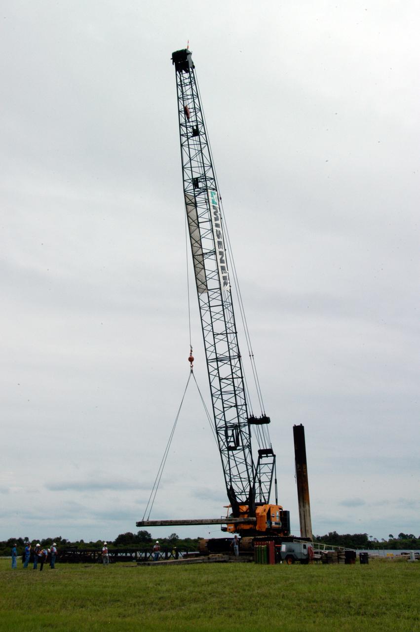
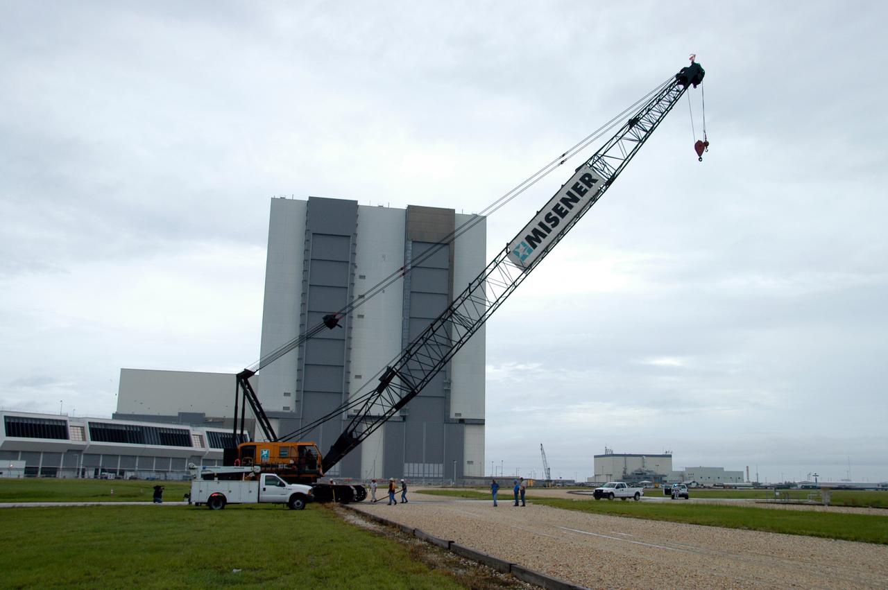
A large crawler crane arrives at the turn basin at the Launch Complex 39 Area on NASA's Kennedy Space Center. The crane with its 70-foot boom will be moved to Launch Pad 39B and used to construct a new lightning protection system for the Constellation Program and Ares/Orion launches. Pad B will be the site of the first Ares vehicle launch, including Ares I-X which is scheduled for April 2009.
A large crawler crane arrives at the turn basin at the Launch Complex 39 Area on NASA's Kennedy Space Center. The crane with its 70-foot boom will be moved to Launch Pad 39B and used to construct a new lightning protection system for the Constellation Program and Ares/Orion launches. Pad B will be the site of the first Ares vehicle launch, including Ares I-X which is scheduled for April 2009.
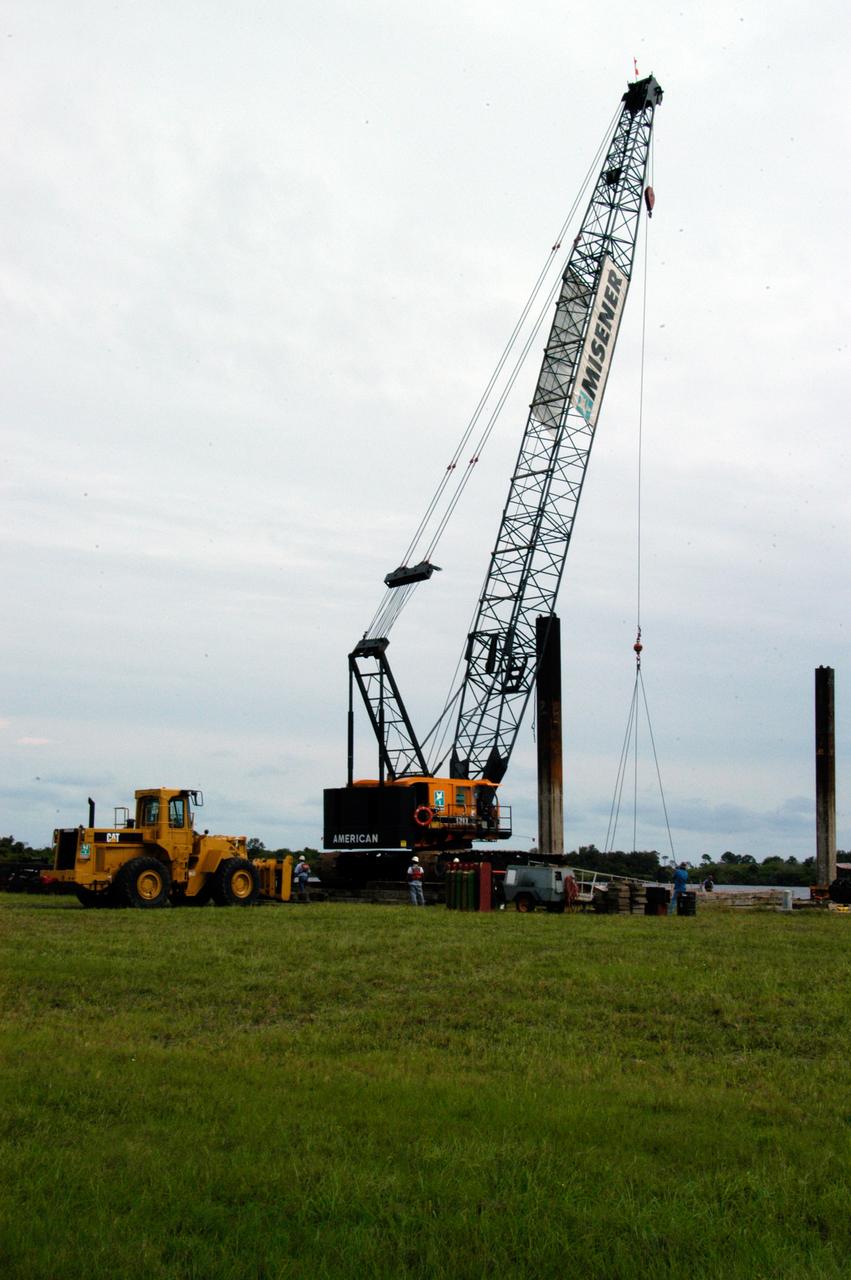
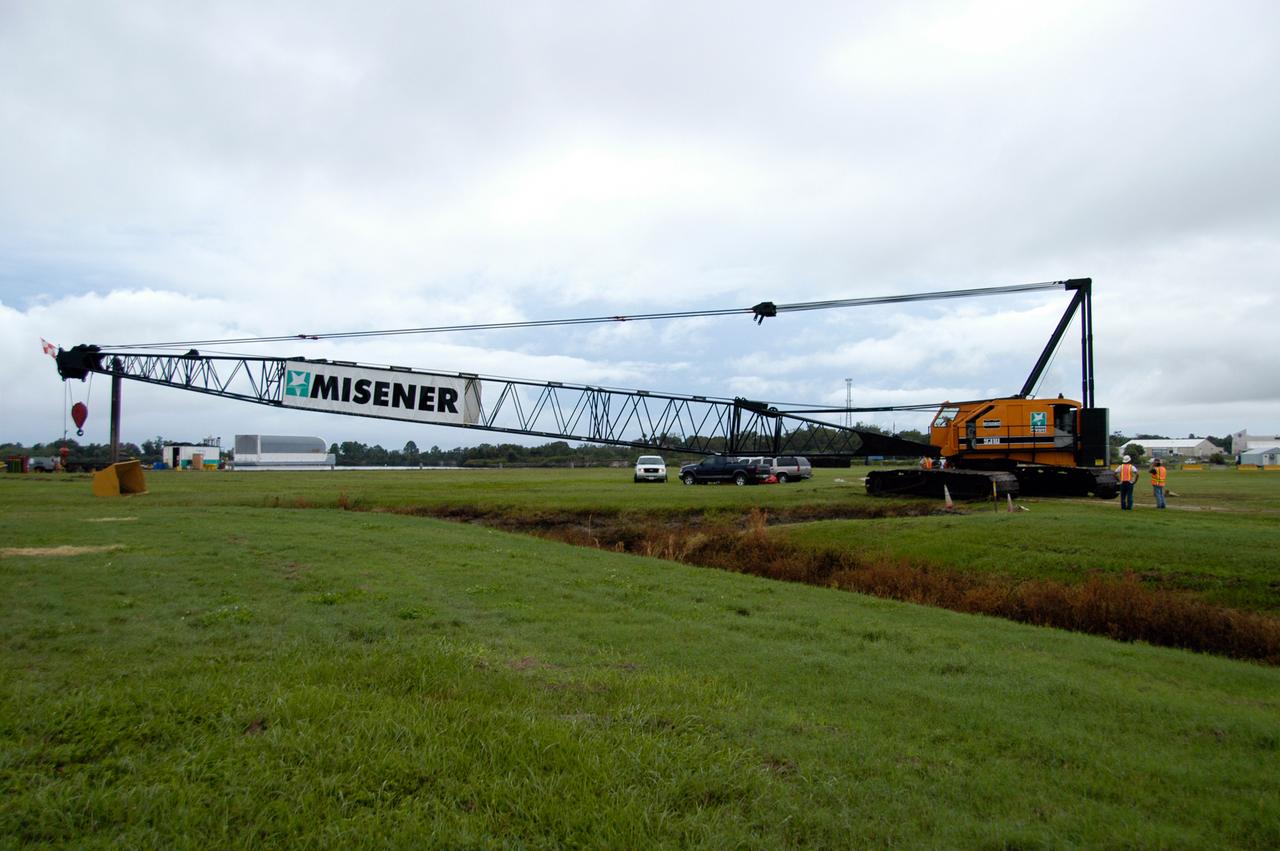
A large crawler crane traveling long one of the crawlerway tracks makes the turn toward Launch Pad 39B. The crane with its 70-foot boom will be used to construct a new lightning protection system for the Constellation Program and Ares/Orion launches. Pad B will be the site of the first Ares vehicle launch, including Ares I-X which is scheduled for April 2009.
A large crawler crane moves past the Vehicle Assembly Building on its way to Launch Pad 39B. The crane with its 70-foot boom will be used to construct a new lightning protection system for the Constellation Program and Ares/Orion launches. Pad B will be the site of the first Ares vehicle launch, including Ares I-X which is scheduled for April 2009.

A large crawler crane travels along one of the crawlerway tracks on its way to Launch Pad 39B. The crane with its 70-foot boom will be used to construct a new lightning protection system for the Constellation Program and Ares/Orion launches. Pad B will be the site of the first Ares vehicle launch, including Ares I-X which is scheduled for April 2009.

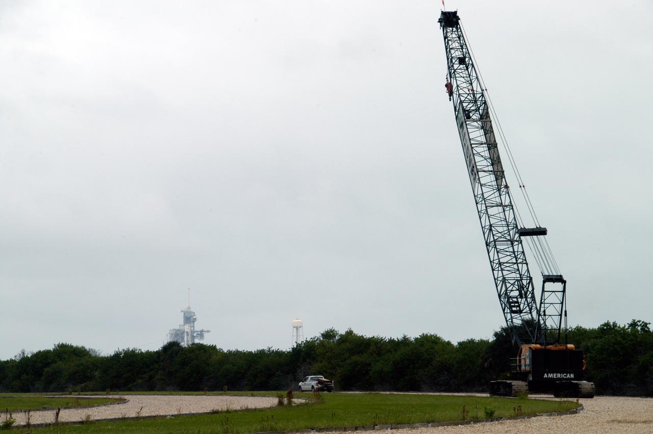
A large crawler crane begins moving away from the turn basin at the Launch Complex 39 Area on NASA's Kennedy Space Center. The crane with its 70-foot boom will be moved to Launch Pad 39B and used to construct a new lightning protection system for the Constellation Program and Ares/Orion launches. Pad B will be the site of the first Ares vehicle launch, including Ares I-X which is scheduled for April 2009.
A large crawler crane begins moving away from the turn basin at the Launch Complex 39 Area on NASA's Kennedy Space Center. The crane with its 70-foot boom will be moved to Launch Pad 39B and used to construct a new lightning protection system for the Constellation Program and Ares/Orion launches. Pad B will be the site of the first Ares vehicle launch, including Ares I-X which is scheduled for April 2009.
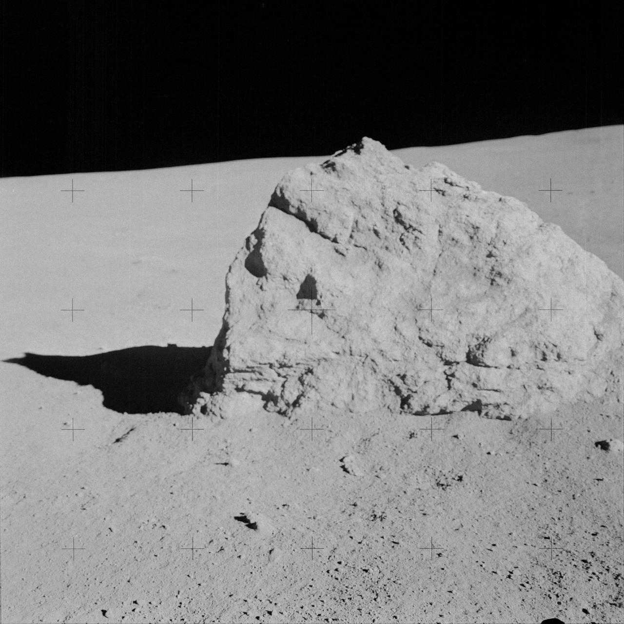
AS14-64-9135 (6 Feb. 1971) --- Astronaut Alan B. Shepard Jr., commander, took this close-up view of a large boulder, approximately five feet long, during the second extravehicular activity (EVA), on Feb. 6, 1971. Astronauts Shepard and Edgar D. Mitchell, lunar module pilot, descended in the Lunar Module (LM) to explore the moon, while astronaut Stuart A. Roosa, command module pilot, remained with the Command and Service Modules (CSM) in lunar orbit.
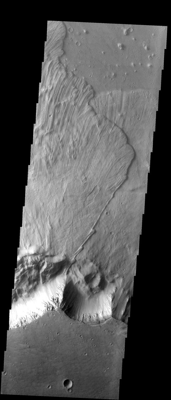
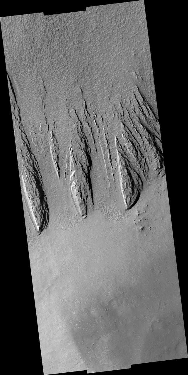
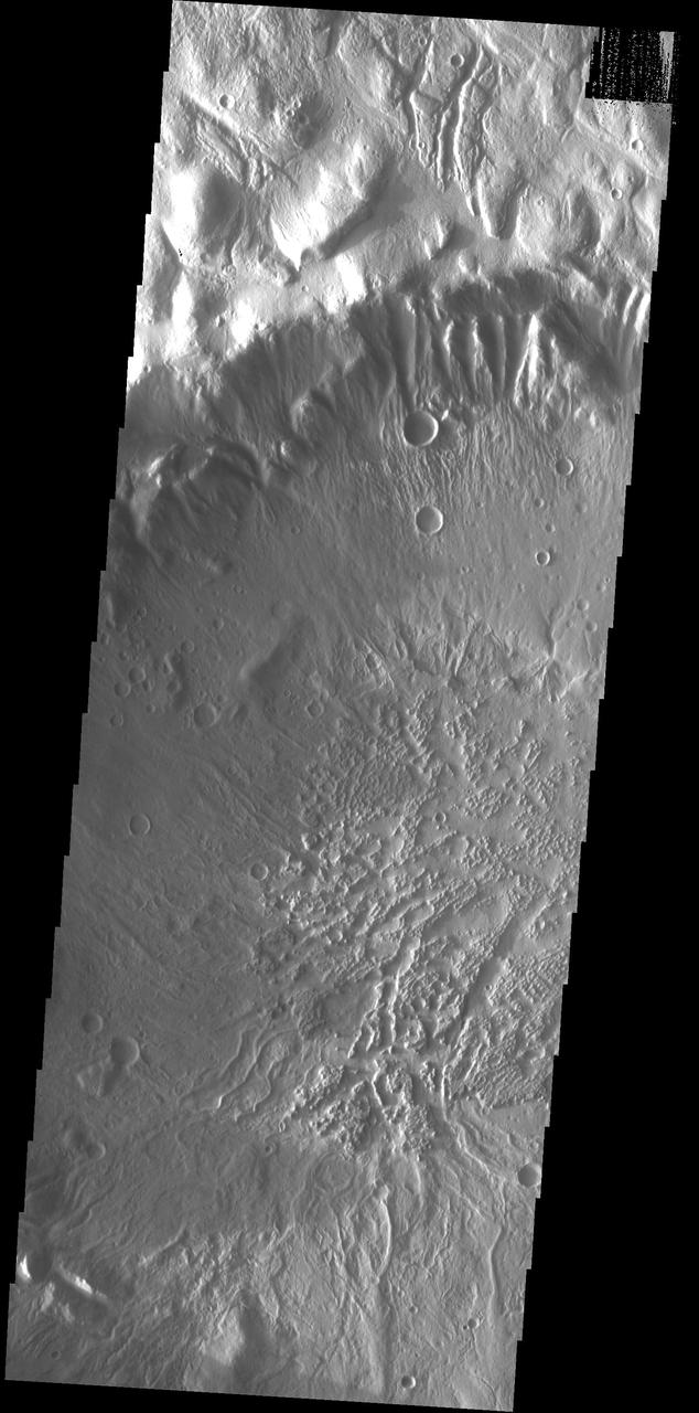
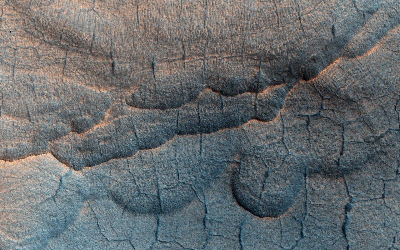
These large landslides are located in Ganges Chasma
This image shows large, relatively flat-lying, puzzle-like pieces in this scene are mesas composed largely of solid carbon dioxide
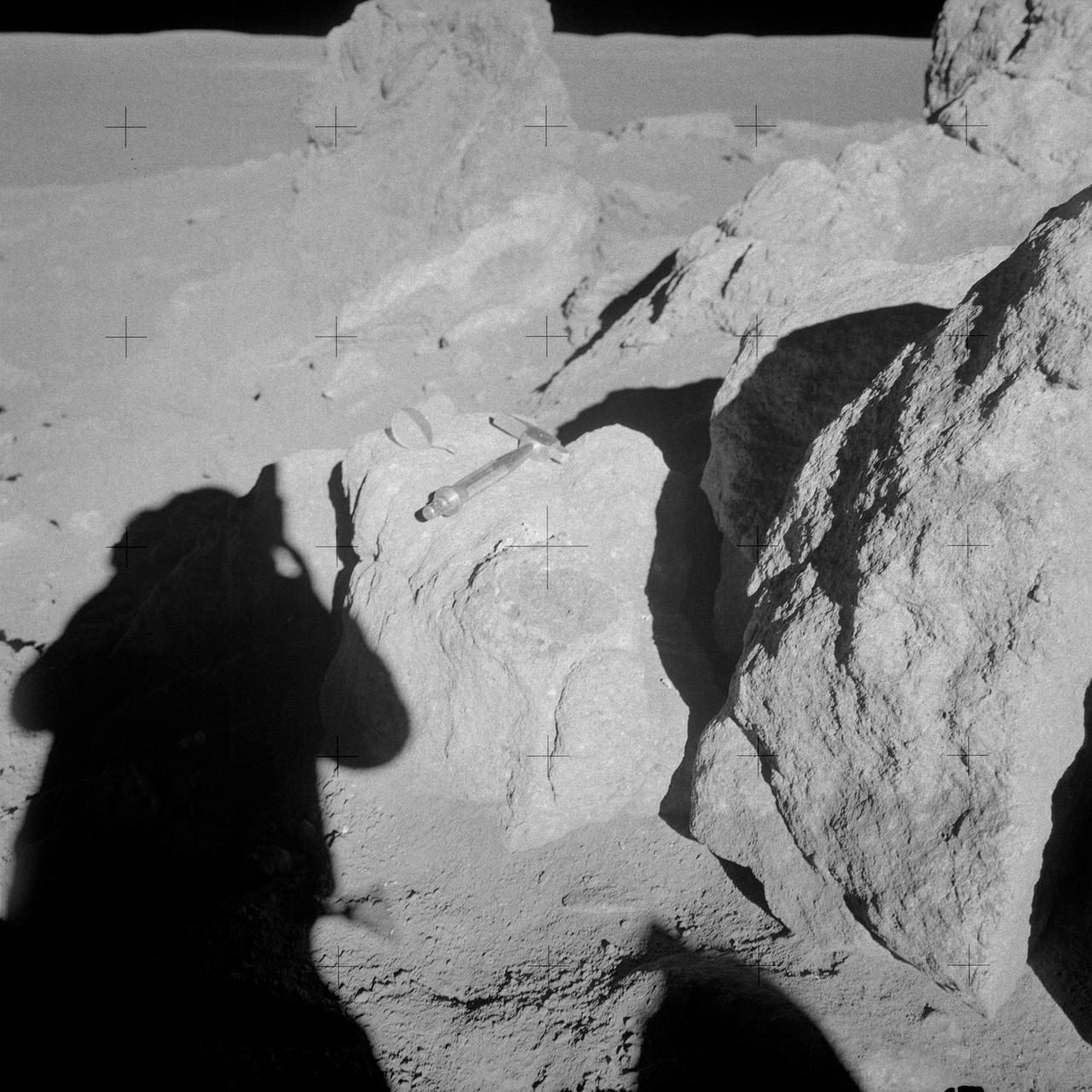
AS14-68-9453 (6 Feb. 1971) --- Astronaut Edgar D. Mitchell, lunar module pilot, whose shadow is in the foreground, photographs a group of large boulders near the rim of Cone Crater. An interesting feature is the white and brown rock in the boulder. Mitchell removed a sample where the hammer is lying. While astronauts Alan B. Shepard Jr., commander, and Mitchell descended in the Lunar Module (LM) "Antares" to explore the Fra Mauro region of the moon, astronaut Stuart A. Roosa, command module pilot, remained with the Command and Service Modules (CSM) "Kitty Hawk" in lunar orbit.

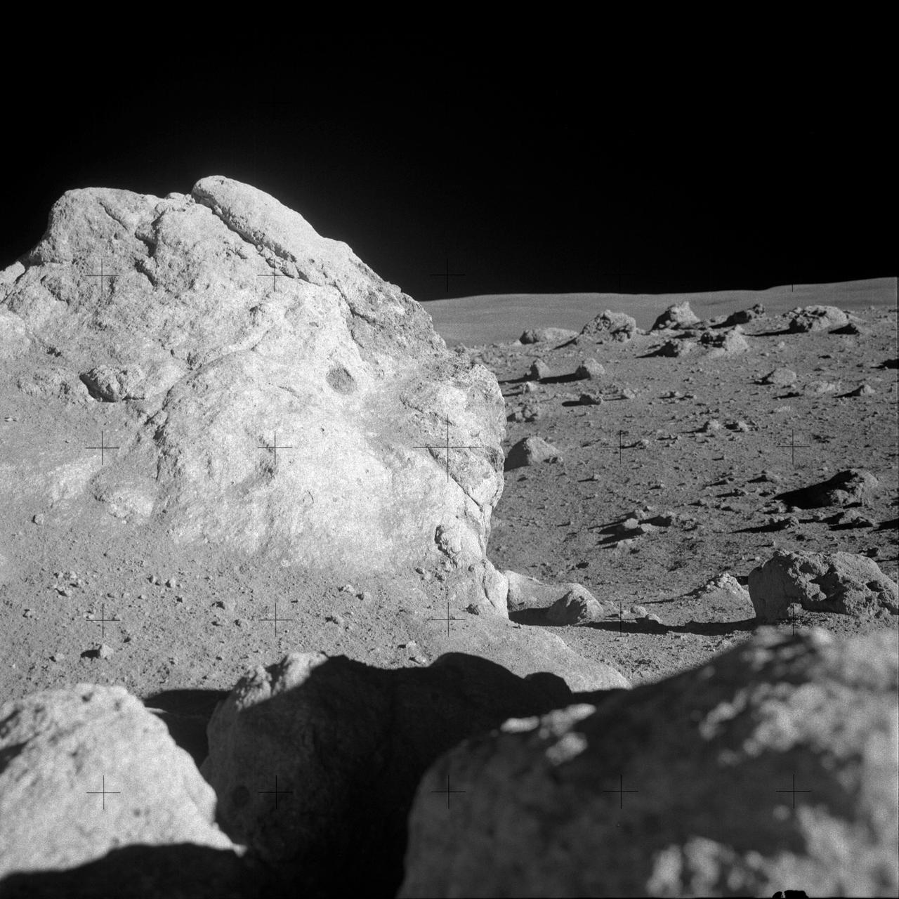
AS14-68-9448 (6 Feb. 1971) --- A close-up view of a large multi-colored boulder in the boulder field located on the rim of Cone Crater, as photographed by the moon-exploring crew members of the Apollo 14 lunar landing mission. This view is looking west by southwest. The Lunar Module (LM) can be seen in the background. While astronauts Alan B. Shepard Jr., commander, and Edgar D. Mitchell, lunar module pilot, were exploring the moon, after descending in the LM, astronaut Stuart A. Roosa, command module pilot, remained with the Command and Service Modules (CSM) in lunar orbit.
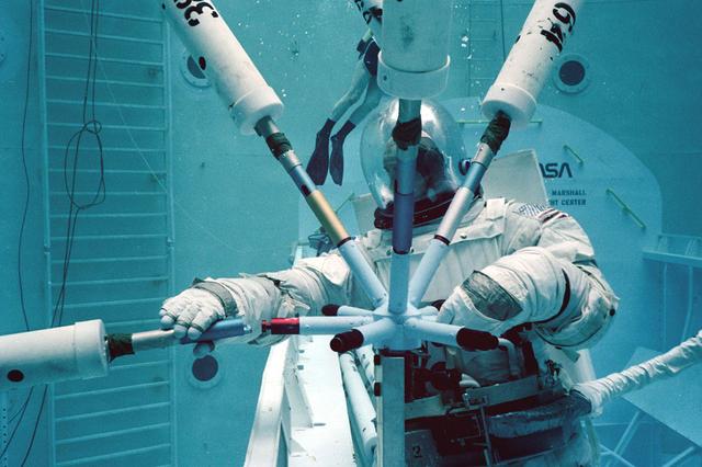
Once the United States' space program had progressed from Earth's orbit into outerspace, the prospect of building and maintaining a permanent presence in space was realized. To accomplish this feat, NASA launched a temporary workstation, Skylab, to discover the effects of low gravity and weightlessness on the human body, and also to develop tools and equipment that would be needed in the future to build and maintain a more permanent space station. The structures, techniques, and work schedules had to be carefully designed to fit this unique construction site. The components had to be lightweight for transport into orbit, yet durable. The station also had to be made with removable parts for easy servicing and repairs by astronauts. All of the tools necessary for service and repairs had to be designed for easy manipulation by a suited astronaut. And construction methods had to be efficient due to limited time the astronauts could remain outside their controlled environment. In lieu of all the specific needs for this project, an environment on Earth had to be developed that could simulate a low gravity atmosphere. A Neutral Buoyancy Simulator (NBS) was constructed by NASA Marshall Space Flight Center (MSFC) in 1968. Since then, NASA scientists have used this facility to understand how humans work best in low gravity and also provide information about the different kinds of structures that can be built. Pictured is a Massachusetts Institute of Technology (MIT) student working in a spacesuit on the Experimental Assembly of Structures in Extravehicular Activity (EASE) project which was developed as a joint effort between MFSC and MIT. The EASE experiment required that crew members assemble small components to form larger components, working from the payload bay of the space shuttle.

Tidal disruption event Every galaxy has a black hole at its center. Usually they are quiet, without gas accretions, like the one in our Milky Way. But if a star creeps too close to the black hole, the gravitational tides can rip away the star’s gaseous matter. Like water spinning around a drain, the gas swirls into a disk around the black hole at such speeds that it heats to millions of degrees. As an inner ring of gas spins into the black hole, gas particles shoot outward from the black hole’s polar regions. Like bullets shot from a rifle, they zoom through the jets at velocities close to the speed of light. Astronomers using NASA’s Hubble Space Telescope observed correlations between supermassive black holes and an event similar to tidal disruption, pictured above in the Centaurus A galaxy. Certain galaxies have shining centers, illuminated by heated gas circling around a supermassive black hole. Matter escapes where it can, forming two jets of plasma moving near the speed of light. To learn more about the relationship between galaxies and the black holes at their cores, go to NASA’s Hubble Space Telescope: <a href="http://www.nasa.gov/mission_pages/hubble/main/" rel="nofollow">www.nasa.gov/mission_pages/hubble/main/</a> -------------------------------- Original caption: A team of astronomers using the Hubble Space Telescope found an unambiguous link between the presence of supermassive black holes that power high-speed, radio-signal-emitting jets and the merger history of their host galaxies. Almost all galaxies with the jets were found to be merging with another galaxy, or to have done so recently. Credit: NASA/ESA/STScI <b><a href="http://www.nasa.gov/audience/formedia/features/MP_Photo_Guidelines.html" rel="nofollow">NASA image use policy.</a></b> <b><a href="http://www.nasa.gov/centers/goddard/home/index.html" rel="nofollow">NASA Goddard Space Flight Center</a></b> enables NASA’s mission through four scientific endeavors: Earth Science, Heliophysics, Solar System Exploration, and Astrophysics. Goddard plays a leading role in NASA’s accomplishments by contributing compelling scientific knowledge to advance the Agency’s mission. <b>Follow us on <a href="http://twitter.com/NASAGoddardPix" rel="nofollow">Twitter</a></b> <b>Like us on <a href="http://www.facebook.com/pages/Greenbelt-MD/NASA-Goddard/395013845897?ref=tsd" rel="nofollow">Facebook</a></b> <b>Find us on <a href="http://instagrid.me/nasagoddard/?vm=grid" rel="nofollow">Instagram</a></b>
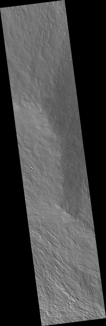
This large fracture occurs on the lava flows of Ceraunius Tholus.

This large dune field is located on the floor of Proctor Crater
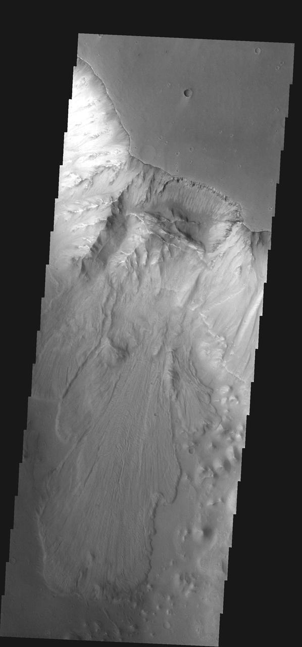
This large landslide is located within Ganges Chasma
This image by NASA Mars Odyssey spacecraft shows Utopia Planitia, a large plain in the northern hemisphere of Mars. It is believed that this basin is the result of a large impact.
AS14-68-9451 (6 Feb. 1971) --- A close-up view of a large boulder in a field of boulders near the rim of Cone Crater, which was photographed by the Apollo 14 moon-explorers during the mission's second extravehicular activity (EVA). Astronauts Alan B. Shepard Jr., commander, and Edgar D. Mitchell, lunar module pilot, descended in the Apollo 14 Lunar Module (LM) to explore the lunar surface while astronaut Stuart A. Roosa, command module pilot, remained with the Command and Service Modules (CSM) in lunar orbit.
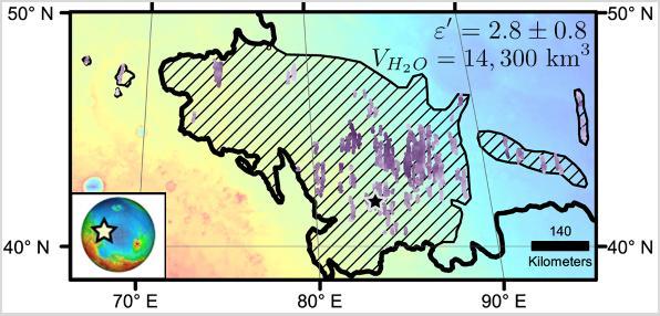
Diagonal striping on this map of a portion of the Utopia Planitia region on Mars indicates the area where a large subsurface deposit rich in water ice was assessed using the Shallow Radar (SHARAD) instrument on NASA's Mars Reconnaissance Orbiter. The area is about halfway between the planet's equator and north pole, and the deposit is estimated to hold about as much water as what is in Lake Superior, largest of the Great Lakes. The scale bar at lower right indicates 140 kilometers (76 miles). The violet vertical bars show depth to the bottom of the ice-rich deposit, as estimated from SHARAD passes overhead. Darkest violet indicates a depth of about 550 feet (about 170 meters). Palest violet indicates a depth of about 33 feet (10 meters). The value of 2.8 plus-or-minus 0.8 in the upper right corner denotes the dielectric constant, a property related to radar reflectivity. The value of 14,300 cubic kilometers is an estimate of the volume of water in the deposit. http://photojournal.jpl.nasa.gov/catalog/PIA21138
A large mobile crane and hi-lift are maneuvered into place for removal of the aperture assembly and cavity doors from NASA's SOFIA observatory aircraft.
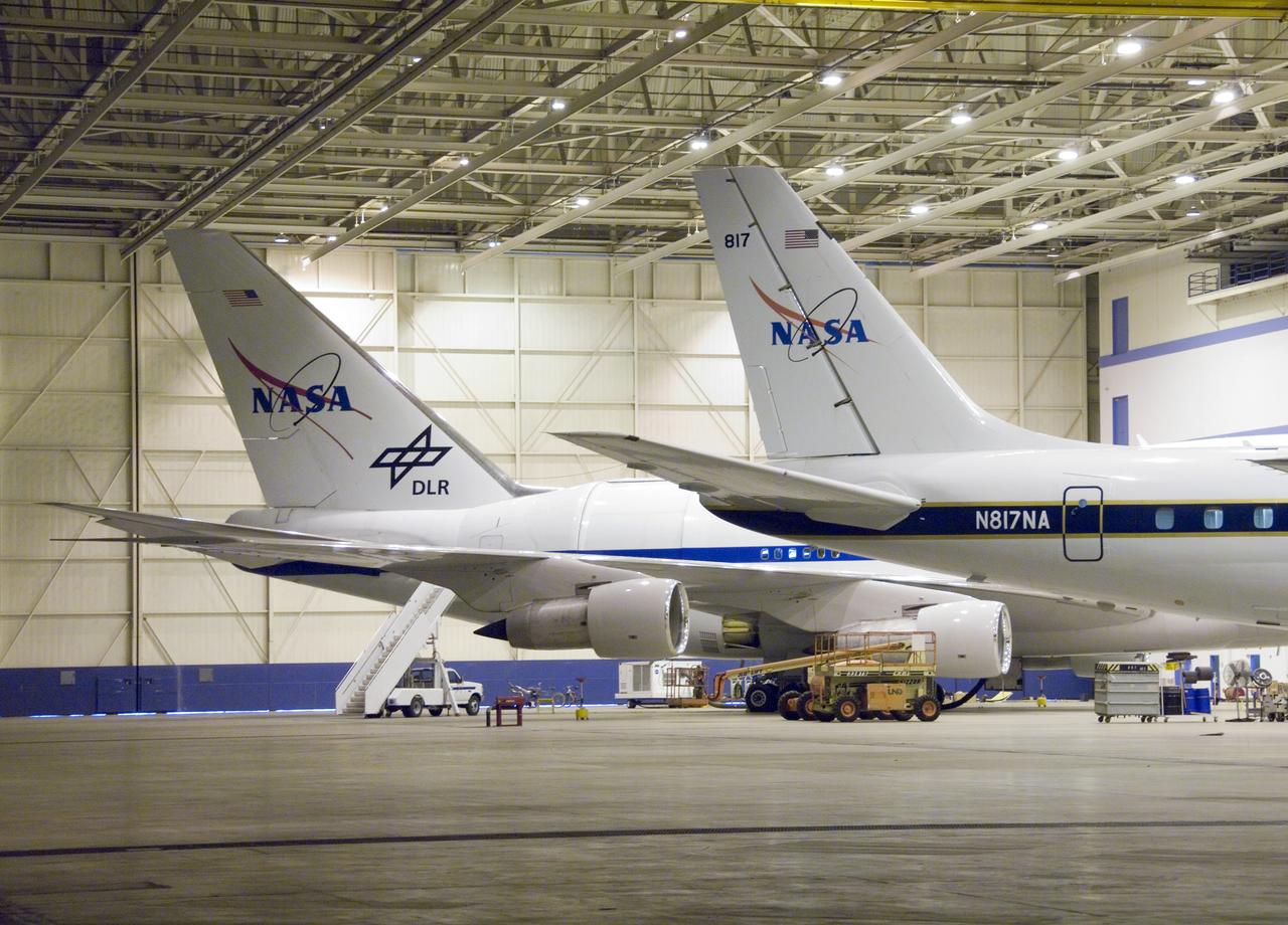
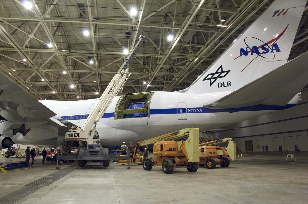
Two large science aircraft, a DC-8 flying laboratory and the SOFIA 747SP, are based at NASA's Dryden Aircraft Operations Facility in Palmdale, Calif.
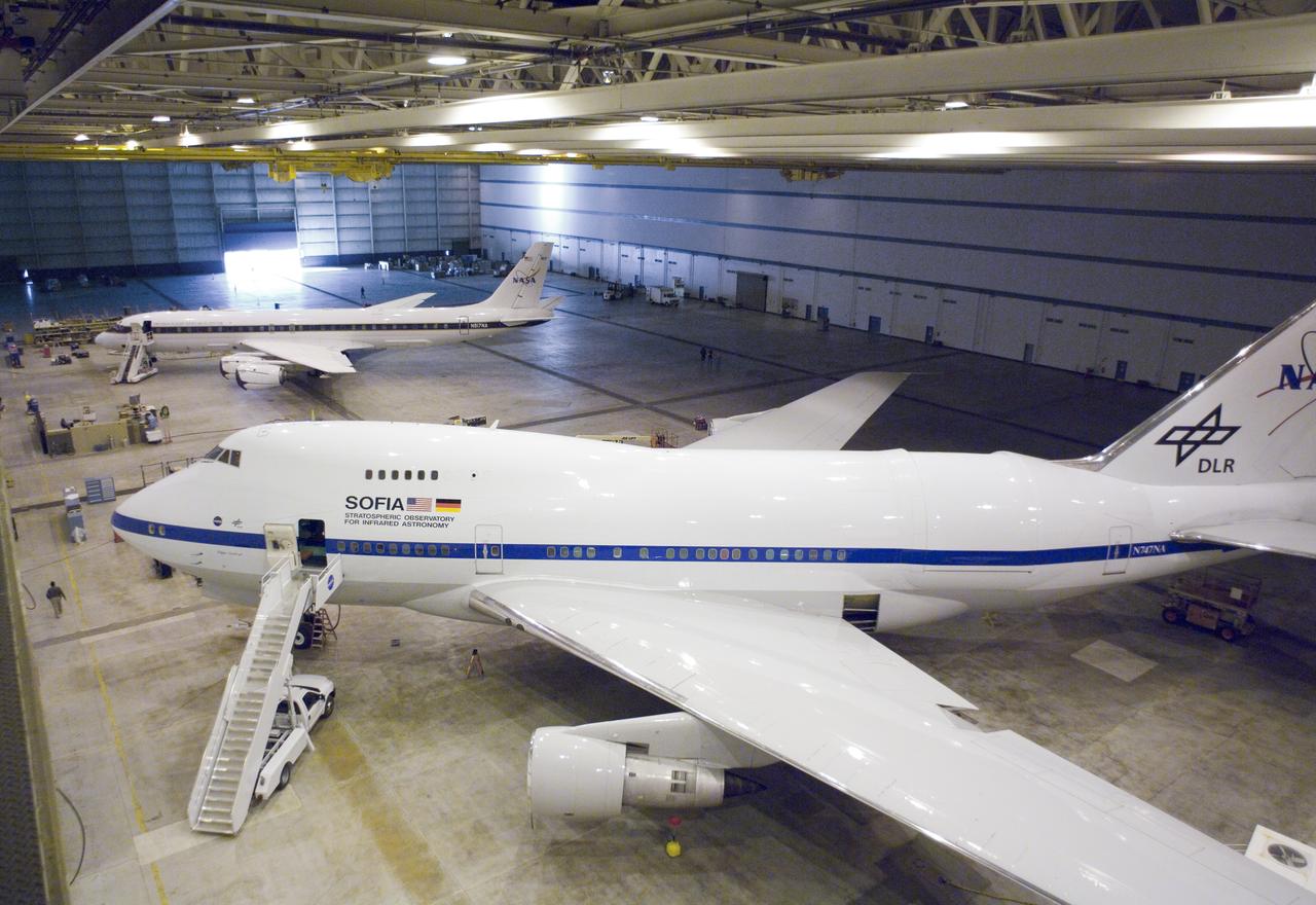
The Dryden Aircraft Operations Facility in Palmdale, Calif., is now home to two large science aircraft, NASA's SOFIA observatory and a DC-8 science laboratory.
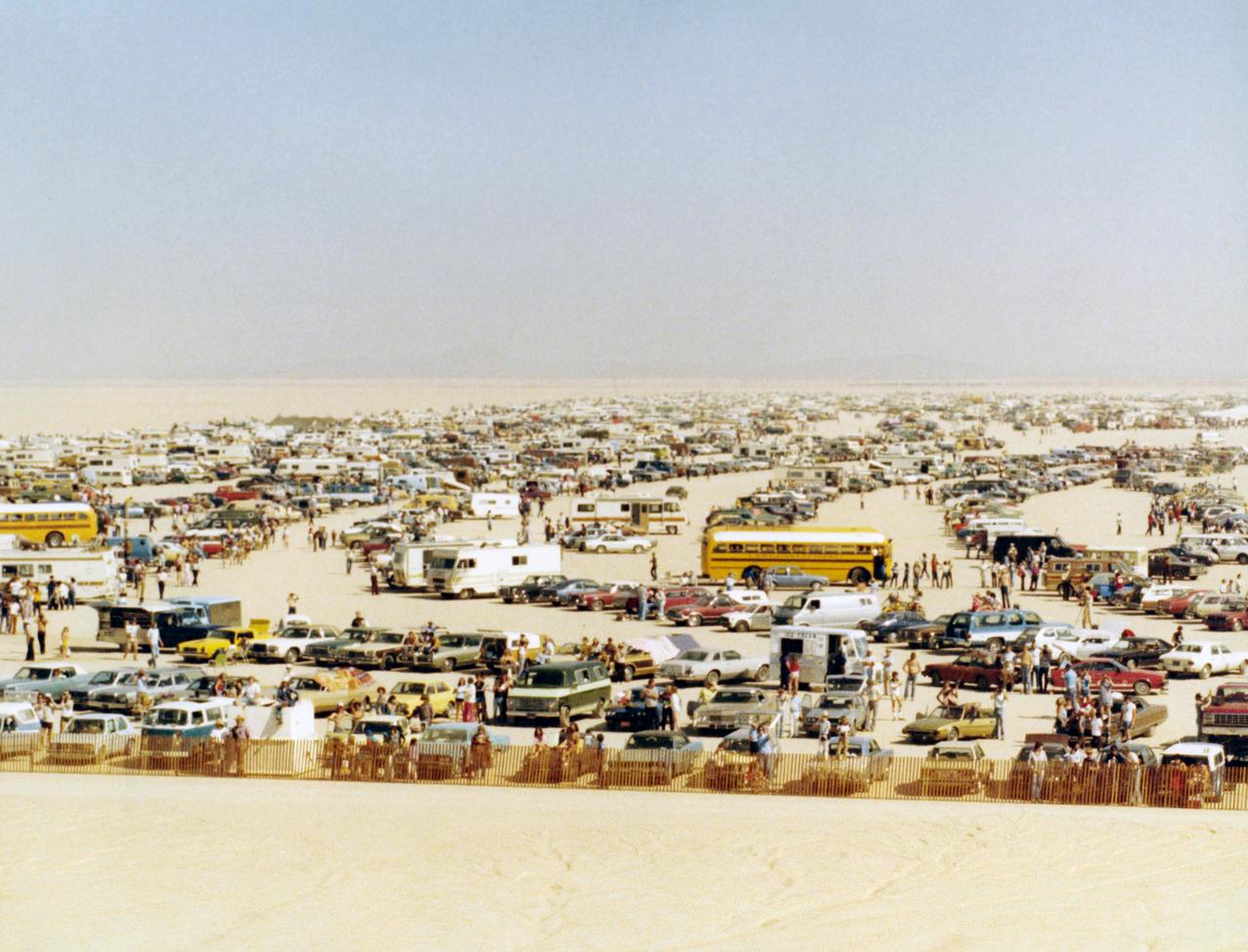
Large crowds gathered on Rogers Dry Lake at Edwards AFB to see the first landing of the Space Shuttle Columbia, completing its first orbital mission.
NASA Cassini spacecraft spies the large Penelope crater on Saturn moon Tethys.
A large impact basin dominates the high southern latitudes of Saturn moon Dione.
This large sand sheet and dune field is located on the floor of Juventae Chasma
These odd shaped pits occur on the floor of a large crater in Terra Sabaea
This large dune field is located in a trough of the north polar ice cap
This extensive dune field in located on the floor of a large unnamed crater in Noachis Terra
This image, from NASA Mariner 10 spacecraft which launched in 1974, features a 140 kilometer diameter crater and its surrounding zone of secondary craters. T
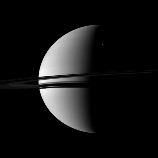
A small crescent of the moon Rhea is dwarfed by the larger crescent of Saturn in this image captured by NASA Cassini spacecraft. Rhea can be seen in the upper right of the image.
This crater, seen NASA Mars Reconnaissance Orbiter, is located in Meridiani Planum, about 20-kilometers northwest of where NASA Opportunity rover landed in 2004 and about 42-kilometers northwest of Endeavour Crater rim.
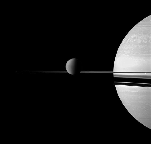
NASA Cassini spacecraft views Saturn with a selection of its moons in varying sizes. Also seen here are Titan center, Enceladus far right, Pandora, barely detectable as a speck on the far left, has been brightened by a factor of two.
This image taken by NASA Mars Reconnaissance Orbiter shows a part of a central mound in an impact crater in Arabia Terra.

Taken in late southern spring and when Mars is near perihelion (closest distance to the Sun), this image shows the effects of dry ice sublimation on a longitudinal dune in the far Southern hemisphere. The bright patches on the dune are still covered in frost, and the dark regions are frost-free. Longitudinal dunes form when the wind switches between two common directions*. Based on the direction of this dune's long crest and the orientation of the smaller ripples, it appears the wind blows from the east and from the northwest. However, it would require taking multiple HiRISE images of this location over time and noticing movement before we could say this definitively. The broad base of this dune may indicate that dune sand has spilled out from areas once covered in ice. During the next Martian Southern hemisphere winter (about half a Mars year or one Earth year from when this image was taken), this dune will again be covered in frost and possibly solid carbon dioxide ice, unable to blow in the wind until the volatiles begin to sublimate in the spring. *These are ripples indicating a wind out of the north/northwest. The scene is 250 m across. http://photojournal.jpl.nasa.gov/catalog/PIA19293
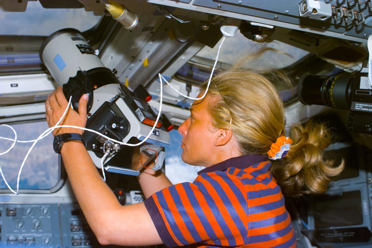
S85-E-5043 (12 August 1997) --- Astronaut N. Jan Davis, payload commander, uses a large format Earth observation camera through the overhead window in the aft flight deck of the Space Shuttle Discovery. The photograph was taken with the Electronic Still Camera (ESC).
This NASA Mars Odyssey image shows a remarkable array of dunes on the floor of a large impact crater named Baldet. Many of the dunes in this region are isolated features with large, sand-free interdune surfaces between the individual dunes.
This observation captured by NASA Mars Reconnaissance Orbiter shows a couple of landforms that may result from the loss of large amounts of ice from subsurface deposits: polygonal patterns of troughs and large scallop-shaped depressions.
New detailed radio data from the NRAO Jansky Very Large Array VLA revealed that the large perpendicular extension of UGC 10288 halo blue is really a distant background galaxy with radio jets.