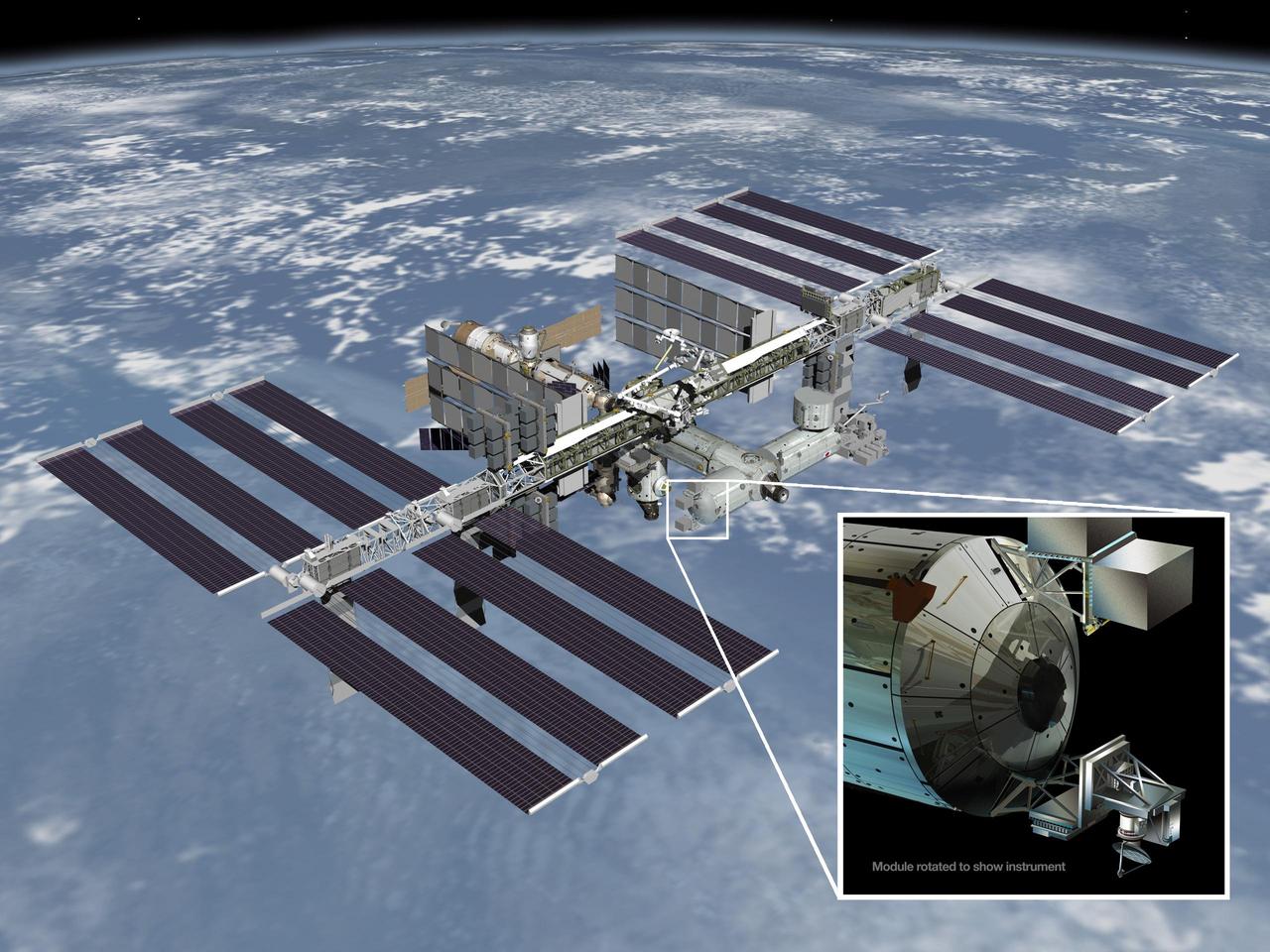
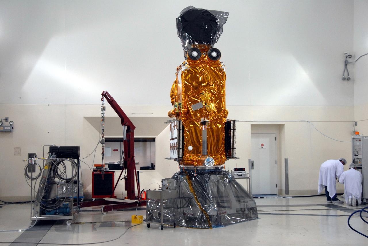
Artist rendering of NASA ISS-RapidScat instrument inset, which will launch to the International Space Station in 2014 to measure ocean surface wind speed and direction and help improve weather forecasts, including hurricane monitoring.
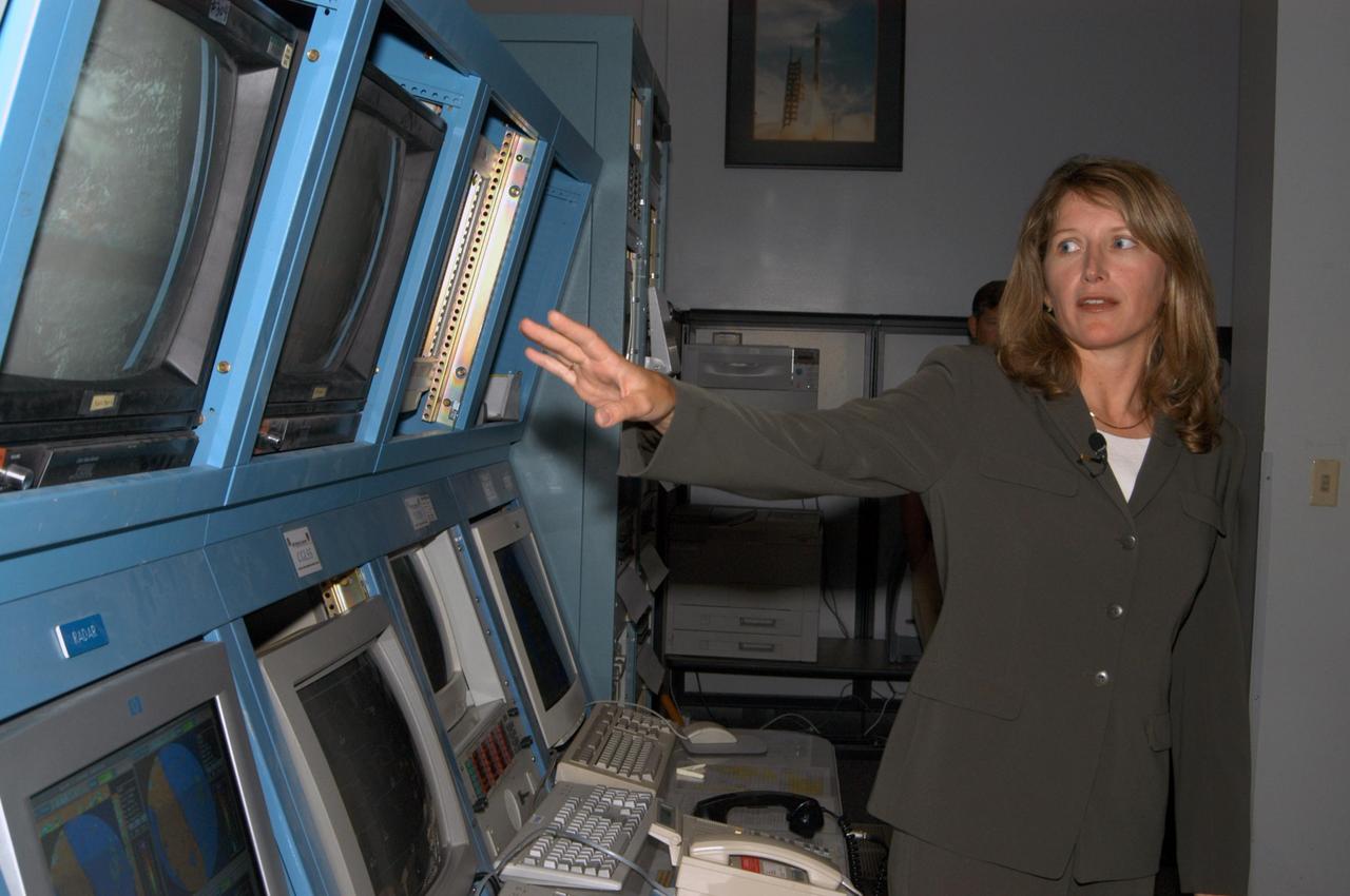
KENNEDY SPACE CENTER, FLA. - At the Cape Canaveral forecast facility in Florida, Shuttle Weather Officer Kathy Winters briefs the media on how the launch weather forecast is developed. Attendees also were able to meet the forecasters for the space shuttle and the expendable launch vehicles. Also participating were members of the Applied Meteorology Unit who provide special expertise to the forecasters by analyzing and interpreting unusual or inconsistent weather data. The media were able to see the release of the Rawinsonde weather balloon carrying instruments aloft to be used as part of developing the forecast. Photo credit: NASA/George Shelton
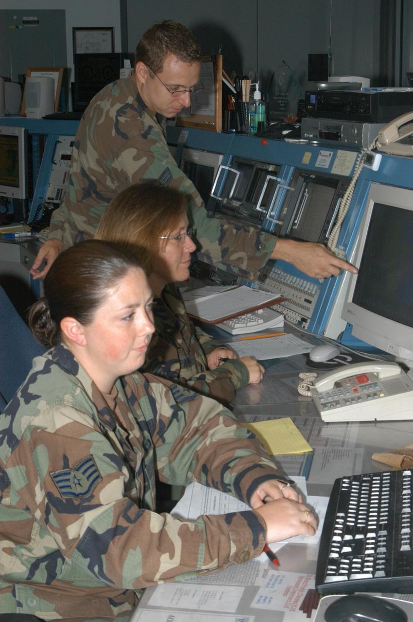
KENNEDY SPACE CENTER, FLA. - At the Cape Canaveral forecast facility in Florida, media were able to meet members of the weather team who review data used for forecasts as part of a tour of the facility. The team will play a role in the July 1 launch of Space Shuttle Discovery on mission STS-121. At the facility, which is operated by the U.S. Air Force 45th Weather Squadron, received a briefing on how the launch weather forecast is developed by Shuttle Weather Officer Kathy Winters and met the forecasters for the space shuttle and the expendable launch vehicles. Also participating were members of the Applied Meteorology Unit who provide special expertise to the forecasters by analyzing and interpreting unusual or inconsistent weather data. The media were able to see the release of the Rawinsonde weather balloon carrying instruments aloft to be used as part of developing the forecast. Photo credit: NASA/George Shelton
KENNEDY SPACE CENTER, FLA. - At the Cape Canaveral weather station in Florida, a member of the weather team prepares a Rawinsonde weather balloon for release. The release was planned as part of a media tour prior to the launch of Space Shuttle Discovery on mission STS-121 July 1. At the facility, which is operated by the U.S. Air Force 45th Weather Squadron, media saw the tools used by the weather team to create the forecast for launch day. They received a briefing on how the launch weather forecast is developed by Shuttle Weather Officer Kathy Winters and met the forecasters for the space shuttle and the expendable launch vehicles. Also participating were members of the Applied Meteorology Unit who provide special expertise to the forecasters by analyzing and interpreting unusual or inconsistent weather data. The media were able to see the release of the Rawinsonde weather balloon carrying instruments aloft to be used as part of developing the forecast. Photo credit: NASA/George Shelton
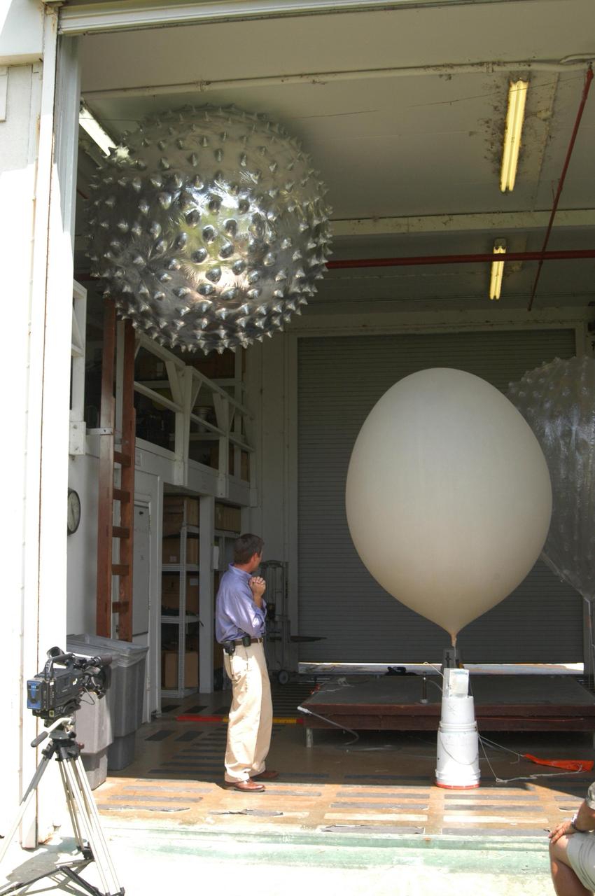
KENNEDY SPACE CENTER, FLA. - At the Cape Canaveral weather station in Florida, a member of the weather team looks over the weather balloons inside. The release of a Rawinsonde weather balloon was planned as part of a media tour prior to the launch of Space Shuttle Discovery on mission STS-121 July 1. At the facility, which is operated by the U.S. Air Force 45th Weather Squadron, media saw the tools used by the weather team to create the forecast for launch day. They received a briefing on how the launch weather forecast is developed by Shuttle Weather Officer Kathy Winters and met the forecasters for the space shuttle and the expendable launch vehicles. Also participating were members of the Applied Meteorology Unit who provide special expertise to the forecasters by analyzing and interpreting unusual or inconsistent weather data. The media were able to see the release of the Rawinsonde weather balloon carrying instruments aloft to be used as part of developing the forecast. Photo credit: NASA/George Shelton
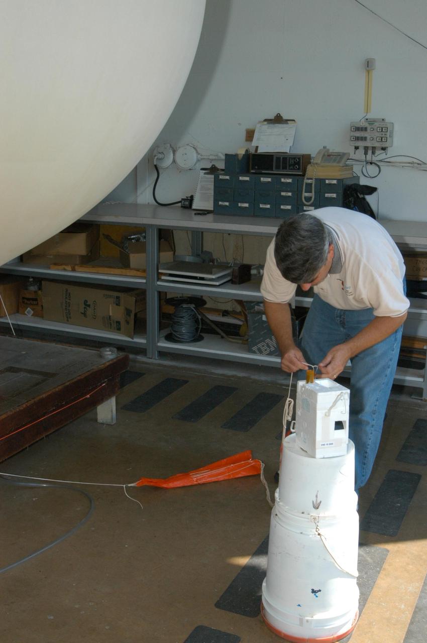
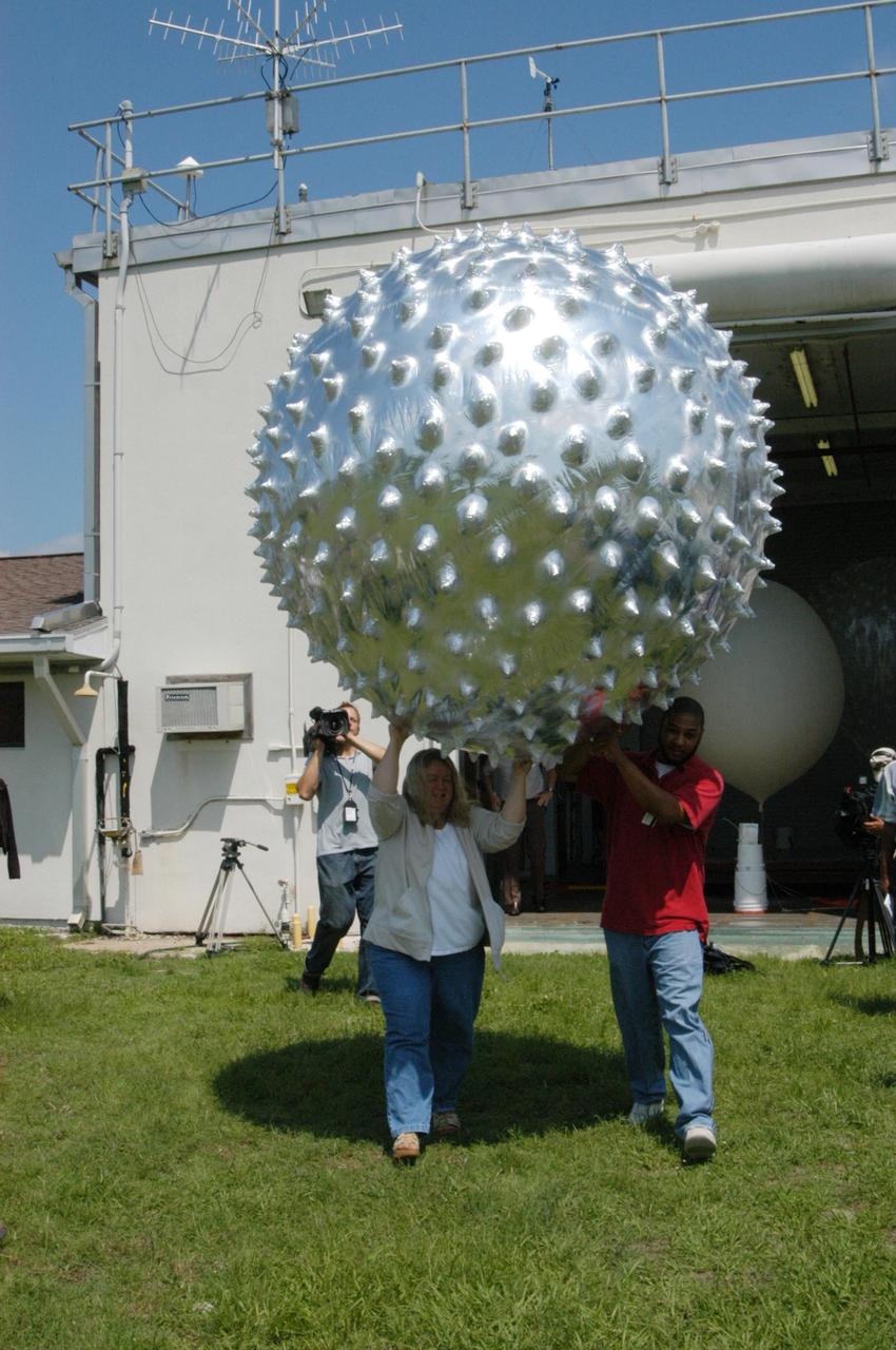
KENNEDY SPACE CENTER, FLA. - At the Cape Canaveral forecast facility in Florida, a worker carries a Rawinsonde weather balloon outside for release. Rawinsonde balloons are GPS-tracked and can collect such data as atmospheric pressure, temperature, humidity and wind speed and direction up to 100,000 feet. The release was planned as part of a media tour prior to the launch of Space Shuttle Discovery on mission STS-121 July 1. At the facility, which is operated by the U.S. Air Force 45th Weather Squadron, media saw the tools used by the weather team to create the forecast for launch day. They received a briefing on how the launch weather forecast is developed by Shuttle Weather Officer Kathy Winters and met the forecasters for the space shuttle and the expendable launch vehicles. Also participating were members of the Applied Meteorology Unit who provide special expertise to the forecasters by analyzing and interpreting unusual or inconsistent weather data. The media were able to see the release of the Rawinsonde weather balloon carrying instruments aloft to be used as part of developing the forecast. Photo credit: NASA/George Shelton
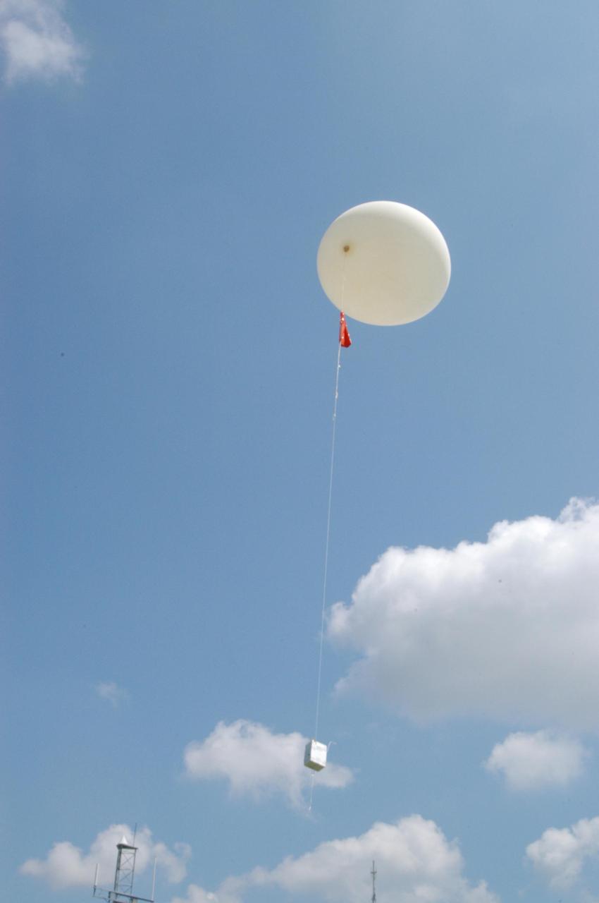
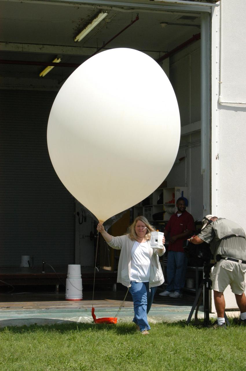
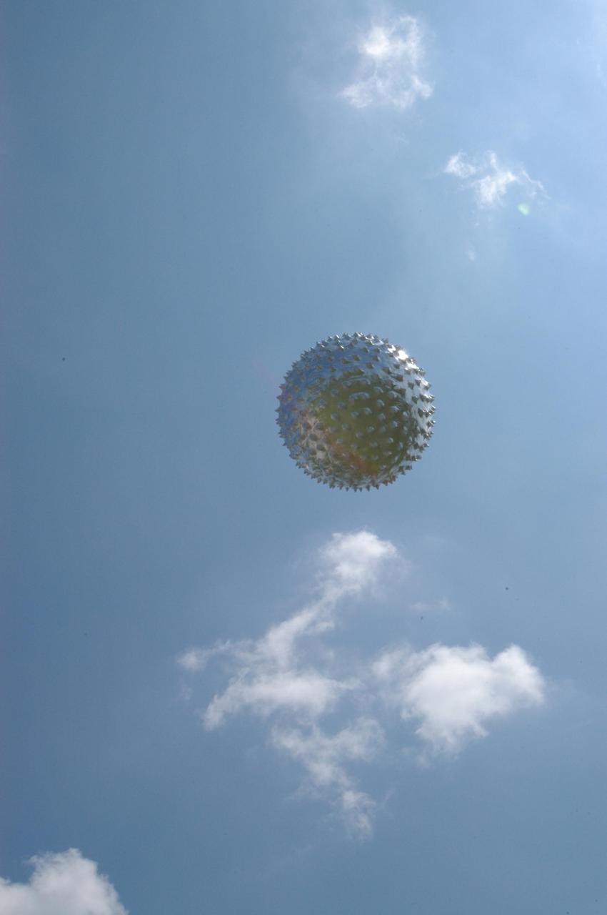
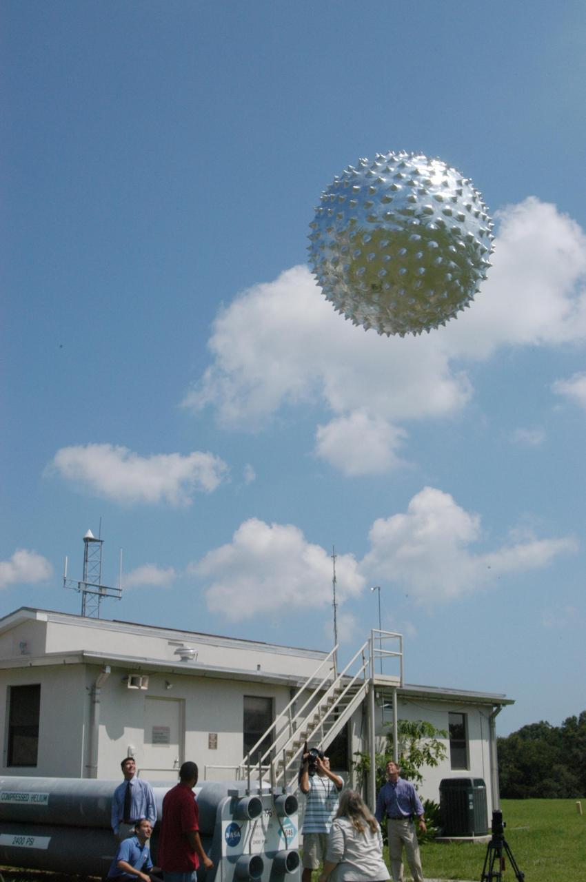
KENNEDY SPACE CENTER, FLA. - A Rawinsonde weather balloon sails into the sky after release from the Cape Canaveral forecast facility in Florida. The release was planned as part of a media tour prior to the launch of Space Shuttle Discovery on mission STS-121 July 1. Rawinsonde balloons are GPS-tracked and can collect such data as atmospheric pressure, temperature, humidity and wind speed and direction up to 100,000 feet. At the facility, which is operated by the U.S. Air Force 45th Weather Squadron, media saw the tools used by the weather team to create the forecast for launch day. They received a briefing on how the launch weather forecast is developed by Shuttle Weather Officer Kathy Winters and met the forecasters for the space shuttle and the expendable launch vehicles. Also participating were members of the Applied Meteorology Unit who provide special expertise to the forecasters by analyzing and interpreting unusual or inconsistent weather data. The media were able to see the release of the Rawinsonde weather balloon carrying instruments aloft to be used as part of developing the forecast. Photo credit: NASA/George Shelton

KENNEDY SPACE CENTER, FLA. - At the Cape Canaveral forecast facility in Florida, a worker releases a Rawinsonde weather balloon outside for release. Rawinsonde balloons are GPS-tracked and can collect such data as atmospheric pressure, temperature, humidity and wind speed and direction up to 100,000 feet. The release was planned as part of a media tour prior to the launch of Space Shuttle Discovery on mission STS-121 July 1. At the facility, which is operated by the U.S. Air Force 45th Weather Squadron, media saw the tools used by the weather team to create the forecast for launch day. They received a briefing on how the launch weather forecast is developed by Shuttle Weather Officer Kathy Winters and met the forecasters for the space shuttle and the expendable launch vehicles. Also participating were members of the Applied Meteorology Unit who provide special expertise to the forecasters by analyzing and interpreting unusual or inconsistent weather data. The media were able to see the release of the Rawinsonde weather balloon carrying instruments aloft to be used as part of developing the forecast. Photo credit: NASA/George Shelton
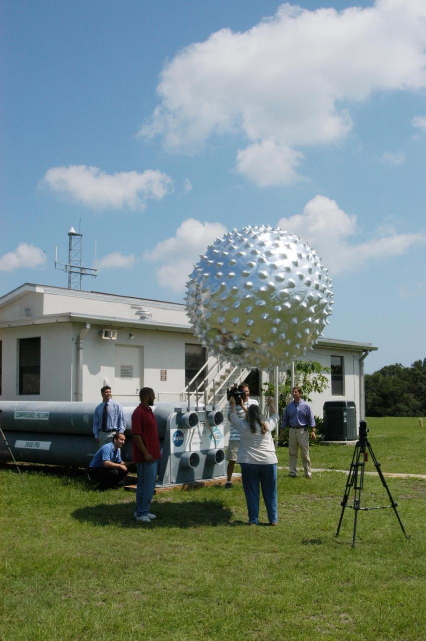
KENNEDY SPACE CENTER, FLA. - At the Cape Canaveral weather station in Florida, workers release an upper-level weather balloon while several newscasters watch. The release of the balloon was part of a media tour prior to the launch of Space Shuttle Discovery on mission STS-121 July 1. The radar-tracked balloon detects wind shears that can affect a shuttle launch. At the facility, which is operated by the U.S. Air Force 45th Weather Squadron, media saw the tools used by the weather team to create the forecast for launch day. They received a briefing on how the launch weather forecast is developed by Shuttle Weather Officer Kathy Winters and met the forecasters for the space shuttle and the expendable launch vehicles. Also participating were members of the Applied Meteorology Unit who provide special expertise to the forecasters by analyzing and interpreting unusual or inconsistent weather data. The media were able to see the release of the Rawinsonde weather balloon carrying instruments aloft to be used as part of developing the forecast. Photo credit: NASA/George Shelton
KENNEDY SPACE CENTER, FLA. - At the Cape Canaveral weather station in Florida, workers carry an upper-level weather balloon outside for release. The release was part of a media tour prior to the launch of Space Shuttle Discovery on mission STS-121 July 1. The radar-tracked balloon detects wind shears that can affect a shuttle launch. At the facility, which is operated by the U.S. Air Force 45th Weather Squadron, media saw the tools used by the weather team to create the forecast for launch day. They received a briefing on how the launch weather forecast is developed by Shuttle Weather Officer Kathy Winters and met the forecasters for the space shuttle and the expendable launch vehicles. Also participating were members of the Applied Meteorology Unit who provide special expertise to the forecasters by analyzing and interpreting unusual or inconsistent weather data. The media were able to see the release of the Rawinsonde weather balloon carrying instruments aloft to be used as part of developing the forecast. Photo credit: NASA/George Shelton
KENNEDY SPACE CENTER, FLA. - An upper-level weather balloon sails into the sky after release from the Cape Canaveral weather station in Florida. The release was planned as part of a media tour prior to the launch of Space Shuttle Discovery on mission STS-121 July 1. The radar-tracked balloon detects wind shears that can affect a shuttle launch. At the facility, which is operated by the U.S. Air Force 45th Weather Squadron, media saw the tools used by the weather team to create the forecast for launch day. They received a briefing on how the launch weather forecast is developed by Shuttle Weather Officer Kathy Winters and met the forecasters for the space shuttle and the expendable launch vehicles. Also participating were members of the Applied Meteorology Unit who provide special expertise to the forecasters by analyzing and interpreting unusual or inconsistent weather data. The media were able to see the release of the Rawinsonde weather balloon carrying instruments aloft to be used as part of developing the forecast. Photo credit: NASA/George Shelton
KENNEDY SPACE CENTER, FLA. - Under the watchful eyes of the media, an upper-level weather balloon begins its lift into the sky. The release of the balloon at the Cape Canaveral weather station in Florida was part of a media tour prior to the launch of Space Shuttle Discovery on mission STS-121 July 1. The radar-tracked balloon detects wind shears that can affect a shuttle launch. At the facility, which is operated by the U.S. Air Force 45th Weather Squadron, media saw the tools used by the weather team to create the forecast for launch day. They received a briefing on how the launch weather forecast is developed by Shuttle Weather Officer Kathy Winters and met the forecasters for the space shuttle and the expendable launch vehicles. Also participating were members of the Applied Meteorology Unit who provide special expertise to the forecasters by analyzing and interpreting unusual or inconsistent weather data. The media were able to see the release of the Rawinsonde weather balloon carrying instruments aloft to be used as part of developing the forecast. Photo credit: NASA/George Shelton
A United Launch Alliance Atlas V rocket lifts off from Space Launch Complex 41 at Cape Canaveral Air Force Station carrying the NOAA Geostationary Operational Environmental Satellite, or GOES-S. Liftoff was at 5:02 p.m. EST. GOES-S is the second satellite in a series of next-generation weather satellites. It will launch to a geostationary position over the U.S. to provide images of storms and help predict weather forecasts, severe weather outlooks, watches, warnings, lightning conditions and longer-term forecasting.

A United Launch Alliance Atlas V rocket lifts off from Space Launch Complex 41 at Cape Canaveral Air Force Station carrying the NOAA Geostationary Operational Environmental Satellite, or GOES-S. Liftoff was at 5:02 p.m. EST. GOES-S is the second satellite in a series of next-generation weather satellites. It will launch to a geostationary position over the U.S. to provide images of storms and help predict weather forecasts, severe weather outlooks, watches, warnings, lightning conditions and longer-term forecasting.
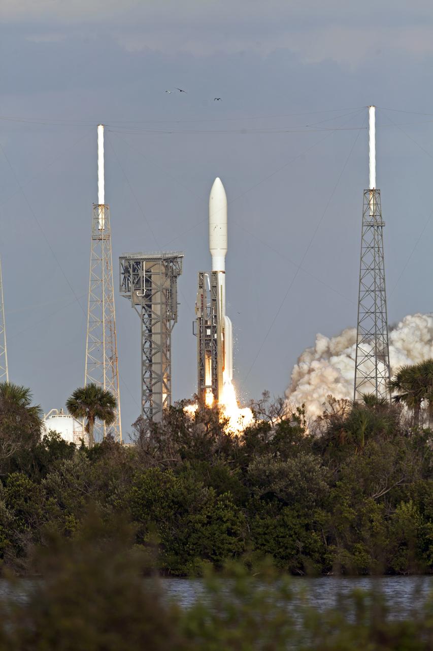
A United Launch Alliance Atlas V rocket lifts off from Space Launch Complex 41 at Cape Canaveral Air Force Station carrying the NOAA Geostationary Operational Environmental Satellite, or GOES-S. Liftoff was at 5:02 p.m. EST. GOES-S is the second satellite in a series of next-generation weather satellites. It will launch to a geostationary position over the U.S. to provide images of storms and help predict weather forecasts, severe weather outlooks, watches, warnings, lightning conditions and longer-term forecasting.
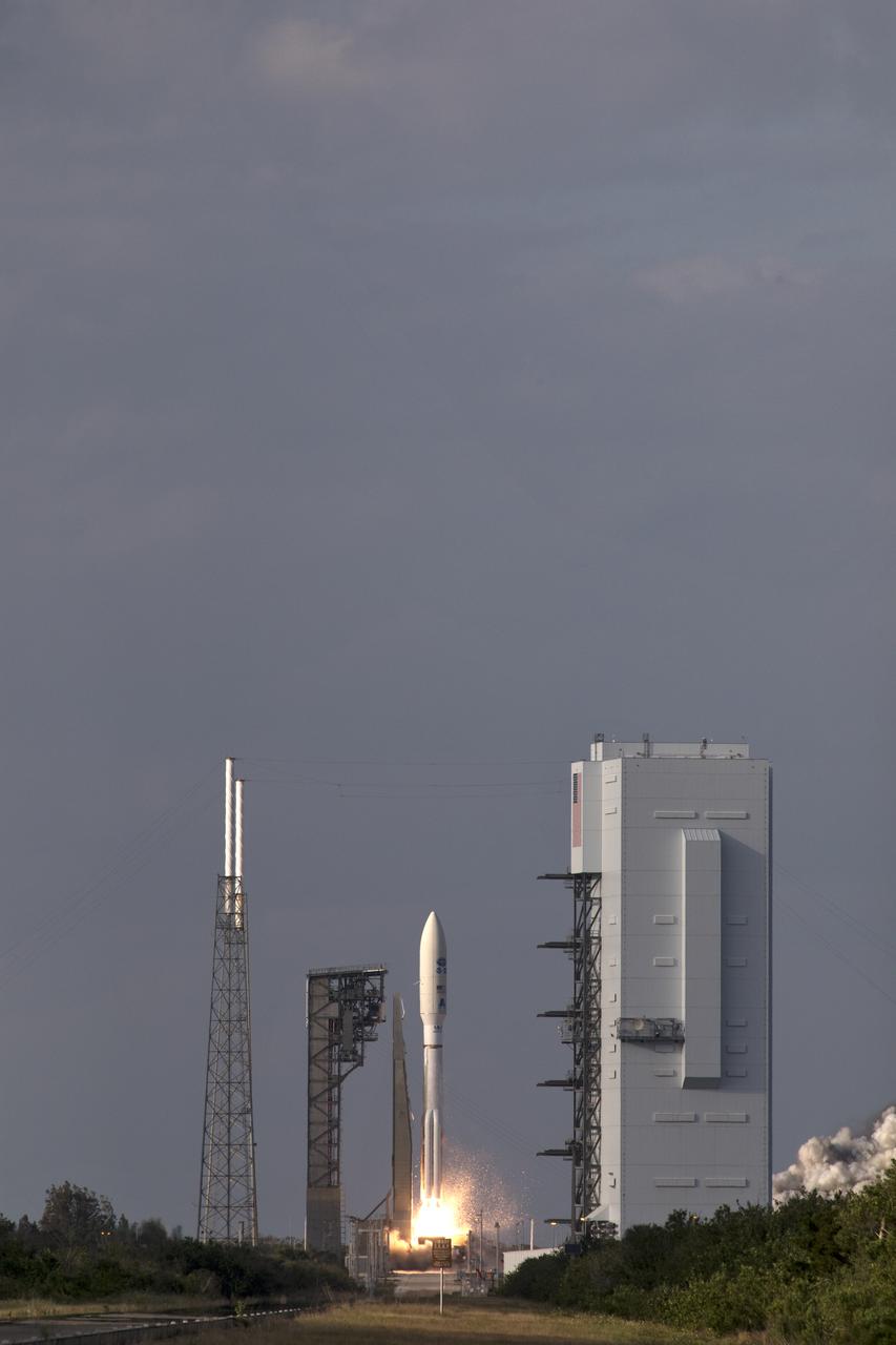
A United Launch Alliance Atlas V rocket lifts off from Space Launch Complex 41 at Cape Canaveral Air Force Station carrying the NOAA Geostationary Operational Environmental Satellite, or GOES-S. Liftoff was at 5:02 p.m. EST. GOES-S is the second satellite in a series of next-generation weather satellites. It will launch to a geostationary position over the U.S. to provide images of storms and help predict weather forecasts, severe weather outlooks, watches, warnings, lightning conditions and longer-term forecasting.
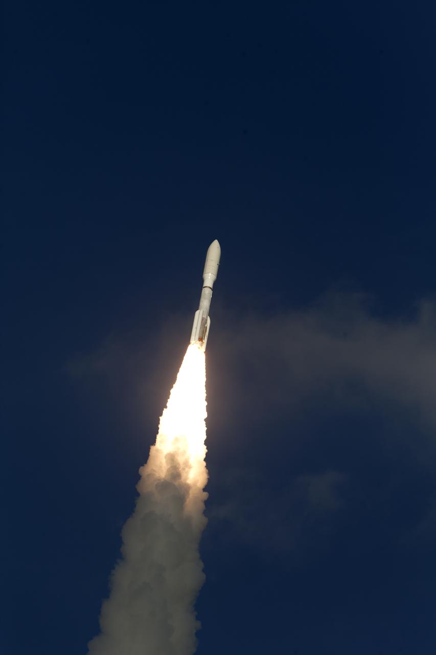
A United Launch Alliance Atlas V rocket lifts off from Space Launch Complex 41 at Cape Canaveral Air Force Station carrying the NOAA Geostationary Operational Environmental Satellite, or GOES-S. Liftoff was at 5:02 p.m. EST. GOES-S is the second satellite in a series of next-generation weather satellites. It will launch to a geostationary position over the U.S. to provide images of storms and help predict weather forecasts, severe weather outlooks, watches, warnings, lightning conditions and longer-term forecasting.
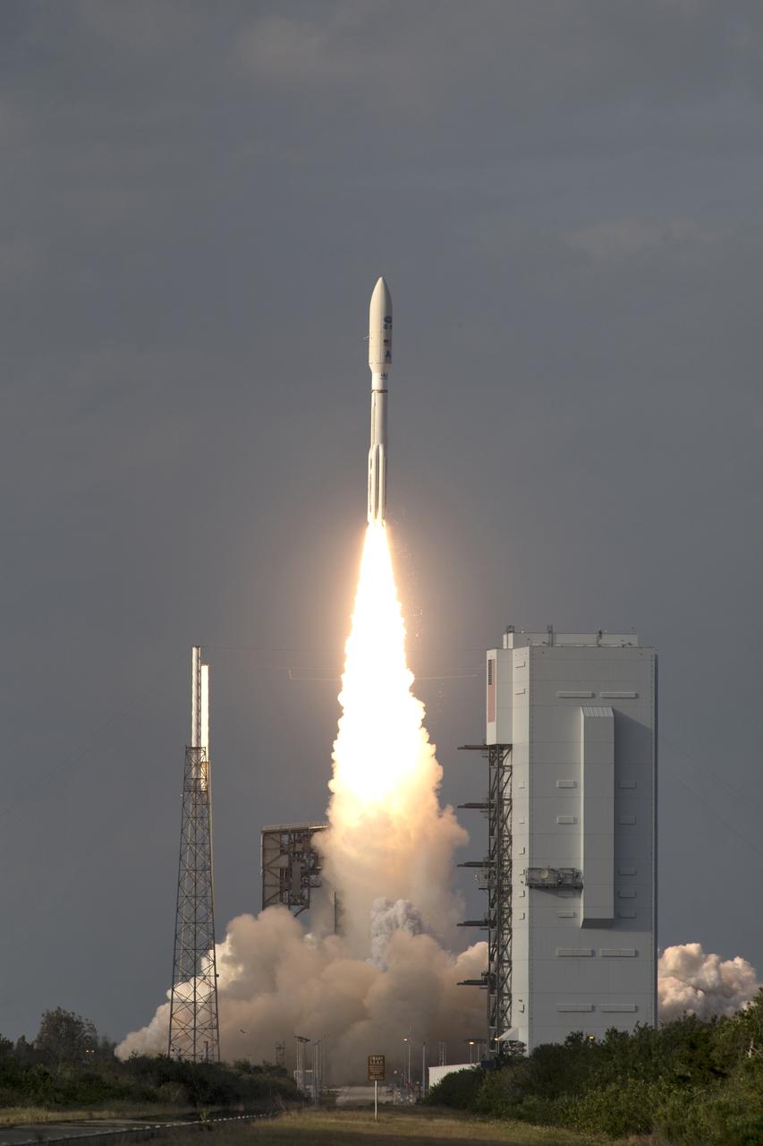
A United Launch Alliance Atlas V rocket lifts off from Space Launch Complex 41 at Cape Canaveral Air Force Station carrying the NOAA Geostationary Operational Environmental Satellite, or GOES-S. Liftoff was at 5:02 p.m. EST. GOES-S is the second satellite in a series of next-generation weather satellites. It will launch to a geostationary position over the U.S. to provide images of storms and help predict weather forecasts, severe weather outlooks, watches, warnings, lightning conditions and longer-term forecasting.

During the countdown for the launch of NOAA's Geostationary Operational Environmental Satellite, or GOES-R, Stephanie Martin of NASA Communications, right, interviews Al Roker, weather forecaster on NBC's "Today Show." GOES-R is the first satellite in a series of next-generation GOES satellites for NOAA, the National Oceanographic and Atmospheric Administration. It will launch to a geostationary orbit over the western hemisphere to provide images of storms and help meteorologists predict severe weather conditionals and develop long-range forecasts.

During the countdown for the launch of NOAA's Geostationary Operational Environmental Satellite, or GOES-R, Stephanie Martin of NASA Communications, left, interviews Al Roker, weather forecaster on NBC's "Today Show." GOES-R is the first satellite in a series of next-generation GOES satellites for NOAA, the National Oceanographic and Atmospheric Administration. It will launch to a geostationary orbit over the western hemisphere to provide images of storms and help meteorologists predict severe weather conditionals and develop long-range forecasts.
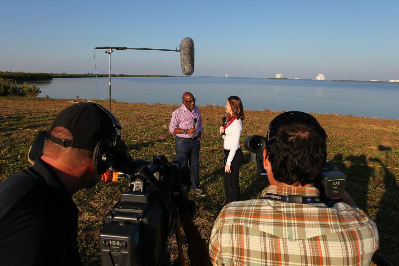
During the countdown for the launch of NOAA's Geostationary Operational Environmental Satellite, or GOES-R, Stephanie Martin of NASA Communications, right, interviews Al Roker, weather forecaster on NBC's "Today Show." GOES-R is the first satellite in a series of next-generation GOES satellites for NOAA, the National Oceanographic and Atmospheric Administration. It will launch to a geostationary orbit over the western hemisphere to provide images of storms and help meteorologists predict severe weather conditionals and develop long-range forecasts.
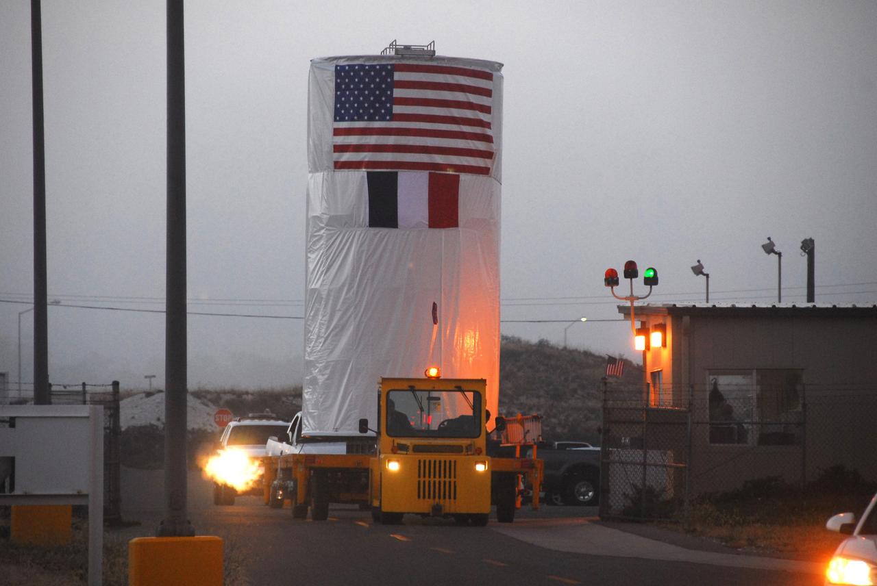
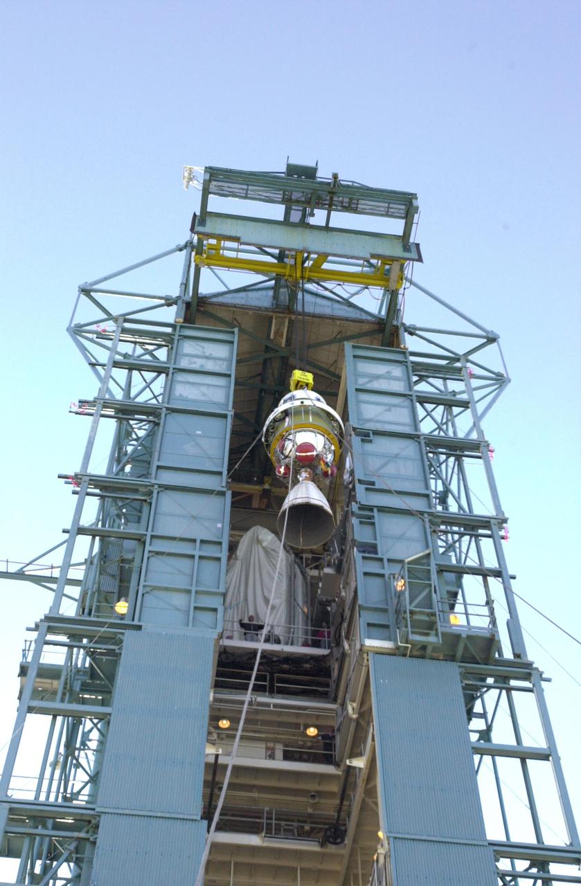
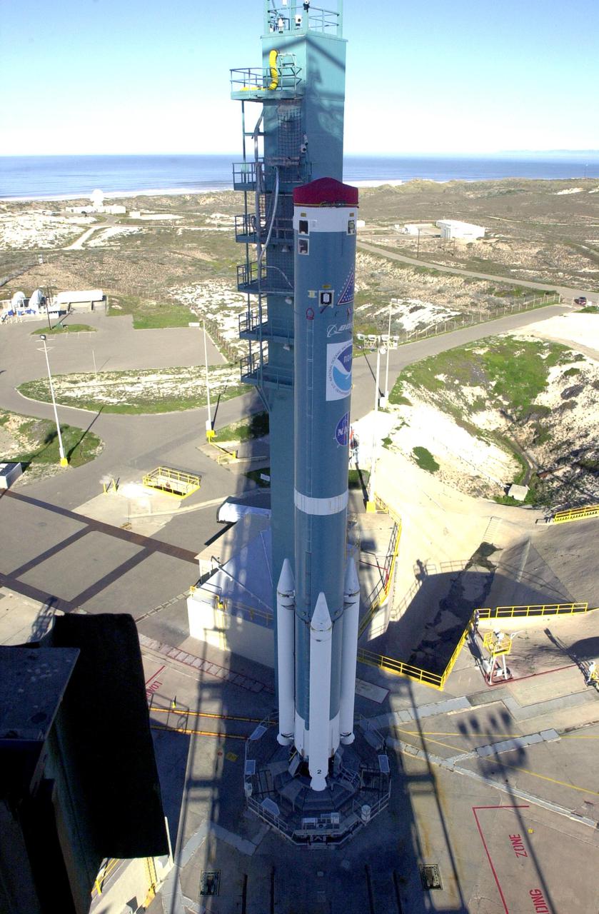
VANDENBERG AIR FORCE BASE, Calif. – Inside its shipping container, the Ocean Surface Topography Mission, or OSTM/Jason 2, spacecraft is moved to Space Launch Complex 2 for mating with its Delta II launch vehicle. The launch is scheduled for June 20 from Vandenberg Air Force Base. The launch window extends from 12:46 a.m. to 12:55 a.m. PDT. The satellite will be placed in an 830-mile-high orbit at an inclination of 66 degrees after separating from the Delta II 55 minutes after liftoff. The five primary science instruments of the Ocean Surface Topography Mission aboard the Jason 2 spacecraft are dedicated to measuring the height of the ocean surface. These measurements will be used to evaluate and forecast climate changes and improve weather forecasting. The results also are expected to help forecasters better predict hurricane intensity.

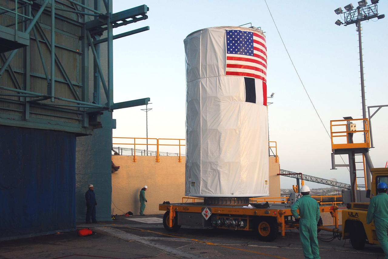
VANDENBERG AIR FORCE BASE, Calif. – On Space Launch Complex 2, the Ocean Surface Topography Mission, or OSTM/Jason 2, spacecraft is moved into the mobile service tower for mating with its Delta II launch vehicle. The launch is scheduled for June 20 from Vandenberg Air Force Base. The launch window extends from 12:46 a.m. to 12:55 a.m. PDT. The satellite will be placed in an 830-mile-high orbit at an inclination of 66 degrees after separating from the Delta II 55 minutes after liftoff. The five primary science instruments of the Ocean Surface Topography Mission aboard the Jason 2 spacecraft are dedicated to measuring the height of the ocean surface. These measurements will be used to evaluate and forecast climate changes and improve weather forecasting. The results also are expected to help forecasters better predict hurricane intensity.
VANDENBERG AIR FORCE BASE, Calif. – Inside its shipping container, the Ocean Surface Topography Mission, or OSTM/Jason 2, spacecraft is moved to Space Launch Complex 2 for mating with its Delta II launch vehicle. The launch is scheduled for June 20 from Vandenberg Air Force Base. The launch window extends from 12:46 a.m. to 12:55 a.m. PDT. The satellite will be placed in an 830-mile-high orbit at an inclination of 66 degrees after separating from the Delta II 55 minutes after liftoff. The five primary science instruments of the Ocean Surface Topography Mission aboard the Jason 2 spacecraft are dedicated to measuring the height of the ocean surface. These measurements will be used to evaluate and forecast climate changes and improve weather forecasting. The results also are expected to help forecasters better predict hurricane intensity.
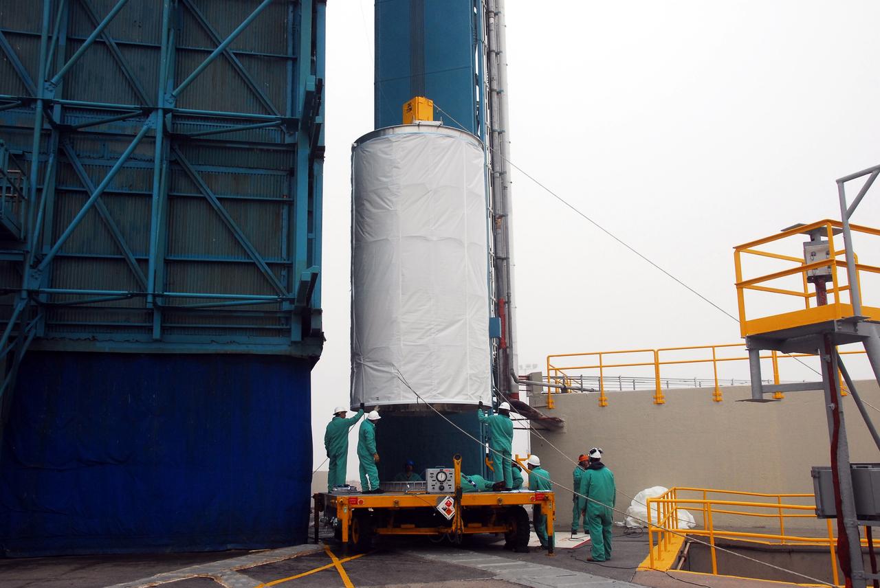
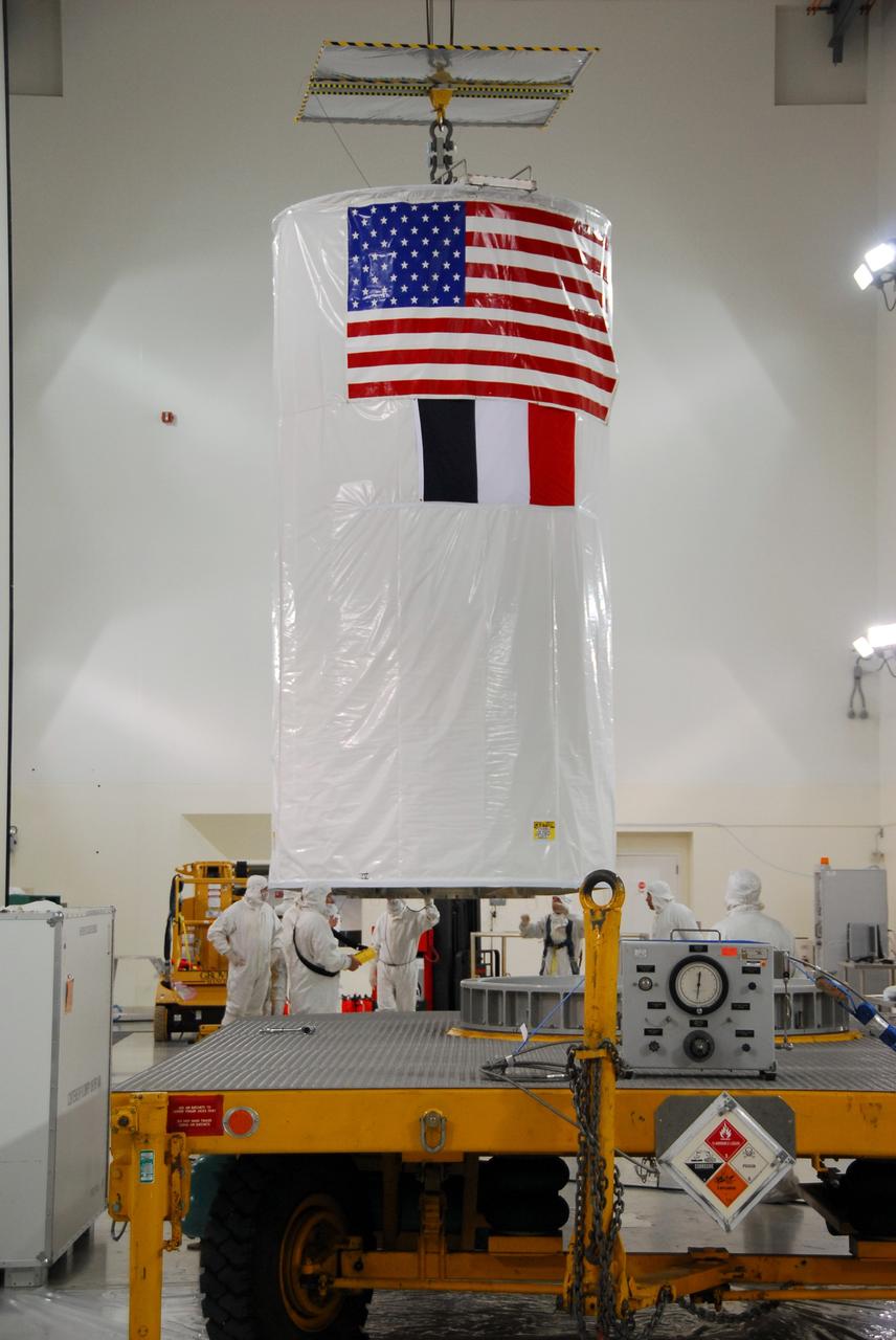
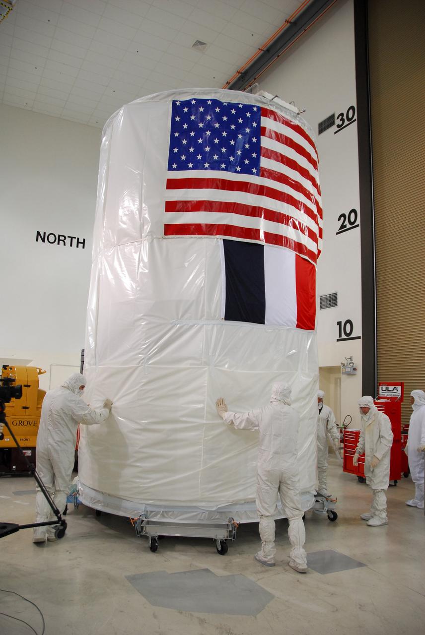
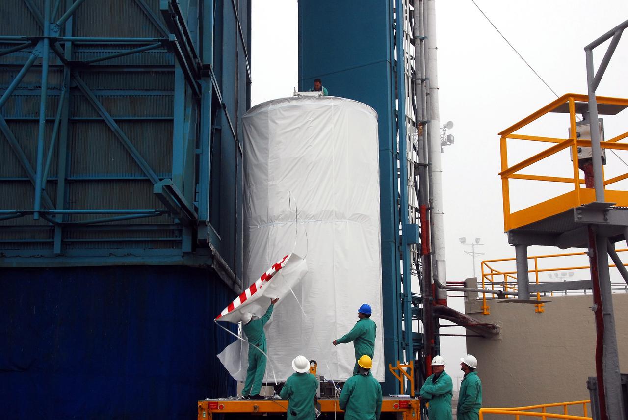
VANDENBERG AIR FORCE BASE, Calif. – The Ocean Surface Topography Mission, or OSTM/Jason 2, spacecraft is being wrapped, or bagged, before fueling, encapsulation and transfer to the launch pad. The launch of the OSTM/Jason 2 aboard a Delta II rocket is scheduled for Friday, June 20, from Vandenberg Air Force Base in California. The launch window extends from 12:46 a.m. to 12:55 a.m. PDT. The satellite will be placed in an 830-mile-high orbit at an inclination of 66 degrees after separating from the Delta II 55 minutes after liftoff. The five primary science instruments of the Ocean Surface Topography Mission aboard the Jason 2 spacecraft are dedicated to measuring ocean surface height. These measurements will be used to evaluate and forecast climate changes and improve weather forecasting. The results also are expected to help forecasters better predict hurricane intensity. Photo credit: NASA

VANDENBERG AIR FORCE BASE, Calif. – The Ocean Surface Topography Mission, or OSTM/Jason 2, spacecraft is being weighed before fueling, encapsulation and transfer to the launch pad. The launch of the OSTM/Jason 2 aboard a Delta II rocket is scheduled for Friday, June 20, from Vandenberg Air Force Base in California. The launch window extends from 12:46 a.m. to 12:55 a.m. PDT. The satellite will be placed in an 830-mile-high orbit at an inclination of 66 degrees after separating from the Delta II 55 minutes after liftoff. The five primary science instruments of the Ocean Surface Topography Mission aboard the Jason 2 spacecraft are dedicated to measuring ocean surface height. These measurements will be used to evaluate and forecast climate changes and improve weather forecasting. The results also are expected to help forecasters better predict hurricane intensity. Photo credit: NASA
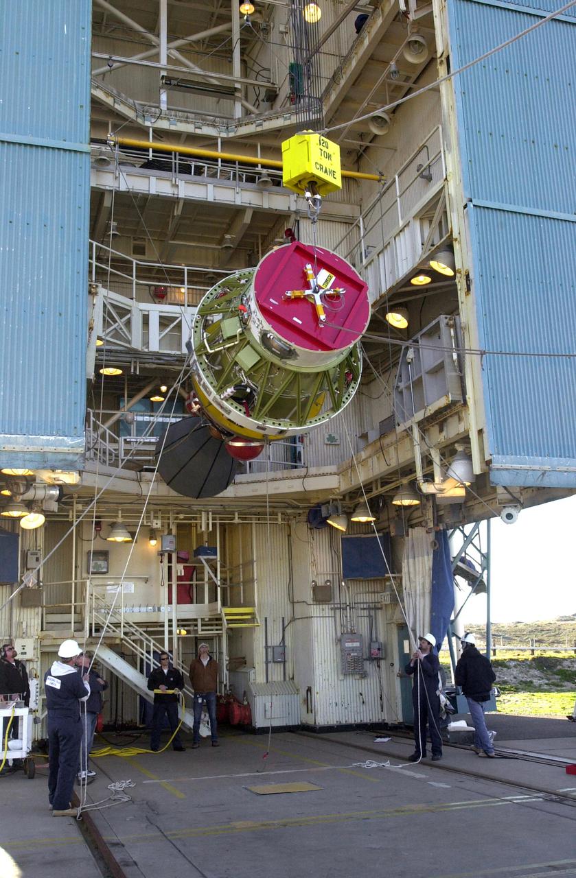
VANDENBERG AIR FORCE BASE, Calif. – On Space Launch Complex 2, workers get ready to lift the Ocean Surface Topography Mission, or OSTM/Jason 2, spacecraft into the mobile service tower. In the tower it will mated with its Delta II launch vehicle. The launch window extends from 12:46 a.m. to 12:55 a.m. PDT. The satellite will be placed in an 830-mile-high orbit at an inclination of 66 degrees after separating from the Delta II 55 minutes after liftoff. The five primary science instruments of the Ocean Surface Topography Mission aboard the Jason 2 spacecraft are dedicated to measuring the height of the ocean surface. These measurements will be used to evaluate and forecast climate changes and improve weather forecasting. The results also are expected to help forecasters better predict hurricane intensity.
VANDENBERG AIR FORCE BASE, Calif. – An overhead crane is used to move the covered Ocean Surface Topography Mission, or OSTM/Jason 2, spacecraft onto a transporter for the trip to the launch pad. The launch of the OSTM/Jason 2 aboard a Delta II rocket is scheduled for Friday, June 20, from Vandenberg Air Force Base in California. The launch window extends from 12:46 a.m. to 12:55 a.m. PDT. The satellite will be placed in an 830-mile-high orbit at an inclination of 66 degrees after separating from the Delta II 55 minutes after liftoff. The five primary science instruments of the Ocean Surface Topography Mission aboard the Jason 2 spacecraft are dedicated to measuring ocean surface height. These measurements will be used to evaluate and forecast climate changes and improve weather forecasting. The results also are expected to help forecasters better predict hurricane intensity. Photo credit: NASA/Dan Liberotti
VANDENBERG AIR FORCE BASE, Calif. – The shipping canister is ready to be placed over the Ocean Surface Topography Mission, or OSTM/Jason 2, spacecraft for transport to the launch pad. The launch of the OSTM/Jason 2 aboard a Delta II rocket is scheduled for Friday, June 20, from Vandenberg Air Force Base in California. The launch window extends from 12:46 a.m. to 12:55 a.m. PDT. The satellite will be placed in an 830-mile-high orbit at an inclination of 66 degrees after separating from the Delta II 55 minutes after liftoff. The five primary science instruments of the Ocean Surface Topography Mission aboard the Jason 2 spacecraft are dedicated to measuring ocean surface height. These measurements will be used to evaluate and forecast climate changes and improve weather forecasting. The results also are expected to help forecasters better predict hurricane intensity. Photo credit: NASA/Dan Liberotti
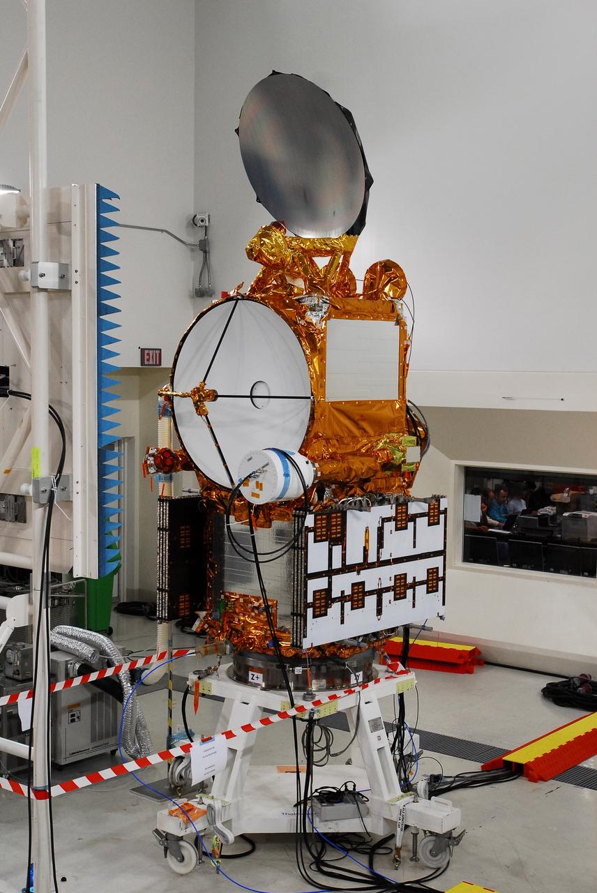
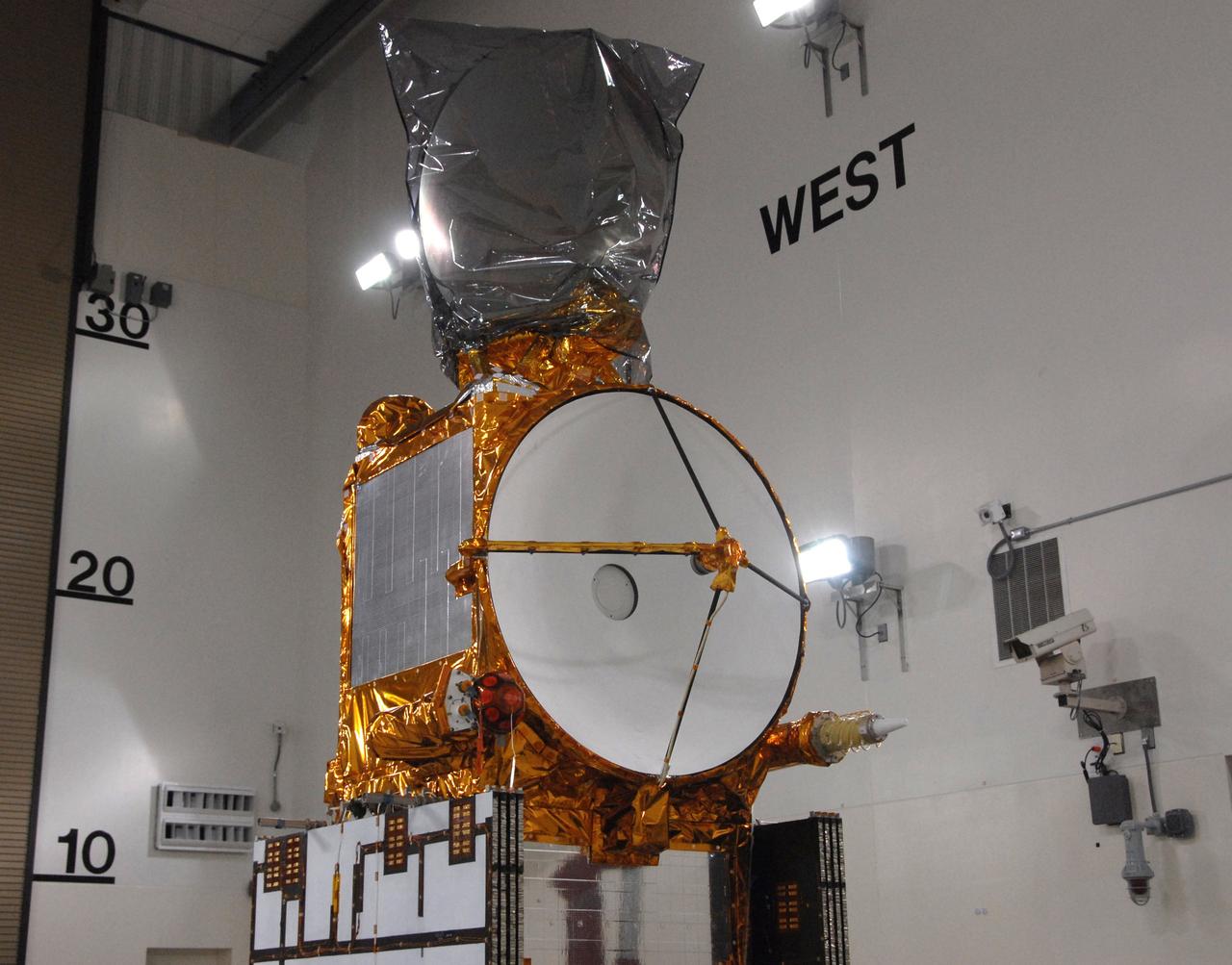
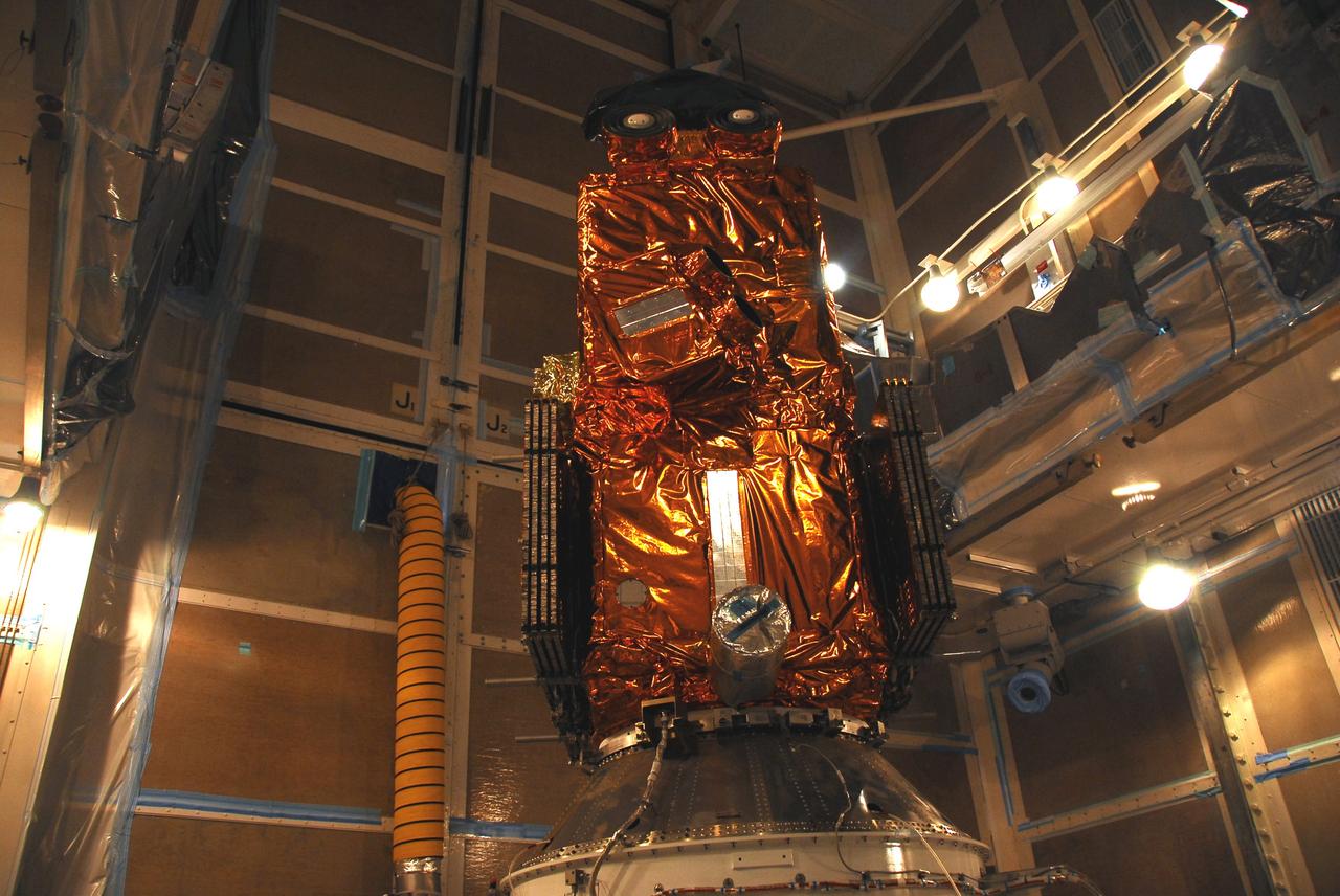
VANDENBERG AIR FORCE BASE, Calif. – The Ocean Surface Topography Mission, or OSTM/Jason-2, spacecraft is getting final checkouts after mating to the Delta II rocket on the Space Launch Complex 2 at Vandenberg Air Force Base in California. The launch of the OSTM/Jason 2 aboard the Delta II rocket is scheduled for June 20. The launch window extends from 12:46 a.m. to 12:55 a.m. PDT. The satellite will be placed in an 830-mile-high orbit at an inclination of 66 degrees after separating from the Delta II 55 minutes after liftoff. The five primary science instruments of the Ocean Surface Topography Mission aboard the Jason 2 spacecraft are dedicated to measuring ocean surface height. These measurements will be used to evaluate and forecast climate changes and improve weather forecasting. The results also are expected to help forecasters better predict hurricane intensity.
VANDENBERG AIR FORCE BASE, Calif. – On Space Launch Complex 2, the Ocean Surface Topography Mission, or OSTM/Jason 2, spacecraft is lifted alongside the mobile service tower. In the tower it will mated with its Delta II launch vehicle. The launch window extends from 12:46 a.m. to 12:55 a.m. PDT. The satellite will be placed in an 830-mile-high orbit at an inclination of 66 degrees after separating from the Delta II 55 minutes after liftoff. The five primary science instruments of the Ocean Surface Topography Mission aboard the Jason 2 spacecraft are dedicated to measuring the height of the ocean surface. These measurements will be used to evaluate and forecast climate changes and improve weather forecasting. The results also are expected to help forecasters better predict hurricane intensity.
VANDENBERG AIR FORCE BASE, Calif. – The Ocean Surface Topography Mission, or OSTM/Jason 2, spacecraft is being weighed before fueling, encapsulation and transfer to the launch pad. The launch of the OSTM/Jason 2 aboard a Delta II rocket is scheduled for Friday, June 20, from Vandenberg Air Force Base in California. The launch window extends from 12:46 a.m. to 12:55 a.m. PDT. The satellite will be placed in an 830-mile-high orbit at an inclination of 66 degrees after separating from the Delta II 55 minutes after liftoff. The five primary science instruments of the Ocean Surface Topography Mission aboard the Jason 2 spacecraft are dedicated to measuring ocean surface height. These measurements will be used to evaluate and forecast climate changes and improve weather forecasting. The results also are expected to help forecasters better predict hurricane intensity. Photo credit: NASA
VANDENBERG AIR FORCE BASE, Calif. – The Ocean Surface Topography Mission, or OSTM/Jason 2, spacecraft is being prepared for bagging before encapsulation and transfer to the launch pad. The launch of the Ocean Surface Topography Mission, or OSTM/Jason 2, aboard a Delta II rocket is scheduled for Friday, June 20, from Vandenberg Air Force Base in California. The launch window extends from 12:46 a.m. to 12:55 a.m. PDT. The satellite will be placed in an 830-mile-high orbit at an inclination of 66 degrees after separating from the Delta II 55 minutes after liftoff. The five primary science instruments of the Ocean Surface Topography Mission aboard the Jason 2 spacecraft are dedicated to measuring ocean surface height. These measurements will be used to evaluate and forecast climate changes and improve weather forecasting. The results also are expected to help forecasters better predict hurricane intensity. Photo credit: NASA
VANDENBERG AIR FORCE BASE, Calif. – The Ocean Surface Topography Mission, or OSTM/Jason-2, spacecraft is getting final checkouts after mating to the Delta II rocket on the Space Launch Complex 2 at Vandenberg Air Force Base in California. The launch of the OSTM/Jason 2 aboard the Delta II rocket is scheduled for June 20. The launch window extends from 12:46 a.m. to 12:55 a.m. PDT. The satellite will be placed in an 830-mile-high orbit at an inclination of 66 degrees after separating from the Delta II 55 minutes after liftoff. The five primary science instruments of the Ocean Surface Topography Mission aboard the Jason 2 spacecraft are dedicated to measuring ocean surface height. These measurements will be used to evaluate and forecast climate changes and improve weather forecasting. The results also are expected to help forecasters better predict hurricane intensity.
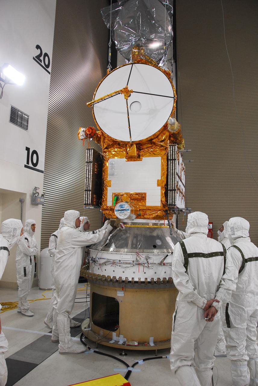
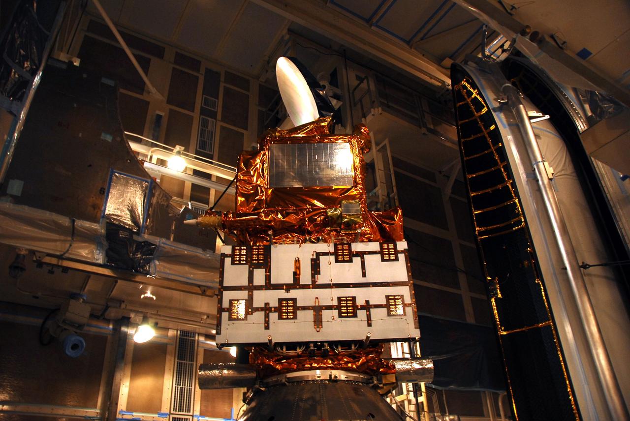
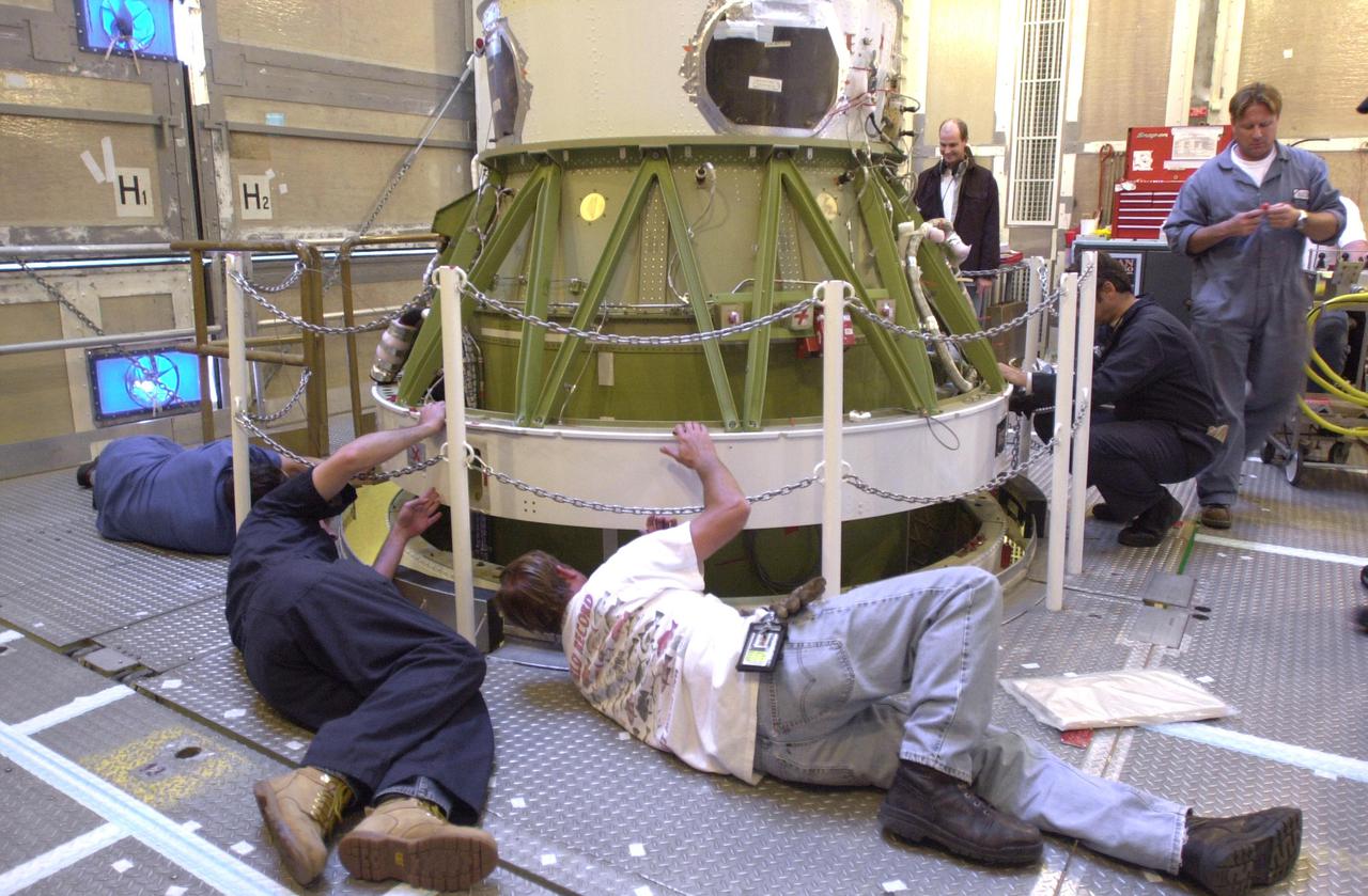
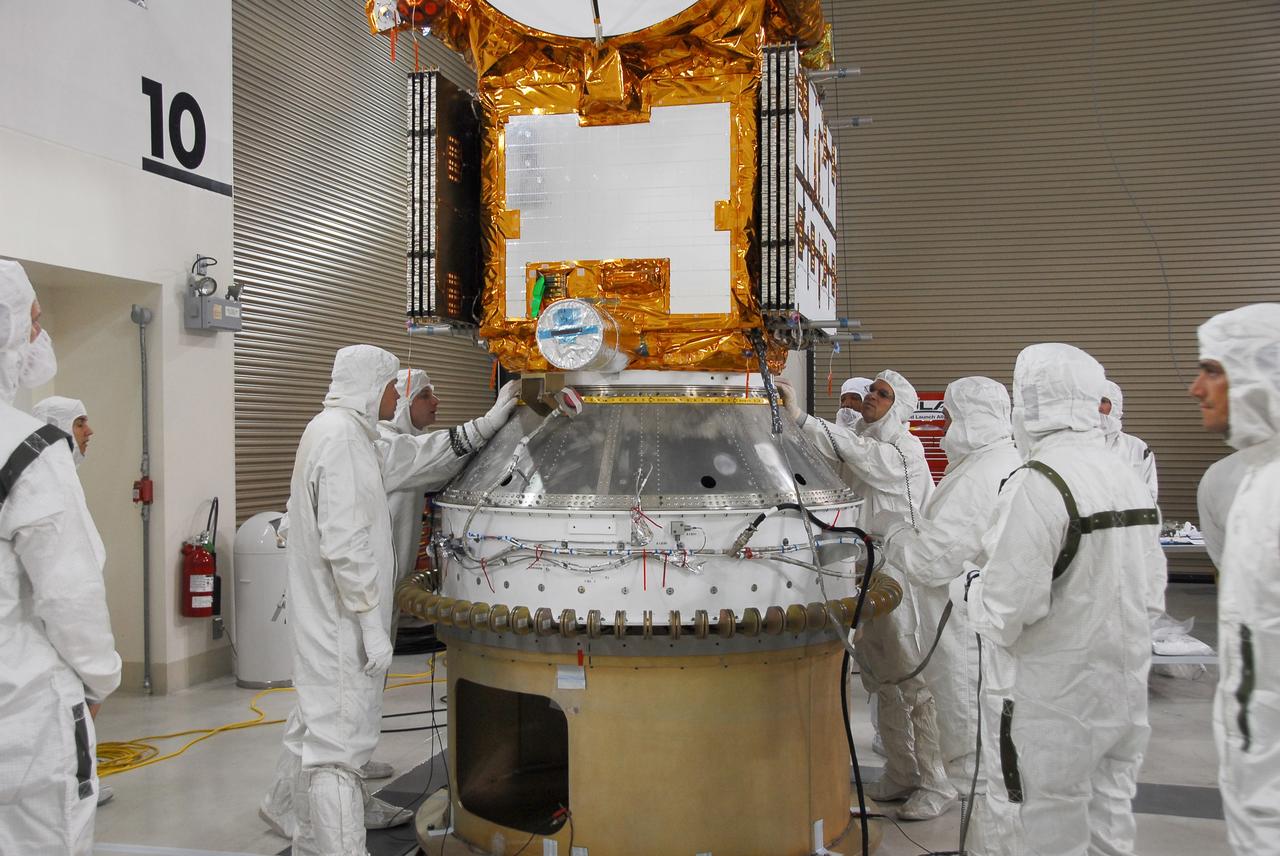
VANDENBERG AIR FORCE BASE, Calif. – Engineers check the installation of the Ocean Surface Topography Mission, or OSTM/Jason 2, spacecraft onto the payload attach fitting, or PAF. The PAF is the interface with the Delta II launch vehicle. The launch of the OSTM/Jason 2 aboard a Delta II rocket is scheduled for Friday, June 20, from Vandenberg Air Force Base in California. The launch window extends from 12:46 a.m. to 12:55 a.m. PDT. The satellite will be placed in an 830-mile-high orbit at an inclination of 66 degrees after separating from the Delta II 55 minutes after liftoff. The five primary science instruments of the Ocean Surface Topography Mission aboard the Jason 2 spacecraft are dedicated to measuring ocean surface height. These measurements will be used to evaluate and forecast climate changes and improve weather forecasting. The results also are expected to help forecasters better predict hurricane intensity. Photo credit: NASA
VANDENBERG AIR FORCE BASE, Calif. – The Ocean Surface Topography Mission, or OSTM/Jason 2, spacecraft is being prepared for bagging before encapsulation and transfer to the launch pad. The launch of the Ocean Surface Topography Mission, or OSTM/Jason 2, aboard a Delta II rocket is scheduled for Friday, June 20, from Vandenberg Air Force Base in California. The launch window extends from 12:46 a.m. to 12:55 a.m. PDT. The satellite will be placed in an 830-mile-high orbit at an inclination of 66 degrees after separating from the Delta II 55 minutes after liftoff. The five primary science instruments of the Ocean Surface Topography Mission aboard the Jason 2 spacecraft are dedicated to measuring ocean surface height. These measurements will be used to evaluate and forecast climate changes and improve weather forecasting. The results also are expected to help forecasters better predict hurricane intensity. Photo credit: NASA
VANDENBERG AIR FORCE BASE, Calif. – Another look at the Ocean Surface Topography Mission, or OSTM/Jason 2, spacecraft from the opposite side before its fueling, encapsulation and transfer to the launch pad. The launch of the OSTM/Jason 2 aboard a Delta II rocket is scheduled for Friday, June 20, from Vandenberg Air Force Base in California. The launch window extends from 12:46 a.m. to 12:55 a.m. PDT. The satellite will be placed in an 830-mile-high orbit at an inclination of 66 degrees after separating from the Delta II 55 minutes after liftoff. The five primary science instruments of the Ocean Surface Topography Mission aboard the Jason 2 spacecraft are dedicated to measuring ocean surface height. These measurements will be used to evaluate and forecast climate changes and improve weather forecasting. The results also are expected to help forecasters better predict hurricane intensity. Photo credit: NASA
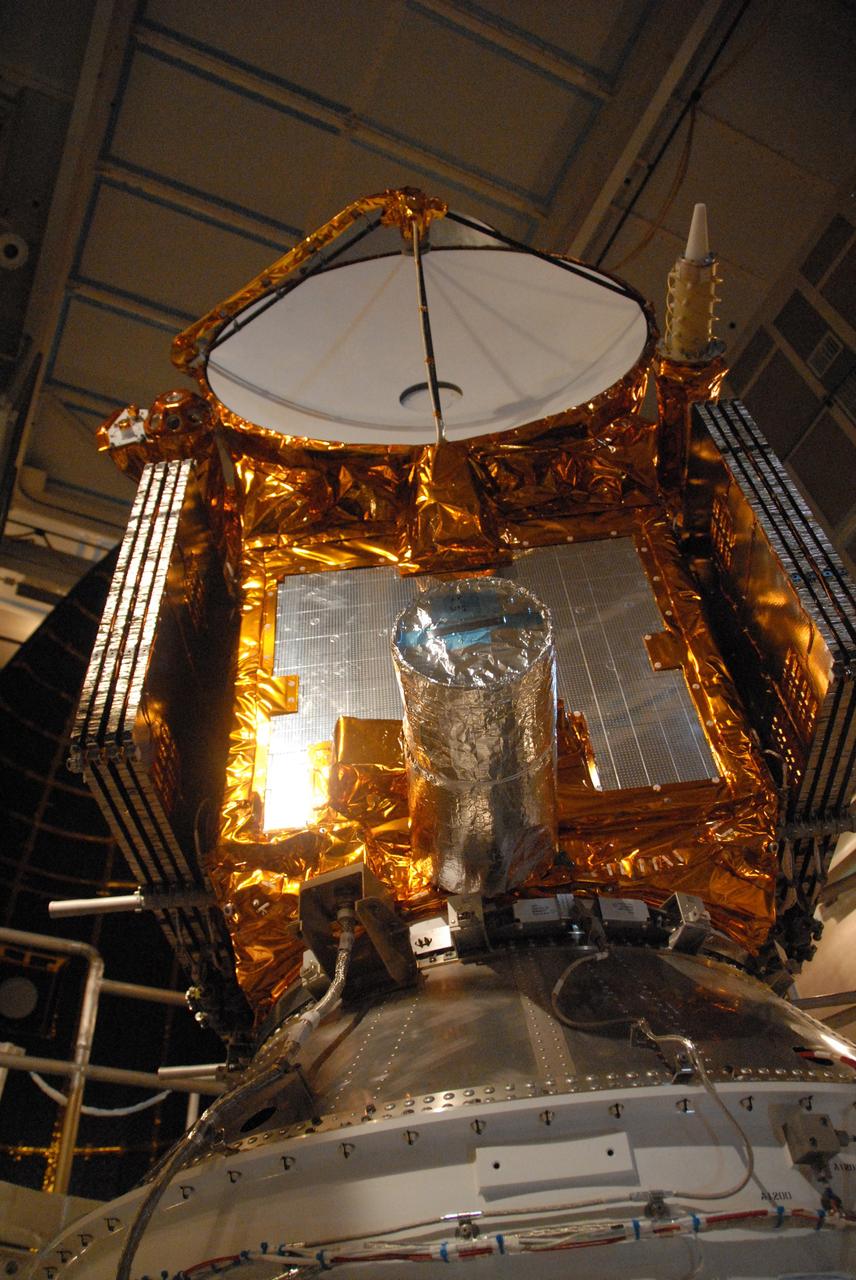
VANDENBERG AIR FORCE BASE, Calif. – The Ocean Surface Topography Mission, or OSTM/Jason-2, spacecraft is getting final checkouts after mating to the Delta II rocket on the Space Launch Complex 2 at Vandenberg Air Force Base in California. The launch of the OSTM/Jason 2 aboard the Delta II rocket is scheduled for June 20. The launch window extends from 12:46 a.m. to 12:55 a.m. PDT. The satellite will be placed in an 830-mile-high orbit at an inclination of 66 degrees after separating from the Delta II 55 minutes after liftoff. The five primary science instruments of the Ocean Surface Topography Mission aboard the Jason 2 spacecraft are dedicated to measuring ocean surface height. These measurements will be used to evaluate and forecast climate changes and improve weather forecasting. The results also are expected to help forecasters better predict hurricane intensity.
VANDENBERG AIR FORCE BASE, Calif. – On Space Launch Complex 2, the Ocean Surface Topography Mission, or OSTM/Jason 2, spacecraft is prepared to be lifted into the mobile service tower. In the tower it will mated with its Delta II launch vehicle. The launch window extends from 12:46 a.m. to 12:55 a.m. PDT. The satellite will be placed in an 830-mile-high orbit at an inclination of 66 degrees after separating from the Delta II 55 minutes after liftoff. The five primary science instruments of the Ocean Surface Topography Mission aboard the Jason 2 spacecraft are dedicated to measuring the height of the ocean surface. These measurements will be used to evaluate and forecast climate changes and improve weather forecasting. The results also are expected to help forecasters better predict hurricane intensity.
VANDENBERG AIR FORCE BASE, Calif. – The Ocean Surface Topography Mission, or OSTM/Jason 2, spacecraft is being prepared for bagging before encapsulation and transfer to the launch pad. The launch of the Ocean Surface Topography Mission, or OSTM/Jason 2, aboard a Delta II rocket is scheduled for Friday, June 20, from Vandenberg Air Force Base in California. The launch window extends from 12:46 a.m. to 12:55 a.m. PDT. The satellite will be placed in an 830-mile-high orbit at an inclination of 66 degrees after separating from the Delta II 55 minutes after liftoff. The five primary science instruments of the Ocean Surface Topography Mission aboard the Jason 2 spacecraft are dedicated to measuring ocean surface height. These measurements will be used to evaluate and forecast climate changes and improve weather forecasting. The results also are expected to help forecasters better predict hurricane intensity. Photo credit: NASA
KENNEDY SPACE CENTER, FLA. - Space Shuttle Atlantis continues its slow crawl toward the Vehicle Assembly Building from Launch Pad 39B. The rollback was a safety precaution as the area waits for the arrival of Tropical Storm Ernesto. The storm was forecast to be bringing 58-mph to 70-mph winds in the next 24 hours. After this photo was taken, a revised forecast of lesser winds expected from Ernesto and its projected direction convinced Launch Integration Manager LeRoy Cain and Shuttle Launch Director Mike Leinbach to return the shuttle to the launch pad. Photo credit: NASA/Ken Thornsley
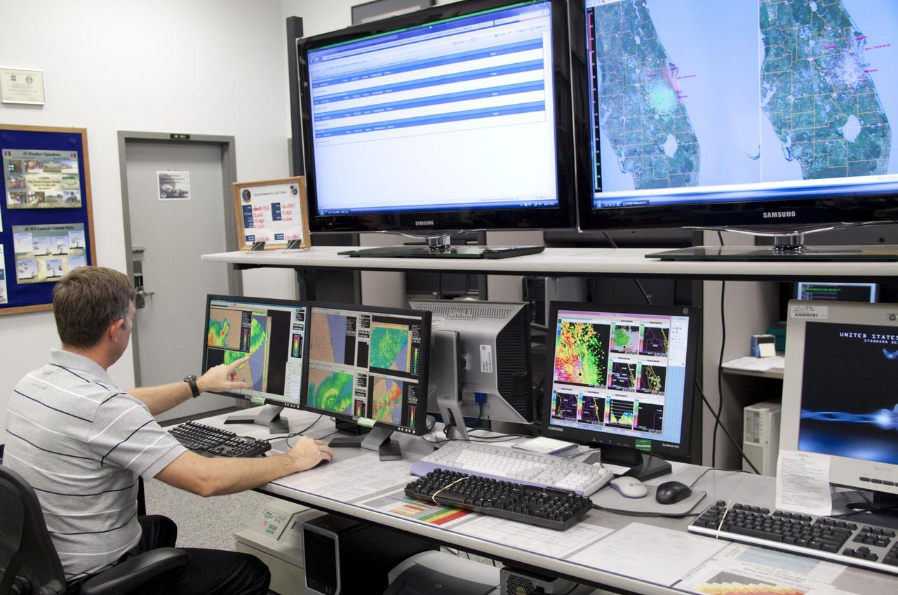
CAPE CANAVERAL, Fla. - At the Cape Canaveral Air Force Station forecast facility in Florida, a member of the weather team demonstrates the effectiveness of the new weather radar display recently installed. The facility is operated by the U.S. Air Force 45th Weather Squadron and will generate a launch weather forecast for the scheduled July 8 lift off of space shuttle Atlantis on the STS-135 mission. Photo credit: NASA/Jack Pfaller
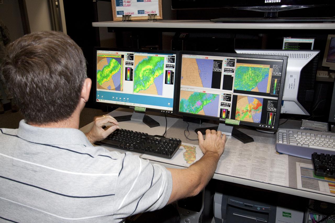
CAPE CANAVERAL, Fla. - At the Cape Canaveral Air Force Station forecast facility in Florida, a member of the weather team demonstrates the effectiveness of the new weather radar display recently installed. The facility is operated by the U.S. Air Force 45th Weather Squadron and will generate a launch weather forecast for the scheduled July 8 lift off of space shuttle Atlantis on the STS-135 mission. Photo credit: NASA/Jack Pfaller
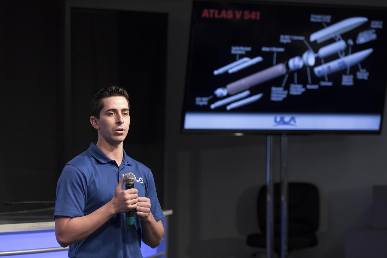
Gabriel Rodriguez-Mena, a United Launch Alliance systems test engineer, speaks to members of social media in the Kennedy Space Center’s Press Site auditorium. The briefing focused on the National Oceanic and Atmospheric Administration's, or NOAA's, Geostationary Operational Environmental Satellite, or GOES-S. The spacecraft is the second satellite in a series of next-generation NOAA weather satellites. It will launch to a geostationary position over the U.S. to provide images of storms and help predict weather forecasts, severe weather outlooks, watches, warnings, lightning conditions and longer-term forecasting. GOES-S is slated to lift off at 5:02 p.m. EST on March 1, 2018 aboard a United Launch Alliance Atlas V rocket.

CAPE CANAVERAL, Fla. – Mike McAleenan, launch weather officer with the U.S. Air Force 45th Weather Squadron, provides an on the launch-day forecast during a briefing regarding NOAA’s Deep Space Climate Observatory spacecraft, or DSCOVR. DSCOVR will launch aboard a SpaceX Falcon 9 rocket. The mission is a partnership between NOAA, NASA and the U.S. Air Force. DSCOVR will maintain the nation's real-time solar wind monitoring capabilities which are critical to the accuracy and lead time of NOAA's space weather alerts and forecasts. To learn more about DSCOVR, visit http://www.nesdis.noaa.gov/DSCOVR. Photo credit: NASA/Kim Shiflett
Jason Townsend, NASA's social media manager, speaks to members of social media in the Kennedy Space Center’s Press Site auditorium. The briefing focused on the National Oceanic and Atmospheric Administration's, or NOAA's, Geostationary Operational Environmental Satellite, or GOES-S. The spacecraft is the second satellite in a series of next-generation NOAA weather satellites. It will launch to a geostationary position over the U.S. to provide images of storms and help predict weather forecasts, severe weather outlooks, watches, warnings, lightning conditions and longer-term forecasting. GOES-S is slated to lift off at 5:02 p.m. EST on March 1, 2018 aboard a United Launch Alliance Atlas V rocket.

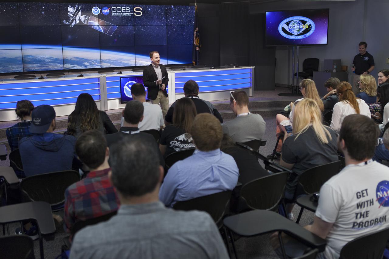
In the Kennedy Space Center's Press Site auditorium, George Morrow, deputy director of NASA's Goddard Space Flight Center in Greenbelt, Maryland, speaks to members of the media at a mission briefing on National Oceanic and Atmospheric Administration's, or NOAA's, Geostationary Operational Environmental Satellite, or GOES-S. The spacecraft is the second satellite in a series of next-generation NOAA weather satellites. It will launch to a geostationary position over the U.S. to provide images of storms and help predict weather forecasts, severe weather outlooks, watches, warnings, lightning conditions and longer-term forecasting. GOES-S is slated to lift off at 5:02 p.m. EST on March 1, 2018 aboard a United Launch Alliance Atlas V rocket.
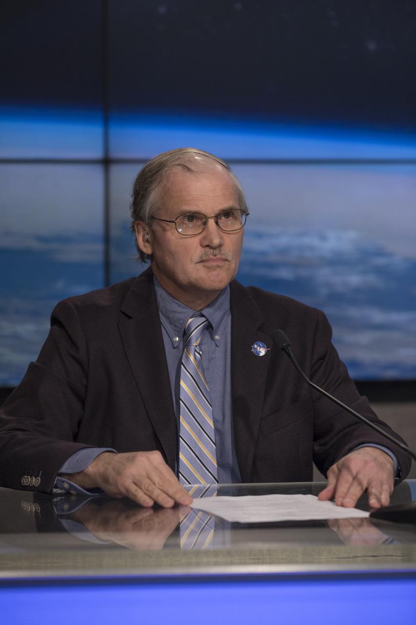
In the Kennedy Space Center's Press Site auditorium, Dan Lindsey, GOES-R senior scientific advisor for NOAA, speaks to members of the media at a mission briefing on National Oceanic and Atmospheric Administration's, or NOAA's, Geostationary Operational Environmental Satellite, or GOES-S. The spacecraft is the second satellite in a series of next-generation NOAA weather satellites. It will launch to a geostationary position over the U.S. to provide images of storms and help predict weather forecasts, severe weather outlooks, watches, warnings, lightning conditions and longer-term forecasting. GOES-S is slated to lift off at 5:02 p.m. EST on March 1, 2018 aboard a United Launch Alliance Atlas V rocket.

In the Kennedy Space Center's Press Site auditorium, Kristin Calhoun, a research scientist with NOAA's National Severe Storms Laboratory, speaks to members of the media at a mission briefing on National Oceanic and Atmospheric Administration's, or NOAA's, Geostationary Operational Environmental Satellite, or GOES-S. The spacecraft is the second satellite in a series of next-generation NOAA weather satellites. It will launch to a geostationary position over the U.S. to provide images of storms and help predict weather forecasts, severe weather outlooks, watches, warnings, lightning conditions and longer-term forecasting. GOES-S is slated to lift off at 5:02 p.m. EST on March 1, 2018 aboard a United Launch Alliance Atlas V rocket.

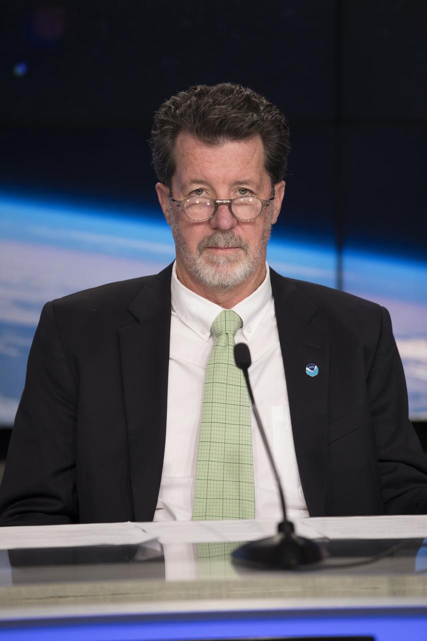
In the Kennedy Space Center's Press Site auditorium, Louis Uccellini, director of the National Weather Service for NOAA, speaks to members of the media at a mission briefing on National Oceanic and Atmospheric Administration's, or NOAA's, Geostationary Operational Environmental Satellite, or GOES-S. The spacecraft is the second satellite in a series of next-generation NOAA weather satellites. It will launch to a geostationary position over the U.S. to provide images of storms and help predict weather forecasts, severe weather outlooks, watches, warnings, lightning conditions and longer-term forecasting. GOES-S is slated to lift off at 5:02 p.m. EST on March 1, 2018 aboard a United Launch Alliance Atlas V rocket
In the Kennedy Space Center's Press Site auditorium, Jim Roberts, a scientist with the Earth System Research Laboratory's Office of Atmospheric Research for NOAA, speaks to members of the media at a mission briefing on National Oceanic and Atmospheric Administration's, or NOAA's, Geostationary Operational Environmental Satellite, or GOES-S. The spacecraft is the second satellite in a series of next-generation NOAA weather satellites. It will launch to a geostationary position over the U.S. to provide images of storms and help predict weather forecasts, severe weather outlooks, watches, warnings, lightning conditions and longer-term forecasting. GOES-S is slated to lift off at 5:02 p.m. EST on March 1, 2018 aboard a United Launch Alliance Atlas V rocket.

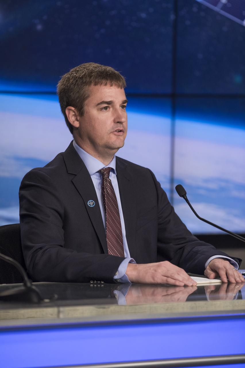
Tim Walsh, GOES-R System Program director for the National Oceanic and Atmospheric Administration, or NOAA, speaks to members of social media in the Kennedy Space Center’s Press Site auditorium. The briefing focused on the Geostationary Operational Environmental Satellite, or GOES-S, the second spacecraft in a series of next-generation NOAA weather satellites. It will launch to a geostationary position over the U.S. to provide images of storms and help predict weather forecasts, severe weather outlooks, watches, warnings, lightning conditions and longer-term forecasting. GOES-S is slated to lift off at 5:02 p.m. EST on March 1, 2018 aboard a United Launch Alliance Atlas V rocket.
Tim Walsh, GOES-R System Program director for the National Oceanic and Atmospheric Administration, or NOAA, speaks to members of social media in the Kennedy Space Center’s Press Site auditorium. The briefing focused on the Geostationary Operational Environmental Satellite, or GOES-S, the second spacecraft in a series of next-generation NOAA weather satellites. It will launch to a geostationary position over the U.S. to provide images of storms and help predict weather forecasts, severe weather outlooks, watches, warnings, lightning conditions and longer-term forecasting. GOES-S is slated to lift off at 5:02 p.m. EST on March 1, 2018 aboard a United Launch Alliance Atlas V rocket.
Joe Pica, director of the Office of Observations for the National Oceanic and Atmospheric Administration's, or NOAA’s, National Weather Service, speaks to members of social media in the Kennedy Space Center’s Press Site auditorium. The briefing focused on the Geostationary Operational Environmental Satellite, or GOES-S, the second spacecraft in a series of next-generation NOAA weather satellites. It will launch to a geostationary position over the U.S. to provide images of storms and help predict weather forecasts, severe weather outlooks, watches, warnings, lightning conditions and longer-term forecasting. GOES-S is slated to lift off at 5:02 p.m. EST on March 1, 2018 aboard a United Launch Alliance Atlas V rocket.
In the Kennedy Space Center's Press Site auditorium, Steve Cole of NASA Communications speaks to members of the media at a mission briefing on National Oceanic and Atmospheric Administration's, or NOAA's, Geostationary Operational Environmental Satellite, or GOES-S. The spacecraft is the second satellite in a series of next-generation NOAA weather satellites. It will launch to a geostationary position over the U.S. to provide images of storms and help predict weather forecasts, severe weather outlooks, watches, warnings, lightning conditions and longer-term forecasting. GOES-S is slated to lift off at 5:02 p.m. EST on March 1, 2018 aboard a United Launch Alliance Atlas V rocket.
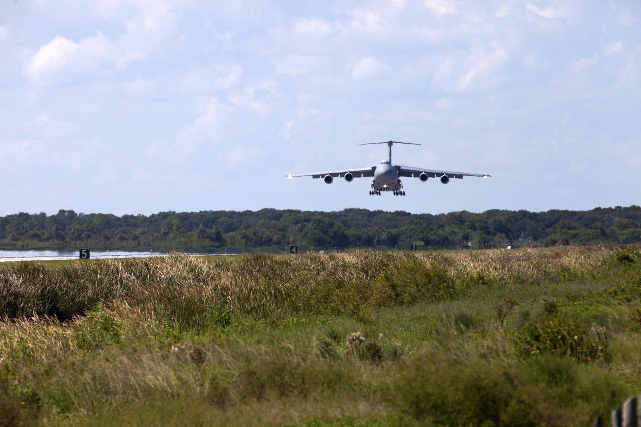
An Air Force C-5 Galaxy transport plane approaches the Shuttle Landing Facility at NASA's Kennedy Space Center in Florida to deliver the GOES-R spacecraft for launch processing. The GOES series are weather satellites operated by NOAA to enhance forecasts. The spacecraft is to launch aboard a United Launch Alliance Atlas V rocket in November.
KENNEDY SPACE CENTER, FLA. - Viewed from the NASA News Center across the turn basin in the Launch Complex 39 Area, Space Shuttle Atlantis continues its slow crawl toward the Vehicle Assembly Building from Launch Pad 39B. After this photo was taken, the decision was made to return the shuttle to the launch pad. The rollback was a safety precaution as the area waits for the arrival of Tropical Storm Ernesto. The storm was forecast to be bringing 58-mph to 70-mph winds in the next 24 hours. The revised forecast of lesser winds expected from Ernesto and its projected direction convinced Launch Integration Manager LeRoy Cain and Shuttle Launch Director Mike Leinbach to return the shuttle to the launch pad. Photo credit: NASA/Kim Shiflett
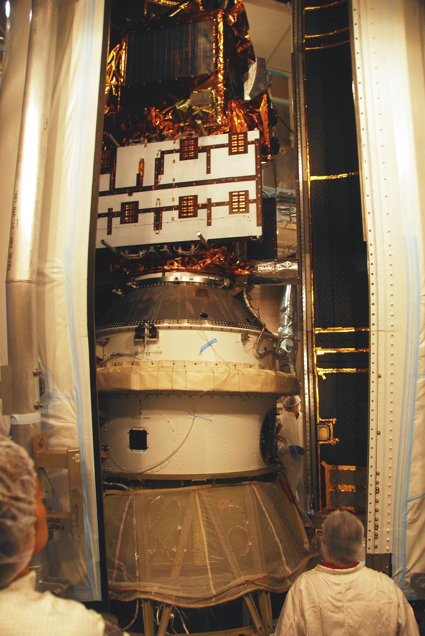
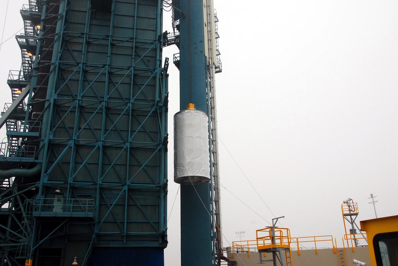
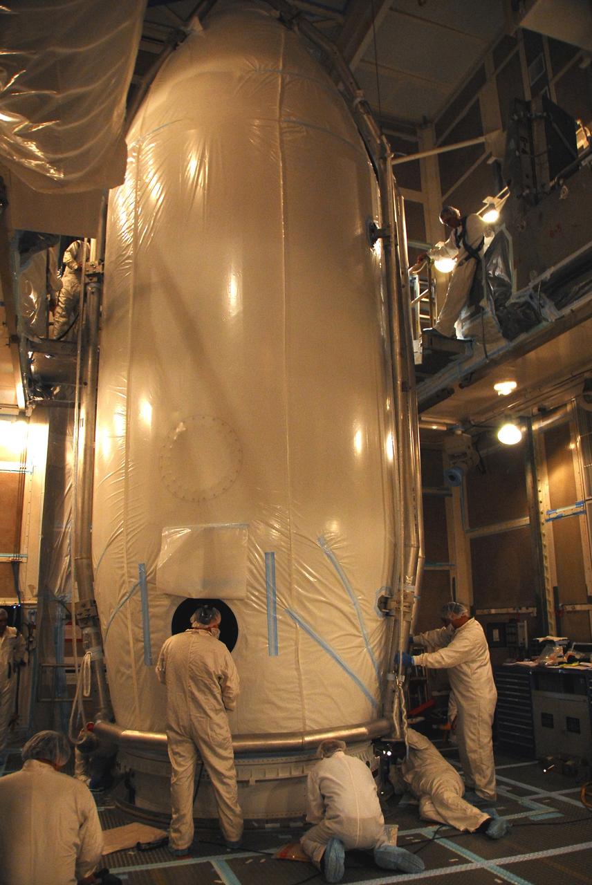
VANDENBERG AIR FORCE BASE, Calif. – In the mobile service tower on Space Launch Complex 2, the second half of the fairing moves close to the Ocean Surface Topography Mission, or OSTM/Jason 2, spacecraft to complete encapsulation. The fairing is a molded structure that fits flush with the outside surface of the Delta II upper stage booster and forms an aerodynamically smooth nose cone, protecting the spacecraft during launch and ascent. The launch of the OSTM/Jason-2 is scheduled for June 20 from Vandenberg Air Force Base. The launch window extends from 12:46 a.m. to 12:55 a.m. PDT. The satellite will be placed in an 830-mile-high orbit at an inclination of 66 degrees after separating from the Delta II 55 minutes after liftoff. The five primary science instruments of the Ocean Surface Topography Mission aboard the Jason 2 spacecraft are dedicated to measuring the height of the ocean surface. These measurements will be used to evaluate and forecast climate changes and improve weather forecasting. The results also are expected to help forecasters better predict hurricane intensity.
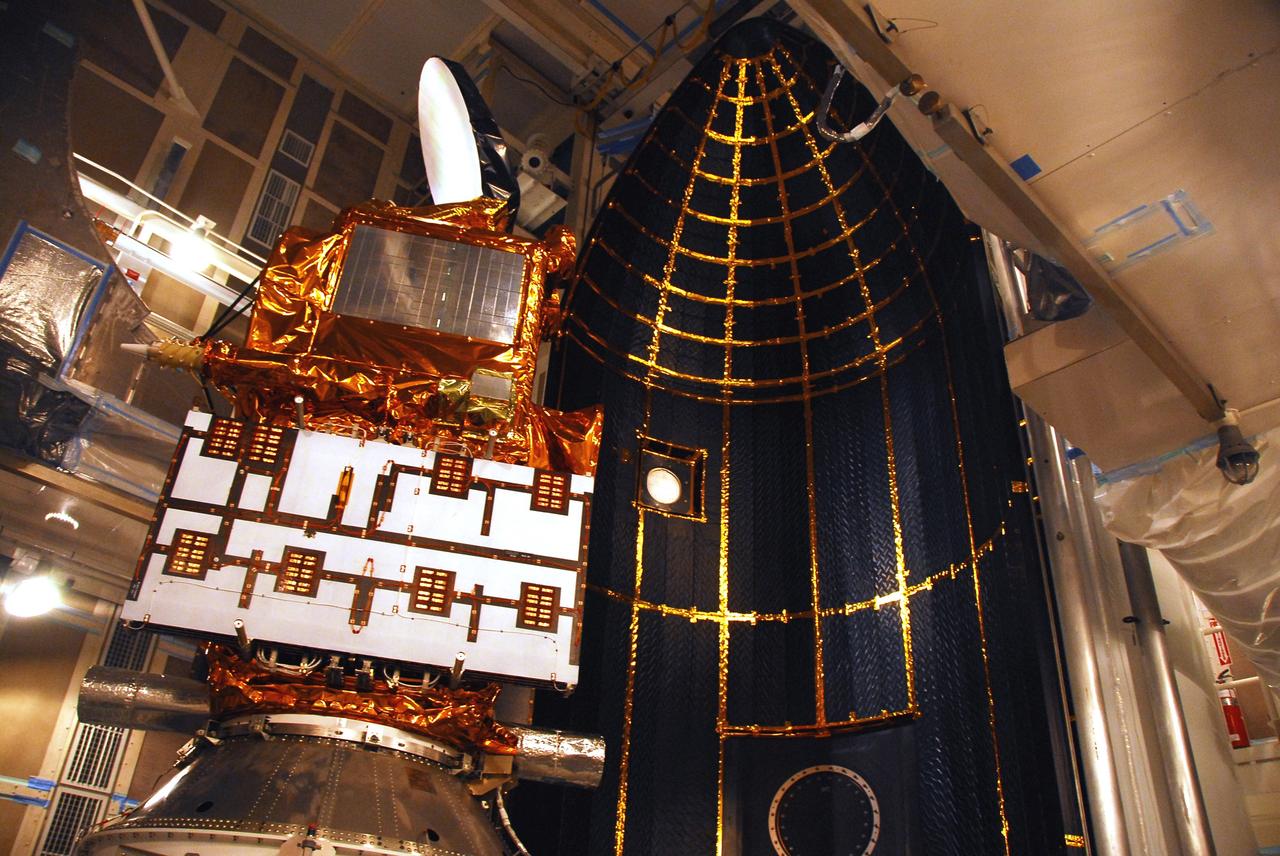
VANDENBERG AIR FORCE BASE, Calif. – In the mobile service tower on Space Launch Complex 2, the first half of the fairing (at right) is moved closer toward the Ocean Surface Topography Mission, or OSTM/Jason 2, spacecraft for encapsulation. The fairing is a molded structure that fits flush with the outside surface of the Delta II upper stage booster and forms an aerodynamically smooth nose cone, protecting the spacecraft during launch and ascent. The launch of the OSTM/Jason-2 is scheduled for June 20 from Vandenberg Air Force Base. The launch window extends from 12:46 a.m. to 12:55 a.m. PDT. The satellite will be placed in an 830-mile-high orbit at an inclination of 66 degrees after separating from the Delta II 55 minutes after liftoff. The five primary science instruments of the Ocean Surface Topography Mission aboard the Jason 2 spacecraft are dedicated to measuring the height of the ocean surface. These measurements will be used to evaluate and forecast climate changes and improve weather forecasting. The results also are expected to help forecasters better predict hurricane intensity.
VANDENBERG AIR FORCE BASE, Calif. – In the mobile service tower on Space Launch Complex 2, the first half of the fairing (at right) is being moved toward the Ocean Surface Topography Mission, or OSTM/Jason 2, spacecraft for encapsulation. The fairing is a molded structure that fits flush with the outside surface of the Delta II upper stage booster and forms an aerodynamically smooth nose cone, protecting the spacecraft during launch and ascent. The launch of the OSTM/Jason-2 is scheduled for June 20 from Vandenberg Air Force Base. The launch window extends from 12:46 a.m. to 12:55 a.m. PDT. The satellite will be placed in an 830-mile-high orbit at an inclination of 66 degrees after separating from the Delta II 55 minutes after liftoff. The five primary science instruments of the Ocean Surface Topography Mission aboard the Jason 2 spacecraft are dedicated to measuring the height of the ocean surface. These measurements will be used to evaluate and forecast climate changes and improve weather forecasting. The results also are expected to help forecasters better predict hurricane intensity.
VANDENBERG AIR FORCE BASE, Calif. – In the mobile service tower on Space Launch Complex 2, workers secure the fairing around the Ocean Surface Topography Mission, or OSTM/Jason 2, spacecraft to complete encapsulation. The fairing is a molded structure that fits flush with the outside surface of the Delta II upper stage booster and forms an aerodynamically smooth nose cone, protecting the spacecraft during launch and ascent. The launch of the OSTM/Jason-2 is scheduled for June 20 from Vandenberg Air Force Base. The launch window extends from 12:46 a.m. to 12:55 a.m. PDT. The satellite will be placed in an 830-mile-high orbit at an inclination of 66 degrees after separating from the Delta II 55 minutes after liftoff. The five primary science instruments of the Ocean Surface Topography Mission aboard the Jason 2 spacecraft are dedicated to measuring the height of the ocean surface. These measurements will be used to evaluate and forecast climate changes and improve weather forecasting. The results also are expected to help forecasters better predict hurricane intensity.
VANDENBERG AIR FORCE BASE, Calif. – In the mobile service tower on Space Launch Complex 2, the first half of the fairing moves into place behind the Ocean Surface Topography Mission, or OSTM/Jason 2, spacecraft for encapsulation. The fairing is a molded structure that fits flush with the outside surface of the Delta II upper stage booster and forms an aerodynamically smooth nose cone, protecting the spacecraft during launch and ascent. The launch of the OSTM/Jason-2 is scheduled for June 20 from Vandenberg Air Force Base. The launch window extends from 12:46 a.m. to 12:55 a.m. PDT. The satellite will be placed in an 830-mile-high orbit at an inclination of 66 degrees after separating from the Delta II 55 minutes after liftoff. The five primary science instruments of the Ocean Surface Topography Mission aboard the Jason 2 spacecraft are dedicated to measuring the height of the ocean surface. These measurements will be used to evaluate and forecast climate changes and improve weather forecasting. The results also are expected to help forecasters better predict hurricane intensity.
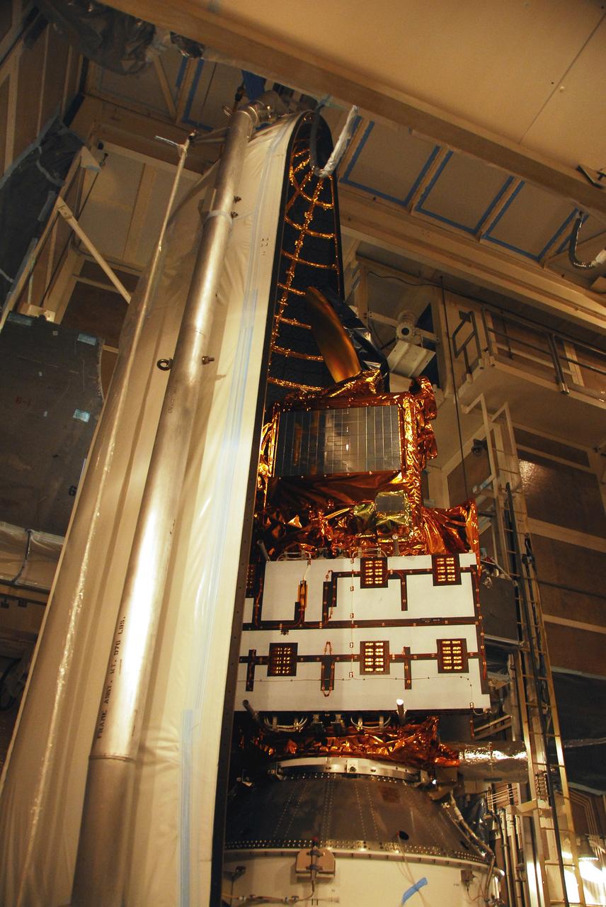
VANDENBERG AIR FORCE BASE, Calif. – In the mobile service tower on Space Launch Complex 2, the Ocean Surface Topography Mission, or OSTM/Jason 2, spacecraft is ready for encapsulation in the fairing. The fairing is a molded structure that fits flush with the outside surface of the Delta II upper stage booster and forms an aerodynamically smooth nose cone, protecting the spacecraft during launch and ascent. The launch of the OSTM/Jason-2 is scheduled for June 20 from Vandenberg Air Force Base. The launch window extends from 12:46 a.m. to 12:55 a.m. PDT. The satellite will be placed in an 830-mile-high orbit at an inclination of 66 degrees after separating from the Delta II 55 minutes after liftoff. The five primary science instruments of the Ocean Surface Topography Mission aboard the Jason 2 spacecraft are dedicated to measuring the height of the ocean surface. These measurements will be used to evaluate and forecast climate changes and improve weather forecasting. The results also are expected to help forecasters better predict hurricane intensity.
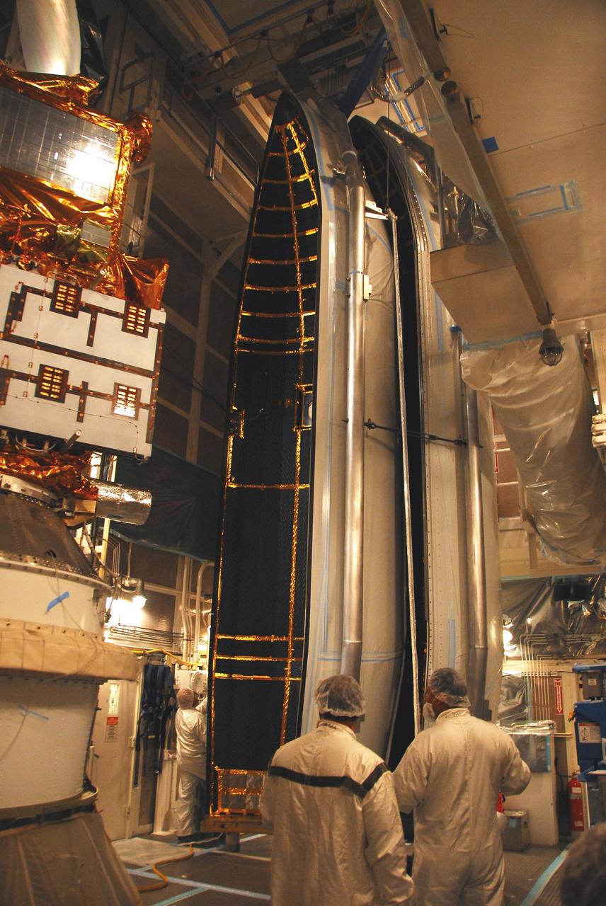
VANDENBERG AIR FORCE BASE, Calif. – In the mobile service tower on Space Launch Complex 2, the first half of the fairing (at right) is being moved toward the Ocean Surface Topography Mission, or OSTM/Jason 2, spacecraft for encapsulation. The fairing is a molded structure that fits flush with the outside surface of the Delta II upper stage booster and forms an aerodynamically smooth nose cone, protecting the spacecraft during launch and ascent. The launch of the OSTM/Jason-2 is scheduled for June 20 from Vandenberg Air Force Base. The launch window extends from 12:46 a.m. to 12:55 a.m. PDT. The satellite will be placed in an 830-mile-high orbit at an inclination of 66 degrees after separating from the Delta II 55 minutes after liftoff. The five primary science instruments of the Ocean Surface Topography Mission aboard the Jason 2 spacecraft are dedicated to measuring the height of the ocean surface. These measurements will be used to evaluate and forecast climate changes and improve weather forecasting. The results also are expected to help forecasters better predict hurricane intensity.
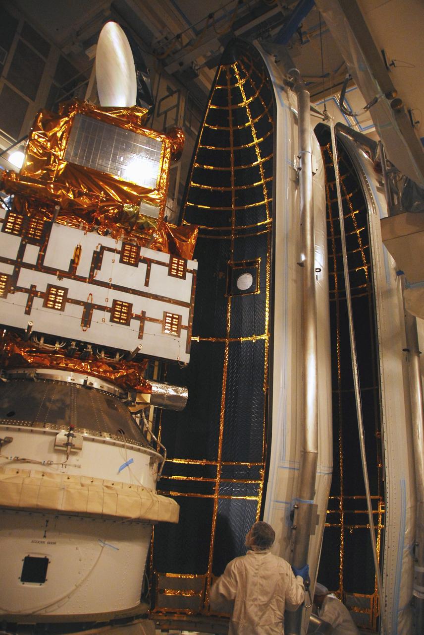
VANDENBERG AIR FORCE BASE, Calif. – In the mobile service tower on Space Launch Complex 2, the first half of the fairing (at right) is moved closer toward the Ocean Surface Topography Mission, or OSTM/Jason 2, spacecraft for encapsulation. The fairing is a molded structure that fits flush with the outside surface of the Delta II upper stage booster and forms an aerodynamically smooth nose cone, protecting the spacecraft during launch and ascent. The launch of the OSTM/Jason-2 is scheduled for June 20 from Vandenberg Air Force Base. The launch window extends from 12:46 a.m. to 12:55 a.m. PDT. The satellite will be placed in an 830-mile-high orbit at an inclination of 66 degrees after separating from the Delta II 55 minutes after liftoff. The five primary science instruments of the Ocean Surface Topography Mission aboard the Jason 2 spacecraft are dedicated to measuring the height of the ocean surface. These measurements will be used to evaluate and forecast climate changes and improve weather forecasting. The results also are expected to help forecasters better predict hurricane intensity.
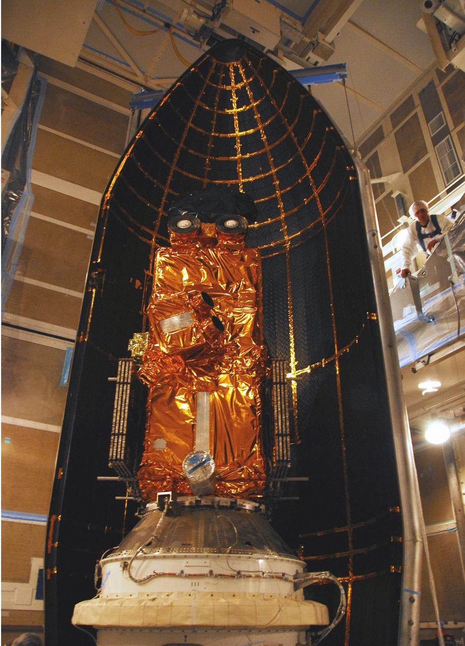
VANDENBERG AIR FORCE BASE, Calif. – In the mobile service tower on Space Launch Complex 2, the first half of the fairing moves into place behind the Ocean Surface Topography Mission, or OSTM/Jason 2, spacecraft for encapsulation. The fairing is a molded structure that fits flush with the outside surface of the Delta II upper stage booster and forms an aerodynamically smooth nose cone, protecting the spacecraft during launch and ascent. The launch of the OSTM/Jason-2 is scheduled for June 20 from Vandenberg Air Force Base. The launch window extends from 12:46 a.m. to 12:55 a.m. PDT. The satellite will be placed in an 830-mile-high orbit at an inclination of 66 degrees after separating from the Delta II 55 minutes after liftoff. The five primary science instruments of the Ocean Surface Topography Mission aboard the Jason 2 spacecraft are dedicated to measuring the height of the ocean surface. These measurements will be used to evaluate and forecast climate changes and improve weather forecasting. The results also are expected to help forecasters better predict hurricane intensity.
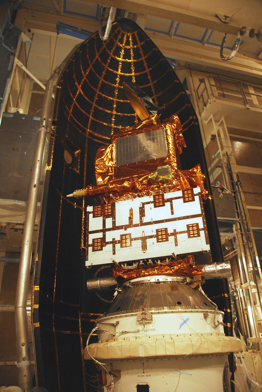
VANDENBERG AIR FORCE BASE, Calif. – In the mobile service tower on Space Launch Complex 2, the first half of the fairing moves into place behind the Ocean Surface Topography Mission, or OSTM/Jason 2, spacecraft for encapsulation. The fairing is a molded structure that fits flush with the outside surface of the Delta II upper stage booster and forms an aerodynamically smooth nose cone, protecting the spacecraft during launch and ascent. The launch of the OSTM/Jason-2 is scheduled for June 20 from Vandenberg Air Force Base. The launch window extends from 12:46 a.m. to 12:55 a.m. PDT. The satellite will be placed in an 830-mile-high orbit at an inclination of 66 degrees after separating from the Delta II 55 minutes after liftoff. The five primary science instruments of the Ocean Surface Topography Mission aboard the Jason 2 spacecraft are dedicated to measuring the height of the ocean surface. These measurements will be used to evaluate and forecast climate changes and improve weather forecasting. The results also are expected to help forecasters better predict hurricane intensity.

The Tropospheric Doppler Radar Wind Profiler (TDRWP), located at Kennedy Space Center, is the only instrument of its kind in operation. Consisting of 640 antennae and occupying five acres near the Launch and Landing Facility, the TDRWP operates at nearly 50 MHz. It will be used as a primary instrument to measure upper level winds for NASA’s Artemis missions, which will launch from the Florida spaceport. The instrument has the ability to provide data from 6,000 to 62,000 feet, every five minutes, far outpacing weather balloons.
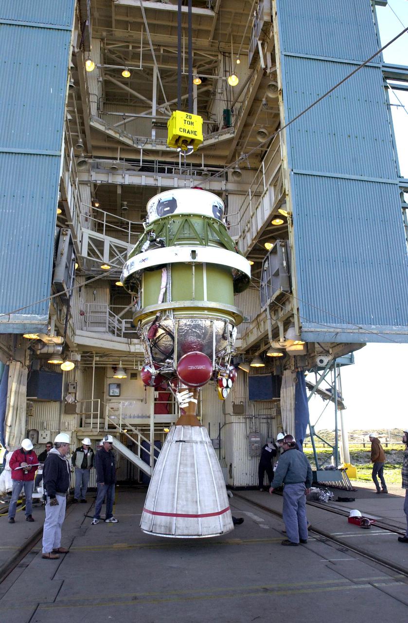
VANDENBERG AIR FORCE BASE, CALIF. - At Space Launch Complex 2 on Vandenberg Air Force Base in California, the second stage of the Boeing Delta II rocket is now suspended vertically and can be lifted up the service tower for mating with the first stage. The Delta II will launch the National Oceanic and Atmospheric Administration (NOAA-N) spacecraft. After launch, NOAA-N will be renamed NOAA-18 and will provide measurements of the Earth's surface and atmosphere that will be entered into NOAA’s weather forecasting models and used for other environmental studies. Each day, the satellite will send data to NOAA’s Command and Data Acquisition station computers, adding vital information to forecasting models, especially over the oceans, where conventional data is lacking. Launch of NOAA-N is scheduled for May 11, 2005.
VANDENBERG AIR FORCE BASE, CALIF. - Inside the service tower at Space Launch Complex 2 on Vandenberg Air Force Base in California, Boeing workers get ready to mate the second stage (above) to the first stage of a Boeing Delta II rocket. The Delta II will launch the National Oceanic and Atmospheric Administration (NOAA-N) spacecraft. After launch, NOAA-N will be renamed NOAA-18 and will provide measurements of the Earth's surface and atmosphere that will be entered into NOAA’s weather forecasting models and used for other environmental studies. Each day, the satellite will send data to NOAA’s Command and Data Acquisition station computers, adding vital information to forecasting models, especially over the oceans, where conventional data is lacking. Launch of NOAA-N is scheduled for May 11, 2005.
VANDENBERG AIR FORCE BASE, CALIF. - At Space Launch Complex 2 on Vandenberg Air Force Base in California, Boeing workers help guide the second stage of the Boeing Delta II rocket to a vertical position. The second stage will be lifted and mated with the first stage. The Delta II will launch the National Oceanic and Atmospheric Administration (NOAA-N) spacecraft. After launch, NOAA-N will be renamed NOAA-18 and will provide measurements of the Earth's surface and atmosphere that will be entered into NOAA’s weather forecasting models and used for other environmental studies. Each day, the satellite will send data to NOAA’s Command and Data Acquisition station computers, adding vital information to forecasting models, especially over the oceans, where conventional data is lacking. Launch of NOAA-N is scheduled for May 11, 2005.
VANDENBERG AIR FORCE BASE, CALIF. - At Space Launch Complex 2 on Vandenberg Air Force Base in California, the second stage of the Boeing Delta II rocket is lifted up the service tower for mating with the first stage. The Delta II will launch the National Oceanic and Atmospheric Administration (NOAA-N) spacecraft. After launch, NOAA-N will be renamed NOAA-18 and will provide measurements of the Earth's surface and atmosphere that will be entered into NOAA’s weather forecasting models and used for other environmental studies. Each day, the satellite will send data to NOAA’s Command and Data Acquisition station computers, adding vital information to forecasting models, especially over the oceans, where conventional data is lacking. Launch of NOAA-N is scheduled for May 11, 2005.
VANDENBERG AIR FORCE BASE, CALIF. - At Space Launch Complex 2 on Vandenberg Air Force Base in California, the first stage of the Boeing Delta II rocket rests on the pad. It will be mated with the second stage. The Delta II will launch the National Oceanic and Atmospheric Administration (NOAA-N) spacecraft. After launch, NOAA-N will be renamed NOAA-18 and will provide measurements of the Earth's surface and atmosphere that will be entered into NOAA’s weather forecasting models and used for other environmental studies. Each day, the satellite will send data to NOAA’s Command and Data Acquisition station computers, adding vital information to forecasting models, especially over the oceans, where conventional data is lacking. Launch of NOAA-N is scheduled for May 11, 2005.
VANDENBERG AIR FORCE BASE, CALIF. - Inside the service tower at Space Launch Complex 2 on Vandenberg Air Force Base in California, Boeing workers attach the second stage to the first stage, below, of a Boeing Delta II rocket. The Delta II will launch the National Oceanic and Atmospheric Administration (NOAA-N) spacecraft. After launch, NOAA-N will be renamed NOAA-18 and will provide measurements of the Earth's surface and atmosphere that will be entered into NOAA’s weather forecasting models and used for other environmental studies. Each day, the satellite will send data to NOAA’s Command and Data Acquisition station computers, adding vital information to forecasting models, especially over the oceans, where conventional data is lacking. Launch of NOAA-N is scheduled for May 11, 2005.
Mic Woltman, chief of the Fleet Systems Integration Branch of NASA's Launch Services Program, left, and Gabriel Rodriguez-Mena, a United Launch Alliance systems test engineer, speak to members of social media in the Kennedy Space Center’s Press Site auditorium. The briefing focused on the National Oceanic and Atmospheric Administration's, or NOAA's, Geostationary Operational Environmental Satellite, or GOES-S. The spacecraft is the second satellite in a series of next-generation NOAA weather satellites. It will launch to a geostationary position over the U.S. to provide images of storms and help predict weather forecasts, severe weather outlooks, watches, warnings, lightning conditions and longer-term forecasting. GOES-S is slated to lift off at 5:02 p.m. EST on March 1, 2018 aboard a United Launch Alliance Atlas V rocket.
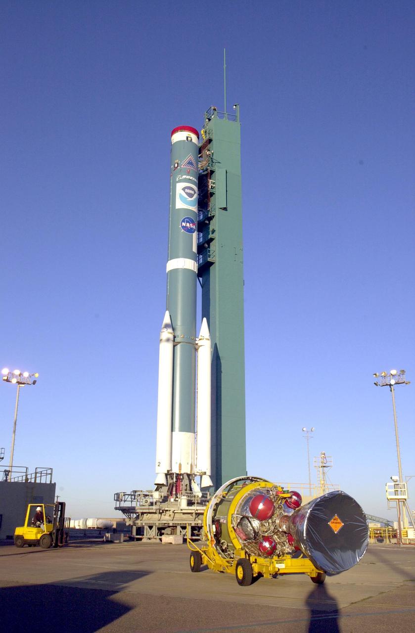
VANDENBERG AIR FORCE BASE, CALIF. - The second stage of the Boeing Delta II rocket, in the background, arrives at Space Launch Complex 2 on Vandenberg Air Force Base in California. It will be mated with the first stage. The Delta II is the launch vehicle for the National Oceanic and Atmospheric Administration (NOAA-N) spacecraft. After launch, NOAA-N will be renamed NOAA-18 and will provide measurements of the Earth's surface and atmosphere that will be entered into NOAA’s weather forecasting models and used for other environmental studies. Each day, the satellite will send data to NOAA’s Command and Data Acquisition station computers, adding vital information to forecasting models, especially over the oceans, where conventional data is lacking. Launch of NOAA-N is scheduled for May 11, 2005.
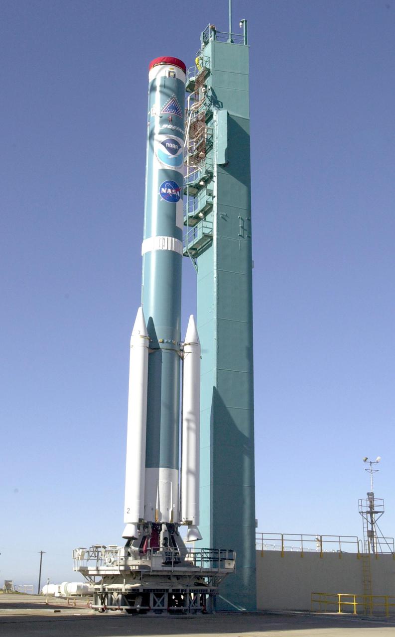
VANDENBERG AIR FORCE BASE, CALIF. - At Space Launch Complex 2 on Vandenberg Air Force Base in California, the first stage of the Boeing Delta II rocket rests on the pad. It will be mated with the second stage. The Delta II will launch the National Oceanic and Atmospheric Administration (NOAA-N) spacecraft. After launch, NOAA-N will be renamed NOAA-18 and will provide measurements of the Earth's surface and atmosphere that will be entered into NOAA’s weather forecasting models and used for other environmental studies. Each day, the satellite will send data to NOAA’s Command and Data Acquisition station computers, adding vital information to forecasting models, especially over the oceans, where conventional data is lacking. Launch of NOAA-N is scheduled for May 11, 2005.
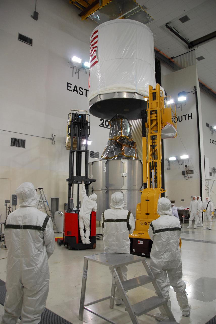
VANDENBERG AIR FORCE BASE, Calif. – The upper canister cylinder stops above the wrapped Ocean Surface Topography Mission, or OSTM/Jason 2, spacecraft. Once the canister is lowered and attached to the lower segments, the OSTM/Jason 2 will be transported to the launch pad. The launch of the OSTM/Jason 2 aboard a Delta II rocket is scheduled for Friday, June 20, from Vandenberg Air Force Base in California. The launch window extends from 12:46 a.m. to 12:55 a.m. PDT. The satellite will be placed in an 830-mile-high orbit at an inclination of 66 degrees after separating from the Delta II 55 minutes after liftoff. The five primary science instruments of the Ocean Surface Topography Mission aboard the Jason 2 spacecraft are dedicated to measuring ocean surface height. These measurements will be used to evaluate and forecast climate changes and improve weather forecasting. The results also are expected to help forecasters better predict hurricane intensity. Photo credit: NASA/Dan Liberotti
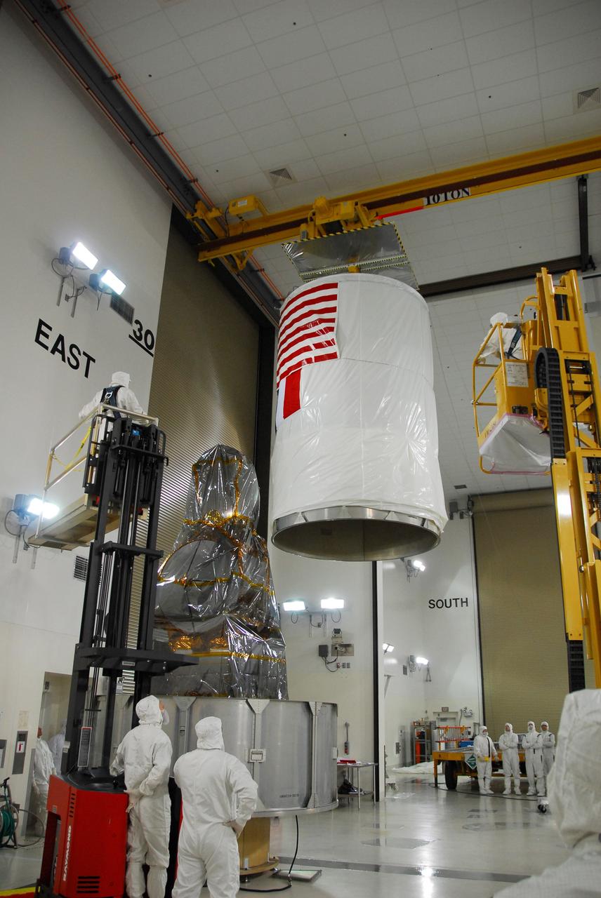
VANDENBERG AIR FORCE BASE, Calif. – The upper canister cylinder is moved toward the wrapped Ocean Surface Topography Mission, or OSTM/Jason 2, spacecraft. Once the canister is fully in place, the OSTM/Jason 2 will be transported to the launch pad. The launch of the OSTM/Jason 2 aboard a Delta II rocket is scheduled for Friday, June 20, from Vandenberg Air Force Base in California. The launch window extends from 12:46 a.m. to 12:55 a.m. PDT. The satellite will be placed in an 830-mile-high orbit at an inclination of 66 degrees after separating from the Delta II 55 minutes after liftoff. The five primary science instruments of the Ocean Surface Topography Mission aboard the Jason 2 spacecraft are dedicated to measuring ocean surface height. These measurements will be used to evaluate and forecast climate changes and improve weather forecasting. The results also are expected to help forecasters better predict hurricane intensity. Photo credit: NASA/Dan Liberotti

VANDENBERG AIR FORCE BASE, Calif. – Suspended by an overhead crane, the Ocean Surface Topography Mission, or OSTM/Jason 2, spacecraft is moved toward the payload attach fitting, or PAF, for installation. The PAF is the interface with the Delta II launch vehicle. The launch of the OSTM/Jason 2 aboard a Delta II rocket is scheduled for Friday, June 20, from Vandenberg Air Force Base in California. The launch window extends from 12:46 a.m. to 12:55 a.m. PDT. The satellite will be placed in an 830-mile-high orbit at an inclination of 66 degrees after separating from the Delta II 55 minutes after liftoff. The five primary science instruments of the Ocean Surface Topography Mission aboard the Jason 2 spacecraft are dedicated to measuring ocean surface height. These measurements will be used to evaluate and forecast climate changes and improve weather forecasting. The results also are expected to help forecasters better predict hurricane intensity. Photo credit: NASA

VANDENBERG AIR FORCE BASE, Calif. – Workers begin placing the canister segments around the base of the wrapped Ocean Surface Topography Mission, or OSTM/Jason 2, spacecraft. Once the canister is fully in place, the OSTM/Jason 2 will be transported to the launch pad. The launch of the OSTM/Jason 2 aboard a Delta II rocket is scheduled for Friday, June 20, from Vandenberg Air Force Base in California. The launch window extends from 12:46 a.m. to 12:55 a.m. PDT. The satellite will be placed in an 830-mile-high orbit at an inclination of 66 degrees after separating from the Delta II 55 minutes after liftoff. The five primary science instruments of the Ocean Surface Topography Mission aboard the Jason 2 spacecraft are dedicated to measuring ocean surface height. These measurements will be used to evaluate and forecast climate changes and improve weather forecasting. The results also are expected to help forecasters better predict hurricane intensity. Photo credit: NASA/Dan Liberotti
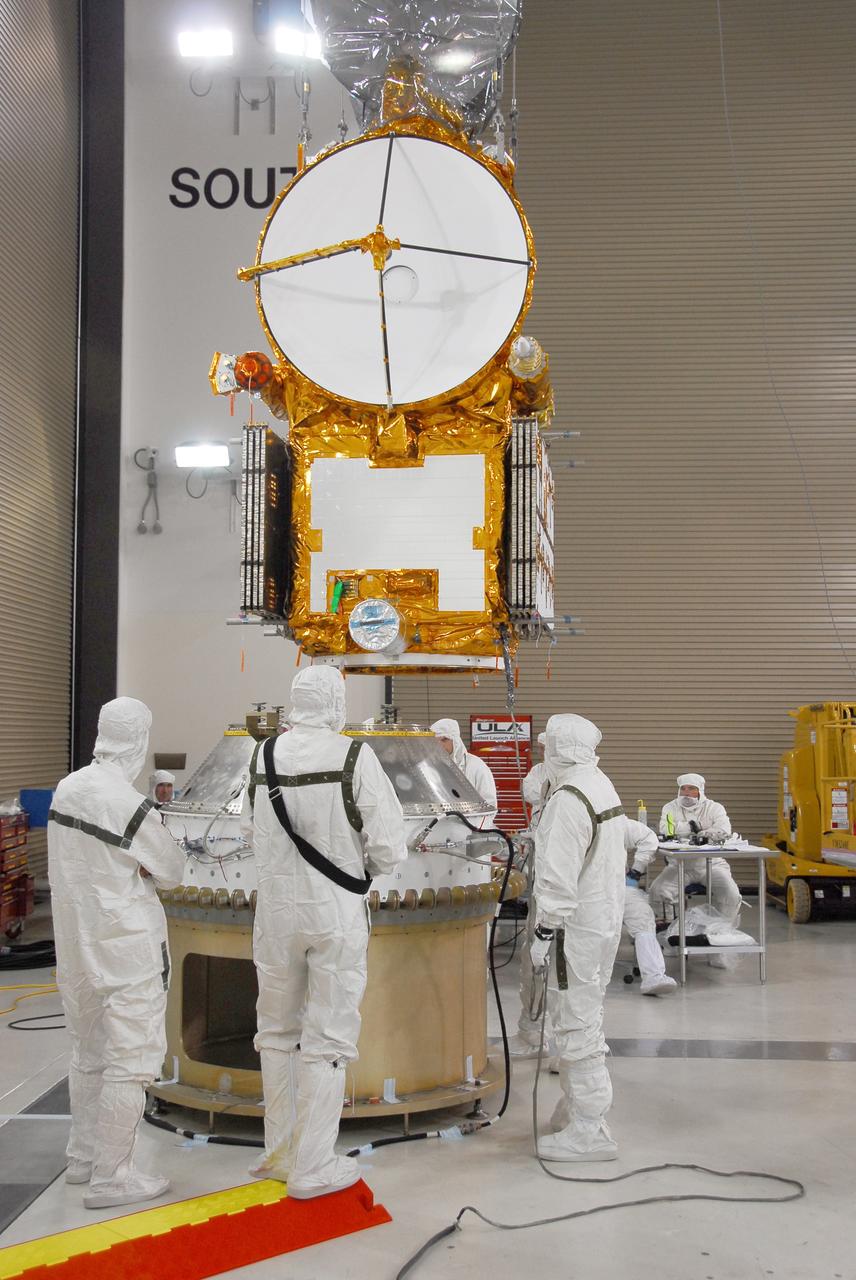
VANDENBERG AIR FORCE BASE, Calif. – Engineers check the progress of the Ocean Surface Topography Mission, or OSTM/Jason 2, spacecraft as it moves toward the payload attach fitting, or PAF, for installation. The PAF is the interface with the Delta II launch vehicle. The launch of the OSTM/Jason 2 aboard a Delta II rocket is scheduled for Friday, June 20, from Vandenberg Air Force Base in California. The launch window extends from 12:46 a.m. to 12:55 a.m. PDT. The satellite will be placed in an 830-mile-high orbit at an inclination of 66 degrees after separating from the Delta II 55 minutes after liftoff. The five primary science instruments of the Ocean Surface Topography Mission aboard the Jason 2 spacecraft are dedicated to measuring ocean surface height. These measurements will be used to evaluate and forecast climate changes and improve weather forecasting. The results also are expected to help forecasters better predict hurricane intensity. Photo credit: NASA
VANDENBERG AIR FORCE BASE, Calif. – Engineers check the fit of the Ocean Surface Topography Mission, or OSTM/Jason 2, spacecraft as it is lowered onto the payload attach fitting, or PAF, for installation. The PAF is the interface with the Delta II launch vehicle. The launch of the OSTM/Jason 2 aboard a Delta II rocket is scheduled for Friday, June 20, from Vandenberg Air Force Base in California. The launch window extends from 12:46 a.m. to 12:55 a.m. PDT. The satellite will be placed in an 830-mile-high orbit at an inclination of 66 degrees after separating from the Delta II 55 minutes after liftoff. The five primary science instruments of the Ocean Surface Topography Mission aboard the Jason 2 spacecraft are dedicated to measuring ocean surface height. These measurements will be used to evaluate and forecast climate changes and improve weather forecasting. The results also are expected to help forecasters better predict hurricane intensity. Photo credit: NASA
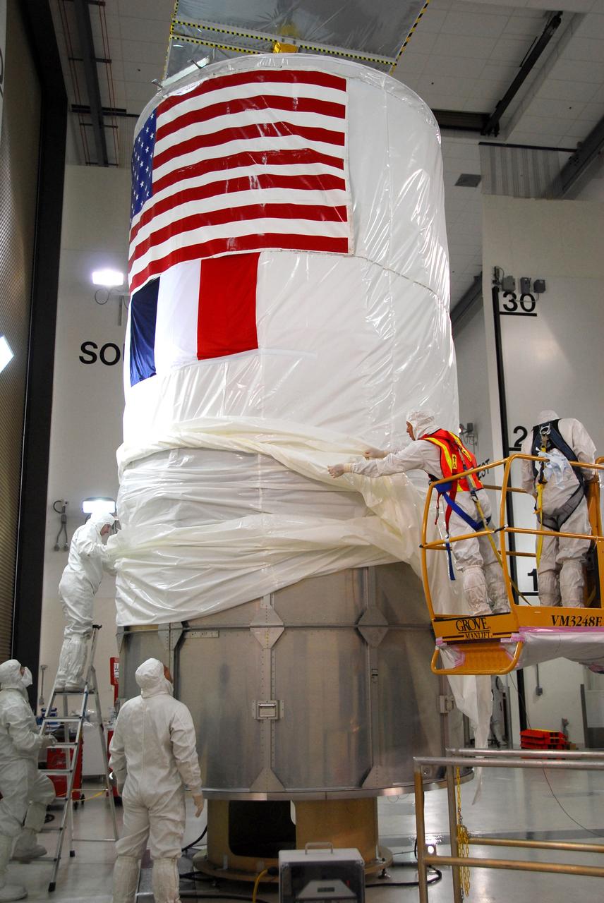
VANDENBERG AIR FORCE BASE, Calif. – Workers pull the protective cover from the upper canister over the lower segments surrounding the Ocean Surface Topography Mission, or OSTM/Jason 2, spacecraft. The OSTM/Jason 2 will be transported to the launch pad. The launch of the OSTM/Jason 2 aboard a Delta II rocket is scheduled for Friday, June 20, from Vandenberg Air Force Base in California. The launch window extends from 12:46 a.m. to 12:55 a.m. PDT. The satellite will be placed in an 830-mile-high orbit at an inclination of 66 degrees after separating from the Delta II 55 minutes after liftoff. The five primary science instruments of the Ocean Surface Topography Mission aboard the Jason 2 spacecraft are dedicated to measuring ocean surface height. These measurements will be used to evaluate and forecast climate changes and improve weather forecasting. The results also are expected to help forecasters better predict hurricane intensity. Photo credit: NASA/Dan Liberotti
KENNEDY SPACE CENTER, FLA. - Equipment in areas of the Launch Control Center at NASA's Kennedy Space Center are wrapped in protective covers for the arrival of Tropical Storm Ernesto in Central Florida. The storm is forecast to be bringing 58-mph to 70-mph winds in the next 24 hours. Photo credit: NASA/George Shelton
VANDENBERG AFB, CALIF. -- An artist's rendering of the NOAA-M spacecraft, a polar-orbiting Earth environmental observation satellite that will provide global data to NOAA's short- and long-range weather forecasting systems. Launch of the NOAA-M aboard a Titan II rocket is scheduled for June 24, 2002, from VAFB
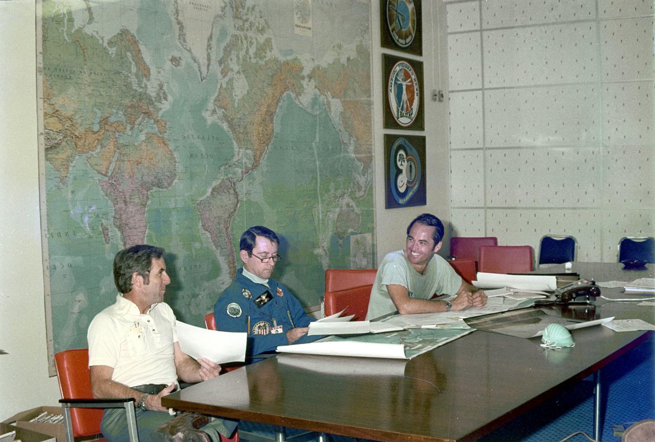
KENNEDY SPACE CENTER, FLA. - Space Shuttle prime crew members Robert Crippen, left, pilot, and John Young, center, commander, along with backup crewman Richard Truly, study forecasts of weather conditions for launch of the maiden flight of STS-1, America’s first reusable space transportation system.
KENNEDY SPACE CENTER, FLA. - Equipment in areas of the Launch Control Center at NASA's Kennedy Space Center are wrapped in protective covers for the arrival of Tropical Storm Ernesto in Central Florida. The storm is forecast to be bringing 58-mph to 70-mph winds in the next 24 hours. Photo credit: NASA/George Shelton

A.J. Sandora, Lockheed Martin's GOES-R Series Mechanical Operations Assembly, Test and Launch Operations (ATLO) manager, speaks to members of social media in the Kennedy Space Center’s Press Site auditorium. The briefing focused on the National Oceanic and Atmospheric Administration's, or NOAA's, Geostationary Operational Environmental Satellite, or GOES-S. Built by Lockheed Martin Space Systems of Littleton, Colorado, the spacecraft is the second satellite in a series of next-generation NOAA weather satellites. It will launch to a geostationary position over the U.S. to provide images of storms and help predict weather forecasts, severe weather outlooks, watches, warnings, lightning conditions and longer-term forecasting. GOES-S is slated to lift off at 5:02 p.m. EST on March 1, 2018 aboard a United Launch Alliance Atlas V rocket.
Pam Sullivan, NASA's GOES-R flight director, left, and A.J. Sandora, Lockheed Martin's GOES-R Series Mechanical Operations Assembly, Test and Launch Operations (ATLO) manager, speak to members of social media in the Kennedy Space Center’s Press Site auditorium. The briefing focused on the National Oceanic and Atmospheric Administration's, or NOAA's, Geostationary Operational Environmental Satellite, or GOES-S. The spacecraft is the second satellite in a series of next-generation NOAA weather satellites. It will launch to a geostationary position over the U.S. to provide images of storms and help predict weather forecasts, severe weather outlooks, watches, warnings, lightning conditions and longer-term forecasting. GOES-S is slated to lift off at 5:02 p.m. EST on March 1, 2018 aboard a United Launch Alliance Atlas V rocket.
In the Kennedy Space Center's Press Site auditorium, Jim Roberts, a scientist with the Earth System Research Laboratory's Office of Atmospheric Research for NOAA, left, and Kristin Calhoun, a research scientist with NOAA's National Severe Storms Laboratory, speak to members of the media at a mission briefing on National Oceanic and Atmospheric Administration's, or NOAA's, Geostationary Operational Environmental Satellite, or GOES-S. The spacecraft is the second satellite in a series of next-generation NOAA weather satellites. It will launch to a geostationary position over the U.S. to provide images of storms and help predict weather forecasts, severe weather outlooks, watches, warnings, lightning conditions and longer-term forecasting. GOES-S is slated to lift off at 5:02 p.m. EST on March 1, 2018 aboard a United Launch Alliance Atlas V rocket.
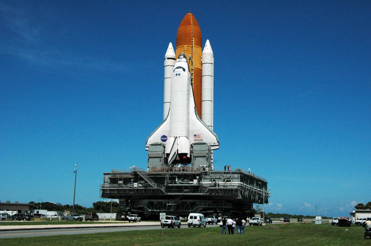
KENNEDY SPACE CENTER, FLA. - On the crawlerway, Space Shuttle Atlantis reverses direction and begins rolling back out to Launch Pad 39B. It had been moved off the launch pad due to concerns about the impact of Tropical Storm Ernesto, expected within 24 hours. The forecast of lesser winds expected from Ernesto and its projected direction convinced Launch Integration Manager LeRoy Cain and Shuttle Launch Director Mike Leinbach to return the shuttle to the launch pad. Photo credit: NASA/Ken Thornsley
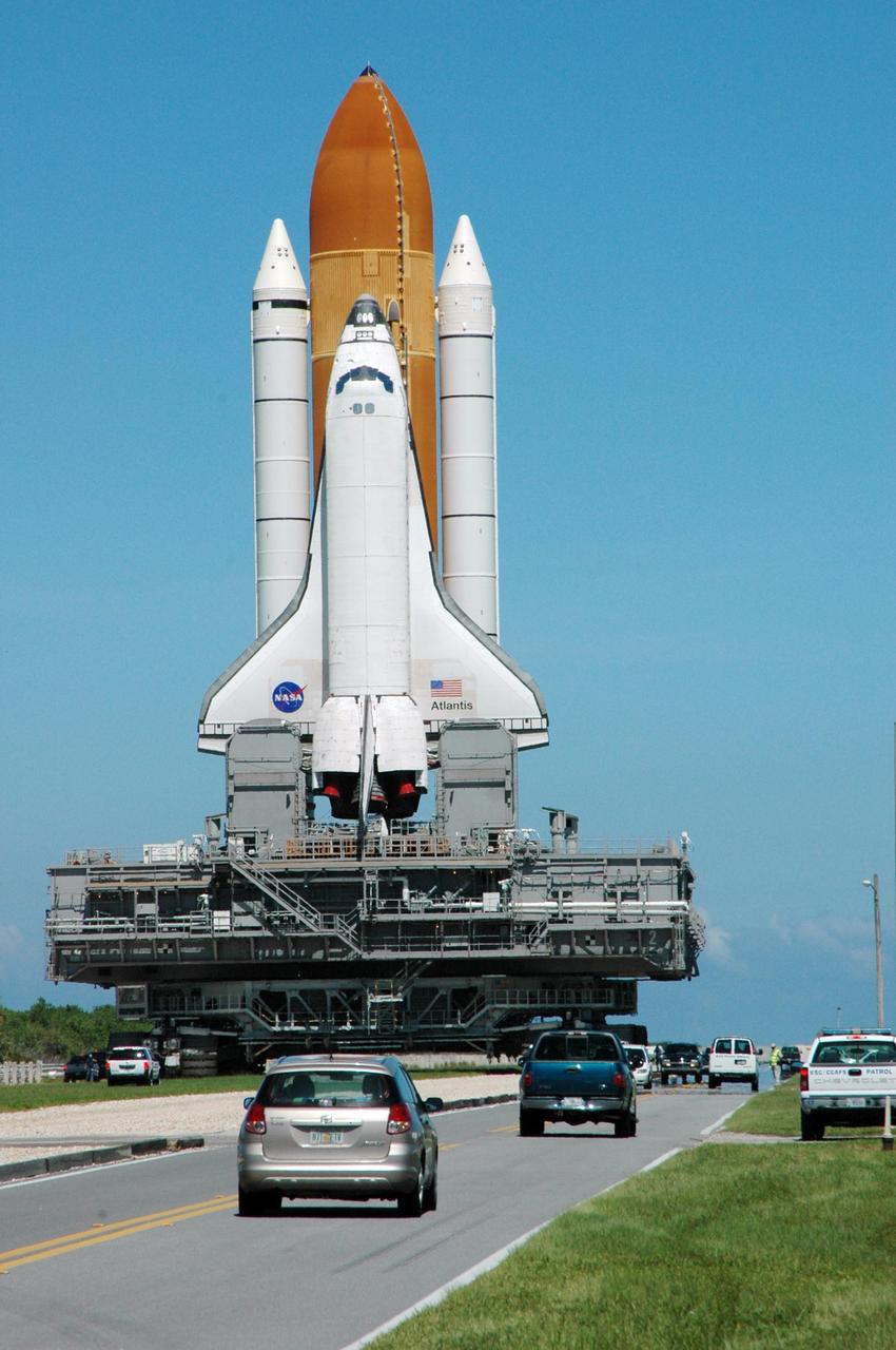
KENNEDY SPACE CENTER, FLA. - Space Shuttle Atlantis reverses direction and begins rolling back out to Launch Pad 39B. It had been moved off the launch pad due to concerns about the impact of Tropical Storm Ernesto, expected within 24 hours. The forecast of lesser winds expected from Ernesto and its projected direction convinced Launch Integration Manager LeRoy Cain and Shuttle Launch Director Mike Leinbach to return the shuttle to the launch pad Photo credit: NASA/Ken Thornsley
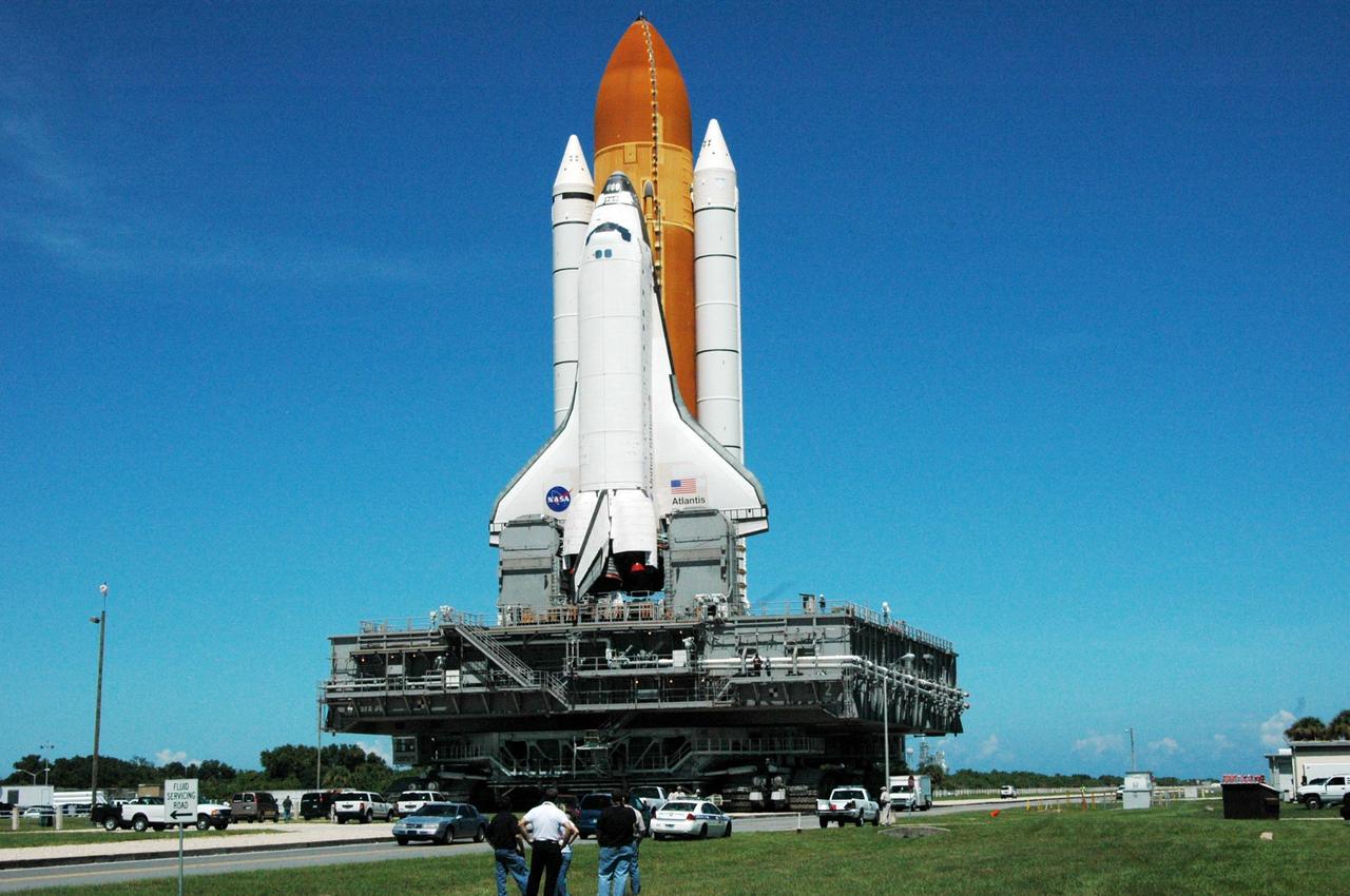
KENNEDY SPACE CENTER, FLA. - Space Shuttle Atlantis reverses direction and begins rolling back out to Launch Pad 39B. It had been moved off the launch pad due to concerns about the impact of Tropical Storm Ernesto, expected within 24 hours. The forecast of lesser winds expected from Ernesto and its projected direction convinced Launch Integration Manager LeRoy Cain and Shuttle Launch Director Mike Leinbach to return the shuttle to the launch pad. Photo credit: NASA/Ken Thornsley
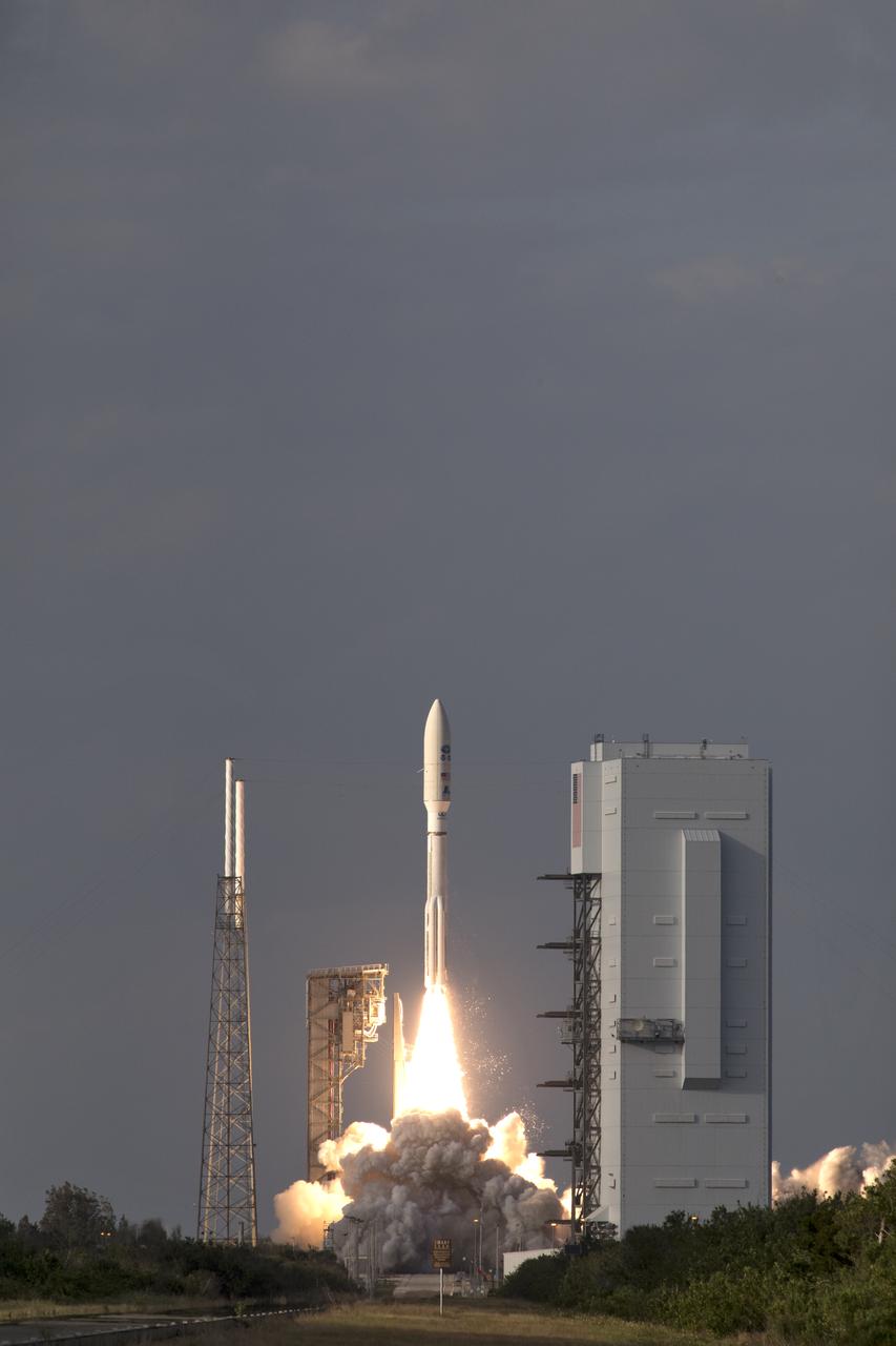
The United Launch Alliance Delta IV Heavy rocket launches NASA's Parker Solar Probe to touch the Sun, Sunday, Aug. 12, 2018 from Launch Complex 37 at Cape Canaveral Air Force Station, Florida. Parker Solar Probe is humanity’s first-ever mission into a part of the Sun’s atmosphere called the corona. Here it will directly explore solar processes that are key to understanding and forecasting space weather events that can impact life on Earth. Photo Credit: (NASA/Bill Ingalls)
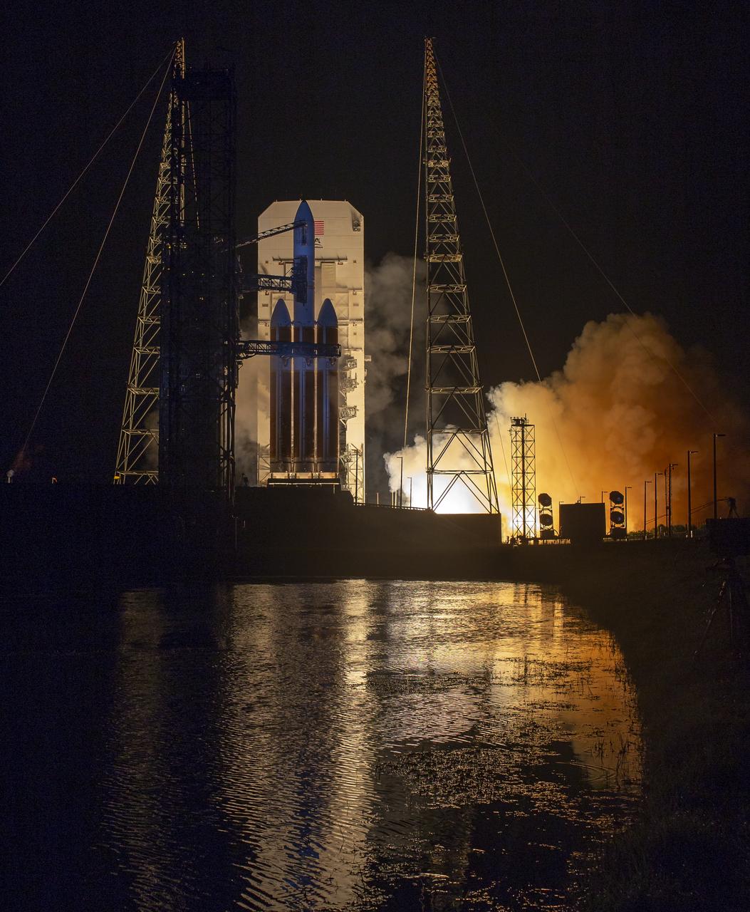
The United Launch Alliance Delta IV Heavy rocket launches NASA's Parker Solar Probe to touch the Sun, Sunday, Aug. 12, 2018 from Launch Complex 37 at Cape Canaveral Air Force Station, Florida. Parker Solar Probe is humanity’s first-ever mission into a part of the Sun’s atmosphere called the corona. Here it will directly explore solar processes that are key to understanding and forecasting space weather events that can impact life on Earth. Photo Credit: (NASA/Bill Ingalls)
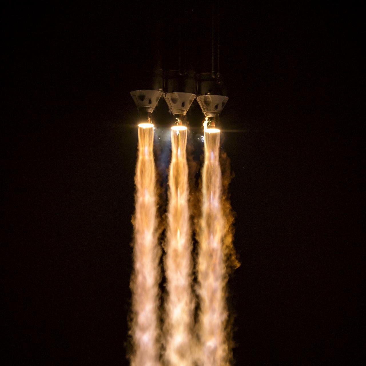
The United Launch Alliance Delta IV Heavy rocket launches NASA's Parker Solar Probe to touch the Sun, Sunday, Aug. 12, 2018 from Launch Complex 37 at Cape Canaveral Air Force Station, Florida. Parker Solar Probe is humanity’s first-ever mission into a part of the Sun’s atmosphere called the corona. Here it will directly explore solar processes that are key to understanding and forecasting space weather events that can impact life on Earth. Photo Credit: (NASA/Bill Ingalls)

Will Ulrich, launch weather officer with the U.S. Air Force 45th Space Wing, discusses the liftoff weather forecast during the prelaunch news conference for SpaceX’s 18th Commercial Resupply Services (CRS-18) mission to the International Space Station, July 24, 2019, at NASA’s Kennedy Space Center in Florida. The SpaceX Falcon 9 rocket and uncrewed Dragon spacecraft are scheduled to launch July 24, 2019, from Space Launch Complex 40 at Florida’s Cape Canaveral Air Force Station.

A truck with a specialized transporter drives out of the cargo hold of an Air Force C-5 Galaxy transport plane at the Shuttle Landing Facility at NASA's Kennedy Space Center in Florida to deliver the GOES-R spacecraft for launch processing. The GOES series are weather satellites operated by NOAA to enhance forecasts. The spacecraft is to launch aboard a United Launch Alliance Atlas V rocket in November.
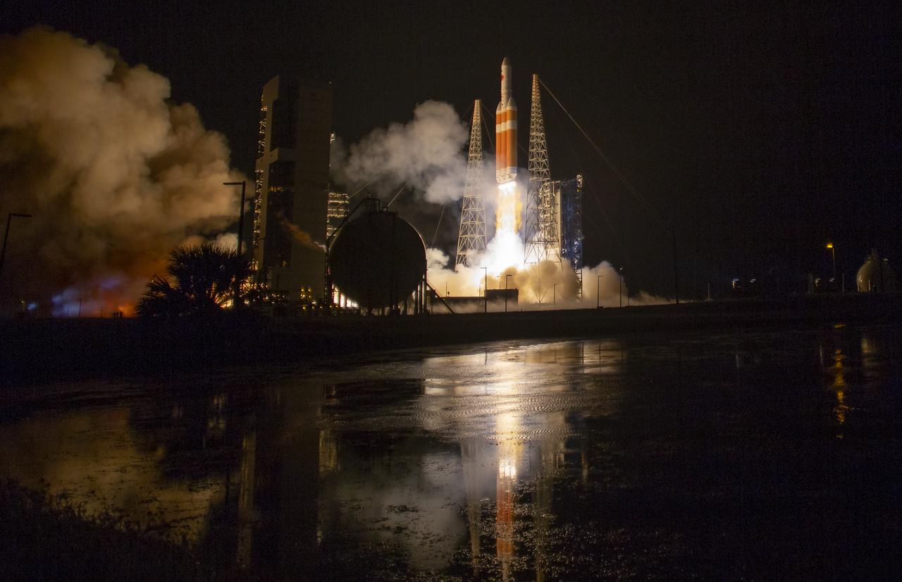
The United Launch Alliance Delta IV Heavy rocket launches NASA's Parker Solar Probe to touch the Sun, Sunday, Aug. 12, 2018 from Launch Complex 37 at Cape Canaveral Air Force Station, Florida. Parker Solar Probe is humanity’s first-ever mission into a part of the Sun’s atmosphere called the corona. Here it will directly explore solar processes that are key to understanding and forecasting space weather events that can impact life on Earth. Photo Credit: (NASA/Bill Ingalls)