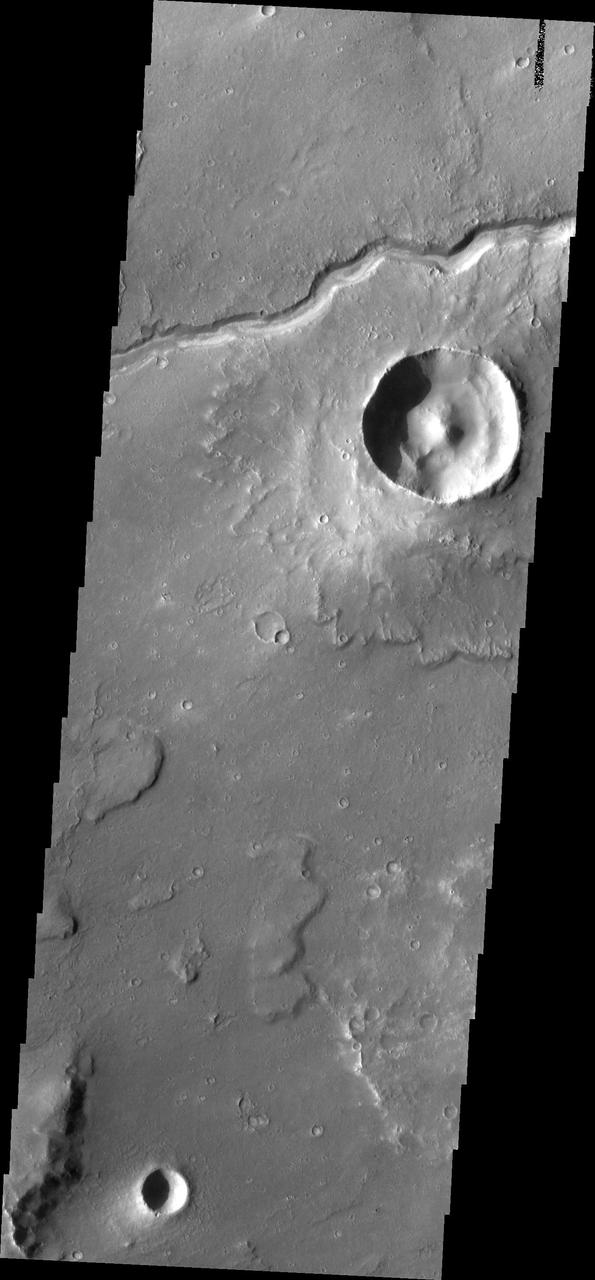
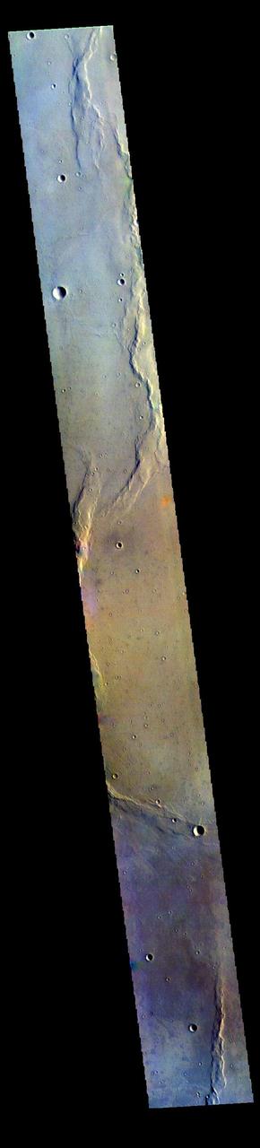
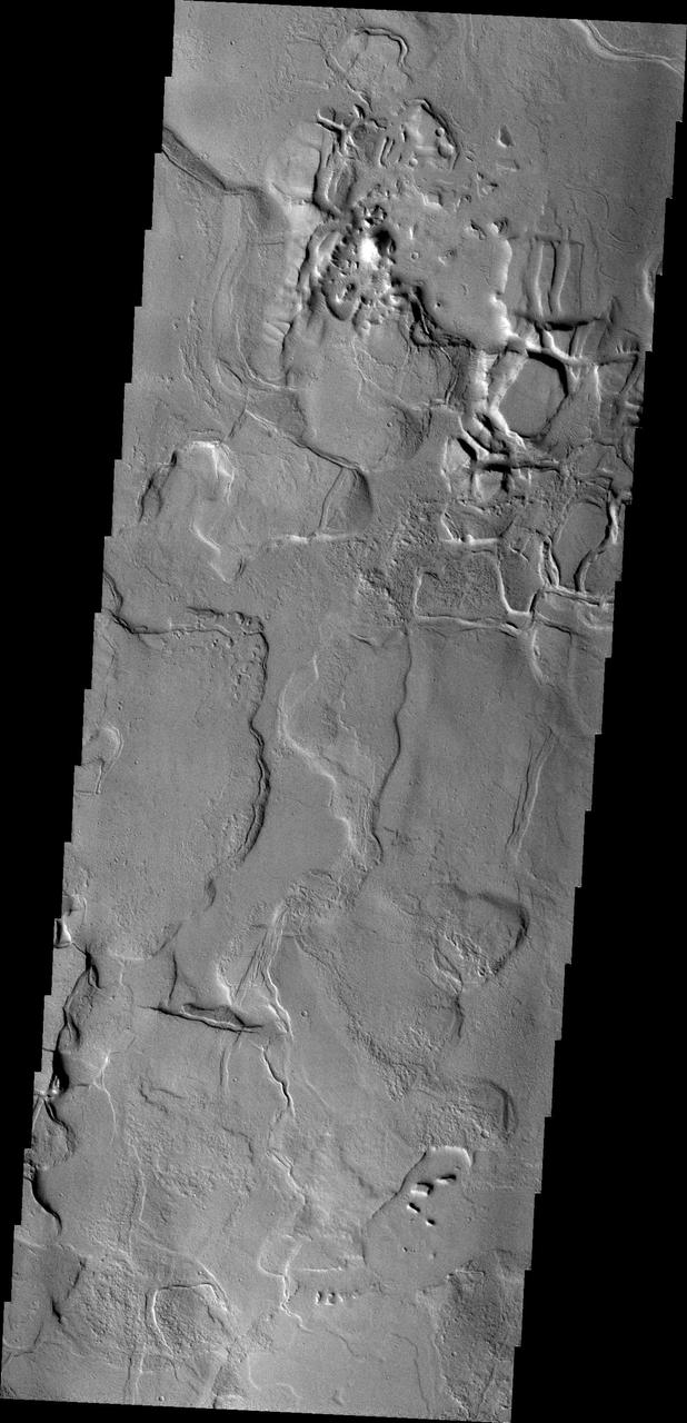
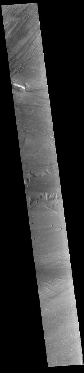
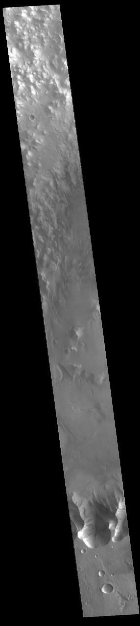
Lunae Planum
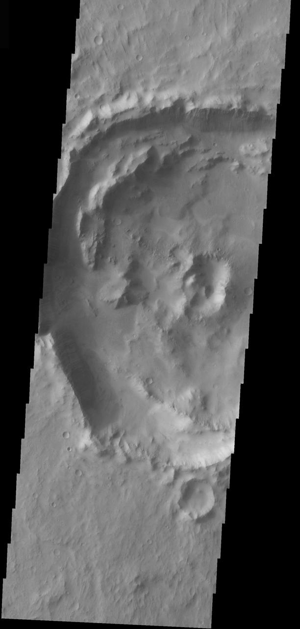
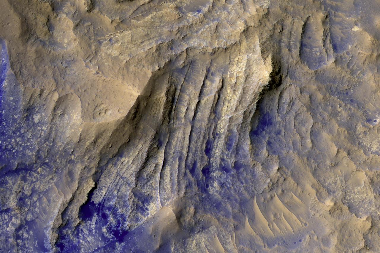
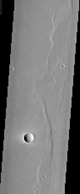
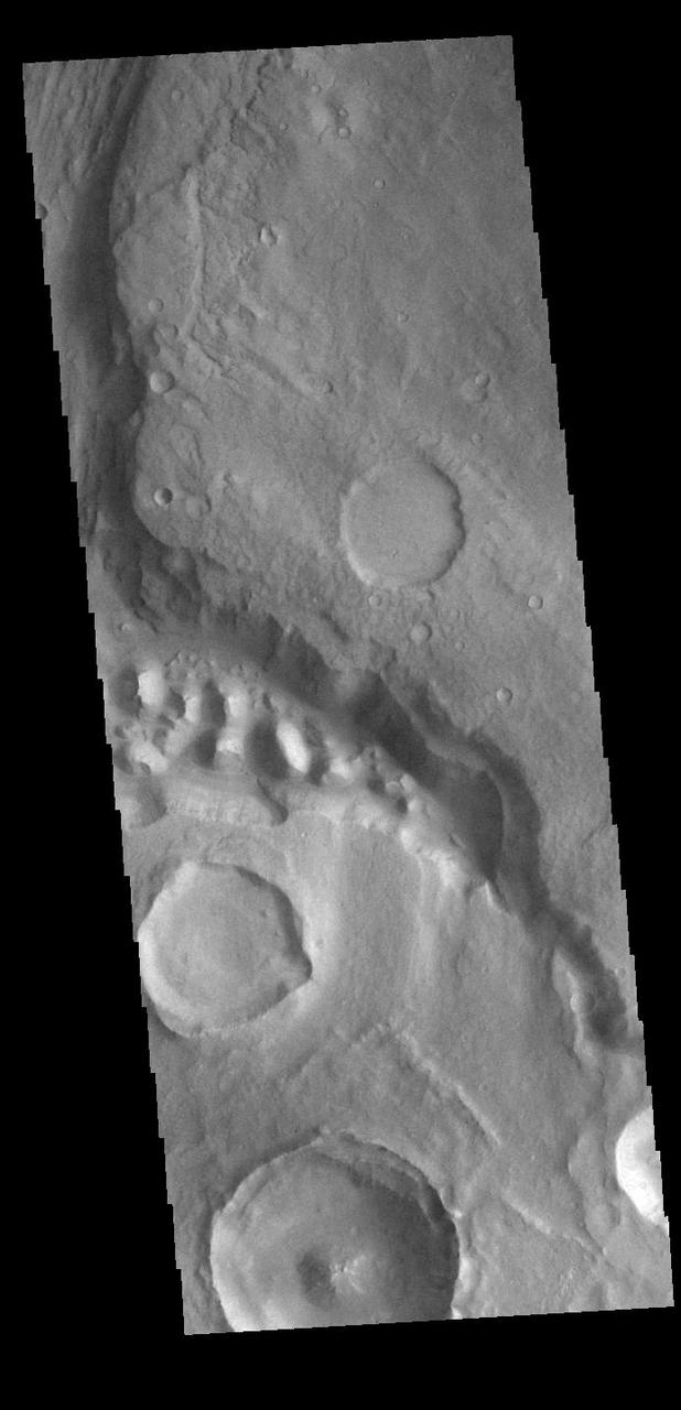
Central Peak Crater in Lunae Planum
Luna 16 was the first robotic mission to land on the Moon on basaltic plains of Mare Fecunditatis and return a sample to the Earth. It was launched by the Soviet Union on 12 September 1970. This image was taken by NASA Lunar Reconnaissance Orbiter.
This image by NASA Mars Odyssey spacecraft is within a region called Lunae Planum, west of NASA Viking 1 landing site, that marks the transition between the Tharsis rise, a giant volcanic complex, and the northern lowland plains.
Luna 21 lander delivered the Lunokhod 2 rover to the floor of Le Monnier crater in January 1973. This image taken by NASA Lunar Reconnaissance Orbiter also shows the rover tracks.
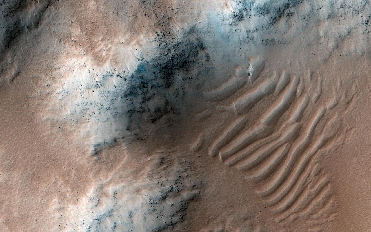
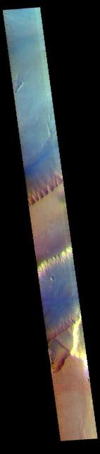
The THEMIS VIS camera contains 5 filters. The data from different filters can be combined in multiple ways to create a false color image. These false color images may reveal subtle variations of the surface not easily identified in a single band image. Today's false color image shows part of Lunae Planum. The THEMIS VIS camera is capable of capturing color images of the Martian surface using five different color filters. In this mode of operation, the spatial resolution and coverage of the image must be reduced to accommodate the additional data volume produced from using multiple filters. To make a color image, three of the five filter images (each in grayscale) are selected. Each is contrast enhanced and then converted to a red, green, or blue intensity image. These three images are then combined to produce a full color, single image. Because the THEMIS color filters don't span the full range of colors seen by the human eye, a color THEMIS image does not represent true color. Also, because each single-filter image is contrast enhanced before inclusion in the three-color image, the apparent color variation of the scene is exaggerated. Nevertheless, the color variation that does appear is representative of some change in color, however subtle, in the actual scene. Note that the long edges of THEMIS color images typically contain color artifacts that do not represent surface variation. Orbit Number: 95001 Latitude: 18.596 Longitude: 295.651 Instrument: VIS Captured: 2023-05-15 16:32 https://photojournal.jpl.nasa.gov/catalog/PIA26137
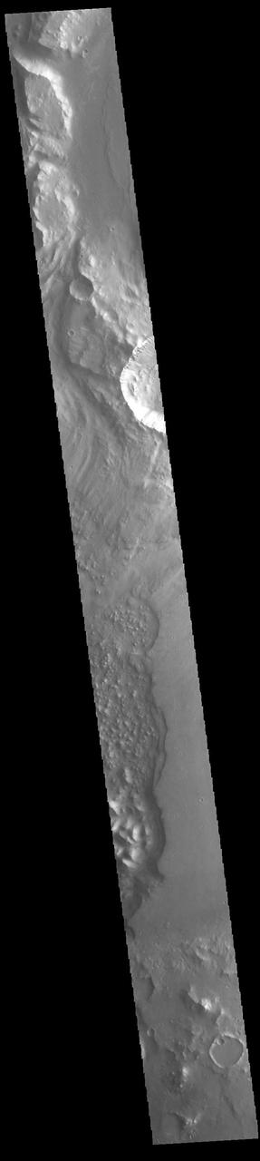
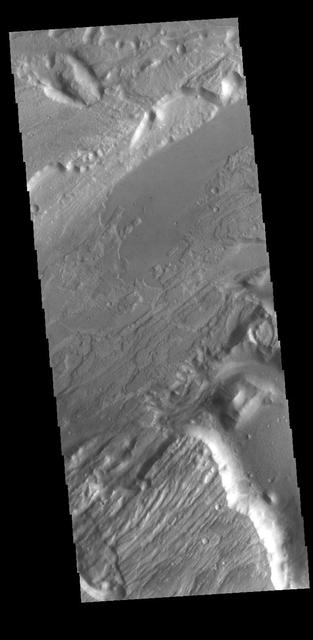
The layered bedrock in this image was brought from several kilometers of depth during the formation of this 44 kilometer wide crater in the volcanic plains of Lunae Planum. As these layers were exhumed and brought to nearly vertical orientations, faulting and fracturing occurred and breccia dikes formed. Breccias are rocks consisting of angular and sharp fragments, and a dike is a fracture that has been widened by forces pulling apart the rock while simultaneously filling it with rocky materials. Breccia dikes are a common feature in terrestrial craters and can now be recognized in brilliant preservation on Mars. http://photojournal.jpl.nasa.gov/catalog/PIA12178

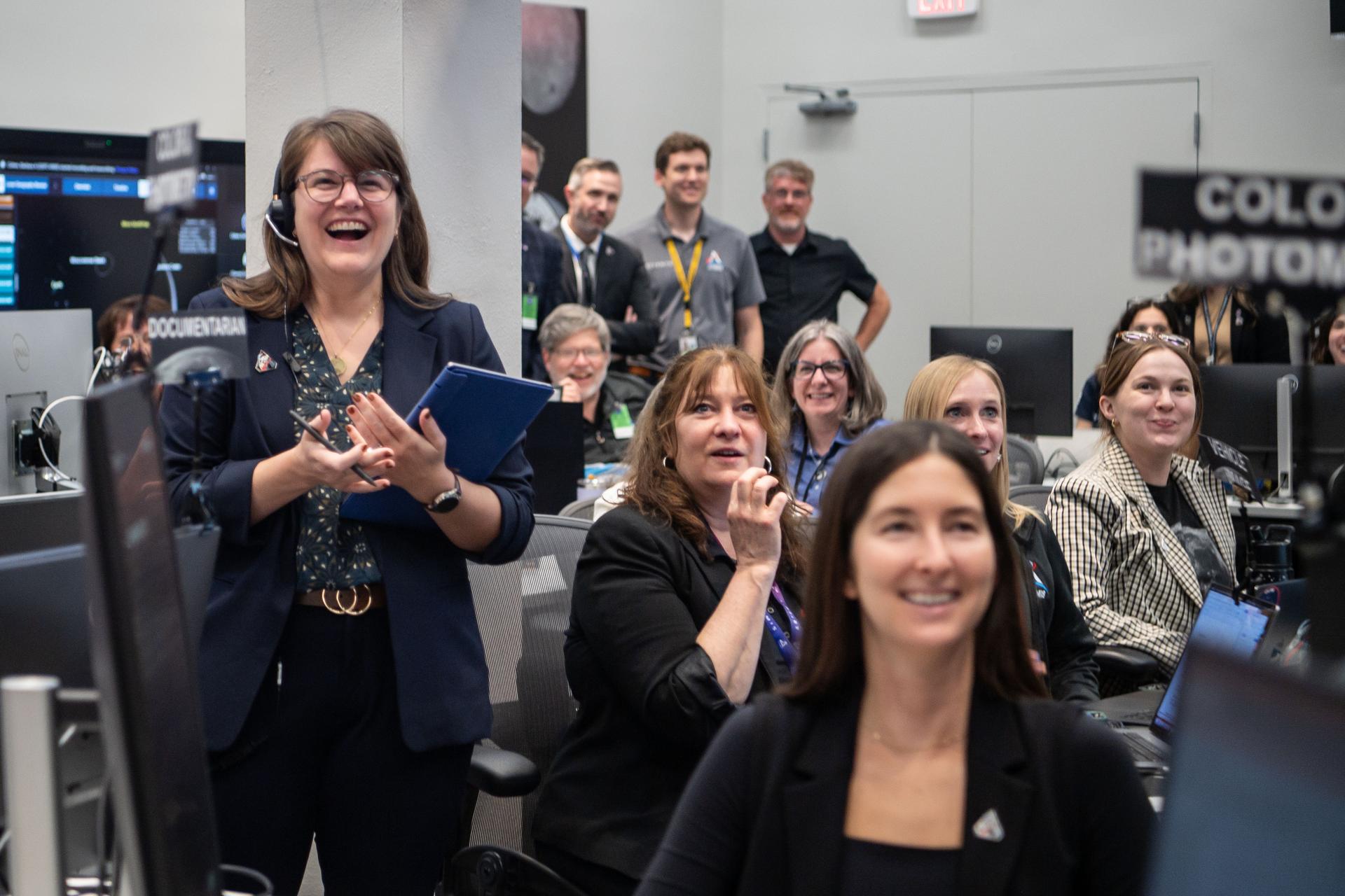
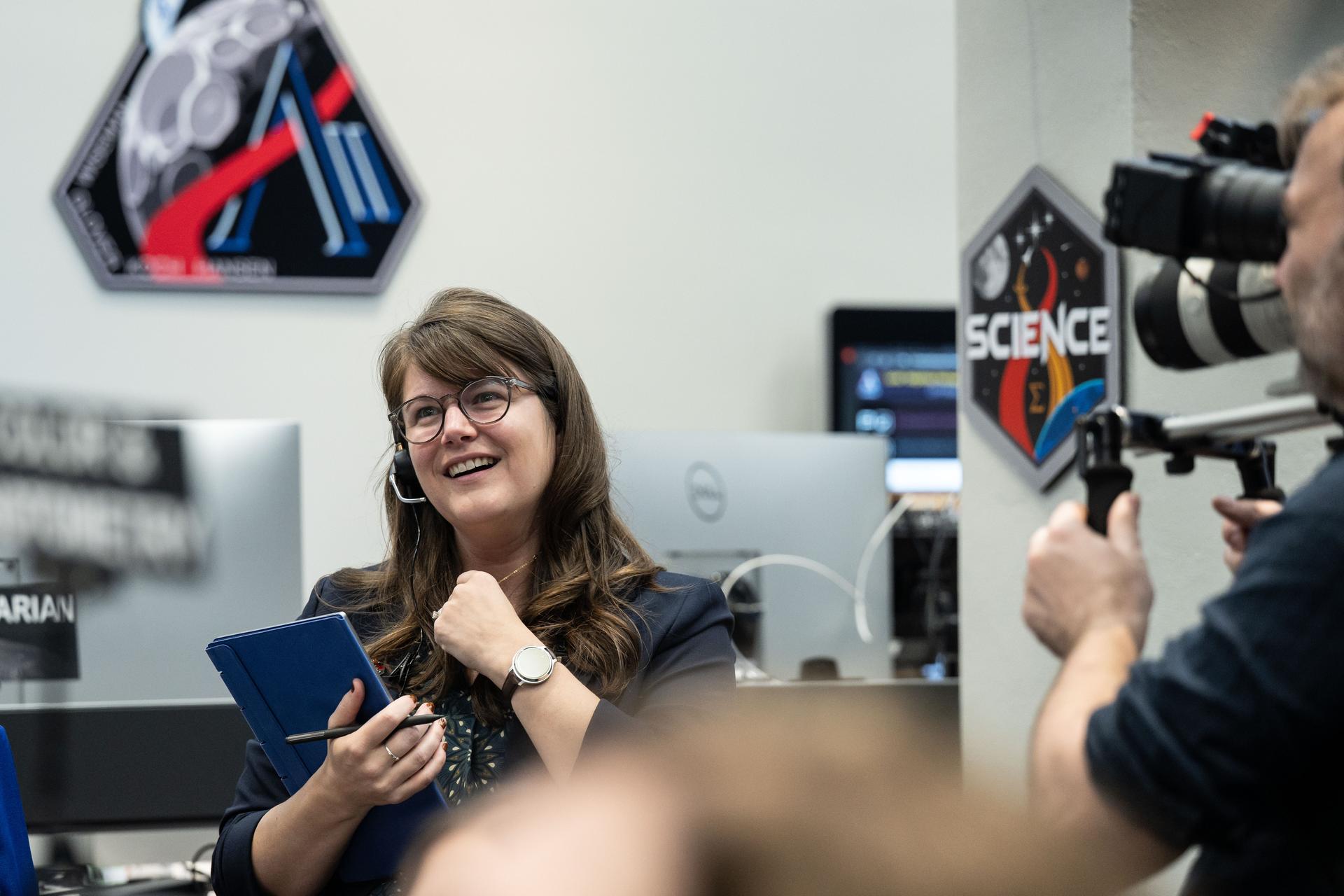
Sarah Luna, executive officer for NASA’s Exploration Systems Development Mission Directorate speaks at the Moon to Mars Architecture Workshop, Wednesday, Jan. 21, 2026, at the National Academy of Sciences in Washington. NASA held the workshop to engage the broader space community and collect feedback from U.S. industry and academia and international partners to inform NASA's Moon to Mars Architecture, the agency's roadmap for human exploration of the Moon and Mars. Photo Credit: (NASA/Joel Kowsky)
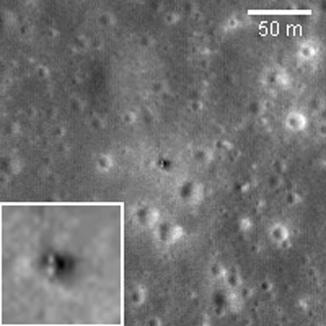
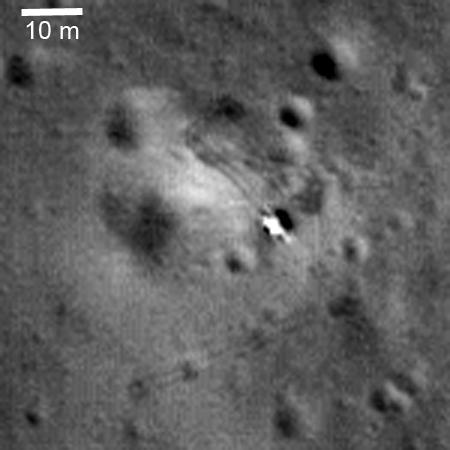
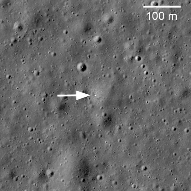
On February 21, 1972, Luna 20 soft landed in the rugged highlands between Mare Fecunditatis and Mare Crisium. The Luna 20 descent stage still sits silently on the Moon, clearly visible in this image taken by NASA Lunar Reconnaissance Orbiter.
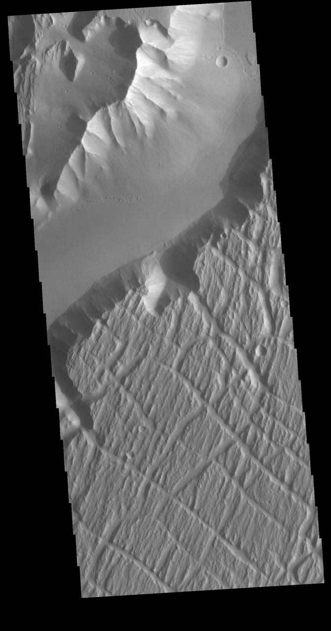
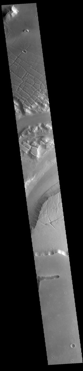
Echus Chaos is a region of low hills located between Lunae Planum (to the right of this image) and Echus Palus (to the left of this image). This chaos terrain may have formed as the rocks that make up Lunae Planum slowly slid downhill into Echus Palus. As these rocks slid downhill, they broke up into large pieces that formed the hills that we see today. What caused this landslide is not well known, but it could have been due to large floods of water moving through Echus Palus, causing the edge of Lunae Planum to become soaked and fall apart. Ground shaking from movement along nearby faults or meteorite impacts may have also helped to make the edge of Lunae Planum unstable and collapse. https://photojournal.jpl.nasa.gov/catalog/PIA25556
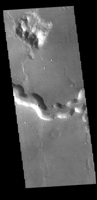
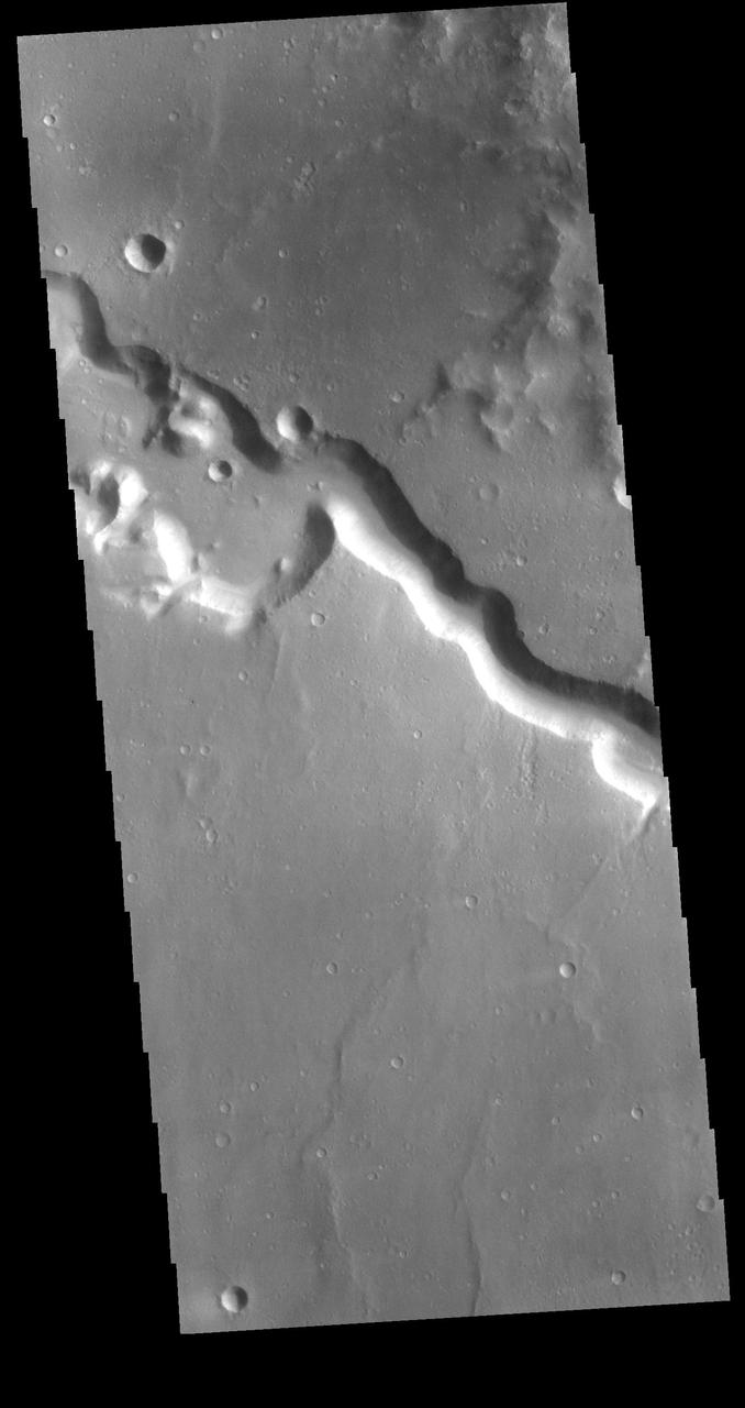
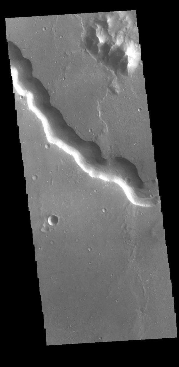
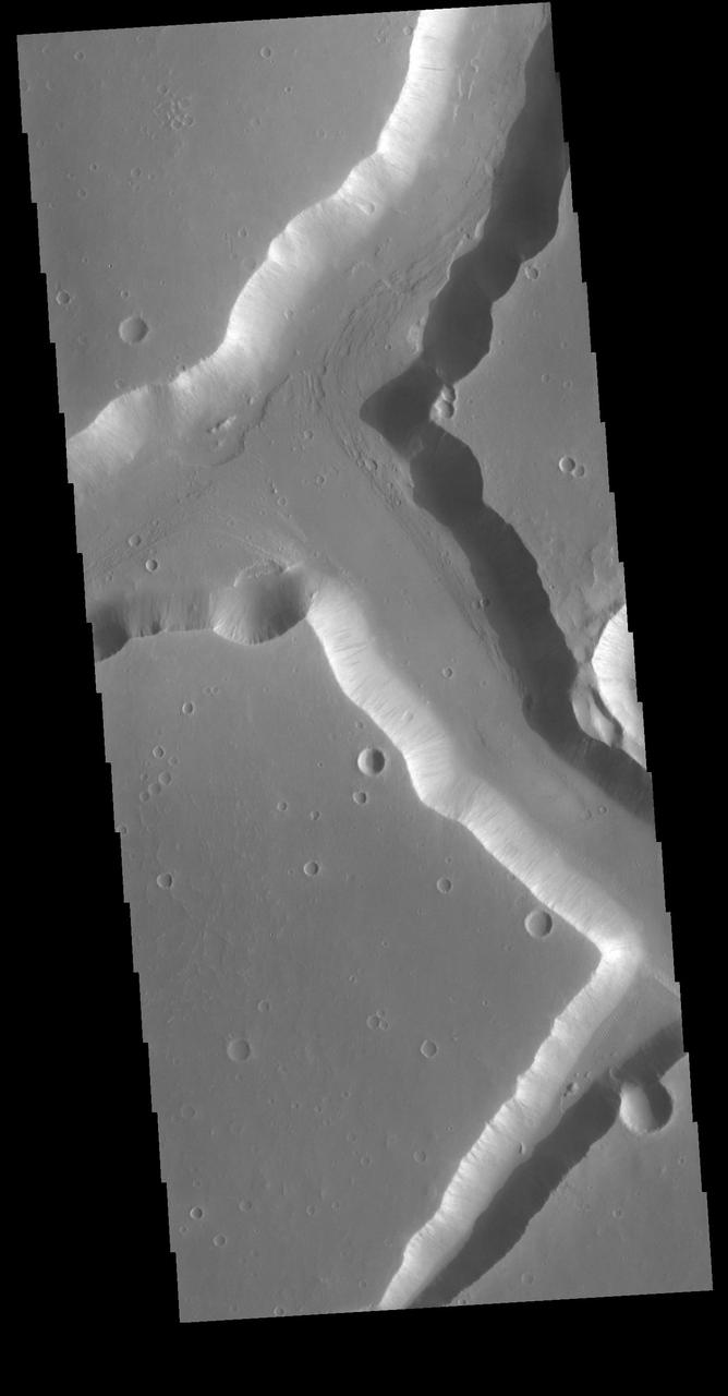
Today's VIS image shows a section of Bahram Vallis. This channel is located in northern Lunae Planum, south of Kasei Valles. Bharam Vallis drains from the higher elevations of Lunae Planum towards the Chryse Planitia basin. This channel is over 300km long (186miles). Orbit Number: 88175 Latitude: 20.6178 Longitude: 302.162 Instrument: VIS Captured: 2021-10-30 15:19 https://photojournal.jpl.nasa.gov/catalog/PIA25156
Today's VIS image shows a section of Bahram Vallis. This channel is located in northern Lunae Planum, south of Kasei Valles. Bharam Vallis drains from the higher elevations of Lunae Planum towards the Chryse Planitia basin. This channel is over 300km (186 miles) long. Orbit Number: 94564 Latitude: 20.5977 Longitude: 302.359 Instrument: VIS Captured: 2023-04-09 17:00 https://photojournal.jpl.nasa.gov/catalog/PIA26036
Today's VIS image shows a section of Bahram Vallis. This channel is located in northern Lunae Planum, south of Kasei Valles. Bharam Vallis drains from the higher elevations of Lunae Planum towards the Chryse Planitia basin. This channel is over 300km long (186miles). Orbit Number: 87576 Latitude: 20.3115 Longitude: 302.882 Instrument: VIS Captured: 2021-09-11 07:37 https://photojournal.jpl.nasa.gov/catalog/PIA25224
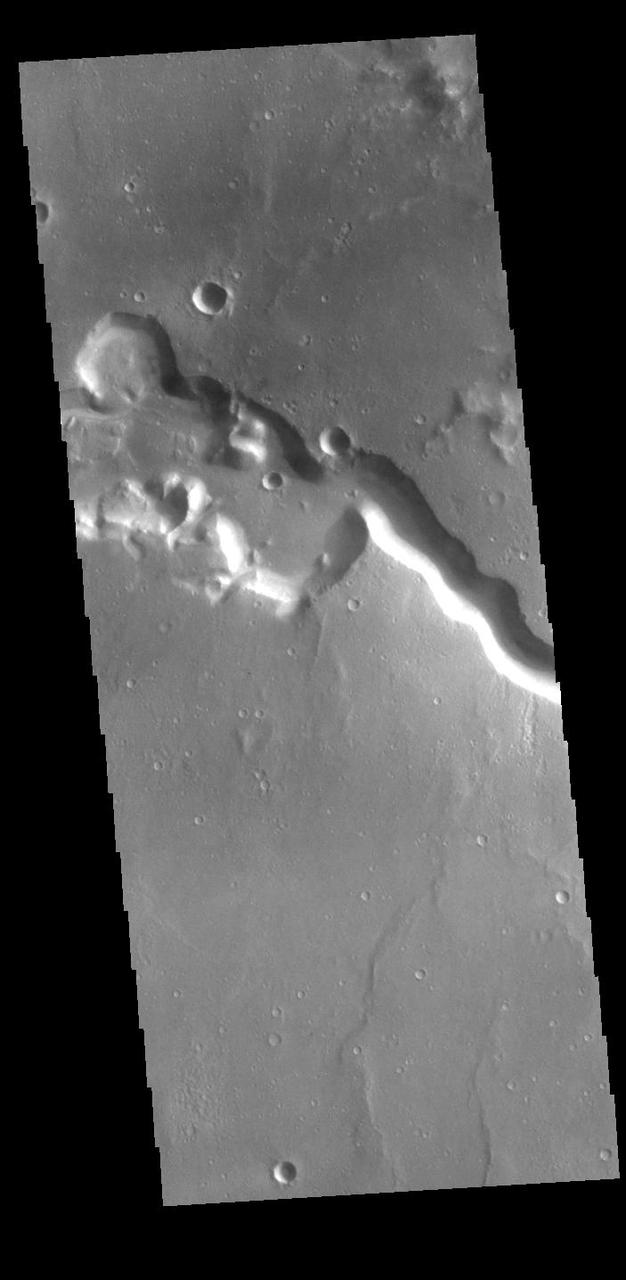
Today's VIS image shows a section of Bahram Vallis. This channel is located in northern Lunae Planum, south of Kasei Valles. Bharam Vallis drains from the higher elevations of Lunae Planum towards the Chryse Planitia basin. This channel is over 300km long (186miles). Orbit Number: 94876 Latitude: 21.1353 Longitude: 301.426 Instrument: VIS Captured: 2023-05-05 09:33 https://photojournal.jpl.nasa.gov/catalog/PIA26211
Today's VIS image shows a section of Bahram Vallis. This channel is located in northern Lunae Planum, south of Kasei Valles. Bharam Vallis drains from the higher elevations of Lunae Planum towards the Chryse Planitia basin. This channel is over 300km long (186miles). Orbit Number: 94826 Latitude: 21.4639 Longitude: 303.82 Instrument: VIS Captured: 2023-05-01 06:44 https://photojournal.jpl.nasa.gov/catalog/PIA26179
Today's VIS image shows a section of Bahram Vallis. This channel is located in northern Lunae Planum, south of Kasei Valles. Bharam Vallis drains from the higher elevations of Lunae Planum towards the Chryse Planitia basin. This channel is over 300km long (186miles). Orbit Number: 93965 Latitude: 20.1543 Longitude: 302.9 Instrument: VIS Captured: 2023-02-19 09:18 https://photojournal.jpl.nasa.gov/catalog/PIA25936
Today's VIS image shows a section of Bahram Vallis. This channel is located in northern Lunae Planum, south of Kasei Valles. Bharam Vallis drains from the higher elevations of Lunae Planum towards the Chryse Planitia basin. This channel is over 300km long (186miles). In this image Bahram Vallis enters Waspam Crater (right side of image) and then exits the crater (top right corner). Orbit Number: 81374 Latitude: 20.3853 Longitude: 303.032 Instrument: VIS Captured: 2020-04-18 15:46 https://photojournal.jpl.nasa.gov/catalog/PIA23956
Echus Chasma separates the Tharsis region from Lunae Planum. This image from NASA 2001 Mars Odyssey shows volcanic flow materials from Tharsis within the chasma.
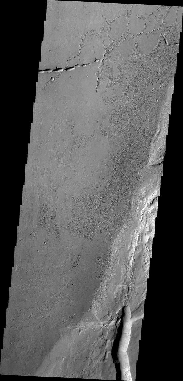
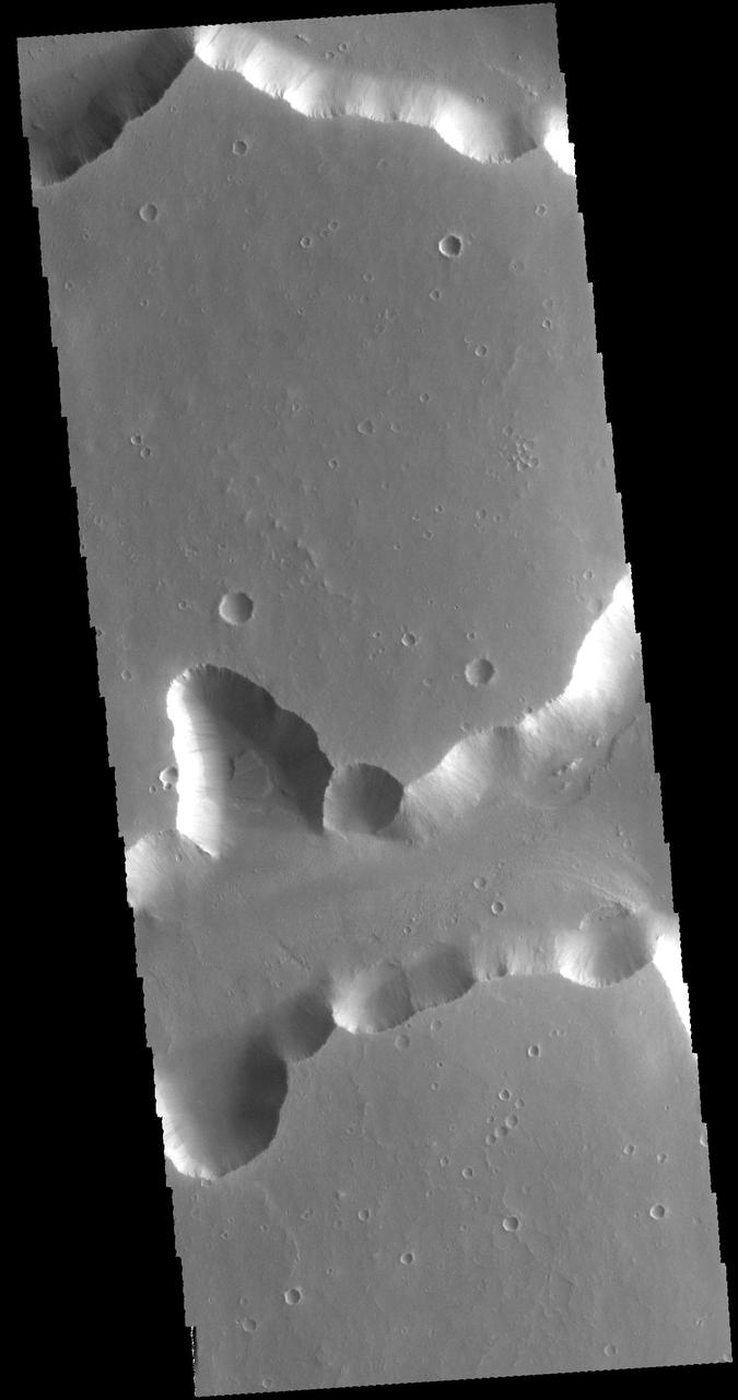
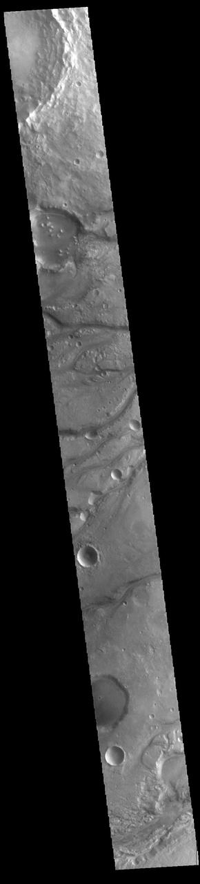
This NASA Mars Odyssey image is of the ridged plains of Lunae Planum in the northern hemisphere of Mars. Wrinkle ridges, a very common landform on Mars, Mercury, Venus, and the Moon, are found mostly along the eastern side of the image.
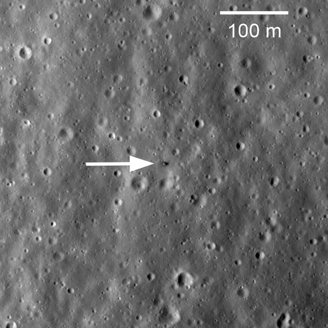
This image taken by NASA Lunar Reconnaissance Orbiter shows Soviet robotic lander Luna 17 still sitting on Mare Imbrium where it delivered the Lunokhod 1 Rover in November 1970.

Echus Chasma forms the boundary between the Tharsis volcanoes to the west and Lunae Planum to the east. This region is both tectonically fractured rocks top and volcanic flows middle and bottom. This image is from NASA 2001 Mars Odyssey spacecraft.
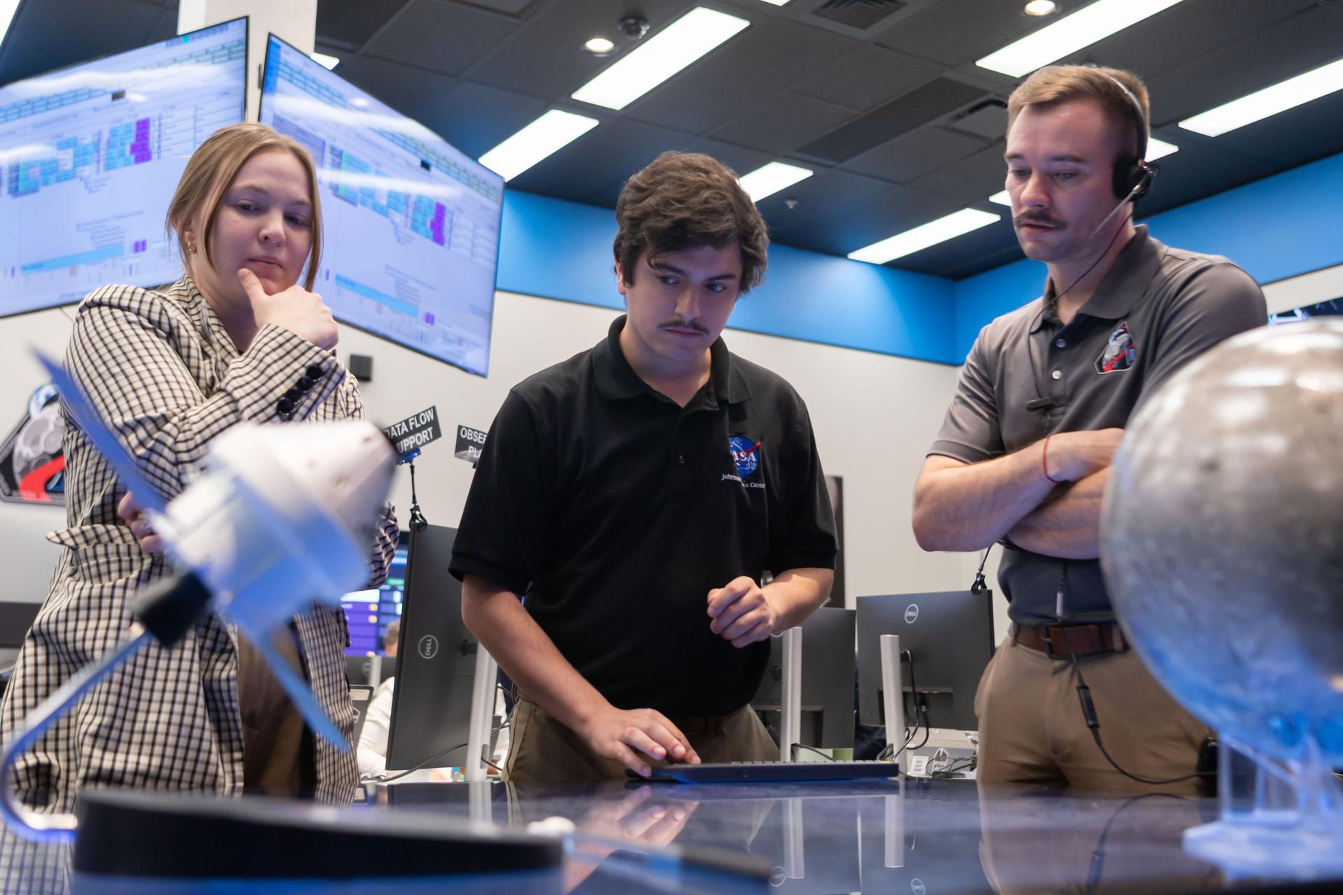
Crew lunar observations team member, Sara Schmidt, left, asset manager, Luke McSherry, and Artemis deputy lunar science lead, Jacob Richardson work in the Science Evaluation Room (SER). Built specifically for Artemis missions with these science priorities in mind, the SER is equipped to support rapid data interpretation, collaborative analysis, real-time decision making, and seamless coordination between the science and operations teams. Credits: NASA/Luna Posadas Nava

Artemis II crew lunar observations team member, David Charney, monitors the mission from the Science Evaluation Room (SER). Built specifically for Artemis missions with these science priorities in mind, the SER is equipped to support rapid data interpretation, collaborative analysis, real-time decision making, and seamless coordination between the science and operations teams. Credits: NASA/Luna Posadas Nava

Science evaluation room communicator, Kiarre Dumes, left, and deputy lunar science lead Marie Henderson work in the Science Evaluation Room (SER) during Artemis II. Built specifically for Artemis missions with these science priorities in mind, the SER is equipped to support rapid data interpretation, collaborative analysis, real-time decision making, and seamless coordination between the science and operations teams. Credits: NASA/Luna Posadas Nava

Artemis II lunar science team members, from left, Barbara Cohen, Jennifer Heldmann, and Anthony Colaprete, work in the Science Evaluation Room (SER). Built specifically for Artemis missions with these science priorities in mind, the SER is equipped to support rapid data interpretation, collaborative analysis, real-time decision making, and seamless coordination between the science and operations teams. Credits: NASA/Luna Posadas Nava

Artemis II lunar science team members, from left, Ryan Ewing, and Barbara Cohen, react to crew observations during the lunar flyby on April 6, 2026. The team worked in the Science Evaluation Room (SER) in Mission Control at NASA’s Johnson Space Center in Houston. Built specifically for Artemis missions with these science priorities in mind, the SER is equipped to support rapid data interpretation, collaborative analysis, real-time decision making, and seamless coordination between the science and operations teams. Credits: NASA/Luna Posadas Nava

Artemis science officer, Angela Garcia, left and lunar science team member, Kiarre Dumes discuss science operations in the Science Evaluation Room (SER) in Mission Control at NASA's Johnson Space Center in Houston. The SER supports lunar science and planetary observations for the Artemis science officer in the mission’s main flight control room. Dumes serves as the SERCOMM, or Science Evaluation Room Communicator, acting as the singular voice from the science team in the back room, reporting to the science officer. Credits: NASA/Luna Posadas Nava

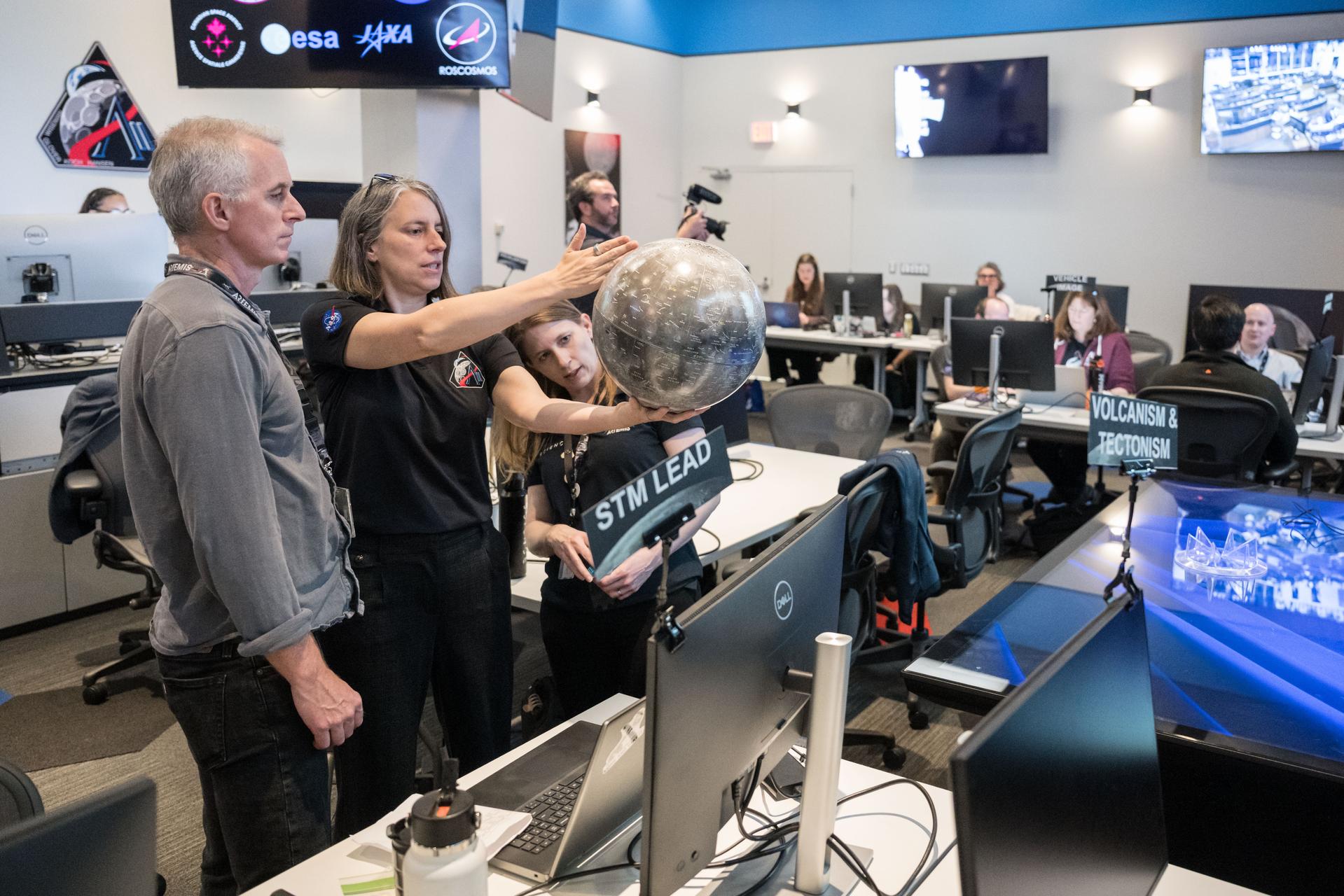
Artemis curation lead, Juliane Gross, holds a lunar globe in the Science Evaluation Room (SER) in Mission Control at Johnson Space Center in Houston. The SER supports lunar science and planetary observations for the Artemis science officer in the mission’s main flight control room. Built specifically for Artemis missions with these science priorities in mind, the SER is equipped to support rapid data interpretation, collaborative analysis, real-time decision making, and seamless coordination between the science and operations teams. Credits: NASA/Luna Posadas Nava
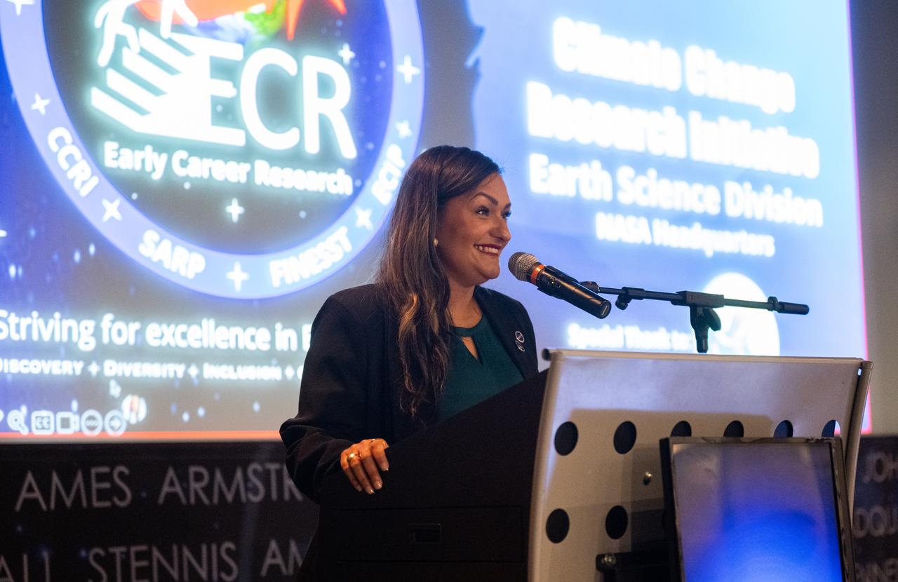
Yaítza Luna-Cruz, a program executive in the Earth Science Division of NASA’s Science Mission Directorate and program manager for the Early Career Research Program, speaks to the Climate Change Research Initiative (CCRI) cohort, Wednesday, Aug. 7, 2024, at the Mary W. Jackson NASA Headquarters building in Washington, DC. The Earth Science Division’s Early Career Research Program’s Climate Change Research Initiative (CCRI) is a year-long STEM engagement and experiential learning opportunity for educators and students from high school to graduate level. Photo Credit: (NASA/Joel Kowsky)
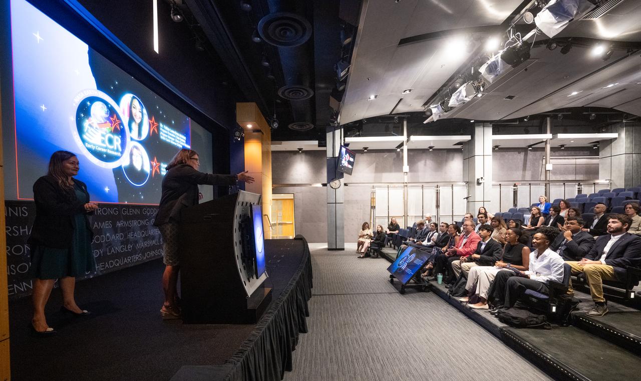
Cynthia Hall, support scientist for the Early Career Research Program in NASA’s Earth Science Division, right, and Yaítza Luna-Cruz, a program executive in the Earth Science Division of NASA’s Science Mission Directorate and program manager for the Early Career Research Program speak to the Climate Change Research Initiative (CCRI) cohort, Wednesday, Aug. 7, 2024, at the Mary W. Jackson NASA Headquarters building in Washington, DC. The Earth Science Division’s Early Career Research Program’s Climate Change Research Initiative (CCRI) is a year-long STEM engagement and experiential learning opportunity for educators and students from high school to graduate level. Photo Credit: (NASA/Joel Kowsky)

Rosie Rios, the 43rd Treasurer of the United States explores how understanding our history will provide a clearer roadmap for understanding where the country's future is heading. Presented by the Ames Women's Influence Network (WIN) and the Hispanic Advisory Committee for Employees (HACE) in the Syvertson Auditorium (N-201) at Ames Research Center. Back row; Leedjia Svec, Jonais Dino, Nettie Halcomb Roozeboom, Carolina Blake, Carolina Rudisel, Kathy Lee. Front row; Vanessa Kuroda, Rosie Rios, Annette Randall, Ali Guarneros Luna and Erika Rodriquez
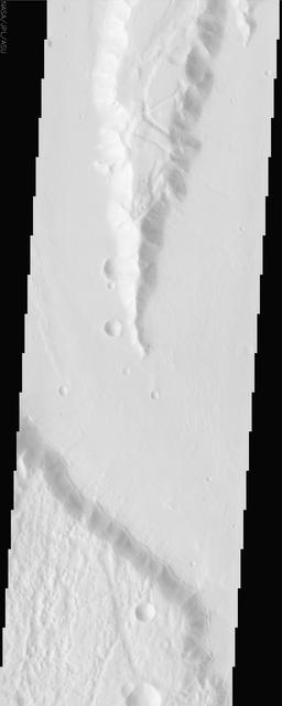
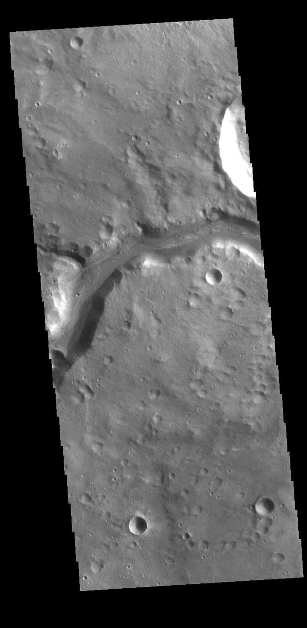
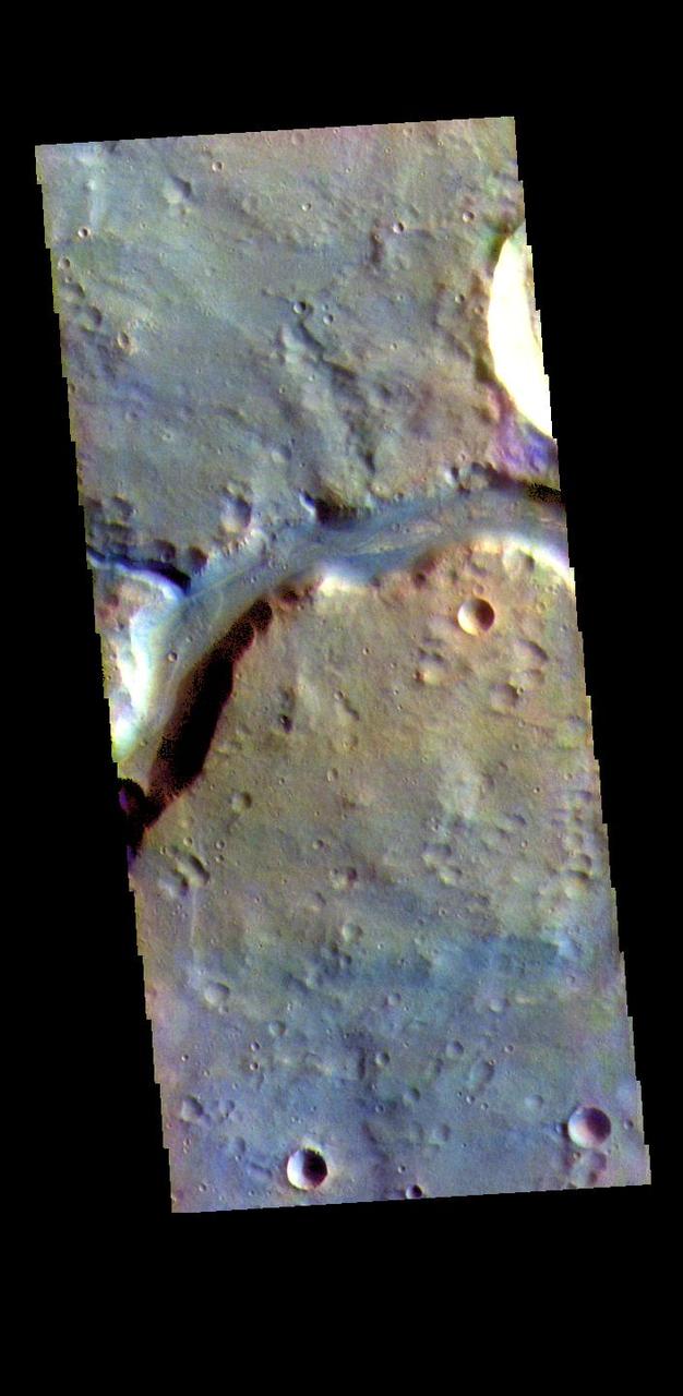
This VIS image shows a section of Bahram Vallis. Bahram Vallis is located on the northeastern margin of Lunae Planum. Orbit Number: 70146 Latitude: 20.6144 Longitude: 302.265 Instrument: VIS Captured: 2017-10-06 22:04 https://photojournal.jpl.nasa.gov/catalog/PIA22363
Today's VIS image shows a section of Bahram Vallis. This channel is located in northern Lunae Planum, south of Kasei Valles. Orbit Number: 71256 Latitude: 21.0762 Longitude: 301.486 Instrument: VIS Captured: 2018-01-06 08:51 https://photojournal.jpl.nasa.gov/catalog/PIA22379

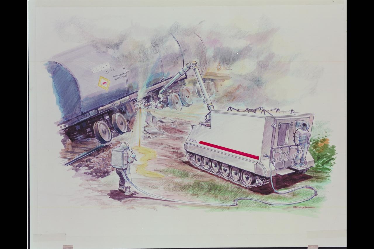
Artist: Ed Luna HAZMAT (Hazardous Materials) art; Phase 2 - Nuclear Plant (reactor) explosion & clear-up
Artist: Ed Luna HAZMAT (Hazardous Materials) art; Phase 1 - Tanker Clean-up
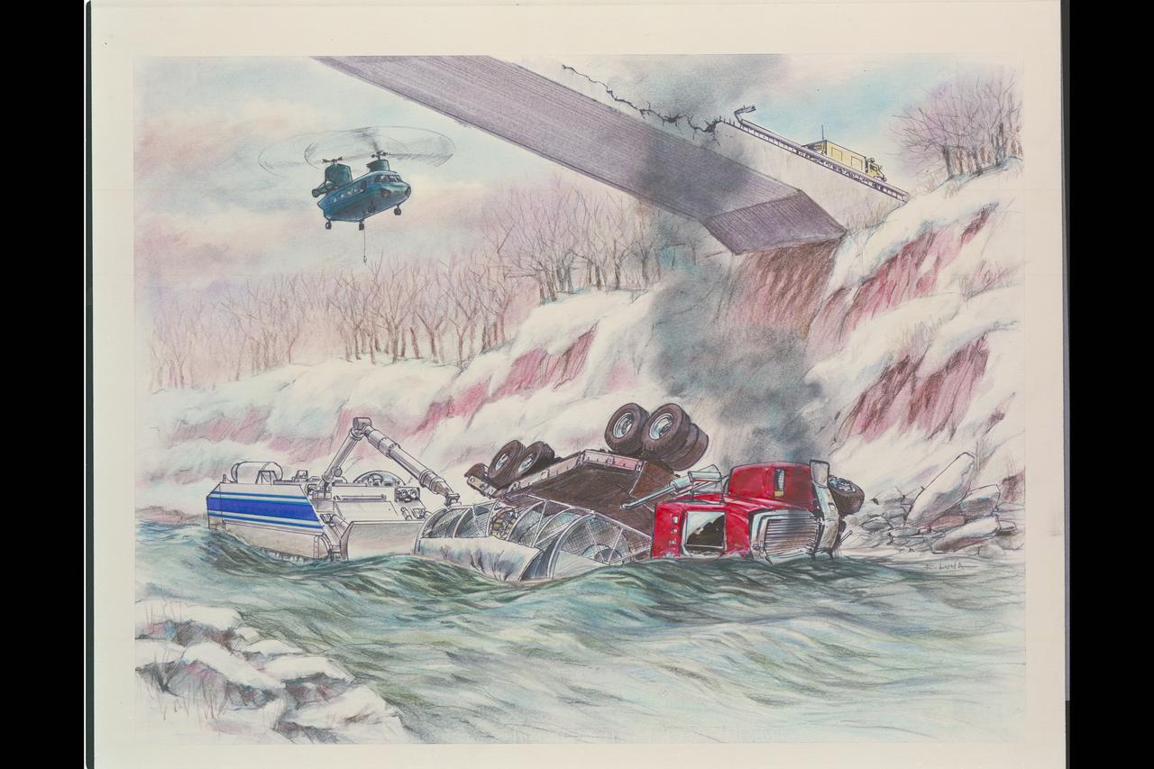
Artist: Ed Luna HAZMAT: Truck Crash: chemical spill clean-up in river (nuclear transportation clean-up)
Artemis II lunar science team members, from left, Cindy Evans, and Wilfredo Garcia Lopez, react to crew observations during the lunar flyby on April 6, 2026. The team worked in the Science Evaluation Room (SER) in Mission Control at NASA’s Johnson Space Center in Houston. Built specifically for Artemis missions with these science priorities in mind, the SER is equipped to support rapid data interpretation, collaborative analysis, real-time decision making, and seamless coordination between the science and operations teams. Credits: NASA/Luna Posadas Nava

Artemis II lunar science team member, Juliane Gross, center, and the extended lunar science team behind her, celebrates crew observations made during the lunar flyby on April 6. The team worked in the Science Evaluation Room (SER) in Mission Control at NASA’s Johnson Space Center in Houston. Built specifically for Artemis missions with these science priorities in mind, the SER is equipped to support rapid data interpretation, collaborative analysis, real-time decision making, and seamless coordination between the science and operations teams. Credits: NASA/Luna Posadas Nava
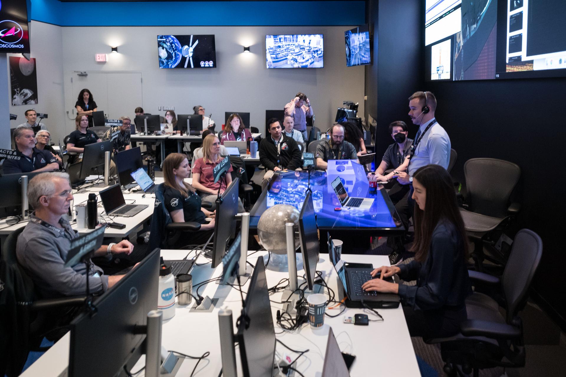
The Artemis II lunar science team gathers for a kickoff meeting before working on the lunar targeting plan for the crew's lunar flyby. The Lunar Targeting Plan is the Artemis II crew's Moon observing assignment, and is fine-tuned to the exact lighting conditions on the Moon’s surface when the Artemis II crew flies by. Like a spacewalk plan, it provides strong, detailed guidance, plus flexibility for the crew to make decisions based on what they’re seeing and experiencing in real time. Targets are prioritized based on both their science value and their visibility at the time of observation. Credits: NASA/Luna Posadas Nava

Artemis II lunar science team members, in the foreground from left: Amber Turner and Jared Ralleta in the center. Standing up behind Turner is Jacob Richardson, and sitting behind and to the right, of Ralleta, are Ryan Watkins in the front, and Debra Needham behind her. The SER supports the Artemis science officer in the mission’s main flight control room. Built specifically for Artemis missions with these science priorities in mind, the SER is equipped to support rapid data interpretation, collaborative analysis, real-time decision making, and seamless coordination between the science and operations teams. Credits: NASA/Luna Posadas Nava
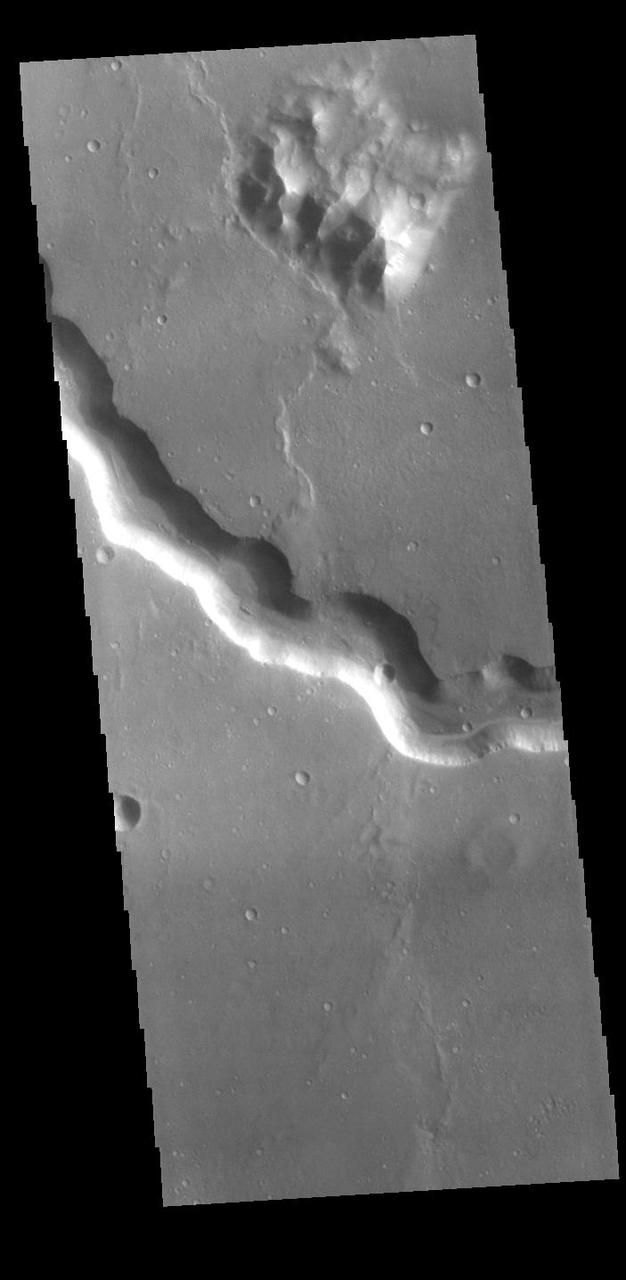
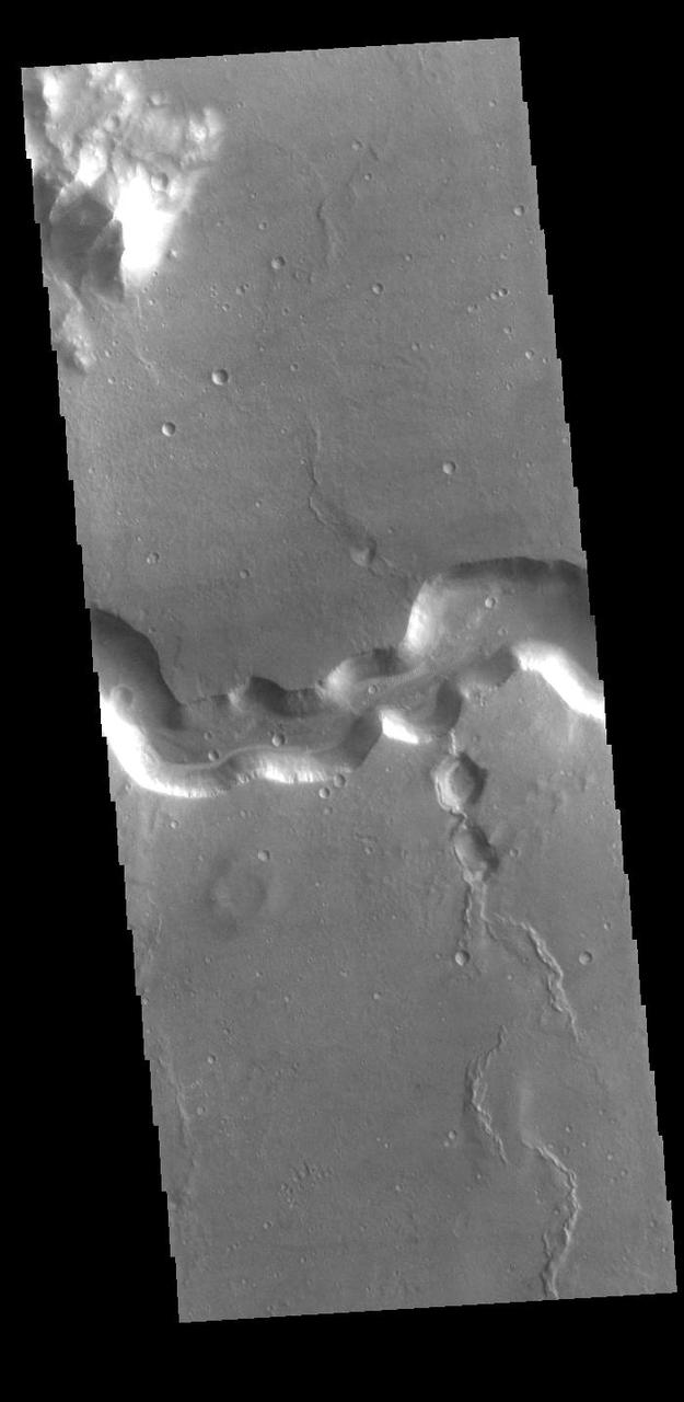
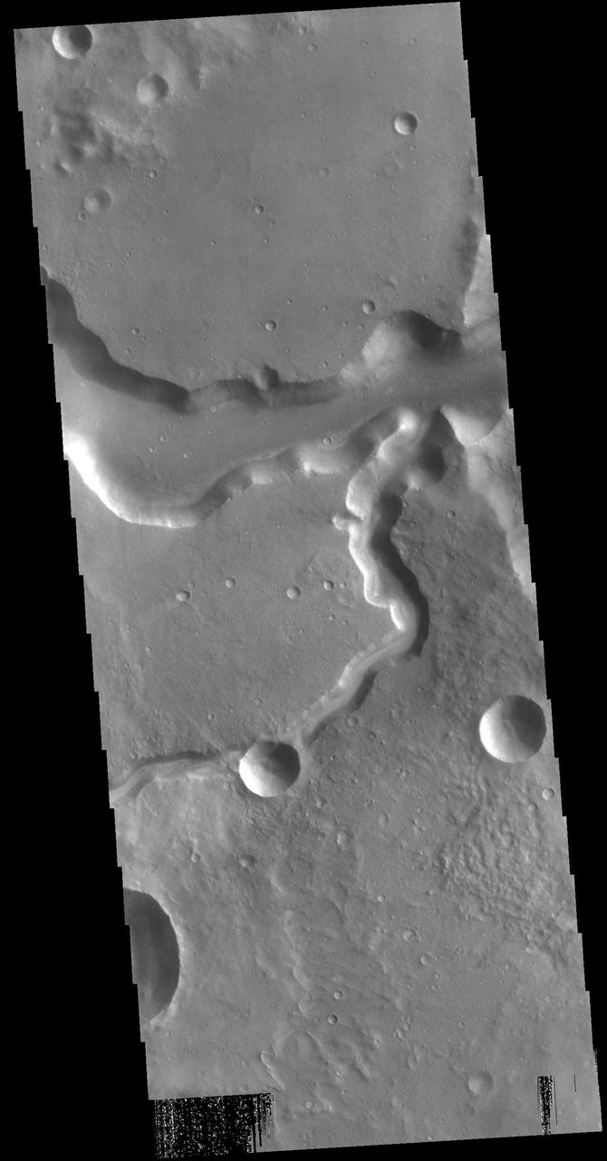
Today's VIS image shows part of the complex region of channels and craters between Lunae Planum and Xanthe Terra. This image is located just east of Maja Valles, the major outflow channel in this region. The large crater at the top of the image, with channels entering and exiting, is named Chia Crater. Orbit Number: 94377 Latitude: 0.364977 Longitude: 299.866 Instrument: VIS Captured: 2023-03-25 07:20 https://photojournal.jpl.nasa.gov/catalog/PIA26022
Today's image shows a portion of Kasei Valles. The plateau in the center of the image is called Lunae Mensa. The THEMIS VIS camera contains 5 filters. The data from different filters can be combined in multiple ways to create a false color image. These false color images may reveal subtle variations of the surface not easily identified in a single band image. Orbit Number: 60604 Latitude: 24.2802 Longitude: 297.794 Instrument: VIS Captured: 2015-08-12 21:22 https://photojournal.jpl.nasa.gov/catalog/PIA22711
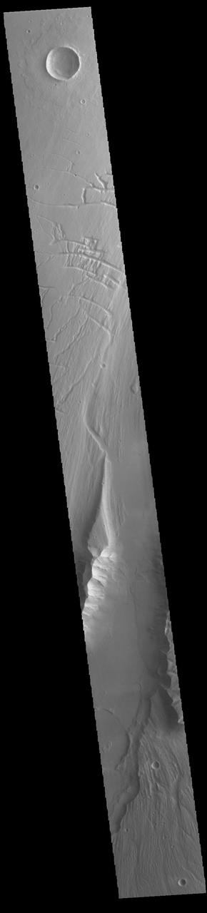
Today's VIS image shows part of Maja Valles, a large channel system in Lunae Planum. Maja Valles in 1600 km (1000 miles) long. Like most outflow channels in the region, Maja Valles arises from the Valles Marineris region and drains into Chryse Planitia. Maja Valles starts in Juventae Chasma. Orbit Number: 85617 Latitude: 4.08955 Longitude: 299.934 Instrument: VIS Captured: 2021-04-03 00:18 https://photojournal.jpl.nasa.gov/catalog/PIA24857
Today's VIS image shows a section of Bahram Vallis. This channel is located in northern Lunae Planum, south of Kasei Valles. Bharam Vallis drains from the higher elevations of Lunae Planum towards the Chryse Planitia basin. This channel is over 300km long (186miles). Orbit Number: 95138 Latitude: 20.0779 Longitude: 303.077 Instrument: VIS Captured: 2023-05-26 23:17 https://photojournal.jpl.nasa.gov/catalog/PIA26260
Between the Tharsis region and Lunae Planum lies Echus Chasma and the source of Kasei Vallis. Flows from the Tharsis volcanoes are buckled by tectonic forces forming mounds and fractures in the Chasma as seen in this image from NASA 2001 Mars Odyssey.
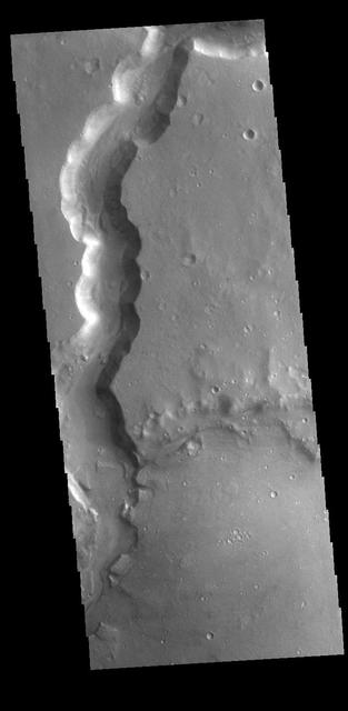
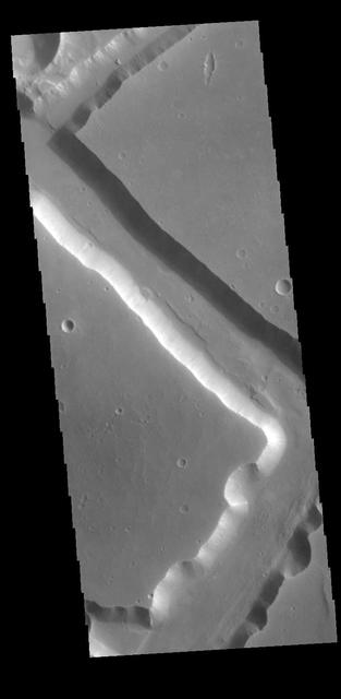
Bahram Vallis crosses this VIS image. Bharam Vallis drains from the the higher elevations of Lunae Planum into the Chryse Planitia basin. At the base of several of the scalloped channel wall sections deposits of material can be seen. Orbit Number: 77643 Latitude: 20.8706 Longitude: 303.262 Instrument: VIS Captured: 2019-06-16 10:30 https://photojournal.jpl.nasa.gov/catalog/PIA23363
Bahram Vallis crosses this VIS image. Bharam Vallis drains from the higher elevations of Lunae Planum into the Chryse Planitia basin. Bahram Vallis is 270km (167 miles) long, with an almost uniform width along most of the channel. Orbit Number: 86116 Latitude: 20.5906 Longitude: 302.116 Instrument: VIS Captured: 2021-05-14 02:29 https://photojournal.jpl.nasa.gov/catalog/PIA24222
Artemis II Lunar Science Deputy Jacob Richardson and Artemis II Lunar Science Team Member Kiarre Dumes react to the astronauts' verbal observations of the Moon during their flyby on April 6. The science team trained the astronauts in geology both in the classroom and in the field. They also built the lunar targeting plan that, like a spacewalk plan, provides strong, detailed observation guidance, plus flexibility for the crew to make decisions based on what they’re seeing and experiencing in real time. The science team had many moments of celebration during the lunar flyby as the astronauts took pictures of the Moon and provided verbal descriptions of what they were seeing. This type of information reveals the geologic history of an area and will be critical to collect when future Artemis astronauts explore the Moon's surface. Credits: NASA/Luna Posadas Nava
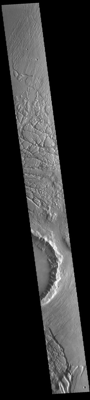
Located on the western margin of Lunae Planum, Sacra Fossae is a group of linear depressions. The right angle turns and uniform width seen in this VIS image indicate that these channels were formed by faulting rather than liquid flow. Two bounding faults with a down-dropped interior are called graben. Orbit Number: 71244 Latitude: 17.7623 Longitude: 288.309 Instrument: VIS Captured: 2018-01-05 09:06 https://photojournal.jpl.nasa.gov/catalog/PIA22373
The right angle intersections in this VIS image are some of the graben that form Sacra Fossae. The fossae are located on the margin of Lunae Planum near the beginning of Kasei Valles. Graben are depressions caused by parallel faults where a block of material drops down along the fault face. Orbit Number: 72616 Latitude: 18.1066 Longitude: 287.915 Instrument: VIS Captured: 2018-04-28 09:42 https://photojournal.jpl.nasa.gov/catalog/PIA22617
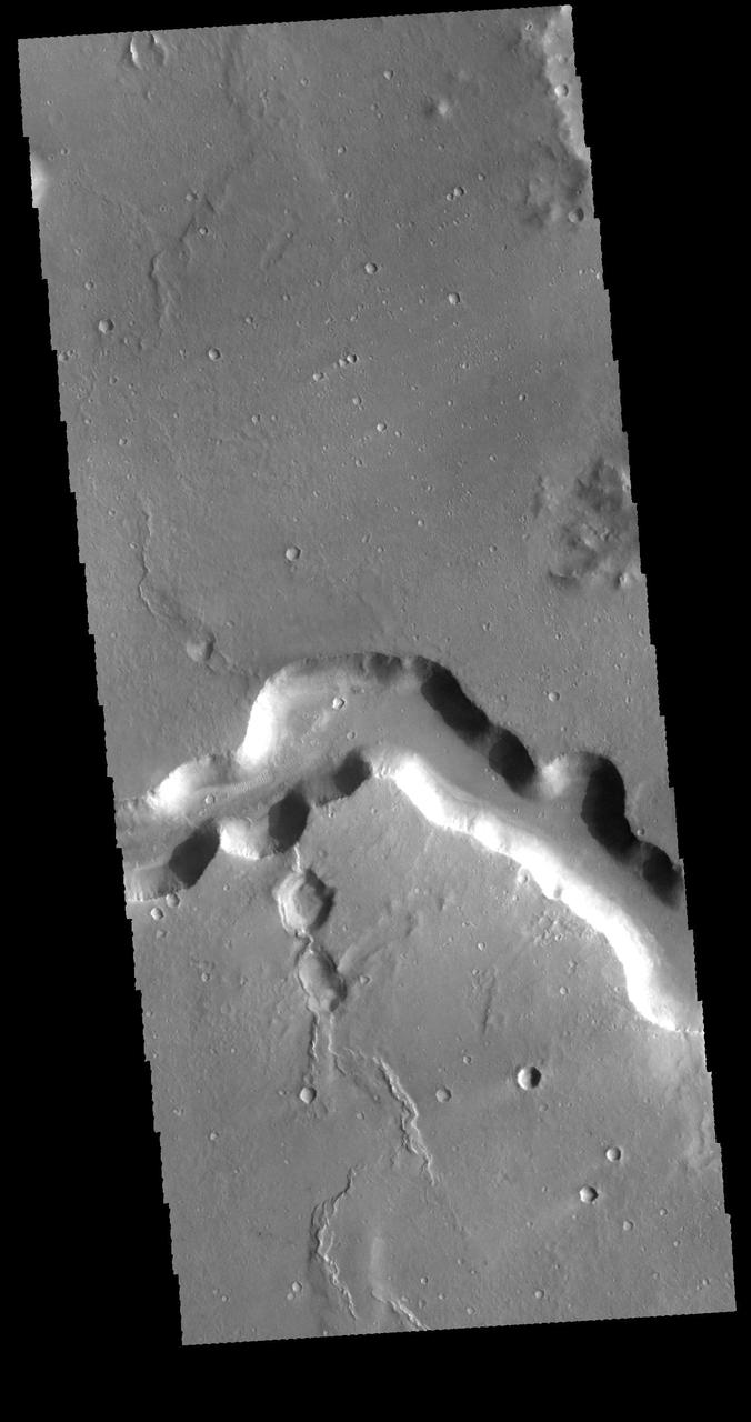
Today's VIS image shows a portion of Bahram Vallis. Bahram Vallis is located at the north eastern margin of Lunae Planum. Orbit Number: 64222 Latitude: 20.6103 Longitude: 302.477 Instrument: VIS Captured: 2016-06-05 20:40 http://photojournal.jpl.nasa.gov/catalog/PIA20803
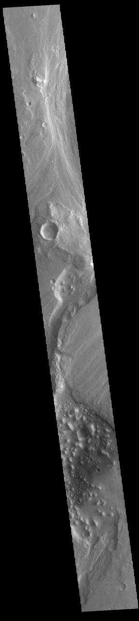
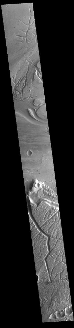
Today's VIS image shows part of Maja Valles, a large channel system in Lunae Planum. The main part of the channel is visible at the upper left in this image. The lower part of the image is located within an old crater called Stege Crater. The channel in the central part of the image is flowing along the inner rim of the crater and into the main Maja Valles channel just off the image to the left. Maja Valles in 1600 km (1000 miles) long. Like most outflow channels in the region, Maja Valles arises from Valles Marineris and drains into Chryse Planitia. Maja Valles starts in Juventae Chasma. Orbit Number: 89111 Latitude: 4.27445 Longitude: 300.886 Instrument: VIS Captured: 2022-01-15 16:56 https://photojournal.jpl.nasa.gov/catalog/PIA25347
Artemis II deputy lunar science lead Marie Henderson, shown standing on the left, and lunar science team members, from the right foreground, Ariel Deutsch, Maria Banks behind her, Ryan Watkins to her right, and Sara Schmidt in the checkered jacket. In this image they are reacting to astronauts' observations of Moon features during their flyby on April 6, 2026. Leading up to the flight, the science team has been training the astronauts in in the classroom and in the field. They also built the lunar targeting plan that, like a spacewalk plan on the International Space Station, provides strong, detailed observation guidance, plus flexibility for the crew to make decisions based on what they’re seeing and experiencing in real time. The science team had many moments of celebration during the lunar flyby as the astronauts took images of the Moon and provided verbal descriptions of what they were seeing. This type of information reveals the geologic history of various lunar areas and will be critical to collect when future Artemis astronauts explore the Moon's surface. Credits: NASA/Luna Posadas Nava
Today's VIS image is located near the beginning of Kasei Valles. At the top of the image is the relative high land of Lunae Planum. The Kasei Valles channel is just below. The bottom part of the image is an eroded surface that forms an island in the channel. The surface of the island has been modified by the flow of water. The linear features forming right angle intersections were caused by tectonic forces in the region. Orbit Number: 72404 Latitude: 18.9511 Longitude: 286.59 Instrument: VIS Captured: 2018-04-10 22:34 https://photojournal.jpl.nasa.gov/catalog/PIA22584
The steep sided depressions in this image captured by NASA 2001 Mars Odyssey spacecraft are fault bounded tectonic features called graben. These depressions are part of a large region of graben called Sacra Fossae. Sacra Fossae is located on the western margin of Lunae Planum. Orbit Number: 60829 Latitude: 18.2961 Longitude: 287.711 Instrument: VIS Captured: 2015-08-31 10:01 http://photojournal.jpl.nasa.gov/catalog/PIA20094
The mesas and valleys in the center of this VIS image are part of Echus Chaos. Located on the margin of Lunae Planum and south of Kasei Valles, Echus Chaos is 480 km (298 miles) long. Orbit Number: 85293 Latitude: 13.7712 Longitude: 285.65 Instrument: VIS Captured: 2021-03-07 08:06 https://photojournal.jpl.nasa.gov/catalog/PIA24825
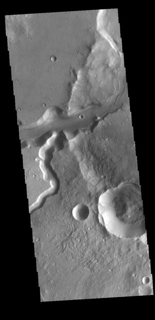
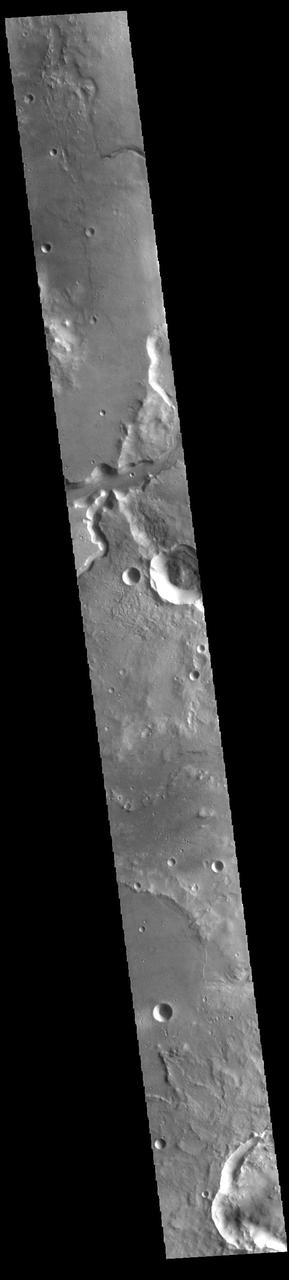
The channels that dissect the center of the VIS image are called Maumee Valles. The much larger Maja Valles is located at the very bottom of the image. The channels in this region are flowing from the highlands of Lunae Planum into the lowlands of Chryse Planitia. Maumee Valles is 390km (242 miles) long. Orbit Number: 94227 Latitude: 18.6849 Longitude: 304.703 Instrument: VIS Captured: 2023-03-12 23:02 https://photojournal.jpl.nasa.gov/catalog/PIA25995

Artemis II crew lunar observations team member, Alex Stoken, monitors the mission from the Science Evaluation Room (SER). Built specifically for Artemis missions with these science priorities in mind, the SER is equipped to support rapid data interpretation, collaborative analysis, real-time decision making, and seamless coordination between the science and operations teams. Credits: NASA/Luna Posadas Nava

Jared Ralleta, Artemis II lunar science team member, reacts to the lunar flyby crew observations in the Science Evaluation Room (SER). Built specifically for Artemis missions with these science priorities in mind, the SER is equipped to support rapid data interpretation, collaborative analysis, real-time decision making, and seamless coordination between the science and operations teams. Credits: NASA/Luna Posadas Nava

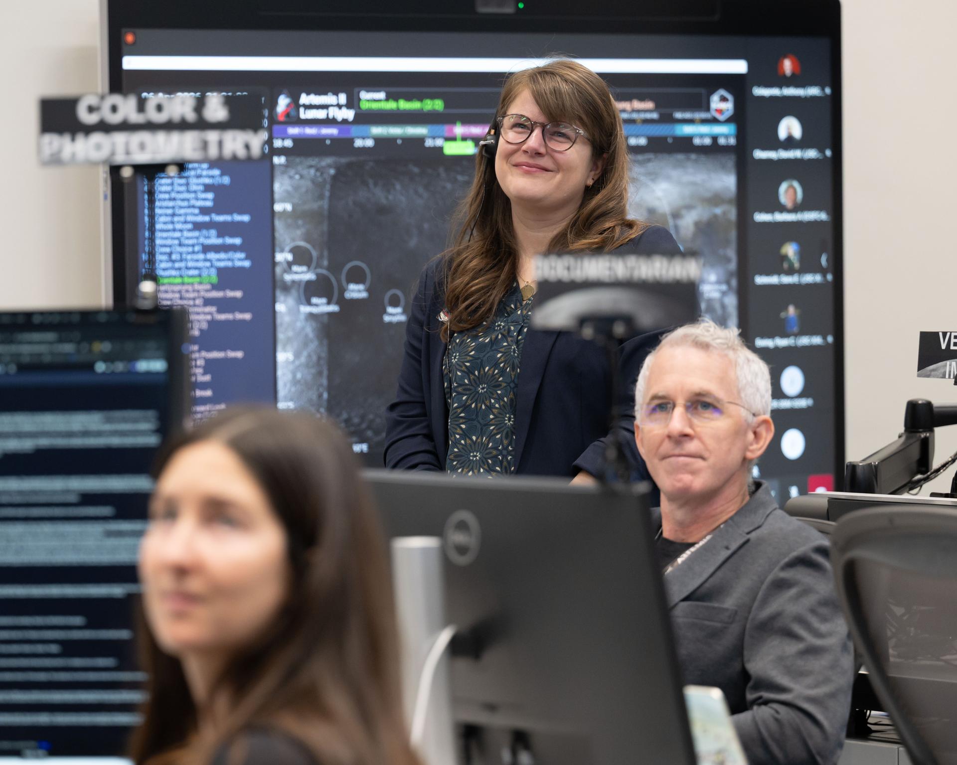
jsc2026e021376 (April 6, 2026) - Nicky Fox, associate administrator for NASA's Science Mission Directorate and Brad Bailey, assistant deputy associate administrator for exploration, observe and celebrate a successful lunar flyby with the Artemis II lunar science team in the Science Evaluation Room in Mission Control at NASA's Johnson Space Center in Houston. Credits: NASA/Luna Posadas Nava
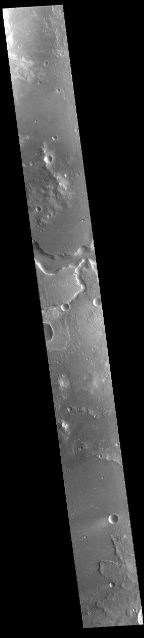
Today's VIS image shows a portion of Kasei Valles. Kasei Valles is one of the largest outflow channel systems on Mars, in places up to 482 km (300 miles) wide and 1580 km (982 miles) long. For comparison, the Grand Canyon in Arizona is is only 29 km (18 miles) at its widest and only 446 km (277 miles) long. Kasei Valles flows eastward through Lunae Planum and empties into Chryse Planitia. Orbit Number: 85218 Latitude: 21.7275 Longitude: 288.166 Instrument: VIS Captured: 2021-03-01 03:56 https://photojournal.jpl.nasa.gov/catalog/PIA24821
Today's VIS image shows a portion of Kasei Valles. Kasei Valles is one of the largest outflow channel systems on Mars, in places up to 482 km (300 miles) wide and 1580 km (982 miles) long. For comparison, the Grand Canyon in Arizona is is only 29 km (18 miles) at its widest and only 446 km (277 miles) long. Kasei Valles flows eastward through Lunae Planum and empties into Chryse Planitia. Orbit Number: 93978 Latitude: 24.9563 Longitude: 287.171 Instrument: VIS Captured: 2023-02-20 11:01 https://photojournal.jpl.nasa.gov/catalog/PIA25939
Today's VIS image shows a portion of Kasei Valles. Kasei Valles is one of the largest outflow channel systems on Mars, in places up to 482 km (300 miles) wide and 1580 km (982 miles) long. For comparison, the Grand Canyon in Arizona is is only 29 km (18 miles) at its widest and only 446 km (277 miles) long. Kasei Valles flows eastward through Lunae Planum and empties into Chryse Planitia. Orbit Number: 93928 Latitude: 25.9137 Longitude: 289.462 Instrument: VIS Captured: 2023-02-16 08:13 https://photojournal.jpl.nasa.gov/catalog/PIA25927
Today's VIS image shows a portion of Kasei Valles. Kasei Valles is one of the largest outflow channel systems on Mars, in places up to 482 km (300 miles) wide and 1580 km (982 miles) long. For comparison, the Grand Canyon in Arizona is is only 29 km (18 miles) at its widest and only 446 km (277 miles) long. Kasei Valles flows eastward through Lunae Planum and empties into Chryse Planitia. Orbit Number: 80538 Latitude: 24.6507 Longitude: 300.343 Instrument: VIS Captured: 2020-02-09 19:44 https://photojournal.jpl.nasa.gov/catalog/PIA23845
Today's VIS image shows a portion of Kasei Valles. Kasei Valles is one of the largest outflow channel systems on Mars, in places up to 482 km (300 miles) wide and 1580 km (982 miles) long. For comparison, the Grand Canyon in Arizona is is only 29 km (18 miles) at its widest and only 446 km (277 miles) long. Kasei Valles flows eastward through Lunae Planum and empties into Chryse Planitia. Orbit Number: 85280 Latitude: 25.2042 Longitude: 299.095 Instrument: VIS Captured: 2021-03-06 06:28 https://photojournal.jpl.nasa.gov/catalog/PIA24822
On the north side of Mars' great equatorial rift Valles Marineris lies a large depression called Juventae Chasma. The chasma stretches for 180 kilometers (110 miles) east-west and 250 km (155 miles) north-south. Most of its floor lies 5km (3 miles) or more below the surrounding surface of Lunae Planum. The large outflow channel Maja Valles originates at the northern end of Juventae Chasma. Sand dunes cover a large portion of the floor of Juventae Chasma, visible in the central part of this VIS image. Orbit Number: 85954 Latitude: -3.98251 Longitude: 298.967 Instrument: VIS Captured: 2021-04-30 18:13 https://photojournal.jpl.nasa.gov/catalog/PIA24889

S69-60662 (December 1969) --- This is the insignia of the Apollo 13 lunar landing mission. The Apollo 13 prime crew will be astronauts James A. Lovell Jr., commander; Thomas K. Mattingly II, command module pilot; and Fred W. Haise Jr., lunar module pilot. Represented in the Apollo 13 emblem is Apollo, the sun god of Greek mythology, symbolizing how the Apollo flights have extended the light of knowledge to all mankind. The Latin phrase Ex Luna, Scientia means "From the Moon, Knowledge." Apollo 13 will be the National Aeronautics and Space Administration's (NASA) third lunar landing mission.

Today's VIS image shows a portion of Kasei Valles. Kasei Valles is one of the largest outflow channel systems on Mars, in places up to 482 km (300 miles) wide and 1580 km (982 miles) long. For comparison, the Grand Canyon in Arizona is is only 29 km (18 miles) at its widest and only 446 km (277 miles) long. Kasei Valles flows eastward through Lunae Planum and empties into Chryse Planitia. Orbit Number: 88163 Latitude: 22.243 Longitude: 288.106 Instrument: VIS Captured: 2021-10-29 15:37 https://photojournal.jpl.nasa.gov/catalog/PIA25153

Artemis II deputy lunar science lead, Jacob Richardson, celebrates with a dance after hearing astronauts describe seeing impact flashes on the Moon during their lunar flyby on April 6, 2026. Richardson was monitoring the flyby from the Science Evaluation Room (SER) in Mission Control at NASA’s Johnson Space Center in Houston. Built specifically for Artemis missions with these science priorities in mind, the SER is equipped to support rapid data interpretation, collaborative analysis, real-time decision making, and seamless coordination between the science and operations teams. Credits: NASA/Luna Posadas Nava
Artemis II deputy lunar science lead Marie Henderson, background, and lunar science team members, Ariel Deutsch, and Ryan Ewing, react to crew observations during the lunar flyby on April 6, 2026. The team worked in the Science Evaluation Room (SER) in Mission Control at NASA’s Johnson Space Center in Houston. Built specifically for Artemis missions with these science priorities in mind, the SER is equipped to support rapid data interpretation, collaborative analysis, real-time decision making, and seamless coordination between the science and operations teams. Credits: NASA/Luna Posadas Nava
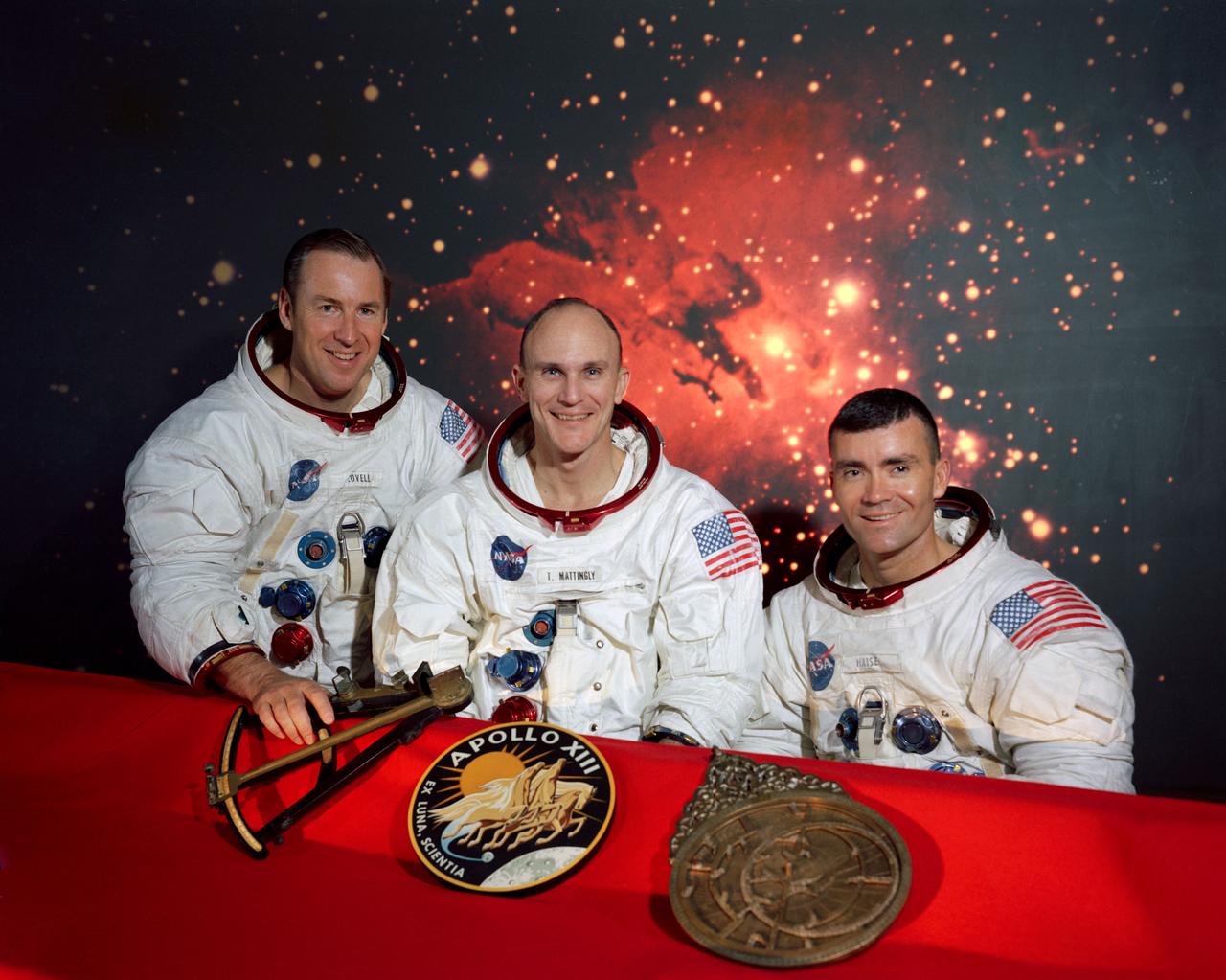
S69-62224 (December 1969) --- The members of the prime crew of the Apollo 13 lunar landing mission (left to right) are astronauts James A. Lovell Jr., commander; Thomas K. Mattingly II, command module pilot; and Fred W. Haise Jr., lunar module pilot. They are seated in front of a scene of the Lagoon Nebula, with the mission insignia and two items of early navigation in the foreground. Represented in the Apollo 13 emblem (center) is Apollo, the sun god of Greek mythology, symbolizing that the Apollo flights have extended the light of knowledge to all mankind. The Latin phrase Ex Luna, Scientia means "From the Moon, Knowledge." The Hindu astrolabe in Sanskrit (on right) was used to predict the position of celestial bodies before the invention of the octant (on left) was used in 1790 to determine the altitude of celestial bodies from aboard ship.
Artemis II deputy lunar science lead, Marie Henderson, reacts to the astronauts' verbal observations of the Moon during their flyby on April 6, 2026. Along with other lunar science team members, Henderson helped train the astronauts in geology both in the classroom and in the field. The team also built the lunar targeting plan that, like an International Space Station spacewalk plan, provides strong, detailed observation guidance, plus flexibility for the crew to make decisions based on what they’re seeing and experiencing in real time. The science team had many moments of celebration during the lunar flyby as the astronauts took images of the Moon and provided verbal descriptions of what they were seeing. This type of information reveals the geologic history of an area and will be critical to collect when future Artemis astronauts explore the Moon's surface. Credits: NASA/Luna Posadas Nava

Artemis II deputy lunar science lead, Jacob Richardson, left, and Artemis II lunar science team members, Kiarre Dumes, react to the astronauts' verbal observations of the Moon during their flyby on April 6, 2026. Along with other lunar science team members, Richardson and Dumes helped train the crew in geology both in the classroom and in the field. The science team also built the lunar targeting plan that, like an International Space Station spacewalk plan, provides strong, detailed observation guidance, plus flexibility for the crew to make decisions based on what they’re seeing and experiencing in real time. The science team had many moments of celebration during the lunar flyby as the astronauts took images of the Moon and provided verbal descriptions of what they were seeing. This type of information reveals the geologic history of an area and will be critical to collect when future Artemis astronauts explore the Moon's surface. Credits: NASA/Luna Posadas Nava
Artemis curation lead, Juliane Gross, reacts to the astronauts' verbal observations of the Moon during their flyby on April 6, 2026. Along with other members of the Artemis II lunar science team, Gross helped train the Artemis II crew in geology both in the classroom and in the field. The team also built the lunar targeting plan that, like an International Space Station spacewalk plan, provides strong, detailed observation guidance, plus flexibility for the crew to make decisions based on what they’re seeing and experiencing in real time. The science team had many moments of celebration during the lunar flyby as the astronauts took images of the Moon and provided verbal descriptions of what they were seeing. This type of information reveals the geologic history of an area and will be critical to collect when future Artemis astronauts explore the Moon's surface. Credits: NASA/Luna Posadas Nava
Artemis II lunar science team members, from left, Debra Needham, Juliane Gross, and Ryan Watkins, react to the astronauts' verbal observations of the Moon during their flyby on April 6, 2026. The science team trained the astronauts in geology and observation, both in the classroom and in the field. The team also built the lunar targeting plan that, like an International Space Station spacewalk plan, provides strong, detailed observation guidance, plus flexibility for the crew to make decisions based on what they’re seeing and experiencing in real time. The science team had many moments of celebration during the lunar flyby as the astronauts took images of the Moon and provided verbal descriptions of what they were seeing. This type of information reveals the geologic history of an area and will be critical to collect when future Artemis astronauts explore the Moon's surface. Credits: NASA/Luna Posadas Nava
Artemis II deputy lunar science lead, Marie Henderson, reacts to the astronauts' verbal observations of the Moon during their flyby on April 6, 2026. Along with other lunar science team members, Ewing helped train the crew in geology both in the classroom and in the field. The science team also built the lunar targeting plan that, like an International Space Station spacewalk plan, provides strong, detailed observation guidance, plus flexibility for the crew to make decisions based on what they’re seeing and experiencing in real time. The science team had many moments of celebration during the lunar flyby as the astronauts took images of the Moon and provided verbal descriptions of what they were seeing. This type of information reveals the geologic history of an area and will be critical to collect when future Artemis astronauts explore the Moon's surface. Credits: NASA/Luna Posadas Nava

Artemis II lunar science team member, Ryan Ewing, reacts to the astronauts' verbal observations of the Moon during their flyby on April 6, 2026. Along with other lunar science team members, Ewing helped train the crew in geology both in the classroom and in the field. The science team also built the lunar targeting plan that, like an International Space Station spacewalk plan, provides strong, detailed observation guidance, plus flexibility for the crew to make decisions based on what they’re seeing and experiencing in real time. The science team had many moments of celebration during the lunar flyby as the astronauts took images of the Moon and provided verbal descriptions of what they were seeing. This type of information reveals the geologic history of an area and will be critical to collect when future Artemis astronauts explore the Moon's surface. Credits: NASA/Luna Posadas Nava

Artemis II lunar science team member, Ariel Deutsch, reacts to the astronauts' verbal observations of the Moon during their flyby on April 6. The science team has spent years training the astronauts in geology and observation, both in the classroom and in the field. They also built the lunar targeting plan that, like a spacewalk plan, provides strong, detailed observation guidance, plus flexibility for the crew to make decisions based on what they’re seeing and experiencing in real time. The science team had many moments of celebration during the lunar flyby as the astronauts took pictures of the Moon and provided verbal descriptions of what they were seeing. This type of information reveals the geologic history of an area and will be critical to collect when future Artemis astronauts explore the Moon's surface. Credits: NASA/Luna Posadas Nava

Ernie Wright, Artemis II lunar science visualization lead, reacts to hearing the astronauts describe features of the Moon as they few by on April 6, 2026. To prepare the crew for this mission, the Artemis II lunar science team trained the astronauts in geology, both in the classroom and in the field. They also built the lunar targeting plan that, which, like an International Space Station spacewalk plan, provides strong, detailed observation guidance, plus flexibility for the crew to make decisions based on what they’re seeing and experiencing in real time. The science team had many moments of celebration during the lunar flyby as the astronauts took images of the Moon and provided verbal descriptions of what they were seeing. This type of information reveals the geologic history of an area and will be critical to collect when future Artemis astronauts explore the Moon's surface. Credits: NASA/Luna Posadas Nava
The THEMIS VIS camera contains 5 filters. The data from different filters can be combined in multiple ways to create a false color image. These false color images may reveal subtle variations of the surface not easily identified in a single band image. Today's false color image shows a section of Bahram Vallis. This channel is located in northern Lunae Planum, south of Kasei Valles. Bharam Vallis drains from the higher elevations of Lunae Planum towards the Chryse Planitia basin. This channel is over 300km long (186miles). The THEMIS VIS camera is capable of capturing color images of the Martian surface using five different color filters. In this mode of operation, the spatial resolution and coverage of the image must be reduced to accommodate the additional data volume produced from using multiple filters. To make a color image, three of the five filter images (each in grayscale) are selected. Each is contrast enhanced and then converted to a red, green, or blue intensity image. These three images are then combined to produce a full color, single image. Because the THEMIS color filters don't span the full range of colors seen by the human eye, a color THEMIS image does not represent true color. Also, because each single-filter image is contrast enhanced before inclusion in the three-color image, the apparent color variation of the scene is exaggerated. Nevertheless, the color variation that does appear is representative of some change in color, however subtle, in the actual scene. Note that the long edges of THEMIS color images typically contain color artifacts that do not represent surface variation. Orbit Number: 94826 Latitude: 21.4639 Longitude: 303.82 Instrument: VIS Captured: 2023-05-01 06:44 https://photojournal.jpl.nasa.gov/catalog/PIA26135

Project LOLA. Test subject sitting at the controls: Project LOLA or Lunar Orbit and Landing Approach was a simulator built at Langley to study problems related to landing on the lunar surface. It was a complex project that cost nearly 2 million dollars. James Hansen wrote: This simulator was designed to provide a pilot with a detailed visual encounter with the lunar surface the machine consisted primarily of a cockpit, a closed-circuit TV system, and four large murals or scale models representing portions of the lunar surface as seen from various altitudes. The pilot in the cockpit moved along a track past these murals which would accustom him to the visual cues for controlling a spacecraft in the vicinity of the moon. Unfortunately, such a simulation--although great fun and quite aesthetic--was not helpful because flight in lunar orbit posed no special problems other than the rendezvous with the LEM, which the device did not simulate. Not long after the end of Apollo, the expensive machine was dismantled. (p. 379) Ellis J. White wrote in his paper, Discussion of Three Typical Langley Research Center Simulation Programs : A typical mission would start with the first cart positioned on model 1 for the translunar approach and orbit establishment. After starting the descent, the second cart is readied on model 2 and, at the proper time, when superposition occurs, the pilot s scene is switched from model 1 to model 2. then cart 1 is moved to and readied on model 3. The procedure continues until an altitude of 150 feet is obtained. The cabin of the LM vehicle has four windows which represent a 45 degree field of view. The projection screens in front of each window represent 65 degrees which allows limited head motion before the edges of the display can be seen. The lunar scene is presented to the pilot by rear projection on the screens with four Schmidt television projectors. The attitude orientation of the vehicle is represented by changing the lunar scene through the portholes determined by the scan pattern of four orthicons. The stars are front projected onto the upper three screens with a four-axis starfield generation (starball) mounted over the cabin and there is a separate starball for the low window. -- Published in James R. Hansen, Spaceflight Revolution: NASA Langley Research Center From Sputnik to Apollo, (Washington: NASA, 1995), p. 379 Ellis J. White, Discussion of Three Typical Langley Research Center Simulation Programs, Paper presented at the Eastern Simulation Council (EAI s Princeton Computation Center), Princeton, NJ, October 20, 1966.
Artemis II lunar science team members, from left, Ryan Ewing, Juliane Gross, and Debra Needham, discuss lunar geography ahead of the translunar injection burn that accelerated the Orion spacecraft to break free of Earth’s orbit and began the outbound trajectory toward the Moon. They are in the Science Evaluation Room (SER) a back room that supports lunar science and planetary observations for the Artemis science officer in the mission’s main flight control room. Built specifically for Artemis missions with these science priorities in mind, the SER is equipped to support rapid data interpretation, collaborative analysis, real-time decision making, and seamless coordination between the science and operations teams.
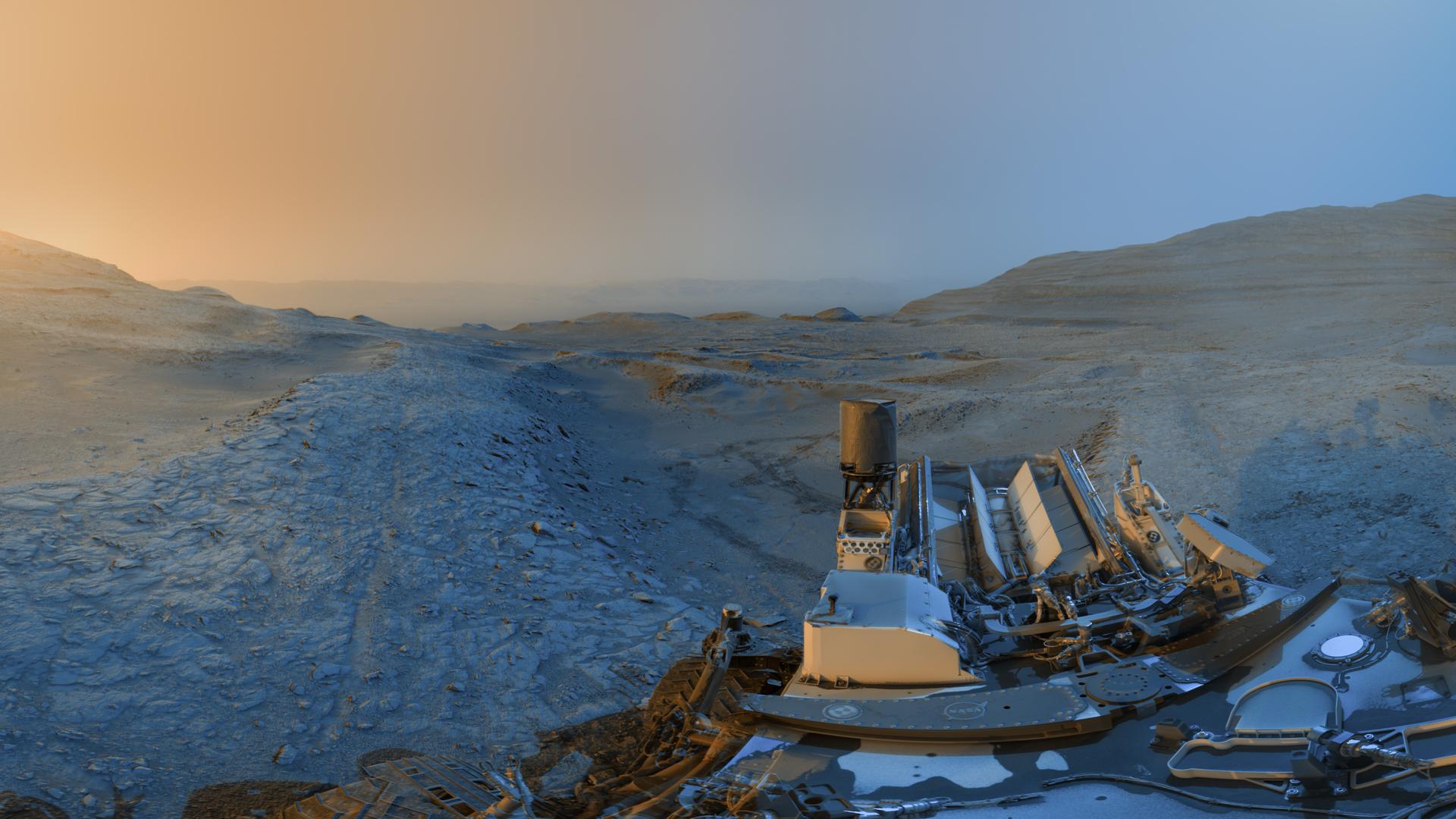
NASA’s Curiosity Mars rover used its black-and-white navigation cameras to capture panoramas at two times of day on Nov. 18, 2025, spanning periods that occurred on both the 4,722nd and 4,723rd Martian days, or sols, of the mission. The panoramas were captured at 4:15 p.m. on Sol 4,722 and 8:20 a.m. on Sol 4,723 (both at local Mars time), then merged together. Color was later added for an artistic interpretation of the scene with blue representing the morning panorama and yellow representing the afternoon one. The resulting “postcard” is similar to ones the rover took in June 2023 and November 2021. Adding color to these kinds of merged images helps different details stand out in the landscape. The scene captured in this postcard shows Curiosity at the top of a ridge referred to as a boxwork formation. These formations crisscross a region in the lower foothills of Mount Sharp, a 3-mile-tall (5-kilometer-tall) mountain which Curiosity has been climbing since 2014. Curiosity used the drill on the end of its robotic arm to collect a rock sample from the top of this ridge at a spot nicknamed “Nevado Sajama.” This view looks north across the boxwork formations and downslope of Mount Sharp toward the floor of Gale Crater, a vast impact crater the mountain is located within. The crater’s rim can be seen far in the distant horizon, approximately 25 miles (40 kilometers) away. Wheel tracks are visible in the hollow behind Curiosity, where a sample was also drilled at a spot nicknamed “Valle de la Luna.” The boxwork formations are believed to have been created billions of years ago when water on ancient Mars dripped through rock cracks, carrying minerals with them. The minerals hardened after the water dried up; eons later, wind sandblasted the softer rock around these hardened minerals, exposing the ridges Curiosity is exploring today. These ridges may reveal more about the planet’s watery past. Curiosity was built by NASA’s Jet Propulsion Laboratory, which is managed by Caltech in Pasadena, California. JPL leads the mission on behalf of NASA’s Science Mission Directorate in Washington as part of NASA’s Mars Exploration Program portfolio. For more about Curiosity, visit: science.nasa.gov/mission/msl-curiosity

NASA image release March 11, 2011 Caption: The lunar farside as never seen before! LROC WAC orthographic projection centered at 180° longitude, 0° latitude. Credit: NASA/Goddard/Arizona State University. Because the moon is tidally locked (meaning the same side always faces Earth), it was not until 1959 that the farside was first imaged by the Soviet Luna 3 spacecraft (hence the Russian names for prominent farside features, such as Mare Moscoviense). And what a surprise - unlike the widespread maria on the nearside, basaltic volcanism was restricted to a relatively few, smaller regions on the farside, and the battered highlands crust dominated. A different world from what we saw from Earth. Of course, the cause of the farside/nearside asymmetry is an interesting scientific question. Past studies have shown that the crust on the farside is thicker, likely making it more difficult for magmas to erupt on the surface, limiting the amount of farside mare basalts. Why is the farside crust thicker? That is still up for debate, and in fact several presentations at this week's Lunar and Planetary Science Conference attempt to answer this question. The Clementine mission obtained beautiful mosaics with the sun high in the sky (low phase angles), but did not have the opportunity to observe the farside at sun angles favorable for seeing surface topography. This WAC mosaic provides the most complete look at the morphology of the farside to date, and will provide a valuable resource for the scientific community. And it's simply a spectacular sight! The Lunar Reconnaissance Orbiter Camera (LROC) Wide Angle Camera (WAC) is a push-frame camera that captures seven color bands (321, 360, 415, 566, 604, 643, and 689 nm) with a 57-km swath (105-km swath in monochrome mode) from a 50 km orbit. One of the primary objectives of LROC is to provide a global 100 m/pixel monochrome (643 nm) base map with incidence angles between 55°-70° at the equator, lighting that is favorable for morphological interpretations. Each month, the WAC provides nearly complete coverage of the Moon under unique lighting. As an added bonus, the orbit-to-orbit image overlap provides stereo coverage. Reducing all these stereo images into a global topographic map is a big job, and is being led by LROC Team Members from the German Aerospace Center (Deutsches Zentrum für Luft- und Raumfahrt; DLR). Several preliminary WAC topographic products have appeared in LROC featured images over the past year (Orientale basin, Sinus Iridum). For a sneak preview of the WAC global DEM with the WAC global mosaic, view a rotating composite moon (70 MB video from ASU's LROC website). The WAC topographic dataset will be completed and released later this year. The global mosaic released today is comprised of over 15,000 WAC images acquired between November 2009 and February 2011. The non-polar images were map projected onto the GLD100 shape model (WAC derived 100 m/pixel DTM), while polar images were map projected on the LOLA shape model. In addition, the LOLA derived crossover corrected ephemeris, and an improved camera pointing, provide accurate positioning (better than 100 m) of each WAC image. As part of the March 2011 PDS release, the LROC team posted the global map in ten regional tiles. Eight of the tiles are equirectangular projections that encompass 60° latitude by 90° longitude. In addition, two polar stereographic projections are available for each pole from ±60° to the pole. These reduced data records (RDR) products will be available for download on March 15, 2011. As the mission progresses, and our knowledge of the lunar photometric function increases, improved and new mosaics will be released! Work your way around the moon with these six orthographic projections constructed from WAC mosaics. The nearside view linked below is different from that released on 21 February. To read more con't here: <a href="http://www.nasa.gov/mission_pages/LRO/news/lro-farside.html" rel="nofollow">www.nasa.gov/mission_pages/LRO/news/lro-farside.html</a> <b><a href="http://www.nasa.gov/centers/goddard/home/index.html" rel="nofollow">NASA Goddard Space Flight Center</a></b> enables NASA’s mission through four scientific endeavors: Earth Science, Heliophysics, Solar System Exploration, and Astrophysics. Goddard plays a leading role in NASA’s accomplishments by contributing compelling scientific knowledge to advance the Agency’s mission. <b>Follow us on <a href="http://twitter.com/NASA_GoddardPix" rel="nofollow">Twitter</a></b> <b>Join us on <a href="http://www.facebook.com/pages/Greenbelt-MD/NASA-Goddard/395013845897?ref=tsd" rel="nofollow">Facebook</a></b>