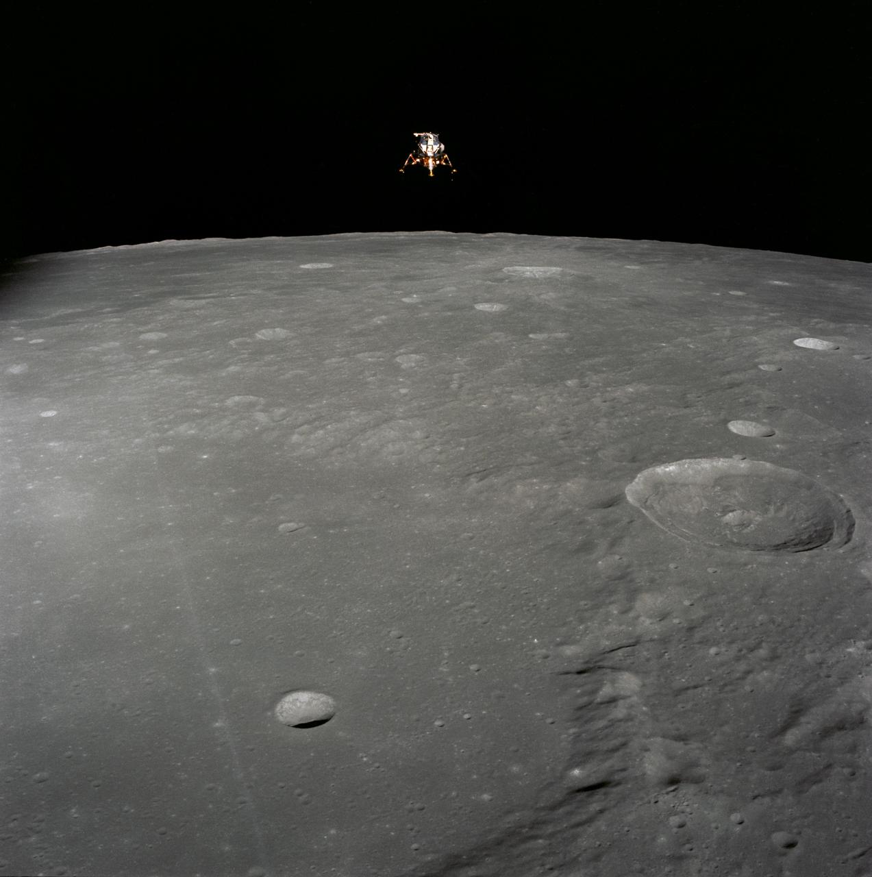
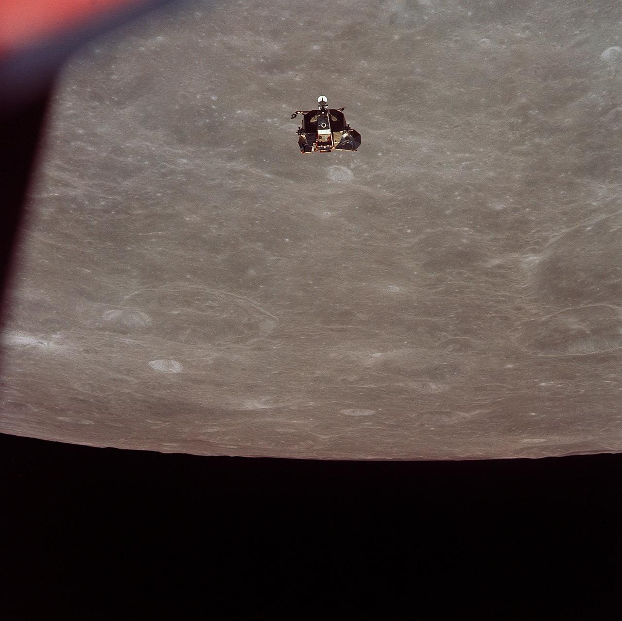
AS12-51-7507 (19 Nov. 1969) --- The Apollo 12 Lunar Module (LM), in a lunar landing configuration, is photographed in lunar orbit from the Command and Service Modules (CSM). The coordinates of the center of the lunar surface shown in picture are 4.5 degrees west longitude and 7 degrees south latitude. The largest crater in the foreground is Ptolemaeus; and the second largest is Herschel. Aboard the LM were astronauts Charles Conrad Jr., commander; and Alan L. Bean, lunar module pilot. Astronaut Richard R. Gordon Jr., command module pilot, remained with the CSM in lunar orbit while Conrad and Bean descended in the LM to explore the surface of the moon. Photo credit: NASA
AS15-91-12366 (31 July-2 Aug. 1971) --- The crater Posidonius at the northeastern edge of the Sea of Serenity, was photographed with a 70mm handheld Hasselblad from the Command and Service Module (CSM) by astronaut Alfred M. Worden, command module pilot, in lunar orbit. While Worden remained with the CSM in lunar orbit, astronauts David R. Scott and James B. Irwin descended in the Lunar Module (LM) "Falcon" to explore the lunar surface.
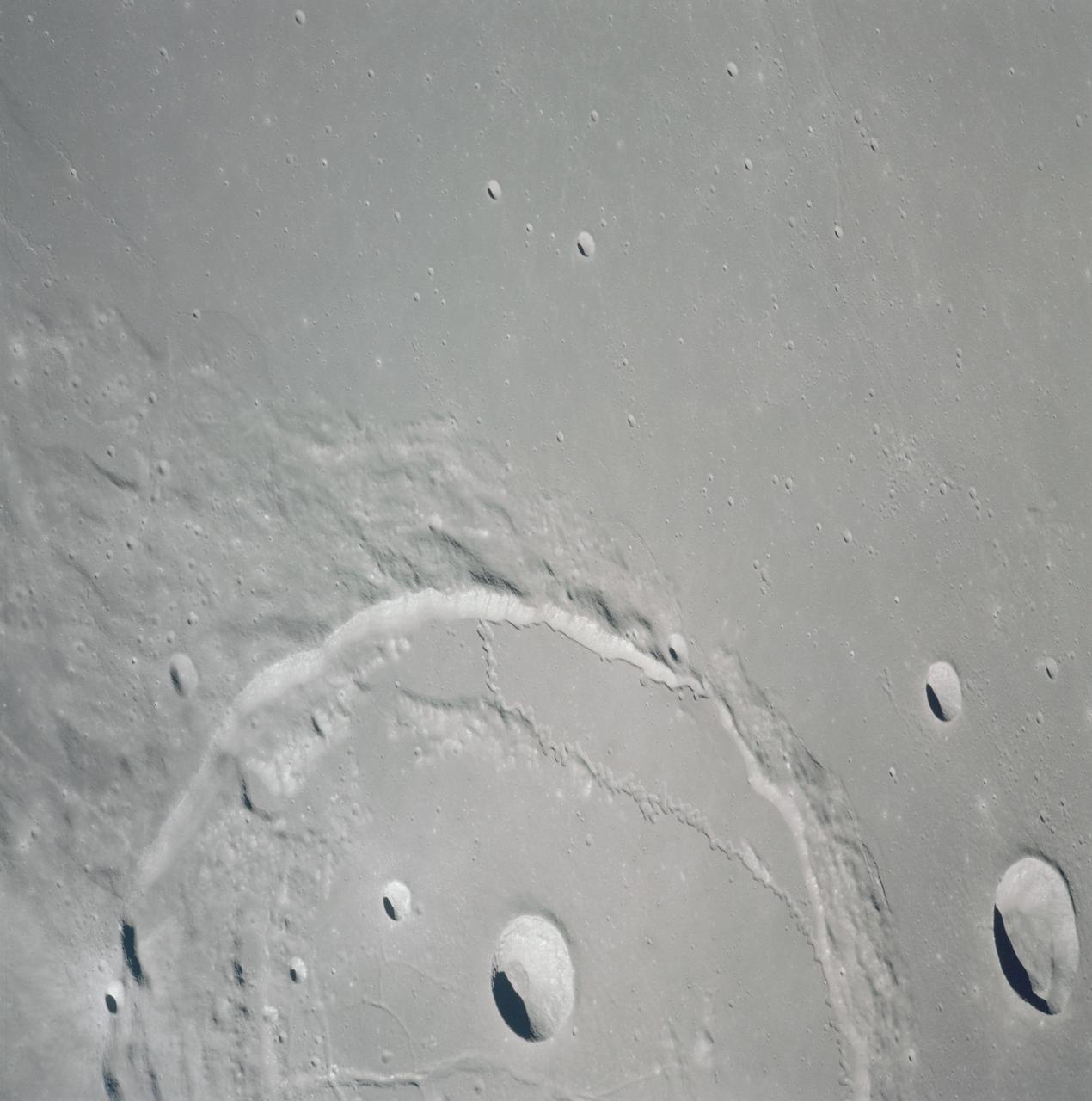
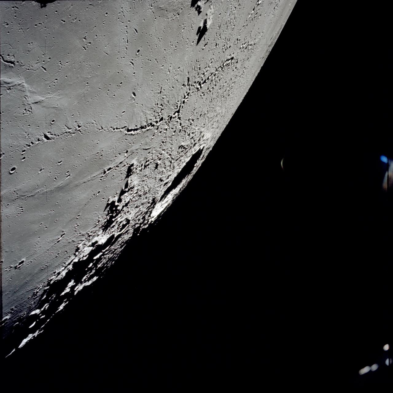
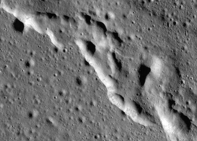
AS15-97-13168 (31 July-2 Aug. 1971) --- A view of the flow structure on the rim and edge of the crater Tsiolkovsky in the highlands of the lunar farside, as photographed from lunar orbit by astronaut Alfred M. Worden in the Apollo 15 Command and Service Module (CSM). Note the scarp at the edge of the flow and elongated grooves on the flow surface. While astronauts David R. Scott and James B. Irwin descended in the Lunar Module (LM) "Falcon" to explore the moon's Hadley-Apennine landing site, Worden remained with the CSM in lunar orbit.
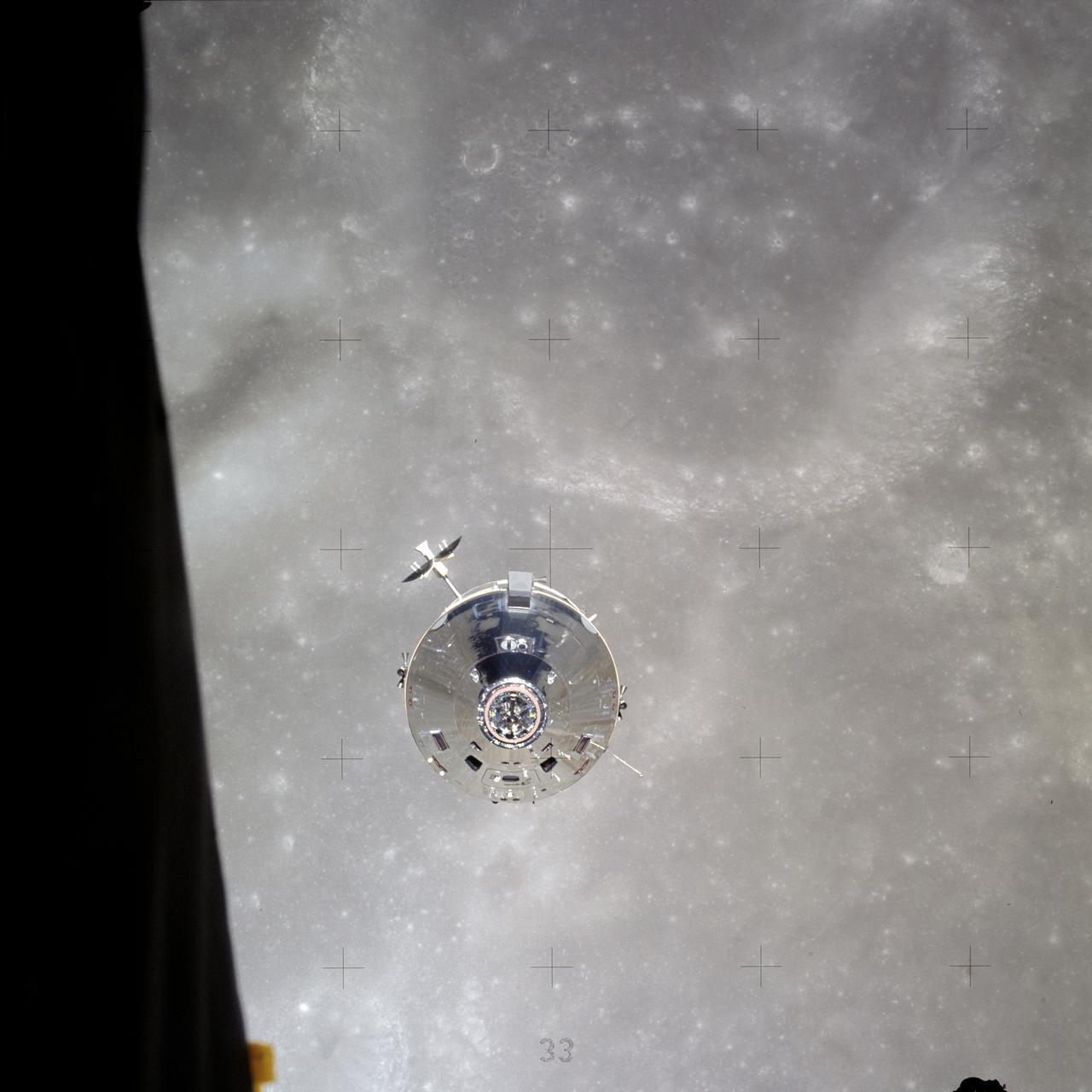
AS16-113-18282 (23 April 1972) --- The Apollo Command and Service Modules (CSM) "Casper" approaches the Lunar Module (LM) "Orion", from which this photograph was made. The two spacecraft are about to make their final rendezvous of the mission, on April 23, 1972. Astronauts John W. Young, commander, and Charles M. Duke Jr., lunar module pilot, aboard the LM, were returning to the CSM, in lunar orbit, after three successful days on the lunar surface. Astronaut Thomas K. (Ken) Mattingly II, command module pilot, remained with the CSM in lunar orbit, while Young and Duke descended in the LM to explore the Descartes region of the moon.
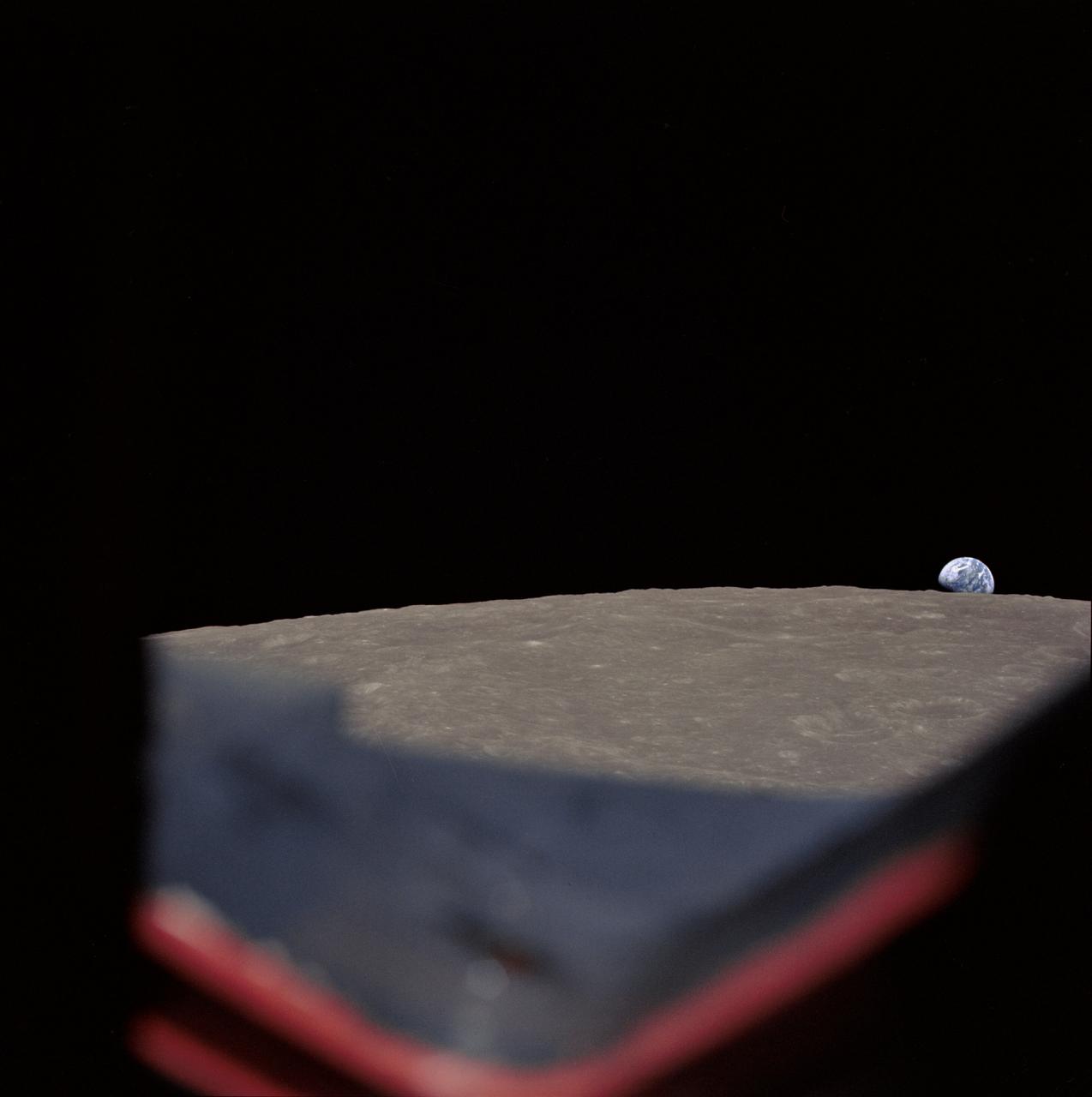
AS8-14-2392 (21-27 Dec. 1968) --- High-oblique view of the moon's surface showing Earth rising above the lunar horizon, looking west-southwest, as photographed from the Apollo 8 spacecraft as it orbited the moon. The center of the picture is located at about 105 degrees east longitude and 13 degrees south latitude. The lunar surface probably has less pronounced color than indicated by this print.

AS11-44-6642 (21 July 1969) --- The Apollo 11 Lunar Module ascent stage, with astronauts Neil A. Armstrong and Edwin E. Aldrin Jr. aboard, is photographed from the Command and Service Modules (CSM) during rendezvous in lunar orbit. The Lunar Module (LM) was making its docking approach to the CSM. Astronaut Michael Collins remained with the CSM in lunar orbit while the other two crewmen explored the lunar surface. The large, dark-colored area in the background is Smyth's Sea, centered at 85 degrees east longitude and 2 degrees south latitude on the lunar surface (nearside). This view looks west. The Earth rises above the lunar horizon.

AS11-37-5445 (20 July 1969) --- The Apollo 11 Command and Service Modules (CSM) are photographed from the Lunar Module (LM) in lunar orbit during the Apollo 11 lunar landing mission. The lunar surface below is in the north central Sea of Fertility. The coordinates of the center of the picture are 51 degrees east longitude and 1 degree north latitude. About half of the crater Taruntius G is visible in the lower left corner of the picture. Part of Taruntius H can be seen at lower right.
AS17-145-22273 (7-19 Dec. 1972) --- In this view, taken from the Lunar Module (LM), the Command and Service Module (CSM) are seen preparing to rendezvous with the LM. Note the reflection of the lunar surface on the CSM. The CSM, is piloted by Ronald E. Evans; while astronauts Eugene A. Cernan, commander; and Harrison W. Schmitt, lunar module pilot, are onboard the LM, following their extravehicular activities (EVA) on the moon's surface. While astronauts Cernan and Schmitt descended in the LM "Challenger" to explore the Taurus-Littrow region of the moon, astronaut Evans remained with the CSM "America" in lunar orbit.
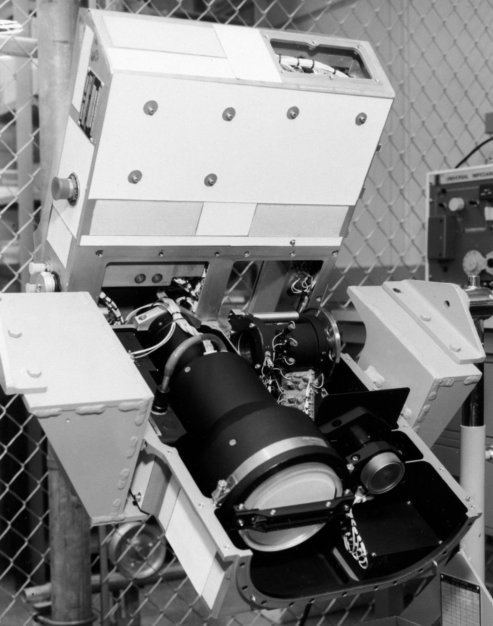
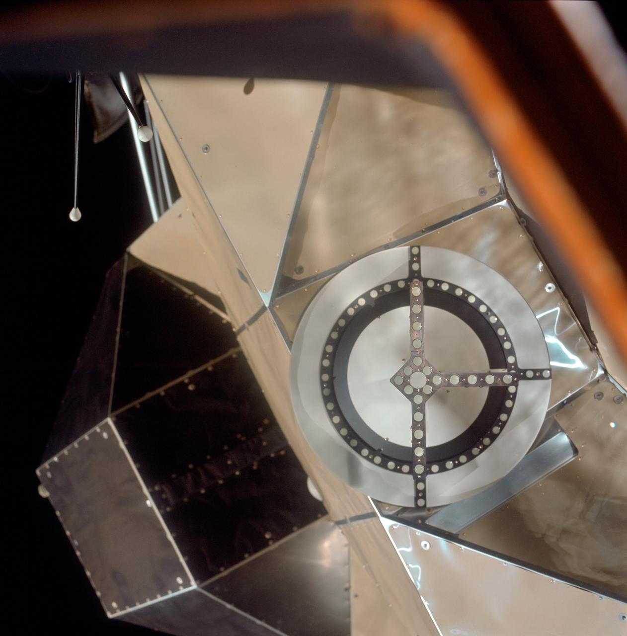
S72-49482 (November 1972) --- The Optical Recorder of the Lunar Sounder Experiment (S-209) which will be mounted in the SIM bay of the Apollo 17 Service Module. The three functional parts of the Lunar Sounder are the optical recorder, the coherent synthetic aperture radar, and the antennas, a retractable dipole for HF and a yagi for VHF. The Lunar Sounder will probe three-quarters of a mile below the moon's surface from the orbiting Apollo 17 spacecraft. Electronic data recorded on film will be retrieved by the crew during trans-Earth EVA. Geologic information on the lunar interior obtained by the sounder will permit scientific investigation of underground rock layers, lava flow patterns, rille (canyon) structures, mascon properties, and any areas containing water. A prototype lunar sounder has been flight tested in aircraft over selected Earth sites to confirm the equipment design and develop scientific analysis techniques. The Lunar Sounder Experiment was developed by North American Rockwell's (NR) Space Division for NASA's Manned Spacecraft Center to provide data for a scientific investigation team with representatives from the Jet Propulsion Laboratory, University of Utah, University of Michigan, U.S. Geological Survey, and NASA Ames Research Center.
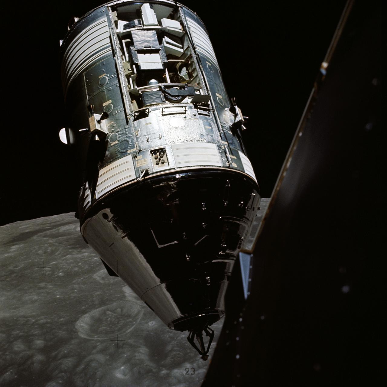
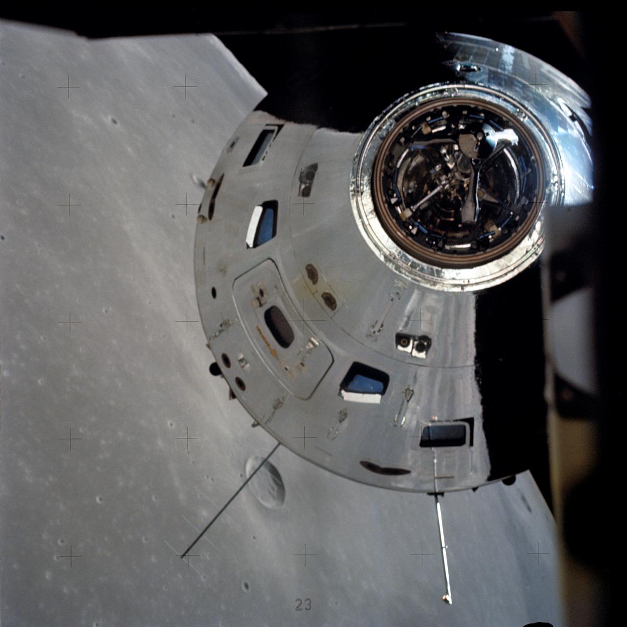
AS17-145-22254 (14 Dec. 1972) --- An excellent view of the Apollo 17 Command and Service Modules (CSM) photographed from the Lunar Module (LM) "Challenger" during rendezvous and docking maneuvers in lunar orbit. The LM ascent stage, with astronauts Eugene A. Cernan and Harrison H. Schmitt aboard, had just returned from the Taurus-Littrow landing site on the lunar surface. Astronaut Ronald E. Evans remained with the CSM in lunar orbit. Note the exposed Scientific Instrument Module (SIM) Bay in Sector 1 of the Service Module (SM). Three experiments are carried in the SIM bay: S-209 lunar sounder, S-171 infrared scanning spectrometer, and the S-169 far-ultraviolet spectrometer. Also mounted in the SIM bay are the panoramic camera, mapping camera and laser altimeter used in service module photographic tasks. A portion of the LM is on the right.
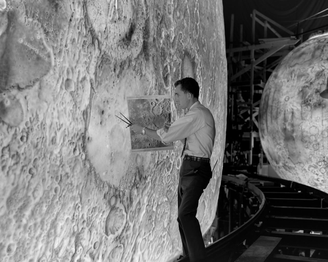
Artists used paintbrushes and airbrushes to recreate the lunar surface on each of the four models comprising the LOLA simulator. Project LOLA or Lunar Orbit and Landing Approach was a simulator built at Langley to study problems related to landing on the lunar surface. It was a complex project that cost nearly 2 million dollars. James Hansen wrote: This simulator was designed to provide a pilot with a detailed visual encounter with the lunar surface the machine consisted primarily of a cockpit, a closed-circuit TV system, and four large murals or scale models representing portions of the lunar surface as seen from various altitudes. The pilot in the cockpit moved along a track past these murals which would accustom him to the visual cues for controlling a spacecraft in the vicinity of the moon. Unfortunately, such a simulation--although great fun and quite aesthetic--was not helpful because flight in lunar orbit posed no special problems other than the rendezvous with the LEM, which the device did not simulate. Not long after the end of Apollo, the expensive machine was dismantled. (p. 379) Ellis J. White described the simulator as follows: Model 1 is a 20-foot-diameter sphere mounted on a rotating base and is scaled 1 in. 9 miles. Models 2,3, and 4 are approximately 15x40 feet scaled sections of model 1. Model 4 is a scaled-up section of the Crater Alphonsus and the scale is 1 in. 200 feet. All models are in full relief except the sphere. -- Published in James R. Hansen, Spaceflight Revolution: NASA Langley Research Center From Sputnik to Apollo, (Washington: NASA, 1995), p. 379 Ellis J. White, Discussion of Three Typical Langley Research Center Simulation Programs, Paper presented at the Eastern Simulation Council (EAI s Princeton Computation Center), Princeton, NJ, October 20, 1966.
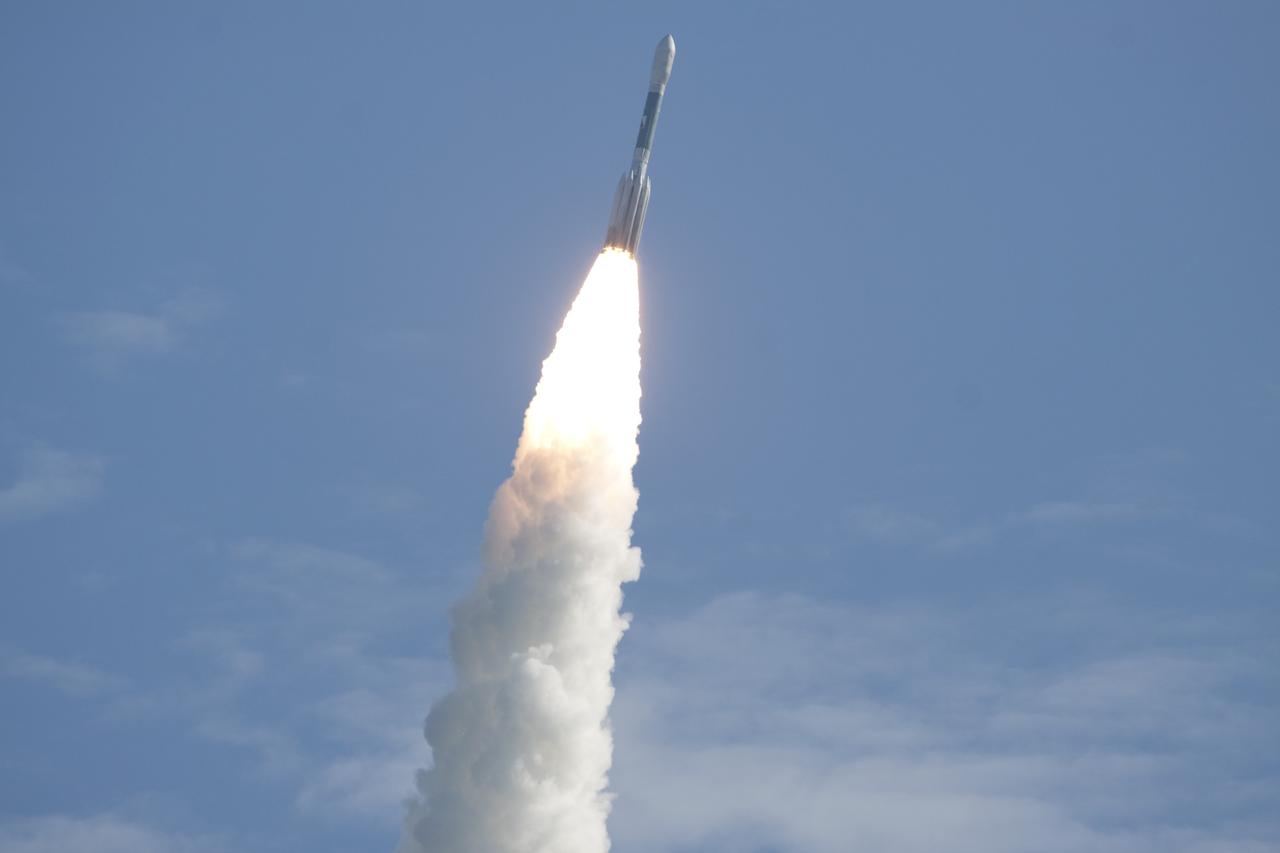
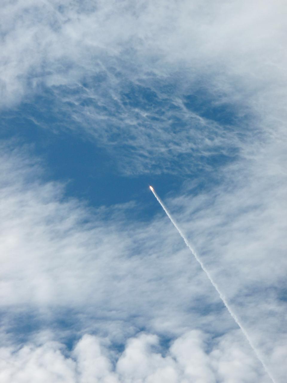
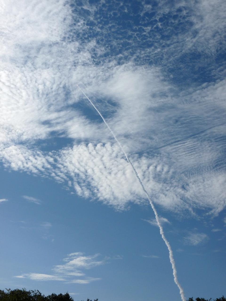
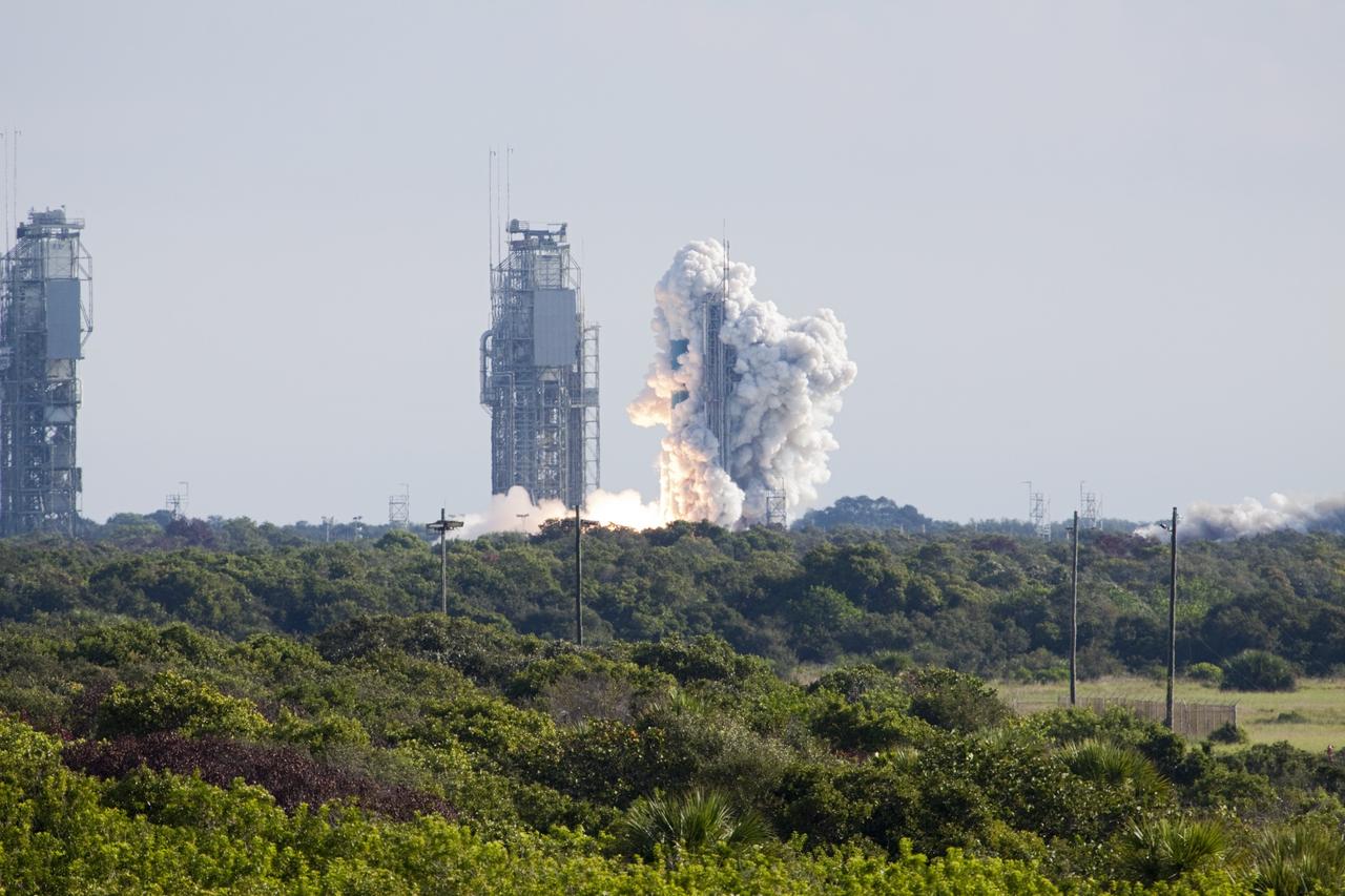
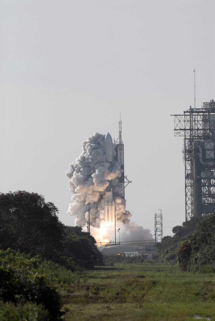
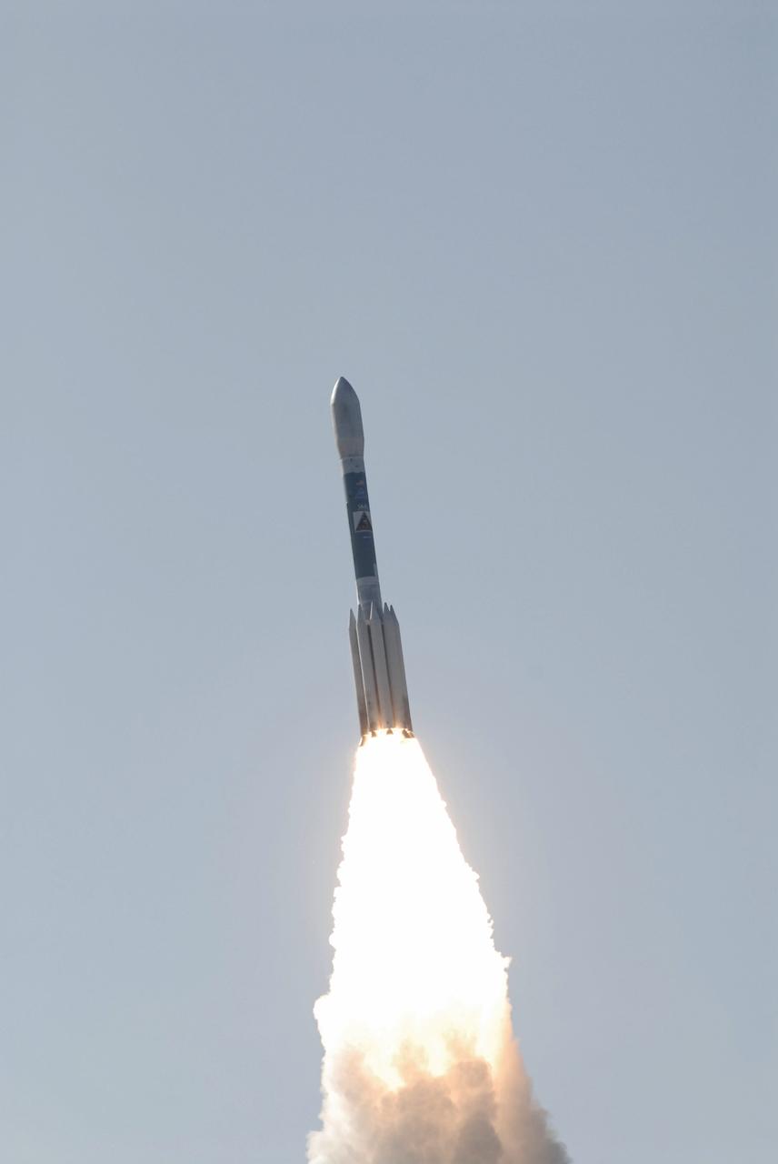
CAPE CANAVERAL, Fla. – Fire and smoke light up a blue sky as a United Launch Alliance Delta II Heavy rocket propels NASA’s Gravity Recovery and Interior Laboratory (GRAIL) mission into space. Liftoff from Space Launch Complex 17B on Cape Canaveral Air Force Station in Florida was at 9:08:52 a.m. EDT Sept.10. GRAIL-A will separate from the second stage of the rocket at about one hour, 21 minutes after liftoff, followed by GRAIL-B at 90 minutes after launch. The spacecraft are embarking on a three-month journey to reach the moon. GRAIL will fly twin spacecraft in tandem around the moon to precisely measure and map variations in the moon's gravitational field. The mission will provide the most accurate global gravity field to date for any planet, including Earth. This detailed information will reveal differences in the density of the moon's crust and mantle and will help answer fundamental questions about the moon's internal structure, thermal evolution, and history of collisions with asteroids. The aim is to map the moon's gravity field so completely that future moon vehicles can safely navigate anywhere on the moon’s surface. For more information, visit http://www.nasa.gov/grail. Photo credit: NASA/Darrell McCall
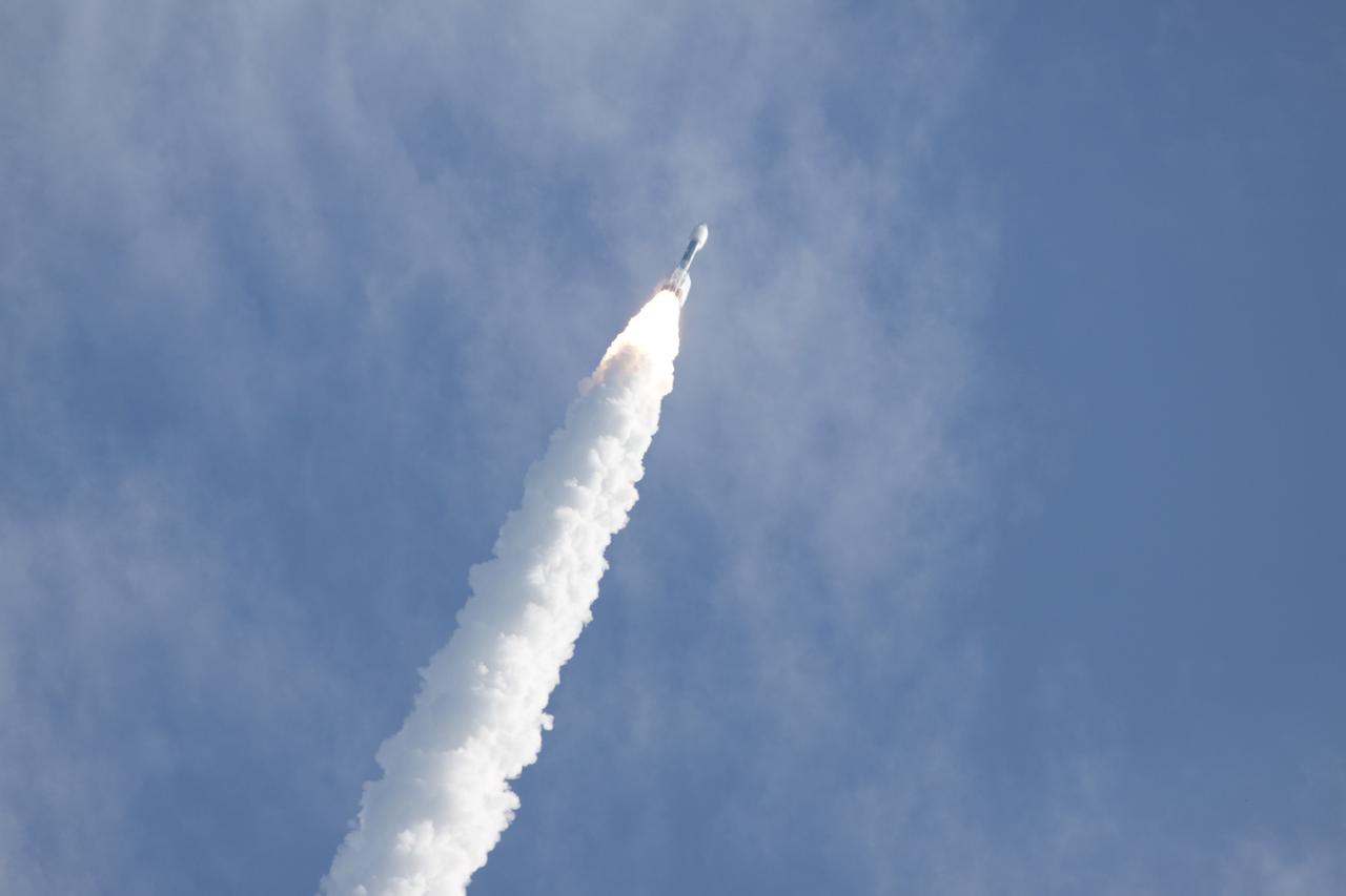
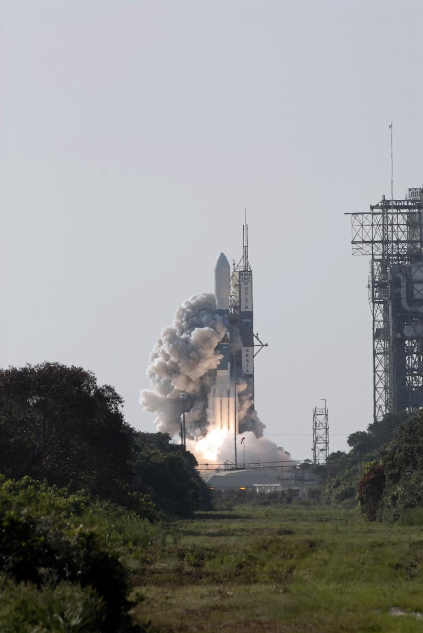
CAPE CANAVERAL, Fla. – The United Launch Alliance Delta II Heavy rocket propels NASA’s twin Gravity Recovery and Interior Laboratory (GRAIL) mission into the clouds over Space Launch Complex 17B on Cape Canaveral Air Force Station in Florida. Liftoff was at 9:08:52 a.m. EDT Sept.10. GRAIL-A will separate from the second stage of the rocket at about one hour 21 minutes after liftoff, followed by GRAIL-B at 90-minutes after launch. The spacecraft are embarking on a three-month journey to reach the moon. GRAIL will fly twin spacecraft in tandem around the moon to precisely measure and map variations in the moon's gravitational field. The mission will provide the most accurate global gravity field to date for any planet, including Earth. This detailed information will reveal differences in the density of the moon's crust and mantle and will help answer fundamental questions about the moon's internal structure, thermal evolution, and history of collisions with asteroids. The aim is to map the moon's gravity field so completely that future moon vehicles can safely navigate anywhere on the moon’s surface. For more information, visit http://www.nasa.gov/grail. Photo credit: NASA/Darrell McCall

CAPE CANAVERAL, Fla. – Fire lights up the sky as a United Launch Alliance Delta II Heavy rocket lofts NASA’s Gravity Recovery and Interior Laboratory (GRAIL) mission into space. Liftoff from Space Launch Complex 17B on Cape Canaveral Air Force Station in Florida was at 9:08:52 a.m. EDT Sept.10. GRAIL-A will separate from the second stage of the rocket at about one hour, 21 minutes after liftoff, followed by GRAIL-B at 90 minutes after launch. The spacecraft are embarking on a three-month journey to reach the moon. GRAIL will fly twin spacecraft in tandem around the moon to precisely measure and map variations in the moon's gravitational field. The mission will provide the most accurate global gravity field to date for any planet, including Earth. This detailed information will reveal differences in the density of the moon's crust and mantle and will help answer fundamental questions about the moon's internal structure, thermal evolution, and history of collisions with asteroids. The aim is to map the moon's gravity field so completely that future moon vehicles can safely navigate anywhere on the moon’s surface. For more information, visit http://www.nasa.gov/grail. Photo credit: NASA/Darrell McCall
CAPE CANAVERAL, Fla. –The United Launch Alliance Delta II Heavy rocket propels NASA’s twin Gravity Recovery and Interior Laboratory (GRAIL) mission into the clouds over Space Launch Complex 17B on Cape Canaveral Air Force Station in Florida. Liftoff was at 9:08:52 a.m. EDT Sept.10. GRAIL-A will separate from the second stage of the rocket at about one hour, 21 minutes after liftoff, followed by GRAIL-B at 90 minutes after launch. The spacecraft are embarking on a three-month journey to reach the moon. GRAIL will fly twin spacecraft in tandem around the moon to precisely measure and map variations in the moon's gravitational field. The mission will provide the most accurate global gravity field to date for any planet, including Earth. This detailed information will reveal differences in the density of the moon's crust and mantle and will help answer fundamental questions about the moon's internal structure, thermal evolution, and history of collisions with asteroids. The aim is to map the moon's gravity field so completely that future moon vehicles can safely navigate anywhere on the moon’s surface. For more information, visit http://www.nasa.gov/grail. Photo credit: NASA/Fletcher Hildreth
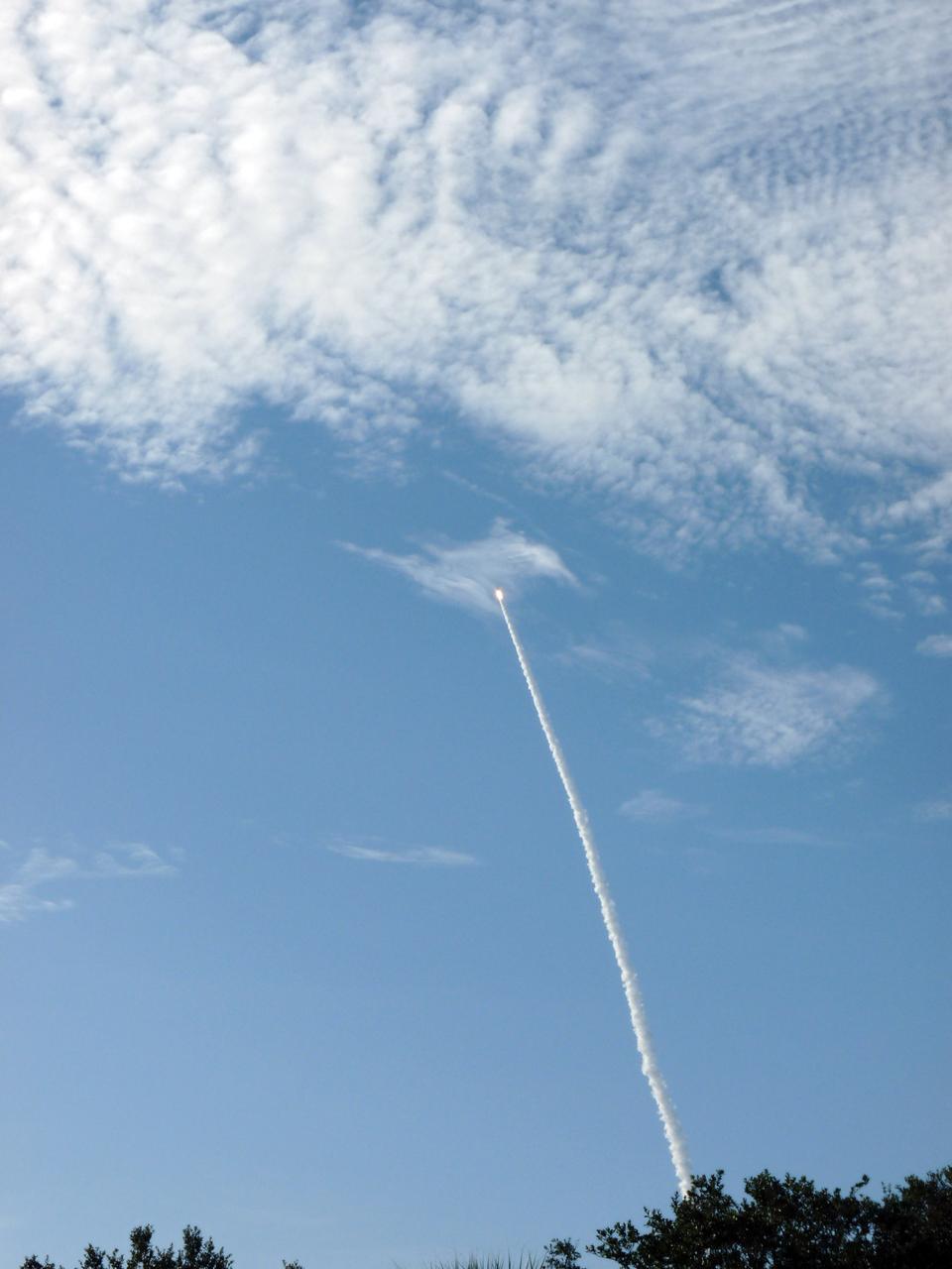
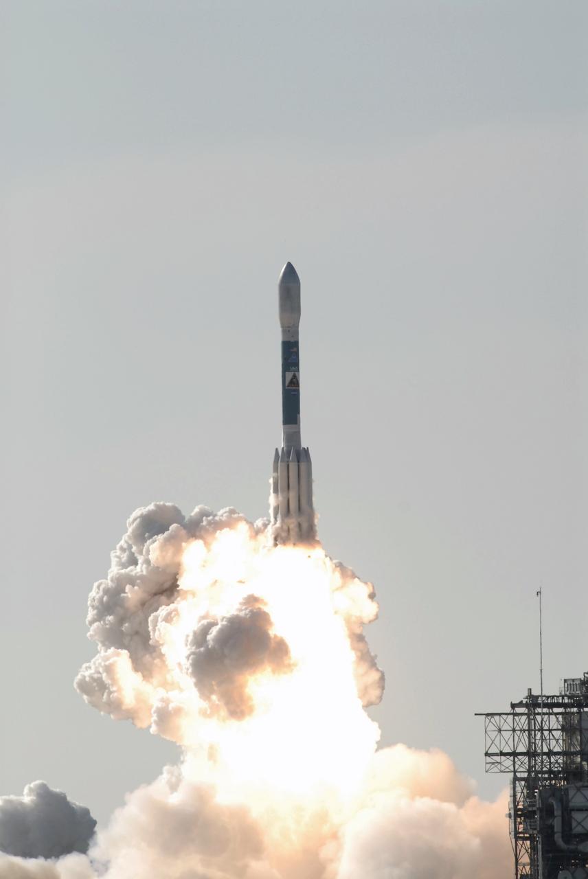
CAPE CANAVERAL, Fla. – Fire lights up a blue sky on Space Launch Complex 17B on Cape Canaveral Air Force Station in Florida as a United Launch Alliance Delta II Heavy rocket lofts the Gravity Recovery and Interior Laboratory (GRAIL) mission into space. Liftoff was at 9:08:52 a.m. EDT Sept.10. GRAIL-A will separate from the second stage of the rocket at about one hour, 21 minutes after liftoff, followed by GRAIL-B at 90 minutes after launch. The spacecraft are embarking on a three-month journey to reach the moon. GRAIL will fly twin spacecraft in tandem around the moon to precisely measure and map variations in the moon's gravitational field. The mission will provide the most accurate global gravity field to date for any planet, including Earth. This detailed information will reveal differences in the density of the moon's crust and mantle and will help answer fundamental questions about the moon's internal structure, thermal evolution, and history of collisions with asteroids. The aim is to map the moon's gravity field so completely that future moon vehicles can safely navigate anywhere on the moon’s surface. For more information, visit http://www.nasa.gov/grail. Photo credit: NASA/Fletcher Hildreth
CAPE CANAVERAL, Fla. – NASA’s twin Gravity Recovery and Interior Laboratory (GRAIL) mission is moments away from liftoff atop a United Launch Alliance Delta II Heavy rocket. Leaving from Space Launch Complex 17B on Cape Canaveral Air Force Station in Florida, the spacecraft is scheduled to launch at 9:08:52 a.m. EDT Sept.10. GRAIL-A will separate from the second stage of the rocket at about one hour, 21 minutes after liftoff, followed by GRAIL-B at 90 minutes after launch. The spacecraft are embarking on a three-month journey to reach the moon. GRAIL will fly twin spacecraft in tandem around the moon to precisely measure and map variations in the moon's gravitational field. The mission will provide the most accurate global gravity field to date for any planet, including Earth. This detailed information will reveal differences in the density of the moon's crust and mantle and will help answer fundamental questions about the moon's internal structure, thermal evolution, and history of collisions with asteroids. The aim is to map the moon's gravity field so completely that future moon vehicles can safely navigate anywhere on the moon’s surface. For more information, visit http://www.nasa.gov/grail. Photo credit: NASA/Darrell McCall
CAPE CANAVERAL, Fla. – Rising from fire and smoke, NASA’s twin Gravity Recovery and Interior Laboratory (GRAIL) mission launches atop a United Launch Alliance Delta II Heavy rocket. Leaving from Space Launch Complex 17B on Cape Canaveral Air Force Station in Florida, the spacecraft launched at 9:08:52 a.m. EDT Sept.10. GRAIL-A will separate from the second stage of the rocket at about one hour, 21 minutes after liftoff, followed by GRAIL-B at 90 minutes after launch. The spacecraft are embarking on a three-month journey to reach the moon. GRAIL will fly twin spacecraft in tandem around the moon to precisely measure and map variations in the moon's gravitational field. The mission will provide the most accurate global gravity field to date for any planet, including Earth. This detailed information will reveal differences in the density of the moon's crust and mantle and will help answer fundamental questions about the moon's internal structure, thermal evolution, and history of collisions with asteroids. The aim is to map the moon's gravity field so completely that future moon vehicles can safely navigate anywhere on the moon’s surface. For more information, visit http://www.nasa.gov/grail. Photo credit: NASA/Darrell McCall
CAPE CANAVERAL, Fla. –The United Launch Alliance Delta II Heavy rocket propels NASA’s twin Gravity Recovery and Interior Laboratory (GRAIL) mission into the clouds over Space Launch Complex 17B on Cape Canaveral Air Force Station in Florida. Liftoff was at 9:08:52 a.m. EDT Sept.10. GRAIL-A will separate from the second stage of the rocket at about one hour, 21 minutes after liftoff, followed by GRAIL-B at 90 minutes after launch. The spacecraft are embarking on a three-month journey to reach the moon. GRAIL will fly twin spacecraft in tandem around the moon to precisely measure and map variations in the moon's gravitational field. The mission will provide the most accurate global gravity field to date for any planet, including Earth. This detailed information will reveal differences in the density of the moon's crust and mantle and will help answer fundamental questions about the moon's internal structure, thermal evolution, and history of collisions with asteroids. The aim is to map the moon's gravity field so completely that future moon vehicles can safely navigate anywhere on the moon’s surface. For more information, visit http://www.nasa.gov/grail. Photo credit: NASA/Fletcher Hildreth
CAPE CANAVERAL, Fla. – Plumes of smoke surround Space Launch Complex 17B on Cape Canaveral Air Force Station in Florida as a United Launch Alliance Delta II Heavy rocket lofts NASA’s Gravity Recovery and Interior Laboratory (GRAIL) mission into space. Liftoff was at 9:08:52 a.m. EDT Sept.10. GRAIL-A will separate from the second stage of the rocket at about one hour, 21 minutes after liftoff, followed by GRAIL-B at 90 minutes after launch. The spacecraft are embarking on a three-month journey to reach the moon. GRAIL will fly twin spacecraft in tandem around the moon to precisely measure and map variations in the moon's gravitational field. The mission will provide the most accurate global gravity field to date for any planet, including Earth. This detailed information will reveal differences in the density of the moon's crust and mantle and will help answer fundamental questions about the moon's internal structure, thermal evolution, and history of collisions with asteroids. The aim is to map the moon's gravity field so completely that future moon vehicles can safely navigate anywhere on the moon’s surface. For more information, visit http://www.nasa.gov/grail. Photo credit: NASA/Darrell McCall
CAPE CANAVERAL, Fla. – Fire and smoke light up the sky as a United Launch Alliance Delta II Heavy rocket propels NASA’s Gravity Recovery and Interior Laboratory (GRAIL) mission into space. Liftoff from Space Launch Complex 17B on Cape Canaveral Air Force Station in Florida was at 9:08:52 a.m. EDT Sept.10. GRAIL-A will separate from the second stage of the rocket at about one hour, 21 minutes after liftoff, followed by GRAIL-B at 90 minutes after launch. The spacecraft are embarking on a three-month journey to reach the moon. GRAIL will fly twin spacecraft in tandem around the moon to precisely measure and map variations in the moon's gravitational field. The mission will provide the most accurate global gravity field to date for any planet, including Earth. This detailed information will reveal differences in the density of the moon's crust and mantle and will help answer fundamental questions about the moon's internal structure, thermal evolution, and history of collisions with asteroids. The aim is to map the moon's gravity field so completely that future moon vehicles can safely navigate anywhere on the moon’s surface. For more information, visit http://www.nasa.gov/grail. Photo credit: NASA/Darrell McCall
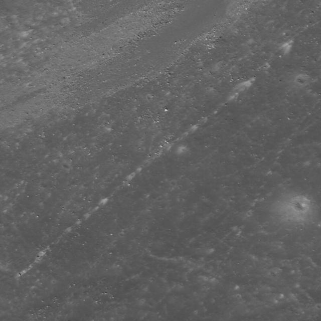
High-albedo marks on the lunar surface left by a boulder bouncing down the northeast wall of farside highlands crater Moore F in this image captured by NASA Lunar Reconnaissance Orbiter.
NASA Lunar Reconnaissance Orbiter spies many boulder trails are found on the lunar crater walls and basin massifs. Some of the trails are smooth and nearly straight while others are curvy or gouge into the surface.
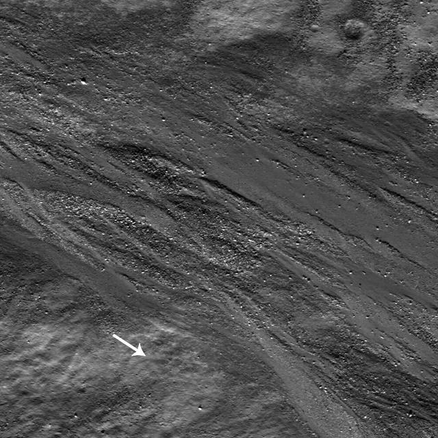
High-albedo marks on the lunar surface left by a boulder bouncing down the northeast wall of farside highlands crater Moore F in this image captured by NASA Lunar Reconnaissance Orbiter.
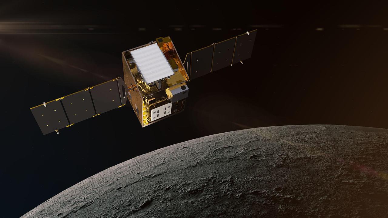
This artist's concept depicts NASA's Lunar Trailblazer in lunar orbit about 60 miles (100 kilometers) from the surface of the Moon. The spacecraft weighs only 440 pounds (200 kilograms) and measures 11.5 feet (3.5 meters) wide when its solar panels are fully deployed. Lunar Trailblazer is managed by NASA's Jet Propulsion Laboratory, and its science investigation and mission operations are led by Caltech with the mission operations center at IPAC. Managed for NASA by Caltech, JPL also provides system engineering, mission assurance, the HVM3 instrument, as well as mission design and navigation. Lockheed Martin Space provides the spacecraft, integrates the flight system, and supports operations under contract with Caltech. Lunar Trailblazer is part of NASA's Small Innovative Missions for Planetary Exploration (SIMPLEx) program, which is managed by the Planetary Missions Program Office at NASA's Marshall Space Flight Center in Huntsville, Alabama, as part of the Discovery Program at NASA Headquarters in Washington. The program conducts space science investigations in the Planetary Science Division of NASA's Science Mission Directorate at NASA Headquarters. https://photojournal.jpl.nasa.gov/catalog/PIA26453
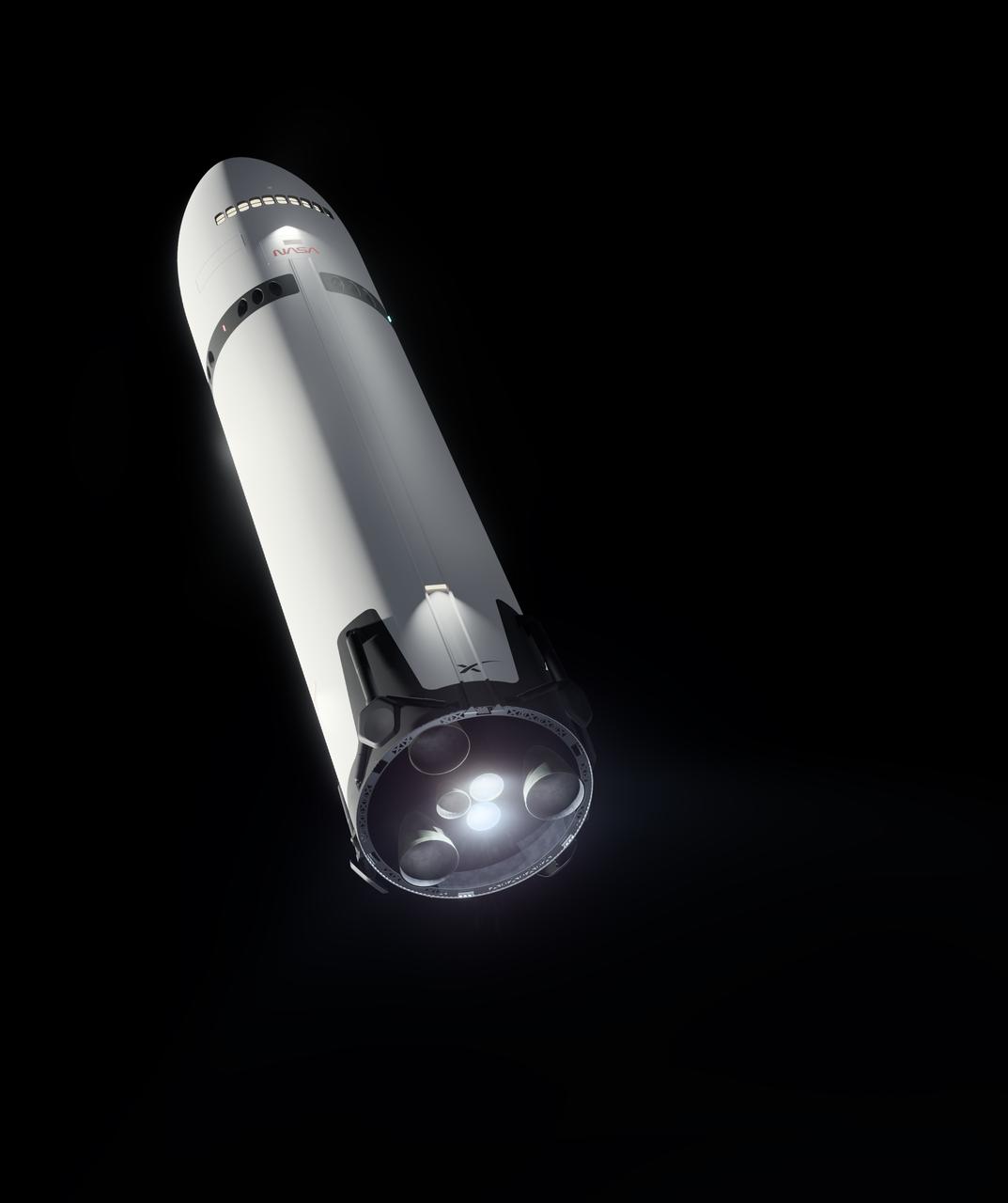
This artist’s concept portrays SpaceX’s Starship Human Landing System (HLS) with two Raptor engines lit, performing a braking burn prior to its Moon landing. The burn will occur after Starship HLS departs low lunar orbit to reduce the lander’s velocity prior to final descent to the lunar surface. NASA is working with SpaceX to develop Starship HLS to carry astronauts from lunar orbit to the Moon’s surface and back for Artemis III and Artemis IV as part of the agency’s Artemis campaign.

Project LOLA. Test subject sitting at the controls: Project LOLA or Lunar Orbit and Landing Approach was a simulator built at Langley to study problems related to landing on the lunar surface. It was a complex project that cost nearly 2 million dollars. James Hansen wrote: This simulator was designed to provide a pilot with a detailed visual encounter with the lunar surface the machine consisted primarily of a cockpit, a closed-circuit TV system, and four large murals or scale models representing portions of the lunar surface as seen from various altitudes. The pilot in the cockpit moved along a track past these murals which would accustom him to the visual cues for controlling a spacecraft in the vicinity of the moon. Unfortunately, such a simulation--although great fun and quite aesthetic--was not helpful because flight in lunar orbit posed no special problems other than the rendezvous with the LEM, which the device did not simulate. Not long after the end of Apollo, the expensive machine was dismantled. (p. 379) Ellis J. White wrote in his paper, Discussion of Three Typical Langley Research Center Simulation Programs : A typical mission would start with the first cart positioned on model 1 for the translunar approach and orbit establishment. After starting the descent, the second cart is readied on model 2 and, at the proper time, when superposition occurs, the pilot s scene is switched from model 1 to model 2. then cart 1 is moved to and readied on model 3. The procedure continues until an altitude of 150 feet is obtained. The cabin of the LM vehicle has four windows which represent a 45 degree field of view. The projection screens in front of each window represent 65 degrees which allows limited head motion before the edges of the display can be seen. The lunar scene is presented to the pilot by rear projection on the screens with four Schmidt television projectors. The attitude orientation of the vehicle is represented by changing the lunar scene through the portholes determined by the scan pattern of four orthicons. The stars are front projected onto the upper three screens with a four-axis starfield generation (starball) mounted over the cabin and there is a separate starball for the low window. -- Published in James R. Hansen, Spaceflight Revolution: NASA Langley Research Center From Sputnik to Apollo, (Washington: NASA, 1995), p. 379 Ellis J. White, Discussion of Three Typical Langley Research Center Simulation Programs, Paper presented at the Eastern Simulation Council (EAI s Princeton Computation Center), Princeton, NJ, October 20, 1966.
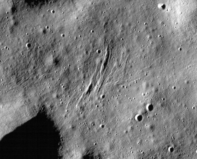
These graben - a kind of trench that is formed as a surface expands - were imaged near a region of the Moon called Mare Frigoris by NASA's Lunar Reconnaissance Orbiter (LRO). https://photojournal.jpl.nasa.gov/catalog/PIA23237
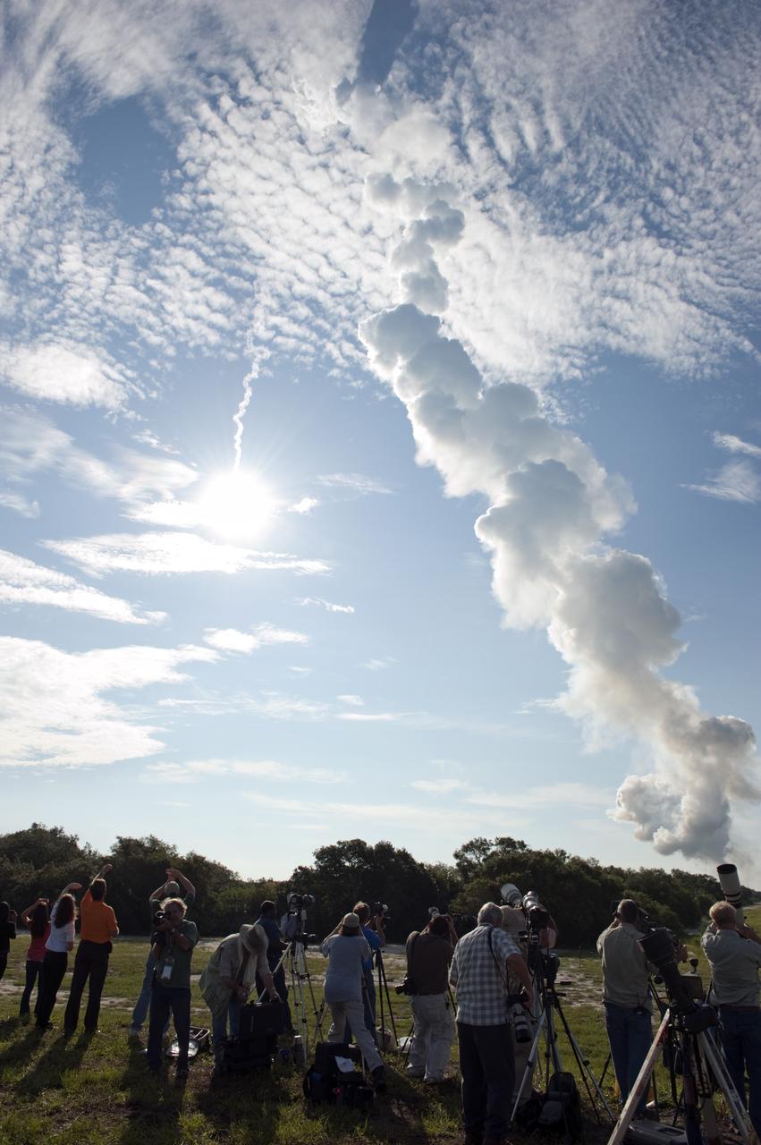
CAPE CANAVERAL, Fla. – Sun reflects off the United Launch Alliance Delta II Heavy rocket launching NASA’s Gravity Recovery and Interior Laboratory (GRAIL) mission into space as media representatives at Press Site 1 near Space Launch Complex 17B on Cape Canaveral Air Force Station in Florida capture the moment. Liftoff was at 9:08:52 a.m. EDT Sept.10. GRAIL-A will separate from the second stage of the rocket at about one hour, 21 minutes after liftoff, followed by GRAIL-B at 90 minutes after launch. The spacecraft are embarking on a three-month journey to reach the moon. GRAIL will fly twin spacecraft in tandem around the moon to precisely measure and map variations in the moon's gravitational field. The mission will provide the most accurate global gravity field to date for any planet, including Earth. This detailed information will reveal differences in the density of the moon's crust and mantle and will help answer fundamental questions about the moon's internal structure, thermal evolution, and history of collisions with asteroids. The aim is to map the moon's gravity field so completely that future moon vehicles can safely navigate anywhere on the moon’s surface. For more information, visit http://www.nasa.gov/grail. Photo credit: NASA/ Kim Shiflett
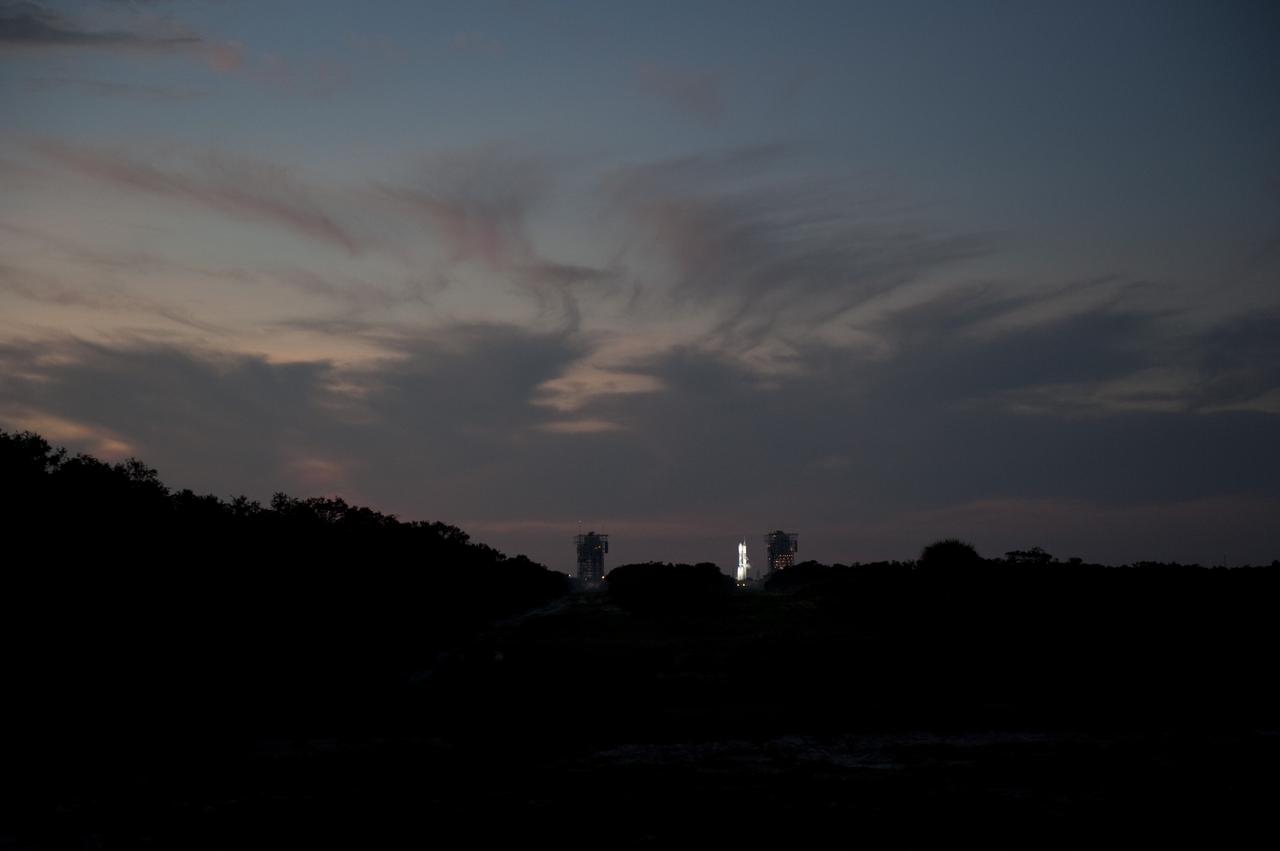
CAPE CANAVERAL, Fla. – As the sun rises, in the distance, spotlights illuminate the United Launch Alliance Delta II Heavy rocket that will launch NASA’s twin Gravity Recovery and Interior Laboratory (GRAIL) mission from Space Launch Complex 17B on Cape Canaveral Air Force Station in Florida. Liftoff is scheduled for 9:08:52 a.m. EDT Sept.10. GRAIL will fly twin spacecraft in tandem around the moon to precisely measure and map variations in the moon's gravitational field. The mission will provide the most accurate global gravity field to date for any planet, including Earth. This detailed information will reveal differences in the density of the moon's crust and mantle and will help answer fundamental questions about the moon's internal structure, thermal evolution, and history of collisions with asteroids. The aim is to map the moon's gravity field so completely that future moon vehicles can safely navigate anywhere on the moon’s surface. For more information, visit http://www.nasa.gov/grail. Photo credit: NASA/ Kim Shiflett
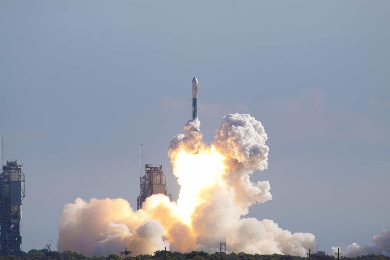
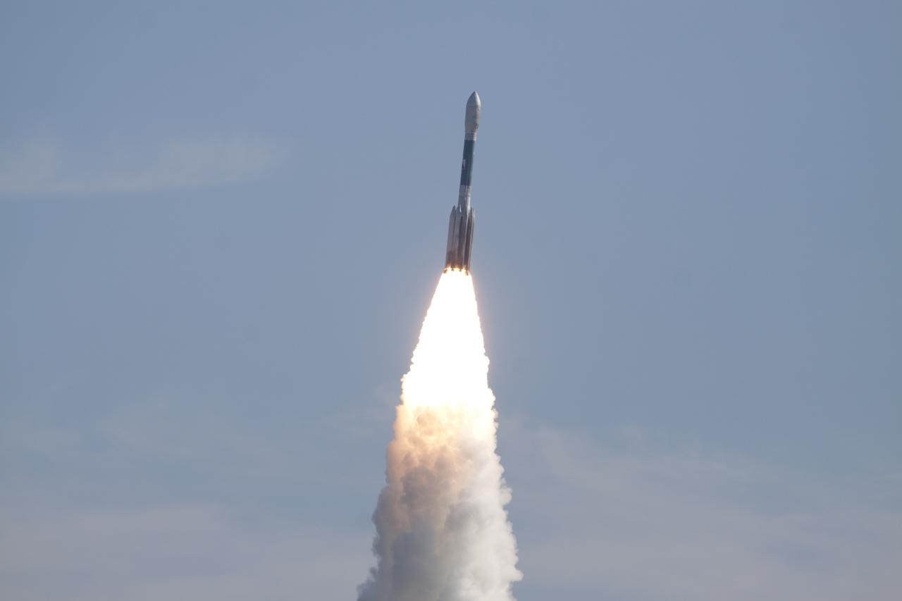
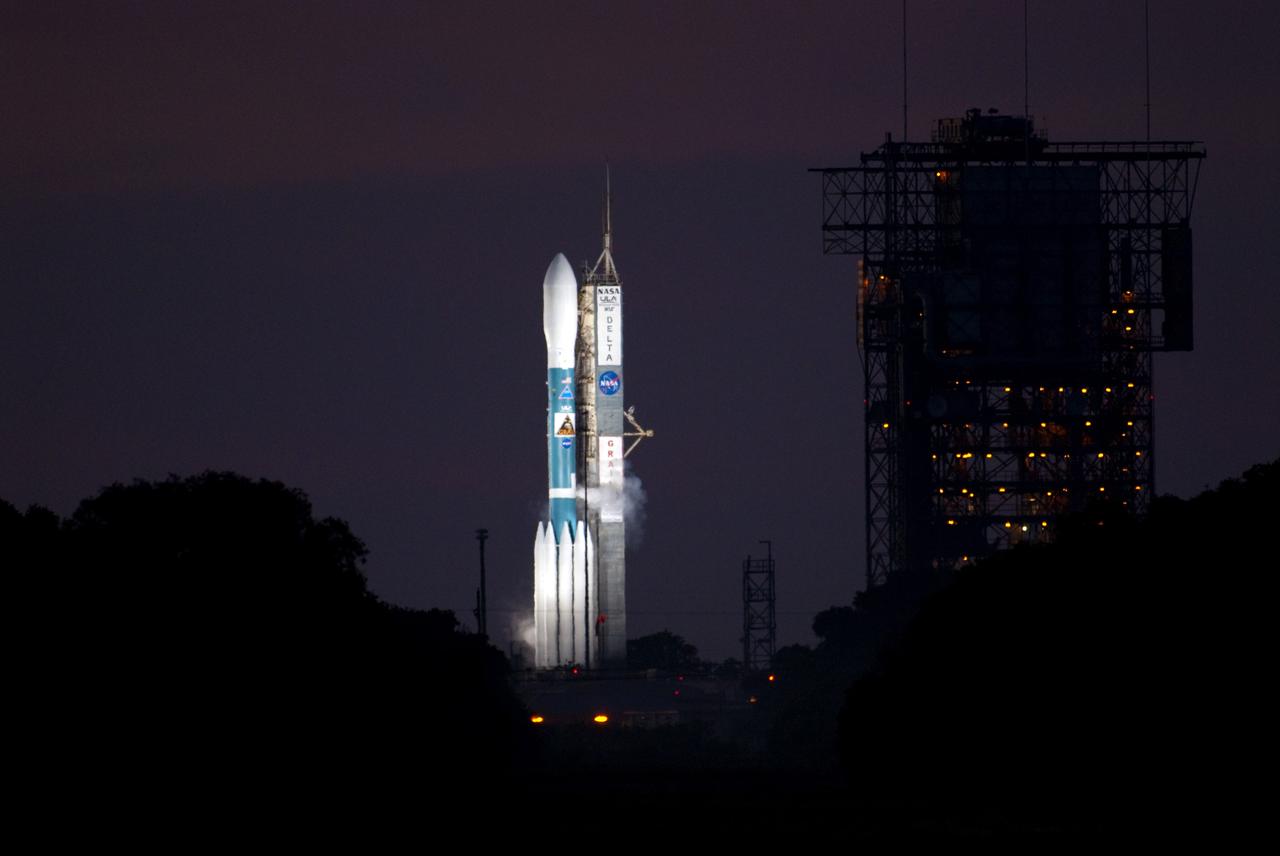
CAPE CANAVERAL, Fla. – Rising from fire and smoke, the United Launch Alliance Delta II Heavy rocket lifted off at 9:08 a.m. EDT Sept. 10 from Space Launch Complex 17B on Cape Canaveral Air Force Station in Florida carrying NASA’s twin Gravity Recovery and Interior Laboratory (GRAIL) mission to the moon. GRAIL will fly twin spacecraft in tandem around the moon to precisely measure and map variations in the moon's gravitational field. The mission will provide the most accurate global gravity field to date for any planet, including Earth. This detailed information will reveal differences in the density of the moon's crust and mantle and will help answer fundamental questions about the moon's internal structure, thermal evolution, and history of collisions with asteroids. The aim is to map the moon's gravity field so completely that future moon vehicles can safely navigate anywhere on the moon’s surface. For more information, visit http://www.nasa.gov/grail. Photo credit: NASA/Kim Shiflett
CAPE CANAVERAL, Fla. – Rising from fire and smoke, the United Launch Alliance Delta II Heavy rocket lifted off at 9:08 a.m. EDT Sept. 10 from Space Launch Complex 17B on Cape Canaveral Air Force Station in Florida carrying NASA’s twin Gravity Recovery and Interior Laboratory (GRAIL) mission to the moon. GRAIL will fly twin spacecraft in tandem around the moon to precisely measure and map variations in the moon's gravitational field. The mission will provide the most accurate global gravity field to date for any planet, including Earth. This detailed information will reveal differences in the density of the moon's crust and mantle and will help answer fundamental questions about the moon's internal structure, thermal evolution, and history of collisions with asteroids. The aim is to map the moon's gravity field so completely that future moon vehicles can safely navigate anywhere on the moon’s surface. For more information, visit http://www.nasa.gov/grail. Photo credit: NASA/Kim Shiflett
CAPE CANAVERAL, Fla. – With a clear blue sky for a background, the United Launch Alliance Delta II Heavy rocket is propelled skyward after lifting off at 9:08 a.m. EDT Sept. 10 from Space Launch Complex 17B on Cape Canaveral Air Force Station in Florida. The Delta II is carrying NASA’s twin Gravity Recovery and Interior Laboratory (GRAIL) mission to the moon. GRAIL will fly twin spacecraft in tandem around the moon to precisely measure and map variations in the moon's gravitational field. The mission will provide the most accurate global gravity field to date for any planet, including Earth. This detailed information will reveal differences in the density of the moon's crust and mantle and will help answer fundamental questions about the moon's internal structure, thermal evolution, and history of collisions with asteroids. The aim is to map the moon's gravity field so completely that future moon vehicles can safely navigate anywhere on the moon’s surface. For more information, visit http://www.nasa.gov/grail. Photo credit: NASA/Kim Shiflett
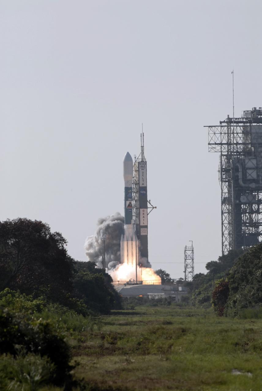
CAPE CANAVERAL, Fla. – The United Launch Alliance Delta II Heavy rocket lifted off at 9:08 a.m. EDT Sept. 10 from Space Launch Complex 17B on Cape Canaveral Air Force Station in Florida carrying NASA’s twin Gravity Recovery and Interior Laboratory (GRAIL) mission to the moon. GRAIL will fly twin spacecraft in tandem around the moon to precisely measure and map variations in the moon's gravitational field. The mission will provide the most accurate global gravity field to date for any planet, including Earth. This detailed information will reveal differences in the density of the moon's crust and mantle and will help answer fundamental questions about the moon's internal structure, thermal evolution, and history of collisions with asteroids. The aim is to map the moon's gravity field so completely that future moon vehicles can safely navigate anywhere on the moon’s surface. For more information, visit http://www.nasa.gov/grail. Photo credit: NASA/Kim Shiflett
CAPE CANAVERAL, Fla. – Rising from fire and smoke, the United Launch Alliance Delta II Heavy rocket lifted off at 9:08 a.m. EDT Sept. 10 from Space Launch Complex 17B on Cape Canaveral Air Force Station in Florida carrying NASA’s twin Gravity Recovery and Interior Laboratory (GRAIL) mission to the moon. GRAIL will fly twin spacecraft in tandem around the moon to precisely measure and map variations in the moon's gravitational field. The mission will provide the most accurate global gravity field to date for any planet, including Earth. This detailed information will reveal differences in the density of the moon's crust and mantle and will help answer fundamental questions about the moon's internal structure, thermal evolution, and history of collisions with asteroids. The aim is to map the moon's gravity field so completely that future moon vehicles can safely navigate anywhere on the moon’s surface. For more information, visit http://www.nasa.gov/grail. Photo credit: NASA/Kim Shiflett
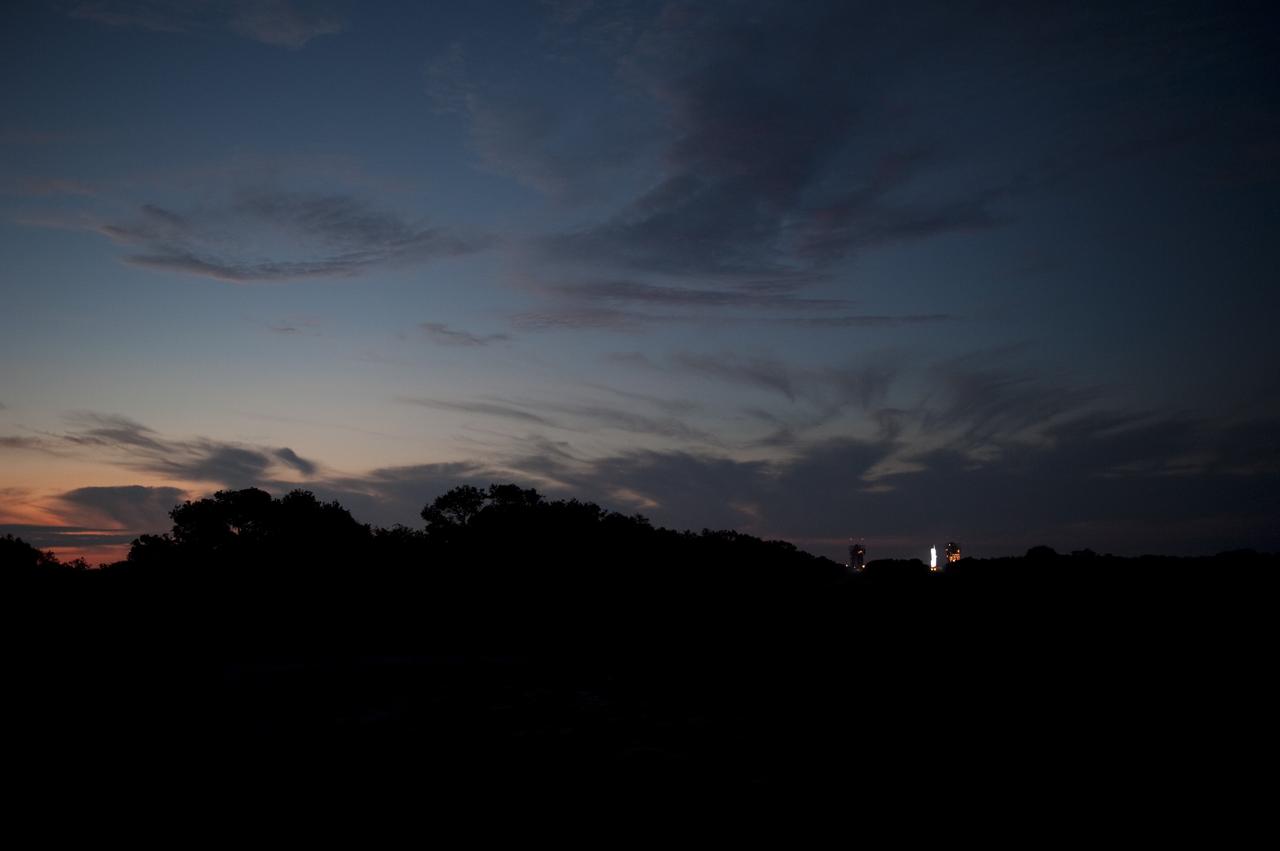
CAPE CANAVERAL, Fla. – As the sun rises, in the distance, spotlights illuminate the United Launch Alliance Delta II Heavy rocket that will launch NASA’s twin Gravity Recovery and Interior Laboratory (GRAIL) mission from Space Launch Complex 17B on Cape Canaveral Air Force Station in Florida. Liftoff is scheduled for 9:08:52 a.m. EDT Sept.10. GRAIL will fly twin spacecraft in tandem around the moon to precisely measure and map variations in the moon's gravitational field. The mission will provide the most accurate global gravity field to date for any planet, including Earth. This detailed information will reveal differences in the density of the moon's crust and mantle and will help answer fundamental questions about the moon's internal structure, thermal evolution, and history of collisions with asteroids. The aim is to map the moon's gravity field so completely that future moon vehicles can safely navigate anywhere on the moon’s surface. For more information, visit http://www.nasa.gov/grail. Photo credit: NASA/ Kim Shiflett
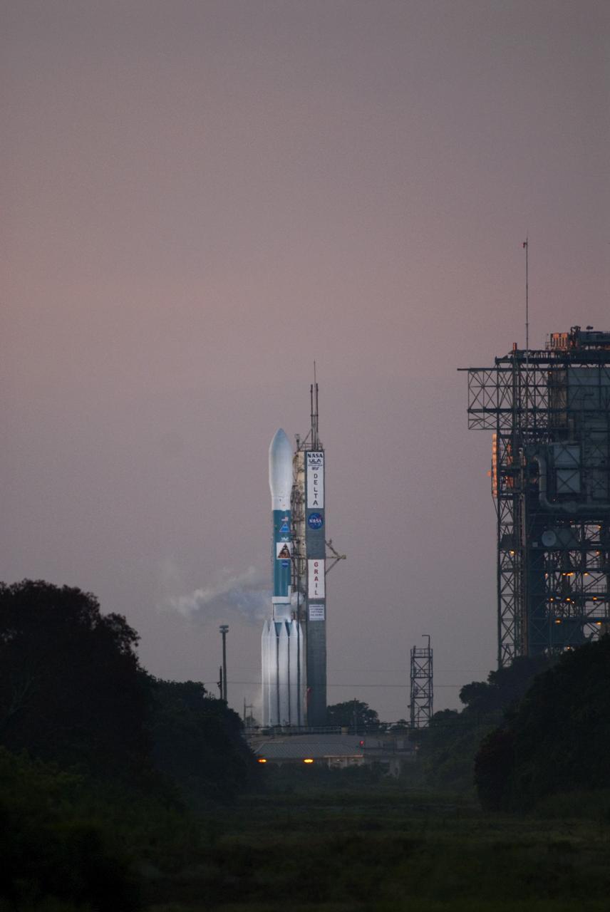
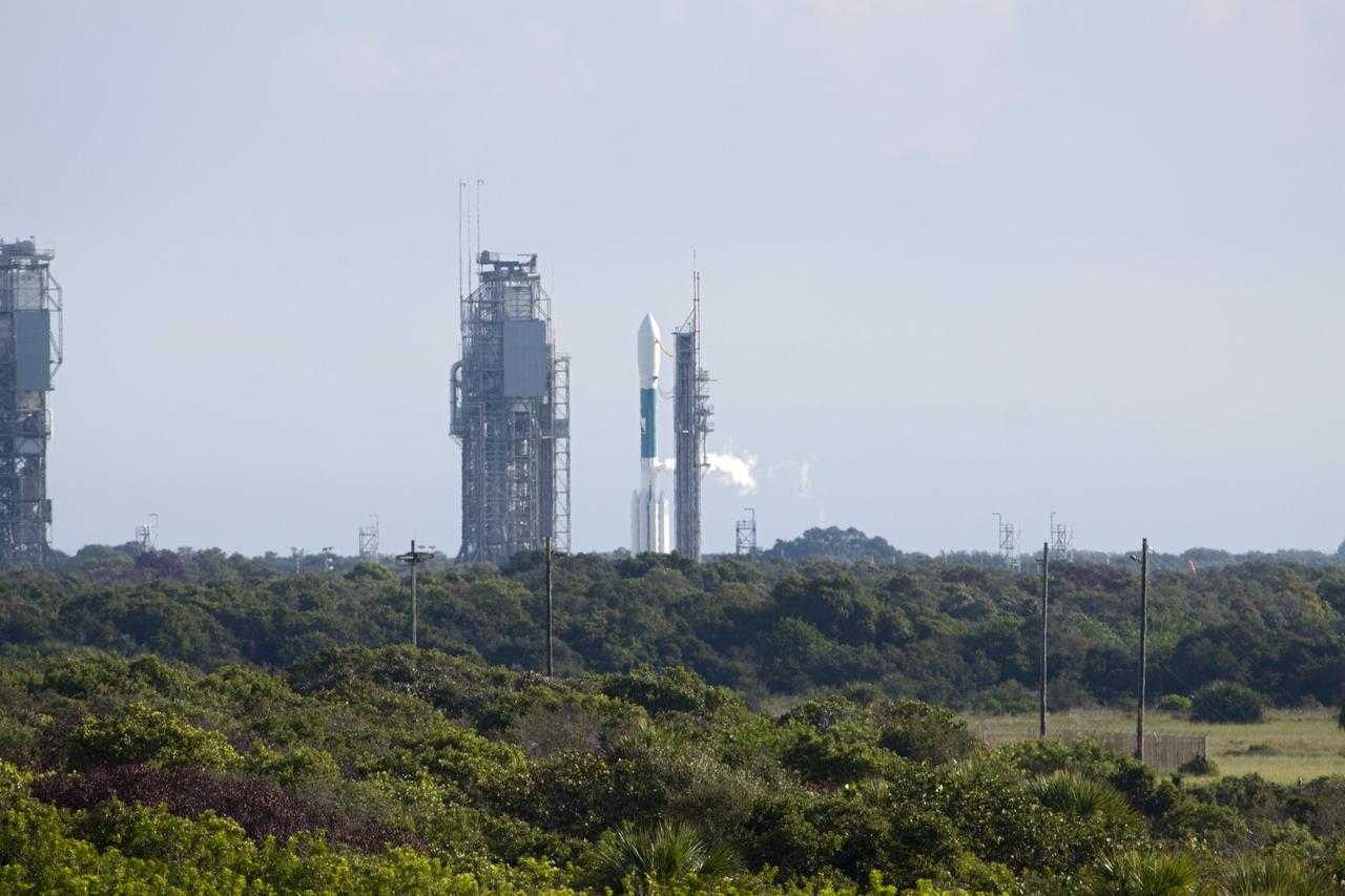
CAPE CANAVERAL, Fla. – Surrounded by an early morning sky, the United Launch Alliance Delta II Heavy rocket sits on Space Launch Complex 17B on Cape Canaveral Air Force Station in Florida as it waits to launch NASA’s twin Gravity Recovery and Interior Laboratory (GRAIL) mission to the moon. GRAIL will fly twin spacecraft in tandem around the moon to precisely measure and map variations in the moon's gravitational field. The mission will provide the most accurate global gravity field to date for any planet, including Earth. This detailed information will reveal differences in the density of the moon's crust and mantle and will help answer fundamental questions about the moon's internal structure, thermal evolution, and history of collisions with asteroids. The aim is to map the moon's gravity field so completely that future moon vehicles can safely navigate anywhere on the moon’s surface. For more information, visit http://www.nasa.gov/grail. Photo credit: NASA/Kim Shiflett
CAPE CANAVERAL, Fla. – Bathed in light against an early morning sky, the United Launch Alliance Delta II Heavy rocket sits on Space Launch Complex 17B on Cape Canaveral Air Force Station in Florida as it waits to launch NASA’s twin Gravity Recovery and Interior Laboratory (GRAIL) mission to the moon. GRAIL will fly twin spacecraft in tandem around the moon to precisely measure and map variations in the moon's gravitational field. The mission will provide the most accurate global gravity field to date for any planet, including Earth. This detailed information will reveal differences in the density of the moon's crust and mantle and will help answer fundamental questions about the moon's internal structure, thermal evolution, and history of collisions with asteroids. The aim is to map the moon's gravity field so completely that future moon vehicles can safely navigate anywhere on the moon’s surface. For more information, visit http://www.nasa.gov/grail. Photo credit: NASA/Kim Shiflett
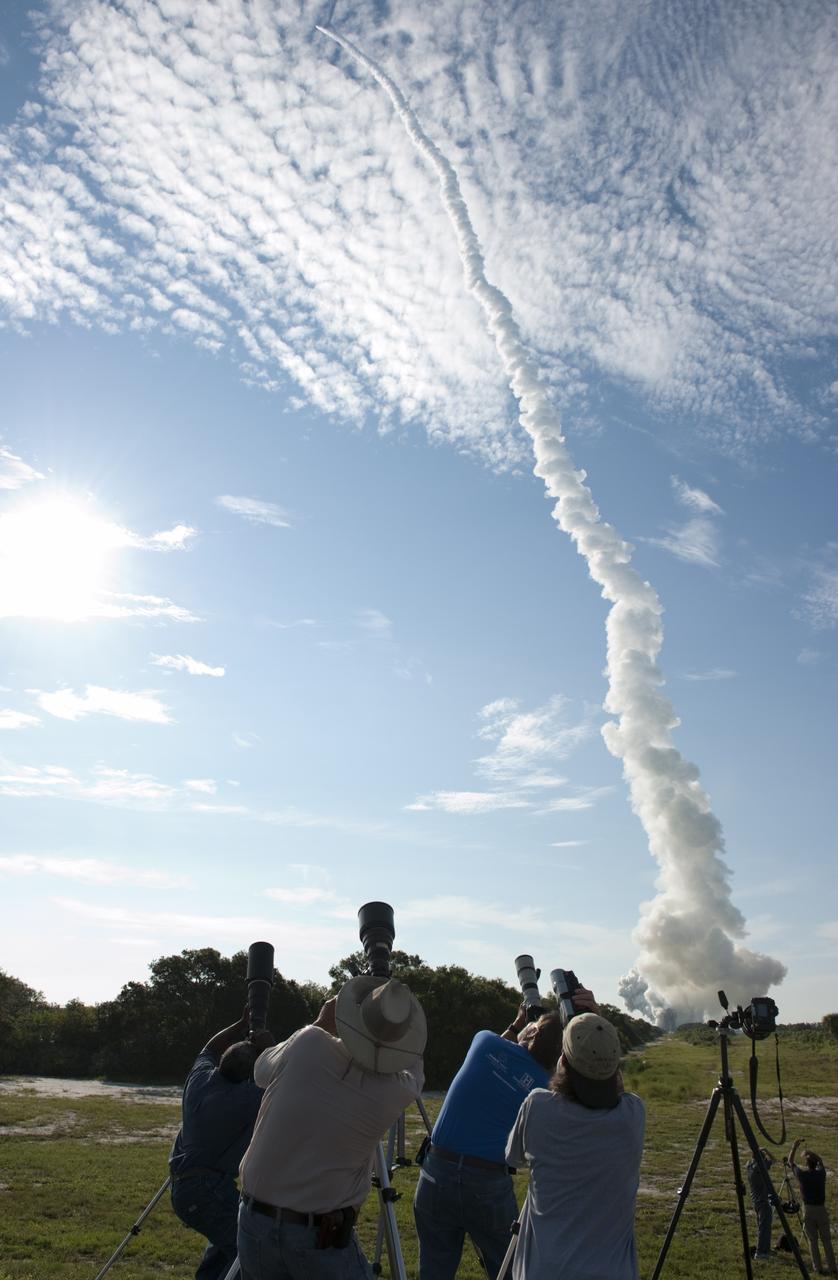
CAPE CANAVERAL, Fla. – Plumes of smoke trail the United Launch Alliance Delta II Heavy rocket launching NASA’s Gravity Recovery and Interior Laboratory (GRAIL) mission into space as media representatives at Press Site 1 near Space Launch Complex 17B on Cape Canaveral Air Force Station in Florida photograph it. Liftoff was at 9:08:52 a.m. EDT Sept.10. GRAIL-A will separate from the second stage of the rocket at about one hour, 21 minutes after liftoff, followed by GRAIL-B at 90 minutes after launch. The spacecraft are embarking on a three-month journey to reach the moon. GRAIL will fly twin spacecraft in tandem around the moon to precisely measure and map variations in the moon's gravitational field. The mission will provide the most accurate global gravity field to date for any planet, including Earth. This detailed information will reveal differences in the density of the moon's crust and mantle and will help answer fundamental questions about the moon's internal structure, thermal evolution, and history of collisions with asteroids. The aim is to map the moon's gravity field so completely that future moon vehicles can safely navigate anywhere on the moon’s surface. For more information, visit http://www.nasa.gov/grail. Photo credit: NASA/ Kim Shiflett
CAPE CANAVERAL, Fla. – An early morning sky illuminates the United Launch Alliance Delta II Heavy rocket that will launch NASA’s twin Gravity Recovery and Interior Laboratory (GRAIL) mission from Space Launch Complex 17B on Cape Canaveral Air Force Station in Florida. Liftoff is scheduled for 9:08:52 a.m. EDT Sept.10. GRAIL will fly twin spacecraft in tandem around the moon to precisely measure and map variations in the moon's gravitational field. The mission will provide the most accurate global gravity field to date for any planet, including Earth. This detailed information will reveal differences in the density of the moon's crust and mantle and will help answer fundamental questions about the moon's internal structure, thermal evolution, and history of collisions with asteroids. The aim is to map the moon's gravity field so completely that future moon vehicles can safely navigate anywhere on the moon’s surface. For more information, visit http://www.nasa.gov/grail. Photo credit: NASA/ Kim Shiflett
CAPE CANAVERAL, Fla. – Surrounded by an early morning sky, the United Launch Alliance Delta II Heavy rocket sits on Space Launch Complex 17B on Cape Canaveral Air Force Station in Florida as it waits to launch NASA’s twin Gravity Recovery and Interior Laboratory (GRAIL) mission to the moon. GRAIL will fly twin spacecraft in tandem around the moon to precisely measure and map variations in the moon's gravitational field. The mission will provide the most accurate global gravity field to date for any planet, including Earth. This detailed information will reveal differences in the density of the moon's crust and mantle and will help answer fundamental questions about the moon's internal structure, thermal evolution, and history of collisions with asteroids. The aim is to map the moon's gravity field so completely that future moon vehicles can safely navigate anywhere on the moon’s surface. For more information, visit http://www.nasa.gov/grail. Photo credit: NASA/Kim Shiflett
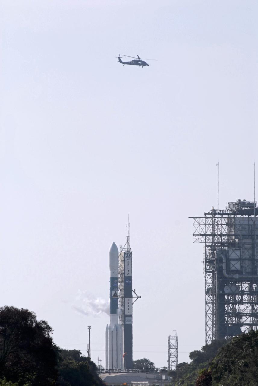
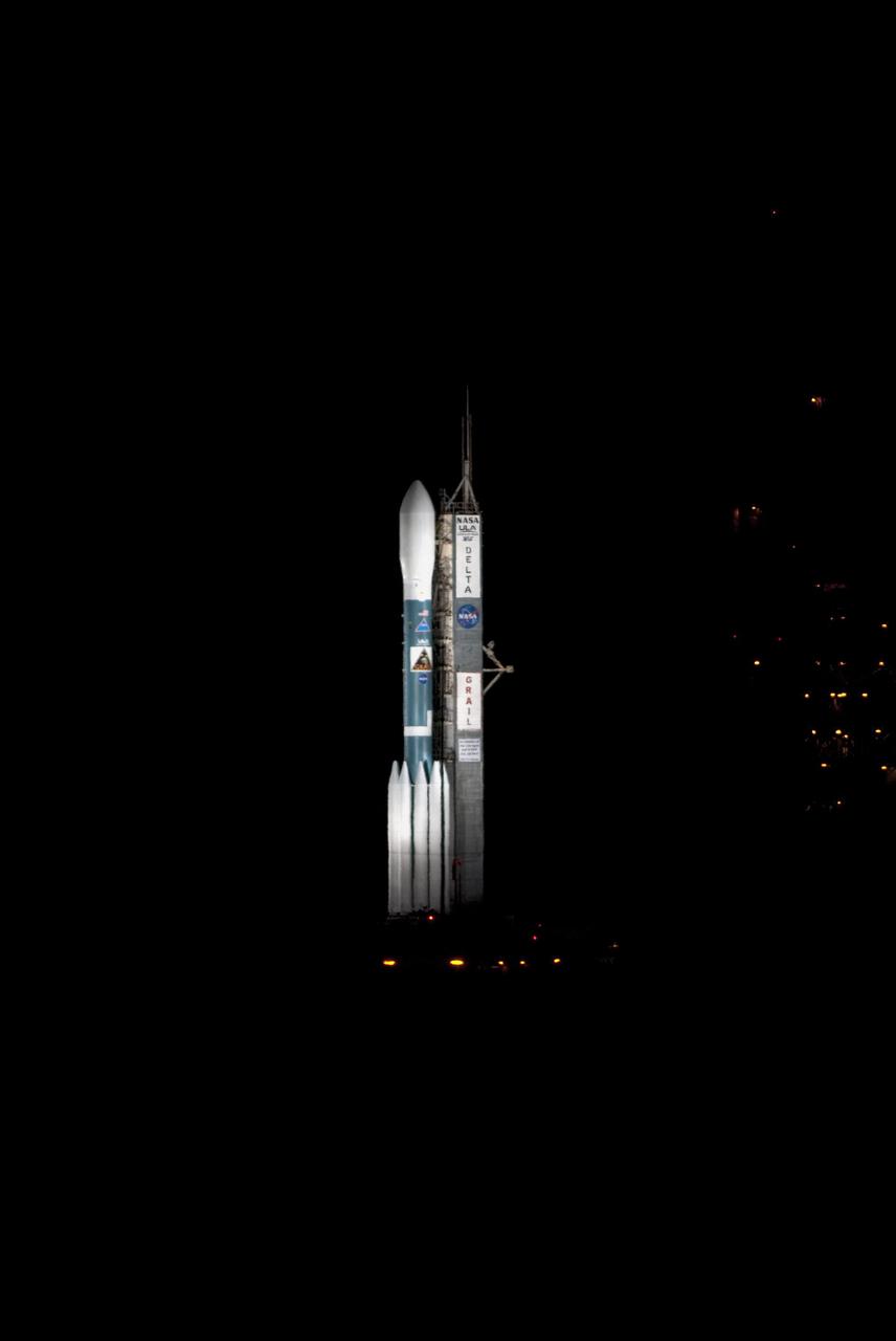
CAPE CANAVERAL, Fla. – A U.S. Air Force helicopter flies overhead as the United Launch Alliance Delta II Heavy rocket sits on Space Launch Complex 17B on Cape Canaveral Air Force Station in Florida waiting to launch NASA’s twin Gravity Recovery and Interior Laboratory (GRAIL) mission to the moon. GRAIL will fly twin spacecraft in tandem around the moon to precisely measure and map variations in the moon's gravitational field. The mission will provide the most accurate global gravity field to date for any planet, including Earth. This detailed information will reveal differences in the density of the moon's crust and mantle and will help answer fundamental questions about the moon's internal structure, thermal evolution, and history of collisions with asteroids. The aim is to map the moon's gravity field so completely that future moon vehicles can safely navigate anywhere on the moon’s surface. For more information, visit http://www.nasa.gov/grail. Photo credit: NASA/Kim Shiflett
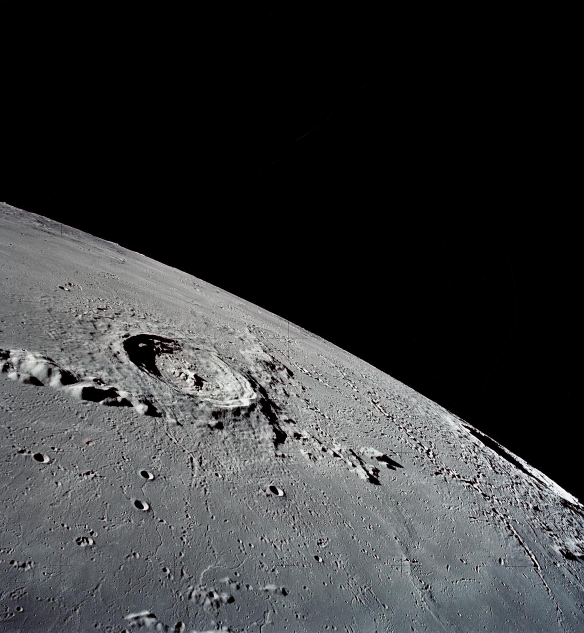
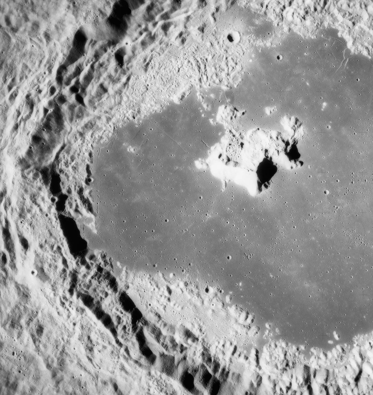
AS16-120-19237 (April 1972) --- An oblique view of a portion of the lunar nearside as photographed from the Apollo 16 spacecraft in lunar orbit. The small, bright crater is Lassell D at the northeastern edge of Mare Nubium (Sea of Clouds). The area seen in this picture is immediately west of Lassell C Crater, southwest of Guoricke Crater, and southwest of Davy Crater.
AS11-44-6626 (21 July 1969) --- The Apollo 11 Lunar Module (LM) ascent stage, with astronauts Neil A. Armstrong and Edwin E. Aldrin Jr. aboard, is photographed from the Command and Service Modules (CSM) in lunar orbit. Astronaut Michael Collins, command module pilot, remained with the CSM in lunar orbit while Armstrong and Aldrin explored the moon. The LM is approaching from below. The coordinates of the center of the lunar terrain seen below is located at 102 degrees east longitude and 1 degree north latitude.

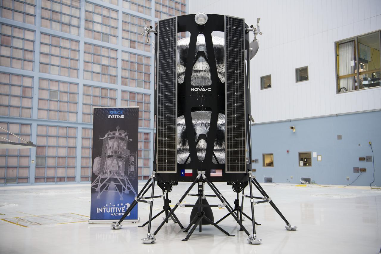
IM-1, the first NASA Commercial Launch Program Services launch for Intuitive Machines’ Nova-C lunar lander, will carry multiple payloads to the Moon, including Lunar Node-1, demonstrating autonomous navigation via radio beacon to support precise geolocation and navigation among lunar orbiters, landers, and surface personnel. NASA’s CLPS initiative oversees industry development of small robotic landers and rovers to support NASA’s Artemis campaign.
Lunar Node-1, an autonomous navigation payload that will change how human explorers safely traverse the Moon’s surface and live and work in lunar orbit, awaits liftoff as part of Intuitive Machines’ IM-1 mission, its first under NASA’s Commercial Lunar Payload Services initiative. LN-1 was developed, built, and tested at NASA’s Marshall Space Flight Center in Huntsville, Alabama.
AS17-145-22287 (7-19 Dec. 1972) --- An oblique view of the large crater Copernicus on the lunar nearside, as photographed from the Apollo 17 spacecraft in lunar orbit. This view is looking generally southwest toward the crater on the horizon. The coordinates of the center of Copernicus are approximately 20 degrees west longitude and 9.5 degrees north latitude.
AS17-145-22285 (7-19 Dec. 1972) --- This is a view of the Eratosthenes Crater, taken looking southward from the Command and Service Module (CSM), being piloted by astronaut Ronald E. Evans. Copernicus is on the horizon. The other astronauts are Eugene A. Cernan, commander; and Harrison H. Schmitt, lunar module pilot.

AS08-14-2383 (24 Dec. 1968) --- The rising Earth is about five degrees above the lunar horizon in this telephoto view taken from the Apollo 8 spacecraft near 110 degrees east longitude. The horizon, about 570 kilometers (350 statute miles) from the spacecraft, is near the eastern limb of the moon as viewed from Earth. Width of the view at the horizon is about 150 kilometers (95 statute miles). On Earth 240,000 statute miles away the sunset terminator crosses Africa. The crew took the photo around 10:40 a.m. Houston time on the morning of Dec. 24, and that would make it 15:40 GMT on the same day. The South Pole is in the white area near the left end of the terminator. North and South America are under the clouds.
AS15-97-13160 (31 July-2 Aug. 1971) --- A view of a portion of the crater Tsiolkovsky located in the highlands on the farside of the moon, as photographed from the Apollo 15 Command and Service Modules (CSM) by astronaut Alfred M. Worden, command module pilot. Note the dark, flat crater floor surrounding the very prominent central mountains. The mountains are in the northeastern corner of the photograph. The other upland area comprises part of the southwestern edge of the crater. While astronauts David R. Scott, commander, and James B. Irwin, lunar module pilot, descended in the Lunar Module (LM) "Falcon" to explore the moon, astronaut Worden remained with the CSM in lunar orbit.
S71-44670 (31 July 1971) --- A near vertical view of the crater Tsiolkovsky on the lunar farside, as photographed by the Fairchild metric camera in the Scientific Instrument Module (SIM) bay of the Apollo 15 Command and Service Modules (CSM) in lunar orbit. This view is looking northerly. The coordinates of the crater's central peaks are 128 degrees east longitude and 20 degrees south latitude. The mare area measured from east to west is approximately 145 kilometers (90 statute miles) across. The three-inch mapping camera was one of eight lunar orbital science experiments mounted in the SIM bay.
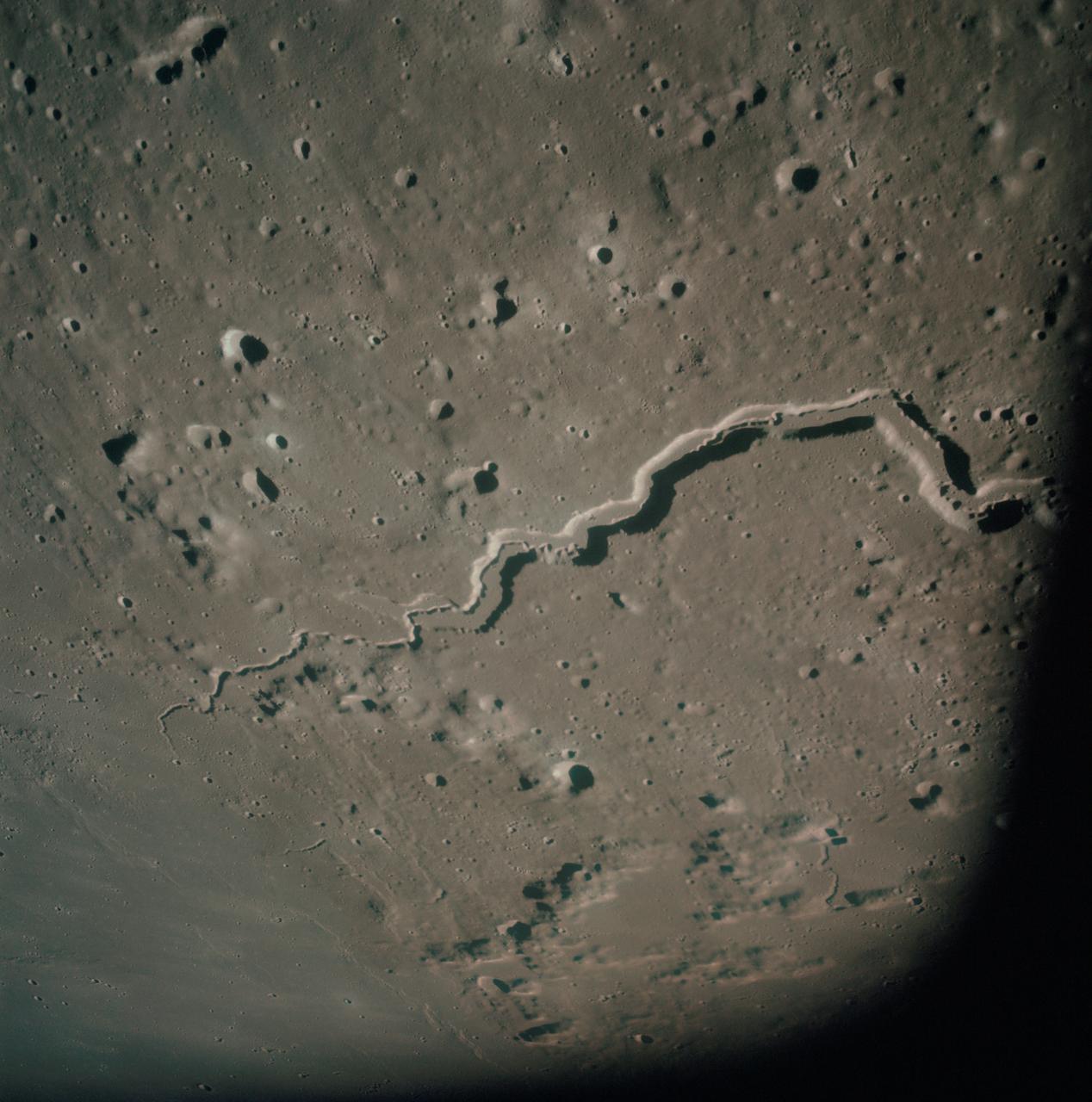
AS15-93-12628 (31 July 1971) --- The snake-like rille feature in this 70mm frame, photographed from the lunar-orbiting Apollo 15 Command and Service Modules (CSM) by astronaut Alfred M. Worden, command module pilot, is Schroter's Valley. The long feature is located not far from the crater Aristarcus (out of frame) on the western side of the moon. Center coordinates of the area pictured are located at 25 degrees north latitude and 52.5 degrees west longitude. While astronauts David R. Scott, commander, and James B. Irwin, lunar module pilot, descended in the Lunar Module (LM) "Falcon" to explore the Hadley-Apennine area of the moon, astronaut Worden remained with the CSM in lunar orbit.
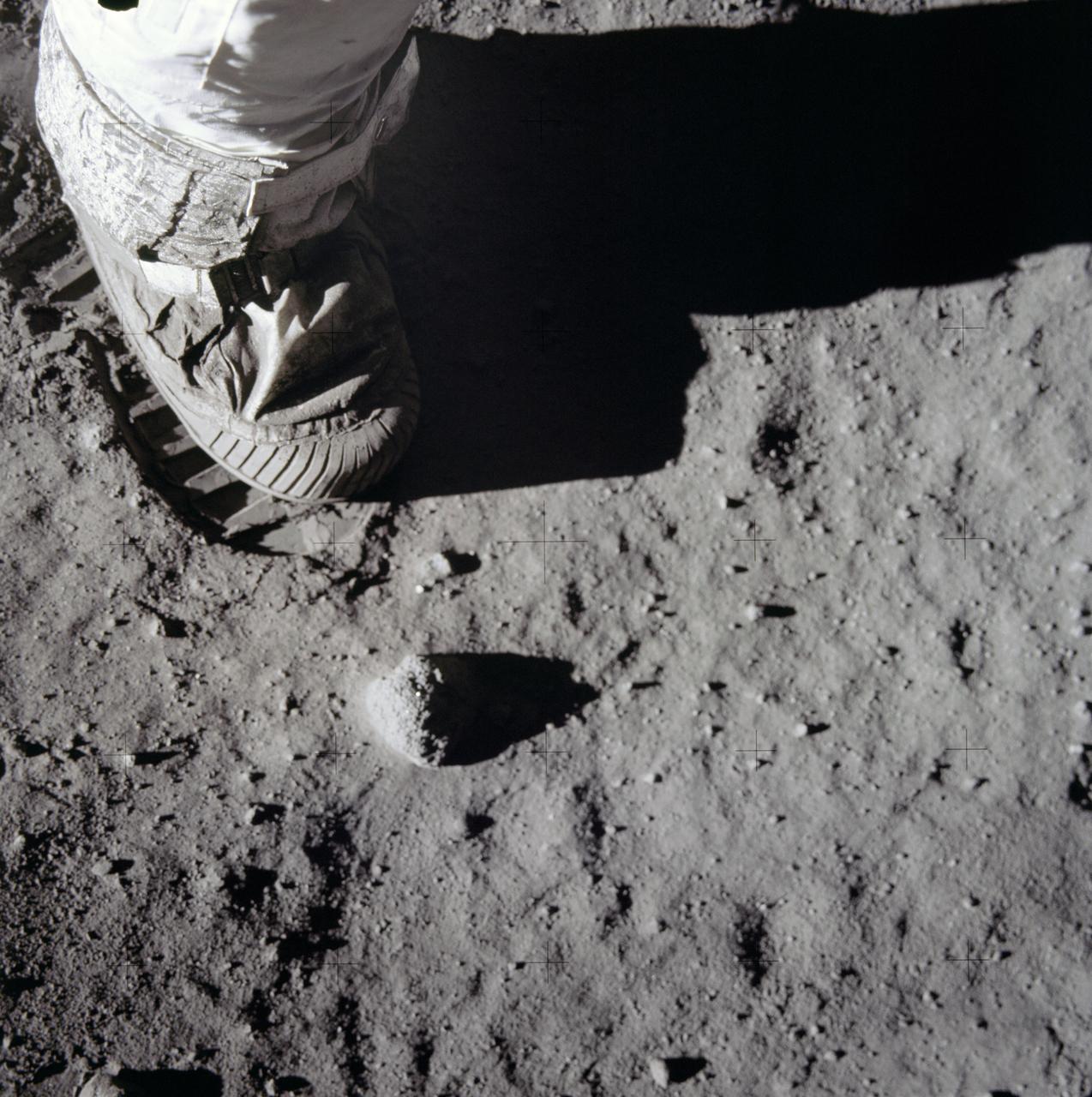
AS11-40-5880 (20 July 1969) --- A close-up view of an astronaut's boot and bootprint in the lunar soil, photographed with a 70mm lunar surface camera during the Apollo 11 lunar surface extravehicular activity (EVA). While astronauts Neil A. Armstrong, commander, and Edwin A. Aldrin Jr., lunar module pilot, descended in the Lunar Module (LM) "Eagle" to explore the Sea of Tranquility region of the moon, astronaut Michael Collins, command module pilot, remained with the Command and Service Modules (CSM)" Columbia" in lunar orbit.
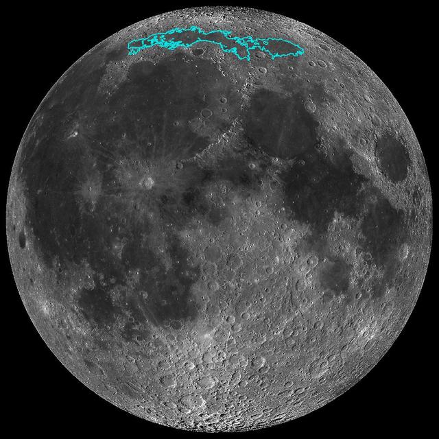
New surface features of the Moon have been discovered in a region called Mare Frigoris, outlined here in teal. This image is a mosaic composed of many images taken by NASA's Lunar Reconnaissance Orbiter (LRO). https://photojournal.jpl.nasa.gov/catalog/PIA23209
Scientists have discovered these wrinkle ridges in a region of the Moon called Mare Frigoris. These ridges add to evidence that the Moon has an actively changing surface. This image was taken by NASA's Lunar Reconnaissance Orbiter (LRO). https://photojournal.jpl.nasa.gov/catalog/PIA23210
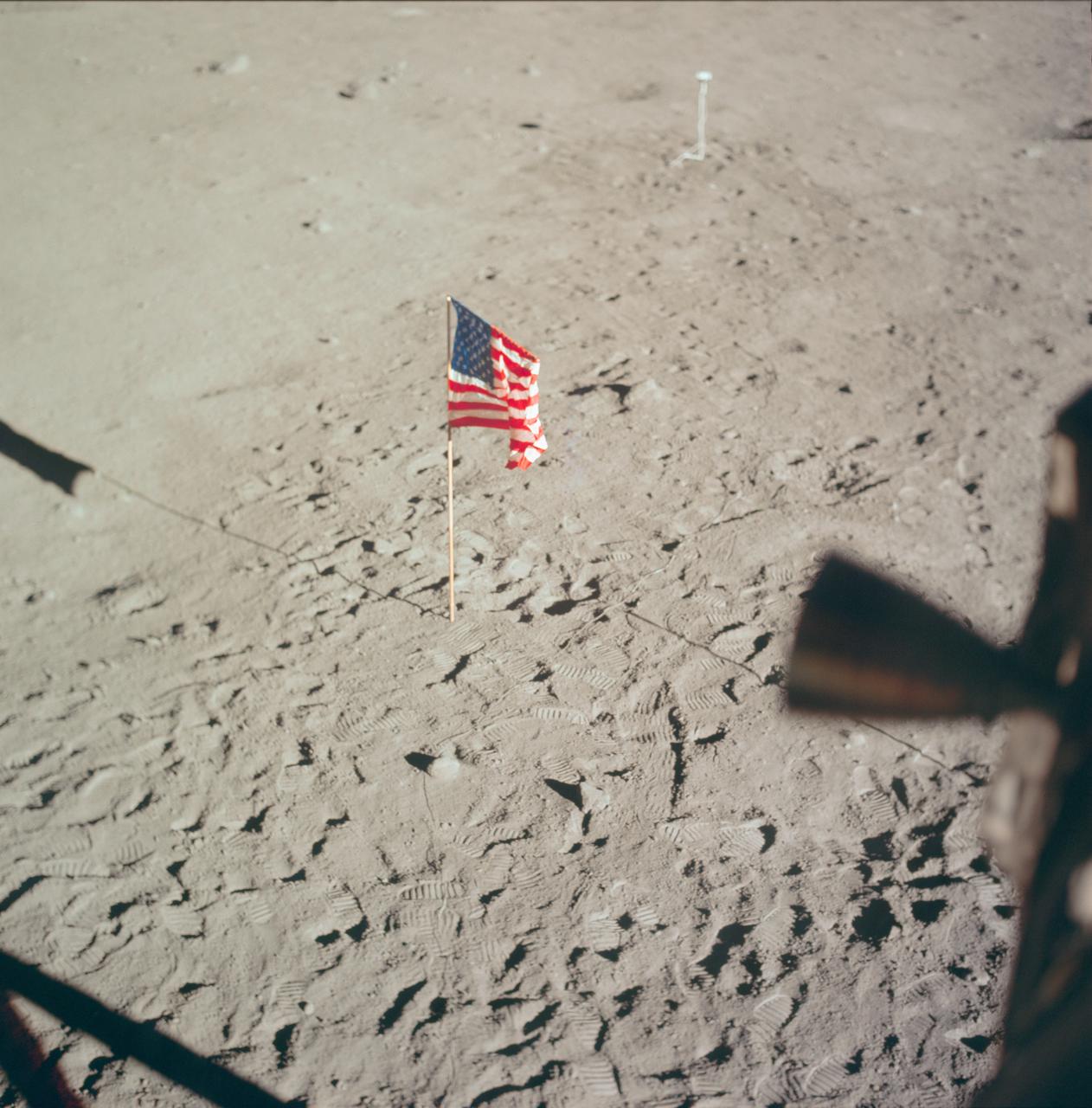
AS11-37-5545 (20 July 1969) --- The flag of the United States, deployed on the surface of the moon, dominates this photograph taken from inside the Lunar Module (LM). The footprints of astronauts Neil A. Armstrong and Edwin E. Aldrin Jr. stand out very clearly. In the far background is the deployed black and white lunar surface television camera which televised the Apollo 11 lunar surface extravehicular activity (EVA). While astronauts Armstrong, commander, and Aldrin, lunar module pilot, descended in the Lunar Module (LM) "Eagle" to explore the Sea of Tranquility region of the moon, astronaut Michael Collins, command module pilot, remained with the Command and Service Modules (CSM) "Columbia" in lunar orbit.
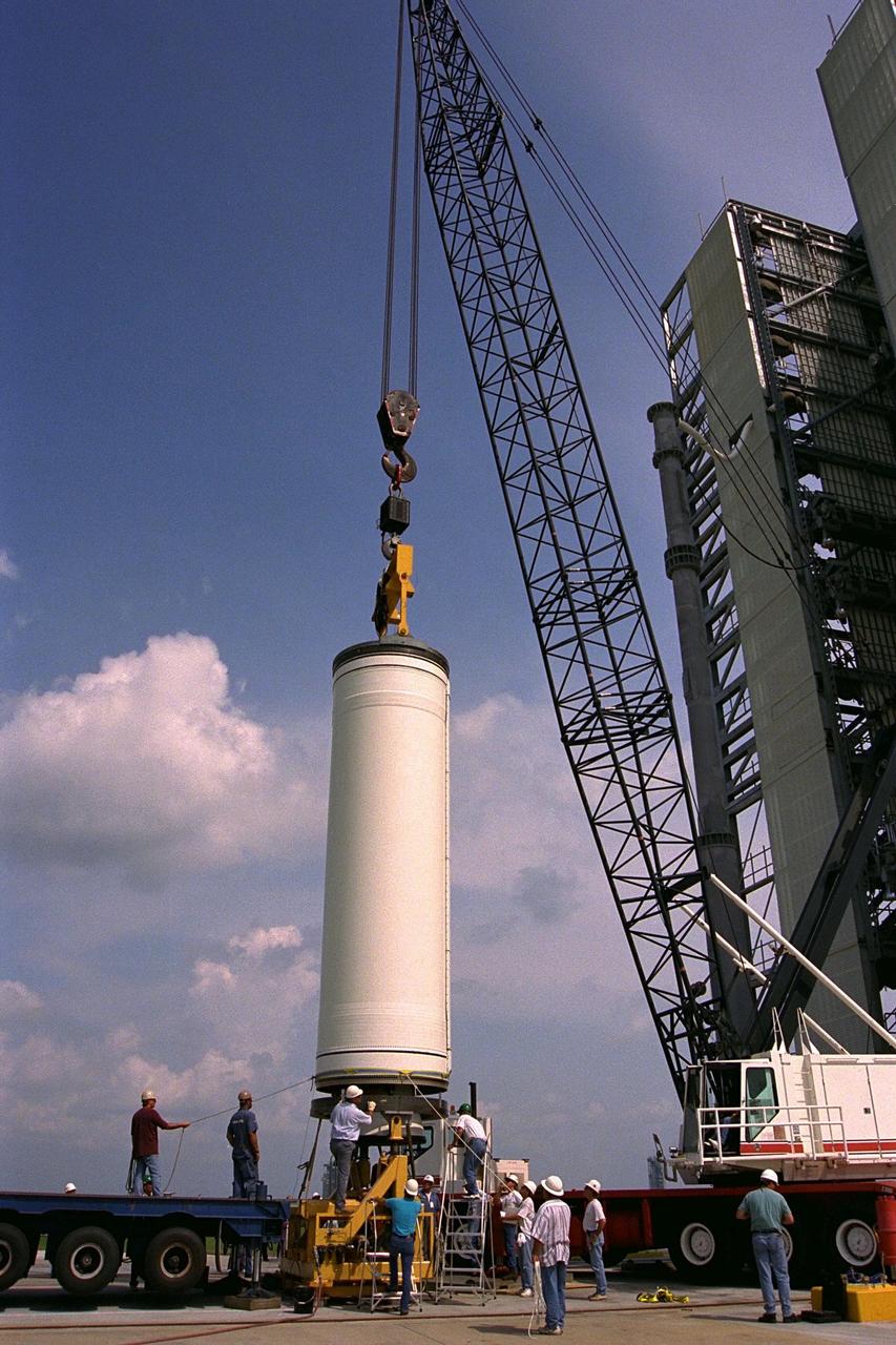
Workers erect the first stage of a Lockheed Martin Launch Vehicle-2 (LMLV-2) at Launch Complex 46 at Cape Canaveral Air Station, Fla. The Lunar Prospector spacecraft is scheduled to launch aboard the LMLV-2 in October for an 18-month mission that will orbit the Earth’s Moon to collect data from the lunar surface. Designed for a low polar orbit investigation of the Moon, the Lunar Prospector will map the Moon’s surface composition and possible polar ice deposits, measure magnetic and gravity fields, and study lunar outgassing events

Workers erect the first stage of a Lockheed Martin Launch Vehicle-2 (LMLV-2) at Launch Complex 46 at Cape Canaveral Air Station, Fla. The Lunar Prospector spacecraft is scheduled to launch aboard the LMLV-2 in October for an 18-month mission that will orbit the Earth’s Moon to collect data from the lunar surface. Designed for a low polar orbit investigation of the Moon, the Lunar Prospector will map the Moon’s surface composition and possible polar ice deposits, measure magnetic and gravity fields, and study lunar outgassing events
AS11-37-5458 (20 July 1969) --- This excellent view from the right-hand window of the Apollo 11 Lunar Module (LM) shows the surface of the moon in the vicinity of where the LM touched down. Numerous small rocks and craters can be seen between the LM and the lunar horizon. Astronaut Michael Collins, command module pilot, remained with the Command and Service Modules (CSM) in lunar orbit while astronauts Neil A. Armstrong, commander; and Edwin E. Aldrin Jr., lunar module pilot, descended in the LM to the lunar surface.
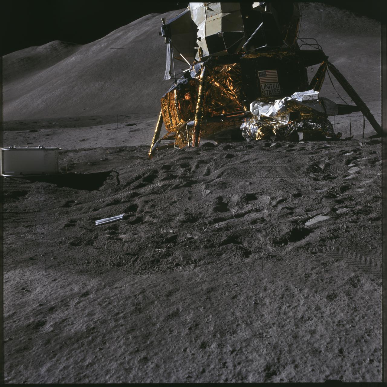
AS15-86-11600 (31 July 1971) --- A view of the Lunar Module (LM) "Falcon" taken early in the first Apollo 15 lunar surface extravehicular activity (EVA) at the Hadley-Apennine landing site prior to deployment of lunar surface equipment. Hadley Delta Mountain is in the background. While astronauts David R. Scott, commander and James B. Irwin, lunar module pilot, descended in the LM to explore the moon, astronaut Alfred M. Worden, command module pilot, remained with the Command and Service Modules (CSM) in lunar orbit.
AS11-44-6581 (20 July 1969) --- The Apollo 11 Lunar Module (LM), in a lunar landing configuration, is photographed in lunar orbit from the Command and Service Modules (CSM). Inside the LM were astronauts Neil A. Armstrong, commander, and Edwin E. Aldrin Jr., lunar module pilot. Astronaut Michael Collins, command module pilot, remained with the CSM in lunar orbit while Armstrong and Aldrin descended in the LM to explore the lunar surface. The protrusions connected to the landing pods are sensors to aid in the touchdown or landing process.
AS12-47-6988 (19 Nov. 1969) --- Astronaut Charles Conrad Jr., commander of the Apollo 12 lunar landing mission, stands at the Module Equipment Stowage Assembly (MESA) on the Lunar Module (LM) following the first Apollo 12 extravehicular activity (EVA) on the lunar surface. The erectable S-band antenna is already deployed at right. The carrier for the Apollo Lunar Hand Tools (ALHT) is near Conrad. While astronauts Conrad and Alan L. Bean, lunar module pilot, descended in the LM to explore the lunar surface, astronaut Richard F. Gordon Jr., command module pilot, remained with the Command and Service Modules (CSM) in lunar orbit.
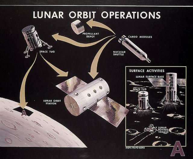
This 1970 artist's concept shows the Nuclear Shuttle and Space Tug operating in conjunction with other spacecraft to support lunar exploration. Marshall Space Flight Center plans during the late 1960s for lunar orbital and surface bases required extensive logistics operations in lunar orbit.
AS11-36-5365 (21 July 1969) --- A close-up view of the docking target on the Apollo 11 Lunar Module (LM) photographed from the Command Module during the LM/CSM docking in lunar orbit. Astronauts Neil A. Armstrong, commander, and Edwin E. Aldrin Jr., lunar module pilot, in the LM, were returning from the lunar surface. Astronaut Michael Collins, command module pilot, remained with the Command and Service Modules (CSM) in lunar orbit while Armstrong and Aldrin explored the moon.
Small light colored area within the crater is Surveyor 1 on lunar surface photographed by Lunar Orbiter III. Published in the book "A Century at Langley" by Joseph Chambers. pg. 93 Moon Lunar Orbiter-Lunar Orbiter III: The hidden or dark side of the Moon was taken by Lunar Orbiter III During its mission to photograph potential lunar-landing sites for Apollo missions. -- Photograph published in Winds of Change, 75th Anniversary NASA publication (page 94), by James Schultz. Photo Number:67-H-328 is 1967-L-04026

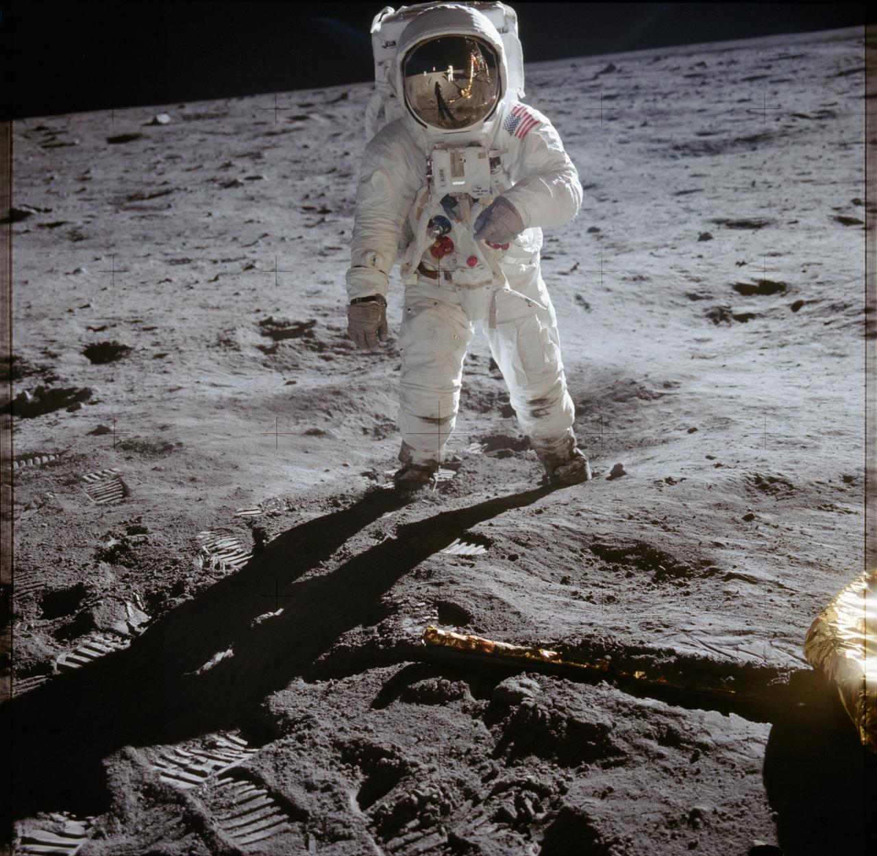
AS11-40-5875 (20 July 1969) --- Astronaut Edwin E. Aldrin Jr., lunar module pilot of the first lunar landing mission, poses for a photograph beside the deployed United States flag during an Apollo 11 extravehicular activity (EVA) on the lunar surface. The Lunar Module (LM) is on the left, and the footprints of the astronauts are clearly visible in the soil of the moon. Astronaut Neil A. Armstrong, commander, took this picture with a 70mm Hasselblad lunar surface camera. While astronauts Armstrong and Aldrin descended in the LM, the "Eagle", to explore the Sea of Tranquility region of the moon, astronaut Michael Collins, command module pilot, remained with the Command and Service Modules (CSM) "Columbia" in lunar orbit. Photo credit: NASA
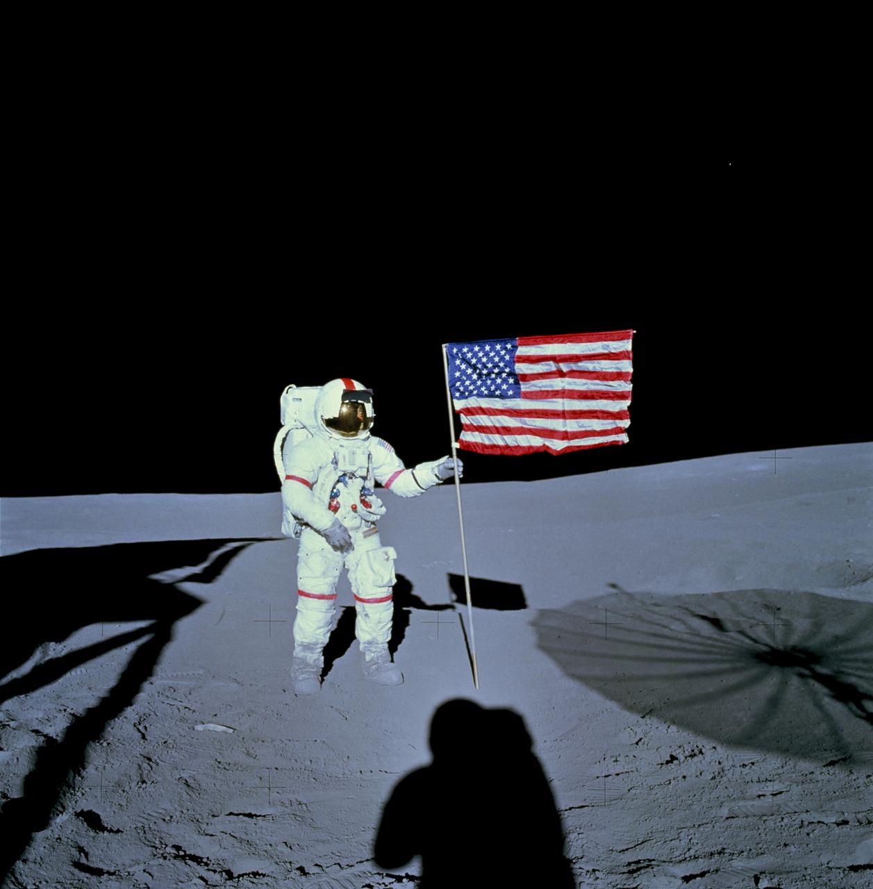
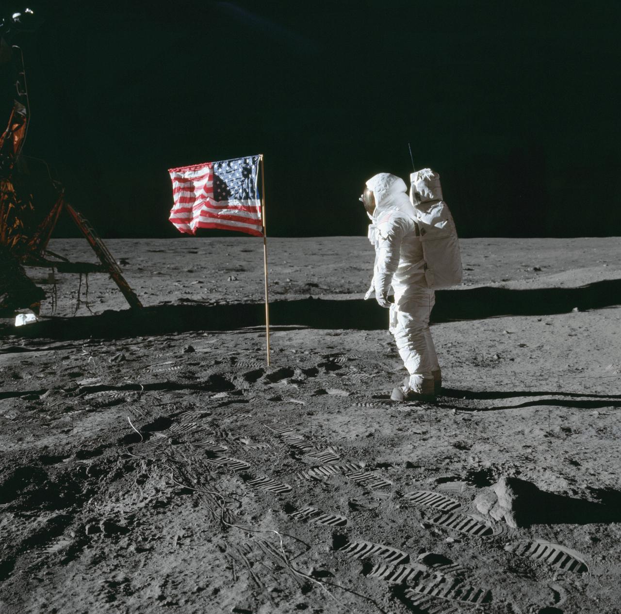
AS14-66-9232 (5 Feb. 1971) --- Astronaut Alan B. Shepard Jr., commander of the Apollo 14 lunar landing mission, stands by the deployed United States flag on the lunar surface during the early moments of the first extravehicular activity (EVA) of the mission. Shadows of the Lunar Module (LM), astronaut Edgar D. Mitchell, lunar module pilot, and the erectable S-Band Antenna surround the scene of the third flag implanting to be performed on the lunar surface. While astronauts Shepard and Mitchell descended in the LM ?Antares? to explore the Fra Mauro region of the moon, astronaut Stuart A. Roosa, command module pilot, remained with the Command and Service Modules (CSM) ?Kitty Hawk? in lunar orbit.
AS12-48-7160 (19-20 Nov. 1969) --- This view of the lunar surface was taken by one of the two astronauts on the Apollo 12 mission during their extravehicular activity. Seen in this view are the U.S. flag, several astronaut footprints, and a small crater near their Lunar Module landing site. Astronaut Charles Conrad Jr., commander, and Alan L. Bean, lunar module pilot, descended in the Lunar Module to explore the lunar surface. Astronaut Richard F. Gordon Jr., command module pilot, remained with Command and Service Modules in lunar orbit.
AS11-40-5874 (20 July 1969) --- Astronaut Edwin E. Aldrin Jr., lunar module pilot of the first lunar landing mission, poses for a photograph beside the deployed United States flag during Apollo 11 extravehicular activity (EVA) on the lunar surface. The Lunar Module (LM) is on the left, and the footprints of the astronauts are clearly visible in the soil of the moon. Astronaut Neil A. Armstrong, commander, took this picture with a 70mm Hasselblad lunar surface camera. While astronauts Armstrong and Aldrin descended in the LM the "Eagle" to explore the Sea of Tranquility region of the moon, astronaut Michael Collins, command module pilot, remained with the Command and Service Modules (CSM) "Columbia" in lunar orbit.
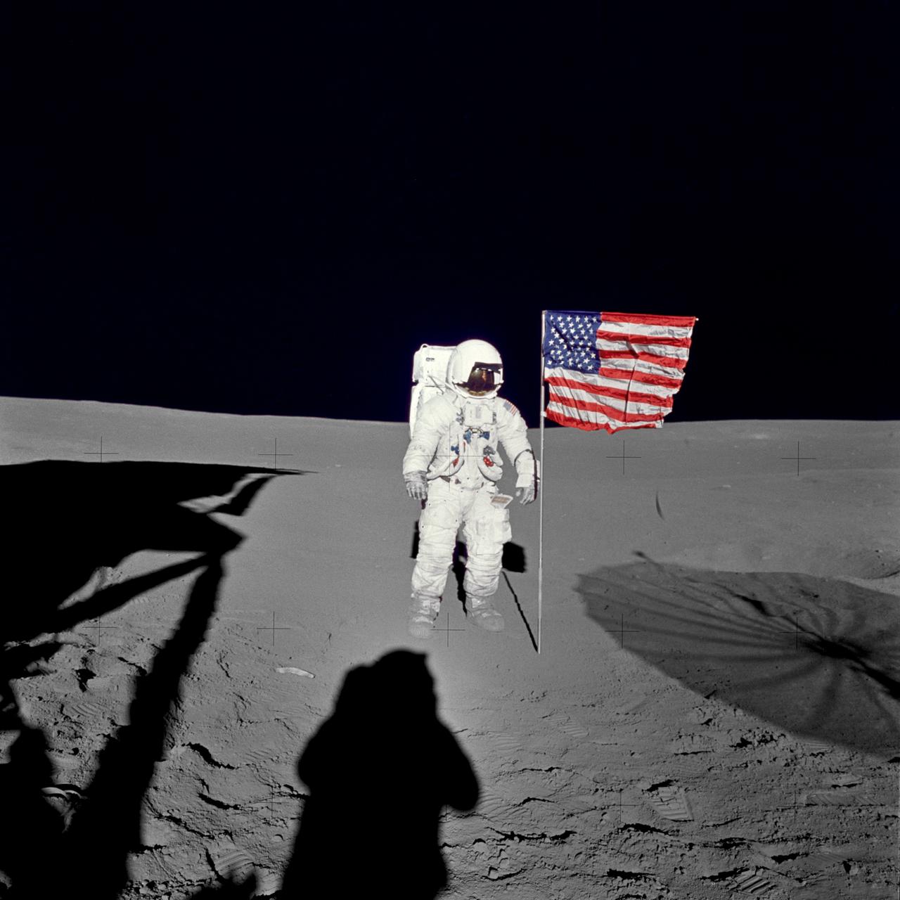
AS14-66-9233 (5 Feb. 1971) --- Astronaut Edgar D. Mitchell, lunar module pilot for the Apollo 14 lunar landing mission, stands by the deployed U.S. flag on the lunar surface during the early moments of the first extravehicular activity (EVA) of the mission. He was photographed by astronaut Alan B. Shepard Jr., mission commander, using a 70mm modified lunar surface Hasselblad camera. While astronauts Shepard and Mitchell descended in the Lunar Module (LM) "Antares" to explore the Fra Mauro region of the moon, astronaut Stuart A. Roosa, command module pilot, remained with the Command and Service Modules (CSM) "Kitty Hawk" in lunar orbit.
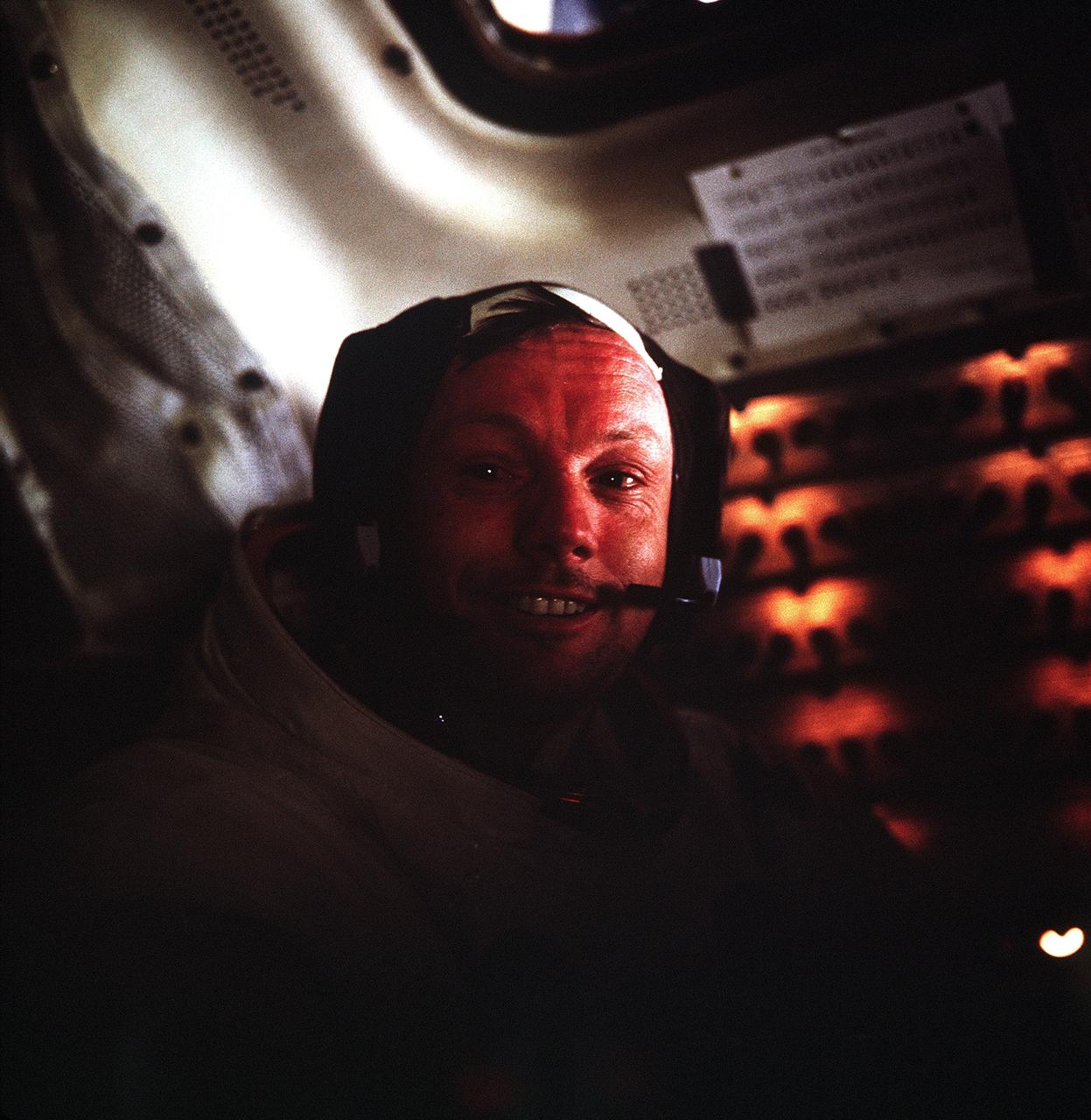
AS11-37-5528 (20 July 1969) --- This photograph of astronaut Neil A. Armstrong, Apollo 11 commander, was taken inside the Lunar Module (LM) while the LM rested on the lunar surface. Astronauts Armstrong and Edwin E. Aldrin Jr., lunar module pilot, had already completed their historic extravehicular activity (EVA) when this picture was made. Astronaut Michael Collins, command module pilot, remained with the Command and Service Modules (CSM) in lunar orbit while Armstrong and Aldrin explored the moon's surface.
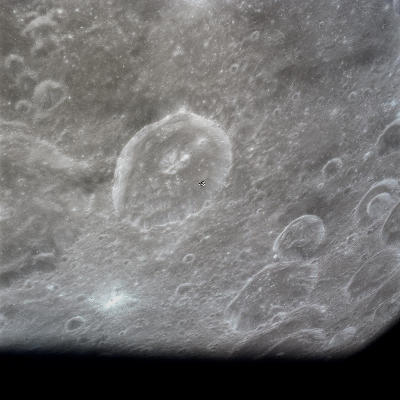
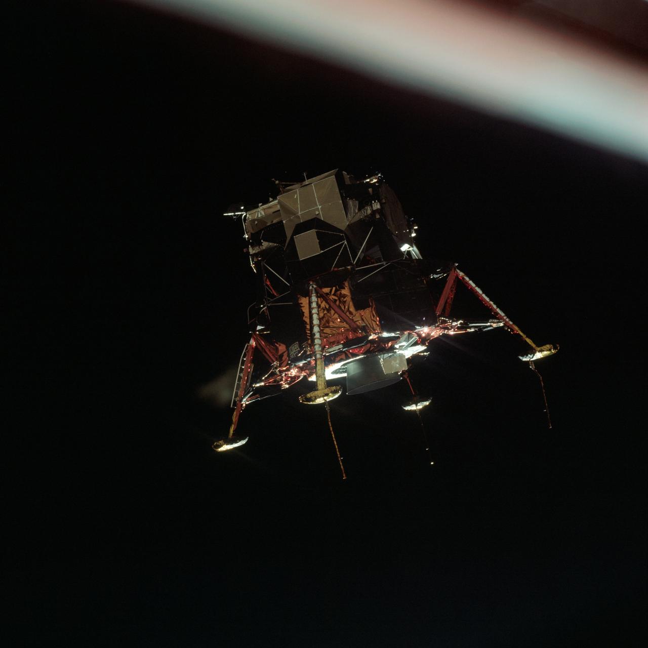
AS16-122-19527 (23 April 1972) --- The Apollo 16 Lunar Module (LM) ascent stage, with astronauts John W. Young and Charles M. Duke Jr. aboard, returns from the lunar surface to rejoin the Command and Service Modules (CSM) in lunar orbit. Astronaut Thomas K. (Ken) Mattingly II took this photograph from the Command Module (CM). The LM is above the Crater Schubert B. The lunar surface area visible in this picture is located at the western edge of Smyth's Sea.
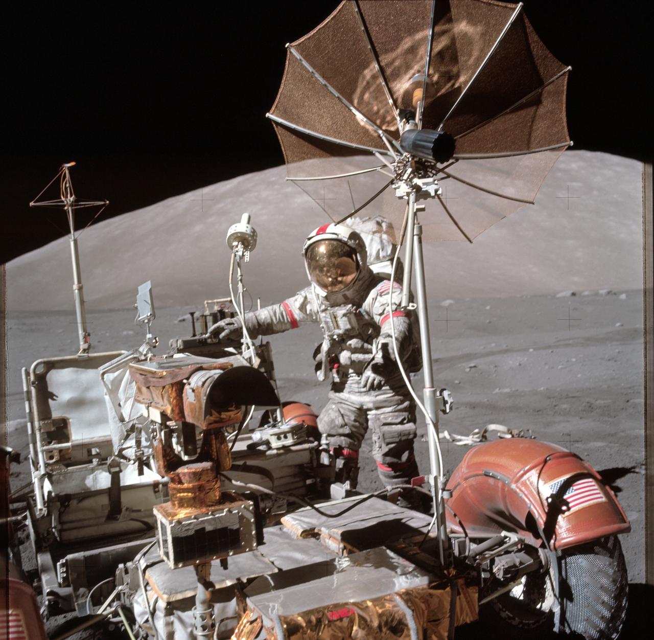
AS17-134-20476 (13 Dec. 1972) --- Astronaut Eugene A. Cernan, Apollo 17 commander, approaches the parked Lunar Roving Vehicle (LRV) on the lunar surface during the flight's third period of extravehicular activity (EVA). South Massif can be seen in the background. The photograph was taken with a hand-held Hasselblad camera by scientist-astronaut Harrison H. Schmitt, lunar module pilot. While the two explored the surface of the moon, astronaut Ronald E. Evans remained with the Command and Service Modules (CSM) in lunar orbit.
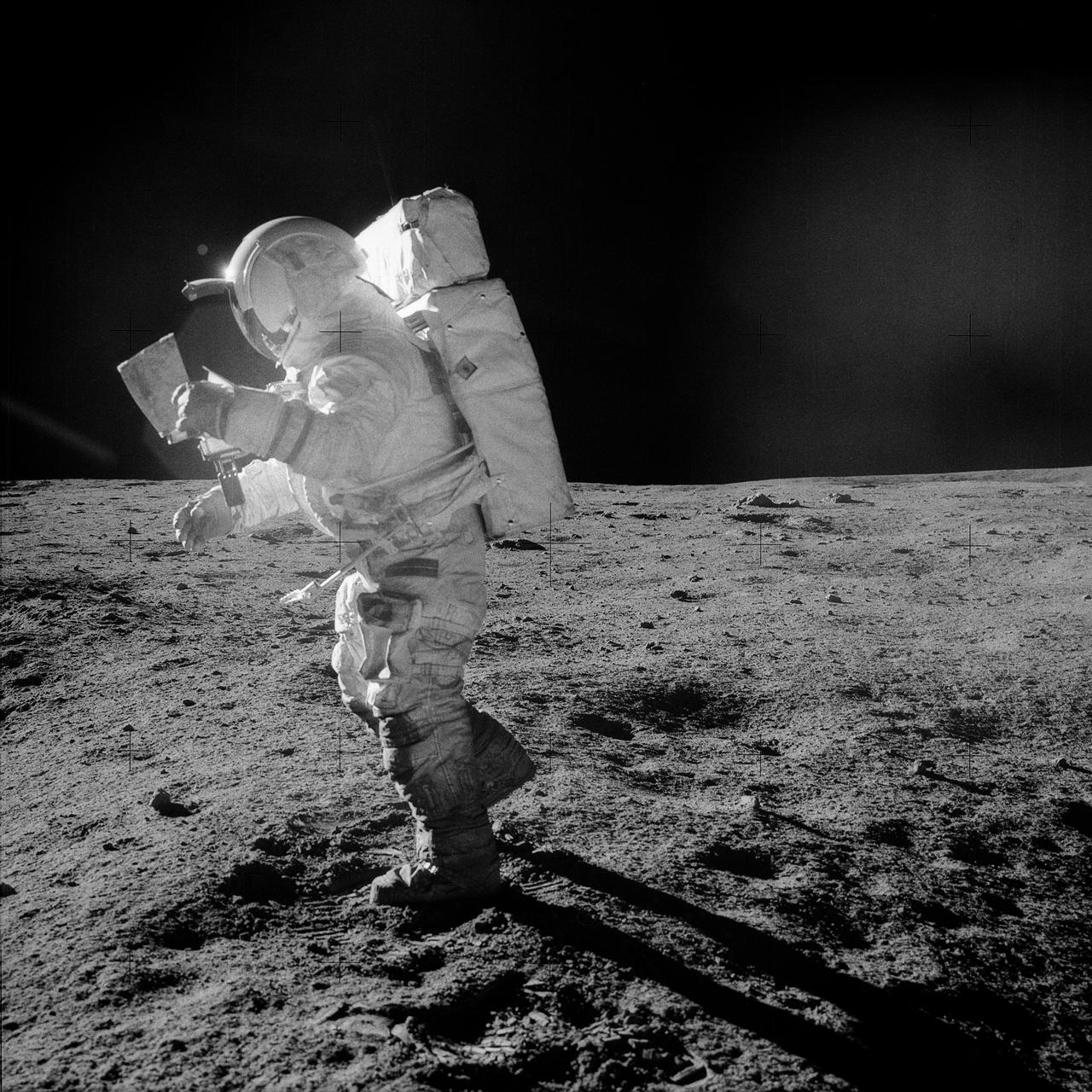
AS14-64-9089 (5-6 Feb. 1971) --- Astronaut Edgar D. Mitchell, lunar module pilot, moves across the lunar surface as he looks over a traverse map during an extravehicular activity (EVA). Lunar dust can be seen clinging to the boots and legs of the space suit. Astronauts Alan B. Shepard Jr., commander, and Mitchell explored the lunar surface while astronaut Stuart A. Roosa, command module pilot, orbited the moon in the Command and Service Modules (CSM).
AS08-14-2400 (21-27 Dec. 1968) --- This near vertical photograph of the lunar surface taken with a telephoto lens during the Apollo 8 lunar orbit mission. The area covered by the photograph is approximately 20 miles on a side, and the photographed area is located at about 3 degrees south latitude and 160 degrees west longitude on the lunar farside. The lunar surface probably had less pronounced color than indicated by this print.
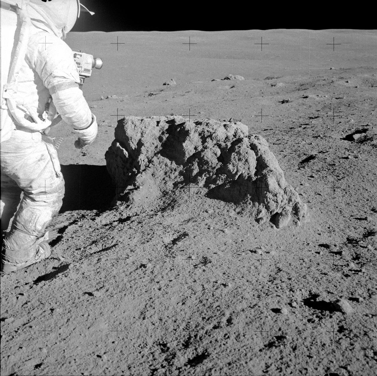
AS14-68-9414 (6 Feb. 1971) --- Astronaut Alan B. Shepard Jr., Apollo 14 commander, stands beside a large boulder on the lunar surface during the mission's second extravehicular activity (EVA), on Feb. 6, 1971. Note the lunar dust clinging to Shepard's space suit. Astronauts Shepard and Edgar D. Mitchell, lunar module pilot, explored the lunar surface while astronaut Stuart A. Roosa, command module pilot, orbited the moon in the Command and Service Modules (CSM).
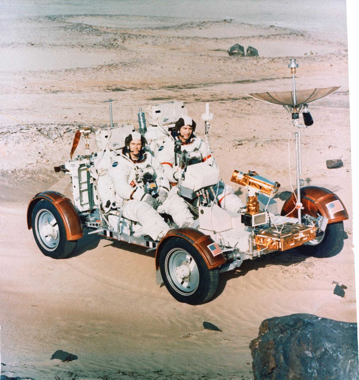
S72-30695 (22 Dec. 1971) --- Astronauts John W. Young, right, Apollo 16 commander, and Charles M. Duke Jr., lunar module pilot, maneuver a training version of the Lunar Roving Vehicle (LRV) about a field at Kennedy Space Center (KSC) simulated to represent the lunar surface. The LRV is planned to transport the two crew men around the Descartes area on the lunar surface while astronaut Thomas K. Mattingly II, command module pilot, orbits the moon in the Command and Service Modules (CSM).
This illustration shows NASA's Lunar Flashlight, with its four solar arrays deployed, shortly after launch. The small satellite, or SmallSat, launched Nov. 30, 2022, aboard a SpaceX Falcon 9 rocket as a rideshare with ispace's HAKUTO-R Mission 1. It will take about three months to reach its science orbit to seek out surface water ice in the darkest craters of the Moon's South Pole. A technology demonstration, Lunar Flashlight will use a reflectometer equipped with four lasers that emit near-infrared light in wavelengths readily absorbed by surface water ice. This is the first time that multiple colored lasers will be used to seek out ice inside these dark regions on the Moon, which haven't seen sunlight in billions of years. Should the lasers hit bare rock or regolith (broken rock and dust), the light will reflect back to the spacecraft. But if the target absorbs the light, that would indicate the presence of water ice. The greater the absorption, the more ice there may be. The science data collected by the mission will be compared with observations made by other lunar missions to help reveal the distribution of surface water ice on the Moon for potential use by future astronauts. https://photojournal.jpl.nasa.gov/catalog/PIA25626
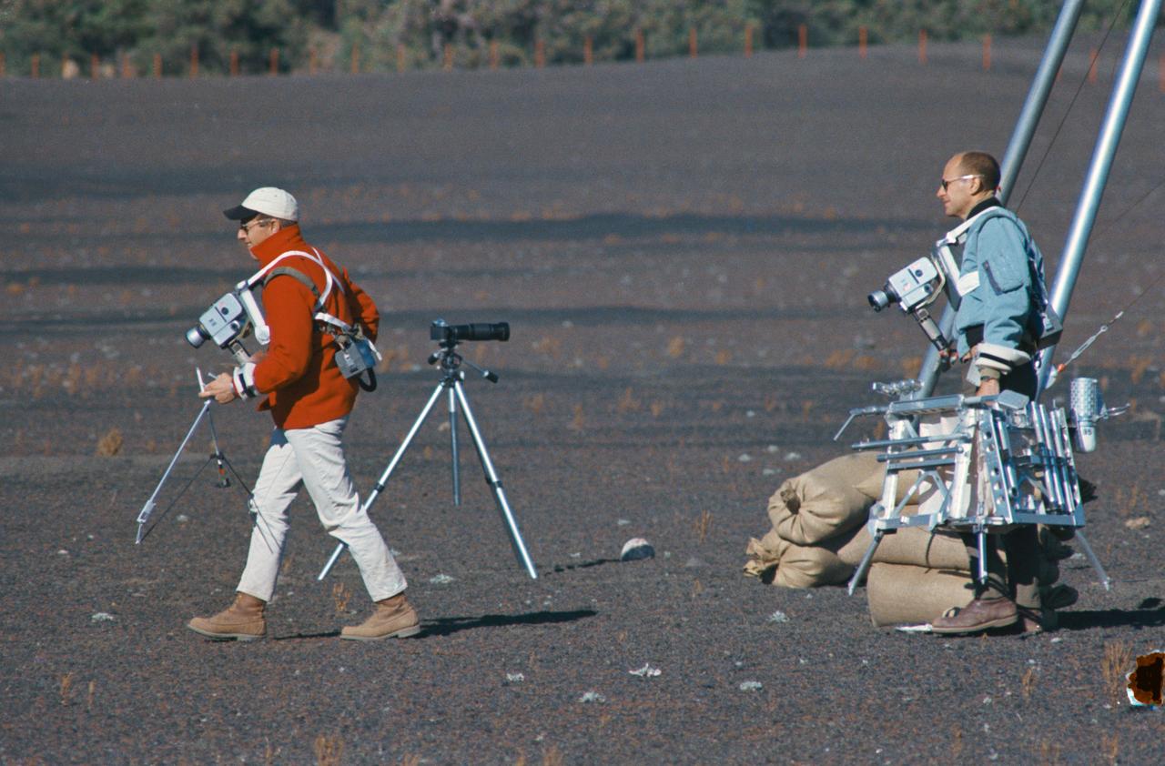
S69-55667 (10 Oct. 1969) --- Astronauts Charles Conrad Jr. and Alan L. Bean train for their upcoming Apollo 12 lunar landing mission. Here they are entering a simulated lunar surface area near Flagstaff, Arizona. Both are wearing lunar surface cameras strapped to their bodies. Conrad (left), the Apollo 12 mission commander, is carrying some of the tools from the geological tool container. The geological tool container, being carried here by Bean, the lunar module pilot, is similar to the one which will be used during scheduled extravehicular activity (EVA) periods on Nov. 19 and 20, 1969, on the lunar surface. While astronauts Conrad and Bean conduct their scheduled EVA on the moon's surface, astronaut Richard F. Gordon Jr., command module pilot, will man the Command and Service Modules (CSM) in lunar orbit.
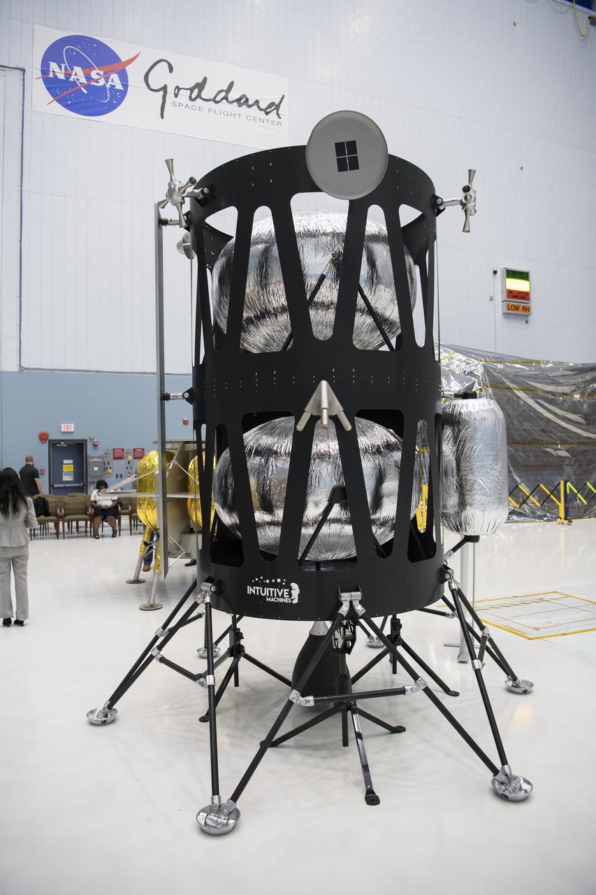
The Intuitive Machines lunar lander is seen, Friday, May 31, 2019, at Goddard Space Flight Center in Md. Astrobotic, Intuitive Machines, and Orbit Beyond have been selected to provide the first lunar landers for the Artemis program's lunar surface exploration. Photo credit: (NASA/Aubrey Gemignani)
The Intuitive Machines lunar lander is seen, Friday, May 31, 2019, at Goddard Space Flight Center in Md. Astrobotic, Intuitive Machines, and Orbit Beyond have been selected to provide the first lunar landers for the Artemis program's lunar surface exploration. Photo credit: (NASA/Aubrey Gemignani)

S71-40085 (July 1971) --- An enlarged Lunar Orbiter photograph of the Apollo 15 landing area in the Hadley-Apennine region on the nearside of the moon. The overlay indicates the location of the numerous informally-named surface features. These names will facilitate understanding the verbal descriptions from the astronauts during their lunar surface extravehicular activity (EVA). This is an August 1967, Lunar Orbiter V photograph of Site 26.1.
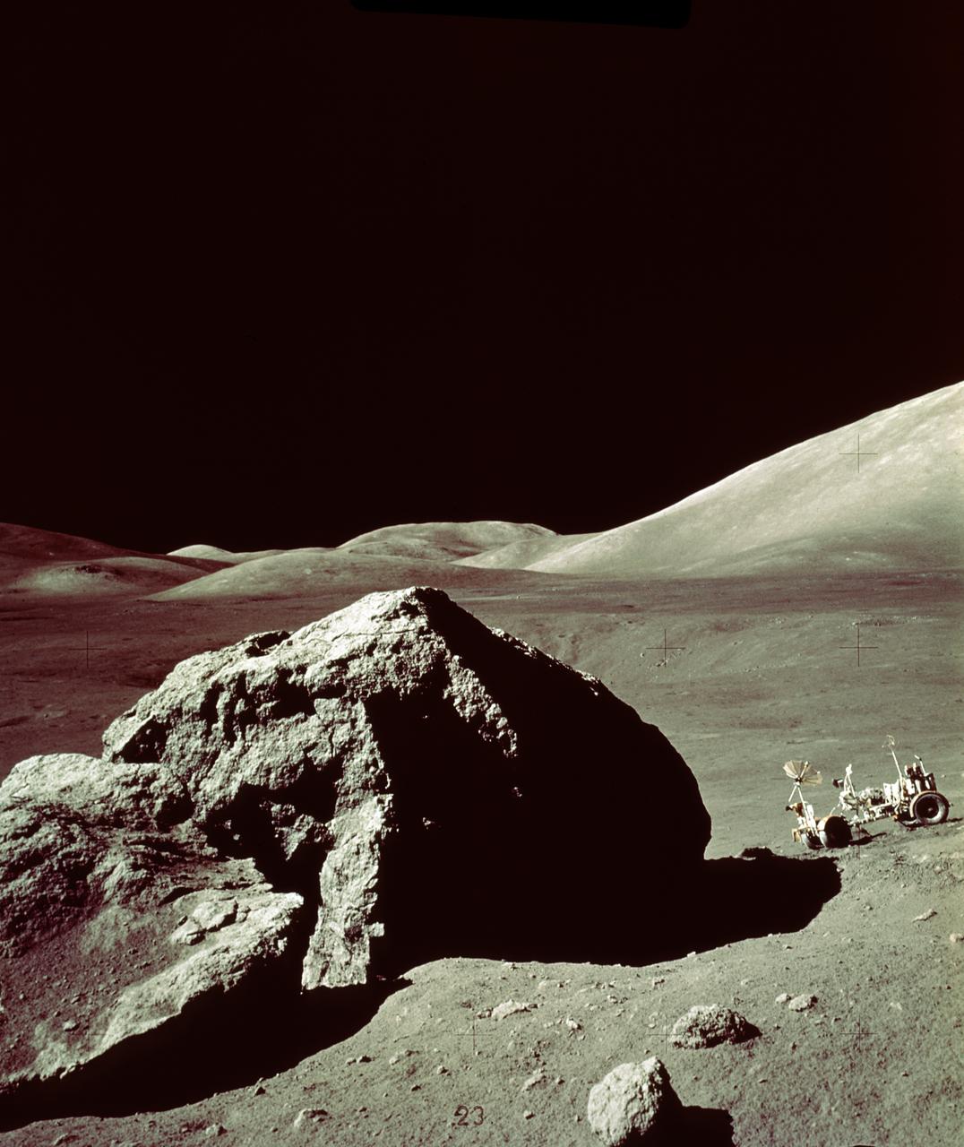
In this Apollo 17 onboard photo, a Lunar Roving Vehicle (LRV) is parked beside a huge boulder near the Valley of Tourus-Litttrow on the lunar surface. The seventh and last manned lunar landing and return to Earth mission, the Apollo 17, carrying a crew of three astronauts: Mission Commander Eugene A. Cernan; Lunar Module pilot Harrison H. Schmitt; and Command Module pilot Ronald E. Evans, lifted off on December 7, 1972 from the Kennedy Space Flight Center (KSC). Scientific objectives of the Apollo 17 mission included geological surveying and sampling of materials and surface features in a preselected area of the Taurus-Littrow region, deploying and activating surface experiments, and conducting in-flight experiments and photographic tasks during lunar orbit and transearth coast (TEC). These objectives included: Deployed experiments such as the Apollo lunar surface experiment package (ALSEP) with a Heat Flow experiment, Lunar seismic profiling (LSP), Lunar surface gravimeter (LSG), Lunar atmospheric composition experiment (LACE) and Lunar ejecta and meteorites (LEAM). The mission also included Lunar Sampling and Lunar orbital experiments. Biomedical experiments included the Biostack II Experiment and the BIOCORE experiment. The mission marked the longest Apollo mission, 504 hours, and the longest lunar surface stay time, 75 hours, which allowed the astronauts to conduct an extensive geological investigation. They collected 257 pounds (117 kilograms) of lunar samples with the use of the Marshall Space Flight Center developed LRV. The mission ended on December 19, 1972
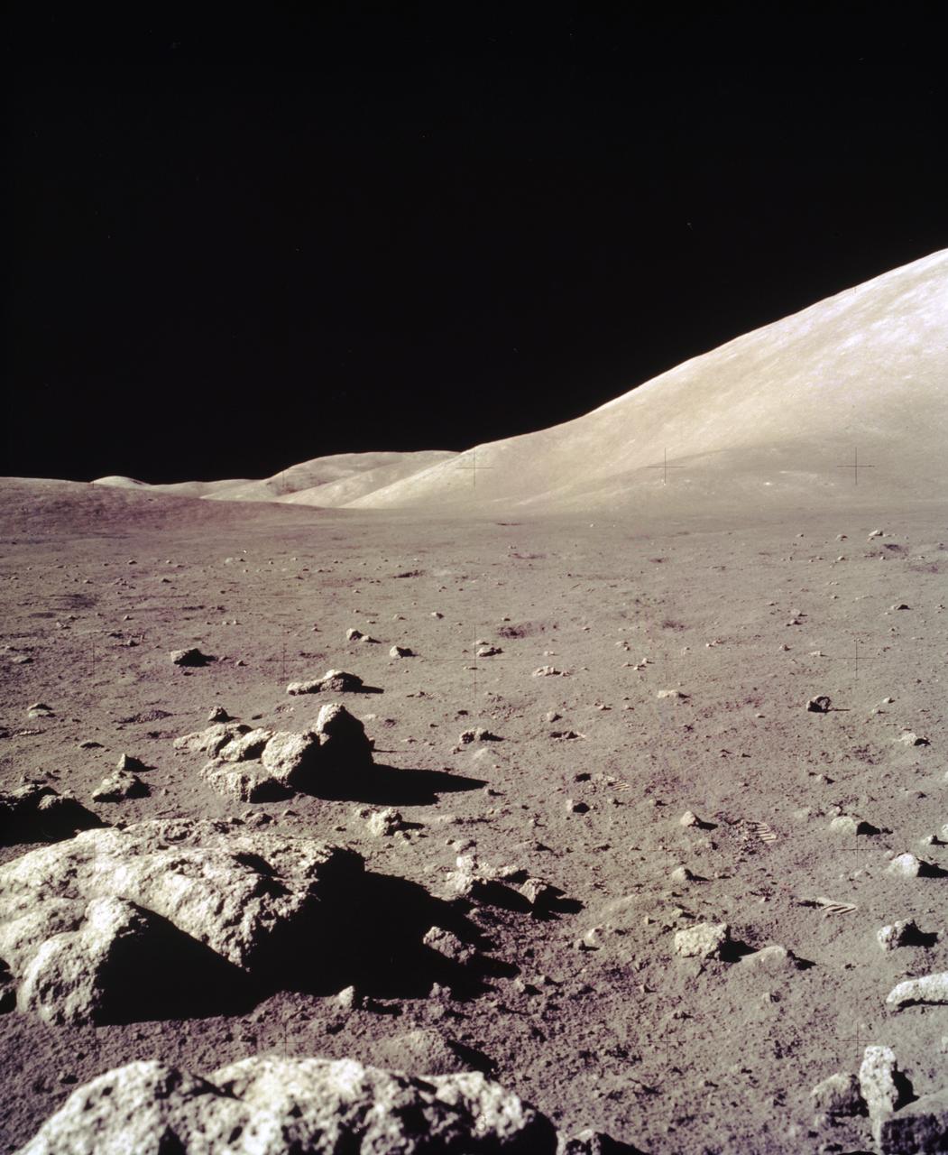
This view of the Lunar surface was taken during the Apollo 17 mission. The seventh and last manned lunar landing and return to Earth mission, the Apollo 17, carrying a crew of three astronauts: Mission Commander Eugene A. Cernan; Lunar Module pilot Harrison H. Schmitt; and Command Module pilot Ronald E. Evans, lifted off on December 7, 1972 from the Kennedy Space Flight Center (KSC). Scientific objectives of the Apollo 17 mission included geological surveying and sampling of materials and surface features in a preselected area of the Taurus-Littrow region, deploying and activating surface experiments, and conducting in-flight experiments and photographic tasks during lunar orbit and transearth coast (TEC). These objectives included: Deployed experiments such as the Apollo lunar surface experiment package (ALSEP) with a Heat Flow experiment, Lunar seismic profiling (LSP), Lunar surface gravimeter (LSG), Lunar atmospheric composition experiment (LACE) and Lunar ejecta and meteorites (LEAM). The mission also included Lunar Sampling and Lunar orbital experiments. Biomedical experiments included the Biostack II Experiment and the BIOCORE experiment. The mission marked the longest Apollo mission, 504 hours, and the longest lunar surface stay time, 75 hours, which allowed the astronauts to conduct an extensive geological investigation. They collected 257 pounds (117 kilograms) of lunar samples with the use of the Marshall Space Flight Center designed Lunar Roving Vehicle (LRV). The mission ended on December 19, 1972.
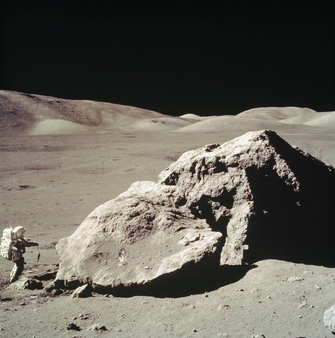
In this Apollo 17 onboard photo, Lunar Module pilot Harrison H. Schmitt collects rock samples from a huge boulder near the Valley of Tourus-Littrow on the lunar surface. The seventh and last manned lunar landing and return to Earth mission, the Apollo 17, carrying a crew of three astronauts: Schmitt; Mission Commander Eugene A. Cernan; and Command Module pilot Ronald E. Evans, lifted off on December 7, 1972 from the Kennedy Space Flight Center (KSC). Scientific objectives of the Apollo 17 mission included geological surveying and sampling of materials and surface features in a preselected area of the Taurus-Littrow region, deploying and activating surface experiments, and conducting in-flight experiments and photographic tasks during lunar orbit and transearth coast (TEC). These objectives included: Deployed experiments such as the Apollo lunar surface experiment package (ALSEP) with a Heat Flow experiment, Lunar seismic profiling (LSP), Lunar surface gravimeter (LSG), Lunar atmospheric composition experiment (LACE) and Lunar ejecta and meteorites (LEAM). The mission also included Lunar Sampling and Lunar orbital experiments. Biomedical experiments included the Biostack II Experiment and the BIOCORE experiment. The mission marked the longest Apollo mission, 504 hours, and the longest lunar surface stay time, 75 hours, which allowed the astronauts to conduct an extensive geological investigation. They collected 257 pounds (117 kilograms) of lunar samples with the use of the Marshall Space Flight Center designed Lunar Roving Vehicle (LRV). The mission ended on December 19, 1972
AS11-40-5903 (20 July 1969) --- Astronaut Edwin E. Aldrin Jr., lunar module pilot, walks on the surface of the moon near the leg of the Lunar Module (LM) "Eagle" during the Apollo 11 extravehicular activity (EVA). Astronaut Neil A. Armstrong, commander, took this photograph with a 70mm lunar surface camera. While astronauts Armstrong and Aldrin descended in the Lunar Module (LM) "Eagle" to explore the Sea of Tranquility region of the moon, astronaut Michael Collins, command module pilot, remained with the Command and Service Modules (CSM) "Columbia" in lunar orbit.

AS11-40-5902 (20 July 1969) --- Astronaut Edwin E. Aldrin Jr., lunar module pilot, walks on the surface of the moon near a leg of the Lunar Module during the Apollo 11 extravehicular activity (EVA). Astronaut Neil A. Armstrong, Apollo 11 commander, took this photograph with a 70mm lunar surface camera. The astronauts' bootprints are clearly visible in the foreground. While astronauts Armstrong and Aldrin descended in the Lunar Module (LM) "Eagle" to explore the Sea of Tranquility region of the moon, astronaut Michael Collins, command module pilot, remained with the Command and Service Modules (CSM) "Columbia" in lunar orbit.
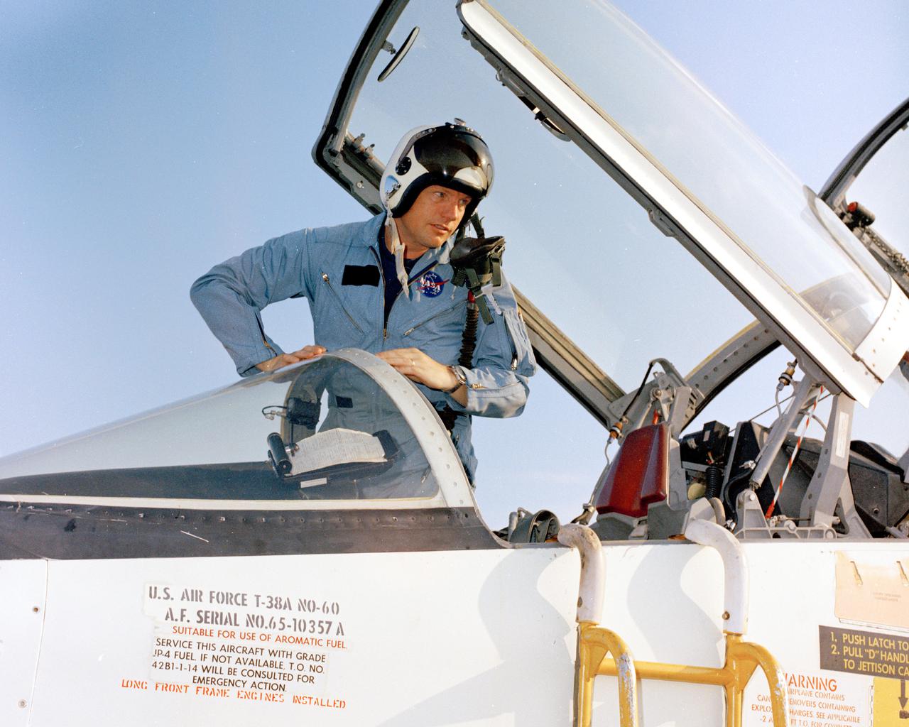
PATRICK AFB, Fla. – In preparation of the nation’s first lunar landing mission, Apollo 11 crew members arrive at Patrick Air Force Base, Florida. Mission commander Neil Armstrong climbs out of a T-38 jet. Lift off atop a Saturn V launch vehicle is scheduled for July 16, 1969. During Apollo 11 the command module, Columbia, will remain in orbit around the moon while the lunar module, Eagle, carrying Armstrong and Aldrin, lands on the lunar surface. During 2½ hours of surface exploration, the crew plans to collect lunar surface material for analysis back on Earth. For more: http:__www-pao.ksc.nasa.gov_history_apollo_apollo-11_apollo-11.htm Photo credit: NASA
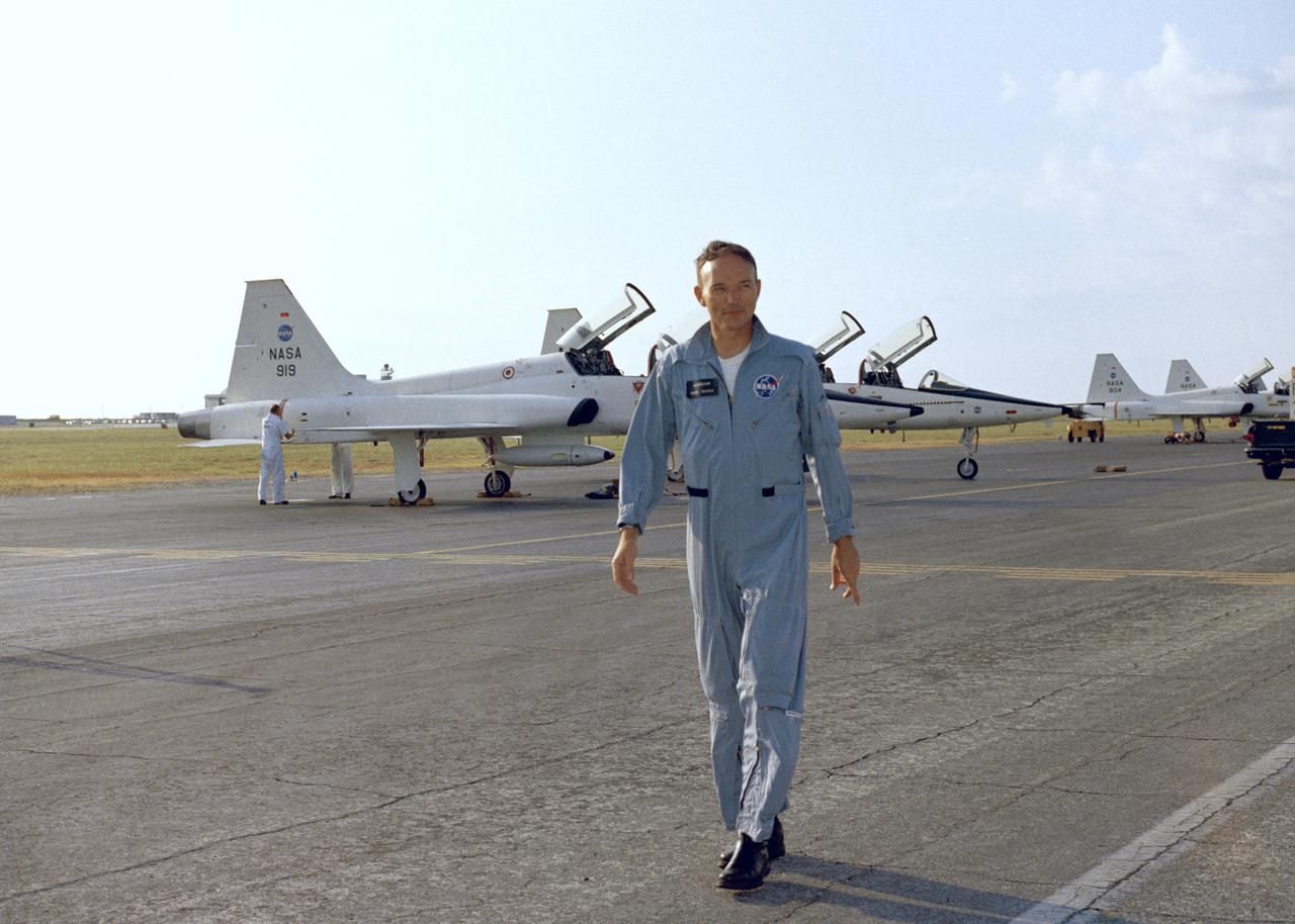
PATRICK AFB, Fla. – Apollo 11 command module pilot Michael Collins, just arrived at Patrick Air Force Base in a T-38 jet in preparation of the nation’s first lunar landing mission. Lift off atop a Saturn V launch vehicle is scheduled for July 16, 1969. During Apollo 11, the command module, Columbia, will remain in orbit around the moon while the lunar module, Eagle, carrying Armstrong and Aldrin, lands on the lunar surface. During 2½ hours of surface exploration, the crew plans to collect lunar surface material for analysis back on Earth. For more: http:__www-pao.ksc.nasa.gov_history_apollo_apollo-11_apollo-11.htm Photo credit: NASA
The second stage of the Lockheed Martin Launch Vehicle-2 (LMLV-2) is hoisted into position at Launch Pad 46 at Cape Canaveral Air Station for mating to the rocket’s first stage, which is out of camera view. The LMLV-2 will carry the Lunar Prospector spacecraft, scheduled to launch in October for an 18-month mission that will orbit the Earth’s moon to collect data from the lunar surface. Designed for a low polar orbit investigation of the moon, the Lunar Prospector will map the moon’s surface composition and possible polar ice deposits, measure magnetic and gravity fields, and study lunar outgassing events
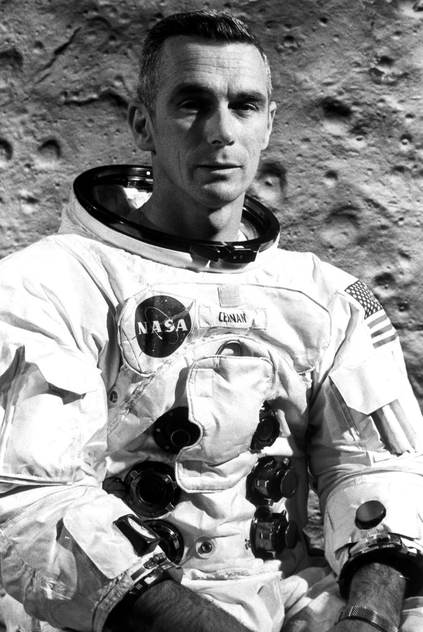
KENNEDY SPACE CENTER, FLA. -- Astronaut Eugene A. Cernan is lunar module pilot for Apollo 10, scheduled for launch from the nation's spaceport on May 18. Cernan and Apollo 10 Commander Thomas P. Stafford are to detach the lunar module after the spacecraft enters lunar orbit and drop down to within 10 miles of the Moon's pockmarked surface before rejoining John W. Young, command module pilot, orbiting the Moon in the command_service module. The Apollo 10 mission is a dress rehearsal for a manned lunar landing later this year.
AS14-66-9244 (5-6 Feb. 1971) --- An excellent view of the lunar terrain looking through the right window of the Lunar Module (LM), photographed by one of the Apollo 14 astronauts during their stay on the lunar surface. Pothole-sized craters can be seen in the foreground. While astronauts Alan B. Shepard Jr., commander, and Edgar D. Mitchell, lunar module pilot, descended in the LM to explore the moon, astronaut Stuart A. Roosa, command module pilot, remained with the Command and Service Modules (CSM) in lunar orbit.
AS11-40-5863 (20 July 1969) --- Astronaut Edwin E. Aldrin Jr., lunar module pilot, is photographed egressing the Lunar Module (LM) during the Apollo 11 extravehicular activity (EVA) on the moon. This photograph was taken by astronaut Neil A. Armstrong, commander, with a 70mm lunar surface camera. While astronauts Armstrong and Aldrin descended in the Lunar Module (LM) "Eagle" to explore the Sea of Tranquility region of the moon, astronaut Michael Collins, command module pilot, remained with the Command and Service Modules (CSM) "Columbia" in lunar orbit.
AS12-46-6832 (19 Nov. 1969) --- A close-up view of a lunar mound as photographed during the Apollo 12 extravehicular activity (EVA) on the lunar surface. Astronaut Richard F. Gordon Jr., command module pilot, remained with the Apollo 12 Command and Service Modules (CSM) in lunar orbit while astronauts Charles Conrad Jr., commander, and Alan L. Bean, lunar module pilot, descended in the Lunar Module (LM) to explore the moon.
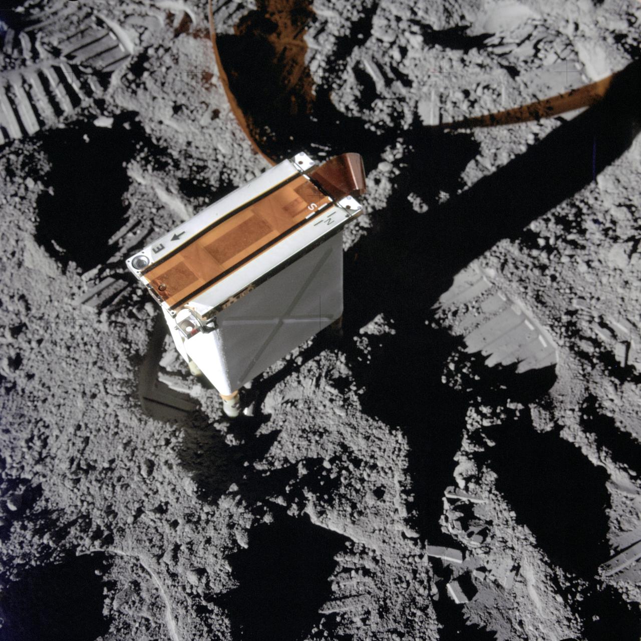
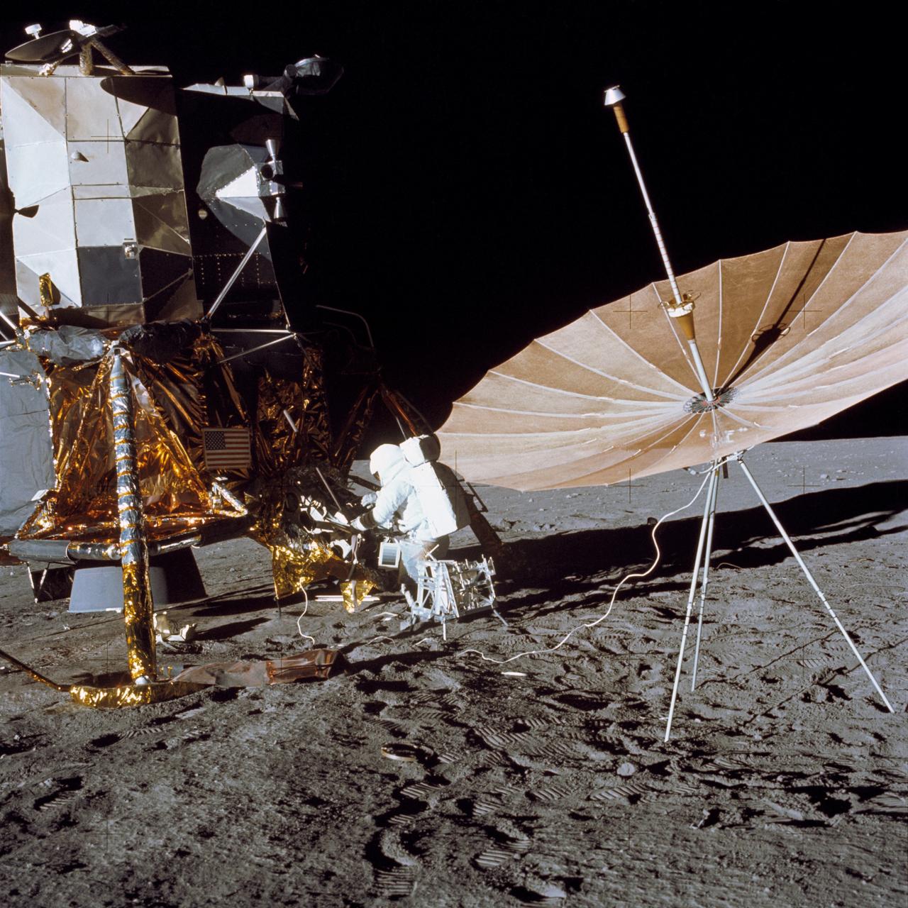
AS14-67-9364 (5 Feb. 1971) --- A close-up view of the charged particle lunar environment experiment (CPLEE), a component of the Apollo lunar surface experiments package (ALSEP) which was deployed on the moon by the Apollo 14 astronauts. While astronauts Alan B. Shepard Jr., commander, and Edgar D. Mitchell, lunar module pilot, descended in the Lunar Module (LM) to explore the moon, astronaut Stuart A. Roosa, command module pilot, remained with the Command and Service Modules (CSM) in lunar orbit.
AS11-37-5505 (20 July 1969) --- This photograph shows in fine detail the impressions in the lunar soil made by astronauts Neil A. Armstrong and Edwin E. Aldrin Jr. during their lunar surface extravehicular activity (EVA). While astronauts Armstrong, commander, and Aldrin, lunar module pilot, descended in the Lunar Module (LM) "Eagle" to explore the Sea of Tranquility region of the moon, astronaut Michael Collins, command module pilot, remained with the Command and Service Modules (CSM) "Columbia" in lunar orbit.

AS11-40-5878 (20 July 1969) --- A close-up view of an astronaut's bootprint in the lunar soil, photographed with a 70mm lunar surface camera during the Apollo 11 extravehicular activity (EVA) on the moon. While astronauts Neil A. Armstrong, commander, and Edwin E. Aldrin Jr., lunar module pilot, descended in the Lunar Module (LM) "Eagle" to explore the Sea of Tranquility region of the moon, astronaut Michael Collins, command module pilot, remained with the Command and Service Modules (CSM) "Columbia" in lunar orbit.

S71-39867 (June 1971) --- Astronauts David R. Scott (right), commander, and James B. Irwin, lunar module pilot, are shown on the Lunar Roving Vehicle (LRV) at the Kennedy Space Center (KSC), Florida, during Apollo 15 lunar surface extravehicular activity (EVA) simulations. While astronauts Scott and Irwin descend in the Lunar Module (LM) "Falcon" to explore the moon, astronaut Alfred M. Worden, command module pilot, will remain with the Command and Service Modules (CSM) in lunar orbit.
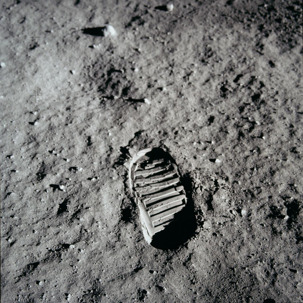
AS11-40-5877 (20 July 1969) --- A close-up view of an astronaut's bootprint in the lunar soil, photographed with a 70mm lunar surface camera during the Apollo 11 extravehicular activity (EVA) on the moon. While astronauts Neil A. Armstrong, commander, and Edwin E. Aldrin Jr., lunar module pilot, descended in the Lunar Module (LM) "Eagle" to explore the Sea of Tranquility region of the moon, astronaut Michael Collins, command module pilot, remained with the Command and Service Modules (CSM) "Columbia" in lunar orbit.
KENNEDY SPACE CENTER, FLA. - NASA's Lunar Prospector spacecraft launched successfully on its way to the Moon from Launch Complex 46 (LC46) at Cape Canaveral Air Station on Jan. 6 at 9:38 p.m. EST. It was the inaugural launch of Lockheed Martin's Athena II launch vehicle and the first launch from LC46, operated by Spaceport Florida Authority. Lunar Prospector, built for the NASA Ames Research Center by Lockheed Martin, is a spin-stabilized spacecraft designed to provide NASA with the first global maps of the Moon's surface and its gravitational magnetic fields, as well as look for the possible presence of ice near the lunar poles. It will orbit the Moon at an altitude of approximately 63 miles during a one-year mission.