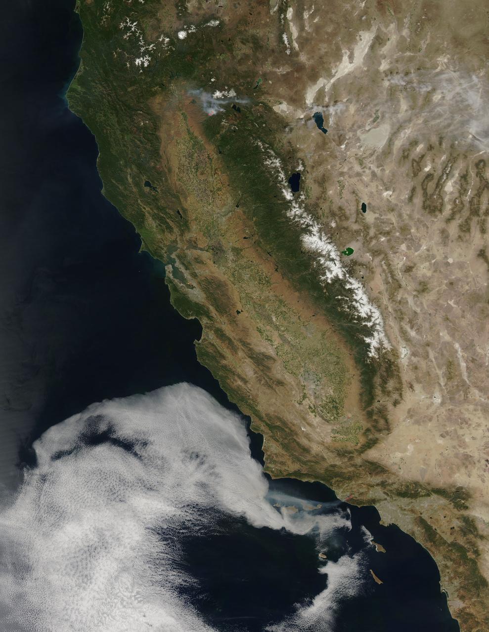
According to the NBCnews.com, Southern California firefighters were battling a growing, brush-fueled wildfire early Friday that had reached the beach in Ventura County and was pushing toward the upscale city of Malibu, officials said. Dubbed the Springs Fire, this "monster" of a wildfire has been made worse by howling Santa Ana winds and unusually dry vegetation. As of 2 am local time in California on Friday the 3rd, it was within "seven or eight miles" of Malibu, Ventura County Fire Department spokesman Bill Nash said. Weather conditions are not cooperating in the containment of this fire. The Weather Channel has predicted dry winds from offshore that will bring gusts of 40 to 50 miles per hour to the Southern California region on Friday the 3rd which could easily spread the fire. A complication to the winds is the extremely dry plant life left from a season in which only about five inches of rain fell in the area. The Springs Fire grew to 10,000 acres and was ten percent contained as of early Friday morning, according to the California Department of Forestry and Fire Prevention. Evacuations took place Thursday, and as of Friday morning 15 homes had been damaged. More than 2,000 homes and 100 commercial properties were under threat from the fire and those numbers could grow with weather conditions today (May 3). Currently the fire is burning in a rural area outside of Malibu, but it doesn't have to go very far to get to some expensive homes and more populated areas. It's current direction has it burning down the mountainside toward Malibu. Firefighters expect to receive help from tankers and helicopters in the air Friday morning, according to a release from the Ventura County Fire Department. The cause of the fire remained under investigation Friday. There had been no lightning or other natural fire-starting phenomenon in the area when the blaze began, Nash said. This natural-color satellite image was collected by the Moderate Resolution Imaging Spectroradiometer (MODIS) aboard the Aqua satellite on May 02, 2013. Actively burning areas, detected by MODIS’s thermal bands, are outlined in red. NASA image courtesy Jeff Schmaltz LANCE/EOSDIS MODIS Rapid Response Team, GSFC. Caption by Lynn Jenner with information from NBCnews.com <b><a href="http://www.nasa.gov/audience/formedia/features/MP_Photo_Guidelines.html" rel="nofollow">NASA image use policy.</a></b> <b><a href="http://www.nasa.gov/centers/goddard/home/index.html" rel="nofollow">NASA Goddard Space Flight Center</a></b> enables NASA’s mission through four scientific endeavors: Earth Science, Heliophysics, Solar System Exploration, and Astrophysics. Goddard plays a leading role in NASA’s accomplishments by contributing compelling scientific knowledge to advance the Agency’s mission. <b>Follow us on <a href="http://twitter.com/NASA_GoddardPix" rel="nofollow">Twitter</a></b> <b>Like us on <a href="http://www.facebook.com/pages/Greenbelt-MD/NASA-Goddard/395013845897?ref=tsd" rel="nofollow">Facebook</a></b> <b>Find us on <a href="http://instagram.com/nasagoddard?vm=grid" rel="nofollow">Instagram</a></b>
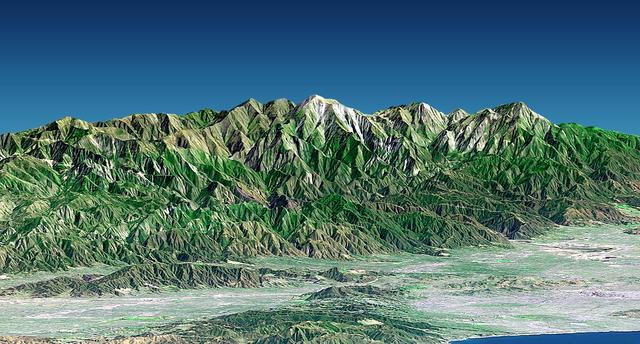
Mount San Antonio more commonly known as Mount Baldy crowns the San Gabriel Mountains northeast of Los Angeles in this computer-generated east-northeast perspective viewed from above the Malibu coastline.

ISS032-E-027051 (16 Sept. 2012) --- NASA astronaut Sunita Williams, Expedition 33 commander, exercises on the Cycle Ergometer with Vibration Isolation System (CEVIS) in the Destiny laboratory of the International Space Station while participating in the first triathlon in space simultaneously with athletes in the Nautica Malibu Triathlon held in Southern California.

ISS032-E-027050 (16 Sept. 2012) --- NASA astronaut Sunita Williams, Expedition 33 commander, exercises on the Cycle Ergometer with Vibration Isolation System (CEVIS) in the Destiny laboratory of the International Space Station while participating in the first triathlon in space simultaneously with athletes in the Nautica Malibu Triathlon held in Southern California.
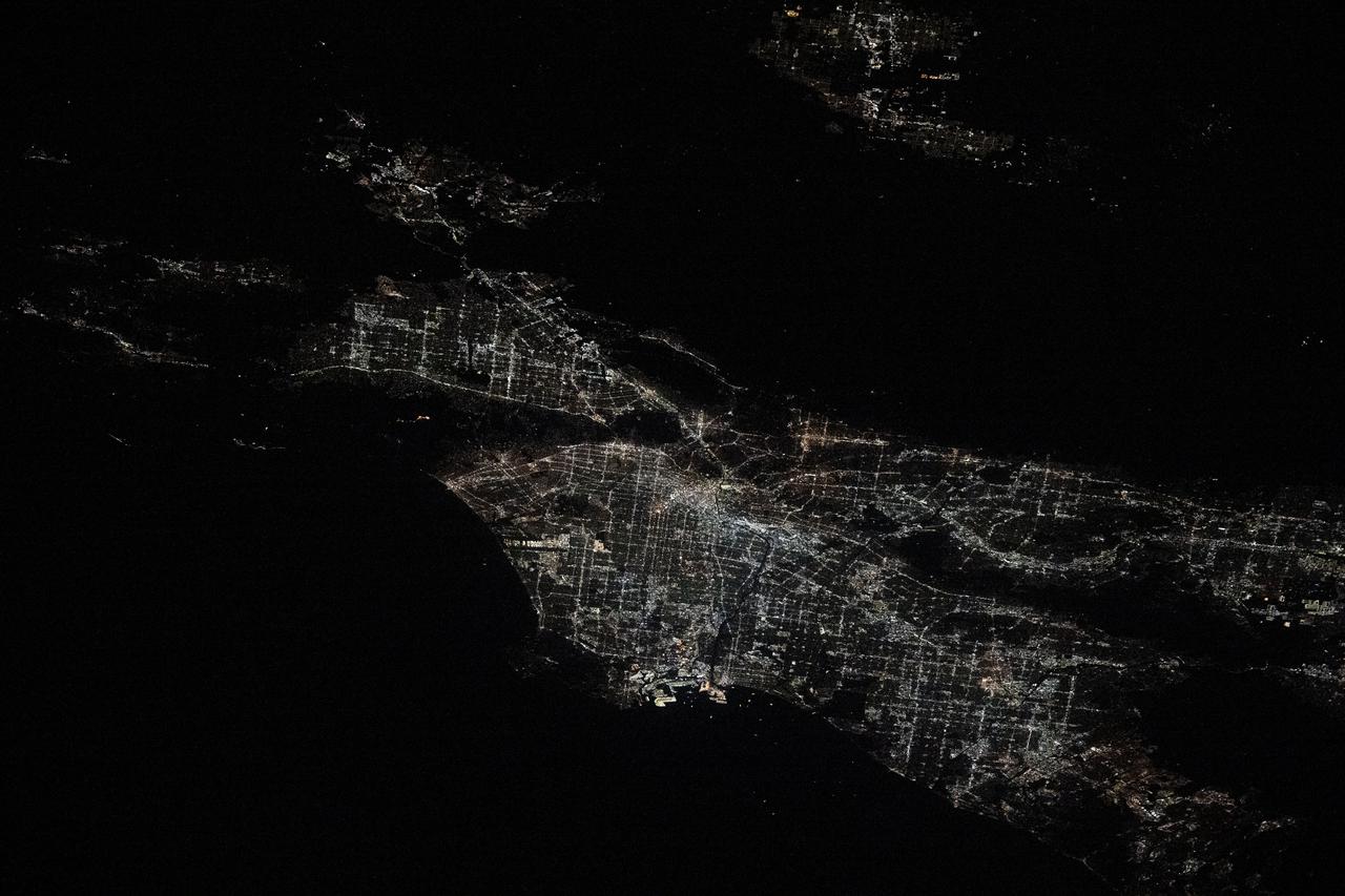
iss072e454582 (Jan. 10, 2024) --- City lights illuminate the Los Angeles, California, metropolitan area at approximately 2:30 a.m. local time as the Palisades, Hurst, and Eaton wildfires rage around nearby suburbs including Malibu, San Fernando, and Pasadena. The International Space Station was orbiting 258 miles above the southwestern United States at the time of this photograph. Credit: NASA/Don Pettit
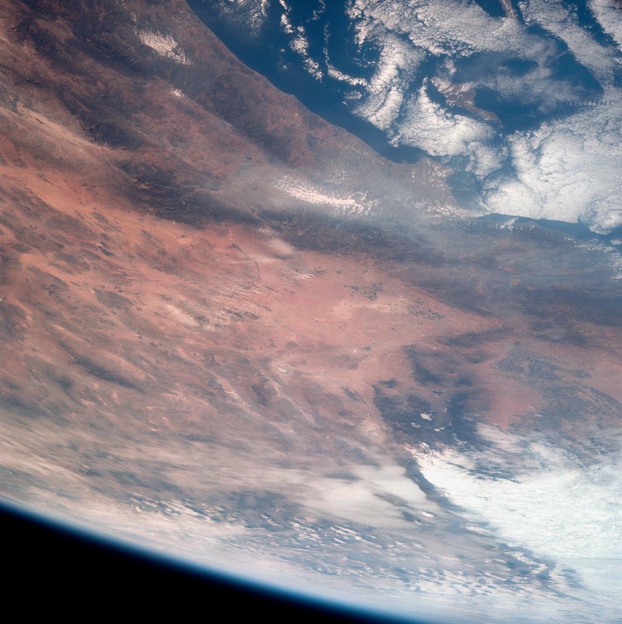
This view of southern California as seen from the Apollo 7 spacecraft during its 18th revolution of the earth. Photographed from an altitude of 124 nautical miles. The coast of California can be seen from Point Mugu southward to Oceanside. Santa Catalina can be seen below the off shore clouds. Details of the Los Angeles area are obscured by pollution which extends from Banning westard for 100 miles to beyond Malibu. In the upper portion of the photograph can be seen (left to right) the San Joaquin Valley beyond Bakersfield, the Techachapi Mountains, the Sierra Nevada, Owens Valley, Death Valley and the Mojave Desert.
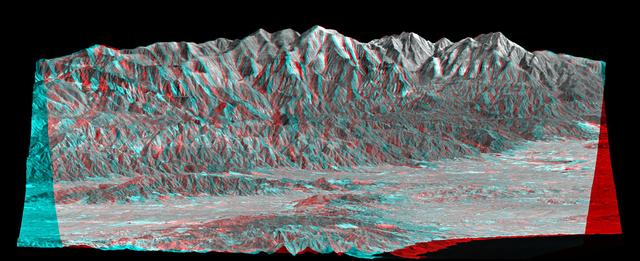
Mount San Antonio more commonly known as Mount Baldy crowns the San Gabriel Mountains northeast of Los Angeles, Calif., in this anaglyph from NASA Shuttle Radar Topography Mission. 3D glasses are necessary to view this image.
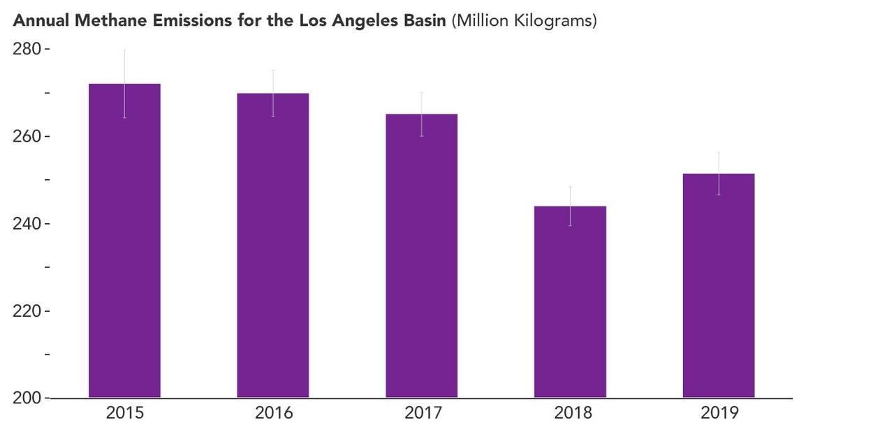
A February 2023 study by researchers at NASA's Jet Propulsion Laboratory in Southern California analyzed data on atmospheric methane concentrations from ground-based sensors scattered around four densely populated Southern California counties. It found that emissions of the powerful greenhouse gas methane fell by about 7% between 2015 and 2020 – a reduction of 33 million pounds (15 million kilograms) of methane released per year. This bar graph shows that overall emissions in the study area decreased between 2015 and 2019, the last full year of the data for the study. Error bars indicate uncertainties in the estimates for each year. Published in Environmental Research Letters, the paper is based on measurements from eight spectroscopic sensors that were installed as part of the Megacities Carbon Project, a multiagency collaboration monitoring greenhouse gases in the Los Angeles, Indianapolis, and Washington, D.C., areas. The sensors have been gathering data since 2015. The California data enabled researchers to study an area that stretches from the beaches of Malibu in the west to the mountains and deserts of San Bernardino and Riverside counties in the east. It also extends south through all of Orange County. The researchers found that the month-to-month fluctuations in methane concentrations around Los Angeles gradually fell from 2015 to 2020, and well into 2022 – a strong indication that local emissions of the gas were also decreasing. Then, using a mathematical model to estimate the emissions decrease, they found the areas covered by sensors in Granada Hills (Los Angeles County) and Ontario (San Bernardino County) accounted for much of the drop in annual emissions from 2015 to 2020. Although the paper doesn't cite causes of the emission reductions in those two locales, researchers suspect they resulted from better management of natural gas pipelines and equipment, which in turn led to lower fugitive – or accidental – methane releases. Improved infrastructure at a massive landfill near Granada Hills likely also played a role. https://photojournal.jpl.nasa.gov/catalog/PIA25863