Cracked Marble
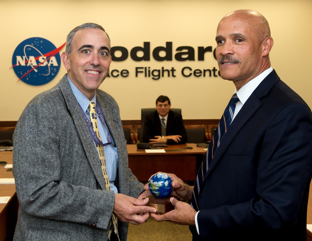
Ray Rubilotta receives the Blue Marble Award
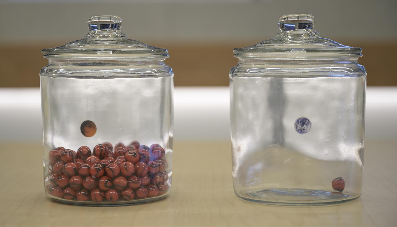
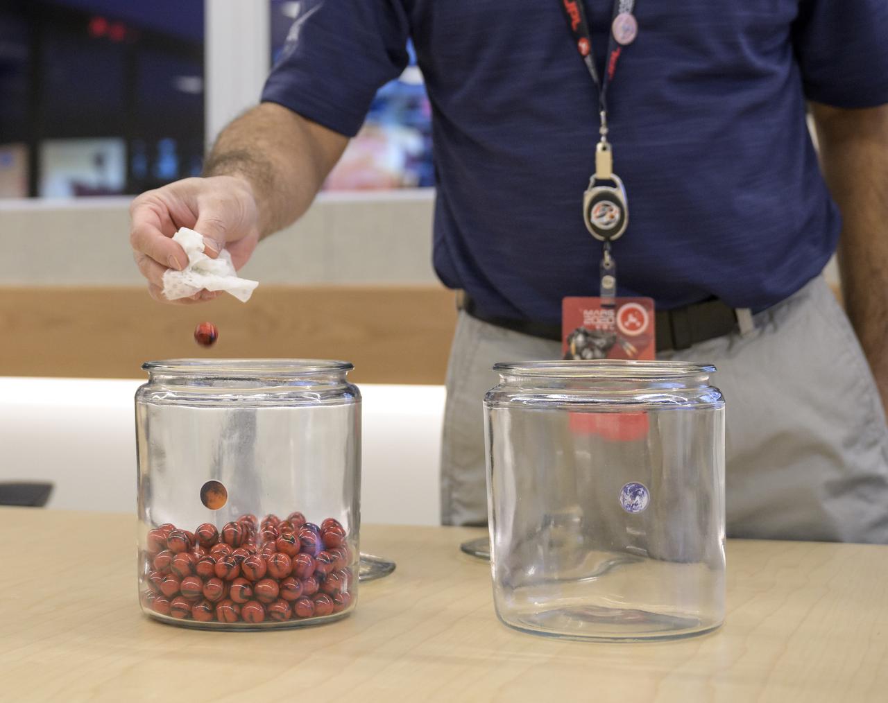
A jar with an Earth sticker and one marble inside and a jar with a Mars sticker full of marbles are seen on a conference room table of the Mission Support Area (MSA)on Wednesday, Feb. 17, 2021, at NASA's Jet Propulsion Laboratory in Pasadena, California. The Perseverance Mars rover team has been moving one marble a day since launch from jar to jar. The Perseverance Mars rover is due to land on Mars Thursday, Feb. 18, 2021. A key objective for Perseverance’s mission on Mars is astrobiology, including the search for signs of ancient microbial life. The rover will characterize the planet’s geology and past climate, pave the way for human exploration of the Red Planet, and be the first mission to collect and cache Martian rock and regolith. Photo Credit: (NASA/Bill Ingalls)
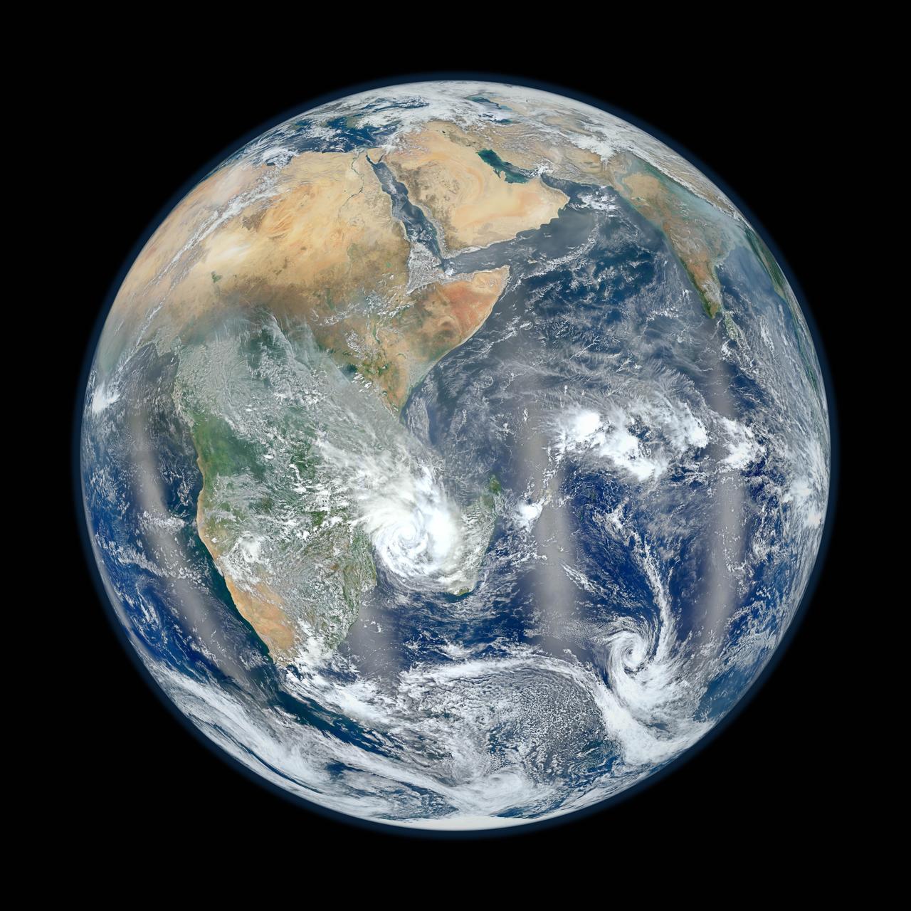
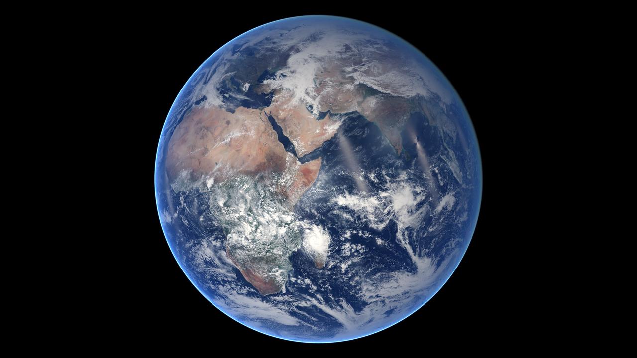
February 2, 2012 <b>Go here to view an image that explains how composite images like these are created: <a href="http://www.flickr.com/photos/gsfc/6803619953">www.flickr.com/photos/gsfc/6803619953</a></b> Responding to public demand, NASA scientists created a companion image to the wildly popular 'Blue Marble' released last week (January 25, 2012). <a href="http://www.flickr.com/photos/gsfc/6760135001">www.flickr.com/photos/gsfc/6760135001</a> The new image is a composite of six separate orbits taken on January 23, 2012 by the Suomi National Polar-orbiting Partnership satellite. Both of these new 'Blue Marble' images are images taken by a new instrument flying aboard Suomi NPP, the Visible Infrared Imaging Radiometer Suite (VIIRS). Compiled by NASA Goddard scientist Norman Kuring, this image has the perspective of a viewer looking down from 7,918 miles (about 12,742 kilometers) above the Earth's surface from a viewpoint of 10 degrees South by 45 degrees East. The four vertical lines of 'haze' visible in this image shows the reflection of sunlight off the ocean, or 'glint,' that VIIRS captured as it orbited the globe. Suomi NPP is the result of a partnership between NASA, NOAA and the Department of Defense. Credit: NASA/NOAA For more information about Suomi NPP go to: <a href="http://www.nasa.gov/npp" rel="nofollow">www.nasa.gov/npp</a> <b><a href="http://www.nasa.gov/audience/formedia/features/MP_Photo_Guidelines.html" rel="nofollow">NASA image use policy.</a></b> <b><a href="http://www.nasa.gov/centers/goddard/home/index.html" rel="nofollow">NASA Goddard Space Flight Center</a></b> enables NASA’s mission through four scientific endeavors: Earth Science, Heliophysics, Solar System Exploration, and Astrophysics. Goddard plays a leading role in NASA’s accomplishments by contributing compelling scientific knowledge to advance the Agency’s mission. <b>Follow us on <a href="http://twitter.com/NASA_GoddardPix" rel="nofollow">Twitter</a></b> <b>Like us on <a href="http://www.facebook.com/pages/Greenbelt-MD/NASA-Goddard/395013845897?ref=tsd" rel="nofollow">Facebook</a></b> <b>Find us on <a href="http://instagrid.me/nasagoddard/?vm=grid" rel="nofollow">Instagram</a></b>
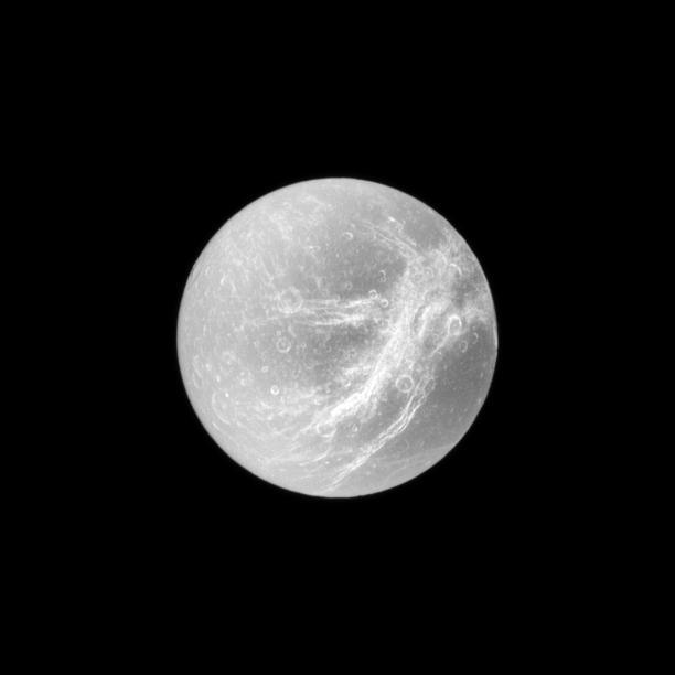
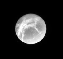
Appearing like the swirls of marble, the wispy terrain of Saturn moon Dione is captured by NASA Cassini spacecraft in a dramatic display of light and dark. These wispy features are a system of braided canyons with bright walls.

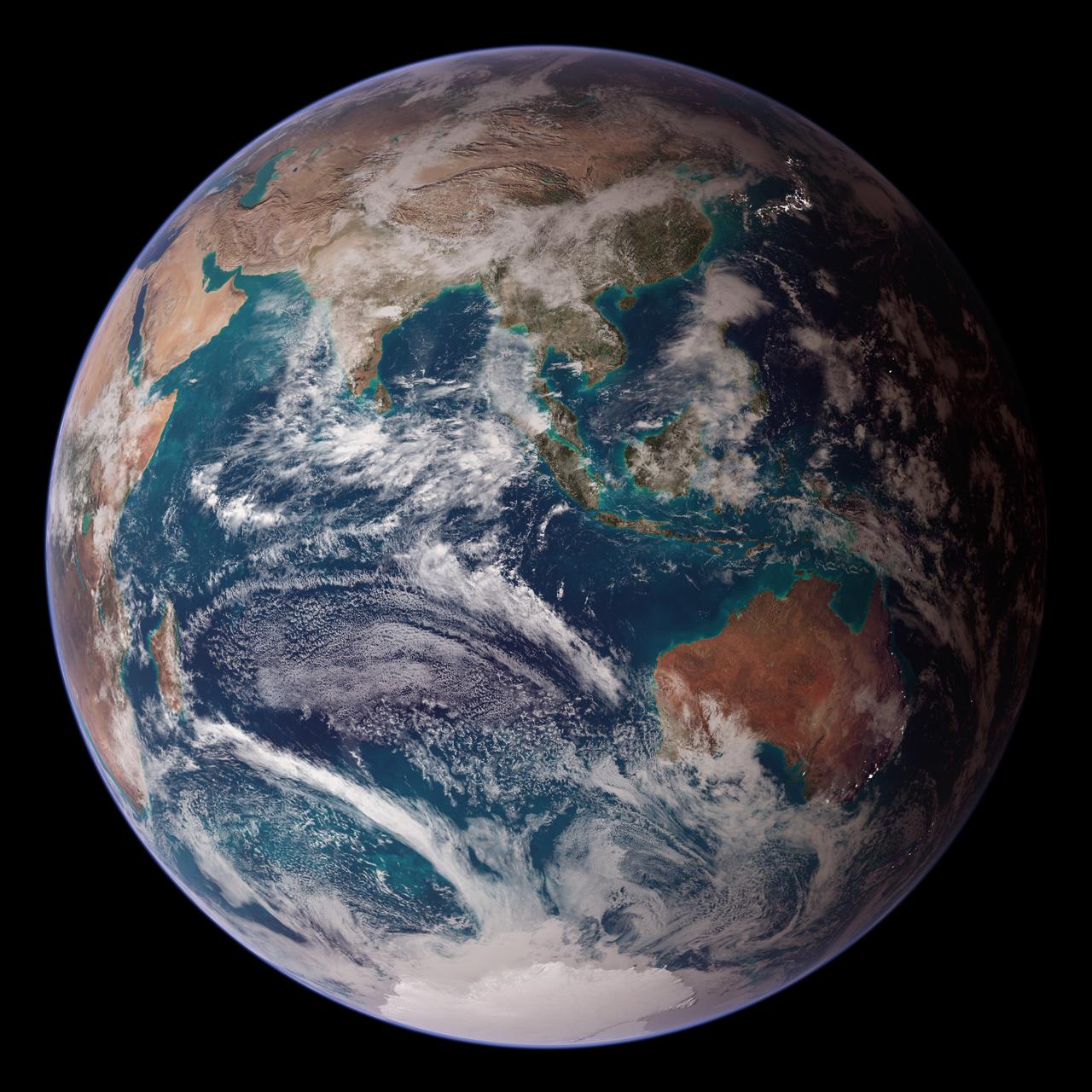
<b>RELEASE DATE: OCTOBER 9, 2007</b> <b>Credit: NASA/Goddard Space Flight Center/Reto Stöckli</b> A day’s clouds. The shape and texture of the land. The living ocean. City lights as a beacon of human presence across the globe. This amazingly beautiful view of Earth from space is a fusion of science and art, a showcase for the remote-sensing technology that makes such views possible, and a testament to the passion and creativity of the scientists who devote their careers to understanding how land, ocean, and atmosphere—even life itself—interact to generate Earth’s unique (as far as we know!) life-sustaining environment. Drawing on data from multiple satellite missions (not all collected at the same time), a team of NASA scientists and graphic artists created layers of global data for everything from the land surface, to polar sea ice, to the light reflected by the chlorophyll in the billions of microscopic plants that grow in the ocean. They wrapped these layers around a globe, set it against a black background, and simulated the hazy edge of the Earth’s atmosphere (the limb) that appears in astronaut photography of the Earth. The land surface layer is based on photo-like surface reflectance observations (reflected sunlight) measured by the Moderate Resolution Imaging Spectroradiometer (MODIS) on NASA’s Terra satellite in July 2004. The sea ice layer near the poles comes from Terra MODIS observations of daytime sea ice observed between August 28 and September 6, 2001. The ocean layer is a composite. In shallow water areas, the layer shows surface reflectances observed by Terra MODIS in July 2004. In the open ocean, the photo-like layer is overlaid with observations of the average ocean chlorophyll content for 2004. NASA’s Aqua MODIS collected the chlorophyll data. The cloud layer shows a single-day snapshot of clouds observed by Terra MODIS across the planet on July 29, 2001. City lights on Earth’s night side are visualized from data collected by the Defense Meteorological Satellite Program mission between 1994–1995. The topography layer is based on radar data collected by the Space Shuttle Endeavour during an 11-day mission in February of 2000. Topography over Antarctica comes from the Radarsat Antarctic Mapping Project, version 2. Most of the data layers in this visualization are available as monthly composites as part of NASA’s Blue Marble Next Generation image collection. The images in the collection appear in cylindrical projection (rectangular maps), and they are available at 500-meter resolution. The large images provided above are the full-size versions of these globes. In their hope that these images will inspire people to appreciate the beauty of our home planet and to learn about the Earth system, the developers of these images encourage readers to re-use and re-publish the images freely. NASA images by Reto Stöckli, based on data from NASA and NOAA. To learn the history of the Blue Marble go here: <a href="http://earthobservatory.nasa.gov/Features/BlueMarble/BlueMarble_history.php" rel="nofollow">earthobservatory.nasa.gov/Features/BlueMarble/BlueMarble_...</a> To learn more about the Blue Marble go here: <a href="http://earthobservatory.nasa.gov/IOTD/view.php?id=8108" rel="nofollow">earthobservatory.nasa.gov/IOTD/view.php?id=8108</a> <b><a href="http://www.nasa.gov/centers/goddard/home/index.html" rel="nofollow">NASA Goddard Space Flight Center</a></b> is home to the nation's largest organization of combined scientists, engineers and technologists that build spacecraft, instruments and new technology to study the Earth, the sun, our solar system, and the universe. <b>Follow us on <a href="http://twitter.com/NASA_GoddardPix" rel="nofollow">Twitter</a></b> <b>Join us on <a href="http://www.facebook.com/pages/Greenbelt-MD/NASA-Goddard/395013845897?ref=tsd" rel="nofollow">Facebook</a><b> </b></b>
<b>RELEASE DATE: OCTOBER 9, 2007</b> <b>Credit: NASA/Goddard Space Flight Center/Reto Stöckli</b> A day’s clouds. The shape and texture of the land. The living ocean. City lights as a beacon of human presence across the globe. This amazingly beautiful view of Earth from space is a fusion of science and art, a showcase for the remote-sensing technology that makes such views possible, and a testament to the passion and creativity of the scientists who devote their careers to understanding how land, ocean, and atmosphere—even life itself—interact to generate Earth’s unique (as far as we know!) life-sustaining environment. Drawing on data from multiple satellite missions (not all collected at the same time), a team of NASA scientists and graphic artists created layers of global data for everything from the land surface, to polar sea ice, to the light reflected by the chlorophyll in the billions of microscopic plants that grow in the ocean. They wrapped these layers around a globe, set it against a black background, and simulated the hazy edge of the Earth’s atmosphere (the limb) that appears in astronaut photography of the Earth. The land surface layer is based on photo-like surface reflectance observations (reflected sunlight) measured by the Moderate Resolution Imaging Spectroradiometer (MODIS) on NASA’s Terra satellite in July 2004. The sea ice layer near the poles comes from Terra MODIS observations of daytime sea ice observed between August 28 and September 6, 2001. The ocean layer is a composite. In shallow water areas, the layer shows surface reflectances observed by Terra MODIS in July 2004. In the open ocean, the photo-like layer is overlaid with observations of the average ocean chlorophyll content for 2004. NASA’s Aqua MODIS collected the chlorophyll data. The cloud layer shows a single-day snapshot of clouds observed by Terra MODIS across the planet on July 29, 2001. City lights on Earth’s night side are visualized from data collected by the Defense Meteorological Satellite Program mission between 1994–1995. The topography layer is based on radar data collected by the Space Shuttle Endeavour during an 11-day mission in February of 2000. Topography over Antarctica comes from the Radarsat Antarctic Mapping Project, version 2. Most of the data layers in this visualization are available as monthly composites as part of NASA’s Blue Marble Next Generation image collection. The images in the collection appear in cylindrical projection (rectangular maps), and they are available at 500-meter resolution. The large images provided above are the full-size versions of these globes. In their hope that these images will inspire people to appreciate the beauty of our home planet and to learn about the Earth system, the developers of these images encourage readers to re-use and re-publish the images freely. NASA images by Reto Stöckli, based on data from NASA and NOAA. To learn the history of the Blue Marble go here: <a href="http://earthobservatory.nasa.gov/Features/BlueMarble/BlueMarble_history.php" rel="nofollow">earthobservatory.nasa.gov/Features/BlueMarble/BlueMarble_...</a> To learn more about the Blue Marble go here: <a href="http://earthobservatory.nasa.gov/IOTD/view.php?id=8108" rel="nofollow">earthobservatory.nasa.gov/IOTD/view.php?id=8108</a> To learn more about NASA's Goddard Space Flight Center go here: <a href="http://www.nasa.gov/centers/goddard/home/index.html" rel="nofollow">www.nasa.gov/centers/goddard/home/index.html</a> <b><a href="http://www.nasa.gov/centers/goddard/home/index.html" rel="nofollow">NASA Goddard Space Flight Center</a></b> is home to the nation's largest organization of combined scientists, engineers and technologists that build spacecraft, instruments and new technology to study the Earth, the sun, our solar system, and the universe. <b><a href="http://www.nasa.gov/centers/goddard/home/index.html" rel="nofollow">NASA Goddard Space Flight Center</a></b> is home to the nation's largest organization of combined scientists, engineers and technologists that build spacecraft, instruments and new technology to study the Earth, the sun, our solar system, and the universe. <b>Follow us on <a href="http://twitter.com/NASA_GoddardPix" rel="nofollow">Twitter</a></b> <b>Join us on <a href="http://www.facebook.com/pages/Greenbelt-MD/NASA-Goddard/395013845897?ref=tsd" rel="nofollow">Facebook</a><b> </b></b>
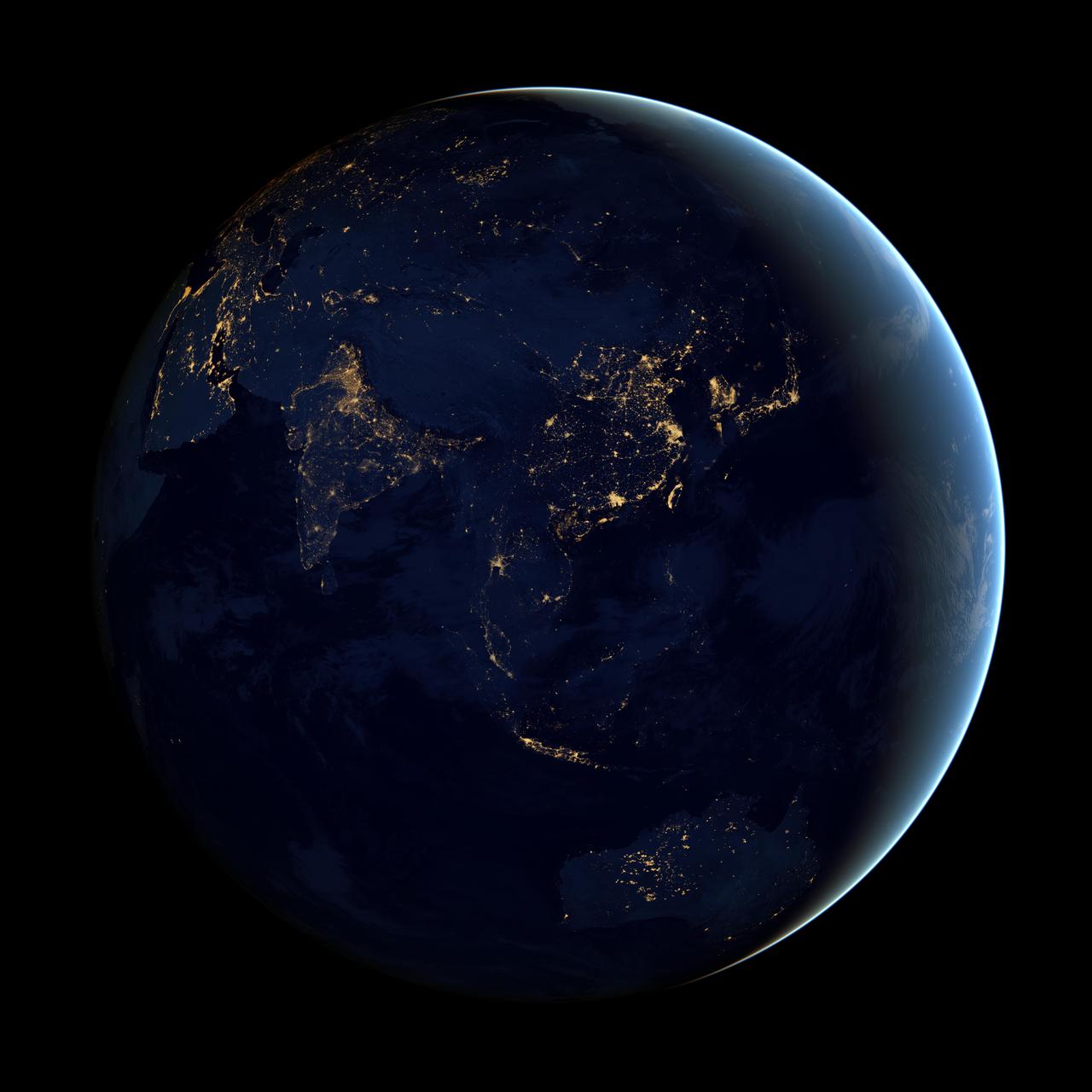
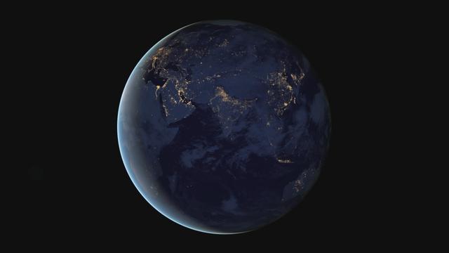
NASA image acquired April 18 - October 23, 2012 This image of Asia and Australia at night is a composite assembled from data acquired by the Suomi NPP satellite in April and October 2012. The new data was mapped over existing Blue Marble imagery of Earth to provide a realistic view of the planet. The nighttime view was made possible by the new satellite’s “day-night band” of the Visible Infrared Imaging Radiometer Suite. VIIRS detects light in a range of wavelengths from green to near-infrared and uses filtering techniques to observe dim signals such as city lights, gas flares, auroras, wildfires, and reflected moonlight. In this case, auroras, fires, and other stray light have been removed to emphasize the city lights. “Night time imagery provides an intuitively graspable view of our planet,” says William Stefanov, a scientist in NASA’s International Space Station program office who has worked with similar images from astronauts. “City lights are an excellent means to track urban and suburban growth, which feeds into planning for energy use and urban hazards, for studying urban heat islands, and for initializing climate models.” Named for satellite meteorology pioneer Verner Suomi, NPP flies over any given point on Earth's surface twice each day at roughly 1:30 a.m. and p.m. The polar-orbiting satellite flies 824 kilometers (512 miles) above the surface, sending its data once per orbit to a ground station in Svalbard, Norway, and continuously to local direct broadcast users distributed around the world. The mission is managed by NASA with operational support from NOAA and its Joint Polar Satellite System, which manages the satellite's ground system. NASA Earth Observatory image by Robert Simmon, using Suomi NPP VIIRS data provided courtesy of Chris Elvidge (NOAA National Geophysical Data Center). Suomi NPP is the result of a partnership between NASA, NOAA, and the Department of Defense. Caption by Mike Carlowicz. Instrument: Suomi NPP - VIIRS Credit: <b><a href="http://www.earthobservatory.nasa.gov/" rel="nofollow"> NASA Earth Observatory</a></b> <b>Click here to view all of the <a href="http://earthobservatory.nasa.gov/Features/NightLights/" rel="nofollow"> Earth at Night 2012 images </a></b> <b>Click here to <a href="http://earthobservatory.nasa.gov/NaturalHazards/view.php?id=79790" rel="nofollow"> read more </a> about this image </b> <b><a href="http://www.nasa.gov/audience/formedia/features/MP_Photo_Guidelines.html" rel="nofollow">NASA image use policy.</a></b> <b><a href="http://www.nasa.gov/centers/goddard/home/index.html" rel="nofollow">NASA Goddard Space Flight Center</a></b> enables NASA’s mission through four scientific endeavors: Earth Science, Heliophysics, Solar System Exploration, and Astrophysics. Goddard plays a leading role in NASA’s accomplishments by contributing compelling scientific knowledge to advance the Agency’s mission. <b>Follow us on <a href="http://twitter.com/NASAGoddardPix" rel="nofollow">Twitter</a></b> <b>Like us on <a href="http://www.facebook.com/pages/Greenbelt-MD/NASA-Goddard/395013845897?ref=tsd" rel="nofollow">Facebook</a></b> <b>Find us on <a href="http://instagram.com/nasagoddard?vm=grid" rel="nofollow">Instagram</a></b>

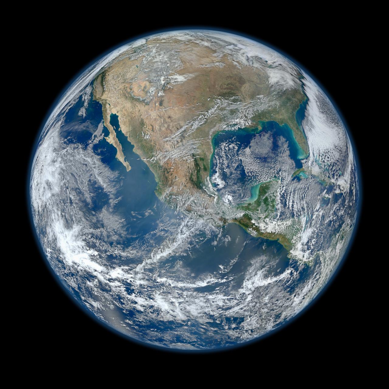
NASA image acquired April 18 - October 23, 2012 This image of North and South America at night is a composite assembled from data acquired by the Suomi NPP satellite in April and October 2012. The new data was mapped over existing Blue Marble imagery of Earth to provide a realistic view of the planet. The nighttime view was made possible by the new satellite’s “day-night band” of the Visible Infrared Imaging Radiometer Suite. VIIRS detects light in a range of wavelengths from green to near-infrared and uses filtering techniques to observe dim signals such as city lights, gas flares, auroras, wildfires, and reflected moonlight. In this case, auroras, fires, and other stray light have been removed to emphasize the city lights. “Artificial lighting is a excellent remote sensing observable and proxy for human activity,” says Chris Elvidge, who leads the Earth Observation Group at NOAA’s National Geophysical Data Center. Social scientists and demographers have used night lights to model the spatial distribution of economic activity, of constructed surfaces, and of populations. Planners and environmental groups have used maps of lights to select sites for astronomical observatories and to monitor human development around parks and wildlife refuges. Electric power companies, emergency managers, and news media turn to night lights to observe blackouts. Named for satellite meteorology pioneer Verner Suomi, NPP flies over any given point on Earth's surface twice each day at roughly 1:30 a.m. and p.m. The polar-orbiting satellite flies 824 kilometers (512 miles) above the surface, sending its data once per orbit to a ground station in Svalbard, Norway, and continuously to local direct broadcast users distributed around the world. The mission is managed by NASA with operational support from NOAA and its Joint Polar Satellite System, which manages the satellite's ground system. NASA Earth Observatory image by Robert Simmon, using Suomi NPP VIIRS data provided courtesy of Chris Elvidge (NOAA National Geophysical Data Center). Suomi NPP is the result of a partnership between NASA, NOAA, and the Department of Defense. Caption by Mike Carlowicz. Instrument: Suomi NPP - VIIRS Credit: <b><a href="http://www.earthobservatory.nasa.gov/" rel="nofollow"> NASA Earth Observatory</a></b> <b>Click here to view all of the <a href="http://earthobservatory.nasa.gov/Features/NightLights/" rel="nofollow"> Earth at Night 2012 images </a></b> <b>Click here to <a href="http://earthobservatory.nasa.gov/NaturalHazards/view.php?id=79787" rel="nofollow"> read more </a> about this image </b> <b><a href="http://www.nasa.gov/audience/formedia/features/MP_Photo_Guidelines.html" rel="nofollow">NASA image use policy.</a></b> <b><a href="http://www.nasa.gov/centers/goddard/home/index.html" rel="nofollow">NASA Goddard Space Flight Center</a></b> enables NASA’s mission through four scientific endeavors: Earth Science, Heliophysics, Solar System Exploration, and Astrophysics. Goddard plays a leading role in NASA’s accomplishments by contributing compelling scientific knowledge to advance the Agency’s mission. <b>Follow us on <a href="http://twitter.com/NASA_GoddardPix" rel="nofollow">Twitter</a></b> <b>Like us on <a href="http://www.facebook.com/pages/Greenbelt-MD/NASA-Goddard/395013845897?ref=tsd" rel="nofollow">Facebook</a></b> <b>Find us on <a href="http://instagram.com/nasagoddard?vm=grid" rel="nofollow">Instagram</a></b>
January 25, 2012 <b>*Updated February 2, 2012: According to Flickr, "The western hemisphere Blue Marble 2012 image has rocketed up to over 3.1 million views making it one of the all time most viewed images on the site after only one week."</b> A 'Blue Marble' image of the Earth taken from the VIIRS instrument aboard NASA's most recently launched Earth-observing satellite - Suomi NPP. This composite image uses a number of swaths of the Earth's surface taken on January 4, 2012. The NPP satellite was renamed 'Suomi NPP' on January 24, 2012 to honor the late Verner E. Suomi of the University of Wisconsin. Suomi NPP is NASA's next Earth-observing research satellite. It is the first of a new generation of satellites that will observe many facets of our changing Earth. Suomi NPP is carrying five instruments on board. The biggest and most important instrument is The Visible/Infrared Imager Radiometer Suite or VIIRS. To read more about NASA's Suomi NPP go to: <a href="http://www.nasa.gov/npp" rel="nofollow">www.nasa.gov/npp</a> Credit: NASA/NOAA/GSFC/Suomi NPP/VIIRS/Norman Kuring <b><a href="http://www.nasa.gov/audience/formedia/features/MP_Photo_Guidelines.html" rel="nofollow">NASA image use policy.</a></b> <b><a href="http://www.nasa.gov/centers/goddard/home/index.html" rel="nofollow">NASA Goddard Space Flight Center</a></b> enables NASA’s mission through four scientific endeavors: Earth Science, Heliophysics, Solar System Exploration, and Astrophysics. Goddard plays a leading role in NASA’s accomplishments by contributing compelling scientific knowledge to advance the Agency’s mission. <b>Follow us on <a href="http://twitter.com/NASAGoddardPix" rel="nofollow">Twitter</a></b> <b>Like us on <a href="http://www.facebook.com/pages/Greenbelt-MD/NASA-Goddard/395013845897?ref=tsd" rel="nofollow">Facebook</a></b> <b>Find us on <a href="http://instagrid.me/nasagoddard/?vm=grid" rel="nofollow">Instagram</a></b>

The night side of Earth twinkles with light, and the first thing to stand out is the cities. “Nothing tells us more about the spread of humans across the Earth than city lights,” asserts Chris Elvidge, a NOAA scientist who has studied them for 20 years. This new global view and animation of Earth’s city lights is a composite assembled from data acquired by the Suomi National Polar-orbiting Partnership (Suomi NPP) satellite. The data was acquired over nine days in April 2012 and thirteen days in October 2012. It took satellite 312 orbits and 2.5 terabytes of data to get a clear shot of every parcel of Earth’s land surface and islands. This new data was then mapped over existing Blue Marble imagery of Earth to provide a realistic view of the planet. The nighttime view in visible light was made possible by the new “day-night band” of Suomi NPP’s Visible Infrared Imaging Radiometer Suite. VIIRS detects light in a range of wavelengths from green to near-infrared and uses filtering techniques to observe dim signals such as city lights, auroras, wildfires, and reflected moonlight. This low-light sensor can distinguish night lights with ten to hundreds of times better light detection capability than scientists had before. Named for satellite meteorology pioneer Verner Suomi, NPP flies over any given point on Earth&rsquos surface twice each day at roughly 1:30 a.m. and 1:30 p.m. The polar-orbiting satellite flies 824 kilometers (512 miles) above the surface as it circles the planet 14 times a day. Data is sent once per orbit to a ground station in Svalbard, Norway, and continuously to local direct broadcast users around the world. The mission is managed by NASA with operational support from NOAA and its Joint Polar Satellite System, which manages the satellite's ground system. NASA Earth Observatory image and animation by Robert Simmon, using Suomi NPP VIIRS data provided courtesy of Chris Elvidge (NOAA National Geophysical Data Center). Suomi NPP is the result of a partnership between NASA, NOAA, and the Department of Defense. Caption by Mike Carlowicz. Instrument: Suomi NPP - VIIRS Credit: <b><a href="http://www.earthobservatory.nasa.gov/" rel="nofollow"> NASA Earth Observatory</a></b> <b>Click here to view all of the <a href="http://earthobservatory.nasa.gov/Features/NightLights/" rel="nofollow"> Earth at Night 2012 images </a></b> <b>Click here to <a href="http://earthobservatory.nasa.gov/NaturalHazards/view.php?id=79803" rel="nofollow"> read more </a> about this image </b> <b><a href="http://www.nasa.gov/audience/formedia/features/MP_Photo_Guidelines.html" rel="nofollow">NASA image use policy.</a></b> <b><a href="http://www.nasa.gov/centers/goddard/home/index.html" rel="nofollow">NASA Goddard Space Flight Center</a></b> enables NASA’s mission through four scientific endeavors: Earth Science, Heliophysics, Solar System Exploration, and Astrophysics. Goddard plays a leading role in NASA’s accomplishments by contributing compelling scientific knowledge to advance the Agency’s mission. <b>Follow us on <a href="http://twitter.com/NASA_GoddardPix" rel="nofollow">Twitter</a></b> <b>Like us on <a href="http://www.facebook.com/pages/Greenbelt-MD/NASA-Goddard/395013845897?ref=tsd" rel="nofollow">Facebook</a></b> <b>Find us on <a href="http://instagram.com/nasagoddard?vm=grid" rel="nofollow">Instagram</a></b>
Of all the planets NASA has explored, none have matched the dynamic complexity of our own. Earth is constantly changing, and NASA are working constantly to explore and understand the planet on scales from local to global. Though Earth science has been a key part of NASA’s mission since the agency was founded in 1958, this year has been one of the peaks. Two new Earth-observing satellites have already been launched and put to work: the Global Precipitation Measurement (GPM) and the Orbiting Carbon Observatory 2 (OCO-2). Three more missions are set to take off in the next six months: the wind-measuring ISS-RapidScat, the ISS Cloud-Aerosol Transport System (CATS), and the Soil Moisture Active Passive (SMAP). And research planes have been flying over polar ice, hurricanes, boreal forests, and pollution plumes. All of these new efforts complement an existing fleet of Earth-observing satellites. In visible light and many invisible wavelengths, NASA and its science partners are observing the entire planet every day. The image above was captured on March 30, 2014, by the Visible Infrared Imaging Radiometer Suite (VIIRS) on the Suomi NPP satellite. The composite image of the eastern hemisphere was compiled from eight orbits of the satellite and ten imaging channels, then stitched together to blend the edges of each satellite pass. Read more: <a href="http://earthobservatory.nasa.gov/IOTD/view.php?id=84214&eocn=home&eoci=iotd_title" rel="nofollow">earthobservatory.nasa.gov/IOTD/view.php?id=84214&eocn...</a> NASA Earth Observatory image by Robert Simmon, using Suomi NPP VIIRS imagery from NOAA's Environmental Visualization Laboratory. Suomi NPP is the result of a partnership between NASA, NOAA and the Department of Defense. Caption by Mike Carlowicz. Credit: <b><a href="http://www.earthobservatory.nasa.gov/" rel="nofollow"> NASA Earth Observatory</a></b> <b><a href="http://www.nasa.gov/audience/formedia/features/MP_Photo_Guidelines.html" rel="nofollow">NASA image use policy.</a></b> <b><a href="http://www.nasa.gov/centers/goddard/home/index.html" rel="nofollow">NASA Goddard Space Flight Center</a></b> enables NASA’s mission through four scientific endeavors: Earth Science, Heliophysics, Solar System Exploration, and Astrophysics. Goddard plays a leading role in NASA’s accomplishments by contributing compelling scientific knowledge to advance the Agency’s mission. <b>Follow us on <a href="http://twitter.com/NASAGoddardPix" rel="nofollow">Twitter</a></b> <b>Like us on <a href="http://www.facebook.com/pages/Greenbelt-MD/NASA-Goddard/395013845897?ref=tsd" rel="nofollow">Facebook</a></b> <b>Find us on <a href="http://instagram.com/nasagoddard?vm=grid" rel="nofollow">Instagram</a></b>
The night side of Earth twinkles with light, and the first thing to stand out is the cities. “Nothing tells us more about the spread of humans across the Earth than city lights,” asserts Chris Elvidge, a NOAA scientist who has studied them for 20 years. This new global view and animation of Earth’s city lights is a composite assembled from data acquired by the Suomi National Polar-orbiting Partnership (Suomi NPP) satellite. The data was acquired over nine days in April 2012 and thirteen days in October 2012. It took satellite 312 orbits and 2.5 terabytes of data to get a clear shot of every parcel of Earth’s land surface and islands. This new data was then mapped over existing Blue Marble imagery of Earth to provide a realistic view of the planet. The nighttime view in visible light was made possible by the new “day-night band” of Suomi NPP’s Visible Infrared Imaging Radiometer Suite. VIIRS detects light in a range of wavelengths from green to near-infrared and uses filtering techniques to observe dim signals such as city lights, auroras, wildfires, and reflected moonlight. This low-light sensor can distinguish night lights with ten to hundreds of times better light detection capability than scientists had before. Named for satellite meteorology pioneer Verner Suomi, NPP flies over any given point on Earth&rsquos surface twice each day at roughly 1:30 a.m. and 1:30 p.m. The polar-orbiting satellite flies 824 kilometers (512 miles) above the surface as it circles the planet 14 times a day. Data is sent once per orbit to a ground station in Svalbard, Norway, and continuously to local direct broadcast users around the world. The mission is managed by NASA with operational support from NOAA and its Joint Polar Satellite System, which manages the satellite's ground system. NASA Earth Observatory image and animation by Robert Simmon, using Suomi NPP VIIRS data provided courtesy of Chris Elvidge (NOAA National Geophysical Data Center). Suomi NPP is the result of a partnership between NASA, NOAA, and the Department of Defense. Caption by Mike Carlowicz. Instrument: Suomi NPP - VIIRS Credit: <b><a href="http://www.earthobservatory.nasa.gov/" rel="nofollow"> NASA Earth Observatory</a></b> <b>Click here to view all of the <a href="http://earthobservatory.nasa.gov/Features/NightLights/" rel="nofollow"> Earth at Night 2012 images </a></b> <b>Click here to <a href="http://earthobservatory.nasa.gov/NaturalHazards/view.php?id=79803" rel="nofollow"> read more </a> about this image </b> <b><a href="http://www.nasa.gov/audience/formedia/features/MP_Photo_Guidelines.html" rel="nofollow">NASA image use policy.</a></b> <b><a href="http://www.nasa.gov/centers/goddard/home/index.html" rel="nofollow">NASA Goddard Space Flight Center</a></b> enables NASA’s mission through four scientific endeavors: Earth Science, Heliophysics, Solar System Exploration, and Astrophysics. Goddard plays a leading role in NASA’s accomplishments by contributing compelling scientific knowledge to advance the Agency’s mission. <b>Follow us on <a href="http://twitter.com/NASA_GoddardPix" rel="nofollow">Twitter</a></b> <b>Like us on <a href="http://www.facebook.com/pages/Greenbelt-MD/NASA-Goddard/395013845897?ref=tsd" rel="nofollow">Facebook</a></b> <b>Find us on <a href="http://instagram.com/nasagoddard?vm=grid" rel="nofollow">Instagram</a></b>

NASA image acquired April 18 - October 23, 2012 This new image of Europe, Africa, and the Middle East at night is a composite assembled from data acquired by the Suomi NPP satellite in April and October 2012. The new data was mapped over existing Blue Marble imagery of Earth to provide a realistic view of the planet. The nighttime view was made possible by the new satellite’s “day-night band” of the Visible Infrared Imaging Radiometer Suite. VIIRS detects light in a range of wavelengths from green to near-infrared and uses filtering techniques to observe dim signals such as gas flares, auroras, wildfires, city lights, and reflected moonlight. In this case, auroras, fires, and other stray light have been removed to emphasize the city lights. “Night time imagery provides an intuitively graspable view of our planet,” says William Stefanov, senior remote sensing scientist for the International Space Station program office. “They provide a fairly straightforward means to map urban versus rural areas, and to show where the major population centers are and where they are not.” Named for satellite meteorology pioneer Verner Suomi, NPP flies over any given point on Earth's surface twice each day at roughly 1:30 a.m. and p.m. The polar-orbiting satellite flies 824 kilometers (512 miles) above the surface, sending its data once per orbit to a ground station in Svalbard, Norway, and continuously to local direct broadcast users distributed around the world. The mission is managed by NASA with operational support from NOAA and its Joint Polar Satellite System, which manages the satellite's ground system. NASA Earth Observatory image by Robert Simmon, using Suomi NPP VIIRS data provided courtesy of Chris Elvidge (NOAA National Geophysical Data Center). Suomi NPP is the result of a partnership between NASA, NOAA, and the Department of Defense. Caption by Mike Carlowicz. Instrument: Suomi NPP - VIIRS Credit: <b><a href="http://www.earthobservatory.nasa.gov/" rel="nofollow"> NASA Earth Observatory</a></b> <b>Click here to view all of the <a href="http://earthobservatory.nasa.gov/Features/NightLights/" rel="nofollow"> Earth at Night 2012 images </a></b> <b>Click here to <a href="http://earthobservatory.nasa.gov/NaturalHazards/view.php?id=79793" rel="nofollow"> read more </a> about this image </b> <b><a href="http://www.nasa.gov/audience/formedia/features/MP_Photo_Guidelines.html" rel="nofollow">NASA image use policy.</a></b> <b><a href="http://www.nasa.gov/centers/goddard/home/index.html" rel="nofollow">NASA Goddard Space Flight Center</a></b> enables NASA’s mission through four scientific endeavors: Earth Science, Heliophysics, Solar System Exploration, and Astrophysics. Goddard plays a leading role in NASA’s accomplishments by contributing compelling scientific knowledge to advance the Agency’s mission. <b>Follow us on <a href="http://twitter.com/NASA_GoddardPix" rel="nofollow">Twitter</a></b> <b>Like us on <a href="http://www.facebook.com/pages/Greenbelt-MD/NASA-Goddard/395013845897?ref=tsd" rel="nofollow">Facebook</a></b> <b>Find us on <a href="http://instagram.com/nasagoddard?vm=grid" rel="nofollow">Instagram</a></b>

Behold one of the more detailed images of the Earth yet created. This Blue Marble Earth montage shown above -- created from photographs taken by the Visible/Infrared Imager Radiometer Suite (VIIRS) instrument on board the new Suomi NPP satellite -- shows many stunning details of our home planet. The Suomi NPP satellite was launched last October and renamed last week after Verner Suomi, commonly deemed the father of satellite meteorology. The composite was created from the data collected during four orbits of the robotic satellite taken earlier this month and digitally projected onto the globe. Many features of North America and the Western Hemisphere are particularly visible on a high resolution version of the image. http://photojournal.jpl.nasa.gov/catalog/PIA18033

Perseverance flight director Magdy Bareh holds an empty jar after moving the final marble from the Perseverance Mars rover Earth launch jar to the Mars landing jar in a conference room of the Mission Support Area (MSA) Thursday, Feb. 18, 2021, at NASA's Jet Propulsion Laboratory in Pasadena, California. The Perseverance Mars rover team has been moving one marble a day since launch from jar to jar. A key objective for Perseverance’s mission on Mars is astrobiology, including the search for signs of ancient microbial life. The rover will characterize the planet’s geology and past climate, pave the way for human exploration of the Red Planet, and be the first mission to collect and cache Martian rock and regolith. Photo Credit: (NASA/Bill Ingalls)
Perseverance flight director Magdy Bareh moves the final marble from the Perseverance Mars rover Earth launch jar to the Mars landing in a conference room of the Mission Support Area (MSA) Thursday, Feb. 18, 2021, at NASA's Jet Propulsion Laboratory in Pasadena, California. The Perseverance Mars rover team has been moving one marble a day since launch from jar to jar. A key objective for Perseverance’s mission on Mars is astrobiology, including the search for signs of ancient microbial life. The rover will characterize the planet’s geology and past climate, pave the way for human exploration of the Red Planet, and be the first mission to collect and cache Martian rock and regolith. Photo Credit: (NASA/Bill Ingalls)

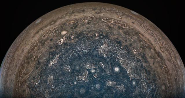
This striking view of Jupiter's Great Red Spot and turbulent southern hemisphere was captured by NASA's Juno spacecraft as it performed a close pass of the gas giant planet. Juno took the three images used to produce this color-enhanced view on Feb. 12, 2019, between 9:59 a.m. PST (12:59 p.m. EST) and 10:39 p.m. PST (1:39 p.m. EST), as the spacecraft performed its 17th science pass of Jupiter. At the time the images were taken, the spacecraft was between 16,700 miles (26,900 kilometers) and 59,300 miles (95,400 kilometers) above Jupiter's cloud tops, above a southern latitude spanning from about 40 to 74 degrees. https://photojournal.jpl.nasa.gov/catalog/PIA22946 Enhanced image by Kevin M. Gill (CC-BY) based on images provided courtesy of NASA/JPL-Caltech/SwRI/MSSS
The Blackhawk landslide, Lucerne Valley, California, is a lobe of marble breccia, 10 to 30 m thick, 3 km wide, and nearly 8 km long. Geologic evidence shows that the rockslide came down the gently inclined slope as a nearly monolithic sheet moving more than 100 km per hour. The accepted hypothesis is that the slide was lubricated by a layer of compressed air. At least two earlier similar but smaller rockslides have occurred in the area. The south-looking perspective view image was acquired on September 22, 2014, and is located at 34.4 degrees north, 116.7 degrees west. http://photojournal.jpl.nasa.gov/catalog/PIA21008
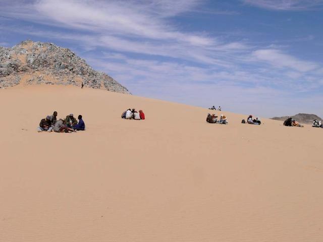
An SUV-sized Asteroid 2008TC# Impacts on October 7, 2008 in the Nubian Desert, Northern Sudan: Dr. Peter Jenniskens, NASA/SETI joined Muawia Shaddas of the University of Khartoum in leading an expedition on a search for samples. (Lunch at Marble Mountain) Photo Credit: NASA/SETI/P. Jenniskens

An attendee of the USA Science and Engineering Festival uses marbles to build a universe consisting of atoms and dark matter. The USA Science and Engineering Festival took place at the Washington Convention Center in Washington, DC on April 26 and 27, 2014. Photo Credit: (NASA/Aubrey Gemignani)

NASA Headquarter's Office of Infrastructure and Administration, Environmental Management Division presents the annual Blue Marble Award to Ames Scientist Leslie Prufert-Bebout receives . Leslie Prufert-Bebout is a microbial ecologist who studies many different species of algea in natural biological communities.
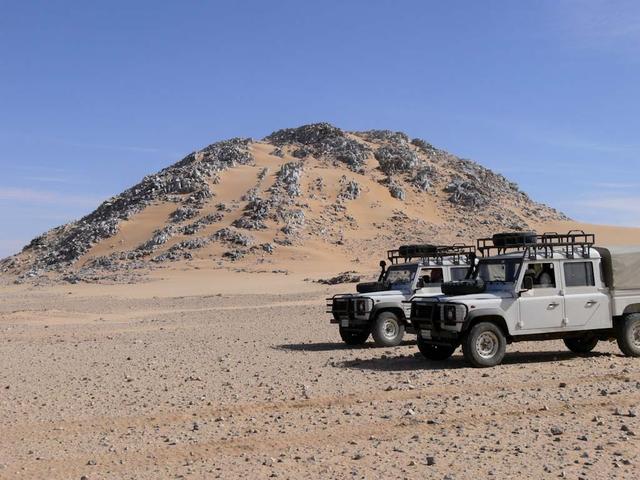
An SUV-sized Asteroid 2008TC# Impacts on October 7, 2008 in the Nubian Desert, Northern Sudan: Dr. Peter Jenniskens, NASA/SETI joined Muawia Shaddas of the University of Khartoum in leading an expedition on a search for samples. (Marble Mountain) Photo Credit: NASA/SETI/P. Jenniskens
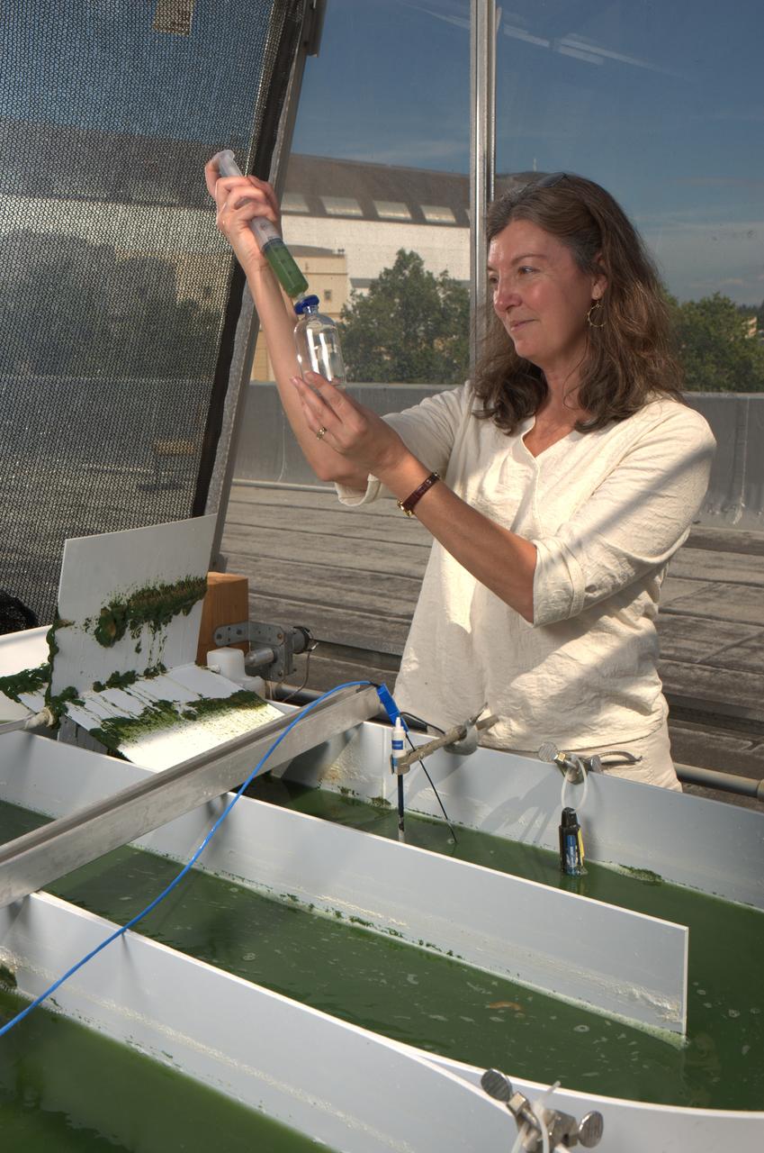
NASA Headquarter's Office of Infrastructure and Administration, Environmental Management Division presents the annual Blue Marble Award to Ames Scientist Leslie Prufert-Bebout receives . Leslie Prufert-Bebout is a microbial ecologist who studies many different species of algea in natural biological communities.
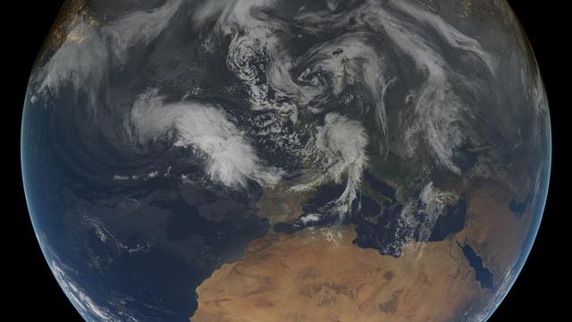
This composite image shows the weather situation over Europe at 12:00 UTC on 13 February 2014. The image is composed of infra-red imagery from the geostationary satellites of EUMETSAT and NOAA, overlaid on NASA's Blue Marble land imagery. Copyright: 2014 EUMETSAT, <a href="http://www.flickr.com/photos/eumetsat/12500210655">www.flickr.com/photos/eumetsat/12500210655</a>
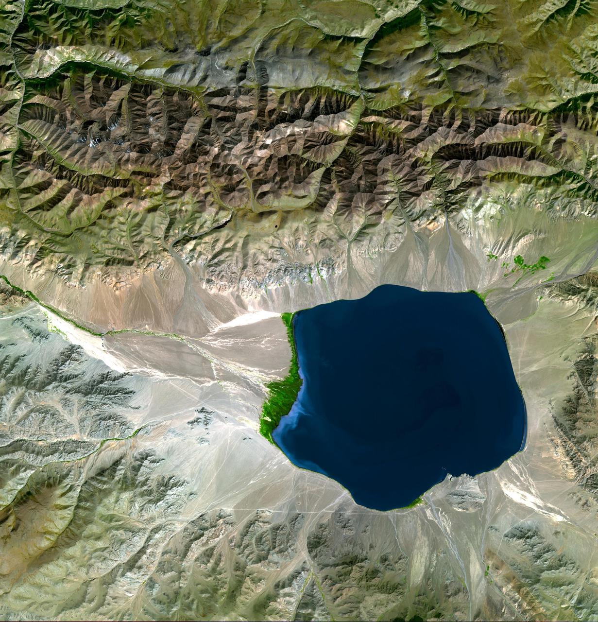
The Uvs Nuur Basin in Mongolia and the Russian Federation is the northernmost of the enclosed basins of Central Asia. It takes its name from Uvs Nuur Lake, a large, shallow and very saline lake, very important for migrating birds. Inscribed as a UNESCO World Heritage Site in 2003, the site is made up of twelve protected areas representing major biomes of eastern Eurasia. The steppe ecosystem supports a rich diversity of birds and the desert is home to a number of rare gerbil, jerboas and the marbled polecat. The mountains are an important refuge for the endangered snow leopard, mountain sheep, and the Asiatic ibex. The image covers an area of 46 x 47.8 km, was acquired on September 4, 2001, and is located near 50.3 degrees north latitude, 90.7 degrees east longitude. This image is from NASA Terra satellite. http://photojournal.jpl.nasa.gov/catalog/PIA10613
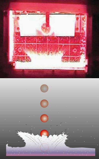
Clues to the formation of planets and planetary rings -- like Saturn's dazzling ring system -- may be found by studying how dust grains interact as they collide at low speeds. To study the question of low-speed dust collisions, NASA sponsored the COLLisions Into Dust Experiment (COLLIDE) at the University of Colorado. It was designed to spring-launch marble-size projectiles into trays of powder similar to space or lunar dust. COLLIDE-1 (1998) discovered that collisions below a certain energy threshold eject no material. COLLIDE-2 was designed to identify where the threshold is. In COLLIDE-2, scientists nudged small projectiles into dust beds and recorded how the dust splashed outward (video frame at top; artist's rendering at bottom). The slowest impactor ejected no material and stuck in the target. The faster impactors produced ejecta; some rebounded while others stuck in the target.
NASA's Juno spacecraft soared directly over Jupiter's south pole when JunoCam acquired this image on February 2, 2017 at 6:06 a.m. PT (9:06 a.m. ET), from an altitude of about 62,800 miles (101,000 kilometers) above the cloud tops. From this unique vantage point we see the terminator (where day meets night) cutting across the Jovian south polar region's restless, marbled atmosphere with the south pole itself approximately in the center of that border. The terminator is offset a bit because it's summer in Jupiter's southern hemisphere. However, the tilt of Jupiter's spin axis is only 3 degrees, much less than Earth's 23.5-degree tilt. This image was processed by citizen scientist John Landino. This enhanced color version highlights the bright high clouds and numerous meandering oval storms. Away from the polar region, the seeming chaos of Jupiter's polar region gives way to the more familiar color banding that Jupiter is known for. http://photojournal.jpl.nasa.gov/catalog/PIA21382
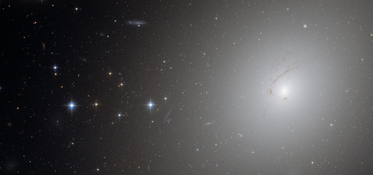
This picture, taken by Hubble’s Advanced Camera for Surveys, shows NGC 4696, the largest galaxy in the Centaurus Cluster. (To see a video of NGC 4696 go here: <a href="http://www.flickr.com/photos/gsfc/4888176841/)">www.flickr.com/photos/gsfc/4888176841/)</a> The huge dust lane, around 30 000 light-years across, that sweeps across the face of the galaxy makes NGC 4696 look different from most other elliptical galaxies. Viewed at certain wavelengths, strange thin filaments of ionised hydrogen are visible within it. In this picture, these structures are visible as a subtle marbling effect across the galaxy’s bright centre. Credit: ESA/Hubble and NASA <b><a href="http://www.nasa.gov/centers/goddard/home/index.html" rel="nofollow">NASA Goddard Space Flight Center</a></b> is home to the nation's largest organization of combined scientists, engineers and technologists that build spacecraft, instruments and new technology to study the Earth, the sun, our solar system, and the universe. <b>Follow us on <a href="http://twitter.com/NASA_GoddardPix" rel="nofollow">Twitter</a></b> <b>Join us on <a href="http://www.facebook.com/pages/Greenbelt-MD/NASA-Goddard/395013845897?ref=tsd" rel="nofollow">Facebook</a><b></b></b>

To commemorate the upcoming 10th anniversary of the DSCOVR (Deep Space Climate Observatory) mission, NASA’s Goddard Space Flight Center in Greenbelt, Md., hosted environmentalist and former Vice President Al Gore, shown here addressing a crowd in the Building 3 Harry J. Goett Auditorium, on Oct. 16, 2024. “The image of our Earth from space is the single most compelling iconic image that any of us have ever seen,” Gore said at a panel discussion for employees. “Now we have, thanks to DSCOVR, 50,000 ‘Blue Marble’ photographs … To date there are more than 100 peer-reviewed scientific publications that are based on the unique science gathered at the L1 point by DSCOVR. For all of the scientists who are here and those on the teams that are represented here, I want to say congratulations and thank you.” Following Gore’s talk on climate monitoring, Goddard scientists participated in a panel discussion, “Remote Sensing and the Future of Earth Observations,” which explored the latest advancements in technology that allow for the monitoring of the atmosphere from space and showcased how Goddard’s research drives the future of Earth science. Gore’s visit also entailed a meeting with the DSCOVR science team, a view into the clean room where Goddard is assembling the Roman Space Telescope, and a stop at the control center for PACE: NASA’s Plankton, Aerosol, Cloud, ocean Ecosystem mission. Launched Feb. 11, 2015, DSCOVR is a space weather station that monitors changes in the solar wind, providing space weather alerts and forecasts for geomagnetic storms that could disrupt power grids, satellites, telecommunications, aviation and GPS. DSCOVR is a joint mission among NASA, the National Oceanic and Atmospheric Administration (NOAA), and the U.S. Air Force. The project originally was called Triana, a mission conceived of by Gore in 1998 during his vice presidency.

This image provides the clearest ever view of galaxy NGC 949, which lies over 30 million light-years away in the constellation of Triangulum. The galaxy has an unusual shape, made more obscure due to its inclination. From our point of view, it is difficult to discern exactly what type of galaxy NGC 949 is, but it is certainly a disc galaxy of some kind, most likely a spiral. NGC 949 was first discovered by Sir William Herschel on 21 September 1786, using an 18.7-inch reflecting telescope. The galaxy was one of about 3000 objects Herschel catalogued as "nebulae" during an intense and systematic deep sky survey, the results of which eventually formed the bulk of the New General Catalogue (NGC). Taken with Hubble’s Advanced Camera for Surveys (ACS), this new image shows extraordinary detail. This detail allows us to see a strange asymmetric alignment in the dark lanes of dust that snake across the galaxy. The top-right half of the galaxy appears considerably more marbled with dust in this image; a curious observation explained by stars tending to favour locations towards the centre of a galaxy, and dust preferring almost invariably to reside along the galactic plane. When a galaxy is inclined as NGC 949 is, some regions — in this case the top-right — are tipped towards us and the light from the stars we see in these regions has had to travel through more dust. This causes the light to appear redder — the result of the same process that gives the sun’s light a red hue at dusk — or else disappear entirely, making the dust appear more prominent on that side of the galaxy. In the part tipped away from us, the light from the stars has had to pass through much less dust to reach us, so it appears brighter, and the dust is much less prominent. Were it possible to view NGC 949 from the opposite side, the apparent alignment of the dust would be reversed. The scientific advantages of this effect were recently displayed in suitably stunning style in the M31 PHAT mosa
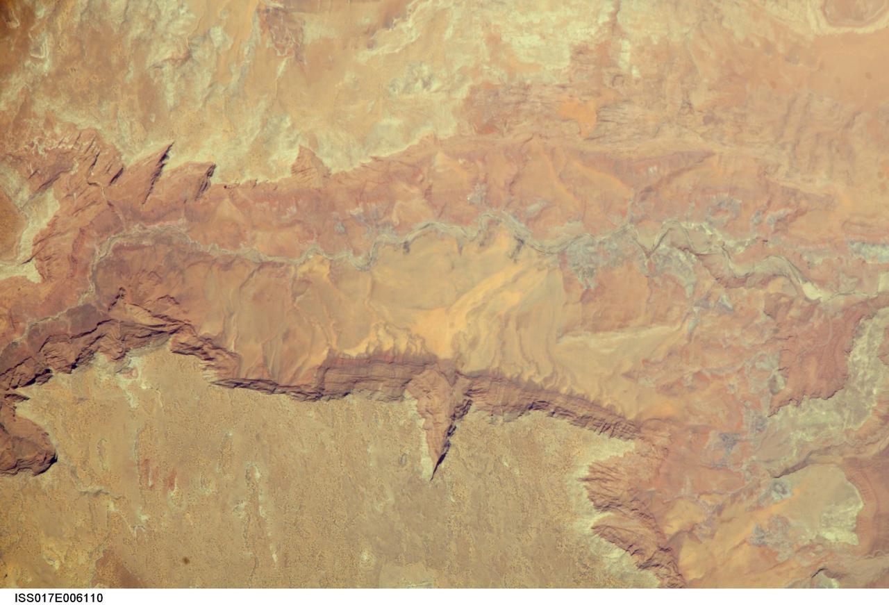
ISS017-E-006110 (2 May 2008) --- Vermilion Cliffs and Paria River, Arizona are featured in this image photographed by an Expedition 17 crewmember on the International Space Station. The largest tributary of the Colorado River between Lake Powell and the Grand Canyon, the Paria River flows southeast from headwaters in southernmost Utah to join the Colorado River between Page, AZ and Marble Canyon. The Paria River provides spectacular scenery, and is known for the very narrow "slot" canyons that it cuts through the layered rocks of the Colorado Plateau. According to scientists, these canyons formed over millions of years by water erosion slicing deep into the rock layers. Exploring the river channel through the slot canyons is a popular activity for hikers and backpackers. Indeed, there is no road access to much of the river channel, and hiking in on foot is the only way to experience the slot canyons. The Paria River also exposes the red and white layers of rocks beneath the Paria Plateau that are known as the Vermilion Cliffs (center). Scientists say that these rocks record the changing environmental conditions of the region during the early Mesozoic Era, ranging from widespread deserts to more water-rich periods when rivers flowed across the landscape. The spectacular scenery of the Vermilion Cliffs and Paria Canyon falls within the Vermilion Cliffs National Monument. This rugged and remote landscape is also home to many species of raptors -- including the California condor -- and other desert fauna such as bighorn sheep.
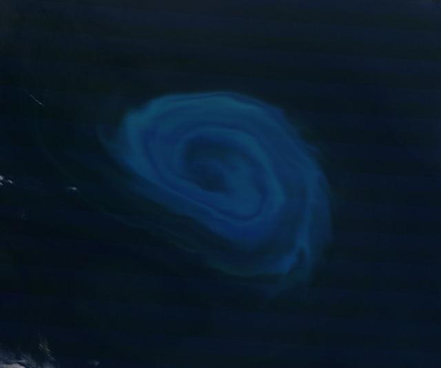
NASA image acquired December 26, 2011 Off the coast of South Africa, near where the South Atlantic meets the Southern Indian Ocean, a massive summer phytoplankton bloom colored the waters with a swirl of turquoise, green and white in late December 2011. Although this circular bloom has the appearance of a precious antique gaming marble, it is actually the result of millions of tiny plant-like organisms (phytoplankton) which are growing where nutrient-rich waters mix together. Each spring and summer, lengthening sunshine comes to the southern oceans, providing light to spur the growth of these microscopic plants. The lengthening light also melts sea ice, which can release additional nutrients into the sea. Blooms such as this one become a banquet for krill, fish and other marine species which survive in these cool waters. The Moderate Resolution Imaging Spectroradiometer (MODIS) aboard NASA’s Terra satellite captured this true-color image on December 26, 2011 as it passed over the region. Credit: NASA/GSFC/Jeff Schmaltz/MODIS Land Rapid Response Team <b><a href="http://www.nasa.gov/audience/formedia/features/MP_Photo_Guidelines.html" rel="nofollow">NASA image use policy.</a></b> <b><a href="http://www.nasa.gov/centers/goddard/home/index.html" rel="nofollow">NASA Goddard Space Flight Center</a></b> enables NASA’s mission through four scientific endeavors: Earth Science, Heliophysics, Solar System Exploration, and Astrophysics. Goddard plays a leading role in NASA’s accomplishments by contributing compelling scientific knowledge to advance the Agency’s mission. <b>Follow us on <a href="http://twitter.com/NASA_GoddardPix" rel="nofollow">Twitter</a></b> <b>Like us on <a href="http://www.facebook.com/pages/Greenbelt-MD/NASA-Goddard/395013845897?ref=tsd" rel="nofollow">Facebook</a></b> <b>Find us on <a href="http://instagrid.me/nasagoddard/?vm=grid" rel="nofollow">Instagram</a></b>

Composite image of category 5 Hurricane Patricia, off the Pacific coast of Mexico, from 06:00 UTC on Friday, 23 October 2015. At 8 a.m. EDT on October 23, 2015, the National Hurricane Center said that Hurricane Patricia had grown into a monster hurricane. In fact, it is the strongest eastern north pacific hurricane on record. At 8 a.m. EDT (1200 UTC) on Oct. 23, the eye of Hurricane Patricia was located near latitude 17.3 North, longitude 105.6 West. That's about 145 miles (235 km) southwest of Manzanillo, Mexico and about 215 miles (345 km) south of Cabo Corrientes, Mexico. Patricia was moving toward the north-northwest near 12 mph (19 kph) and a turn toward the north is expected later this morning, followed by a turn toward the north-northeast this afternoon. On the forecast track, the core of Patricia will make landfall in the hurricane warning area today, October 23, 2015 during the afternoon or evening. Maximum sustained winds remain near 200 mph (325 kph) with higher gusts. The National Hurricane Center (NHC) said that Patricia is a category 5 hurricane on the Saffir-Simpson Hurricane Wind Scale. Some fluctuations in intensity are possible today, but Patricia is expected to remain an extremely dangerous category 5 hurricane through landfall. Hurricane force winds extend outward up to 30 miles (45 km) from the center and tropical storm force winds extend outward up to 175 miles (280 km). The estimated minimum central pressure is 880 millibars. Copyright: 2015 EUMETSAT. Infrared data from the geostationary satellites of EUMETSAT and NOAA overlays a computer-generated model of the Earth, containing NASA's Blue Marble Next Generation imagery <b><a href="http://www.nasa.gov/audience/formedia/features/MP_Photo_Guidelines.html" rel="nofollow">NASA image use policy.</a></b> <b><a href="http://www.nasa.gov/centers/goddard/home/index.html" rel="nofollow">NASA Goddard Space Flight Center</a></b> enables NASA’s mission through four scientific endeavors: Earth Science, Heliophysics, Solar System Exploration, and Astrophysics. Goddard plays a leading role in NASA’s accomplishments by contributing compelling scientific knowledge to advance the Agency’s mission. <b>Follow us on <a href="http://twitter.com/NASAGoddardPix" rel="nofollow">Twitter</a></b> <b>Like us on <a href="http://www.facebook.com/pages/Greenbelt-MD/NASA-Goddard/395013845897?ref=tsd" rel="nofollow">Facebook</a></b> <b>Find us on <a href="http://instagrid.me/nasagoddard/?vm=grid" rel="nofollow">Instagram</a></b>
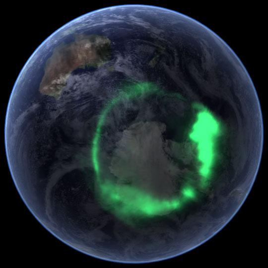
NASA file image acquired September 11, 2005 <b>To view a video of this event go here: <a href="http://www.flickr.com/photos/gsfc/6257608714">www.flickr.com/photos/gsfc/6257608714</a></b> From space, the aurora is a crown of light that circles each of Earth’s poles. The IMAGE satellite captured this view of the aurora australis (southern lights) on September 11, 2005, four days after a record-setting solar flare sent plasma—an ionized gas of protons and electrons—flying towards the Earth. The ring of light that the solar storm generated over Antarctica glows green in the ultraviolet part of the spectrum, shown in this image. The IMAGE observations of the aurora are overlaid onto NASA’s satellite-based Blue Marble image. From the Earth’s surface, the ring would appear as a curtain of light shimmering across the night sky. Like all solar storms, the September storm distorted the shape of the magnetic field that surrounds the Earth. Without buffeting from the solar wind (charged particles like protons and electrons that are ejected from the Sun), the Earth’s magnetic field would look something like a plump doughnut, with the North and South poles forming the slender hole in the center. In reality, the nearly constant solar winds flatten the space side of the “doughnut” into a long tail. The amount of distortion changes when solar storms, such as the flare on September 7, send stronger winds towards the Earth. Changes to the magnetic field release fast-moving particles, which flow with charged particles from the Sun towards the center of the “doughnut” at the Earth’s poles. As the particles sink into the atmosphere, they collide with oxygen and nitrogen, lighting the sky with Nature’s version of neon lights, the aurora. Though scientists knew that the aurora were caused by charged particles from the Sun and their interaction with the Earth’s magnetic field, they had no way to measure the interaction until NASA launched the Imager for Magnetopause-to-Aurora Global Exploration (IMAGE) satellite in 2000. The satellite’s mission was to collect data that would allow scientists to study the structure and dynamics of the Earth’s magnetic field for the first time. Designed to operate for two years, IMAGE sent its last data to Earth in December 2005 after a highly successful five-year mission. Since 2000, IMAGE has provided insight into how the Earth’s powerful magnetic field protects the planet from solar winds. Without the shield the magnetic field provides, the upper atmosphere would evaporate into space under the influence of solar winds. IMAGE has shown scientists what sort of changes the magnetic field undertakes as it diverts solar winds from the Earth. For a summary of the discoveries that IMAGE has made possible, see IMAGE Discovers. Instrument: IMAGE Credit: <a href="http://svs.gsfc.nasa.gov/index.html" rel="nofollow">NASA/Goddard Space Flight Center Scientific Visualization Studio</a> <b><a href="http://www.nasa.gov/audience/formedia/features/MP_Photo_Guidelines.html" rel="nofollow">NASA image use policy.</a></b> <b><a href="http://www.nasa.gov/centers/goddard/home/index.html" rel="nofollow">NASA Goddard Space Flight Center</a></b> enables NASA’s mission through four scientific endeavors: Earth Science, Heliophysics, Solar System Exploration, and Astrophysics. Goddard plays a leading role in NASA’s accomplishments by contributing compelling scientific knowledge to advance the Agency’s mission. <b>Follow us on <a href="http://twitter.com/NASAGoddardPix" rel="nofollow">Twitter</a></b> <b>Like us on <a href="http://www.facebook.com/pages/Greenbelt-MD/NASA-Goddard/395013845897?ref=tsd" rel="nofollow">Facebook</a></b> <b>Find us on <a href="http://instagrid.me/nasagoddard/?vm=grid" rel="nofollow">Instagram</a></b>
This image provides the clearest ever view of galaxy NGC 949, which lies over 30 million light-years away in the constellation of Triangulum. The galaxy has an unusual shape, made more obscure due to its inclination. From our point of view, it is difficult to discern exactly what type of galaxy NGC 949 is, but it is certainly a disk galaxy of some kind, most likely a spiral. NGC 949 was first discovered by Sir William Herschel on September 21, 1786, using an 18.7-inch reflecting telescope. The galaxy was one of about 3,000 objects Herschel cataloged as "nebulae" during an intense and systematic deep sky survey, the results of which eventually formed the bulk of the New General Catalogue (NGC). Taken with Hubble’s Advanced Camera for Surveys (ACS), this image shows extraordinary detail. This detail allows us to see a strange asymmetric alignment in the dark lanes of dust that snake across the galaxy. The top-right half of the galaxy appears considerably more marbled with dust in this image; a curious observation explained by stars tending to favor locations towards the center of a galaxy, and dust preferring almost invariably to reside along the galactic plane. When a galaxy is inclined as NGC 949 is, some regions — in this case the top-right — are tipped toward us and the light from the stars we see in these regions has had to travel through more dust. This causes the light to appear redder — the result of the same process that gives the sun’s light a red hue at dusk — or else disappear entirely, making the dust appear more prominent on that side of the galaxy. In the part tipped away from us, the light from the stars has had to pass through much less dust to reach us, so it appears brighter, and the dust is much less prominent. Were it possible to view NGC 949 from the opposite side, the apparent alignment of the dust would be reversed. The scientific advantages of this effect were recently displayed in suitably stunning style in the M31 PHAT mosaic, which allowed astronomers to produce a partial three-dimensional dust map of M31 four times clearer than any previously attempted. Credit: ESA/Hubble & NASA <b><a href="http://www.nasa.gov/audience/formedia/features/MP_Photo_Guidelines.html" rel="nofollow">NASA image use policy.</a></b> <b><a href="http://www.nasa.gov/centers/goddard/home/index.html" rel="nofollow">NASA Goddard Space Flight Center</a></b> enables NASA’s mission through four scientific endeavors: Earth Science, Heliophysics, Solar System Exploration, and Astrophysics. Goddard plays a leading role in NASA’s accomplishments by contributing compelling scientific knowledge to advance the Agency’s mission. <b>Follow us on <a href="http://twitter.com/NASAGoddardPix" rel="nofollow">Twitter</a></b> <b>Like us on <a href="http://www.facebook.com/pages/Greenbelt-MD/NASA-Goddard/395013845897?ref=tsd" rel="nofollow">Facebook</a></b> <b>Find us on <a href="http://instagrid.me/nasagoddard/?vm=grid" rel="nofollow">Instagram</a></b>
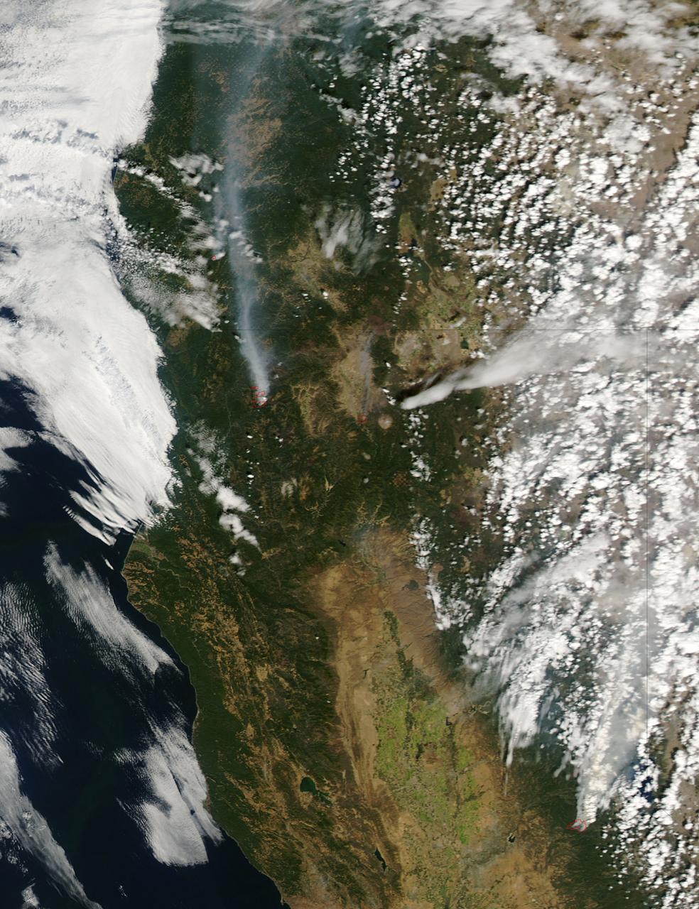
The fire season in California has been anything but cooperative this year. Hot conditions combined with a state-wide drought and dry lightning makes for unpleasant conditions and leads to an abundance of forest fires. On August 12, lightning struck and started the fire that grew into the Happy Camp Complex. Currently over 113,000 acres have been affected and the fire is only 55% contained as of today. Strong winds tested fire lines yesterday (8/15), and are expected to do so again today. Despite the high winds, existing fire lines held with no spotting or expansion outside current containment lines. The south end of the fire continued backing slowly toward Elk Creek in the Marble Mountain Wilderness. The Man Fire joined with the Happy Camp Complex yesterday and will be managed by California Interagency Incident Management Team 4 as of 6:00am on Wednesday, September 17, 2014. Nearby the Happy Camp Complex, near Mt. Shasta and the town of Weed, another fire erupted that fire officials said quickly damaged or destroyed 100 structures Monday (8/15). Hundreds of firefighters were trying to contain that fire. A California Fire spokesman said more than 300 acres were scorched and more than 100 structures damaged or destroyed in just a few hours. The blaze, dubbed the Boles Fire, also led to the closure of Interstate 5 and U.S. 97. Weed is in Siskiyou County, about 50 miles south of the California-Oregon border. With strong winds, the fire was able to rage into the community before firefighters could get equipment to the blaze. About 1,500 to 2,000 residents were being evacuated to the Siskiyou County fairgrounds. An evacuation center was set up at the county fairgrounds in Yreka. NASA's Aqua satellite collected this natural-color image with the Moderate Resolution Imaging Spectroradiometer, MODIS, instrument on September 15, 2014. Actively burning areas, detected by MODIS’s thermal bands, are outlined in red. NASA image courtesy Jeff Schmaltz LANCE/EOSDIS MODIS Rapid Response Team, GSFC. Caption by Lynn Jenner with information from Inciweb and California Department of Forestry and Fire Protection. <b><a href="http://www.nasa.gov/audience/formedia/features/MP_Photo_Guidelines.html" rel="nofollow">NASA image use policy.</a></b> <b><a href="http://www.nasa.gov/centers/goddard/home/index.html" rel="nofollow">NASA Goddard Space Flight Center</a></b> enables NASA’s mission through four scientific endeavors: Earth Science, Heliophysics, Solar System Exploration, and Astrophysics. Goddard plays a leading role in NASA’s accomplishments by contributing compelling scientific knowledge to advance the Agency’s mission. <b>Follow us on <a href="http://twitter.com/NASAGoddardPix" rel="nofollow">Twitter</a></b> <b>Like us on <a href="http://www.facebook.com/pages/Greenbelt-MD/NASA-Goddard/395013845897?ref=tsd" rel="nofollow">Facebook</a></b> <b>Find us on <a href="http://instagram.com/nasagoddard?vm=grid" rel="nofollow">Instagram</a></b>
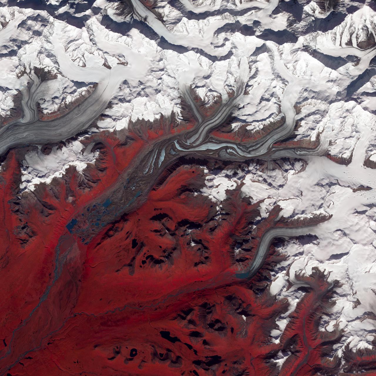
NASA image acquired August 27, 2009 Like rivers of liquid water, glaciers flow downhill, with tributaries joining to form larger rivers. But where water rushes, ice crawls. As a result, glaciers gather dust and dirt, and bear long-lasting evidence of past movements. Alaska’s Susitna Glacier revealed some of its long, grinding journey when the Advanced Spaceborne Thermal Emission and Reflection Radiometer (ASTER) on NASA’s Terra satellite passed overhead on August 27, 2009. This satellite image combines infrared, red, and green wavelengths to form a false-color image. Vegetation is red and the glacier’s surface is marbled with dirt-free blue ice and dirt-coated brown ice. Infusions of relatively clean ice push in from tributaries in the north. The glacier surface appears especially complex near the center of the image, where a tributary has pushed the ice in the main glacier slightly southward. A photograph taken by researchers from the U.S. Geological Survey (archived by the National Snow and Ice Data Center) shows an equally complicated Susitna Glacier in 1970, with dirt-free and dirt-encrusted surfaces forming stripes, curves, and U-turns. Susitna flows over a seismically active area. In fact, a 7.9-magnitude quake struck the region in November 2002, along a previously unknown fault. Geologists surmised that earthquakes had created the steep cliffs and slopes in the glacier surface, but in fact most of the jumble is the result of surges in tributary glaciers. Glacier surges—typically short-lived events where a glacier moves many times its normal rate—can occur when melt water accumulates at the base and lubricates the flow. This water may be supplied by meltwater lakes that accumulate on top of the glacier; some are visible in the lower left corner of this image. The underlying bedrock can also contribute to glacier surges, with soft, easily deformed rock leading to more frequent surges. NASA Earth Observatory image created by Jesse Allen and Robert Simmon, using data provided courtesy of NASA/GSFC/METI/ERSDAC/JAROS, and U.S./Japan ASTER Science Team. Caption by Michon Scott. Instrument: Terra - ASTER Credit: <b><a href="http://www.earthobservatory.nasa.gov/" rel="nofollow"> NASA Earth Observatory</a></b> <b><a href="http://www.nasa.gov/centers/goddard/home/index.html" rel="nofollow">NASA Goddard Space Flight Center</a></b> enables NASA’s mission through four scientific endeavors: Earth Science, Heliophysics, Solar System Exploration, and Astrophysics. Goddard plays a leading role in NASA’s accomplishments by contributing compelling scientific knowledge to advance the Agency’s mission. <b>Follow us on <a href="http://twitter.com/NASA_GoddardPix" rel="nofollow">Twitter</a></b> <b>Join us on <a href="http://www.facebook.com/pages/Greenbelt-MD/NASA-Goddard/395013845897?ref=tsd" rel="nofollow">Facebook</a></b>

NASA's Lunar Reconnaissance Orbiter (LRO) recently captured a unique view of Earth from the spacecraft's vantage point in orbit around the moon. "The image is simply stunning," said Noah Petro, Deputy Project Scientist for LRO at NASA's Goddard Space Flight Center in Greenbelt, Maryland. "The image of the Earth evokes the famous 'Blue Marble' image taken by Astronaut Harrison Schmitt during Apollo 17, 43 years ago, which also showed Africa prominently in the picture." In this composite image we see Earth appear to rise over the lunar horizon from the viewpoint of the spacecraft, with the center of the Earth just off the coast of Liberia (at 4.04 degrees North, 12.44 degrees West). The large tan area in the upper right is the Sahara Desert, and just beyond is Saudi Arabia. The Atlantic and Pacific coasts of South America are visible to the left. On the moon, we get a glimpse of the crater Compton, which is located just beyond the eastern limb of the moon, on the lunar farside. LRO was launched on June 18, 2009, and has collected a treasure trove of data with its seven powerful instruments, making an invaluable contribution to our knowledge about the moon. LRO experiences 12 earthrises every day; however the spacecraft is almost always busy imaging the lunar surface so only rarely does an opportunity arise such that its camera instrument can capture a view of Earth. Occasionally LRO points off into space to acquire observations of the extremely thin lunar atmosphere and perform instrument calibration measurements. During these movements sometimes Earth (and other planets) pass through the camera's field of view and dramatic images such as the one shown here are acquired. This image was composed from a series of images taken Oct. 12, when LRO was about 83 miles (134 kilometers) above the moon's farside crater Compton. Capturing an image of the Earth and moon with LRO's Lunar Reconnaissance Orbiter Camera (LROC) instrument is a complicated task. First the spacecraft must be rolled to the side (in this case 67 degrees), then the spacecraft slews with the direction of travel to maximize the width of the lunar horizon in LROC's Narrow Angle Camera image. All this takes place while LRO is traveling faster than 3,580 miles per hour (over 1,600 meters per second) relative to the lunar surface below the spacecraft! The high-resolution Narrow Angle Camera (NAC) on LRO takes black-and-white images, while the lower resolution Wide Angle Camera (WAC) takes color images, so you might wonder how we got a high-resolution picture of the Earth in color. Since the spacecraft, Earth, and moon are all in motion, we had to do some special processing to create an image that represents the view of the Earth and moon at one particular time. The final Earth image contains both WAC and NAC information. WAC provides the color, and the NAC provides high-resolution detail. "From the Earth, the daily moonrise and moonset are always inspiring moments," said Mark Robinson of Arizona State University in Tempe, principal investigator for LROC. "However, lunar astronauts will see something very different: viewed from the lunar surface, the Earth never rises or sets. Since the moon is tidally locked, Earth is always in the same spot above the horizon, varying only a small amount with the slight wobble of the moon. The Earth may not move across the 'sky', but the view is not static. Future astronauts will see the continents rotate in and out of view and the ever-changing pattern of clouds will always catch one's eye, at least on the nearside. The Earth is never visible from the farside; imagine a sky with no Earth or moon - what will farside explorers think with no Earth overhead?" NASA's first Earthrise image was taken with the Lunar Orbiter 1 spacecraft in 1966. Perhaps NASA's most iconic Earthrise photo was taken by the crew of the Apollo 8 mission as the spacecraft entered lunar orbit on Christmas Eve Dec. 24, 1968. That evening, the astronauts -- Commander Frank Borman, Command Module Pilot Jim Lovell, and Lunar Module Pilot William Anders -- held a live broadcast from lunar orbit, in which they showed pictures of the Earth and moon as seen from their spacecraft. Said Lovell, "The vast loneliness is awe-inspiring and it makes you realize just what you have back there on Earth." Credit: NASA/Goddard/Arizona State University <b><a href="http://www.nasa.gov/audience/formedia/features/MP_Photo_Guidelines.html" rel="nofollow">NASA image use policy.</a></b> <b><a href="http://www.nasa.gov/centers/goddard/home/index.html" rel="nofollow">NASA Goddard Space Flight Center</a></b> enables NASA’s mission through four scientific endeavors: Earth Science, Heliophysics, Solar System Exploration, and Astrophysics. Goddard plays a leading role in NASA’s accomplishments by contributing compelling scientific knowledge to advance the Agency’s mission. <b>Follow us on <a href="http://twitter.com/NASAGoddardPix" rel="nofollow">Twitter</a></b> <b>Like us on <a href="http://www.facebook.com/pages/Greenbelt-MD/NASA-Goddard/395013845897?ref=tsd" rel="nofollow">Facebook</a></b> <b>Find us on <a href="http://instagrid.me/nasagoddard/?vm=grid" rel="nofollow">Instagram</a></b>