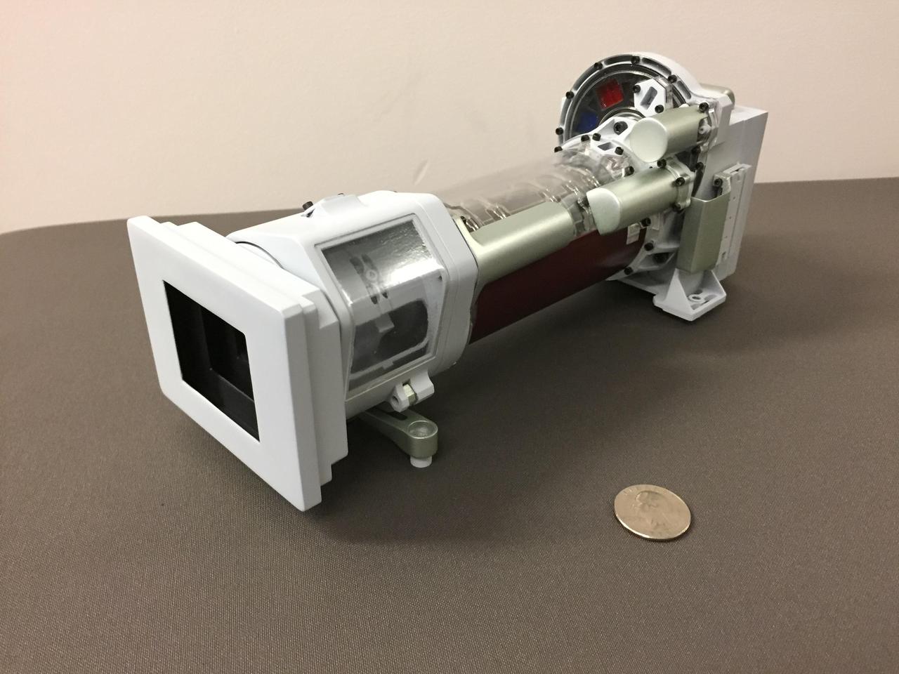
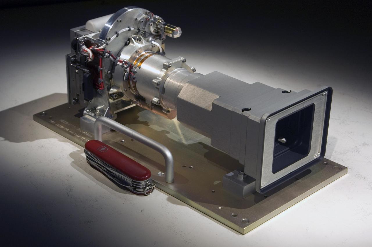
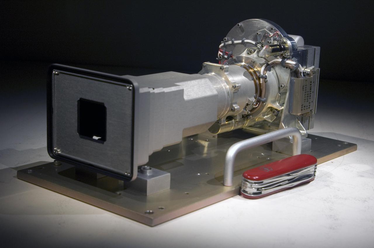
This image shows a 3-D printed model of Mastcam-Z, one of the science cameras on NASA's Mars 2020 rover. Mastcam-Z will include a 3:1 zoom lens. https://photojournal.jpl.nasa.gov/catalog/PIA22101
This view of a Martian rock slab called "Old Soaker," which has a network of cracks that may have originated in drying mud, comes from the Mast Camera (Mastcam) on NASA's Curiosity Mars rover. The location is within an exposure of Murray formation mudstone on lower Mount Sharp inside Gale Crater. Mud cracks would be evidence of a time more than 3 billion years ago when dry intervals interrupted wetter periods that supported lakes in the area. Curiosity has found evidence of ancient lakes in older, lower-lying rock layers and also in younger mudstone that is above Old Soaker. Several images from Mastcam's left-eye camera are combined into this mosaic view. They were taken on Dec. 20, 2016, during the 1,555th Martian day, or sol, of Curiosity's work on Mars. The Old Soaker slab is about 4 feet (1.2 meters) long. Figure 1 includes a scale bar of 30 centimeters (12 inches). The scene is presented with a color adjustment that approximates white balancing, to resemble how the rocks and sand would appear under daytime lighting conditions on Earth. http://photojournal.jpl.nasa.gov/catalog/PIA21262
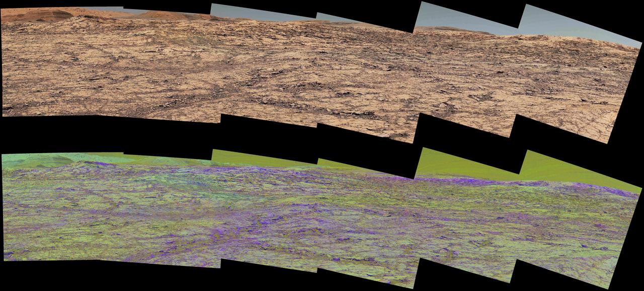
This pair of images from the Mast Camera (Mastcam) on NASA's Curiosity rover illustrates how special filters are used to scout terrain ahead for variations in the local bedrock. The upper panorama is in the Mastcam's usual full color, for comparison. The lower panorama of the same scene, in false color, combines three exposures taken through different "science filters," each selecting for a narrow band of wavelengths. Filters and image processing steps were selected to make stronger signatures of hematite, an iron-oxide mineral, evident as purple. Hematite is of interest in this area of Mars -- partway up "Vera Rubin Ridge" on lower Mount Sharp -- as holding clues about ancient environmental conditions under which that mineral originated. In this pair of panoramas, the strongest indications of hematite appear related to areas where the bedrock is broken up. With information from this Mastcam reconnaissance, the rover team selected destinations in the scene for close-up investigations to gain understanding about the apparent patchiness in hematite spectral features. The Mastcam's left-eye camera took the component images of both panoramas on Sept. 12, 2017, during the 1,814th Martian day, or sol, of Curiosity's work on Mars. The view spans from south-southeast on the left to south-southwest on the right. The foreground across the bottom of the scene is about 50 feet (about 15 meters) wide. Figure 1 includes scale bars of 1 meter (3.3 feet) in the middle distance and 5 meters (16 feet) at upper right. Curiosity's Mastcam combines two cameras: the right eye with a telephoto lens and the left eye with a wider-angle lens. Each camera has a filter wheel that can be rotated in front of the lens for a choice of eight different filters. One filter for each camera is clear to all visible light, for regular full-color photos, and another is specifically for viewing the Sun. Some of the other filters were selected to admit wavelengths of light that are useful for identifying iron minerals. Each of the filters used for the lower panorama shown here admits light from a narrow band of wavelengths, extending to only about 5 to 10 nanometers longer or shorter than the filter's central wavelength. The three observations combined into this product used filters centered at three near-infrared wavelengths: 751 nanometers, 867 nanometers and 1,012 nanometers. Hematite distinctively absorbs some frequencies of infrared light more than others. Usual color photographs from digital cameras -- such as the upper panorama here from Mastcam -- combine information from red, green and blue filtering. The filters are in a microscopic grid in a "Bayer" filter array situated directly over the detector behind the lens, with wider bands of wavelengths. The colors of the upper panorama, as with most featured images from Mastcam, have been tuned with a color adjustment similar to white balancing for approximating how the rocks and sand would appear under daytime lighting conditions on Earth. https://photojournal.jpl.nasa.gov/catalog/PIA22065
This set of views illustrates capabilities of the Mast Camera MastCam instrument on NASA Mars Science Laboratory Curiosity rover, using a scene on Earth as an example of what MastCam two cameras can see from different distances.
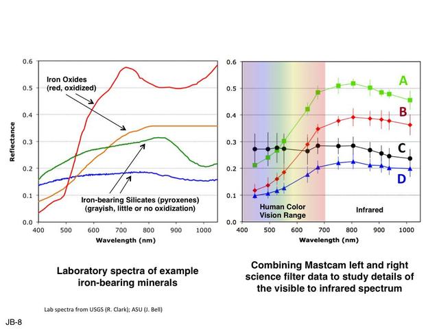
This set of images illustrates how the science filters of the Mast Camera Mastcam on NASA Mars rover Curiosity can be used to investigate aspects of the composition and mineralogy of materials on Mars.
This animation shows the order in which the 142 images that make up Mastcam-Z's first 360-degree panorama were taken. Mastcam-Z is a pair of zoomable cameras on the mast, or "head," of NASA's Perseverance Mars rover. Arizona State University in Tempe leads the operations of the Mastcam-Z instrument, working in collaboration with Malin Space Science Systems in San Diego. A key objective for Perseverance's mission on Mars is astrobiology, including the search for signs of ancient microbial life. The rover will characterize the planet's geology and past climate, pave the way for human exploration of the Red Planet, and be the first mission to collect and cache Martian rock and regolith (broken rock and dust). Subsequent NASA missions, in cooperation with ESA (European Space Agency), would send spacecraft to Mars to collect these sealed samples from the surface and return them to Earth for in-depth analysis. Animation available at https://photojournal.jpl.nasa.gov/catalog/PIA24444
This image shows the 142 images that make up Mastcam-Z's first 360-degree panorama. Mastcam-Z is a pair of zoomable cameras on the mast, or "head," of NASA's Perseverance Mars rover. Arizona State University in Tempe leads the operations of the Mastcam-Z instrument, working in collaboration with Malin Space Science Systems in San Diego. A key objective for Perseverance's mission on Mars is astrobiology, including the search for signs of ancient microbial life. The rover will characterize the planet's geology and past climate, pave the way for human exploration of the Red Planet, and be the first mission to collect and cache Martian rock and regolith (broken rock and dust). Subsequent NASA missions, in cooperation with ESA (European Space Agency), would send spacecraft to Mars to collect these sealed samples from the surface and return them to Earth for in-depth analysis. https://photojournal.jpl.nasa.gov/catalog/PIA24445

With two cameras set about 10 inches apart at the top of the rover's remote sensing mast, Mastcam-Z can produce a 3D image to be viewed with 3D glasses. This is similar to the way our two human eyes work, with our brain forming the 3D image, but no glasses needed! This stereo, or 3D, image was taken with the Mastcam-Z simulator system, used during testing at Arizona State University. https://photojournal.jpl.nasa.gov/catalog/PIA24196
This view from the Mast Camera (Mastcam) on NASA's Curiosity Mars rover shows a site where two different types of bedrock meet on lower Mount Sharp. The scene combines multiple images taken by the left-eye camera of Mastcam on May 25, 2015, during the 995th Martian day, or sol, of Curiosity's work on Mars, in a valley just below "Marias Pass." The color has been approximately white-balanced to resemble how the scene would appear under daytime lighting conditions on Earth. The paler part of the outcrop, in the foreground, is mudstone similar to what Curiosity examined in 2014, and in early 2015, at "Pahrump Hills." The darker, finely bedded bedrock higher in the image and overlying the mudstone stratigraphically is sandstone that the rover team calls the "Stimson" unit. The scene covers an area about 10 feet (3 meters) wide in the foreground. Malin Space Science Systems, San Diego, built and operates the rover's Mastcam. NASA's Jet Propulsion Laboratory, a division of the California Institute of Technology, Pasadena, manages the Mars Science Laboratory Project for NASA's Science Mission Directorate, Washington. http://photojournal.jpl.nasa.gov/catalog/PIA19676
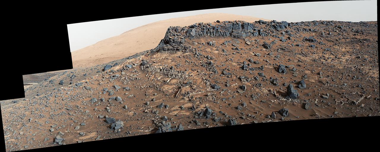
Large-scale crossbedding in the sandstone of this ridge on a lower slope of Mars' Mount Sharp is common in petrified sand dunes. The scene combines multiple images taken with both cameras of the Mast Camera (Mastcam) on Curiosity on Aug. 27, 2015, during the 1,087th Martian day, or sol of the rover's work on Mars. It spans from east, at left, to south-southwest. Figure 1 includes a scale bar of 200 centimeters (about 6.6 feet). Sets of bedding laminations lie at angles to each other. Such crossbedding is common in wind-deposited sandstone of the U.S. Southwest. An example from Utah is pictured at http://3dparks.wr.usgs.gov/zion/html2/3d153.html. The sandstone in the image from Mars is part of the Stimson unit on Mount Sharp. The color of the Mastcam mosaic has been approximately white-balanced to resemble how the scene would appear under daytime lighting conditions on Earth. The component images in the center and upper portion of the mosaic are from Mastcam's right-eye camera, which is equipped with a 100-millimeter-focal-length telephoto lens. Images used in the foreground and at far left and right were taken with Mastcam's left-eye camera, using a wider-angle, 34-millimeter lens. Malin Space Science Systems, San Diego, built and operates Curiosity's Mastcam. NASA's Jet Propulsion Laboratory, a division of the California Institute of Technology, Pasadena, built the rover and manages the project for NASA's Science Mission Directorate, Washington. For more information about Curiosity, visit http://www.nasa.gov/msl and http://mars.jpl.nasa.gov/msl . http://photojournal.jpl.nasa.gov/catalog/PIA19818
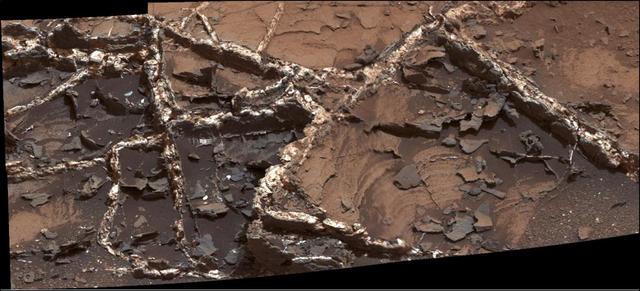
Prominent mineral veins at the "Garden City" site examined by NASA's Curiosity Mars rover vary in thickness and brightness, as seen in this image from Curiosity's Mast Camera (Mastcam). The image covers and area roughly 2 feet (60 centimeters) across. Types of vein material evident in the area include: 1) thin, dark-toned fracture filling material; 2) thick, dark-toned vein material in large fractures; 3) light-toned vein material, which was deposited last. Figure 1 includes annotations identifying each of those three major kinds and a scale bar indicating 10 centimeters (3.9 inches). Researchers used the Mastcam and other instruments on Curiosity in March and April 2015 to study the structure and composition of mineral veins at Garden City, for information about fluids that deposited minerals in fractured rock there. Malin Space Science Systems, San Diego, built and operates Curiosity's Mastcam. NASA's Jet Propulsion Laboratory, a division of the California Institute of Technology, Pasadena, built the rover and manages the project for NASA's Science Mission Directorate, Washington. http://photojournal.jpl.nasa.gov/catalog/PIA19922
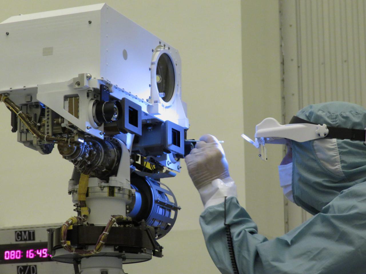
A JPL optical technician performs a final inspection and swab cleaning of the front optics of the Mars 2020 mission's Perseverance rover Mastcam-Z cameras at the Kennedy Space Center in Florida in March 2020. https://photojournal.jpl.nasa.gov/catalog/PIA24197
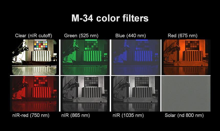
This figure shows images acquired through each of the eight filters in the filter wheel of the 34-millimeter-focal-length Mast Camera Mastcam-34 on NASA Mars rover Curiosity.
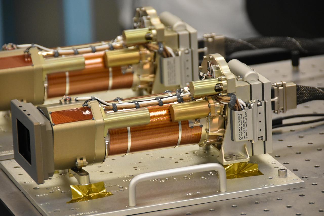
The Mastcam-Z cameras are on a workbench during their assembly at Malin Space Science Systems in San Diego. A square lightshade is mounted at the left end of the camera to reduce the scattered light that reaches the optics. Both cameras are almost identical, except for slight differences in the adjustable color filters that will provide more information about the mineralogy of the rocks on Mars. https://photojournal.jpl.nasa.gov/catalog/PIA24198
The Mast Camera Mastcam instrument for NASA Mars Science Laboratory will use a side-by side pair of cameras for examining terrain around the mission rover, Curiosity. The Mastcam 34 offers wider-angle viewing.
The Mast Camera Mastcam instrument for NASA Mars Science Laboratory will use a side-by side pair of cameras for examining terrain around the mission rover, Curiosity. The Mastcam 100 offers telephoto capability.
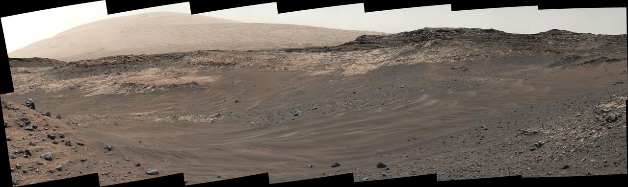
A southward-looking panorama combining images from both cameras of the Mast Camera Mastcam instrument on NASA Curiosity Mars Rover shows diverse geological textures on Mount Sharp. A southward-looking panorama combining images from both cameras of the Mast Camera (Mastcam) instrument on NASA's Curiosity Mars Rover shows diverse geological textures on Mount Sharp. Three years after landing on Mars, the mission is investigating this layered mountain for evidence about changes in Martian environmental conditions, from an ancient time when conditions were favorable for microbial life to the much-drier present. Gravel and sand ripples fill the foreground, typical of terrains that Curiosity traversed to reach Mount Sharp from its landing site. Outcrops in the midfield are of two types: dust-covered, smooth bedrock that forms the base of the mountain, and sandstone ridges that shed boulders as they erode. Rounded buttes in the distance contain sulfate minerals, perhaps indicating a change in the availability of water when they formed. Some of the layering patterns on higher levels of Mount Sharp in the background are tilted at different angles than others, evidence of complicated relationships still to be deciphered. The scene spans from southeastward at left to southwestward at right. The component images were taken on April 10 and 11, 2015, the 952nd and 953rd Martian days (or sols) since the rover's landing on Mars on Aug. 6, 2012, UTC (Aug. 5, PDT). Images in the central part of the panorama are from Mastcam's right-eye camera, which is equipped with a 100-millimeter-focal-length telephoto lens. Images used in outer portions, including the most distant portions of the mountain in the scene, were taken with Mastcam's left-eye camera, using a wider-angle, 34-millimeter lens. http://photojournal.jpl.nasa.gov/catalog/PIA19803
This false-color image demonstrates how use of special filters available on the Mast Camera (Mastcam) of NASA's Curiosity Mars rover can reveal the presence of certain minerals in target rocks. It is a composite of images taken through three "science" filters chosen for making hematite, an iron-oxide mineral, stand out as exaggerated purple. This target rock, called "Christmas Cove," lies in an area on Mars' "Vera Rubin Ridge" where Mastcam reconnaissance imaging (see PIA22065) with science filters suggested a patchy distribution of exposed hematite. Bright lines within the rocks are fractures filled with calcium sulfate minerals. Christmas Cove did not appear to contain much hematite until the rover team conducted an experiment on this target: Curiosity's wire-bristled brush, the Dust Removal Tool, scrubbed the rock, and a close-up with the Mars Hand Lens Imager (MAHLI) confirmed the brushing. The brushed area is about is about 2.5 inches (6 centimeters) across. The next day -- Sept. 17, 2017, on the mission's Sol 1819 -- this observation with Mastcam and others with the Chemistry and Camera (ChemCam showed a strong hematite presence that had been subdued beneath the dust. The team is continuing to explore whether the patchiness in the reconnaissance imaging may result more from variations in the amount of dust cover rather than from variations in hematite content. Curiosity's Mastcam combines two cameras: one with a telephoto lens and the other with a wider-angle lens. Each camera has a filter wheel that can be rotated in front of the lens for a choice of eight different filters. One filter for each camera is clear to all visible light, for regular full-color photos, and another is specifically for viewing the Sun. Some of the other filters were selected to admit wavelengths of light that are useful for identifying iron minerals. Each of the filters used for this image admits light from a narrow band of wavelengths, extending to only about 5 nanometers longer or shorter than the filter's central wavelength. Three observations are combined for this image, each through one of the filters centered at 751 nanometers (in the near-infrared part of the spectrum just beyond red light), 527 nanometers (green) and 445 nanometers (blue). Usual color photographs from digital cameras -- such as a Mastcam one of this same place (see PIA22067) -- also combine information from red, green and blue filtering, but the filters are in a microscopic grid in a "Bayer" filter array situated directly over the detector behind the lens, with wider bands of wavelengths. Mastcam's narrow-band filters used for this view help to increase spectral contrast, making blues bluer and reds redder, particularly with the processing used to boost contrast in each of the component images of this composite. Fine-grained hematite preferentially absorbs sunlight around in the green portion of the spectrum around 527 nanometers. That gives it the purple look from a combination of red and blue light reflected by the hematite and reaching the camera through the other two filters. https://photojournal.jpl.nasa.gov/catalog/PIA22066
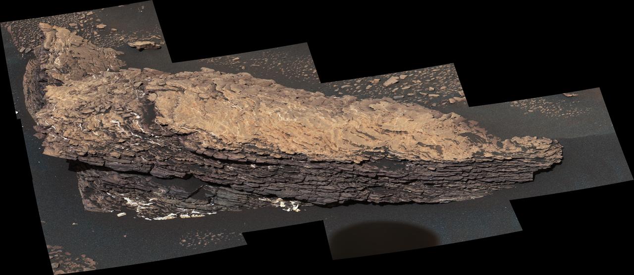
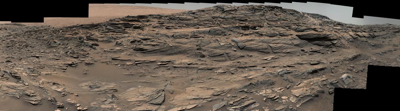
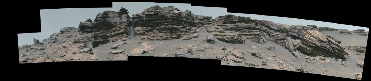
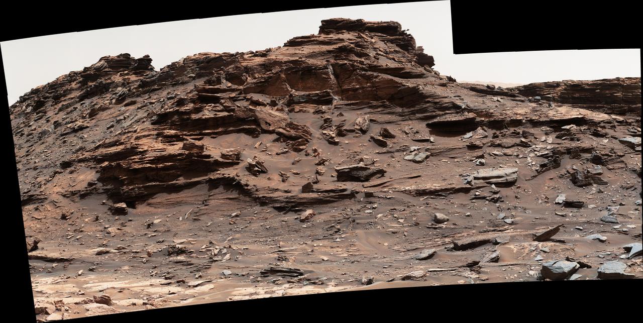
This mosaic of images shows a boulder-sized rock called "Strathdon," which is made up of many complex layers. NASA's Curiosity Mars rover took these images using its Mast Camera, or Mastcam, on July 9, 2019, the 2,461st Martian sol, or day, of the mission. The color in the image has been adjusted to approximate white balancing to resemble how the rocks and sand would appear under daytime lighting conditions on Earth. https://photojournal.jpl.nasa.gov/catalog/PIA23348
This set of images illustrates how the science filters of the Mast Camera Mastcam on NASA Mars rover Curiosity can be used to investigate aspects of the composition and mineralogy of materials on Mars.
NASA's Perseverance Mars rover used its Mastcam-Z instrument to view this workspace around the sample collected from a rock nicknamed "Cheyava Falls." A drill hole is visible (far left) where a sample was collected on July 21, 2024. At right is a rock nicknamed "Steamboat Mountain." A circular white abrasion patch can be seen on each rock; these are where the rover used an abrasion tool to clear away the top surface, allowing instruments to study the rocks' composition. The images that make up this composite were taken by the rover's Mastcam-Z instrument on July 23, 2024, the 1217th day, or sol, of the mission. https://photojournal.jpl.nasa.gov/catalog/PIA26401
This view from the Mast Camera (Mastcam) on NASA's Curiosity Mars rover shows a site with a network of prominent mineral veins below a cap rock ridge on lower Mount Sharp. Researchers used the rover in March 2015 to examine the structure and composition of the crisscrossing veins at the "Garden City" site in the center of this scene. For geologists, the vein complex offers a three-dimensional exposure of mineralized fractures in a geological setting called the Pahrump section of the Lower Murray Formation. Curiosity spent several months examining sites in the Pahrump section below this site, before arriving at Garden City. Mineral veins such as these form where fluids move through fractured rocks, depositing minerals in the fractures and affecting chemistry of the surrounding rock. In this case, the veins have been more resistant to erosion than the surrounding host rock. The component images of this mosaic view were taken by the left-eye camera of Mastcam on March 27, 2015, during the 938th Martian day, or sol, of Curiosity's work on Mars. The scene is presented with a color adjustment that approximates white balancing, to resemble how the rocks would appear under daytime lighting conditions on Earth. For scale, the cap rock scarp is about 3 feet (1 meter) tall. Figure 1 includes scale bars of 1 meter (3.3 feet) vertically and 2 meters (6.7 feet) horizontally. Malin Space Science Systems, San Diego, built and operates Curiosity's Mastcam. NASA's Jet Propulsion Laboratory, a division of the California Institute of Technology, Pasadena, built the rover and manages the project for NASA's Science Mission Directorate, Washington. http://photojournal.jpl.nasa.gov/catalog/PIA19921
This view southeastward from Curiosity's Mast Camera (Mastcam) shows terrain judged difficult for traversing between the rover and an outcrop in the middle distance where a pale rock unit meets a darker rock unit above it. The Mastcam's left-eye camera captured the component images on May 10, 2015, during the 981st Martian day, or sol, of Curiosity's work on Mars. This observation helped the rover team evaluate routes for driving to that geological contact area where the two rock units meet. The outcrop exposing the contact is in the eastern portion of the "Logan Pass" area. The windblown ripples and the steep ground where ripples are lacking are both poor terrain for the rover to cross. The team subsequently chose to approach a different site where the pale and darker rock units are in contact with each other. That alternative site is in the northern portion of the Logan Pass area, outside of this scene. This panorama spans from east, at left, to south-southwest. The color has been approximately white-balanced to resemble how the scene would appear under daytime lighting conditions on Earth. http://photojournal.jpl.nasa.gov/catalog/PIA19662
On a part of "Vera Rubin Ridge" where rover-team researchers sought to determine whether dust coatings are hiding rocks' hematite content, the Mast Camera (Mastcam) on NASA's Curiosity Mars rover took this image of a rock surface that had been brushed with the rover's Dust Removal Tool. The image is shown in the usual full color of featured Mastcam images: with a color adjustment similar to white balancing for approximating how the rocks and sand would appear under daytime lighting conditions on Earth. Sunlight on Mars is tinged by the dusty atmosphere and this adjustment helps geologists recognize color patterns they are familiar with on Earth. In this case, the purplish tint of the brushed area suggested fine-grained hematite. Bright lines within the rocks are fractures filled with calcium sulfate minerals. The brushed area is about 2.5 inches (6 centimeters) across. The image was taken on Sept. 17, 2017, during the 1,819th Martian day, or sol, of Curiosity's work on Mars. Mastcam also imaged this same scene using three special filters that help to identify hematite, an iron-oxide mineral that can provide information about ancient environmental conditions. A science-filters image identifies hematite in this brushed target even more clearly. https://photojournal.jpl.nasa.gov/catalog/PIA22067
NASA's Curiosity Mars rover used its Mast Camera, or Mastcam, to capture this scene around a drill hole named "Edinburgh." The images used to create the scene were taken on March 22 and 23, 2020, which were the 2,711th and 2,712th Martian days, or sols, of the mission. The scene was captured while Curiosity was parked on top of a feature called the "Greenheugh Pediment." Looming above in the background is the top of Mount Sharp, the 3-mile-tall (5-kilometer-tall) mountain that Curiosity has been ascending since 2014. The color balance of the scene was processed to reflect the way it would look to the human eye under daytime lighting on Earth. https://photojournal.jpl.nasa.gov/catalog/PIA25046
A view from the Kimberly formation on Mars taken by NASA Curiosity rover. The strata in the foreground dip towards the base of Mount Sharp, indicating the ancient depression that existed before the larger bulk of the mountain formed. The colors are adjusted so that rocks look approximately as they would if they were on Earth, to help geologists interpret the rocks. This "white balancing" to adjust for the lighting on Mars overly compensates for the absence of blue on Mars, making the sky appear light blue and sometimes giving dark, black rocks a blue cast. This image was taken by the Mast Camera (Mastcam) on Curiosity on the 580th Martian day, or sol, of the mission. Malin Space Science Systems, San Diego, built and operates Curiosity's Mastcam. NASA's Jet Propulsion Laboratory, a division of the California Institute of Technology, Pasadena, built the rover and manages the project for NASA's Science Mission Directorate, Washington. http://photojournal.jpl.nasa.gov/catalog/PIA19839
An image taken at the Hidden Valley site, en-route to Mount Sharp, by NASA Curiosity rover. A variety of mudstone strata in the area indicate a lakebed deposit, with river- and stream-related deposits nearby. Decoding the history of how these sedimentary rocks were formed, and during what period of time, was a key component in the confirming of the role of water and sedimentation in the formation of the floor of Gale Crater and Mount Sharp. This image was taken by the Mast Camera (Mastcam) on Curiosity on the 703rd Martian day, or sol, of the mission. Malin Space Science Systems, San Diego, built and operates Curiosity's Mastcam. NASA's Jet Propulsion Laboratory, a division of the California Institute of Technology, Pasadena, built the rover and manages the project for NASA's Science Mission Directorate, Washington. http://photojournal.jpl.nasa.gov/catalog/PIA19840

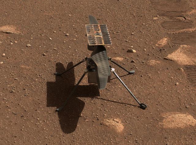
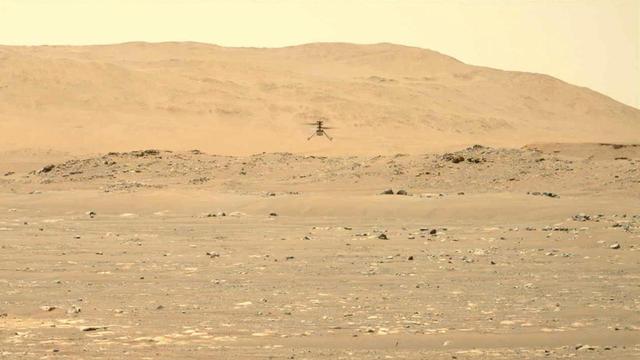
NASA's Ingenuity Mars Helicopter lands with a soft bounce after its fifth flight on May 7, 2021. The images in this GIF were captured by the Mastcam-Z imager aboard NASA's Perseverance rover. Movie available at https://photojournal.jpl.nasa.gov/catalog/PIA24649
Mastcam-Z, a pair of zoomable cameras aboard NASA's Perseverance rover, imaged its calibration target for the first time on Feb. 20, 2021, the second Martian day, or sol, of Perseverance's mission. Visible in this natural-color composite are the Mastcam-Z primary-color and grayscale calibration target (the colorful circular object at right foreground) as well as the camera's secondary calibration target (the small colorful L-bracket just below the primary target). The Mastcam-Z team uses these targets to calibrate images of the Martian terrain to adjust for changes in brightness and dust in the atmosphere throughout the day. The white square plate containing a grid of circular colored disks mounted farther to the aft on the rover is the calibration target for the SuperCam instrument. To the left of the image, the dusty and rocky Martian surface is visible at the Perseverance rover's landing site in Jezero crater. For more details about the Mastcam-Z calibration targets, see the article "Mars in Full Color" on the Mastcam-Z public web site, at https://mastcamz.asu.edu/mars-in-full-color. A key objective for Perseverance's mission on Mars is astrobiology, including the search for signs of ancient microbial life. The rover will characterize the planet's geology and past climate, pave the way for human exploration of the Red Planet, and be the first mission to collect and cache Martian rock and regolith. The Mars 2020 Perseverance mission is part of NASA's Moon to Mars exploration approach, which includes Artemis missions to the Moon that will help prepare for human exploration of the Red Planet. Subsequent missions by NASA in cooperation with ESA (European Space Agency) would send spacecraft to Mars to collect these cached samples from the surface and return them to Earth for in-depth analysis. https://photojournal.jpl.nasa.gov/catalog/PIA24423
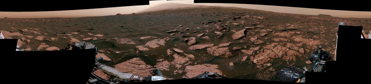
NASA's Perseverance Mars rover used its Mastcam-Z stereo imaging system to capture this 360-degree panorama of "Van Zyl Overlook," where the rover was parked for 13 days as the Ingenuity helicopter performed its first flights. The 2.4 billion-pixel panorama is made up of 992 individual right-eye Mastcam-Z images stitched together. The images were taken between April 15 and 26, 2021, or the 53rd and 64th Martian days, or sols, of the mission. A few small patches of near-field sand had been covered by parts of Perseverance when the right-eye Mastcam-Z images were taken; those gaps were filled with images of the same sandy patches taken by the Mastcam-Z left-eye camera at the same time, or from the earlier navigation camera images. Imaging coverage of the sky has also been digitally smoothed and expanded based on the actual sky color observed as the panorama was being acquired on Mars. Arizona State University in Tempe leads the operations of the Mastcam-Z instrument, working in collaboration with Malin Space Science Systems in San Diego. A key objective for Perseverance's mission on Mars is astrobiology, including the search for signs of ancient microbial life. The rover will characterize the planet's geology and past climate, pave the way for human exploration of the Red Planet, and be the first mission to collect and cache Martian rock and regolith (broken rock and dust). Subsequent NASA missions, in cooperation with ESA (European Space Agency), would send spacecraft to Mars to collect these sealed samples from the surface and return them to Earth for in-depth analysis. The Mars 2020 Perseverance mission is part of NASA's Moon to Mars exploration approach, which includes Artemis missions to the Moon that will help prepare for human exploration of the Red Planet. https://photojournal.jpl.nasa.gov/catalog/PIA24663
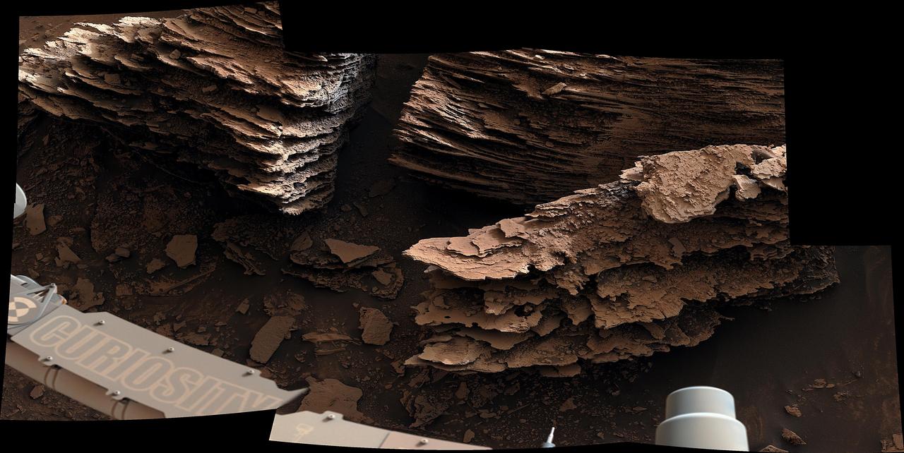
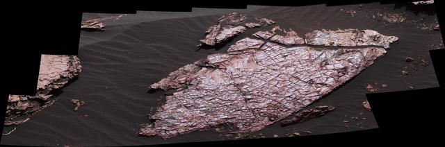
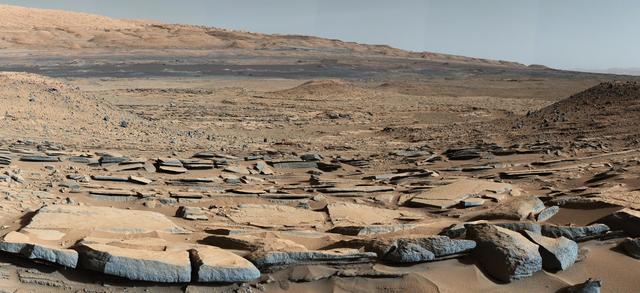
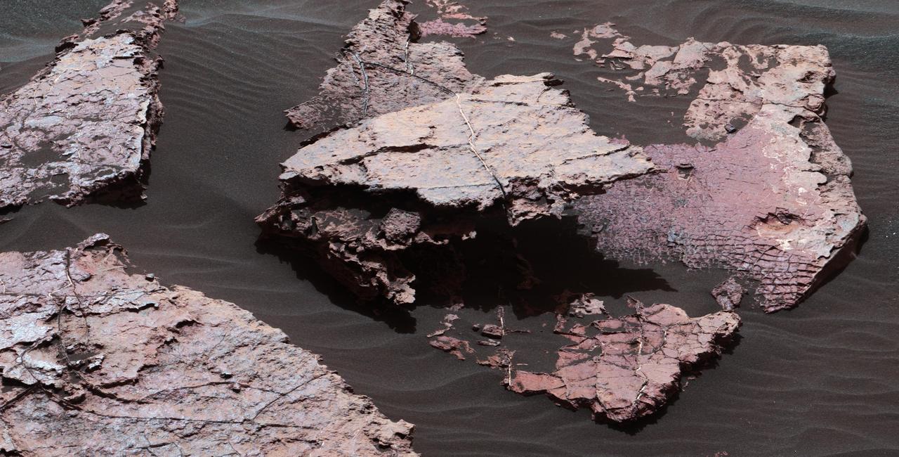
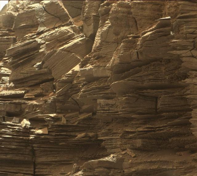
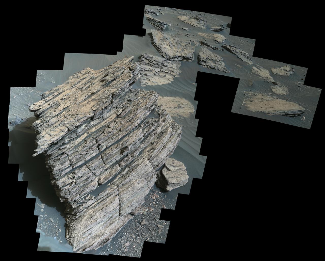
NASA's Curiosity Mars rover captured this view of layered, flaky rocks believed to have formed in an ancient streambed or small pond. The six images that make up this mosaic were captured using Curiosity's Mast Camera, or Mastcam, on June 2, 2022, the 3,492nd Martian day, or sol, of the mission. https://photojournal.jpl.nasa.gov/catalog/PIA25368
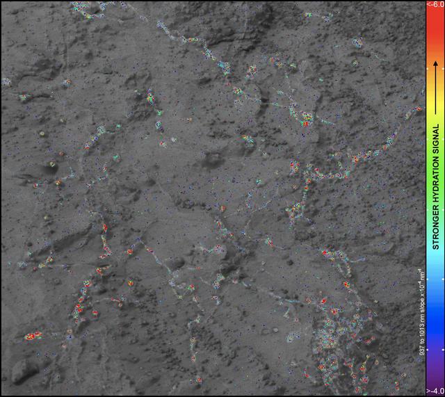
On this image of the rock target Knorr, color coding maps the amount of mineral hydration indicated by a ratio of near-infrared reflectance intensities measured by the Mastcam on NASA Mars rover Curiosity.
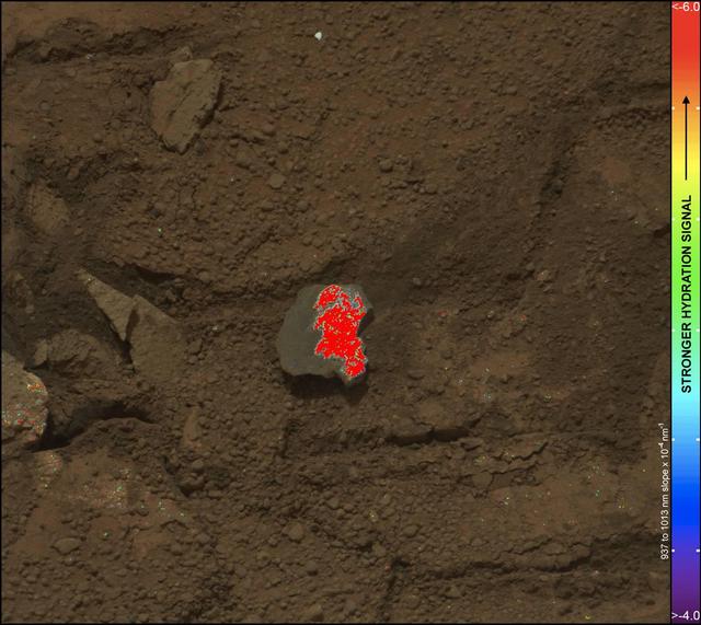
On this image of the broken rock called Tintina, color coding maps the amount of mineral hydration indicated by a ratio of near-infrared reflectance intensities measured by the Mastcam on NASA Mars rover Curiosity.
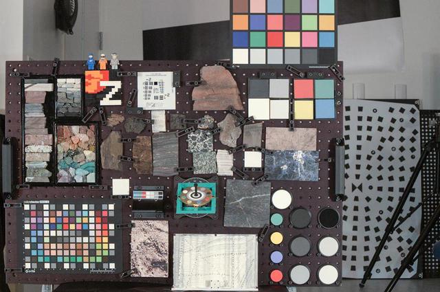
This modern-looking "geoboard" adds a pop of color to the lab at Malin Space Science Systems in San Diego, California. With an array of colors and textures, this board looks like art, but it is an important tool for camera testing. Imaging the color samples and the rock and mineral specimens gives the camera team important references for when they are imaging rocks on Mars with Mastcam-Z. https://photojournal.jpl.nasa.gov/catalog/PIA24199
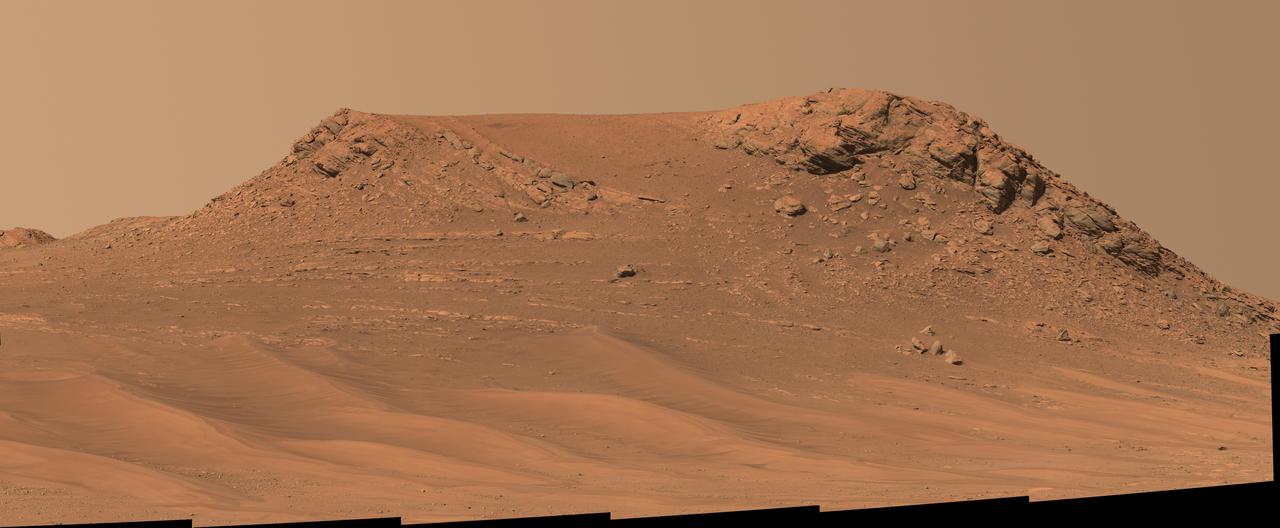
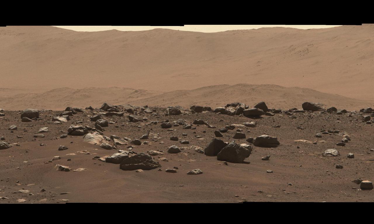
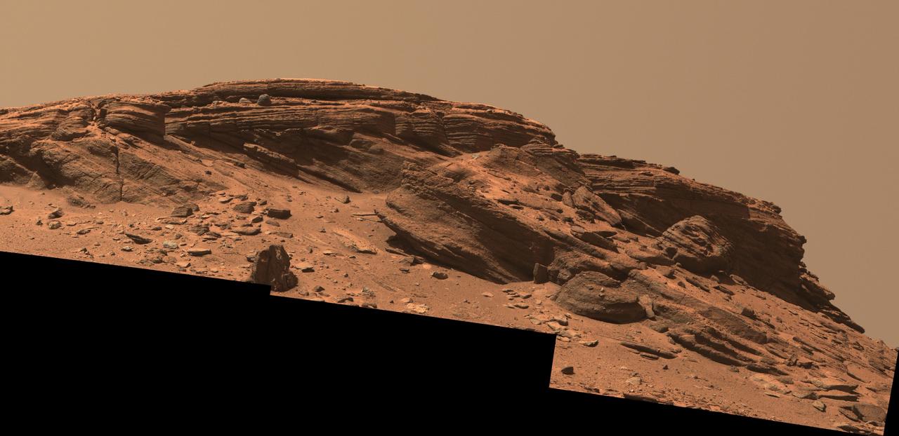
NASA's Perseverance Mars rover captured this mosaic of an isolated hill nicknamed "Pinestand." Scientists think sedimentary layers stacked on top of one another here could have been formed by a deep, fast-moving river. But uncertainty about their formation remains because the layers are exceptionally tall by Earth geology standards to have been created by a river – some standing 66 feet (20 meters) high. The mosaic was captured by Perseverance's Mastcam-Z camera on Feb. 26, 2023, the 718th Martian day, or sol, of the mission. The mosaic was stitched together from 18 individual Mastcam-Z images after they were sent back to Earth. This natural color view is approximately how the scene would appear to an average person if they were on Mars. Arizona State University leads the operations of the Mastcam-Z instrument, working in collaboration with Malin Space Science Systems in San Diego, on the design, fabrication, testing, and operation of the cameras, and in collaboration with the Niels Bohr Institute of the University of Copenhagen on the design, fabrication, and testing of the calibration targets. A key objective for Perseverance's mission on Mars is astrobiology, including the search for signs of ancient microbial life. The rover will characterize the planet's geology and past climate, pave the way for human exploration of the Red Planet, and be the first mission to collect and cache Martian rock and regolith (broken rock and dust). Subsequent NASA missions, in cooperation with ESA (European Space Agency), would send spacecraft to Mars to collect these sealed samples from the surface and return them to Earth for in-depth analysis. The Mars 2020 Perseverance mission is part of NASA's Moon to Mars exploration approach, which includes Artemis missions to the Moon that will help prepare for human exploration of the Red Planet. https://photojournal.jpl.nasa.gov/catalog/PIA25830
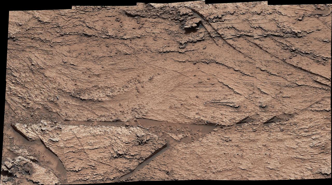
A grid of small polygons on the Martian rock surface near the right edge of this view may have originated as cracks in drying mud more than 3 billion years ago. Multiple images from the Mast Camera (Mastcam) on NASA's Curiosity Mars rover were combined for this mosaic of a block called "Squid Cove" and its immediate surroundings. The location is within an exposure of Murray formation mudstone on lower Mount Sharp inside Gale Crater. Mastcam's right-eye camera, which has a telephoto lens, took the component images of this view on Dec. 20, 2016, during the 1,555th Martian day, or sol, of Curiosity's work on Mars. The rover drove farther uphill on Gale Crater before the possible mud cracks were detected in the Mastcam images. This possible evidence about the area's ancient environment prompted the rover mission to backtrack for closer inspection of Squid Cove and nearby target rocks. This scene is presented with a color adjustment that approximates white balancing, to resemble how the rocks and sand would appear under daytime lighting conditions on Earth. The polygons are about half an inch to 1 inch (about 1 to 2 centimeters) across. Figure 1 includes a scale bar of 30 centimeters (12 inches). The polygons are outlined by ridges. This could result from a three-step process after cracks form due to drying: Wind-blown sediments accumulate in the open cracks. Later, these sediments and the dried mud become rock under the pressure of multiple younger layers that accumulate on top of them. Most recently, after the overlying layers were eroded away by wind, the vein-filling material resists erosion better than the once-muddy material, so the pattern that began as cracks appears as ridges. Mud cracks would be evidence of a drying interval between wetter periods that supported lakes in the area. Curiosity has found evidence of ancient lakes in older, lower-lying rock layers and also in younger mudstone that is above Squid Cove. http://photojournal.jpl.nasa.gov/catalog/PIA21263
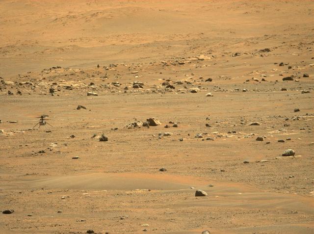
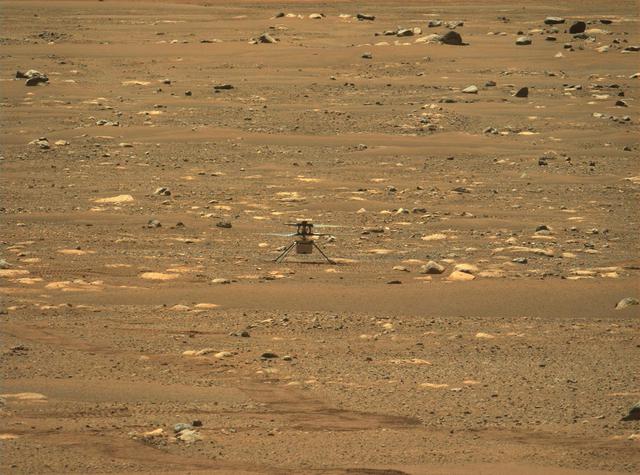
NASA's Ingenuity Mars Helicopter's was captured after landing on May 7, 2021, by the Mastcam-Z imager, one of the instruments aboard the agency's Perseverance rover. The helicopter ascended to a new height record of 33 feet (10 meters) and flew 424 feet (129 meters) to a new landing site. This was the helicopter's fifth flight, and the first time the helicopter made a one-way flight. It was airborne a total of 108 seconds. https://photojournal.jpl.nasa.gov/catalog/PIA24648
NASA's Curiosity Mars rover used the drill on the end of its robotic arm to collect a sample from a rock nicknamed "Sequoia" on Oct. 17, 2023, the 3,980th Martian day, or sol, of the mission. The mission was naming science targets after locations in California's Sierra Nevada mountain range at the time this sample was collected. This image was captured by the rover's Mast Camera, or Mastcam. https://photojournal.jpl.nasa.gov/catalog/PIA26048
Stitched together from 79 individual images, this Mastcam-Z right-eye 110-mm zoom mosaic is from the camera's first high-resolution panorama imaging sequence. These images were taken on the afternoon of Sol 4 (Feb. 22, 2021) of the mission; a sol is a Martian day. The camera was commanded to take these images by scanning the mast, or "head," a full 360-degrees around the horizon visible from the landing site. The top of some of the distant crater rim is cut off in some images to ensure the images would cover the front ridge of the Jezero Crater's ancient delta, which is only about 1.25 miles (2 kilometers) away from the rover in the center of this panorama. At that distance and focal length, Mastcam-Z can resolve features as small as about 50 centimeters (1.6 feet) across along the front of the delta. The mosaic is not white balanced but is instead displayed in a preliminary calibrated version of a natural color composite, approximately simulating the colors of the scene that we would see if we were there viewing it ourselves. Arizona State University in Tempe leads the operations of the Mastcam-Z instrument, working in collaboration with Malin Space Science Systems in San Diego. A key objective for Perseverance's mission on Mars is astrobiology, including the search for signs of ancient microbial life. The rover will characterize the planet's geology and past climate, pave the way for human exploration of the Red Planet, and be the first mission to collect and cache Martian rock and regolith (broken rock and dust). Subsequent NASA missions, in cooperation with ESA (European Space Agency), would send spacecraft to Mars to collect these sealed samples from the surface and return them to Earth for in-depth analysis. The Mars 2020 Perseverance mission is part of NASA's Moon to Mars exploration approach, which includes Artemis missions to the Moon that will help prepare for human exploration of the Red Planet. Complete mosaic available at https://photojournal.jpl.nasa.gov/catalog/PIA23727
NASA's Ingenuity Mars helicopter is seen here in a close-up taken by Mastcam-Z, a pair of zoomable cameras aboard the Perseverance rover. This image was taken on April 5, the 45th Martian day, or sol, of the mission. The mosaic is not white balanced but is instead displayed in a preliminary calibrated version of a natural color composite, approximately simulating the colors of the scene that we would see if we were there viewing it ourselves. Arizona State University in Tempe leads the operations of the Mastcam-Z instrument, working in collaboration with Malin Space Science Systems in San Diego. A key objective for Perseverance's mission on Mars is astrobiology, including the search for signs of ancient microbial life. The rover will characterize the planet's geology and past climate, pave the way for human exploration of the Red Planet, and be the first mission to collect and cache Martian rock and regolith (broken rock and dust). Subsequent NASA missions, in cooperation with ESA (European Space Agency), would send spacecraft to Mars to collect these sealed samples from the surface and return them to Earth for in-depth analysis. The Mars 2020 Perseverance mission is part of NASA's Moon to Mars exploration approach, which includes Artemis missions to the Moon that will help prepare for human exploration of the Red Planet. https://photojournal.jpl.nasa.gov/catalog/PIA24547
This is the first 360-degree panorama taken by Mastcam-Z, a zoomable pair of cameras aboard NASA's Perseverance Mars rover. The panorama was stitched together on Earth from 142 individual images taken on Sol 3, the third Martian day of the mission (Feb. 21, 2021). Annotated versions of this panorama include a scale bar and close-ups of rock features seen in the distance. A detail shot from the top of the panorama shows the rim of Jezero Crater, Perseverance's landing site. Arizona State University in Tempe leads the operations of the Mastcam-Z instrument, working in collaboration with Malin Space Science Systems in San Diego. A key objective for Perseverance's mission on Mars is astrobiology, including the search for signs of ancient microbial life. The rover will characterize the planet's geology and past climate, pave the way for human exploration of the Red Planet, and be the first mission to collect and cache Martian rock and regolith (broken rock and dust). Subsequent NASA missions, in cooperation with ESA (European Space Agency), would send spacecraft to Mars to collect these sealed samples from the surface and return them to Earth for in-depth analysis. https://photojournal.jpl.nasa.gov/catalog/PIA24264
NASA's Perseverance Mars rover used its dual-camera Mastcam-Z imager to capture this image of "Santa Cruz," a hill about 1.5 miles (2.5 kilometers) away from the rover, on April 29, 2021, the 68th Martian day, or sol, of the mission. The entire scene is inside of Mars' Jezero Crater; the crater's rim can be seen on the horizon line beyond the hill. This scene is not white balanced; instead, it is displayed in a preliminary calibrated version of a natural-color composite, approximately simulating the colors of the scene as it would appear to a person on Mars. Arizona State University in Tempe leads the operations of the Mastcam-Z instrument, working in collaboration with Malin Space Science Systems in San Diego. A key objective for Perseverance's mission on Mars is astrobiology, including the search for signs of ancient microbial life. The rover will characterize the planet's geology and past climate, pave the way for human exploration of the Red Planet, and be the first mission to collect and cache Martian rock and regolith (broken rock and dust). Subsequent NASA missions, in cooperation with ESA (European Space Agency), would send spacecraft to Mars to collect these sealed samples from the surface and return them to Earth for in-depth analysis. The Mars 2020 Perseverance mission is part of NASA's Moon to Mars exploration approach, which includes Artemis missions to the Moon that will help prepare for human exploration of the Red Planet. https://photojournal.jpl.nasa.gov/catalog/PIA24546

This early-morning view from the Mast Camera (Mastcam) on NASA's Curiosity Mars rover covers a field of view of about 130 degrees of the inner wall of Gale Crater. It was acquired during a period when there was very little dust or haze in the atmosphere, so conditions were optimal for long-distance imaging. The right side of the image fades into the glare of the rising sun. Mastcam's right-eye camera, which has a telephoto lens, took the component images on March 16, 2016, during the 1,284th sol, or Martian day, of Curiosity's work on Mars. The rover's location was on the "Naukluft Plateau" of lower Mount Sharp, inside Gale Crater. The view spans from west-northwest on the left to northeast on the right. Details of the morphology (shape and pattern of features) on the wall, which include gullies, channels and debris fans help geologists understand the processes that have shaped the crater and transported sediments -- sand, pebbles and larger rocks -- down to the floor of the crater. Some of the foothills show layers morphologically not unlike the layers Curiosity is exploring near the base of Mount Sharp, suggesting that the crater was filled along the north wall with sediments that have in large part now been eroded away, much as happened closer to Mount Sharp. The scene is presented with a color adjustment that approximates white balancing, to resemble how the terrain would appear under daytime lighting conditions on Earth. Figure 1 includes labels on three peaks of the crater wall, for scale and position reference. The peak labeled "A," near the left end of the panorama, is at azimuth 291.8 degrees east of north and 18.1 miles (29.1 kilometers) away from the rover's position. It rises about 6,200 feet (1,900 meters) above the closest point on the floor of the crater. Peak "B," at azimuth 357.2 degrees east of north (or 2.8 degrees from north), is about 17.6 miles (28.4 kilometers) away and rises about 3,900 feet (1,200 meters) above the base of its foothills. Peak "C," at azimuth 33.6 degrees east of north, is about 27.3 miles (45.5 kilometers) distant and rises about 6,200 feet (1,900 meters) above the base of its foothills. http://photojournal.jpl.nasa.gov/catalog/PIA20333
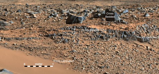
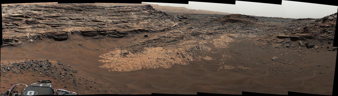
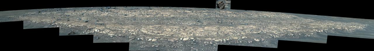
NASA's Curiosity Mars rover captured evidence of rock layers that built up as windblown sand accumulated in some areas and was scoured away in others in the ancient past. This panorama, made up of nine individual images that were later stitched together, was captured at a location nicknamed "Las Claritas" using Curiosity's Mast Camera, or Mastcam, on May 19, 2022, the 3,478th Martian day, or sol, of the mission. https://photojournal.jpl.nasa.gov/catalog/PIA25369
NASA's Perseverance Mars rover used its Mastcam-Z camera to capture this rocky hilltop nicknamed "Rockytop" on July 24, 2022, the 507th Martian day, or sol, of the mission. The feature is named after Rockytop in Shenandoah National Park. A key objective for Perseverance's mission on Mars is astrobiology, including the search for signs of ancient microbial life. The rover will characterize the planet's geology and past climate, pave the way for human exploration of the Red Planet, and be the first mission to collect and cache Martian rock and regolith (broken rock and dust). Subsequent NASA missions, in cooperation with ESA (European Space Agency), would send spacecraft to Mars to collect these sealed samples from the surface and return them to Earth for in-depth analysis. The Mars 2020 Perseverance mission is part of NASA's Moon to Mars exploration approach, which includes Artemis missions to the Moon that will help prepare for human exploration of the Red Planet. Movie available at https://photojournal.jpl.nasa.gov/catalog/PIA25660
This view from the Mast Camera (Mastcam) in NASA's Curiosity Mars rover shows the "Marias Pass" area where a lower and older geological unit of mudstone -- the pale zone in the center of the image -- lies in contact with an overlying geological unit of sandstone. Just before Curiosity reached Marias Pass, the rover's laser-firing Chemistry and Camera (ChemCam) instrument examined a rock found to be rich in silica, a mineral-forming chemical. This scene combines several images taken on May 22, 2015, during the 992nd Martian day, or sol, of Curiosity's work on Mars. The scene is presented with a color adjustment that approximates white balancing, to resemble how the rocks and sand would appear under daytime lighting conditions on Earth. http://photojournal.jpl.nasa.gov/catalog/?IDNumber=pia20174
This view from the Mast Camera (Mastcam) in NASA's Curiosity Mars rover shows finely layered rocks within the "Murray Buttes" region on lower Mount Sharp. The buttes and mesas rising above the surface in this area are eroded remnants of ancient sandstone that originated when winds deposited sand after lower Mount Sharp had formed. Curiosity closely examined that layer -- called the "Stimson formation" -- during the first half of 2016, while crossing a feature called "Naukluft Plateau" between two exposures of the Murray formation. The layering within the sandstone is called "cross-bedding" and indicates that the sandstone was deposited by wind as migrating sand dunes. The image was taken on Sept. 8, 2016, during the 1454th Martian day, or sol, of Curiosity's work on Mars. http://photojournal.jpl.nasa.gov/catalog/PIA21043
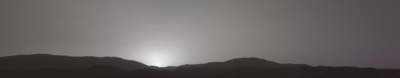
This sunset on Mars was captured by NASA's Perseverance Mars rover using its Mastcam-Z camera system on Nov. 9, 2021, the 257th Martian day, or sol, of the mission. Martian sunsets typically stand out for their distinctive blue color. Fine dust in the atmosphere permits blue light to penetrate the atmosphere more efficiently than colors with longer wavelengths. But this sunset looks different: less dust in the atmosphere resulted in a more muted color than average. The color has been calibrated and white-balanced to remove camera artifacts. The Mastcam-Z investigation is led and operated by Arizona State University in Tempe, working in collaboration with Malin Space Science Systems in San Diego, California, on the design, fabrication, testing, and operation of the cameras, and in collaboration with the Neils Bohr Institute of the University of Copenhagen on the design, fabrication, and testing of the calibration targets. A key objective for Perseverance's mission on Mars is astrobiology, including the search for signs of ancient microbial life. The rover will characterize the planet's geology and past climate, pave the way for human exploration of the Red Planet, and be the first mission to collect and cache Martian rock and regolith (broken rock and dust). Subsequent NASA missions, in cooperation with ESA (European Space Agency), would send spacecraft to Mars to collect these sealed samples from the surface and return them to Earth for in-depth analysis. The Mars 2020 Perseverance mission is part of NASA's Moon to Mars exploration approach, which includes Artemis missions to the Moon that will help prepare for human exploration of the Red Planet. https://photojournal.jpl.nasa.gov/catalog/PIA24935
Sedimentary layers at "Franklin Cliffs" are displayed in a mosaic captured by NASA's Perseverance Mars rover using its Mastcam-Z camera on Feb. 12, 2023, the 704th Martian day, or sol, of the mission. The mosaic is made up of three individual images that were stitched together after being sent back from Mars. This natural color view is approximately how the scene would appear to an average person if they were on Mars. Franklin Cliffs, along with other locations like "Skrinkle Haven" and "Pinestand" may have been created as sediment built up here in an ancient river or delta. Arizona State University leads the operations of the Mastcam-Z instrument, working in collaboration with Malin Space Science Systems in San Diego, on the design, fabrication, testing, and operation of the cameras, and in collaboration with the Niels Bohr Institute of the University of Copenhagen on the design, fabrication, and testing of the calibration targets. A key objective for Perseverance's mission on Mars is astrobiology, including the search for signs of ancient microbial life. The rover will characterize the planet's geology and past climate, pave the way for human exploration of the Red Planet, and be the first mission to collect and cache Martian rock and regolith (broken rock and dust). Subsequent NASA missions, in cooperation with ESA (European Space Agency), would send spacecraft to Mars to collect these sealed samples from the surface and return them to Earth for in-depth analysis. The Mars 2020 Perseverance mission is part of NASA's Moon to Mars exploration approach, which includes Artemis missions to the Moon that will help prepare for human exploration of the Red Planet. https://photojournal.jpl.nasa.gov/catalog/PIA25911
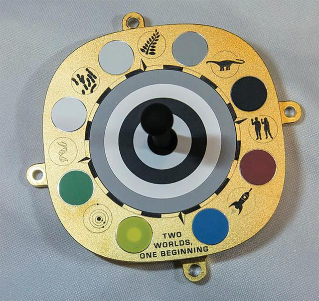
The primary calibration target for Mastcam-Z, a pair of zoomable cameras aboard NASA's Perseverance Mars rover, features color swatches used by scientists to fine-tune the cameras' settings. The object in the center, known as a shadow post, helps scientists check the color of the sky to calibrate for lighting conditions. Symbols and mottos relevant to the mission are included around the target's perimeter: (clockwise from top) a fern; an Apatosaurus; a man and woman raising their hands in greeting (a nod to plaques carried aboard Pioneer 10 and 11, as well as the Golden Record aboard Voyagers 1 and 2); a rocket traveling from Earth (blue dot) to Mars (red dot); a motto reading "Two Worlds, One Beginning," in reference to the idea of Earth and the Red Planet growing out of the same proto-stellar dust; a model of the inner solar system; a DNA helix; and cyanobacteria, one of the earliest forms of life on Earth. A key objective for Perseverance's mission on Mars is astrobiology, including the search for signs of ancient microbial life. The rover will characterize the planet's geology and past climate, pave the way for human exploration of the Red Planet, and be the first mission to collect and cache Martian rock and regolith (broken rock and dust). https://photojournal.jpl.nasa.gov/catalog/PIA24178
This 360-degree mosaic from the Mast Camera (Mastcam) on NASA's Curiosity Mars rover looks out over a portion of the Bagnold Dunes, which stretch for several miles. From early February to early April 2017, the rover examined four sites near linear dunes for comparison with what it found in late 2015 and early 2016 during its investigation of crescent-shaped dunes. The dark, rippled surface of a linear dune is visible at the center of the view and receding into the distance to the left. The bedrock of the Murray formation, made from sediments deposited in lakes billions of years ago, is in the foreground, along with some components of the rover. The location, called "Ogunquit Beach," is on the northwestern flank of lower Mount Sharp. Northwest is at both ends of this full-circle panorama; southeast is at the center, where a higher portion of Mount Sharp dominates the horizon. Among the questions this Martian dune campaign is addressing is how winds shape the dunes into different patterns. Others include whether Martian winds sort grains of sand in ways that affect the distribution of mineral compositions, which also would have implications for studies of Martian sandstones. The 115 individual images that were combined into this mosaic were acquired by the Mastcam's left-eye camera on March 24 and March 25, 2017, (PST) during the 1,647th Martian day, or sol, of Curiosity's work on Mars. This mosaic is white-balanced so that the colors of the colors of the rock and sand materials resemble how they would appear under daytime lighting conditions on Earth. The rover's position on Sol 1647 is shown at https://mars.nasa.gov/multimedia/images/2017/curiositys-traverse-map-through-sol-1646 as the location reached by a drive on Sol 1646. https://photojournal.jpl.nasa.gov/catalog/PIA11241
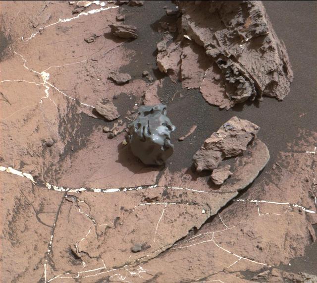
The dark, smooth-surfaced object at the center of this Oct. 30, 2016, image from the Mast Camera (Mastcam) on NASA's Curiosity Mars rover was examined with laser pulses and confirmed to be an iron-nickel meteorite. The grid of shiny points visible on the object resulted from that laser zapping by Curiosity's Chemistry and Camera (ChemCam) instrument. The meteorite is about the size of a golf ball. It is informally named "Egg Rock," for a site in Maine. Locations around Bar Harbor, Maine, are the naming theme for an area on Mars' Mount Sharp that Curiosity reached in October. Iron-nickel meteorites are a common class of space rocks found on Earth, and previous examples have been found on Mars, but Egg Rock is the first on Mars to be examined with a laser-firing spectrometer. The scene is presented with a color adjustment that approximates white balancing, to resemble how the rocks and sand would appear under daytime lighting conditions on Earth. Figure 1 includes a scale bar of 5 centimeters (about 2 inches). http://photojournal.jpl.nasa.gov/catalog/PIA21134
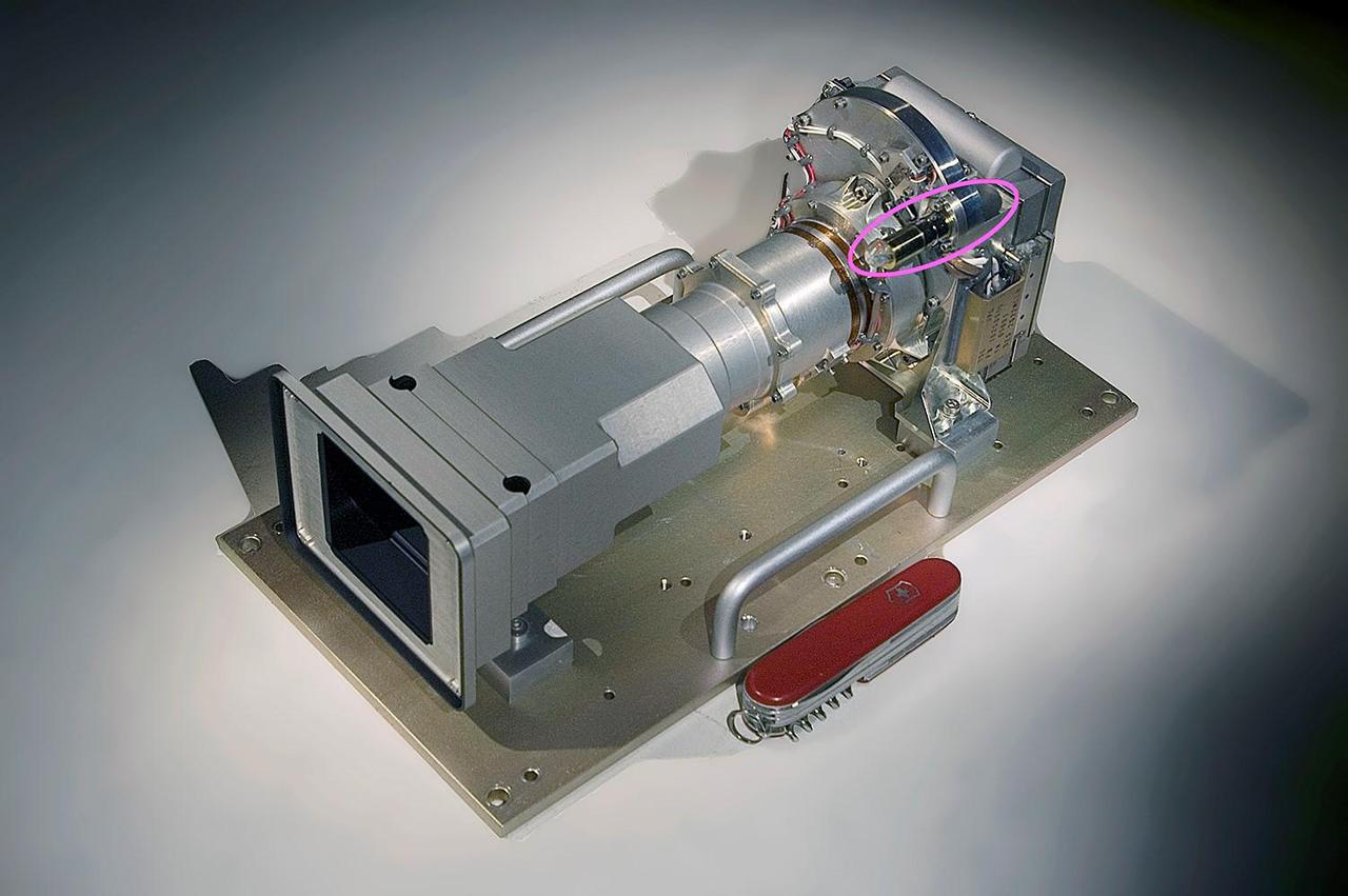
The Mast Camera, or Mastcam, aboard NASA's Curiosity Mars rover is built with two cameras – the left has a 34 mm focal length; the right, a 100 mm focal length. Behind each lens is a rotating wheel (circled in pink) arranged with filters. In addition to providing color images of the rover's surroundings, the cameras and their filters help scientists determine from afar the composition of rocks by the wavelengths of light, or spectra, they reflect in different colors. On Sept. 19, 2023, the left camera's filter wheel became stuck between the green and clear filter positions, the effects of which can be seen on the mission's raw, or unprocessed, images. The filter wheel is part of a spur-and-pinion mechanism, with the spur teeth around the filter wheel. The actuation uses a small motor that drives the pinion gear both forward and backward. Despite having been commanded at more than twice its normal torque, this motor has been unable to move in the counterclockwise direction. If unable to nudge the wheel back to the clear filter, the mission would rely on the higher resolution 100 mm right camera as the primary color-imaging system. The camera needs to take nine times more images than the left to cover the same area, which could affect how the team scouts for science targets and rover routes. The ability to observe detailed color spectra of rocks from afar would also be degraded. https://photojournal.jpl.nasa.gov/catalog/PIA26043
NASA's Perseverance Mars rover viewed these rocks using its Mastcam-Z imager on April 27, 2021, the 66th Martian day, or sol, of the mission. Stitched together from 21 images, this mosaic is not white balanced; instead, it is displayed in a preliminary calibrated version of a natural-color composite, approximately simulating the colors of the scene as it would appear on Mars. For scale, the largest piece of rock casting a shadow in the upper right part of the mosaic is about 11 inches (27 centimeters) across, and the entire scene is about 10 feet (3 meters) across. The smallest pebbles and other features that can reliably be resolved at this zoom scale are around 0.04 to 0.08 inches (1-2 millimeters) across. The scene was also captured in enhanced color (Figure 1) as well as a color anaglyph made for viewing through red-blue 3D glasses (Figure 2). Arizona State University in Tempe leads the operations of the Mastcam-Z instrument, working in collaboration with Malin Space Science Systems in San Diego. A key objective for Perseverance's mission on Mars is astrobiology, including the search for signs of ancient microbial life. The rover will characterize the planet's geology and past climate, pave the way for human exploration of the Red Planet, and be the first mission to collect and cache Martian rock and regolith (broken rock and dust). Subsequent NASA missions, in cooperation with ESA (European Space Agency), would send spacecraft to Mars to collect these sealed samples from the surface and return them to Earth for in-depth analysis. The Mars 2020 Perseverance mission is part of NASA's Moon to Mars exploration approach, which includes Artemis missions to the Moon that will help prepare for human exploration of the Red Planet. https://photojournal.jpl.nasa.gov/catalog/PIA24627
NASA's Ingenuity Mars Helicopter is seen here at the starting point of its 47th flight on Mars. This video shows the dust initially kicked up by the helicopter's spinning rotors, as well as Ingenuity taking off, hovering, and beginning its 1,444-foot (440-meter) journey to the southwest. The rotorcraft landed – off camera – at Airfield "Iota." The video was captured by the Mastcam-Z imager aboard NASA's Perseverance rover on March 9, 2023. At the time the video was taken, the rover was about 394 feet (120 meters) from the helicopter. Animation available at https://photojournal.jpl.nasa.gov/catalog/PIA25686
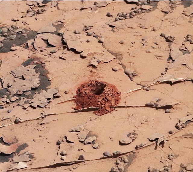
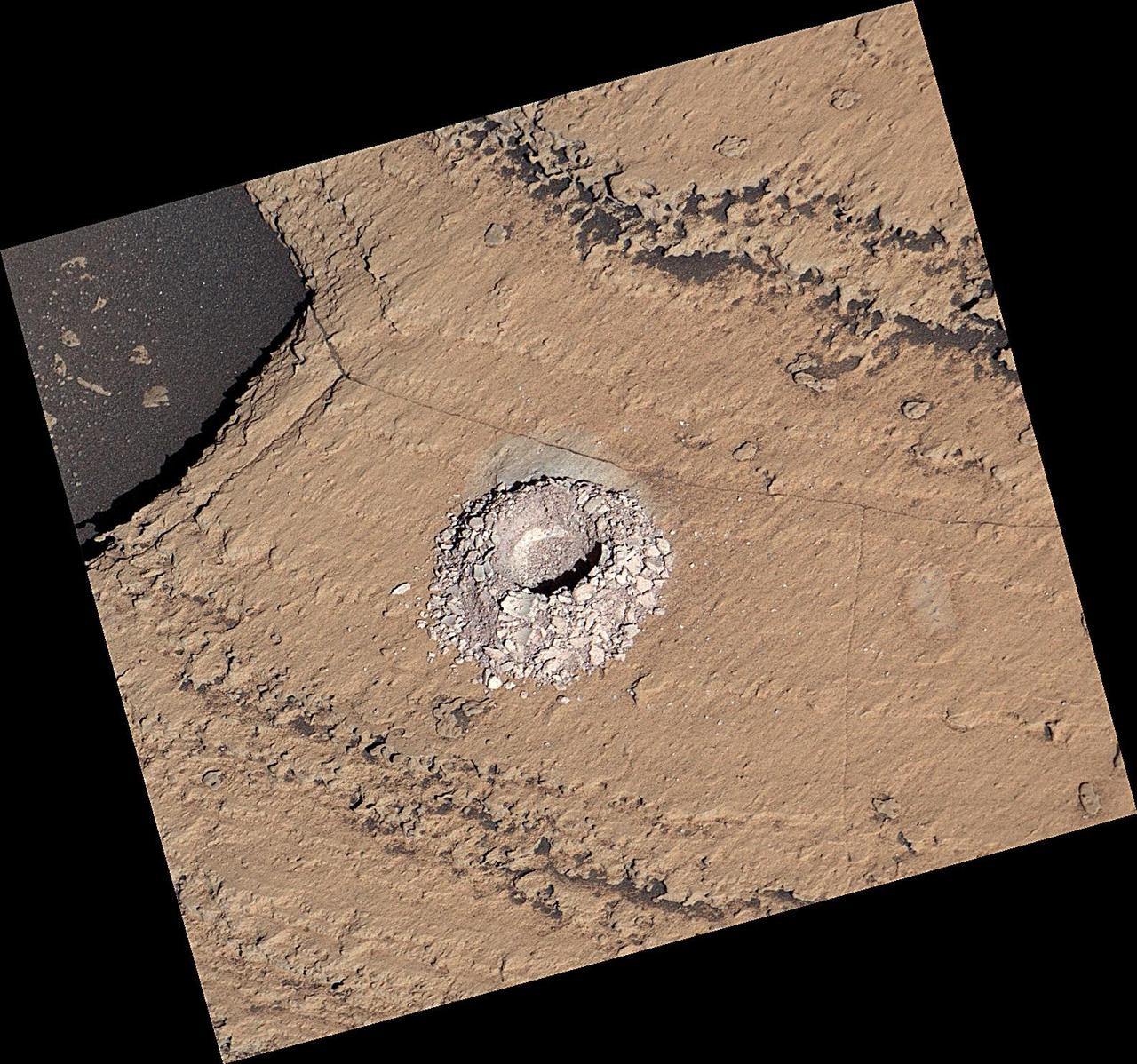
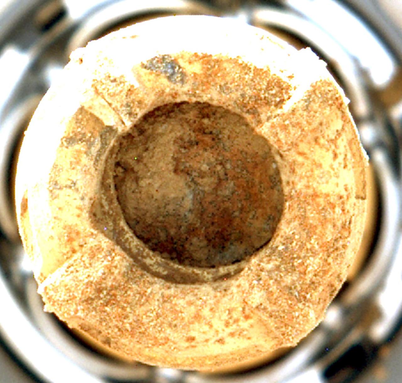
A close-up image of a 2-inch-deep hole produced using a new drilling technique for NASA's Curiosity rover. The hole is about 0.6 inches (1.6 centimeters) in diameter. This image was taken by Curiosity's Mast Camera (Mastcam) on Sol 2057. It has been white balanced and contrast-enhanced. Curiosity drilled this hole in a target called "Duluth" on May 20, 2018. It was the first rock sample captured by the drill since October 2016. A mechanical issue took the drill offline in December 2016. https://photojournal.jpl.nasa.gov/catalog/PIA22326

This view from the Mast Camera (Mastcam) in NASA's Curiosity Mars rover shows a sloping hillside within the "Murray Buttes" region on lower Mount Sharp. The rim of Gale Crater, where the rover has been active since landing in 2012, is visible in the distance, through the dusty haze. The image was taken on Sept. 8, 2016, during the 1454th Martian day, or sol, of Curiosity's work on Mars. http://photojournal.jpl.nasa.gov/catalog/PIA21041

This view from the Mast Camera (Mastcam) in NASA's Curiosity Mars rover shows an outcrop with finely layered rocks within the "Murray Buttes" region on lower Mount Sharp. The buttes and mesas rising above the surface in this area are eroded remnants of ancient sandstone that originated when winds deposited sand after lower Mount Sharp had formed. Curiosity closely examined that layer -- called the "Stimson formation" -- during the first half of 2016, while crossing a feature called "Naukluft Plateau" between two exposures of the Murray formation. The layering within the sandstone is called "cross-bedding" and indicates that the sandstone was deposited by wind as migrating sand dunes. The image was taken on Sept. 8, 2016, during the 1454th Martian day, or sol, of Curiosity's work on Mars. http://photojournal.jpl.nasa.gov/catalog/PIA21044
NASA's Perseverance Mars rover captured this mosaic of a location nicknamed "Castell Henllys" using its Mastcam-Z camera on April 13, 2023, the 763rd Martian day, or sol, of the mission. The rounded boulders seen here are believed to have been washed into Jezero Crater, which Perseverance is exploring, by strong flood waters billions of years ago. This occurred during one of three major periods that scientists have identified in the development of the lake and river system that occupied Jezero in the ancient past. This view looks toward the southwest, with the Castell Henllys area approximately 328 feet (100 meters) away. The mosaic is made up of three images that were stitched together after being sent back to Mars. The image has been processed to improve contrast on the terrain. Arizona State University leads the operations of the Mastcam-Z instrument, working in collaboration with Malin Space Science Systems in San Diego, on the design, fabrication, testing, and operation of the cameras, and in collaboration with the Niels Bohr Institute of the University of Copenhagen on the design, fabrication, and testing of the calibration targets. A key objective for Perseverance's mission on Mars is astrobiology, including the search for signs of ancient microbial life. The rover will characterize the planet's geology and past climate, pave the way for human exploration of the Red Planet, and be the first mission to collect and cache Martian rock and regolith (broken rock and dust). Subsequent NASA missions, in cooperation with ESA (European Space Agency), would send spacecraft to Mars to collect these sealed samples from the surface and return them to Earth for in-depth analysis. The Mars 2020 Perseverance mission is part of NASA's Moon to Mars exploration approach, which includes Artemis missions to the Moon that will help prepare for human exploration of the Red Planet. https://photojournal.jpl.nasa.gov/catalog/PIA26208

This mosaic taken by NASA's Mars Curiosity rover looks uphill at Mount Sharp, which Curiosity has been climbing. Highlighted in white is an area with clay-bearing rocks that scientists are eager to explore; it could shed additional light on the role of water in creating Mount Sharp. The mosaic was assembled from dozens of images taken by Curiosity's Mast Camera (Mastcam). It was taken on Sol 1931 back in January. Mount Sharp stands in the middle of Gale Crater, which is 96 miles (154 kilometers) in diameter. This mound, which Curiosity has been climbing since 2014, likely formed in the presence of water at various points of time in Mars ancient history. That makes it an ideal place to study how water influenced the habitability of Mars billions of years ago. The scene has been white-balanced so the colors of the rock materials resemble how they would appear under daytime lighting conditions on Earth. https://photojournal.jpl.nasa.gov/catalog/PIA22312
This mosaic taken by NASA's Mars Curiosity rover looks uphill at Mount Sharp, which Curiosity has been climbing. Spanning the center of the image is an area with clay-bearing rocks that scientists are eager to explore; it could shed additional light on the role of water in creating Mount Sharp. The mosaic was assembled from dozens of images taken by Curiosity's Mast Camera (Mastcam). It was taken on Sol 1931 back in January. Mount Sharp stands in the middle of Gale Crater, which is 96 miles (154 kilometers) in diameter. This mound, which Curiosity has been climbing since 2014, likely formed in the presence of water at various points of time in Mars ancient history. That makes it an ideal place to study how water influenced the habitability of Mars billions of years ago. The scene has been white-balanced so the colors of the rock materials resemble how they would appear under daytime lighting conditions on Earth. https://photojournal.jpl.nasa.gov/catalog/PIA22313
The top of the butte in this scene from the Mast Camera (Mastcam) on NASA's Curiosity Mars rover stands about 16 feet (about 5 meters) above the rover and about 82 feet (about 25 meters) east-southeast of the rover. Mastcam's right-eye (telephoto-lens) camera took the component images of this mosaic on Sept. 1, 2016, during the 1,448th Martian day, or sol, of Curiosity's work on Mars. The site is in the scenic "Murray Buttes" area, where individual buttes and mesas were assigned numbers. This one is "M9a." The average slope on the prominent ridge on the left side is more than 40 degrees, while the average slope on the right side of the highest point is about 30 degrees. The rover's location when it recorded this scene was the site it reached in its Sol 1446 drive. (See map at http://mars.nasa.gov/msl/multimedia/images/?ImageID=8009.) The scene is presented with a color adjustment that approximates white balancing, to resemble how the rocks and sand would appear under daytime lighting conditions on Earth. http://photojournal.jpl.nasa.gov/catalog/PIA20843
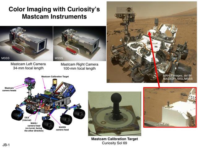
This set of images illustrates the twin cameras of the Mastcam instrument on NASA Curiosity Mars rover upper left, the Mastcam calibration target lower center, and the locations of the cameras and target on the rover.
NASA's Perseverance Mars rover used its Mastcam-Z camera to capture this image of "Bettys Rock" on June 23, 2022, the 477th Martian day, or sol, of the mission. This rock is named after Bettys Rock in Shenandoah National Park. A key objective for Perseverance's mission on Mars is astrobiology, including the search for signs of ancient microbial life. The rover will characterize the planet's geology and past climate, pave the way for human exploration of the Red Planet, and be the first mission to collect and cache Martian rock and regolith (broken rock and dust). Subsequent NASA missions, in cooperation with ESA (European Space Agency), would send spacecraft to Mars to collect these sealed samples from the surface and return them to Earth for in-depth analysis. The Mars 2020 Perseverance mission is part of NASA's Moon to Mars exploration approach, which includes Artemis missions to the Moon that will help prepare for human exploration of the Red Planet. Movie available at https://photojournal.jpl.nasa.gov/catalog/PIA25656
NASA's Perseverance Mars rover used its Mastcam-Z instrument to capture this view of the "Cheyava Falls" rock sample within the rover's drill bit on July 21, 2024, the 1,215th Martian day, or sol, of the mission. Markings akin to leopard spots can be seen in the rock – fascinating traits that may bear on the question of whether the Red Planet was home to microscopic life in the distant past. The spots seen in the rock are small, irregularly shaped light patches surrounded by a thin rim of dark minerals. These spots indicate chemical conditions during formation or alteration of this rock billions of years ago that could have provided energy for microbial life, if it was ever present at this location on Mars. https://photojournal.jpl.nasa.gov/catalog/PIA26370
NASA's Perseverance Mars rover used its Mastcam-Z camera to capture this enhanced color image of "Hogwallow Flats" on June 6, 2022, the 461st Martian day, or sol, of the mission. Hogwallow Flats is made up of fine-grained sedimentary rock that was deposited underwater in the ancient past. Perseverance collected two pairs of rock-core samples near this area because of its high potential for preserving signs of ancient life and information about the timing of habitable conditions in Mars' Jezero Crater. A key objective for Perseverance's mission on Mars is astrobiology, including the search for signs of ancient microbial life. The rover will characterize the planet's geology and past climate, pave the way for human exploration of the Red Planet, and be the first mission to collect and cache Martian rock and regolith (broken rock and dust). Subsequent NASA missions, in cooperation with ESA (European Space Agency), would send spacecraft to Mars to collect these sealed samples from the surface and return them to Earth for in-depth analysis. The Mars 2020 Perseverance mission is part of NASA's Moon to Mars exploration approach, which includes Artemis missions to the Moon that will help prepare for human exploration of the Red Planet. Movie available at https://photojournal.jpl.nasa.gov/catalog/PIA25672
This image was taken after the first flight of NASA's Ingenuity Mars Helicopter — and the first powered, controlled flight on another planet. It was captured by Mastcam-Z, a pair of zoomable cameras aboard NASA's Perseverance Mars rover, on April 19, 2021. Flying in a controlled manner on Mars is far more difficult than flying on Earth. The Red Planet has significant gravity (about one-third that of Earth's), but its atmosphere is just 1% as dense as Earth's at the surface. Stitched together from multiple images, the mosaic is not white balanced; instead, it is displayed in a preliminary calibrated version of a natural color composite, approximately simulating the colors of the scene that we would see if we were there viewing it ourselves. Arizona State University in Tempe leads the operations of the Mastcam-Z instrument, working in collaboration with Malin Space Science Systems in San Diego. A key objective for Perseverance's mission on Mars is astrobiology, including the search for signs of ancient microbial life. The rover will characterize the planet's geology and past climate, pave the way for human exploration of the Red Planet, and be the first mission to collect and cache Martian rock and regolith (broken rock and dust). Subsequent NASA missions, in cooperation with ESA (European Space Agency), would send spacecraft to Mars to collect these sealed samples from the surface and return them to Earth for in-depth analysis. The Mars 2020 Perseverance mission is part of NASA's Moon to Mars exploration approach, which includes Artemis missions to the Moon that will help prepare for human exploration of the Red Planet. https://photojournal.jpl.nasa.gov/catalog/PIA24550
A vantage point on "Vera Rubin Ridge" provided NASA's Curiosity Mars rover this detailed look back over the area where it began its mission inside Gale Crater, plus more-distant features of the crater. This view toward the north-northeast combines eight images taken by the right-eye, telephoto-lens camera of Curiosity's Mast Camera (Mastcam). It shows more detail of a fraction of the area pictured in a more sweeping panorama (see PIA22210) acquired from the same rover location using Mastcam's left-eye, wider-angle-lens camera. The scene has been white-balanced so the colors of the rock materials resemble how they would appear under daytime lighting conditions on Earth. The component images were taken on Oct. 25, 2017, during the 1,856th Martian day, or sol, of the rover's work on Mars. At that point, Curiosity had gained 1,073 feet (327 meters) in elevation and driven 10.95 miles (17.63 kilometers) from its landing site. Mount Sharp stands about 3 miles (5 kilometers) high in the middle of Gale Crater, which spans 96 miles (154 kilometers) in diameter. Vera Rubin Ridge is on the northwestern flank of lower Mount Sharp. The right foreground of this panorama shows a portion of Vera Rubin Ridge. In the distance is the northern wall of Gale Crater, with the rim crest forming the horizon roughly 25 miles (40 kilometers) from the rover's location. An annotated version, Figure 1, indicates where the rover landed (at "Bradbury Landing") in 2012 and the initial portion of its drive, including investigation sites "Yellowknife Bay," "Darwin" and "Cooperstown." The rover's exact landing site is hidden behind a slight rise. The heat shield, back shell, and parachute used during the spacecraft's descent are within the pictured area but not recognizable due to the distance and to camouflaging by dust. At Yellowknife Bay in 2013, the mission found evidence of an ancient freshwater-lake environment that offered all of the basic chemical ingredients for microbial life. Figure 2 includes three scale bars: of 40 meters (131 feet) at a distance of about 1,530 meters (1,673 yards) near the base of Mount Sharp; of 1,500 meters (1,640 yards) at a distance of about 30.75 kilometers (19.1 miles) near the base of the crater wall; and of 2,000 meters (1.2 miles) at a distance of about 41.2 kilometers (25.6 miles) at the crest of the rim. Annotated images are available at https://photojournal.jpl.nasa.gov/catalog/PIA22209

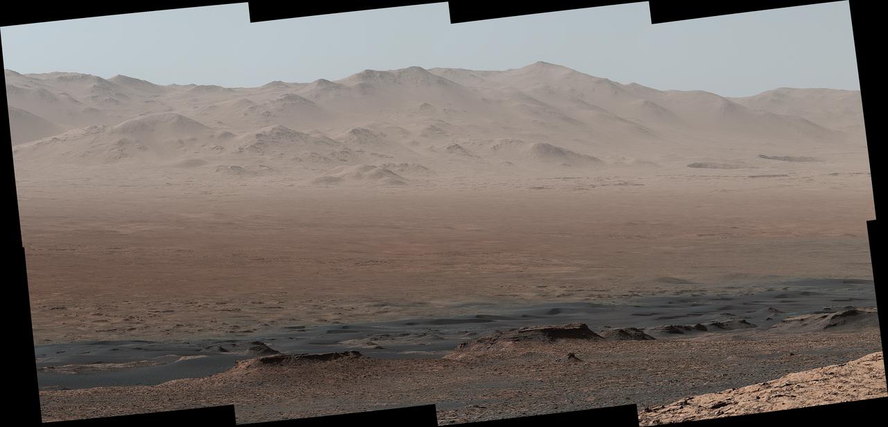
Climbing "Vera Rubin Ridge" provided NASA's Curiosity Mars rover this sweeping vista of the interior and rim of Gale Crater, including much of the rover's route during its first five-and-a-half years on Mars and features up to about 50 miles (85 kilometers) away. The scene spans from southwest on the left to northeast on the right, combining 16 side-by-side images taken by the left-eye, wider-angle-lens camera of Curiosity's Mast Camera (Mastcam). It has been white-balanced so the colors of the rock materials resemble how they would appear under daytime lighting conditions on Earth. The component images were taken on Oct. 25, 2017, during the 1,856th Martian day, or sol, of the rover's work on Mars. At that point, Curiosity had gained 1,073 feet (327 meters) in elevation and driven 10.95 miles (17.63 kilometers) from its landing site. Mount Sharp stands about 3 miles (5 kilometers) high in the middle of Gale Crater, which spans 96 miles (154 kilometers) in diameter. Vera Rubin Ridge is on the northwestern flank of lower Mount Sharp. The foreground of this panorama shows portions of lower Mount Sharp. The middle distance shows the floor of Gale Crater. Most of the horizon is formed by the crater's rim. The top of the rim is about 1.2 miles (2 kilometers) higher than the rover's position. On the horizon near the center of the image is a glimpse outside of Gale Crater, to a peak about 50 miles (85 kilometers) from the rover. An annotated version, Figure 1, indicates the rover's approximate path since its 2012 landing, identifies some of the sites it has investigated along the way, such as "Yellowknife Bay," "The Kimberley," "Namib Dune" and "Murray Buttes"; and points out other geological features visible in the scene, such as the channel of Peace Vallis, an ancient streambed descending from the crater rim. The relative positions of the labeled features are also mapped on an accompanying orbital view in PIA22208, with two areas color-coded for ease of matching them in the annotated panorama and the orbital view. Figure 2 is a version with a white-line box indicating the smaller area covered in a more-detailed vista (see PIA22209) taken from this same rover location by Mastcam's right-eye, telephoto-lens camera. It also includes three scale bars: of 50 meters (164 feet) at a distance of 1,170 meters (1,280 yards) near the base of Mount Sharp; of 1,000 meters (1,094 yards) at a distance of about 23.4 kilometers (14.5 miles) near the base of the crater wall; and of 2 kilometers (1.2 miles) at a distance of about 31.5 kilometers (19.6 miles) at the crest of the rim. Annotated images are available at https://photojournal.jpl.nasa.gov/catalog/PIA22210
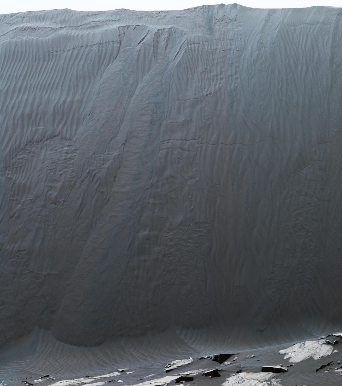
This view combines multiple images from the telephoto-lens camera of the Mast Camera (Mastcam) on NASA's Curiosity Mars rover to reveal fine details of the downwind face of "Namib Dune." The site is part of the dark-sand "Bagnold Dunes" field along the northwestern flank of Mount Sharp. Images taken from orbit have shown that dunes in the Bagnold field move as much as about 3 feet (1 meter) per Earth year. Sand on this face of Namib Dune has cascaded down a slope of about 26 to 28 degrees. The top of the face is about 13 to 17 feet (4 to 5 meters) above the rocky ground at its base. http://photojournal.jpl.nasa.gov/catalog/PIA20283
NASA's Ingenuity Mars Helicopter hovers and rotates over Jezero Crater during its second experimental flight test on April 22, 2021. The footage was captured by the Mastcam-Z imager, a pair of zoomable cameras aboard NASA's Perseverance Mars rover. Altimeter data from the solar-powered helicopter indicates it climbed to its prescribed maximum altitude of 16 feet (5 meters), flew downrange 7 feet (2 meters) and returned, performed several turns while in a hover, and landed. Total flight time 51.9 seconds. Flying in a controlled manner on Mars is far more difficult than flying on Earth. The Red Planet has significant gravity (about one-third that of Earth's), but an atmosphere with only about 1% of the density at Earth's surface. Stitched together from multiple images, the mosaic is not white balanced; instead, it is displayed in a preliminary calibrated version of a natural-color composite, approximately simulating the colors of the scene as it would appear on Mars. Arizona State University in Tempe leads the operations of the Mastcam-Z instrument, working in collaboration with Malin Space Science Systems in San Diego. The Ingenuity Mars Helicopter was built by JPL, which also manages this technology demonstration project for NASA Headquarters. It is supported by NASA's Science Mission Directorate, Aeronautics Research Mission Directorate, and Space Technology Mission Directorate. NASA's Ames Research Center and Langley Research Center provided significant flight performance analysis and technical assistance during Ingenuity's development. A key objective for Perseverance's mission on Mars is astrobiology, including the search for signs of ancient microbial life. The rover will characterize the planet's geology and past climate, pave the way for human exploration of the Red Planet, and be the first mission to collect and cache Martian rock and regolith (broken rock and dust). Subsequent NASA missions, in cooperation with ESA (European Space Agency), would send spacecraft to Mars to collect these sealed samples from the surface and return them to Earth for in-depth analysis. The Mars 2020 Perseverance mission is part of NASA's Moon to Mars exploration approach, which includes Artemis missions to the Moon that will help prepare for human exploration of the Red Planet. Movie available at https://photojournal.jpl.nasa.gov/catalog/PIA24595
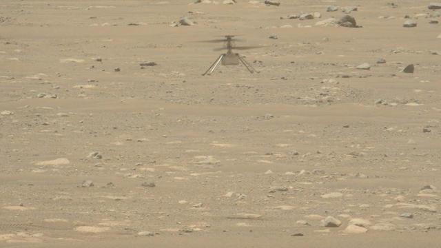
NASA's Ingenuity Mars Helicopter takes off and lands in this video captured on April 19, 2021, by Mastcam-Z, an imager aboard NASA's Perseverance Mars rover. This video features only the moments of takeoff and the landing and not footage of the helicopter hovering for about 30 seconds. The Ingenuity Mars Helicopter was built by JPL, which also manages this technology demonstration project for NASA Headquarters. It is supported by NASA's Science Mission Directorate, Aeronautics Research Mission Directorate, and Space Technology Mission Directorate. NASA's Ames Research Center and Langley Research Center provided significant flight performance analysis and technical assistance during Ingenuity's development. A key objective for Perseverance's mission on Mars is astrobiology, including the search for signs of ancient microbial life. The rover will characterize the planet's geology and past climate, pave the way for human exploration of the Red Planet, and be the first mission to collect and cache Martian rock and regolith (broken rock and dust). Subsequent NASA missions, in cooperation with ESA (European Space Agency), would send spacecraft to Mars to collect these sealed samples from the surface and return them to Earth for in-depth analysis. The Mars 2020 Perseverance mission is part of NASA's Moon to Mars exploration approach, which includes Artemis missions to the Moon that will help prepare for human exploration of the Red Planet. Movie available at https://photojournal.jpl.nasa.gov/catalog/PIA24583
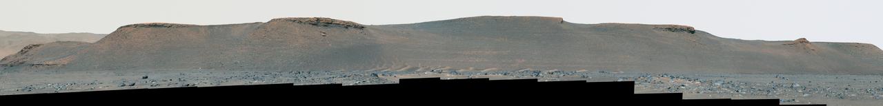
NASA's Perseverance rover used its Mastcam-Z camera to capture this enhanced color view of the eroded eastern edge of the delta within Mars' Jezero Crater on April 7, 2022, the 402nd Martian day, or sol, of the mission. A deposit of boulders, at the edge of the delta, may have been moved there by high-energy floods in the ancient past. Perseverance will be exploring and sampling boulder deposits like this one in 2023 after dropping off its first cache of samples at a site called Three Forks as part of the Mars Sample Return campaign. A key objective for Perseverance's mission on Mars is astrobiology, including the search for signs of ancient microbial life. The rover will characterize the planet's geology and past climate, pave the way for human exploration of the Red Planet, and be the first mission to collect and cache Martian rock and regolith (broken rock and dust). Subsequent NASA missions, in cooperation with ESA (European Space Agency), would send spacecraft to Mars to collect these sealed samples from the surface and return them to Earth for in-depth analysis. The Mars 2020 Perseverance mission is part of NASA's Moon to Mars exploration approach, which includes Artemis missions to the Moon that will help prepare for human exploration of the Red Planet. Movie available at https://photojournal.jpl.nasa.gov/catalog/PIA25671
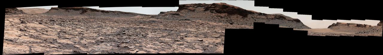
The mesa in the center of this scene from the "Murray Buttes" area on Mars' lower Mount Sharp is longer than a football field. It extends more than 361 feet (110 meters) from the left-most outcrop low on the slope to the right side where rock debris is behind a light-toned, dust-covered dune. The panorama combines sets of images taken by the left-eye camera of the Mast Camera (Mastcam) on NASA's Curiosity Mars rover, for the left half of the scene, and by Mastcam's right-eye camera for the right half of the scene. The component images from the left-eye camera were taken on Aug. 22, 2016, during the 1,438th Martian day, or sol, of the rover's work on Mars. The ones from the right-eye camera, which has a telephoto lens, were taken the following day, on Sol 1439. From the rover's position when the component images were taken, the top of the central mesa is about 310 feet (about 95 meters) away and about 52 feet (about 16 meters) above the rover. The relatively flat foreground is part of a geological layer called the Murray formation, which includes lakebed mud deposits. The buttes and mesas rising above this surface are eroded remnants of ancient sandstone that originated when winds deposited sand after lower Mount Sharp had formed. They are capped by material that is relatively resistant to erosion, just as is the case with many similarly shaped buttes and mesas on Earth. The scene is presented with a color adjustment that approximates white balancing, to resemble how the rocks and sand would appear under daytime lighting conditions on Earth. http://photojournal.jpl.nasa.gov/catalog/PIA20842
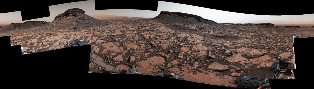
Original Caption Released with Image: This 360-degree panorama was acquired by the Mast Camera (Mastcam) on NASA's Curiosity Mars rover while the rover was in an area called "Murray Buttes" on lower Mount Sharp, one of the most scenic landscapes yet visited by any Mars rover. The view stitches together many individual images taken by Mastcam's left-eye camera on Sept. 4, 2016, during the 1,451st Martian day, or sol, of the mission. North is at both ends and south is in the center. The rover's location when it recorded this scene was the site it reached in its Sol 1448 drive. (See map at http://mars.nasa.gov/msl/multimedia/images/?ImageID=8015.) The dark, flat-topped mesa near the center of the scene rises to about 39 feet (about 12 meters) above the surrounding plain. From the rover's position, the top of this mesa is about 131 feet (about 40 meters) away, and the beginning of the debris apron at the base of the mesa is about 98 feet (about 30 meters) away. In the left half of the image, the dark butte that appears largest sits eastward from the rover and about 33 feet (about 10 meters) high. From the rover's position, the top of this butte is about 85 feet (about 26 meters) away, and the beginning of the debris apron at its base is about 33 feet (about 10 meters) away. An upper portion of Mount Sharp appears on the horizon to the right of it. The relatively flat foreground is part of a geological layer called the Murray formation, which includes lakebed mud deposits. The buttes and mesas rising above this surface are eroded remnants of ancient sandstone that originated when winds deposited sand after lower Mount Sharp had formed. They are capped by material that is relatively resistant to erosion, just as is the case with many similarly shaped buttes and mesas on Earth. The area's informal naming honors Bruce Murray (1931-2013), a Caltech planetary scientist and director of NASA's Jet Propulsion Laboratory, Pasadena, California. The scene is presented with a color adjustment that approximates white balancing, to resemble how the rocks and sand would appear under daytime lighting conditions on Earth. http://photojournal.jpl.nasa.gov/catalog/PIA20840
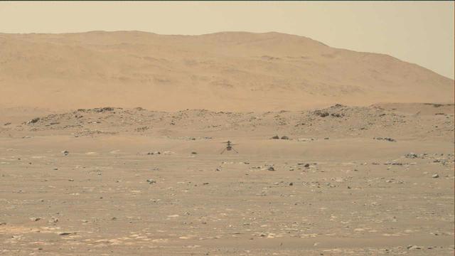
NASA's Ingenuity Mars Helicopter hovers over the Martian surface — the first instance of powered, controlled flight on another planet — as viewed by the Mastcam-Z imager aboard the Perseverance Mars rover on April 19, 2021. The solar-powered helicopter first became airborne at 3:34 a.m. EDT (12:34 a.m. PDT) — 12:33 Local Mean Solar Time (Mars time) — a time the Ingenuity team determined would have optimal energy and flight conditions. Altimeter data indicate Ingenuity climbed to its prescribed maximum altitude of 10 feet (3 meters) and maintained a stable hover for 30 seconds. It then descended, touching back down on the surface of Mars after logging a total of 39.1 seconds of flight. Flying in a controlled manner on Mars is far more difficult than flying on Earth. The Red Planet has significant gravity (about one-third that of Earth's), but its atmosphere is just 1% as dense as Earth's at the surface. Stitched together from multiple images, the mosaic is not white balanced; instead, it is displayed in a preliminary calibrated version of a natural-color composite, approximately simulating the colors of the scene as it would appear on Mars. Arizona State University in Tempe leads the operations of the Mastcam-Z instrument, working in collaboration with Malin Space Science Systems in San Diego. The Ingenuity Mars Helicopter was built by JPL, which also manages this technology demonstration project for NASA Headquarters. It is supported by NASA's Science Mission Directorate, Aeronautics Research Mission Directorate, and Space Technology Mission Directorate. NASA's Ames Research Center and Langley Research Center provided significant flight performance analysis and technical assistance during Ingenuity's development. A key objective for Perseverance's mission on Mars is astrobiology, including the search for signs of ancient microbial life. The rover will characterize the planet's geology and past climate, pave the way for human exploration of the Red Planet, and be the first mission to collect and cache Martian rock and regolith (broken rock and dust). Subsequent NASA missions, in cooperation with ESA (European Space Agency), would send spacecraft to Mars to collect these sealed samples from the surface and return them to Earth for in-depth analysis. The Mars 2020 Perseverance mission is part of NASA's Moon to Mars exploration approach, which includes Artemis missions to the Moon that will help prepare for human exploration of the Red Planet. Movie available at https://photojournal.jpl.nasa.gov/catalog/PIA24590
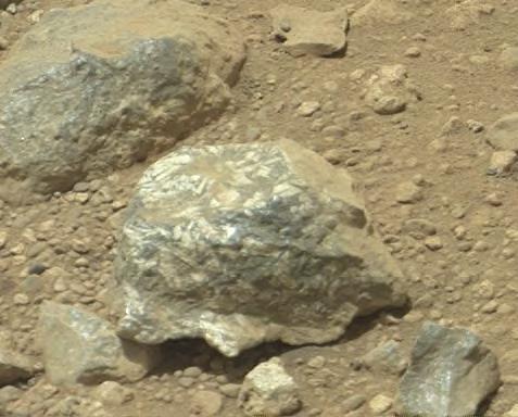
The Mast Camera Mastcam on NASA Mars rover Curiosity showed researchers interesting color and patterns in this unnamed rock.
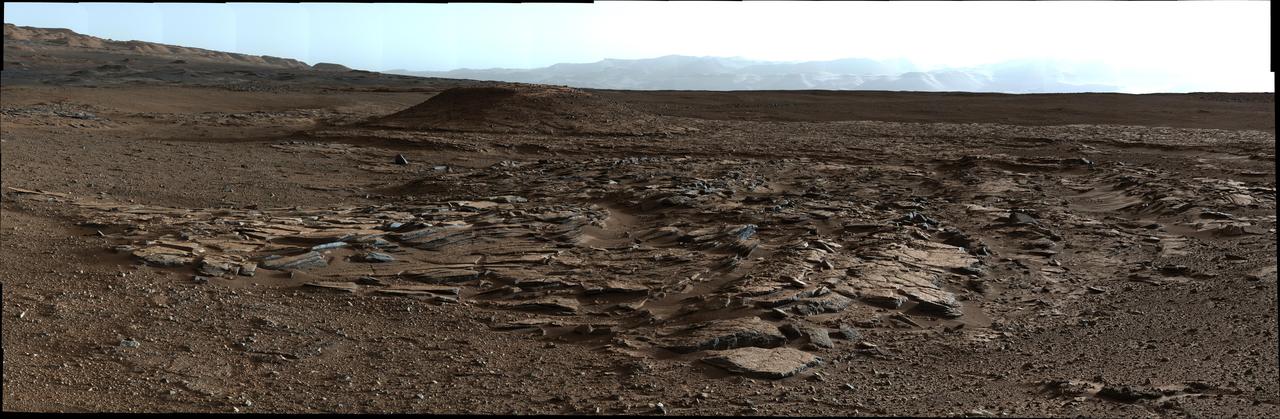
This image from Curiosity Mastcam looks to the west of a waypoint on the rover route to Mount Sharp. The mountain lies to the left of the scene.
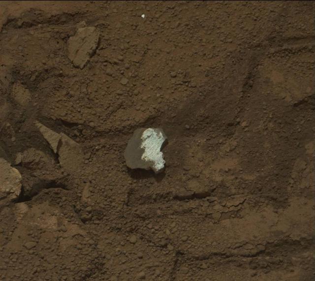
This raw image of Tintina, a broken rock fragment in a rover wheel track, was taken by Curiosity Mast Camera Mastcam.
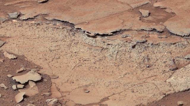
This image from the right Mast Camera Mastcam of NASA Curiosity Mars rover shows roughly spherical features.
NASA's Perseverance Mars rover used its Mastcam-Z camera system to shoot video of Phobos, one of Mars' two moons, eclipsing the Sun. It's the most zoomed-in, highest-frame-rate observation of a Phobos solar eclipse ever taken from the Martian surface. Several Mars rovers have observed Phobos crossing in front of the Sun over the past 18 years. Spirit and Opportunity made the first observations in 2004; Curiosity in 2019 was the first to record video of the event. Each time these eclipses are observed, they allow scientists to measure subtle shifts in Phobos' orbit over time. The moon's tidal forces pull on the deep interior crust and mantle of the Red Planet; studying how much Phobos shifts over time reveals something about how resistant the crust and mantle are, and thus what kinds of materials they're made of. It's long been known that Phobos is drifting toward the Martian surface year by year; tens of millions of years from now, it is expected to crash into the planet or fragment into chunks that will impact the planet. Studying Phobos' orbit also allows scientists to refine predictions of when the doomed moon will crash into Mars. A key objective for Perseverance's mission on Mars is astrobiology, including the search for signs of ancient microbial life. The rover will characterize the planet's geology and past climate, pave the way for human exploration of the Red Planet, and be the first mission to collect and cache Martian rock and regolith (broken rock and dust). Subsequent NASA missions, in cooperation with ESA (European Space Agency), would send spacecraft to Mars to collect these sealed samples from the surface and return them to Earth for in-depth analysis. The Mars 2020 Perseverance mission is part of NASA's Moon to Mars exploration approach, which includes Artemis missions to the Moon that will help prepare for human exploration of the Red Planet. Movie available at https://photojournal.jpl.nasa.gov/catalog/PIA25179
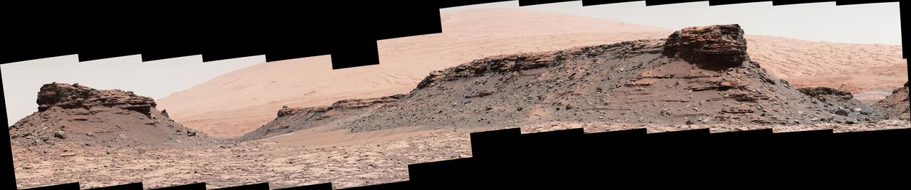
The two prominent mesas in this view of Mars' "Murray Buttes" region from NASA's Curiosity Mars rover are about 260 feet (about 80 meters) apart. The top of the one on the left is about 26 feet (about 8 meters) above the surrounding plain and about 330 feet (about 100 meters) from Curiosity's position when the rover acquired this view on Aug. 18, 2016, during the 1,434th Martian day, or sol, of its work Mars. The component images of this mosaic were taken by the right-eye camera of the rover's Mast Camera (Mastcam), which has a telephoto lens. The mesa on the right is about 33 feet (about 10 meters) high. The top of it is about 270 feet (about 82 meters) from the rover. Upper Mount Sharp is the salmon-hued mound dominating the horizon between the scene's two prominent mesas. The left edge of this view is east-northeast from the rover; the right edge is southeast. The rover's location when it recorded this scene was the site it reached in its Sol 1433 drive. (See map at http://mars.nasa.gov/msl/multimedia/images/?ImageID=7999.) The scene is presented with a color adjustment that approximates white balancing, to resemble how the rocks and sand would appear under daytime lighting conditions on Earth. http://photojournal.jpl.nasa.gov/catalog/PIA20841
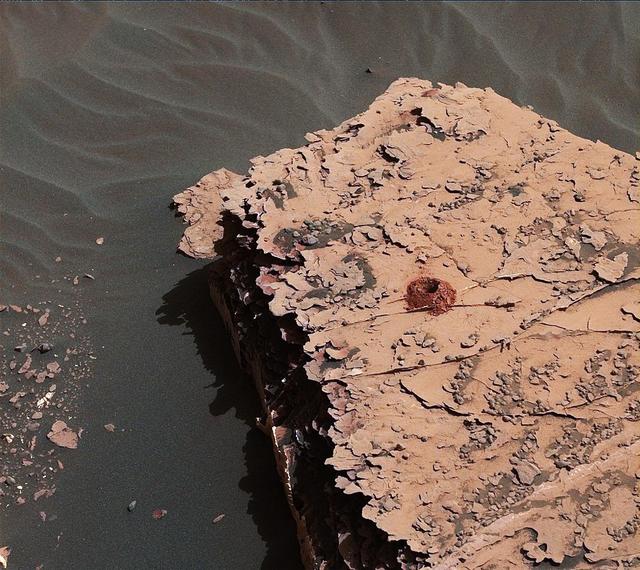
NASA's Curiosity rover successfully drilled a hole 2 inches (5.1 centimeters) deep in a target called "Duluth" on May 20, 2018. The hole is about .6 inches (1.6 centimeters) across. It was the first rock sample captured by the drill since October 2016. A mechanical issue took the drill offline in December 2016. Engineers at NASA's Jet Propulsion Laboratory in Pasadena, California, had to innovate a new way for the rover to drill in order to restore this ability. The new technique, called Feed Extended Drilling (FED) keeps the drill's bit extended out past two stabilizer posts that were originally used to steady the drill against Martian rocks. It lets Curiosity drill using the force of its robotic arm, a little more like a human would while drilling into a wall at home. This image was taken by Curiosity's Mast Camera (Mastcam) on Sol 2057. It has been white balanced and contrast-enhanced. https://photojournal.jpl.nasa.gov/catalog/PIA22325

This view from the Mast Camera (Mastcam) on NASA's Curiosity Mars rover shows two scales of ripples, plus other textures, in an area where the mission examined a linear-shaped dune in the Bagnold dune field on lower Mount Sharp. The scene is an excerpt from a 360-degree panorama acquired on March 24 and March 25, 2017, (PST) during the 1,647th Martian day, or sol, of Curiosity's work on Mars, at a location called "Ogunquit Beach." Crests of the longer ripples visible in the dark sand of the dune are several feet (a few meters) apart. This medium-scale feature in active sand dunes on Mars was one of Curiosity's findings at the crescent-shaped dunes that the rover examined in late 2015 and early 2016. Ripples that scale are not seen on Earth's sand dunes. Overlaid on those ripples are much smaller ripples, with crests about ten times closer together. Textures of the local bedrock in the foreground -- part of the Murray formation that originated as lakebed sediments -- and of gravel-covered ground (at right) are also visible. The image has been white-balanced so that the colors of the colors of the rock and sand materials resemble how they would appear under daytime lighting conditions on Earth. https://photojournal.jpl.nasa.gov/catalog/PIA11242
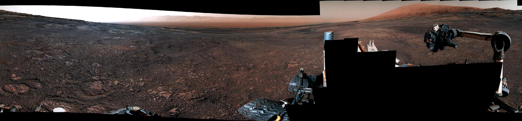
This panorama was taken on Dec. 19, 2018, (Sol 2265) by the Mast Camera (Mastcam) on NASA's Curiosity Mars rover. The rover's last drill location on Vera Rubin Ridge is visible, as well as the clay region it will spend the next year exploring. The scene combines 122 images taken with Mastcam's left-eye camera. It is presented with a color adjustment that approximates white balancing to resemble how the rocks and sand would appear under daytime lighting conditions on Earth. https://photojournal.jpl.nasa.gov/catalog/PIA23042
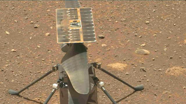
The Ingenuity Mars Helicopter's carbon fiber blades can be seen in this video taken by the Mastcam-Z instrument aboard NASA's Perseverance Mars rover on April 8, 2021, the 48th Martian day, or sol, of the mission. The four blades are arranged into two 4-foot-long (1.2-meter-long) counter-rotating rotors that can spin at roughly 2,400 rpm. The video shows the blades performing a wiggle test before the actual spin-up to ensure they were working properly. The helicopter weighs about 4 pounds (1.8 kilograms) on Earth, and about 1.5 pounds (0.68 kilograms) on Mars. It stands 1.6 feet (0.49 meters) high. It's four specially made carbon fiber blades are arranged into two 4-foot-long (1.2-meter-long) counter-rotating rotors that spin at roughly 2,400 rpm. The helicopter's fuselage is 5.4 inches by 7.7 inches by 6.4 inches (13.6 centimeters by 19.5 centimeters by 16.3 centimeters); it has four carbon composite landing legs, each 1.26 feet (0.384 meters) long, giving the helicopter about 5 inches (13 centimeters) of clearance above the ground. It is powered by a solar array on top of the rotor system, which charges six lithium-ion batteries A key objective for Perseverance's mission on Mars is astrobiology, including the search for signs of ancient microbial life. The rover will characterize the planet's geology and past climate, pave the way for human exploration of the Red Planet, and be the first mission to collect and cache Martian rock and regolith (broken rock and dust). Subsequent NASA missions, in cooperation with ESA (European Space Agency), would send spacecraft to Mars to collect these sealed samples from the surface and return them to Earth for in-depth analysis. The Mars 2020 Perseverance mission is part of NASA's Moon to Mars exploration approach, which includes Artemis missions to the Moon that will help prepare for human exploration of the Red Planet. Animation available at https://photojournal.jpl.nasa.gov/catalog/PIA24549
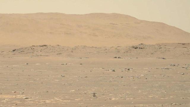
In this footage captured by the Mastcam-Z imager aboard the Perseverance Mars rover on April 19, 2021, the agency's Ingenuity Mars Helicopter lifts of from the Martian surface, hovers for 30 seconds, then touches back down. Lasting a total of 39.1 seconds, the flight marks the first instance of powered, controlled flight on another planet. The solar-powered helicopter first became airborne at 3:34 a.m. EDT (12:34 a.m. PDT) — 12:33 Local Mean Solar Time (Mars time) — a time the Ingenuity team determined would have optimal energy and flight conditions. Altimeter data indicate Ingenuity climbed to its prescribed maximum altitude of 10 feet (3 meters) and maintained a stable hover for 30 seconds. It then descended. Flying in a controlled manner on Mars is far more difficult than flying on Earth. The Red Planet has significant gravity (about one-third that of Earth's), but its atmosphere is just 1% as dense as Earth's at the surface. Stitched together from multiple images, the mosaic is not white balanced; instead, it is displayed in a preliminary calibrated version of a natural-color composite, approximately simulating the colors of the scene as it would appear on Mars. Arizona State University in Tempe leads the operations of the Mastcam-Z instrument, working in collaboration with Malin Space Science Systems in San Diego. The Ingenuity Mars Helicopter was built by JPL, which also manages this technology demonstration project for NASA Headquarters. It is supported by NASA's Science Mission Directorate, Aeronautics Research Mission Directorate, and Space Technology Mission Directorate. NASA's Ames Research Center and Langley Research Center provided significant flight performance analysis and technical assistance during Ingenuity's development. A key objective for Perseverance's mission on Mars is astrobiology, including the search for signs of ancient microbial life. The rover will characterize the planet's geology and past climate, pave the way for human exploration of the Red Planet, and be the first mission to collect and cache Martian rock and regolith (broken rock and dust). Subsequent NASA missions, in cooperation with ESA (European Space Agency), would send spacecraft to Mars to collect these sealed samples from the surface and return them to Earth for in-depth analysis. The Mars 2020 Perseverance mission is part of NASA's Moon to Mars exploration approach, which includes Artemis missions to the Moon that will help prepare for human exploration of the Red Planet. Movie available at https://photojournal.jpl.nasa.gov/catalog/PIA24521
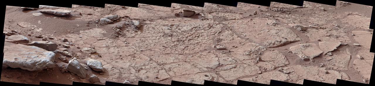
This wide view of the John Klein location selected for the first rock drilling by NASA Mars rover Curiosity is a mosaic taken by Curiosity right Mast Camera Mastcam.
Curiosity eyes the Mastcam are shrouded in a silvery material, awaiting their first look around the clean room at NASA Jet Propulsion Laboratory, where the rover is being built.
NASA rover Curiosity uses its calibration target for the Mastcam to approximate colors we would see on Mars, using the known colors of materials on the target.
The right Mast Camera Mastcam of NASA Curiosity Mars rover provided this view of the lower stratigraphy at Yellowknife Bay inside Gale Crater on Mars.
The Shaler outcrop is dramatically layered, as seen in this mosaic of telephoto images from the right Mast Camera Mastcam on NASA Mars rover Curiosity.

This image from the Mast Camera Mastcam on NASA Mars rover Curiosity shows inclined layering known as cross-bedding in an outcrop called Shaler.
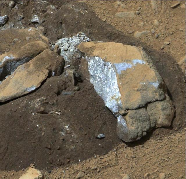
The Mast Camera Mastcam on NASA Mars rover Curiosity showed researchers interesting internal color in this rock called Sutton_Inlier, which was broken by the rover driving over it.
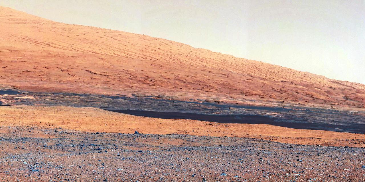
This image taken by the Mast Camera MastCam on NASA Curiosity rover highlights the interesting geology of Mount Sharp, a mountain inside Gale Crater, where the rover landed.
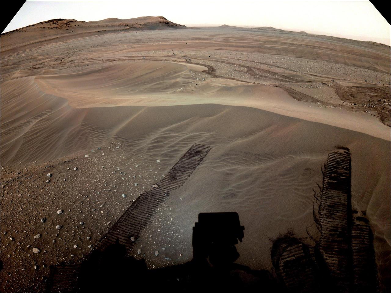
The location where NASA's Perseverance will begin depositing its first cache of samples is shown in this image taken by the Mars rover on Dec. 14, 2022, the 646th Martian day, or sol, of the mission. This enhanced color image was taken by the rover's Mastcam-Z camera and is not representative of the way the scene would look to the human eye. A key objective for Perseverance's mission on Mars is astrobiology, including the search for signs of ancient microbial life. The rover will characterize the planet's geology and past climate, pave the way for human exploration of the Red Planet, and be the first mission to collect and cache Martian rock and regolith (broken rock and dust). Subsequent NASA missions, in cooperation with ESA (European Space Agency), would send spacecraft to Mars to collect these sealed samples from the surface and return them to Earth for in-depth analysis. The Mars 2020 Perseverance mission is part of NASA's Moon to Mars exploration approach, which includes Artemis missions to the Moon that will help prepare for human exploration of the Red Planet. https://photojournal.jpl.nasa.gov/catalog/PIA25675
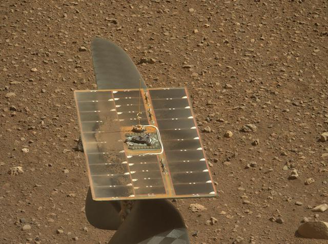
The solar panel of NASA's Ingenuity Mars Helicopter's solar panel as seen by Mastcam-Z, a pair of zoomable cameras aboard NASA's Perseverance Mars rover. Roughly 6.5 by 17 inches (425 mm by 165 mm), the panel charges six lithium-ion batteries inside the helicopter. The small amount of dust on the panel may have accumulated above the helicopter during landing and fallen onto it during helicopter deployment. This dust has had no adverse impact on the helicopter's power. Solar cells in the array are optimized for the solar spectrum encountered at Mars, and the stored energy is used to operate heaters for the cold Martian nights as well as power the helicopter during flight operations. Power expended by the helicopter during an up-to-90-second flight is about 350 watts. The image is not white balanced; instead it is displayed in a preliminary calibrated version of a natural-color composite, approximately simulating the colors of the scene that we would see if we were there viewing it ourselves. Arizona State University in Tempe leads the operations of the Mastcam-Z instrument, working in collaboration with Malin Space Science Systems in San Diego. A key objective for Perseverance's mission on Mars is astrobiology, including the search for signs of ancient microbial life. The rover will characterize the planet's geology and past climate, pave the way for human exploration of the Red Planet, and be the first mission to collect and cache Martian rock and regolith (broken rock and dust). Subsequent NASA missions, in cooperation with ESA (European Space Agency), would send spacecraft to Mars to collect these sealed samples from the surface and return them to Earth for in-depth analysis. The Mars 2020 Perseverance mission is part of NASA's Moon to Mars exploration approach, which includes Artemis missions to the Moon that will help prepare for human exploration of the Red Planet. https://photojournal.jpl.nasa.gov/catalog/PIA24545
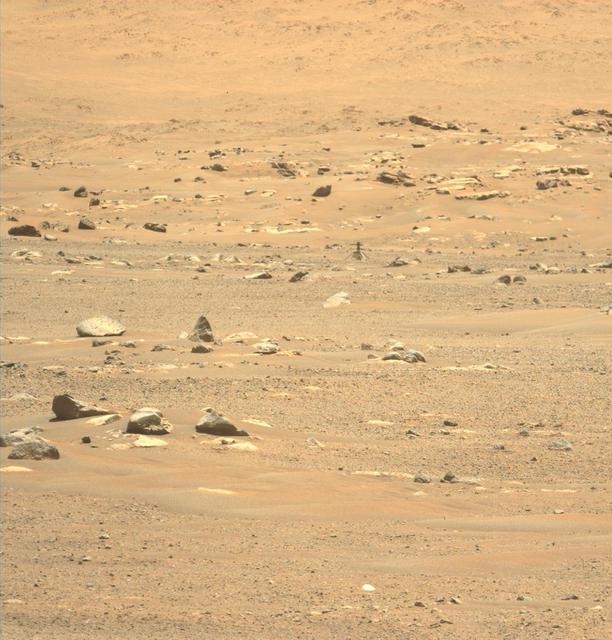
This image of Ingenuity was taken on May 23, 2021 – the day after its sixth flight – by the Mastcam-Z instrument aboard the Perseverance Mars rover. https://photojournal.jpl.nasa.gov/catalog/PIA24599

NASA's Perseverance Mars rover used its Mastcam-Z camera to capture Mercury – seen as a tiny speck – passing in front of the Sun on Oct. 28, 2023, the 953th Martian day, or sol, of the mission. The top portion of the GIF zooms in on the upper part of the Sun seen in Mastcam-Z's view; the reticle highlights the planet's transit. The GIF has been sped up 400 times; the portion of Mercury's transit captured by Mastcam-Z took place in just under an hour. Arizona State University leads the operations of the Mastcam-Z instrument, working in collaboration with Malin Space Science Systems in San Diego, on the design, fabrication, testing, and operation of the cameras, and in collaboration with the Niels Bohr Institute of the University of Copenhagen on the design, fabrication, and testing of the calibration targets. A key objective for Perseverance's mission on Mars is astrobiology, including the search for signs of ancient microbial life. The rover will characterize the planet's geology and past climate, pave the way for human exploration of the Red Planet, and be the first mission to collect and cache Martian rock and regolith (broken rock and dust). The Mars 2020 Perseverance mission is part of NASA's Moon to Mars exploration approach, which includes Artemis missions to the Moon that will help prepare for human exploration of the Red Planet. Video available at https://photojournal.jpl.nasa.gov/catalog/PIA26250
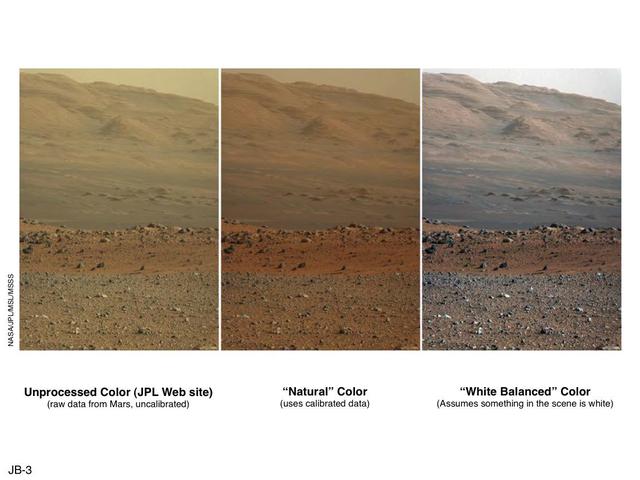
These three versions of the same image taken by the Mast Camera Mastcam on NASA Mars rover Curiosity illustrate different choices that scientists can make in presenting the colors recorded by the camera.