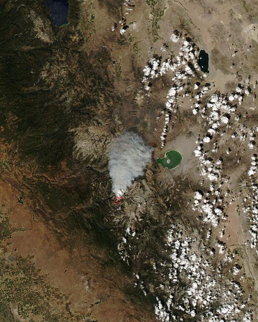
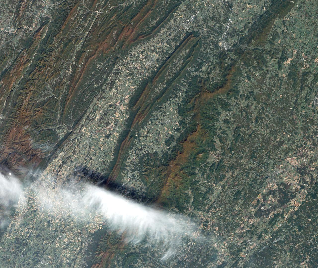
The Meadow Fire in Yosemite National Park is a remote, hold-over lightning caused fire which began on September 4 and is located five miles east of Yosemite Valley, CA. The fuel burning is timber and brush. There is active fire behavior with long range spotting. The National Park Service reports that a fire, that may be a spot fire, from the Meadow lightning-caused fire, was discovered at approximately 12:30 PM, Sunday September 7. The fire is approximately 2,582 acres. It is burning within the Little Yosemite Valley on both sides of the Merced River. All trails in the area are closed. Approximately 100 hikers and backpackers were evacuated from the fire area in Little Yosemite Valley. Half-Dome, a popular tourist destination, has been closed. The fire is burning in Yosemite Wilderness. Eighty-five hikers and climbers were also evacuated from the summit of Half Dome by helicopters from the California Highway Patrol, US Department of Agriculture Forest Service, Sequoia Kings Canyon National Park, and CAL Fire. This natural-color satellite image was collected by the Moderate Resolution Imaging Spectroradiometer (MODIS) aboard the Aqua satellite on Sept. 07, 2014. Actively burning areas, detected by MODIS’s thermal bands, are outlined in red. NASA image courtesy Jeff Schmaltz, MODIS Rapid Response Team. Caption: NASA/Goddard, Lynn Jenner with information from the National Park Service and the National Interagency Coordination Center. <b><a href="http://www.nasa.gov/audience/formedia/features/MP_Photo_Guidelines.html" rel="nofollow">NASA image use policy.</a></b> <b><a href="http://www.nasa.gov/centers/goddard/home/index.html" rel="nofollow">NASA Goddard Space Flight Center</a></b> enables NASA’s mission through four scientific endeavors: Earth Science, Heliophysics, Solar System Exploration, and Astrophysics. Goddard plays a leading role in NASA’s accomplishments by contributing compelling scientific knowledge to advance the Agency’s mission. <b>Follow us on <a href="http://twitter.com/NASAGoddardPix" rel="nofollow">Twitter</a></b> <b>Like us on <a href="http://www.facebook.com/pages/Greenbelt-MD/NASA-Goddard/395013845897?ref=tsd" rel="nofollow">Facebook</a></b> <b>Find us on <a href="http://instagram.com/nasagoddard?vm=grid" rel="nofollow">Instagram</a></b>
Vikings settled North America one thousand years ago, long before Columbus arrived. At L'Anse aux Meadows in northern Newfoundland, houses and workshops provide the earliest evidence of European settlement in the New World, and have been designated a UNESCO World Heritage Site. The image was acquired August 3, 2021, covers an are of 14.6 by 15.6 km, and is located at 51.6 degrees north, 55.5 degrees west. https://photojournal.jpl.nasa.gov/catalog/PIA24941

LAnse aux Meadows is a site on the northernmost tip of the island of Newfoundland, located in the Province of Newfoundland and Labrador, Canada, where the remains of a Viking village were discovered in 1960. This image is from NASA Terra satellite.
A short drive from Windsor, England, west of London, near the Thames, lies Runnymede meadow. Following John Kennedy's 1963 assassination, the British government commemorated his life by gifting 1.6 ha to the US federal government, making it the only piece of American soil in Britain. The image was acquired June 6, 2016, covers an area of 7.5 by 8 km, and is located at 51.4 degrees north, 0.6 degrees west. https://photojournal.jpl.nasa.gov/catalog/PIA26508

iss074e0247458 (Feb. 1, 2026) --- The frozen Khuvsgul Lake (left) in Mongolia appears hidden within the wintry landscape of the Siberian Taiga near the Russian border—the largest terrestrial biome on Earth, characterized by rugged mountain ranges, forested hills, and meadows, and home to wildlife such as brown bears, wolves, moose, and reindeer. The International Space Station was orbiting 261 miles above Asia when this photograph was taken.
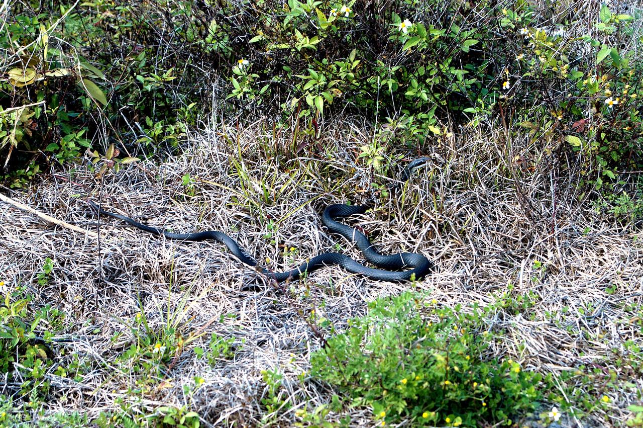
KENNEDY SPACE CENTER, FLA. - A black racer snake slithers away through a patch of dry grass on the grounds of Kennedy Space Center. The Black Racer Snake is one of the fastest, non-venomous snakes in North America. It has a slender body with a slender oval-shaped head and white patch on its chin. It lives in brushy areas, rocky hillsides and meadows, and underneath boards or tin around old buildings. Black Racers feed on insects, eggs, mice, frogs and lizards. Kennedy shares a boundary with the Merritt Island National Wildlife Refuge, home to some of the nation’s rarest and most unusual species of wildlife. In addition, the Refuge supports 19 endangered or threatened wildlife species on Federal or State lists, more than any other single refuge in the U.S.
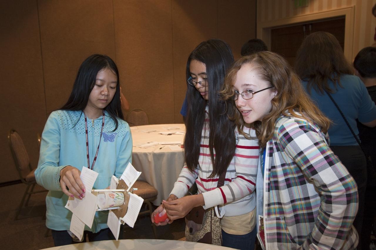
ORLANDO, Fla. – Students from Meadow Woods Middle School in Orlando take part in a hands-on activity during NASA’s Project Management PM Challenge 2012. Education specialists from NASA’s Kennedy Space Center supported the annual PM Challenge with demonstrations designed to illustrate various principles of physics. The demonstrations are designed to increase student interest and pursuit of the science, technology, engineering and mathematics STEM fields integral to producing the next generation of scientists and engineers. PM Challenge 2012 was held at the Caribe Royale Hotel and Convention Center in Orlando, Fla., on Feb. 22-23, to provide a forum for all stakeholders in the project management community to meet and share stories, lessons learned and new uses of technology in the industry. The PM Challenge is sponsored by NASA's Office of the Chief Engineer. For additional information, visit http://www.nasa.gov/offices/oce/pmchallenge/index.html. Photo credit: NASA/Jim Grossmann
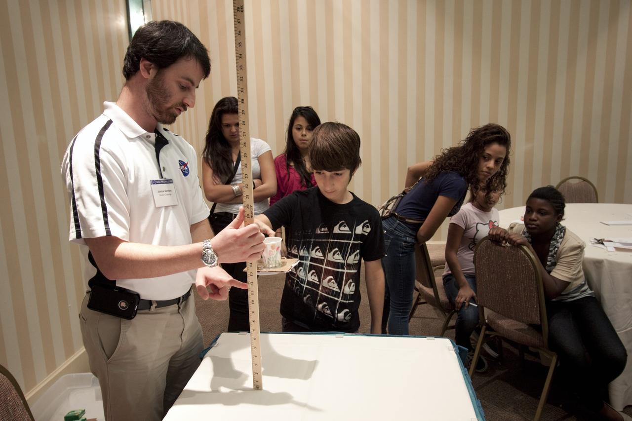
ORLANDO, Fla. – Education project specialist Josh Santora, left, from NASA’s Kennedy Space Center, engages a student from Meadow Woods Middle School in Orlando in a physics demonstration during NASA’s Project Management PM Challenge 2012. The demonstrations are designed to increase student interest and pursuit of the science, technology, engineering and mathematics STEM fields integral to producing the next generation of scientists and engineers. PM Challenge 2012 was held at the Caribe Royale Hotel and Convention Center in Orlando, Fla., on Feb. 22-23, to provide a forum for all stakeholders in the project management community to meet and share stories, lessons learned and new uses of technology in the industry. The PM Challenge is sponsored by NASA's Office of the Chief Engineer. For additional information, visit http://www.nasa.gov/offices/oce/pmchallenge/index.html. Photo credit: NASA/Jim Grossmann

ORLANDO, Fla. – Education specialists from NASA’s Kennedy Space Center set up a physics demonstration for the students from Meadow Woods Middle School in Orlando during NASA’s Project Management PM Challenge 2012. Here, Jim Gerard, in the red shirt at center, is assisted by Rachel Powers, in the blue shirt. The demonstrations are designed to increase student interest and pursuit of the science, technology, engineering and mathematics STEM fields integral to producing the next generation of scientists and engineers. PM Challenge 2012 was held at the Caribe Royale Hotel and Convention Center in Orlando, Fla., on Feb. 22-23, to provide a forum for all stakeholders in the project management community to meet and share stories, lessons learned and new uses of technology in the industry. The PM Challenge is sponsored by NASA's Office of the Chief Engineer. For additional information, visit http://www.nasa.gov/offices/oce/pmchallenge/index.html. Photo credit: NASA/Jim Grossmann
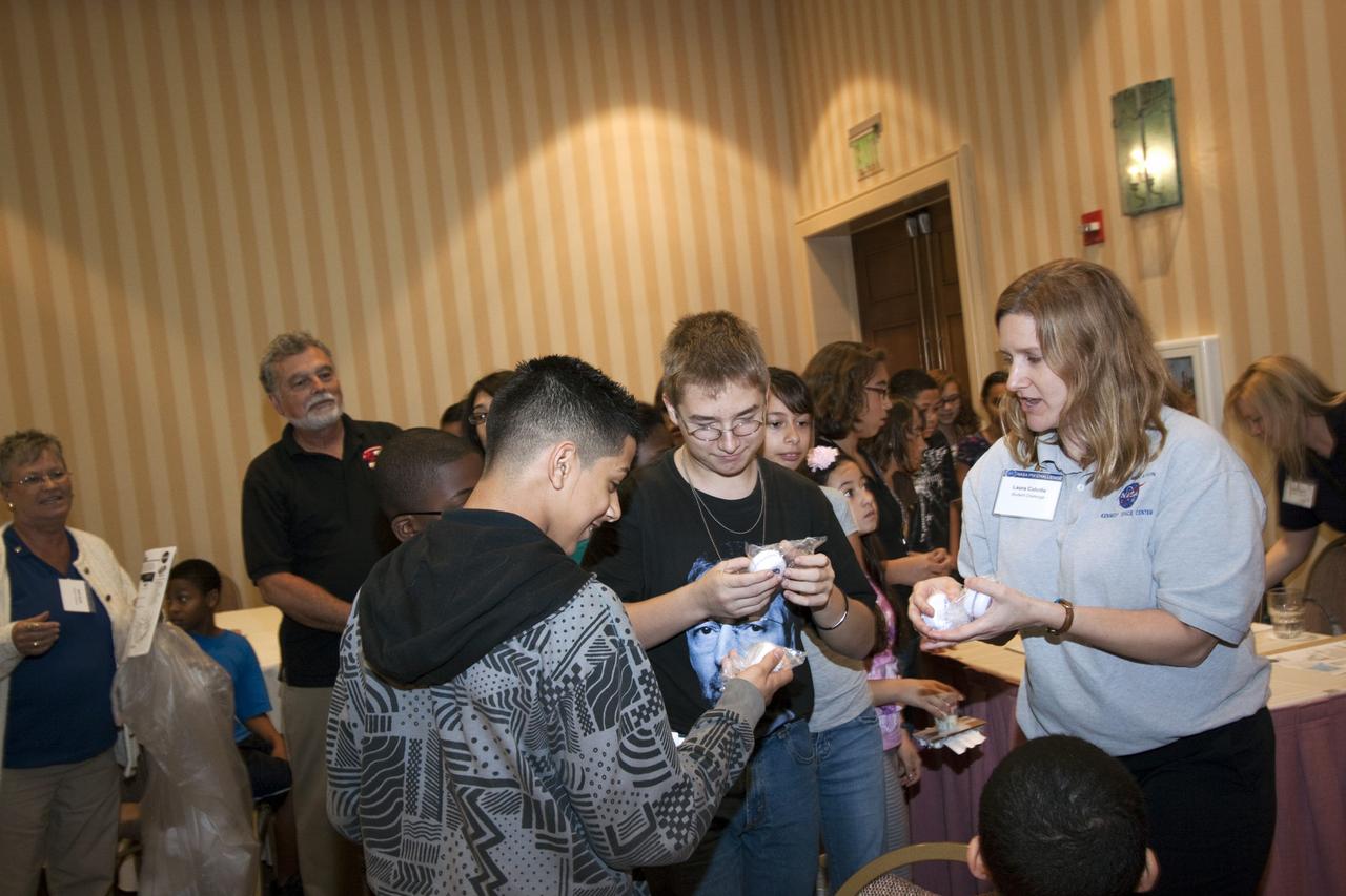
ORLANDO, Fla. – Laura Colville, in the gray shirt at right, from the Educator Resource Center at NASA’s Kennedy Space Center, interacts with students from Meadow Woods Middle School in Orlando during NASA’s Project Management PM Challenge 2012. The demonstrations are designed to increase student interest and pursuit of the science, technology, engineering and mathematics STEM fields integral to producing the next generation of scientists and engineers. PM Challenge 2012 was held at the Caribe Royale Hotel and Convention Center in Orlando, Fla., on Feb. 22-23, to provide a forum for all stakeholders in the project management community to meet and share stories, lessons learned and new uses of technology in the industry. The PM Challenge is sponsored by NASA's Office of the Chief Engineer. For additional information, visit http://www.nasa.gov/offices/oce/pmchallenge/index.html. Photo credit: NASA/Jim Grossmann

ORLANDO, Fla. – Education specialist Jim Gerard, in the red shirt, from NASA’s Kennedy Space Center, prepares a physics demonstration for students from Meadow Woods Middle School in Orlando during NASA’s Project Management PM Challenge 2012. The demonstrations are designed to increase student interest and pursuit of the science, technology, engineering and mathematics STEM fields integral to producing the next generation of scientists and engineers. PM Challenge 2012 was held at the Caribe Royale Hotel and Convention Center in Orlando, Fla., on Feb. 22-23, to provide a forum for all stakeholders in the project management community to meet and share stories, lessons learned and new uses of technology in the industry. The PM Challenge is sponsored by NASA's Office of the Chief Engineer. For additional information, visit http://www.nasa.gov/offices/oce/pmchallenge/index.html. Photo credit: NASA/Jim Grossmann
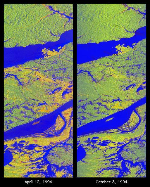
These two false-color images of the Manaus region of Brazil in South America were acquired by the Spaceborne Imaging Radar-C and X-band Synthetic Aperture Radar on board the space shuttle Endeavour. The image at left was acquired on April 12, 1994, and the image at right was acquired on October 3, 1994. The area shown is approximately 8 kilometers by 40 kilometers (5 miles by 25 miles). The two large rivers in this image, the Rio Negro (at top) and the Rio Solimoes (at bottom), combine at Manaus (west of the image) to form the Amazon River. The image is centered at about 3 degrees south latitude and 61 degrees west longitude. North is toward the top left of the images. The false colors were created by displaying three L-band polarization channels: red areas correspond to high backscatter, horizontally transmitted and received, while green areas correspond to high backscatter, horizontally transmitted and vertically received. Blue areas show low returns at vertical transmit/receive polarization; hence the bright blue colors of the smooth river surfaces can be seen. Using this color scheme, green areas in the image are heavily forested, while blue areas are either cleared forest or open water. The yellow and red areas are flooded forest or floating meadows. The extent of the flooding is much greater in the April image than in the October image and appears to follow the 10-meter (33-foot) annual rise and fall of the Amazon River. The flooded forest is a vital habitat for fish, and floating meadows are an important source of atmospheric methane. These images demonstrate the capability of SIR-C/X-SAR to study important environmental changes that are impossible to see with optical sensors over regions such as the Amazon, where frequent cloud cover and dense forest canopies block monitoring of flooding. Field studies by boat, on foot and in low-flying aircraft by the University of California at Santa Barbara, in collaboration with Brazil's Instituto Nacional de Pesguisas Estaciais, during the first and second flights of the SIR-C/X-SAR system have validated the interpretation of the radar images. http://photojournal.jpl.nasa.gov/catalog/PIA01735
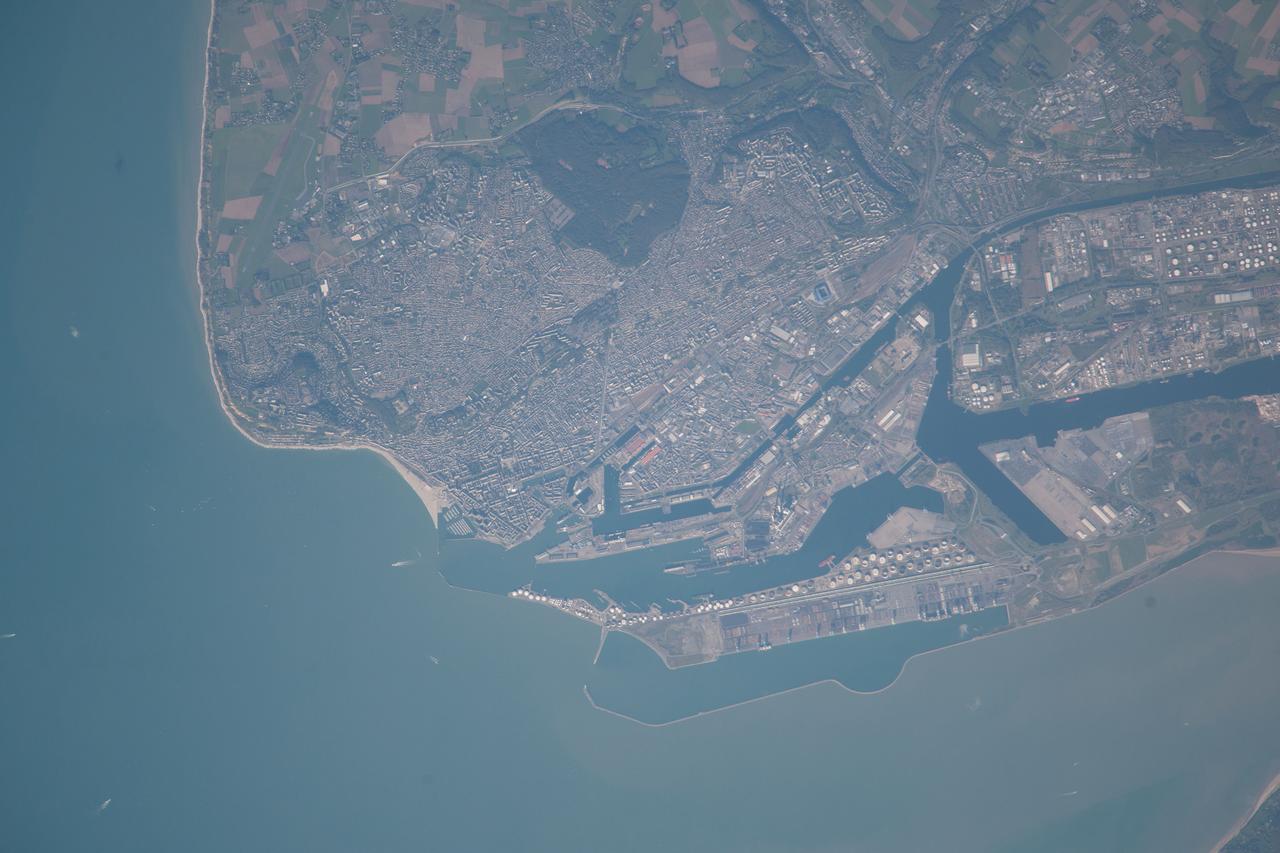
ISS037-E-021618 (26 Oct. 2013) --- Le Havre, France is featured in this image photographed by an Expedition 37 crew member on the International Space Station. The port city of Le Havre, France is located at the confluence of the Seine River and the English Channel along the northern coastline of the country (Upper Normandy region). Le Havre is the largest container port in France, and the second largest in terms of total traffic after Marseille. The extensive port facilities, visible at center, include numerous docks (large cargo ships are clearly visible in this detailed photograph), storage tanks for petro- and other chemicals, and large industrial and warehouse facilities with white rooftops. The port also serves seagoing pleasure cruise vessels. The southern edge of the port facility along the Seine includes a seawall-enclosed ship turning area (lower center). The Montgeon Forest, visible as a large green region at upper center, includes 200 hectares of woodland and 30 hectares of meadows and lawns. The urban area of Le Havre, to the north of the port facilities, was largely destroyed during World War II. After the war, the city was rebuilt following the vision of architect Auguste Perret. Perret favored the use of reinforced and precast concrete in building structures, and much of the city built between 1945 and 1964 follows his plan in both form and materials ? leading to the designation of Le Havre as a UNESCO World Heritage Site.
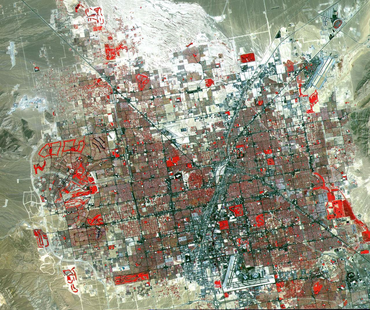
This image of Las Vegas, NV was acquired on August, 2000 and covers an area 42 km (25 miles) wide and 30 km (18 miles) long. The image displays three bands of the reflected visible and infrared wavelength region, with a spatial resolution of 15 m. McCarran International Airport to the south and Nellis Air Force Base to the NE are the two major airports visible. Golf courses appear as bright red areas of worms. The first settlement in Las Vegas (which is Spanish for The Meadows) was recorded back in the early 1850s when the Mormon church, headed by Brigham Young, sent a mission of 30 men to construct a fort and teach agriculture to the Indians. Las Vegas became a city in 1905 when the railroad announced this city was to be a major division point. Prior to legalized gambling in 1931, Las Vegas was developing as an agricultural area. Las Vegas' fame as a resort area became prominent after World War II. The image is located at 36.1 degrees north latitude and 115.1 degrees west longitude. http://photojournal.jpl.nasa.gov/catalog/PIA11096
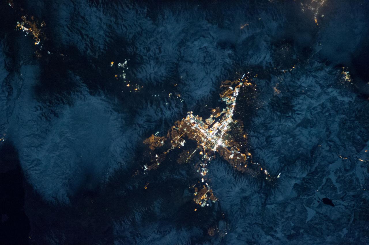
ISS034-E-035548 (28 Jan. 2013) --- A nighttime view of the Reno, Nevada metropolitan area is featured in this image photographed by an Expedition 34 crew member on the International Space Station. Known as ?the biggest little city in the world?, the city of Reno is located in Truckee Meadows along the eastern foothills of the Sierra Nevada near the California border. It forms part of the Reno-Sparks metropolitan area?the largest such area in northern Nevada, and the second largest in the state after Las Vegas. Lake Tahoe, a major destination for skiing and other outdoor recreational activities, is located less than 50 kilometers to the southwest of the Reno-Sparks metro area. The relatively isolated nature of the metropolitan area within the surrounding terrain is highlighted in this nighttime image. The major industrial and commercial areas of both Reno and Sparks are brightly lit at center. The major street grid is visible as orange linear features adjacent to the industrial/commercial areas. Residential areas appear dark in contrast. The Reno-Tahoe International Airport (center) is visible as a dark, dagger-shaped region in the southeast quarter of the metropolitan area. At the time this photograph was taken, the moon was in a waning gibbous phase (98 percent of a full moon). Moonlight provided enough illumination of the ground surface such that the topography, accentuated by snow cover, surrounding the Reno-Sparks area is clearly visible (upper right, lower right) following color enhancement.
On July 3, 1936, President Franklin Delano Roosevelt stood amidst the crowd in Big Meadows and officially dedicated Shenandoah National Park in Virginia. The Thematic Mapper on the Landsat satellite captured this view of the heart of Shenandoah National Park on October 10, 2010, at the height of the fall “leaf-peeping” season. The orange and brown swath across the image highlights the hilly backbone of the park, where leaves had turned to their fall colors. The 169-kilometer (105-mile) Skyline Drive that meanders across the crest of the ridge is often jammed with tourists in autumn. The park includes more than 518 miles of hiking trails, including more than 100 miles of the Appalachian Trail. The highest peak is Hawksbill Mountain at 4,051 feet (1,235 m), but the most popular with hikers is Old Rag Mountain. A circuitous eight-mile (13 kilometer) trail leads to an exposed, rocky summit 3,291 feet (1,003 meters) above sea level. The 2,200 foot elevation change from base to summit, combined with several rock scrambles, make Old Rag not only the most popular but also the most dangerous hike. Read more: <a href="http://go.nasa.gov/2bRnFxH" rel="nofollow">go.nasa.gov/2bRnFxH</a> Credit: NASA/Landsat5 <b><a href="http://www.nasa.gov/audience/formedia/features/MP_Photo_Guidelines.html" rel="nofollow">NASA image use policy.</a></b> <b><a href="http://www.nasa.gov/centers/goddard/home/index.html" rel="nofollow">NASA Goddard Space Flight Center</a></b> enables NASA’s mission through four scientific endeavors: Earth Science, Heliophysics, Solar System Exploration, and Astrophysics. Goddard plays a leading role in NASA’s accomplishments by contributing compelling scientific knowledge to advance the Agency’s mission. <b>Follow us on <a href="http://twitter.com/NASAGoddardPix" rel="nofollow">Twitter</a></b> <b>Like us on <a href="http://www.facebook.com/pages/Greenbelt-MD/NASA-Goddard/395013845897?ref=tsd" rel="nofollow">Facebook</a></b> <b>Find us on <a href="http://instagrid.me/nasagoddard/?vm=grid" rel="nofollow">Instagram</a></b>
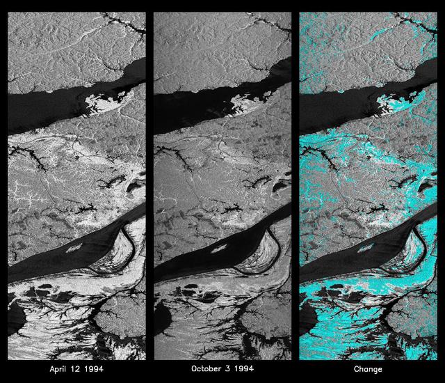
These L-band images of the Manaus region of Brazil were acquired by the Spaceborne Imaging Radar-C and X-band Synthetic Aperture Radar (SIR-C/X-SAR) aboard the space shuttle Endeavour. The left image was acquired on April 12, 1994, and the middle image was acquired on October 3, 1994. The area shown is approximately 8 kilometers by 40 kilometers (5 miles by 25 miles). The two large rivers in this image, the Rio Negro (top) and the Rio Solimoes (bottom), combine at Manaus (west of the image) to form the Amazon River. The image is centered at about 3 degrees south latitude and 61 degrees west longitude. North is toward the top left of the images. The differences in brightness between the images reflect changes in the scattering of the radar channel. In this case, the changes are indicative of flooding. A flooded forest has a higher backscatter at L-band (horizontally transmitted and received) than an unflooded river. The extent of the flooding is much greater in the April image than in the October image, and corresponds to the annual, 10-meter (33-foot) rise and fall of the Amazon River. A third image at right shows the change in the April and October images and was created by determining which areas had significant decreases in the intensity of radar returns. These areas, which appear blue on the third image at right, show the dramatic decrease in the extent of flooded forest, as the level of the Amazon River falls. The flooded forest is a vital habitat for fish and floating meadows are an important source of atmospheric methane. This demonstrates the capability of SIR-C/X-SAR to study important environmental changes that are impossible to see with optical sensors over regions such as the Amazon, where frequent cloud cover and dense forest canopies obscure monitoring of floods. Field studies by boat, on foot and in low-flying aircraft by the University of California at Santa Barbara, in collaboration with Brazil's Instituto Nacional de Pesguisas Estaciais, during the first and second flights of the SIR-C/X-SAR system have validated the interpretation of the radar images. http://photojournal.jpl.nasa.gov/catalog/PIA01740
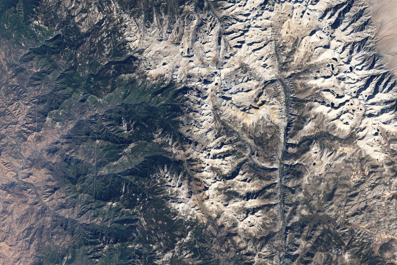
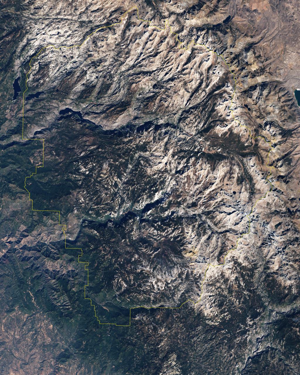
Naked peaks, sheltered valleys, snowfields, towering trees, and alpine meadows make up the varied landscape of Sequoia National Park in California. Established as a National Park by Congress on September 25, 1890, Sequoia National Park is the second-oldest U.S. National Park, after Yellowstone. This national park borders Kings Canyon National Park. The Thematic Mapper sensor on NASA’s Landsat 5 satellite captured this true-color image of Sequoia National Park, outlined in white, on October 22, 2008. Sunlight illuminates southern slopes, leaving northern faces in shadow in this autumn image. In the west, deep green conifers carpet most of the land. These forested mountains are home to the park’s most famous giant sequoia trees. Sequoia National Park sits at the southern end of the Sierra Nevada mountains. Terrain alternates between extremes, from peaks such as Mt. Whitney—the highest peak in the contiguous United States—to deep caverns. The rivers and lakes in this region are part of a watershed valuable not only to the plants and animals of the park, but also to farms and cities in California’s Central Valley. Read more: <a href="http://go.nasa.gov/2bzGOXr" rel="nofollow">go.nasa.gov/2bzGOXr</a> Credit: NASA/Landsat5 <b><a href="http://www.nasa.gov/audience/formedia/features/MP_Photo_Guidelines.html" rel="nofollow">NASA image use policy.</a></b> <b><a href="http://www.nasa.gov/centers/goddard/home/index.html" rel="nofollow">NASA Goddard Space Flight Center</a></b> enables NASA’s mission through four scientific endeavors: Earth Science, Heliophysics, Solar System Exploration, and Astrophysics. Goddard plays a leading role in NASA’s accomplishments by contributing compelling scientific knowledge to advance the Agency’s mission. <b>Follow us on <a href="http://twitter.com/NASAGoddardPix" rel="nofollow">Twitter</a></b> <b>Like us on <a href="http://www.facebook.com/pages/Greenbelt-MD/NASA-Goddard/395013845897?ref=tsd" rel="nofollow">Facebook</a></b> <b>Find us on <a href="http://instagrid.me/nasagoddard/?vm=grid" rel="nofollow">Instagram</a></b>
Naked summits alternate with forested lowlands in Yosemite Valley, part of California’s Yosemite National Park. During the Pleistocene Ice Age, glaciers sculpted the underlying rocks in this region, leaving behind canyons, waterfalls, rugged peaks, and granite domes. As the ice retreated, forests grew, but forests only extend as high as 2,900 meters (9,500 feet) above sea level. Above the tree line are rocky landscapes with sparse alpine vegetation. So from the sky, Yosemite Valley appears as a light-and-dark patchwork of forest, rock, and shadow. The Enhanced Thematic Mapper Plus on NASA’s Landsat 7 satellite captured this true-color image of part of Yosemite Valley on August 18, 2001. The valley runs roughly east-west, and tall granite peaks lining the valley’s southern side cast long shadows across the valley floor. On the valley’s northern side, steep slopes appear almost white. Along the valley floor, roadways form narrow, meandering lines of off-white, past parking lots, buildings, and meadows. On the north side of Yosemite Valley is El Capitan. Shooting straight up more than 915 meters (3,000 feet) above the valley floor, El Capitan is considered the largest granite monolith in the world. This granite monolith sits across the valley from Bridalveil Fall, one of the valley’s most prominent waterfalls. Read more: <a href="http://go.nasa.gov/2bzGo3d" rel="nofollow">go.nasa.gov/2bzGo3d</a> Credit: NASA/Landsat7 <b><a href="http://www.nasa.gov/audience/formedia/features/MP_Photo_Guidelines.html" rel="nofollow">NASA image use policy.</a></b> <b><a href="http://www.nasa.gov/centers/goddard/home/index.html" rel="nofollow">NASA Goddard Space Flight Center</a></b> enables NASA’s mission through four scientific endeavors: Earth Science, Heliophysics, Solar System Exploration, and Astrophysics. Goddard plays a leading role in NASA’s accomplishments by contributing compelling scientific knowledge to advance the Agency’s mission. <b>Follow us on <a href="http://twitter.com/NASAGoddardPix" rel="nofollow">Twitter</a></b> <b>Like us on <a href="http://www.facebook.com/pages/Greenbelt-MD/NASA-Goddard/395013845897?ref=tsd" rel="nofollow">Facebook</a></b> <b>Find us on <a href="http://instagrid.me/nasagoddard/?vm=grid" rel="nofollow">Instagram</a></b>