Saturnian Meteorology
The Meteorology Instrument on Viking Lander 1 http://photojournal.jpl.nasa.gov/catalog/PIA00392
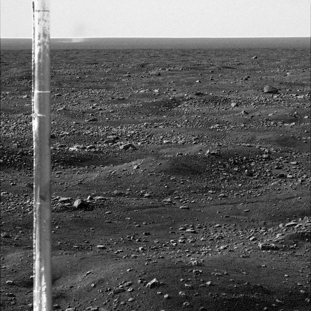
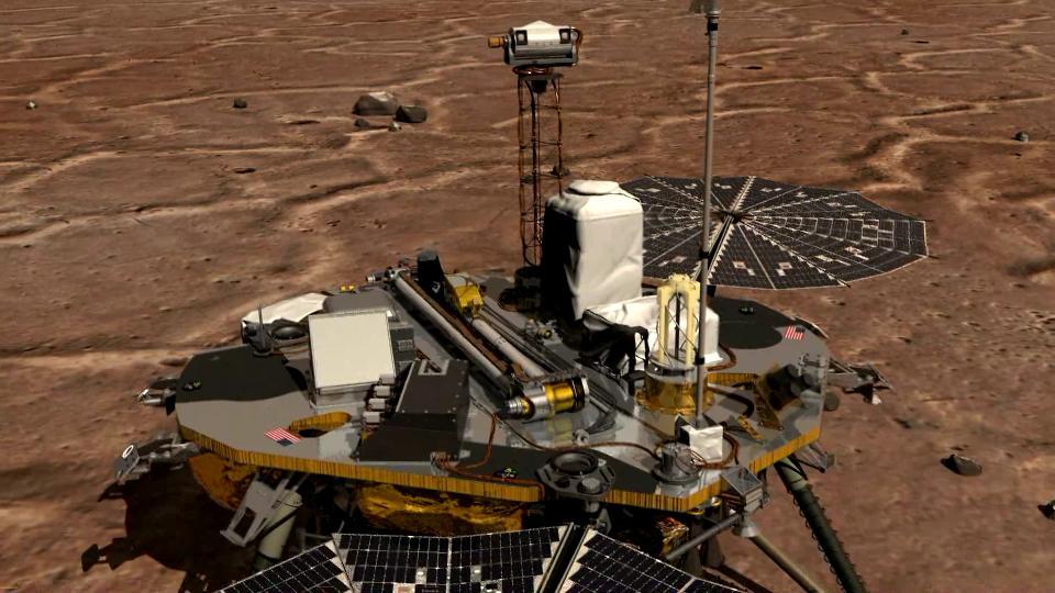
Martian Arctic Dust Devil and Phoenix Meteorology Mast
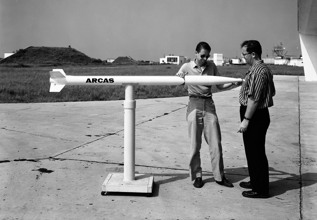
First Arcas meteorological rocket, shown at Wallops prior to flight test, July 31, 1959. Photograph published in A New Dimension Wallops Island Flight Test Range: The First Fifteen Years by Joseph Shortal. A NASA publication. Page 696.
NASA Terra satellite shows the shape and size of cellular patterns within marine stratocumulus cloud layers can change dramatically with the prevailing meteorological conditions.
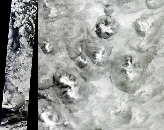
These images, acquired December 17, 1996 by NASA Galileo orbiter, show a small portion of the equatorial region of Jupiter of a dark clearing of clouds in the meteorologically-active troposphere.
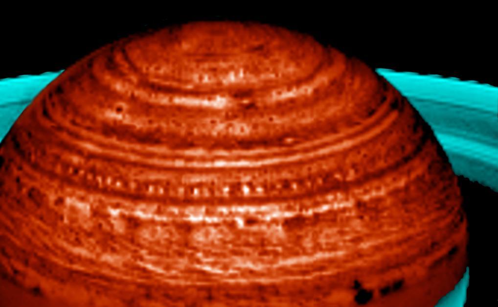
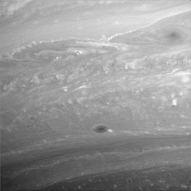
In this image captured by NASA Cassini spacecraft, Saturn fascinating meteorology manifests itself in a tring of pearls formation, spanning over 60,000 kilometers 37,000 miles.

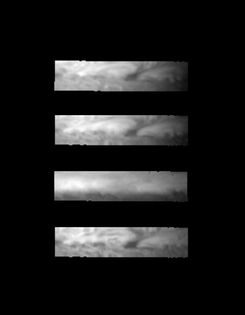
A high resolution image of the Jovian mid-latitudes taken by NASA Voyager 1 spacecraft on March 2, 1979, shows distinctly differing characteristics of the planet meteorology. http://photojournal.jpl.nasa.gov/catalog/PIA00360
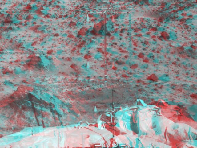
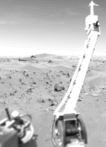
The Atmospheric Structure Instrument/Meteorology Package ASI/MET is the mast and windsocks at the center of this stereo image from NASA Mars Pathfinder. 3D glasses are necessary to identify surface detail.
This image from NASA Phoenix Mars Lander of the Canadian-built meteorological station lidar, which was successfully activated on Sol 2 by first opening its dust cover, then emitting rapid pulses of light.
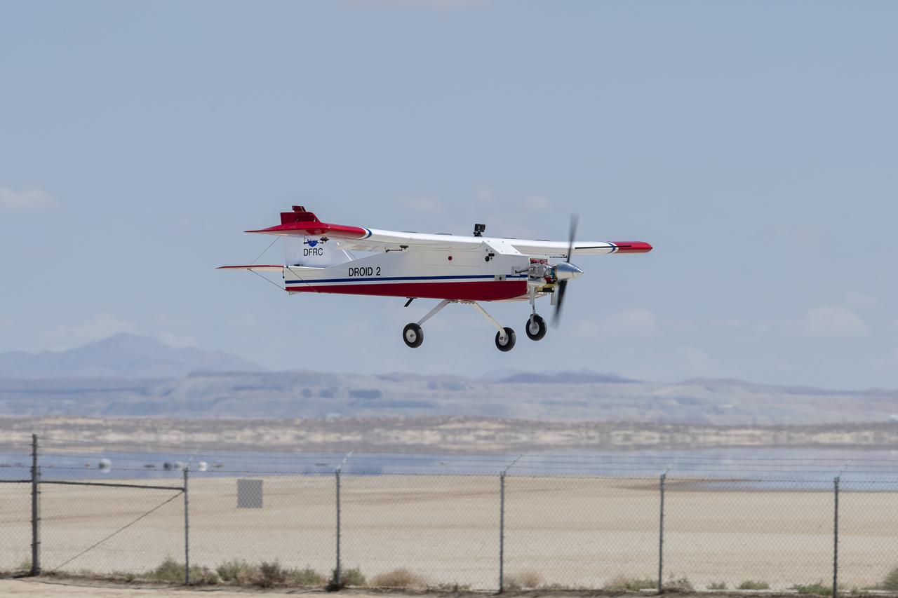
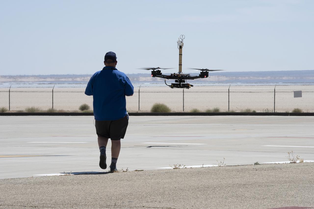
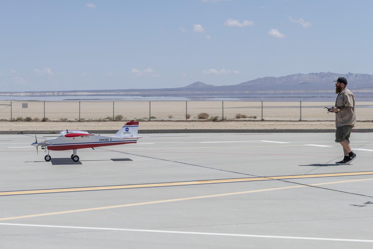
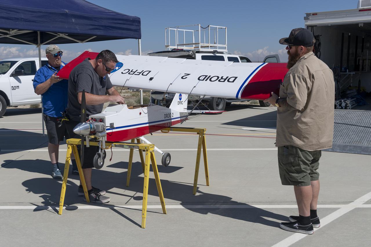
The DROID 2 (Dryden Remotely Operated Integrated Drone 2) prepares to land at NASA's Armstrong Flight Research Center in Edwards, California, as part of the Advanced Exploration of Reliable Operation at Low Altitudes: Meteorology, Simulation, and Technology campaign. The focus was to study wind to provide data for safe takeoff and landing of future air taxis.
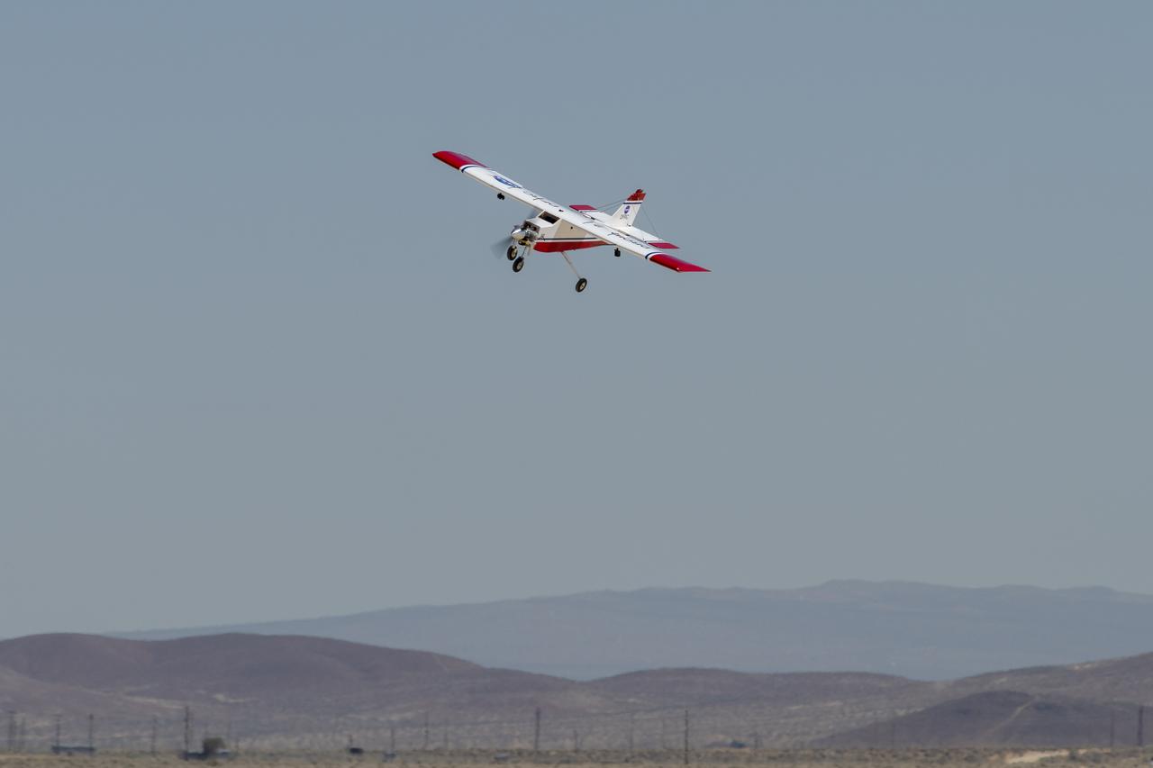
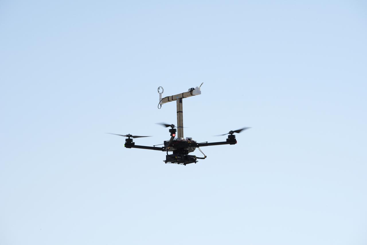
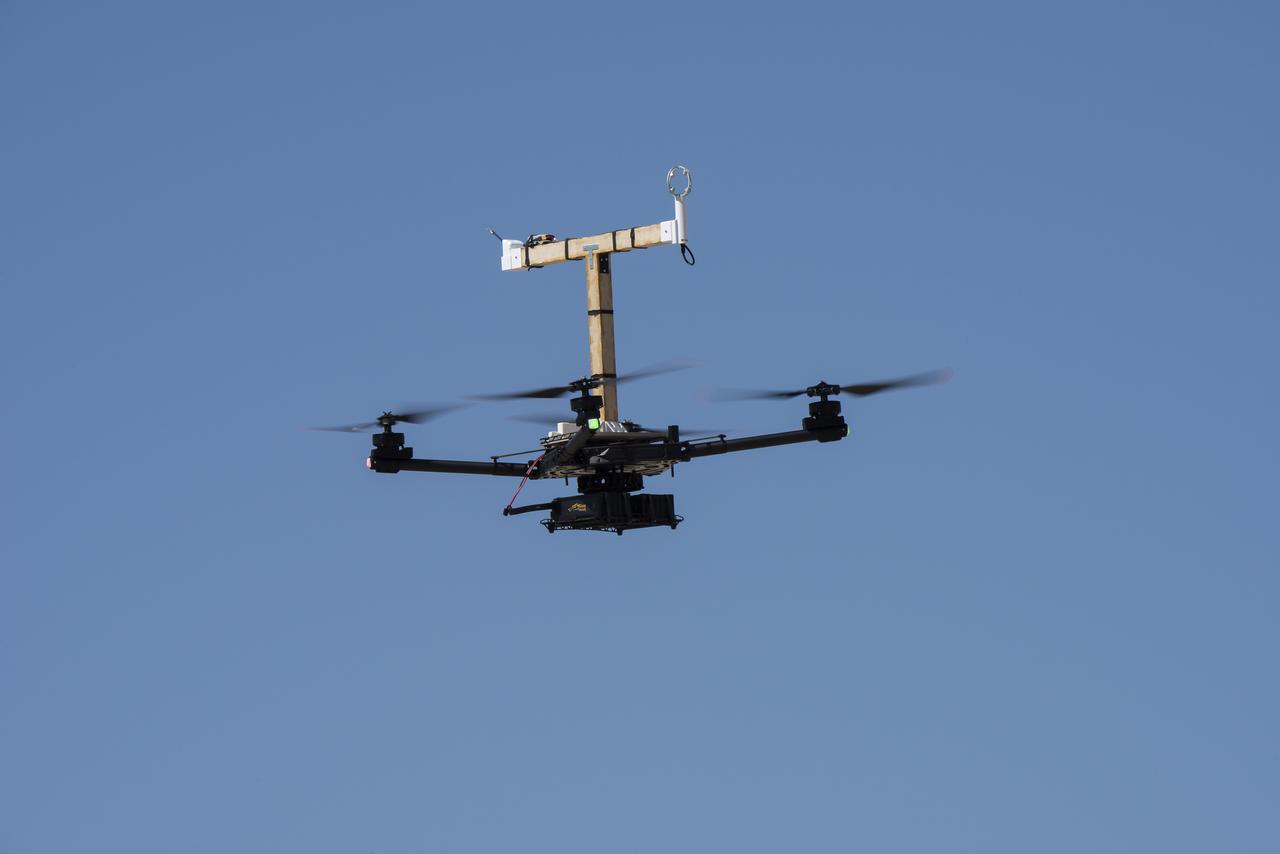
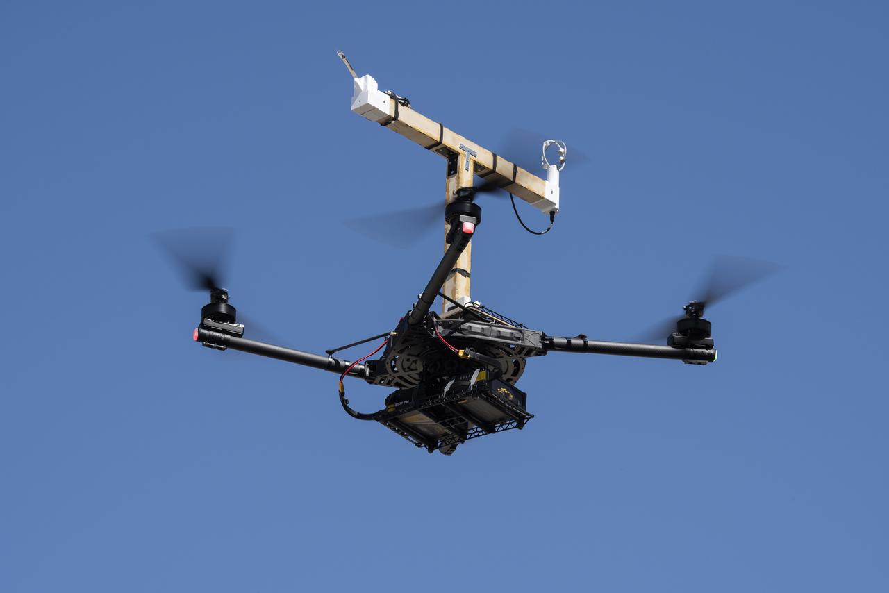
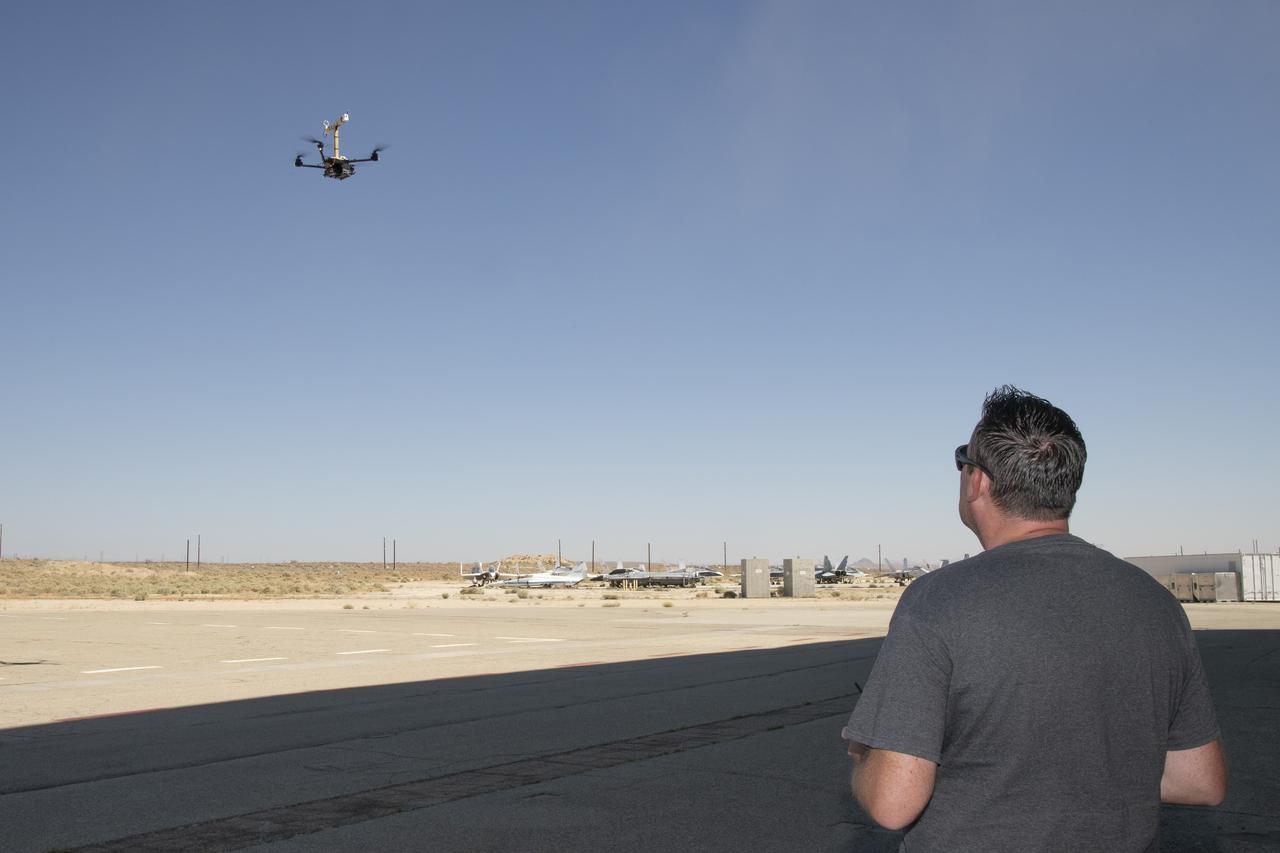
The DROID 2 (Dryden Remotely Operated Integrated Drone 2) flies at NASA's Armstrong Flight Research Center in Edwards, California, as part of the Advanced Exploration of Reliable Operation at Low Altitudes: Meteorology, Simulation, and Technology campaign. The focus was to study wind to provide data for safe takeoff and landing of future air taxis.
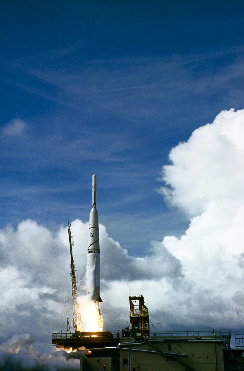
The launch of Thor/Able 3 launch vehicle on August 6, 1959, from the Atlantic Missile Range. The payload was Explorer VI for meteorology study.

The Alta-X aircraft flies by the former space shuttle hangar at NASA’s Armstrong Flight Research Center in Edwards, California, as part of the Advanced Exploration of Reliable Operation at Low Altitudes: Meteorology, Simulation and Technology campaign. The campaign was at NASA Armstrong to study wind from the ground to 2,000 feet to provide data to assist future drones to safely land on rooftop hubs called vertiports and to potentially improve weather prediction.
The Alta-X aircraft flies at NASA’s Armstrong Flight Research Center in Edwards, California, as part of the Advanced Exploration of Reliable Operation at Low Altitudes: Meteorology, Simulation and Technology campaign. The campaign was at NASA Armstrong to study wind from the ground to 2,000 feet to provide data to assist future drones to safely land on rooftop hubs called vertiports and to potentially improve weather prediction.
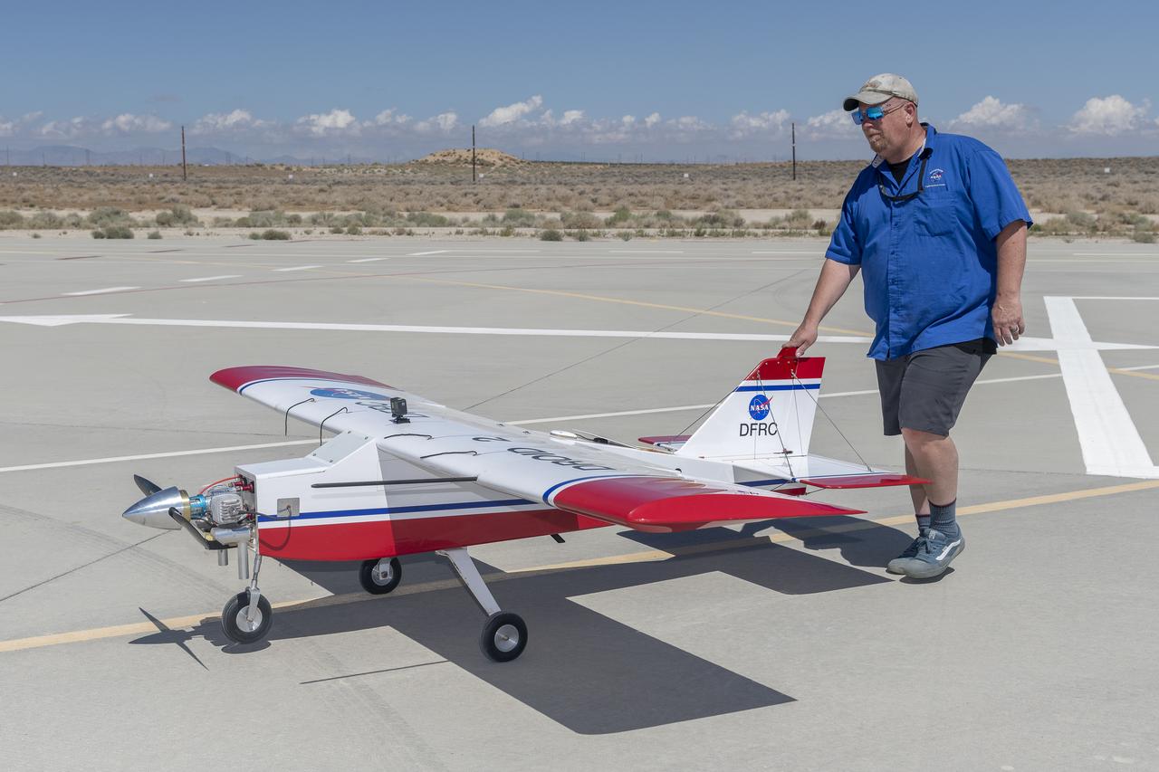
Robert "Red" Jensen positions the DROID 2 (Dryden Remotely Operated Integrated Drone) aircraft before a flight for the Advanced Exploration of Reliable Operation at Low Altitudes: Meteorology, Simulation, and Technology campaign. The weather study was at NASA's Armstrong Flight Research Center in Edwards, California. The focus was to study wind to provide data for safe takeoff and landing of future air taxis.
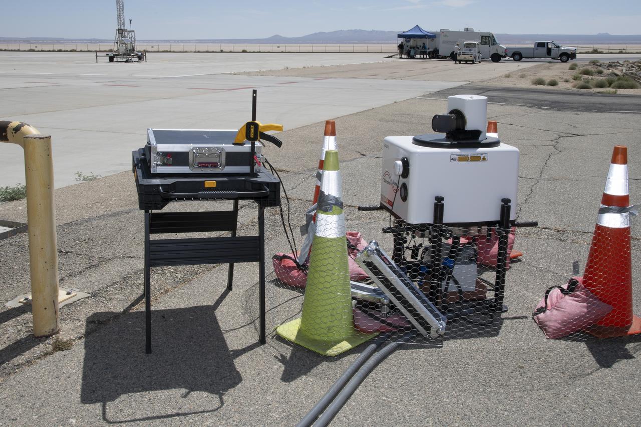
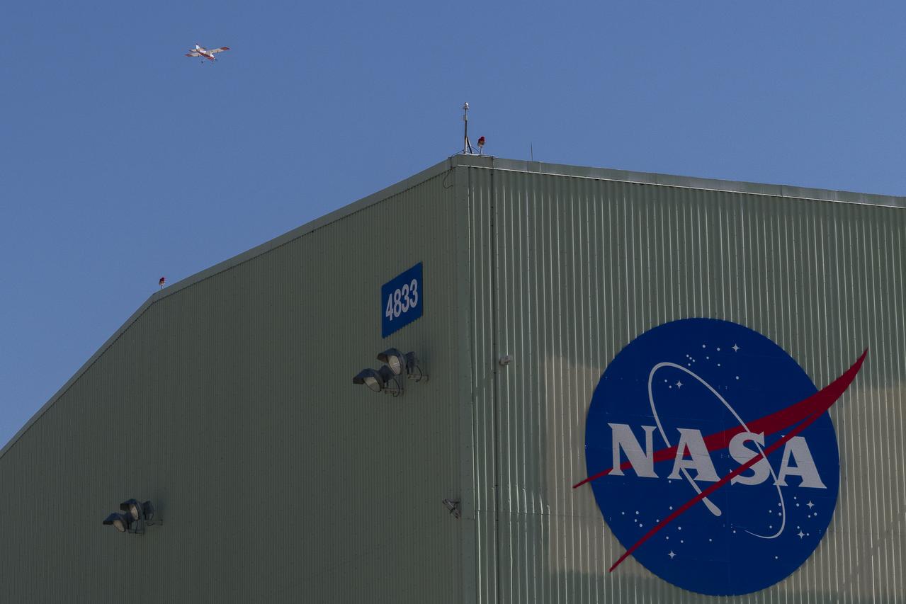
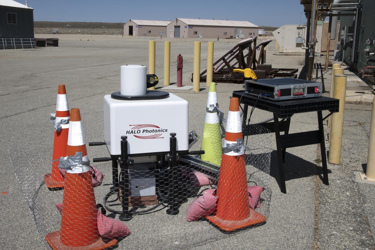
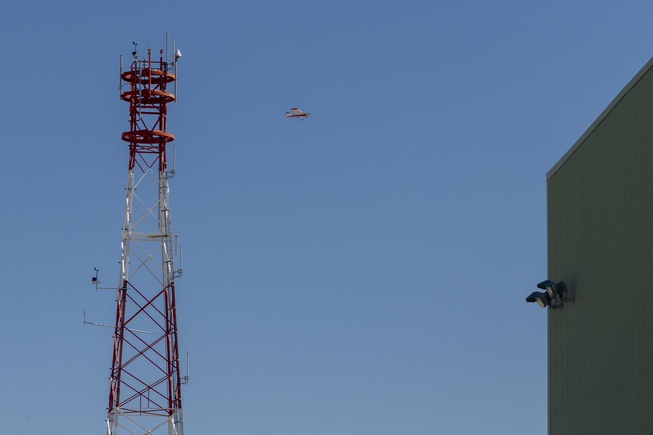
This is one of two lidar units positioned on either end of Building 4833 at NASA’s Armstrong Flight Research Center in Edwards, California, that formed the cutting-edge ‘virtual tower concept.’ The units use lasers to measure airflow from the ground level to 2,000 feet to provide data to assist future drones to safely land on rooftop hubs called vertiports, and to potentially improve weather prediction. It was part of the multi-faceted Advanced Exploration of Reliable Operation at Low Altitudes: Meteorology, Simulation and Technology campaign.
Justin Link prepares the DROID 2 (Dryden Remotely Operated Integrated Drone 2) aircraft before a flight for the Advanced Exploration of Reliable Operation at Low Altitudes: Meteorology, Simulation, and Technology campaign. The weather study was at NASA's Armstrong Flight Research Center in Edwards, California. The focus was to study wind to provide data for safe takeoff and landing of future air taxis.
The Alta-X aircraft flies by the former space shuttle hangar at NASA’s Armstrong Flight Research Center in Edwards, California, as part of the Advanced Exploration of Reliable Operation at Low Altitudes: Meteorology, Simulation and Technology campaign. The campaign was at NASA Armstrong Flight to study wind from the ground to 2,000 feet to provide data to assist future drones to safely land on rooftop hubs called vertiports and to potentially improve weather prediction.
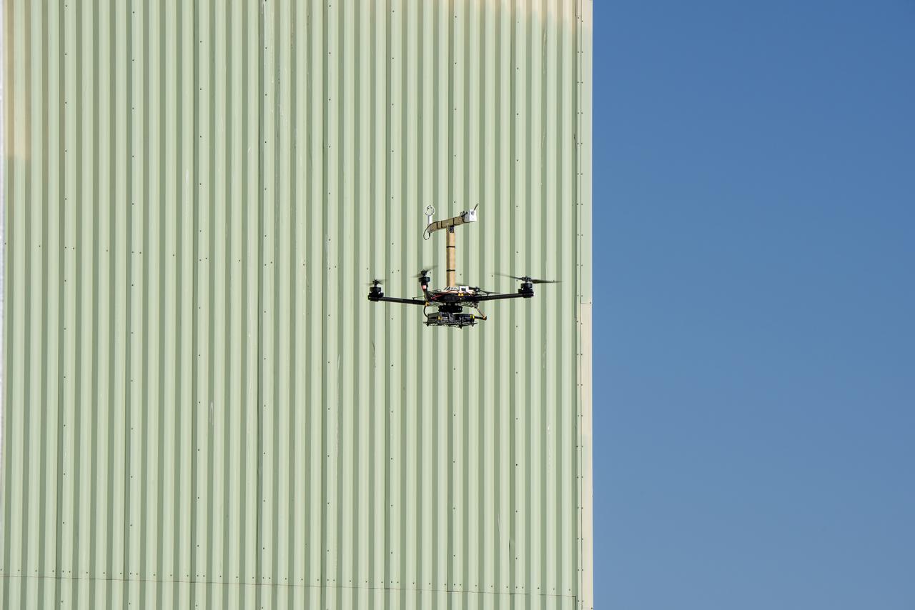
The DROID 2 (Dryden Remotely Operated Integrated Drone 2) aircraft flies by the former space shuttle hangar at NASA's Armstrong Flight Research Center in Edwards, California, as part of the Advanced Exploration of Reliable Operation at Low Altitudes: Meteorology, Simulation, and Technology campaign. The focus was to study wind to provide data for safe takeoff and landing of future air taxis.
Red Jensen lands the Alta-X aircraft at NASA’s Armstrong Flight Research Center in Edwards, California, as part of the Advanced Exploration of Reliable Operation at Low Altitudes: Meteorology, Simulation and Technology campaign. The campaign was at NASA Armstrong to study wind from the ground to 2,000 feet to provide data to assist future drones to safely land on rooftop hubs called vertiports and to potentially improve weather prediction.
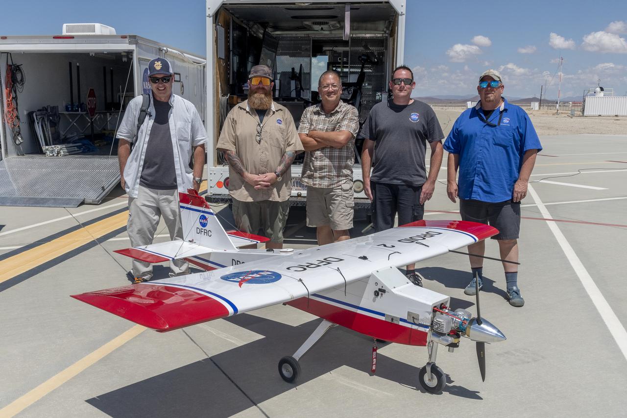
John Melton, Justin Hall, Derek Abramson, Justin Link, and Robert "Red" Jensen were key on mission day for the Advanced Exploration of Reliable Operation at Low Altitudes: Meteorology, Simulation, and Technology campaign. The DROID 2 (Dryden Remotely Operated Integrated Drone 2) aircraft supported the campaign at NASA's Armstrong Flight Research Center in Edwards, California. The focus was to study wind to provide data for safe takeoff and landing of future air taxis.
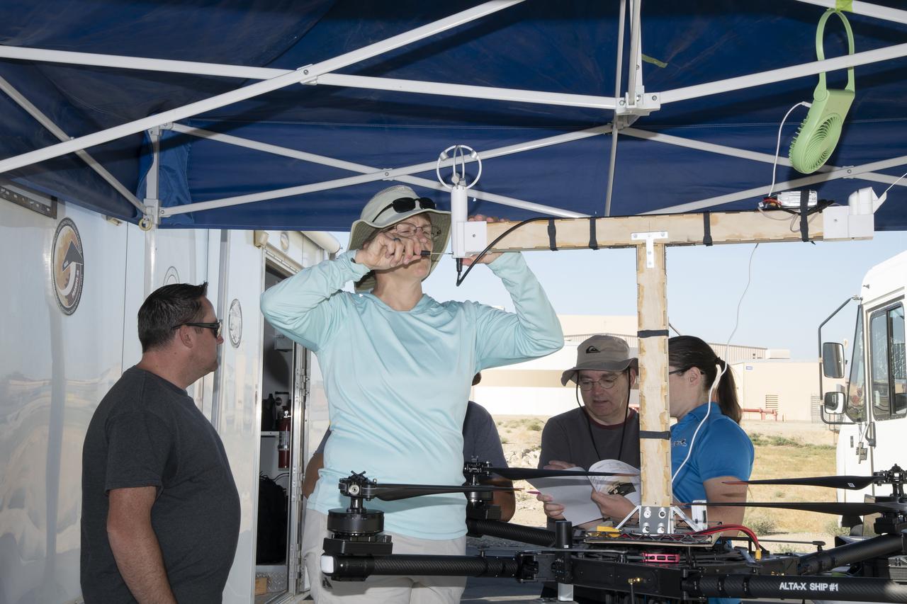
Jennifer Fowler works on securing sensors onto the test fixture on the Alta-X aircraft. Justin Link, Grady Koch, and Tyler Willhite are in the background. The Advanced Exploration of Reliable Operation at Low Altitudes: Meteorology, Simulation and Technology campaign was at NASA’s Armstrong Flight Research Center in Edwards, California. The focus was to study wind from the ground to 2,000 feet to provide data to assist future drones to safely land on rooftop hubs called vertiports and to potentially improve weather prediction.
Jennifer Fowler talks to Red Jensen prior to a flight for the Advanced Exploration of Reliable Operation at Low Altitudes: Meteorology, Simulation and Technology campaign. Tyler Willhite completes some equipment checks for the research in the background. The weather study was at NASA’s Armstrong Flight Research Center in Edwards, California. The focus was to study wind from the ground to 2,000 feet to provide data to assist future drones to safely land on rooftop hubs called vertiports and to potentially improve weather prediction.
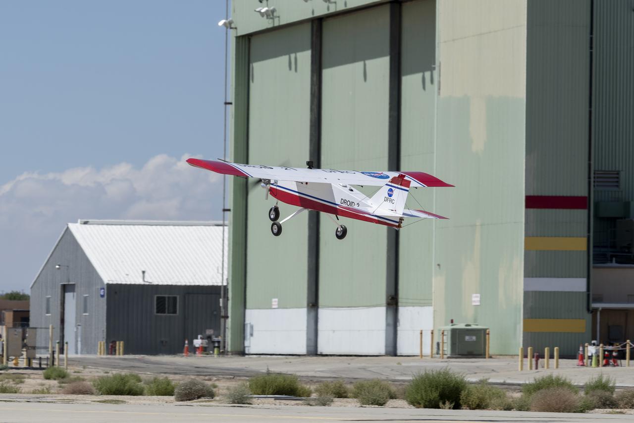
The DROID 2 (Dryden Remotely Operated Integrated Drone 2) aircraft flies by the former space shuttle hangar at NASA's Armstrong Flight Research Center in Edwards, California, as part of the Advanced Exploration of Reliable Operation at Low Altitudes: Meteorology, Simulation, and Technology campaign. The focus was to study wind to provide data for safe takeoff and landing of future air taxis.
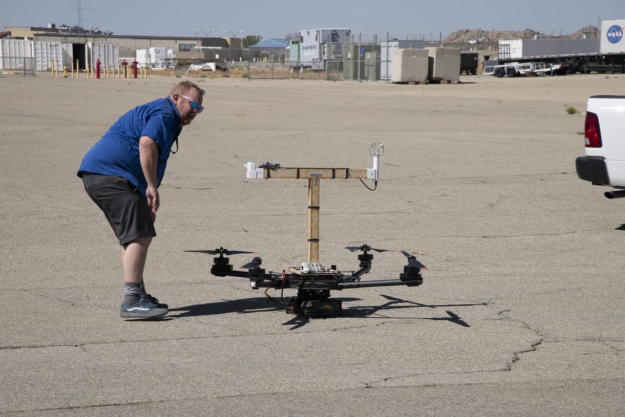
Red Jensen looks over the Alta-X aircraft before a flight for the Advanced Exploration of Reliable Operation at Low Altitudes: Meteorology, Simulation and Technology campaign. The weather study was at NASA’s Armstrong Flight Research Center in Edwards, California. The focus was to study wind from the ground to 2,000 feet to provide data to assist future drones to safely land on rooftop hubs called vertiports and to potentially improve weather prediction.
The Alta-X aircraft flies at NASA’s Armstrong Flight Research Center in Edwards, California, as part of the Advanced Exploration of Reliable Operation at Low Altitudes: Meteorology, Simulation and Technology campaign. The campaign was at NASA Armstrong to study wind from the ground to 2,000 feet to provide data to assist future drones to safely land on rooftop hubs called vertiports and to potentially improve weather prediction.
This is one of two lidar units positioned on either end of Building 4833 at NASA’s Armstrong Flight Research Center in Edwards, California, that formed the cutting-edge ‘virtual tower concept.’ The units use lasers to measure airflow from the ground level to 2,000 feet to provide data to assist future drones to safely land on rooftop hubs called vertiports, and to potentially improve weather prediction. It was part of the multi-faceted Advanced Exploration of Reliable Operation at Low Altitudes: Meteorology, Simulation and Technology campaign.
The Alta-X aircraft flies at NASA’s Armstrong Flight Research Center in Edwards, California, as part of the Advanced Exploration of Reliable Operation at Low Altitudes: Meteorology, Simulation and Technology campaign. The campaign was at NASA Armstrong to study wind from the ground to 2,000 feet to provide data to assist future drones to safely land on rooftop hubs called vertiports and to potentially improve weather prediction.
The Alta-X aircraft flies by a 140-foot instrumented tower at NASA’s Armstrong Flight Research Center in Edwards, California, as part of the Advanced Exploration of Reliable Operation at Low Altitudes: Meteorology, Simulation and Technology campaign. The campaign was at NASA Armstrong to study wind from the ground to 2,000 feet to provide data to assist future drones to safely land on rooftop hubs called vertiports and to potentially improve weather prediction.

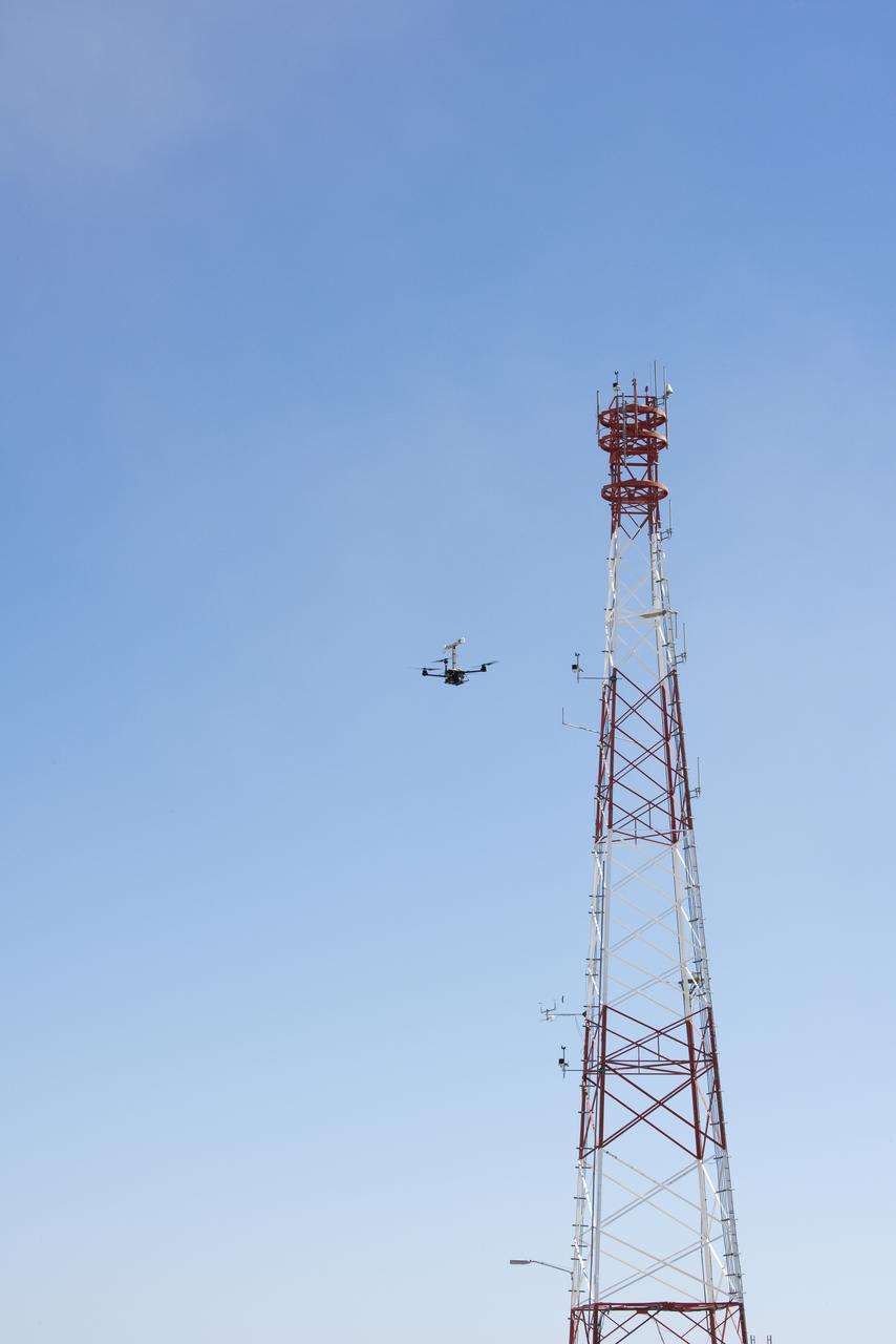
The DROID 2 (Dryden Remotely Operated Integrated Drone 2) flies by a 140-foot instrumented tower at NASA's Armstrong Flight Research Center in Edwards, California, as part of the Advanced Exploration of Reliable Operation at Low Altitudes: Meteorology, Simulation, and Technology campaign. The focus was to study wind to provide data for safe takeoff and landing of future air taxis.

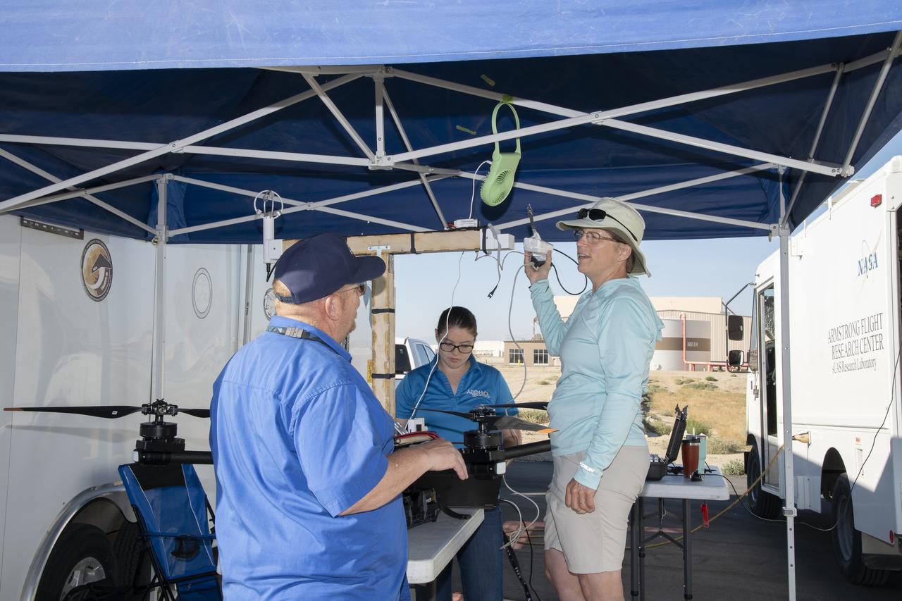
Justin Link, left, Red Jensen and Derek Abramson prepare for an Alta-X aircraft flight as part of the Advanced Exploration of Reliable Operation at Low Altitudes: Meteorology, Simulation and Technology campaign. In the background are Grady Koch and Jennifer Fowler. The campaign was at NASA Armstrong to study wind from the ground to 2,000 feet to provide data to assist future drones to safely land on rooftop hubs called vertiports and to potentially improve weather prediction.
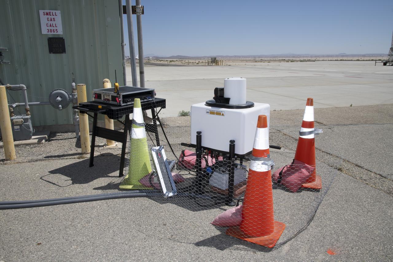
This is one of two lidar units positioned on either end of Building 4833 at NASA’s Armstrong Flight Research Center in Edwards, California, that formed the cutting-edge ‘virtual tower concept.’ The units use lasers to measure airflow from the ground level to 2,000 feet to provide data to assist future drones to safely land on rooftop hubs called vertiports, and to potentially improve weather prediction. It was part of the multi-faceted Advanced Exploration of Reliable Operation at Low Altitudes: Meteorology, Simulation and Technology campaign.
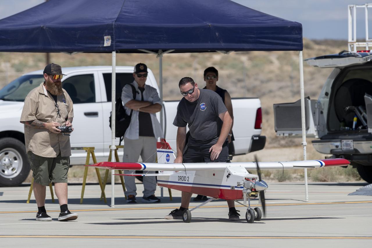
Justin Hall, left, prepares to pilot the DROID 2 (Dryden Remotely Operated Integrated Drone 2) aircraft, as John Melton watches and Justin Link makes a final adjustment. The flight was part of the Advanced Exploration of Reliable Operation at Low Altitudes: Meteorology, Simulation, and Technology campaign. The weather study was at NASA's Armstrong Flight Research Center in Edwards, California. The focus was to study wind to provide data for safe takeoff and landing of future air taxis.
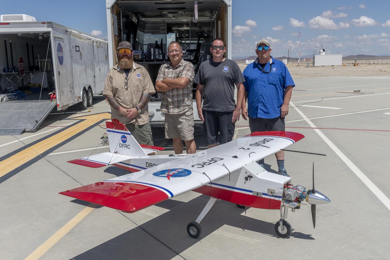
Justin Hall, Derek Abramson, Justin Link, and Robert "Red" Jensen were key to a successful mission for the DROID 2 (Dryden Remotely Operated Integrated Drone 2) aircraft at NASA's Armstrong Flight Research Center in Edwards, California. The aircraft flew as part of the Advanced Exploration of Reliable Operation at Low Altitudes: Meteorology, Simulation, and Technology campaign. The focus was to study wind to provide data for safe takeoff and landing of future air taxis.
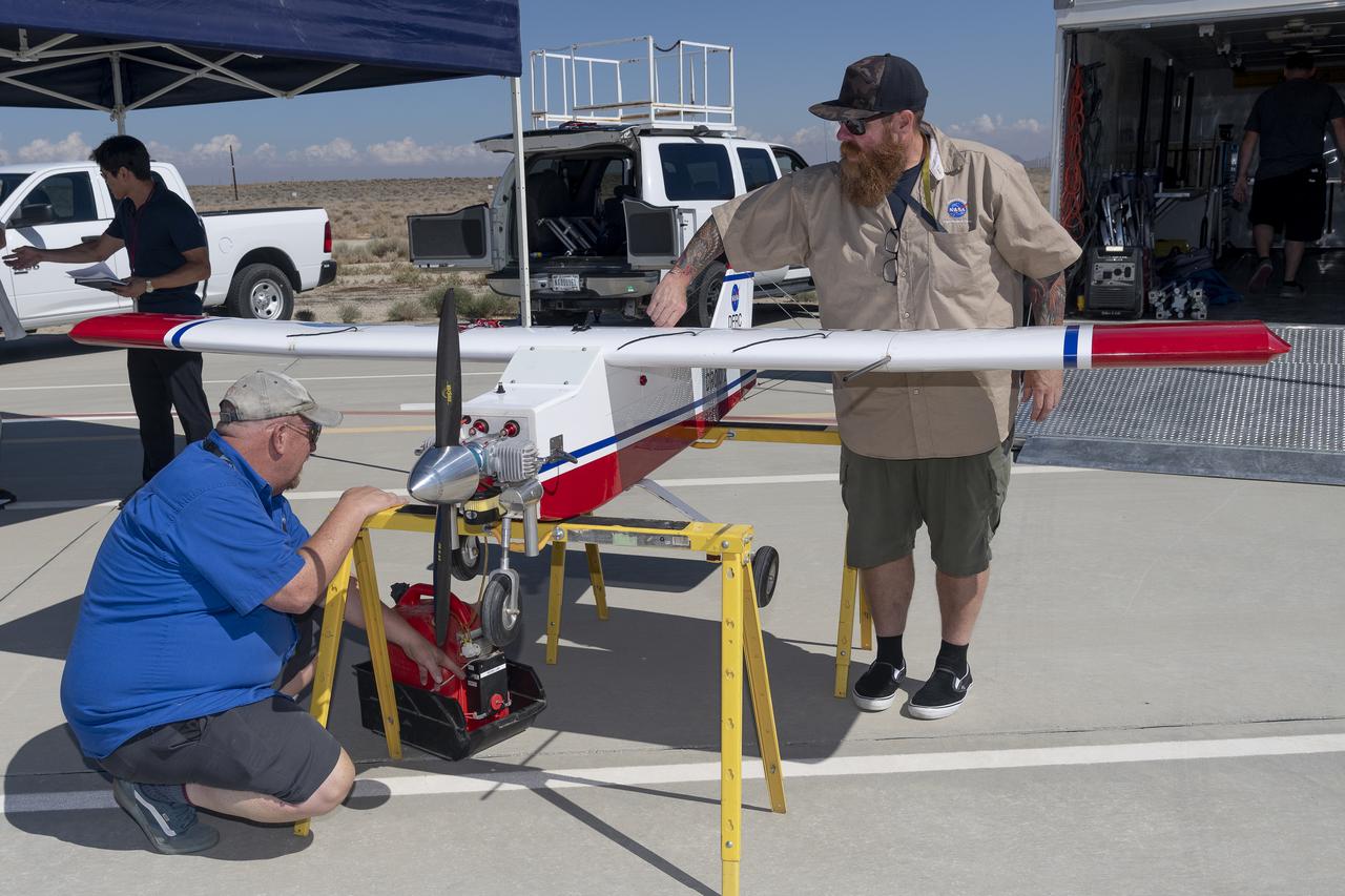
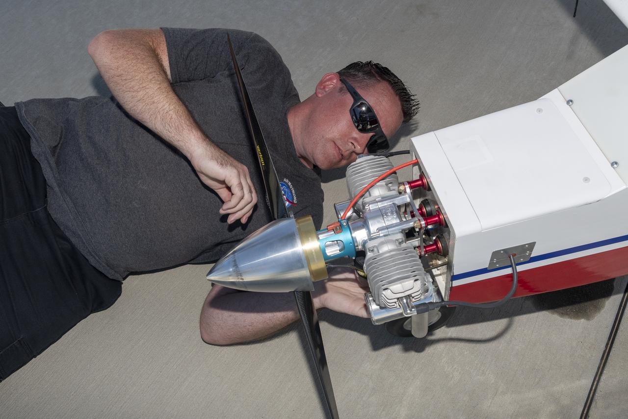
Robert "Red" Jensen and Justin Hall prepare the DROID 2 (Dryden Remotely Operated Integrated Drone 2) aircraft for the Advanced Exploration of Reliable Operation at Low Altitudes: Meteorology, Simulation, and Technology campaign flights. The weather study was at NASA's Armstrong Flight Research Center in Edwards, California. The focus was to study wind to provide data for safe takeoff and landing of future air taxis.
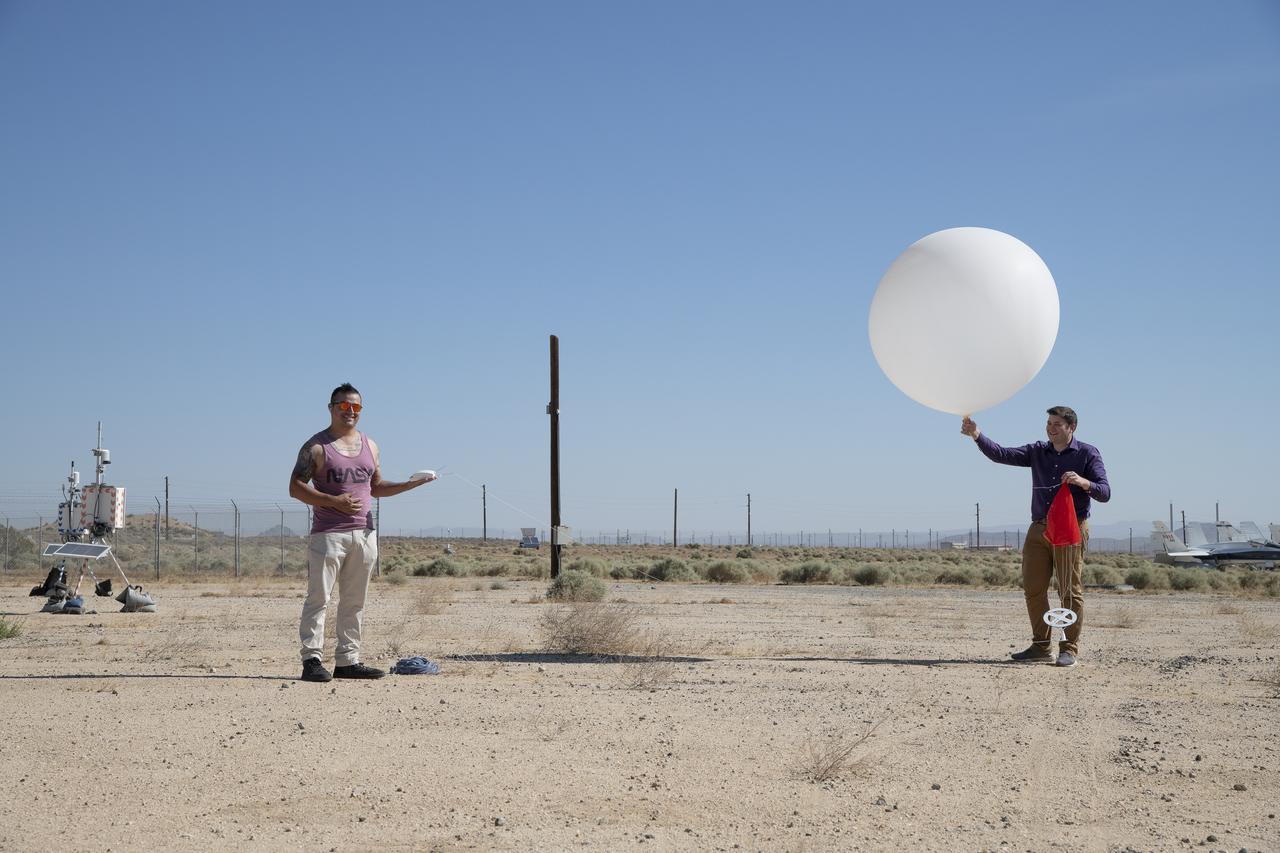
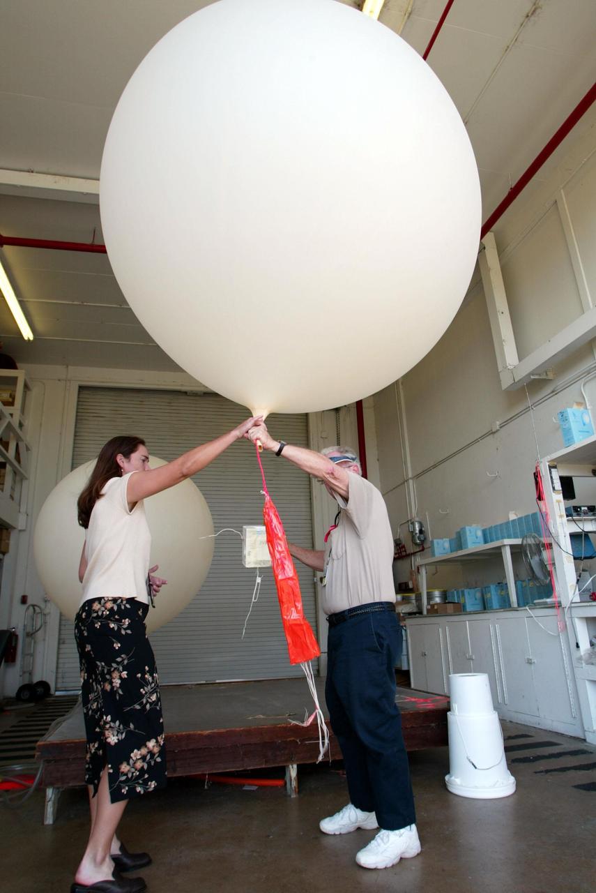
Rocky Garcia and Wesley James prepare a weather balloon to collect wind data for the Advanced Exploration of Reliable Operation at Low Altitudes: Meteorology, Simulation and Technology campaign. The weather study was at NASA’s Armstrong Flight Research Center in Edwards, California. The focus was to study wind from the ground to 2,000 feet to provide data to assist future drones to safely land on rooftop hubs called vertiports and to potentially improve weather prediction.
Tyler Willhite, sitting, and Derek Abramson and Justin Link, prepare for an Alta-X aircraft flight. Behind them are Jennifer Fowler, from left and Grady Kock. The Alta-X flight was part of the Advanced Exploration of Reliable Operation at Low Altitudes: Meteorology, Simulation and Technology campaign. The campaign was at NASA Armstrong to study wind from the ground to 2,000 feet to provide data to assist future drones to safely land on rooftop hubs called vertiports and to potentially improve weather prediction.
The DROID 2 (Dryden Remotely Operated Integrated Drone 2) flies by a 140-foot instrumented tower and the former space shuttle hangar at NASA's Armstrong Flight Research Center in Edwards, California, as part of the Advanced Exploration of Reliable Operation at Low Altitudes: Meteorology, Simulation, and Technology campaign. The focus was to study wind to provide data for safe takeoff and landing of future air taxis.
Justin Hall lands the DROID 2 (Dryden Remotely Operated Integrated Drone 2) aircraft at NASA's Armstrong Flight Research Center in Edwards, California, as part of the Advanced Exploration of Reliable Operation at Low Altitudes: Meteorology, Simulation, and Technology campaign. The focus was to study wind to provide data for safe takeoff and landing of future air taxis.
Justin Link positions the Alta-X aircraft for a hover to capture data as part of the Advanced Exploration of Reliable Operation at Low Altitudes: Meteorology, Simulation and Technology campaign. The campaign was at NASA Armstrong to study wind from the ground to 2,000 feet to provide data to assist future drones to safely land on rooftop hubs called vertiports and to potentially improve weather prediction.

Robert "Red" Jensen lands the DROID 2 (Dryden Remotely Operated Integrated Drone 2) aircraft at NASA's Armstrong Flight Research Center in Edwards, California, as part of the Advanced Exploration of Reliable Operation at Low Altitudes: Meteorology, Simulation, and Technology campaign. The focus was to study wind to provide data for safe takeoff and landing of future air taxis.

This is one of two lidar units positioned on either end of Building 4833 at NASA’s Armstrong Flight Research Center in Edwards, California, that formed the cutting-edge ‘virtual tower concept.’ The units use lasers to measure airflow from the ground level to 2,000 feet to provide data to assist future drones to safely land on rooftop hubs called vertiports, and to potentially improve weather prediction. It was part of the multi-faceted Advanced Exploration of Reliable Operation at Low Altitudes: Meteorology, Simulation and Technology campaign.
Robert "Red" Jensen, Justin Link, and Justin Hall prepare the DROID 2 (Dryden Remotely Operated Integrated Drone 2) for the Advanced Exploration of Reliable Operation at Low Altitudes: Meteorology, Simulation, and Technology campaign flights. The weather study was at NASA's Armstrong Flight Research Center in Edwards, California. The focus was to study wind to provide data for safe takeoff and landing of future air taxis.
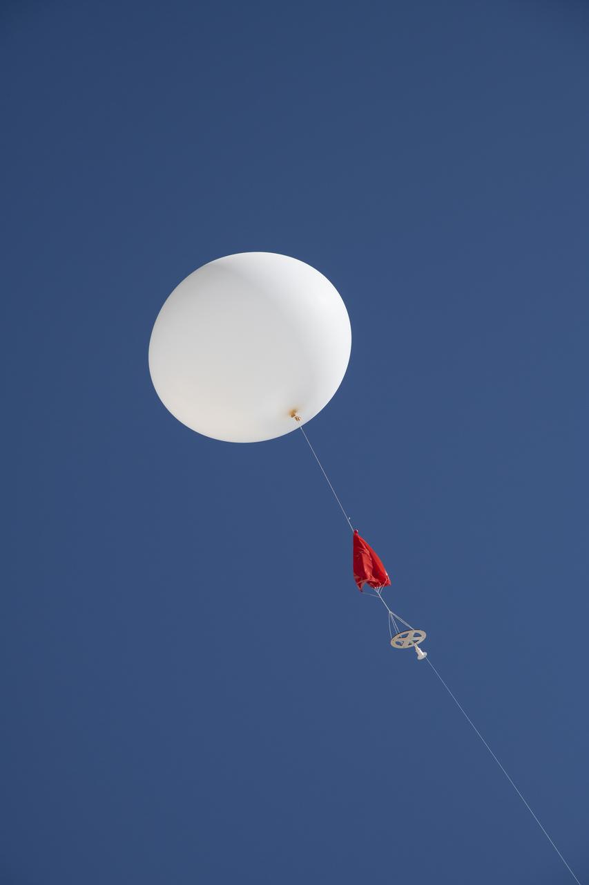
A weather balloon is launched to collect wind data for the Advanced Exploration of Reliable Operation at Low Altitudes: Meteorology, Simulation and Technology campaign. The weather study was at NASA’s Armstrong Flight Research Center in Edwards, California. The focus was to study wind from the ground to 2,000 feet to provide data to assist future drones to safely land on rooftop hubs called vertiports and to potentially improve weather prediction.
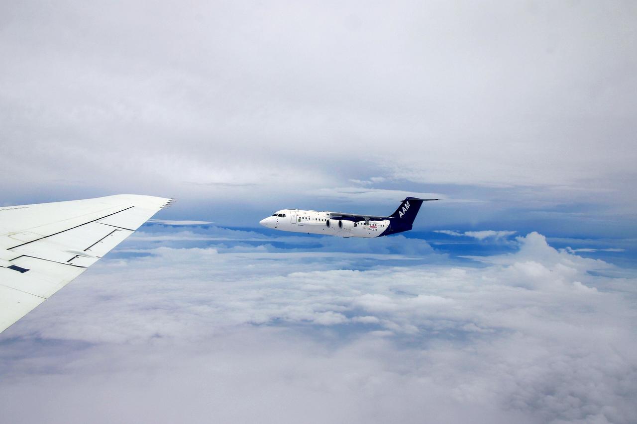
DC-8 NAMMA (NASA African Monson Multidisciplinary Analyses) MISSION TO CAPE VERDE, AFRICA Formation flight with the U.K's Meteorological Office's BAE-146 Research aircraft off the coast of West Africa

The Eastern U.S., Europe, and Japan are brightly lit by their cities, while interiors of Africa, Asia, Australia, and South America are dark and lightly populated in this image created in 2000 by NASA Goddard Space Flight Center.
KENNEDY SPACE CENTER, FLA. - At Weather Station A, Cape Canaveral Air Force Station, Judy Kelley, supervisor of Meteorology Operations, and Stephen Ezell, meteorological systems operator, get ready to release a weather balloon. Such balloons are released twice a day. The package at the bottom is a radio sonde that collects temperature and humidity data as the balloon rises. The data is released to agencies nationwide, including the 45th Space Wing, which uses the data for its daily weather reports. The weather station provides additional data to NASA for launches -- releasing 12 balloons in eight hours prior to liftoff - and landings - releasing 5 balloons in six and a half hours before expected touchdown.
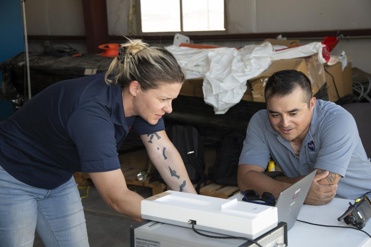
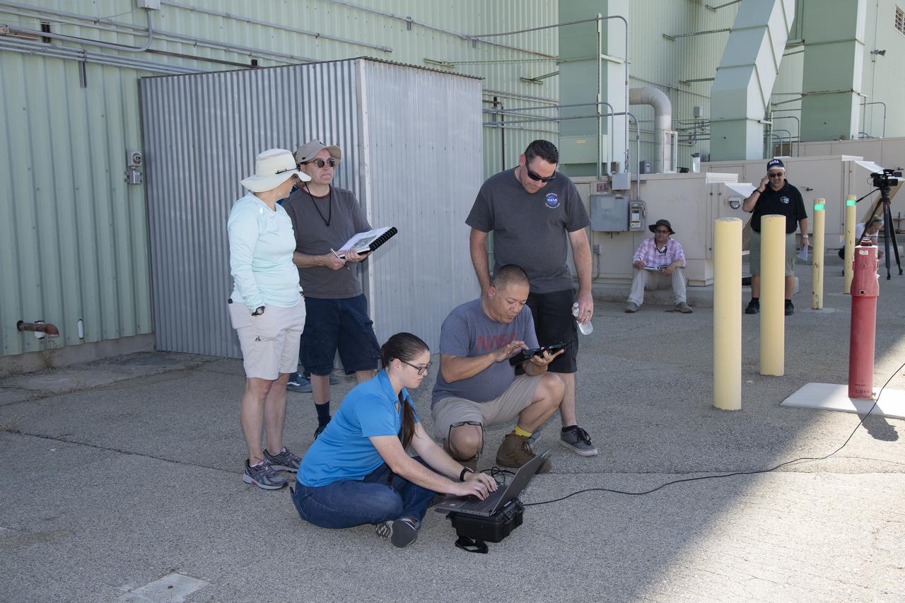
Tegan French and Rocky Garcia are at a weather balloon system’s ground station monitoring temperature, humidity, pressure, and winds transmitted from an instrument package on the balloon as it ascends. The balloon is part of the different methods to collect wind and weather data for the Advanced Exploration of Reliable Operation at Low Altitudes: Meteorology, Simulation and Technology campaign. The weather study was at NASA’s Armstrong Flight Research Center in Edwards, California. The focus was to study wind from the ground to 2,000 feet to provide data to assist future drones to safely land on rooftop hubs called vertiports and to potentially improve weather prediction.
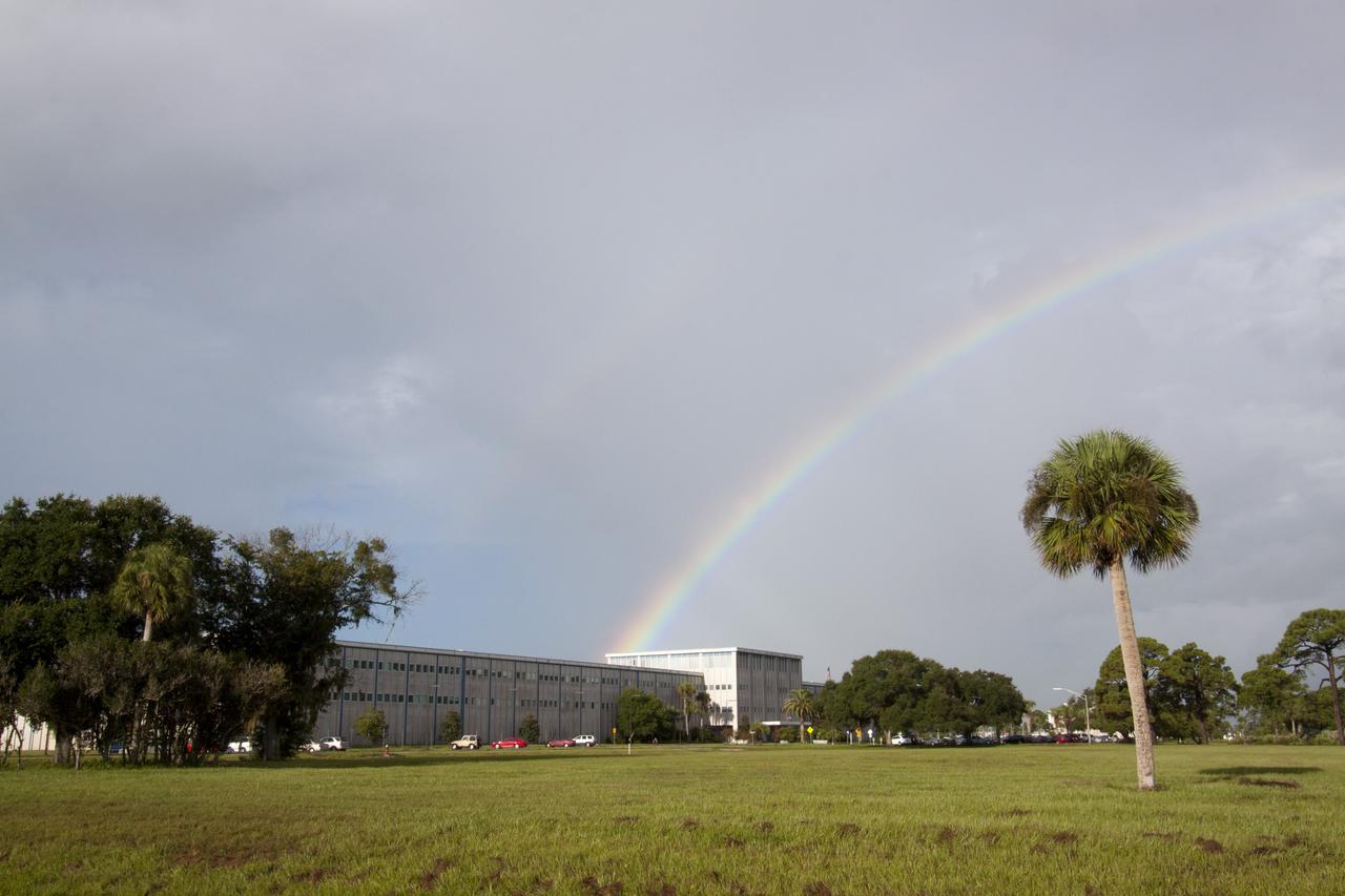
CAPE CANAVERAL, Fla. -- As the sun was rising over NASA's Kennedy Space Center in Florida, an early morning rain shower caused a meteorological and optical rainbow show over the Headquarters building. Florida's Space Coast often is the scene of showers and thunderstorms during the summer months. Photo credit: NASA/Jack Pfaller
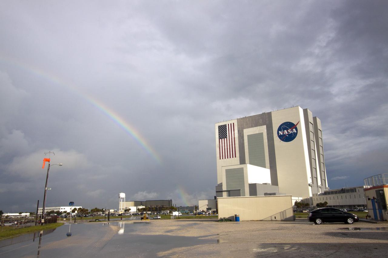
CAPE CANAVERAL, Fla. -- As the sun was rising over NASA's Kennedy Space Center in Florida, an early morning rain shower caused a meteorological and optical rainbow show next to the Vehicle Assembly Building. Florida's Space Coast often is the scene of showers and thunderstorms during the summer months. Photo credit: NASA/Jack Pfaller
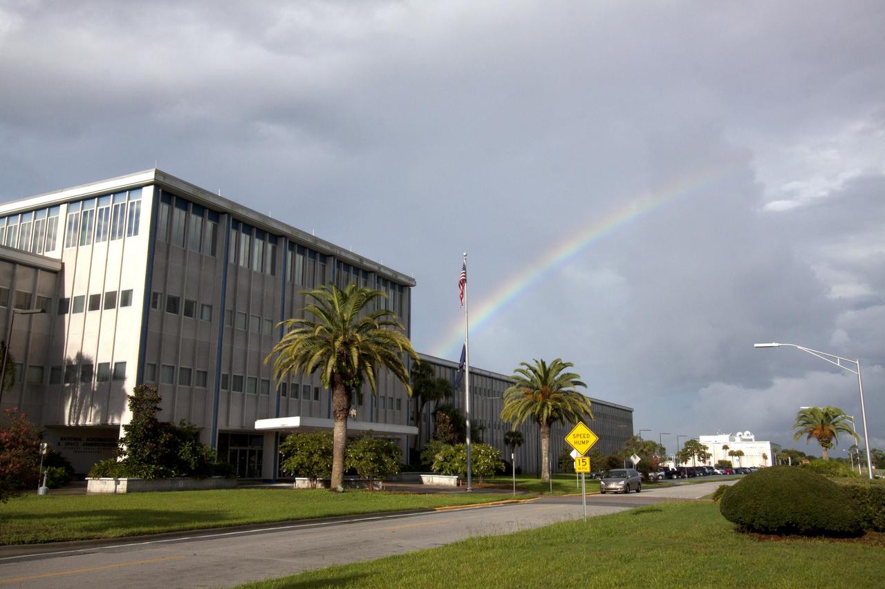
CAPE CANAVERAL, Fla. -- As the sun was rising over NASA's Kennedy Space Center in Florida, an early morning rain shower caused a meteorological and optical rainbow show over the Headquarters building. Florida's Space Coast often is the scene of showers and thunderstorms during the summer months. Photo credit: NASA/Jack Pfaller

At the Hurricane Katrina observance held Aug. 29 in the StenniSphere auditorium, Stennis Space Center Deputy Director David Throckmorton (left) and RAdm. Timothy McGee, Commander, Naval Meteorology and Oceanography Command, unveil a plaque dedicated to SSC employees.

Workers at the Astrotech processing facility in Titusville prepared for a news media showing of the Geostationary Operational Environmental Satellite-1 (GOES-1). GOES-1 was the first in a new generation of weather satellites deployed above Earth. It was the first 3-axis, body-stabilized meteorological satellite to be used by the National Oceanic Atmospheric Administration (NOAA) and NASA. These features allowed GOES-1 to continuously monitor the Earth, rather than viewing it just five percent of the time as was the case with spin-stabilized meteorological satellites. GOES-1 also has independent imaging and sounding instruments which can operate simultaneously yet independently. As a result, observations provided by each instrument will not be interrupted. The imager produces visual and infrared images of the Earth's surface, oceans, cloud cover and severe storm development, while the prime sounding products include vertical temperature and moisture profiles, and layer mean moisture.
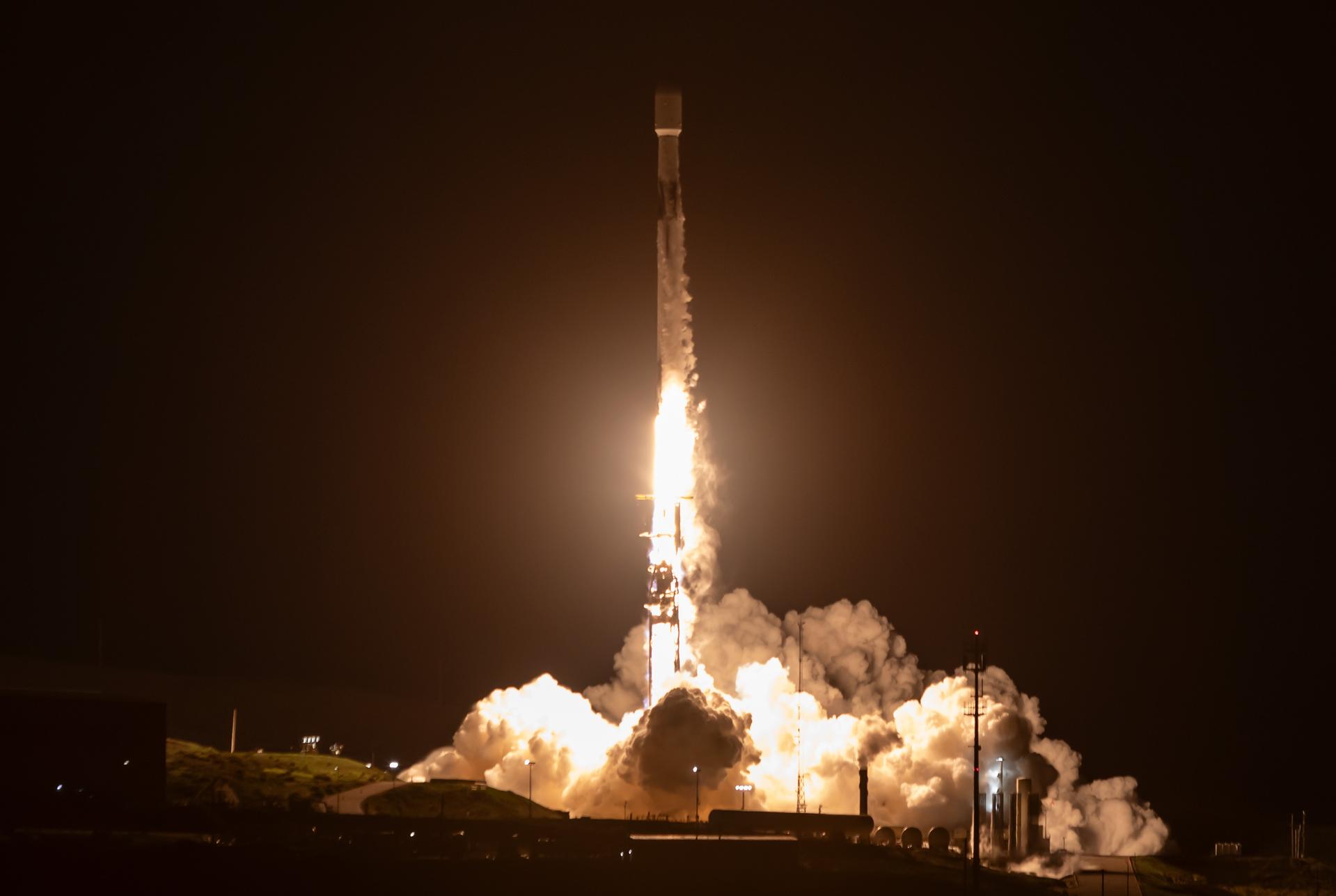
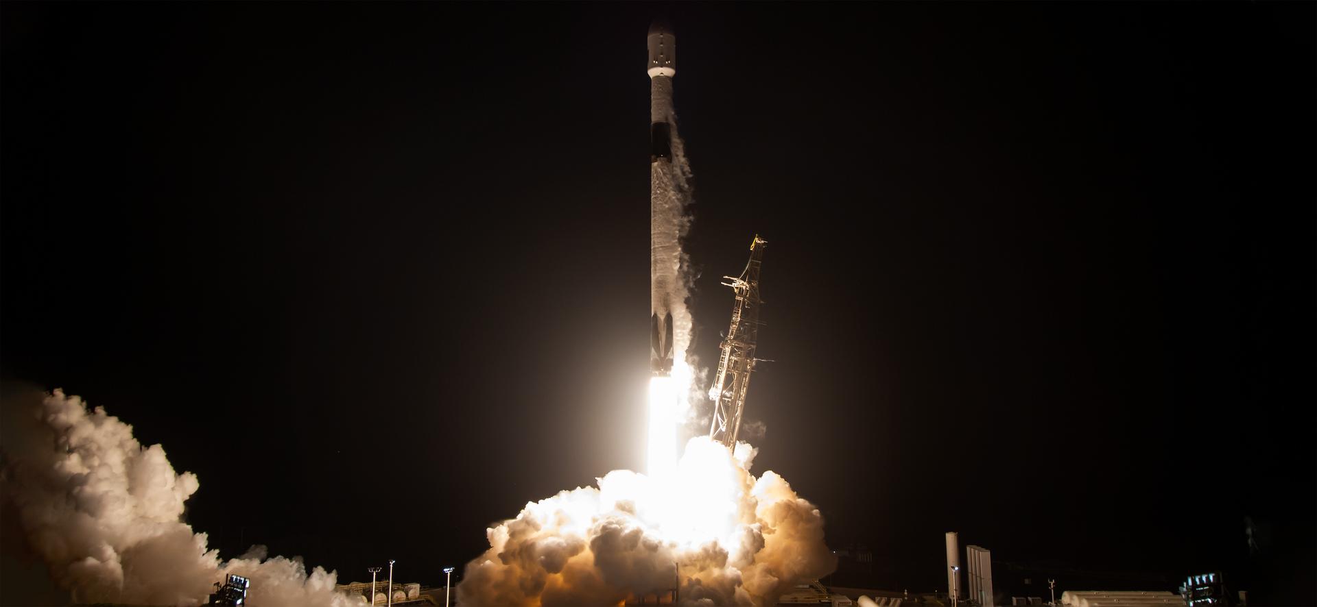
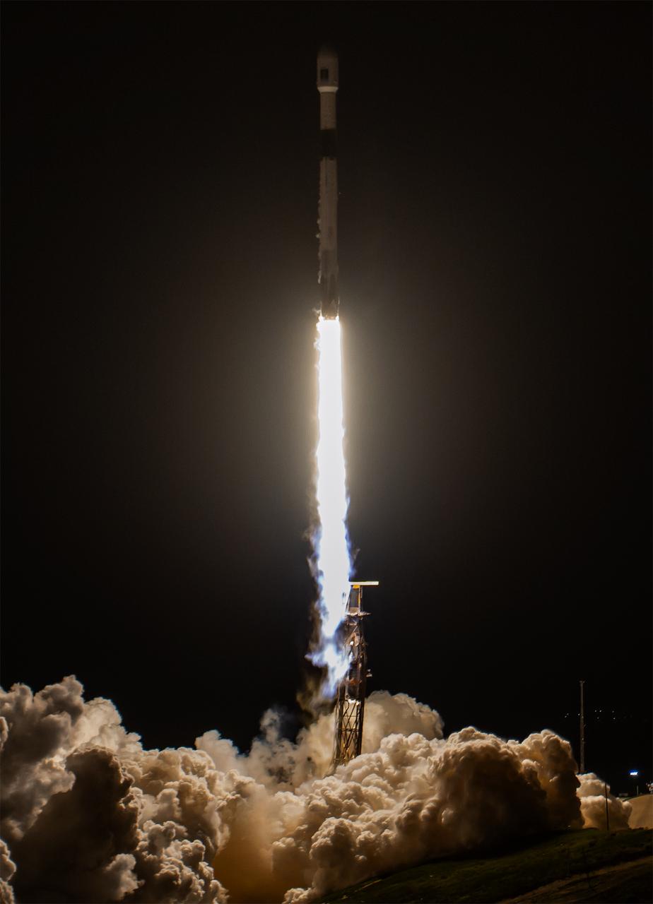
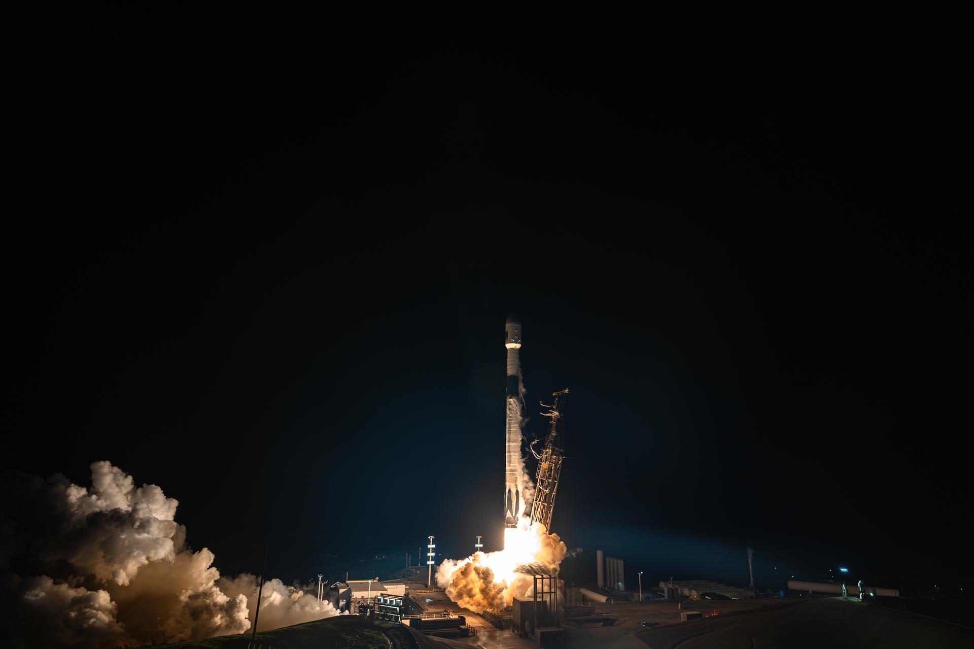
A SpaceX Falcon 9 rocket carrying the international Sentinel-6B spacecraft lifts off from Space Launch Complex 4 East at Vandenberg Space Force Base in California at 9:21 p.m. PST Sunday, Nov. 16, 2025. A collaboration between NASA, ESA (European Space Agency), EUMETSAT (European Organisation for the Exploitation of Meteorological Satellites), and the National Oceanic and Atmospheric Administration (NOAA), Sentinel-6B is designed to measure sea levels down to roughly an inch for about 90% of the world’s oceans.
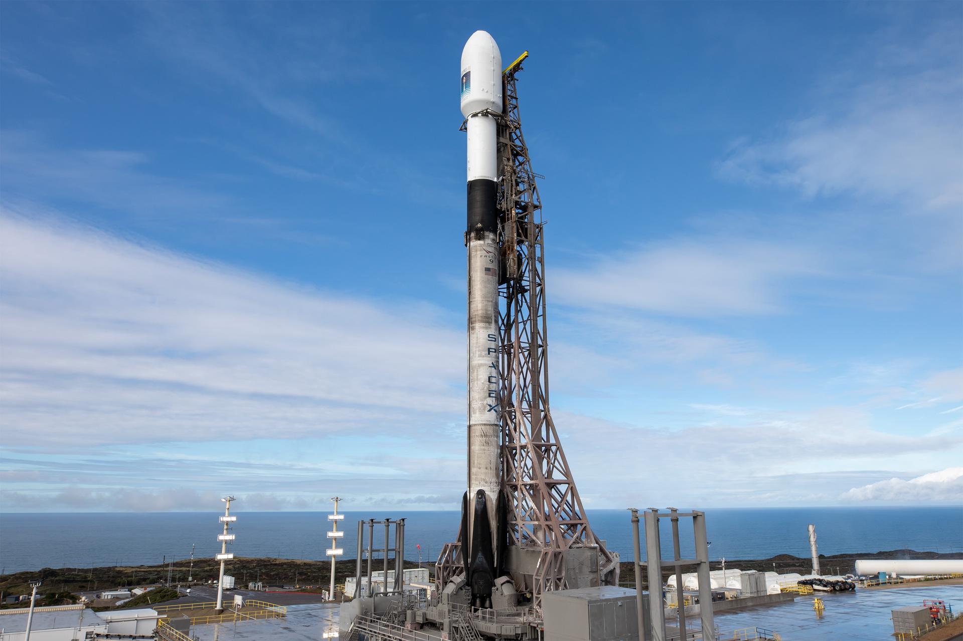
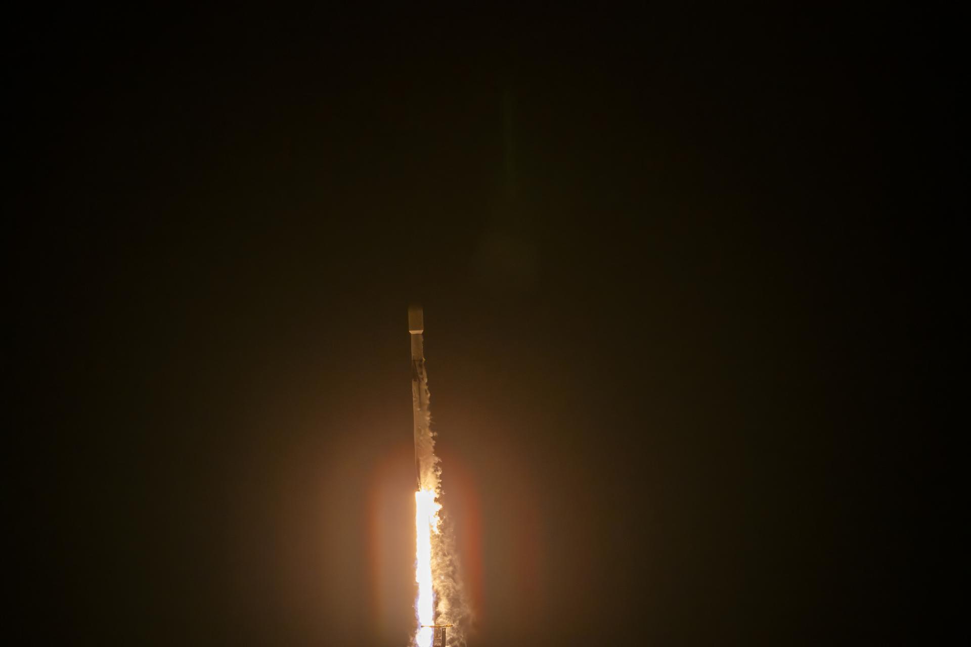
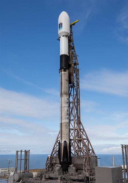
A SpaceX rocket carrying the Sentinel-6B satellite stands vertical on the launch pad at Space Launch Complex 4 East at Vandenberg Space Force Base in California on Sunday, Nov. 16, 2025, ahead of launch targeted for no earlier than 9:21 p.m. PST. A collaboration between NASA, ESA (European Space Agency), EUMETSAT (European Organisation for the Exploitation of Meteorological Satellites), and the National Oceanic and Atmospheric Administration (NOAA), Sentinel-6B is designed to measure sea levels down to roughly an inch for about 90% of the world’s oceans.
Workers at Astrotech, Titusville, Fla., work on the GOES-M satellite. The GOES-M provides weather imagery and quantitative sounding data used to support weather forecasting, severe storm tracking and meteorological research. The satellite is undergoing testing at Astrotech before its scheduled launch July 12 on an Atlas-IIA booster, Centaur upper stage from Cape Canaveral Air Force Station

Stennis Space Center Director Patrick Scheuermann (right) and Naval Meteorology and Oceanography Command Chief of Staff James Pettigrew drop the first shovelfuls of dirt on a time capsule to be opened on the rocket engine test facility's 100th anniversary in 2061. The time capsule was placed in front of the Roy S. Estess Building on Oct. 25 as Stennis concluded celebrations of its 50th anniversary. NASA publicly announced plans to build the rocket engine test site Oct. 25, 1961.
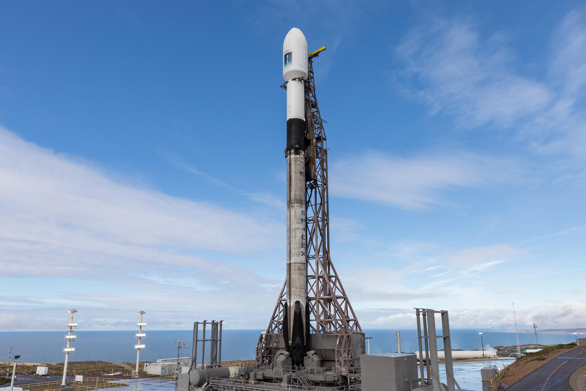
A SpaceX rocket carrying the Sentinel-6B satellite stands vertical on the launch pad at Space Launch Complex 4 East at Vandenberg Space Force Base in California on Sunday, Nov. 16, 2025, ahead of launch targeted for no earlier than 9:21 p.m. PST. A collaboration between NASA, ESA (European Space Agency), EUMETSAT (European Organisation for the Exploitation of Meteorological Satellites), and the National Oceanic and Atmospheric Administration (NOAA), Sentinel-6B is designed to measure sea levels down to roughly an inch for about 90% of the world’s oceans.
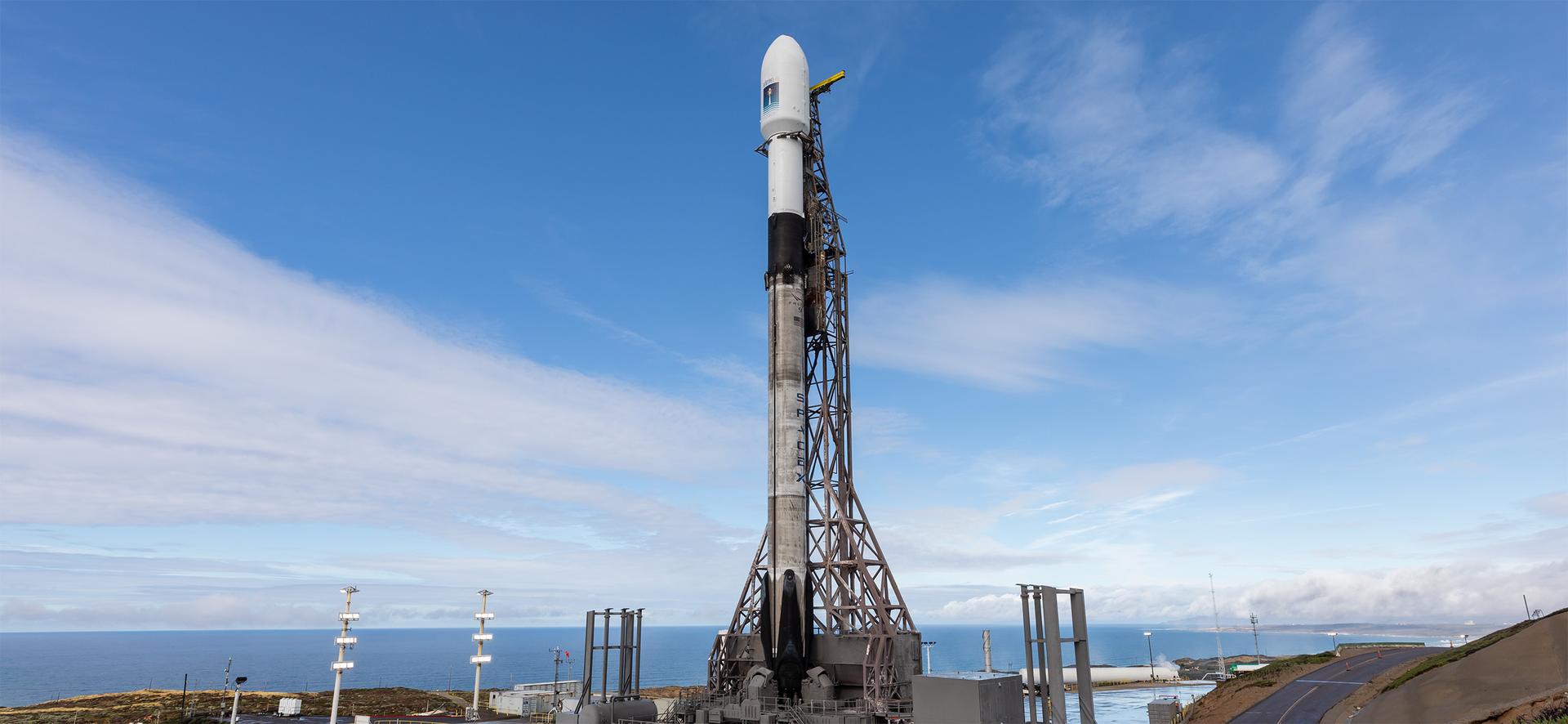
A SpaceX rocket carrying the Sentinel-6B satellite stands vertical on the launch pad at Space Launch Complex 4 East at Vandenberg Space Force Base in California on Sunday, Nov. 16, 2025, ahead of launch targeted for no earlier than 9:21 p.m. PST. A collaboration between NASA, ESA (European Space Agency), EUMETSAT (European Organisation for the Exploitation of Meteorological Satellites), and the National Oceanic and Atmospheric Administration (NOAA), Sentinel-6B is designed to measure sea levels down to roughly an inch for about 90% of the world’s oceans.
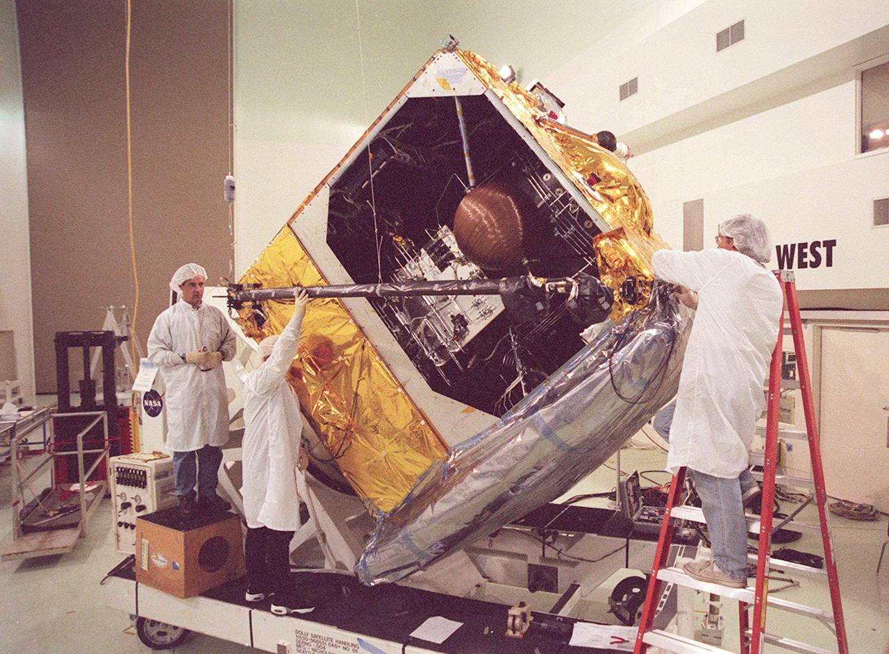
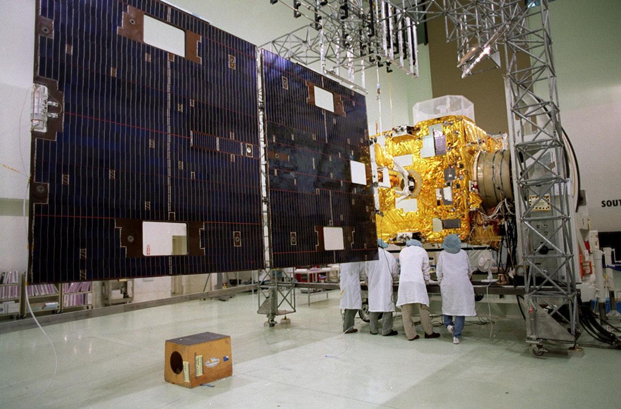
Workers at Astrotech, Titusville, Fla., begin deploying the magnetometer boom on the GOES-M satellite. The satellite is undergoing testing at Astrotech. The GOES-M provides weather imagery and quantitative sounding data used to support weather forecasting, severe storm tracking and meteorological research. The satellite is scheduled to launch July 12 on an Atlas-IIA booster, Centaur upper stage from Cape Canaveral Air Force Station
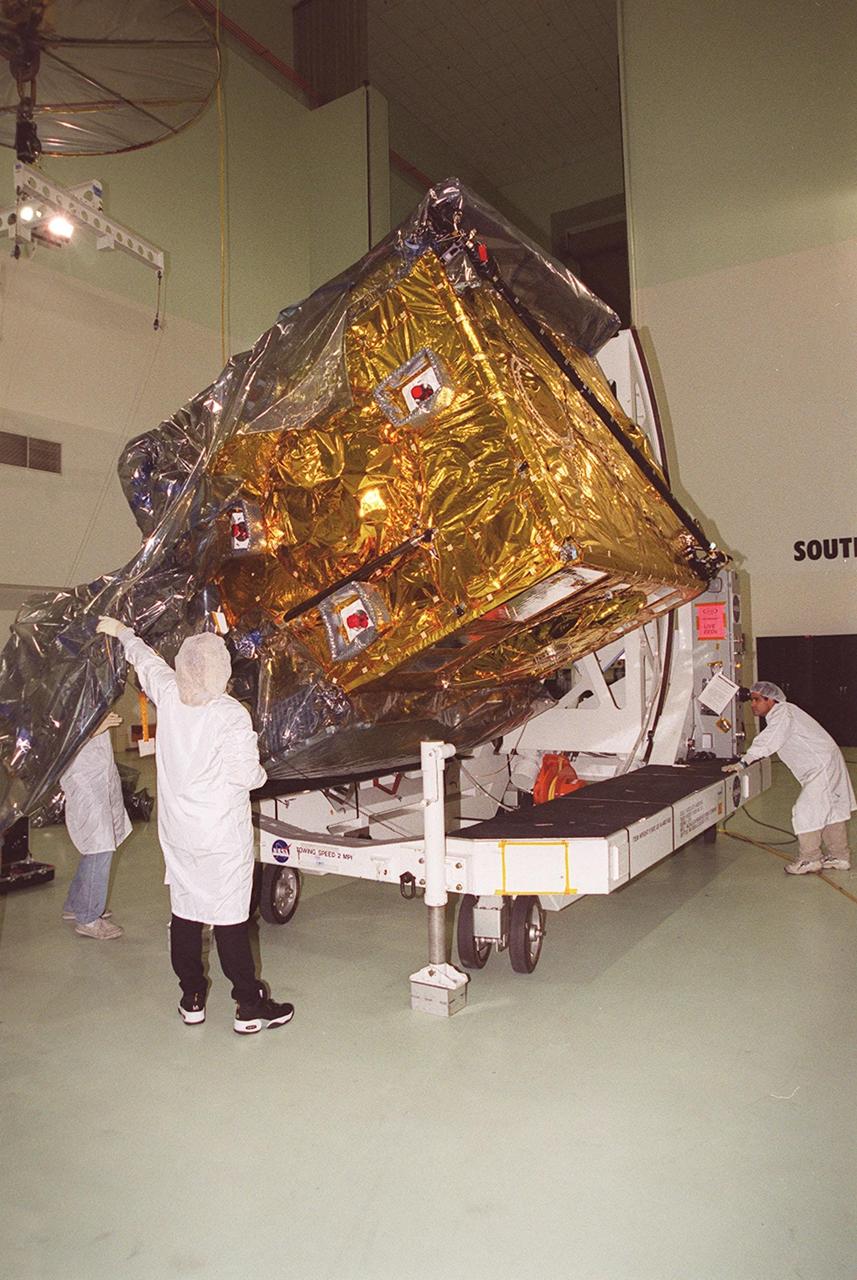
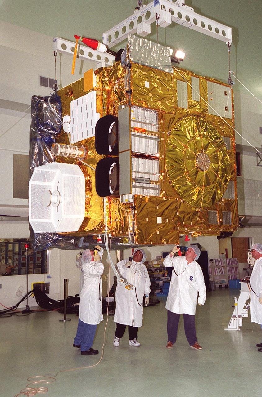
KENNEDY SPACE CENTER, FLA. -- After arrival at Astrotech, Titusville, Fla., the GOES-M (Geostationary Operational Environmental Satellite) is attached to an overhead crane. The GOES-M provides weather imagery and quantitative sounding data used to support weather forecasting, severe storm tracking and meteorological research. The satellite will undergo testing at Astrotech before its scheduled launch July 12 on an Atlas-IIA booster, Centaur upper stage from Cape Canaveral Air Force Station
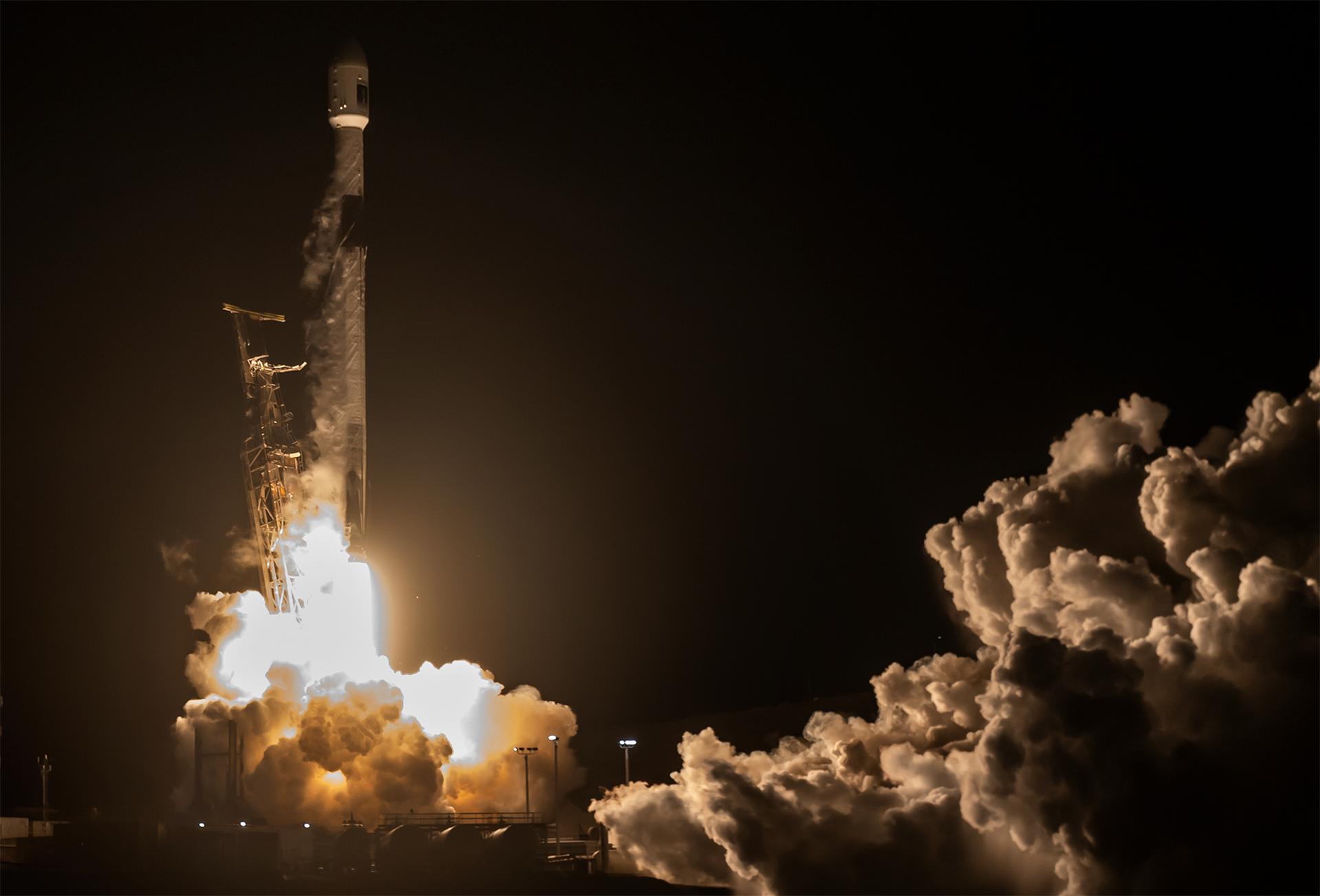
A SpaceX Falcon 9 rocket carrying the international Sentinel-6B spacecraft lifts off from Space Launch Complex 4 East at Vandenberg Space Force Base in California at 9:21 p.m. PST Sunday, Nov. 16, 2025. A collaboration between NASA, ESA (European Space Agency), EUMETSAT (European Organisation for the Exploitation of Meteorological Satellites), and the National Oceanic and Atmospheric Administration (NOAA), Sentinel-6B is designed to measure sea levels down to roughly an inch for about 90% of the world’s oceans.
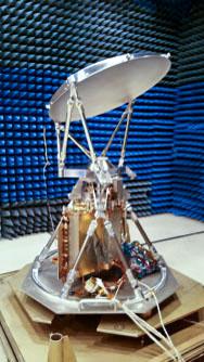
jsc2021e048037 (10/22/2021) --- A preflight view of COWVR during Antenna Range Testing. Space Test Program-Houston 8-Compact Ocean Wind Vector Radiometer (STP-H8-COWVR) demonstrates on-orbit use of a new terrestrial microwave meteorological sensor. It is designed to deliver accurate sea surface wind direction and speed data that are critical to naval surface operations and forecasting and tracking hurricanes and typhoons. Image courtesy of JPL.
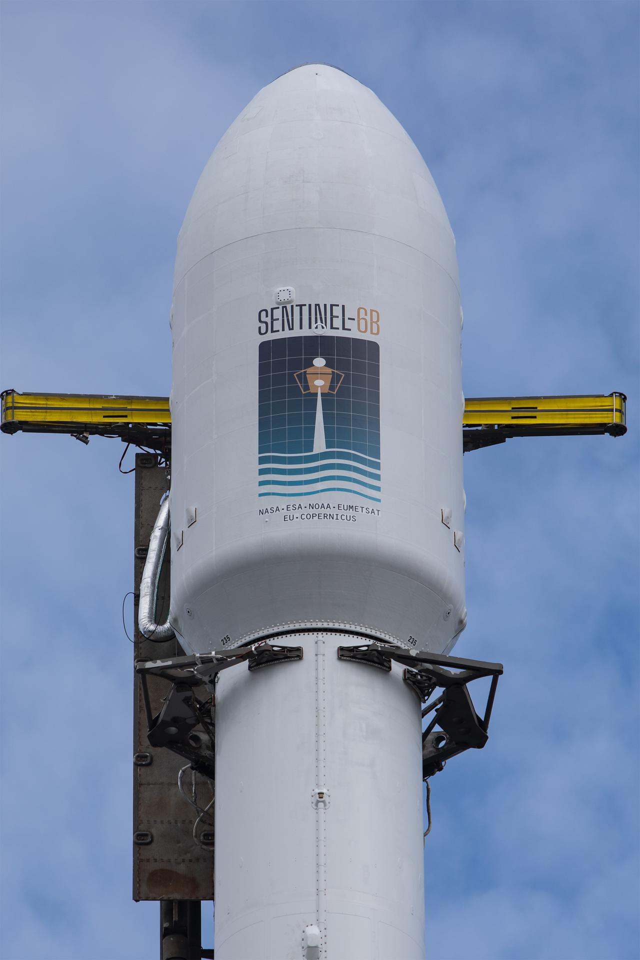
A SpaceX rocket carrying the Sentinel-6B satellite stands vertical on the launch pad at Space Launch Complex 4 East at Vandenberg Space Force Base in California on Sunday, Nov. 16, 2025, ahead of launch targeted for no earlier than 9:21 p.m. PST. A collaboration between NASA, ESA (European Space Agency), EUMETSAT (European Organisation for the Exploitation of Meteorological Satellites), and the National Oceanic and Atmospheric Administration (NOAA), Sentinel-6B is designed to measure sea levels down to roughly an inch for about 90% of the world’s oceans.
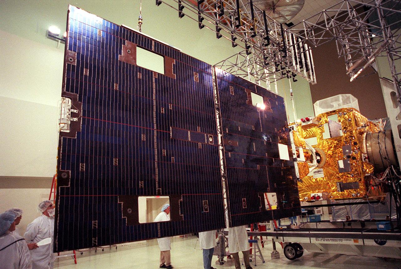
Workers at Astrotech, Titusville, Fla., take a close look at the solar panel on the GOES-M satellite. The GOES-M provides weather imagery and quantitative sounding data used to support weather forecasting, severe storm tracking and meteorological research. The satellite is scheduled to launch July 12 on an Atlas-IIA booster, Centaur upper stage from Cape Canaveral Air Force Station
jsc2021e0480388 (10/22/2021) --- A preflight view of COWVR during TVAC Testing. Space Test Program-Houston 8-Compact Ocean Wind Vector Radiometer (STP-H8-COWVR) demonstrates on-orbit use of a new terrestrial microwave meteorological sensor. It is designed to deliver accurate sea surface wind direction and speed data that are critical to naval surface operations and forecasting and tracking hurricanes and typhoons. Image courtesy of JPL.
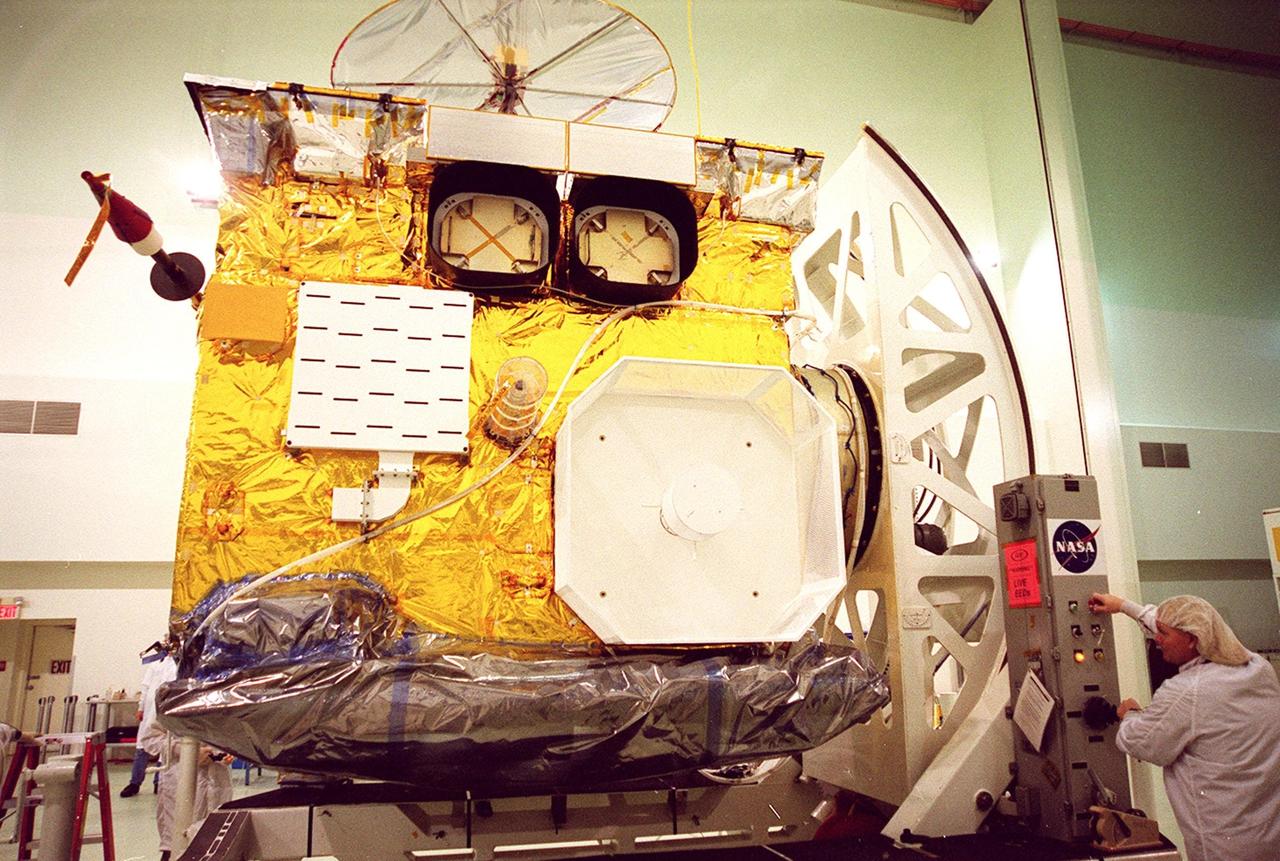
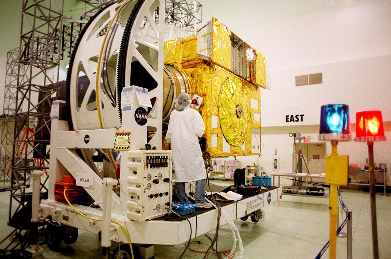
At Astrotech, Titusville, Fla., the GOES-M (Geostationary Operational Environmental Satellite) satellite is tilted on a workstand so that workers can remove the rest of the protective cover. The GOES-M provides weather imagery and quantitative sounding data used to support weather forecasting, severe storm tracking and meteorological research. The satellite will undergo testing at Astrotech before its scheduled launch July 12 on an Atlas-IIA booster, Centaur upper stage from Cape Canaveral Air Force Station
At Astrotech, Titusville, Fla., a worker (right) turns the GOES-M satellite, bringing its side into view. The GOES-M provides weather imagery and quantitative sounding data used to support weather forecasting, severe storm tracking and meteorological research. The satellite is undergoing testing at Astrotech before its scheduled launch July 12 on an Atlas-IIA booster, Centaur upper stage from Cape Canaveral Air Force Station
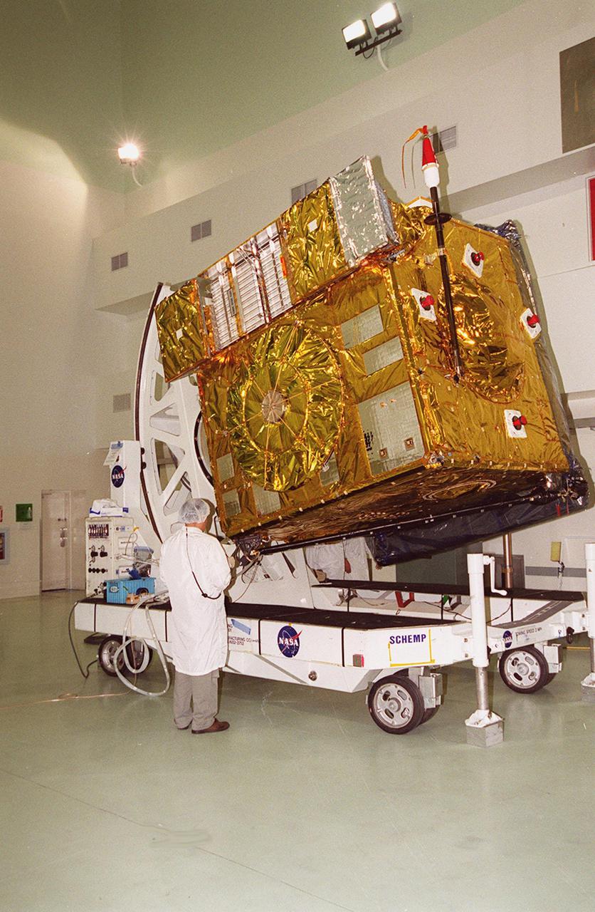
At Astrotech, Titusville, Fla., the GOES-M satellite is lifted at an angle on a workstand. The satellite is undergoing testing at Astrotech. The GOES-M provides weather imagery and quantitative sounding data used to support weather forecasting, severe storm tracking and meteorological research. The satellite is scheduled to launch July 12 on an Atlas-IIA booster, Centaur upper stage from Cape Canaveral Air Force Station
A SpaceX Falcon 9 rocket carrying the international Sentinel-6B spacecraft lifts off from Space Launch Complex 4 East at Vandenberg Space Force Base in California at 9:21 p.m. PST Sunday, Nov. 16, 2025. A collaboration between NASA, ESA (European Space Agency), EUMETSAT (European Organisation for the Exploitation of Meteorological Satellites), and the National Oceanic and Atmospheric Administration (NOAA), Sentinel-6B is designed to measure sea levels down to roughly an inch for about 90% of the world’s oceans.

KENNEDY SPACE CENTER, FLA. -- After arrival at Astrotech, Titusville, Fla., the GOES-M (Geostationary Operational Environmental Satellite) is attached to an overhead crane. The GOES-M provides weather imagery and quantitative sounding data used to support weather forecasting, severe storm tracking and meteorological research. The satellite will undergo testing at Astrotech before its scheduled launch July 12 on an Atlas-IIA booster, Centaur upper stage from Cape Canaveral Air Force Station
A SpaceX Falcon 9 rocket carrying the international Sentinel-6B spacecraft lifts off from Space Launch Complex 4 East at Vandenberg Space Force Base in California on Sunday, Nov. 16, 2025. A collaboration between NASA, ESA (European Space Agency), EUMETSAT (European Organisation for the Exploitation of Meteorological Satellites), and the National Oceanic and Atmospheric Administration (NOAA), Sentinel-6B is designed to measure sea levels down to roughly an inch for about 90% of the world’s oceans.

At Astrotech, Titusville, Fla., the GOES-M (Geostationary Operational Environmental Satellite) satellite is tilted on a workstand so that workers can remove part of the protective cover. The GOES-M provides weather imagery and quantitative sounding data used to support weather forecasting, severe storm tracking and meteorological research. The satellite will undergo testing at Astrotech before its scheduled launch July 12 on an Atlas-IIA booster, Centaur upper stage from Cape Canaveral Air Force Station

StenniSphere, the John C. Stennis Space Center's visitor center in Hancock County, Miss., features a 14,000-square-foot museum and outdoor exhibits about Stennis Space Center. Designed to entertain while educating, StenniSphere includes informative displays and exhibits from NASA, the Naval Meteorology and Oceanography Command, and other resident agencies. Recently named Mississippi's Travel Attraction of the Year, StenniSphere hosted a quarter of a million visitors in its first year and is a major school field trip destination.
Workers at Astrotech, Titusville, Fla., begin deploying the magnetometer boom on the GOES-M satellite. The satellite is undergoing testing at Astrotech. The GOES-M provides weather imagery and quantitative sounding data used to support weather forecasting, severe storm tracking and meteorological research. The satellite is scheduled to launch July 12 on an Atlas-IIA booster, Centaur upper stage from Cape Canaveral Air Force Station
A SpaceX Falcon 9 rocket carrying the international Sentinel-6B spacecraft lifts off from Space Launch Complex 4 East at Vandenberg Space Force Base in California at 9:21 p.m. PST Sunday, Nov. 16, 2025. A collaboration between NASA, ESA (European Space Agency), EUMETSAT (European Organisation for the Exploitation of Meteorological Satellites), and the National Oceanic and Atmospheric Administration (NOAA), Sentinel-6B is designed to measure sea levels down to roughly an inch for about 90% of the world’s oceans.
A SpaceX rocket carrying the Sentinel-6B satellite stands vertical on the launch pad at Space Launch Complex 4 East at Vandenberg Space Force Base in California on Sunday, Nov. 16, 2025, ahead of launch targeted for no earlier than 9:21 p.m. PST. A collaboration between NASA, ESA (European Space Agency), EUMETSAT (European Organisation for the Exploitation of Meteorological Satellites), and the National Oceanic and Atmospheric Administration (NOAA), Sentinel-6B is designed to measure sea levels down to roughly an inch for about 90% of the world’s oceans.
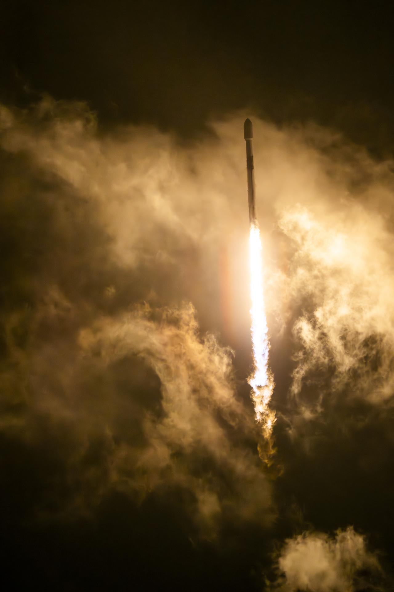
A SpaceX Falcon 9 rocket carrying the international Sentinel-6B spacecraft lifts off from Space Launch Complex 4 East at Vandenberg Space Force Base in California on Sunday, Nov. 16, 2025. A collaboration between NASA, ESA (European Space Agency), EUMETSAT (European Organisation for the Exploitation of Meteorological Satellites), and the National Oceanic and Atmospheric Administration (NOAA), Sentinel-6B is designed to measure sea levels down to roughly an inch for about 90% of the world’s oceans.
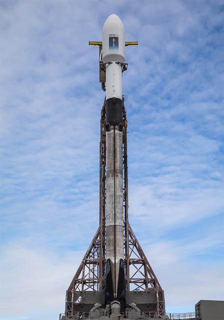
A SpaceX rocket carrying the Sentinel-6B satellite stands vertical on the launch pad at Space Launch Complex 4 East at Vandenberg Space Force Base in California on Sunday, Nov. 16, 2025, ahead of launch targeted for no earlier than 9:21 p.m. PST. A collaboration between NASA, ESA (European Space Agency), EUMETSAT (European Organisation for the Exploitation of Meteorological Satellites), and the National Oceanic and Atmospheric Administration (NOAA), Sentinel-6B is designed to measure sea levels down to roughly an inch for about 90% of the world’s oceans.
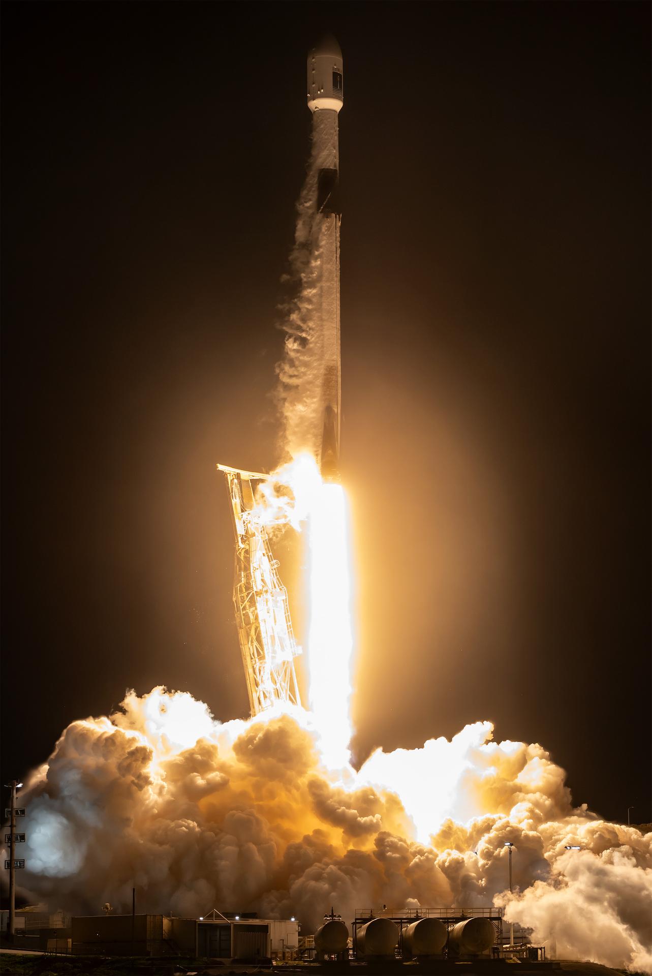
A SpaceX Falcon 9 rocket carrying the international Sentinel-6B spacecraft lifts off from Space Launch Complex 4 East at Vandenberg Space Force Base in California at 9:21 p.m. PST Sunday, Nov. 16, 2025. A collaboration between NASA, ESA (European Space Agency), EUMETSAT (European Organisation for the Exploitation of Meteorological Satellites), and the National Oceanic and Atmospheric Administration (NOAA), Sentinel-6B is designed to measure sea levels down to roughly an inch for about 90% of the world’s oceans.
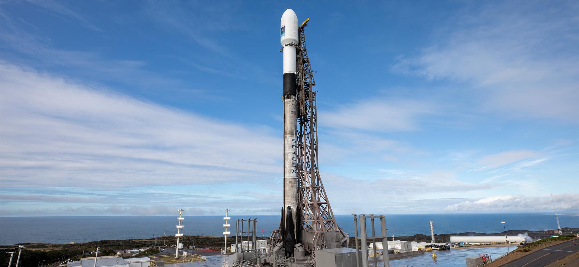
A SpaceX rocket carrying the Sentinel-6B satellite stands vertical on the launch pad at Space Launch Complex 4 East at Vandenberg Space Force Base in California on Sunday, Nov. 16, 2025, ahead of launch targeted for no earlier than 9:21 p.m. PST. A collaboration between NASA, ESA (European Space Agency), EUMETSAT (European Organisation for the Exploitation of Meteorological Satellites), and the National Oceanic and Atmospheric Administration (NOAA), Sentinel-6B is designed to measure sea levels down to roughly an inch for about 90% of the world’s oceans.

With the GOES-M satellite tilted on a workstand at Astrotech, Titusville, Fla, workers check out a part of the underside. The GOES-M provides weather imagery and quantitative sounding data used to support weather forecasting, severe storm tracking and meteorological research. The satellite is undergoing testing at Astrotech before its scheduled launch July 12 on an Atlas-IIA booster, Centaur upper stage from Cape Canaveral Air Force Station
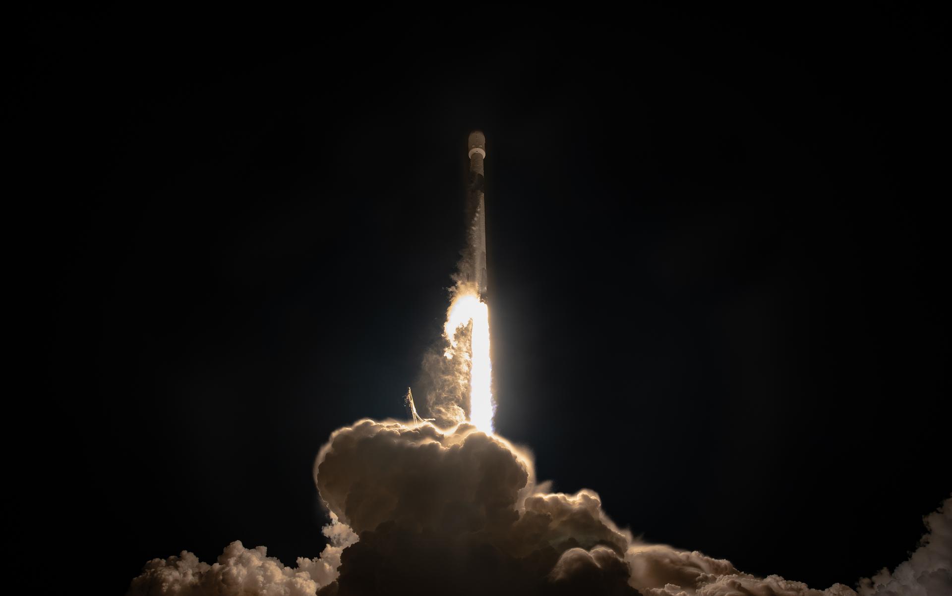
A SpaceX Falcon 9 rocket carrying the international Sentinel-6B spacecraft lifts off from Space Launch Complex 4 East at Vandenberg Space Force Base in California at 9:21 p.m. PST Sunday, Nov. 16, 2025. A collaboration between NASA, ESA (European Space Agency), EUMETSAT (European Organisation for the Exploitation of Meteorological Satellites), and the National Oceanic and Atmospheric Administration (NOAA), Sentinel-6B is designed to measure sea levels down to roughly an inch for about 90% of the world’s oceans.
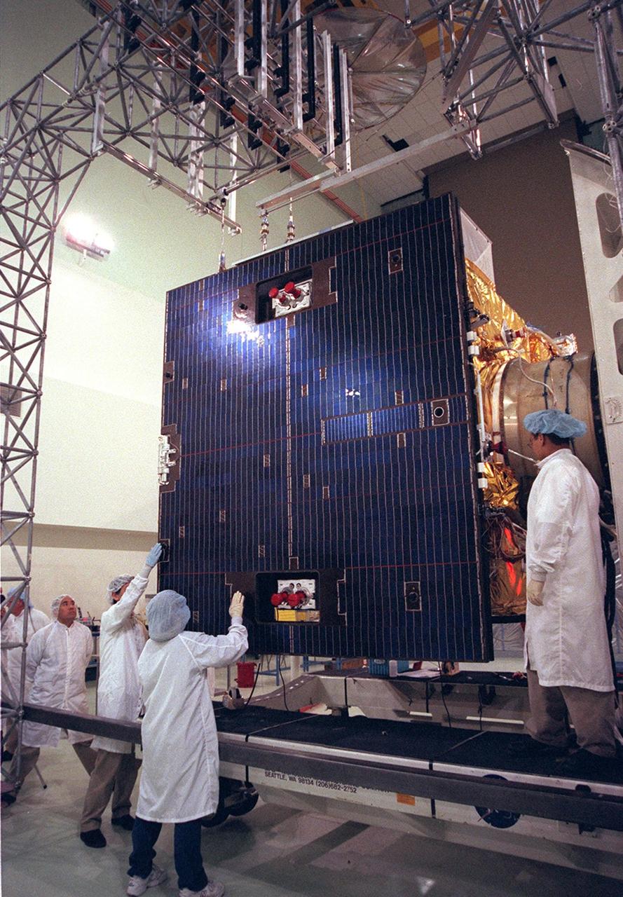
Workers at Astrotech, Titusville, Fla., prepare to open the solar panel on the GOES-M satellite. The GOES-M provides weather imagery and quantitative sounding data used to support weather forecasting, severe storm tracking and meteorological research. The satellite is scheduled to launch July 12 on an Atlas-IIA booster, Centaur upper stage from Cape Canaveral Air Force Station
At Astrotech, Titusville, Fla., a worker checks components of the GOES-M satellite. The GOES-M provides weather imagery and quantitative sounding data used to support weather forecasting, severe storm tracking and meteorological research. The satellite is scheduled to launch July 12 on an Atlas-IIA booster, Centaur upper stage from Cape Canaveral Air Force Station

51I-35-075 (30 Aug 1985) --- Typhoon Pat was photographed on the morning of August 30th at a position of approximately 25 degrees N, 131 degrees E. Stereoscopically-overlapping photographs taken by the 51I crew provide much more detail of the three-dimensional structure of tropical cyclones than can be determined from data returned from meteorological satellites. The 51I shuttle mission was launched on August 27 and landed September 3. The mission was flown in the space shuttle orbiter Discovery.
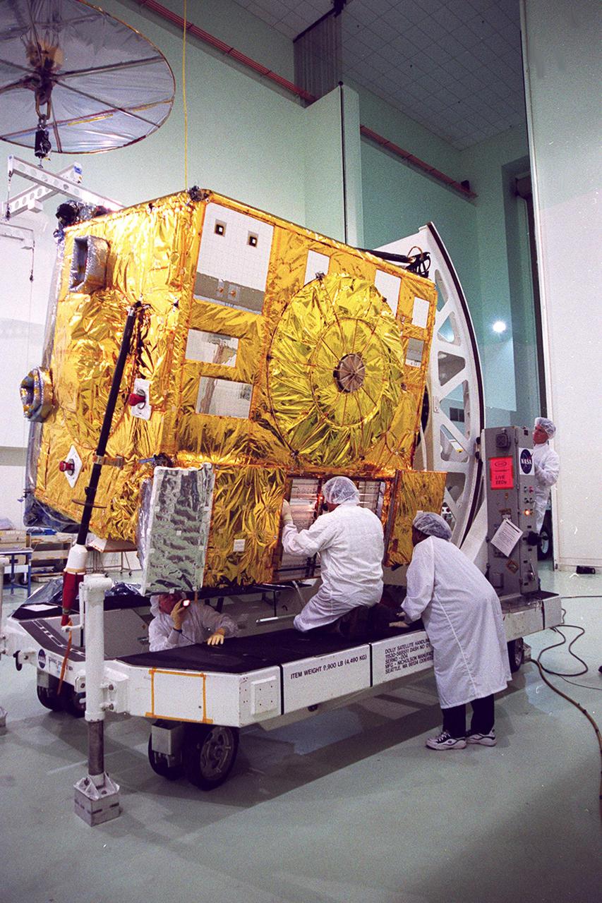
While an overhead crane lifts the GOES-M satellite at Astrotech, Titusville, Fla., workers check the underside. The GOES-M provides weather imagery and quantitative sounding data used to support weather forecasting, severe storm tracking and meteorological research. The satellite is undergoing testing at Astrotech before its scheduled launch July 12 on an Atlas-IIA booster, Centaur upper stage from Cape Canaveral Air Force Station
With the GOES-M satellite tilted on a workstand at Astrotech, Titusville, Fla, workers check out a part of the underside. The GOES-M provides weather imagery and quantitative sounding data used to support weather forecasting, severe storm tracking and meteorological research. The satellite is undergoing testing at Astrotech before its scheduled launch July 12 on an Atlas-IIA booster, Centaur upper stage from Cape Canaveral Air Force Station
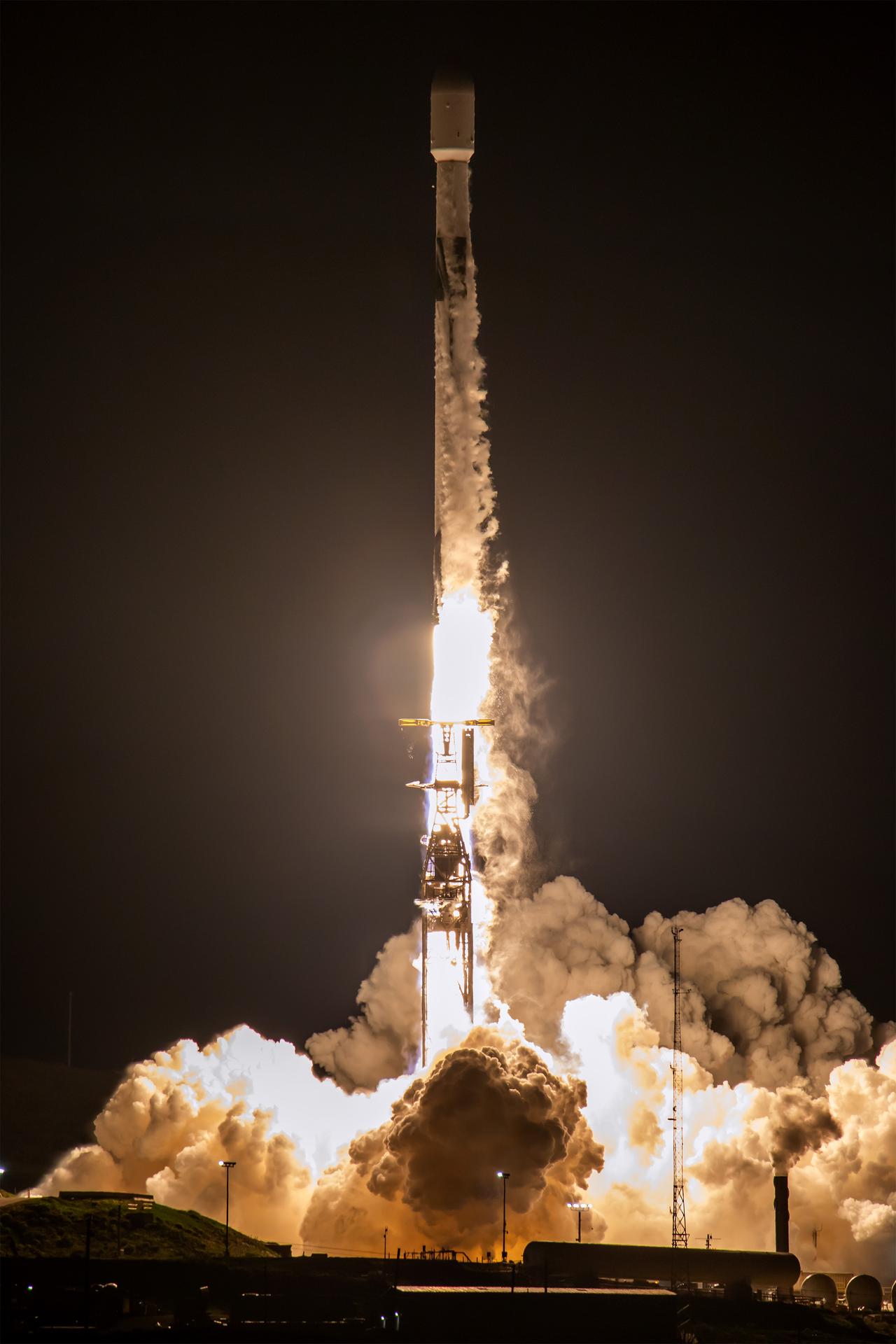
A SpaceX Falcon 9 rocket carrying the international Sentinel-6B spacecraft lifts off from Space Launch Complex 4 East at Vandenberg Space Force Base in California at 9:21 p.m. PST Sunday, Nov. 16, 2025. A collaboration between NASA, ESA (European Space Agency), EUMETSAT (European Organisation for the Exploitation of Meteorological Satellites), and the National Oceanic and Atmospheric Administration (NOAA), Sentinel-6B is designed to measure sea levels down to roughly an inch for about 90% of the world’s oceans.

At Astrotech, Titusville, Fla., the GOES-M satellite is lifted at an angle on a workstand. The satellite is undergoing testing at Astrotech. The GOES-M provides weather imagery and quantitative sounding data used to support weather forecasting, severe storm tracking and meteorological research. The satellite is scheduled to launch July 12 on an Atlas-IIA booster, Centaur upper stage from Cape Canaveral Air Force Station
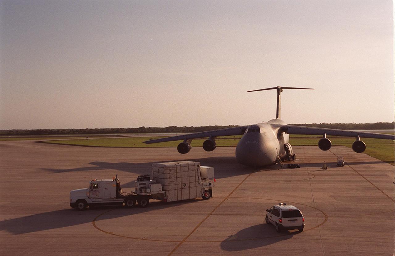
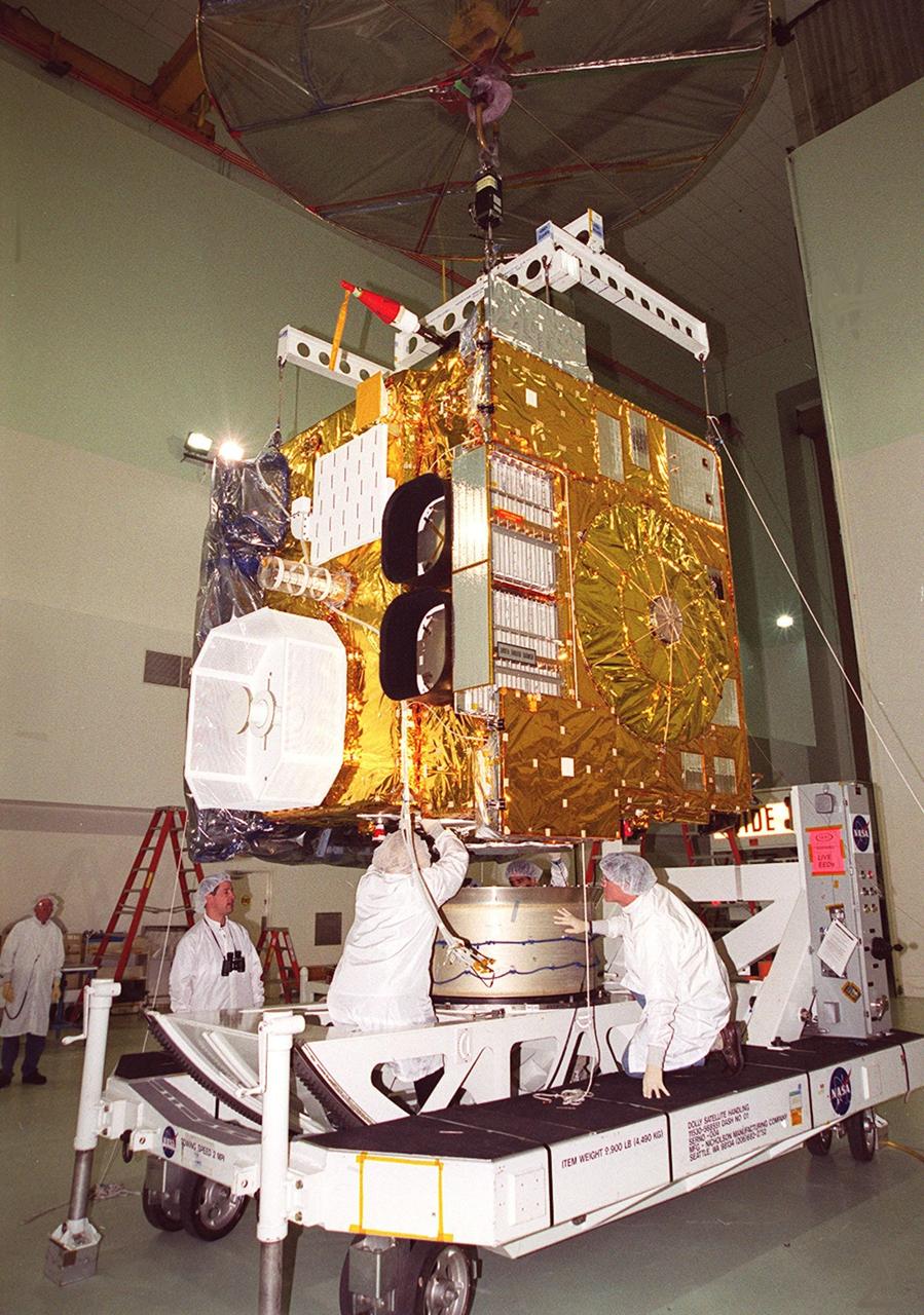
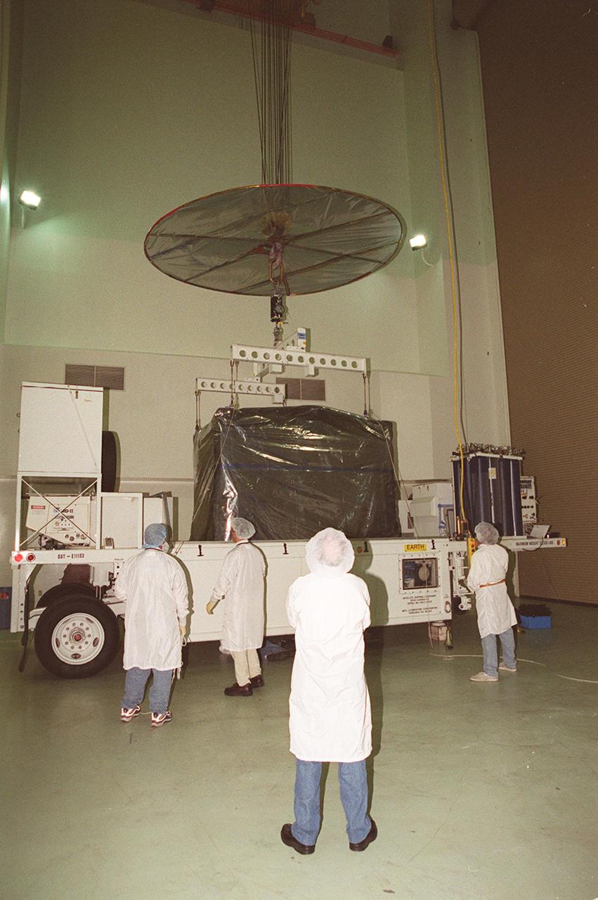
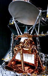
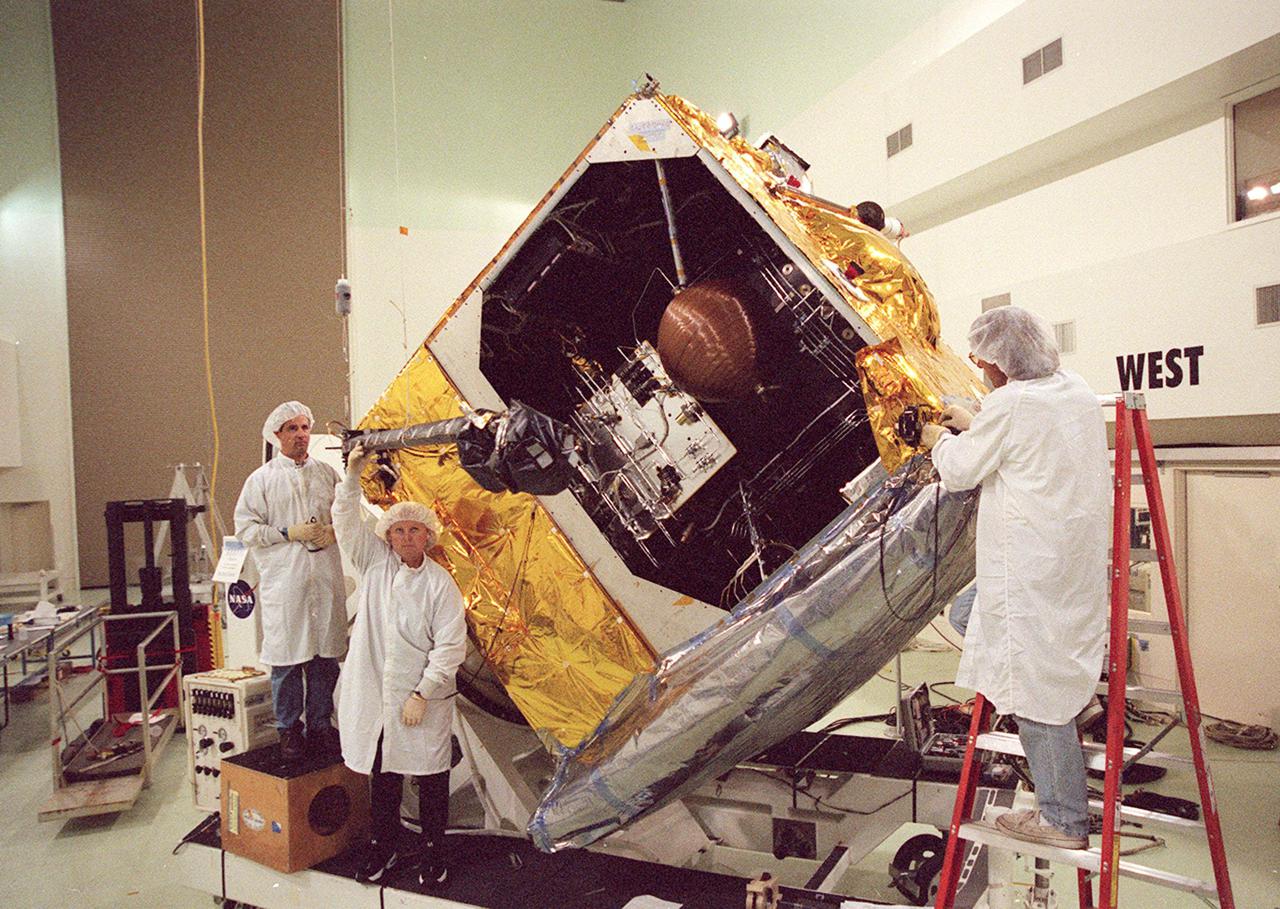
At the KSC Shuttle Landing Facility, the GOES-M satellite, encased in a container, begins its trek to Astrotech in Titusville, Fla., where it will undergo final testing. The GOES-M (Geostationary Operational Environmental Satellite, I-M Series) provides weather imagery and quantitative sounding data used to support weather forecasting, severe storm tracking, and meteorological research. The satellite is scheduled to be launched on an Atlas-IIA booster, with a Centaur upper stage, July 12 from Launch Pad 36-A, Cape Canaveral Air Force Station
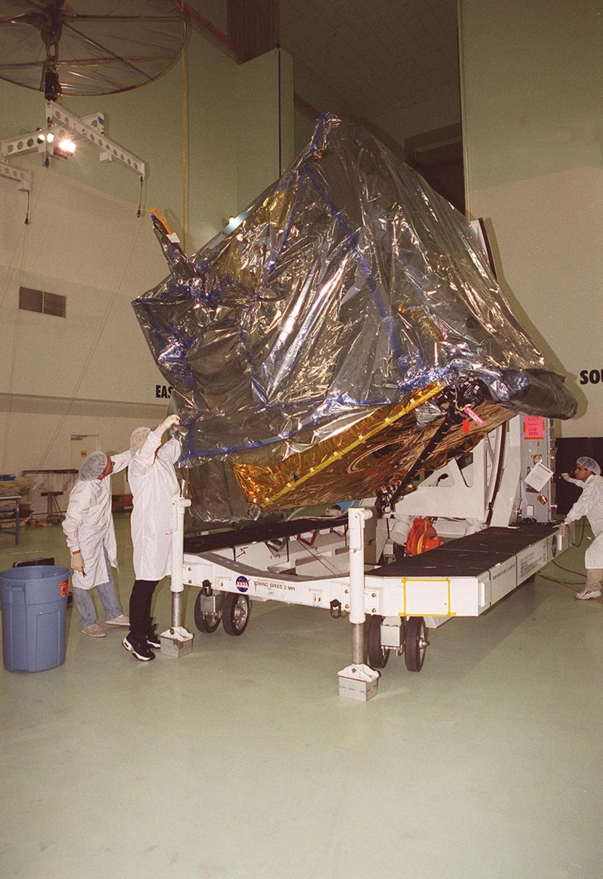
At Astrotech, Titusville, Fla., the GOES-M (Geostationary Operational Environmental Satellite) satellite is tilted on a workstand so that workers can remove part of the protective cover. The GOES-M provides weather imagery and quantitative sounding data used to support weather forecasting, severe storm tracking and meteorological research. The satellite will undergo testing at Astrotech before its scheduled launch July 12 on an Atlas-IIA booster, Centaur upper stage from Cape Canaveral Air Force Station

Workers at Astrotech, Titusville, Fla., begin deploying the magnetometer boom on the GOES-M satellite. The satellite is undergoing testing at Astrotech. The GOES-M provides weather imagery and quantitative sounding data used to support weather forecasting, severe storm tracking and meteorological research. The satellite is scheduled to launch July 12 on an Atlas-IIA booster, Centaur upper stage from Cape Canaveral Air Force Station
Workers at Astrotech, Titusville, Fla., look at components on the GOES-M satellite after opening the solar panel. The GOES-M provides weather imagery and quantitative sounding data used to support weather forecasting, severe storm tracking and meteorological research. The satellite is scheduled to launch July 12 on an Atlas-IIA booster, Centaur upper stage from Cape Canaveral Air Force Station
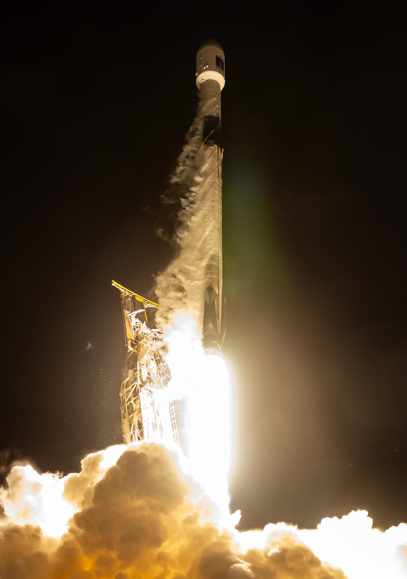
A SpaceX Falcon 9 rocket carrying the international Sentinel-6B spacecraft lifts off from Space Launch Complex 4 East at Vandenberg Space Force Base in California at 9:21 p.m. PST Sunday, Nov. 16, 2025. A collaboration between NASA, ESA (European Space Agency), EUMETSAT (European Organisation for the Exploitation of Meteorological Satellites), and the National Oceanic and Atmospheric Administration (NOAA), Sentinel-6B is designed to measure sea levels down to roughly an inch for about 90% of the world’s oceans.

Stennis Space Center Director Patrick Scheuermann (right) and Naval Meteorology and Oceanography Command Chief of Staff James Pettigrew drop the first shovelfuls of dirt on a time capsule to be opened on the rocket engine test facility's 100th anniversary in 2061. The time capsule was placed in front of the Roy S. Estess Building on Oct. 25 as Stennis concluded celebrations of its 50th anniversary.
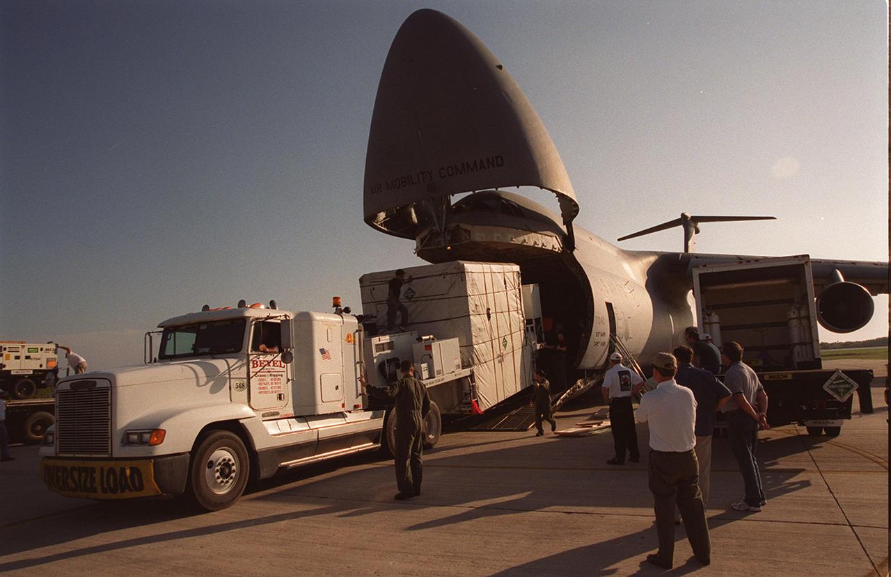
At the KSC Shuttle Landing Facility, the GOES-M satellite is offloaded from the yawning mouth of the C-5 aircraft. It will be transferred to Astrotech in Titusville, Fla., for final testing. The GOES-M (Geostationary Operational Environmental Satellite, I-M Series) provides weather imagery and quantitative sounding data used to support weather forecasting, severe storm tracking, and meteorological research. The satellite is scheduled to be launched on an Atlas-IIA booster, with a Centaur upper stage, July 12 from Launch Pad 36-A, Cape Canaveral Air Force Station

The John C. Stennis Space Center's visitor center, StenniSphere, is one of Mississippi's leading tourist attractions and features a 14,000-square-foot interactive review of Stennis Space Center's role in America's space program. Designed to entertain while educating, StenniSphere includes informative displays and exhibits from NASA, the Naval Meteorology and Oceanography Command, and other resident agencies located at Stennis Space Center in Hancock County, Miss.
A SpaceX Falcon 9 rocket carrying the international Sentinel-6B spacecraft lifts off from Space Launch Complex 4 East at Vandenberg Space Force Base in California at 9:21 p.m. PST Sunday, Nov. 16, 2025. A collaboration between NASA, ESA (European Space Agency), EUMETSAT (European Organisation for the Exploitation of Meteorological Satellites), and the National Oceanic and Atmospheric Administration (NOAA), Sentinel-6B is designed to measure sea levels down to roughly an inch for about 90% of the world’s oceans.