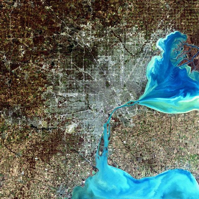
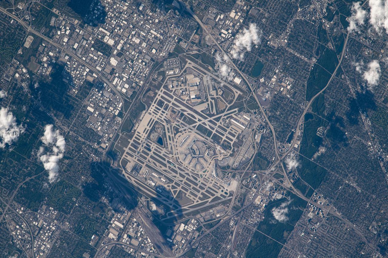
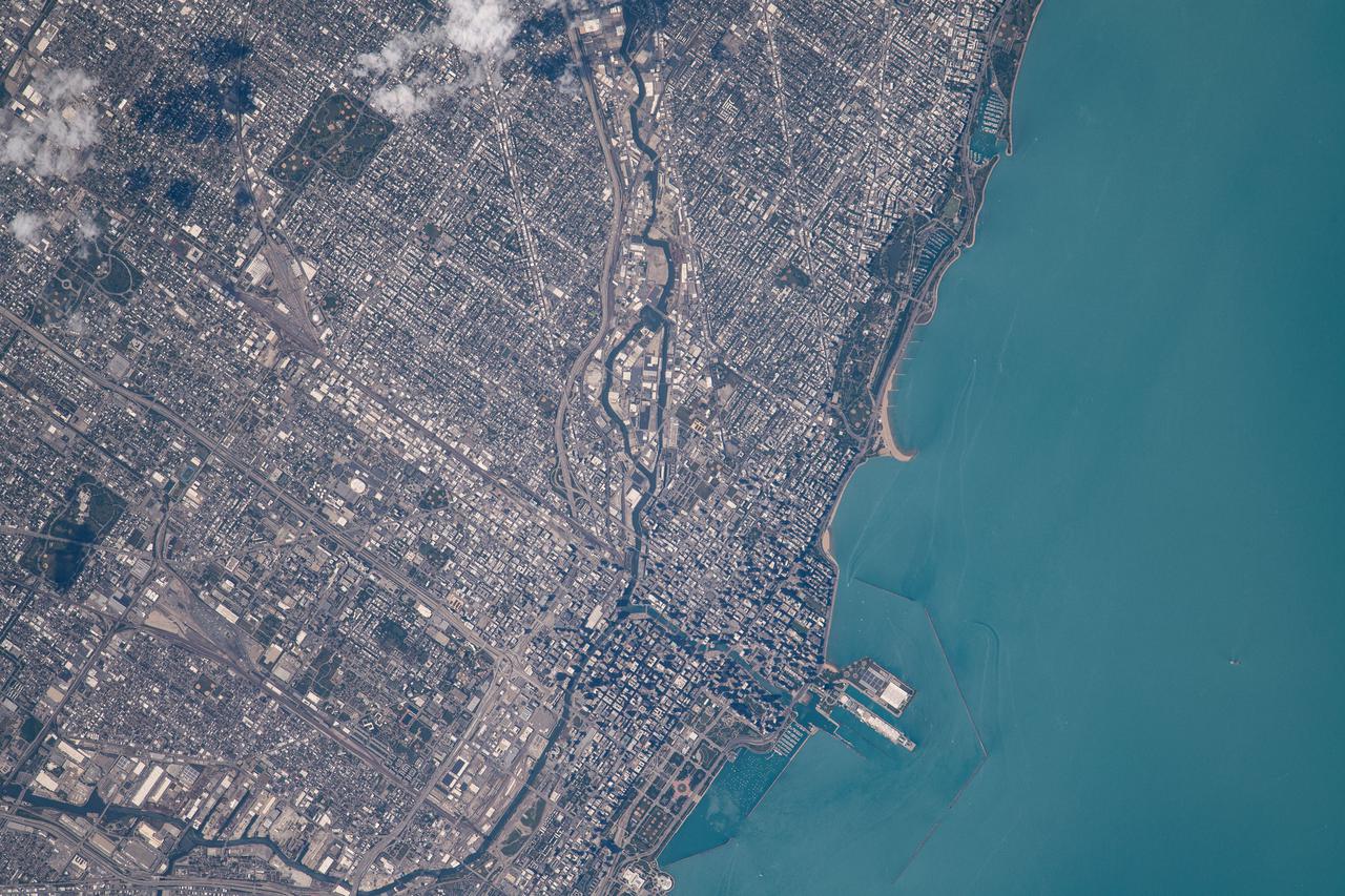
Detroit, Michigan, USA Sensor: L7 ETM+ Acquisition Date: December 11, 2001 Path/Row: 20/30 Lat/Long: 42.330/-83.046 Detroit, Michigan, is commonly referred to as Motor City because of the many automobile manufacturing plants located in the city. It is the largest city in Michigan, with a population approaching one million. Credit: NASA/Goddard/Landsat <b><a href="http://www.nasa.gov/audience/formedia/features/MP_Photo_Guidelines.html" rel="nofollow">NASA image use policy.</a></b> <b><a href="http://www.nasa.gov/centers/goddard/home/index.html" rel="nofollow">NASA Goddard Space Flight Center</a></b> enables NASA’s mission through four scientific endeavors: Earth Science, Heliophysics, Solar System Exploration, and Astrophysics. Goddard plays a leading role in NASA’s accomplishments by contributing compelling scientific knowledge to advance the Agency’s mission. <b>Follow us on <a href="http://twitter.com/NASA_GoddardPix" rel="nofollow">Twitter</a></b> <b>Like us on <a href="http://www.facebook.com/pages/Greenbelt-MD/NASA-Goddard/395013845897?ref=tsd" rel="nofollow">Facebook</a></b> <b>Find us on <a href="http://instagram.com/nasagoddard?vm=grid" rel="nofollow">Instagram</a></b>
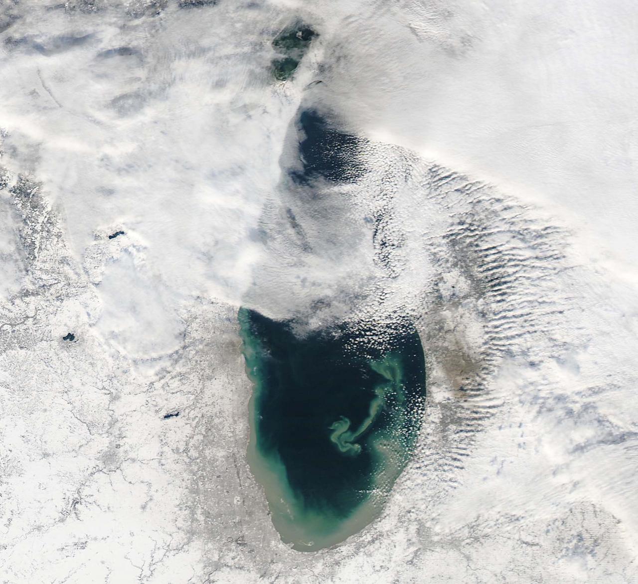
NASA image acquired December 17, 2010 In mid-December 2010, suspended sediments transformed the southern end of Lake Michigan. Ranging in color from brown to green, the sediment filled the surface waters along the southern coastline and formed a long, curving tendril extending toward the middle of the lake. The Moderate Resolution Imaging Spectroradiometer (MODIS) on NASA’s Aqua satellite captured these natural-color images on December 17, 2010 (top), and December 10, 2010 (bottom). Such sediment clouds are not uncommon in Lake Michigan, where winds influence lake circulation patterns. A scientificpaper published in 2007 described a model of the circulation, noting that while the suspended particles mostly arise from lake-bottom sediments along the western shoreline, they tend to accumulate on the eastern side. When northerly winds blow, two circulation gyres, rotating in opposite directions, transport sediment along the southern shoreline. As the northerly winds die down, the counterclockwise gyre predominates, and the smaller, clockwise gyre dissipates. Clear water—an apparent remnant of the small clockwise gyre—continues to interrupt the sediment plume. George Leshkevich, a researcher with the U.S. National Oceanic and Atmospheric Administration, explains that the wind-driven gyres erode lacustrine clay (very fine lakebed sediment) on the western shore before transporting it, along with re-suspended lake sediments, to the eastern shore. On the eastern side, the gyre encounters a shoreline bulge that pushes it toward the lake’s central southern basin, where it deposits the sediments. The sediment plume on December 17 followed a windy weather front in the region on December 16. NASA image courtesy MODIS Rapid Response Team at NASA GSFC. Caption by Michon Scott. Instrument: Aqua - MODIS <b><a href="http://www.nasa.gov/centers/goddard/home/index.html" rel="nofollow">NASA Goddard Space Flight Center</a></b> enables NASA’s mission through four scientific endeavors: Earth Science, Heliophysics, Solar System Exploration, and Astrophysics. Goddard plays a leading role in NASA’s accomplishments by contributing compelling scientific knowledge to advance the Agency’s mission. <b>Follow us on <a href="http://twitter.com/NASA_GoddardPix" rel="nofollow">Twitter</a></b> <b>Join us on <a href="http://www.facebook.com/pages/Greenbelt-MD/NASA-Goddard/395013845897?ref=tsd" rel="nofollow">Facebook</a></b> To read more about this image go to: <a href="http://earthobservatory.nasa.gov/IOTD/view.php?id=48511" rel="nofollow">earthobservatory.nasa.gov/IOTD/view.php?id=48511</a>

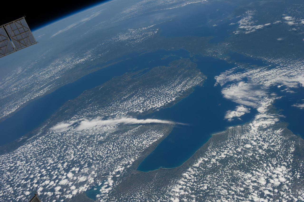
Mackinac Island, Michigan, is a small island off the northern coast of Lake Huron. What makes it special is that all cars and motor vehicles were banned in 1900 from the 3.8-sq-island, home to 600 year-round residents. Each year over 1 million tourists visit the island to enjoy its peace and tranquility. The scene was acquired August 9, 2021 , covers an area of 13.8 by 21.3 km, and is located at 45.8 degrees north, 84.6 degrees west. https://photojournal.jpl.nasa.gov/catalog/PIA26621
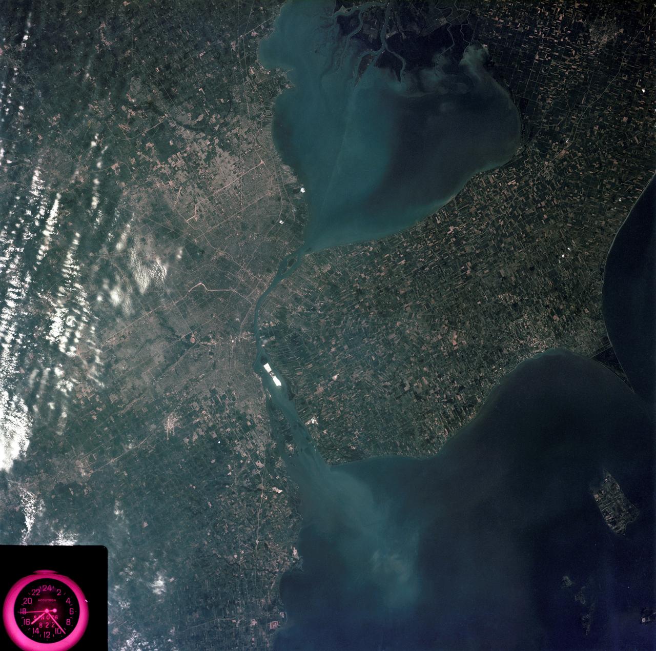
SL3-83-0152 (July-September 1973) --- A near vertical view of the metropolitan Detroit, Michigan area is seen in this Skylab 3 Earth Resources Experiments Package S190-B (five-inch Earth terrain camera) photograph taken from the Skylab space station in Earth orbit. The 25-mile long Detroit River drains the smaller body of water (Lake St. Clair) and flows southwestward separating Detroit from Windsor, Ontario, and empties into Lake Erie. The Detroit River handles a great deal of Great Lakes barge and ship traffic. Major streets and thoroughfares radiating from the city are clearly visible. Fighting Island is the highly reflective, white area located almost in the center of the picture. This high reflectivity is caused by the functional use of the island-disposal ponds for chemical salts. Sedimentation and/or pollution patterns in the area provide interesting visual phenomena for speculation and analysis. Distinct and rather unique cultivated field patterns can be observed south and east of Windsor, Ontario. This is a direct result of an English survey and land tenure system which was utilized when the area was settled. New areas of residential development are fairly easy to differentiate from older, established residential areas. Vegetation and extent of area coverage can be determined. The Oakland County Planning Commission and the Federal Bureau of Outdoor Recreation working closely with Irv Sattinger of the Environmental Research Institute of Michigan (University of Michigan) are presently processing and analyzing photographic and Multispectral scanner data to determine its usefulness for recreation and open space site studies for this area. Photo credit: NASA
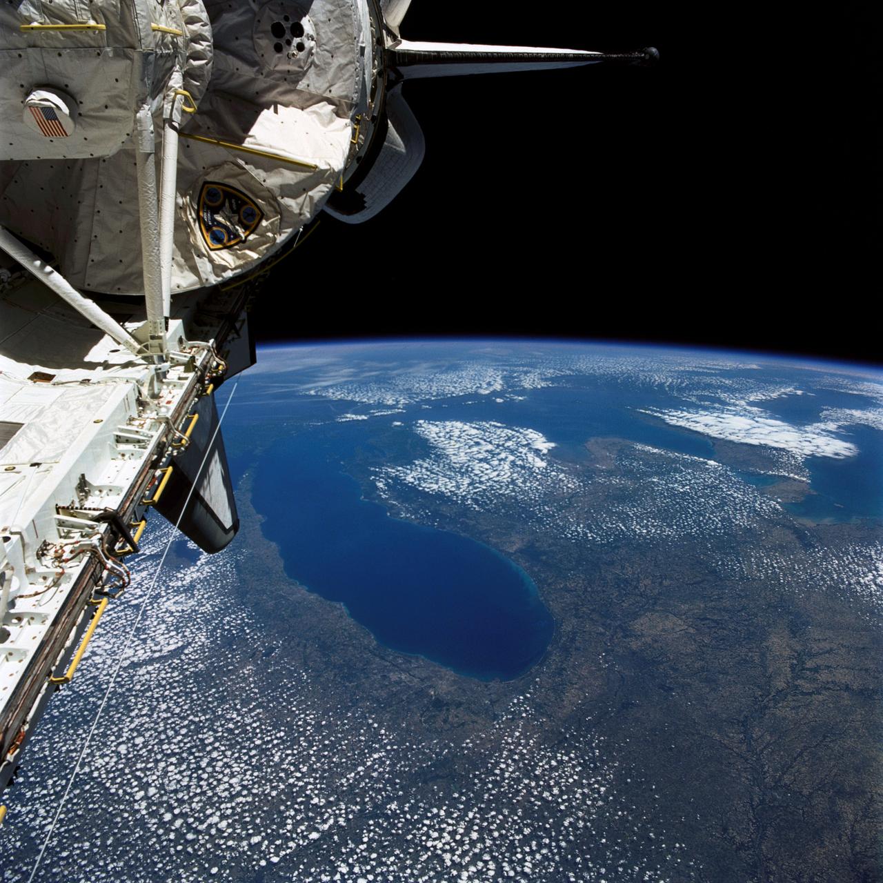
STS040-77-045 (6 June 1991) --- This image, photographed on June 6, 1991, is an oblique view looking north-northeast and shows most of the Great Lakes region. Part of Columbia's cargo bay and the Spacelab Life Sciences (SLS-1) module are in the foreground. In the center of the image is Lake Michigan with Chicago clearly visible along the southwest shore. According to NASA photo experts studying the STS-40 imagery, this image shows several interesting meteorological phenomena. The difference in temperature between the warming land and the cold lake waters is illustrated by the low level clouds. The warming land surface results in rising air and the formation of clouds, while the lake waters are cold and result in the lakes remaining cloud free. Also visible is evidence of lake breezes developing around several of the lakes. This phenomena is also driven by the difference in temperature between the land and the water. Winds blowing off the lakes must travel 25 - 30 miles inland before it warms sufficiently to create clouds.
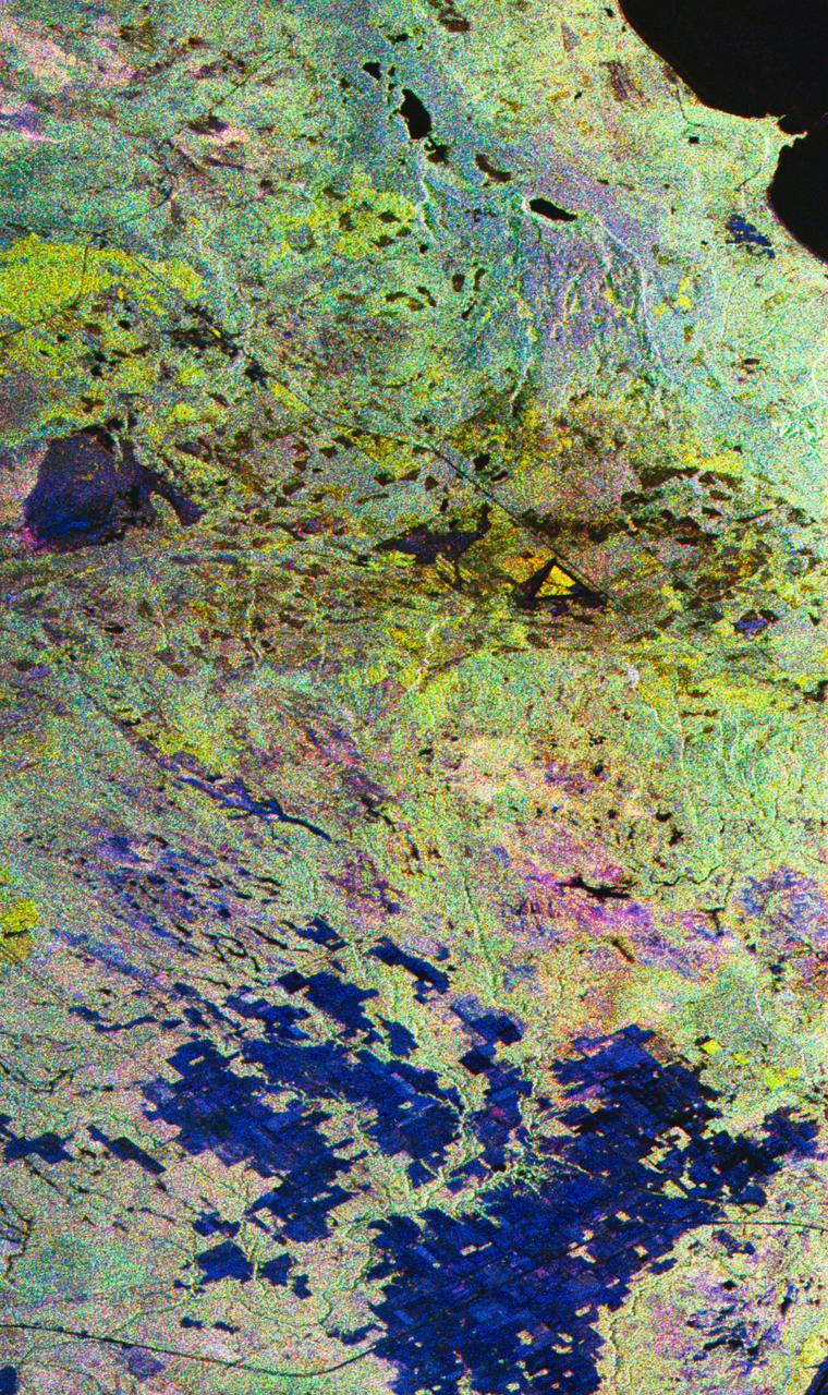
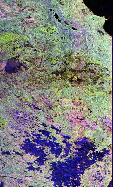
STS059-S-027 (10 April 1994) --- This image is a false-color composite of Raco, Michigan, centered at 46.39 degrees north latitude, 84.88 degrees east longitude. This image was acquired by the Spaceborne Imaging Radar-C and X-Band Synthetic Aperture Radar (SIR-C/X-SAR) aboard the Space Shuttle Endeavour on its 6th orbit and during the first full-capacity test of the instrument. This image was produced using both L-Band and C-Band data. The area shown is approximately 20 kilometers by 50 kilometers. Raco is located at the eastern end of Michigan's upper peninsula, west of Sault Ste. Marie and south of Whitefish Bay on Lake Superior. The site is located at the boundary between the boreal forests and the northern temperate forests, a transitional zone that is expected to be ecologically sensitive to anticipated global changes resulting from climatic warming. On any given day, there is a 60 percent chance that this area will be obscured to some extent by cloud cover which makes it difficult to image using optical sensors. In this color representation (Red=LHH, Green=LHV, Blue=CHH), darker areas in the image are smooth surfaces such as frozen lakes and other non-forested areas. The colors are related to the types of trees and the brightness is related to the amount of plant material covering the surface, called forest biomass. Accurate information about land-cover is important to area resource managers and for use in regional- to global-scale scientific models used to understand global change. SIR-C/X-SAR radars illuminate Earth with microwaves allowing detailed observations at any time, regardless of weather or sunlight conditions. SIR-C/X-SAR uses three microwave wavelengths: L-Band (24 cm), C-Band (6 cm), and X-Band (3 cm). The multi-frequency data will be used by the international scientific community to better understand the global environment and how it is changing. The SIR-C/X-SAR data, complemented by aircraft and ground studies, will give scientists clearer insights into those environmental changes which are caused by nature and those changes which are induced by human activity. SIR-C was developed by NASA's Jet Propulsion Laboratory (JPL). X-SAR was developed by the Dornire and Alenia Spazio Companies for the German Space Agency, Deutsche Agentur fuer Raumfahrtangelegenheiten (DARA), and the Italian Space Agency, Agenzia Spaziale Italiana (ASI). JPL Photo ID: P-43882
This image is a false-color composite of Raco, Michigan, centered at 46.39 degrees north latitude, 84.88 degrees west longitude. This image was acquired by the Spaceborne Imaging Radar-C and X-Band Synthetic Aperture Radar (SIR-C/X-SAR) aboard the space shuttle Endeavour on its sixth orbit and during the first full-capability test of the instrument on April 9, 1994. This image was produced using both L-band and C-band data. The area shown is approximately 20 kilometers by 50 kilometers (12 by 30 miles). Raco is located at the eastern end of Michigan's upper peninsula, west of Sault Ste. Marie and south of Whitefish Bay on Lake Superior. The site is located at the boundary between the boreal forests and the northern temperate forests, a transitional zone that is expected to be ecologically sensitive to anticipated global changes resulting from climatic warming. On any given day, there is a 60 percent chance that this area will be obscured to some extent by cloud clover which makes it difficult to image using optical sensors. http://photojournal.jpl.nasa.gov/catalog/PIA01700
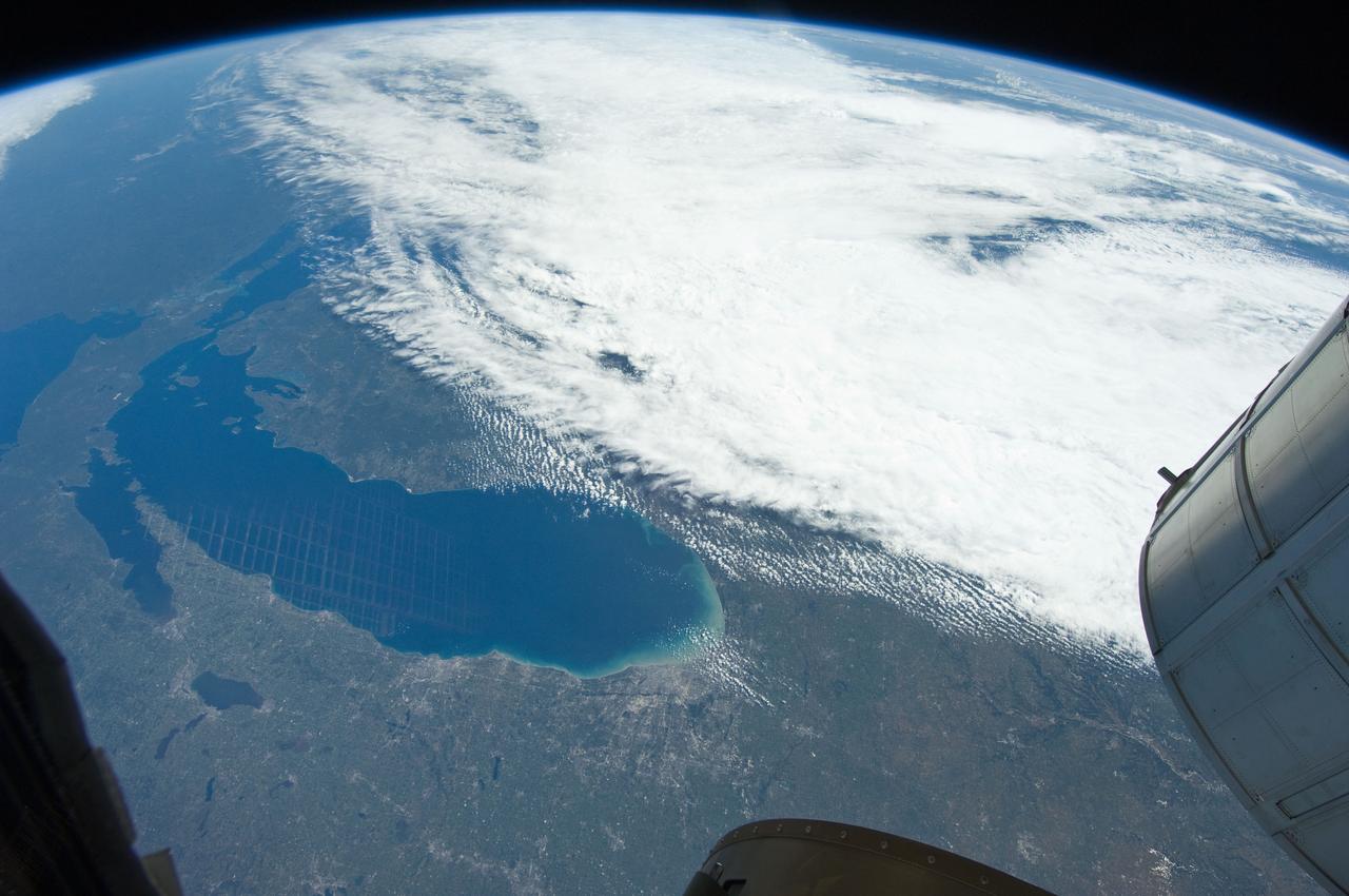
iss073e0865640 (Oct. 7, 2025) --- Lake Michigan beams in the afternoon sunlight as clouds blanket its southern tip—spanning Michigan, Indiana, and Illinois—in this photograph taken from the International Space Station while orbiting 263 miles above Earth. The northern tip of Lake Huron is visible at left.
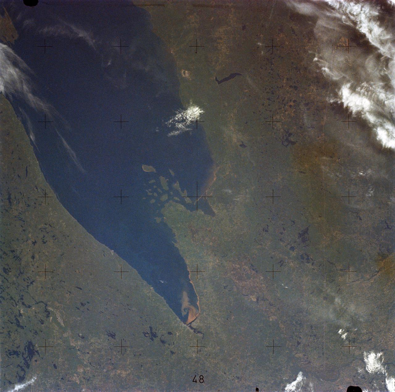
SL2-05-389 (22 June 1973) --- This scene displays the southeastern part of Michigan's Lower Peninsula and adjacent Ontario, Canada (43.0N, 84.0W). Detroit can be recognized by its radial pattern of development and sediment plumes in the rivers from the massive industrial activity. The area pockmarked by lakes northwest of Detroit essentially outlines the limits of the Defiance Moraine caused by the stagnation and melting of Ice Age glaciers. Photo credit: NASA
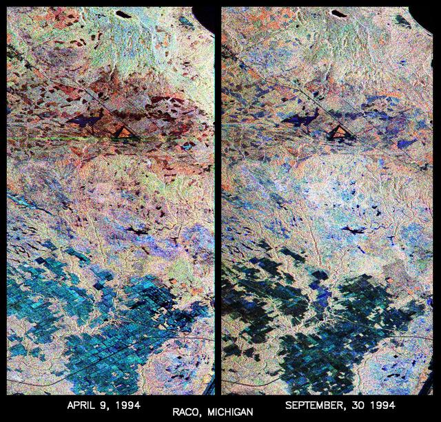
These are two false-color composites of Raco, Michigan, located at the eastern end of Michigan upper peninsula, west of Sault Ste. Marie and south of Whitefish Bay on Lake Superior. The two images (centered at 46.39 degrees north latitude, 84.88 degrees west longitude) show significant seasonal changes in the mid-latitude region of mixed deciduous and coniferous forests. The images were acquired by the Spaceborne Imaging Radar-C and X-band Synthetic Aperture Radar (SIR-C/X-SAR) aboard the shuttle Endeavour on the sixth orbit of each mission. In these images, red is L-band (23 cm) with horizontal/vertical polarization; green is C-band (6 cm) with horizontal/vertical polarization; blue is C-band with horizontal/horizontal polarization. The region shown is largely forested and includes a large portion of Hiawatha National Forest, as well as an agricultural region near the bottom of each image. In early April, the area was snow-covered with up to 50 centimeters (19.5 inches) of snow in forest clearings and agricultural fields. Buds had not yet broken on deciduous trees, but the trees were not frozen and sap was generally flowing. Lake Superior, in the upper right, and the small inland lakes were frozen and snow-covered on April 9, 1994. By the end of September, deciduous trees were just beginning to change color after a relatively wet period. Leaf loss was estimated at about 30 percent, depending on the species, and the soil was moist to wet after a heavy rainfall on September 28, 1994. Most agricultural fields were covered with grasses of up to 60 centimeters (23 inches) in height. In the two images the colors are related to the types of land cover (i.e. vegetation type) and the brightness is related to the amount of plant material and its relative moisture content. Significant seasonal changes between early spring and early fall are illustrated by this pair of images. For the agricultural region near the bottom of the images, the change from snow-cover to moist soil with short vegetation cover is shown by the color change from blue to green and blue. The green color corresponds to significant increases in vegetation cover and field-to-field differences in blue are the result of differences in surface roughness and soil moisture. In the forested areas, many of the conifer forests appear similar in both images (red pine forests appear red in both images). However, there is more blue and green in the September 30, 1994 image as a consequence of greater foliage and more moisture in the forest crowns. Lowland conifer forests (spruce and northern white cedars) appear as bright green in both images. Deciduous forests produce very strong radar returns at these frequencies and polarization combinations, resulting in a nearly white appearance on the images (the specific color mix is related to the local species mix). In the September 30, 1994 image, the areas of deciduous forest appear darker than in the April image because of the weaker radar signal from the foliage in the crown layer. The clear-cut areas (shown in April by the irregularly shaped dark areas in the center) change dramatically in appearance due to loss of snow cover and increases in soil moisture and vegetation cover by the end of September. http://photojournal.jpl.nasa.gov/catalog/PIA01730
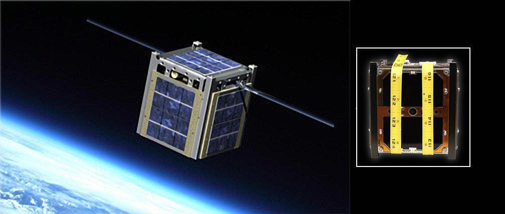
The image on the left is an artist rendering of Montana State University Explorer 1 CubeSat; at right is a CubeSat created by the University of Michigan designated the Michigan Mulitpurpose Mini-satellite, or M-Cubed.

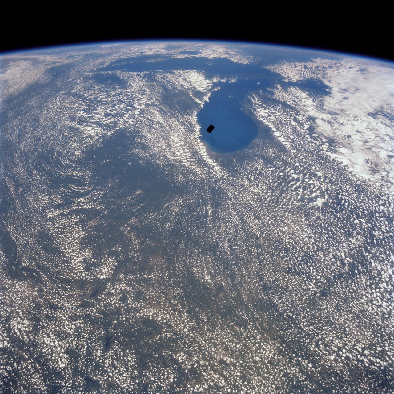
iss058e013234 (Feb. 13, 2019) --- The International Space Station was flying 256 miles above Canada when an Expedition 58 crew member, looking north to south, photographed Lake Superior and Lake Michigan surrounded by the cloudy and frozen terrain of the North American continent.
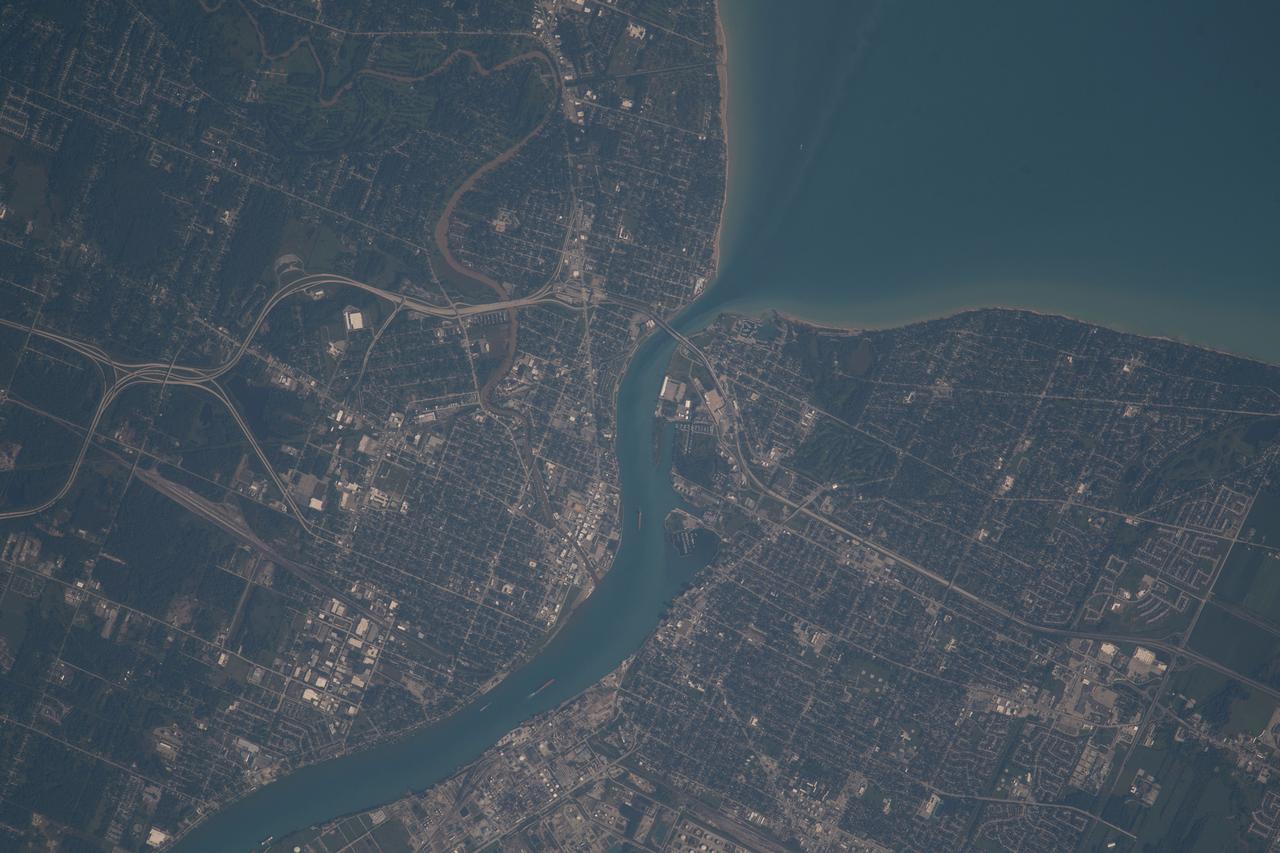
iss073e0814049 (Sept. 26, 2025) --- Detroit, Michigan, sits on the banks of the Detroit River, which connects Lake St. Clair (center) to Lake Erie to the south. To the north, the St. Clair River links Lake St. Clair with Lake Huron. Both rivers serve as natural borders between the United States and Canada. The International Space Station was orbiting 259 miles above Ontario, Canada, at the time of this photograph.
iss073e0000553 (April 22, 2025) --- The freshwater Lake St. Clair rests in between Detroit, Michigan (left), and Ontario, Canada, and connects Lake Huron and Lake Erie in North America in this photograph from the International Space Station as it orbited 260 miles above.
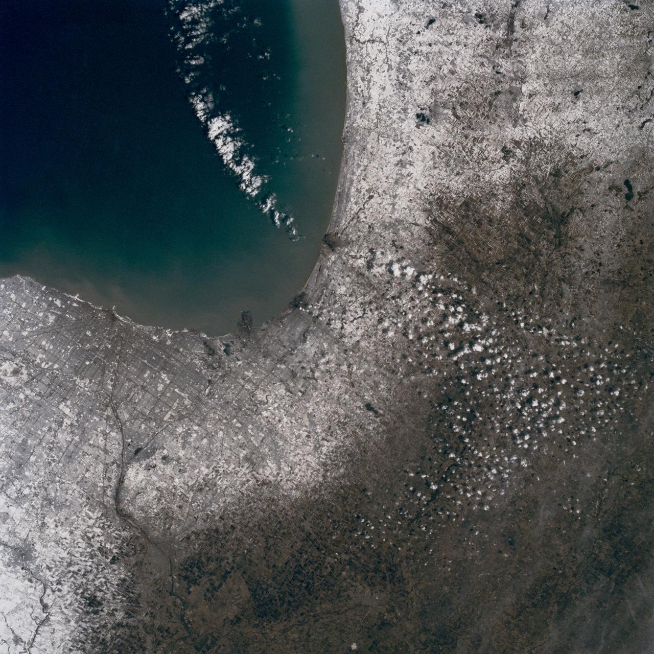
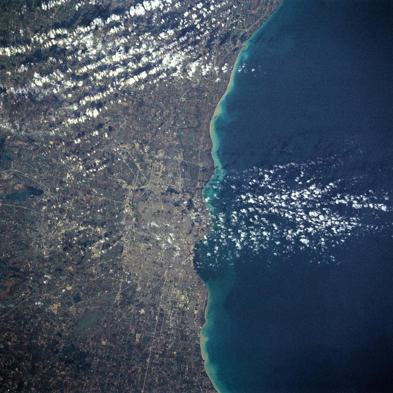
In this late winter scene of Chicago, Illinois, USA (41.5N, 87.0W) the light dusting of snow has actually enhanced the determination of the cities street pattern, parks and other cultural features. Sited at the south end of Lake Michigan, Chicago has long served as an industrial, transportation and communications center for the midwest. The obvious snowline on the ground enables meteorologists to trace the regional groundtracks of winter storms.
NASA Terra satellite presents this false color view of portions of Wisconsin and Michigan, including Devil Lake, Druid Lake, Ghost Lake, Spider Lake, and Witches Lake in Wisconsin; and Bat Lake, Corpse Pond and Witch Lake in Michigan.

L59-7932 First University of Michigan Strongarm sounding rocket on launcher at Wallops for test, November 10, 1959. Photograph published in A New Dimension Wallops Island Flight Test Range: The First Fifteen Years by Joseph Shortal. A NASA publication. Page 701.E5-188 Shop and Launcher Pictures

L59-7932 First University of Michigan Strongarm sounding rocket on launcher at Wallops for test, November 10, 1959. Photograph published in A New Dimension Wallops Island Flight Test Range: The First Fifteen Years by Joseph Shortal. A NASA publication. Page 701.E5-188 Shop and Launcher Pictures

L59-7932 First University of Michigan Strongarm sounding rocket on launcher at Wallops for test, November 10, 1959. Photograph published in A New Dimension Wallops Island Flight Test Range: The First Fifteen Years by Joseph Shortal. A NASA publication. Page 701.E5-188 Shop and Launcher Pictures

L59-7932 First University of Michigan Strongarm sounding rocket on launcher at Wallops for test, November 10, 1959. Photograph published in A New Dimension Wallops Island Flight Test Range: The First Fifteen Years by Joseph Shortal. A NASA publication. Page 701.E5-188 Shop and Launcher Pictures

iss072e097446 (Oct. 24, 2024) -- As the International Space Station soared 257 miles above Lake Michigan, NASA astronaut and Expedition 72 Flight Engineer Don Pettit captured this long-exposure photograph of city lights streaking across Earth while a green and red aurora moved through the atmosphere.

L59-7932 First University of Michigan Strongarm sounding rocket on launcher at Wallops for test, November 10, 1959. Photograph published in A New Dimension Wallops Island Flight Test Range: The First Fifteen Years by Joseph Shortal. A NASA publication. Page 701.E5-188 Shop and Launcher Pictures

L59-7932 First University of Michigan Strongarm sounding rocket on launcher at Wallops for test, November 10, 1959. Photograph published in A New Dimension Wallops Island Flight Test Range: The First Fifteen Years by Joseph Shortal. A NASA publication. Page 701.E5-188 Shop and Launcher Pictures
This is an X-band image of seasonal changes at the ecological test site of Raco, Michigan, located south of Whitefish Bay on Lake Superior. The image is centered at about 46 degrees north latitude and 85 degrees west longitude. This image was acquired by the X-band Synthetic Aperture Radar onboard the space shuttle Endeavour on April 10th, 1994, and on October 1, 1994. The areas shown in red correspond to the April 10th data; the areas in blue correspond to data acquired on October 1, 1994; green indicates the ratio of data acquired on April 10 and October 1, 1994. The area shown is 22.7 kilometers by 53 kilometers (14 miles by 33 miles). Lake Superior in the upper right was frozen in April and had small waves (ripples) on its surface in October. The land area contains mostly forests and, to a lesser extent, agricultural regions. In April the area was covered in wet snow. By October, there agricultural areas were covered with grass. Vegetation and soils were moist due to rainfalls three days before the data was acquired on October 1, 1994. The bright light green/yellow tones in the lower half of the image show the stronger reflections of the snow-covered agricultural fields. The pinkish color corresponds to the coniferous and deciduous forests. The green area represents red pines. These trees are smaller than the surrounding forest cover and allow more radar penetration. The area is green because the radar is sensing the surface, which undergoes great change from snow to grass and fern undergrowth between April and October. The bright green triangle in the upper half of the image is an old airstrip, while the modern airport can be seen on the bottom right side of the image. The Raco site is an important location for monitoring seasonal changes and future global change because it is situated at the ecological transition zone between the boreal forests and the northern temperate forests. This transitional zone is expected to be ecologically sensitive to anticipated global changes resulting from climatic warming. Baseline studies of vegetation are essential in monitoring these expected changes. http://photojournal.jpl.nasa.gov/catalog/PIA01734
iss055e018833 (April 10, 2018) --- An Expedition 55 crew member photographed the Mackinac Bridge which connects the upper and lower peninsulas of the state of Michigan across an area of water separating Lake Michigan and Lake Huron.
Radiant Extinction Apparatus - University of Michigan

Radiant Extinction Apparatus - University of Michigan
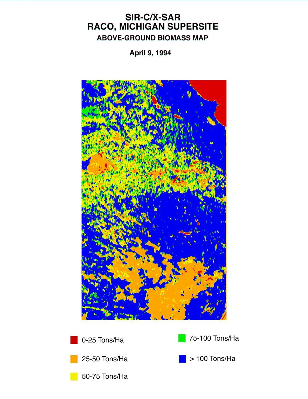
This biomass map of the Raco, Michigan, area was produced from data acquired by NASA Spaceborne Imaging Radar C/X-Band Synthetic Aperture Radar SIR-C/X-SAR onboard space shuttle Endeavour.
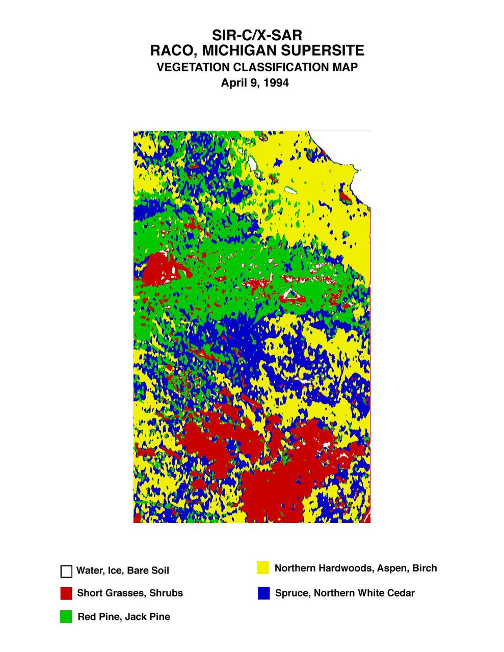
This is a vegetation map of the Raco, Michigan area produced from data acquired by NASA Spaceborne Imaging Radar C/X-Band Synthetic Aperture Radar SIR-C/X-SAR onboard space shuttle Endeavour.

Sault Ste. Marie is the name of two cities on Saint Mary River, separating Canada and the State of Michigan in the United States. This image was acquired by NASA Terra spacecraft on June 10, 2007.
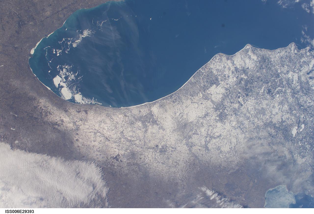
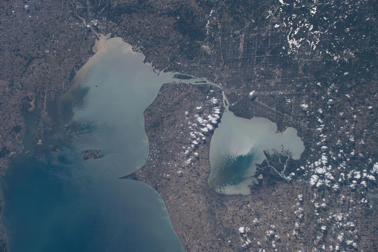
ISS006-E-29393 (21 February 2003) --- A number of large pieces of ice collected along and just off the shoreline southwest of Benton Harbor, Michigan and smaller pieces trailing northward offshore from Chicago, Illinois were captured with a digital still camera by one of the Expedition Six crewmembers on board the International Space Station (ISS). Note the ice accumulation along the entire eastern shoreline of Lake Michigan as well as the wind-drive lake-effect snow cover over the western half of the Lower Michigan Peninsula.
ISS036-E-017925 (11 July 2013) --- One of the Expedition 36 crew members aboard the Earth-orbiting International Space Station on July 11 captured this high oblique view of Lake Michigan (left) and Lake Huron and much of the state of Michigan in between.

NASA WITH UNIVERSITY OF MICHIGAN 5 KILOWATT NASA 173M HALL THRUSTER

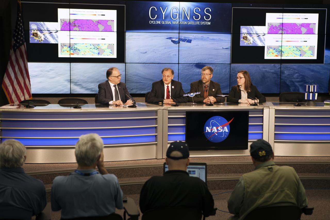
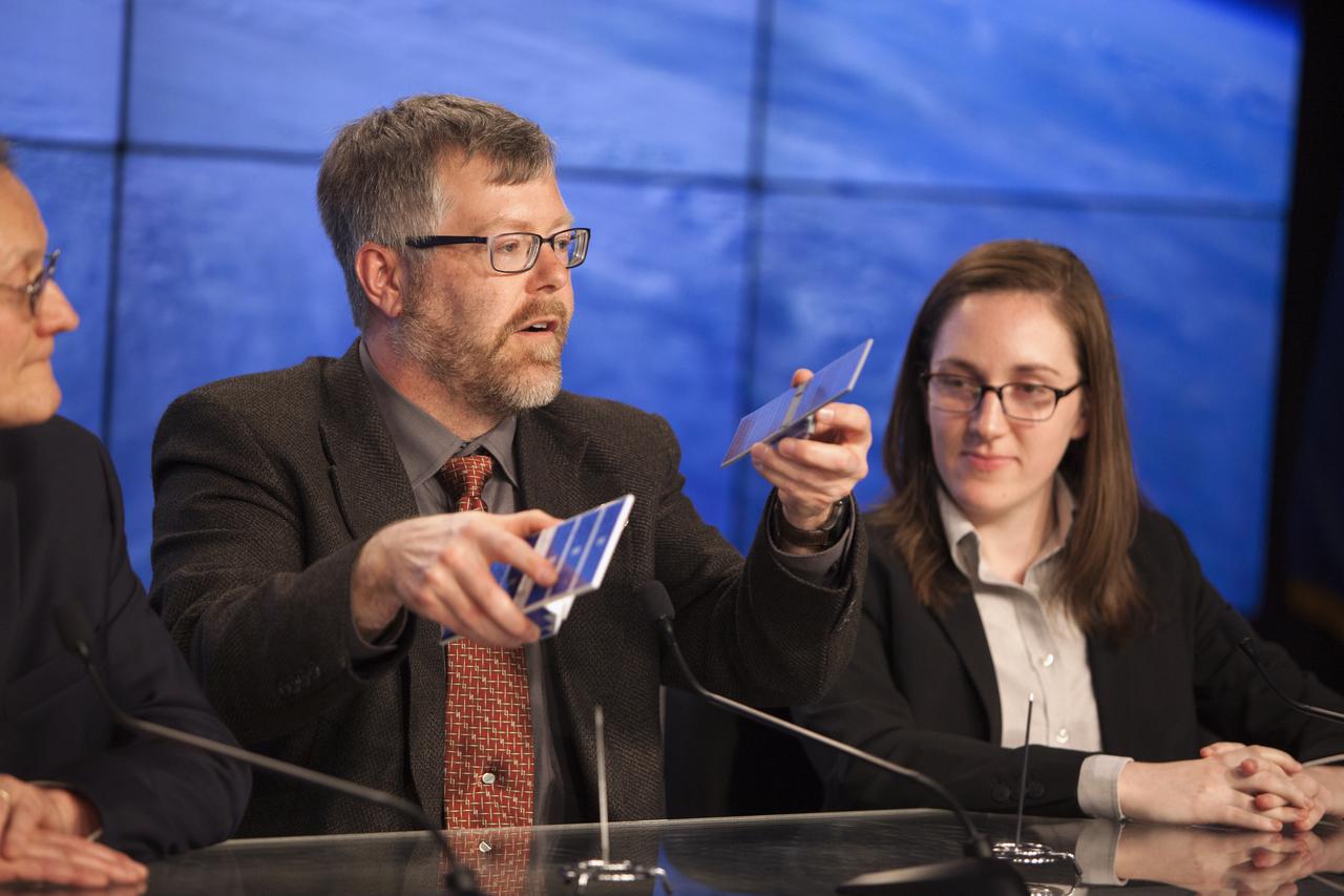
In the Kennedy Space Center’s Press Site auditorium, NASA and industry leaders speak to members of the media during a mission science briefing for the agency’s Cyclone Global Navigation Satellite System, or CYGNSS, spacecraft. From left are: Sean Potter of NASA Communications; Dr. Chris Ruf, CYGNSS principal investigator, Department of Climate and Space Sciences and Engineering at the University of Michigan; Aaron Ridley, CYGNSS constellation scientist in the Climate and Space Department at the University of Michigan in Ann Arbor, Michigan; and Mary Morris, doctoral student in the Department of Climate and Space Sciences and Engineering at the University of Michigan. The eight CYGNSS satellites will make frequent and accurate measurements of ocean surface winds throughout the life cycle of tropical storms and hurricanes. The data will help scientists probe key air-sea interaction processes that take place near the core of storms, which are rapidly changing and play a crucial role in the beginning and intensification of hurricanes.

In the Kennedy Space Center’s Press Site auditorium, NASA and industry leaders speak to members of the media during a mission science briefing for the agency’s Cyclone Global Navigation Satellite System, or CYGNSS, spacecraft. From left are: Sean Potter of NASA Communications; Dr. Chris Ruf, CYGNSS principal investigator, Department of Climate and Space Sciences and Engineering at the University of Michigan; Aaron Ridley, CYGNSS constellation scientist in the Climate and Space Department at the University of Michigan in Ann Arbor, Michigan; and Mary Morris, doctoral student in the Department of Climate and Space Sciences and Engineering at the University of Michigan. The eight CYGNSS satellites will make frequent and accurate measurements of ocean surface winds throughout the life cycle of tropical storms and hurricanes. The data will help scientists probe key air-sea interaction processes that take place near the core of storms, which are rapidly changing and play a crucial role in the beginning and intensification of hurricanes.
In the Kennedy Space Center’s Press Site auditorium, NASA and industry leaders speak to members of the media during a mission science briefing for the agency’s Cyclone Global Navigation Satellite System, or CYGNSS, spacecraft. From left are: Sean Potter of NASA Communications; Dr. Chris Ruf, CYGNSS principal investigator, Department of Climate and Space Sciences and Engineering at the University of Michigan; Aaron Ridley, CYGNSS constellation scientist in the Climate and Space Department at the University of Michigan in Ann Arbor, Michigan; and Mary Morris, doctoral student in the Department of Climate and Space Sciences and Engineering at the University of Michigan. The eight CYGNSS satellites will make frequent and accurate measurements of ocean surface winds throughout the life cycle of tropical storms and hurricanes. The data will help scientists probe key air-sea interaction processes that take place near the core of storms, which are rapidly changing and play a crucial role in the beginning and intensification of hurricanes.
In the Kennedy Space Center’s Press Site auditorium, NASA and industry leaders speak to members of the media during a mission science briefing for the agency’s Cyclone Global Navigation Satellite System, or CYGNSS, spacecraft. From left are: Dr. Chris Ruf, CYGNSS principal investigator, Department of Climate and Space Sciences and Engineering at the University of Michigan; Aaron Ridley, CYGNSS constellation scientist in the Climate and Space Department at the University of Michigan in Ann Arbor, Michigan; and Mary Morris, doctoral student in the Department of Climate and Space Sciences and Engineering at the University of Michigan. The eight CYGNSS satellites will make frequent and accurate measurements of ocean surface winds throughout the life cycle of tropical storms and hurricanes. The data will help scientists probe key air-sea interaction processes that take place near the core of storms, which are rapidly changing and play a crucial role in the beginning and intensification of hurricanes.
iss065e074473 (May 26, 2021) --- O'Hare International Airport in Chicago, Illinois, is pictured from the International Space Station as it orbited 262 miles above western Michigan.
iss065e086284 (June 3, 2021) --- Chicago, Illinois, is pictured from the International Space Station as it orbited 262 miles above Lake Michigan.

ISS046e005404 (01/05/2016) --- The glittering lights of the American Midwest illuminate the Earth in this captivating image taken by the International Space Station Expedition 46 crew on Jan. 5, 2016. The picture, which was taken while the station was flying above Alabama, shows numerous major cities, including the major city of Chicago (middle-left) situated on the Lake Michigan coastline. Also in view are three of the American Great Lakes, including Lake Michigan (left), Lake Huron (middle) and Lake Erie (right).
ISS028-E-044831 (7 Sept. 2011) --- While many of the Great Lakes and their surrounding areas are covered by the remnants of Tropical Storm Lee and upper level low over Michigan and southeastern Canada, Lake Michigan and Chicago are mostly clear and can be easily delineated (lower left center) in this image. The view was photographed by one of the Expedition 28 crew members aboard the International Space Station on Sept. 7, 2011.
STS058-102-018 (18 Oct-1 Nov 1993) --- A cloud-free, wide-angle view from above western Tennessee to the northern edge of Lake Michigan. The view extends from Saint Louis, Missouri near the lower left-hand corner, past Evansville, Indiana and Louisville, Kentucky to Cincinnati, Ohio. A range of hills covered by trees in Fall foliage extends from the Ohio River toward Lake Michigan, ending just southwest of Indianapolis, Indiana.
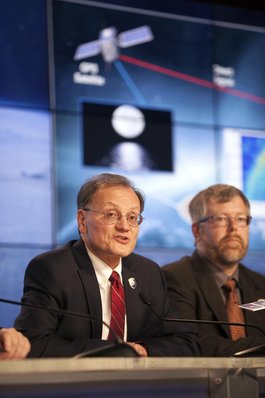
In the Kennedy Space Center’s Press Site auditorium, NASA and industry leaders speak to members of the media during a mission science briefing for the agency’s Cyclone Global Navigation Satellite System, or CYGNSS, spacecraft. From left are: Dr. Chris Ruf, CYGNSS principal investigator, Department of Climate and Space Sciences and Engineering at the University of Michigan; and Aaron Ridley, CYGNSS constellation scientist in the Climate and Space Department at the University of Michigan in Ann Arbor, Michigan. The eight CYGNSS satellites will make frequent and accurate measurements of ocean surface winds throughout the life cycle of tropical storms and hurricanes. The data will help scientists probe key air-sea interaction processes that take place near the core of storms, which are rapidly changing and play a crucial role in the beginning and intensification of hurricanes.

In the Kennedy Space Center’s Press Site auditorium, NASA and industry leaders speak to members of the media during a mission science briefing for the agency’s Cyclone Global Navigation Satellite System, or CYGNSS, spacecraft. From left are: Aaron Ridley, CYGNSS constellation scientist in the Climate and Space Department at the University of Michigan in Ann Arbor, Michigan; and Mary Morris, doctoral student in the Department of Climate and Space Sciences and Engineering at the University of Michigan. The eight CYGNSS satellites will make frequent and accurate measurements of ocean surface winds throughout the life cycle of tropical storms and hurricanes. The data will help scientists probe key air-sea interaction processes that take place near the core of storms, which are rapidly changing and play a crucial role in the beginning and intensification of hurricanes.
iss071e045652 (April 25, 2024) --- Lake Michigan figures prominently in the United States' upper midwest region with Lake Superior and Lake Huron in this photograph from the International Space Station as it orbited 257 miles above North America.

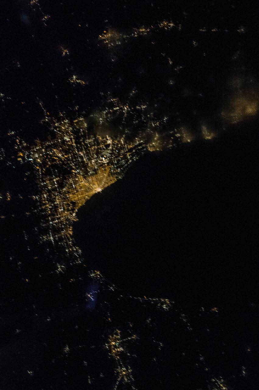
iss070e105102 (March 1, 2024) --- The city lights of Detroit, Michigan, separated from the city of Windsor in Ontario, Canada, by the Detroit River, are pictured from the International Space Station as it orbited 264 miles above.

iss070e099645 (Feb., 23, 2024) --- Chicago, Illinois, was pictured at night by Expedition 70 Flight Engineer Jasmin Moghbeli as the International Space Station orbited 261 miles above Lake Michigan.

iss071e000004 (April 7, 2024) --- Lakes Michigan, Huron, and Erie figure prominently in this photograph from the International Space Station as it orbited 261 miles above The Prairie State of Illinois.
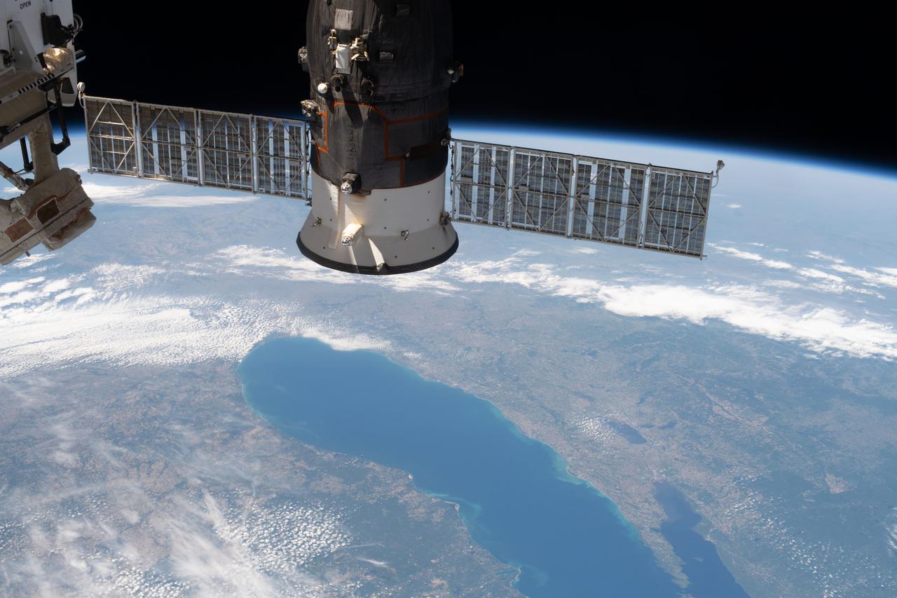
iss063e027839 (June 13, 2020) --- Lake Michigan figures prominently in this photograph of North America from the International Space Station with Russia's Progress 74 resupply ship in the foreground.
iss059e090279 (June 3, 2019) --- Lakes Erie and St. Clair and the cities of Detroit, Michigan and Toledo, Ohio are pictured as the International Space Station orbited 257 miles over North America.
iss056e085102 (July 8, 2018) --- An Expedition 56 crew member photographed downtown Chicago, Illinois as the International Space Station was beginning its orbit over Lake Michigan.
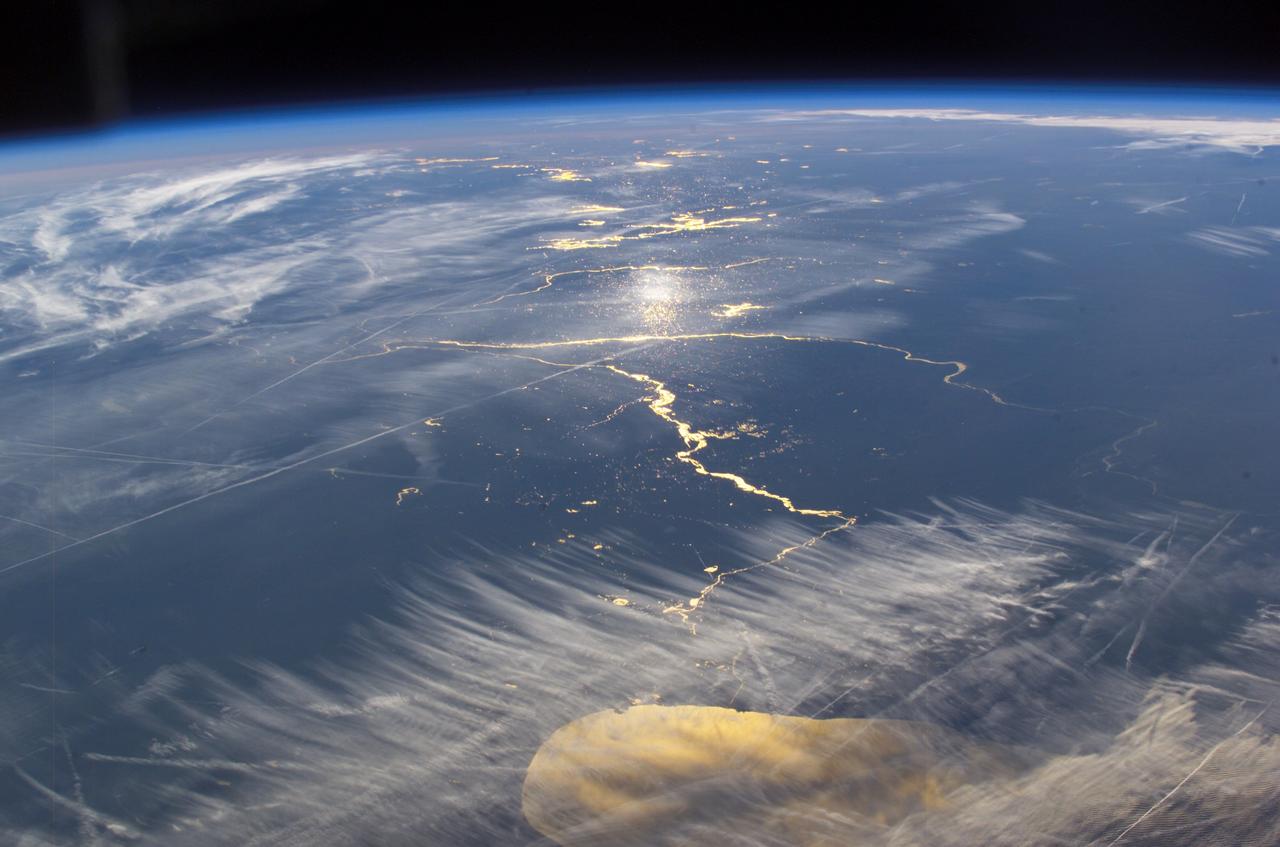
iss061e004575 (Oct. 8, 2019) --- The Sun's glint beams off Lake Michigan in this southward view taken from the International Space Station orbiting 253 miles above Canada just north of Lake Superior.
ISS047e043884 (04/05/2016) --- Expedition 47 crewmembers on board the International Space Station captured this brightly lit night image of the largest city along Lake Michigan in the US Midwest state of Illinois: Chicago.
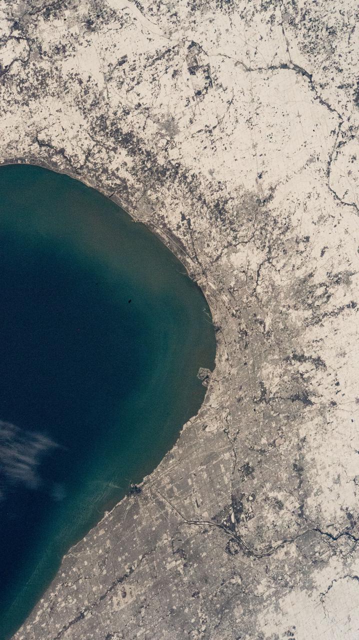
iss066e146455 (Feb. 18, 2022) --- The southern tip of Lake Michigan and a snow-covered Chicago, Illinois, are pictured from the International Space Station as it orbited 260 miles above.
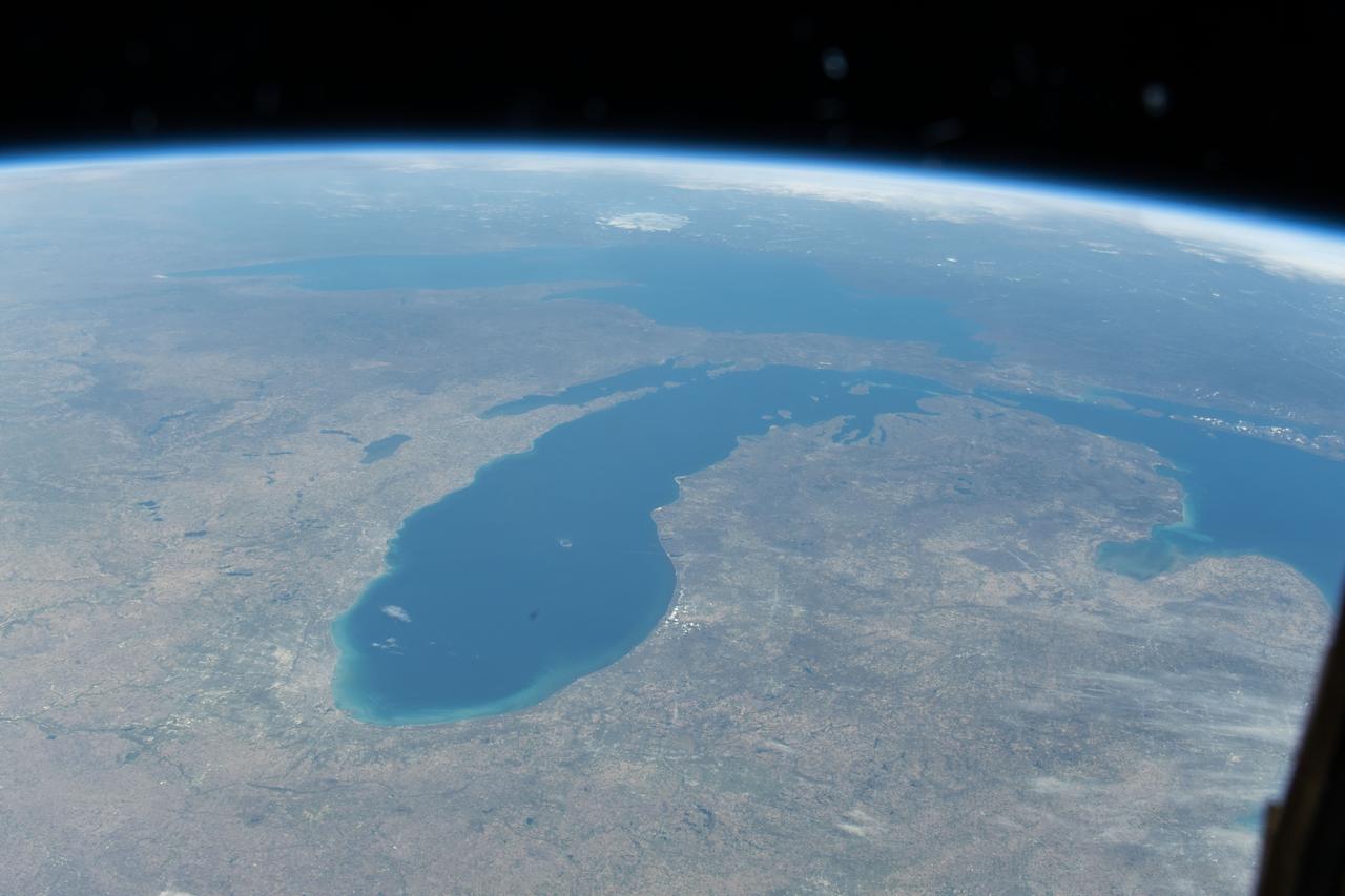
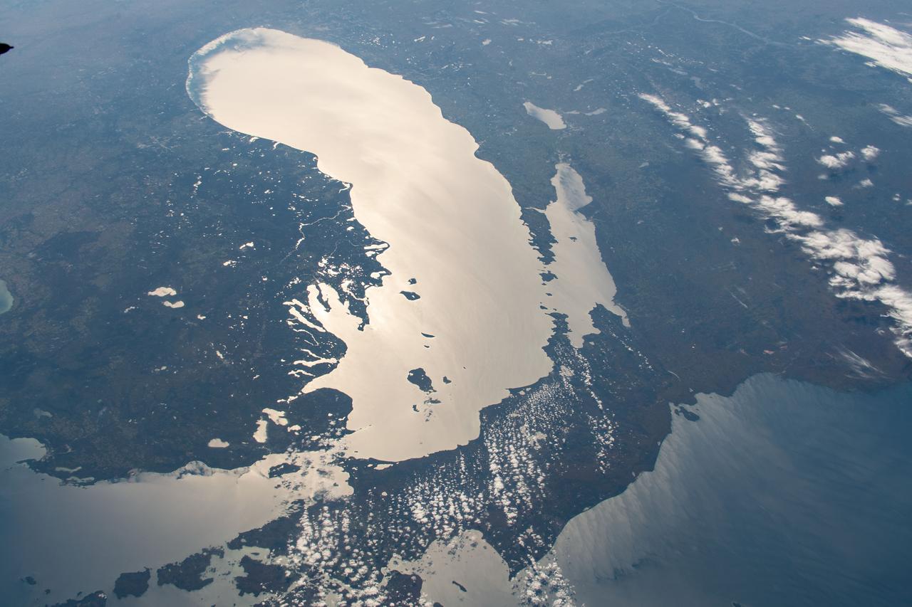
STS084-710-098 (15-24 May 1997) --- A rare view of the Great Lakes captured in one frame. The Great Lakes region is home to 8.5 million Canadians and 32.5 million Americans. At center is Lake Huron and Georgian Bay. Above Lake Huron and towards the horizon is Lake Michigan, the only Great Lake to be located entirely within the United States. To the right of Lake Michigan, and partially under clouds, is Lake Superior the second largest lake in the world after the Caspian Sea. Lake Erie is located to the left of Lake Huron. Next to Lake Erie is Lake Ontario. According to geologists, the Great Lakes were created by glacial processes that began about 1,000,000 years ago.
iss069e060965 (Aug. 16, 2023) --- The St. Clair River separates the American city of Port Huron, Michigan (left), from the Canadian city of Sarnia, Ontario (right), and enters into Lake Huron in this photograph from the International Space Station as it orbited 263 miles above.
iss061e067911 (Dec. 6, 2019) --- Chicago's O'Hare International Airport is centered in this photograph with the Windy City's downtown at the top right corner on the coast of Lake Michigan. The International Space Station was orbiting 259 miles above the state of Illinois when this picture was taken.
iss073e0000481 (April 22, 2025) --- The St. Clair River flows into the freshwater Lake St. Clair and separates the American state of Michigan (top) from the Canadian province of Ontario (bottom) in this photograph from the International Space Station as it orbited 260 miles above.

iss064e051420 (April 2, 2021) --- The Detroit River, pictured from the International Space Station as it orbited 264 miles above, separates Detroit, Michigan, from Windsor in Ontario, Canada. The Detroit River also connects to Lake St. Clair (pictured at top) and Lake Erie (out of frame).
ISS037-E-006132 (5 Oct. 2013) --- One of the Expedition 37 crew members aboard the International Space Station recorded this nearly vertical night image featuring the southwest coast of Lake Michigan, including the greater metropolitan area of Chicago, IL, on Oct. 5, 2013.

Gerard M. Faeth, University of Michigan, principal investigator in combustion science experiments, including Flow/Soot-Formation in Nonbuoyant Laminar Diffusion Flames, investigation of Laminar Jet Diffusion Flames in Microgravity: A Paradigm for Soot Processes in Turbulent Flames, and Soot Processes in Freely-Propagating Laminar Premixed Flames.

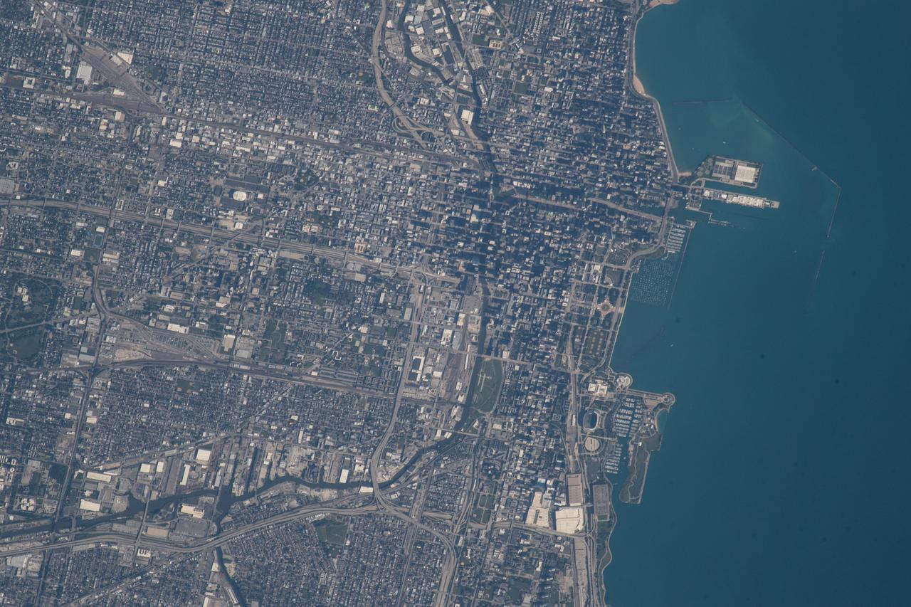
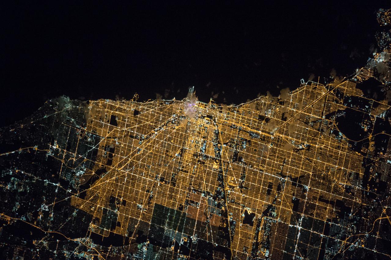
iss073e0080182 (May 15, 2025) --- Chicago, Illinois, with a metropolitan population of 9.6 million near the southern tip of Lake Michigan, is pictured at approximately 1:32 a.m. local time from the International Space Station as it orbited 261 miles above.
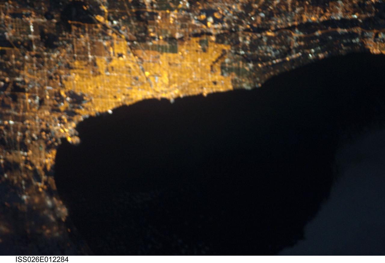
ISS026-E-012284 (23 Dec. 2010) --- From 220 miles above Earth, one of the Expedition 26 crew members aboard the International Space Station recorded this night image of the Chicago metropolitan area and part of Lake Michigan, using a still camera equipped with a 180-mm lens.
ISS008-E-06565 (30 November 2003) --- This view featuring the Lake Michigan area was photographed by an Expedition 8 crewmember on the International Space Station (ISS). The photo also shows Chicago area; Illinois River; Mississippi and Missouri Rivers meeting at St. Louis. Aircraft contrails are also visible.
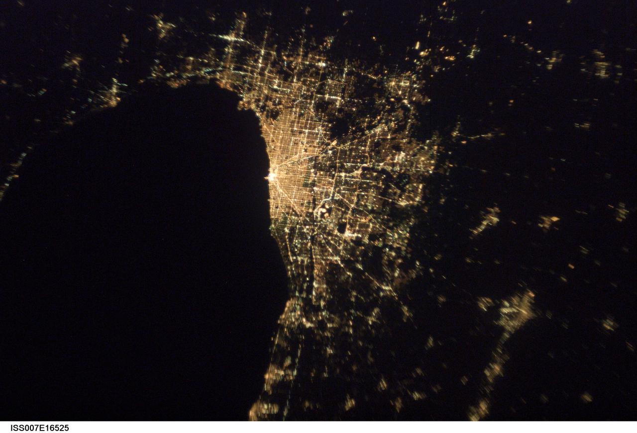
ISS007-E-16525 (7 October 2003) --- This image of Chicago, Illinois at night, taken by an Expedition 7 crewmember onboard the International Space Station (ISS), shows patterns of the city center and major roads along the coast of Lake Michigan.
iss073e0000460 (April 22, 2025) --- The sun's glint beams off the freshwater Lake St. Clair, sits in between Lake Huron (right) and Lake Erie (bottom left), and separates Detroit, Michigan (top left) from Ontario, Canada, in this photograph from the International Space Station as it orbited 260 miles above.
STS105-714-028 (20 August 2001) --- Backdropped by Lake Michigan, this distant view shows the recently deployed small science satellite called Simplesat, which is an engineering satellite, designed to evaluate the use of inexpensive commercial hardware for spacecraft. It was spring-ejected from a canister at the rear of the Shuttle's cargo bay.
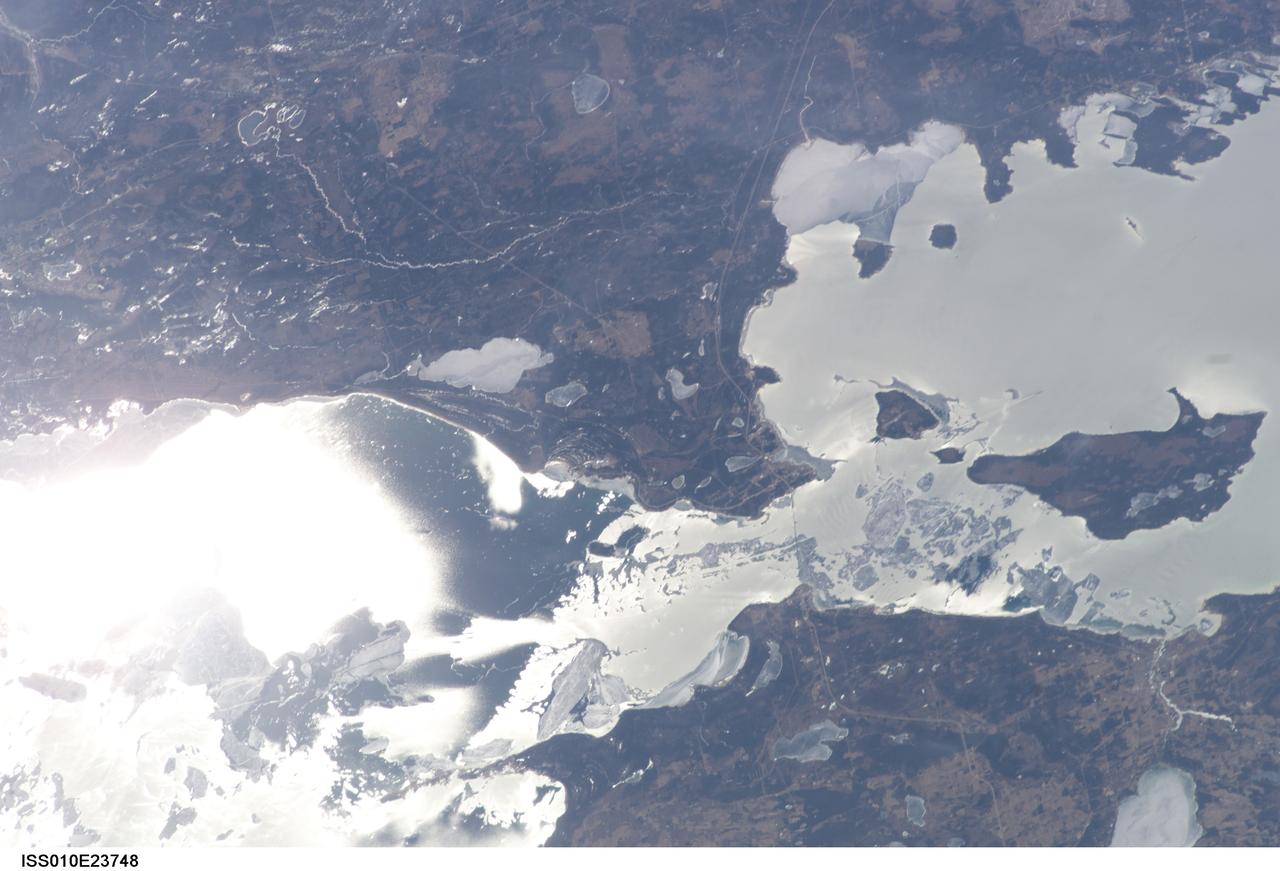
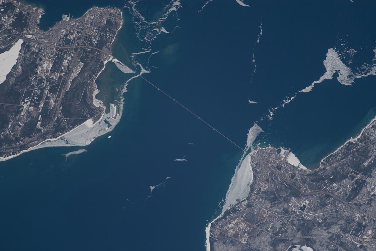
ISS010-E-23748 (9 April 2005) --- The Straits of Mackinac are featured in this image photographed by an Expedition 10 crewmember on the International Space Station (ISS). The Mackinac Bridge spans a stretch of water five miles wide between Michigan’s lower and upper peninsulas. The strait connects Lakes Michigan (left) and Huron (right). The bridge is a combination of pier-supported spans with a high, central suspension sector that allows passage of lake steamers. The suspension sector is the longest in the Americas (8614 feet or 1.6 miles). Prior to construction of the bridge, the only passage across the straits was by ferryboat. This view shows the ice broken into a series of irregular rafts that appear gray against bright water in this partial sunglint view. The shipping channel is maintained even through remnants of the ice mass, but the ice ridges can be hazardous to shipping during ice break-up.
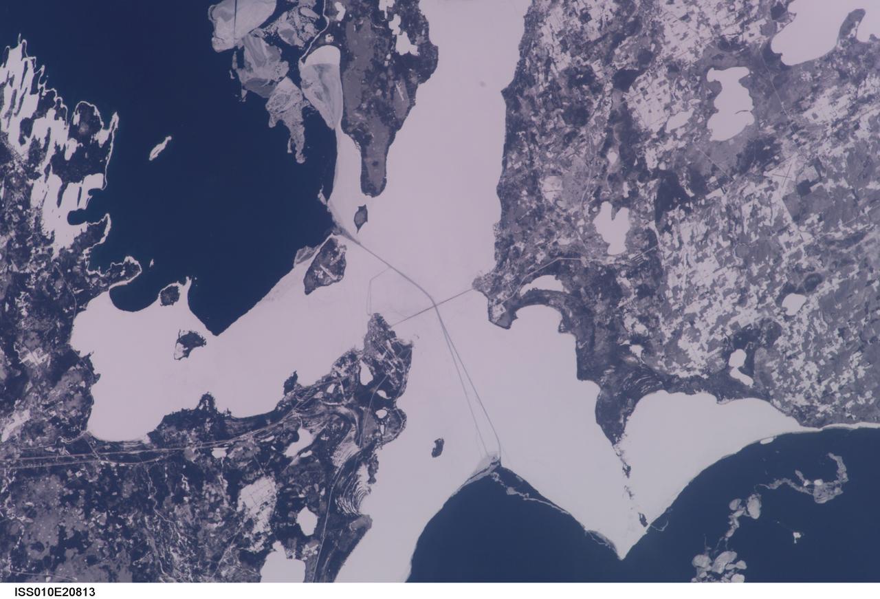
ISS010-E-20813 (22 March 2005) --- The Straits of Mackinac are featured in this image photographed by an Expedition 10 crewmember on the International Space Station (ISS). The Mackinac Bridge spans a stretch of water five miles wide between Michigan’s lower and upper peninsulas. The strait connects Lakes Michigan (left) and Huron (right). The bridge is a combination of pier-supported spans with a high, central suspension sector that allows passage of lake steamers. The suspension sector is the longest in the Americas (8614 feet or 1.6 miles). Prior to construction of the bridge, the only passage across the straits was by ferryboat. This view shows shipping lanes opened by ice breakers. A narrow passage leads to the small town of St. Ignace at the north end of the bridge (Mackinaw City appears at the south end). The shipping channel is maintained even through remnants of the ice mass, but the ice ridges can be hazardous to shipping during ice break-up.
ISS028-E-010162 (29 June 2011) --- Sault Ste Marie, Ontario and Michigan are featured in this image photographed by an Expedition 28 crew member on the International Space Station. The twin cities of Sault Ste Marie are located across the St. Mary?s River that forms part of the international boundary between Canada (Province of Ontario) and the United States (State of Michigan). This photograph highlights the two cities, together with the region of lakes and islands that separates Lakes Huron and Superior, two of the Great Lakes of North America. Smaller lakes include Lake George to the west; the large forested islands of St. Joseph and Drummond are visible at lower left. The Sault Ste Marie urban areas (upper right) have a distinctive gray to white coloration in the image, contrasting with the deep green of forested areas in Ontario and the lighter green of agricultural fields in Michigan. The coloration of water surfaces in the lakes and rivers varies from blue to blue-green to silver, and is likely caused by varying degrees of sediment and sunglint ? light reflecting back to the observer on the space station from the water surface, much as light reflects from a mirror. Prior to formalization of the US/Canada border in 1817, Sault Ste Marie was a single community. Archeological evidence suggests that the region had been occupied by Native Americans at least five hundred years ago. A mission ? the first European settlement in Michigan ? was established there in 1668 by the French Jesuit Father Jacques Marquette. Today, shipping locks and canals in both urban areas are an important part of the Great Lakes shipping traffic system.

Dr. Shanique Brown, an assistant professor of industrial-organizational psychology at Wayne State University in Detroit, Michigan, delivers the Black History Month keynote address to team members at NASA's Marshall Space Flight Center Feb. 28. Participants mingled with Brown and Marshall leaders after the speech and a panel discussion on diversity and inclusion, and sampled a variety of ethnic foods. The 2019 commemoration, themed "Migrations From Here to There," was organized by Marshall's Office of Diversity and Equal Opportunity

iss070e022671 (Nov. 10, 2023) --- The sun's first rays begin illuminating Earth's atmosphere in this photograph from the International Space Station as it orbited 260 miles above the central United States. At far left, the city lights of Chicago, Illinois, are outlined by Lake Michigan. At far right, the city lights of the Dallas/Forth Worth metropolitan area shine through the clouds.
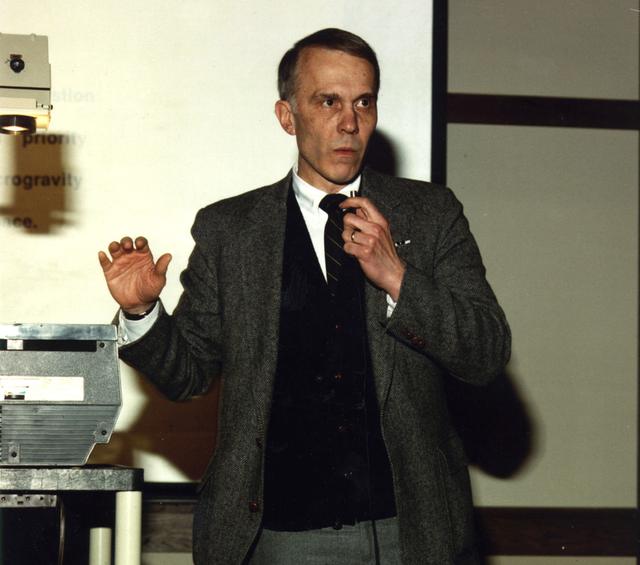
Professor Gerard M. Faeth, Department of Aerospace Engineering, University of Michigan, Arn Arbor, MI, is a principal investigator in NASA combustion science directed by Glenn Research Center. His projects include: Soot Processes in Freely-Propagating Laminar Premixed Flames; Investigation of Laminar Jet Diffusion Flames in Microgravity: A Paradigm for Soot Processes in Turbulent Flames (scheduled to fly on the STS-107 mission); and Flow/Soot- Formation in Nonbuoyant Laminar Diffusion Flames.

iss056e032790 (June 20, 2018) --- Canada and the United States are separated at this entry point by the St. Mary's River. The similarly named cities of Sault Ste. Marie, Michigan is to the south and Sault Ste. Marie, Ontario is to the north (in this orientation they are from left to right). The St. Mary's River leads into Lake Superior heading west and Lake Huron heading south.
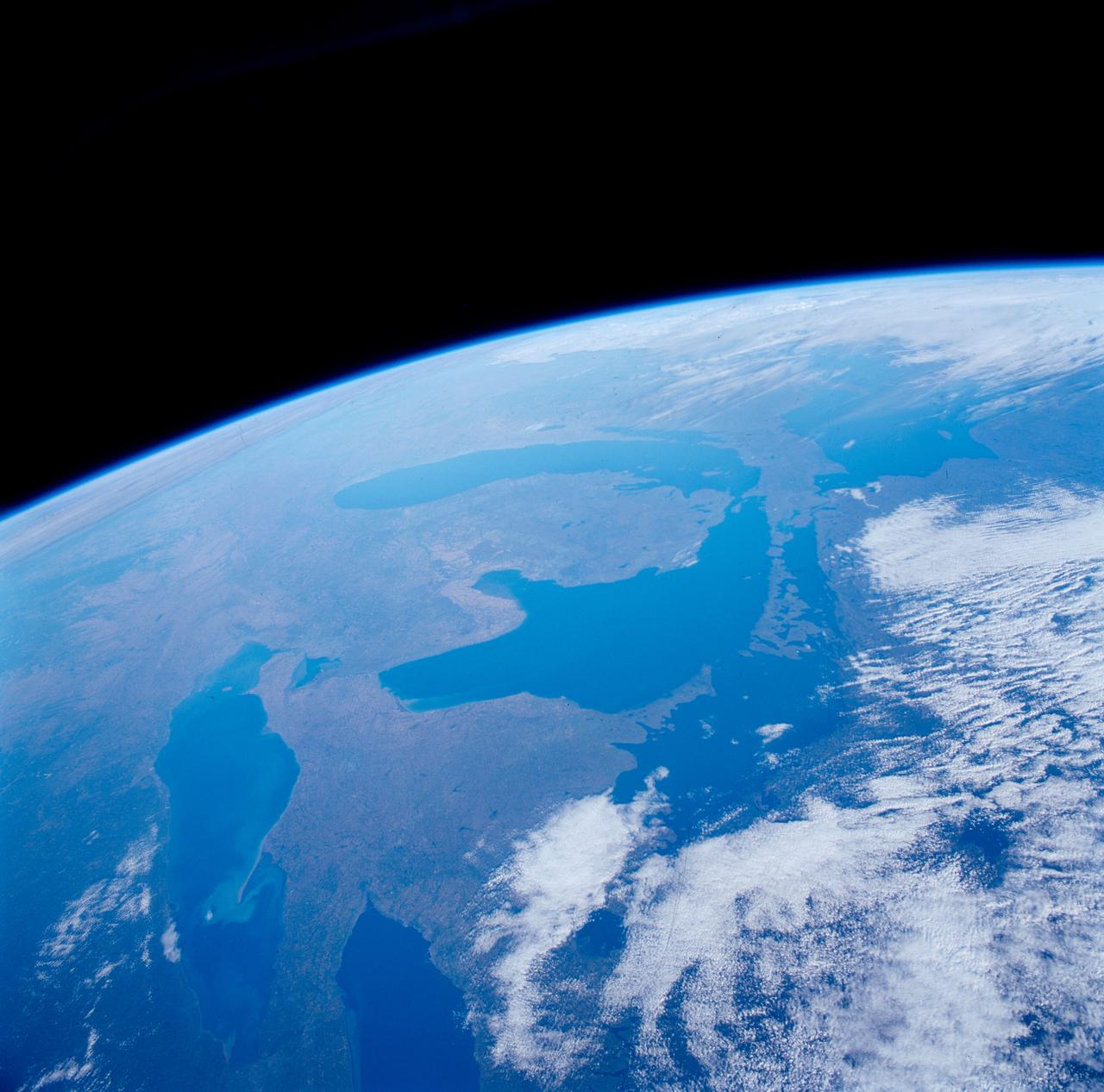
In this oblique view of the Georgia and South Carolina coast, the southern most Appalachians (32.0N, 83.0W) dominate the foreground. Contrails criss cross over Atlanta, a major airline hub. The coastal plain which wraps around the southern Appalachians, is well delineated. Faintly visible under the haze toward Earth's limb are the Great lakes (Lake Michigan near center), the folded belts of the central Appalachians and Long Island, New York.

Anna Michalak, an Orbiting Carbon Observatory science team member from the University of Michigan, Ann Arbor, speaks during a media briefing to discuss the upcoming Orbiting Carbon Observatory mission, the first NASA spacecraft dedicated to studying carbon dioxide, Thursday, Jan. 29, 2009, at NASA Headquarters in Washington. Photo Credit: (NASA/Paul E. Alers)
Stein_Sun: Visualization of the complex magnetic field produced as magnetic flux rises toward the Sun¹s surface from the deep convection zone. The image shows a snapshot of how the magnetic field has evolved two days from the time uniform, untwisted, horizontal magnetic field started to be advected by inflows at the bottom (20 megameters deep). Axes are in megameters, and the color scale shows the log of the magnetic field strength. Credit: Robert Stein, Michigan State University; Tim Sandstrom, NASA/Ames
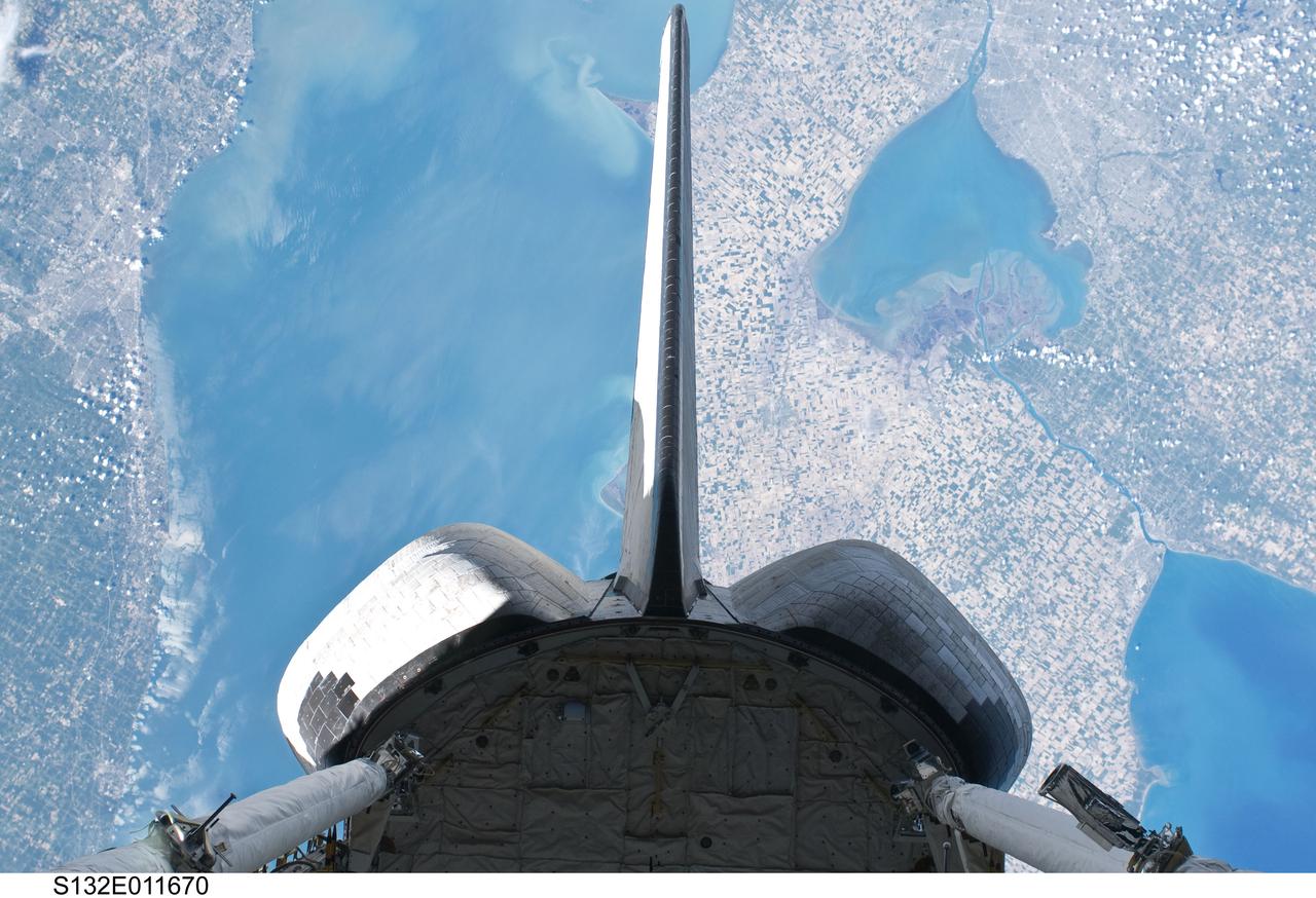
S132-E-011670 (25 May 2010) --- Backdropped over parts of Michigan and the Canadian province of Ontario, space shuttle Atlantis? vertical stabilizer, orbital maneuvering system (OMS) pods and aft payload bay are featured in this image photographed by an STS-132 on the shuttle during flight day 12 activities. Recognizable features in the photo include Lake St. Clair and parts of Lake Huron and Lake Erie.

SL2-05-390 (22 June 1973) --- Greater Detroit (42.0N, 82.5W) is located at the southeastern border of Michigan on the Detroit River across from Windsor, Ontario, Canada and Lake Huron to the north. The river connecting Lake Erie is a channel left over from the Ice Age Glaciers. The land use pattern in this scene is typical of this part of the upper Midwest. The once extensive forests have been cleared for farmland and pasture, but narrow rows of trees still line farm boundaries. Photo credit: NASA
SL2-05-454 (22 June 1973) --- This view shows the west end of Lake Superior and Duluth, MN (47.0N, 91.0W). Portions of Minnesota, Michigan and Ontario, Canada are in the scene. The Duluth metropolitan area is at the west end of the lake. The discoloration plume in the water at Duluth is the result of tailings from the iron ore smelters that process the iron ore from the nearby open pit mines seen near the upper left corner of the photo. Photo credit: NASA
61A-31-005 (30 Oct 1985) --- This almost vertical view, photographed from Earth-orbit by an STS-61A crew member, centers on the metropolis of Milwaukee, Wisconsin, and some of the adjacent Lake Michigan shoreline, southward toward the Illinois border. The 70mm frame was photographed on the first day of the Spacelab D-1 mission with a handheld Hasselblad camera.

Two US Congressmen, accompanied by NASA Administrator James E. Webb, visited the Marshall Space Flight Center (MSFC) April 28, 1964, for a briefing on the Saturn program and a tour of the facilities. They are (left to right) Congressman Gerald Ford Jr., Republican representative of Michigan; Dr. Wernher von Braun, MSFC director; Congressman George H. Mahon, Democratic representative of Texas; and Mr. Webb. Not pictured is Dr. Robert Seamans, associate administrator, who was also in the group.
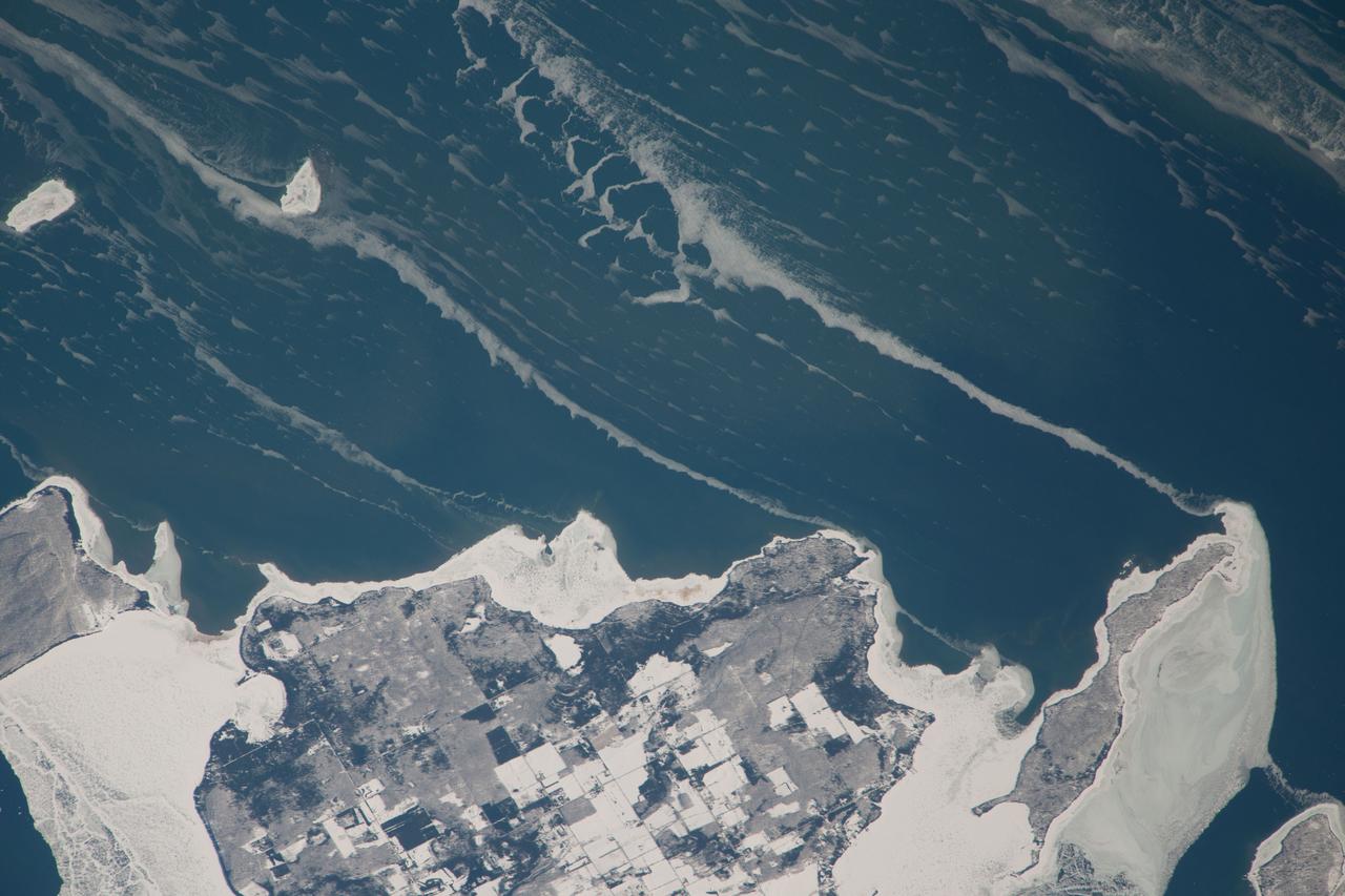
ISS038-E-057977 (22 Feb. 2014) --- Snow-covered fields appear as geometric patterns on Washington Island, on Lake Michigan, in this photograph taken by the Expedition 38 crew of the International Space Station. The island is nine kilometers long (5.6 miles) and lies on the western shore of Lake Michigan, as a continuation of Door Peninsula (Wisconsin). Note that north is to the lower left in the image. White coastal ice hugs the shoreline and connects Washington Island with Detroit Island and Rock Island. Ice typically accumulates first near land, where cooling is more rapid than in deeper lake water. Two other snow-covered islands (image top left) are small enough and far enough from land to evade the collars of ice. On the day this image was taken, southwesterly winds were blowing ice into the lake in the form of long, coherent stringers. The thickness of a stringer is related to the length of coastline that feeds it. The smallest northern stringer (image left) is fed by the shortest section of upwind coastline, and the longest (image right) is supplied by the large amount of shore ice around Detroit Island.
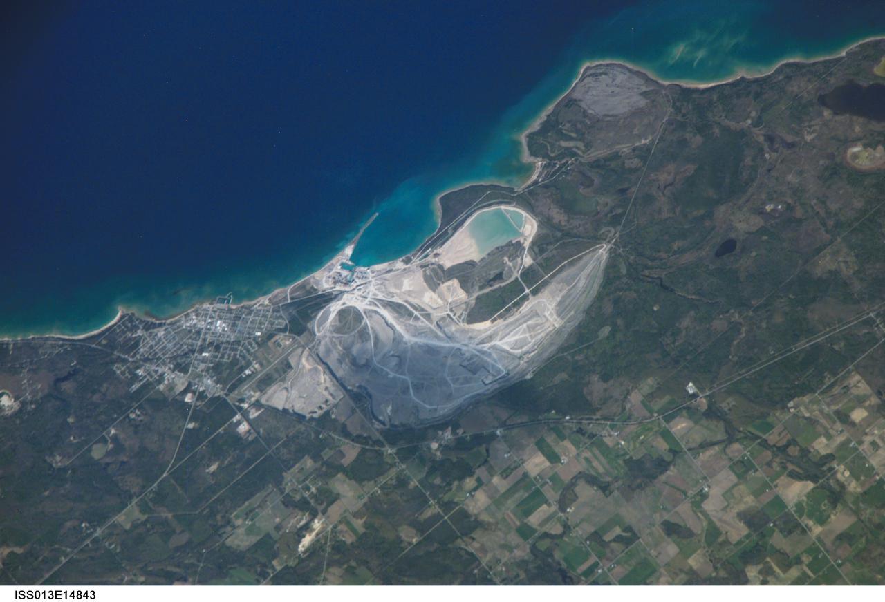
ISS013-E-14843 (6 May 2006) --- Calcite Quarry, Michigan is featured in this image photographed by an Expedition 13 crewmember on the International Space Station. While the Great Lakes region of North America is well known for its importance to shipping between the United States, Canada, and the Atlantic Ocean, it is also the location of an impressive structure in the continent's bedrock -- the Michigan Basin, NASA scientists point out. The Basin looks much like a large bull's-eye defined by the arrangement of exposed rock layers, which all tilt inwards towards the center forming a huge bowl-shaped structure. While this "bowl" is not readily apparent while on the ground, detailed mapping of the rock units on a regional scale revealed the structure to geologists. The outer layers of the Basin include thick deposits of carbonates (limestone and dolomite). These carbonate rocks are mined throughout the Great Lakes region using large open-pit mines. The largest carbonate mine in the world, Calcite Quarry, is depicted in this image. The mine has been active for over 85 years; the worked area (grey region in image center) measures approximately 7 kilometers long by 4 kilometers wide, and is crossed by several access roads (white) into various areas of the mine.

CAPE CANAVERAL, Fla. – Michael Kersjes, author and former special education teacher and football coach from Michigan, speaks to workers during the Disability Awareness and Action Working Group, or DAAWG, event at NASA's Kennedy Space Center in Florida. The theme of his presentation was "Power of the Human Spirit." Kersjes is the author of the book, "A Smile as Big as the Moon," which told the true story of how he worked to get special education students into Space Camp, a competitive education program at the U.S. Space and Rocket Center in Huntsville, Alabama. His book was made into a movie in 2012. For information on Kennedy's diversity programs, visit http://odeo.ksc.nasa.gov. Photo credit: NASA/Kim Shiflett

Michael Kersjes, author and former special education teacher and football coach from Michigan, speaks to workers during the Disability Awareness and Action Working Group, or DAAWG, event at NASA's Kennedy Space Center in Florida. The theme of his presentation was "Power of the Human Spirit." Kersjes is the author of the book, "A Smile as Big as the Moon," which told the true story of how he worked to get special education students into Space Camp, a competitive education program at the U.S. Space and Rocket Center in Huntsville, Alabama. His book was made into a movie in 2012.
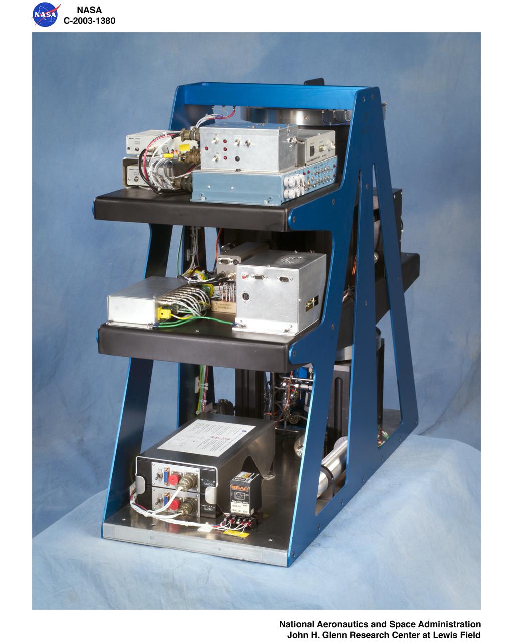
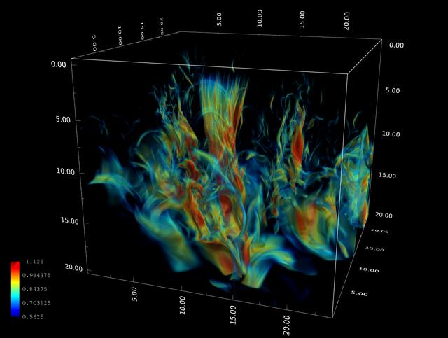
The Laminar Soot Processes (LSP) experiment under way during the Microgravity Sciences Lab-1 mission in 1997. LSP-2 will fly in the STS-107 Research 1 mission in 2001. The principal investigator is Dr. Gerard Faeth of the University of Michigan. LSP uses a small jet burner, similar to a classroom butane lighter, that produces flames up to 60 mm (2.3 in) long. Measurements include color TV cameras and a temperature sensor, and laser images whose darkness indicates the quantity of soot produced in the flame. Glenn Research in Cleveland, OH, manages the project.
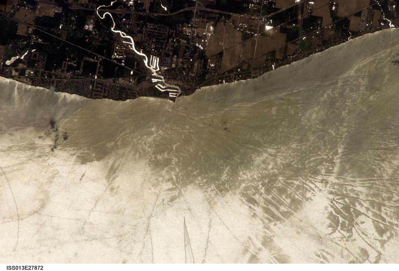
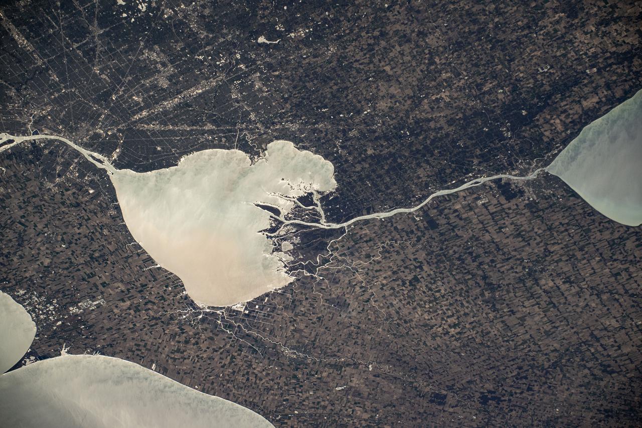
ISS013-E-27872 (28 May 2006) --- Considerable sunglint emphasizes features on Lake Erie in this image photographed by an Expedition 13 crewmember on the International Space Station. This detailed, south-looking image shows features on the surface of Lake Erie, about 30 miles west of Cleveland, Ohio. This view shows the Vermilion River in strong sunglint. The angular water bodies along the river are likely marinas. The main part of the image show numerous ship wakes in the zone of partial glint around the disk of the Sun's reflection point. The wakes radiate from the mouth of the Vermilion River, with many of them heading northwest in the direction of Detroit, Michigan.
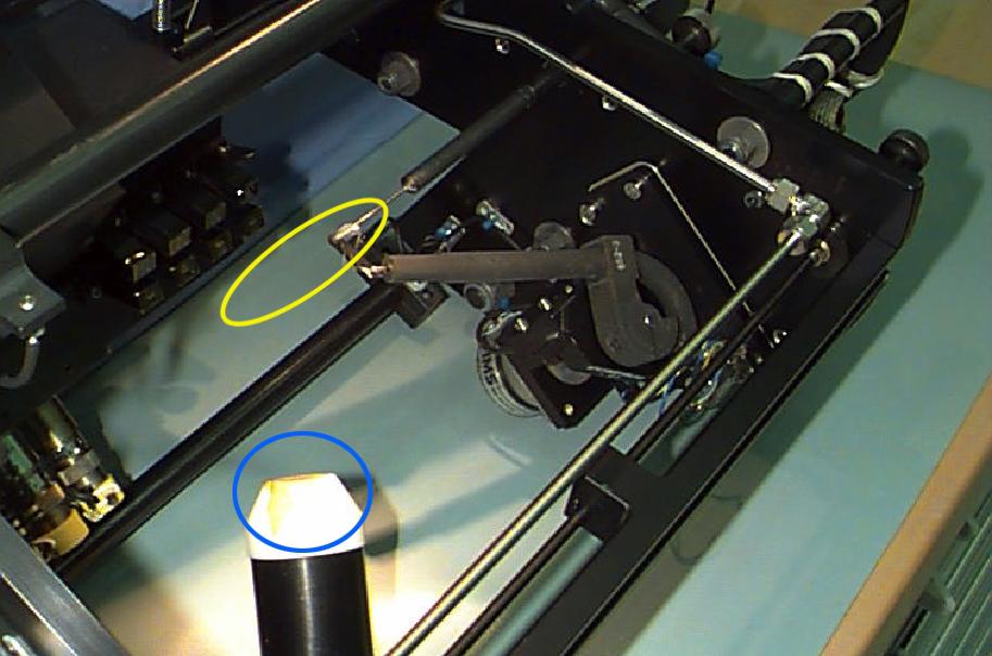
Interior of the Equipment Module for the Laminar Soot Processes (LSP-2) experiment that fly in the STS-107 Research 1 mission in 2002 (LSP-1 flew on Microgravity Sciences Lab-1 mission in 1997). The principal investigator is Dr. Gerard Faeth of the University of Michigan. LSP uses a small jet burner (yellow ellipse), similar to a classroom butane lighter, that produces flames up to 60 mm (2.3 in) long. Measurements include color TV cameras and a radiometer or heat sensor (blue circle), and laser images whose darkness indicates the quantity of soot produced in the flame. Glenn Research in Cleveland, OH, manages the project.

Michael Kersjes, author and former special education teacher and football coach from Michigan, speaks to workers during the Disability Awareness and Action Working Group, or DAAWG, event at NASA's Kennedy Space Center in Florida. The theme of his presentation was "Power of the Human Spirit." Kersjes is the author of the book, "A Smile as Big as the Moon," which told the true story of how he worked to get special education students into Space Camp, a competitive education program at the U.S. Space and Rocket Center in Huntsville, Alabama. His book was made into a movie in 2012.
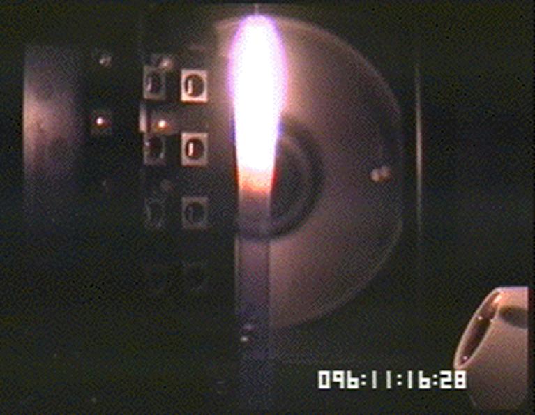
Image of soot (smoke) plume made for the Laminar Soot Processes (LSP) experiment during the Microgravity Sciences Lab-1 mission in 1997. LSP-2 will fly in the STS-107 Research 1 mission in 2002. The principal investigator is Dr. Gerard Faeth of the University of Michigan. LSP uses a small jet burner, similar to a classroom butane lighter, that produces flames up to 60 mm (2.3 in) long. Measurements include color TV cameras and a temperature sensor, and laser images whose darkness indicates the quantity of soot produced in the flame. Glenn Research in Cleveland, OH, manages the project.

NASA Kennedy Space Center Director Bob Cabana, left, presents a special plaque to Michael Kersjes, author and former special education teacher and football coach from Michigan, after his presentation to workers during the Disability Awareness and Action Working Group, or DAAWG, event. The theme of Kersjes' presentation was "Power of the Human Spirit." Kersjes is the author of the book, "A Smile as Big as the Moon," which told the true story of how he worked to get special education students into Space Camp, a competitive education program at the U.S. Space and Rocket Center in Huntsville, Alabama. His book was made into a movie in 2012.

CAPE CANAVERAL, Fla. – Michael Kersjes, author and former special education teacher and football coach from Michigan, speaks to workers during the Disability Awareness and Action Working Group, or DAAWG, event at NASA's Kennedy Space Center in Florida. The theme of his presentation was "Power of the Human Spirit." Kersjes is the author of the book, "A Smile as Big as the Moon," which told the true story of how he worked to get special education students into Space Camp, a competitive education program at the U.S. Space and Rocket Center in Huntsville, Alabama. His book was made into a movie in 2012. For information on Kennedy's diversity programs, visit http://odeo.ksc.nasa.gov. Photo credit: NASA/Kim Shiflett

S82-28906 (27 March 1982) --- Astronaut C. Gordon Fullerton, STS-3 pilot, mans the right hand aft station of the flight deck on the Earth-orbiting Columbia. The photograph was taken with a 35mm camera by astronaut Jack R. Lousma, crew commander. The "Go Blue" sticker is a University of Michigan memento of Lousma, and the Air Force sign was put up by Fullerton, a USAF colonel. Lousma, a USMC colonel, received his BS degree in aeronautical engineering in 1959 from UM. One of two aft windows for cargo bay viewing and one of two ceiling windows are visible in the photo. Fullerton and Lousma watched the activity of the remote manipulator system (RMS) arm out the lower window and they took a number of photos of Earth from the upper window. Photo credit: NASA

STS054-S-020 (15 Jan 1993) --- McMonagle watches as a top spins above his head on the middeck of the Earth-orbiting Endeavour. The demonstration was part of a lengthy "physics of toys" program conducted by all five crewmembers on their third day aboard the Shuttle. Through telephone and TV downlinks, students in four schools around the country participated in a special lesson to discover how specific toys function differently in the classroom compared to those on the Shuttle. Students at Westwood Elementary School in Flint, Michigan -- McMonagle's hometown -- asked him questions about the several toys he demonstrated. The top demonstrates gyroscopic motion, the center of mass and angular momentum. The entire collection of toys will be videotaped for an educational program to be distributed to schools in the autumn. The scene was downlinked at 18:01:59:11 GMT, Jan. 15, 1993.

Berkley, Michigan high school student, Kirk M. Sherhart, is greeted by (left to right): Astronauts Russell L. Schweickart, and Owen K. Garriott; Marshall Space Flight Center (MSFC) Skylab Program Manager, Leland Belew; and MSFC Director of Administration and Technical Services, David Newby, during a tour of MSFC. Sherhart was among 25 winners of a contest in which some 3,500 high school students proposed experiments for the following year’s Skylab mission. The nationwide scientific competition was sponsored by the National Science Teachers Association and the National Aeronautics and Space Administration (NASA). The winning students, along with their parents and sponsor teachers, visited MSFC where they met with scientists and engineers, participated in design reviews for their experiments, and toured MSFC facilities. Of the 25 students, 6 did not see their experiments conducted on Skylab because the experiments were not compatible with Skylab hardware and timelines. Of the 19 remaining, 11 experiments required the manufacture of additional equipment.