Mountains of Darkness

Mountain of Ice
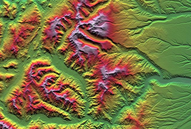
Stone Mountain
Mountains in the Distance
At the Mountains of Madness
Mountains on Io
A Mountain of Hollows
Frosty Mountains
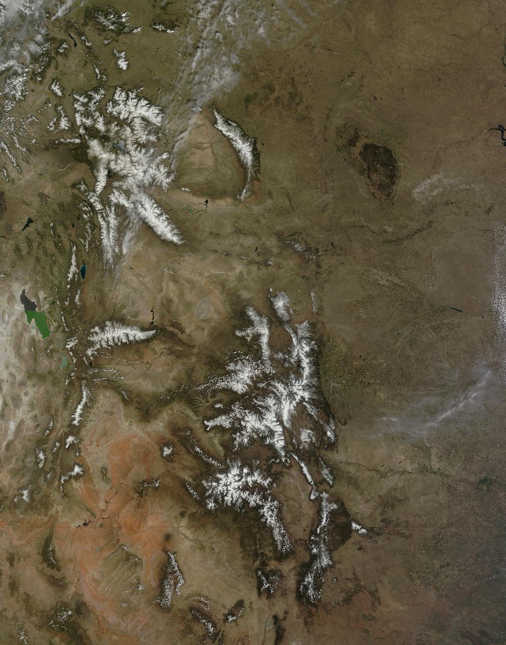
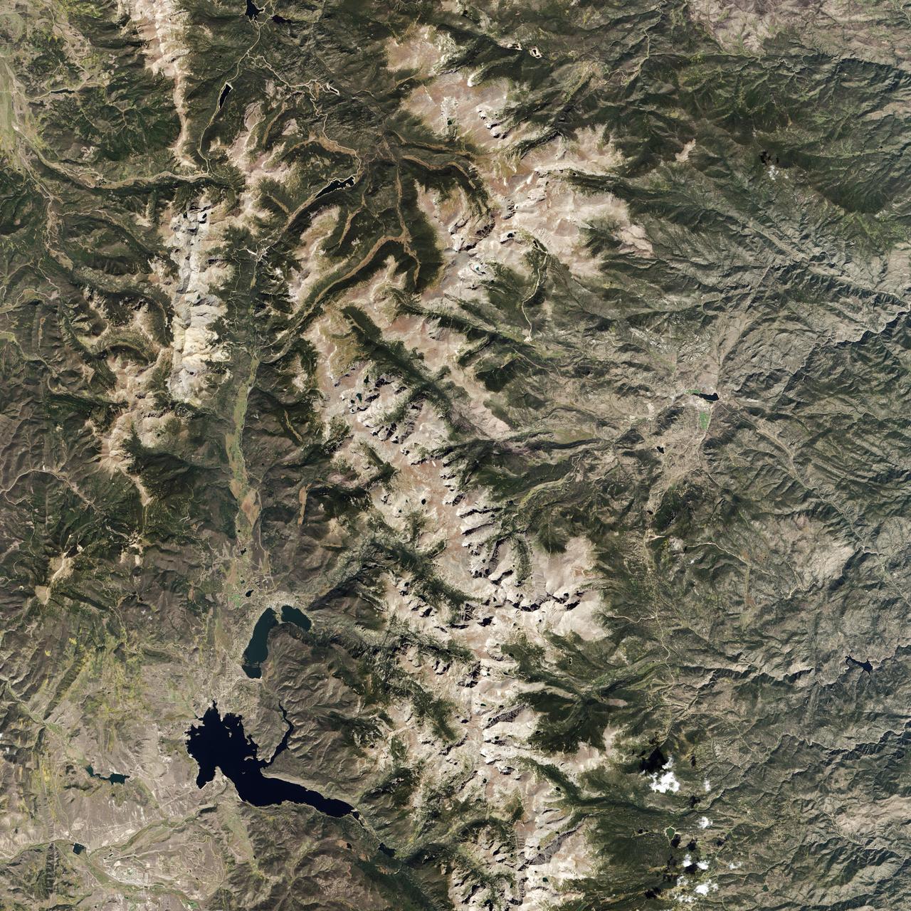
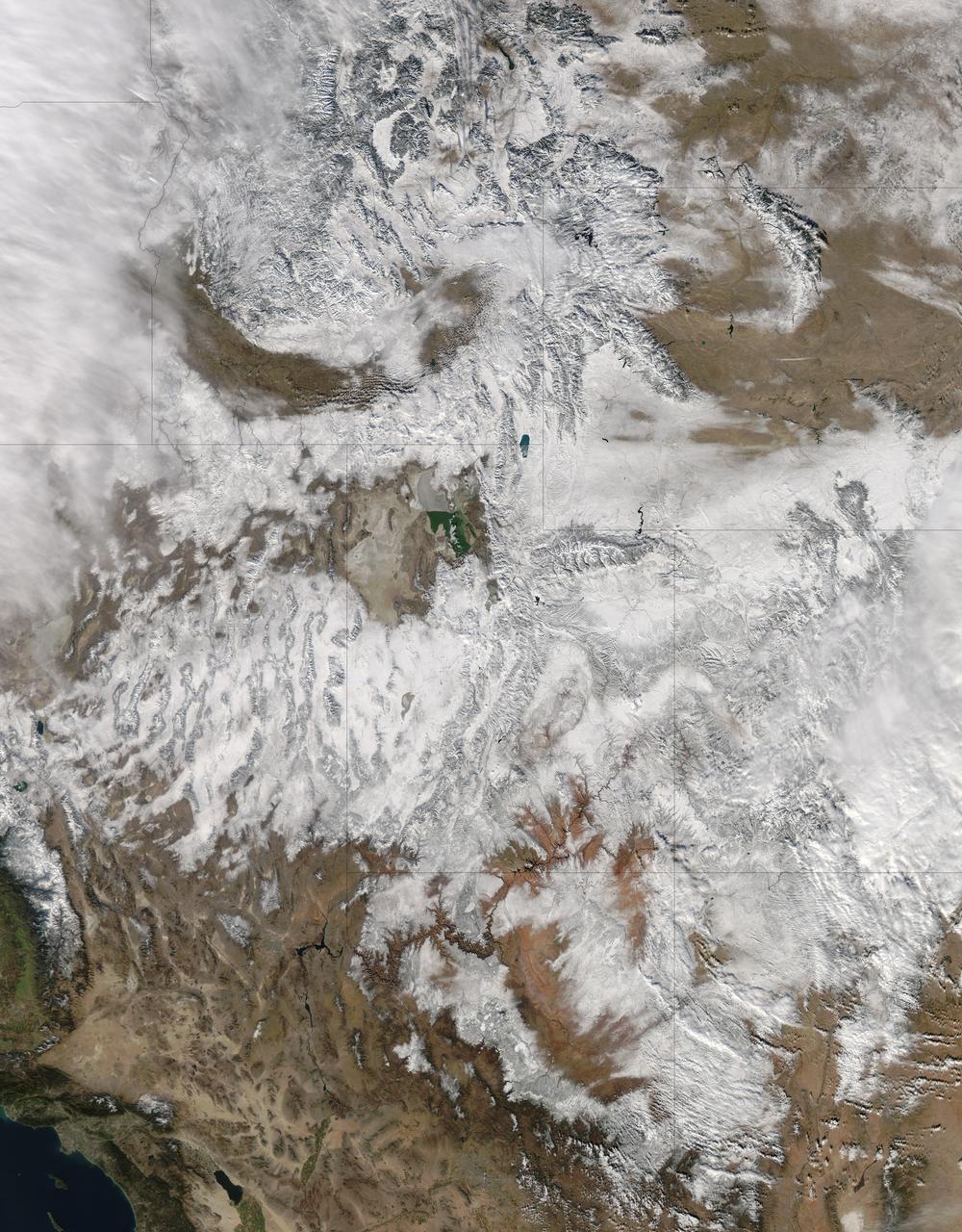
On April 29, 2015 the Moderate Resolution Imaging Spectroradiometer (MODIS) aboard NASA’s Terra satellite captured a true-color image of a typical spring scene in the western United State: snow-crowned Rocky Mountains rising above the faintly greening plains. The Rocky Mountains stretch from British Columbia, Canada to the Rio Grande in New Mexico, a span of roughly 3,000 miles, and contains many of the highest peaks in the continental United States. The tallest, Mount Elbert, rises 14,400 ft. (4,401 m) above sea level, and is located in the San Isabel National Forest, near Leadville, Colorado. This image covers seven Rocky Mountain states. From north to south they are: Montana and Idaho, Wyoming; Utah (with the Great Salt Lake visible) and Colorado; Arizona and New Mexico. To the east, the Great Plain states captured are, from north to south: North Dakota, South Dakota, Nebraska, Kansas, Oklahoma and northwestern Texas. Credit: NASA/GSFC/Jeff Schmaltz/MODIS Land Rapid Response Team <b><a href="http://www.nasa.gov/audience/formedia/features/MP_Photo_Guidelines.html" rel="nofollow">NASA image use policy.</a></b> <b><a href="http://www.nasa.gov/centers/goddard/home/index.html" rel="nofollow">NASA Goddard Space Flight Center</a></b> enables NASA’s mission through four scientific endeavors: Earth Science, Heliophysics, Solar System Exploration, and Astrophysics. Goddard plays a leading role in NASA’s accomplishments by contributing compelling scientific knowledge to advance the Agency’s mission. <b>Follow us on <a href="http://twitter.com/NASAGoddardPix" rel="nofollow">Twitter</a></b> <b>Like us on <a href="http://www.facebook.com/pages/Greenbelt-MD/NASA-Goddard/395013845897?ref=tsd" rel="nofollow">Facebook</a></b> <b>Find us on <a href="http://instagrid.me/nasagoddard/?vm=grid" rel="nofollow">Instagram</a></b>
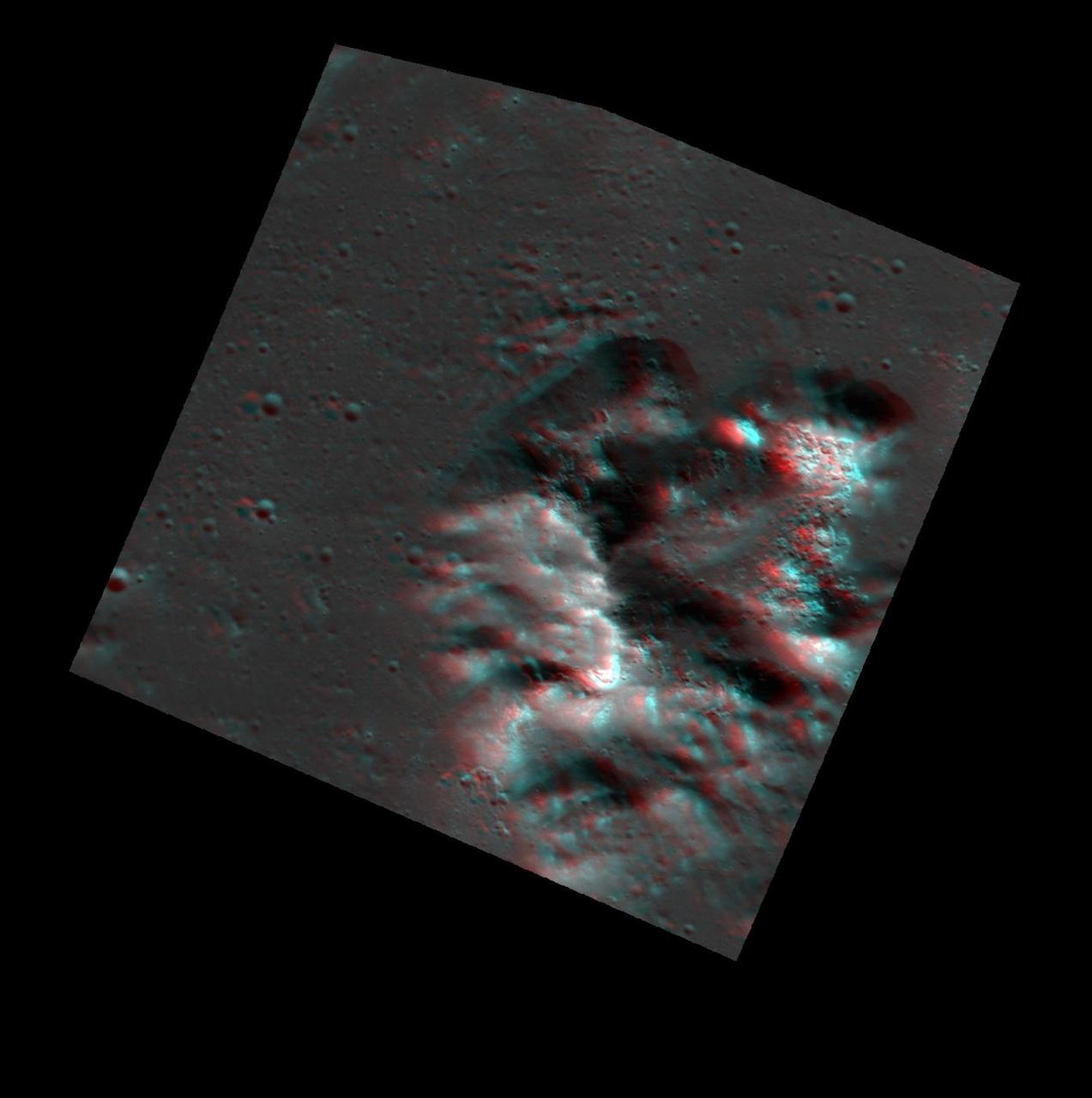
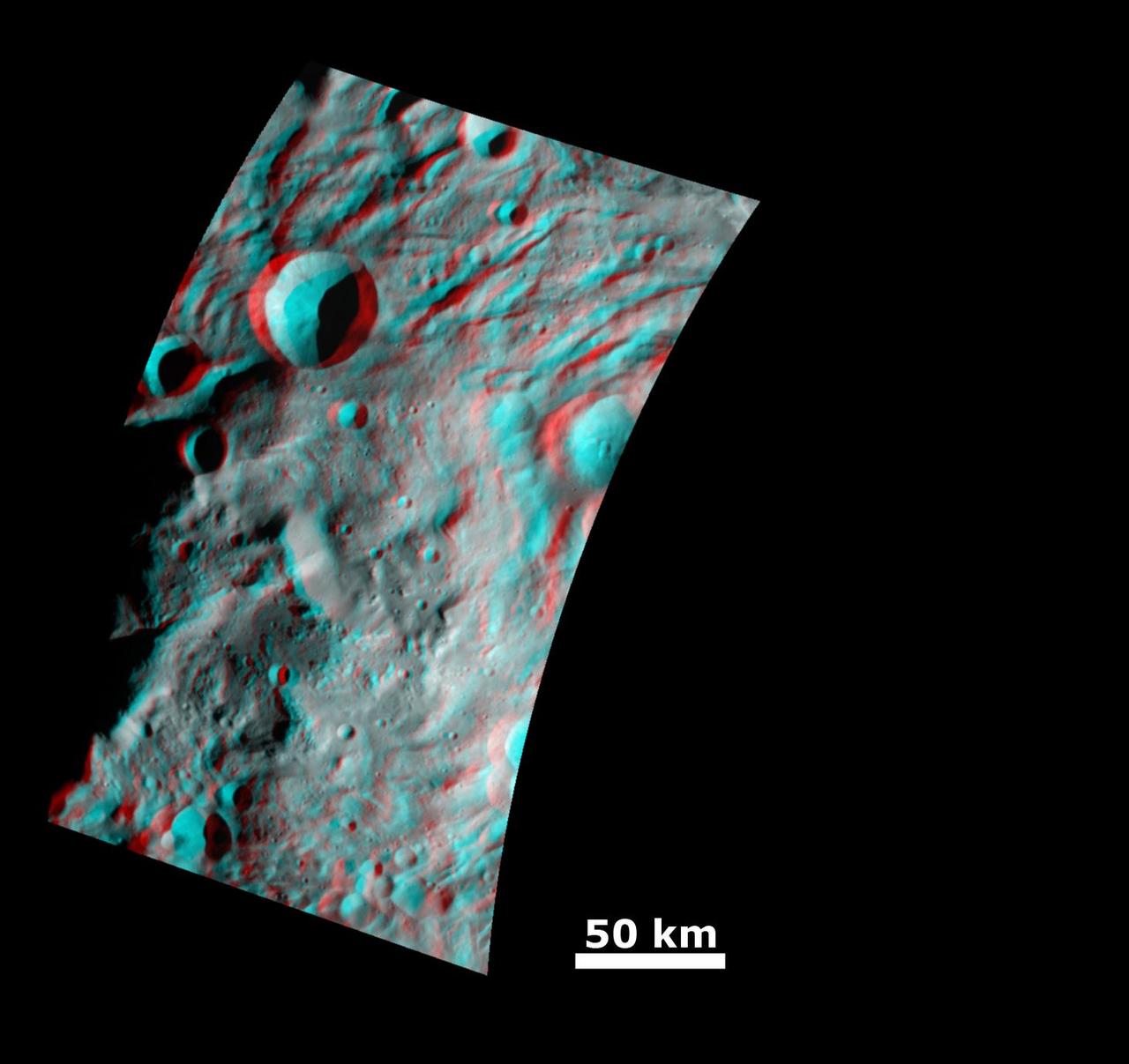
A Mountain of Hollows Anaglyph
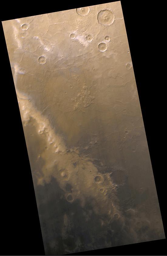
The Mysterious Martian Mountains of Mitchel
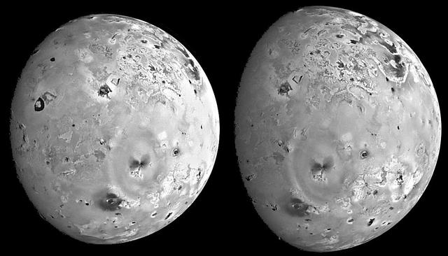
Mountains and Plateaus on Io
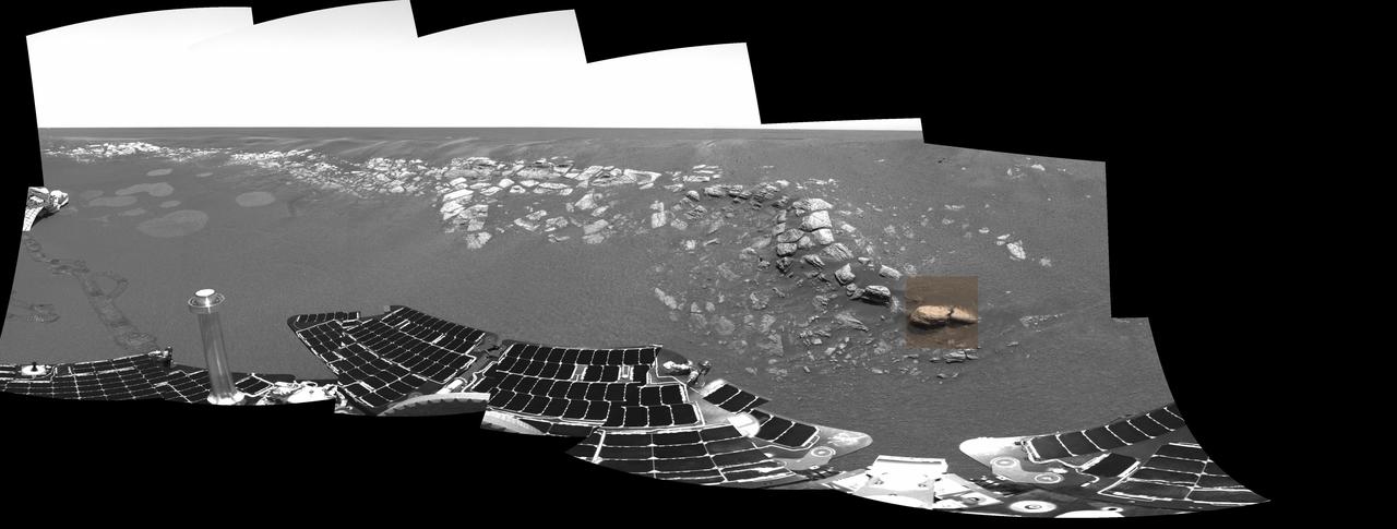
Stone Mountain in Context
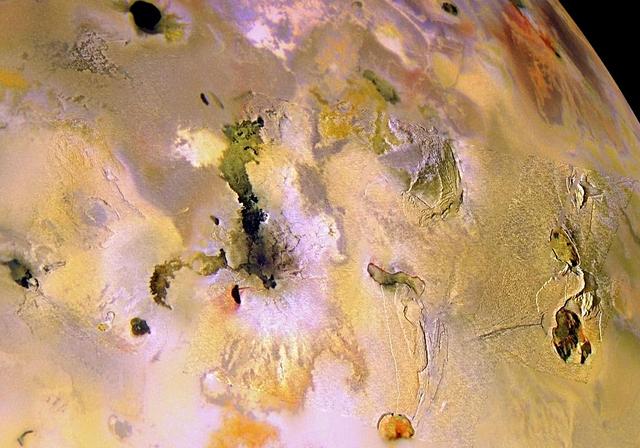
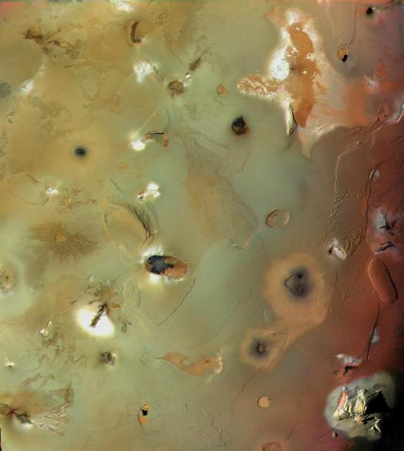
Ionian Mountains and Calderas, in Color
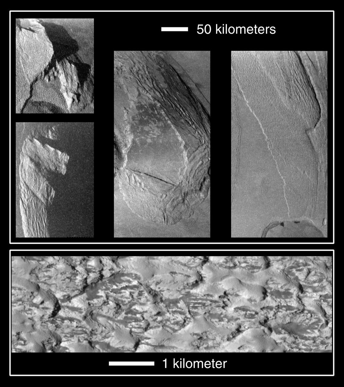
Collapsing Mountains on Io
Coasts and Drowned Mountains
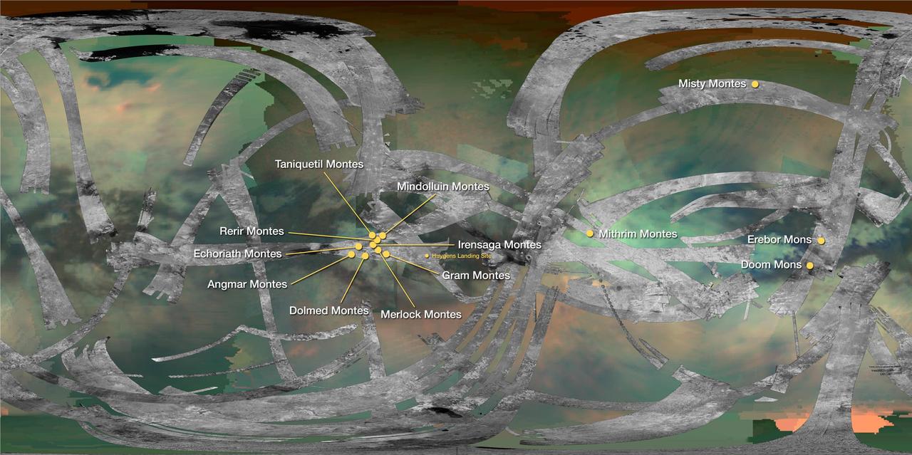
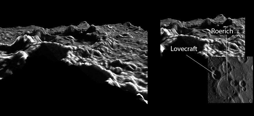
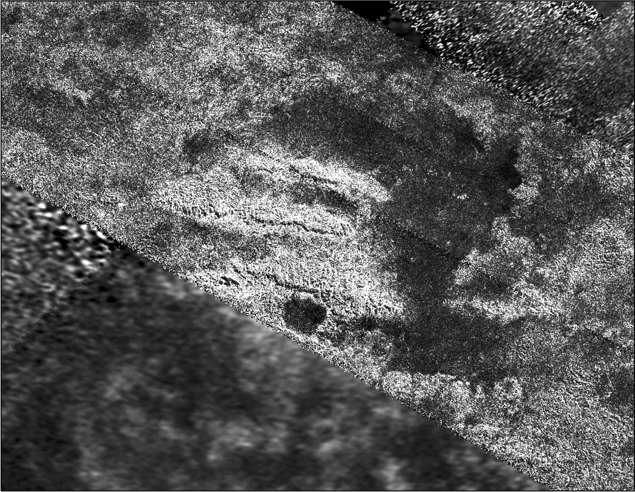
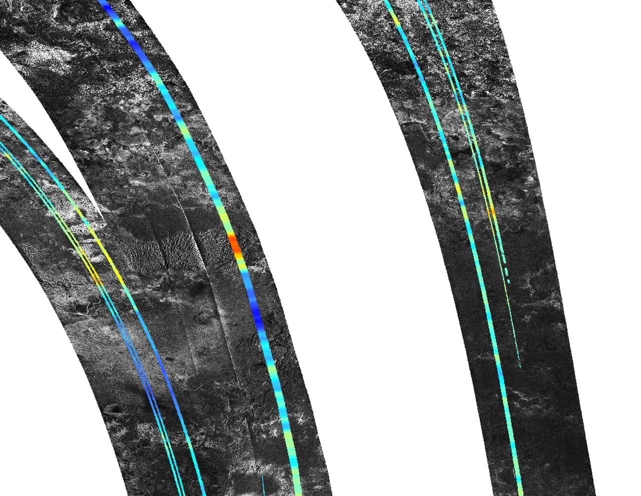
This map of Saturn moon Titan identifies the locations of mountains named by the International Astronomical Union. By convention, mountains on Titan are named for mountains from Middle-earth, the fictional setting in fantasy novels by J.R.R. Tolkien.
Colorado’s Rocky Mountain National Park presents a very different landscape in summertime than in wintertime. Snow retreats and gives way to blooms of wildflowers, even at high elevations. Roads and trails become accessible, allowing visitors easier access to the rugged mountain trails and vistas. The diversity of the park’s landscape is visible in this image, acquired on September 20, 2014, with the Operational Land Imager (OLI) on the Landsat 8 satellite. Except for a few patches, seasonal snow is mostly gone. Even the “Never Summer Mountains”—a range along the park’s northwest border known to receive snow any time of year—appears to be temporarily snow-free. Read more: <a href="http://go.nasa.gov/29Rmz4Y" rel="nofollow">go.nasa.gov/29Rmz4Y</a> Credit: NASA/Landsat8 <b><a href="http://www.nasa.gov/audience/formedia/features/MP_Photo_Guidelines.html" rel="nofollow">NASA image use policy.</a></b> <b><a href="http://www.nasa.gov/centers/goddard/home/index.html" rel="nofollow">NASA Goddard Space Flight Center</a></b> enables NASA’s mission through four scientific endeavors: Earth Science, Heliophysics, Solar System Exploration, and Astrophysics. Goddard plays a leading role in NASA’s accomplishments by contributing compelling scientific knowledge to advance the Agency’s mission. <b>Follow us on <a href="http://twitter.com/NASAGoddardPix" rel="nofollow">Twitter</a></b> <b>Like us on <a href="http://www.facebook.com/pages/Greenbelt-MD/NASA-Goddard/395013845897?ref=tsd" rel="nofollow">Facebook</a></b> <b>Find us on <a href="http://instagrid.me/nasagoddard/?vm=grid" rel="nofollow">Instagram</a></b>
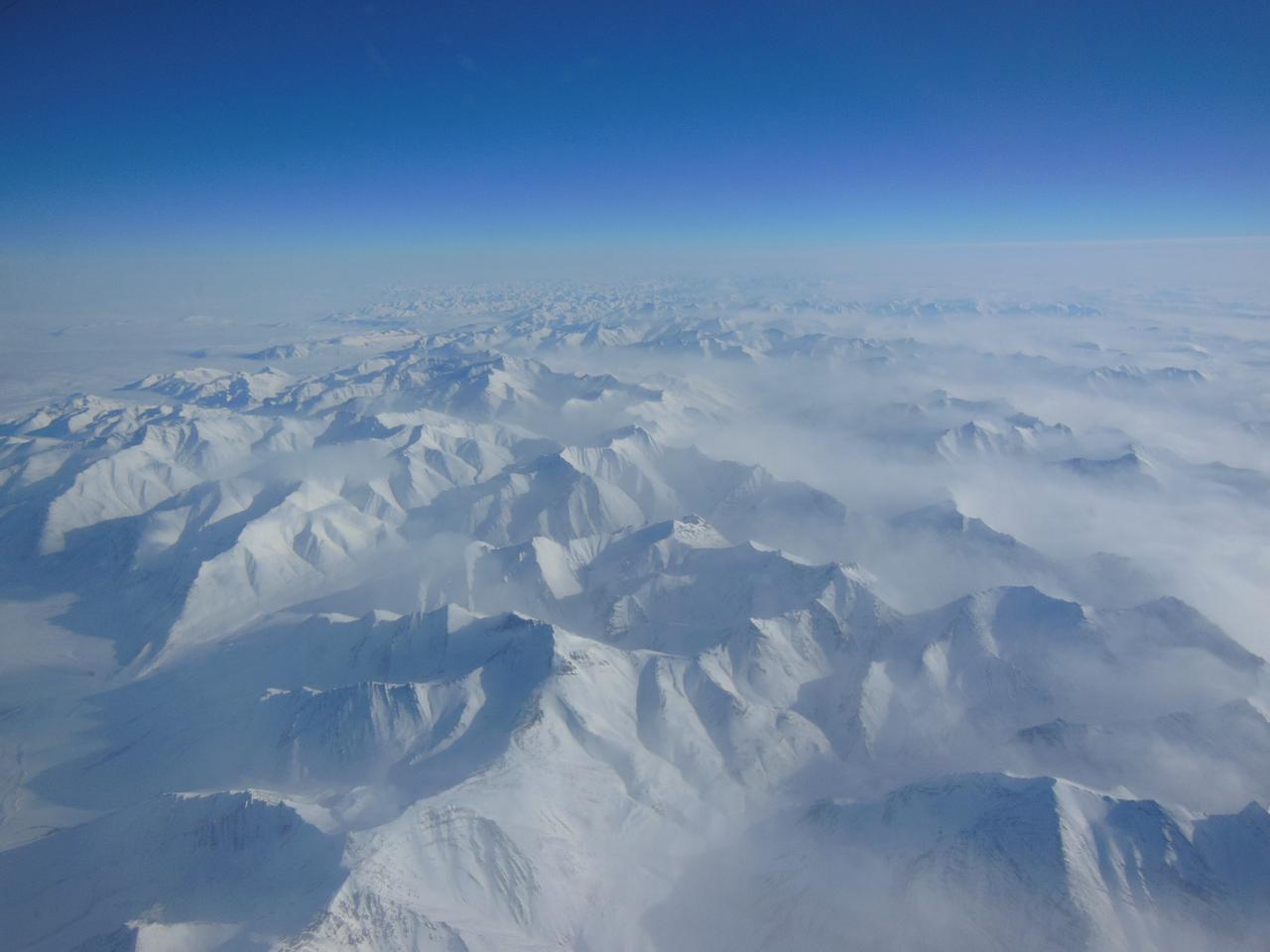
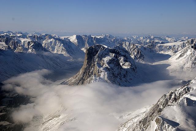
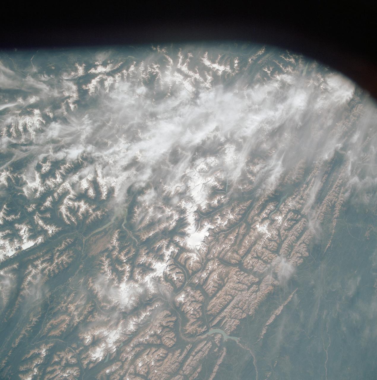
Alaskan mountains seen from high altitude aboard the NASA P-3B during the IceBridge transit flight from Thule to Fairbanks on Mar. 21, 2013. NASA's Operation IceBridge is an airborne science mission to study Earth's polar ice. For more information about IceBridge, visit: <a href="http://www.nasa.gov/icebridge" rel="nofollow">www.nasa.gov/icebridge</a> Credit: NASA/Goddard/Christy Hansen <b><a href="http://www.nasa.gov/audience/formedia/features/MP_Photo_Guidelines.html" rel="nofollow">NASA image use policy.</a></b> <b><a href="http://www.nasa.gov/centers/goddard/home/index.html" rel="nofollow">NASA Goddard Space Flight Center</a></b> enables NASA’s mission through four scientific endeavors: Earth Science, Heliophysics, Solar System Exploration, and Astrophysics. Goddard plays a leading role in NASA’s accomplishments by contributing compelling scientific knowledge to advance the Agency’s mission. <b>Follow us on <a href="http://twitter.com/NASA_GoddardPix" rel="nofollow">Twitter</a></b> <b>Like us on <a href="http://www.facebook.com/pages/Greenbelt-MD/NASA-Goddard/395013845897?ref=tsd" rel="nofollow">Facebook</a></b> <b>Find us on <a href="http://instagram.com/nasagoddard?vm=grid" rel="nofollow">Instagram</a></b>
Most mountains on the Earth are formed as plates collide and the crust buckles. Not so for the Moon, where mountains are formed as a result of impacts as seen by NASA Lunar Reconnaissance Orbiter.
Making Mountains Out of Central Peaks
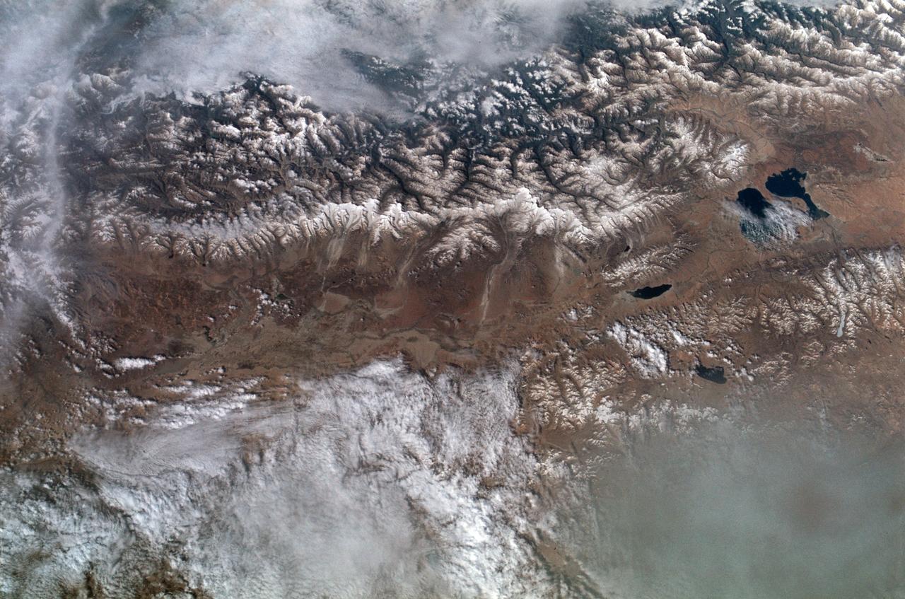
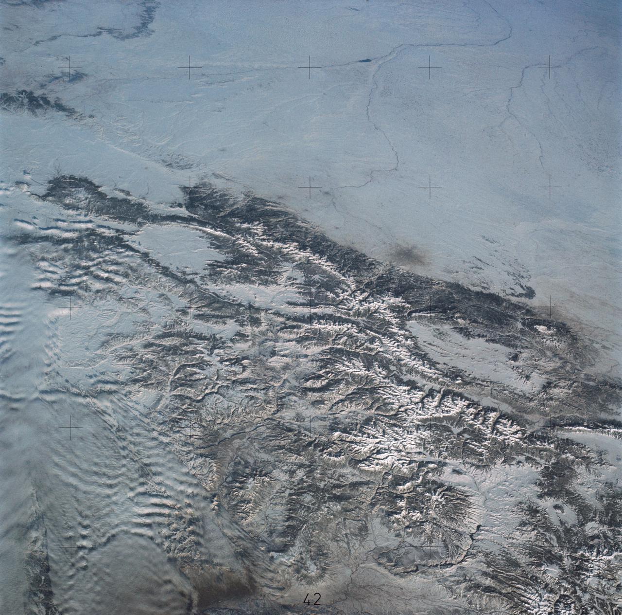
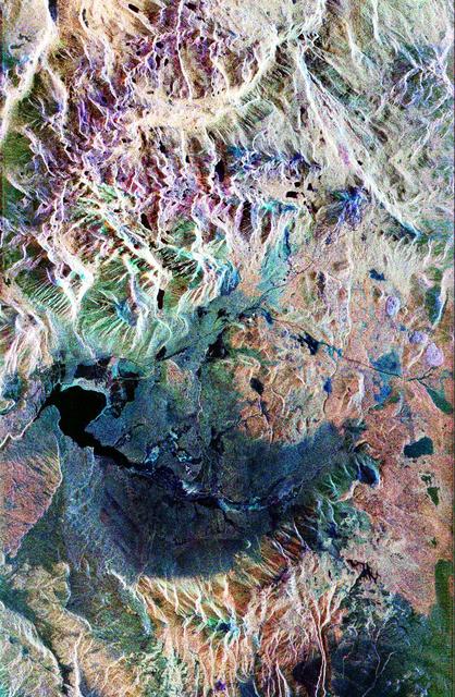
SL2-102-900 (22 June 1973) --- The Great Himalayan Mountain Range, India/Tibet (30.5N, 81.5E) is literally the top of the world where mountains soar to over 20,000 ft. effectively isolating Tibet from the rest of the world. The two lakes seen in the center of the image are the Laga Co and the Kunggyu Co located just inside the Tibet border. Although clouds and rainfall are rare in this region, snow is always present on the mountain peaks. Photo credit: NASA

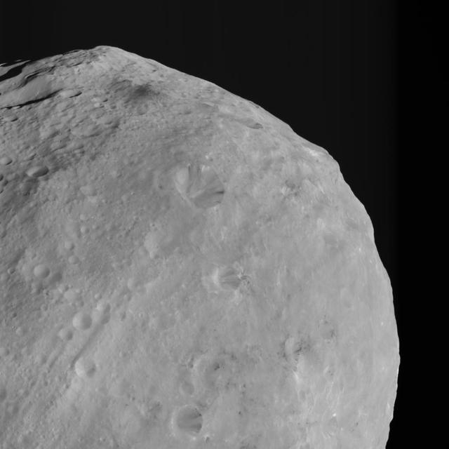
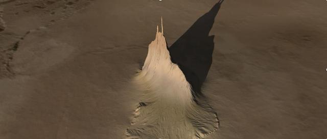
NASA Dawn spacecraft spotted this tall, conical mountain on Ceres from a distance of 915 miles 1,470 kilometers. The mountain, located in the southern hemisphere, stands 4 miles 6 kilometers high.
Io, Showing Volcanic Plains and Mountains http://photojournal.jpl.nasa.gov/catalog/PIA00328

STS054-151-150 (13-19 Jan 1993) --- View west into sun glint off the Rio Salado, Saladillo, and Parana Rivers in Argentina. The Space Shuttle nadir is about 28 degrees north latitude and 57 degrees west longitude. The Andes Mountains are barely visible on Earth's limb. Thunderstorms along the eastern edge of the Andes are typical of this time of year (Southern Hemisphere summer), with anvils moving to the east from the core of the storm.
This image from NASA Dawn spacecraft shows dark colored mountains top of the image in the northern region of asteroid Vesta. The origin of such mountains is currently being investigated.
STS058-91-058 (18 Oct-1 Nov 1993) --- In this unusually clear view, the Ouachita Mountains of southeastern Oklahoma are framed on the north by Lake Eufaula on the South Canadian River, and on the south by the Red River. Sandstone, shale and chert (similar to flint) deposited in a sea several thousand feet deep were squeezed up to form the mountains about 250 million years ago. During the ensuing time, erosion of the western end of the Ouachita Mountains has emphasized linear ridges of resistant rock in the plunging anticlines and synclines, causing relief of 800 meters (2,600 feet) or more. Clouds formed by upslope winds border both the north and south sides of one of the most dramatic plunging synclines (in a syncline the rock layers dip toward the center of the structure). Toward the west, densely forested mountains give way to gently rolling, less rocky terrain and a drier climate which is better suited to farming. The mountains centered on Broken Bow, in the lower right corner of the scene, display abundant timber clearcuts that are being regenerated.

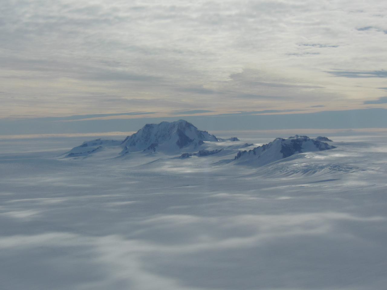
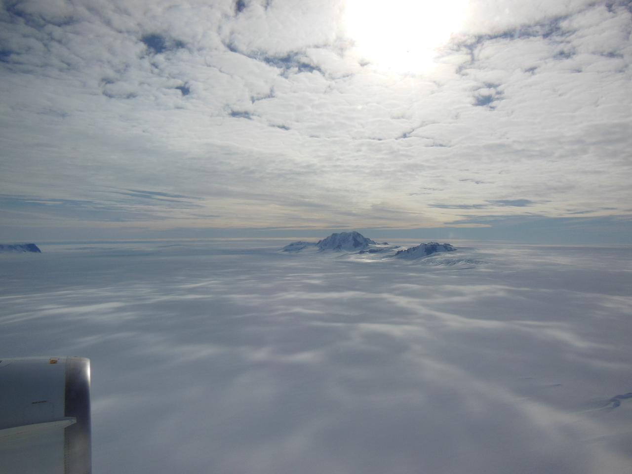
Mountain peaks through the ice cover on Thurston Island off of western Antarctica as seen on the IceBridge flight on Nov. 5, 2014. Image Credit: NASA/Jim Yungel NASA’s Operation IceBridge collected some rare images on a flight out of Punta Arenas, Chile on Nov. 5, 2014, on a science flight over western Antarctica dubbed Ferrigno-Alison-Abbott 01. The crew snapped a few shots of a calving front of the Antarctic ice sheet. This particular flight plan was designed to collect data on changes in ice elevation along the coast near the Ferrigno and Alison ice streams, on the Abbot Ice Shelf, and grounded ice along the Eights Coast.
NASA image acquired December 19, 2012 In time for the 2012 winter solstice, a storm dropped snow over most of the Rocky Mountains in the United States. On December 20, the National Weather Service reported snow depths exceeding 100 centimeters (39 inches) in some places—the result of the recent snowfall plus accumulation from earlier storms. The Moderate Resolution Imaging Spectroradiometer (MODIS) on NASA’s Aqua satellite captured this natural-color image on December 19, 2012. Clouds had mostly cleared from the region, though some cloud cover lingered over parts of the Pacific Northwest and Colorado. Showing more distinct contours than the clouds, the snow cover stretched across the Rocky Mountains and the surrounding region, from Idaho to Arizona and from California to Colorado. Snowfall did not stop in Colorado, as the storm continued moving eastward across the Midwest. By December 20, 2012, a combination of heavy snow and strong winds had closed schools, iced roads, and delayed flights, complicating plans for holiday travelers. Though troublesome for travel, the snow brought much-needed moisture; multiple cities had set new records for consecutive days without measurable snow, CBS news reported. As of December 18, the U.S. Drought Monitor stated that a substantial portion of the continental United States continued to suffer from drought, and “exceptional” drought conditions extended from South Dakota to southern Texas. NASA image courtesy Jeff Schmaltz, LANCE MODIS Rapid Response. Caption by Michon Scott. Instrument: Aqua - MODIS To read more go to: <a href="http://earthobservatory.nasa.gov/IOTD/view.php?id=80035" rel="nofollow">earthobservatory.nasa.gov/IOTD/view.php?id=80035</a> Credit: <b><a href="http://www.earthobservatory.nasa.gov/" rel="nofollow"> NASA Earth Observatory</a></b> <b><a href="http://www.nasa.gov/audience/formedia/features/MP_Photo_Guidelines.html" rel="nofollow">NASA image use policy.</a></b> <b><a href="http://www.nasa.gov/centers/goddard/home/index.html" rel="nofollow">NASA Goddard Space Flight Center</a></b> enables NASA’s mission through four scientific endeavors: Earth Science, Heliophysics, Solar System Exploration, and Astrophysics. Goddard plays a leading role in NASA’s accomplishments by contributing compelling scientific knowledge to advance the Agency’s mission. <b>Follow us on <a href="http://twitter.com/NASA_GoddardPix" rel="nofollow">Twitter</a></b> <b>Like us on <a href="http://www.facebook.com/pages/Greenbelt-MD/NASA-Goddard/395013845897?ref=tsd" rel="nofollow">Facebook</a></b> <b>Find us on <a href="http://instagram.com/nasagoddard?vm=grid" rel="nofollow">Instagram</a></b>
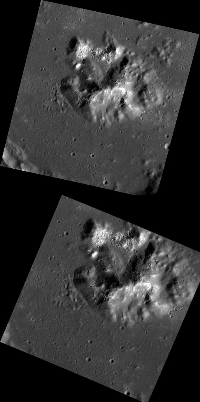
Detailed View of Mountain and Craters at Tohil, Io
Stereo Image of Zal Patera and Neighboring Mountain, Io
Mountains seen from the IceBridge DC-8 during a survey of the Getz Ice Shelf on Oct. 27, 2012. Credit: NASA / Christy Hansen NASA's Operation IceBridge is an airborne science mission to study Earth's polar ice. For more information about IceBridge, visit: <a href="http://www.nasa.gov/icebridge" rel="nofollow">www.nasa.gov/icebridge</a> <b><a href="http://www.nasa.gov/audience/formedia/features/MP_Photo_Guidelines.html" rel="nofollow">NASA image use policy.</a></b> <b><a href="http://www.nasa.gov/centers/goddard/home/index.html" rel="nofollow">NASA Goddard Space Flight Center</a></b> enables NASA’s mission through four scientific endeavors: Earth Science, Heliophysics, Solar System Exploration, and Astrophysics. Goddard plays a leading role in NASA’s accomplishments by contributing compelling scientific knowledge to advance the Agency’s mission. <b>Follow us on <a href="http://twitter.com/NASA_GoddardPix" rel="nofollow">Twitter</a></b> <b>Like us on <a href="http://www.facebook.com/pages/Greenbelt-MD/NASA-Goddard/395013845897?ref=tsd" rel="nofollow">Facebook</a></b> <b>Find us on <a href="http://instagrid.me/nasagoddard/?vm=grid" rel="nofollow">Instagram</a></b>
Mountains seen from the IceBridge DC-8 during a survey of the Getz Ice Shelf on Oct. 27, 2012. Credit: NASA / Christy Hansen NASA's Operation IceBridge is an airborne science mission to study Earth's polar ice. For more information about IceBridge, visit: <a href="http://www.nasa.gov/icebridge" rel="nofollow">www.nasa.gov/icebridge</a> <b><a href="http://www.nasa.gov/audience/formedia/features/MP_Photo_Guidelines.html" rel="nofollow">NASA image use policy.</a></b> <b><a href="http://www.nasa.gov/centers/goddard/home/index.html" rel="nofollow">NASA Goddard Space Flight Center</a></b> enables NASA’s mission through four scientific endeavors: Earth Science, Heliophysics, Solar System Exploration, and Astrophysics. Goddard plays a leading role in NASA’s accomplishments by contributing compelling scientific knowledge to advance the Agency’s mission. <b>Follow us on <a href="http://twitter.com/NASA_GoddardPix" rel="nofollow">Twitter</a></b> <b>Like us on <a href="http://www.facebook.com/pages/Greenbelt-MD/NASA-Goddard/395013845897?ref=tsd" rel="nofollow">Facebook</a></b> <b>Find us on <a href="http://instagrid.me/nasagoddard/?vm=grid" rel="nofollow">Instagram</a></b>
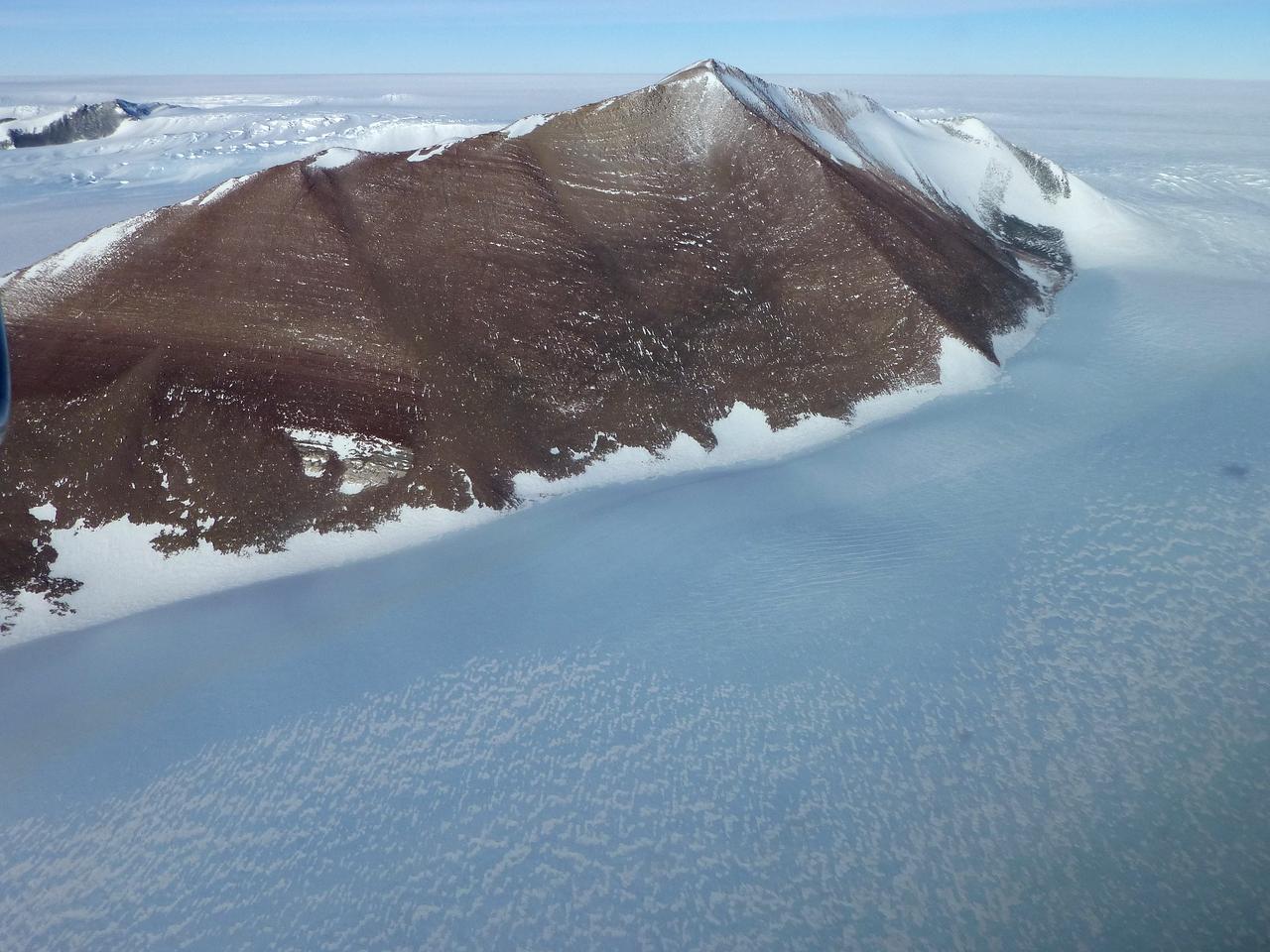
Pensacola Mountains near the Foundation Ice Stream, which Operation IceBridge surveyed on Oct. 28. Credit: NASA / Maria-Jose Vinas NASA's Operation IceBridge is an airborne science mission to study Earth's polar ice. For more information about IceBridge, visit: <a href="http://www.nasa.gov/icebridge" rel="nofollow">www.nasa.gov/icebridge</a> <b><a href="http://www.nasa.gov/audience/formedia/features/MP_Photo_Guidelines.html" rel="nofollow">NASA image use policy.</a></b> <b><a href="http://www.nasa.gov/centers/goddard/home/index.html" rel="nofollow">NASA Goddard Space Flight Center</a></b> enables NASA’s mission through four scientific endeavors: Earth Science, Heliophysics, Solar System Exploration, and Astrophysics. Goddard plays a leading role in NASA’s accomplishments by contributing compelling scientific knowledge to advance the Agency’s mission. <b>Follow us on <a href="http://twitter.com/NASA_GoddardPix" rel="nofollow">Twitter</a></b> <b>Like us on <a href="http://www.facebook.com/pages/Greenbelt-MD/NASA-Goddard/395013845897?ref=tsd" rel="nofollow">Facebook</a></b> <b>Find us on <a href="http://instagrid.me/nasagoddard/?vm=grid" rel="nofollow">Instagram</a></b>
The northwest-southeast trending, snow-covered, linear mountain range is the King Ata Tag Mountain, located in extreme western most China. Highest peaks are just over 20,100 feet above sea level. The town or village of Muji is located in the largest river valley that is south of this range of mountains. This area includes part of the country of Tajikistan. The center point of the photo is approximately 39.30 degrees north and 74.30 degrees easth.
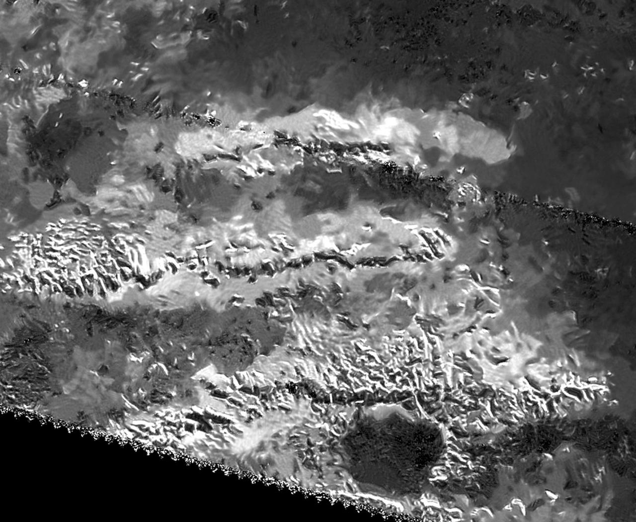
This mosaic, made from radar images obtained by NASA Cassini spacecraft, shows parallel mountain chains on Saturn moon Titan. The mountains appear along the northwest border of a region known as Xanadu.
SL4-138-3875 (February 1974) --- A color oblique photograph looking east over the Rocky Mountains and Great Plains. This view covers a portion of the States of Colorado, Wyoming, and Nebraska. A Skylab 4 crewmen took this picture with a hand-held 70mm Hasselblad camera. This entire region, covered with a blanket of snow, depicts much of the structural and topographic features of the Rocky Mountain chain. Man's only apparent change to the snow pattern seen here is the (right center) metropolitan areas of Denver and Colorado Springs, Colorado, which can be observed along the eastern edge of the mountain front. Grand Junction, Colorado on the western slope of the Rocky Mountains is just off the photograph at left center bottom. The major inter-montane valleys of South Park (right center), Middle Park (center), and North Park (left center) are clearly visible and separate the Colorado Rockies Front Range from the high rugged mountains can be discovered such as Pikes Peak near right border (center), Mt. Cunnison region, circular feature accentuated by the Cunnison River (dark) in the right center (bottom) of the photograph. The snow covered peaks of Mts. Harvard, Princeton and Yale form the high region of the Collegiate Range which is the pronounced mountain area in the right center. Snow cover not only enhances mountain features but also the drainage patterns. East of Denver (right corner) the sinuous trace of the South Platte River (center) and its junction with the North Platte River near North Platte, Nebraska. Lake McConaughy in Nebraska is the body of water (black) near the river intersection. The trace of the Republic River in southern Nebraska is visible near the right corner of the photography. Geologic and hydro logic studies using this photograph will be conducted by Dr. Roger Morrison, U.S. Geological Survey. Photo credit: NASA
The Voyager Mountains
Created using data collected by the JunoCam imager aboard NASA's Juno spacecraft, this animation is an artist's concept that shows a view of a mountain on the Jovian moon Io. The data was recorded during close flybys of the moon in December 2023 and February 2024. The mountain, which the Juno science team has nicknamed "Steeple Mountain," is between 3 and 4.3 miles (5 and 7 kilometers) in height. One side of Steeple Mountain is in shade in the animation because only one side of the mountain was illuminated when imaged by JunoCam. Animation available at https://photojournal.jpl.nasa.gov/catalog/PIA26294
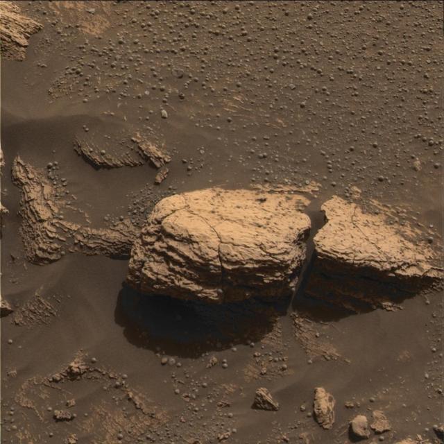
One type of feature of scientific interest on the mountain inside Gale crater is exposure of cemented fractures, evidence that groundwater once reached to at least that height of the mountain. This image is from NASA Mars Reconnaissance Orbiter.
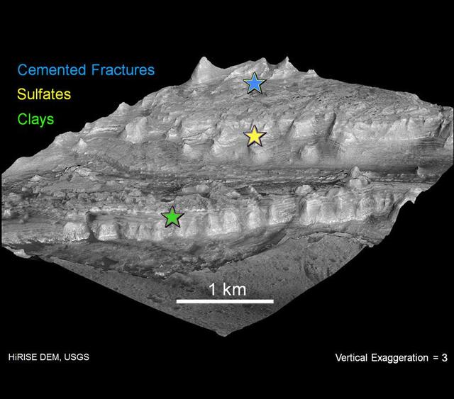
The lower portion of a mountain inside Gale crater on Mars contains layers that may be examined by NASA Mars Science Laboratory. A landing site in Gale, close to the foot of the mountain, has been selected for the mission.
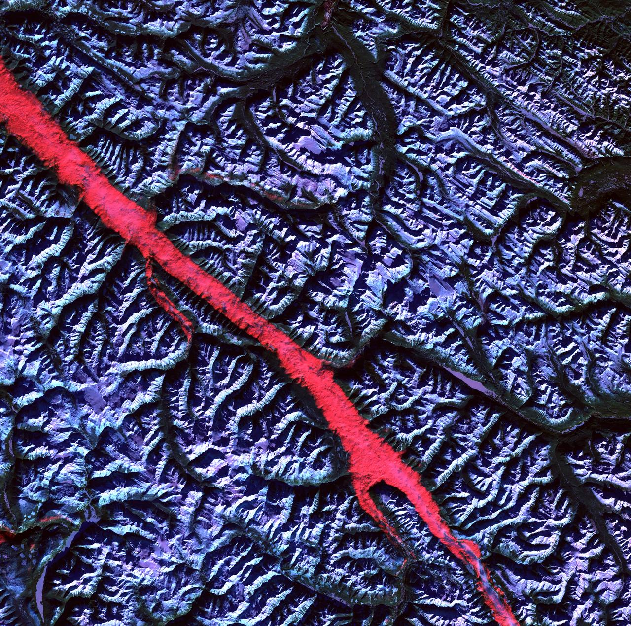
This image from NASA Terra spacecraft shows the Ural Mountains, which run 2500 km north-south through western Russia, and form the boundary between Europe and Asia. Since the 17th century, the mountains were exploited for their deposits of iron, copper, gold, coal, oil, mica and gemstones. The Urals are among the world's oldest existing mountain ranges, having been formed about 275 million years ago due to the collision of the Laurussia supercontinent with the continent of Kazakhstania. The image was acquired July 13, 2011, covers an area of 39 by 62 km, and is located near 65.5 degrees north, 59.9 degrees east. http://photojournal.jpl.nasa.gov/catalog/PIA19795
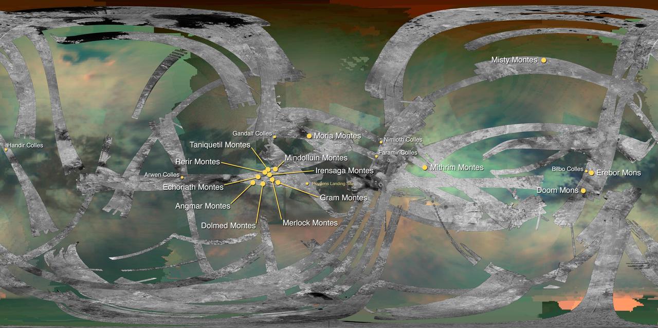
This map of Saturn moon Titan identifies the locations of mountains that have been named by the International Astronomical Union.
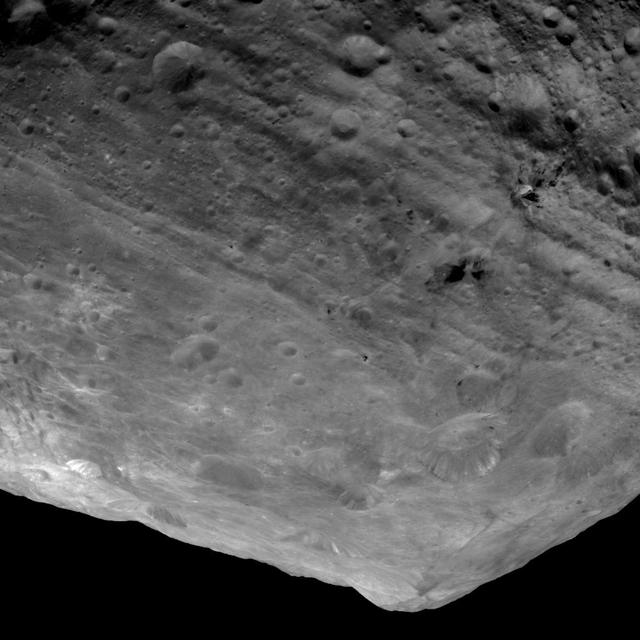
This image from NASA Dawn spacecraft is of the south pole region of the asteroid Vesta, a mountain is rising approximately 9 miles 15 kilometers above the floor of a crater.
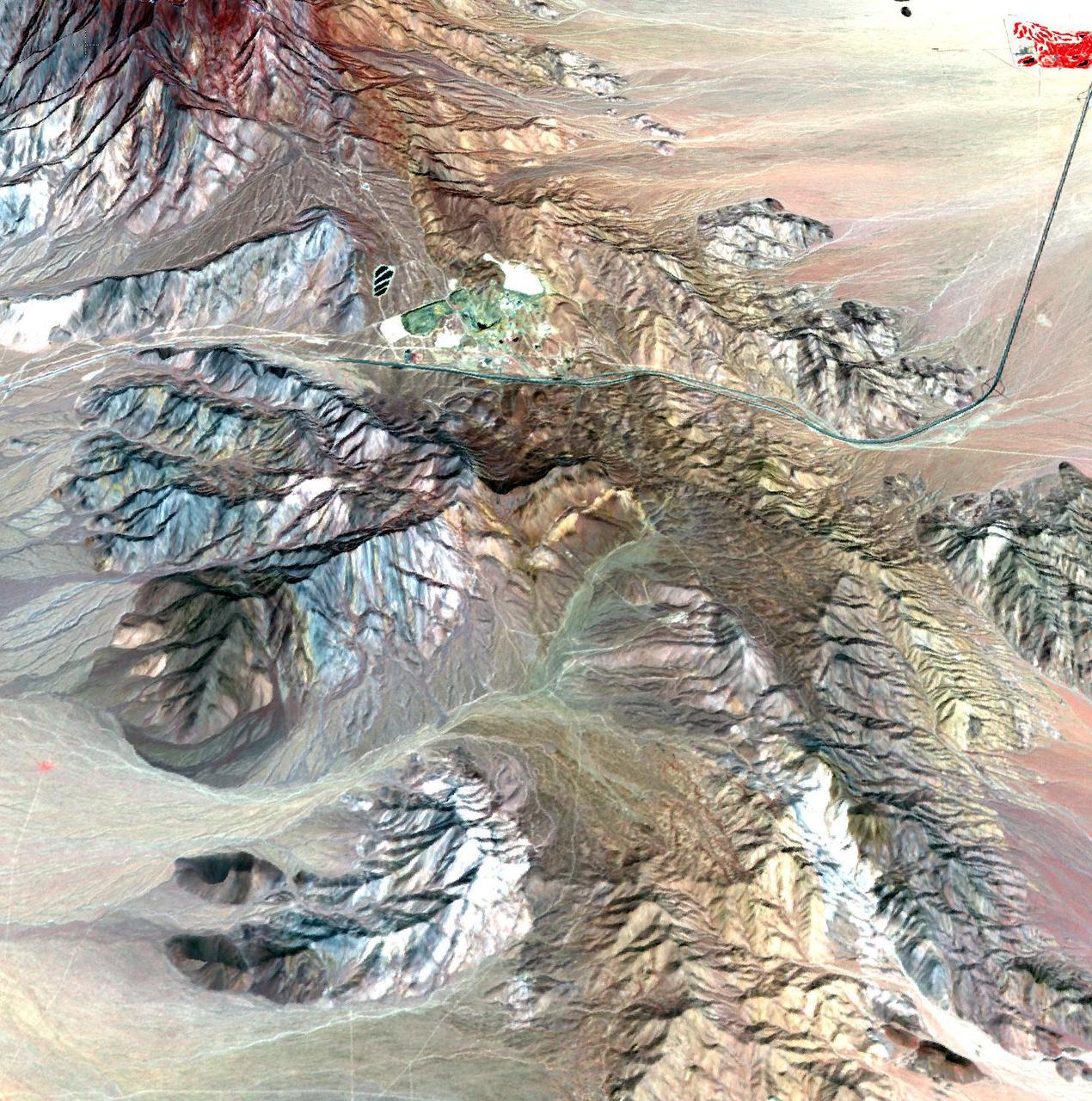
This image of the Mountain Pass rare open-pit earth mine was acquired by NASA Terra spacecraft in southeastern California near the Nevada border.
Acquisition Date: February 2004 The high reflectance of clouds compared to the surrounding land, coupled with the low sun elevation when this image was acquired, causes low clouds to appear red as they fill a portion of the Rocky Mountain Trench. Running parallel with the peaks of the Canadian Rockies and ranging from 2 to 10 miles (3 to 16 kilometers) wide and about 900 miles (1,448 kilometers) long, the Trench aligns with the Fraser River and makes its way past Mount Robson, the highest peak in the Canadian Rockies at 12,972 feet (3,954 meters). Mount Robson is near the center of this image. Credit: NASA/GSFC/Landsat/USGS To learn more about Landsat and to see the orginal high res file go to: <a href="http://landsat.usgs.gov/gallery_view.php?category=greenflag&thesort=mainTitle" rel="nofollow">landsat.usgs.gov/gallery_view.php?category=greenflag&...</a>
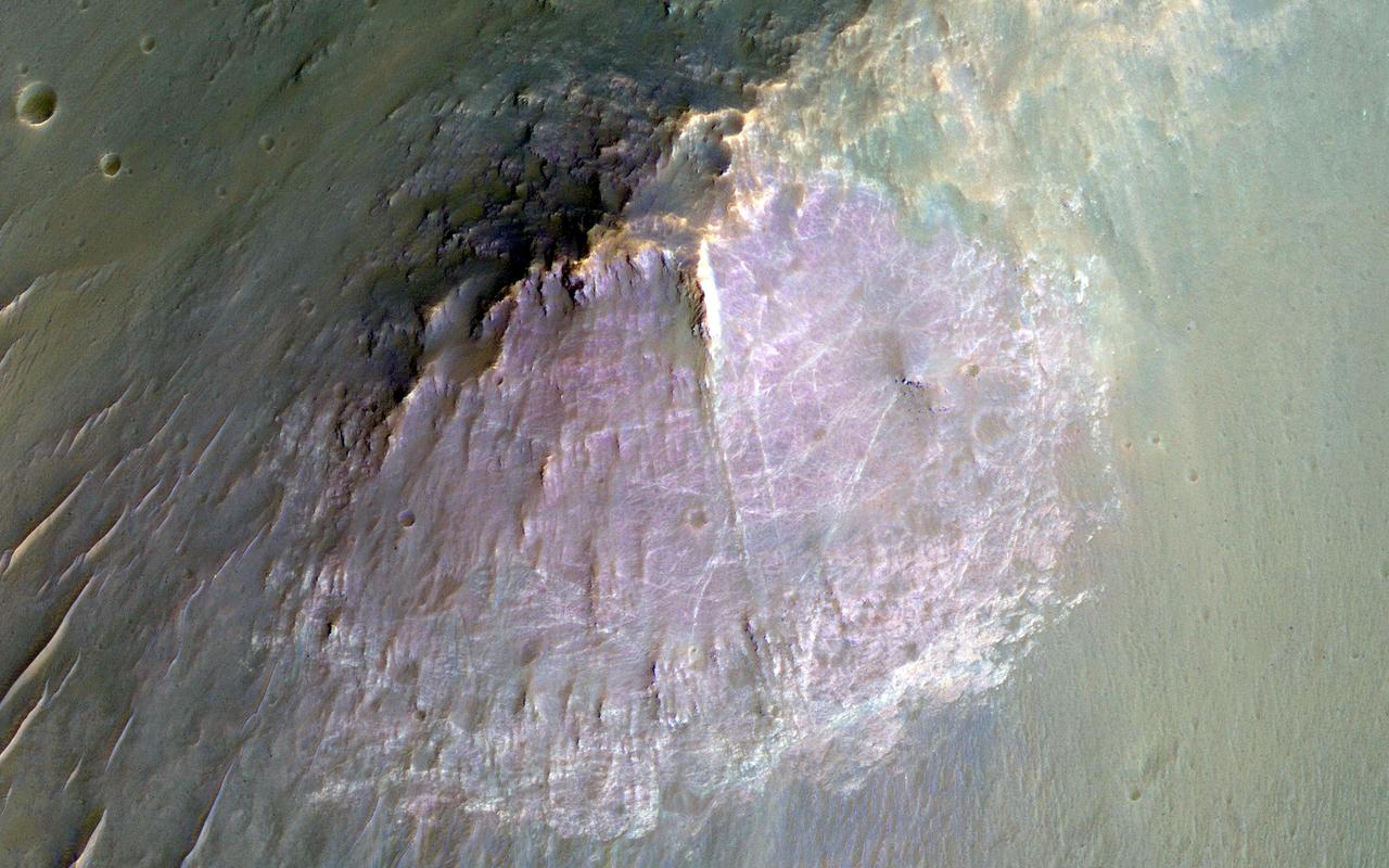
NASA Mars Reconnaissance Orbite observed this image of an isolated mountain in the Southern highlands reveals a large exposure of purplish bedrock. Since HiRISE color is shifted to longer wavelengths than visible color and given relative stretches, this really means that the bedrock is roughly dark in the broad red bandpass image compared to the blue-green and near-infrared bandpass images. In the RGB (red-green-blue) color image, which excludes the near-infrared bandpass image, the bedrock appears bluish in color. This small mountain is located near the northeastern rim of the giant Hellas impact basin, and could be impact ejecta. http://photojournal.jpl.nasa.gov/catalog/PIA19854

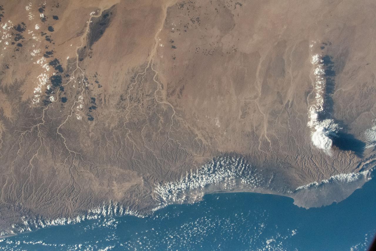
iss058e000188 (Dec. 24, 2018) --- The cloud-covered Pacific coast of the South American nation of Chile contrasts with the Andes Mountain range and the cloud formations extending over Argentina.
AST-30-2601 (20 July 1975) --- An area of the Cascade Mountains southeast of Seattle in the State of Washington, as photographed from the Apollo spacecraft in Earth orbit during the joint U.S.-USSR Apollo-Soyuz Test Project mission. The view includes Snoqualmie Pass, Cle Elum Lake, Kachess Lake and Keechelus Lake. The picture was taken at an altitude of 228 kilometers (141 statute miles) with a 70mm Hasselblad camera using medium-speed Ektachrome QX-807 type film.
This depiction of an area south of San Martin de Los Andes, Argentina, is the first Shuttle Radar Topography Mission SRTM view of the Andes Mountains, the tallest mountain chain in the western hemisphere.
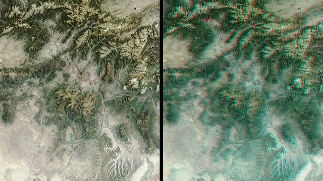
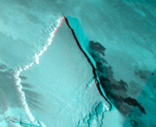
The mountains and desert plateaus of northwest Colorado are shown in this anaglyph from the MISR instrument aboard NASA Terra spacecraft. 3D glasses are necessary to view this image.
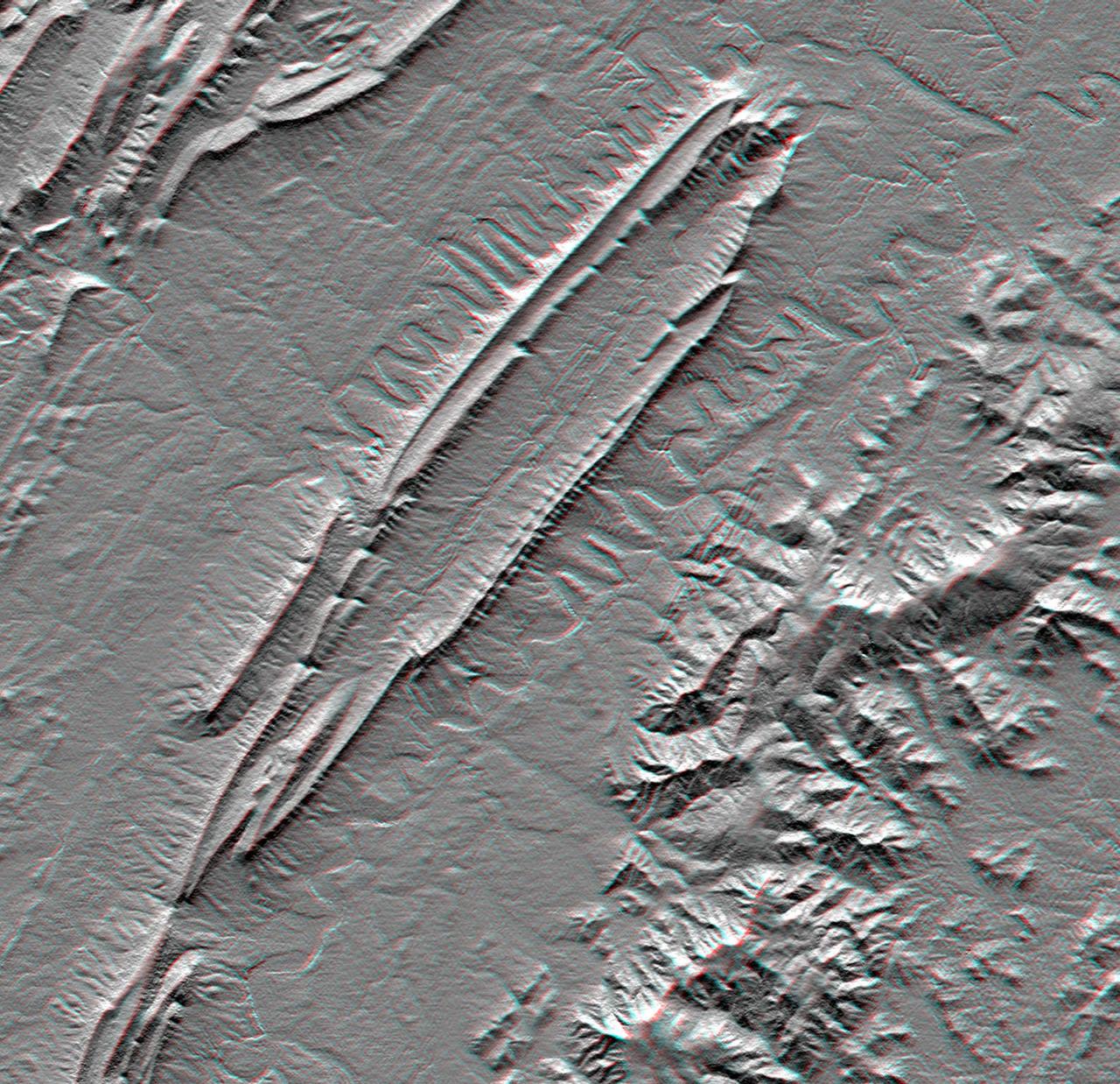
This anaglyph, from NASA Shuttle Radar Topography Mission, is of Massanutten Mountain in the Shenandoah Valley of northern Virginia. 3D glasses are necessary to view this image.
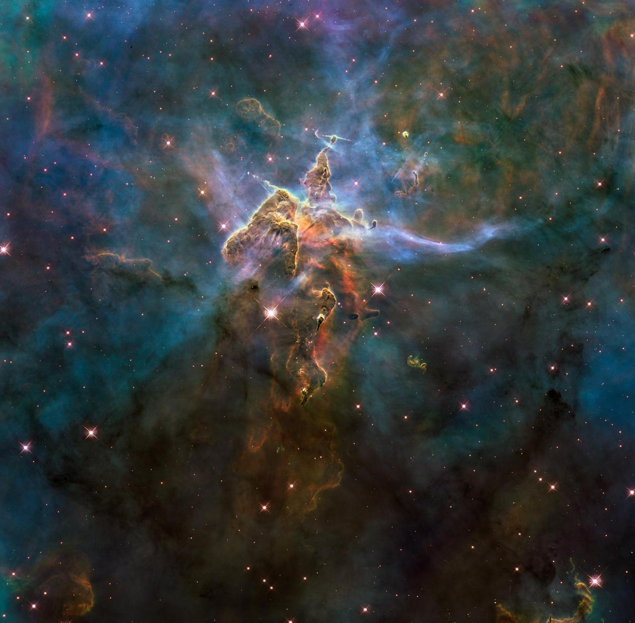
NASA image release April 22, 2010 This craggy fantasy mountaintop enshrouded by wispy clouds looks like a bizarre landscape from Tolkien's "The Lord of the Rings" or a Dr. Seuss book, depending on your imagination. The NASA Hubble Space Telescope photograph, which is stranger than fiction, captures the chaotic activity atop a three-light-year-tall pillar of gas and dust that is being eaten away by the brilliant light from nearby bright stars. The pillar is also being assaulted from within, as infant stars buried inside it fire off jets of gas that can be seen streaming from towering peaks. This turbulent cosmic pinnacle lies within a tempestuous stellar nursery called the Carina Nebula, located 7,500 light-years away in the southern constellation Carina. The image marks the 20th anniversary of Hubble's launch and deployment into Earth orbit. Scorching radiation and fast winds (streams of charged particles) from hot newborn stars in the nebula are shaping and compressing the pillar, causing new stars to form within it. Streamers of hot ionized gas can be seen flowing off the ridges of the structure, and wispy veils of dust, illuminated by starlight, float around its peaks. The pillar is resisting being eroded by radiation much like a towering butte in Utah's Monument Valley withstands erosion by water and wind. Nestled inside this dense mountain are fledgling stars. Long streamers of gas can be seen shooting in opposite directions off the pedestal at the top of the image. Another pair of jets is visible at another peak near the center of the image. These jets are the signpost for new star birth. The jets are launched by swirling disks around the stars, as these disks allow material to slowly accrete onto the stars' surfaces. Hubble's Wide Field Camera 3 observed the pillar on Feb. 1-2, 2010. The colors in this composite image correspond to the glow of oxygen (blue), hydrogen and nitrogen (green), and sulfur (red). Object Names: HH 901, HH 902 Image Type: Astronomical Credit: NASA, ESA, and M. Livio and the Hubble 20th Anniversary Team (STScI) To read learn more about this image go to: <a href="http://www.nasa.gov/mission_pages/hubble/science/hubble20th-img.html" rel="nofollow">www.nasa.gov/mission_pages/hubble/science/hubble20th-img....</a> <b><a href="http://www.nasa.gov/centers/goddard/home/index.html" rel="nofollow">NASA Goddard Space Flight Center</a></b> is home to the nation's largest organization of combined scientists, engineers and technologists that build spacecraft, instruments and new technology to study the Earth, the sun, our solar system, and the universe.
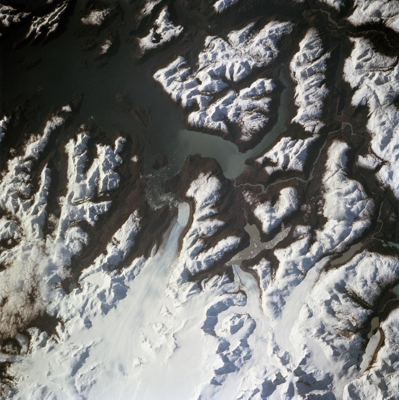
On April 8, 2011, IceBridge flew a mission to coastal areas in southwest Greenland. Mountains and an open-water fjord surround one of the mission's targets, a small ice cap called Sukkertoppen Isflade. Operation IceBridge, now in its third year, makes annual campaigns in the Arctic and Antarctic where science flights monitor glaciers, ice sheets and sea ice. Credit: NASA/GSFC/Michael Studinger To learn more about Ice Bridge go to: <a href="http://www.nasa.gov/mission_pages/icebridge/news/spr11/index.html" rel="nofollow">www.nasa.gov/mission_pages/icebridge/news/spr11/index.html</a> <b><a href="http://www.nasa.gov/centers/goddard/home/index.html" rel="nofollow">NASA Goddard Space Flight Center</a></b> enables NASA’s mission through four scientific endeavors: Earth Science, Heliophysics, Solar System Exploration, and Astrophysics. Goddard plays a leading role in NASA’s accomplishments by contributing compelling scientific knowledge to advance the Agency’s mission. <b>Follow us on <a href="http://twitter.com/NASA_GoddardPix" rel="nofollow">Twitter</a></b> <b>Join us on <a href="http://www.facebook.com/pages/Greenbelt-MD/NASA-Goddard/395013845897?ref=tsd" rel="nofollow">Facebook</a></b>
The Zagros Mountains in Iran offer a visually stunning topographic display of geologic structure in layered sedimentary rocks.
This mosaic, made from radar images obtained by NASA Cassini spacecraft, shows parallel mountain chains on Saturn moon Titan, near an equatorial region known as Adiri.
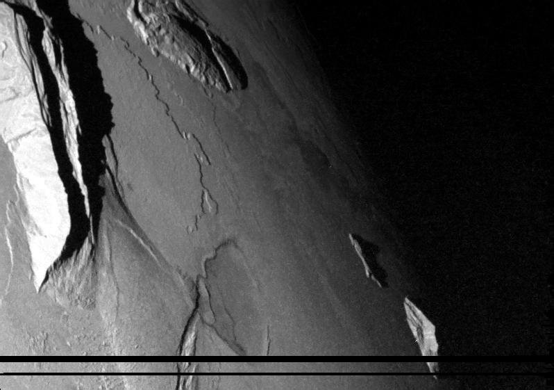
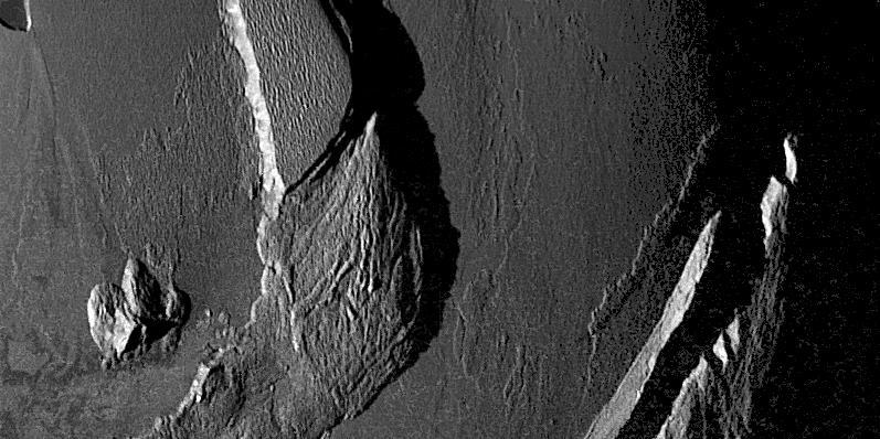
NASA Galileo spacecraft captured this dramatic image of mountains on Io. The Sun was low in the sky. A low scarp runs from the upper left toward the center of the image. The jagged ridge is Mongibello Mons.
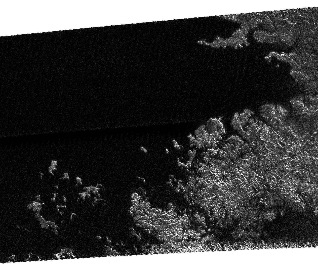
This mosaic, made from radar images obtained by NASA Cassini spacecraft, shows mountainous terrain on Saturn moon Titan in the moon northern hemisphere, north of the Aaru region.
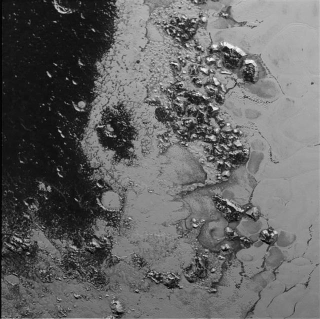
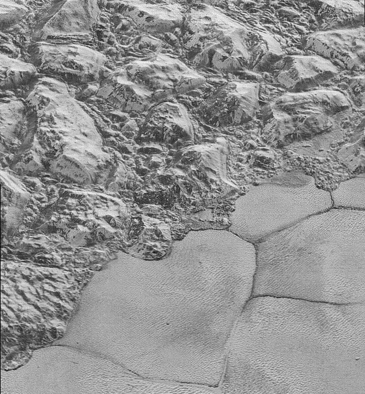
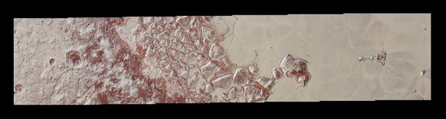
A newly discovered mountain range lies near the southwestern margin of Pluto heart-shaped Tombaugh Regio Tombaugh Region, situated between bright, icy plains and dark, heavily-cratered terrain. This image was acquired by NASA's New Horizons' Long Range Reconnaissance Imager (LORRI) on July 14, 2015, from a distance of 48,000 miles (77,000 kilometers) and sent back to Earth on July 20. Features as small as a half-mile (1 kilometer) across are visible. These frozen peaks are estimated to be one-half mile to one mile (1-1.5 kilometers) high, about the same height as the United States' Appalachian Mountains. The Norgay Montes (Norgay Mountains) discovered by New Horizons on July 15 more closely approximate the height of the taller Rocky Mountains The names of features on Pluto have all been given on an informal basis by the New Horizons team. http://photojournal.jpl.nasa.gov/catalog/PIA19842
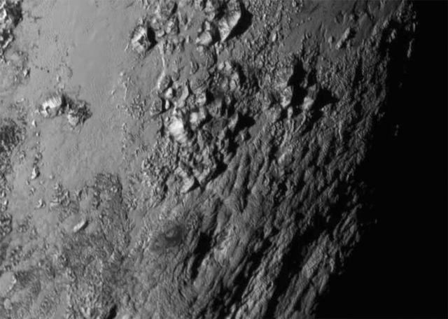
New close-up images of a region near Pluto's equator reveal a giant surprise: a range of youthful mountains rising as high as 11,000 feet (3,500 meters) above the surface of the icy body. The mountains likely formed no more than 100 million years ago -- mere youngsters relative to the 4.56-billion-year age of the solar system -- and may still be in the process of building. That suggests the close-up region, which covers less than one percent of Pluto's surface, may still be geologically active today. The youthful age estimate is based on the lack of craters in this scene. Like the rest of Pluto, this region would presumably have been pummeled by space debris for billions of years and would have once been heavily cratered -- unless recent activity had given the region a facelift, erasing those pockmarks. Unlike the icy moons of giant planets, Pluto cannot be heated by gravitational interactions with a much larger planetary body. Some other process must be generating the mountainous landscape. The mountains are probably composed of Pluto's water-ice "bedrock." Although methane and nitrogen ice covers much of the surface of Pluto, these materials are not strong enough to build the mountains. Instead, a stiffer material, most likely water-ice, created the peaks. The close-up image was taken about 1.5 hours before New Horizons closest approach to Pluto, when the craft was 47,800 miles (770,000 kilometers) from the surface of the planet. The image easily resolves structures smaller than a mile across. http://photojournal.jpl.nasa.gov/catalog/PIA19710
View of the northern Antarctic Peninsula from high altitude during IceBridge's flight back from the Foundation Ice Stream, on Oct. 28. Credit: NASA/Goddard/Maria-Jose Vinas NASA's Operation IceBridge is an airborne science mission to study Earth's polar ice. For more information about IceBridge, visit: <a href="http://www.nasa.gov/icebridge" rel="nofollow">www.nasa.gov/icebridge</a> <b><a href="http://www.nasa.gov/audience/formedia/features/MP_Photo_Guidelines.html" rel="nofollow">NASA image use policy.</a></b> <b><a href="http://www.nasa.gov/centers/goddard/home/index.html" rel="nofollow">NASA Goddard Space Flight Center</a></b> enables NASA’s mission through four scientific endeavors: Earth Science, Heliophysics, Solar System Exploration, and Astrophysics. Goddard plays a leading role in NASA’s accomplishments by contributing compelling scientific knowledge to advance the Agency’s mission. <b>Follow us on <a href="http://twitter.com/NASA_GoddardPix" rel="nofollow">Twitter</a></b> <b>Like us on <a href="http://www.facebook.com/pages/Greenbelt-MD/NASA-Goddard/395013845897?ref=tsd" rel="nofollow">Facebook</a></b> <b>Find us on <a href="http://instagrid.me/nasagoddard/?vm=grid" rel="nofollow">Instagram</a></b>
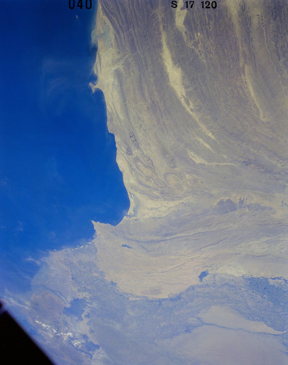
41G-120-040 (5-13 Oct. 1984) --- Pakistan, featuring the city of Karachi, the Makran mountain range, the mouth of the Indus River and the North Arabian Sea were photographed with a medium format camera aboard the space shuttle Challenger during the 41-G mission. Photo credit: NASA
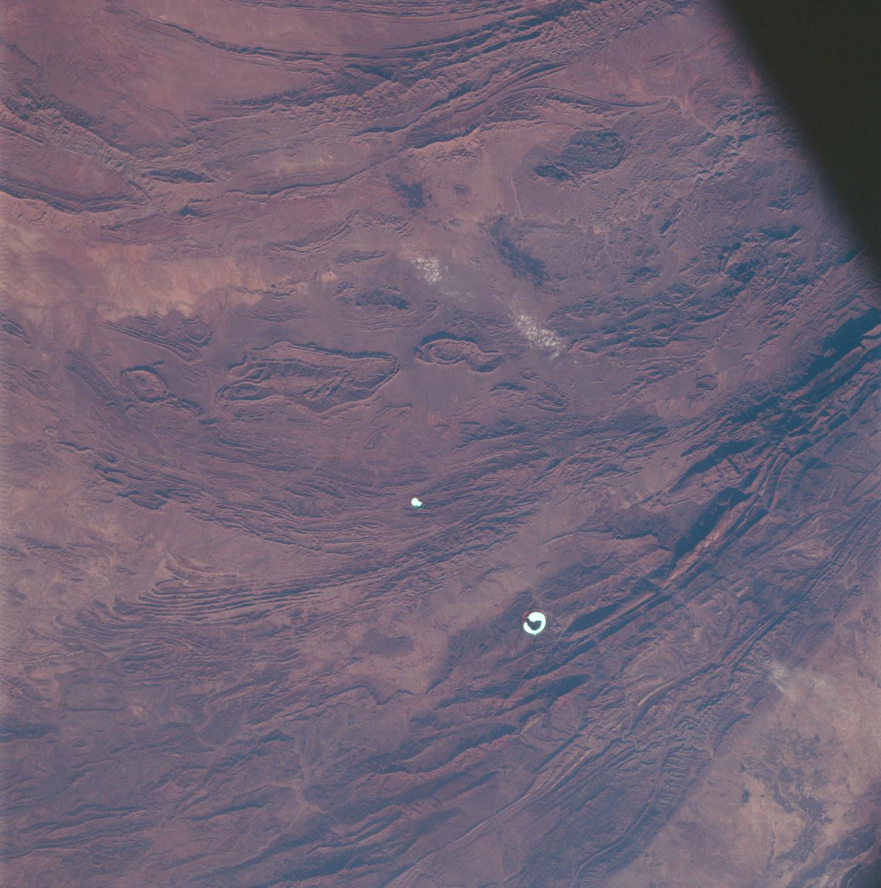
AS07-07-1832 (15 Oct. 1968) --- Toba, Kakar, Fort Sandeman, Sulaiman Range area in (West) Pakistan, as seen from the Apollo 7 spacecraft during its 84th revolution of Earth. Note geological features such as folded mountain structures, anticlines and synclines. Photographed from an altitude of 108 nautical miles, at ground elapsed time of 132 hours and 30 minutes.
AST-19-1570 (24 July 1975) --- An oblique view of the Rocky Mountains area of British Columbia and Alberta in Canada, as photographed from the Apollo spacecraft in Earth orbit during the joint U.S.-USSR Apollo-Soyuz Test Project mission. This picture was taken at an altitude of 222 kilometers (138 statute miles) with a 70mm Hasselblad camera using medium-speed Ektachrome QX-807 type film.
This image from NASA Terra spacecraft shows Baektu Mountain, an active volcano on the border between North Korea and China. Rising to 2744 m, its summit caldera is filled with a crater lake, Heaven Lake.
The trio of ridges on Titan known as Mithrim Montes is home to the hazy Saturnian moon tallest peak. The mountain is located midway along the lower of the three ridges shown in this radar image from NASA Cassini spacecraft.
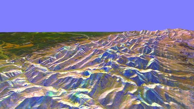
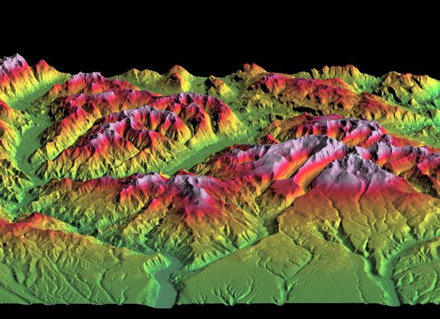
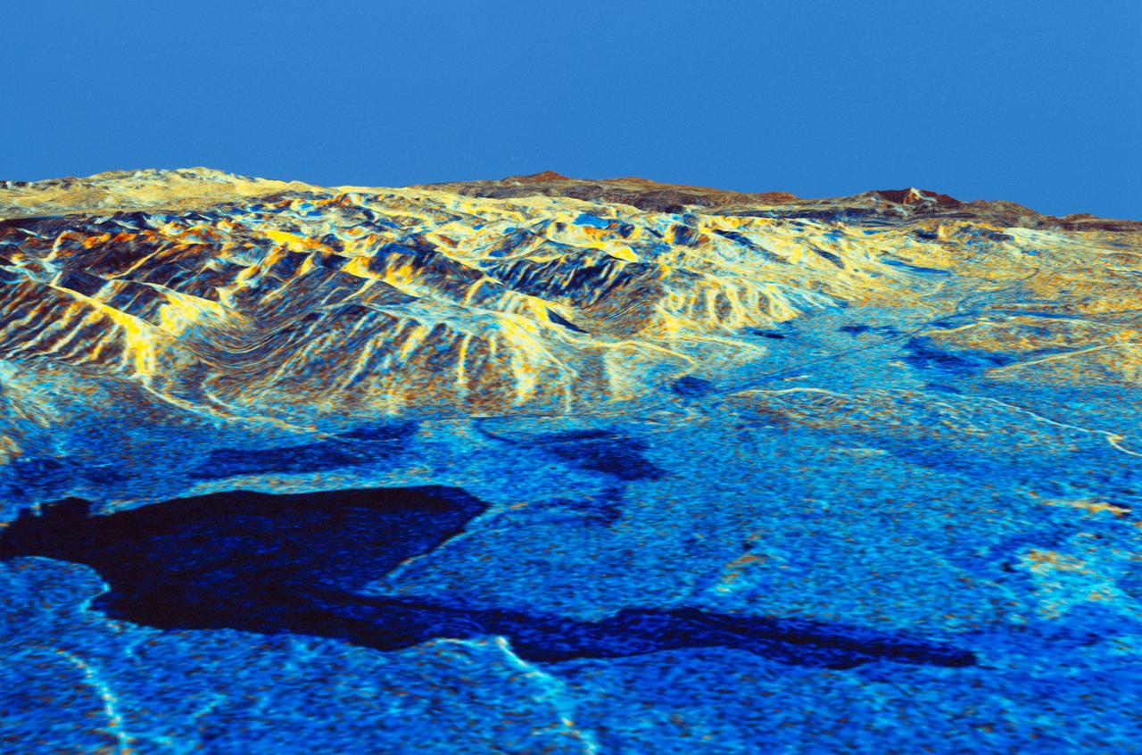
This is a three-dimensional perspective of the eastern front range of the Rocky Mountains, about 120 kilometers 75 miles west of Great Falls, Montana.
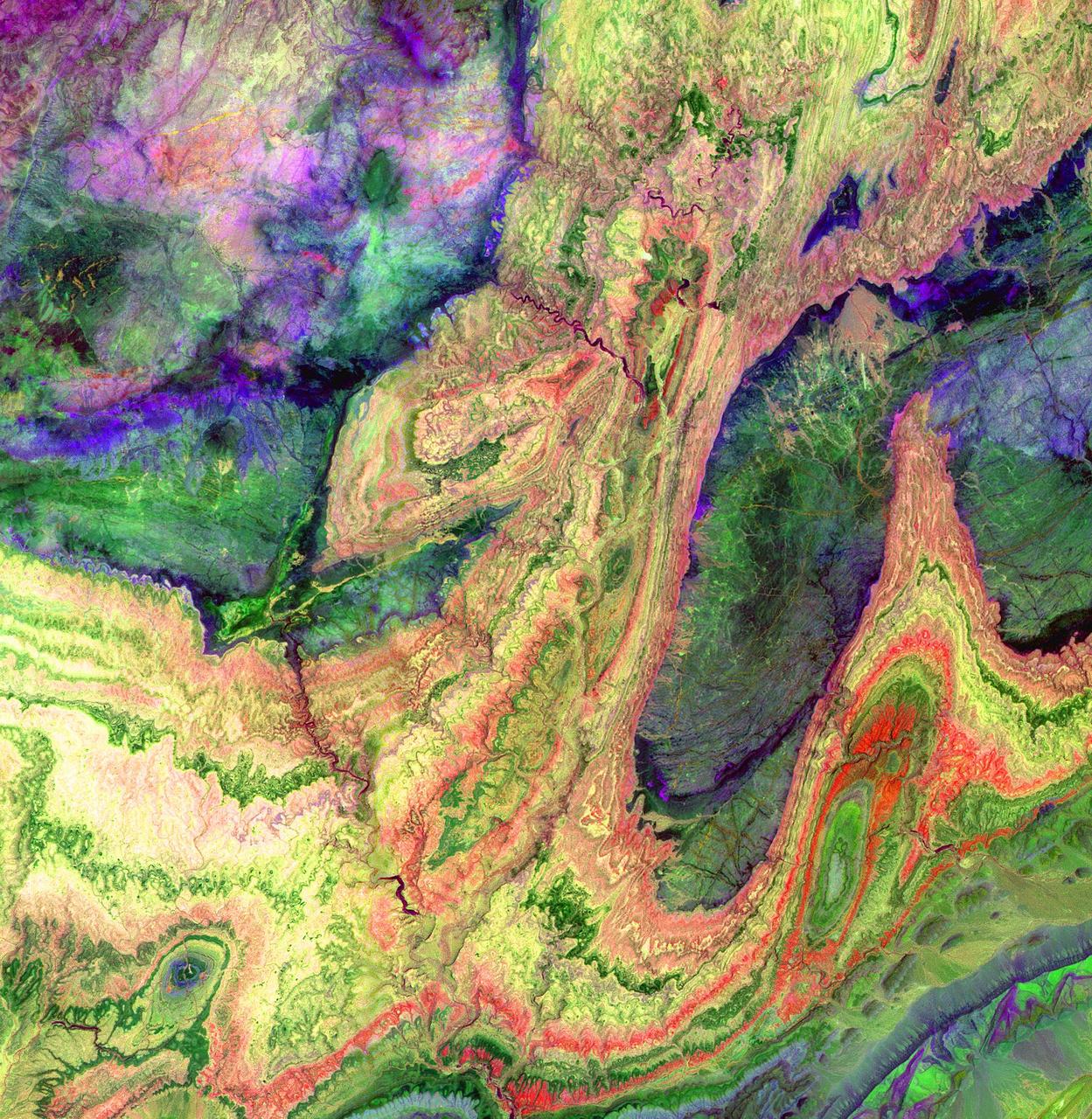
The Anti-Atlas Mountains of Morocco formed as a result of the collision of the African and Eurasian tectonic plates about 80 million years ago. This collision destroyed the Tethys Ocean; the limestone, sandstone, claystone, and gypsum layers that formed the ocean bed were folded and crumpled to create the Atlas and Anti-Atlas Mountains. In this ASTER image, short wavelength infrared bands are combined to dramatically highlight the different rock types, and illustrate the complex folding. The yellowish, orange and green areas are limestones, sandstones and gypsum; the dark blue and green areas are underlying granitic rocks. The ability to map geology using ASTER data is enhanced by the multiple short wavelength infrared bands, that are sensitive to differences in rock mineralogy. This image was acquired on June 13, 2001 by the Advanced Spaceborne Thermal Emission and Reflection Radiometer (ASTER) on NASA's Terra satellite. With its 14 spectral bands from the visible to the thermal infrared wavelength region, and its high spatial resolution of 15 to 90 meters (about 50 to 300 feet), ASTER images Earth to map and monitor the changing surface of our planet. http://photojournal.jpl.nasa.gov/catalog/PIA03893
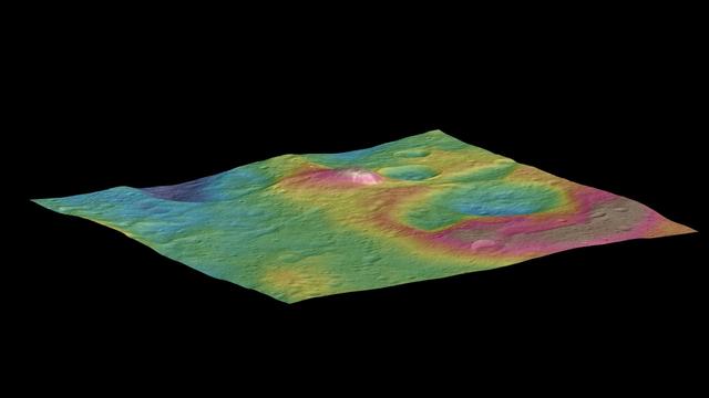
This view, made using images taken by NASA's Dawn spacecraft, features a tall conical mountain on Ceres. Elevations span a range of about 5 miles (8 kilometers) from the lowest places in this region to the highest terrains. Blue represents the lowest elevation, and brown is the highest. The white streaks seen running down the side of the mountain are especially bright parts of the surface. The image was generated using two components: images of the surface taken during Dawn's High Altitude Mapping Orbit (HAMO) phase, where it viewed the surface at a resolution of about 450 feet (140 meters) per pixel, and a shape model generated using images taken at varying sun and viewing angles during Dawn's lower-resolution Survey phase. The image of the region is color-coded according to elevation, and then draped over the shape model to give this view. http://photojournal.jpl.nasa.gov/catalog/PIA19976
In this highest-resolution image from NASA's New Horizons spacecraft, great blocks of Pluto's water-ice crust appear jammed together in the informally named al-Idrisi mountains. Some mountain sides appear coated in dark material, while other sides are bright. Several sheer faces appear to show crustal layering, perhaps related to the layers seen in some of Pluto's crater walls. Other materials appear crushed between the mountains, as if these great blocks of water ice, some standing as much as 1.5 miles high, were jostled back and forth. The mountains end abruptly at the shoreline of the informally named Sputnik Planum, where the soft, nitrogen-rich ices of the plain form a nearly level surface, broken only by the fine trace work of striking, cellular boundaries and the textured surface of the plain's ices (which is possibly related to sunlight-driven ice sublimation). This view is about 50 miles wide. The top of the image is to Pluto's northwest. These images were made with the telescopic Long Range Reconnaissance Imager (LORRI) aboard New Horizons, in a timespan of about a minute centered on 11:36 UT on July 14 -- just about 15 minutes before New Horizons' closest approach to Pluto -- from a range of just 10,000 miles (17,000 kilometers). They were obtained with an unusual observing mode; instead of working in the usual "point and shoot," LORRI snapped pictures every three seconds while the Ralph/Multispectral Visual Imaging Camera (MVIC) aboard New Horizons was scanning the surface. This mode requires unusually short exposures to avoid blurring the images. http://photojournal.jpl.nasa.gov/catalog/PIA20198

STS061-101-023 (8 Dec 1993) --- This color photograph is a spectacular, panoramic (southeastern view) shot that features the northern half of the country of Chile and the Andes Mountains of South America. The Atacama Desert, one of the driest regions on earth, is clearly visible along the northern Chilean coast. This desert extends from roughly Arica in the north to the city of Caldera in the south, a distance of six hundred miles. Some parts of this very arid region go for more than twenty years without measurable precipitation. It is an area of dramatic and abrupt elevation changes. For example, from the waters edge there is an escarpment of the coastal plateau that rises like an unbroken wall two or three thousand feet above the Pacific Ocean. From the coastal plateau, there is an even more dramatic increase in elevation -- from two thousand feet above sea level to an average elevation of thirteen thousand feet above sea level in the Bolivian Altiplano. This elevation change occurs within a one hundred to two hundred mile distance from the Pacific Ocean. The north-south trending spine of the Andes Mountains can be seen on this photograph. Several of the volcanic peaks in this mountain chain exceed 20,000 feet above sea level. Interspersed with these volcanic peaks, numerous dry lake beds (salars) can be seen as highly reflective surfaces. The largest of these salars (Salar de Uyuni) is visible at the edge of the Hubble Space Telescope (HST). Offshore, the cold Peruvian current produces low stratus clouds that can be found along this coastline at certain times of the year. This is the same type of meteorological phenomena that is found along the southern California coast and the Skeleton coast of southwestern Africa.
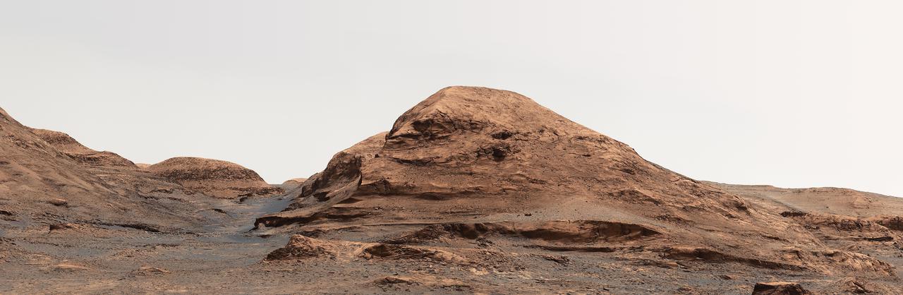
NASA's Curiosity Mars rover used its Mastcam to take an image of this hill, nicknamed "Rafael Navarro Mountain" after Rafael Navarro-González, an astrobiologist who worked on the mission until he passed away January 26, 2021. He was a member of the team working with Curiosity's Sample Analysis at Mars, or SAM, instrument. https://photojournal.jpl.nasa.gov/catalog/PIA24544

iss058e006004 (Jan. 26, 2019) --- This photograph of South America from bottom to top looks from the northeast coast of Argentina to southwest across Chile, the Andes mountains and the Pacific Ocean. The International Space Station was orbiting 259 miles above the Atlantic coast of the South American continent.
This depiction of an area south of San Martin de Los Andes, Argentina, is the first Shuttle Radar Topography Mission SRTMview of the Andes Mountains, the tallest mountain chain in the western hemisphere.
In this southeast looking view, Mont Blanc, on the French/Italian border, (48.0N, 4.5E) the highest mountain peak in all of Europe, is just below and right of center (below the end of the prominent valley of the Aosta River, in the center of the photo. The rivers flow out of the Alps into Italy toward Turin. Chamonix, the famous resort town and center of Alpine mountain climbing, lies in the valley just below Mont Blanc.
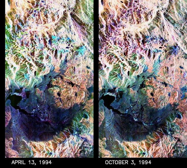
These two false-color composite images of the Mammoth Mountain area in the Sierra Nevada Mountains, Calif., show significant seasonal changes in snow cover. The image at left was acquired by the Spaceborne Imaging Radar-C and X-band Synthetic Aperture Radar aboard the space shuttle Endeavour on its 67th orbit on April 13, 1994. The image is centered at 37.6 degrees north latitude and 119 degrees west longitude. The area is about 36 kilometers by 48 kilometers (22 miles by 29 miles). In this image, red is L-band (horizontally transmitted and vertically received) polarization data; green is C-band (horizontally transmitted and vertically received) polarization data; and blue is C-band (horizontally transmitted and received) polarization data. The image at right was acquired on October 3, 1994, on the space shuttle Endeavour's 67th orbit of the second radar mission. Crowley Lake appears dark at the center left of the image, just above or south of Long Valley. The Mammoth Mountain ski area is visible at the top right of the scene. The red areas correspond to forests, the dark blue areas are bare surfaces and the green areas are short vegetation, mainly brush. The changes in color tone at the higher elevations (e.g. the Mammoth Mountain ski area) from green-blue in April to purple in September reflect changes in snow cover between the two missions. The April mission occurred immediately following a moderate snow storm. During the mission the snow evolved from a dry, fine-grained snowpack with few distinct layers to a wet, coarse-grained pack with multiple ice inclusions. Since that mission, all snow in the area has melted except for small glaciers and permanent snowfields on the Silver Divide and near the headwaters of Rock Creek. On October 3, 1994, only discontinuous patches of snow cover were present at very high elevations following the first snow storm of the season on September 28, 1994. For investigations in hydrology and land-surface climatology, seasonal snow cover and alpine glaciers are critical to the radiation and water balances. SIR-C/X-SAR is a powerful tool because it is sensitive to most snowpack conditions and is less influenced by weather conditions than other remote sensing instruments, such as Landsat. In parallel with the operational SIR-C data processing, an experimental effort is being conducted to test SAR data processing using the Jet Propulsion Laboratory's massively parallel supercomputing facility, centered around the Cray Research T3D. These experiments will assess the abilities of large supercomputers to produce high throughput SAR processing in preparation for upcoming data-intensive SAR missions. The images released here were produced as part of this experimental effort. http://photojournal.jpl.nasa.gov/catalog/PIA01753
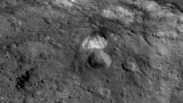
Among the highest features seen on Ceres so far is a mountain about 4 miles (6 kilometers) high, which is roughly the elevation of Mount McKinley in Alaska's Denali National Park. This image comes from an animation, shown in PIA19619, generated using data from NASA's Dawn spacecraft. Vertical relief has been exaggerated by a factor of five. Exaggerating the relief helps scientists understand and visualize the topography much more easily, and highlights features that are sometimes subtle. http://photojournal.jpl.nasa.gov/catalog/PIA19618
The Air Mountains are located in northern Niger and extend over 84,000 square kilometers within the Sahara Desert. Geologically, the area is notable for its remarkable ring dikes that enclose circular granite massifs. These in turn contain, and are surrounded by, young volcanic features, including cinder cones and lava flows. Two of the massifs are shown here: the oval one includes Mont Idoukal-n-Taghes, Niger's highest point. The montage is made up of images acquired November 5, 2017, covers an area of 45 kilometers north-south, and is located near 18 degrees north, 8.5 degrees east. https://photojournal.jpl.nasa.gov/catalog/PIA22795

STS031-83-090 (24-29 April 1990) --- This late afternoon scene over the Andes Mountains features sun glare, heavy cloud illumination and sunglint against the Pacific Ocean. This photo was among those selected by the crew members for showing at their May 9, 1990, Post-Flight Press Conference (PFPC) at the Johnson Space Center (JSC) Public Affairs Office (PAO) Facility briefing room. Onboard the Space Shuttle Discovery for the flight, which lifted off on April 24, 1990, and landed on April 29, 1990, were astronauts Loren J. Shriver, Charles F. Bolden, Jr., Bruce McCandless II, Kathryn D. Sullivan and Steven A. Hawley. Some of the slides were not actually shown due to a shortage of time.
The Zagros Mountains in Iran offer a visually stunning topographic display of geologic structure in layered sedimentary rocks in this anaglyph from NASA Shuttle Radar Topography Mission. 3D glasses are necessary to view this image.
STS059-S-084 (17 April 1994) --- This is a three-dimensional perspective of Mammoth Mountain, California. This view was constructed by overlaying a SIR-C radar image on a U.S. Geological Survey digital elevation map. Vertical exaggeration is 2x. The image is centered at 37.6 degrees north, 119.0 degrees west. It was acquired from the Spaceborne Imaging Radar-C and X-Band Synthetic Aperture Radar (SIR-C/X-SAR) onboard the Space Shuttle Endeavour on its 67th orbit, April 13, 1994. In this color representation, red is C-Band HV-polarization, green is C-Band VV-polarization and blue is the ratio of C-Band VV to C-Band HV. Blue areas are smooth and yellow areas are rock outcrops with varying amounts of snow and vegetation. Crowley Lake is in the foreground and Highway 395 crosses in the middle of the image. Mammoth Mountain is shown in the upper right. SIR-C/X-SAR is part of NASA's Mission to Planet Earth (MTPE). SIR-C/X-SAR radars illuminate Earth with microwaves allowing detailed observations at any time, regardless of weather or sunlight conditions. SIR-C/X-SAR uses three microwave wavelengths: L-Band (24 cm), C-Band (6 cm), and X-Band (3 cm). The multi-frequency data will be used by the international scientific community to better understand the global environment and how it is changing. The SIR-C/X-SAR data, complemented by aircraft and ground studies, will give scientists clearer insights into those environmental changes which are caused by nature and those changes which are induced by human activity. SIR-C was developed by NASA's Jet Propulsion Laboratory (JPL). X-SAR was developed by the Dornire and Alenia Spazio Companies for the German Space Agency, Deutsche Agentur fuer Raumfahrtangelegenheiten (DARA), and the Italian Space Agency, Agenzia Spaziale Italiana (ASI). JPL Photo ID: P-43933
These images from NASA Terra spacecraft show the nadir view of the eastern United States, stretching from Lake Ontario to northern Georgia, and spanning the Appalachian Mountains.
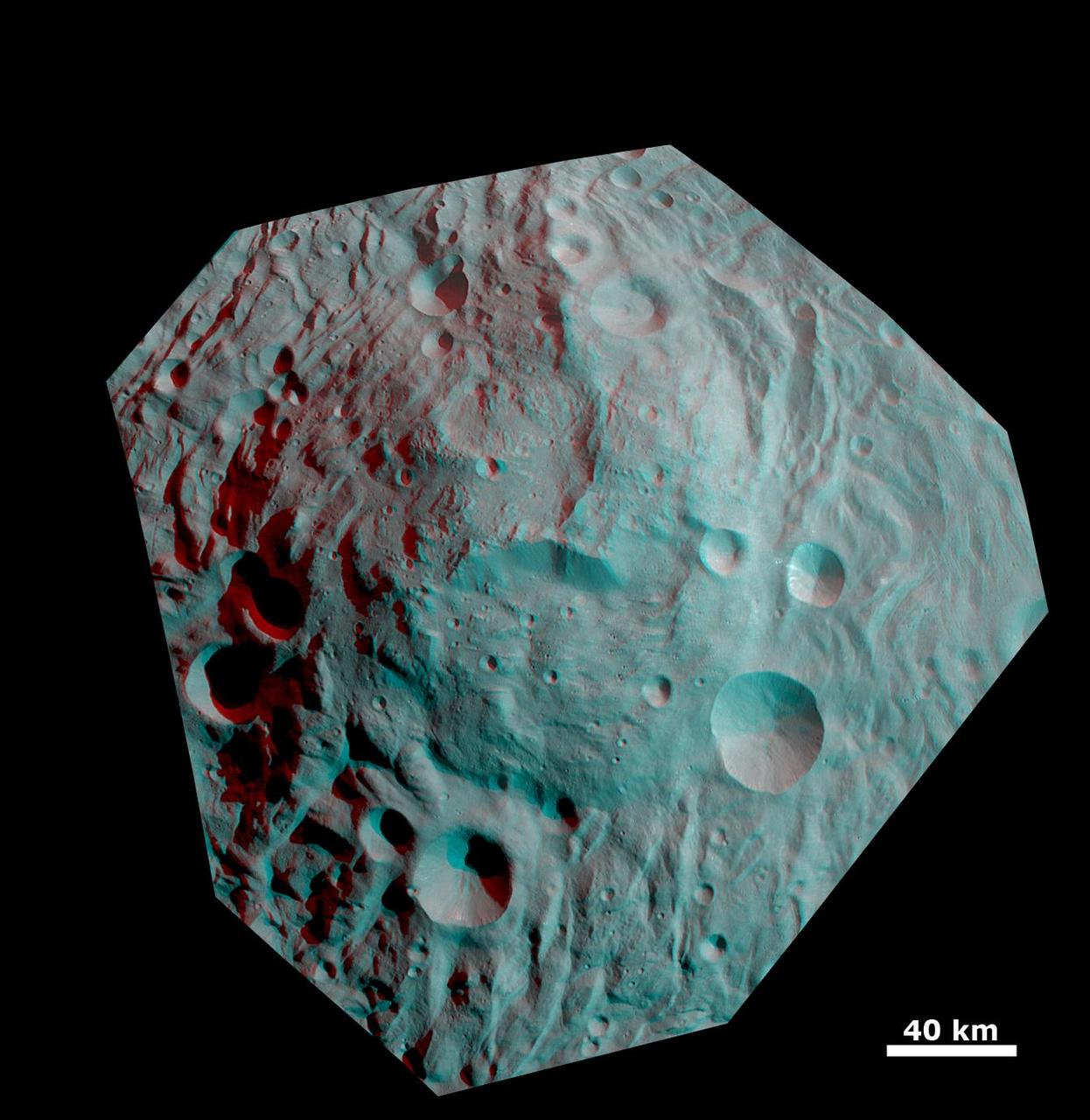
This anaglyph image shows the topography of the mountain-central complex in asteroid Vesta south polar region. You need 3D glasses to view this image.
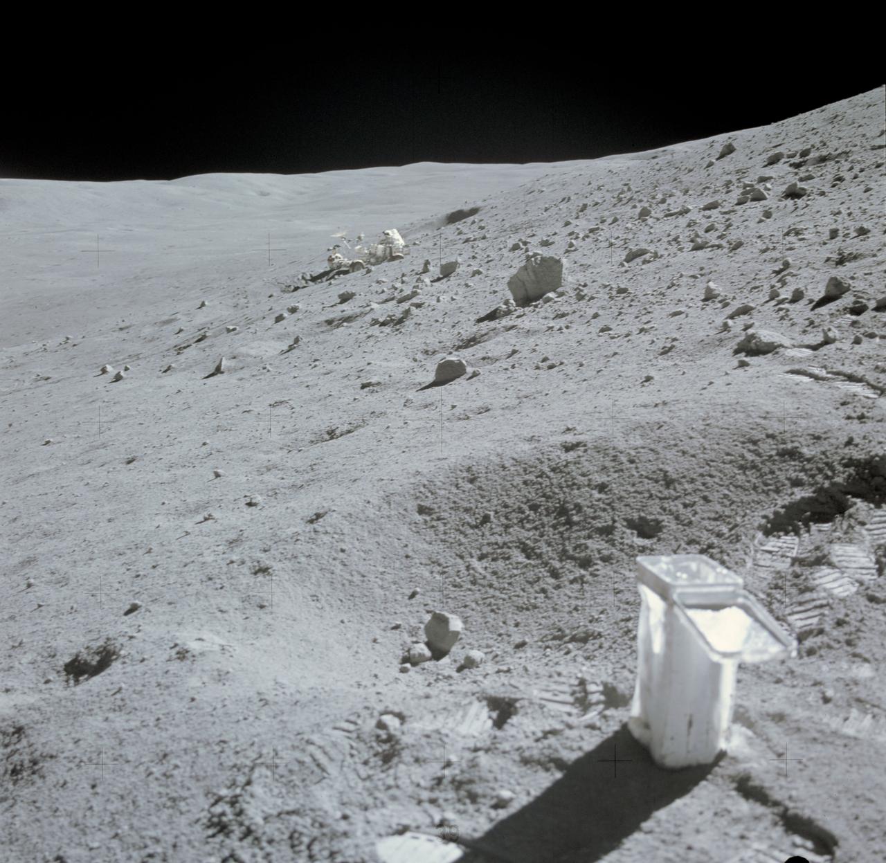
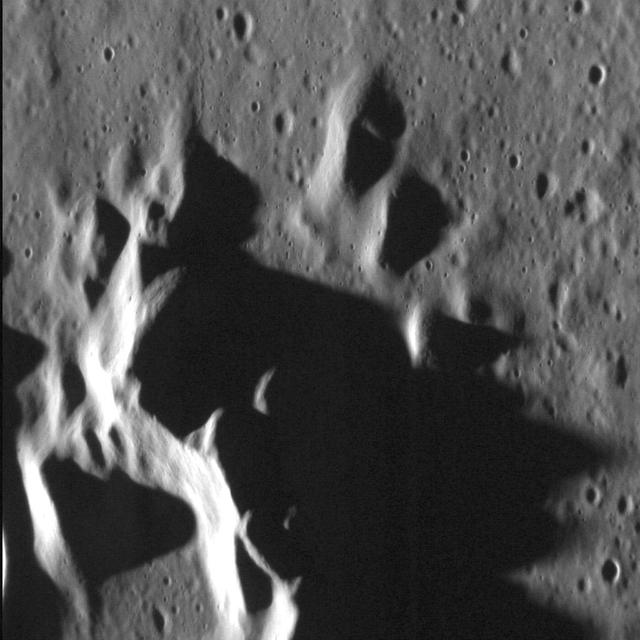
AS16-107-17473 (22 April 1972) --- The Lunar Roving Vehicle (LRV) appears to be parked in a deep lunar depression, on the slope of Stone Mountain. This photograph of the lunar scene at Station No. 4 was taken during the second Apollo 16 extravehicular activity (EVA) at the Descartes landing site. A sample collection bag is in the right foreground. Note field of small boulders at upper right. While astronauts John W. Young, commander, and Charles M. Duke Jr., lunar module pilot, descended in the Lunar Module (LM) "Orion" to explore the moon, astronaut Thomas K. Mattingly II, command module pilot, remained with the Command and Service Modules (CSM) in lunar orbit.

iss073e0906087 (Sept. 28, 2025) --- The Tibesti Mountains in the Sahara, primarily formed by volcanic activity between 34 and 23 million years ago and located mostly in northern Chad, are pictured from the International Space Station as it orbited 260 miles above the African continent.
This false-color composite radar image of the Mammoth Mountain area in the Sierra Nevada Mountains, California, was acquired by the Spaceborne Imaging Radar-C and X-band Synthetic Aperture Radar aboard the space shuttle Endeavour on its 67th orbit on October 3, 1994. The image is centered at 37.6 degrees north latitude and 119.0 degrees west longitude. The area is about 39 kilometers by 51 kilometers (24 miles by 31 miles). North is toward the bottom, about 45 degrees to the right. In this image, red was created using L-band (horizontally transmitted/vertically received) polarization data; green was created using C-band (horizontally transmitted/vertically received) polarization data; and blue was created using C-band (horizontally transmitted and received) polarization data. Crawley Lake appears dark at the center left of the image, just above or south of Long Valley. The Mammoth Mountain ski area is visible at the top right of the scene. The red areas correspond to forests, the dark blue areas are bare surfaces and the green areas are short vegetation, mainly brush. The purple areas at the higher elevations in the upper part of the scene are discontinuous patches of snow cover from a September 28 storm. New, very thin snow was falling before and during the second space shuttle pass. In parallel with the operational SIR-C data processing, an experimental effort is being conducted to test SAR data processing using the Jet Propulsion Laboratory's massively parallel supercomputing facility, centered around the Cray Research T3D. These experiments will assess the abilities of large supercomputers to produce high throughput Synthetic Aperture Radar processing in preparation for upcoming data-intensive SAR missions. The image released here was produced as part of this experimental effort. http://photojournal.jpl.nasa.gov/catalog/PIA01746
iss071e014284 (April 20, 2024) -- Lake Tahoe, situated in the Sierra Nevada Mountains and straddling the border of California and Nevada, was photographed as the International Space Station orbited 258 miles above.
STS068-260-078 (30 September-11 October 1994) --- The ice visible along the bottom of this view is the north end of the larger (southern) of two great remaining ice field of the Andes Mountains in Chile. The longest glacier visible here flows down into the Calen Fjord (an arm of the Pacific Ocean known as Canal Baker) where numerous calved icebergs can be seen floating. The other three glaciers end in glacier-cut valleys with small lakes - the bigger lake has numerous icebergs as well. the river snaking through the mountains to the fjord drains water from the great Lake O'Higgins, which lies out of the picture to the right. Glacial mud can be seen emptying into the fjord and discoloring the water with its milky color.
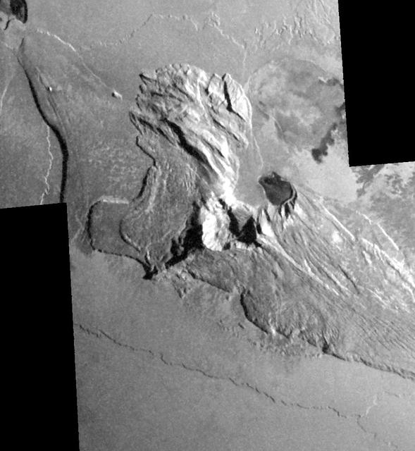
Dramatic shadows across a mountainous landscape on Jupiter's moon Io reveal details of the topography around a peak named Tohil Mons in this mosaic created from images taken by NASA's Galileo spacecraft in October 2001. Tohil Mons rises 5.4 kilometers (18,000 feet) above Io's surface, according to analysis of stereo imaging from earlier Galileo flybys of Io. The new images, with a resolution of 327 meters (1,070 feet) per picture element, were taken when the Sun was low in the sky, producing informative shadows. North is to the top and the Sun illuminates the surface from the upper right. The topographic features revealed include a very straight ridge extending southwest from the peak, 500- to 850-meter-high (1,640- to 2,790-foot-high) cliffs to the northwest and a curious pit immediately east of the peak. Major questions remain about how Io's mountains form and how they are related to Io's ubiquitous volcanoes. Although Io is extremely active volcanically, few of its mountains appear to be volcanoes. However, two volcanic craters do lie directly to the northeast of Tohil's peak, a smaller dark-floored one and a larger one at the very edge of the mosaic. Furthermore, the shape of the pit directly east of the peak suggests a volcanic origin. Galileo scientists will use these images to investigate the geologic history of Tohil Mons and its relationship to the neighboring volcanic features. The image is centered at 28 degrees south latitude and 161 degrees west longitude. http://photojournal.jpl.nasa.gov/catalog/PIA03600
Images of Pluto taken by NASA New Horizons spacecraft before closest approach on July 14, 2015, reveal features as small as 270 yards (250 meters) across, from craters to faulted mountain blocks, to the textured surface of the vast basin informally called Sputnik Planum. Enhanced color has been added from the global color image. This image is about 330 miles (530 kilometers) across. http://photojournal.jpl.nasa.gov/catalog/PIA19955
iss069e003275 (April 13, 2023) --- The middle eastern nation of Oman and its Dhofar mountains on the coast of the Arabian Sea were pictured by UAE (United Arab Emirates) astronaut and Expedition 69 Flight Engineer Sultan Alneyadi as the International Space Station orbited 257 miles above.
SL3-27-180 (July-September 1973) --- A vertical view of the Snowy Mountains area of Australian Alps in the States of Victoria and New South Wales, Australia, as photographed from Earth orbit by one of the six lenses of the Itek-furnished S190-A Multispectral Photographic Facility Experiment aboard the Skylab space station. This picture was taken with type 2443 infrared color film. The lake near the center of the picture is the Eucumbene Reservoir. This area is located immediately south-southwest of the capital city of Canberra. Federal agencies participating with NASA on the EREP project are the Departments of Agriculture, Commerce, Interior, the Environmental Protection Agency and the Corps of Engineers. All EREP photography is available to the public through the Department of Interior?s Earth Resources Observations Systems Data Center, Sioux Falls, South Dakota, 57198. Photo credit: NASA
This anaglyph image from NASA Dawn spacecraft shows the topography of the mountain-central complex in asteroid Vesta south polar region. You need 3D glasses to view this image.
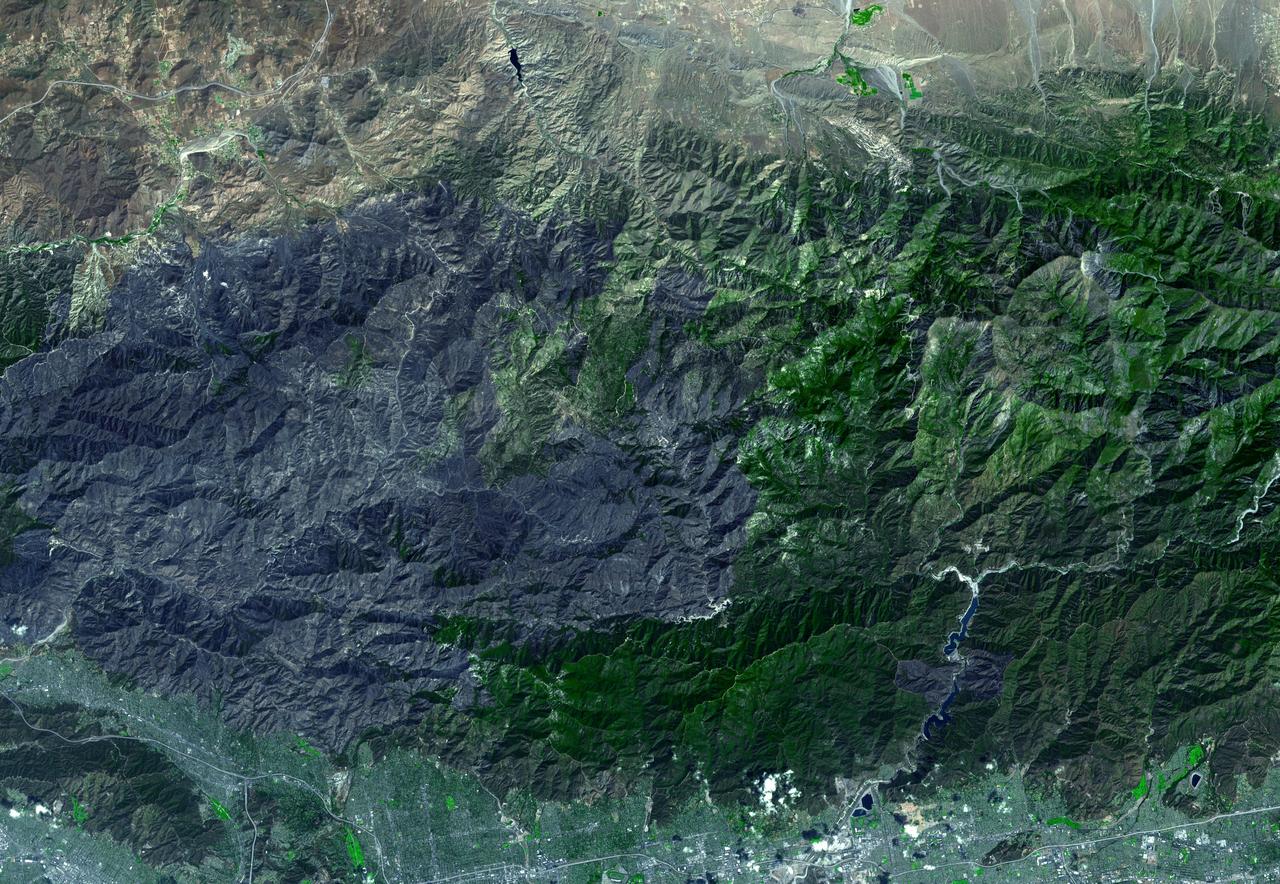
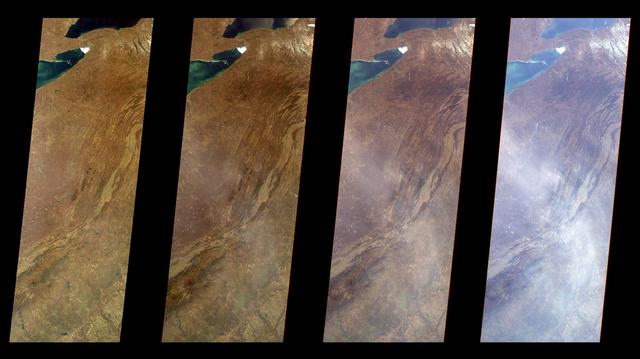
JPL Advanced Spaceborne Thermal Emission and Reflection Radiometer aboard NASA Terra satellite captured this simulated natural color image of the Station fire burning in the San Gabriel Mountains.
NASA Terra spacecraft passed over the Blue Mountains to the west and north of Sydney, A mild winter and an extremely hot September in Australia have led to an early start to the fire season.
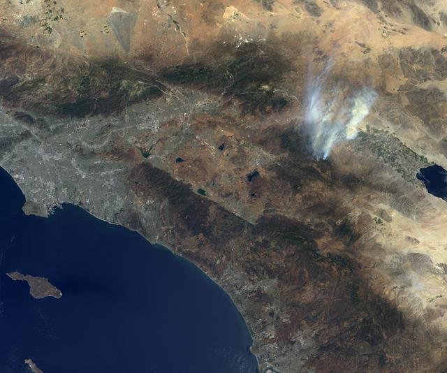
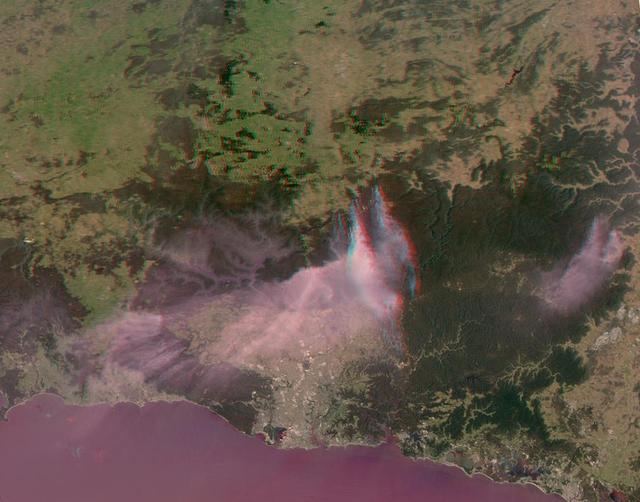
NASA Terra spacecraft passed over the Mountain Fire near Idyllwild, Calif., on Jul. 17, 2013. Los Angeles and the Pacific Ocean can been seen to the left and the Salton Sea is the dark feature in the right center of the image.
The Andes Mountains, part of the Southern Cordillera formed from subduction zone volcanism at the convergent boundary of the Nazca plate and the South American plate. This image is from NASA EarthKAM.

iss073e0420556 (Aug. 3, 2025) --- From bottom to top, or from west to east in this orientation, California's Central Valley extends across the bottom of this photograph and just above the San Francisco Bay Area. Past the Central Valley is the Sierra Nevada mountain range that leads into Nevada's Great Basin region and eastward toward the Rocky Mountains. The International Space Station was soaring 260 miles above the Pacific Ocean at the time of this photograph.
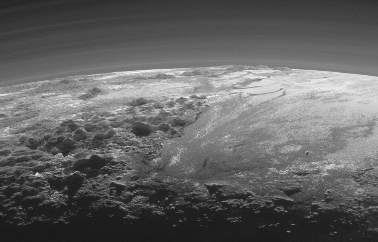
Just 15 minutes after its closest approach to Pluto on July 14, 2015, NASA's New Horizons spacecraft looked back toward the sun and captured a near-sunset view of the rugged, icy mountains and flat ice plains extending to Pluto's horizon. The smooth expanse of the informally named Sputnik Planum (right) is flanked to the west (left) by rugged mountains up to 11,000 feet (3,500 meters) high, including the informally named Norgay Montes in the foreground and Hillary Montes on the skyline. The backlighting highlights more than a dozen layers of haze in Pluto's tenuous but distended atmosphere. The image was taken from a distance of 11,000 miles (18,000 kilometers) to Pluto; the scene is 230 miles (380 kilometers) across. http://photojournal.jpl.nasa.gov/catalog/PIA19947
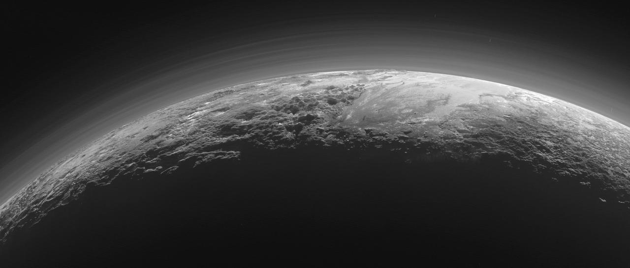
Just 15 minutes after its closest approach to Pluto on July 14, 2015, NASA's New Horizons spacecraft looked back toward the sun and captured this near-sunset view of the rugged, icy mountains and flat ice plains extending to Pluto's horizon. The smooth expanse of the informally named icy plain Sputnik Planum (right) is flanked to the west (left) by rugged mountains up to 11,000 feet (3,500 meters) high, including the informally named Norgay Montes in the foreground and Hillary Montes on the skyline. To the right, east of Sputnik, rougher terrain is cut by apparent glaciers. The backlighting highlights more than a dozen layers of haze in Pluto's tenuous but distended atmosphere. The image was taken from a distance of 11,000 miles (18,000 kilometers) to Pluto; the scene is 780 miles (1,250 kilometers) wide. http://photojournal.jpl.nasa.gov/catalog/PIA19948