Movement in the Shadows
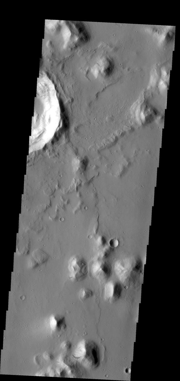
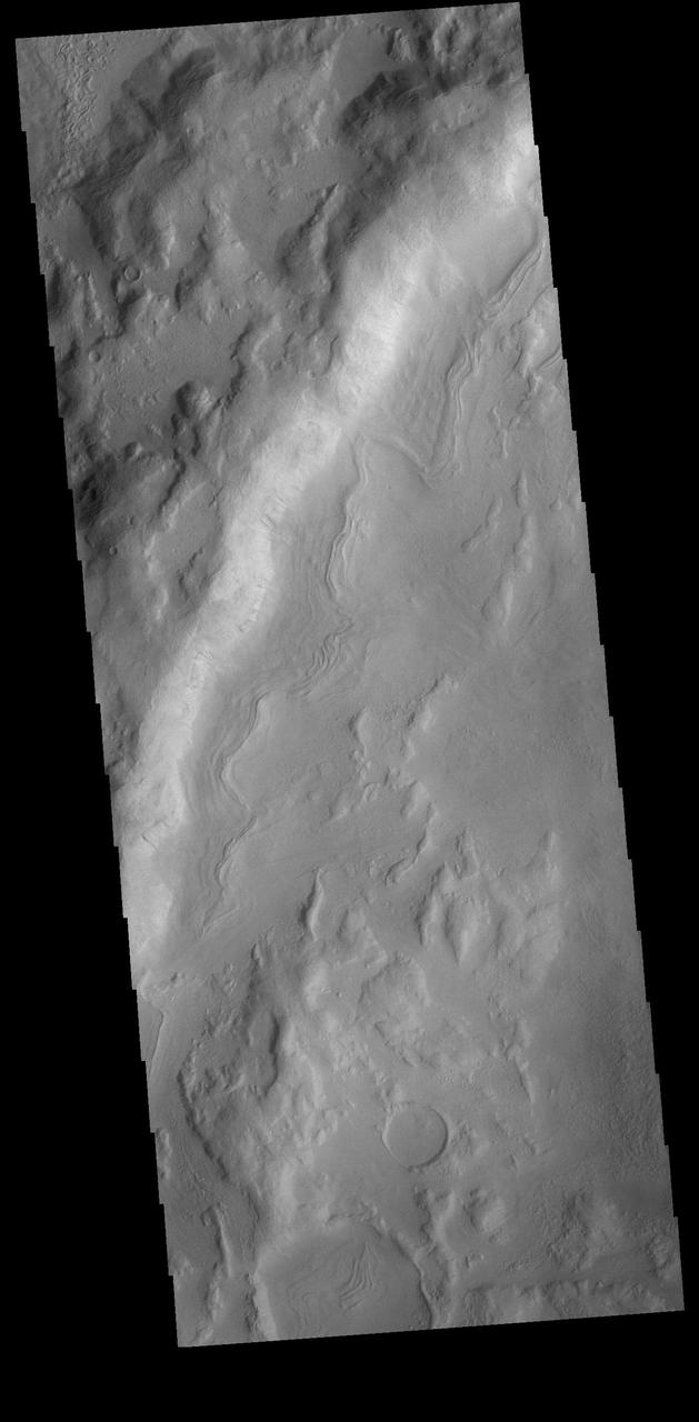
Fretted Terrain Mass Movement
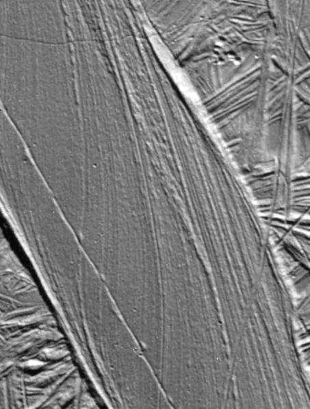
A Record of Crustal Movement on Europa
NASA participates in the Podcast Movement conference, Tuesday, Aug. 20, 2024, at the Gaylord National Resort and Convention Center in National Harbor, Md. During the event, NASA hosted a panel entitled, "Eclipses, Moon Missions, and Climate Change: How NASA Reaches Curious Listeners." Photo Credit: (NASA/Bill Ingalls)
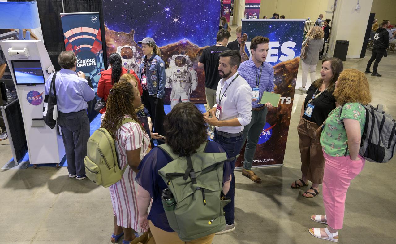
NASA participates in the Podcast Movement conference, Tuesday, Aug. 20, 2024, at the Gaylord National Resort and Convention Center in National Harbor, Md. During the event, NASA hosted a panel entitled, "Eclipses, Moon Missions, and Climate Change: How NASA Reaches Curious Listeners." Photo Credit: (NASA/Bill Ingalls)
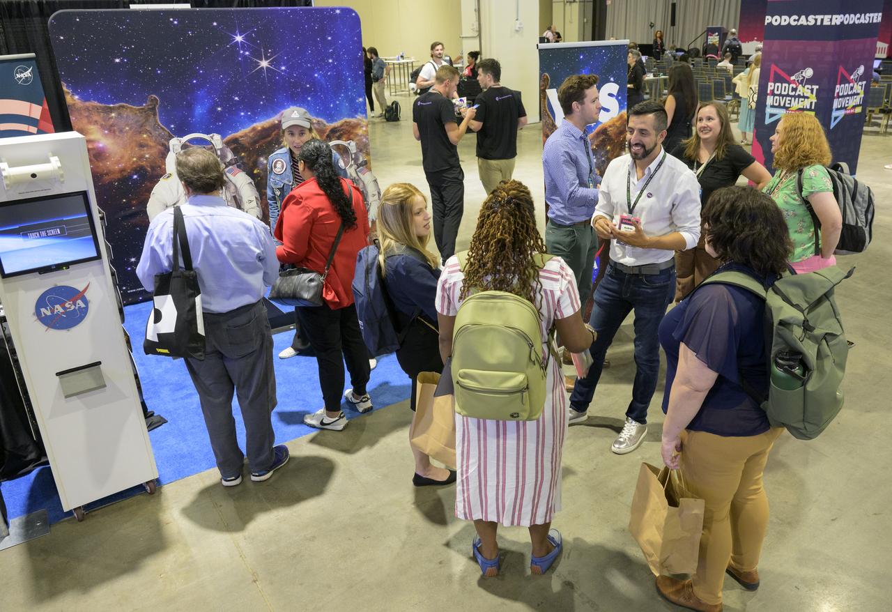
NASA participates in the Podcast Movement conference, Tuesday, Aug. 20, 2024, at the Gaylord National Resort and Convention Center in National Harbor, Md. During the event, NASA hosted a panel entitled, "Eclipses, Moon Missions, and Climate Change: How NASA Reaches Curious Listeners." Photo Credit: (NASA/Bill Ingalls)

NASA participates in the Podcast Movement conference, Tuesday, Aug. 20, 2024, at the Gaylord National Resort and Convention Center in National Harbor, Md. During the event, NASA hosted a panel entitled, "Eclipses, Moon Missions, and Climate Change: How NASA Reaches Curious Listeners." Photo Credit: (NASA/Bill Ingalls)

NASA participates in the Podcast Movement conference, Tuesday, Aug. 20, 2024, at the Gaylord National Resort and Convention Center in National Harbor, Md. During the event, NASA hosted a panel entitled, "Eclipses, Moon Missions, and Climate Change: How NASA Reaches Curious Listeners." Photo Credit: (NASA/Bill Ingalls)
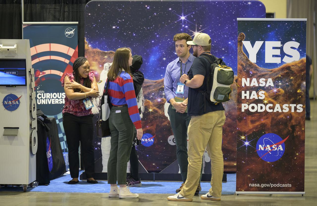
NASA participates in the Podcast Movement conference, Tuesday, Aug. 20, 2024, at the Gaylord National Resort and Convention Center in National Harbor, Md. During the event, NASA hosted a panel entitled, "Eclipses, Moon Missions, and Climate Change: How NASA Reaches Curious Listeners." Photo Credit: (NASA/Bill Ingalls)

NASA Audio Engineer Manny Cooper is seen during a Podcast Movement, NASA hosted a panel entitled, "Eclipses, Moon Missions, and Climate Change: How NASA Reaches Curious Listeners", Tuesday, Aug. 20, 2024, at the Gaylord National Resort and Convention Center in National Harbor, Md. Photo Credit: (NASA/Bill Ingalls)

NASA Audio Lead Katie Konans is seen during a Podcast Movement, NASA hosted a panel entitled, "Eclipses, Moon Missions, and Climate Change: How NASA Reaches Curious Listeners", Tuesday, Aug. 20, 2024, at the Gaylord National Resort and Convention Center in National Harbor, Md. Photo Credit: (NASA/Bill Ingalls)

NASA Audio Lead Katie Konans is seen during a Podcast Movement, NASA hosted a panel entitled, "Eclipses, Moon Missions, and Climate Change: How NASA Reaches Curious Listeners", Tuesday, Aug. 20, 2024, at the Gaylord National Resort and Convention Center in National Harbor, Md. Photo Credit: (NASA/Bill Ingalls)

NASA Astrophysicist and Host of NASA's Curious Universe podcast Padi Boyd is seen during a Podcast Movement, NASA hosted a panel entitled, "Eclipses, Moon Missions, and Climate Change: How NASA Reaches Curious Listeners", Tuesday, Aug. 20, 2024, at the Gaylord National Resort and Convention Center in National Harbor, Md. Photo Credit: (NASA/Bill Ingalls)

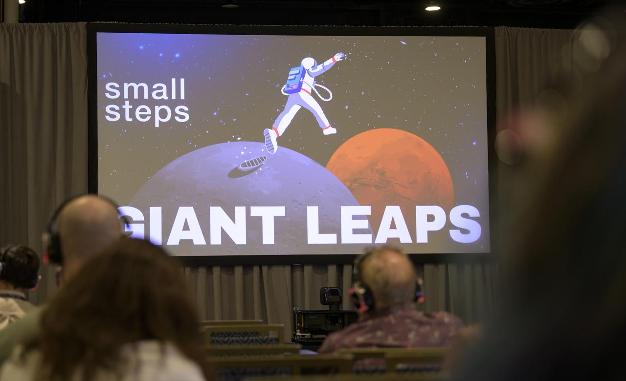
NASA Writer and Host of the Small Steps, Giant Leaps podcast Andrés Almeida is seen during a Podcast Movement, NASA hosted a panel entitled, "Eclipses, Moon Missions, and Climate Change: How NASA Reaches Curious Listeners", Tuesday, Aug. 20, 2024, at the Gaylord National Resort and Convention Center in National Harbor, Md. Photo Credit: (NASA/Bill Ingalls)

NASA Multimedia Producer and Host of Houston, We Have a Podcast Dane Turner, is seen during a Podcast Movement, NASA hosted a panel entitled, "Eclipses, Moon Missions, and Climate Change: How NASA Reaches Curious Listeners", Tuesday, Aug. 20, 2024, at the Gaylord National Resort and Convention Center in National Harbor, Md. Photo Credit: (NASA/Bill Ingalls)

Movement from Spirit Third Extrication Drive
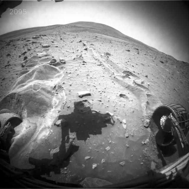
Little Movement in Spirit Sol 2099 Drive
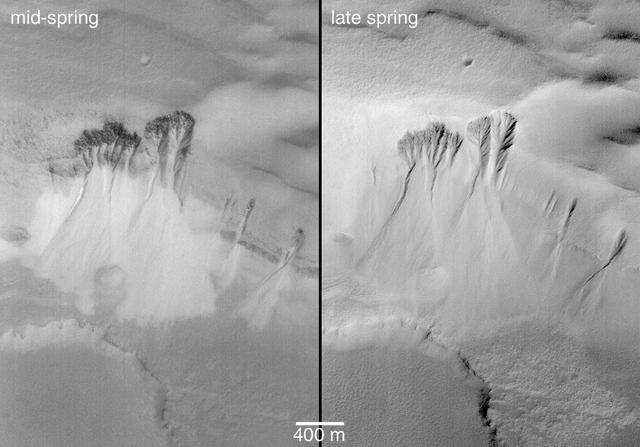
Movement of Whole Martian Dunes Difficult to Detect or Confirm

NASA Audio Lead Katie Konans, left, NASA Multimedia Producer and Host of Houston, We Have a Podcast Dane Turner, NASA Writer and Host of the Small Steps, Giant Leaps podcast Andrés Almeida, NASA Astrophysicist and Host of NASA's Curious Universe podcast Padi Boyd, and NASA Audio Engineer Manny Cooper, right, are seen during a Podcast Movement, NASA hosted a panel entitled, "Eclipses, Moon Missions, and Climate Change: How NASA Reaches Curious Listeners", Tuesday, Aug. 20, 2024, at the Gaylord National Resort and Convention Center in National Harbor, Md. Photo Credit: (NASA/Bill Ingalls)

NASA Audio Lead Katie Konans, left, NASA Multimedia Producer and Host of Houston, We Have a Podcast Dane Turner, NASA Writer and Host of the Small Steps, Giant Leaps podcast Andrés Almeida, NASA Astrophysicist and Host of NASA's Curious Universe podcast Padi Boyd, and NASA Audio Engineer Manny Cooper, right, are seen during a Podcast Movement, NASA hosted a panel entitled, "Eclipses, Moon Missions, and Climate Change: How NASA Reaches Curious Listeners", Tuesday, Aug. 20, 2024, at the Gaylord National Resort and Convention Center in National Harbor, Md. Photo Credit: (NASA/Bill Ingalls)
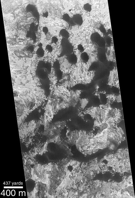
Spring Defrosting of Mass-Movement Material at South High Latitudes
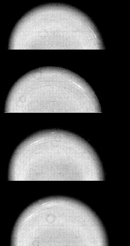
These time-lapse images of Uranus. taken by NASA Voyager 2 on Jan. 14, 1986, show the movement of two small, bright, streaky clouds -- the first such features ever seen on the planet. http://photojournal.jpl.nasa.gov/catalog/PIA00369
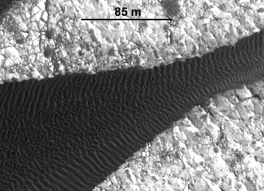
This image, one of two from a two-image animation from NASA Mars Reconnaissance Orbiter, shows movement of ripples covering a sand dune on Mars.

Spirit Arm Movements for Mosaic of Keystone
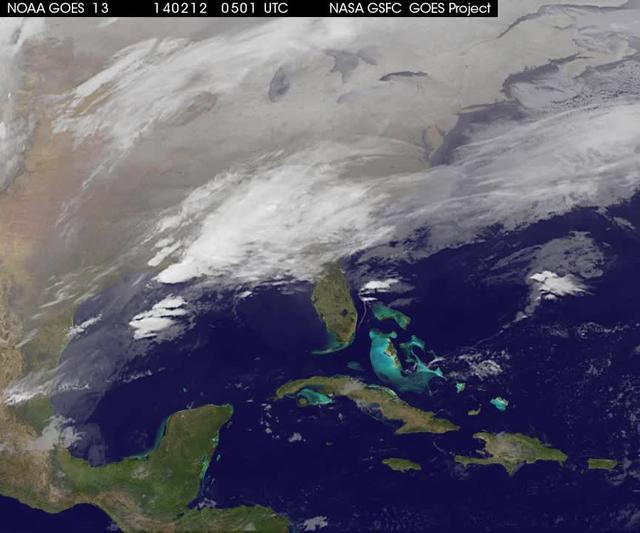
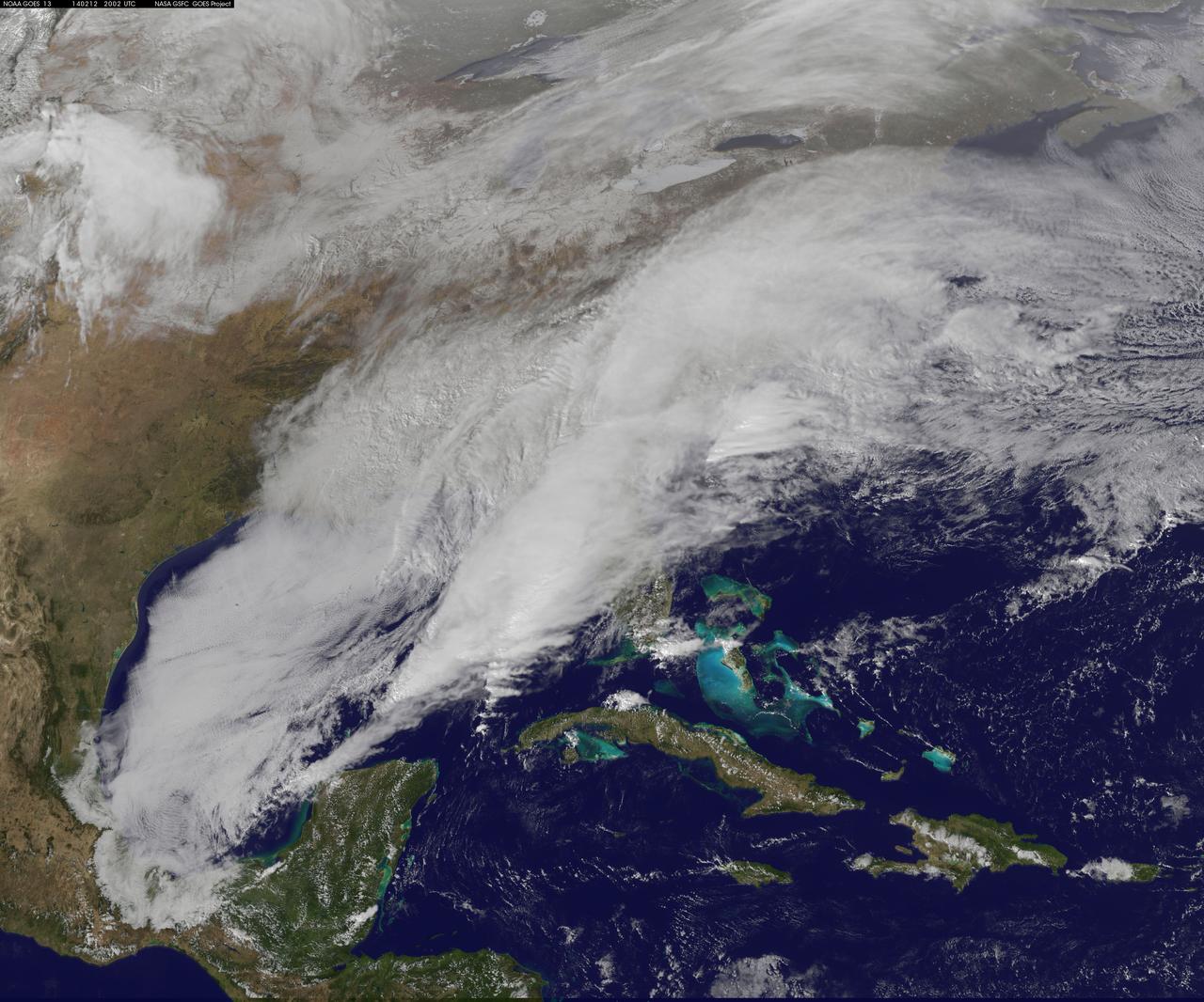
A new NASA video of NOAA's GOES satellite imagery shows three days of movement of the massive winter storm that stretches from the southern U.S. to the northeast. Visible and infrared imagery from NOAA's GOES-East or GOES-13 satellite from Feb. 10 at 1815 UTC/1:15 p.m. EST to Feb. 12 to 1845 UTC/1:45 p.m. EST were compiled into a video made by NASA/NOAA's GOES Project at NASA's Goddard Space Flight Center in Greenbelt, Md. In the video, viewers can see the development and movement of the clouds associated with the progression of the frontal system and related low pressure areas that make up the massive storm. The video also shows the snow covered ground over the Great Lakes region and Ohio Valley that stretches to northern New England. The clouds and fallen snow data from NOAA's GOES-East satellite were overlaid on a true-color image of land and ocean created by data from the Moderate Resolution Imaging Spectroradiometer or MODIS instrument that flies aboard NASA's Aqua and Terra satellites. On February 12 at 10 a.m. EST, NOAA's National Weather Service or NWS continued to issue watches and warnings from Texas to New England. Specifically, NWS cited Winter Storm Warnings and Winter Weather Advisories were in effect from eastern Texas eastward across the interior section of southeastern U.S. states and across much of the eastern seaboard including the Appalachians. Winter storm watches are in effect for portions of northern New England as well as along the western slopes of northern and central Appalachians. For updates on local forecasts, watches and warnings, visit NOAA's <a href="http://www.weather.gov" rel="nofollow">www.weather.gov</a> webpage. NOAA's Weather Prediction Center or WPC noted the storm is expected to bring "freezing rain spreading into the Carolinas, significant snow accumulations are expected in the interior Mid-Atlantic states tonight into Thursday and ice storm warnings and freezing rain advisories are in effect across much of central Georgia. GOES satellites provide the kind of continuous monitoring necessary for intensive data analysis. Geostationary describes an orbit in which a satellite is always in the same position with respect to the rotating Earth. This allows GOES to hover continuously over one position on Earth's surface, appearing stationary. As a result, GOES provide a constant vigil for the atmospheric "triggers" for severe weather conditions such as tornadoes, flash floods, hail storms and hurricanes. For updated information about the storm system, visit NOAA's WPC website; <a href="http://www.hpc.ncep.noaa.gov/" rel="nofollow">www.hpc.ncep.noaa.gov/</a> For more information about GOES satellites, visit: <a href="http://www.goes.noaa.gov/" rel="nofollow">www.goes.noaa.gov/</a> or <a href="http://goes.gsfc.nasa.gov/" rel="nofollow">goes.gsfc.nasa.gov/</a> Rob Gutro NASA's Goddard Space Flight Center <b><a href="http://goes.gsfc.nasa.gov/" rel="nofollow">Credit: NOAA/NASA GOES Project</a></b> <b><a href="http://www.nasa.gov/audience/formedia/features/MP_Photo_Guidelines.html" rel="nofollow">NASA image use policy.</a></b> <b><a href="http://www.nasa.gov/centers/goddard/home/index.html" rel="nofollow">NASA Goddard Space Flight Center</a></b> enables NASA’s mission through four scientific endeavors: Earth Science, Heliophysics, Solar System Exploration, and Astrophysics. Goddard plays a leading role in NASA’s accomplishments by contributing compelling scientific knowledge to advance the Agency’s mission. <b>Follow us on <a href="http://twitter.com/NASAGoddardPix" rel="nofollow">Twitter</a></b> <b>Like us on <a href="http://www.facebook.com/pages/Greenbelt-MD/NASA-Goddard/395013845897?ref=tsd" rel="nofollow">Facebook</a></b> <b>Find us on <a href="http://instagrid.me/nasagoddard/?vm=grid" rel="nofollow">Instagram</a></b>
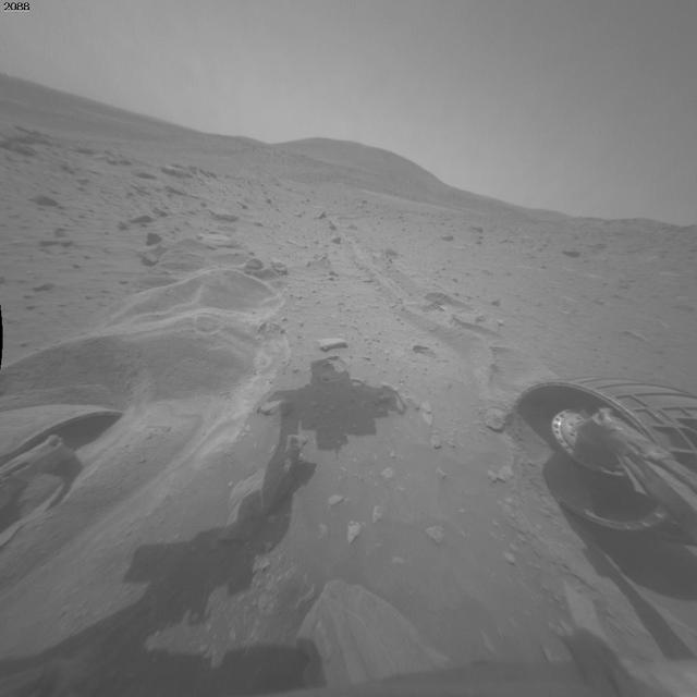
This image is one of two images which documents very slight forward movement of NASA Mars Exploration Rover Spirit during a drive on the rover 2,090th Martian day, or sol Nov. 19, 2009.
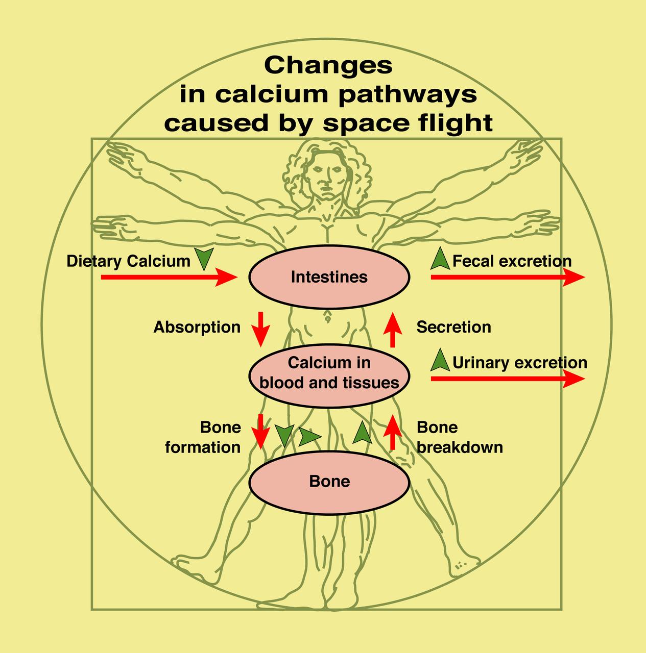
This diagram shows the normal pathways of calcium movement in the body and indicates changes (green arrows) seen during preliminary space flight experiments. Calcium plays a central role because 1) it gives strength and structure to bone and 2) all types of cells require it to function normally. To better understand how and why weightlessness induces bone loss, astronauts have participated in a study of calcium kinetics -- that is, the movement of calcium through the body, including absorption from food, and its role in the formation and breakdown of bone.
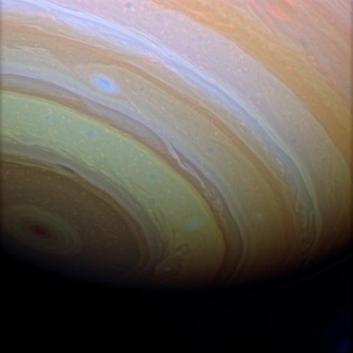
Stunning details in Saturn clouds suggest movement within bands of atmosphere
<b>View a video of the storm here: <a href="http://bit.ly/1m9aJFY" rel="nofollow">bit.ly/1m9aJFY</a></b> This visible image of the winter storm over the U.S. south and East Coast was taken by NOAA's GOES-13 satellite on Feb. 12 at 1855 UTC/1:55 p.m. EST. Snow covered ground can be seen over the Great Lakes region and Ohio Valley. On February 12 at 10 a.m. EST, NOAA's National Weather Service or NWS continued to issue watches and warnings from Texas to New England. Specifically, NWS cited Winter Storm Warnings and Winter Weather Advisories were in effect from eastern Texas eastward across the interior section of southeastern U.S. states and across much of the eastern seaboard including the Appalachians. Winter storm watches are in effect for portions of northern New England as well as along the western slopes of northern and central Appalachians. For updates on local forecasts, watches and warnings, visit NOAA's <a href="http://www.weather.gov" rel="nofollow">www.weather.gov</a> webpage. NOAA's Weather Prediction Center or WPC noted the storm is expected to bring "freezing rain spreading into the Carolinas, significant snow accumulations are expected in the interior Mid-Atlantic states tonight into Thursday and ice storm warnings and freezing rain advisories are in effect across much of central Georgia. GOES satellites provide the kind of continuous monitoring necessary for intensive data analysis. Geostationary describes an orbit in which a satellite is always in the same position with respect to the rotating Earth. This allows GOES to hover continuously over one position on Earth's surface, appearing stationary. As a result, GOES provide a constant vigil for the atmospheric "triggers" for severe weather conditions such as tornadoes, flash floods, hail storms and hurricanes. For updated information about the storm system, visit NOAA's WPC website; <a href="http://www.hpc.ncep.noaa.gov/" rel="nofollow">www.hpc.ncep.noaa.gov/</a> For more information about GOES satellites, visit: <a href="http://www.goes.noaa.gov/" rel="nofollow">www.goes.noaa.gov/</a> or <a href="http://goes.gsfc.nasa.gov/" rel="nofollow">goes.gsfc.nasa.gov/</a> Rob Gutro NASA's Goddard Space Flight Center <b><a href="http://goes.gsfc.nasa.gov/" rel="nofollow">Credit: NOAA/NASA GOES Project</a></b> <b><a href="http://www.nasa.gov/audience/formedia/features/MP_Photo_Guidelines.html" rel="nofollow">NASA image use policy.</a></b> <b><a href="http://www.nasa.gov/centers/goddard/home/index.html" rel="nofollow">NASA Goddard Space Flight Center</a></b> enables NASA’s mission through four scientific endeavors: Earth Science, Heliophysics, Solar System Exploration, and Astrophysics. Goddard plays a leading role in NASA’s accomplishments by contributing compelling scientific knowledge to advance the Agency’s mission. <b>Follow us on <a href="http://twitter.com/NASAGoddardPix" rel="nofollow">Twitter</a></b> <b>Like us on <a href="http://www.facebook.com/pages/Greenbelt-MD/NASA-Goddard/395013845897?ref=tsd" rel="nofollow">Facebook</a></b> <b>Find us on <a href="http://instagrid.me/nasagoddard/?vm=grid" rel="nofollow">Instagram</a></b>
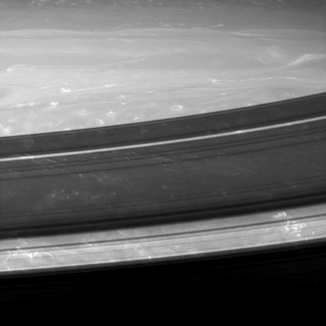
Keeping a close watch on the outer portion of Saturn B ring, NASA Cassini spacecraft records the complex inward and outward movement of the edge of the ring. This ring movement resembles the suspected behavior of spiral disk galaxies.
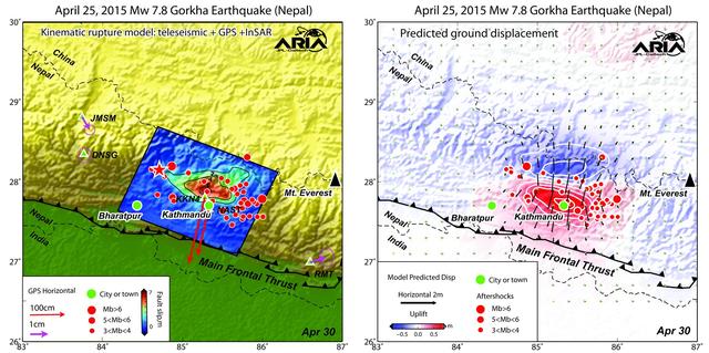
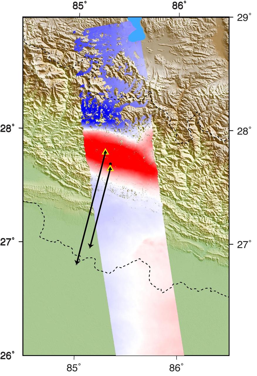
Using a combination of GPS-measured ground motion data, satellite radar data, and seismic observations from instruments distributed around the world, scientists have constructed preliminary estimates of how much the fault responsible for the April 25, 2015, magnitude 7.8 Gorkha earthquake in Nepal moved below Earth's surface (Figure 1). This information is useful for understanding not only what happened in the earthquake but also the potential for future events. It can also be used to infer a map of how Earth's surface moved due to the earthquake over a broader region (Figure 2). The maps created from these data can be viewed at PIA19384. In the first figure, the modeled slip on the fault is shown as viewed from above and indicated by the colors and contours within the rectangle. The peak slip in the fault exceeds 19.7 feet (6 meters). The ground motion measured with GPS is shown by the red and purple arrows and was used to develop the fault slip model. In the second figure, color represents vertical movement and the scaled arrows indicate direction and magnitude of horizontal movement. In both figures, aftershocks are indicated by red dots. Background color and shaded relief reflect regional variations in topography. The barbed lines show where the main fault reaches Earth's surface. The main fault dives northward into the Earth below the Himalaya. http://photojournal.jpl.nasa.gov/catalog/PIA19384
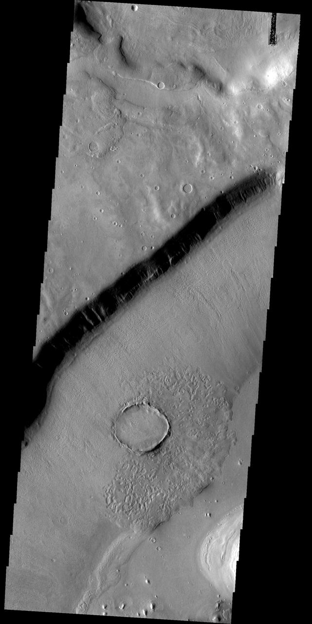
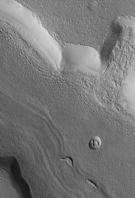
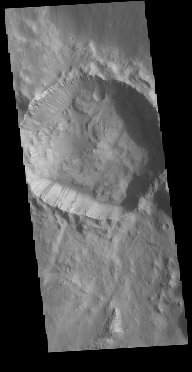
This crater appears to be in the process of being covered over by downslope movement of material. These large slopes of material are common in Deuteronilus Mensae
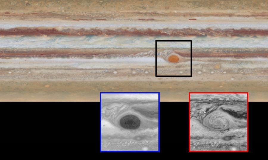
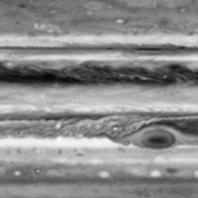
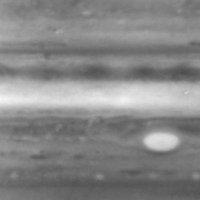
This image is one of two images from NASA Hubble Space Telescope comparing the movement of Jupiter clouds. The movement of Jupiter's clouds can be seen by comparing the first map to the second one in this animated pair of images. Zooming in on the Great Red Spot at blue (below, at left) and red (below, at right) wavelengths reveals a unique filamentary feature not previously seen. http://photojournal.jpl.nasa.gov/catalog/PIA19648

The movement pathways of molten rock, or lava, is demonstrated in this image from NASA Mars Odyssey spacecraft of a portion of Olympus Mons, the largest volcano in our solar system.
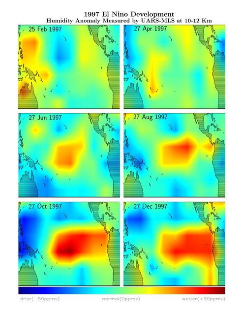
This series of six images shows the movement of atmospheric water vapor over the Pacific Ocean during the formation of the 1997 El Niño condition.
This false-color map from NASA ARIA project shows the amount of permanent surface movement caused almost entirely by the magnitude 7.8 Gorkha earthquake in Nepal.

Dark streaks emanating from within impact crater walls show evidence for mass movement of materials in this image from NASA Mars Odyssey spacecraft.

Images from NASA Cassini spacecraft using three different filters reveal cloud structures and movements at different depths in the atmosphere around Jupiter south pole.
This image from an animated gif shows the movement of the rear right wheel of NASA Curiosity as rover drivers turned the wheels in place at the landing site on Mars.
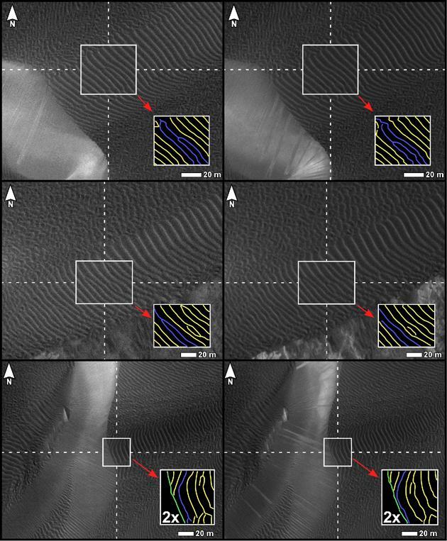
Three pairs of before and after images from NASA Mars Reconnaissance Orbiter illustrate movement of ripples on dark sand dunes in the Nili Patera region of Mars.
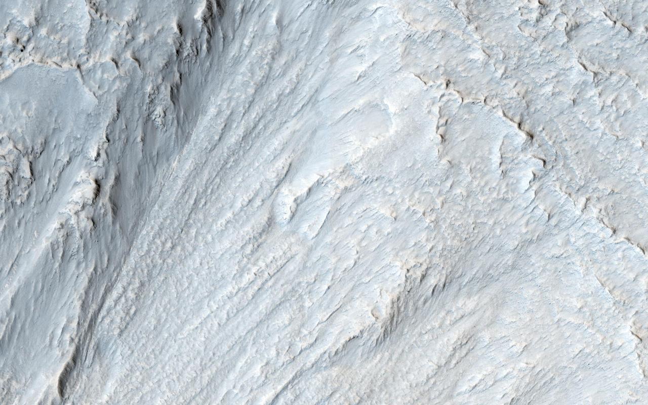
This image captured by NASA Mars Reconnaissance Orbiter appears to show some type of mass movement of material down the wall of a mesa in Deuteronilus Mensae.
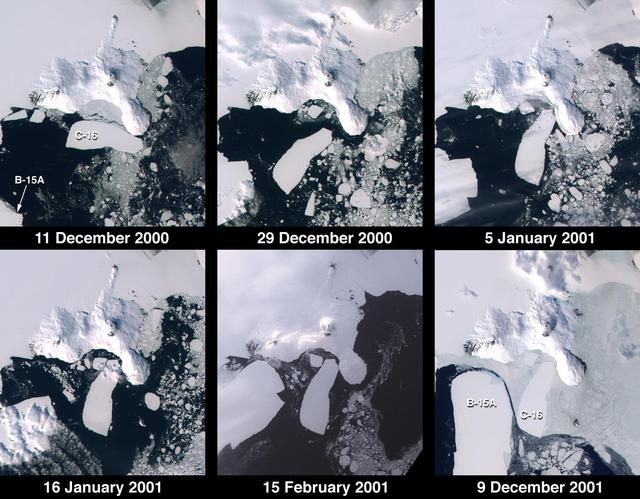
These images from NASA Terra satellite documented iceberg movements and changes in sea ice between December 11, 2000 and December 9, 2001.

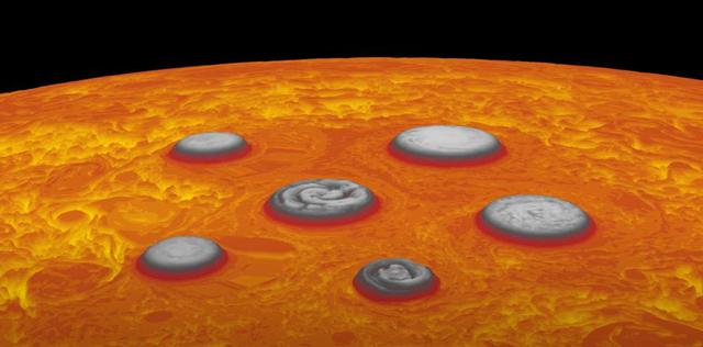
This animation depicts the invisible forces at work at Jupiter's south pole that keep the five circumpolar cyclones there in position relative to each other and to the polar cyclone – the central cyclone directly over the pole. Blue arrows depict the forces that drive the cyclones southward, toward the polar cyclone. Green arrows depict the rejections force generated by the polar cyclone, preventing the circumpolar cyclones from occupying the pole position. Pink arrows demonstrate mutual forces the circumpolar cyclones project, causing them to remain an equal distance from one another, in a pentagonal configuration. Data used to generate this animation was acquired by the Jovian Infrared Auroral Mapper (JIRAM) instrument aboard NASA's Juno spacecraft. JIRAM "sees" in infrared light not visible to the human eye. It was designed to capture the infrared light emerging from deep inside Jupiter, probing the weather layer down to 30 to 45 miles (50 to 70 kilometers) below Jupiter's cloud tops. Movie available at https://photojournal.jpl.nasa.gov/catalog/PIA24968

A dune in the northern polar region of Mars shows significant changes between June 25, 2008 and May 21, 2010 in one of two images taken on by NASA Mars Reconnaissance Orbiter.
This simulation shows the motions the robotic arm on NASA's Perseverance rover carried out during its first two-hour checkout since its Feb. 18, 2021 touchdown on Mars. This simulation does not run in real-time. A key objective for Perseverance's mission on Mars is astrobiology, including the search for signs of ancient microbial life. The rover will characterize the planet's geology and past climate, pave the way for human exploration of the Red Planet, and be the first mission to collect and cache Martian rock and regolith (broken rock and dust). Subsequent NASA missions, in cooperation with ESA (European Space Agency), would send spacecraft to Mars to collect these sealed samples from the surface and return them to Earth for in-depth analysis. The Mars 2020 Perseverance mission is part of NASA's Moon to Mars exploration approach, which includes Artemis missions to the Moon that will help prepare for human exploration of the Red Planet. Animation available at https://photojournal.jpl.nasa.gov/catalog/PIA24332
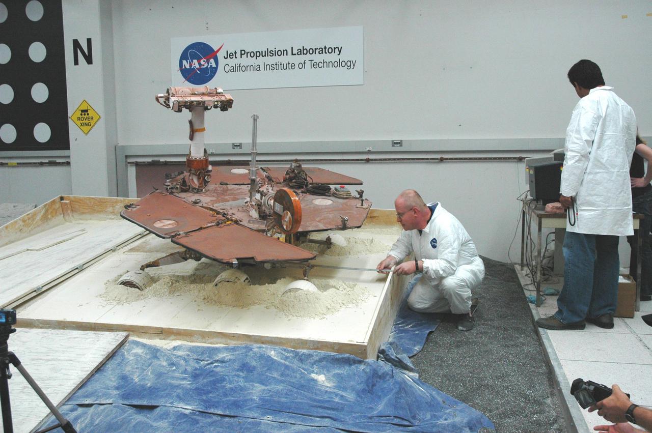
After commanding five of a test rover six wheels to drive forward, rover driver Paolo Bellutta left measures how much the rover moved sideways, downslope, during the maneuver.
This is an image of a camera pushing through NASA Phoenix Mars Lander Stereo Surface Imager SSI.
NASA Aqua spacecraft has illustrated surface air and skin temperature for the period from July 16-24, showing movement of a dome of heat across the eastern two-thirds of the country. See More Details for the movies.
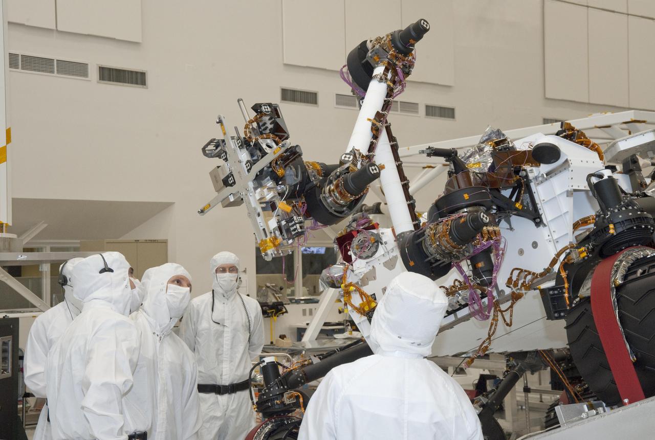
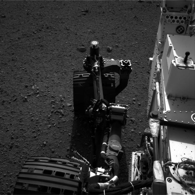
Testing of the robotic arm on NASA Mars rover Curiosity on Sept. 3, 2010, included movements of the arm while the rover was on a table tilted to 20 degrees to simulate a sloped surface on Mars.

Freedom crater, located in Acidalia Planitia, exhibits a concentric ring pattern in its interior as seen in this image from NASA Mars Odyssey spacecraft, suggesting that there has been some movement of these materials towards the center of the crater.
A screen shot from software used by the Mars Exploration Rover team for assessing movements by Spirit and Opportunity illustrates the degree to which Spirit wheels have become embedded in soft material at the location called Troy.
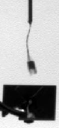
This frame from a series of images shows NASA Phoenix Mars Lander telltale instrument waving in the Martian wind. Documenting the telltale movement helps mission scientists and engineers determine what the wind is like on Mars.
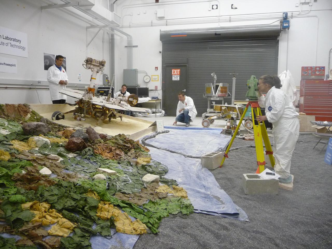
Rover-team members at NASA Jet Propulsion Laboratory, Pasadena, Calif., check slight movements by a test rover during tests simulating the challenge of getting NASA Mars Exploration Rover Spirit out of a sand trap on Mars.
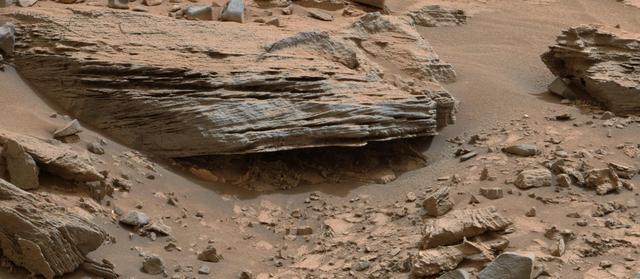
Cross-bedding seen in the layers of this Martian rock is evidence of movement of water recorded by the waves or ripples of loose sediment the water passed over, such as a current in a lake. This image is from NASA Curiosity Mars rover.
This image is one of seven from the narrow-angle camera on NASA Cassini spacecraft assembled as a brief movie of cloud movements on Jupiter. The smallest features visible are about 500 kilometers about 300 miles across.

Dark streaks mark the sides of this mesa where the movement of material has exposed the darker rock beneath. This mesa or hill is just one of hundreds in Tartarus Colles. This image was captured by NASA 2001 Mars Odyssey spacecraft.
This image is one of seven from the narrow-angle camera on NASA Cassini spacecraft assembled as a brief movie of high-altitude cloud movements on Jupiter. It was taken in early October 2000.

This image captured by NASA 2001 Mars Odyssey spacecraft shows downslope movement of material from the hill at the top of the image. Linear ridges and channels are visible on the surface to the debris flow deposit.

These mosaics 6 frames each were taken nine hours apart and reveal Jupiter winds through the movements of cloud features by NASA Galileo orbiter June 26th, 1996.

Several craters were formed on the rim of this large crater. The movement of material downhill toward the floor of the large crater has formed interesting patterns on the floors of the smaller craters
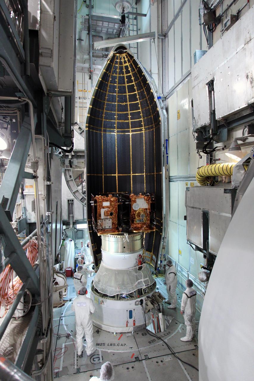
Spacecraft technicians monitor the movement of a section of the clamshell-shaped Delta payload fairing as it encloses NASA twin Gravity Recovery and Interior Laboratory spacecraft at Cape Canaveral Air Force Station in Florida on Aug. 23, 2011.

This MOC image shows a portion of the floor and wall of a trough in the Acheron Fossae region of Mars. Mass movements of dry dust, which appears to mantle much of the scene, have created the dark slope streaks on the wall of the trough
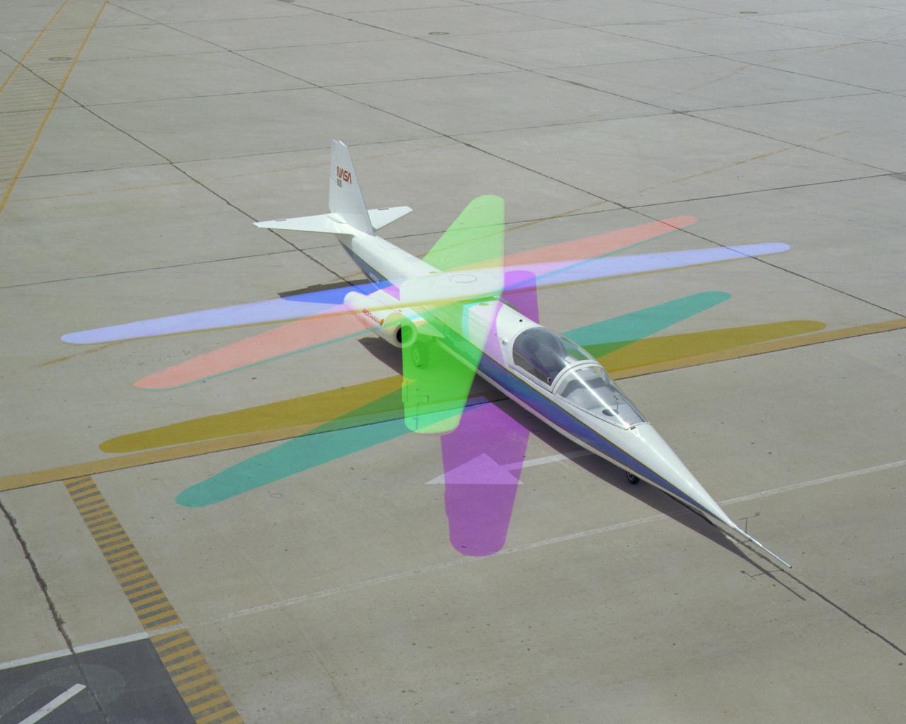
Multiple exposure image showing wing movement on AD-1.
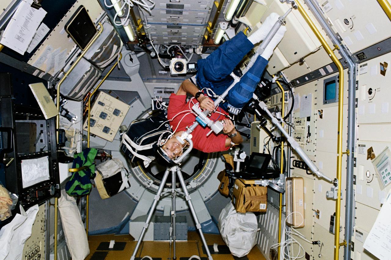
STS047-204-006 (12 - 20 Sept 1992) --- Dr. Mamoru Mohri, payload specialist representing Japan's National Space Development Agency (NASDA), participates in an experiment designed to learn more about Space Adaptation Syndrome (SAS). The experiment is titled, "Comparative Measurement of Visual Stability in Earth and Cosmic Space." During the experiment, Dr. Mohri tracked a flickering light target while eye movements and neck muscle tension were measured. This 45-degree angle position was one of four studied during the eight-day Spacelab-J mission.
This false-color scene from the panoramic camera (Pancam) on NASA's Mars Exploration Rover Opportunity documents movement of dust as a regional dust storm approached the rover's location on Feb. 24, 2017, during the 4,653rd Martian day, or sol, of the rover's work on Mars. Key to detecting the movement is that Pancam color images are combinations of different images taken a short time apart through different color filters. Note that along the horizon, the left portion of the image has a bluish band (with label and arrow in Figure 1). The component image admitting blue light was taken about 150 seconds after the component image admitting red light. A layer of dust-carrying wind hadn't reached this location by the earlier exposure, but had by the later one. This Sol 4653 Opportunity view is toward the north from the rover's location on the western rim of Endeavour Crater in the Meridiani Planum region of Mars. http://photojournal.jpl.nasa.gov/catalog/PIA21485
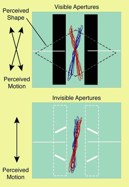
One concern about human adaptation to space is how returning from the microgravity of orbit to Earth can affect an astronaut's ability to fly safely. There are monitors and infrared video cameras to measure eye movements without having to affect the crew member. A computer screen provides moving images which the eye tracks while the brain determines what it is seeing. A video camera records movement of the subject's eyes. Researchers can then correlate perception and response. Test subjects perceive different images when a moving object is covered by a mask that is visible or invisible (above). Early results challenge the accepted theory that smooth pursuit -- the fluid eye movement that humans and primates have -- does not involve the higher brain. NASA results show that: Eye movement can predict human perceptual performance, smooth pursuit and saccadic (quick or ballistic) movement share some signal pathways, and common factors can make both smooth pursuit and visual perception produce errors in motor responses.
Movement of Ares 1-X US-4 segment from Building 50 to Building 333
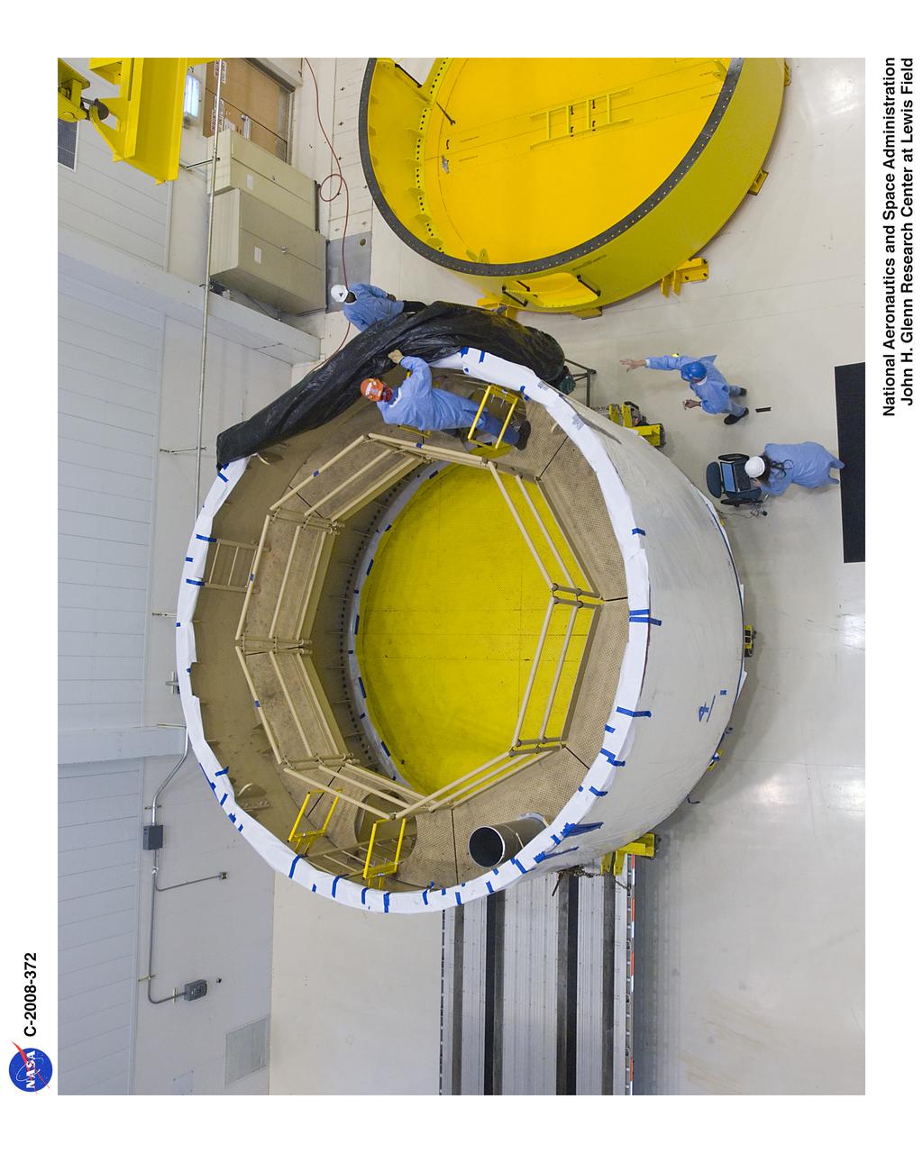
Movement of Ares 1-X US-4 segment from Building 50 to Building 333

Gravity has caused materials to move down the rim of this crater in Terra Sabaea. In this image from NASA 2001 Mars Odyssey, thinner dark slope streaks are less common than broader, lighter markings of downslope movement of materials.
The small hill in this image aptured by NASA 2001 Mars Odyssey spacecraft of Amazonis Planitia has several dark slope streaks, believed to form when down slope movement of rocks or other debris clear off some of the dust cover.
This frame from an animation shows the movement of several dust storms near NASA Phoenix Mars Lander. These images were taken by the lander Surface Stereo Imager SSI on the 137th Martian day, or sol, of the mission Oct. 13, 2008.
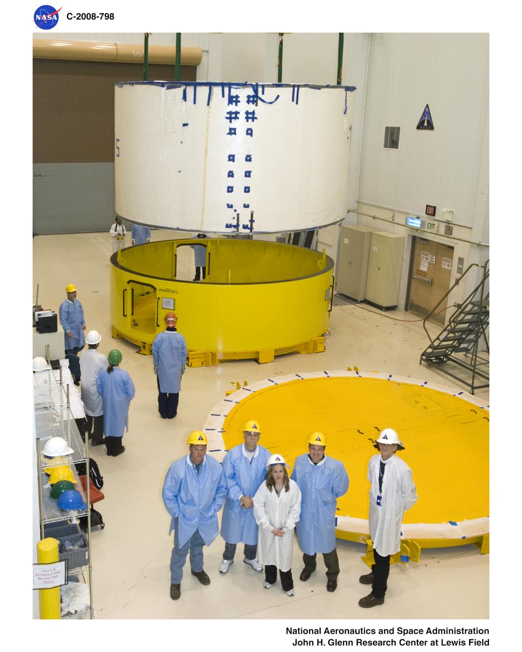
NASA Kennedy lift team observing the movement of Ares 1-X segment US-5 before its critical lift to the Super Stack

Researchers Anna Noe and Eric Altman check out the Doppler Aerosol Wind Lidar (DAWN), an airborne instrument that uses pulsed lasers to detect the movement of atmospheric aerosols such as dust or sea salt. In detecting those movements, it can profile wind vector — both speed and direction. Researchers are testing DAWNs capabilities during flights over the eastern Pacific.
This VIS image is located in an unnamed crater in Noachis Terra. The sinuous feature near the bottom of the crater rim appears to have been caused by down slope movement of materials. The sinuous nature may have been created by inclusion of a volatile material such as ice. Orbit Number: 74447 Latitude: -39.937 Longitude: 11.1296 Instrument: VIS Captured: 2018-09-26 05:13 https://photojournal.jpl.nasa.gov/catalog/PIA22844

This VIS image is located in central Ganges Chasma. A large landslide deposit fills the top third of the image. The radial grooves on the top of the landslide are a common feature formed by the downslope movement of the landslide materials. The landslide was deflected in some areas by preexisting blocks on the chasma floor. Ganges Chasma is part of the Valles Marineris chasma system, but is north of the main section of canyons. Orbit Number: 72790 Latitude: -7.88588 Longitude: 309.432 Instrument: VIS Captured: 2018-05-12 17:34 https://photojournal.jpl.nasa.gov/catalog/PIA22616
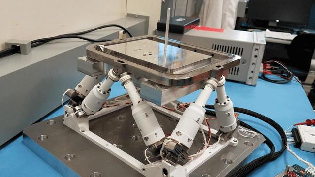
A device with six mechanical legs, the hexapod is a critical part of the Planetary Instrument for X-ray Lithochemistry (PIXL), one of the instruments aboard NASA's Perseverance Mars rover. The hexapod allows PIXL to make slow, precise movements to get closer to and point at specific parts of a rock's surface in order for the instrument to use its X-ray to discover where — and in what quantity — chemicals are distributed there. This GIF has been considerably sped up to show how the hexapod moves. Movie available at https://photojournal.jpl.nasa.gov/catalog/PIA24094
Located on the rim of Chia Crater, this smaller crater contains a multitude of dark slope streaks. These features are assumed to represent down slope movements of material, either a process that removes a dusty top later to reveal dark rocky material below, or one that darkens part of the slope due to surface or near surface flows of a briny volatile. Orbit Number: 72229 Latitude: 0.81902 Longitude: 300.014 Instrument: VIS Captured: 2018-03-27 12:29 https://photojournal.jpl.nasa.gov/catalog/PIA22504

This VIS image is located in Terra Sabaea. The ridge near the right side of the image contains dark slope streaks. These features are thought to form by downslope movement of material which either reveals the darker rock beneath the dust coating, or creates the darker surface by flow of a volatile just beneath the dust coating. Orbit Number: 72662 Latitude: 2.93981 Longitude: 42.3759 Instrument: VIS Captured: 2018-05-02 04:33 https://photojournal.jpl.nasa.gov/catalog/PIA22622

After the scoop on the end of NASA's Mars InSight lander was used to push down on the top of the spacecraft's "mole," or self-hammering heat probe, it was held in place to essentially block the mole from popping out of the soil. The movement of sand grains in the scoop, seen here, suggested that the mole had began bumping up against the bottom of the scoop while hammering on June 20, 2020. Movie available at https://photojournal.jpl.nasa.gov/catalog/PIA23896
S83-35768 (18-24 June 1983) --- Astronaut Sally K. Ride, mission specialist for STS-7, uses a screw driver in order to clean out an air filtering system in the mid-deck of the Earth-orbiting Space Shuttle Challenger. Dr. Ride's constant wear garment bears some extras -- a cartoon of 35 busy astronauts around a Space Shuttle and the acronym TFNG, below which is written, "We deliver!" TFNG stands for thirty-five new guys, referring to the 1978 class of astronaut candidates (ASCAN) from which Dr. Ride and three of her crew members hail. The tiny two-word declarative in white lettering refers to the successful deployment of two communications satellites. This photograph was made with a 35mm camera.
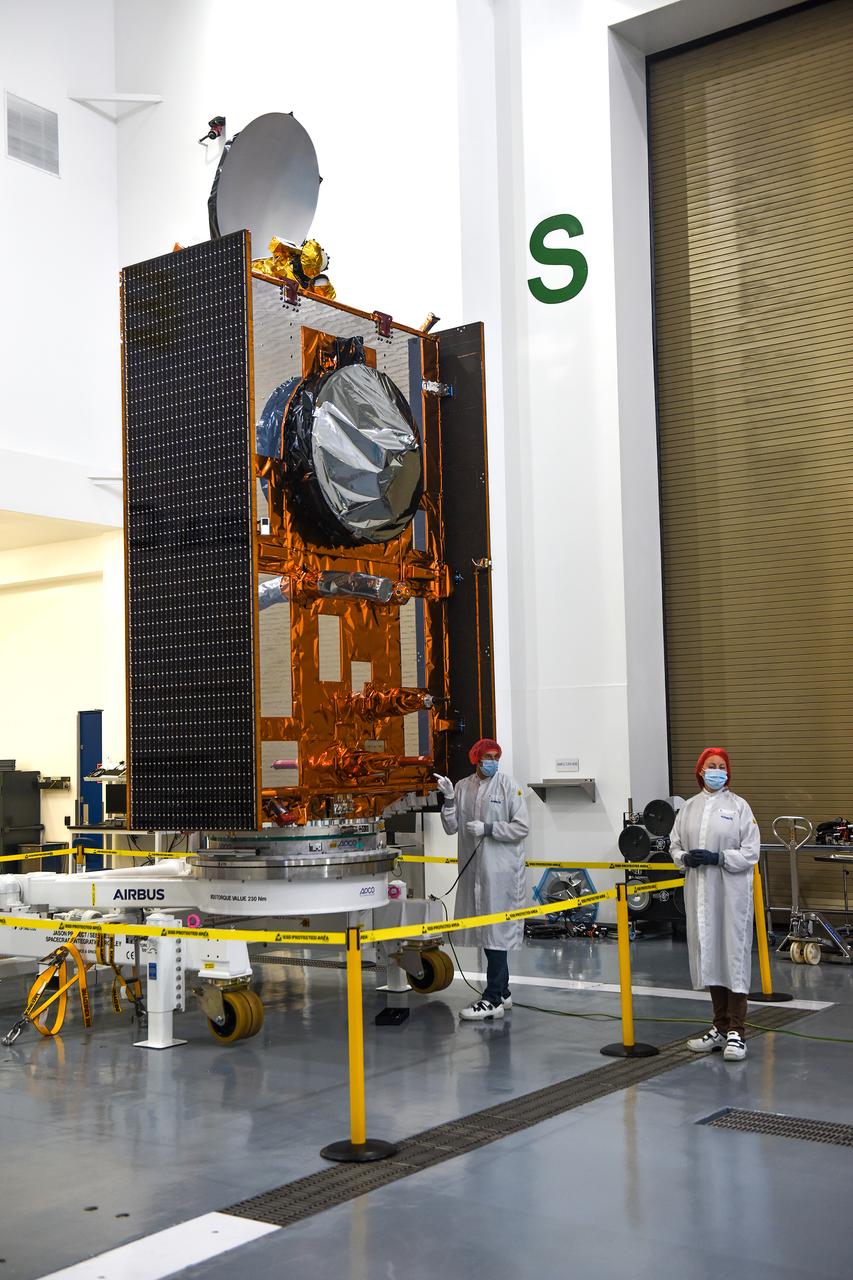
Airbus Defence and Space technicians position the Sentinel-6 Michael Freilich spacecraft for fueling inside SpaceX’s Payload Processing Facility at Vandenberg Air Force Base (VAFB) in California on Oct. 22, 2020. The mission is an international collaboration and will be the first of two satellites launched to continue observing changes in Earth’s sea levels for at least the next decade. The Sentinel-6 Michael Freilich satellite is scheduled to launch from VAFB atop a SpaceX Falcon 9 rocket. NASA’s Launch Services Program at Kennedy Space Center in Florida is responsible for launch management.
This image is one of two frames showing NASA Spirit driving backward as next technique for attempting to extricate the rover from the sand trap where it is embedded. Go to the Photojournal for the animation.
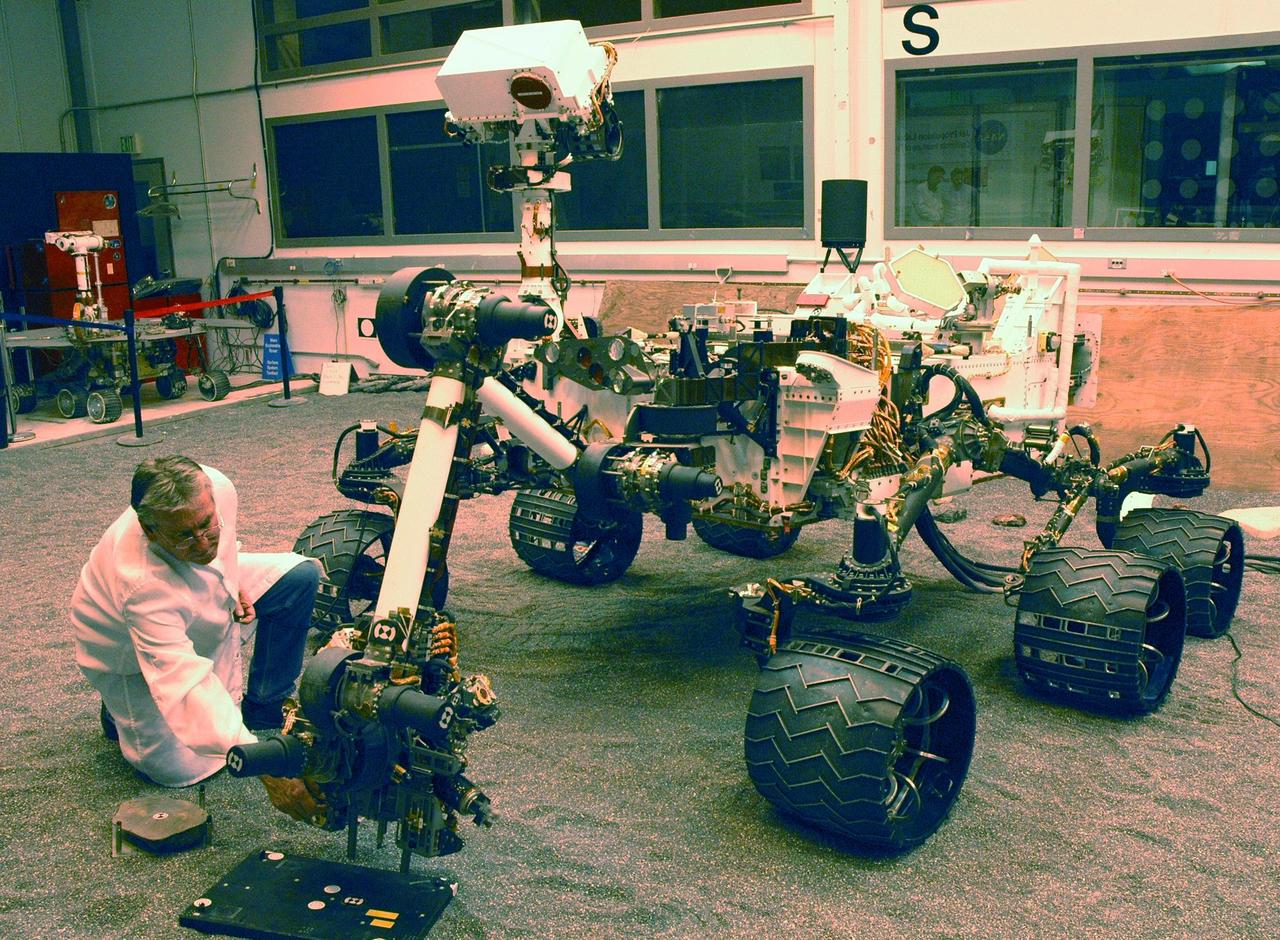
A NASA Mars Science Laboratory test rover called the Vehicle System Test Bed, or VSTB, at NASA Jet Propulsion Laboratory, Pasadena, CA serves as the closest double for Curiosity in evaluations of the mission hardware and software.
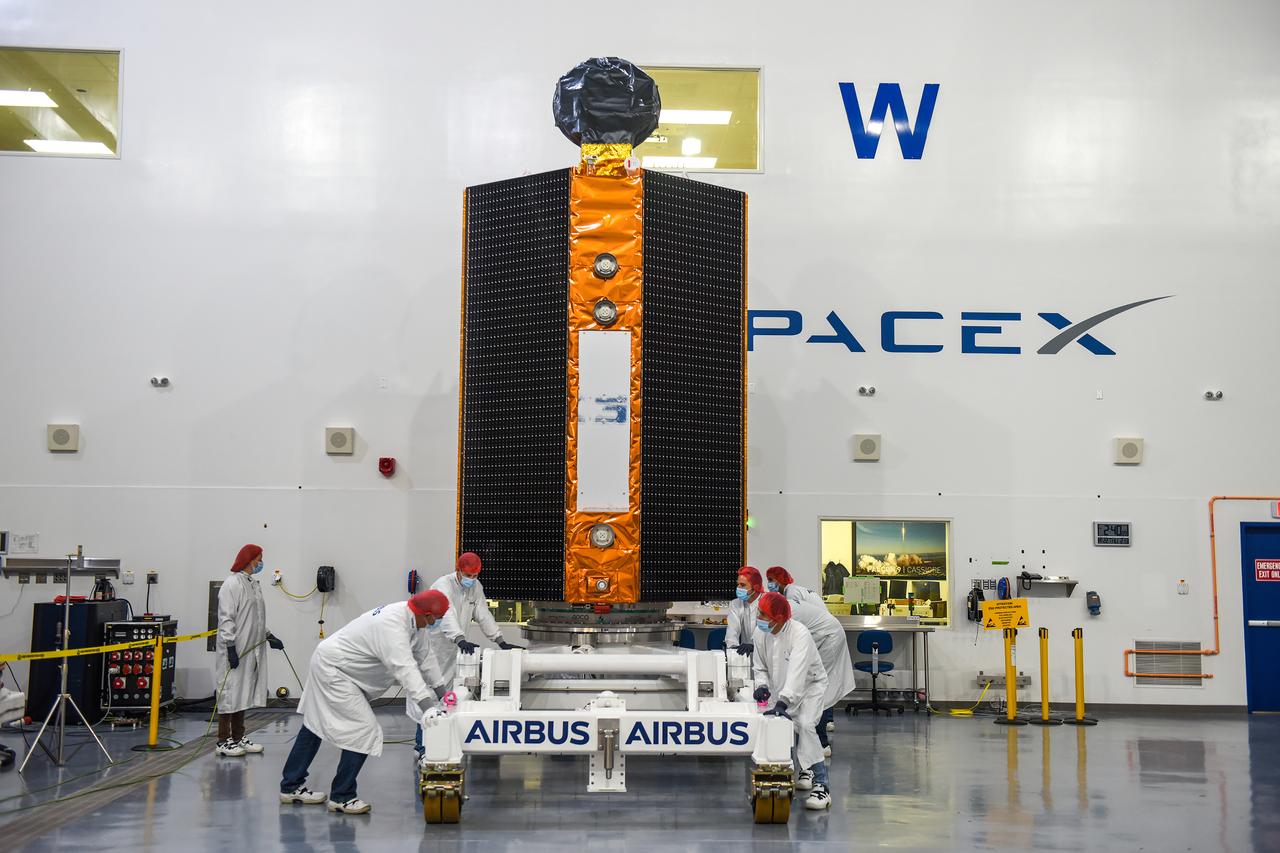
Airbus Defence and Space technicians position the Sentinel-6 Michael Freilich spacecraft for fueling inside SpaceX’s Payload Processing Facility at Vandenberg Air Force Base (VAFB) in California on Oct. 22, 2020. The mission is an international collaboration and will be the first of two satellites launched to continue observing changes in Earth’s sea levels for at least the next decade. The Sentinel-6 Michael Freilich satellite is scheduled to launch from VAFB atop a SpaceX Falcon 9 rocket. NASA’s Launch Services Program at Kennedy Space Center in Florida is responsible for launch management.

An engineer at NASA's Jet Propulsion Laboratory is shown here with the fast steering mirror, a component of the Coronagraph Instrument on NASA's Nancy Grace Roman Space Telescope. The mirror can make small movements that correct for slight wobbling of the observatory. The incoming image needs to be perfectly sharp in order for the instrument to suppress light from a star while allowing the light from planets orbiting it to pass through. Although the technologies differ, it's analogous to image stabilization in digital cameras, in which the camera lens moves to counteract the shake of your hands and keep the image sharp. https://photojournal.jpl.nasa.gov/catalog/PIA25437
In this animation, forces created by movement toward the south pole of a circumpolar cyclone (farthest right) results in the temporary shift in location by the polar cyclone – the central cyclone directly over the pole – and the four other circumpolar cyclones. Data used to generate this animation was acquired by the Jovian Infrared Auroral Mapper (JIRAM) instrument aboard NASA's Juno spacecraft. JIRAM "sees" in infrared light not visible to the human eye. It was designed to capture the infrared light emerging from deep inside Jupiter, probing the weather layer down to 30 to 45 miles (50 to 70 kilometers) below Jupiter's cloud tops. Movie available at https://photojournal.jpl.nasa.gov/catalog/PIA24969
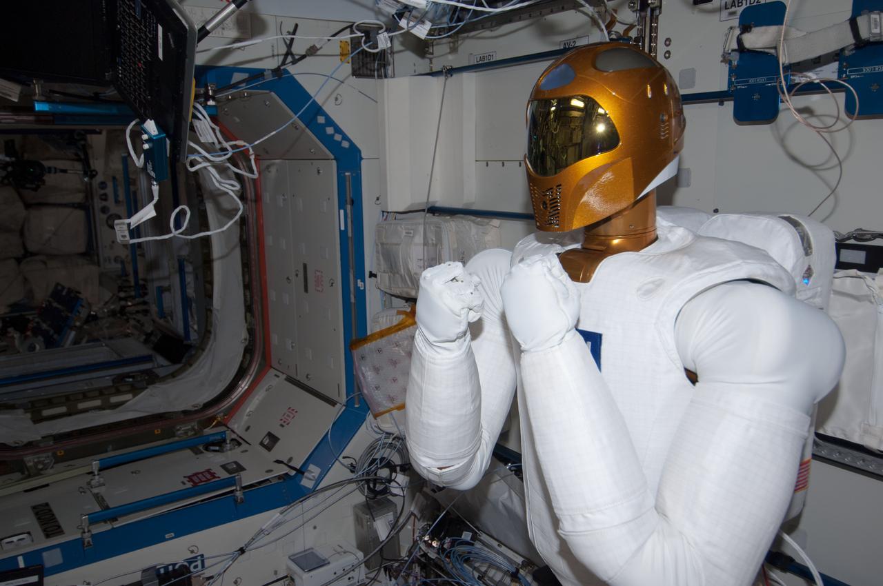
ISS035-E-016453 (9 April 2013) --- R-2 is busy in U.S. lab Destiny aboard the Earth-orbiting International Space Station during tele-operation (by ground controllers) to mimic movement of a crew member.
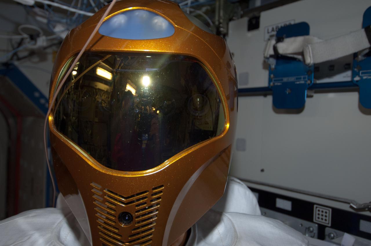
ISS035-E-016453 (9 April 2013) --- R-2 is busy in U.S. lab Destiny aboard the Earth-orbiting International Space Station during tele-operation (by ground controllers) to mimic movement of a crew member.
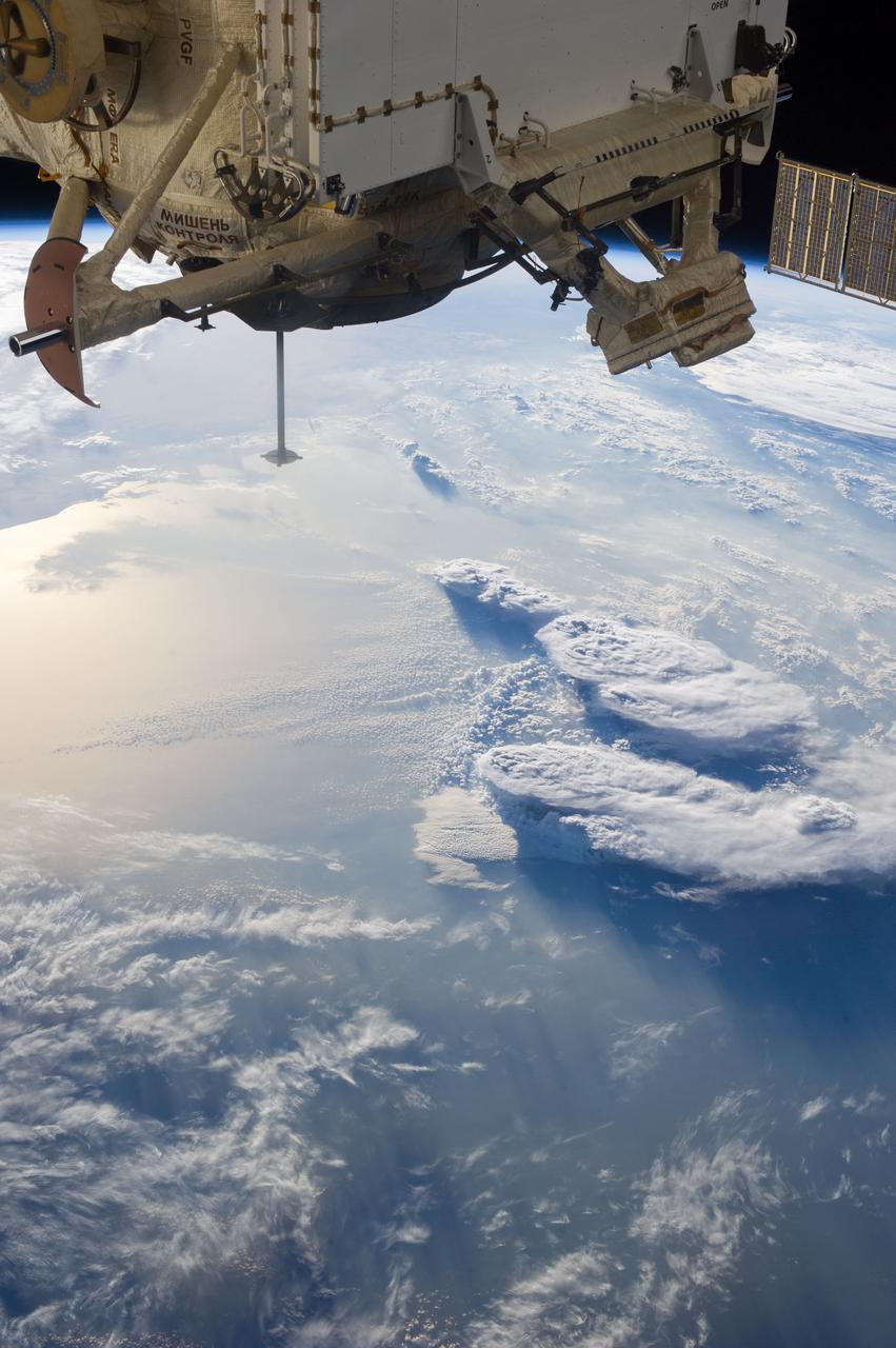
Earth Observation taken during a day pass by the Expedition 37 crew. Identified via Twitter message as storms over the Mediterranean and a nadir docking port left empty after movement of the Soyuz.
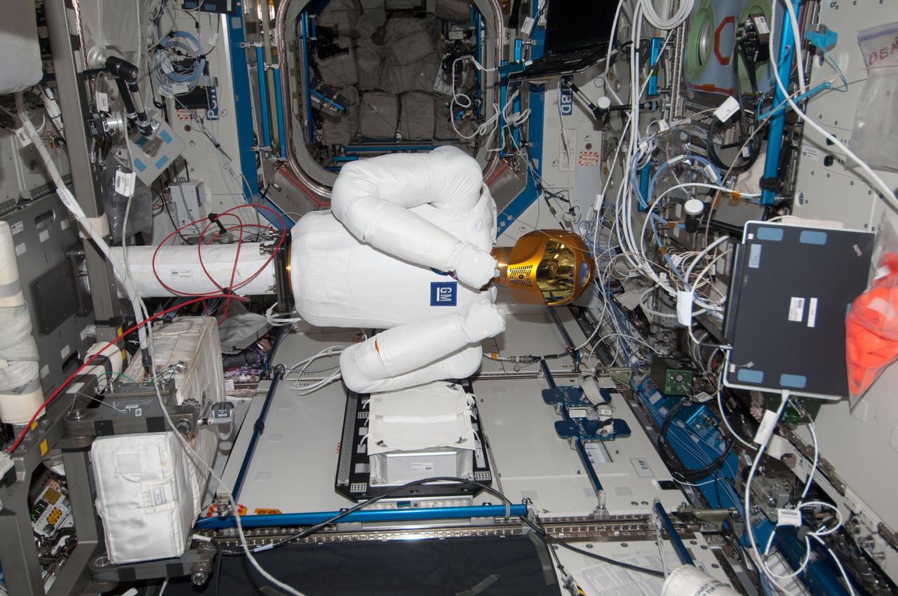
ISS035-E-016453 (9 April 2013) --- R-2 is busy in U.S. lab Destiny aboard the Earth-orbiting International Space Station during tele-operation (by ground controllers) to mimic movement of a crew member.
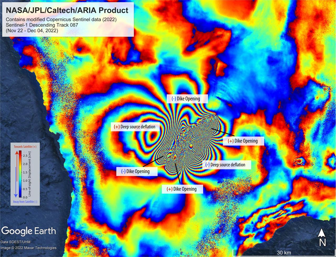
On Nov. 27, 2022, Mauna Loa, Earth's largest active volcano, began erupting from the summit caldera inside Hawaii Volcanoes National Park. Scientists with the Advanced Rapid Imaging and Analysis project (ARIA), a collaboration between NASA's Jet Propulsion Laboratory and the California Institute of Technology, which manages JPL for the agency, analyzed synthetic aperture radar images from the Copernicus Sentinel-1 satellites operated by ESA (European Space Agency) to calculate a map of the Earth's ground movement as a result of the eruption. Using images acquired before and after the start of the eruption – Nov. 22 and Dec. 4, 2022, respectively – scientists produced this false-color map showing the amount of ground surface movement, or displacement, the eruption caused. In the map, surface displacements are seen as color contours, or "fringes," where each color cycle represents about 2.8 centimeters of surface motion. The direction of the ground movement (whether toward or away from the satellite) is indicated by the color cycle (from outer to inner direction). A positive (+) indication, meaning "ground moved towards satellite," has a color cycle of blue-green-yellow-orange-red. A negative (-) indication, meaning "ground moved away from the satellite," has a color cycle of red-orange-yellow-green-blue. The broader fringes are representative of deep source processes within the volcano. In this case, a broad tabular source of magma deflated and fed the eruption as magma or lava was being supplied, somewhat like a deflating balloon (only tabular in shape) that shrank because pressure was relieved. The dense fringes marked as "dike opening" are a signature of the ground rupturing (or opening) as the magma made its way towards the Earth's surface. Scientists use these maps to build detailed models of subsurface volcanic processes to better forecast and understand the impact of future volcanic activity. The Sentinel-1 data were provided by ESA. The image contains modified Copernicus 2022 data, processed by ESA and analyzed by NASA-JPL. https://photojournal.jpl.nasa.gov/catalog/PIA25525

Today's VIS image shows a sand sheet located on the floor of an unnamed crater just north of the edge of the South polar ice cap. The morphology of the dune is different from other sand dunes in lower latitudes. The difference is due to ice cementing the sand grains, making the movement of sand materials almost impossible. Only during the summer season the very surface loses this interstitial ice enough for small movements during windy conditions. Orbit Number: 92704 Latitude: -71.2469 Longitude: 144.353 Instrument: VIS Captured: 2022-11-07 12:42 https://photojournal.jpl.nasa.gov/catalog/PIA25805
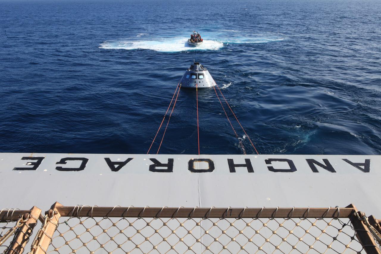
Off the rear of the USS Anchorage, the Orion test article is pulled in by a winch line at the rear of the USS Anchorage’s well deck that brings the capsule into the ship, along with four manned LLAMAs (Line Load Attenuation Mechanism Assembly) that control the capsule’s side-to-side movement and a tending line attached to a rigid hull inflatable boat for controlling Orion’s movement behind the ship. The Underway Recovery Test 6 (URT-6) is spearheaded by Kennedy Space Center's NASA Recovery Team. In partnership with the U.S. Navy, the testing will provide important data that is being used to improve recovery procedures and hardware ahead of Orion's next flight, Exploration Mission-1, when it splashes down in the Pacific Ocean.

As part of Underway Recovery Test 6 on Jan. 18, 2018, the Orion test article is pulled in by a winch line at the rear of the USS Anchorage’s well deck that brings the capsule into the ship, along with four manned LLAMAs (Line Load Attenuation Mechanism Assembly) that control the capsule’s side-to-side movement and a tending line attached to a rigid hull inflatable boat for controlling Orion’s movement behind the ship. The testing with Kennedy Space Center's NASA Recovery Team and the U.S. Navy will provide important data that is being used to improve recovery procedures and hardware ahead of Orion's next flight, Artemis I, when it splashes down in the Pacific Ocean.

In this image many sand dunes are visible. They have an elongated crescent form and are called "barchan dunes." They are formed by the continuous action of the wind, blowing in the same direction, giving this particular shape. The orientation of these dunes tell us that the prevailing wind blows from the right to the left (east to west). The wind is continuously moving sand grains up the longer dune slope, towards the top. The small ripples on the slope are caused by this movement. When the sand grains arrive at the top, they fall down the steeper and shorter slope, which as a consequence, has no ripples. It is this gradual sand movement that causes the dunes to slowly move over time. https://photojournal.jpl.nasa.gov/catalog/PIA23056

As part of Underway Recovery Test 6, the Orion test article is pulled in by a winch line at the rear of the USS Anchorage’s well deck that brings the capsule into the ship, along with four manned LLAMAs (Line Load Attenuation Mechanism Assembly) that control the capsule’s side-to-side movement and a tending line attached to a rigid hull inflatable boat for controlling Orion’s movement behind the ship. The testing with Kennedy Space Center's NASA Recovery Team and the U.S. Navy will provide important data that is being used to improve recovery procedures and hardware ahead of Orion's next flight, Exploration Mission-1, when it splashes down in the Pacific Ocean.

As part of Underway Recovery Test 6, the Orion test article is pulled in by a winch line at the rear of the USS Anchorage’s well deck that brings the capsule into the ship, along with four manned LLAMAs (Line Load Attenuation Mechanism Assembly) that control the capsule’s side-to-side movement and a tending line attached to a rigid hull inflatable boat for controlling Orion’s movement behind the ship. The testing with Kennedy Space Center's NASA Recovery Team and the U.S. Navy will provide important data that is being used to improve recovery procedures and hardware ahead of Orion's next flight, Exploration Mission-1, when it splashes down in the Pacific Ocean.
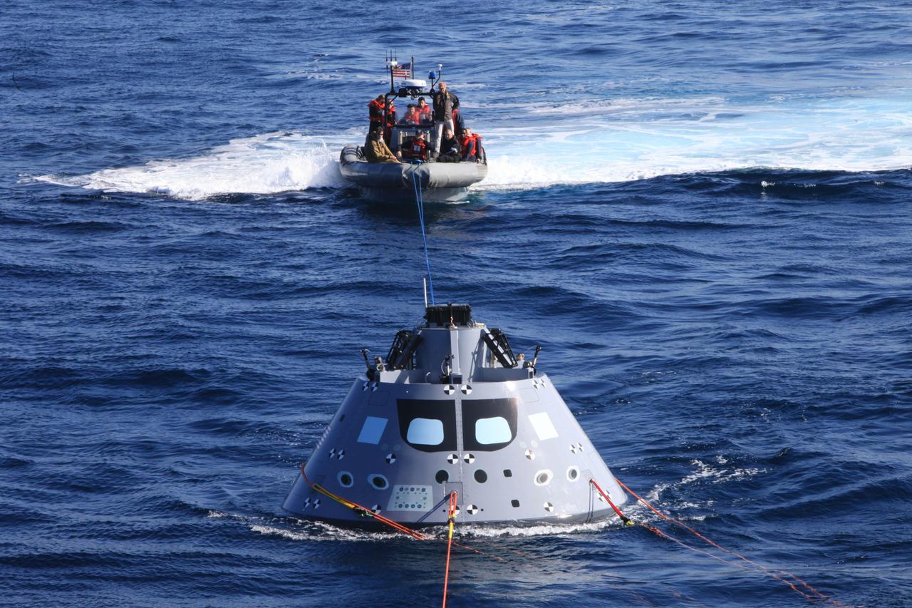
As part of Underway Recovery Test 6 on Jan. 18, 2018, the Orion test article is pulled in by a winch line at the rear of the USS Anchorage’s well deck that brings the capsule into the ship, along with four manned LLAMAs (Line Load Attenuation Mechanism Assembly) that control the capsule’s side-to-side movement and a tending line attached to a rigid hull inflatable boat for controlling Orion’s movement behind the ship. The testing with Kennedy Space Center's NASA Recovery Team and the U.S. Navy will provide important data that is being used to improve recovery procedures and hardware ahead of Orion's next flight, Artemis I, when it splashes down in the Pacific Ocean.
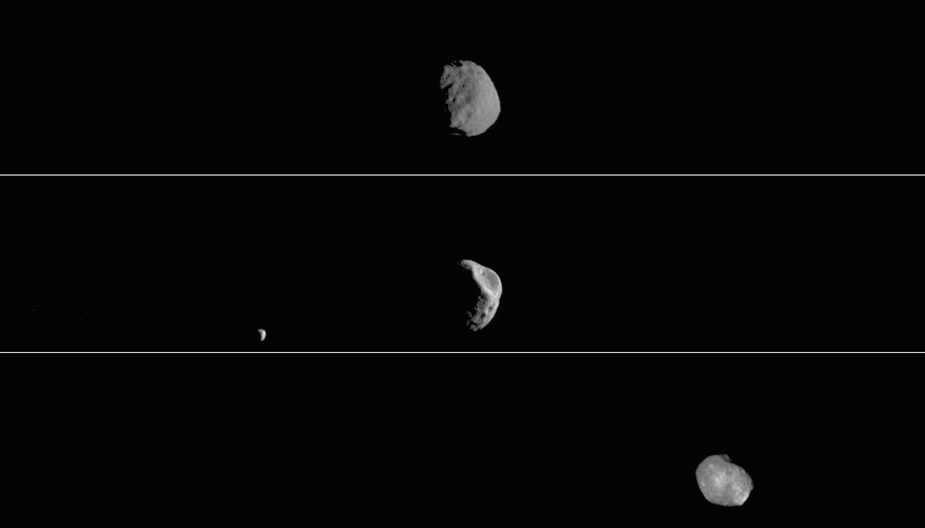
This movie shows three views of the Martian moon Phobos as viewed in visible light by NASA's 2001 Mars Odyssey orbiter. The apparent motion is due to movement by Odyssey's infrared camera, Thermal Emission Imaging System (THEMIS), rather than movement by the moon. Each of the three panels is a series of images taken on different dates (from top to bottom): Sept. 29, 2017; Feb. 15, 2018; and April 24, 2019. Deimos, Mars' other moon, can also be seen in the second panel. While displayed here in visible-wavelength light, THEMIS also recorded thermal-infrared imagery in the same scan. Movie available at https://photojournal.jpl.nasa.gov/catalog/PIA23208

This VIS image shows part of Tempe Fossae. Tempe Fossae is a series of tectonic graben that cross Tempe Terra. The downward movement of blocks of material between bounding faults create a feature known as a graben. The THEMIS VIS camera contains 5 filters. The data from different filters can be combined in multiple ways to create a false color image. These false color images may reveal subtle variations of the surface not easily identified in a single band image. Orbit Number: 61440 Latitude: 47.7189 Longitude: 296.122 Instrument: VIS Captured: 2015-10-20 17:44 https://photojournal.jpl.nasa.gov/catalog/PIA22794