Northeast Isidis
Northeast Hellas Landscape
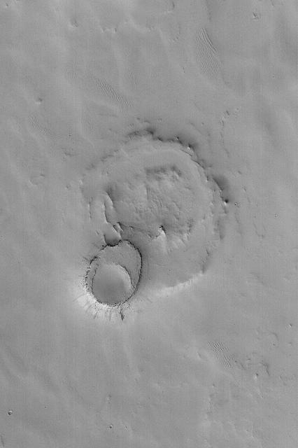
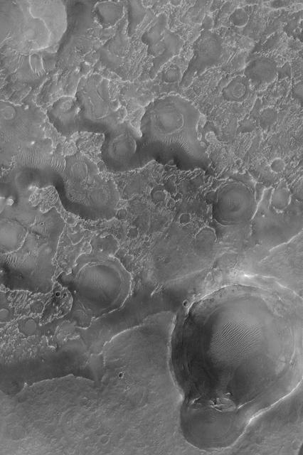
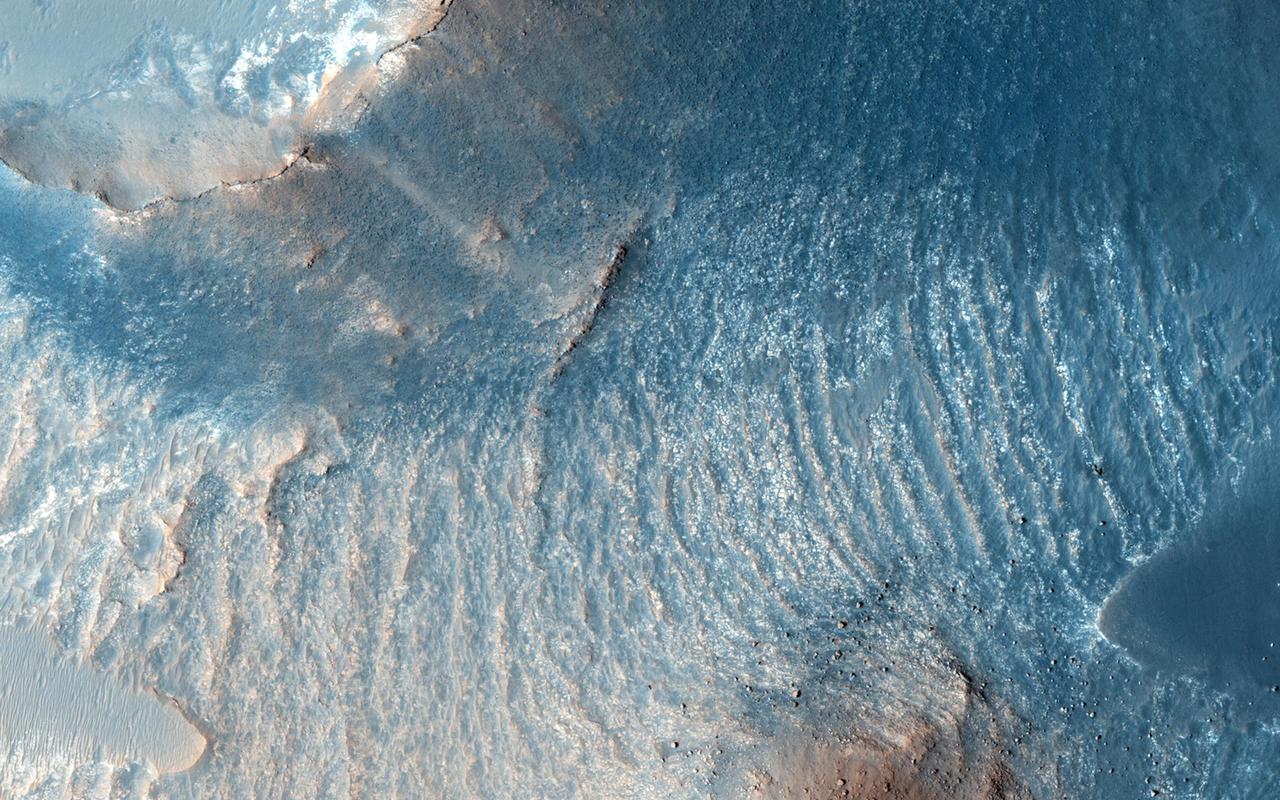
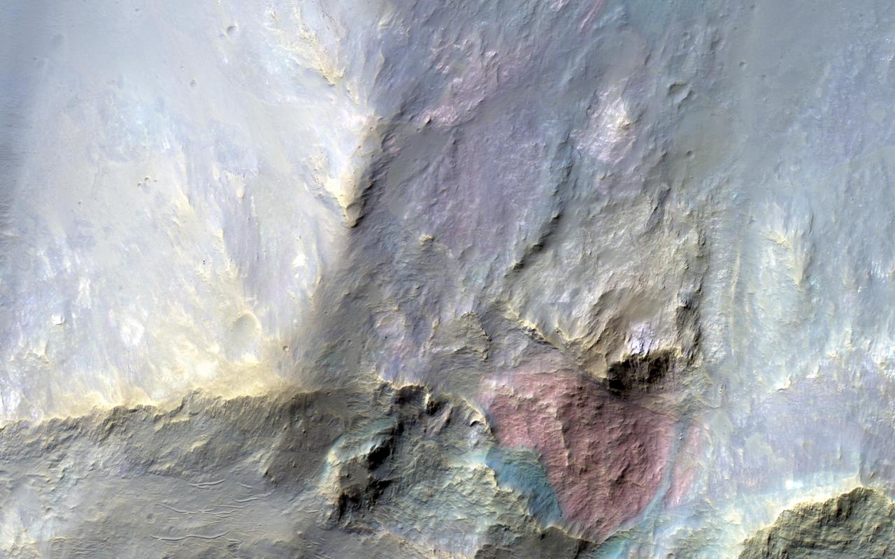
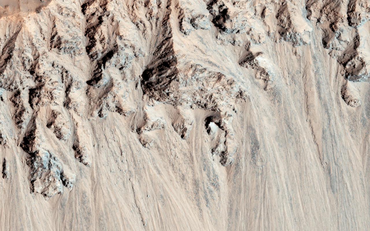
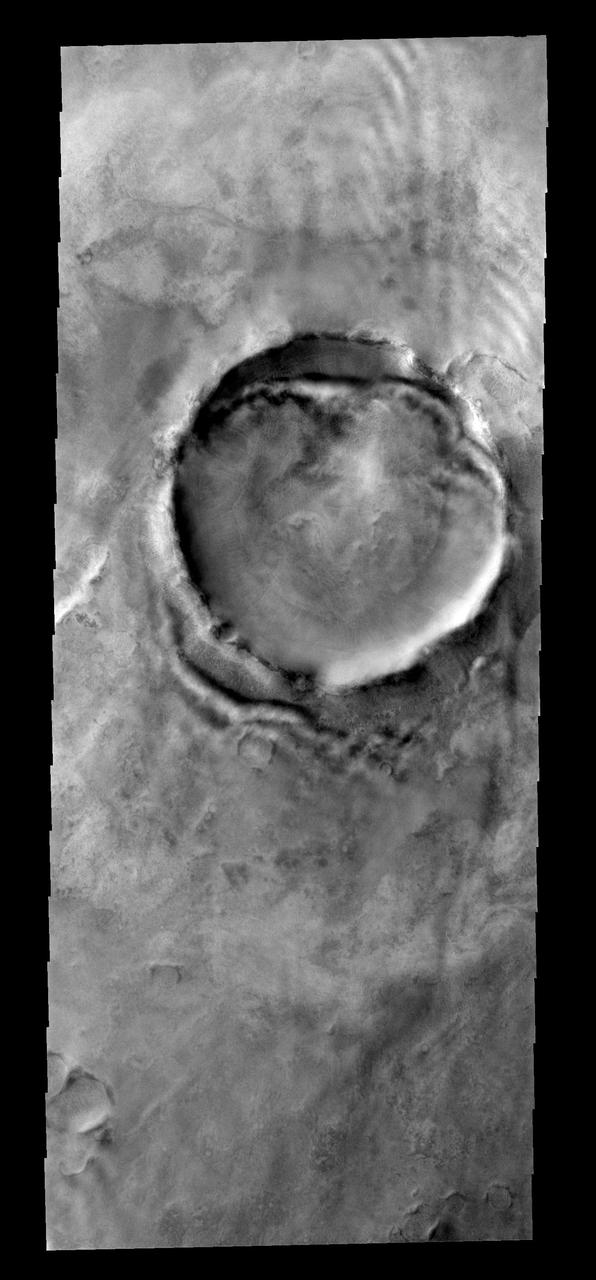
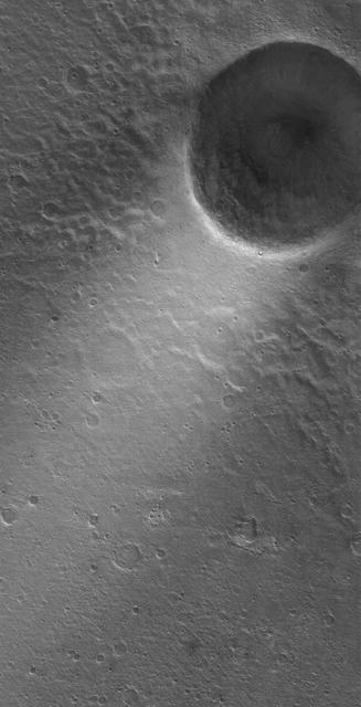
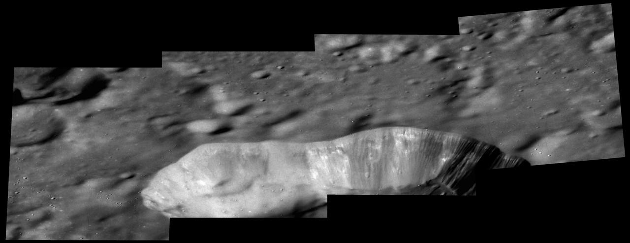
Exhuming Crater in Northeast Arabia
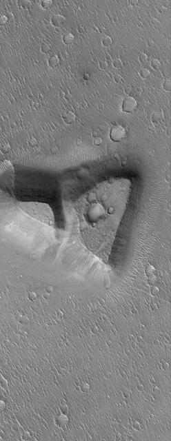
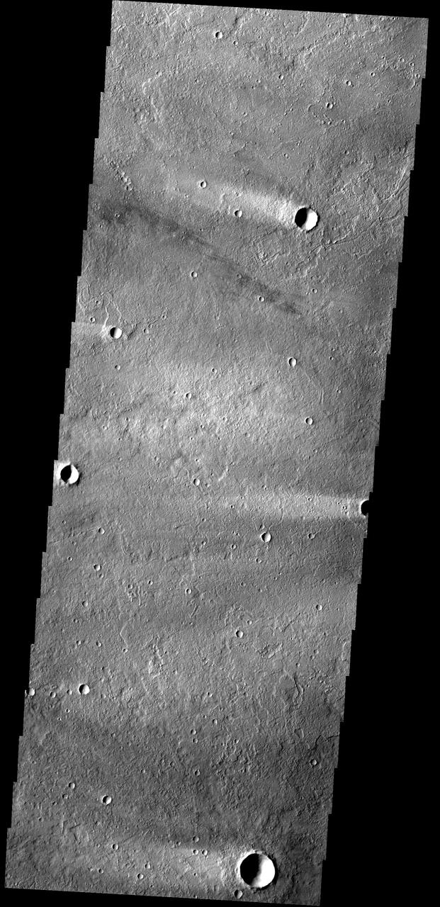
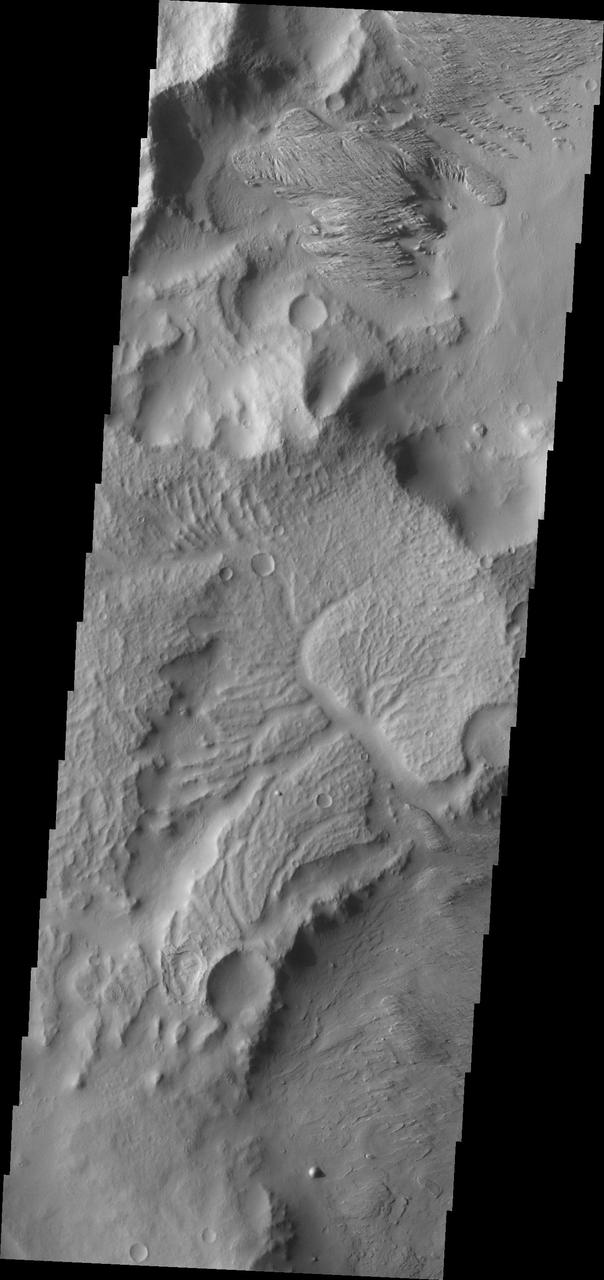
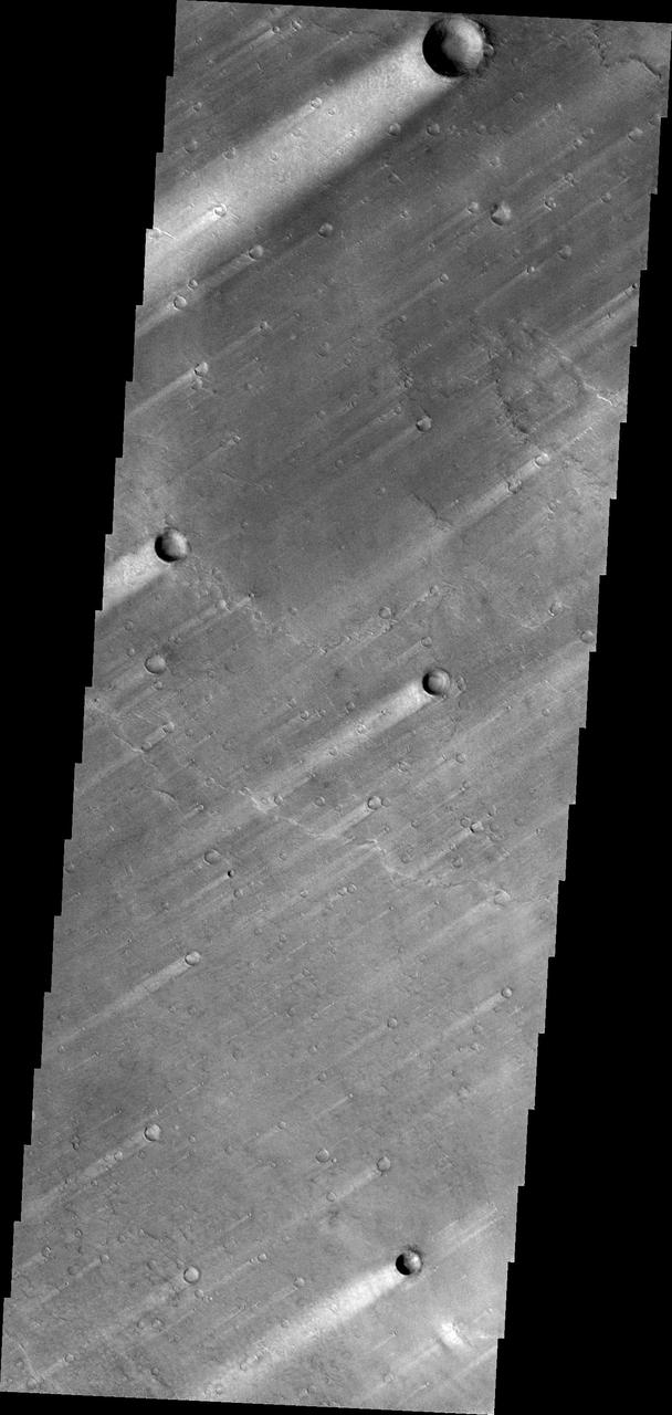
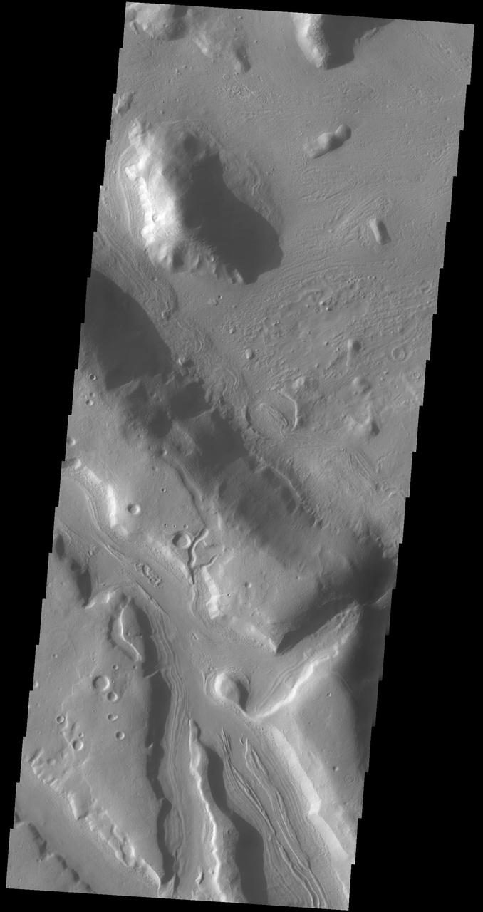
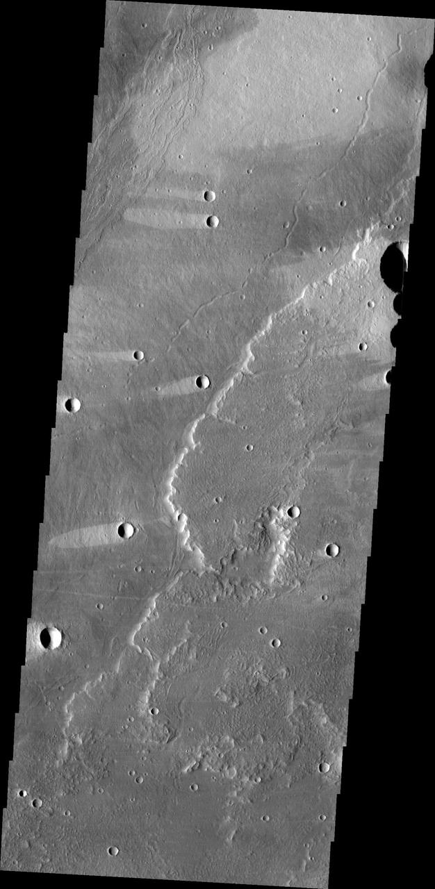
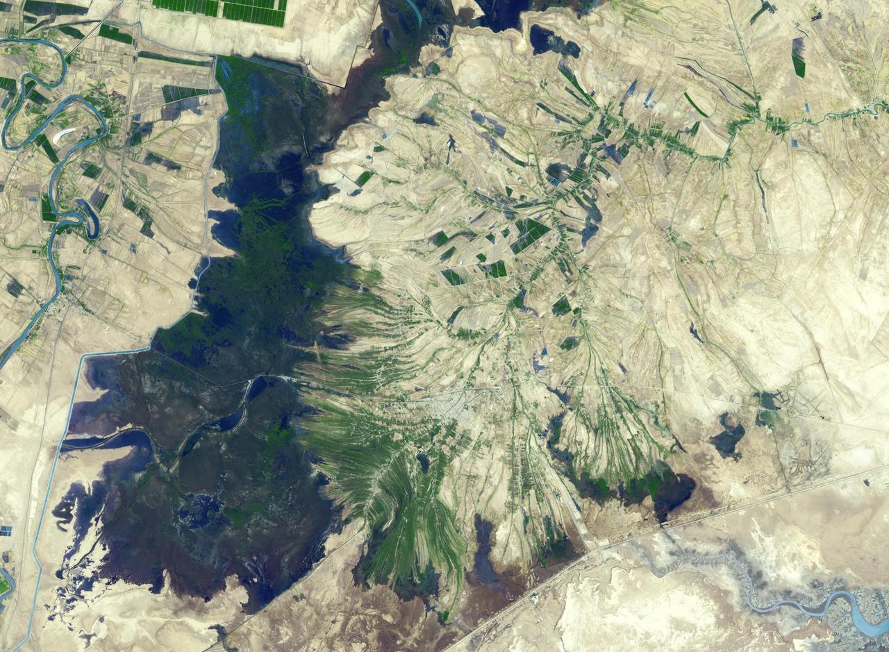
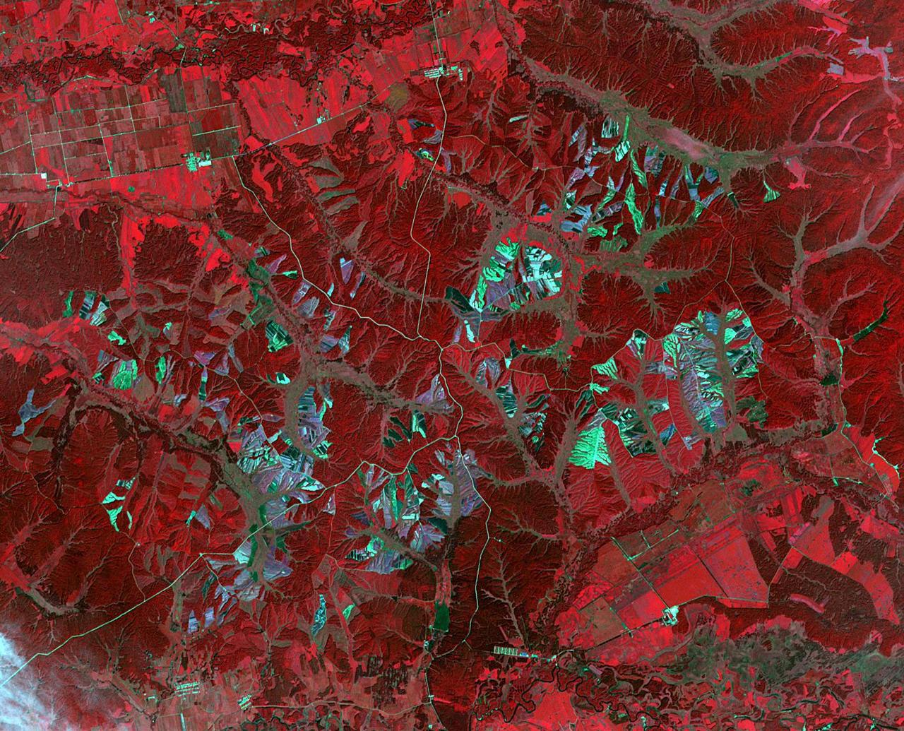
Northeast Arabia Terra
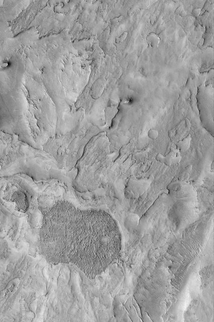
Northeast Sinus Meridiani Landforms
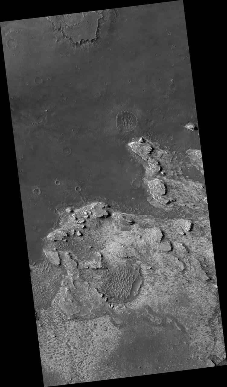
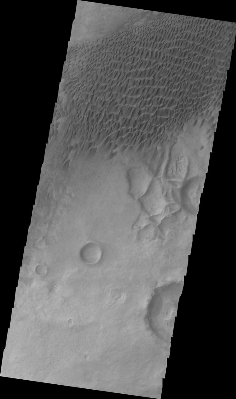
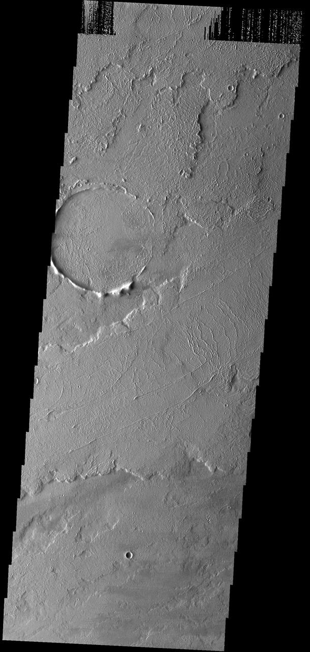
Northeast Arabia Terra
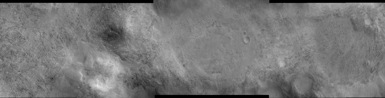
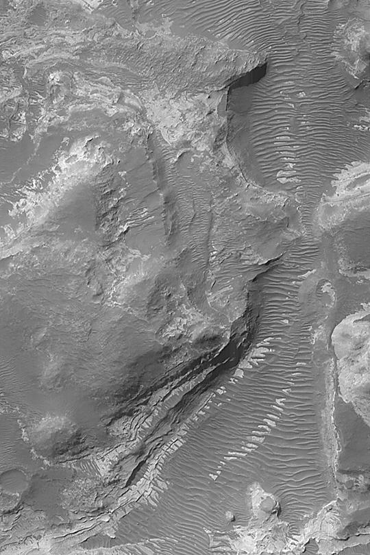
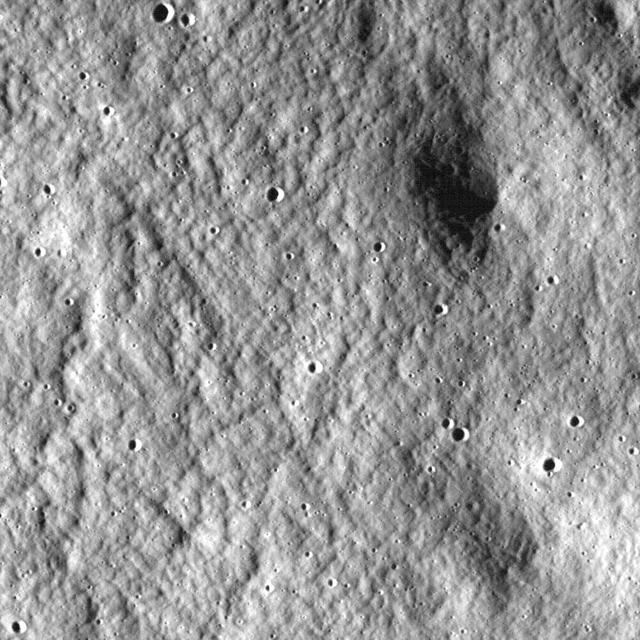
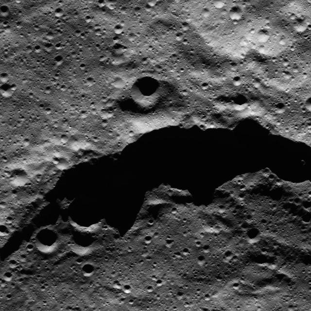
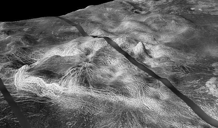
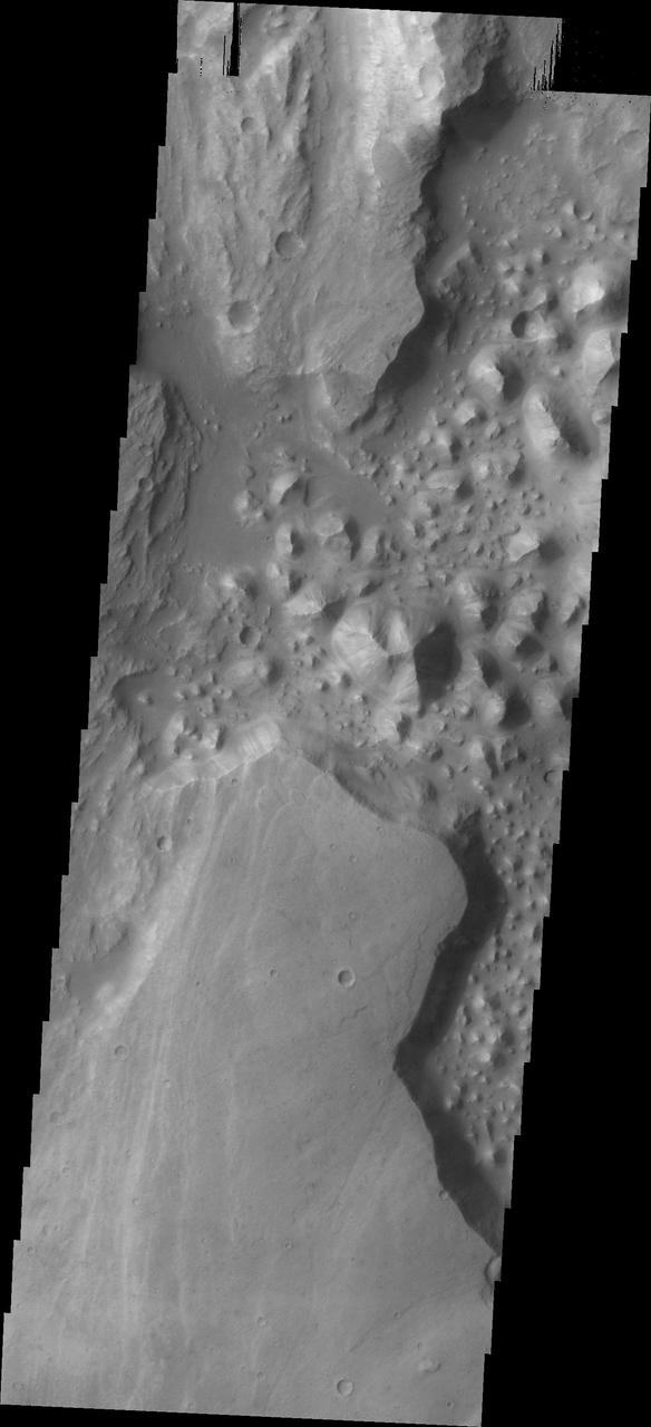
Landscape Northeast of Halley Crater
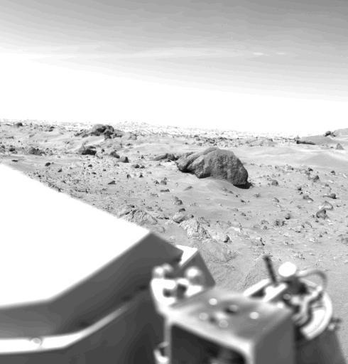
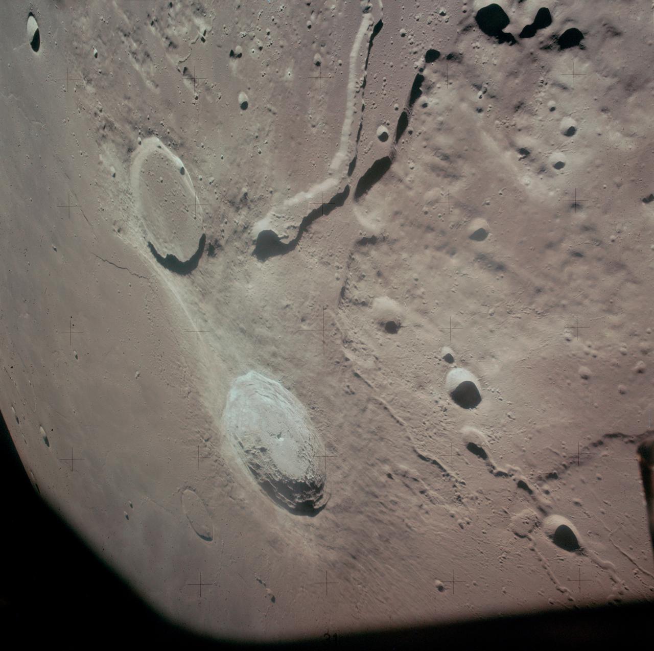
Northeast View in 360-degree Panorama
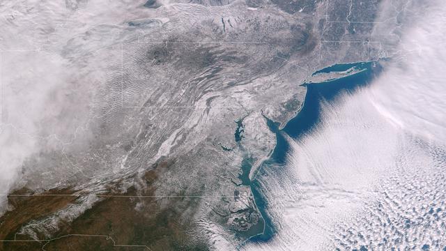
Clear, cold air following behind the winter storm of January 21, 2014 highlights the extent of snowfall in the Mid-Atlantic states. The frigid temperatures that remain entrenched over the central and eastern U.S. will begin to affect the southern states through the rest of the week. Winter Weather Advisories are posted for a portions of Texas for snow and freezing rain, while Hard Freeze Warnings extend from the Southeast states into northern Florida. This image was taken around 1840Z on January 22, 2014. Image credit: NOAA/NASA/Suomi NPP Credit: NASA/NOAA via <b><a href="www.nnvl.noaa.gov/" rel="nofollow"> NOAA Environmental Visualization Laboratory</a></b> <b><a href="http://www.nasa.gov/audience/formedia/features/MP_Photo_Guidelines.html" rel="nofollow">NASA image use policy.</a></b> <b><a href="http://www.nasa.gov/centers/goddard/home/index.html" rel="nofollow">NASA Goddard Space Flight Center</a></b> enables NASA’s mission through four scientific endeavors: Earth Science, Heliophysics, Solar System Exploration, and Astrophysics. Goddard plays a leading role in NASA’s accomplishments by contributing compelling scientific knowledge to advance the Agency’s mission. <b>Follow us on <a href="http://twitter.com/NASAGoddardPix" rel="nofollow">Twitter</a></b> <b>Like us on <a href="http://www.facebook.com/pages/Greenbelt-MD/NASA-Goddard/395013845897?ref=tsd" rel="nofollow">Facebook</a></b> <b>Find us on <a href="http://instagram.com/nasagoddard?vm=grid" rel="nofollow">Instagram</a></b>
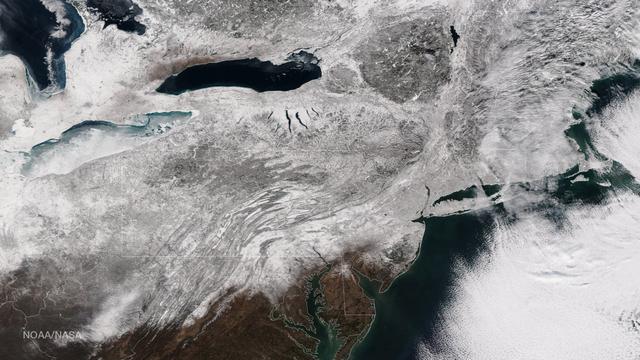
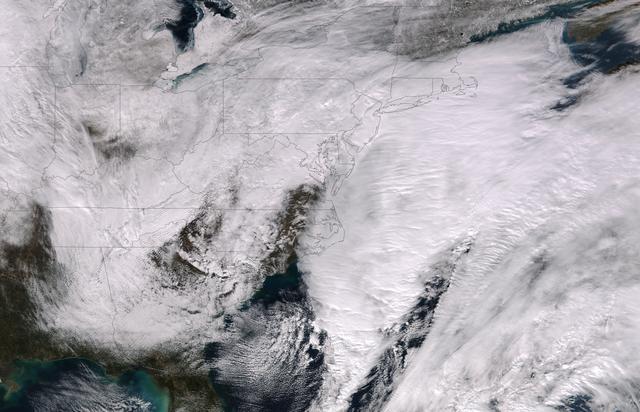
As the storm moves offshore and the skies clear over the Northeast United States, the extent of snowfall from the blizzard is shown in this image from the Suomi NPP satellite imagery, taken on January 28, 2015 at 1:50 EST. Portions of Suffolk County, New York and parts of eastern and southern New England, including areas in and around Portland, Maine, Boston, Massachusetts, and Providence, Rhode Island, received more than 20 inches of snowfall. Up to 36 inches of snow were reported in Auburn, Hudson and Lunenburg, Massachusetts. Credit: NASA/NOAA/NPP/VIIRS Via: <b><a href="www.nnvl.noaa.gov/" rel="nofollow"> NOAA Environmental Visualization Laboratory</a></b> <b><a href="http://www.nasa.gov/audience/formedia/features/MP_Photo_Guidelines.html" rel="nofollow">NASA image use policy.</a></b> <b><a href="http://www.nasa.gov/centers/goddard/home/index.html" rel="nofollow">NASA Goddard Space Flight Center</a></b> enables NASA’s mission through four scientific endeavors: Earth Science, Heliophysics, Solar System Exploration, and Astrophysics. Goddard plays a leading role in NASA’s accomplishments by contributing compelling scientific knowledge to advance the Agency’s mission. <b>Follow us on <a href="http://twitter.com/NASAGoddardPix" rel="nofollow">Twitter</a></b> <b>Like us on <a href="http://www.facebook.com/pages/Greenbelt-MD/NASA-Goddard/395013845897?ref=tsd" rel="nofollow">Facebook</a></b> <b>Find us on <a href="http://instagram.com/nasagoddard?vm=grid" rel="nofollow">Instagram</a></b>
Candidate Cavern Entrance Northeast of Arsia Mons
Big, Dark Dunes Northeast of Syrtis Major
This image from NASA 2001 Mars Odyssey shows a sand sheet with dune forms located northeast of Douglass Crater.
NASA Terra spacecraft captured these views of the dust and sand that swept over northeast China on March 10, 2004.

This image of northeast Africa and the Arabian Peninsula was taken from an altitude of about 500,000 kilometers 300,000 miles by NASA’s Galileo spacecraft on December 9, 1992, as it left Earth en route to Jupiter. http://photojournal.jpl.nasa.gov/catalog/PIA00127
Last weekend's late October snow may have melted in Maryland, Delaware, parts of Pennsylvania and New Jersey, but residents in north central Connecticut are still dealing with the effects of the storm. According to Connecticut Light and Power, 430,868 residents were still without power today, Nov. 3, 2011. For estimated restoration times, visit their website at: <a href="http://www.cl-p.com/stormcenter/estimates/" rel="nofollow">www.cl-p.com/stormcenter/estimates/</a>. A late October snowstorm from a Nor'easter blanketed the eastern U.S. from West Virginia to Maine and broke records the weekend before Halloween Monday. NASA's Aqua satellite flew over the region on October 30 after the snow was ending in New England and captured the ghostly blanket of white. When NASA's Aqua satellite passed over the northeastern U.S. on November 2, 2011 at 2:00 p.m. EDT, the Moderate Resolution Imaging Spectroradiometer (MODIS) instrument captured a detailed image of the remaining snowfall. Snow still covers the ground in western and central Connecticut, southeastern New York, western and central Massachusetts, and parts of Vermont, New Hampshire and Maine. Over the Atlantic, cirrocumulus clouds create a diagonal border. The image was created at NASA's Goddard Space Flight Center in Greenbelt, Md. Image Credit: NASA Goddard MODIS Rapid Response Team; Caption: NASA Goddard, Rob Gutro <b><a href="http://www.nasa.gov/audience/formedia/features/MP_Photo_Guidelines.html" rel="nofollow">NASA image use policy.</a></b> <b><a href="http://www.nasa.gov/centers/goddard/home/index.html" rel="nofollow">NASA Goddard Space Flight Center</a></b> enables NASA’s mission through four scientific endeavors: Earth Science, Heliophysics, Solar System Exploration, and Astrophysics. Goddard plays a leading role in NASA’s accomplishments by contributing compelling scientific knowledge to advance the Agency’s mission. <b>Follow us on <a href="http://twitter.com/NASA_GoddardPix" rel="nofollow">Twitter</a></b> <b>Like us on <a href="http://www.facebook.com/pages/Greenbelt-MD/NASA-Goddard/395013845897?ref=tsd" rel="nofollow">Facebook</a></b> <b>Find us on <a href="http://instagrid.me/nasagoddard/?vm=grid" rel="nofollow">Instagram</a></b>
This image was taken by the Suomi NPP satellite's VIIRS instrument at 1825Z on January 26, 2015. A low pressure system currently forming off the mid-Atlantic coast will rapidly strengthen into a major nor'easter today and affect parts of the Northeast U.S. through early Wednesday. This system will be responsible for heavy to intense snowfall and strong winds, with blizzard conditions expected from eastern New Jersey to eastern Massachusetts where Blizzard Warnings are in effect. Accumulations will likely exceed one foot from eastern New Jersey through eastern Maine by late Tuesday. The heaviest snow accumulations, perhaps exceeding two feet, are forecast across portions of Connecticut, Rhode Island and Massachusetts, including the Boston area. Currently, New York City is forecast to receive 18-24 inches of snow, and Boston is forecast to receive 24-36 inches of snow. Wind gusts of 45 to 60 mph will be common from eastern New Jersey to eastern Massachusetts, leading to widespread blizzard conditions. Wind gusts up to 70 mph are possible in far eastern Massachusetts, including Cape Cod and Nantucket. Credit: NASA/NOAA/NPP/VIIRS Via: NASA/NOAA via <b><a href="www.nnvl.noaa.gov/" rel="nofollow"> NOAA Environmental Visualization Laboratory</a></b> <b><a href="http://www.nasa.gov/audience/formedia/features/MP_Photo_Guidelines.html" rel="nofollow">NASA image use policy.</a></b> <b><a href="http://www.nasa.gov/centers/goddard/home/index.html" rel="nofollow">NASA Goddard Space Flight Center</a></b> enables NASA’s mission through four scientific endeavors: Earth Science, Heliophysics, Solar System Exploration, and Astrophysics. Goddard plays a leading role in NASA’s accomplishments by contributing compelling scientific knowledge to advance the Agency’s mission. <b>Follow us on <a href="http://twitter.com/NASAGoddardPix" rel="nofollow">Twitter</a></b> <b>Like us on <a href="http://www.facebook.com/pages/Greenbelt-MD/NASA-Goddard/395013845897?ref=tsd" rel="nofollow">Facebook</a></b> <b>Find us on <a href="http://instagram.com/nasagoddard?vm=grid" rel="nofollow">Instagram</a></b>
This Mars view looks northeast from Nasa's Viking 1 and completes the 360 panorama of the landing site begun earlier with the spacecraft's other camera. A layer of haze can be seen in the Martian sky. Large dark boulders dominate the scene. The largest boulder (center) is about 3 meters (10 feet) wide and one meter (3 feet) high. Rocks in the foreground are lighter and appear mottled. The rocks may have been derived from lava flows or stream deposits which are visible on orbiter images. These deposits may have been redistributed by impact craters. The fine material visible between the rocks has dune morphology and appears to have been deposited by wind. http://photojournal.jpl.nasa.gov/catalog/PIA00387
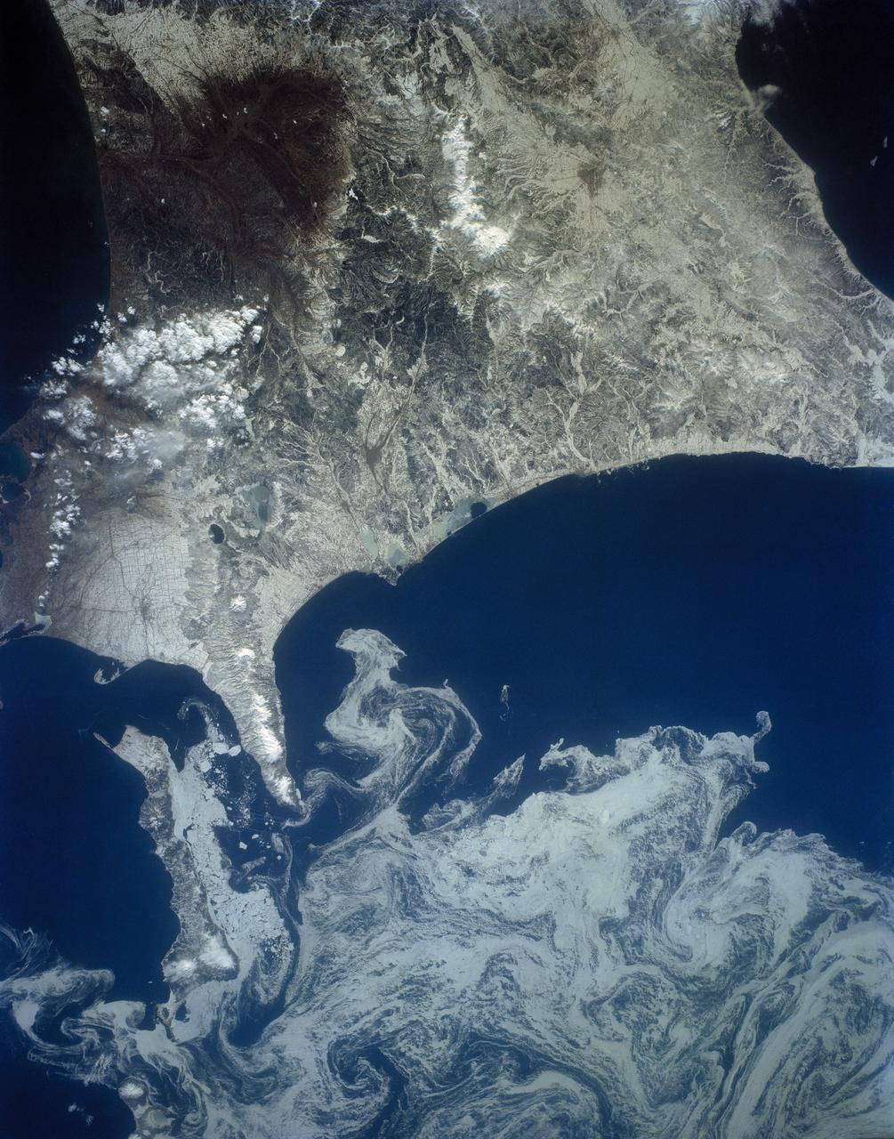
The northeast coast of Hokkaido and Kunashir Island, Japan (44.0N, 143.0E) are seen bordered by drifting sea ice. The sea ice has formed a complex pattern of eddies in response to surface water currents and winds. Photos of this kind aid researchers in describing local ocean current patterns and the effects of wind speed and direction on the drift of surface material, such as ice floes or oil. Kunashir is the southernmost of the Kuril Islands.
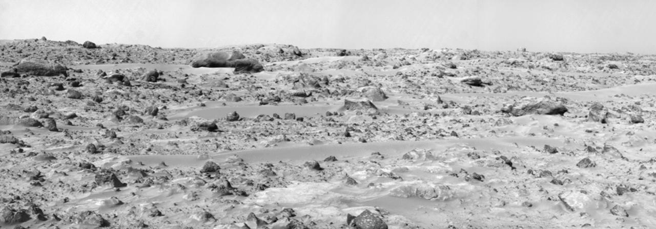
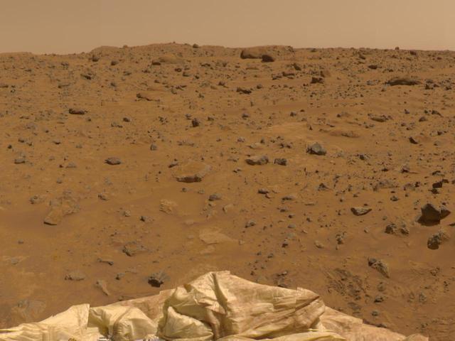
This panorama of the region to the northeast of the lander was constructed to support the Sojourner Rover Team's plans to conduct an "autonomous traverse" to explore the terrain away from the lander after science objectives in the lander vicinity had been met. The large, relatively bright surface in the foreground, about 10 meters (33 feet) from the spacecraft, in this scene is "Baker's Bench." The large, elongated rock left of center in the middle distance is "Zaphod." This view was produced by combining 8 individual "Superpan" scenes from the left and right eyes of the IMP camera. Each frame consists of 8 individual frames (left eye) and 7 frames (right eye) taken with different color filters that were enlarged by 500% and then co-added using Adobe Photoshop to produce, in effect, a super-resolution panchromatic frame that is sharper than an individual frame would be. http://photojournal.jpl.nasa.gov/catalog/PIA01000
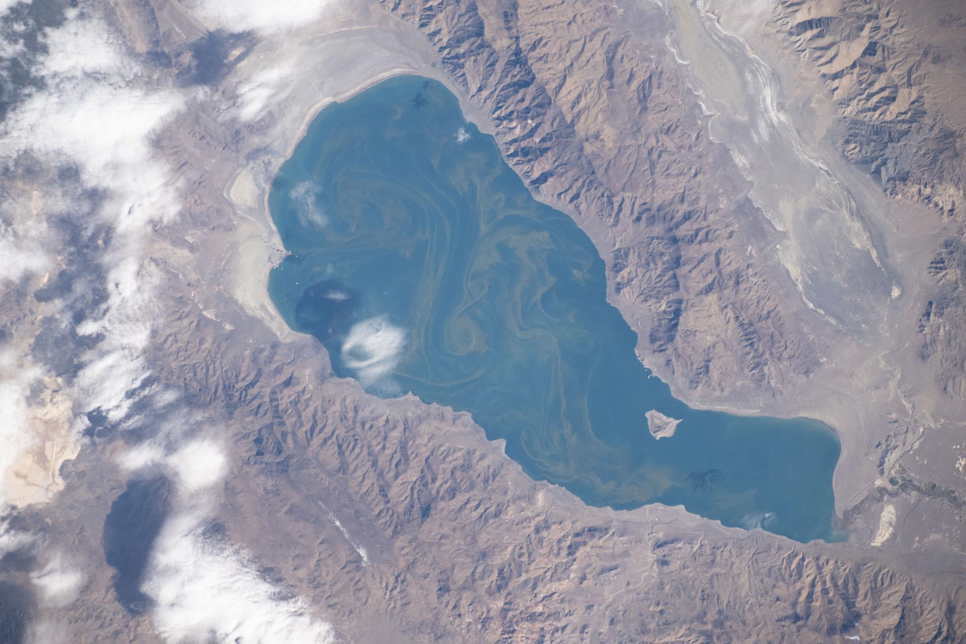
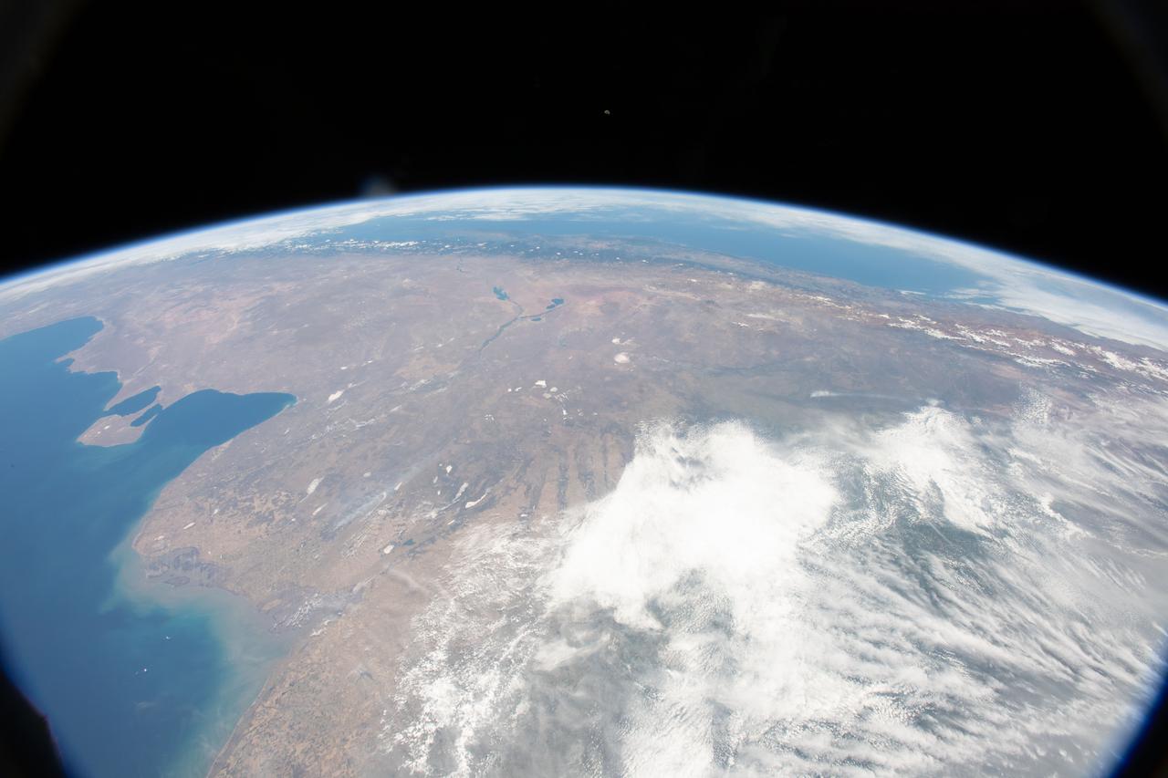
iss073e0919979 (Oct. 19, 2025) --- Pyramid Lake, located northeast of Reno, Nevada, is pictured from the International Space Station as it orbited 265 miles above North America. Surrounded by dramatic desert terrain, the lake is a popular destination for fishing, camping, and birdwatching.
These lava flows are located to the northeast of Tharsis Tholus
A variety of diverse morphological features are present in this image (21 by 5.5 kilometers) located in the southeastern area of the Nili Fossae region and just northeast of Syrtis Major. This particular region has been studied intensely due to the presence of volcanics from Syrtis Major and impact ejecta from the Isidis Basin. The region is rich in unaltered mafic deposits, in contact with diverse altered deposits rich in clays, carbonates, and sulfates. These deposits make the Nili Fossae region one of the most colorful regions on Mars, which is most distinctive in infrared color composites (IRB). HiRISE IRB color aids in chemical and mineral-type mapping, especially when correlated with other MRO instruments such as CRISM. http://photojournal.jpl.nasa.gov/catalog/PIA19940

iss073e0824130 (Sept. 14, 2025) --- The Korean Peninsula—highlighted by Seoul, South Korea (bottom left)—and Northeast China—illuminated by the Beijing Municipality (top left)—are pictured from the International Space Station as it orbited 262 miles above Asia at approximately 12:42 a.m. local time.

iss069e010181 (May 12, 2023) --- The Soyuz MS-23 crew ship is pictured docked to the Prichal docking module as the International Space Station orbited 261 miles above the northeast coast of the United States. The city lights of New York City and the surrounding metropolitan area are easily visible from the orbital outpost.
The windstreaks in this image are located on Tharsis volcanic flows northeast of Olympus Mons
S73-35080 (July-September 1973) --- A vertical view of northeast Oklahoma and the metropolitan Tulsa area is seen in this Skylab 3 Earth Resources Experiments Package S190-B (five-inch Earth terrain camera) photograph taken from the Skylab space station in Earth orbit. THE PICTURE SHOULD BE HELD WITH THE CLOCK ON THE LEFT AND THE LAKE IN THE CORNER ON THE RIGHT. THE LONG STRETCH OF HIGHWAY (U.S. 75) RUNS STRAIGHT NORTH FROM TULSA. Tulsa, a rapidly expanding city in the heart of the mid-continent oil field, has a population of approximately 330,000. The Arkansas River meanders across the southern (lower) portion of the photograph passing through Tulsa as it flows southeastward. Oologah Reservoir, the long body of water, is located northeast of Tulsa. Lake Hudson is the body of water in the right corner of the picture. Keystone Reservoir is to the west and upstream from Tulsa. Westward from Tulsa U.S. 64 makes a 45 degree bend as it turns northwest to cross the Keystone Reservoir. The thin white line over the Oologah Reservoir is a highway bridge. Bartlesville is on U.S. 75 near the north (top) corner of the picture. The Tulsa International Airport is immediately northeast of downtown Tulsa. Several smaller airfields are visible in the surrounding area. The toll roads and other major highways are clearly visible in the picture. Claremore is northeast of Tulsa on U.S. 66 with the Will Rogers Turnpike passing nearby. Sapulpa is southwest of Tulsa on the Turner Turnpike which leads toward Oklahoma City. The detailed information contained in this photograph can be extracted by direct observation and applied to updating land use and cultural maps of Tulsa and to numerous surrounding satellite cities. All EREP photography is available to the public through the Department of Interior?s Earth Resources Observations Systems Data Center, Sioux Falls, South Dakota, 57198. (Alternate number SL3-83-206) Photo credit: NASA
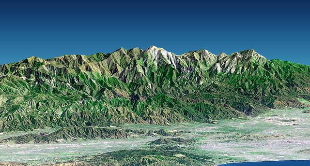
Mount San Antonio more commonly known as Mount Baldy crowns the San Gabriel Mountains northeast of Los Angeles in this computer-generated east-northeast perspective viewed from above the Malibu coastline.
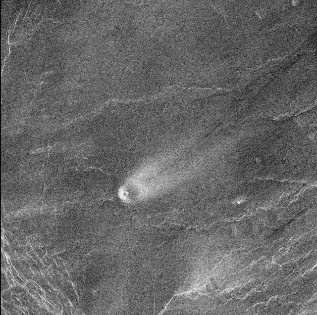
This comet-like tail, trending northeast from the volcanic structure, is a relatively radar-bright deposit. The volcano, with a base diameter of about 3 miles, is a local topographic high point that has slowed down northeast trending winds. http://photojournal.jpl.nasa.gov/catalog/PIA00243
This image from NASA 2001 Mars Odyssey spacecraft shows a channel carved by lava. This channel is located northeast of Olympus Mons.
The small channel and lava flows in this image NASA 2001 Mars Odyssey spacecraft are located northeast of Olympus Mons.
This image covers a 26-kilometer-wide impact crater northeast of the Hellas impact basin as observed by NASA Mars Reconnaissance Orbiter.
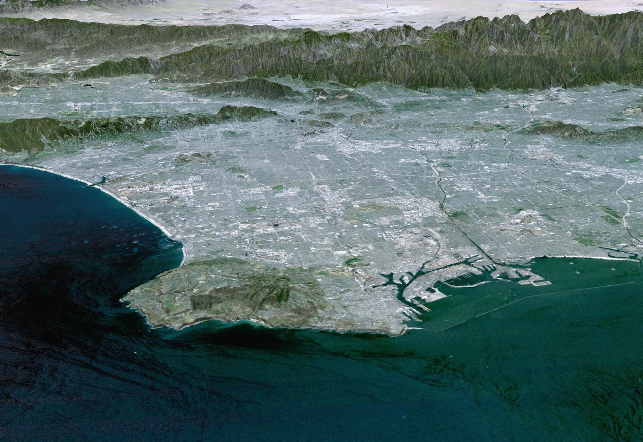
Most of Los Angeles is visible in this computer-generated north-northeast perspective viewed from above the Pacific Ocean.
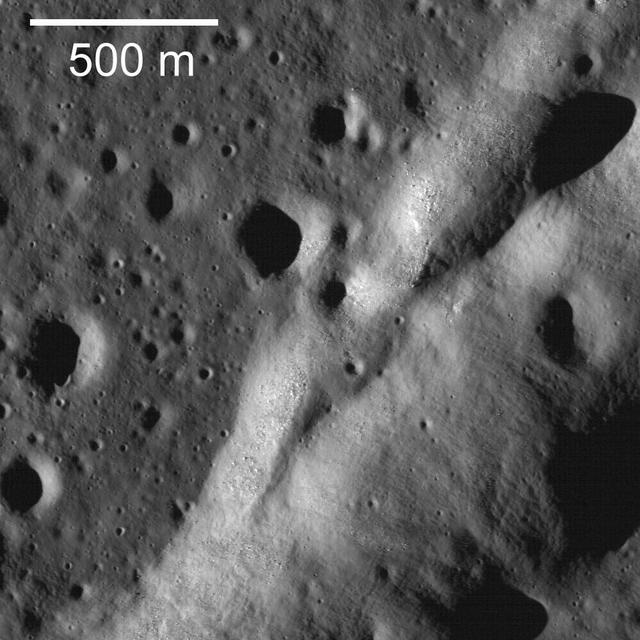
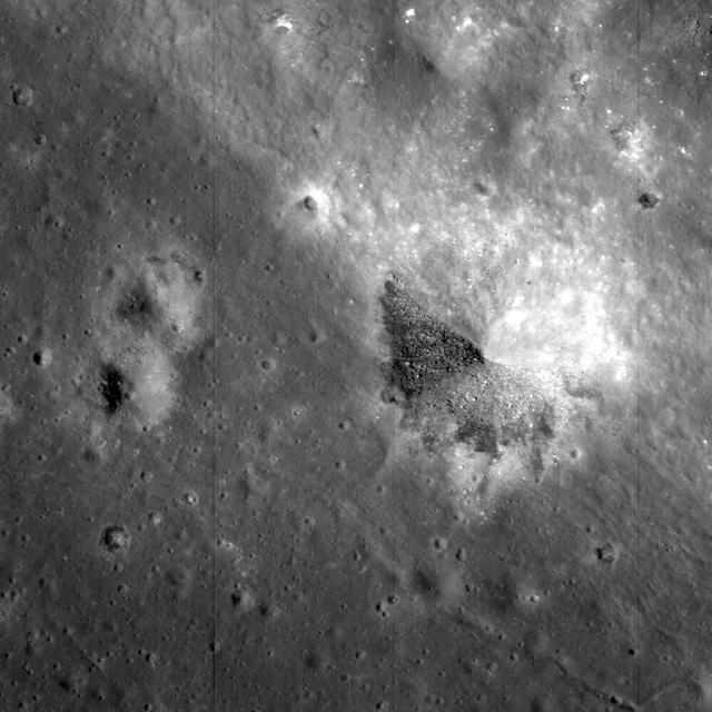
NASA Lunar Reconnaissance Orbiter captures a northeast-trending wrinkle ridge cuts across the plains of Mare Imbrium.
The windstreaks in this image captured by NASA 2001 Mars Odyssey spacecraft are located on the volcanic plains northeast of Olympus Mons.
Close-up view of the lunar highlands, northeast of Clavius crater, taken by NASA Lunar Reconnaissance Orbiter.
AS15-88-12002 (31 July-2 Aug. 1971) --- An oblique view of a portion of the lunar nearside located near the northeast edge of the Ocean of Storms (Oceanus Procellarum), photographed by astronaut Alfred M. Worden, command module pilot, from the Apollo 15 spacecraft in lunar orbit, showing the bright-appearing crater Aristarchus on the left, the crater Herodotus on the right, and Schroter's Valley at lower right. This view is looking southward. Aristarchus the head of Schroter's Valley, a sinuous rille in the Aristarchus Plateau, is called Cobra Head. The coordinates of the center of Aristarchus crater are 47.5 degrees west longitude and 23.6 degrees north latitude. While Worden remained in the Command and Service Modules (CSM) in lunar orbit, astronauts David R. Scott, commander; and James B. Irwin, lunar module pilot, descended in the Lunar Module (LM) "Falcon" to explore the moon.
This well-preserved impact crater in Tyrrhena Terra, northeast of Hellas Planitia, is approximately 6 kilometers in diameter as seen by NASA Mars Reconnaissance Orbiter.
NASA 2001 Mars Odyssey spacecraft shows the apparent effects of wind and water mark the surface of this region just northeast of Gusev Crater.
The windstreaks in this image of Syrtis Major Planum indicate winds blowing from the northeast. This image is from NASA 2001 Mars Odyssey spacecraft.
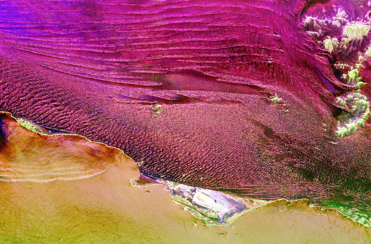
This spaceborne radar image shows part of the vast Namib Sand Sea on the west coast of southern Africa, just northeast of the city of Luderitz, Namibia.
NASA Lunar Reconnaissance Orbiter looks near the northeast edge of the unusually large melt pond adjacent to the lunar far side crater King.
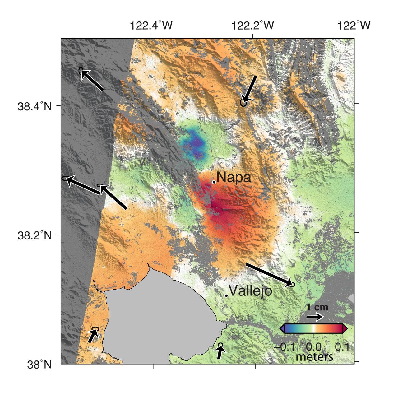
A magnitude 6.0 earthquake struck southern Napa county northeast of San Francisco, California, on Aug. 24, 2014. NASA satellite data reveal ground defomation.
Faint clouds can be seen to the northeast of this crater. The bright and dark bands against the NE crater rim interior and exterior are bright clouds and their shadows
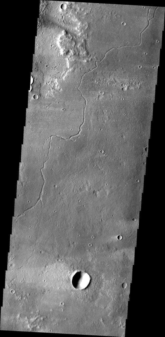
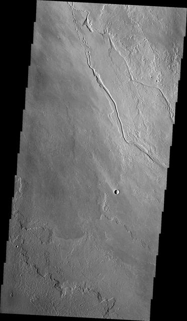
The channels in this image captured by NASA 2001 Mars Odyssey spacecraft are part of Coloe Fossae, a series of linear depressions on the northeast margin of Terra Sabaea.

This radar image shows the dramatic landscape in the Phang Hoei Range of north central Thailand, about 40 kilometers 25 miles northeast of the city of Lom Sak.
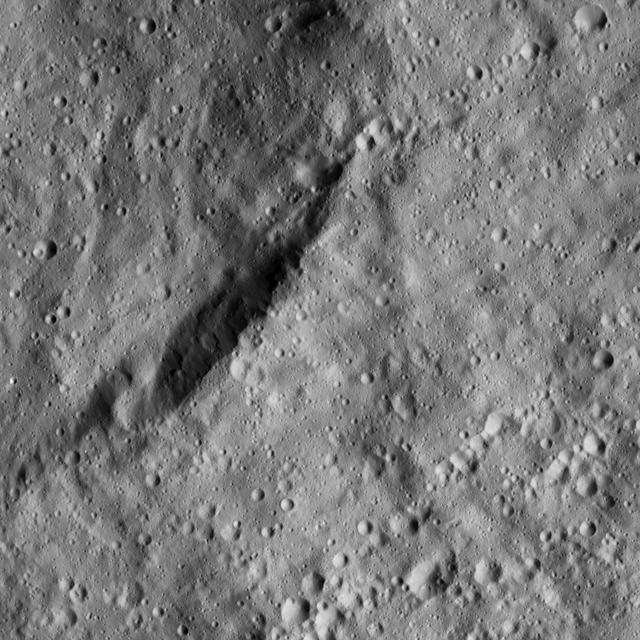
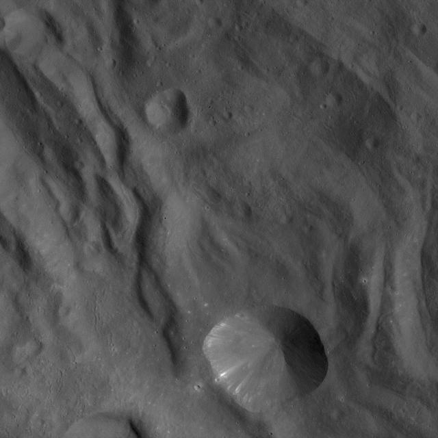
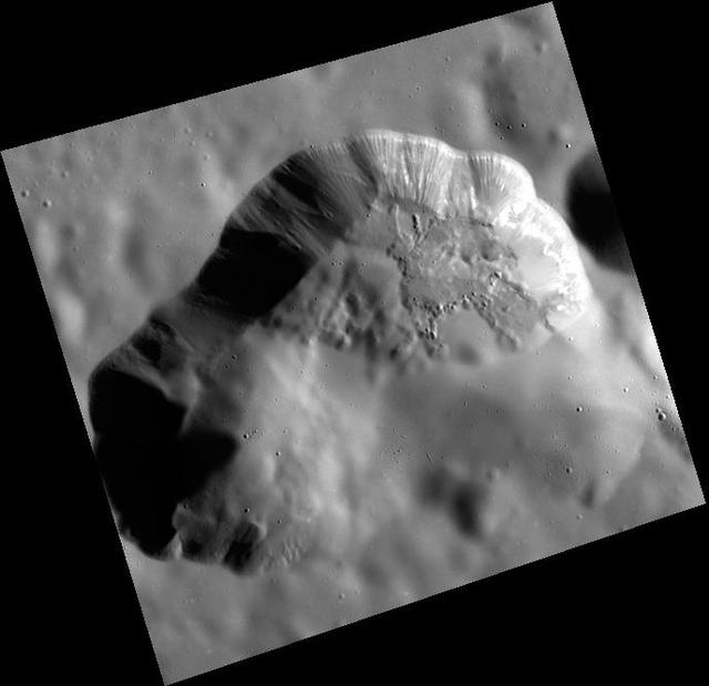
The image from NASA Dawn spacecraft shows the northeast rim of Sintana Crater on Ceres. The crater steep rim is shadowed in this particular view.
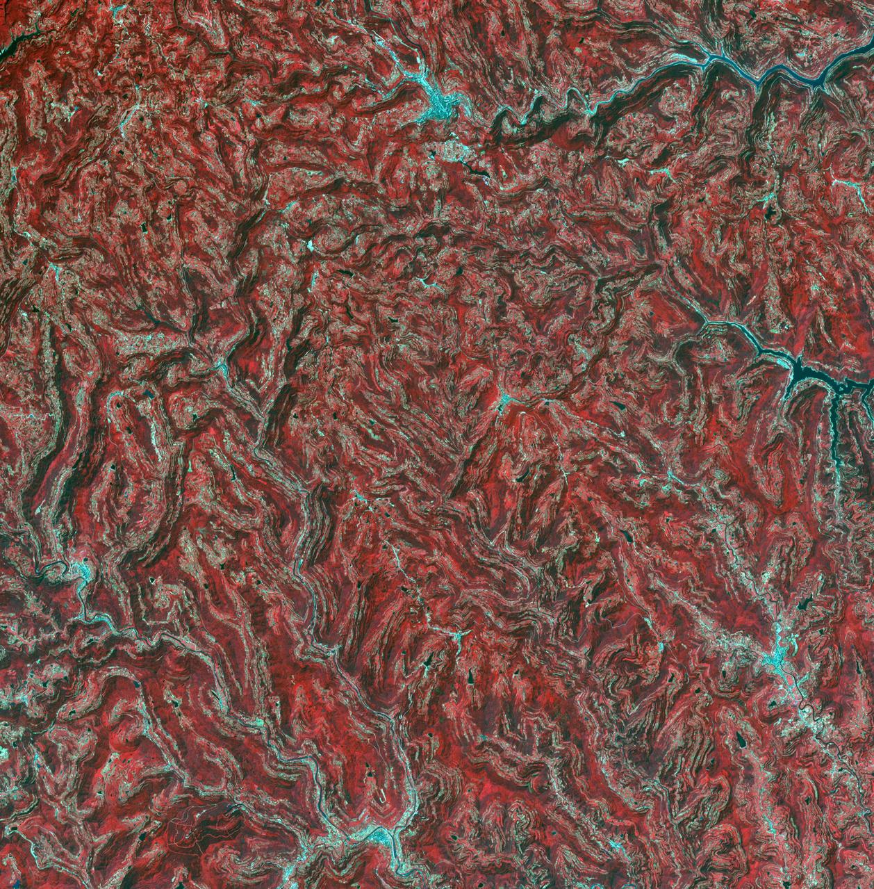
In the northeast Sichuan province of China lies the Sichuan Basin, surrounded by mountains on all sides and drained by the Yangtzee River. The basin is considered the breadbasket of China. On the northeast edge, flat-lying Jurassic to Cretaceous sandstones have been eroded to form an intricately carved landscape of upland fields and lowland streams and valleys. The image was acquired September 11, 2016, covers an area of 36 by 37 kilometers, and is located at 31.9 degrees north, 105.4 degrees east. https://photojournal.jpl.nasa.gov/catalog/PIA23532
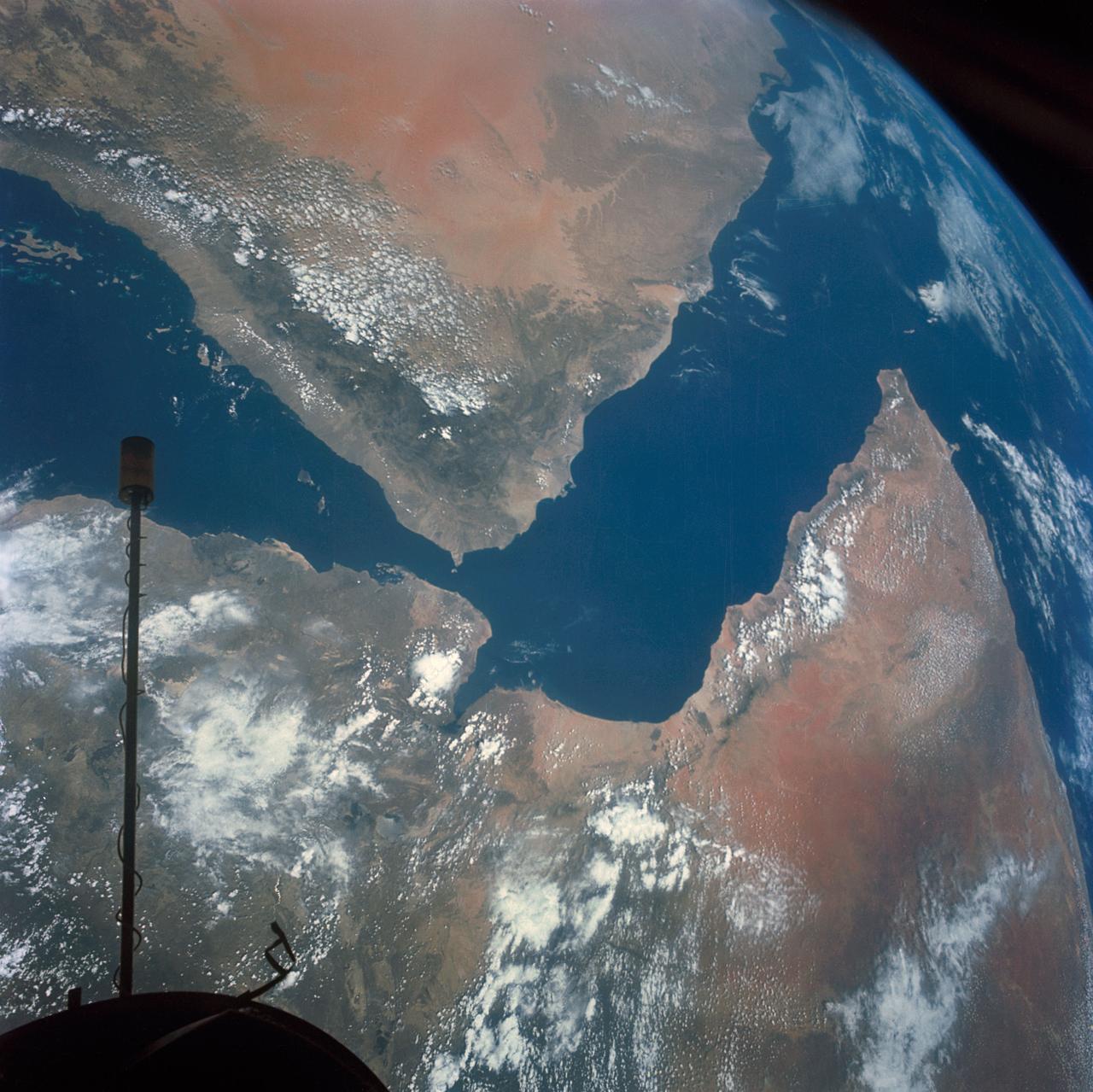
S66-54536 (14 Sept. 1966) --- Arabian Peninsula (on left) and northeast Africa (on right) as seen from the orbiting Gemini-11 spacecraft at an altitude of 340 nautical miles during its 27th revolution of Earth, looking southeast. Saudi Arabia, South Arabia, Yemen, and Aden Protectorate are at left. At bottom right is Ethiopia. French Somaliland is in center on right shore. Somali is at upper right. Body of water at bottom is Red Sea. Gulf of Aden is in center; and at top left is Indian Ocean. Taken with a modified 70mm Hasselblad camera, using Eastman Kodak, Ektachrome, MS (S.O. 368) color film. Photo credit: NASA
View of Helipad to Northeast of BOSU
High-albedo marks on the lunar surface left by a boulder bouncing down the northeast wall of farside highlands crater Moore F in this image captured by NASA Lunar Reconnaissance Orbiter.
Located to the northeast of Olympus Mons, Cyane Sulci is a complexly fractured region of material inundated on its margins by volcanic flows. This image was captured by NASA Mars Odyssey on Oct. 24, 2010.

Attu, the westernmost Aleutian island, is nearly 1760 km from the Alaskan mainland and 1200 km northeast of the northernmost of the Japanese Kurile Islands. This image was acquired July 4, 2000 by NASA Terra spacecraft.
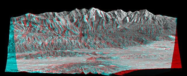
Mount San Antonio more commonly known as Mount Baldy crowns the San Gabriel Mountains northeast of Los Angeles, Calif., in this anaglyph from NASA Shuttle Radar Topography Mission. 3D glasses are necessary to view this image.
This image from NASA Mars Odyssey shows lava flows of Alba Mons and windstreaks behind craters in the area. Windstreak tail directions indicate winds from the East and East-Northeast.
This MOC image shows a wind streak created in the lee -- the downwind side -- of a crater in far eastern Chryse Planitia. The winds responsible for the formation of the streak blew from the upper right northeast to the lower left southwest

This image from NASA EarthKAM is of the northern end of the Persian Gulf and the broad delta complex of the Tigris, Euphrates, Shatt al Arab, and Karun rivers has captured the arid-looking wetlands of northeast Kuwait Bubiyan Island,
The view from NASA Dawn spacecraft shows an unnamed crater that lies in the northeast part of the larger impact feature Gaue. The area is dominated by small craters and is relatively smooth in general.

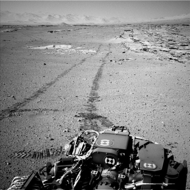
This northeast-facing view from the lower edge of the pale Pahrump Hills outcrop at the base of Mount Sharp includes wind-sculpted ripples of sand and dust in the middle ground. It was taken by Curiosity Navcam on Nov. 13, 2014.
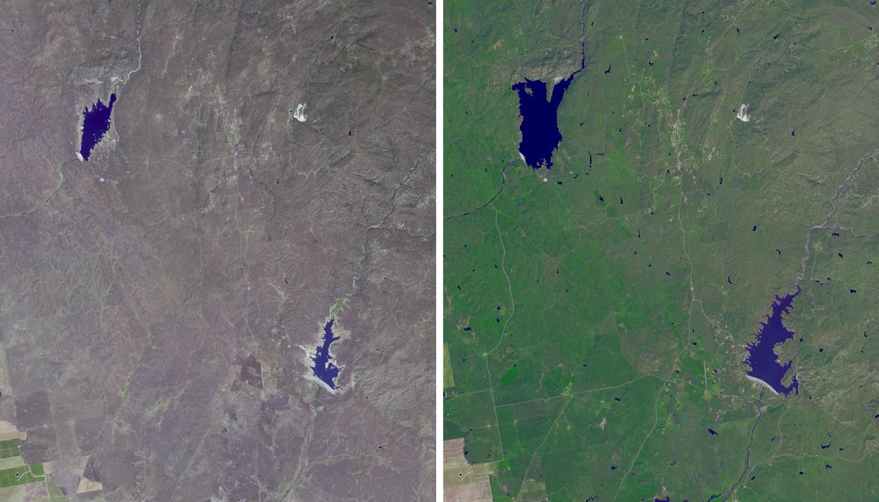
The effects of California severe multiyear drought are seen in this pair of images acquired by NASA Terra spacecraft of the area northeast of Madera, in the Sierra Nevada Moutains foothills between Yosemite National Park and the San Joaquin Valley
This MOC image shows dark sand dunes in Arkhangelsky Crater. The steepest slopes on these dunes, their slip faces, point toward the northeast upper right, indicating formative winds from the southwest
During the 2003 fire season, blazes in the taiga forests of Eastern Siberia were part of a vast network of fires across Siberia and the Russian Far East, northeast China and northern Mongolia seen here by NASA Terra spacecraft.
High-albedo marks on the lunar surface left by a boulder bouncing down the northeast wall of farside highlands crater Moore F in this image captured by NASA Lunar Reconnaissance Orbiter.
The view from NASA's Magellan spacecraft shows Yavine Corona, looking northeast. Coronae are roughly circular, volcanic features believed to form over hot upwellings of magma within the Venusian mantle. http://photojournal.jpl.nasa.gov/catalog/PIA00098
Arguably one of America most magnificent national parks is the Grand Canyon in northern Arizona. NASA Terra spacecraft captured this image looking to the northeast, the buildings and roads in the center foreground are Grand Canyon Village.
In this image of the asteroid Vesta, taken by NASA Dawn spacecraft just shortly before the beginning of high altitude mapping orbit, north is up and the upper right corner is to the northeast.
The channels in this image from NASA 2001 Mars Odyssey spacecraft were created by the flow of lava rather than water. These lava channels are near the northeast flank of Olympus Mons.
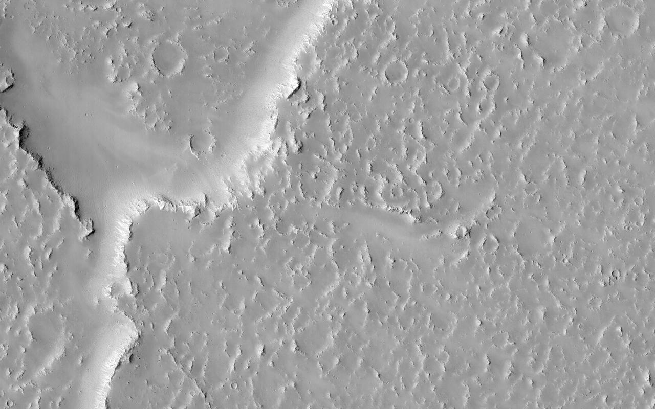
The hills chaos in this image from NASA 2001 Mars Odyssey spacecraft are located between Stege Crater, just outside of the image to the northeast, and Maja Valles left side of image.
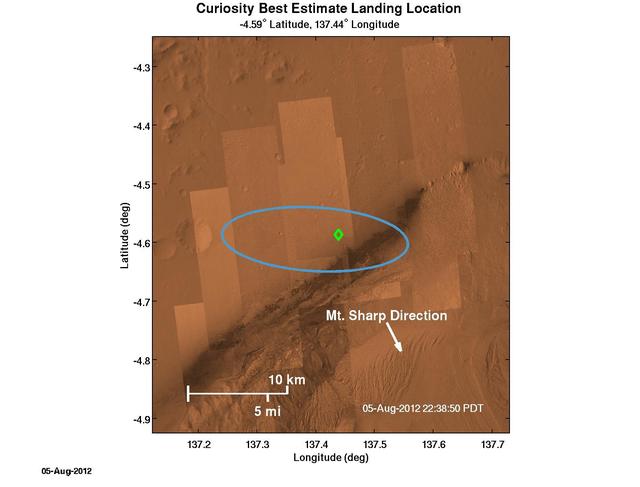
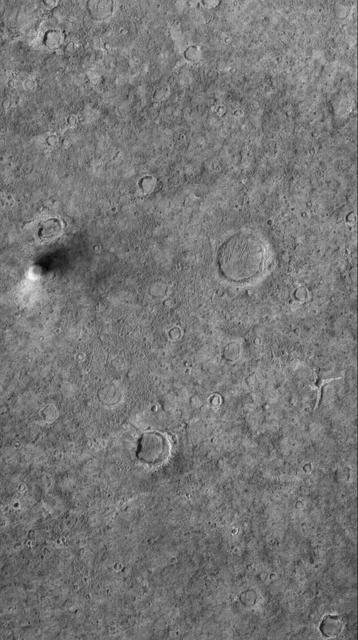
The green diamond shows approximately where NASA Curiosity rover landed on Mars, a region about 2 kilometers northeast of its target in the center of the estimated landing region blue ellipse.
Lava flows south of Arsia Mons in Daedalia Planum transition from younger flows with elongated, sinuous morphologies to the northeast, to older, broader lobes and sheet flows to the southwest. This image is from NASA Mars Reconnaissance Orbiter.
This area of Venus northeast of Ushas Mons measures 40 by 112 kilometers 25 by 70 miles and shows evidence of possible explosive volcanism as seen by NASA Magellan spacecraft. http://photojournal.jpl.nasa.gov/catalog/PIA00213
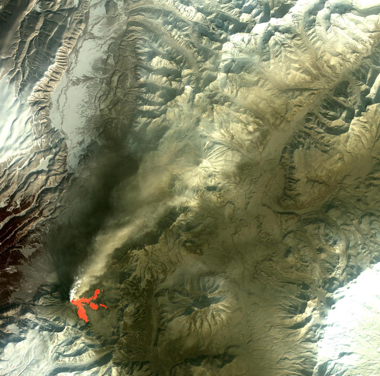
On Feb. 25, 2011, NASA Terra spacecraft captured this image of a large ash-laden eruption plume drifting towards the northeast from Kizimen volcano, an isolated stratovolcano, in Kamchatka, Russia.

NASA SIR-C/X-SAR is shown here in the payload bay of the orbiting space shuttle Endeavour STS-59, with an area of the Pacific Ocean northeast of Hawaii in the background.
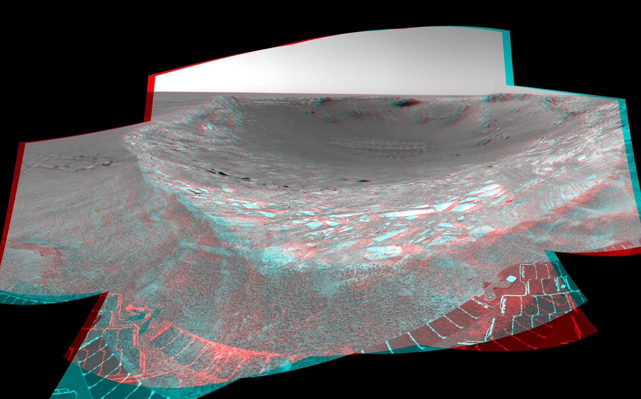
This stereo anaglyph from NASA Mars Exploration Rover Spirit looks toward the northeast across Endurance Crater in Mars Meridiani Planum region. 3D glasses are necessary to view this image.
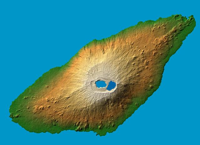
The recently active volcano Mt. Manaro is the dominant feature in this shaded relief image of Ambae Island, part of the Vanuatu archipelago located 1400 miles northeast of Sydney, Australia.
NASA Terra spacecraft acquired this image of Picher, Oklahoma which once boasted 20,000 people in this mining town in northeast Oklahoma. Now, after a 2009 tornado, and a federal cleanup program, the town is a modern-day ghost town.

This MOC image shows a chain of collapse pits on a dust-mantled, lava-covered plain northeast of Ascraeus Mons -- one of the giant volcanoes located in the Tharsis region of Mars
This MOC image shows a dust devil traveling across a plain west-southwest of Schiaparelli Crater, in far eastern Sinus Meridiani. The dust devil is casting a shadow toward the northeast, just south below of an egg-shaped crater
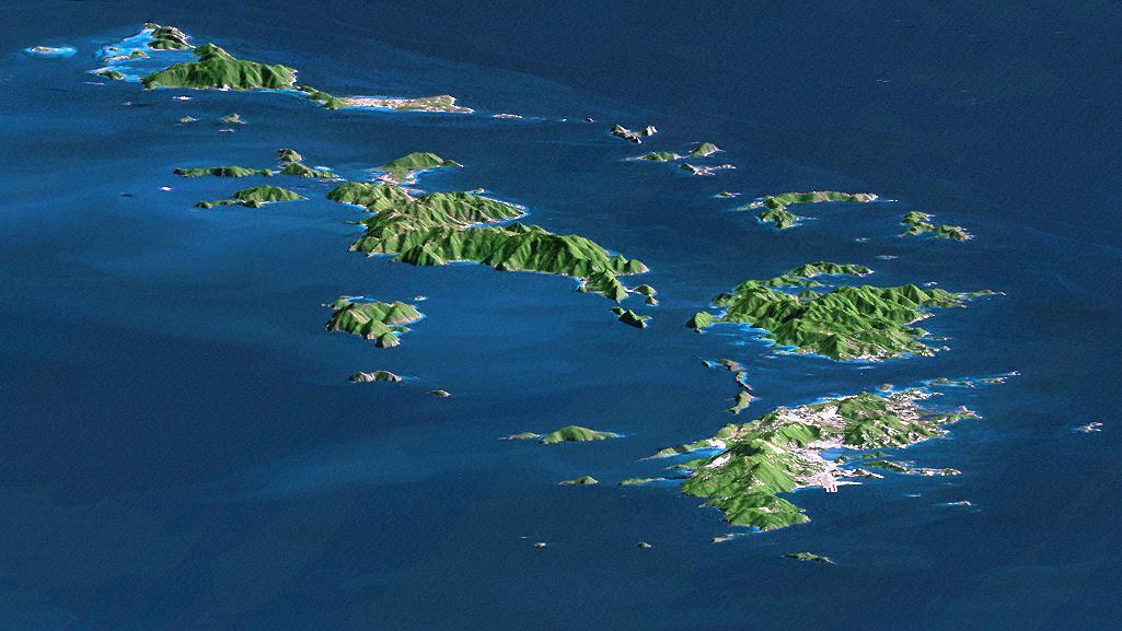
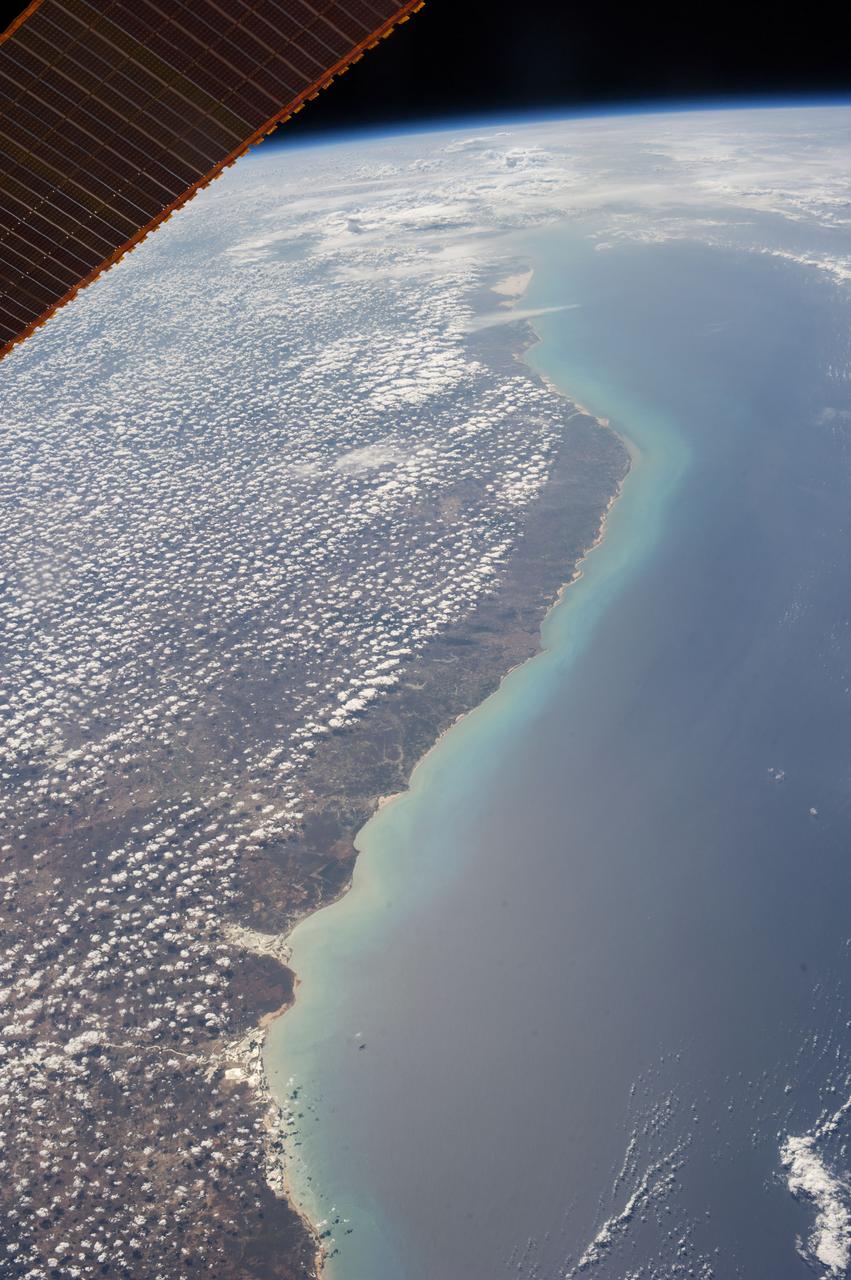
St. Thomas, St. John, Tortola, and Virgin Gorda are the four main islands front to back of this east-looking view of the U.S. Virgin Islands and British Virgin Islands, along the northeast perimeter of the Caribbean Sea.
The target of this observation as seen by ASA Mars Reconnaissance Orbiter is a circular depression in a dark-toned unit associated with a field of cones to the northeast. At the image scale of a Context Camera image, the depression appears to expose layers especially on the sides or walls of the depression, which are overlain by dark sands presumably associated with the dark-toned unit. HiRISE resolution, which is far higher than that of the Context Camera and its larger footprint, can help identify possible layers. http://photojournal.jpl.nasa.gov/catalog/PIA19358
Indigenous Australian owners have been returned the Daintree National Park in northeast Australia, a UNESCO World Heritage Site. More than 160,000 hectares of the 130 million year old rainforest were returned to the Eastern Kuku Yalanji people, who have lived in the area for more than 50,000 years. The image was acquired September 3, 2018, covers an area of 29.6 by 30.3 km, and is located at 16.3 degrees south, 145.4 degrees east. https://photojournal.jpl.nasa.gov/catalog/PIA24869
The volcanic vent northeast of Rachmaninoff basin is framed perfectly in this image. The surface in some regions appears smooth, having been blanketed by very fine particles ejected explosively from the vent. Other regions, like those in the right hand side of the depression, exhibit more texture indicating a younger age. The textured walls indicate downslope movement of material, and a bright horizontal layer just beneath the surface can be traced along much of the northeastern wall. http://photojournal.jpl.nasa.gov/catalog/PIA19223
iss062e103524 (March 20, 2020) --- The northeast coast of Somalia is pictured as the International Space Station orbited above the Gulf of Aden.
iss056e085377 (July 7, 2018) --- Altocumulus clouds blanket the northeast coast of Brazil where the Amazon River flows into the Atlantic Ocean.
iss055e084542 (May 18, 2018) --- A portion the Innamincka Regional Reserve, surrounded by the Strzlecki Desert, is seen in the northeast part of the South Australia.
Earth observation taken during a day pass by the Expedition 37 crew. Per Twitter messsage: Northeast coast of Brazil.
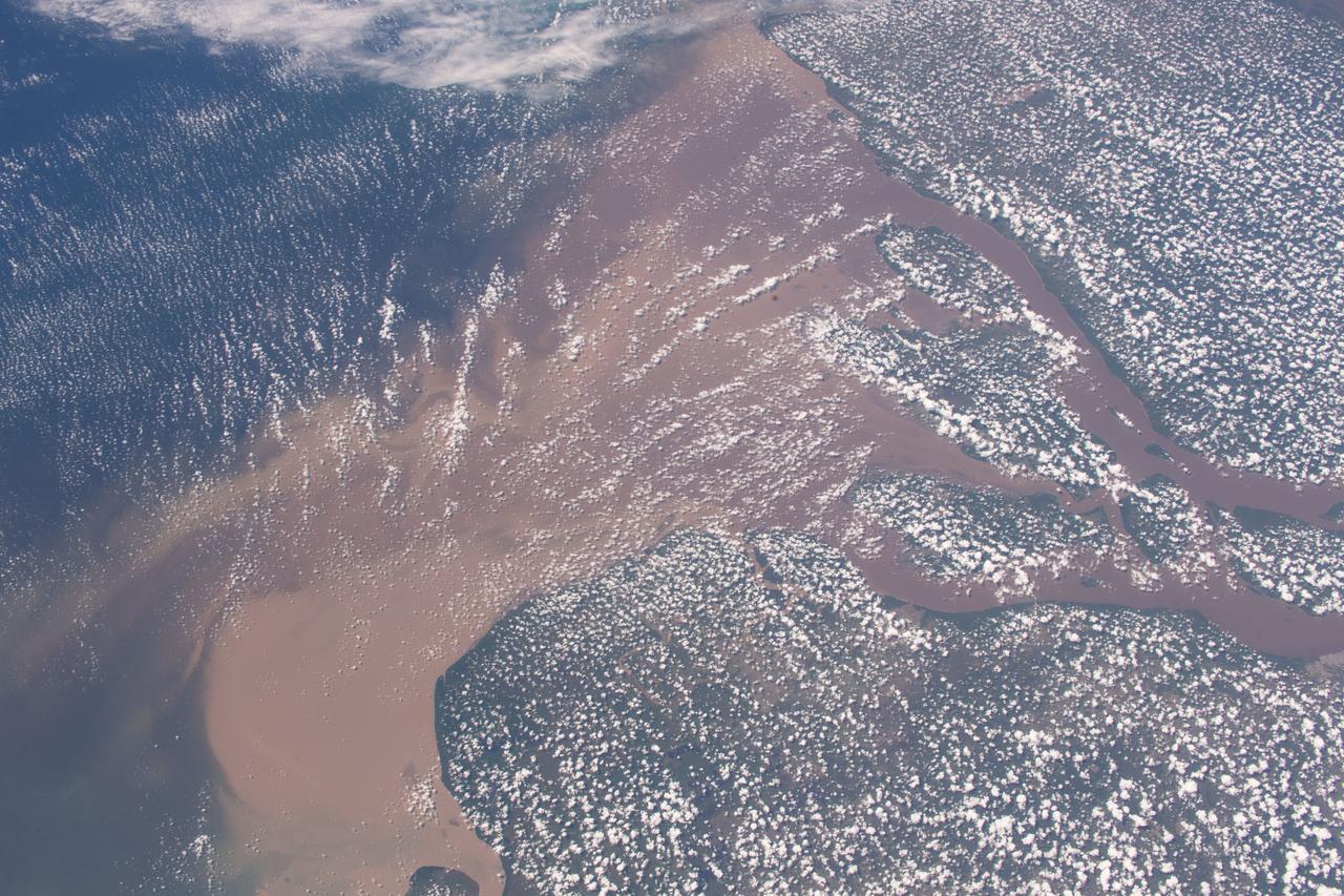
iss056e084566 (July 7, 2018) --- Altocumulus clouds blanket the northeast coast of Brazil where the Amazon River flows into the Atlantic Ocean.

Orbiter Processing Facility High Bay No. 3, 13 platforms and payload bay, looking northeast, July 31, 2006
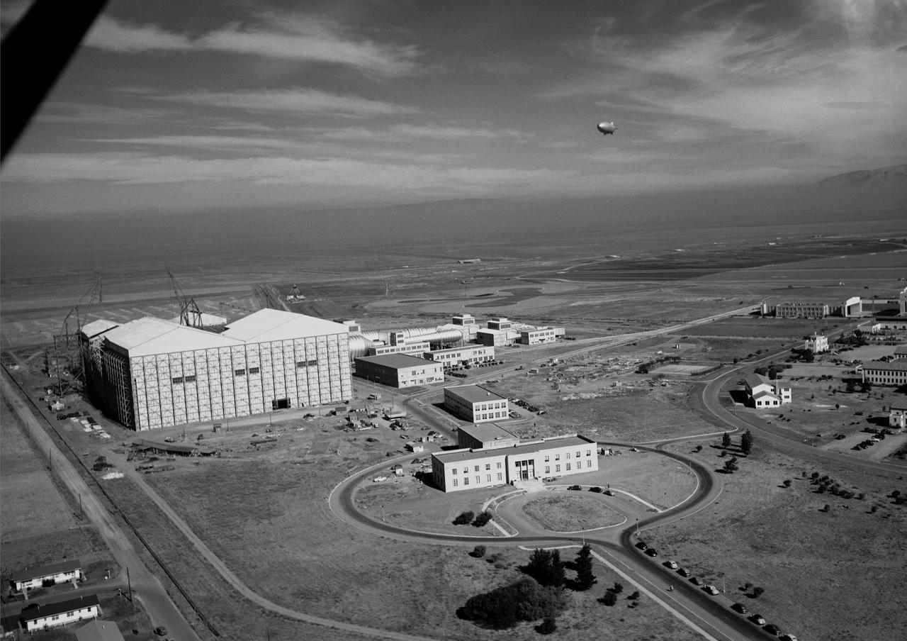
Ames aerial view of Ames Aeronautical Laboratory plot looking northeast with blimp in flight over Moffett Naval airstation.
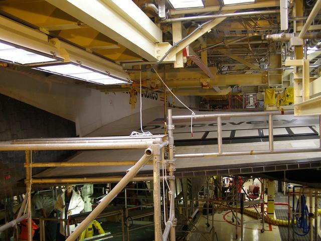
Orbiter Processing Facility High Bay No. 3, second level, looking northeast, July 31, 2006
The town of Shadegan, Iran is northeast of where the Tigris and Euphrates Rivers enter the Persian Gulf. It sits near a wetland and upon land that was once part of an inland river delta. The long, linear orchards follow the topography created by the delta. The image was acquired September 3, 2012, covers an area of 40.6 by 55.3 km, and is located at 30.6 degrees north, 48.6 degrees east. http://photojournal.jpl.nasa.gov/catalog/PIA21170
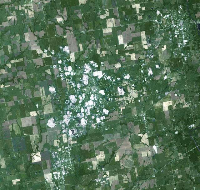
In Heilongjiang province, northeast China, shade covers shelter farmed ginseng from the effects of direct sunlight. China is the world's leading producer of ginseng, a plant believed to have curative properties. It is just as popular in the US as in Asian countries. The image was acquired August 29, 2016, covers an area of 16.7 by 21.2 km, and is located at 47.2 degrees north, 127.9 degrees east. https://photojournal.jpl.nasa.gov/catalog/PIA25895
This series of oblique images highlight the wall and exterior of the beautiful volcanic vent located to the northeast of Rachmaninoff basin and west of Copland crater. Layering can be seen along a portion of the wall and the exterior is smooth due to a blanket of fine particles of lava that were ejected explosively from the vent in a pyroclastic eruption. This vent is deeper than Earth's Grand Canyon. http://photojournal.jpl.nasa.gov/catalog/PIA19282

Towards the top of this image from NASA 2001 Mars Odyssey spacecraft is a T shaped depression and two sections of narrow channel located on the northeast part of the Elysium Mons volcanic complex. Fluids like water, or lava flow downhill.
On Feb. 19, 2014, NASA Curiosity Mars rover looked back after finishing a long drive. The rows of rocks just to the right of the fresh wheel tracks in this view are an outcrop called Junda. This view is looking toward the east-northeast.

This spaceborne radar image shows the intensive agricultural development in central Ukraine, along the Dnieper River. The area shown lies about 320 kilometers 198 miles southeast of Kiev and about 360 kilometers 223 miles northeast of Odessa.
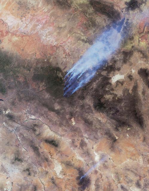
This image from NASA Terra spacecraft shows the Wallow and Horseshoe 2 Fires burning in Arizona. The data were acquired mid-morning on June 7, 2011. Nearly 10 distinct bluish-colored smoke plumes can be seen blowing toward the upper right northeast.

On Friday, April 26, 2014, an avalanche on Mount Everest killed at least 13 Sherpa guides. NASA Terra spacecraft looked toward the northeast, with Mount Everest center, and Lhotse, the fourth-highest mountain on Earth, on the skyline to right center.
iss058e006004 (Jan. 26, 2019) --- This photograph of South America from bottom to top looks from the northeast coast of Argentina to southwest across Chile, the Andes mountains and the Pacific Ocean. The International Space Station was orbiting 259 miles above the Atlantic coast of the South American continent.

During the first two weeks of April, 2003, numerous fires occurred in eastern Russia and northeast China, and produced a large amount of smoke that rose to form a thick layer of tiny atmospheric particles, or aerosols seen here by NASA Terra spacecraft.