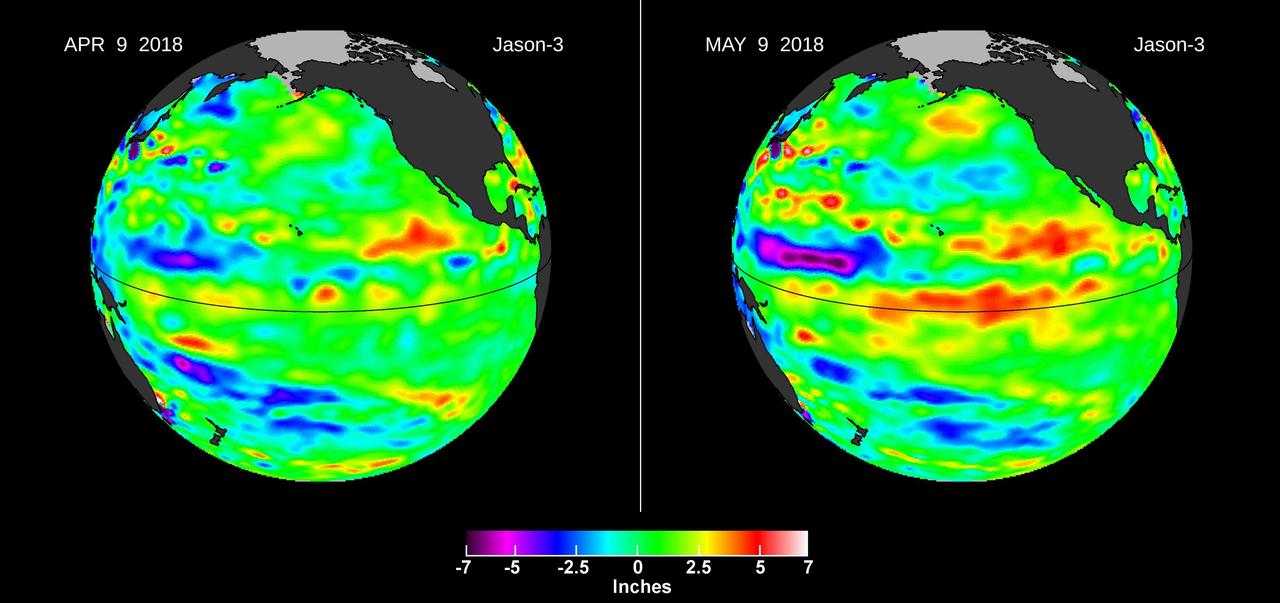
Images from the U.S./European Jason-3 satellite show sea surface height with respect to the seasonal cycle and the long-term trend. Blue/magenta colors indicate lower-than-normal sea levels, while yellow/red colors indicate higher-than-normal sea levels. The April 9, 2018 image (left panel) shows most of the ocean at neutral heights (green). A month later (right panel), a red patch is visible along the equator in the Central Pacific. The red area is a downwelling Kelvin wave, traveling eastward along the equator. https://photojournal.jpl.nasa.gov/catalog/PIA22473
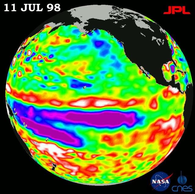
Height measurements taken by NASA U.S.-French TOPEX/Poseidon satellite. The image shows sea surface height relative to normal ocean conditions on July 11, 1998; sea surface height is an indicator of the heat content of the ocean.

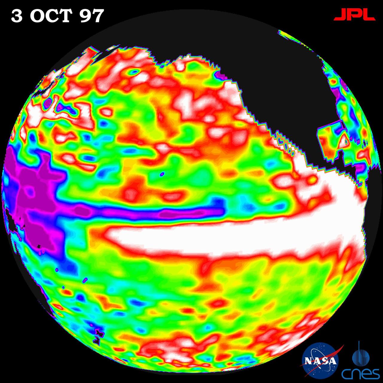
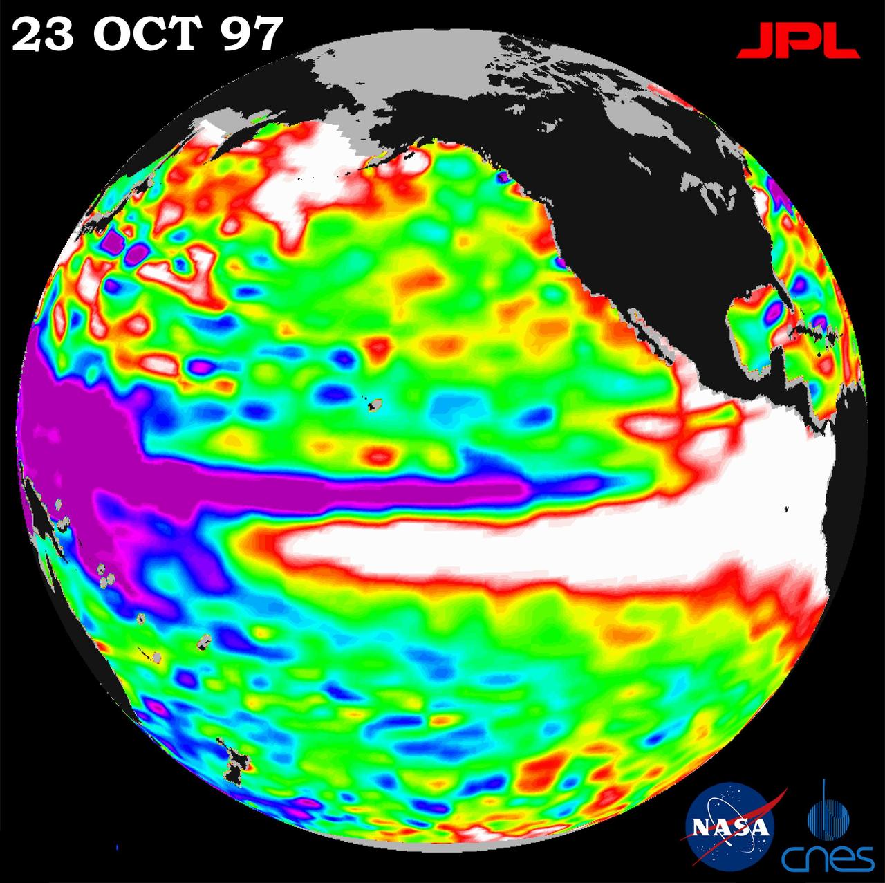
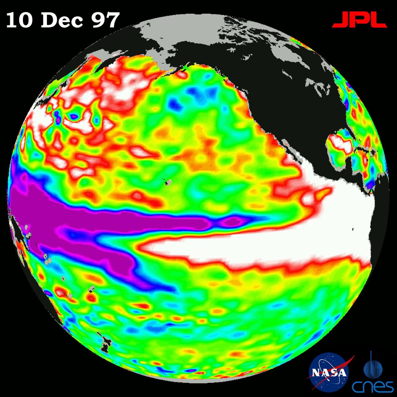
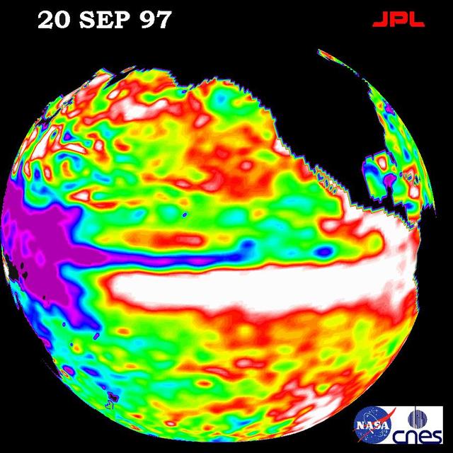
This image of the Pacific Ocean was produced using sea surface height measurements taken by the U.S./French TOPEX/Poseidon satellite. The image shows sea surface height relative to normal ocean conditions on Nov. 10, 1997.
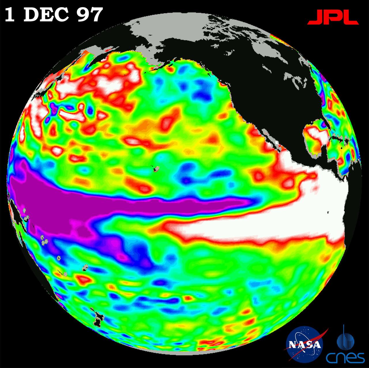
This image of the Pacific Ocean was produced using sea surface height measurements taken by NASA U.S./French TOPEX/Poseidon satellite. The image shows sea surface height relative to normal ocean conditions on Dec. 1, 1997.

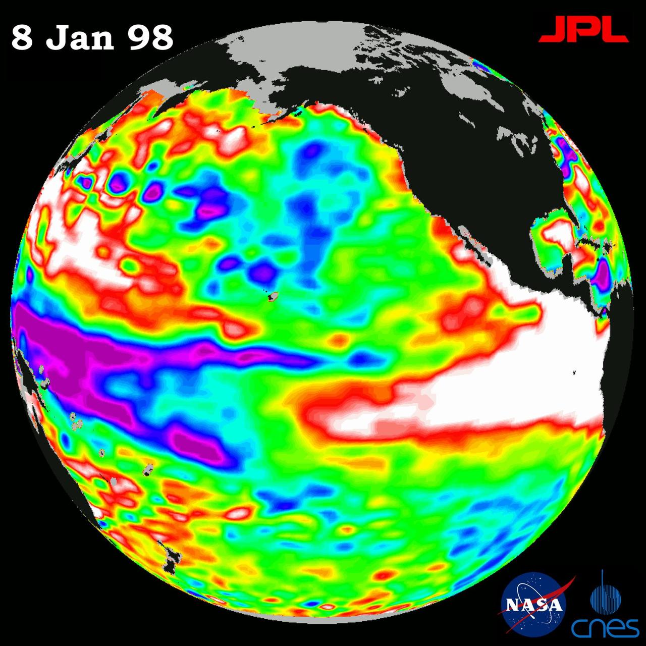
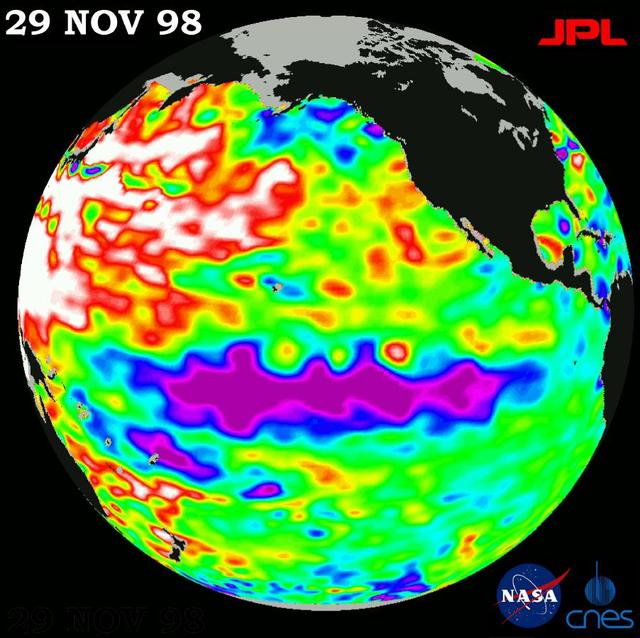
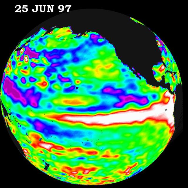
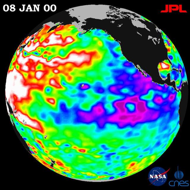
This image of the Pacific Ocean was produced using sea surface height measurements taken by NASA U.S.-French TOPEX/Poseidon satellite.
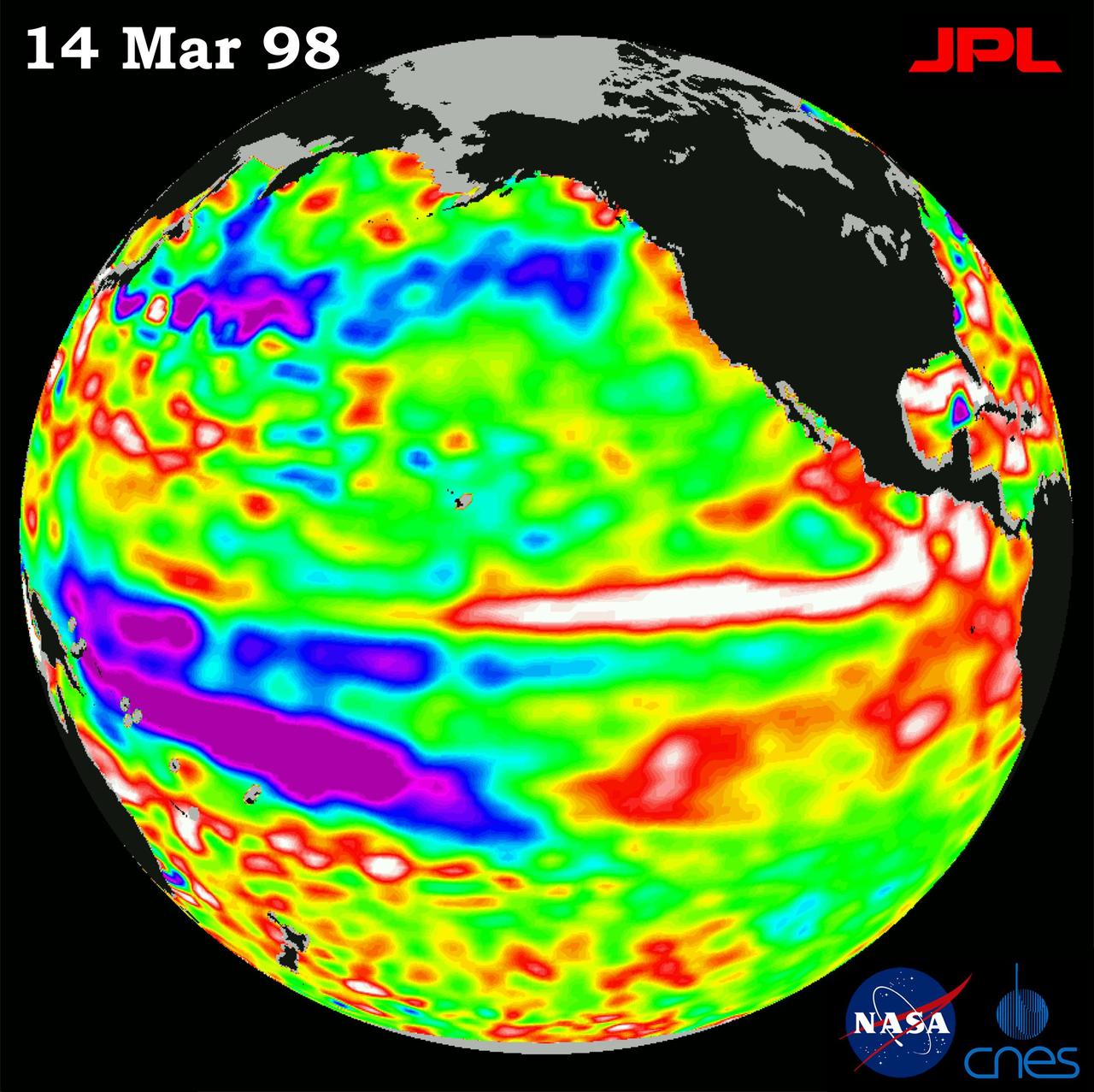
This image of the Pacific Ocean was produced using sea surface height measurements taken by NASA U.S.-French TOPEX/Poseidon satellite.

This image of the Pacific Ocean was produced using sea surface height measurements taken by NASA U.S.-French TOPEX/Poseidon satellite.
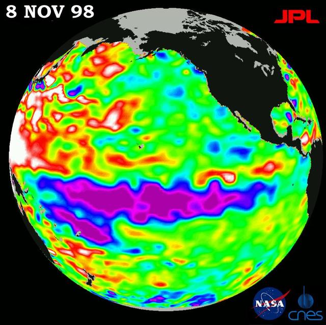
This image of the Pacific Ocean was produced using sea-surface height measurements taken by NASA U.S.-French TOPEX/Poseidon satellite.
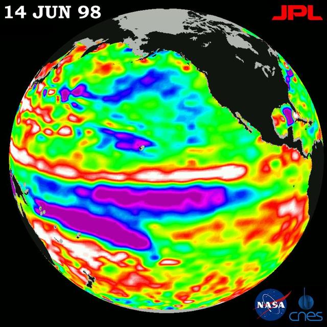
This image of the Pacific Ocean was produced using sea-surface height measurements taken by NASA U.S.-French TOPEX/Poseidon satellite.
This image of the Pacific Ocean was produced using sea surface height measurements taken by NASA U.S./French TOPEX/Poseidon satellite.
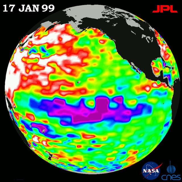
This image of the Pacific Ocean was produced using sea-surface height measurements taken by NASA U.S.-French TOPEX/Poseidon satellite.
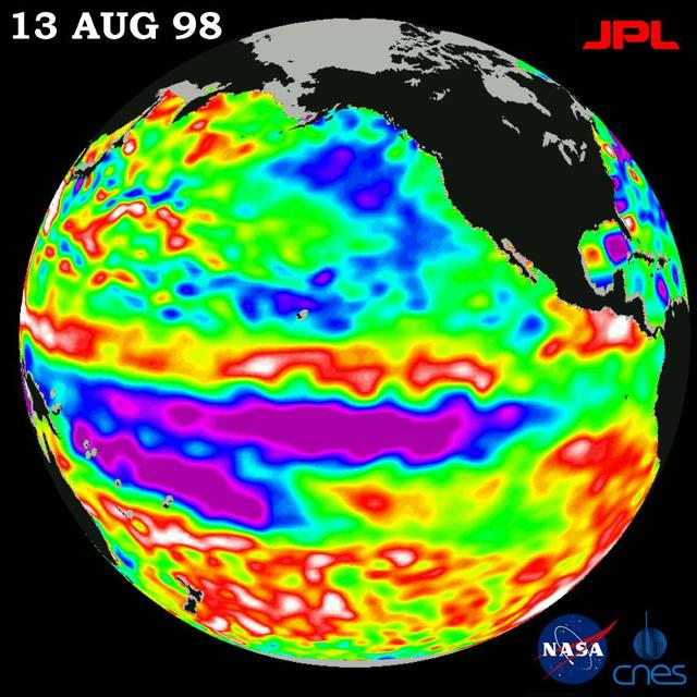
This image of the Pacific Ocean was produced using sea-surface height measurements taken by NASA U.S.-French TOPEX/Poseidon satellite.
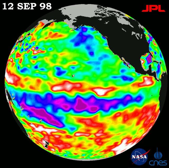
This image of the Pacific Ocean was produced using sea-surface height measurements taken by NASA U.S.-French TOPEX/Poseidon satellite.
This image of the Pacific Ocean was produced using sea surface height measurements taken by NASA U.S./French TOPEX/POSEIDON satellite.
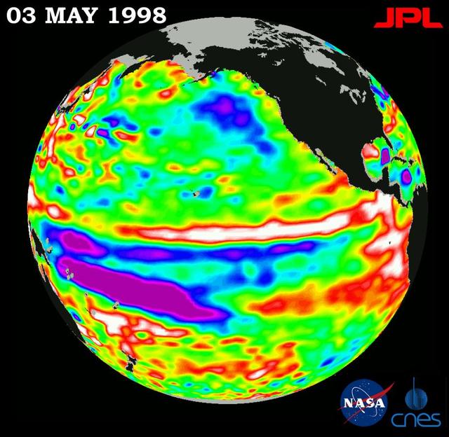
This image of the Pacific Ocean was produced using sea-surface height measurements taken by NASA U.S.-French TOPEX/Poseidon satellite.
This image of the Pacific Ocean was produced using sea surface height measurements taken by NASA U.S.-French TOPEX/Poseidon satellite.
This image of the Pacific Ocean was produced using sea-surface height measurements taken by NASA U.S.-French TOPEX/Poseidon satellite.
This image of the Pacific Ocean was produced using sea surface height measurements taken by NASA U.S.-French TOPEX/Poseidon satellite.
This image of the Pacific Ocean was produced using sea surface height measurements taken by NASA U.S./French TOPEX/POSEIDON satellite.
This image of the Pacific Ocean was produced using sea surface height measurements taken by NASA U.S./French TOPEX/POSEIDON satellite.
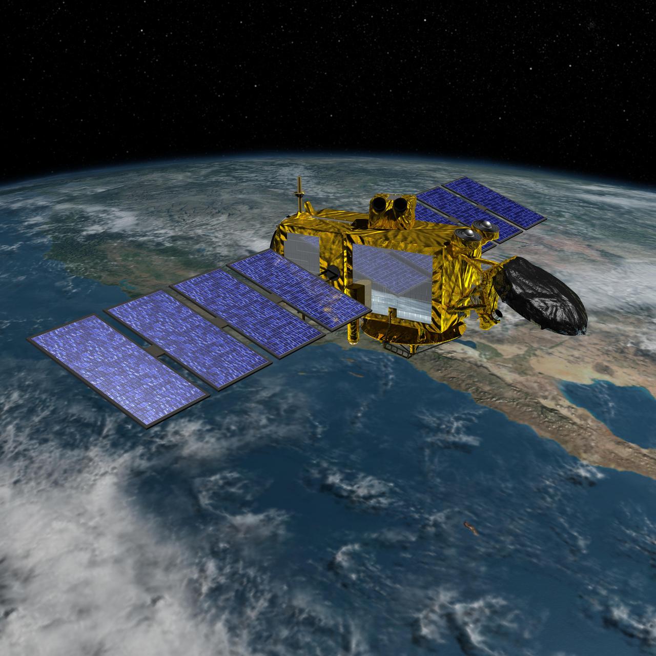
Artist concept of the U.S.-European Jason-3 spacecraft over the California coast. Jason-3 will precisely measure the height of the ocean surface, allowing scientists to monitor ocean circulation and sea level.
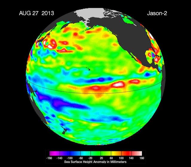
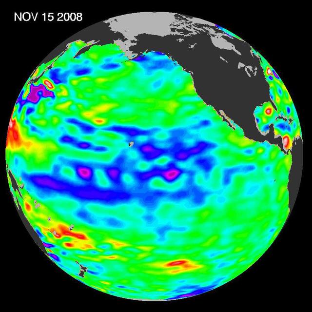
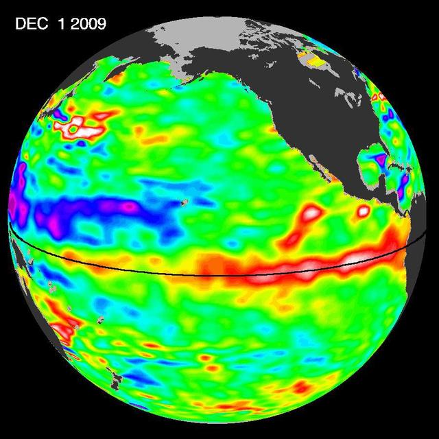
New data from NASA Jason-2 satellite show near-normal sea surface heights in the equatorial Pacific Ocean persisting for a 16th straight month.
These images of the Pacific Ocean near Indonesia were produced using sea surface height measurements taken by NASA U.S.-French TOPEX/Poseidon satellite.
A giant horseshoe pattern of higher than normal sea-surface heights developing over the last year is beginning to dominate the entire western Pacific and Asiatic oceans.
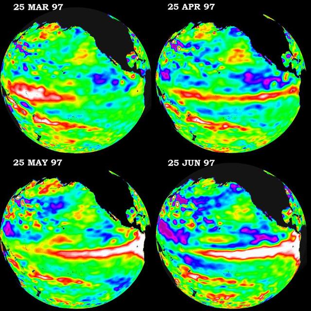
These four views of the Pacific Ocean were produced using sea surface height measurements taken by NASA U.S./French TOPEX/POSEIDON satellite.
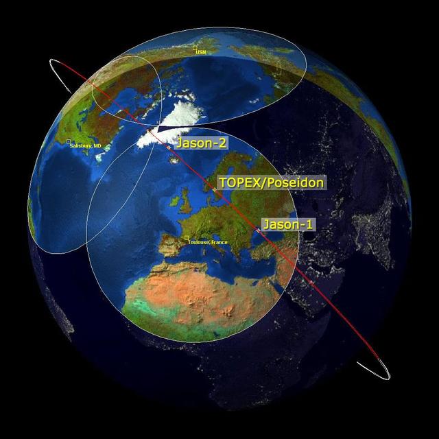
This image is a family portrait of Topex/Poseidon, Jason-1 and Ocean Surface Topography Mission/Jason-2 OSTM/Jason-2, NASA satellites that have measured global sea surface heights since 1992.
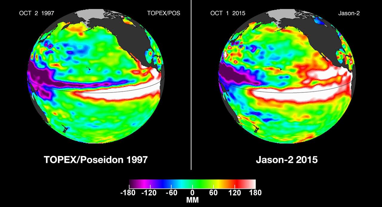
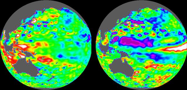
In this side-by-side visualization, Pacific Ocean sea surface height anomalies during the 1997-98 El Niño left are compared with 2015 Pacific conditions right.
The latest image of sea-surface height measurements from NASA U.S./French Jason-1 oceanography satellite shows the Pacific Ocean remains locked in a strong, cool phase of the Pacific Decadal Oscillation.
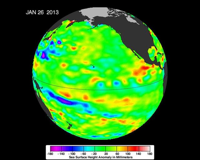
The latest image of sea surface heights in the Pacific Ocean from NASA Jason-2 satellite shows that the equatorial Pacific Ocean is now in its 10th month of being locked in what some call a neutral, or La Nada state.
The most recent sea-level height data from the NASA/European Ocean Surface Topography Mission/Jason-2 oceanography satellite show the continued eastward progression of a strong wave of warm water, known as a Kelvin wave, now approaching South America.
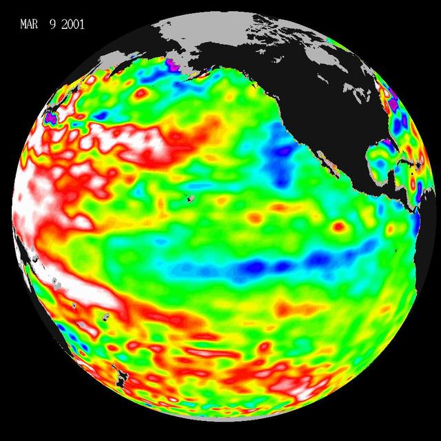
Data taken during a 10-day collection cycle ending March 9, 2001, show that above-normal sea-surface heights and warmer ocean temp. red and white areas still blanket the far-western tropical Pacific and much of the north and south mid-Pacific.
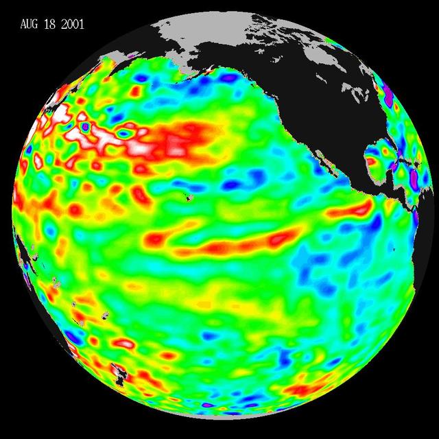
These data, taken during a 10-day collection cycle ending August 18, 2001, show that above-normal sea-surface heights and warmer ocean temperatures still blanket the far-western tropical Pacific and much of the north and south mid-Pacific.
The latest image of Pacific Ocean sea surface heights from the NASA OSTIM/Jason-2 oceanography satellite, on June 11, 2010, shows that Pacific has switched from warm red to cold blue during the last few months.
Unusually warm ocean temperatures off Asia and cool waters in the eastern and equatorial Pacific are signaling La Niña mild return, according to the latest sea-surface heights observed by the joint NASA-French space agency TOPEX/Poseidon satellite.
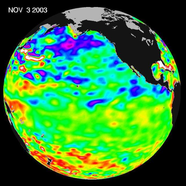
Some climate forecast models indicate there is an above average chance that there could be a weak to borderline El Niño by the end of November 2003. However, the trade winds, blowing from east to west across the equatorial Pacific Ocean, remain strong. Thus, there remains some uncertainty among climate scientists as to whether the warm temperature anomaly will form again this year. The latest remote sensing data from NASA's Jason satellite show near normal conditions across the equatorial Pacific. There are currently no visible signs in sea surface height of an impending El Niño. This equatorial quiet contrasts with the Bering Sea, Gulf of Alaska and U.S. West Coast where lower-than-normal sea surface levels and cool ocean temperatures continue (indicated by blue and purple areas). The image above is a global map of sea surface height, accurate to within 30 millimeters. The image represents data collected and composited over a 10-day period, ending on Nov. 3, 2003. The height of the water relates to the temperature of the water. As the ocean warms, its level rises; and as it cools, its level falls. Yellow and red areas indicate where the waters are relatively warmer and have expanded above sea level, green indicates near normal sea level, and blue and purple areas show where the waters are relatively colder and the surface is lower than sea level. The blue areas are between 5 and 13 centimeters (2 and 5 inches) below normal, whereas the purple areas range from 14 to 18 centimeters (6 to 7 inches) below normal. http://photojournal.jpl.nasa.gov/catalog/PIA04878
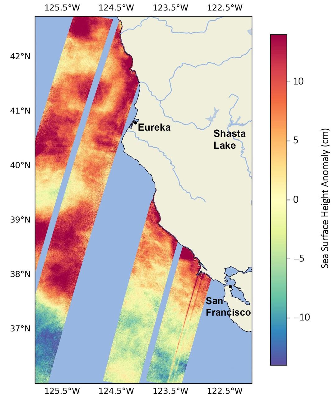
This data visualization image above shows sea surface heights off the northern California coast in August 2023 as measured by the Surface Water and Ocean Topography (SWOT) satellite. Red indicates higher-than-average ocean heights, while blue represents lower-than-average heights. Warm ocean waters from the developing El Niño are shifting north along coastlines in the eastern Pacific Ocean. Along the coast of California, these warm waters are interacting with a persistent marine heat wave that recently influenced the development of Hurricane Hilary. SWOT is able to spot the movement of these warm ocean waters in unprecedented detail. The SWOT science team made the measurements with the Ka-band Radar Interferometer (KaRIn) instrument. With two antennas spread 33 feet (10 meters) apart on a boom, KaRIn produces a pair of data swaths as it circles the globe, bouncing radar pulses off the water's surface to collect water-height measurements. The visualization combines data from two passes of the SWOT satellite. https://photojournal.jpl.nasa.gov/catalog/PIA26091
This animation shows global sea level data collected by the Surface Water and Ocean Topography (SWOT) satellite during its first 21-day science orbit, which it completed from July 26 to Aug. 16, 2023. Red and orange indicate ocean heights that were higher than the global mean sea surface height, while blue represents lower-than-the mean. Sea level differences can highlight ocean currents, like the Gulf Stream coming off the U.S. East Coast or the Kuroshio current off the east coast of Japan. Increased sea surface heights can also indicate regions of relatively warmer water – like the eastern part of the equatorial Pacific Ocean during an El Niño – because water expands as it warms. The SWOT science team made the measurements using the spacecraft's Ka-band Radar Interferometer (KaRIn) instrument. With two antennas spread 33 feet (10 meters) apart on a boom, KaRIn produces a pair of data swaths (tracks visible in the animation) as it circles the globe, bouncing radar pulses off the water's surface to collect surface-height measurements. Launched on Dec. 16, 2022, from Vandenberg Space Force Base in central California, SWOT is now in its operations phase, measuring the height of nearly all water on Earth's surface. The satellite will provide one of the most detailed, comprehensive views yet of the planet's oceans and fresh water lakes and rivers, collecting data that will be used for research and other purposes. Animation available at https://photojournal.jpl.nasa.gov/catalog/PIA26100

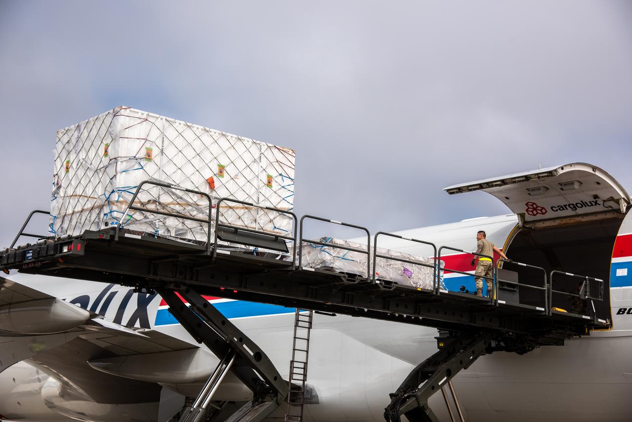
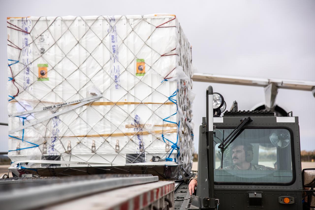
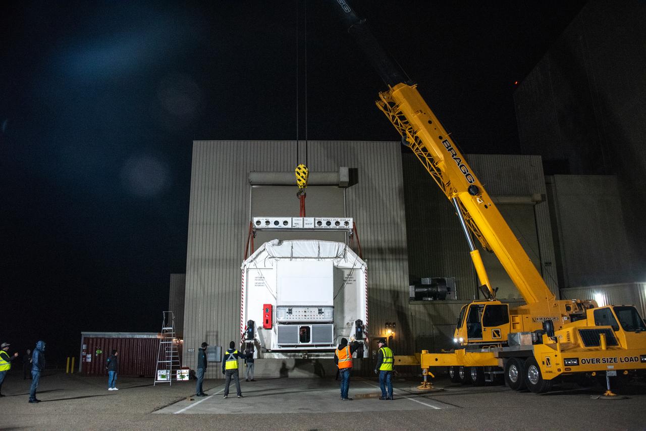
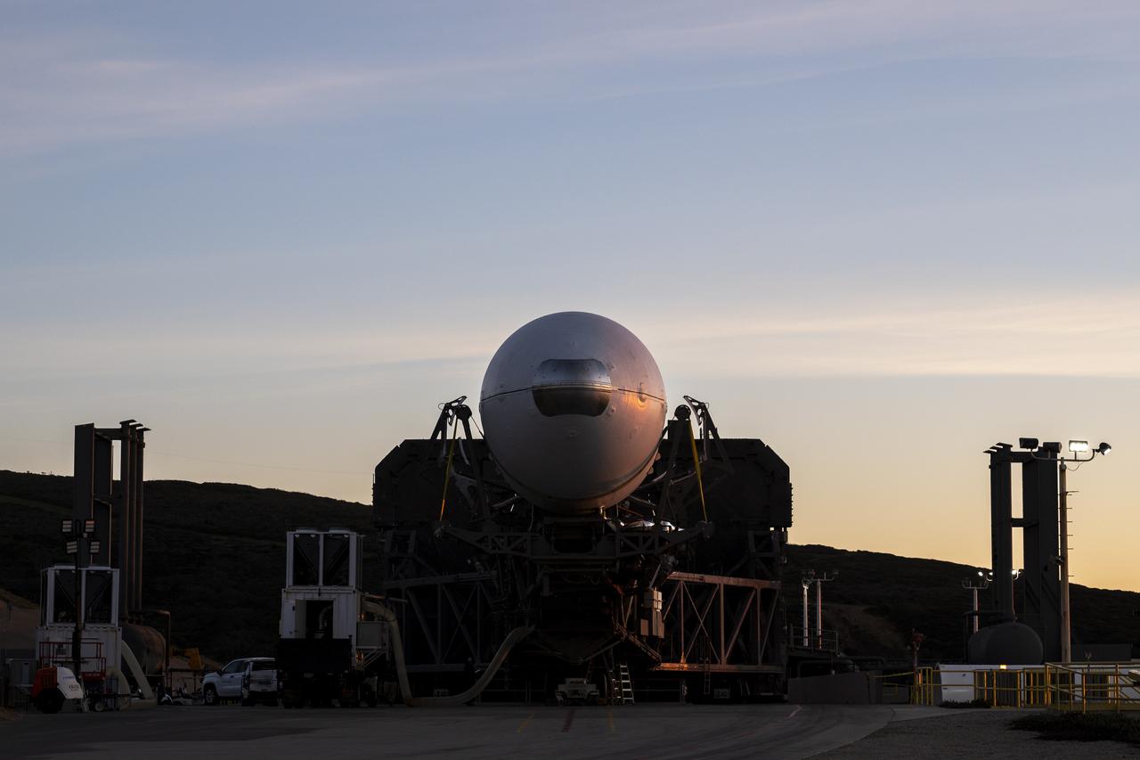
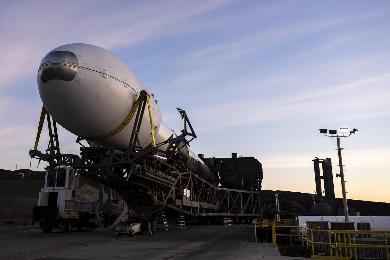
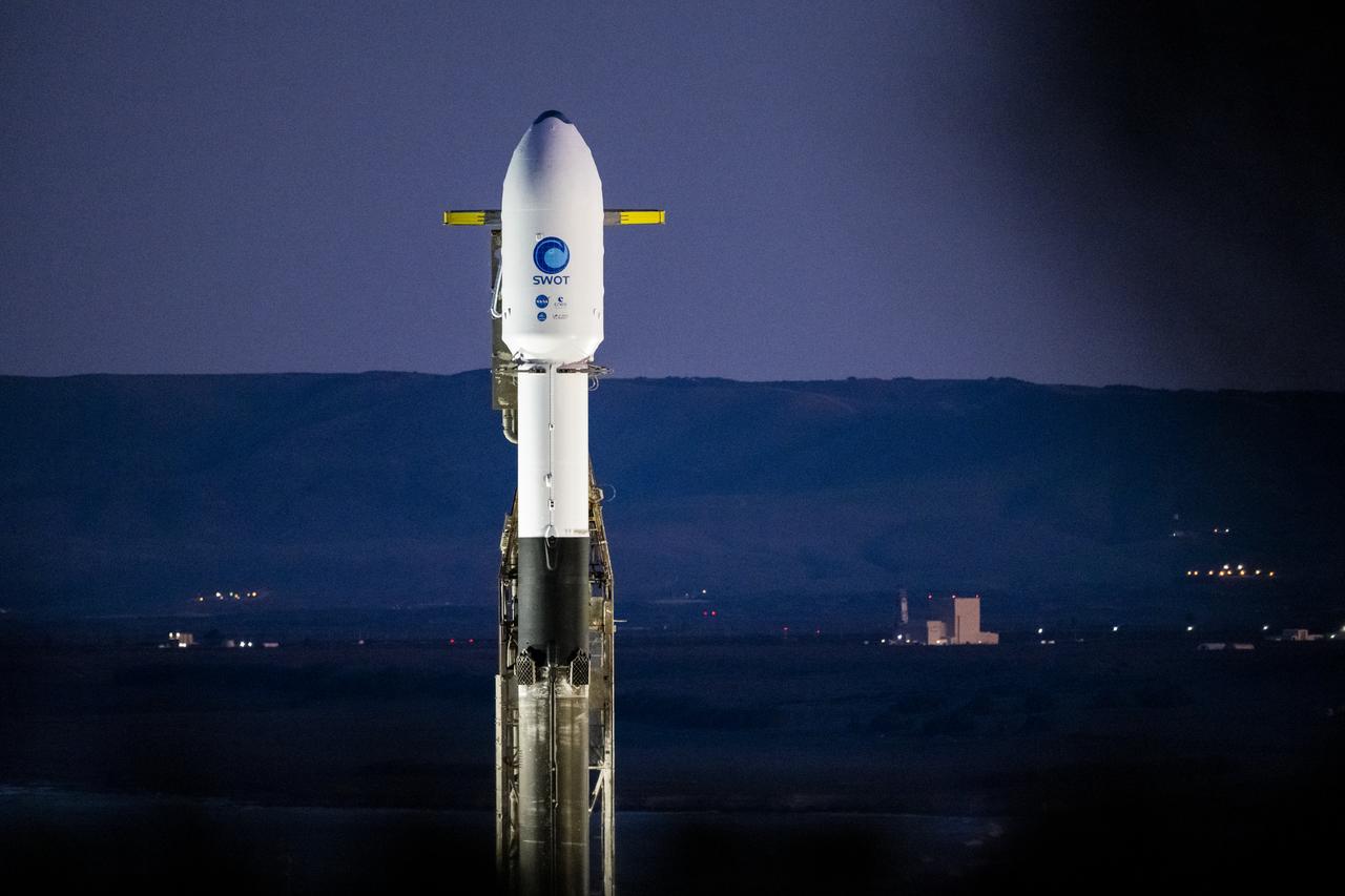
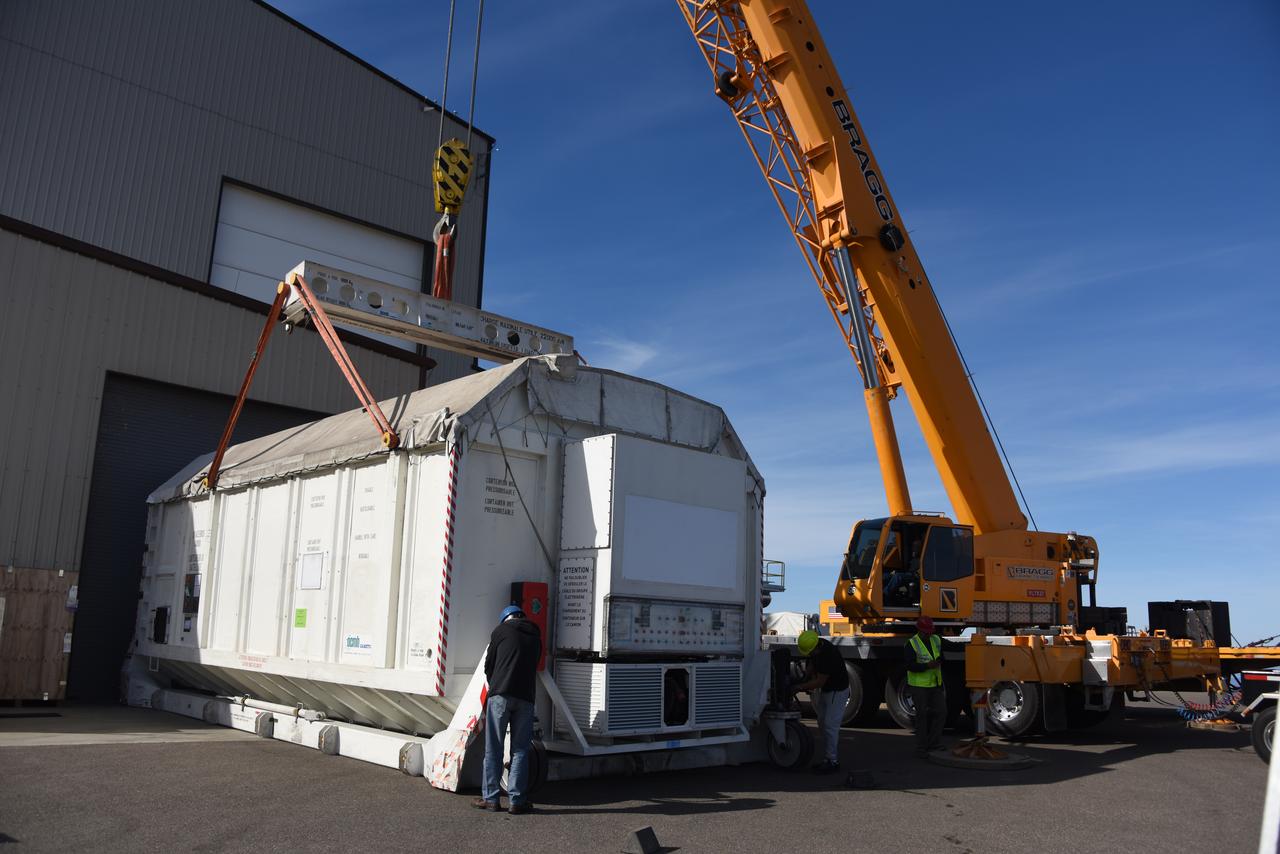
The ground service equipment for the Surface Water and Ocean Topography (SWOT) satellite arrives at Vandenberg Space Force Base in California on Oct. 13, 2022. SWOT is the first mission that will observe nearly all water on Earth’s surface, measuring the height of water in the planet’s lakes, rivers, reservoirs, and the ocean. The satellite is set to launch aboard a SpaceX Falcon 9 rocket in December from Vandenberg’s Space Launch Center-4 East. NASA’s Launch Services Program, based at the agency’s Kennedy Space Center in Florida, is managing the launch service.

The Surface Water and Ocean Topography (SWOT) satellite arrives at Vandenberg Space Force Base in California on Oct. 16, 2022. SWOT is the first mission that will observe nearly all water on Earth’s surface, measuring the height of water in the planet’s lakes, rivers, reservoirs, and the ocean. The satellite is set to launch aboard a SpaceX Falcon 9 rocket in December from Vandenberg’s Space Launch Center-4 East. NASA’s Launch Services Program, based at the agency’s Kennedy Space Center in Florida, is managing the launch service.
The ground service equipment for the Surface Water and Ocean Topography (SWOT) satellite arrives at Vandenberg Space Force Base in California on Oct. 13, 2022. SWOT is the first mission that will observe nearly all water on Earth’s surface, measuring the height of water in the planet’s lakes, rivers, reservoirs, and the ocean. The satellite is set to launch aboard a SpaceX Falcon 9 rocket in December from Vandenberg’s Space Launch Center-4 East. NASA’s Launch Services Program, based at the agency’s Kennedy Space Center in Florida, is managing the launch service.

The ground service equipment for the Surface Water and Ocean Topography (SWOT) satellite arrives at Vandenberg Space Force Base in California on Oct. 13, 2022. SWOT is the first mission that will observe nearly all water on Earth’s surface, measuring the height of water in the planet’s lakes, rivers, reservoirs, and the ocean. The satellite is set to launch aboard a SpaceX Falcon 9 rocket in December from Vandenberg’s Space Launch Center-4 East. NASA’s Launch Services Program, based at the agency’s Kennedy Space Center in Florida, is managing the launch service.
The Surface Water and Ocean Topography (SWOT) satellite arrives at Vandenberg Space Force Base in California on Oct. 16, 2022. SWOT is the first mission that will observe nearly all water on Earth’s surface, measuring the height of water in the planet’s lakes, rivers, reservoirs, and the ocean. The satellite is set to launch aboard a SpaceX Falcon 9 rocket in December from Vandenberg’s Space Launch Center-4 East. NASA’s Launch Services Program, based at the agency’s Kennedy Space Center in Florida, is managing the launch service.
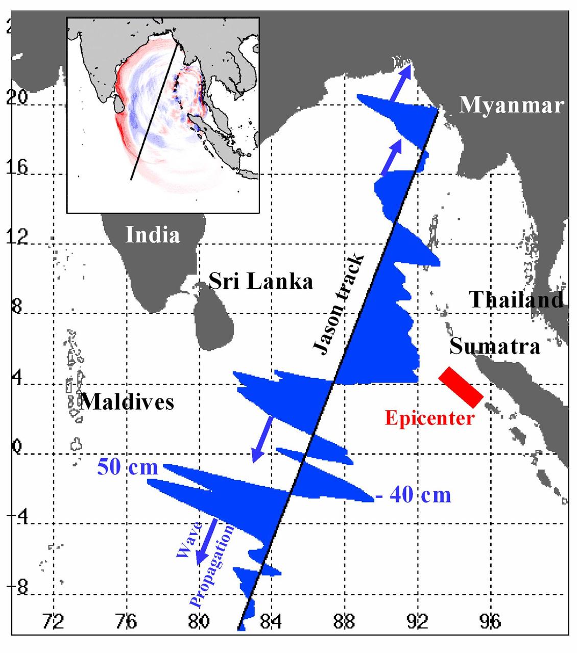
Displayed in blue color is the height of sea surface (shown in blue) measured by the Jason satellite two hours after the initial magnitude 9 earthquake hit the region (shown in red) southwest of Sumatra on December 26, 2004. The data were taken by a radar altimeter onboard the satellite along a track traversing the Indian Ocean when the tsunami waves had just filled the entire Bay of Bengal (see the model simulation inset image). The data shown are the changes of sea surface height from previous observations made along the same track 20-30 days before the earthquake, reflecting the signals of the tsunami waves. The maximum height of the leading wave crest was about 50 cm (or 1.6 ft), followed by a trough of sea surface depression of 40 cm. The directions of wave propagation along the satellite track are shown by the blue arrows. http://photojournal.jpl.nasa.gov/catalog/PIA07219
ElNi?o is experiencing a late-fall resurgence. Sea-level height data from the NASA/European Ocean Surface Topography Mission/Jason-2 oceanography satellite show the equatorial Pacific has triggered a wave of warm water, known as a Kelvin wave.
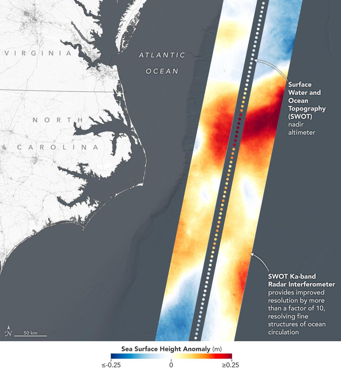
This visualization shows sea surface height measurements in the Gulf Stream off the coast of North Carolina and Virginia. The data was collected on Jan. 21, 2023, by an instrument on the Surface Water and Ocean Topography (SWOT) satellite called the Ka-band Radar Interferometer (KaRIn). KaRIn's two antennas acquired data that was mapped as two wide, colored strips spanning a total of 75 miles (120 kilometers) across. In the visualization, red and orange areas represent sea levels that are higher than the global average, while shades of blue represent sea levels that are lower than average. The spatial resolution of SWOT ocean measurements is 10 times greater than the composite of sea surface height data gathered over the same area by seven other satellites that same day. KaRIn is the scientific heart of the SWOT mission. It's a radar instrument with one antenna at each end of a boom that's 33 feet (10 meters) long. This enables KaRIn to look off to either side of a center line directly below the satellite as the instrument bounces microwave signals off of Earth's surface. The returning radar signals arrive at each antenna slightly out of step, or phase, from one another. When these signals are combined with other information about the antennas and the satellite's altitude, scientists will be able to map the height of water on Earth's surface with never-before-seen clarity. Led by NASA and the French space agency Centre National d'Études Spatiales (CNES), SWOT will measure the height of water on over 90% of Earth's surface, providing a high-definition survey of our planet's water for the first time. The satellite's measurements of freshwater bodies and the ocean will provide insights into how the ocean influences climate change; how a warming world affects lakes, rivers, and reservoirs; and how communities can better prepare for disasters like floods. Launched on Dec. 16, 2022, from Vandenberg Space Force Base in central California, SWOT is now in a six-month period called commissioning, calibration and validation. This is when engineers on the mission check out the satellite's systems and science instruments to ensure data accuracy before the start of science operations in July. https://photojournal.jpl.nasa.gov/catalog/PIA25772
VANDENBERG AIR FORCE BASE, Calif. – The Ocean Surface Topography Mission, or OSTM/Jason 2, spacecraft is being prepared for bagging before encapsulation and transfer to the launch pad. The launch of the Ocean Surface Topography Mission, or OSTM/Jason 2, aboard a Delta II rocket is scheduled for Friday, June 20, from Vandenberg Air Force Base in California. The launch window extends from 12:46 a.m. to 12:55 a.m. PDT. The satellite will be placed in an 830-mile-high orbit at an inclination of 66 degrees after separating from the Delta II 55 minutes after liftoff. The five primary science instruments of the Ocean Surface Topography Mission aboard the Jason 2 spacecraft are dedicated to measuring ocean surface height. These measurements will be used to evaluate and forecast climate changes and improve weather forecasting. The results also are expected to help forecasters better predict hurricane intensity. Photo credit: NASA
VANDENBERG AIR FORCE BASE, Calif. – The Ocean Surface Topography Mission, or OSTM/Jason 2, spacecraft is being prepared for bagging before encapsulation and transfer to the launch pad. The launch of the Ocean Surface Topography Mission, or OSTM/Jason 2, aboard a Delta II rocket is scheduled for Friday, June 20, from Vandenberg Air Force Base in California. The launch window extends from 12:46 a.m. to 12:55 a.m. PDT. The satellite will be placed in an 830-mile-high orbit at an inclination of 66 degrees after separating from the Delta II 55 minutes after liftoff. The five primary science instruments of the Ocean Surface Topography Mission aboard the Jason 2 spacecraft are dedicated to measuring ocean surface height. These measurements will be used to evaluate and forecast climate changes and improve weather forecasting. The results also are expected to help forecasters better predict hurricane intensity. Photo credit: NASA
VANDENBERG AIR FORCE BASE, Calif. – The Ocean Surface Topography Mission, or OSTM/Jason 2, spacecraft is being prepared for bagging before encapsulation and transfer to the launch pad. The launch of the Ocean Surface Topography Mission, or OSTM/Jason 2, aboard a Delta II rocket is scheduled for Friday, June 20, from Vandenberg Air Force Base in California. The launch window extends from 12:46 a.m. to 12:55 a.m. PDT. The satellite will be placed in an 830-mile-high orbit at an inclination of 66 degrees after separating from the Delta II 55 minutes after liftoff. The five primary science instruments of the Ocean Surface Topography Mission aboard the Jason 2 spacecraft are dedicated to measuring ocean surface height. These measurements will be used to evaluate and forecast climate changes and improve weather forecasting. The results also are expected to help forecasters better predict hurricane intensity. Photo credit: NASA
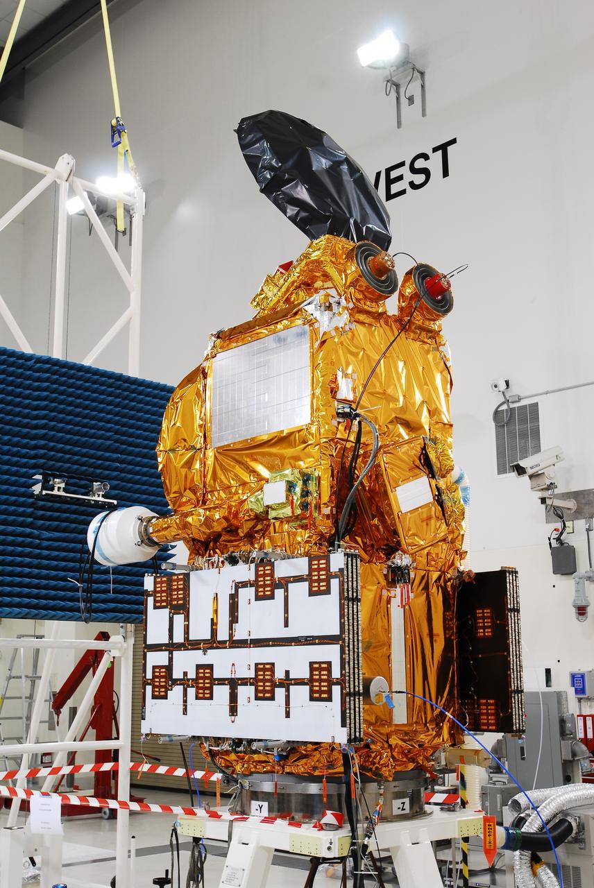
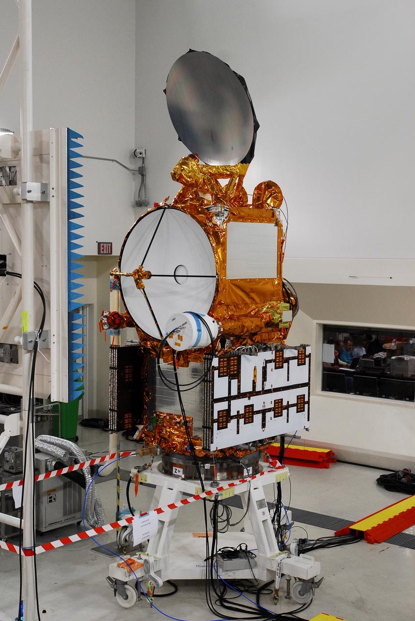
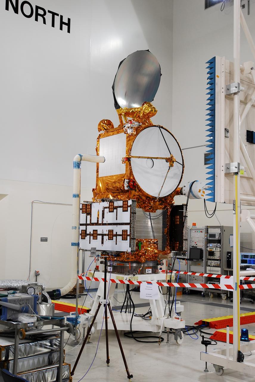
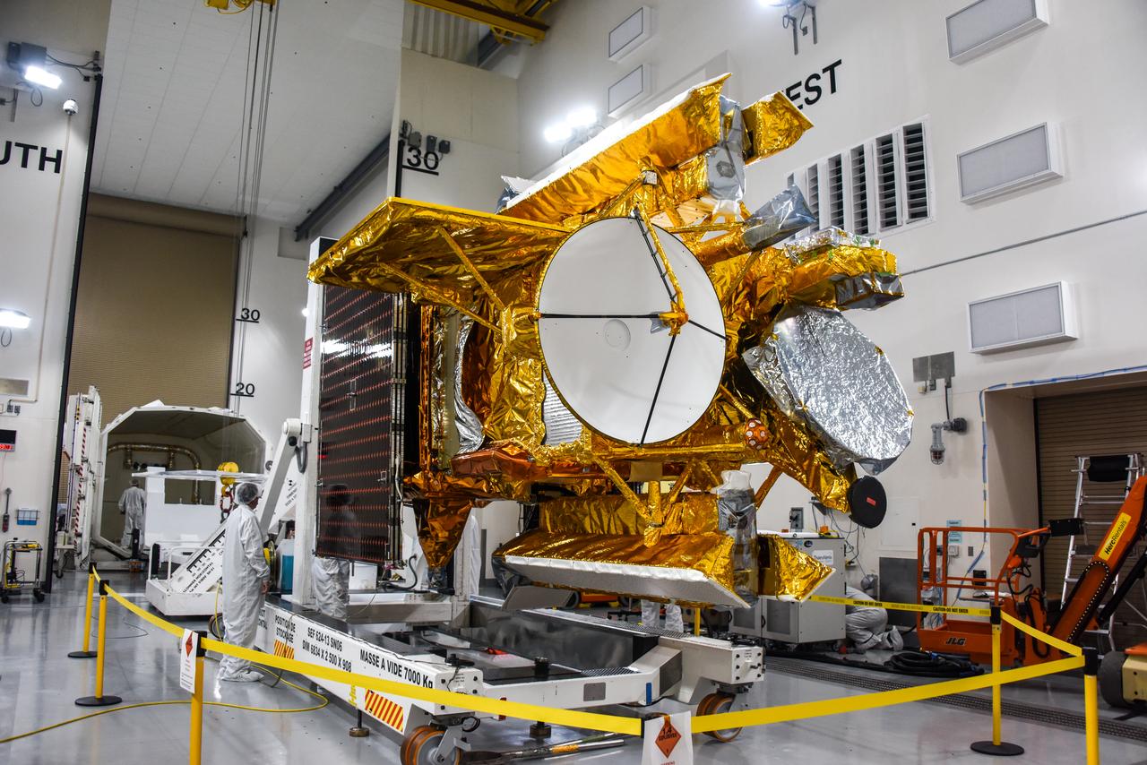
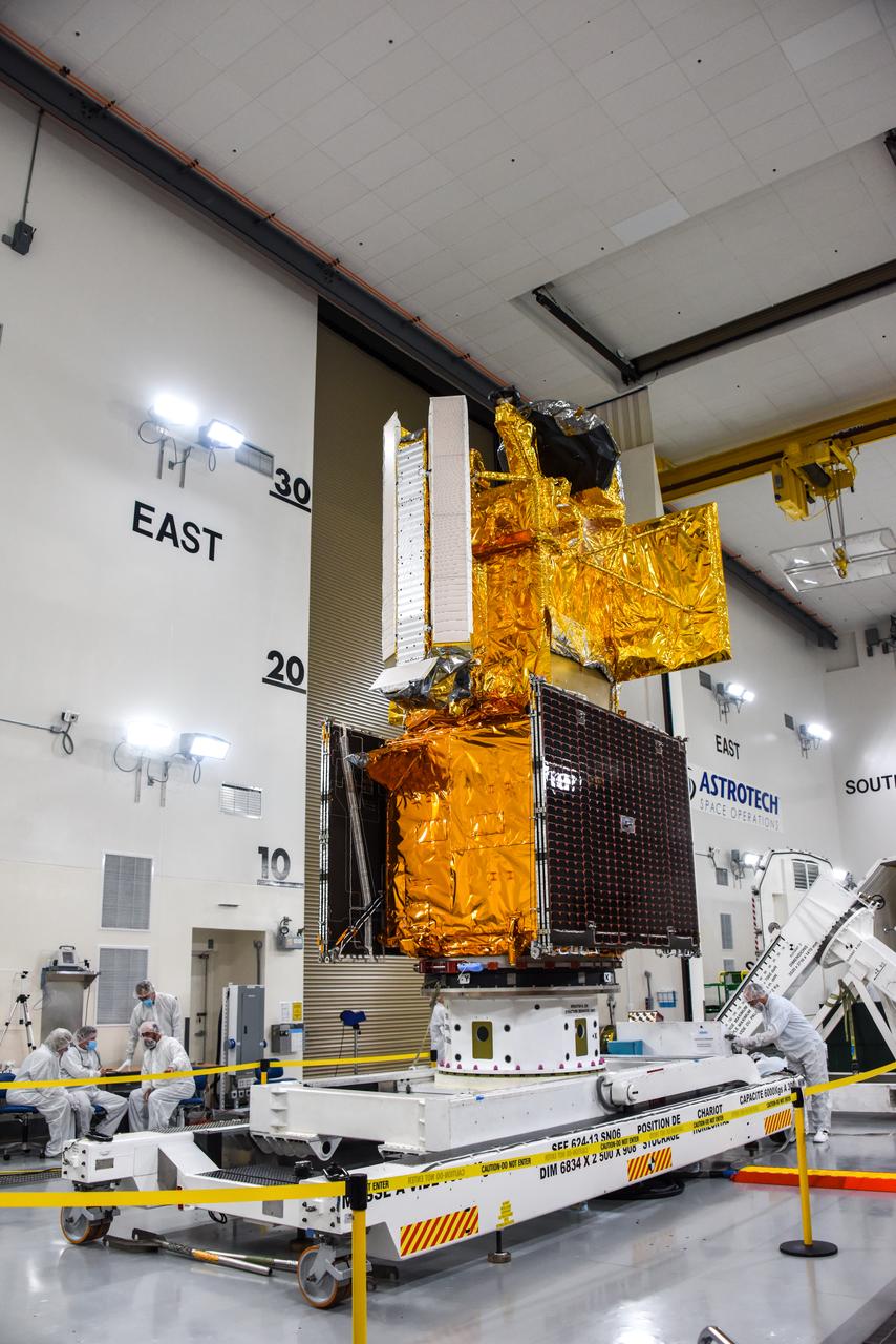
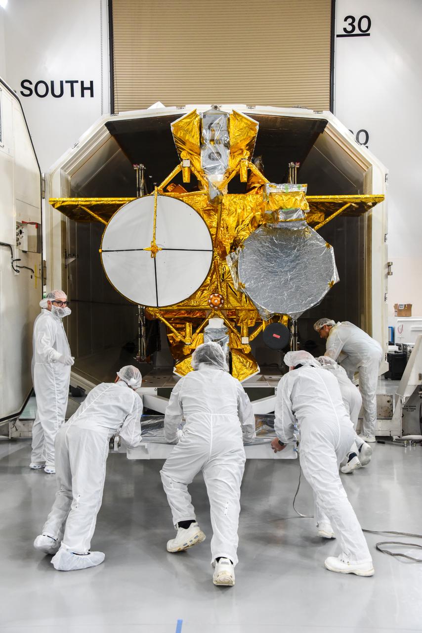
Part of the Surface Water and Ocean Topography (SWOT) satellite's science instrument payload sits in a clean room at NASA's Jet Propulsion Laboratory during assembly. Once fully assembled and launched into orbit, the SUV-size spacecraft will make global surveys of Earth's surface water. By measuring the height of the water in the planet's ocean, lakes, and rivers, researchers can track the volume and location of the finite resource around the world. The data will help with monitoring changes in floodplains and wetlands, measure how much fresh water flows into and out of lakes and rivers and back to the ocean, and track regional shifts in sea level. https://photojournal.jpl.nasa.gov/catalog/PIA24536
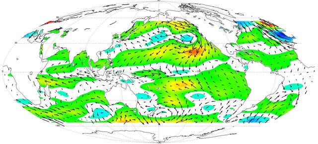
While El Niño events have a significant impact on the entire Earth System, they are most easily visible in measurements of sea surface temperature (SST), sea surface height (SSH) and ocean winds near the surface. In fact, the precursor and the main driver of El Niño events is manifested in the weakening of the normally westward blowing trade winds, or even their complete reversal to blow from west to east, in the Western and Central tropical Pacific. http://photojournal.jpl.nasa.gov/catalog/PIA20365
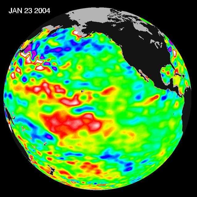
The latest remote sensing data from NASA's Jason satellite show that the equatorial Pacific sea surface levels are higher, indicating warmer sea surface temperatures in the central and west Pacific Ocean. This pattern has the appearance of La Niña rather than El Niño. This contrasts with the Bering Sea, Gulf of Alaska and U.S. West Coast where lower-than-normal sea surface levels and cool ocean temperatures continue (indicated by blue and purple areas). The image above is a global map of sea surface height, accurate to within 30 millimeters. The image represents data collected and composited over a 10-day period, ending on Jan 23, 2004. The height of the water relates to the temperature of the water. As the ocean warms, its level rises; and as it cools, its level falls. Yellow and red areas indicate where the waters are relatively warmer and have expanded above sea level, green indicates near normal sea level, and blue and purple areas show where the waters are relatively colder and the surface is lower than sea level. The blue areas are between 5 and 13 centimeters (2 and 5 inches) below normal, whereas the purple areas range from 14 to 18 centimeters (6 to 7 inches) below normal. http://photojournal.jpl.nasa.gov/catalog/PIA05071
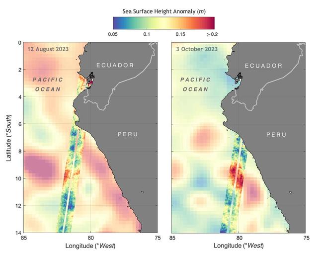
The illustration above shows sea levels off the coasts of Peru and Ecuador on Aug. 12, 2023, and Oct. 3, 2023. The Surface Water and Ocean Topography (SWOT) satellite collected the ocean data during its operational phase, which began in late July. The red and orange colors represent sea levels that are higher than average (units are in meters), while green and blue indicate sea levels that are lower than average. The SWOT data shows some of the development of an El Niño along the west coast of the Americas. The SWOT science team made the measurements using the spacecraft's Ka-band Radar Interferometer (KaRIn) instrument. With two antennas spread 33 feet (10 meters) apart on a boom, KaRIn produces a pair of data swaths (tracks visible in the animation) as it circles the globe, bouncing radar pulses off the water's surface to collect surface-height measurements. Launched on Dec. 16, 2022, from Vandenberg Space Force Base in central California, SWOT is now in its operations phase, measuring the height of nearly all water on Earth's surface. The satellite will provide one of the most detailed, comprehensive views yet of the planet's oceans and fresh water lakes and rivers, collecting data that will be used for research and other purposes. https://photojournal.jpl.nasa.gov/catalog/PIA26181
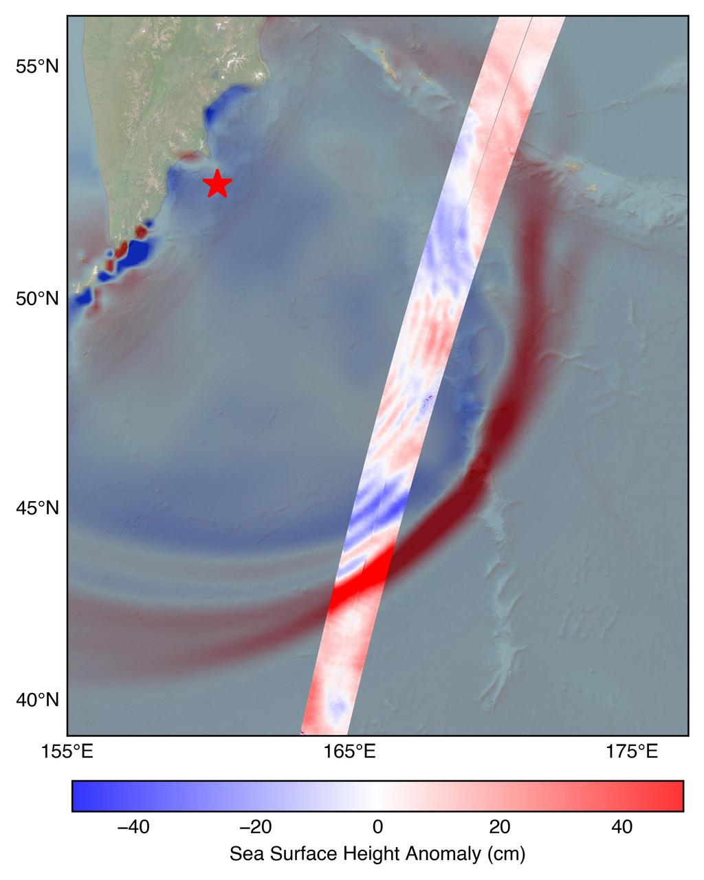
The U.S.-French SWOT (Surface Water and Ocean Topography) satellite captured the leading edge of a tsunami wave that rolled through the Pacific Ocean on July 30, 2025 (11:25 a.m. local time), in the wake of a magnitude 8.8 earthquake that struck Russia's Kamchatka Peninsula. The satellite captured the data about 70 minutes after the earthquake struck. The SWOT sea level measurements, shown in the highlighted swath from the satellite's ground track, is plotted against a tsunami forecast model from the National Oceanic and Atmospheric Administration (NOAA) Center for Tsunami Research in the background. A red star marks the location of the earthquake. The measurements show a wave height exceeding 1.5 feet (45 centimeters) as well as a look at the shape and direction of travel of the leading edge of the wave (indicated in red). Researchers noted that while the wave height might seem small, tsunamis extend from the seafloor to the ocean surface. A seemingly small wave in the open ocean can become much larger in shallower coastal waters. https://photojournal.jpl.nasa.gov/catalog/PIA26652
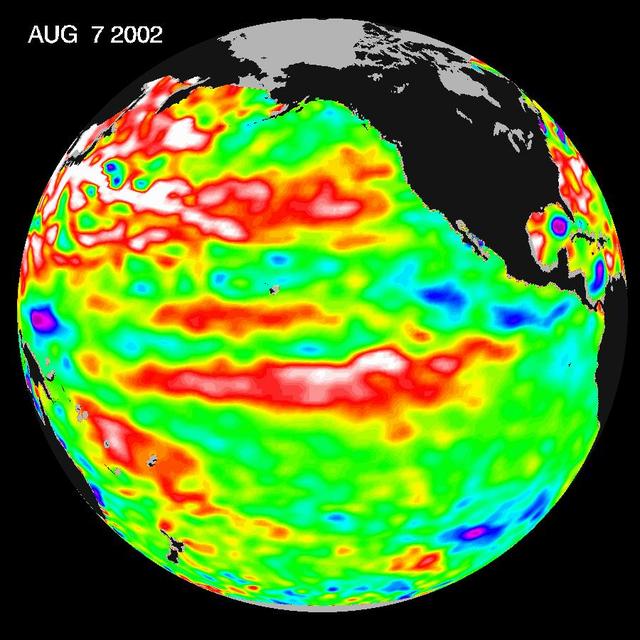
This Topex/Poseidon image of sea-surface heights was taken during a 10-day collection cycle ending August 7, 2002. Sea-surface heights are a measure of how much heat is stored in the ocean below to influence future planetary climate events. Since May 2001, there have been a series of warm Kelvin waves--eastward-moving ocean waves that cross the equatorial Pacific in about two months. A sizable one arrived at the South American coast last February, raising the ocean temperature by 2 degrees Celsius (3.6 degrees Fahrenheit) and triggering the National Oceanic and Atmospheric Administration's forecast for a mild El Niño in 2002. There was another wave in June, followed by the current large pool of warm water in the tropical Pacific that is now moving toward the coast of South America at a speed of 215 kilometers (134 miles) a day and will arrive there in three to four weeks, raising ocean temperatures. Scientists will continue to monitor the Pacific closely for further signs of El Niño formation and intensity. http://photojournal.jpl.nasa.gov/catalog/PIA03855
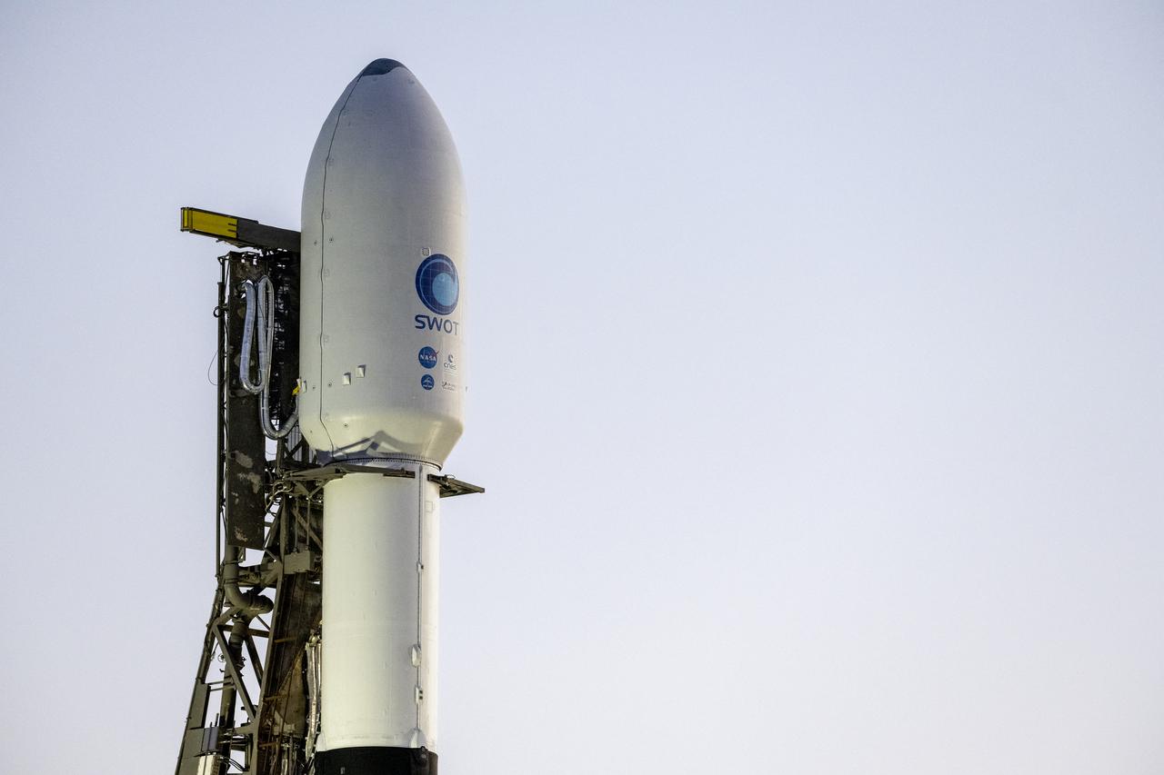
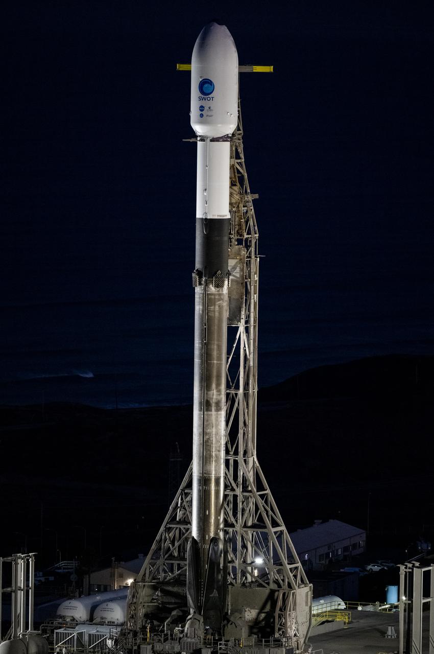
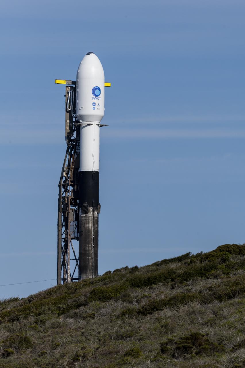
A SpaceX Falcon 9 rocket with the Surface Water and Ocean Topography (SWOT) spacecraft onboard is seen as it rolls out to the pad, Tuesday, Dec. 13, 2022, at Space Launch Complex 4E at Vandenberg Space Force Base in California. Jointly developed by NASA and Centre National D'Etudes Spatiales (CNES), with contributions from the Canadian Space Agency (CSA) and United Kingdom Space Agency, SWOT is the first satellite mission that will observe nearly all water on Earth’s surface, measuring the height of water in the planet’s lakes, rivers, reservoirs, and the ocean. Photo Credit: (NASA/Keegan Barber)
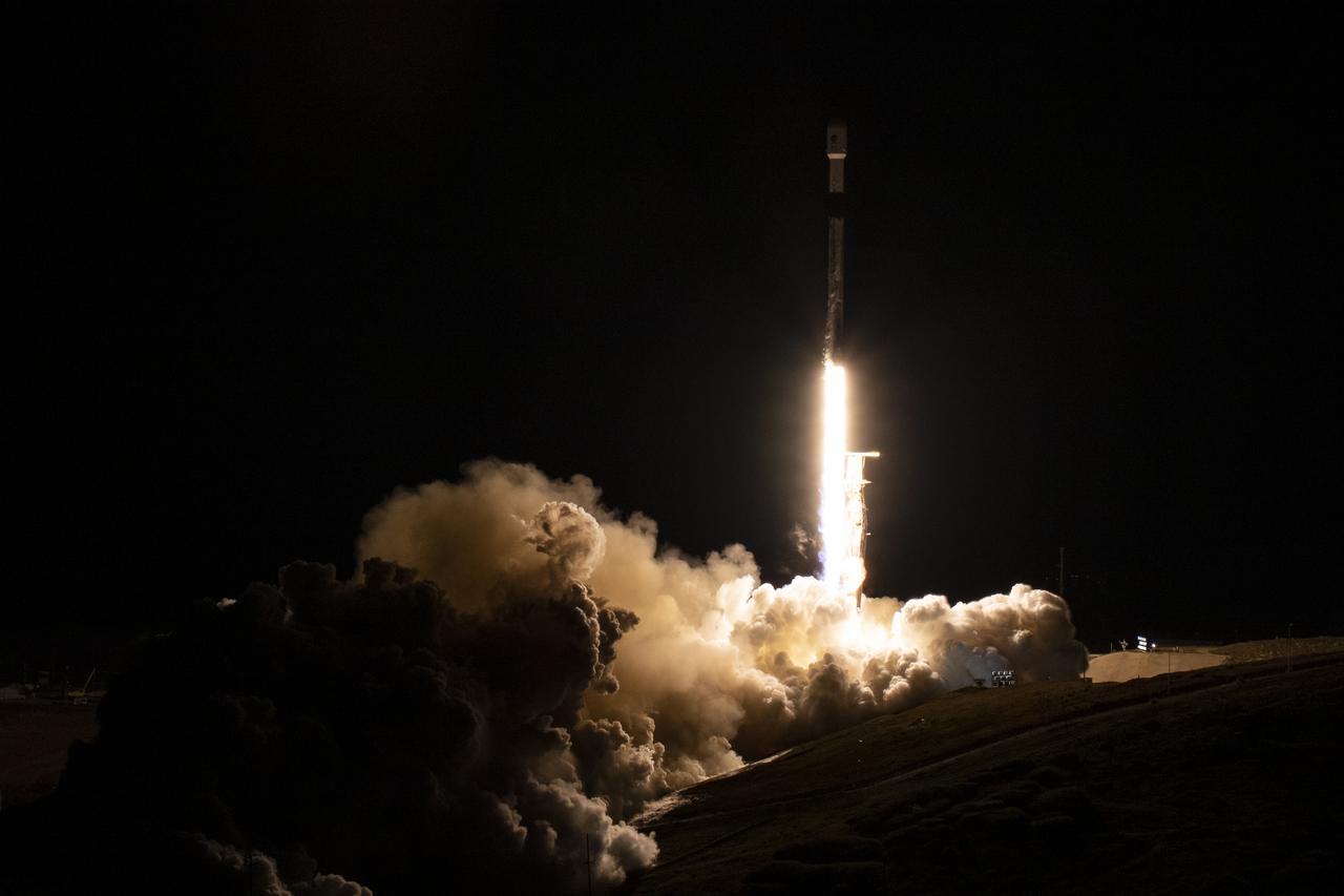
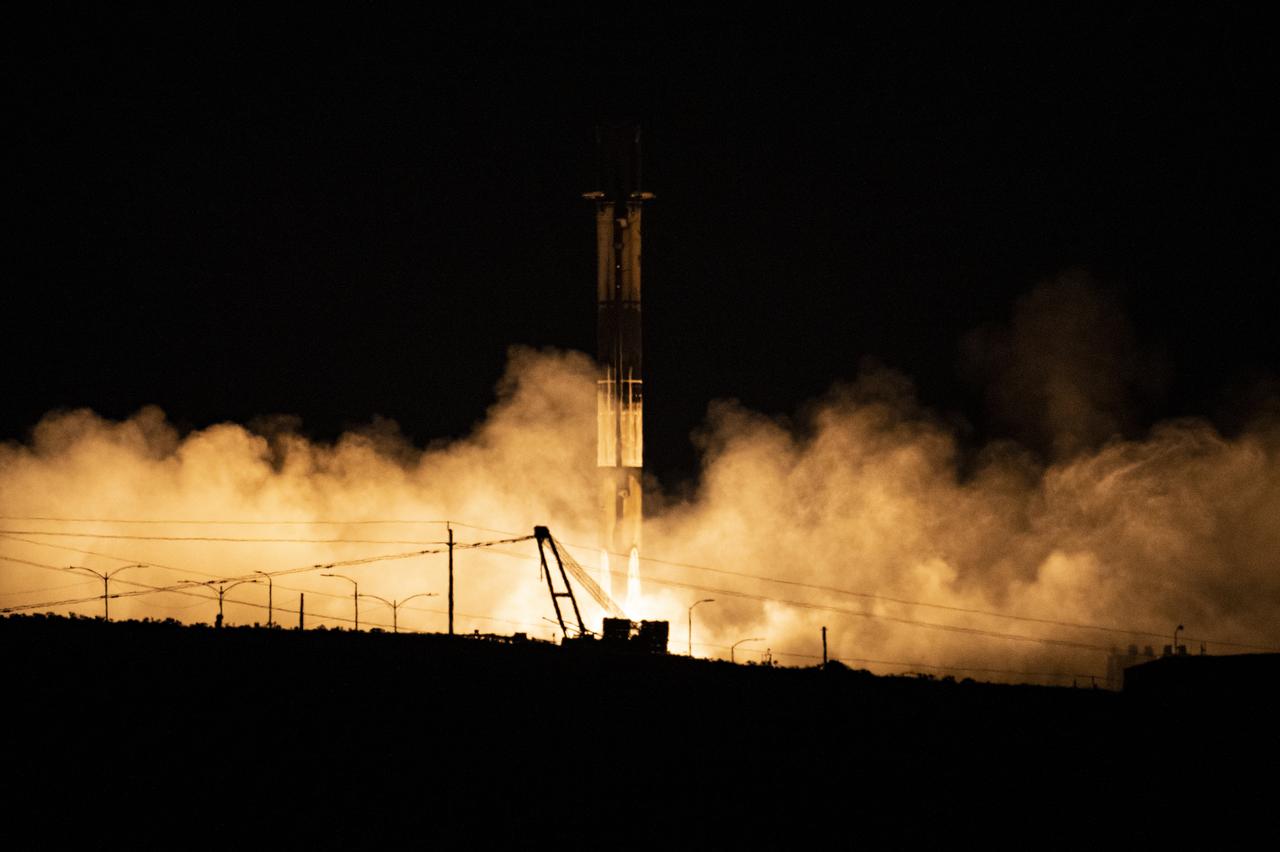
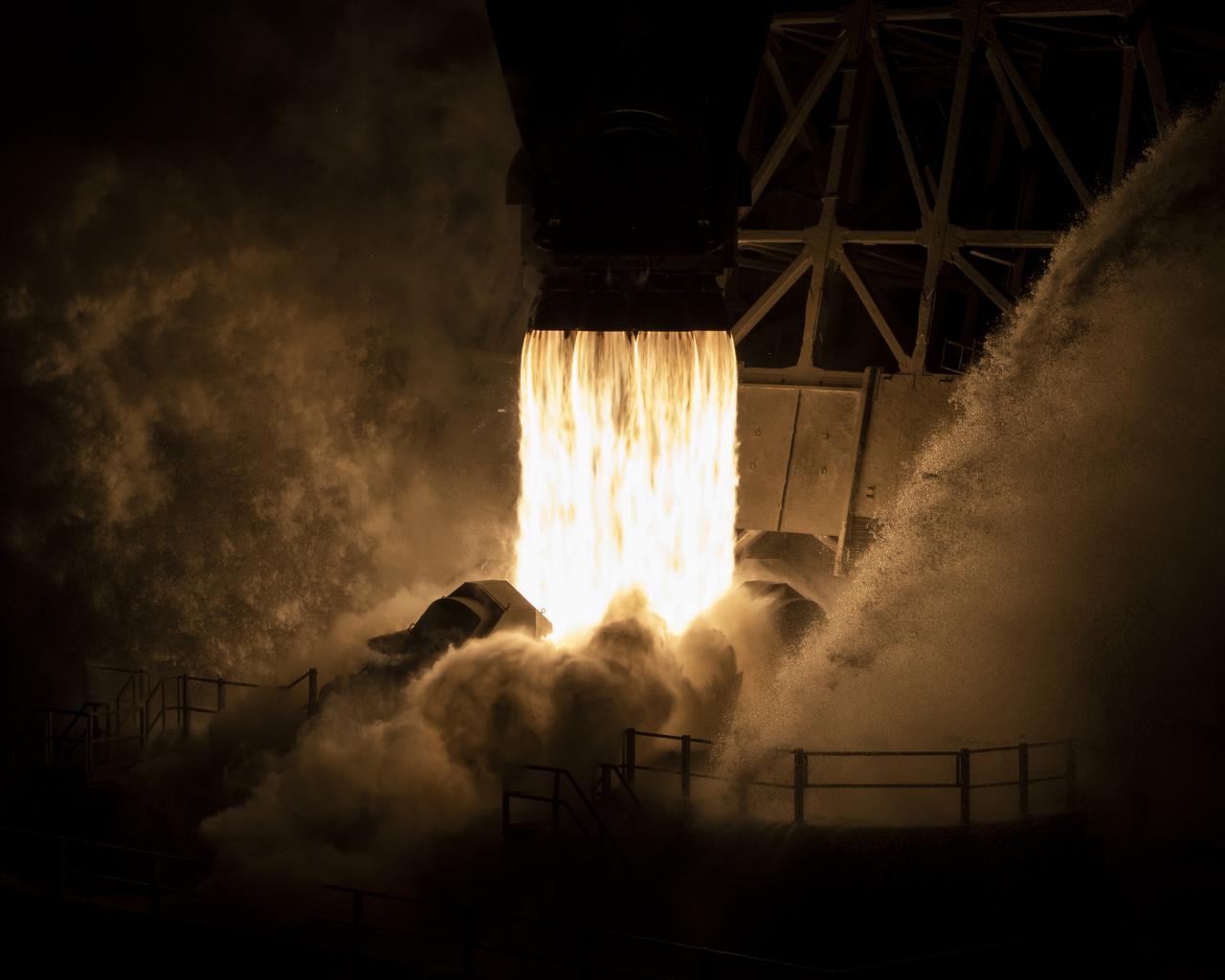
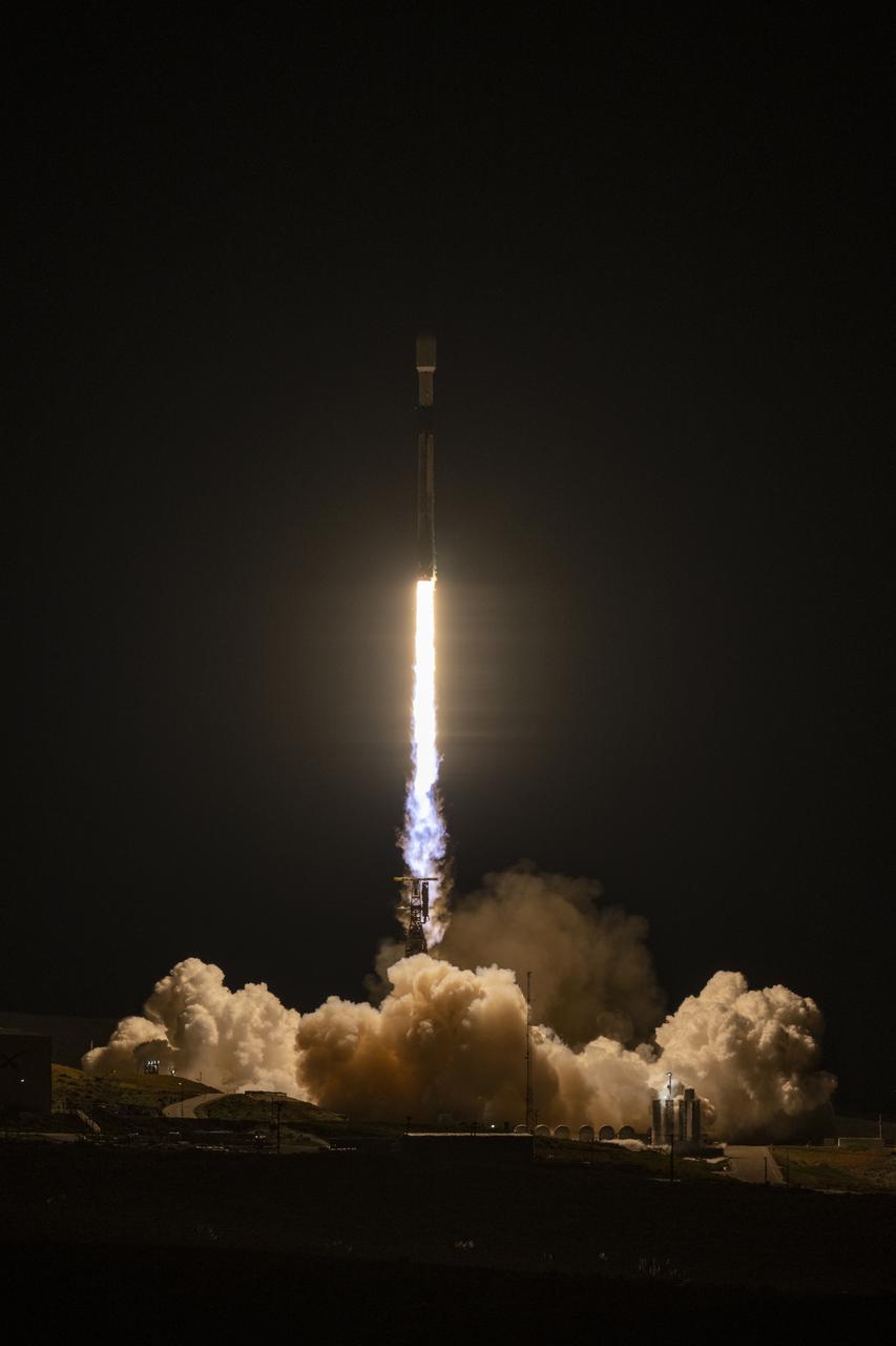
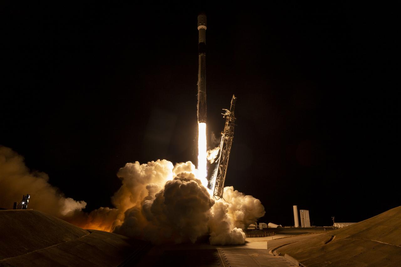
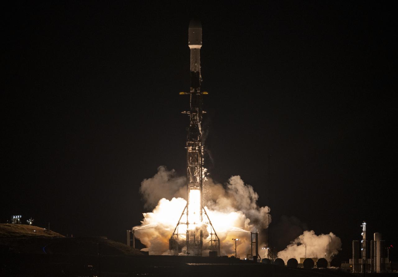
A SpaceX Falcon 9 rocket launches with the Surface Water and Ocean Topography (SWOT) spacecraft onboard, Friday, Dec. 16, 2022, from Space Launch Complex 4E at Vandenberg Space Force Base in California. Jointly developed by NASA and Centre National D'Etudes Spatiales (CNES), with contributions from the Canadian Space Agency (CSA) and United Kingdom Space Agency, SWOT is the first satellite mission that will observe nearly all water on Earth’s surface, measuring the height of water in the planet’s lakes, rivers, reservoirs, and the ocean. Photo Credit: (NASA/Keegan Barber)
A SpaceX Falcon 9 rocket with the Surface Water and Ocean Topography (SWOT) spacecraft onboard is seen as preparations for launch continue, Wednesday, Dec. 14, 2022, at Space Launch Complex 4E at Vandenberg Space Force Base in California. Jointly developed by NASA and Centre National D'Etudes Spatiales (CNES), with contributions from the Canadian Space Agency (CSA) and United Kingdom Space Agency, SWOT is the first satellite mission that will observe nearly all water on Earth’s surface, measuring the height of water in the planet’s lakes, rivers, reservoirs, and the ocean. Photo Credit: (NASA/Keegan Barber)
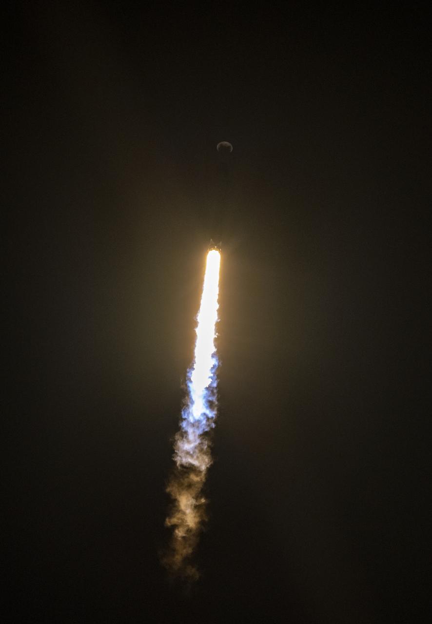
A SpaceX Falcon 9 rocket launches with the Surface Water and Ocean Topography (SWOT) spacecraft onboard, Friday, Dec. 16, 2022, from Space Launch Complex 4E at Vandenberg Space Force Base in California. Jointly developed by NASA and Centre National D'Etudes Spatiales (CNES), with contributions from the Canadian Space Agency (CSA) and United Kingdom Space Agency, SWOT is the first satellite mission that will observe nearly all water on Earth’s surface, measuring the height of water in the planet’s lakes, rivers, reservoirs, and the ocean. Photo Credit: (NASA/Keegan Barber)

A SpaceX Falcon 9 rocket launches with the Surface Water and Ocean Topography (SWOT) spacecraft onboard, Friday, Dec. 16, 2022, from Space Launch Complex 4E at Vandenberg Space Force Base in California. Jointly developed by NASA and Centre National D'Etudes Spatiales (CNES), with contributions from the Canadian Space Agency (CSA) and United Kingdom Space Agency, SWOT is the first satellite mission that will observe nearly all water on Earth’s surface, measuring the height of water in the planet’s lakes, rivers, reservoirs, and the ocean. Photo Credit: (NASA/Keegan Barber)
The U.S./European Jason-3 satellite has produced its first map of sea surface height, which corresponds well to data from its predecessor, Jason-2. Higher-than-normal sea levels are red; lower-than-normal sea levels are blue. El Niño is visible as the red blob in the eastern equatorial Pacific. Extending the timeline of ocean surface topography measurements begun by the Topex/Poseidon and Jason 1 and 2 satellites, Jason 3 will make highly detailed measurements of sea-level on Earth to gain insight into ocean circulation and climate change. http://photojournal.jpl.nasa.gov/catalog/PIA20532
A SpaceX Falcon 9 rocket with the Surface Water and Ocean Topography (SWOT) spacecraft onboard is seen as it rolls out to the pad, Tuesday, Dec. 13, 2022, at Space Launch Complex 4E at Vandenberg Space Force Base in California. Jointly developed by NASA and Centre National D'Etudes Spatiales (CNES), with contributions from the Canadian Space Agency (CSA) and United Kingdom Space Agency, SWOT is the first satellite mission that will observe nearly all water on Earth’s surface, measuring the height of water in the planet’s lakes, rivers, reservoirs, and the ocean. Photo Credit: (NASA/Keegan Barber)
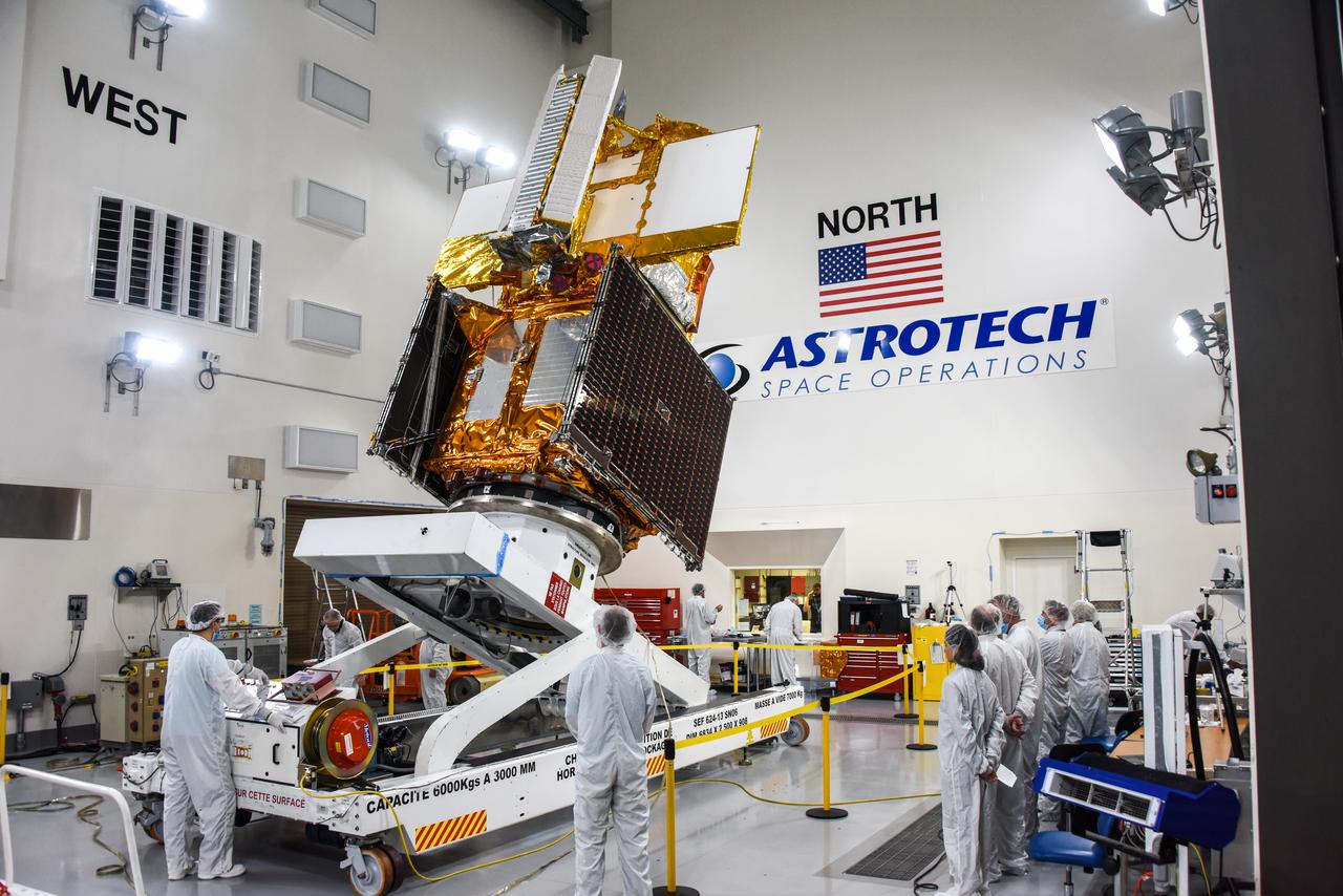
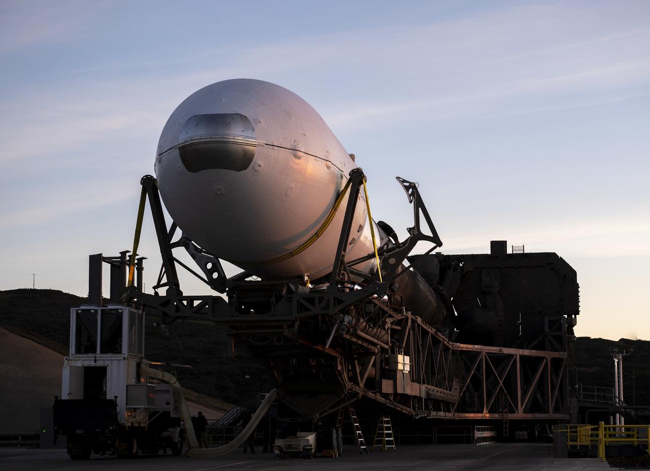
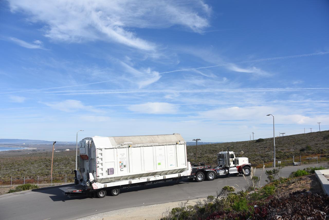
The Surface Water and Ocean Topography (SWOT) spacecraft is moved into a transport container inside the Astrotech facility at Vandenberg Space Force Base in California on Nov. 18, 2022. The satellite will be transported to the SpaceX facility at Vandenberg. SWOT is the first mission that will observe nearly all water on Earth’s surface, measuring the height of water in the planet’s lakes, rivers, reservoirs, and the ocean. It is set to launch aboard a SpaceX Falcon 9 rocket in December from Vandenberg’s Space Launch Center-4 East. NASA’s Launch Services Program, based at the agency’s Kennedy Space Center in Florida, is managing the launch service.

A container, with the Surface Water and Ocean Topography (SWOT) spacecraft inside, is moved to a trailer at the Astrotech facility at Vandenberg Space Force Base in California on Nov. 19, 2022. The satellite will be transported to the SpaceX facility at Vandenberg. SWOT is the first mission that will observe nearly all water on Earth’s surface, measuring the height of water in the planet’s lakes, rivers, reservoirs, and the ocean. It is set to launch aboard a SpaceX Falcon 9 rocket in December from Vandenberg’s Space Launch Center-4 East. NASA’s Launch Services Program, based at the agency’s Kennedy Space Center in Florida, is managing the launch service.
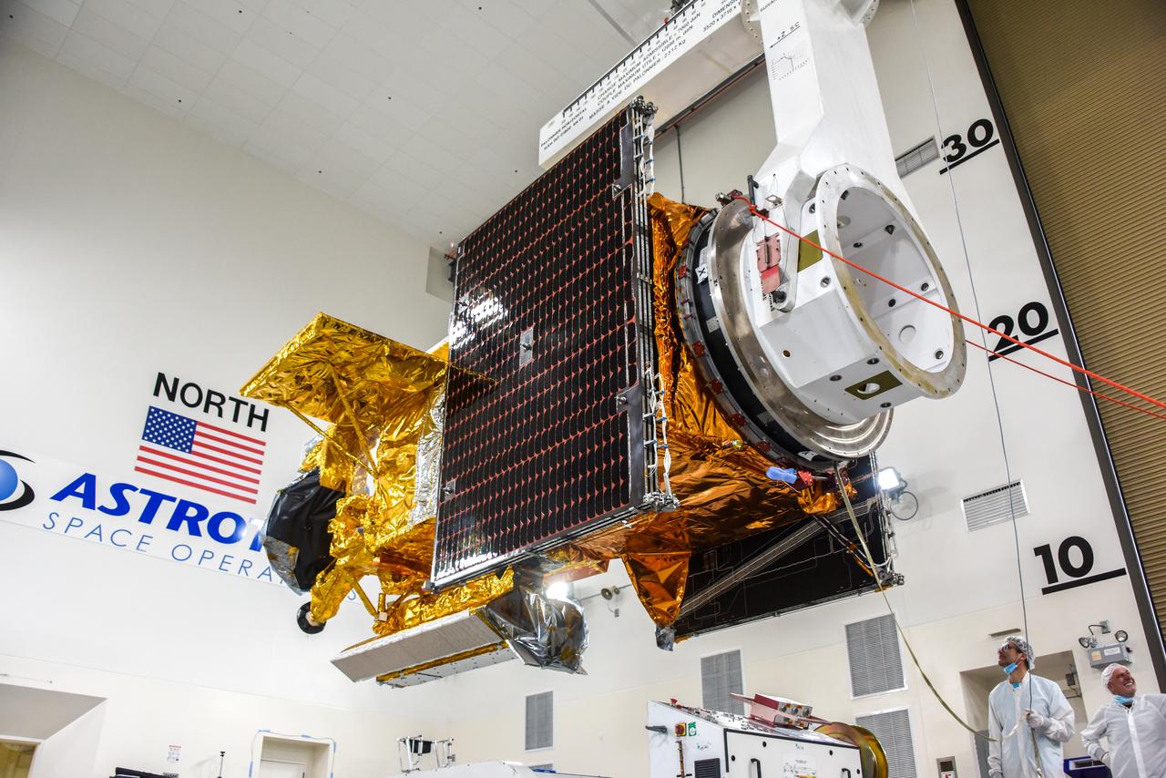
The Surface Water and Ocean Topography (SWOT) spacecraft is moved into a transport container inside the Astrotech facility at Vandenberg Space Force Base in California on Nov. 18, 2022. The satellite will be transported to the SpaceX facility at Vandenberg. SWOT is the first mission that will observe nearly all water on Earth’s surface, measuring the height of water in the planet’s lakes, rivers, reservoirs, and the ocean. It is set to launch aboard a SpaceX Falcon 9 rocket in December from Vandenberg’s Space Launch Center-4 East. NASA’s Launch Services Program, based at the agency’s Kennedy Space Center in Florida, is managing the launch service.

The Surface Water and Ocean Topography (SWOT) spacecraft is transported from Astrotech to the SpaceX facility at Vandenberg Space Force Base in California on Nov. 21, 2022. SWOT is the first mission that will observe nearly all water on Earth’s surface, measuring the height of water in the planet’s lakes, rivers, reservoirs, and the ocean. The satellite is set to launch aboard a SpaceX Falcon 9 rocket in December from Vandenberg’s Space Launch Center-4 East. NASA’s Launch Services Program, based at the agency’s Kennedy Space Center in Florida, is managing the launch service.
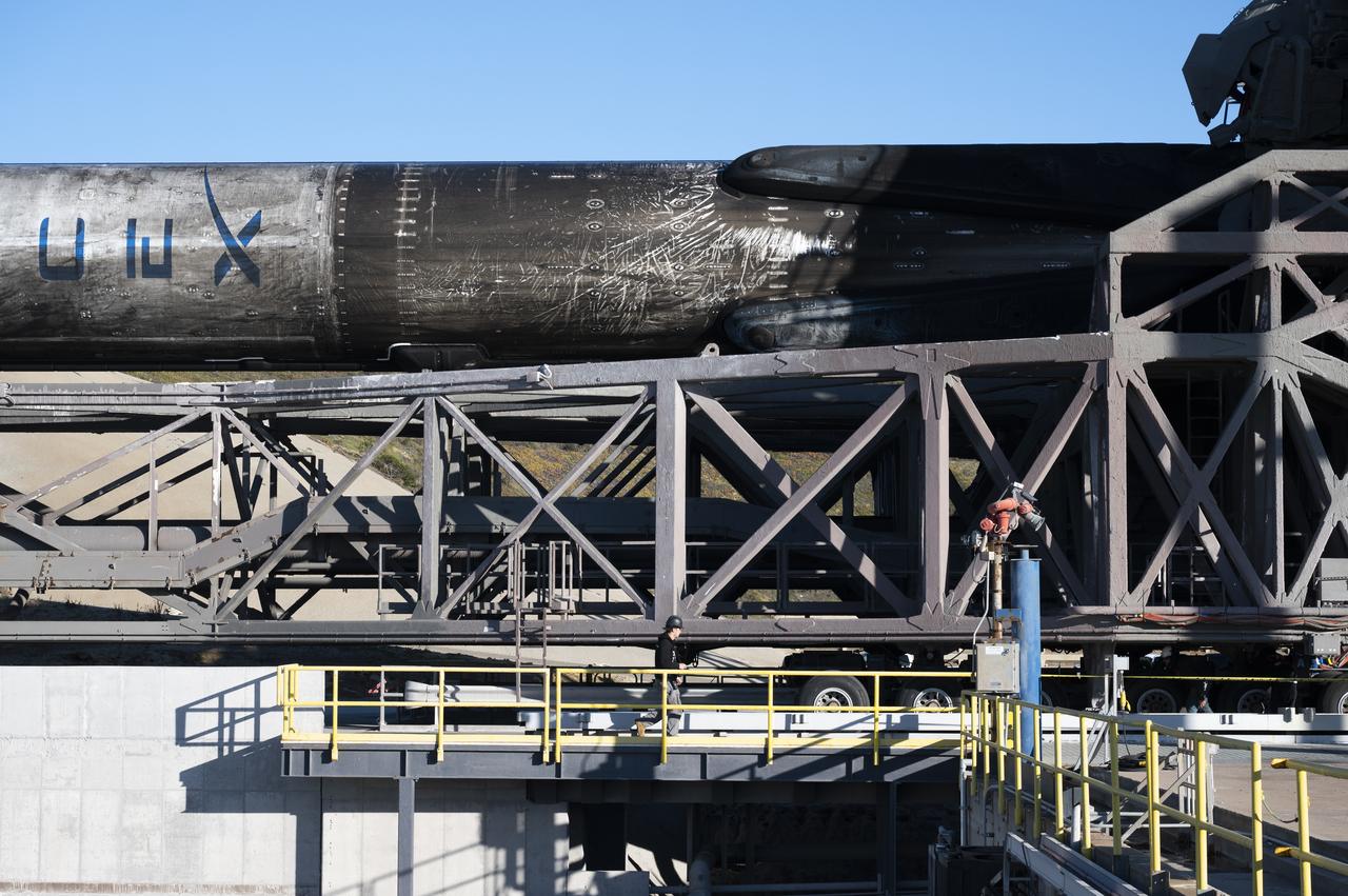
A SpaceX Falcon 9 first-stage booster returns to the landing pad following the launch of the Surface Water and Ocean Topography (SWOT) spacecraft, Friday, Dec. 16, 2022, from Space Launch Complex 4E at Vandenberg Space Force Base in California. Jointly developed by NASA and Centre National D'Etudes Spatiales (CNES), with contributions from the Canadian Space Agency (CSA) and United Kingdom Space Agency, SWOT is the first satellite mission that will observe nearly all water on Earth’s surface, measuring the height of water in the planet’s lakes, rivers, reservoirs, and the ocean. Photo Credit: (NASA/Keegan Barber)
A SpaceX Falcon 9 rocket with the Surface Water and Ocean Topography (SWOT) spacecraft onboard is seen as preparations for launch continue, Wednesday, Dec. 14, 2022, at Space Launch Complex 4E at Vandenberg Space Force Base in California. Jointly developed by NASA and Centre National D'Etudes Spatiales (CNES), with contributions from the Canadian Space Agency (CSA) and United Kingdom Space Agency, SWOT is the first satellite mission that will observe nearly all water on Earth’s surface, measuring the height of water in the planet’s lakes, rivers, reservoirs, and the ocean. Photo Credit: (NASA/Keegan Barber)
The Surface Water and Ocean Topography (SWOT) spacecraft is moved into a transport container inside the Astrotech facility at Vandenberg Space Force Base in California on Nov. 18, 2022. The satellite will be transported to the SpaceX facility at Vandenberg. SWOT is the first mission that will observe nearly all water on Earth’s surface, measuring the height of water in the planet’s lakes, rivers, reservoirs, and the ocean. It is set to launch aboard a SpaceX Falcon 9 rocket in December from Vandenberg’s Space Launch Center-4 East. NASA’s Launch Services Program, based at the agency’s Kennedy Space Center in Florida, is managing the launch service.
A SpaceX Falcon 9 rocket with the Surface Water and Ocean Topography (SWOT) spacecraft onboard is seen as it rolls out to the pad, Tuesday, Dec. 13, 2022, at Space Launch Complex 4E at Vandenberg Space Force Base in California. Jointly developed by NASA and Centre National D'Etudes Spatiales (CNES), with contributions from the Canadian Space Agency (CSA) and United Kingdom Space Agency, SWOT is the first satellite mission that will observe nearly all water on Earth’s surface, measuring the height of water in the planet’s lakes, rivers, reservoirs, and the ocean. Photo Credit: (NASA/Keegan Barber)
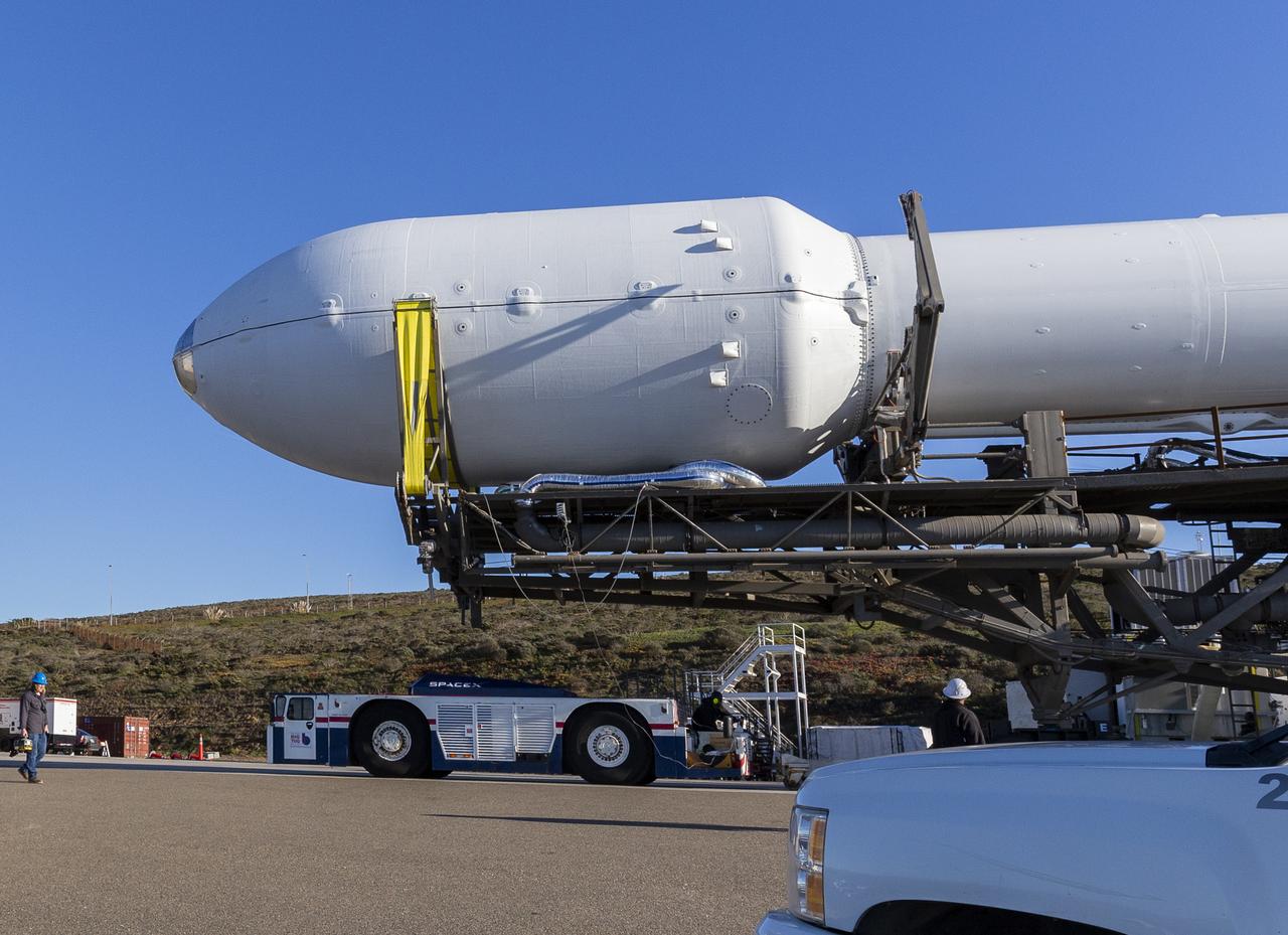
A SpaceX Falcon 9 rocket with the Surface Water and Ocean Topography (SWOT) spacecraft onboard is seen as it rolls out to the pad, Tuesday, Dec. 13, 2022, at Space Launch Complex 4E at Vandenberg Space Force Base in California. Jointly developed by NASA and Centre National D'Etudes Spatiales (CNES), with contributions from the Canadian Space Agency (CSA) and United Kingdom Space Agency, SWOT is the first satellite mission that will observe nearly all water on Earth’s surface, measuring the height of water in the planet’s lakes, rivers, reservoirs, and the ocean. Photo Credit: (NASA/Keegan Barber)
A SpaceX Falcon 9 rocket with the Surface Water and Ocean Topography (SWOT) spacecraft onboard is seen as preparations for launch continue, Wednesday, Dec. 14, 2022, at Space Launch Complex 4E at Vandenberg Space Force Base in California. Jointly developed by NASA and Centre National D'Etudes Spatiales (CNES), with contributions from the Canadian Space Agency (CSA) and United Kingdom Space Agency, SWOT is the first satellite mission that will observe nearly all water on Earth’s surface, measuring the height of water in the planet’s lakes, rivers, reservoirs, and the ocean. Photo Credit: (NASA/Keegan Barber)
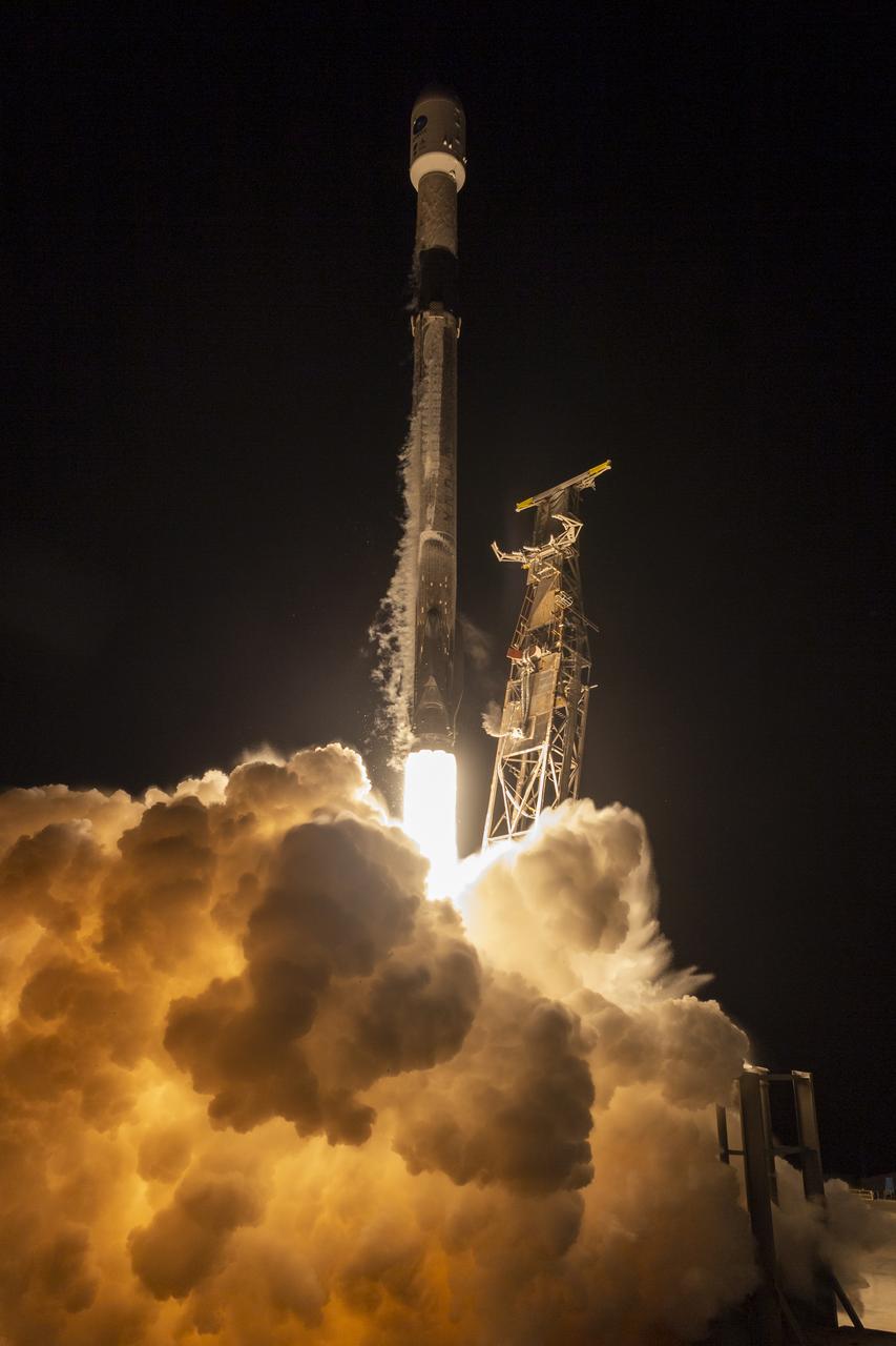
A SpaceX Falcon 9 rocket launches with the Surface Water and Ocean Topography (SWOT) spacecraft onboard, Friday, Dec. 16, 2022, from Space Launch Complex 4E at Vandenberg Space Force Base in California. Jointly developed by NASA and Centre National D'Etudes Spatiales (CNES), with contributions from the Canadian Space Agency (CSA) and United Kingdom Space Agency, SWOT is the first satellite mission that will observe nearly all water on Earth’s surface, measuring the height of water in the planet’s lakes, rivers, reservoirs, and the ocean. Photo Credit: (NASA/Keegan Barber)
A SpaceX Falcon 9 rocket launches with the Surface Water and Ocean Topography (SWOT) spacecraft onboard, Friday, Dec. 16, 2022, from Space Launch Complex 4E at Vandenberg Space Force Base in California. Jointly developed by NASA and Centre National D'Etudes Spatiales (CNES), with contributions from the Canadian Space Agency (CSA) and United Kingdom Space Agency, SWOT is the first satellite mission that will observe nearly all water on Earth’s surface, measuring the height of water in the planet’s lakes, rivers, reservoirs, and the ocean. Photo Credit: (NASA/Keegan Barber)
A SpaceX Falcon 9 rocket launches with the Surface Water and Ocean Topography (SWOT) spacecraft onboard, Friday, Dec. 16, 2022, from Space Launch Complex 4E at Vandenberg Space Force Base in California. Jointly developed by NASA and Centre National D'Etudes Spatiales (CNES), with contributions from the Canadian Space Agency (CSA) and United Kingdom Space Agency, SWOT is the first satellite mission that will observe nearly all water on Earth’s surface, measuring the height of water in the planet’s lakes, rivers, reservoirs, and the ocean. Photo Credit: (NASA/Keegan Barber)
A SpaceX Falcon 9 rocket launches with the Surface Water and Ocean Topography (SWOT) spacecraft onboard, Friday, Dec. 16, 2022, from Space Launch Complex 4E at Vandenberg Space Force Base in California. Jointly developed by NASA and Centre National D'Etudes Spatiales (CNES), with contributions from the Canadian Space Agency (CSA) and United Kingdom Space Agency, SWOT is the first satellite mission that will observe nearly all water on Earth’s surface, measuring the height of water in the planet’s lakes, rivers, reservoirs, and the ocean. Photo Credit: (NASA/Keegan Barber)
A SpaceX Falcon 9 rocket with the Surface Water and Ocean Topography (SWOT) spacecraft onboard is seen as preparations for launch continue, Wednesday, Dec. 14, 2022, at Space Launch Complex 4E at Vandenberg Space Force Base in California. Jointly developed by NASA and Centre National D'Etudes Spatiales (CNES), with contributions from the Canadian Space Agency (CSA) and United Kingdom Space Agency, SWOT is the first satellite mission that will observe nearly all water on Earth’s surface, measuring the height of water in the planet’s lakes, rivers, reservoirs, and the ocean. Photo Credit: (NASA/Keegan Barber)

The Surface Water and Ocean Topography (SWOT) spacecraft is transported from Astrotech to the SpaceX facility at Vandenberg Space Force Base in California on Nov. 21, 2022. SWOT is the first mission that will observe nearly all water on Earth’s surface, measuring the height of water in the planet’s lakes, rivers, reservoirs, and the ocean. The satellite is set to launch aboard a SpaceX Falcon 9 rocket in December from Vandenberg’s Space Launch Center-4 East. NASA’s Launch Services Program, based at the agency’s Kennedy Space Center in Florida, is managing the launch service.
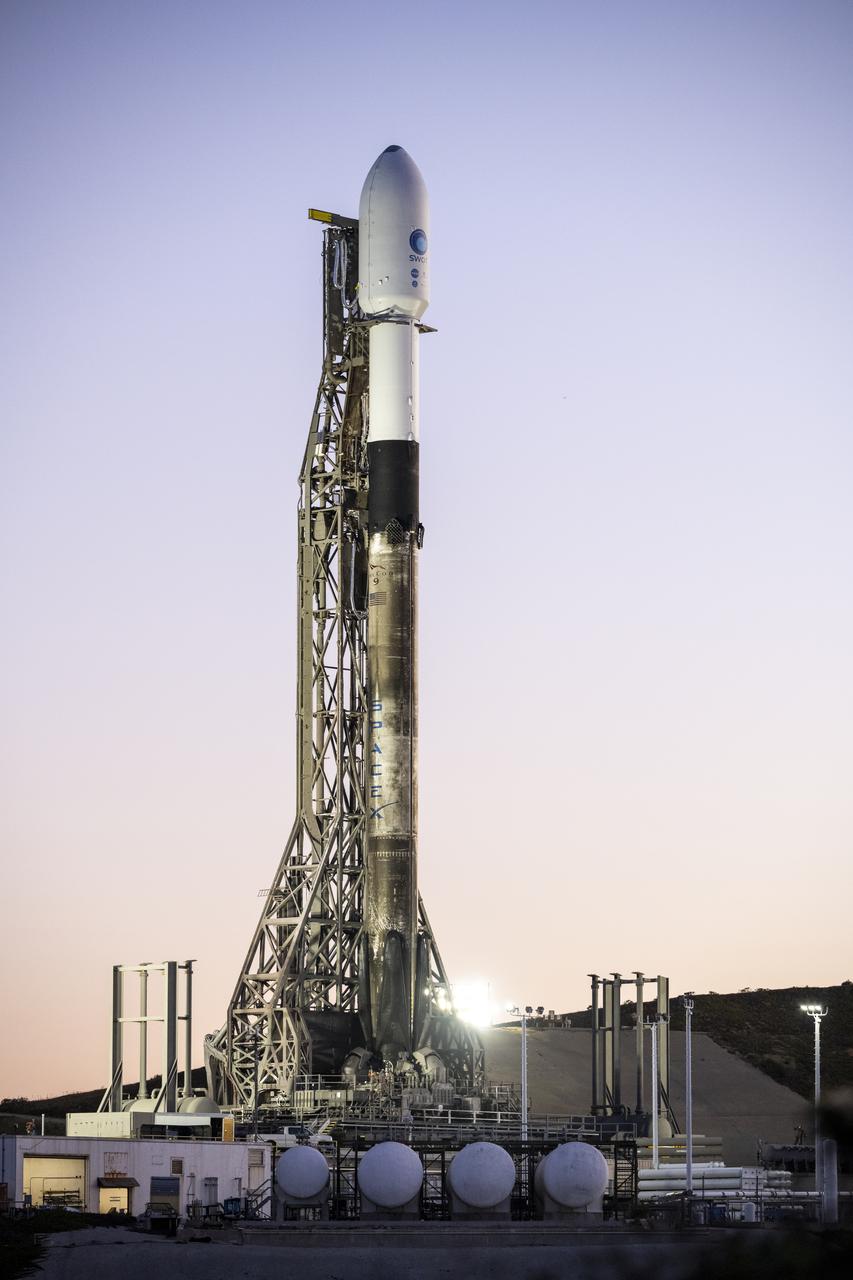
A SpaceX Falcon 9 rocket with the Surface Water and Ocean Topography (SWOT) spacecraft onboard is seen as preparations for launch continue, Wednesday, Dec. 14, 2022, at Space Launch Complex 4E at Vandenberg Space Force Base in California. Jointly developed by NASA and Centre National D'Etudes Spatiales (CNES), with contributions from the Canadian Space Agency (CSA) and United Kingdom Space Agency, SWOT is the first satellite mission that will observe nearly all water on Earth’s surface, measuring the height of water in the planet’s lakes, rivers, reservoirs, and the ocean. Photo Credit: (NASA/Keegan Barber)
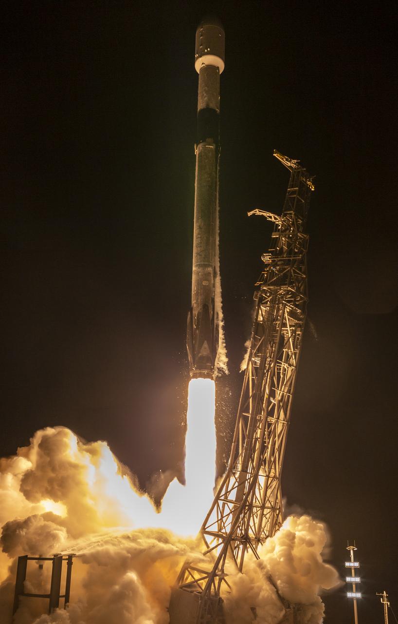
A SpaceX Falcon 9 rocket launches with the Surface Water and Ocean Topography (SWOT) spacecraft onboard, Friday, Dec. 16, 2022, from Space Launch Complex 4E at Vandenberg Space Force Base in California. Jointly developed by NASA and Centre National D'Etudes Spatiales (CNES), with contributions from the Canadian Space Agency (CSA) and United Kingdom Space Agency, SWOT is the first satellite mission that will observe nearly all water on Earth’s surface, measuring the height of water in the planet’s lakes, rivers, reservoirs, and the ocean. Photo Credit: (NASA/Keegan Barber)

A SpaceX Falcon 9 rocket launches with the Surface Water and Ocean Topography (SWOT) spacecraft onboard, Friday, Dec. 16, 2022, from Space Launch Complex 4E at Vandenberg Space Force Base in California. Jointly developed by NASA and Centre National D'Etudes Spatiales (CNES), with contributions from the Canadian Space Agency (CSA) and United Kingdom Space Agency, SWOT is the first satellite mission that will observe nearly all water on Earth’s surface, measuring the height of water in the planet’s lakes, rivers, reservoirs, and the ocean. Photo Credit: (NASA/Keegan Barber)
A SpaceX Falcon 9 rocket with the Surface Water and Ocean Topography (SWOT) spacecraft onboard is seen as preparations for launch continue, Wednesday, Dec. 14, 2022, at Space Launch Complex 4E at Vandenberg Space Force Base in California. Jointly developed by NASA and Centre National D'Etudes Spatiales (CNES), with contributions from the Canadian Space Agency (CSA) and United Kingdom Space Agency, SWOT is the first satellite mission that will observe nearly all water on Earth’s surface, measuring the height of water in the planet’s lakes, rivers, reservoirs, and the ocean. Photo Credit: (NASA/Keegan Barber)
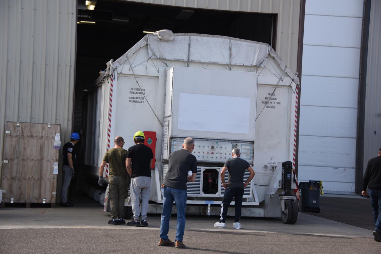
The Surface Water and Ocean Topography (SWOT) spacecraft is transported from Astrotech to the SpaceX facility at Vandenberg Space Force Base in California on Nov. 21, 2022. SWOT is the first mission that will observe nearly all water on Earth’s surface, measuring the height of water in the planet’s lakes, rivers, reservoirs, and the ocean. The satellite is set to launch aboard a SpaceX Falcon 9 rocket in December from Vandenberg’s Space Launch Center-4 East. NASA’s Launch Services Program, based at the agency’s Kennedy Space Center in Florida, is managing the launch service.

A SpaceX Falcon 9 rocket launches with the Surface Water and Ocean Topography (SWOT) spacecraft onboard, Friday, Dec. 16, 2022, from Space Launch Complex 4E at Vandenberg Space Force Base in California. Jointly developed by NASA and Centre National D'Etudes Spatiales (CNES), with contributions from the Canadian Space Agency (CSA) and United Kingdom Space Agency, SWOT is the first satellite mission that will observe nearly all water on Earth’s surface, measuring the height of water in the planet’s lakes, rivers, reservoirs, and the ocean. Photo Credit: (NASA/Keegan Barber)
A SpaceX Falcon 9 rocket with the Surface Water and Ocean Topography (SWOT) spacecraft onboard is seen as preparations for launch continue, Wednesday, Dec. 14, 2022, at Space Launch Complex 4E at Vandenberg Space Force Base in California. Jointly developed by NASA and Centre National D'Etudes Spatiales (CNES), with contributions from the Canadian Space Agency (CSA) and United Kingdom Space Agency, SWOT is the first satellite mission that will observe nearly all water on Earth’s surface, measuring the height of water in the planet’s lakes, rivers, reservoirs, and the ocean. Photo Credit: (NASA/Keegan Barber)
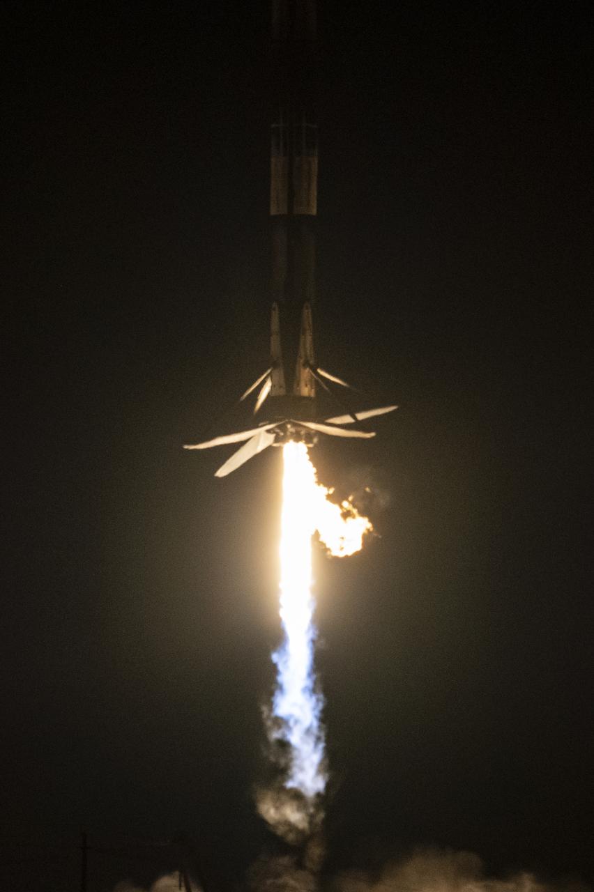
A SpaceX Falcon 9 first-stage booster returns to the landing pad following the launch of the Surface Water and Ocean Topography (SWOT) spacecraft, Friday, Dec. 16, 2022, from Space Launch Complex 4E at Vandenberg Space Force Base in California. Jointly developed by NASA and Centre National D'Etudes Spatiales (CNES), with contributions from the Canadian Space Agency (CSA) and United Kingdom Space Agency, SWOT is the first satellite mission that will observe nearly all water on Earth’s surface, measuring the height of water in the planet’s lakes, rivers, reservoirs, and the ocean. Photo Credit: (NASA/Keegan Barber)
A SpaceX Falcon 9 rocket with the Surface Water and Ocean Topography (SWOT) spacecraft onboard is seen as it rolls out to the pad, Tuesday, Dec. 13, 2022, at Space Launch Complex 4E at Vandenberg Space Force Base in California. Jointly developed by NASA and Centre National D'Etudes Spatiales (CNES), with contributions from the Canadian Space Agency (CSA) and United Kingdom Space Agency, SWOT is the first satellite mission that will observe nearly all water on Earth’s surface, measuring the height of water in the planet’s lakes, rivers, reservoirs, and the ocean. Photo Credit: (NASA/Keegan Barber)
The Surface Water and Ocean Topography (SWOT) spacecraft is moved into a transport container inside the Astrotech facility at Vandenberg Space Force Base in California on Nov. 18, 2022. The satellite will be transported to the SpaceX facility at Vandenberg. SWOT is the first mission that will observe nearly all water on Earth’s surface, measuring the height of water in the planet’s lakes, rivers, reservoirs, and the ocean. It is set to launch aboard a SpaceX Falcon 9 rocket in December from Vandenberg’s Space Launch Center-4 East. NASA’s Launch Services Program, based at the agency’s Kennedy Space Center in Florida, is managing the launch service.
The Surface Water and Ocean Topography (SWOT) spacecraft is transported from Astrotech to the SpaceX facility at Vandenberg Space Force Base in California on Nov. 21, 2022. SWOT is the first mission that will observe nearly all water on Earth’s surface, measuring the height of water in the planet’s lakes, rivers, reservoirs, and the ocean. The satellite is set to launch aboard a SpaceX Falcon 9 rocket in December from Vandenberg’s Space Launch Center-4 East. NASA’s Launch Services Program, based at the agency’s Kennedy Space Center in Florida, is managing the launch service.
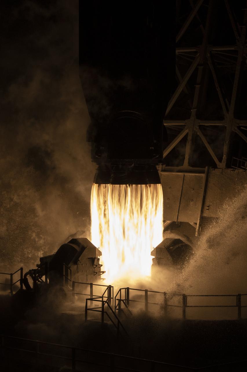
A SpaceX Falcon 9 rocket launches with the Surface Water and Ocean Topography (SWOT) spacecraft onboard, Friday, Dec. 16, 2022, from Space Launch Complex 4E at Vandenberg Space Force Base in California. Jointly developed by NASA and Centre National D'Etudes Spatiales (CNES), with contributions from the Canadian Space Agency (CSA) and United Kingdom Space Agency, SWOT is the first satellite mission that will observe nearly all water on Earth’s surface, measuring the height of water in the planet’s lakes, rivers, reservoirs, and the ocean. Photo Credit: (NASA/Keegan Barber)
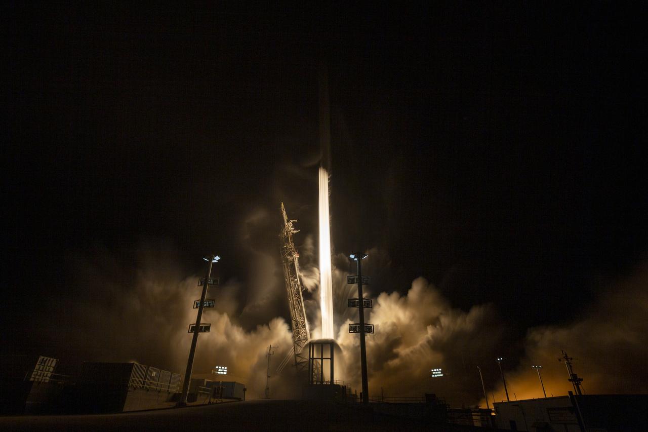
In this 30 second exposure, A SpaceX Falcon 9 rocket launches with the Surface Water and Ocean Topography (SWOT) spacecraft onboard, Friday, Dec. 16, 2022, from Space Launch Complex 4E at Vandenberg Space Force Base in California. Jointly developed by NASA and Centre National D'Etudes Spatiales (CNES), with contributions from the Canadian Space Agency (CSA) and United Kingdom Space Agency, SWOT is the first satellite mission that will observe nearly all water on Earth’s surface, measuring the height of water in the planet’s lakes, rivers, reservoirs, and the ocean. Photo Credit: (NASA/Keegan Barber)
The Surface Water and Ocean Topography (SWOT) spacecraft is moved into a transport container inside the Astrotech facility at Vandenberg Space Force Base in California on Nov. 18, 2022. The satellite will be transported to the SpaceX facility at Vandenberg. SWOT is the first mission that will observe nearly all water on Earth’s surface, measuring the height of water in the planet’s lakes, rivers, reservoirs, and the ocean. It is set to launch aboard a SpaceX Falcon 9 rocket in December from Vandenberg’s Space Launch Center-4 East. NASA’s Launch Services Program, based at the agency’s Kennedy Space Center in Florida, is managing the launch service.

A SpaceX Falcon 9 rocket launches with the Surface Water and Ocean Topography (SWOT) spacecraft onboard, Friday, Dec. 16, 2022, from Space Launch Complex 4E at Vandenberg Space Force Base in California. Jointly developed by NASA and Centre National D'Etudes Spatiales (CNES), with contributions from the Canadian Space Agency (CSA) and United Kingdom Space Agency, SWOT is the first satellite mission that will observe nearly all water on Earth’s surface, measuring the height of water in the planet’s lakes, rivers, reservoirs, and the ocean. Photo Credit: (NASA/Keegan Barber)

A container, with the Surface Water and Ocean Topography (SWOT) spacecraft inside, is moved to a trailer at the Astrotech facility at Vandenberg Space Force Base in California on Nov. 19, 2022. The satellite will be transported to the SpaceX facility at Vandenberg. SWOT is the first mission that will observe nearly all water on Earth’s surface, measuring the height of water in the planet’s lakes, rivers, reservoirs, and the ocean. It is set to launch aboard a SpaceX Falcon 9 rocket in December from Vandenberg’s Space Launch Center-4 East. NASA’s Launch Services Program, based at the agency’s Kennedy Space Center in Florida, is managing the launch service.
A SpaceX Falcon 9 rocket launches with the Surface Water and Ocean Topography (SWOT) spacecraft onboard, Friday, Dec. 16, 2022, from Space Launch Complex 4E at Vandenberg Space Force Base in California. Jointly developed by NASA and Centre National D'Etudes Spatiales (CNES), with contributions from the Canadian Space Agency (CSA) and United Kingdom Space Agency, SWOT is the first satellite mission that will observe nearly all water on Earth’s surface, measuring the height of water in the planet’s lakes, rivers, reservoirs, and the ocean. Photo Credit: (NASA/Keegan Barber)
The Surface Water and Ocean Topography (SWOT) spacecraft is transported from Astrotech to the SpaceX facility at Vandenberg Space Force Base in California on Nov. 21, 2022. SWOT is the first mission that will observe nearly all water on Earth’s surface, measuring the height of water in the planet’s lakes, rivers, reservoirs, and the ocean. The satellite is set to launch aboard a SpaceX Falcon 9 rocket in December from Vandenberg’s Space Launch Center-4 East. NASA’s Launch Services Program, based at the agency’s Kennedy Space Center in Florida, is managing the launch service.
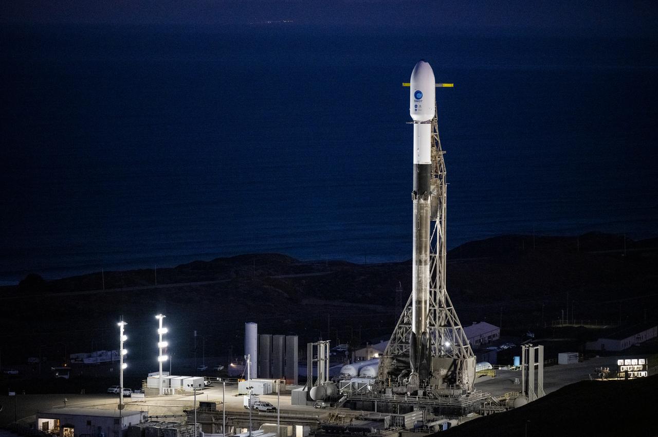
A SpaceX Falcon 9 rocket with the Surface Water and Ocean Topography (SWOT) spacecraft onboard is seen as preparations for launch continue, Wednesday, Dec. 14, 2022, at Space Launch Complex 4E at Vandenberg Space Force Base in California. Jointly developed by NASA and Centre National D'Etudes Spatiales (CNES), with contributions from the Canadian Space Agency (CSA) and United Kingdom Space Agency, SWOT is the first satellite mission that will observe nearly all water on Earth’s surface, measuring the height of water in the planet’s lakes, rivers, reservoirs, and the ocean. Photo Credit: (NASA/Keegan Barber)