The latest image of sea-surface height measurements from NASA U.S./French Jason-1 oceanography satellite shows the Pacific Ocean remains locked in a strong, cool phase of the Pacific Decadal Oscillation.
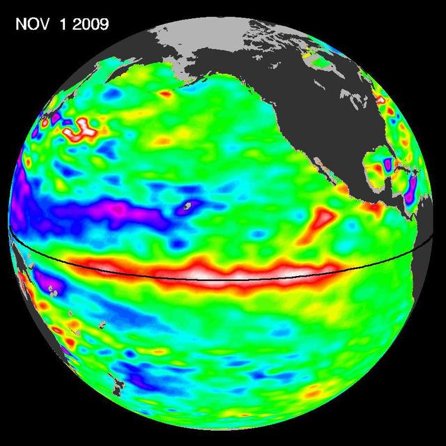
The most recent sea-level height data from the NASA/European Ocean Surface Topography Mission/Jason-2 oceanography satellite show the continued eastward progression of a strong wave of warm water, known as a Kelvin wave, now approaching South America.
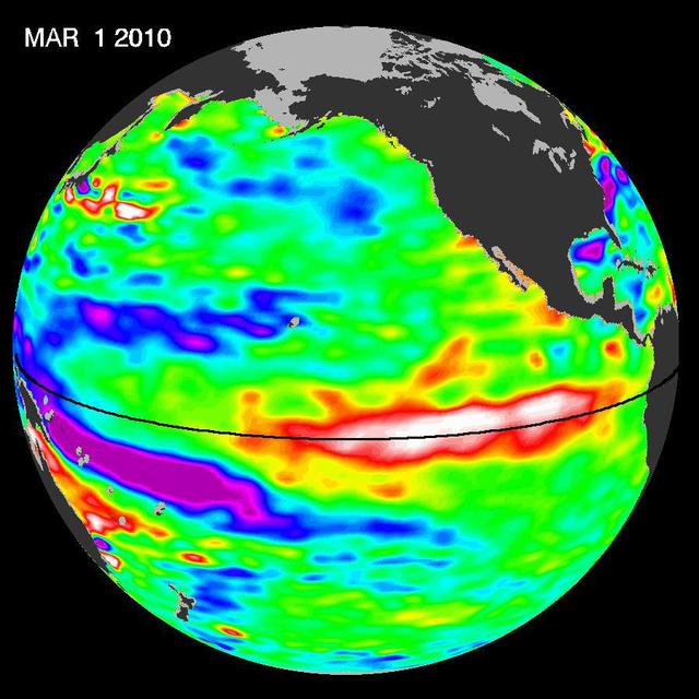
Recent sea-level height data from NASA Jason-2 oceanography satellite show a weakening of trade winds in western and central equatorial Pacific during late-January through February has triggered yet another strong, eastward-moving Kelvin wave.
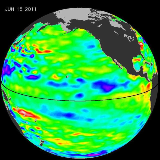
The latest image of Pacific Ocean sea surface heights from the NASA OSTIM/Jason-2 oceanography satellite, on June 11, 2010, shows that Pacific has switched from warm red to cold blue during the last few months.
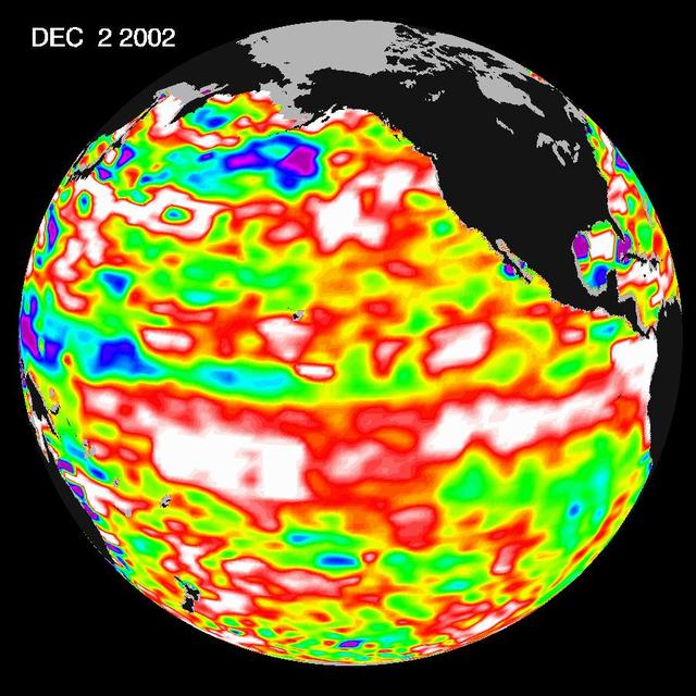
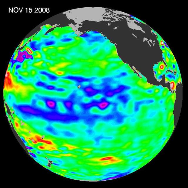
The latest image from NASA Jason oceanography satellite, taken during a 10-day collection cycle ending December 2, 2002, shows the Pacific dominated by two significant areas of higher-than-normal sealevel warmer ocean temperatures.
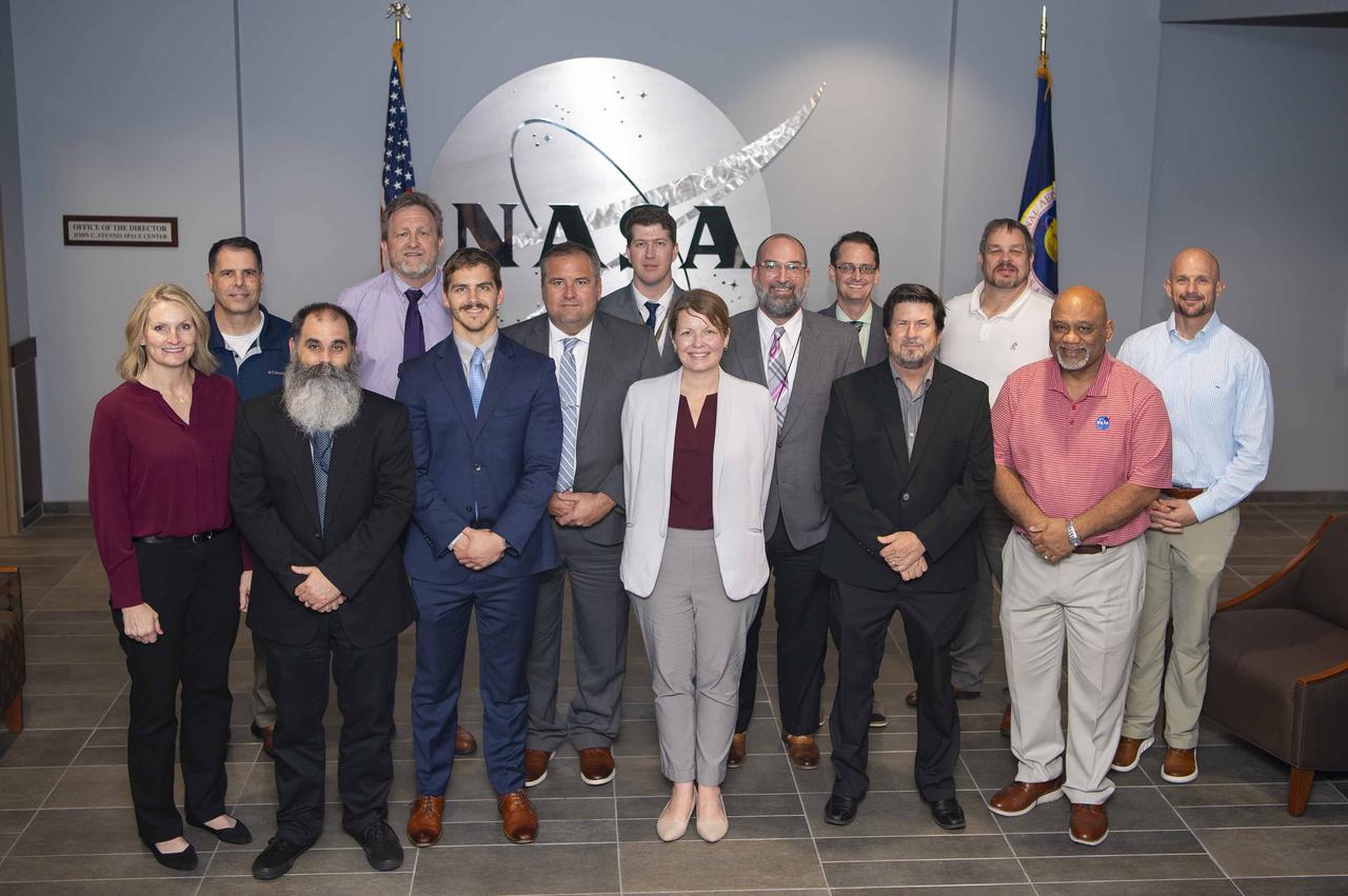
U.S. Navy officials visited with NASA Stennis leaders Nov. 13 for a meet-and-greet opportunity, also receiving an overview briefing about the work and operations of south Mississippi site. Participants in the gathering included (left to right): Anita Harrell, executive director of the NASA Shared Services Center; Joe Schuyler, director of the NASA Stennis Engineering and Test Directorate; Herschel Mims, a management support specialist with the Naval Oceanography Operations Command; Rodney McKellip, NASA Stennis associate director; Francis Prikasky, an electronics engineer and information technology administrator with the Naval Oceanographic Office; Robert Gavagnie, a contract specialist with the Naval Oceanographic Office; James “Brett” English, information systems security manager with the Naval Meteorology and Oceanography Command; Dr. Brooke Jones, head of the Ocean Forecasting Division for the Fleet Numerical Meteorology and Oceanography Center; Maxwell Williamson, a physical scientists with the Naval Oceanographic Office; Dr. Benjamin Phrampus, a research geophysicist with the Naval Research Laboratory; Gary Benton, director of the NASA Stennis Safety and Mission Assurance Directorate; Thom Rich, associate director of the NASA Stennis Center Operations Directorate; Ken Newton, director of service delivery for the NASA Shared Services Center; and Eli Ouder, director of the NASA Stennis/NASA Shared Services Center Office of Procurement.
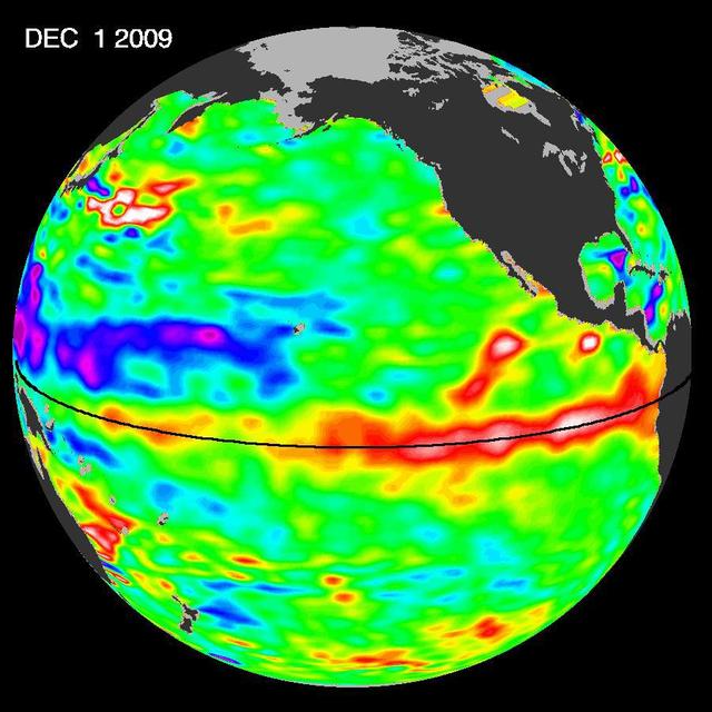
ElNi?o is experiencing a late-fall resurgence. Sea-level height data from the NASA/European Ocean Surface Topography Mission/Jason-2 oceanography satellite show the equatorial Pacific has triggered a wave of warm water, known as a Kelvin wave.

At the Hurricane Katrina observance held Aug. 29 in the StenniSphere auditorium, Stennis Space Center Deputy Director David Throckmorton (left) and RAdm. Timothy McGee, Commander, Naval Meteorology and Oceanography Command, unveil a plaque dedicated to SSC employees.

Stennis Space Center Director Patrick Scheuermann (right) and Naval Meteorology and Oceanography Command Chief of Staff James Pettigrew drop the first shovelfuls of dirt on a time capsule to be opened on the rocket engine test facility's 100th anniversary in 2061. The time capsule was placed in front of the Roy S. Estess Building on Oct. 25 as Stennis concluded celebrations of its 50th anniversary. NASA publicly announced plans to build the rocket engine test site Oct. 25, 1961.

StenniSphere, the John C. Stennis Space Center's visitor center in Hancock County, Miss., features a 14,000-square-foot museum and outdoor exhibits about Stennis Space Center. Designed to entertain while educating, StenniSphere includes informative displays and exhibits from NASA, the Naval Meteorology and Oceanography Command, and other resident agencies. Recently named Mississippi's Travel Attraction of the Year, StenniSphere hosted a quarter of a million visitors in its first year and is a major school field trip destination.

Stennis Space Center Director Patrick Scheuermann (right) and Naval Meteorology and Oceanography Command Chief of Staff James Pettigrew drop the first shovelfuls of dirt on a time capsule to be opened on the rocket engine test facility's 100th anniversary in 2061. The time capsule was placed in front of the Roy S. Estess Building on Oct. 25 as Stennis concluded celebrations of its 50th anniversary.

The John C. Stennis Space Center's visitor center, StenniSphere, is one of Mississippi's leading tourist attractions and features a 14,000-square-foot interactive review of Stennis Space Center's role in America's space program. Designed to entertain while educating, StenniSphere includes informative displays and exhibits from NASA, the Naval Meteorology and Oceanography Command, and other resident agencies located at Stennis Space Center in Hancock County, Miss.

Helen Fricker, ICESat-2 Science Definition Team Member, Scripps Institution of Oceanography, is seen during a NASA Ice, Cloud and land Elevation Satellite-2 (ICESat-2) prelaunch briefing, Thursday, Sept. 13, 2018, at Vandenberg Air Force Base in California. The ICESat-2 mission will measure the changing height of Earth's ice. Photo Credit: (NASA/Bill Ingalls)

Victoria Webb (center) discusses African-American history during a Black History Month program for John C. Stennis Space Center employees on Feb. 16. Webb, a 103-year-old native of Pass Christian, was guest speaker for the program, sponsored by the Stennis Diversity Council and the Naval Meteorology and Oceanography Command. She was joined in her presentation by Valli Battle (left), a NAVOCEANO employee at Stennis, and friend Jeanell Barnes. Black History Month was first observed in 1976 and is celebrated each February. The 2011 theme was African-Americans and the Civil War.

Lori Magruder, ICESat-2 Science Definition Team Lead, University of Texas, left, Tom Neumann, ICESat-2 Deputy Project Scientist, NASA's Goddard Space Flight Center, and Helen Fricker, ICESat-2 Science Definition Team Member, Scripps Institution of Oceanography, are seen during a NASA Ice, Cloud and land Elevation Satellite-2 (ICESat-2) prelaunch briefing, Thursday, Sept. 13, 2018, at Vandenberg Air Force Base in California. The ICESat-2 mission will measure the changing height of Earth's ice. Photo Credit: (NASA/Bill Ingalls)
NASA Physical Oceanography Program Scientist Eric Lindstrom talks about the instruments onboard the Woods Hole Oceanographic Institution research vessel Knorr on Tuesday, Sept. 4, 2012, in Woods Hole, Mass. Various scientific instruments will be deployed in the Atlantic Ocean as part of the Salinity Processes in the Upper Ocean Regional Study (SPURS) which is set to sail on Sept. 6. The NASA-sponsored expedition will sail to the North Atlantic's saltiest spot to get a detailed, 3-D picture of how salt content fluctuates in the ocean's upper layers and how these variations are related to shifts in rainfall patterns around the planet. Photo Credit: (NASA/Bill Ingalls)
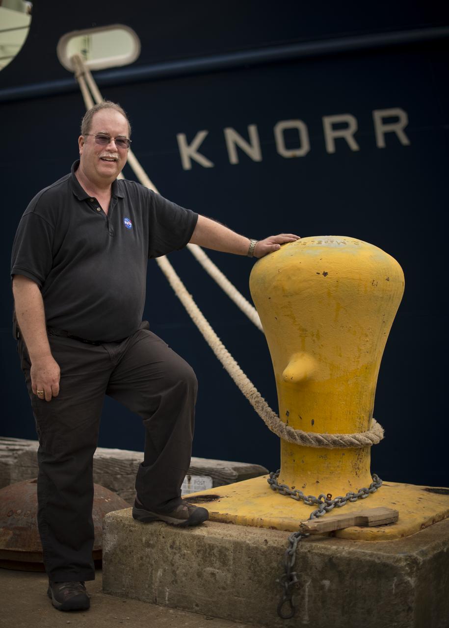
NASA Physical Oceanography Program Scientist Eric Lindstrom poses for a photograph next to the Woods Hole Oceanographic Institution research vessel Knorr on Tuesday, Sept. 4, 2012, in Woods Hole, Mass. Lindstrom will depart on Knorr Sept. 6 to take part in the Salinity Processes in the Upper Ocean Regional Study (SPURS). The NASA-sponsored expedition will sail to the North Atlantic's saltiest spot to get a detailed, 3-D picture of how salt content fluctuates in the ocean's upper layers and how these variations are related to shifts in rainfall patterns around the planet. Photo Credit: (NASA/Bill Ingalls)

NASA John C. Stennis Space Center employees observed Women's History Month on March 17 with a panel discussion that featured accomplished women of the facility. The gathering featured (l to r): Pam Covington, manager of the NASA Office of External Affairs at Stennis; Mary Jones, assistant chief of staff with the Navy Meterology & Oceanography Command; and Lauren Underwood, senior research scientist with Science Systems and Applications, Inc. In addition to the panel discussion, the Stennis Diversity Council and Patriot Technologies also hosted a pair of 'lunch-and-learn' sessions focused on women's issues and history. The luncheons featured videos on Sally Hemings, the slave widely recognized as the mistress of President Thomas Jefferson; and several mothers of U.S. presidents.

The dedication ceremony of the University of Southern Mississippi Center of Higher Learning (CHL) High-Performance Visualization Center at SSC was held Oct. 17. The center's RAVE II 3-D visualization system, available to both on- and off-site scientists, turns data into a fully immersive environment for the user. Cutting the ribbon are, from left, Rear Adm. Thomas Donaldson, commander of the Naval Meteorology and Oceanography Command; Jim Meredith, former director of the CHL; USM President Dr. Shelby Thames; Lt. Gov. Amy Tuck; Dr. Peter Ranelli, director of the CHL; Dewey Herring, chairman of the policy board for the CHL; and former Sen. Cecil Burge.
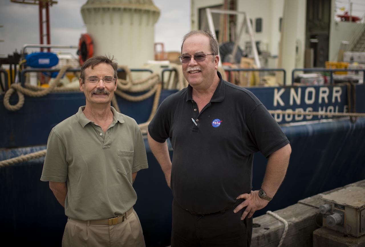
Woods Hole Oceanographic Institution Senior Scientist Ray Schmitt, left, and NASA Physical Oceanography Program Scientist Eric Lindstrom pose for a photograph in front of the Institution's research vessel Knorr on Tuesday, Sept. 4, 2012, in Woods Hole, Mass. Knorr is scheduled to depart on Sept. 6 to take part in the Salinity Processes in the Upper Ocean Regional Study (SPURS). The NASA-sponsored expedition will sail to the North Atlantic's saltiest spot to get a detailed, 3-D picture of how salt content fluctuates in the ocean's upper layers and how these variations are related to shifts in rainfall patterns around the planet. Photo Credit: (NASA/Bill Ingalls)

NASA Physical Oceanography Program Scientist Eric Lindstrom inspects an autonomous wave glider onboard the Woods Hole Oceanographic Institution research vessel Knorr on Tuesday, Sept. 4, 2012, in Woods Hole, Mass. The autonomous gliders will be deployed in the Atlantic Ocean as part of the Salinity Processes in the Upper Ocean Regional Study (SPURS) which is set to sail on Sept. 6. The NASA-sponsored expedition will sail to the North Atlantic's saltiest spot to get a detailed, 3-D picture of how salt content fluctuates in the ocean's upper layers and how these variations are related to shifts in rainfall patterns around the planet. Photo Credit: (NASA/Bill Ingalls)
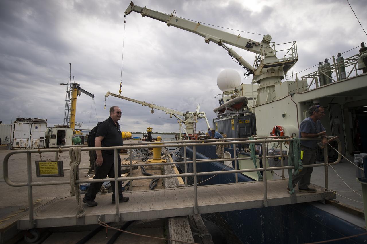
NASA Physical Oceanography Program Scientist Eric Lindstrom boards the Woods Hole Oceanographic Institution's research vessel Knorr on Tuesday, Sept. 4, 2012, in Woods Hole, Mass. Lindstrom will depart on Knorr Sept. 6 to take part in the Salinity Processes in the Upper Ocean Regional Study (SPURS). The NASA-sponsored expedition will sail to the North Atlantic's saltiest spot to get a detailed, 3-D picture of how salt content fluctuates in the ocean's upper layers and how these variations are related to shifts in rainfall patterns around the planet. Photo Credit: (NASA/Bill Ingalls)
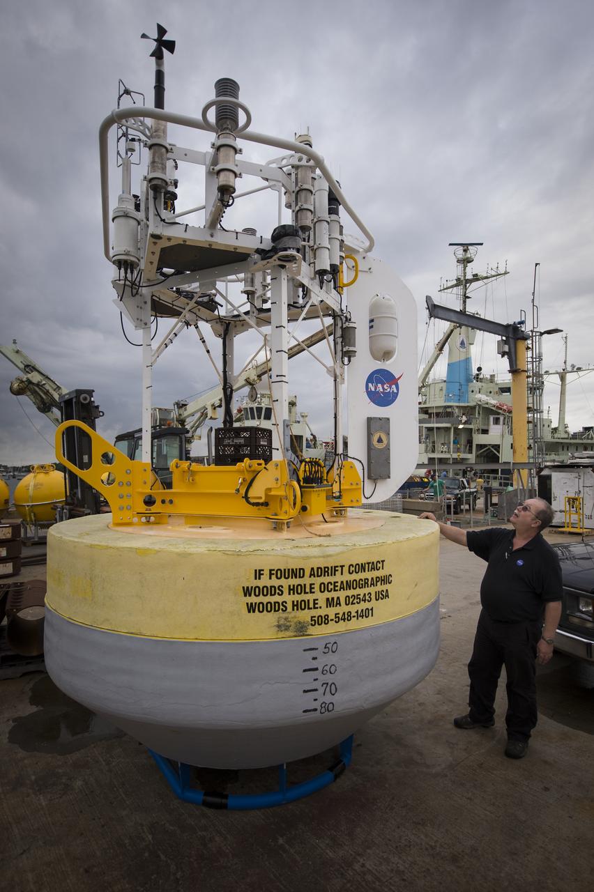
NASA Physical Oceanography Program Scientist Eric Lindstrom inspects a sensor-laden buoy prior to it being loaded onboard the Woods Hole Oceanographic Institution's vessel Knorr on Tuesday, Sept. 4, 2012, in Woods Hole, Mass. The buoy will be deployed in the Atlantic Ocean as part of the Salinity Processes in the Upper Ocean Regional Study (SPURS) which is set to sail on Sept. 6. The NASA-sponsored expedition will sail to the North Atlantic's saltiest spot to get a detailed, 3-D picture of how salt content fluctuates in the ocean's upper layers and how these variations are related to shifts in rainfall patterns around the planet. Photo Credit: (NASA/Bill Ingalls)

NASA Physical Oceanography Program Scientist Eric Lindstrom inspects an autonomous wave glider onboard the Woods Hole Oceanographic Institution research vessel Knorr on Tuesday, Sept. 4, 2012, in Woods Hole, Mass. The autonomous gliders will be deployed in the Atlantic Ocean as part of the Salinity Processes in the Upper Ocean Regional Study (SPURS) which is set to sail on Sept. 6. The NASA-sponsored expedition will sail to the North Atlantic's saltiest spot to get a detailed, 3-D picture of how salt content fluctuates in the ocean's upper layers and how these variations are related to shifts in rainfall patterns around the planet. Photo Credit: (NASA/Bill Ingalls)

Helen Fricker, Scripps Institution of Oceanography, La Jolla, California, ICESat-2 science definition team member, speaks to members of the news media and social media participants during a prelaunch mission briefing for NASA's Ice, Cloud and land Elevation Satellite-2 (ICESat-2), a mission to measure the changing height of Earth's ice, on Sept. 13, 2018 at Vandenberg Air Force Base (VAFB) in California. ICESat-2 will launch aboard a United Launch Alliance Delta II, the rocket’s final mission, from Space Launch Complex 2 at VAFB. Launch is scheduled for 8:46 a.m. EDT (5:46 a.m. PDT).

NASA Physical Oceanography Program Scientist Eric Lindstrom poses for a photograph next to the Woods Hole Oceanographic Institution research vessel Knorr on Tuesday, Sept. 4, 2012, in Woods Hole, Mass. Lindstrom will depart on Knorr Sept. 6 to take part in the Salinity Processes in the Upper Ocean Regional Study (SPURS). The NASA-sponsored expedition will sail to the North Atlantic's saltiest spot to get a detailed, 3-D picture of how salt content fluctuates in the ocean's upper layers and how these variations are related to shifts in rainfall patterns around the planet. Photo Credit: (NASA/Bill Ingalls)

Officials cut the ribbon during dedication ceremonies of the George A. Knauer Marine Science Building on Oct. 17 at NASA Stennis Space Center (SSC). The $2.75 million facility, the first building at the test site funded by the state of Mississippi, houses six science labs, classrooms and office space for 40 faculty and staff. Pictured are, from left, Rear Adm. Thomas Donaldson, commander of the Naval Meteorology and Oceanography Command; SSC Assistant Director David Throckmorton; Dr. George A. Knauer, founder of the Center of Marine Science at the University of Southern Mississippi (USM); Lt. Gov. Amy Tuck; and USM President Dr. Shelby Thames.
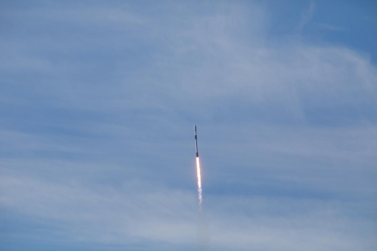
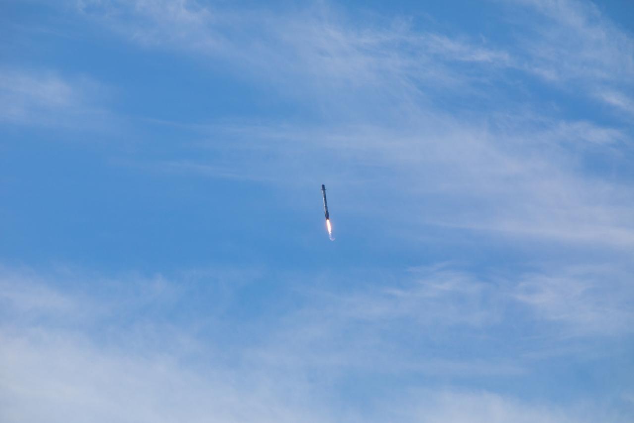
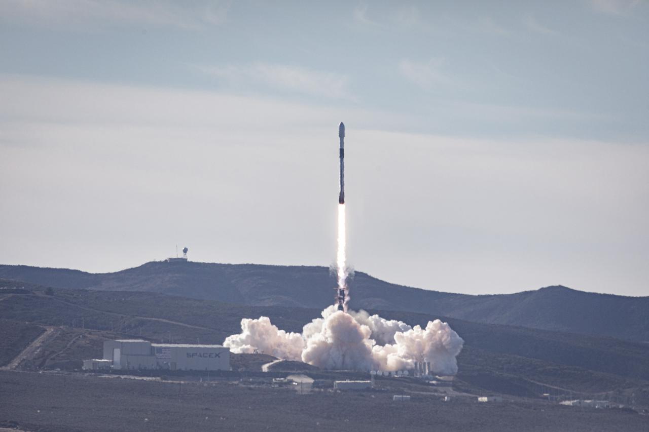
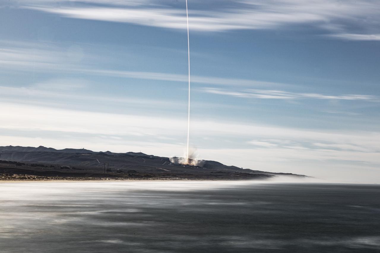
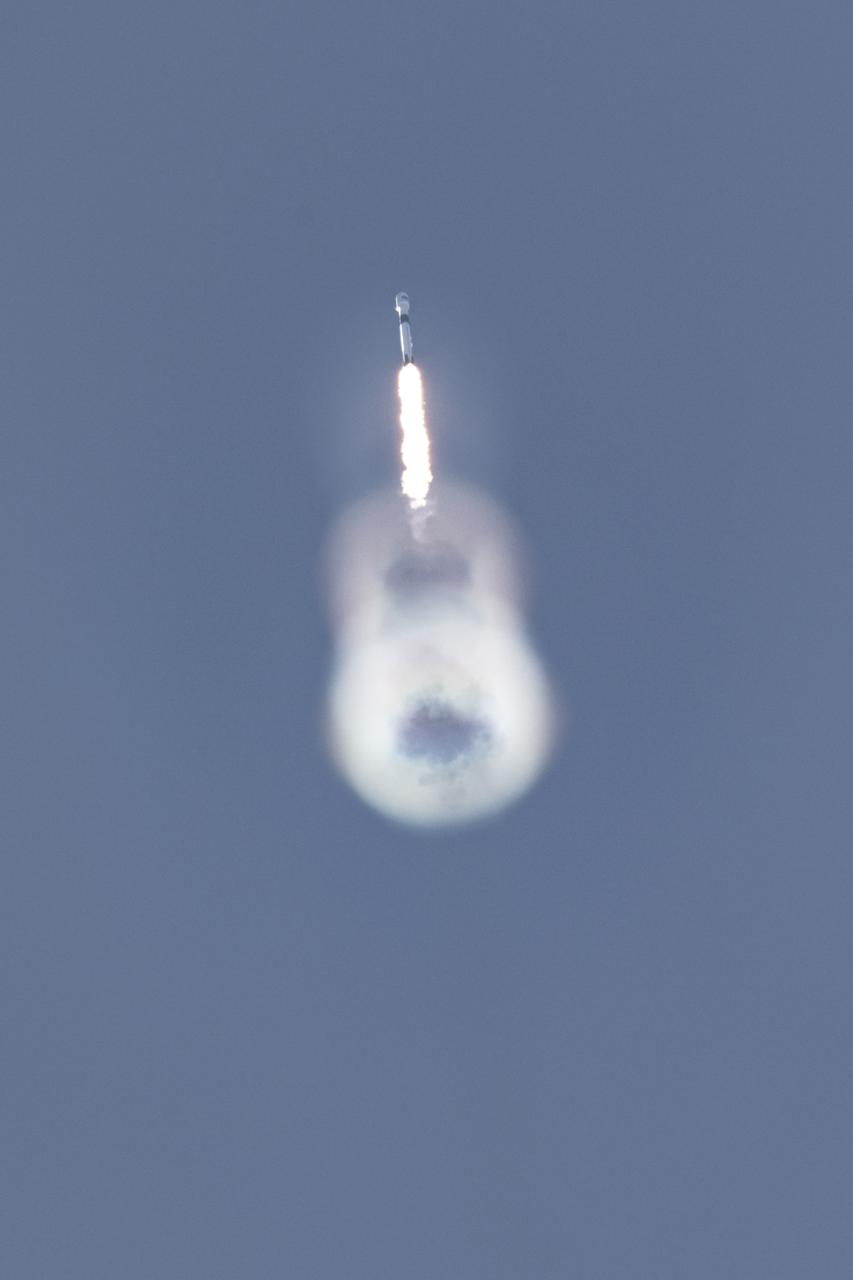
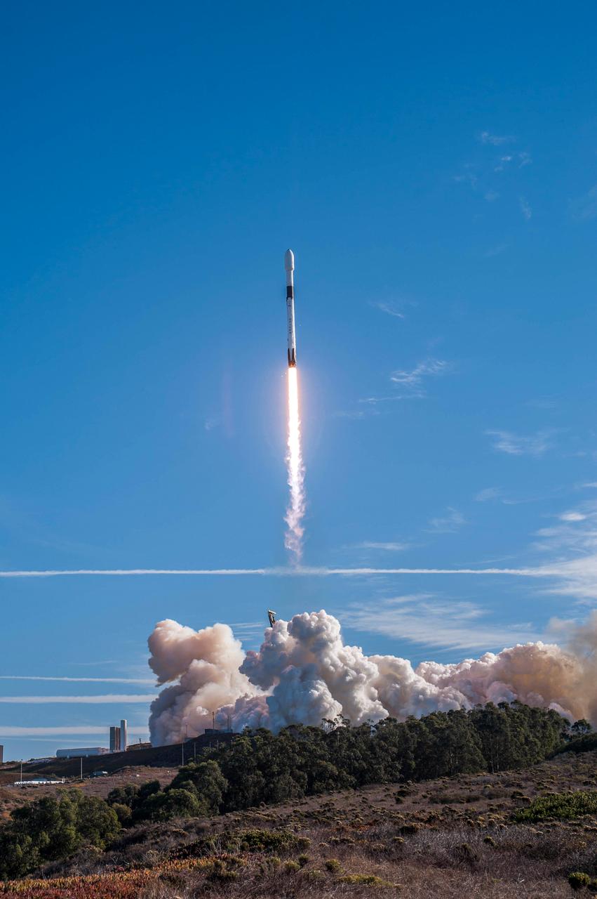
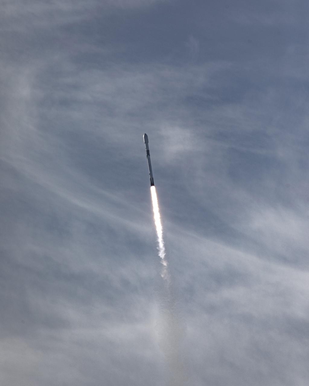
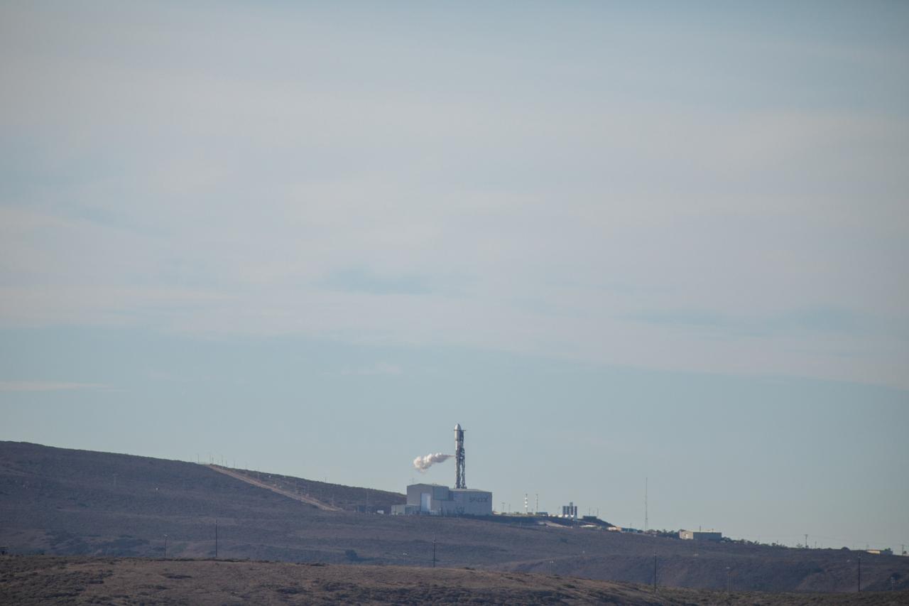
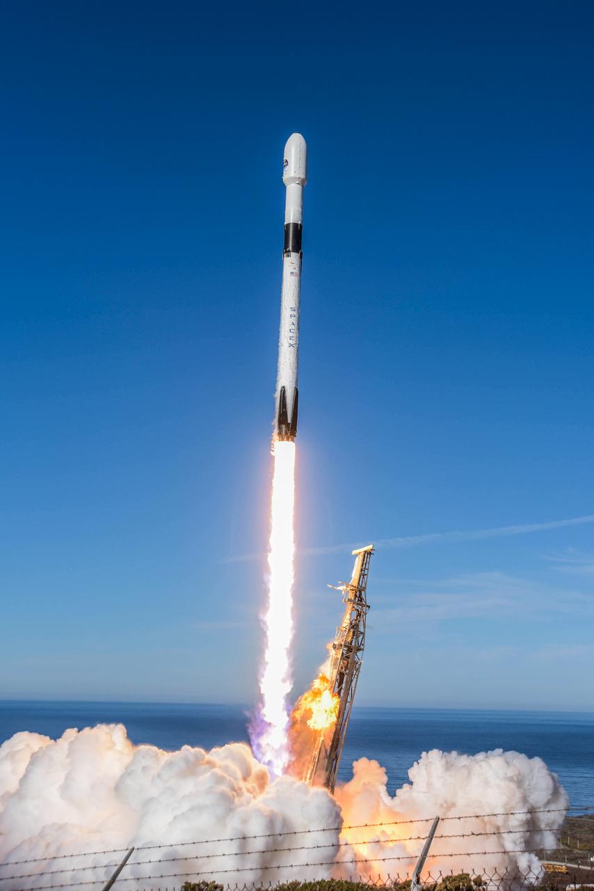
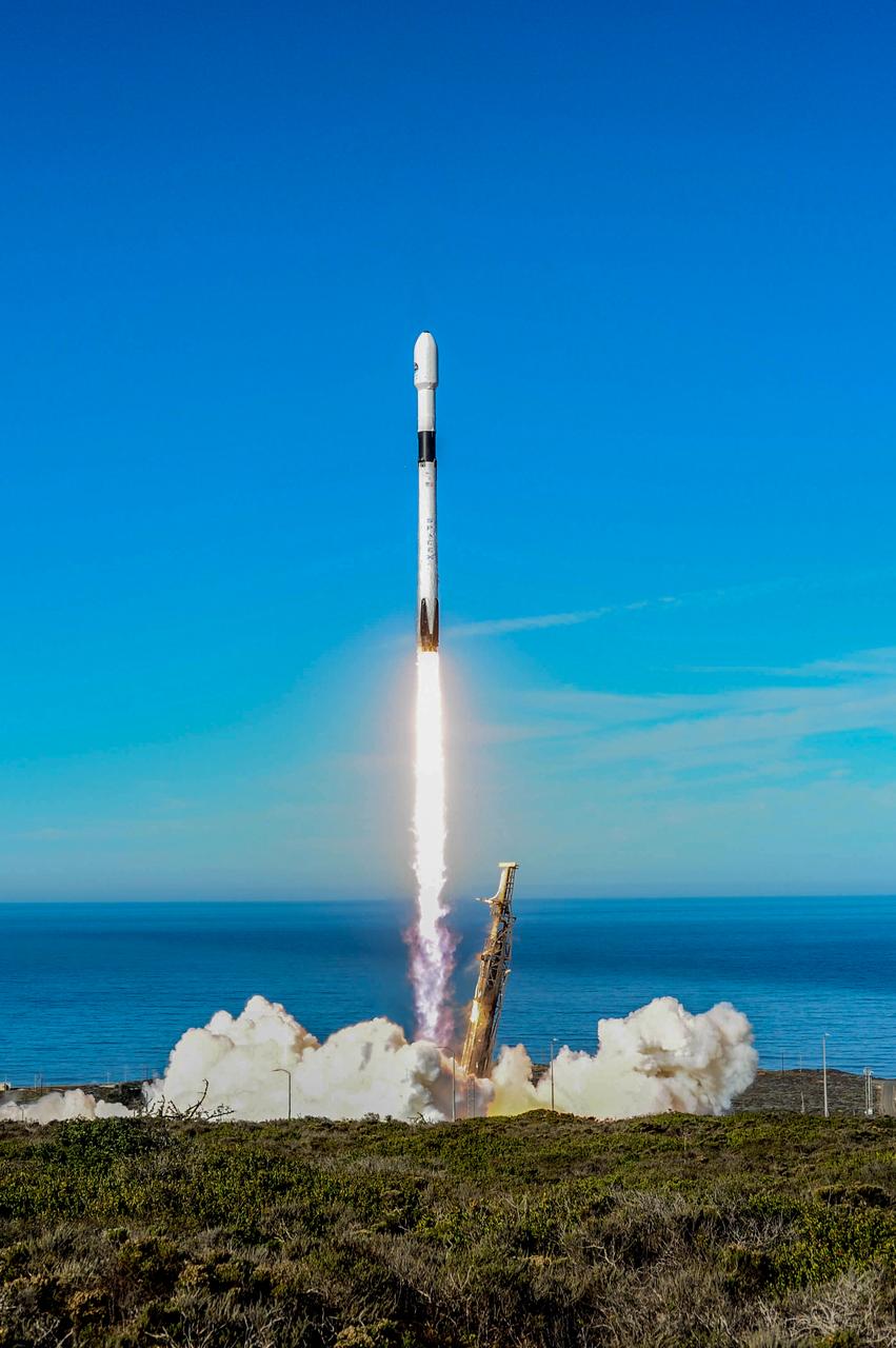
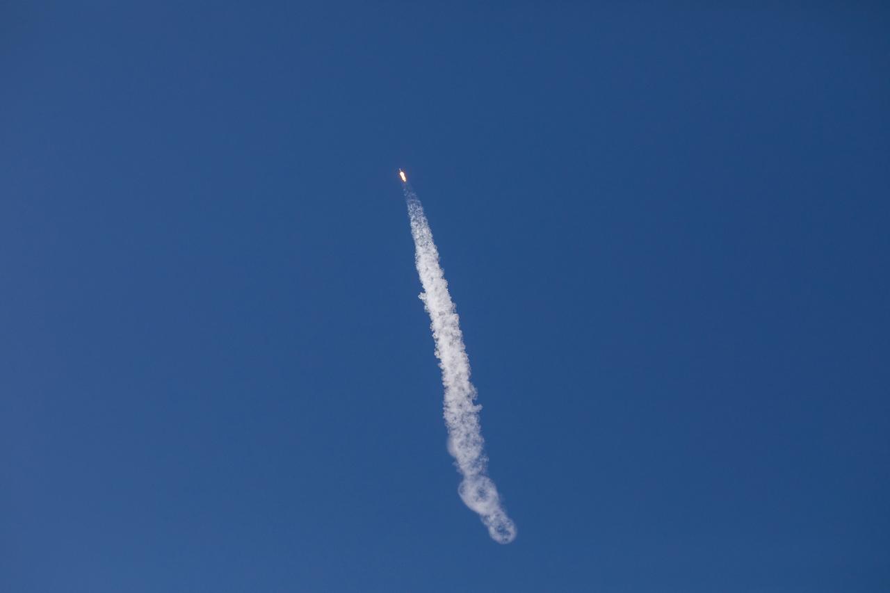
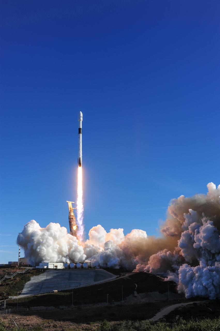
The SpaceX Falcon 9 rocket carrying the Sentinel-6 Michael Freilich spacecraft lifts off from Space Launch Complex 4 at Vandenberg Air Force Base in California, Nov. 21, 2020, at 9:17 a.m. PST (12:17 p.m. EST). The Sentinel-6/Jason-CS (Continuity of Service) mission consists of the Sentinel-6 Michael Freilich satellite, which will be followed by its twin, the Sentinel-6B satellite, in 2025. The Sentinel-6/Jason-CS mission is part of Copernicus, the European Union’s Earth observation program, managed by the European Commission. Continuing the legacy of the Jason series missions, Sentinel-6/Jason-CS will extend the records of sea level into their fourth decade, collecting accurate measurements of sea surface height for more than 90% of the world’s seas, and providing crucial information for operational oceanography, marine meteorology, and climate studies. NASA’s Launch Services Program at Kennedy Space Center was responsible for launch management.

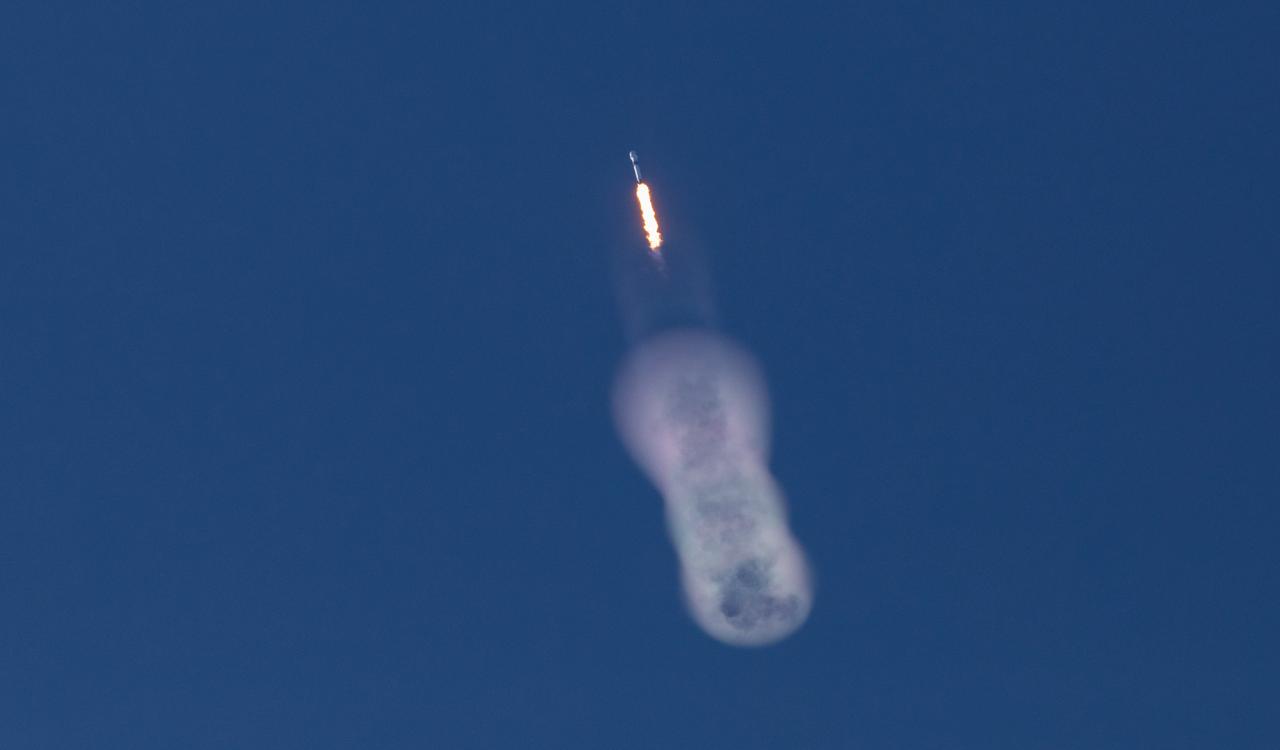
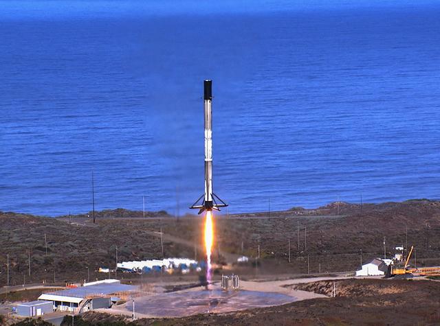
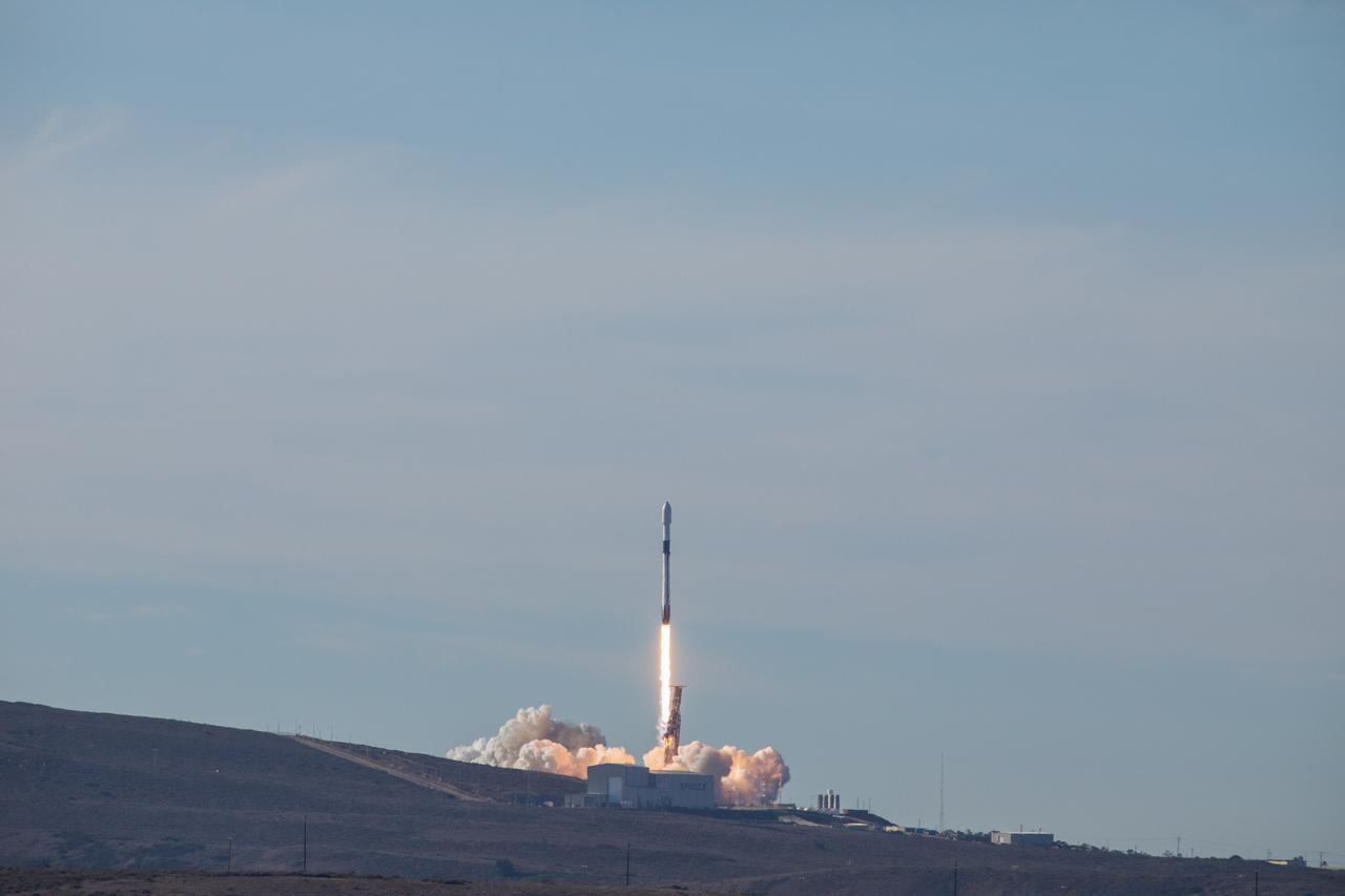
The first-stage booster of a SpaceX Falcon 9 rocket flies down to a landing at Vandenberg Air Force Base in California during the launch of the Sentinel-6 Michael Freilich mission. The Sentinel-6/Jason-CS (Continuity of Service) mission consists of the Sentinel-6 Michael Freilich satellite, which will be followed by its twin, the Sentinel-6B satellite, in 2025. The Sentinel-6/Jason-CS mission is part of Copernicus, the European Union’s Earth observation program, managed by the European Commission. Continuing the legacy of the Jason series missions, Sentinel-6/Jason-CS will extend the records of sea level into their fourth decade, collecting accurate measurements of sea surface height for more than 90% of the world’s seas, and providing crucial information for operational oceanography, marine meteorology, and climate studies. Sentinel-6 Michael Freilich launched Nov. 21, 2020, at 9:17 PST (12:17 EST). NASA’s Launch Services Program at Kennedy Space Center was responsible for launch management.
The first-stage booster of a SpaceX Falcon 9 rocket lands at Vandenberg Air Force Base in California during the launch of the Sentinel-6 Michael Freilich mission. The Sentinel-6/Jason-CS (Continuity of Service) mission consists of the Sentinel-6 Michael Freilich satellite, which will be followed by its twin, the Sentinel-6B satellite, in 2025. The Sentinel-6/Jason-CS mission is part of Copernicus, the European Union’s Earth observation program, managed by the European Commission. Continuing the legacy of the Jason series missions, Sentinel-6/Jason-CS will extend the records of sea level into their fourth decade, collecting accurate measurements of sea surface height for more than 90% of the world’s seas, and providing crucial information for operational oceanography, marine meteorology, and climate studies. Sentinel-6 Michael Freilich launched Nov. 21, 2020, at 9:17 PST (12:17 EST). NASA’s Launch Services Program at Kennedy Space Center was responsible for launch management.
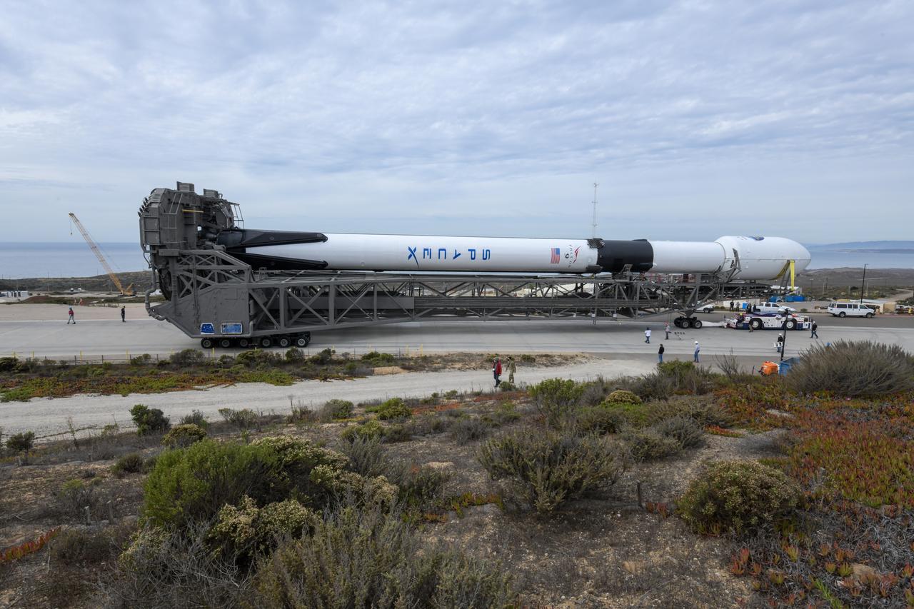
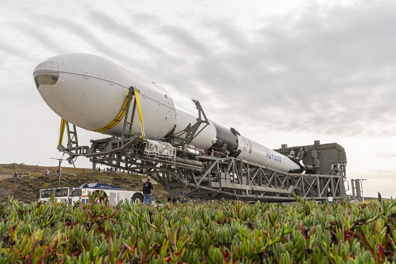
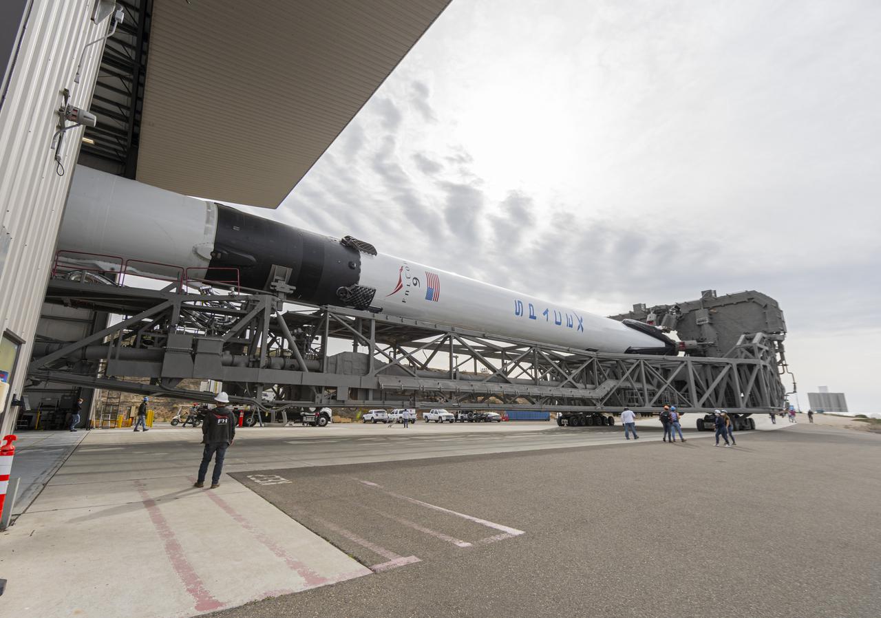
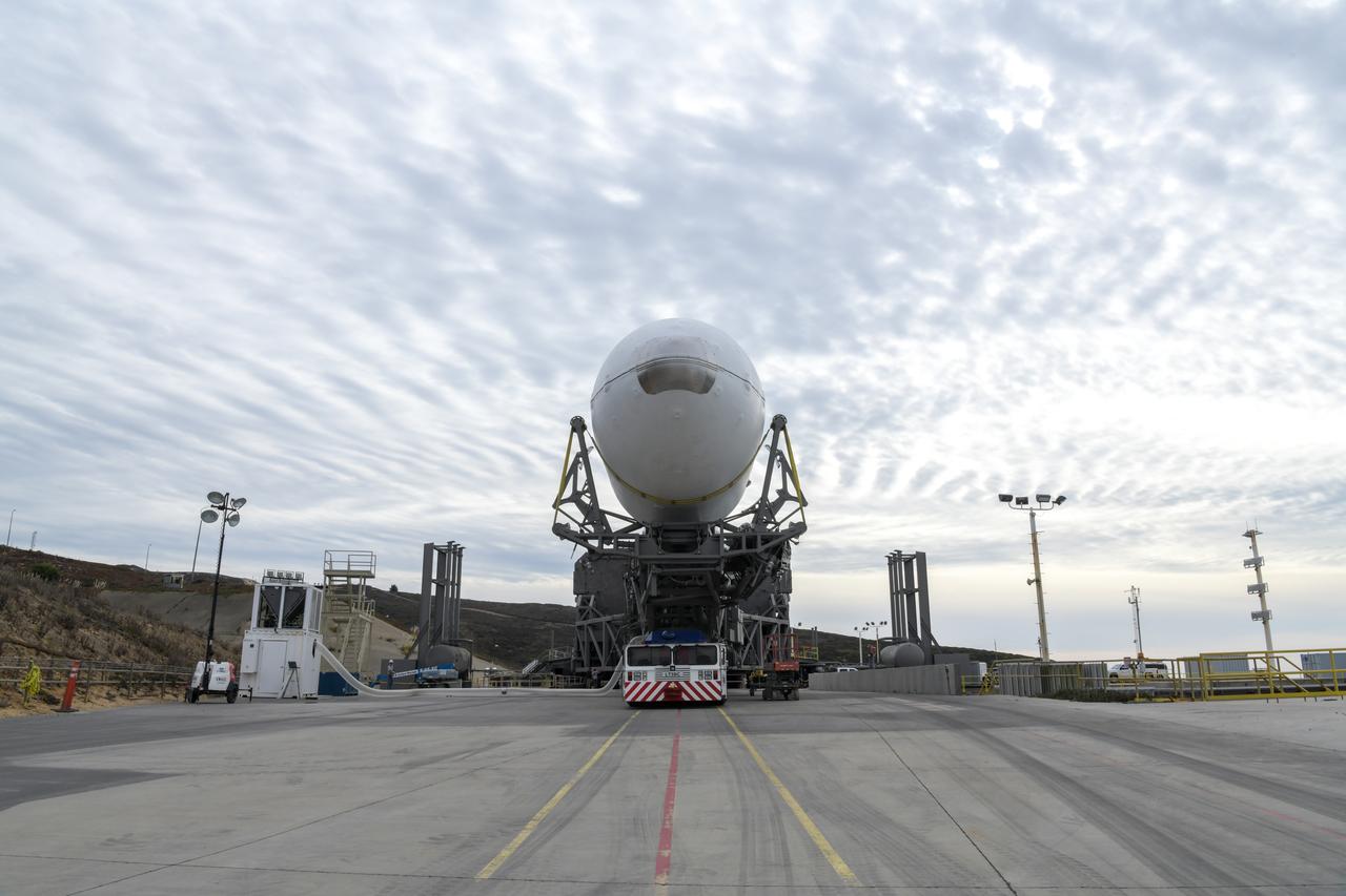
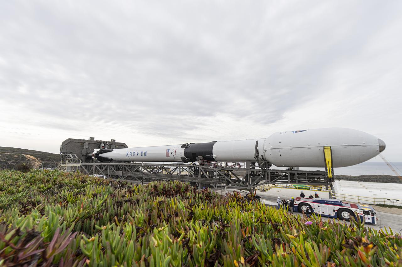
The SpaceX Falcon 9 rocket, topped with the Sentinel-6 Michael Freilich satellite secured inside its payload fairing, rolls from SpaceX’s Payload Processing Facility at Vandenberg Air Force Base in California to Space Launch Complex 4 on Nov. 20, 2020. The Sentinel-6/Jason-CS (Continuity of Service) mission consists of the Sentinel-6 Michael Freilich satellite, which will be followed by its twin, the Sentinel-6B satellite, in 2025. The Sentinel-6/Jason-CS mission is part of Copernicus, the European Union’s Earth observation program, managed by the European Commission. Continuing the legacy of the Jason series missions, Sentinel-6/Jason-CS will extend the records of sea level into their fourth decade, collecting accurate measurements of sea surface height for more than 90% of the world’s seas, and providing crucial information for operational oceanography, marine meteorology, and climate studies. Sentinel-6 Michael Freilich launched Nov. 21, 2020, at 9:17 PST (12:17 EST). NASA’s Launch Services Program at Kennedy Space Center was responsible for launch management.
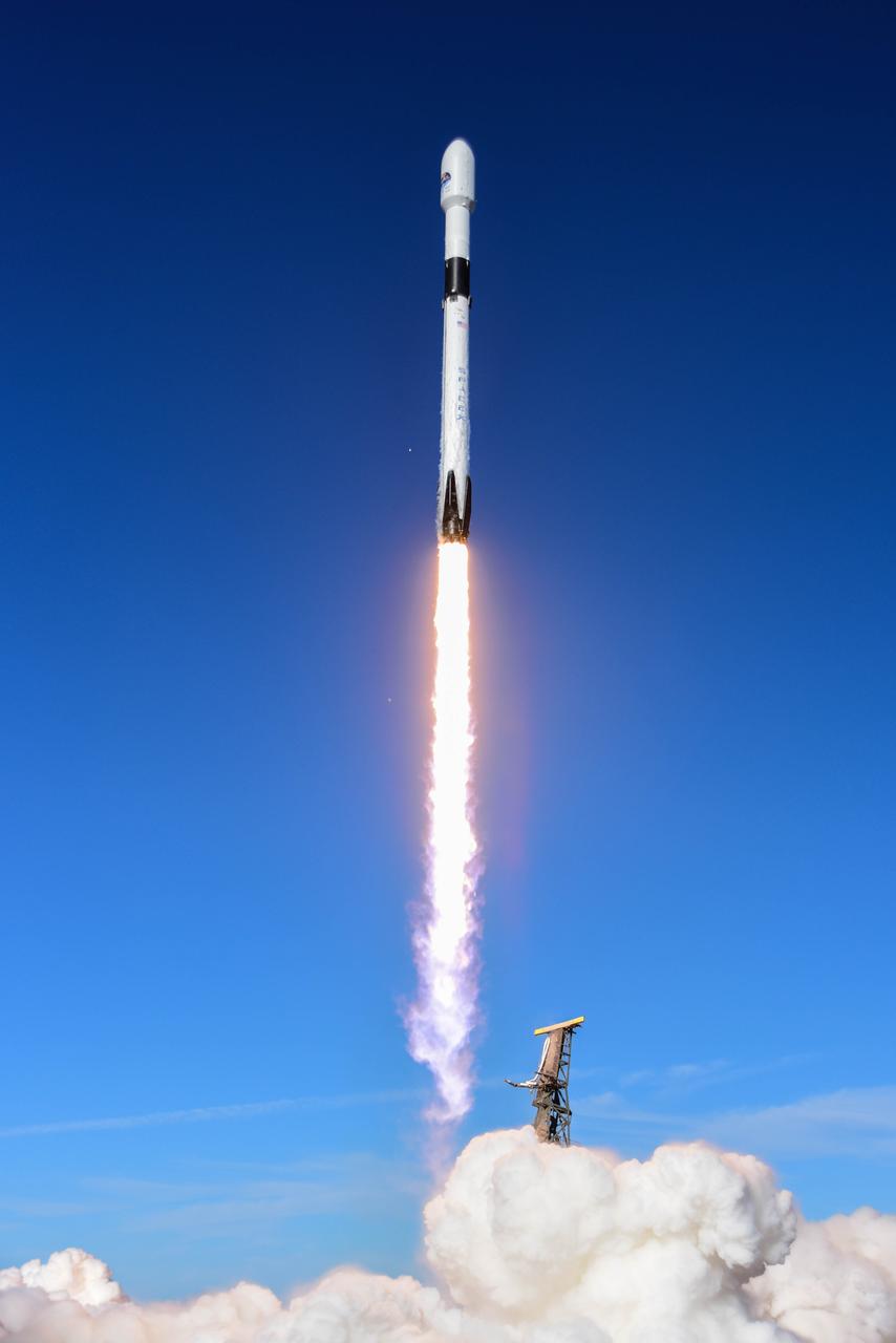
The SpaceX Falcon 9 rocket carrying the Sentinel-6 Michael Freilich spacecraft lifts off from Space Launch Complex 4 at Vandenberg Air Force Base in California, Nov. 21, 2020, at 9:17 a.m. PST (12:17 p.m. EST). The Sentinel-6/Jason-CS (Continuity of Service) mission consists of the Sentinel-6 Michael Freilich satellite, which will be followed by its twin, the Sentinel-6B satellite, in 2025. The Sentinel-6/Jason-CS mission is part of Copernicus, the European Union’s Earth observation program, managed by the European Commission. Continuing the legacy of the Jason series missions, Sentinel-6/Jason-CS will extend the records of sea level into their fourth decade, collecting accurate measurements of sea surface height for more than 90% of the world’s seas, and providing crucial information for operational oceanography, marine meteorology, and climate studies. NASA’s Launch Services Program at Kennedy Space Center was responsible for launch management.
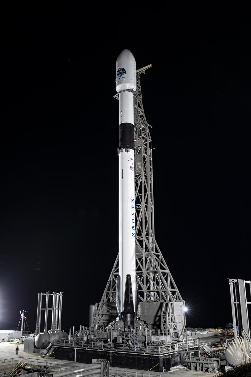
The SpaceX Falcon 9 rocket, topped with the Sentinel-6 Michael Freilich satellite secured inside its payload fairing, is lifted to vertical at Space Launch Complex 4 at Vandenberg Air Force Base in California on Nov. 20, 2020. The Sentinel-6/Jason-CS (Continuity of Service) mission consists of the Sentinel-6 Michael Freilich satellite, which will be followed by its twin, the Sentinel-6B satellite, in 2025. The Sentinel-6/Jason-CS mission is part of Copernicus, the European Union’s Earth observation program, managed by the European Commission. Continuing the legacy of the Jason series missions, Sentinel-6/Jason-CS will extend the records of sea level into their fourth decade, collecting accurate measurements of sea surface height for more than 90% of the world’s seas, and providing crucial information for operational oceanography, marine meteorology, and climate studies. Sentinel-6 Michael Freilich launched Nov. 21, 2020, at 9:17 PST (12:17 EST). NASA’s Launch Services Program at Kennedy Space Center was responsible for launch management.
The SpaceX Falcon 9 rocket, topped with the Sentinel-6 Michael Freilich satellite secured inside its payload fairing, is lifted to vertical at Space Launch Complex 4 at Vandenberg Air Force Base in California on Nov. 20, 2020. The Sentinel-6/Jason-CS (Continuity of Service) mission consists of the Sentinel-6 Michael Freilich satellite, which will be followed by its twin, the Sentinel-6B satellite, in 2025. The Sentinel-6/Jason-CS mission is part of Copernicus, the European Union’s Earth observation program, managed by the European Commission. Continuing the legacy of the Jason series missions, Sentinel-6/Jason-CS will extend the records of sea level into their fourth decade, collecting accurate measurements of sea surface height for more than 90% of the world’s seas, and providing crucial information for operational oceanography, marine meteorology, and climate studies. Sentinel-6 Michael Freilich launched Nov. 21, 2020, at 9:17 PST (12:17 EST). NASA’s Launch Services Program at Kennedy Space Center was responsible for launch management.
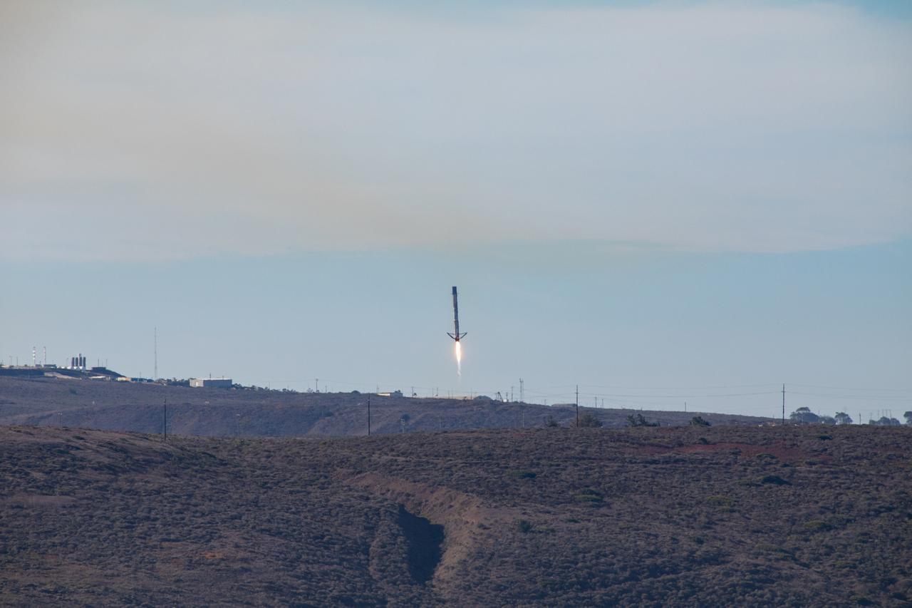
The first-stage booster of a SpaceX Falcon 9 rocket flies down to a landing at Vandenberg Air Force Base in California during the launch of the Sentinel-6 Michael Freilich mission. The Sentinel-6/Jason-CS (Continuity of Service) mission consists of the Sentinel-6 Michael Freilich satellite, which will be followed by its twin, the Sentinel-6B satellite, in 2025. The Sentinel-6/Jason-CS mission is part of Copernicus, the European Union’s Earth observation program, managed by the European Commission. Continuing the legacy of the Jason series missions, Sentinel-6/Jason-CS will extend the records of sea level into their fourth decade, collecting accurate measurements of sea surface height for more than 90% of the world’s seas, and providing crucial information for operational oceanography, marine meteorology, and climate studies. Sentinel-6 Michael Freilich launched Nov. 21, 2020, at 9:17 PST (12:17 EST). NASA’s Launch Services Program at Kennedy Space Center was responsible for launch management.
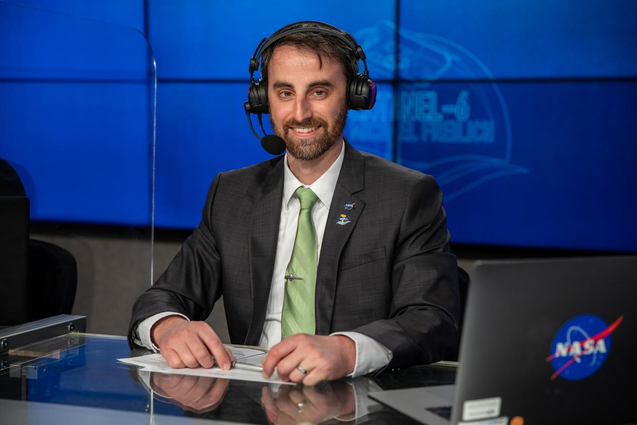
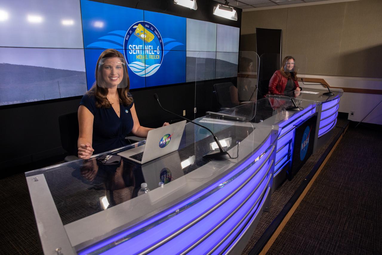
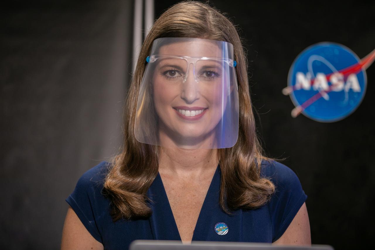
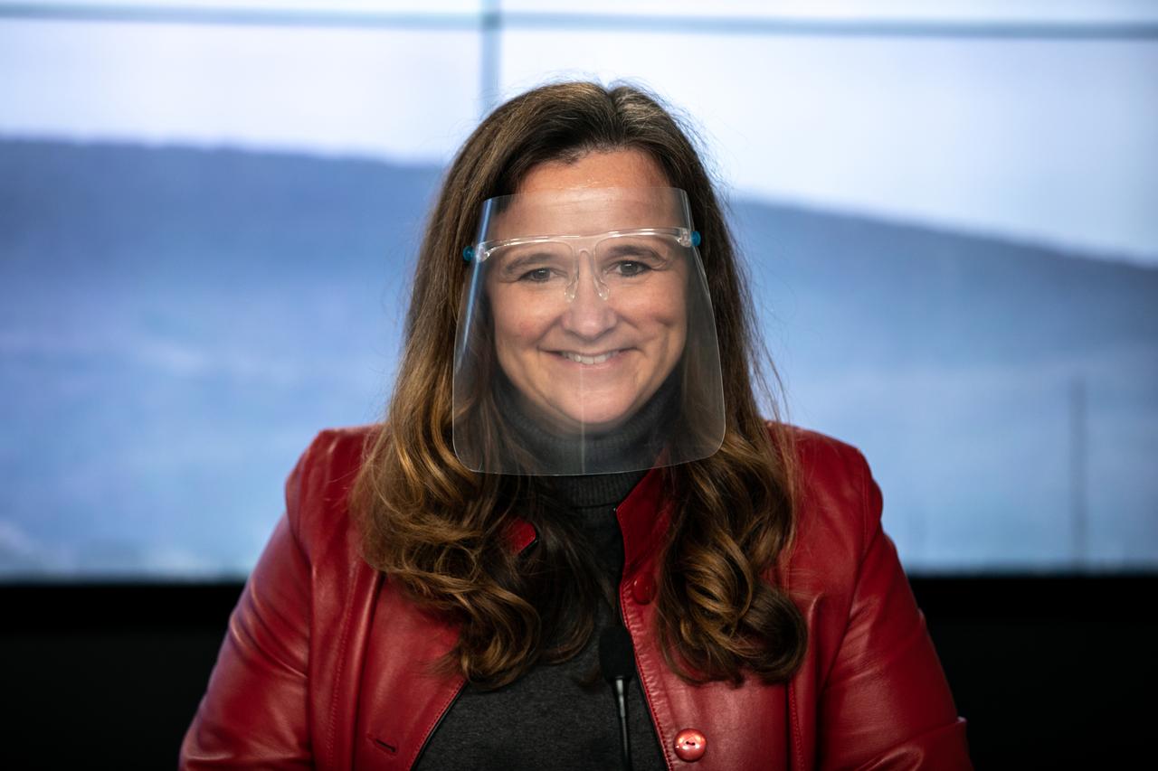
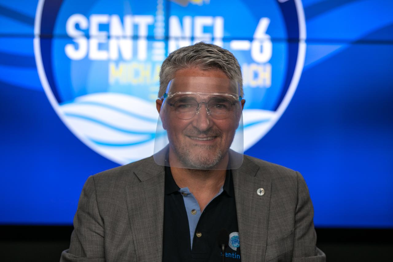
NASA Launch Commentator Joshua Santora participates in the launch broadcast for the Sentinel-6 Michael Freilich mission on Nov. 21, 2020, in the Press Site auditorium at Kennedy Space Center in Florida. The SpaceX Falcon 9 rocket carrying the Sentinel-6 Michael Freilich spacecraft launched from Space Launch Complex 4 at Vandenberg Air Force Base in California at 9:17 a.m. PST (12:17 p.m. EST). The Sentinel-6/Jason-CS (Continuity of Service) mission consists of the Sentinel-6 Michael Freilich satellite, which will be followed by its twin, the Sentinel-6B satellite, in 2025. The Sentinel-6/Jason-CS mission is part of Copernicus, the European Union’s Earth observation program, managed by the European Commission. Continuing the legacy of the Jason series missions, Sentinel-6/Jason-CS will extend the records of sea level into their fourth decade, collecting accurate measurements of sea surface height for more than 90% of the world’s seas, and providing crucial information for operational oceanography, marine meteorology, and climate studies. NASA’s Launch Services Program at Kennedy Space Center was responsible for launch management.
The SpaceX Falcon 9 rocket, topped with the Sentinel-6 Michael Freilich satellite secured inside its payload fairing, is rolled to Space Launch Complex 4 at Vandenberg Air Force Base in California on Nov. 20, 2020, in preparation for launch. The Sentinel-6/Jason-CS (Continuity of Service) mission consists of the Sentinel-6 Michael Freilich satellite, which will be followed by its twin, the Sentinel-6B satellite, in 2025. The Sentinel-6/Jason-CS mission is part of Copernicus, the European Union’s Earth observation program, managed by the European Commission. Continuing the legacy of the Jason series missions, Sentinel-6/Jason-CS will extend the records of sea level into their fourth decade, collecting accurate measurements of sea surface height for more than 90% of the world’s seas, and providing crucial information for operational oceanography, marine meteorology, and climate studies. Sentinel-6 Michael Freilich launched Nov. 21, 2020, at 9:17 PST (12:17 EST). NASA’s Launch Services Program at Kennedy Space Center was responsible for launch management.
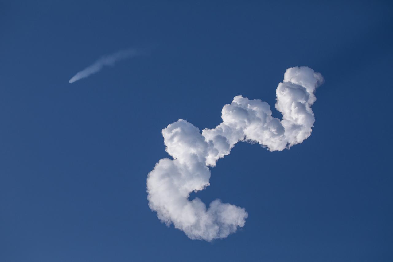
The SpaceX Falcon 9 rocket carrying the Sentinel-6 Michael Freilich spacecraft streaks through the sky after liftoff from Space Launch Complex 4 at Vandenberg Air Force Base in California, Nov. 21, 2020, at 9:17 a.m. PST (12:17 p.m. EST). The Sentinel-6/Jason-CS (Continuity of Service) mission consists of the Sentinel-6 Michael Freilich satellite, which will be followed by its twin, the Sentinel-6B satellite, in 2025. The Sentinel-6/Jason-CS mission is part of Copernicus, the European Union’s Earth observation program, managed by the European Commission. Continuing the legacy of the Jason series missions, Sentinel-6/Jason-CS will extend the records of sea level into their fourth decade, collecting accurate measurements of sea surface height for more than 90% of the world’s seas, and providing crucial information for operational oceanography, marine meteorology, and climate studies. NASA’s Launch Services Program at Kennedy Space Center was responsible for launch management.
The SpaceX Falcon 9 rocket, topped with the Sentinel-6 Michael Freilich satellite secured inside its payload fairing, departs SpaceX’s Payload Processing Facility at Vandenberg Air Force Base in California for its journey to Space Launch Complex 4 on Nov. 20, 2020. The Sentinel-6/Jason-CS (Continuity of Service) mission consists of the Sentinel-6 Michael Freilich satellite, which will be followed by its twin, the Sentinel-6B satellite, in 2025. The Sentinel-6/Jason-CS mission is part of Copernicus, the European Union’s Earth observation program, managed by the European Commission. Continuing the legacy of the Jason series missions, Sentinel-6/Jason-CS will extend the records of sea level into their fourth decade, collecting accurate measurements of sea surface height for more than 90% of the world’s seas, and providing crucial information for operational oceanography, marine meteorology, and climate studies. Sentinel-6 Michael Freilich launched Nov. 21, 2020, at 9:17 PST (12:17 EST). NASA’s Launch Services Program at Kennedy Space Center was responsible for launch management.
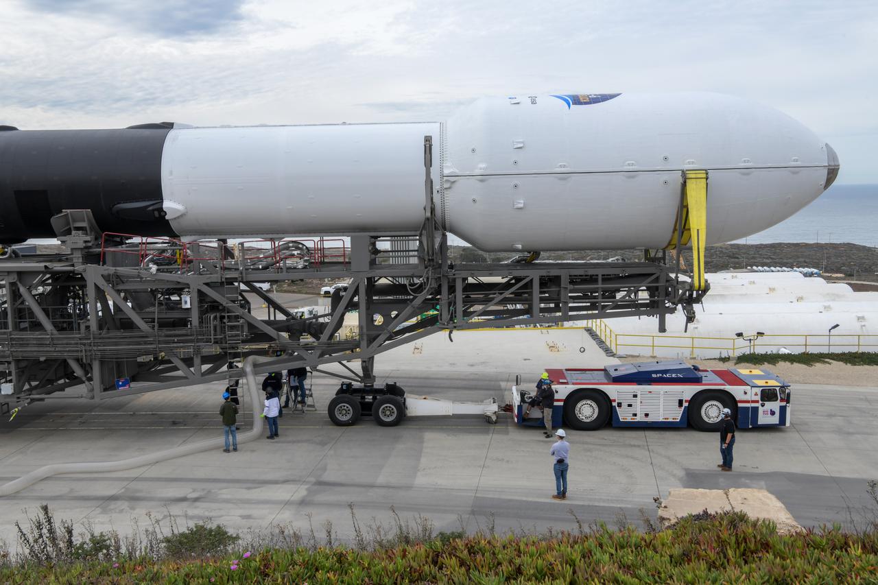
The SpaceX Falcon 9 rocket, topped with the Sentinel-6 Michael Freilich satellite secured inside its payload fairing, rolls from SpaceX’s Payload Processing Facility at Vandenberg Air Force Base in California to Space Launch Complex 4 on Nov. 20, 2020. The Sentinel-6/Jason-CS (Continuity of Service) mission consists of the Sentinel-6 Michael Freilich satellite, which will be followed by its twin, the Sentinel-6B satellite, in 2025. The Sentinel-6/Jason-CS mission is part of Copernicus, the European Union’s Earth observation program, managed by the European Commission. Continuing the legacy of the Jason series missions, Sentinel-6/Jason-CS will extend the records of sea level into their fourth decade, collecting accurate measurements of sea surface height for more than 90% of the world’s seas, and providing crucial information for operational oceanography, marine meteorology, and climate studies. Sentinel-6 Michael Freilich launched Nov. 21, 2020, at 9:17 PST (12:17 EST). NASA’s Launch Services Program at Kennedy Space Center was responsible for launch management.
The first-stage booster of a SpaceX Falcon 9 rocket flies down toward a landing at Vandenberg Air Force Base in California during the launch of the Sentinel-6 Michael Freilich mission. The Sentinel-6/Jason-CS (Continuity of Service) mission consists of the Sentinel-6 Michael Freilich satellite, which will be followed by its twin, the Sentinel-6B satellite, in 2025. The Sentinel-6/Jason-CS mission is part of Copernicus, the European Union’s Earth observation program, managed by the European Commission. Continuing the legacy of the Jason series missions, Sentinel-6/Jason-CS will extend the records of sea level into their fourth decade, collecting accurate measurements of sea surface height for more than 90% of the world’s seas, and providing crucial information for operational oceanography, marine meteorology, and climate studies. Sentinel-6 Michael Freilich launched Nov. 21, 2020, at 9:17 PST (12:17 EST). NASA’s Launch Services Program at Kennedy Space Center was responsible for launch management.
The SpaceX Falcon 9 rocket carrying the Sentinel-6 Michael Freilich spacecraft lifts off from Space Launch Complex 4 at Vandenberg Air Force Base in California, Nov. 21, 2020, at 9:17 a.m. PST (12:17 p.m. EST). The Sentinel-6/Jason-CS (Continuity of Service) mission consists of the Sentinel-6 Michael Freilich satellite, which will be followed by its twin, the Sentinel-6B satellite, in 2025. The Sentinel-6/Jason-CS mission is part of Copernicus, the European Union’s Earth observation program, managed by the European Commission. Continuing the legacy of the Jason series missions, Sentinel-6/Jason-CS will extend the records of sea level into their fourth decade, collecting accurate measurements of sea surface height for more than 90% of the world’s seas, and providing crucial information for operational oceanography, marine meteorology, and climate studies. NASA’s Launch Services Program at Kennedy Space Center was responsible for launch management.
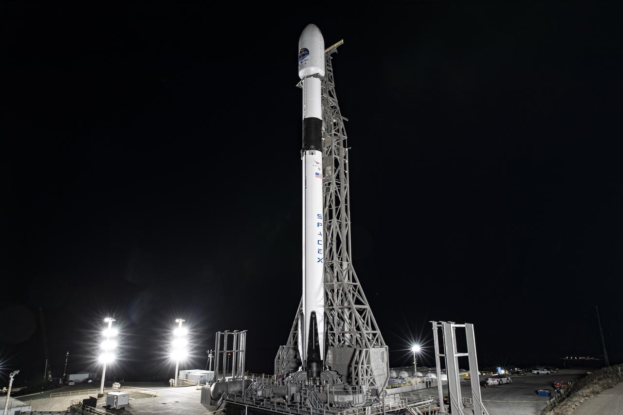
The SpaceX Falcon 9 rocket, topped with the Sentinel-6 Michael Freilich satellite secured inside its payload fairing, is lifted to vertical at Space Launch Complex 4 at Vandenberg Air Force Base in California on Nov. 20, 2020. The Sentinel-6/Jason-CS (Continuity of Service) mission consists of the Sentinel-6 Michael Freilich satellite, which will be followed by its twin, the Sentinel-6B satellite, in 2025. The Sentinel-6/Jason-CS mission is part of Copernicus, the European Union’s Earth observation program, managed by the European Commission. Continuing the legacy of the Jason series missions, Sentinel-6/Jason-CS will extend the records of sea level into their fourth decade, collecting accurate measurements of sea surface height for more than 90% of the world’s seas, and providing crucial information for operational oceanography, marine meteorology, and climate studies. Sentinel-6 Michael Freilich launched Nov. 21, 2020, at 9:17 PST (12:17 EST). NASA’s Launch Services Program at Kennedy Space Center was responsible for launch management.
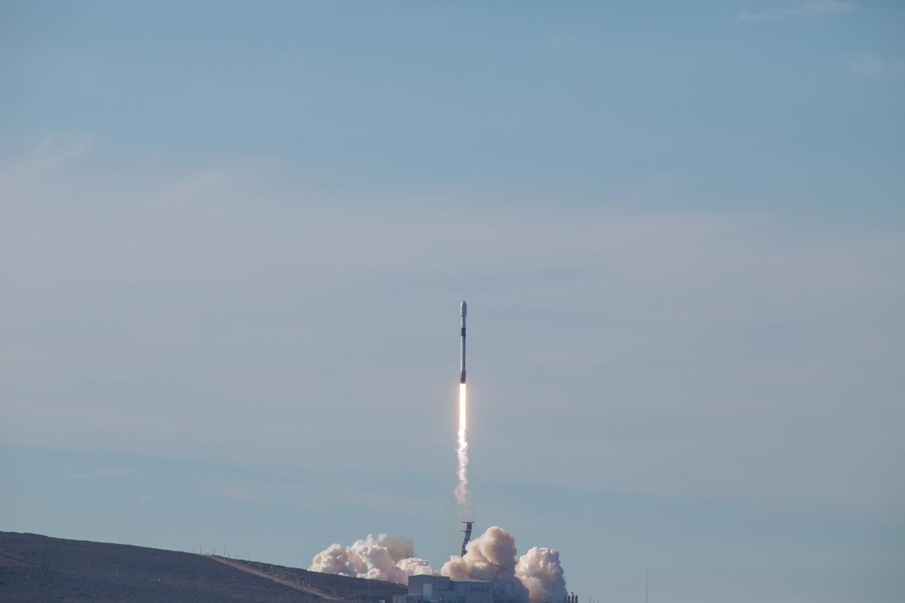
The SpaceX Falcon 9 rocket carrying the Sentinel-6 Michael Freilich spacecraft lifts off from Space Launch Complex 4 at Vandenberg Air Force Base in California, Nov. 21, 2020, at 9:17 a.m. PST (12:17 p.m. EST). The Sentinel-6/Jason-CS (Continuity of Service) mission consists of the Sentinel-6 Michael Freilich satellite, which will be followed by its twin, the Sentinel-6B satellite, in 2025. The Sentinel-6/Jason-CS mission is part of Copernicus, the European Union’s Earth observation program, managed by the European Commission. Continuing the legacy of the Jason series missions, Sentinel-6/Jason-CS will extend the records of sea level into their fourth decade, collecting accurate measurements of sea surface height for more than 90% of the world’s seas, and providing crucial information for operational oceanography, marine meteorology, and climate studies. NASA’s Launch Services Program at Kennedy Space Center was responsible for launch management.
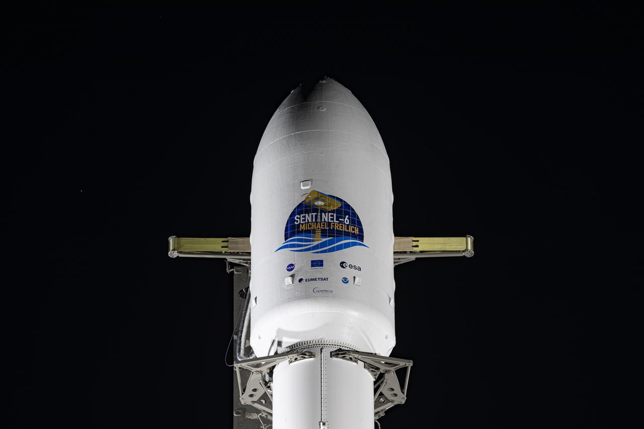
The protective payload fairing containing the Sentinel-6 Michael Freilich satellite is seen atop the SpaceX Falcon 9 after the rocket was lifted to vertical at Space Launch Complex 4 at Vandenberg Air Force Base in California on Nov. 20, 2020. The Sentinel-6/Jason-CS (Continuity of Service) mission consists of the Sentinel-6 Michael Freilich satellite, which will be followed by its twin, the Sentinel-6B satellite, in 2025. The Sentinel-6/Jason-CS mission is part of Copernicus, the European Union’s Earth observation program, managed by the European Commission. Continuing the legacy of the Jason series missions, Sentinel-6/Jason-CS will extend the records of sea level into their fourth decade, collecting accurate measurements of sea surface height for more than 90% of the world’s seas, and providing crucial information for operational oceanography, marine meteorology, and climate studies. Sentinel-6 Michael Freilich launched Nov. 21, 2020, at 9:17 PST (12:17 EST). NASA’s Launch Services Program at Kennedy Space Center was responsible for launch management.
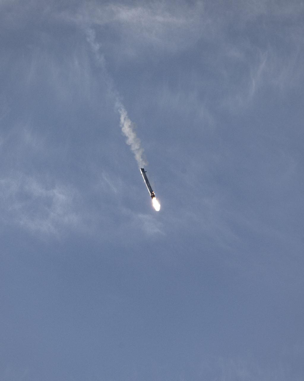
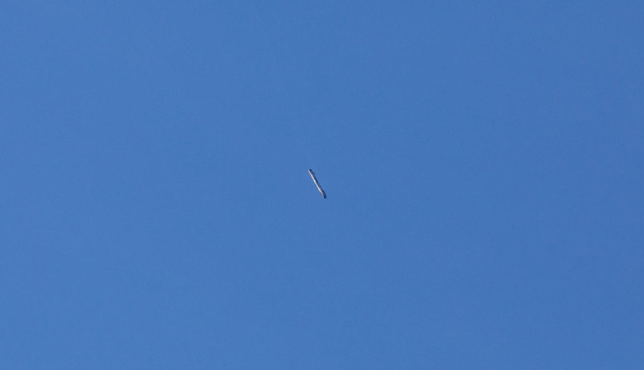
The first-stage booster of a SpaceX Falcon 9 rocket flies down to a landing at Vandenberg Air Force Base in California during the launch of the Sentinel-6 Michael Freilich mission. The Falcon 9 carrying the satellite lifted off from Vandenberg’s Space Launch Complex 4 on Nov. 21, 2020, at 9:17 a.m. PST (12:17 p.m. EST). The Sentinel-6/Jason-CS (Continuity of Service) mission consists of the Sentinel-6 Michael Freilich satellite, which will be followed by its twin, the Sentinel-6B satellite, in 2025. The Sentinel-6/Jason-CS mission is part of Copernicus, the European Union’s Earth observation program, managed by the European Commission. Continuing the legacy of the Jason series missions, Sentinel-6/Jason-CS will extend the records of sea level into their fourth decade, collecting accurate measurements of sea surface height for more than 90% of the world’s seas, and providing crucial information for operational oceanography, marine meteorology, and climate studies. NASA’s Launch Services Program at Kennedy Space Center was responsible for launch management.
The first-stage booster of a SpaceX Falcon 9 rocket flies down to a landing at Vandenberg Air Force Base in California during the launch of the Sentinel-6 Michael Freilich mission. The Falcon 9 carrying the satellite lifted off from Vandenberg’s Space Launch Complex 4 on Nov. 21, 2020, at 9:17 a.m. PST (12:17 p.m. EST). The Sentinel-6/Jason-CS (Continuity of Service) mission consists of the Sentinel-6 Michael Freilich satellite, which will be followed by its twin, the Sentinel-6B satellite, in 2025. The Sentinel-6/Jason-CS mission is part of Copernicus, the European Union’s Earth observation program, managed by the European Commission. Continuing the legacy of the Jason series missions, Sentinel-6/Jason-CS will extend the records of sea level into their fourth decade, collecting accurate measurements of sea surface height for more than 90% of the world’s seas, and providing crucial information for operational oceanography, marine meteorology, and climate studies. NASA’s Launch Services Program at Kennedy Space Center was responsible for launch management.
The SpaceX Falcon 9 rocket, topped with the Sentinel-6 Michael Freilich satellite secured inside its payload fairing, rolls from SpaceX’s Payload Processing Facility at Vandenberg Air Force Base in California to Space Launch Complex 4 on Nov. 20, 2020. The Sentinel-6/Jason-CS (Continuity of Service) mission consists of the Sentinel-6 Michael Freilich satellite, which will be followed by its twin, the Sentinel-6B satellite, in 2025. The Sentinel-6/Jason-CS mission is part of Copernicus, the European Union’s Earth observation program, managed by the European Commission. Continuing the legacy of the Jason series missions, Sentinel-6/Jason-CS will extend the records of sea level into their fourth decade, collecting accurate measurements of sea surface height for more than 90% of the world’s seas, and providing crucial information for operational oceanography, marine meteorology, and climate studies. Sentinel-6 Michael Freilich launched Nov. 21, 2020, at 9:17 PST (12:17 EST). NASA’s Launch Services Program at Kennedy Space Center was responsible for launch management.
The SpaceX Falcon 9 rocket carrying the Sentinel-6 Michael Freilich spacecraft lifts off from Space Launch Complex 4 at Vandenberg Air Force Base in California, Nov. 21, 2020, at 9:17 a.m. PST (12:17 p.m. EST). The Sentinel-6/Jason-CS (Continuity of Service) mission consists of the Sentinel-6 Michael Freilich satellite, which will be followed by its twin, the Sentinel-6B satellite, in 2025. The Sentinel-6/Jason-CS mission is part of Copernicus, the European Union’s Earth observation program, managed by the European Commission. Continuing the legacy of the Jason series missions, Sentinel-6/Jason-CS will extend the records of sea level into their fourth decade, collecting accurate measurements of sea surface height for more than 90% of the world’s seas, and providing crucial information for operational oceanography, marine meteorology, and climate studies. NASA’s Launch Services Program at Kennedy Space Center was responsible for launch management.
The SpaceX Falcon 9 rocket carrying the Sentinel-6 Michael Freilich spacecraft lifts off from Space Launch Complex 4 at Vandenberg Air Force Base in California, Nov. 21, 2020, at 9:17 a.m. PST (12:17 p.m. EST). The Sentinel-6/Jason-CS (Continuity of Service) mission consists of the Sentinel-6 Michael Freilich satellite, which will be followed by its twin, the Sentinel-6B satellite, in 2025. The Sentinel-6/Jason-CS mission is part of Copernicus, the European Union’s Earth observation program, managed by the European Commission. Continuing the legacy of the Jason series missions, Sentinel-6/Jason-CS will extend the records of sea level into their fourth decade, collecting accurate measurements of sea surface height for more than 90% of the world’s seas, and providing crucial information for operational oceanography, marine meteorology, and climate studies. NASA’s Launch Services Program at Kennedy Space Center was responsible for launch management.
The SpaceX Falcon 9 rocket carrying the Sentinel-6 Michael Freilich spacecraft lifts off from Space Launch Complex 4 at Vandenberg Air Force Base in California, Nov. 21, 2020, at 9:17 a.m. PST (12:17 p.m. EST). The Sentinel-6/Jason-CS (Continuity of Service) mission consists of the Sentinel-6 Michael Freilich satellite, which will be followed by its twin, the Sentinel-6B satellite, in 2025. The Sentinel-6/Jason-CS mission is part of Copernicus, the European Union’s Earth observation program, managed by the European Commission. Continuing the legacy of the Jason series missions, Sentinel-6/Jason-CS will extend the records of sea level into their fourth decade, collecting accurate measurements of sea surface height for more than 90% of the world’s seas, and providing crucial information for operational oceanography, marine meteorology, and climate studies. NASA’s Launch Services Program at Kennedy Space Center was responsible for launch management.
The SpaceX Falcon 9 first stage booster lands at Space Launch Complex 4 at Vandenberg Air Force Base in California after launching the Sentinel-6 Michael Freilich spacecraft on Nov. 21, 2020, at 9:17 a.m. PST (12:17 p.m. EST). The Sentinel-6/Jason-CS (Continuity of Service) mission consists of the Sentinel-6 Michael Freilich satellite, which will be followed by its twin, the Sentinel-6B satellite, in 2025. The Sentinel-6/Jason-CS mission is part of Copernicus, the European Union’s Earth observation program, managed by the European Commission. Continuing the legacy of the Jason series missions, Sentinel-6/Jason-CS will extend the records of sea level into their fourth decade, collecting accurate measurements of sea surface height for more than 90% of the world’s seas, and providing crucial information for operational oceanography, marine meteorology, and climate studies. NASA’s Launch Services Program at Kennedy Space Center was responsible for launch management.
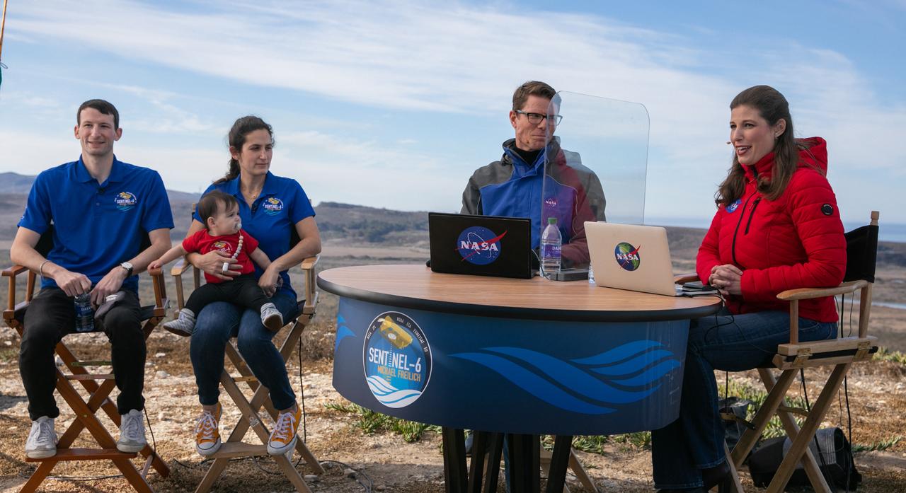
Daniel Freilich, left, and Sarah Freilich, children of Dr. Michael Freilich, speak with NASA Commentators Derrol Nail and Marina Jurica during the launch broadcast for the Sentinel-6 Michael Freilich mission on Nov. 21, 2020, at Vandenberg Air Force Base in California. The Sentinel-6/Jason-CS (Continuity of Service) mission consists of the Sentinel-6 Michael Freilich satellite, which will be followed by its twin, the Sentinel-6B satellite, in 2025. The Sentinel-6/Jason-CS mission is part of Copernicus, the European Union’s Earth observation program, managed by the European Commission. Continuing the legacy of the Jason series missions, Sentinel-6/Jason-CS will extend the records of sea level into their fourth decade, collecting accurate measurements of sea surface height for more than 90% of the world’s seas, and providing crucial information for operational oceanography, marine meteorology, and climate studies. Sentinel-6 Michael Freilich launched Nov. 21, 2020, at 9:17 PST (12:17 EST). NASA’s Launch Services Program at Kennedy Space Center was responsible for launch management.
NASA Launch Commentator Derrol Nail participates in the launch broadcast for the Sentinel-6 Michael Freilich mission on Nov. 21, 2020, at Vandenberg Air Force Base in California. The SpaceX Falcon 9 rocket carrying the Sentinel-6 Michael Freilich spacecraft launched from Vandenberg’s Space Launch Complex 4 at 9:17 a.m. PST (12:17 p.m. EST). The Sentinel-6/Jason-CS (Continuity of Service) mission consists of the Sentinel-6 Michael Freilich satellite, which will be followed by its twin, the Sentinel-6B satellite, in 2025. The Sentinel-6/Jason-CS mission is part of Copernicus, the European Union’s Earth observation program, managed by the European Commission. Continuing the legacy of the Jason series missions, Sentinel-6/Jason-CS will extend the records of sea level into their fourth decade, collecting accurate measurements of sea surface height for more than 90% of the world’s seas, and providing crucial information for operational oceanography, marine meteorology, and climate studies. NASA’s Launch Services Program at Kennedy Space Center was responsible for launch management.
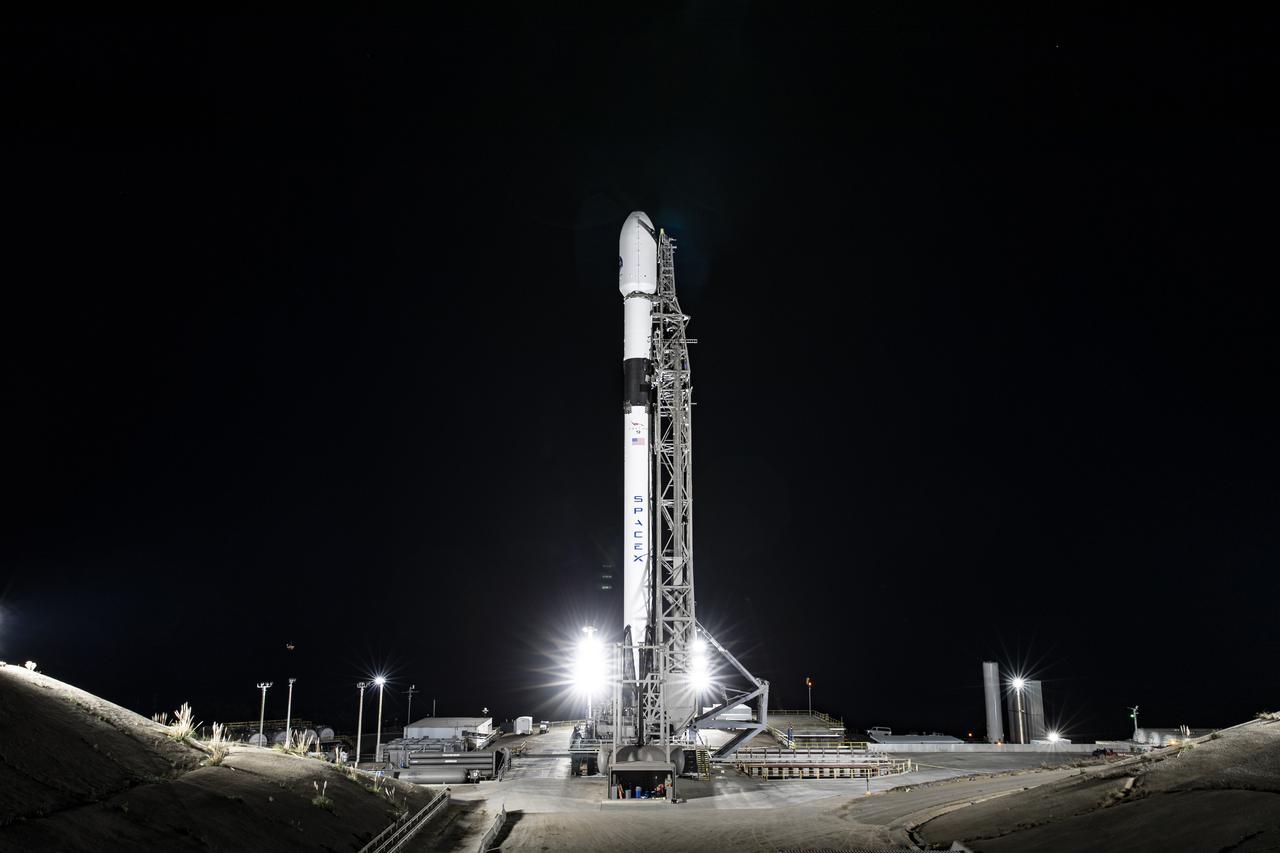
The SpaceX Falcon 9 rocket carrying the Sentinel-6 Michael Freilich spacecraft awaits liftoff from Space Launch Complex 4 at Vandenberg Air Force Base in California, Nov. 21, 2020. The Sentinel-6/Jason-CS (Continuity of Service) mission consists of the Sentinel-6 Michael Freilich satellite, which will be followed by its twin, the Sentinel-6B satellite, in 2025. The Sentinel-6/Jason-CS mission is part of Copernicus, the European Union’s Earth observation program, managed by the European Commission. Continuing the legacy of the Jason series missions, Sentinel-6/Jason-CS will extend the records of sea level into their fourth decade, collecting accurate measurements of sea surface height for more than 90% of the world’s seas, and providing crucial information for operational oceanography, marine meteorology, and climate studies. Sentinel-6 Michael Freilich launched Nov. 21, 2020, at 9:17 PST (12:17 EST). NASA’s Launch Services Program at Kennedy Space Center was responsible for launch management.
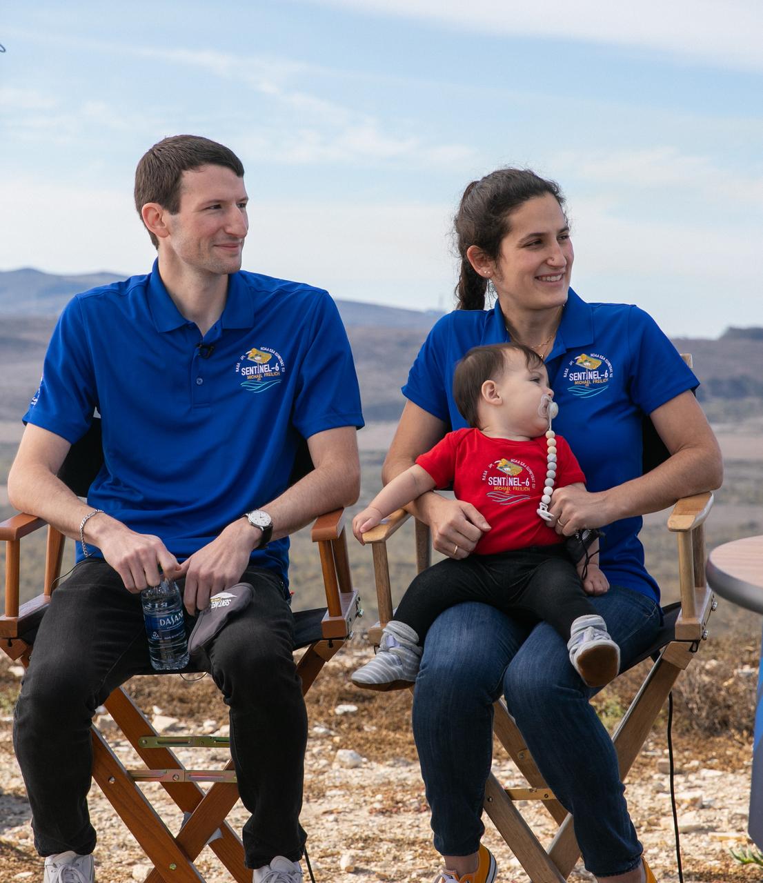
Daniel Freilich, left, and Sarah Freilich, children of Dr. Michael Freilich, participate in the launch broadcast for the Sentinel-6 Michael Freilich mission on Nov. 21, 2020, at Vandenberg Air Force Base in California. The Sentinel-6/Jason-CS (Continuity of Service) mission consists of the Sentinel-6 Michael Freilich satellite, which will be followed by its twin, the Sentinel-6B satellite, in 2025. The Sentinel-6/Jason-CS mission is part of Copernicus, the European Union’s Earth observation program, managed by the European Commission. Continuing the legacy of the Jason series missions, Sentinel-6/Jason-CS will extend the records of sea level into their fourth decade, collecting accurate measurements of sea surface height for more than 90% of the world’s seas, and providing crucial information for operational oceanography, marine meteorology, and climate studies. Sentinel-6 Michael Freilich launched Nov. 21, 2020, at 9:17 PST (12:17 EST). NASA’s Launch Services Program at Kennedy Space Center was responsible for launch management.
Clear, sunny skies provide a backdrop for California’s Vandenberg Air Force Base, where the SpaceX Falcon 9 rocket carrying the Sentinel-6 Michael Freilich spacecraft awaits liftoff from Space Launch Complex 4, Nov. 21, 2020. The Sentinel-6/Jason-CS (Continuity of Service) mission consists of the Sentinel-6 Michael Freilich satellite, which will be followed by its twin, the Sentinel-6B satellite, in 2025. The Sentinel-6/Jason-CS mission is part of Copernicus, the European Union’s Earth observation program, managed by the European Commission. Continuing the legacy of the Jason series missions, Sentinel-6/Jason-CS will extend the records of sea level into their fourth decade, collecting accurate measurements of sea surface height for more than 90% of the world’s seas, and providing crucial information for operational oceanography, marine meteorology, and climate studies. Sentinel-6 Michael Freilich launched Nov. 21, 2020, at 9:17 PST (12:17 EST). NASA’s Launch Services Program at Kennedy Space Center was responsible for launch management.
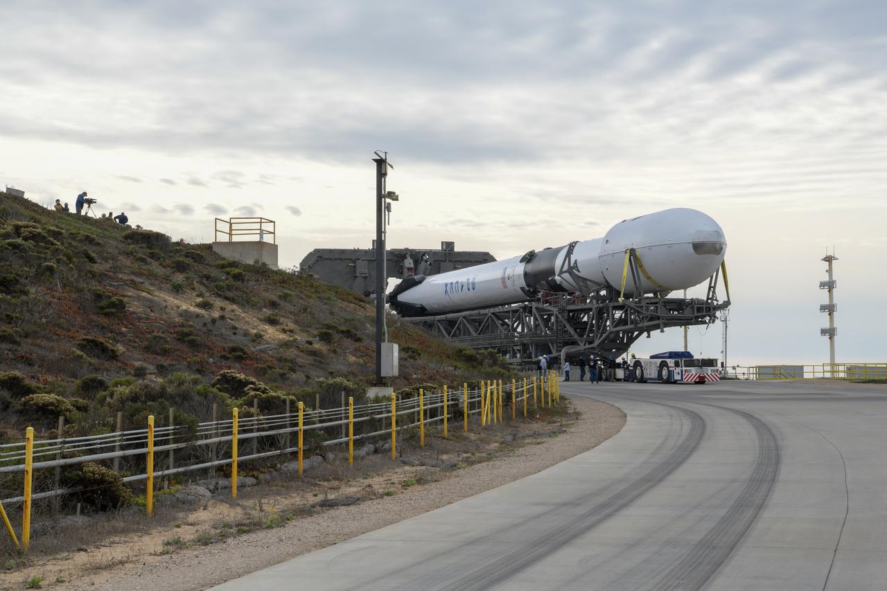
The SpaceX Falcon 9 rocket, topped with the Sentinel-6 Michael Freilich satellite secured inside its payload fairing, rolls from SpaceX’s Payload Processing Facility at Vandenberg Air Force Base in California to Space Launch Complex 4 on Nov. 20, 2020. The Sentinel-6/Jason-CS (Continuity of Service) mission consists of the Sentinel-6 Michael Freilich satellite, which will be followed by its twin, the Sentinel-6B satellite, in 2025. The Sentinel-6/Jason-CS mission is part of Copernicus, the European Union’s Earth observation program, managed by the European Commission. Continuing the legacy of the Jason series missions, Sentinel-6/Jason-CS will extend the records of sea level into their fourth decade, collecting accurate measurements of sea surface height for more than 90% of the world’s seas, and providing crucial information for operational oceanography, marine meteorology, and climate studies. Sentinel-6 Michael Freilich launched Nov. 21, 2020, at 9:17 PST (12:17 EST). NASA’s Launch Services Program at Kennedy Space Center was responsible for launch management.
The SpaceX Falcon 9 rocket carrying the Sentinel-6 Michael Freilich spacecraft lifts off from Space Launch Complex 4 at Vandenberg Air Force Base in California, Nov. 21, 2020, at 9:17 a.m. PST (12:17 p.m. EST). The Sentinel-6/Jason-CS (Continuity of Service) mission consists of the Sentinel-6 Michael Freilich satellite, which will be followed by its twin, the Sentinel-6B satellite, in 2025. The Sentinel-6/Jason-CS mission is part of Copernicus, the European Union’s Earth observation program, managed by the European Commission. Continuing the legacy of the Jason series missions, Sentinel-6/Jason-CS will extend the records of sea level into their fourth decade, collecting accurate measurements of sea surface height for more than 90% of the world’s seas, and providing crucial information for operational oceanography, marine meteorology, and climate studies. NASA’s Launch Services Program at Kennedy Space Center was responsible for launch management.

Phillip Hargrove, a NASA launch trajectory analyst with the agency’s Launch Services Program, participates in the launch broadcast for the Sentinel-6 Michael Freilich mission on Nov. 21, 2020, in the Press Site auditorium at Kennedy Space Center in Florida. The SpaceX Falcon 9 rocket carrying the Sentinel-6 Michael Freilich spacecraft launched from Space Launch Complex 4 at Vandenberg Air Force Base in California at 9:17 a.m. PST (12:17 p.m. EST). The Sentinel-6/Jason-CS (Continuity of Service) mission consists of the Sentinel-6 Michael Freilich satellite, which will be followed by its twin, the Sentinel-6B satellite, in 2025. The Sentinel-6/Jason-CS mission is part of Copernicus, the European Union’s Earth observation program, managed by the European Commission. Continuing the legacy of the Jason series missions, Sentinel-6/Jason-CS will extend the records of sea level into their fourth decade, collecting accurate measurements of sea surface height for more than 90% of the world’s seas, and providing crucial information for operational oceanography, marine meteorology, and climate studies. NASA’s Launch Services Program at Kennedy Space Center was responsible for launch management.
The SpaceX Falcon 9 rocket carrying the Sentinel-6 Michael Freilich spacecraft lifts off from Space Launch Complex 4 at Vandenberg Air Force Base in California, Nov. 21, 2020, at 9:17 a.m. PST (12:17 p.m. EST). The Sentinel-6/Jason-CS (Continuity of Service) mission consists of the Sentinel-6 Michael Freilich satellite, which will be followed by its twin, the Sentinel-6B satellite, in 2025. The Sentinel-6/Jason-CS mission is part of Copernicus, the European Union’s Earth observation program, managed by the European Commission. Continuing the legacy of the Jason series missions, Sentinel-6/Jason-CS will extend the records of sea level into their fourth decade, collecting accurate measurements of sea surface height for more than 90% of the world’s seas, and providing crucial information for operational oceanography, marine meteorology, and climate studies. NASA’s Launch Services Program at Kennedy Space Center was responsible for launch management.
The SpaceX Falcon 9 rocket, topped with the Sentinel-6 Michael Freilich satellite secured inside its payload fairing, is rolled to Space Launch Complex 4 at Vandenberg Air Force Base in California on Nov. 20, 2020, in preparation for launch. The Sentinel-6/Jason-CS (Continuity of Service) mission consists of the Sentinel-6 Michael Freilich satellite, which will be followed by its twin, the Sentinel-6B satellite, in 2025. The Sentinel-6/Jason-CS mission is part of Copernicus, the European Union’s Earth observation program, managed by the European Commission. Continuing the legacy of the Jason series missions, Sentinel-6/Jason-CS will extend the records of sea level into their fourth decade, collecting accurate measurements of sea surface height for more than 90% of the world’s seas, and providing crucial information for operational oceanography, marine meteorology, and climate studies. Sentinel-6 Michael Freilich launched Nov. 21, 2020, at 9:17 PST (12:17 EST). NASA’s Launch Services Program at Kennedy Space Center was responsible for launch management.
NASA Program Scientist Nadya Vinogradova Shiffer, left, of the agency’s Science Mission Directorate, speaks with NASA Commentators Derrol Nail and Marina Jurica during the launch broadcast for the Sentinel-6 Michael Freilich mission on Nov. 21, 2020, at Vandenberg Air Force Base in California. The Sentinel-6/Jason-CS (Continuity of Service) mission consists of the Sentinel-6 Michael Freilich satellite, which will be followed by its twin, the Sentinel-6B satellite, in 2025. The Sentinel-6/Jason-CS mission is part of Copernicus, the European Union’s Earth observation program, managed by the European Commission. Continuing the legacy of the Jason series missions, Sentinel-6/Jason-CS will extend the records of sea level into their fourth decade, collecting accurate measurements of sea surface height for more than 90% of the world’s seas, and providing crucial information for operational oceanography, marine meteorology, and climate studies. Sentinel-6 Michael Freilich launched Nov. 21, 2020, at 9:17 PST (12:17 EST). NASA’s Launch Services Program at Kennedy Space Center was responsible for launch management.
The SpaceX Falcon 9 rocket carrying the Sentinel-6 Michael Freilich spacecraft lifts off from Space Launch Complex 4 at Vandenberg Air Force Base in California, Nov. 21, 2020, at 9:17 a.m. PST (12:17 p.m. EST). The Sentinel-6/Jason-CS (Continuity of Service) mission consists of the Sentinel-6 Michael Freilich satellite, which will be followed by its twin, the Sentinel-6B satellite, in 2025. The Sentinel-6/Jason-CS mission is part of Copernicus, the European Union’s Earth observation program, managed by the European Commission. Continuing the legacy of the Jason series missions, Sentinel-6/Jason-CS will extend the records of sea level into their fourth decade, collecting accurate measurements of sea surface height for more than 90% of the world’s seas, and providing crucial information for operational oceanography, marine meteorology, and climate studies. NASA’s Launch Services Program at Kennedy Space Center was responsible for launch management.
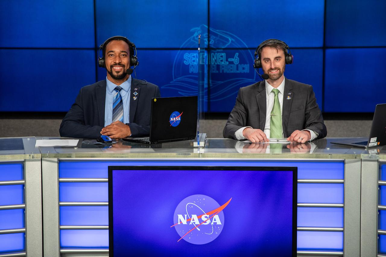
Phillip Hargrove, a NASA launch trajectory analyst with the agency’s Launch Services Program, left, and NASA Launch Commentator Joshua Santora participate in the launch broadcast for the Sentinel-6 Michael Freilich mission on Nov. 21, 2020, in the Press Site auditorium at Kennedy Space Center in Florida. The SpaceX Falcon 9 rocket carrying the Sentinel-6 Michael Freilich spacecraft launched from Space Launch Complex 4 at Vandenberg Air Force Base in California at 9:17 a.m. PST (12:17 p.m. EST). The Sentinel-6/Jason-CS (Continuity of Service) mission consists of the Sentinel-6 Michael Freilich satellite, which will be followed by its twin, the Sentinel-6B satellite, in 2025. The Sentinel-6/Jason-CS mission is part of Copernicus, the European Union’s Earth observation program, managed by the European Commission. Continuing the legacy of the Jason series missions, Sentinel-6/Jason-CS will extend the records of sea level into their fourth decade, collecting accurate measurements of sea surface height for more than 90% of the world’s seas, and providing crucial information for operational oceanography, marine meteorology, and climate studies. NASA’s Launch Services Program at Kennedy Space Center was responsible for launch management.
The SpaceX Falcon 9 rocket carrying the Sentinel-6 Michael Freilich spacecraft lifts off from Space Launch Complex 4 at Vandenberg Air Force Base in California, Nov. 21, 2020, at 9:17 a.m. PST (12:17 p.m. EST). The Sentinel-6/Jason-CS (Continuity of Service) mission consists of the Sentinel-6 Michael Freilich satellite, which will be followed by its twin, the Sentinel-6B satellite, in 2025. The Sentinel-6/Jason-CS mission is part of Copernicus, the European Union’s Earth observation program, managed by the European Commission. Continuing the legacy of the Jason series missions, Sentinel-6/Jason-CS will extend the records of sea level into their fourth decade, collecting accurate measurements of sea surface height for more than 90% of the world’s seas, and providing crucial information for operational oceanography, marine meteorology, and climate studies. NASA’s Launch Services Program at Kennedy Space Center was responsible for launch management.
The SpaceX Falcon 9 rocket carrying the Sentinel-6 Michael Freilich spacecraft lifts off from Space Launch Complex 4 at Vandenberg Air Force Base in California, Nov. 21, 2020, at 9:17 a.m. PST (12:17 p.m. EST). The Sentinel-6/Jason-CS (Continuity of Service) mission consists of the Sentinel-6 Michael Freilich satellite, which will be followed by its twin, the Sentinel-6B satellite, in 2025. The Sentinel-6/Jason-CS mission is part of Copernicus, the European Union’s Earth observation program, managed by the European Commission. Continuing the legacy of the Jason series missions, Sentinel-6/Jason-CS will extend the records of sea level into their fourth decade, collecting accurate measurements of sea surface height for more than 90% of the world’s seas, and providing crucial information for operational oceanography, marine meteorology, and climate studies. NASA’s Launch Services Program at Kennedy Space Center was responsible for launch management.
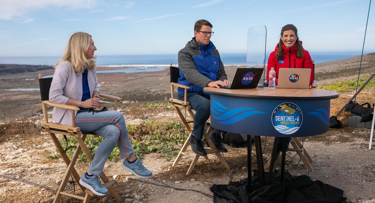
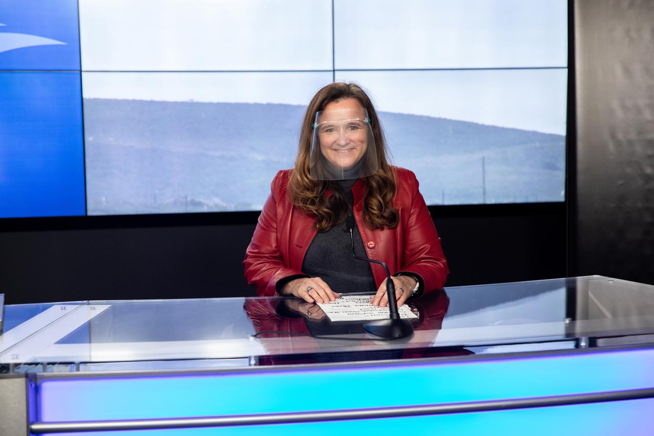
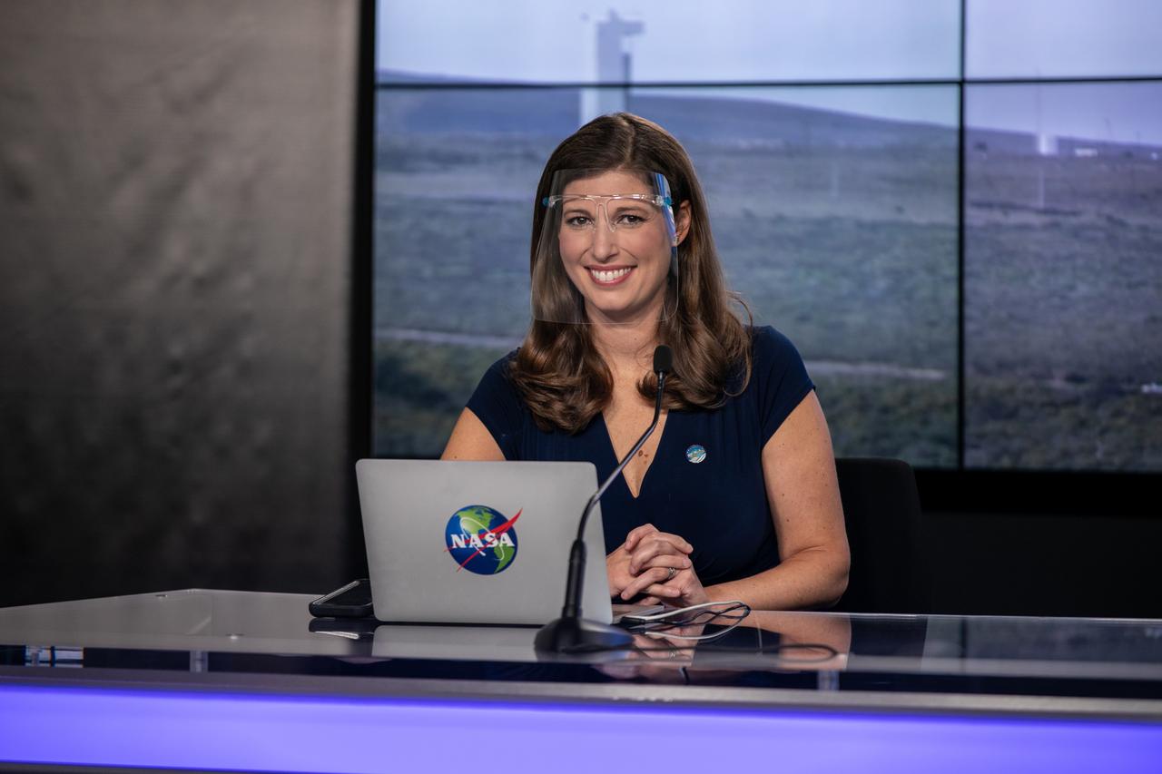
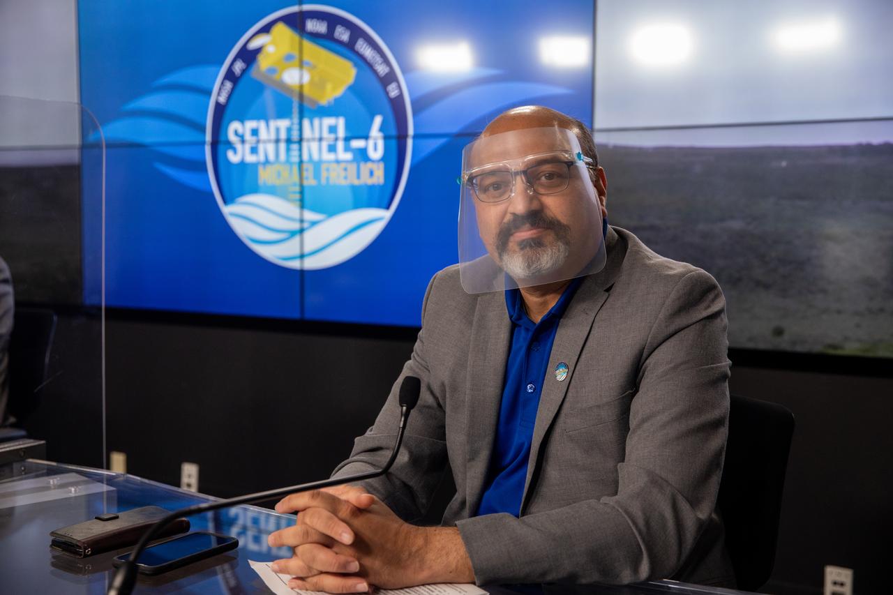
Marina Jurica of NASA’s Jet Propulsion Laboratory in Pasadena, foreground, and Karen St. Germain, director of the agency’s Earth Science Division, participate in a science briefing for the Sentinel-6 Michael Freilich mission at Vandenberg Air Force Base in California on Nov. 20, 2020. The Sentinel-6/Jason-CS (Continuity of Service) mission consists of the Sentinel-6 Michael Freilich satellite, which will be followed by its twin, the Sentinel-6B satellite, in 2025. The Sentinel-6/Jason-CS mission is part of Copernicus, the European Union’s Earth observation program, managed by the European Commission. Continuing the legacy of the Jason series missions, Sentinel-6/Jason-CS will extend the records of sea level into their fourth decade, collecting accurate measurements of sea surface height for more than 90% of the world’s seas, and providing crucial information for operational oceanography, marine meteorology, and climate studies. Sentinel-6 Michael Freilich launched Nov. 21, 2020, at 9:17 PST (12:17 EST). NASA’s Launch Services Program at Kennedy Space Center was responsible for launch management.

Marina Jurica of NASA’s Jet Propulsion Laboratory in Pasadena moderates a science briefing for the Sentinel-6 Michael Freilich mission at Vandenberg Air Force Base in California on Nov. 20, 2020. The Sentinel-6/Jason-CS (Continuity of Service) mission consists of the Sentinel-6 Michael Freilich satellite, which will be followed by its twin, the Sentinel-6B satellite, in 2025. The Sentinel-6/Jason-CS mission is part of Copernicus, the European Union’s Earth observation program, managed by the European Commission. Continuing the legacy of the Jason series missions, Sentinel-6/Jason-CS will extend the records of sea level into their fourth decade, collecting accurate measurements of sea surface height for more than 90% of the world’s seas, and providing crucial information for operational oceanography, marine meteorology, and climate studies. Sentinel-6 Michael Freilich launched Nov. 21, 2020, at 9:17 PST (12:17 EST). NASA’s Launch Services Program at Kennedy Space Center was responsible for launch management.
Marina Jurica of NASA’s Jet Propulsion Laboratory in Pasadena moderates a prelaunch news conference for the Sentinel-6 Michael Freilich mission at Vandenberg Air Force Base in California on Nov. 20, 2020. The Sentinel-6/Jason-CS (Continuity of Service) mission consists of the Sentinel-6 Michael Freilich satellite, which will be followed by its twin, the Sentinel-6B satellite, in 2025. The Sentinel-6/Jason-CS mission is part of Copernicus, the European Union’s Earth observation program, managed by the European Commission. Continuing the legacy of the Jason series missions, Sentinel-6/Jason-CS will extend the records of sea level into their fourth decade, collecting accurate measurements of sea surface height for more than 90% of the world’s seas, and providing crucial information for operational oceanography, marine meteorology, and climate studies. Sentinel-6 Michael Freilich launched Nov. 21, 2020, at 9:17 PST (12:17 EST). NASA’s Launch Services Program at Kennedy Space Center was responsible for launch management.
Karen St. Germain, director of NASA’s Earth Science Division, participates in a science briefing for the Sentinel-6 Michael Freilich mission at Vandenberg Air Force Base in California on Nov. 20, 2020. The Sentinel-6/Jason-CS (Continuity of Service) mission consists of the Sentinel-6 Michael Freilich satellite, which will be followed by its twin, the Sentinel-6B satellite, in 2025. The Sentinel-6/Jason-CS mission is part of Copernicus, the European Union’s Earth observation program, managed by the European Commission. Continuing the legacy of the Jason series missions, Sentinel-6/Jason-CS will extend the records of sea level into their fourth decade, collecting accurate measurements of sea surface height for more than 90% of the world’s seas, and providing crucial information for operational oceanography, marine meteorology, and climate studies. Sentinel-6 Michael Freilich launched Nov. 21, 2020, at 9:17 PST (12:17 EST). NASA’s Launch Services Program at Kennedy Space Center was responsible for launch management.
Pierrik Vuilleumier, project manager, European Space Agency (ESA), participates in a prelaunch news conference for the Sentinel-6 Michael Freilich mission at Vandenberg Air Force Base in California on Nov. 20, 2020. The Sentinel-6/Jason-CS (Continuity of Service) mission consists of the Sentinel-6 Michael Freilich satellite, which will be followed by its twin, the Sentinel-6B satellite, in 2025. The Sentinel-6/Jason-CS mission is part of Copernicus, the European Union’s Earth observation program, managed by the European Commission. Continuing the legacy of the Jason series missions, Sentinel-6/Jason-CS will extend the records of sea level into their fourth decade, collecting accurate measurements of sea surface height for more than 90% of the world’s seas, and providing crucial information for operational oceanography, marine meteorology, and climate studies. Sentinel-6 Michael Freilich launched Nov. 21, 2020, at 9:17 PST (12:17 EST). NASA’s Launch Services Program at Kennedy Space Center was responsible for launch management.
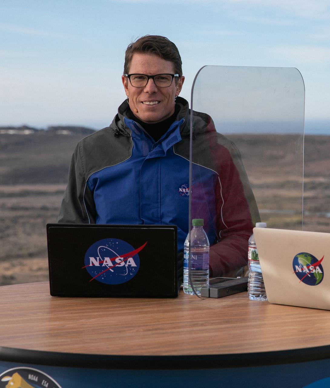
Thomas Zurbuchen, associate administrator for Science Mission Directorate at NASA Headquarters, participates in a prelaunch news conference for the Sentinel-6 Michael Freilich mission at Vandenberg Air Force Base in California on Nov. 20, 2020. The Sentinel-6/Jason-CS (Continuity of Service) mission consists of the Sentinel-6 Michael Freilich satellite, which will be followed by its twin, the Sentinel-6B satellite, in 2025. The Sentinel-6/Jason-CS mission is part of Copernicus, the European Union’s Earth observation program, managed by the European Commission. Continuing the legacy of the Jason series missions, Sentinel-6/Jason-CS will extend the records of sea level into their fourth decade, collecting accurate measurements of sea surface height for more than 90% of the world’s seas, and providing crucial information for operational oceanography, marine meteorology, and climate studies. Sentinel-6 Michael Freilich launched Nov. 21, 2020, at 9:17 PST (12:17 EST). NASA’s Launch Services Program at Kennedy Space Center was responsible for launch management.
Karen St. Germain, director of NASA’s Earth Science Division, participates in a science briefing for the Sentinel-6 Michael Freilich mission at Vandenberg Air Force Base in California on Nov. 20, 2020. The Sentinel-6/Jason-CS (Continuity of Service) mission consists of the Sentinel-6 Michael Freilich satellite, which will be followed by its twin, the Sentinel-6B satellite, in 2025. The Sentinel-6/Jason-CS mission is part of Copernicus, the European Union’s Earth observation program, managed by the European Commission. Continuing the legacy of the Jason series missions, Sentinel-6/Jason-CS will extend the records of sea level into their fourth decade, collecting accurate measurements of sea surface height for more than 90% of the world’s seas, and providing crucial information for operational oceanography, marine meteorology, and climate studies. Sentinel-6 Michael Freilich launched Nov. 21, 2020, at 9:17 PST (12:17 EST). NASA’s Launch Services Program at Kennedy Space Center was responsible for launch management.
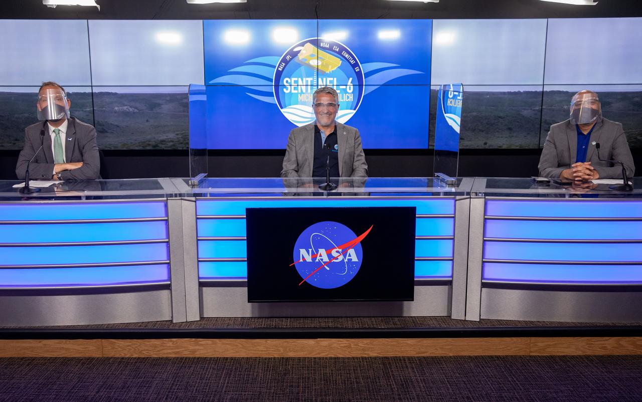
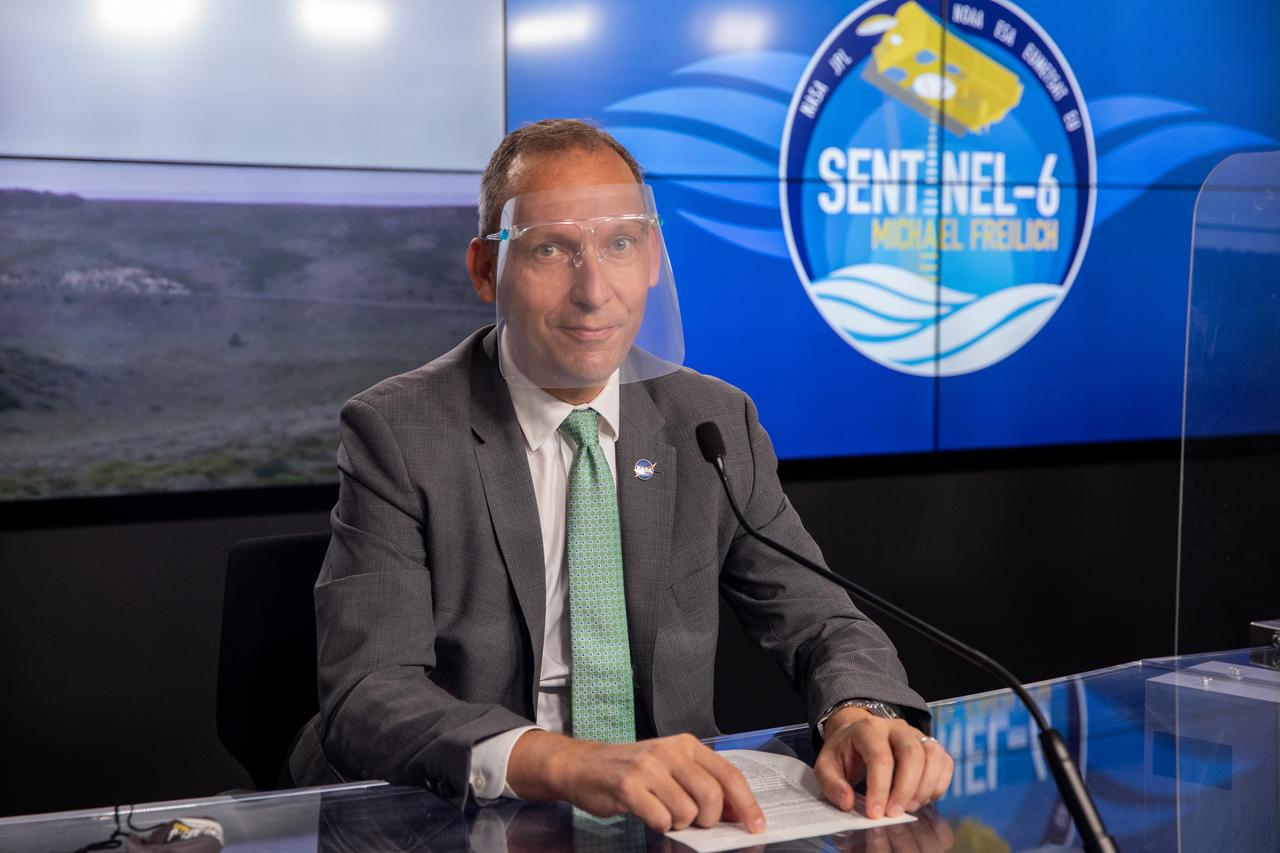
Mission and launch officials participate in a prelaunch news conference for the Sentinel-6 Michael Freilich mission at Vandenberg Air Force Base in California on Nov. 20, 2020. From left are Thomas Zurbuchen, associate administrator for Science Mission Directorate at NASA Headquarters; Pierrik Vuilleumier, project manager, European Space Agency (ESA); and Parag Vaze, project manager, NASA’s Jet Propulsion Laboratory in Pasadena. The Sentinel-6/Jason-CS (Continuity of Service) mission consists of the Sentinel-6 Michael Freilich satellite, which will be followed by its twin, the Sentinel-6B satellite, in 2025. The Sentinel-6/Jason-CS mission is part of Copernicus, the European Union’s Earth observation program, managed by the European Commission. Continuing the legacy of the Jason series missions, Sentinel-6/Jason-CS will extend the records of sea level into their fourth decade, collecting accurate measurements of sea surface height for more than 90% of the world’s seas, and providing crucial information for operational oceanography, marine meteorology, and climate studies. Sentinel-6 Michael Freilich launched Nov. 21, 2020, at 9:17 PST (12:17 EST). NASA’s Launch Services Program at Kennedy Space Center was responsible for launch management.
Marina Jurica of NASA’s Jet Propulsion Laboratory in Pasadena moderates a science briefing for the Sentinel-6 Michael Freilich mission at Vandenberg Air Force Base in California on Nov. 20, 2020. The Sentinel-6/Jason-CS (Continuity of Service) mission consists of the Sentinel-6 Michael Freilich satellite, which will be followed by its twin, the Sentinel-6B satellite, in 2025. The Sentinel-6/Jason-CS mission is part of Copernicus, the European Union’s Earth observation program, managed by the European Commission. Continuing the legacy of the Jason series missions, Sentinel-6/Jason-CS will extend the records of sea level into their fourth decade, collecting accurate measurements of sea surface height for more than 90% of the world’s seas, and providing crucial information for operational oceanography, marine meteorology, and climate studies. Sentinel-6 Michael Freilich launched Nov. 21, 2020, at 9:17 PST (12:17 EST). NASA’s Launch Services Program at Kennedy Space Center was responsible for launch management.
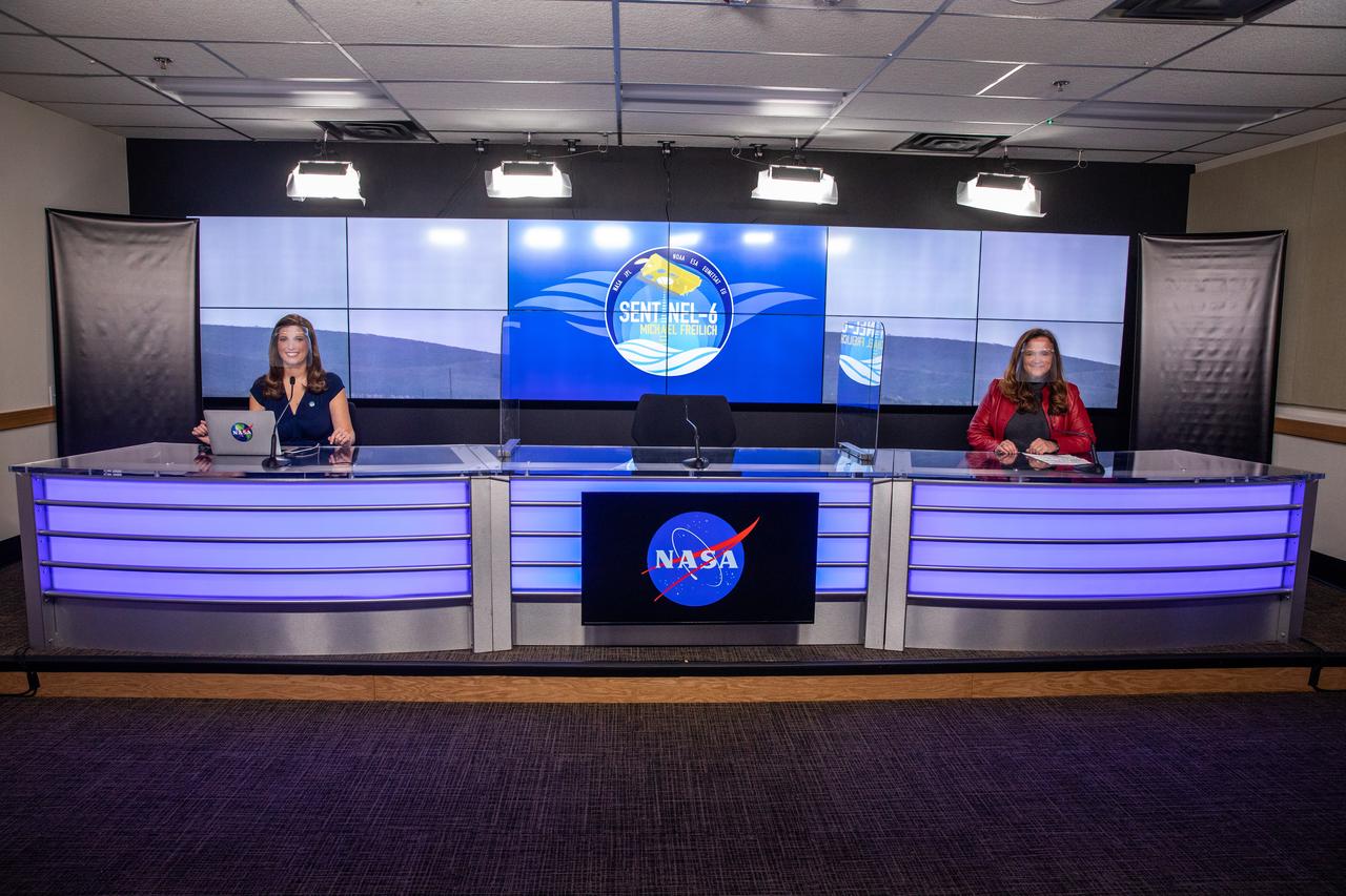
Marina Jurica of NASA’s Jet Propulsion Laboratory in Pasadena, left, and Karen St. Germain, director of the agency’s Earth Science Division, participate in a science briefing for the Sentinel-6 Michael Freilich mission at Vandenberg Air Force Base in California on Nov. 20, 2020. The Sentinel-6/Jason-CS (Continuity of Service) mission consists of the Sentinel-6 Michael Freilich satellite, which will be followed by its twin, the Sentinel-6B satellite, in 2025. The Sentinel-6/Jason-CS mission is part of Copernicus, the European Union’s Earth observation program, managed by the European Commission. Continuing the legacy of the Jason series missions, Sentinel-6/Jason-CS will extend the records of sea level into their fourth decade, collecting accurate measurements of sea surface height for more than 90% of the world’s seas, and providing crucial information for operational oceanography, marine meteorology, and climate studies. Sentinel-6 Michael Freilich launched Nov. 21, 2020, at 9:17 PST (12:17 EST). NASA’s Launch Services Program at Kennedy Space Center was responsible for launch management.
Parag Vaze, project manager, NASA’s Jet Propulsion Laboratory in Pasadena, participates in a prelaunch news conference for the Sentinel-6 Michael Freilich mission at Vandenberg Air Force Base in California on Nov. 20, 2020. The Sentinel-6/Jason-CS (Continuity of Service) mission consists of the Sentinel-6 Michael Freilich satellite, which will be followed by its twin, the Sentinel-6B satellite, in 2025. The Sentinel-6/Jason-CS mission is part of Copernicus, the European Union’s Earth observation program, managed by the European Commission. Continuing the legacy of the Jason series missions, Sentinel-6/Jason-CS will extend the records of sea level into their fourth decade, collecting accurate measurements of sea surface height for more than 90% of the world’s seas, and providing crucial information for operational oceanography, marine meteorology, and climate studies. Sentinel-6 Michael Freilich launched Nov. 21, 2020, at 9:17 PST (12:17 EST). NASA’s Launch Services Program at Kennedy Space Center was responsible for launch management.
Marina Jurica of NASA’s Jet Propulsion Laboratory in Pasadena moderates a science briefing for the Sentinel-6 Michael Freilich mission at Vandenberg Air Force Base in California on Nov. 20, 2020. The Sentinel-6/Jason-CS (Continuity of Service) mission consists of the Sentinel-6 Michael Freilich satellite, which will be followed by its twin, the Sentinel-6B satellite, in 2025. The Sentinel-6/Jason-CS mission is part of Copernicus, the European Union’s Earth observation program, managed by the European Commission. Continuing the legacy of the Jason series missions, Sentinel-6/Jason-CS will extend the records of sea level into their fourth decade, collecting accurate measurements of sea surface height for more than 90% of the world’s seas, and providing crucial information for operational oceanography, marine meteorology, and climate studies. Sentinel-6 Michael Freilich launched Nov. 21, 2020, at 9:17 PST (12:17 EST). NASA’s Launch Services Program at Kennedy Space Center was responsible for launch management.
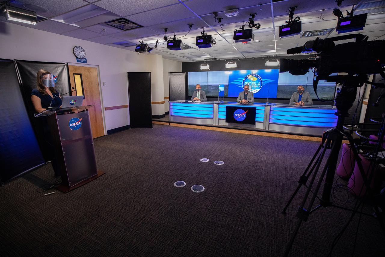
Mission and launch officials participate in a prelaunch news conference for the Sentinel-6 Michael Freilich mission at Vandenberg Air Force Base in California on Nov. 20, 2020. From left are Marina Jurica of NASA’s Jet Propulsion Laboratory in Pasadena; Thomas Zurbuchen, associate administrator for Science Mission Directorate at NASA Headquarters; Pierrik Vuilleumier, project manager, European Space Agency (ESA); and Parag Vaze, project manager, NASA’s Jet Propulsion Laboratory in Pasadena. The Sentinel-6/Jason-CS (Continuity of Service) mission consists of the Sentinel-6 Michael Freilich satellite, which will be followed by its twin, the Sentinel-6B satellite, in 2025. The Sentinel-6/Jason-CS mission is part of Copernicus, the European Union’s Earth observation program, managed by the European Commission. Continuing the legacy of the Jason series missions, Sentinel-6/Jason-CS will extend the records of sea level into their fourth decade, collecting accurate measurements of sea surface height for more than 90% of the world’s seas, and providing crucial information for operational oceanography, marine meteorology, and climate studies. Sentinel-6 Michael Freilich launched Nov. 21, 2020, at 9:17 PST (12:17 EST). NASA’s Launch Services Program at Kennedy Space Center was responsible for launch management.
S73-34295B (June 1973) --- A vertical view of a portion of northern California reproduced from data taken from the Skylab Multispectral Scanner, experiment S192, in the Skylab space station in Earth orbit. This view is the most westerly one-third of Frame No. 001, Roll No. 518, S192, Skylab 2. Frame No. 001 extends from the Pacific coast at the Eureka area southeasterly 175 nautical miles to the Feather River drainage basin. Included in this view are Lake Shasta, Sacramento River Valley, Redding and Red Bluff. This non-photographic image is a color composite of channels 2 (visible), 7, and 12 (infrared) from the Earth Resources Experiments Package (EREP) S192 scanner. The scanner techniques assist with spectral signature identification and mapping of ground truth targets in agriculture, forestry, geology, hydrology and oceanography. Photo credit: NASA
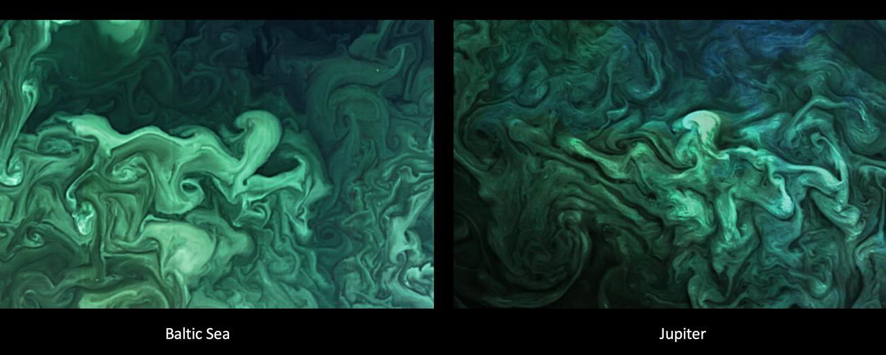
The left image shows a close-up of a phytoplankton blooming in the southern Gulf of Bothnia, in the Baltic Sea, between Sweden and Finland on April 14, 2019. The right image shows turbulent clouds in Jupiter's atmosphere. Jupiter's atmosphere is one of the most turbulent places in the solar system. Orbiting Jupiter and its 79 moons is NASA's Juno spacecraft, which sends images from the largest planet in our solar system back to researchers on Earth. These images from Juno have given oceanographers the raw materials to study the rich turbulence at Jupiter's poles and the physical forces that drive large cyclones on Jupiter. Lia Siegelman, a physical oceanographer and postdoctoral scholar at Scripps Institution of Oceanography at the University of California San Diego, observed similarities between the richness of turbulence around Jovian cyclones and the filaments around smaller eddies with turbulence seen in Earth's oceans. https://photojournal.jpl.nasa.gov/catalog/PIA25034

The left image shows a phytoplankton bloom in the Norwegian Sea. The right image shows turbulent clouds in Jupiter's atmosphere. Jupiter's atmosphere is one of the most turbulent places in the solar system. Orbiting Jupiter and its 79 moons is NASA's Juno spacecraft, which sends images from the largest planet in our solar system back to researchers on Earth. These images from Juno have given oceanographers the raw materials to study the rich turbulence at Jupiter's poles and the physical forces that drive large cyclones on Jupiter. Lia Siegelman, a physical oceanographer and postdoctoral scholar at Scripps Institution of Oceanography at the University of California, San Diego, observed similarities between the richness of turbulence around Jovian cyclones and the filaments around smaller eddies with turbulence seen in Earth's oceans. https://photojournal.jpl.nasa.gov/catalog/PIA25037
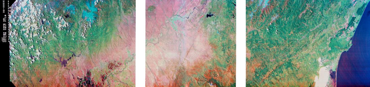
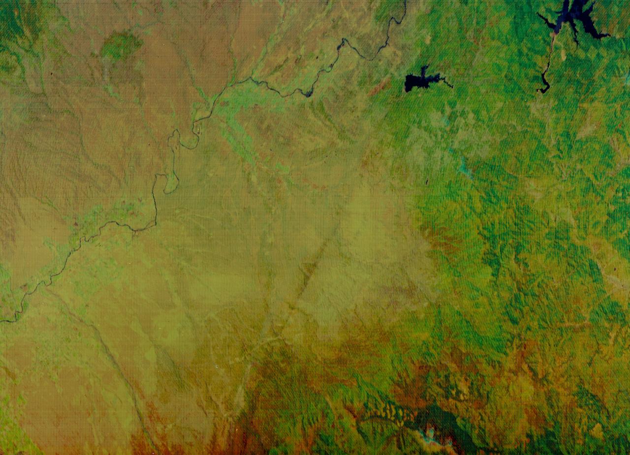
S73-34295 (June 1973) --- A vertical view of a portion of northern California reproduced from data taken from the Skylab Multispectral Scanner, experiment S192, in the Skylab space station in Earth orbit. This view is the most westerly one-third of Frame No. 001, Roll No. 518, S192, Skylab 2. Frame No. 001 extends from the Pacific coast at the Eureka area southeasterly 175 nautical miles to the Feather River drainage basin. Included in this view are Eureka, Trinidad, Klamath & Trinity Rivers and the Coastal Range mountains. This non-photographic image is a color composite of channels 2 (visible), 7, and 12 (infrared) from the Earth Resources Experiments Package (EREP) S192 scanner. The scanner techniques assist with spectral signature identification and mapping of ground truth targets in agriculture, forestry, geology, hydrology and oceanography. Photo credit: NASA
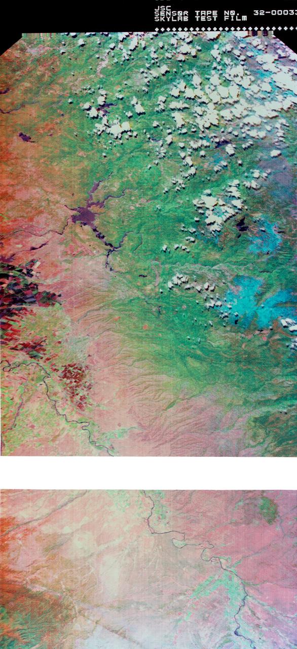
S73-34295A (June 1973) --- A vertical view of a portion of northern California reproduced from data taken from the Skylab Multispectral Scanner, experiment S192, in the Skylab space station in Earth orbit. This view is the most westerly one-third of Frame No. 001, Roll No. 518, S192, Skylab 2. Frame No. 001 extends from the Pacific coast at the Eureka area southeasterly 175 nautical miles to the Feather River drainage basin. Included in this view are Sacramento River Valley, Oroville Reservoir, Oroville and Chico. This non-photographic image is a color composite of channels 2 (visible), 7 and 12 (infrared) from the Earth Resources Experiments Package (EREP) S192 scanner. The scanner techniques assist with spectral signature identification and mapping of ground truth targets in agriculture, forestry, geology, hydrology and oceanography. Photo credit: NASA

NASA DC-8 airborne laboratory flying over Mint Canyon near the snow-covered San Gabriel Mountains of California. The mostly white aircraft is silhouetted against the darker mountains in the background.
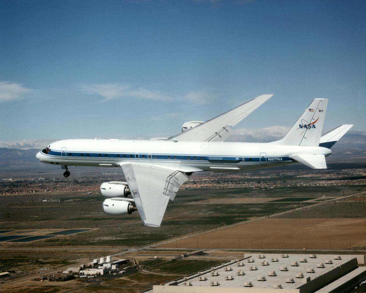
The DC-8 Airborne Laboratory in a left banking turn above the airport at Palmdale, California. The right wing is silhouetted against the blue sky, while the left wing contrasts with the desert terrain. The former airliner is a "dash-72" model and has a range of 5,400 miles. The craft can stay airborne for 12 hours and has an operational speed range between 300 and 500 knots. The research flights are made at between 500 and 41,000 feet. The aircraft can carry up to 30,000 lbs of research/science payload equipment installed in 15 mission-definable spaces.
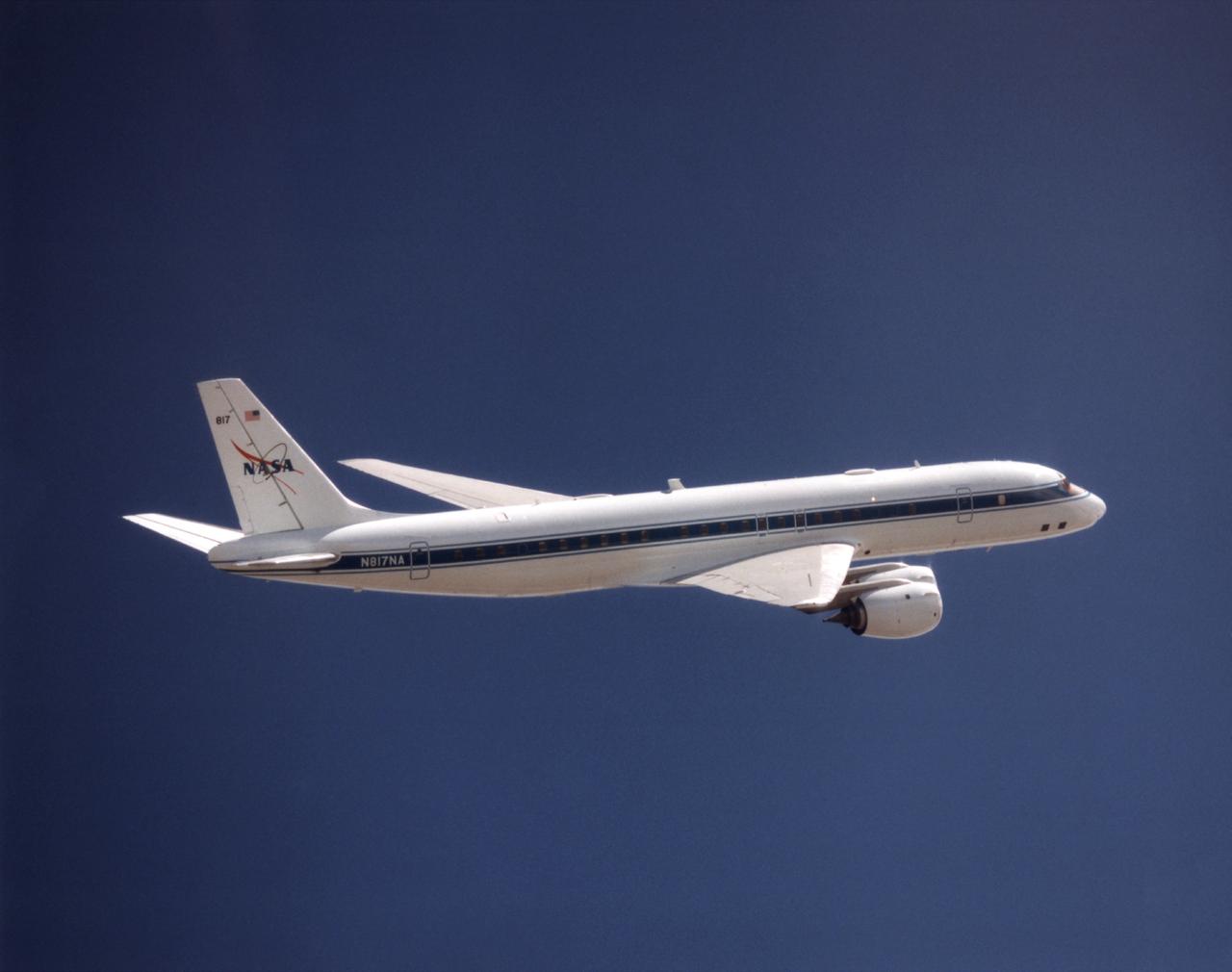
NASA's DC-8 Airborne Science platform shown against a background of a dark blue sky on February 20, 1998. The aircraft is shown from the right rear, slightly above its plane, with the right wing in the foreground and the left wing and horizontal tail in the background. The former airliner is a "dash-72" model and has a range of 5,400 miles. The craft can stay airborne for 12 hours and has an operational speed range between 300 and 500 knots. The research flights are made at between 500 and 41,000 feet. The aircraft can carry up to 30,000 lbs of research/science payload equipment installed in 15 mission-definable spaces.
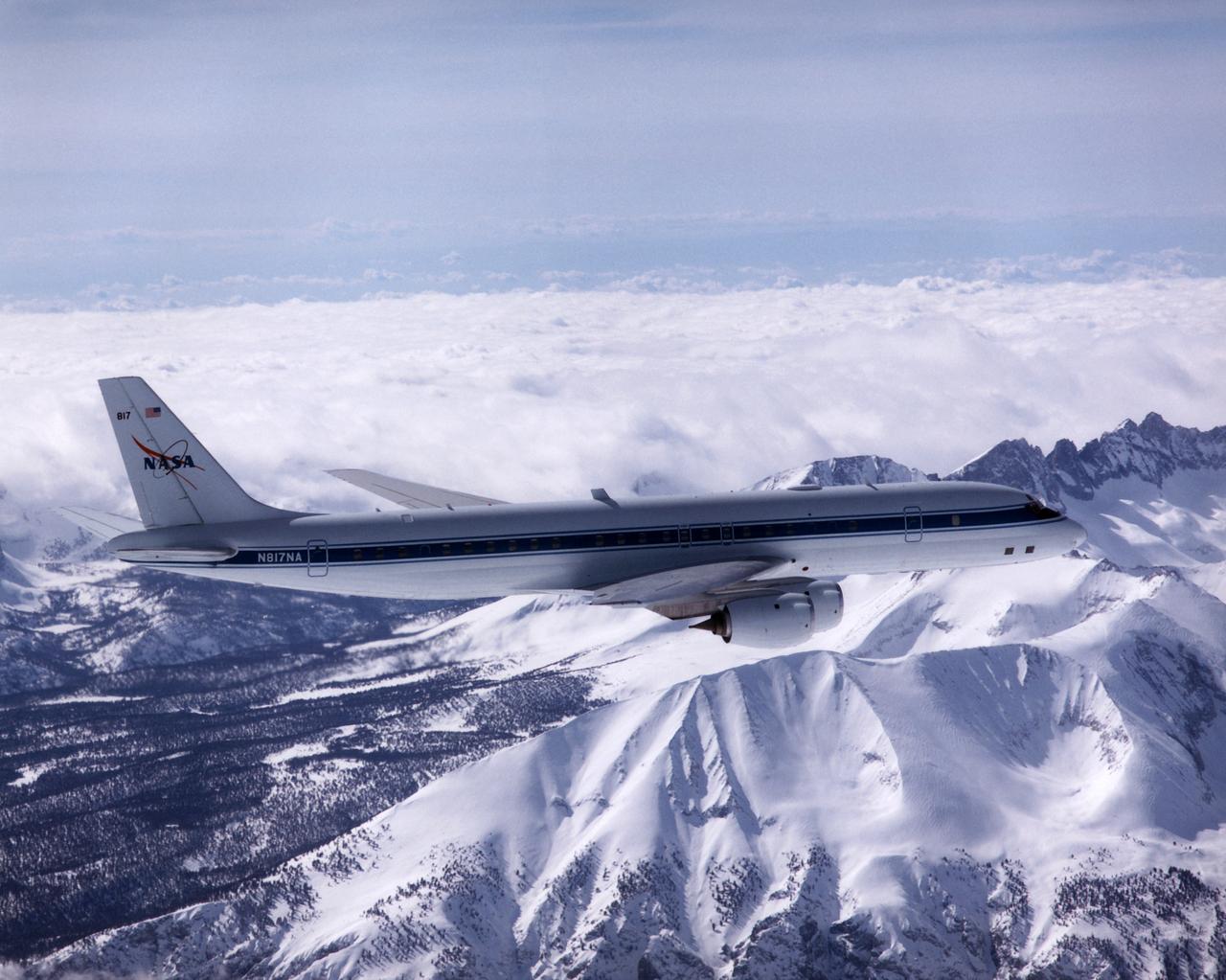
NASA's DC-8 Airborne Laboratory during a flight over the snow-covered Sierra Nevada Mountains. Over the past several years the DC-8 has conducted research missions in such diverse places as the Pacific in spring and Sweden in winter.
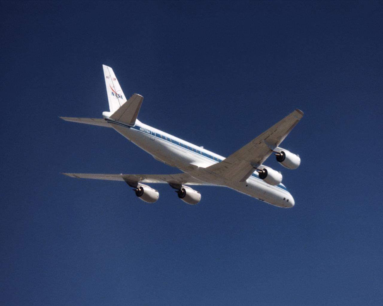
The NASA DC-8 in a right bank over the rugged Sierra Nevada Mountains. The former airliner is a "dash-72" model and has a range of 5,500 miles. The craft can stay airborne for 12 hours and has an operational speed range between 300 and 500 knots. The research flights are made at between 500 and 41,000 feet. The aircraft can carry up to 30,000 lbs of research/science payload equipment installed in 15 mission-definable spaces. In this photo, the aircraft is shown in flight from below, with the DC-8 silhouetted against a blue sky.
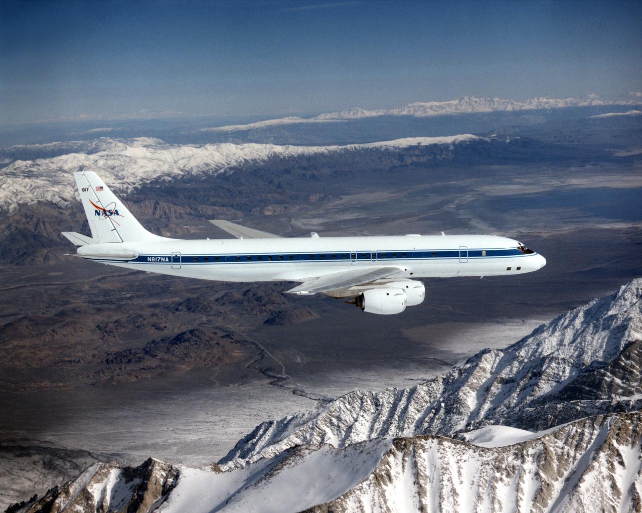
The DC-8 in flight near Lone Pine, Calif. In the foreground are the Sierra Nevada Mountains, covered with winter snow. In the distance are the White Mountains. The DC-8's fuselage is painted white with a dark blue stripe down the side. The wings are silver, while the engine pods are white. In this view of the airplane's right-hand side, only a few of its antennas are visible. The experimental payload can be as great as 30,000 pounds of equipment for gathering data of various sorts.
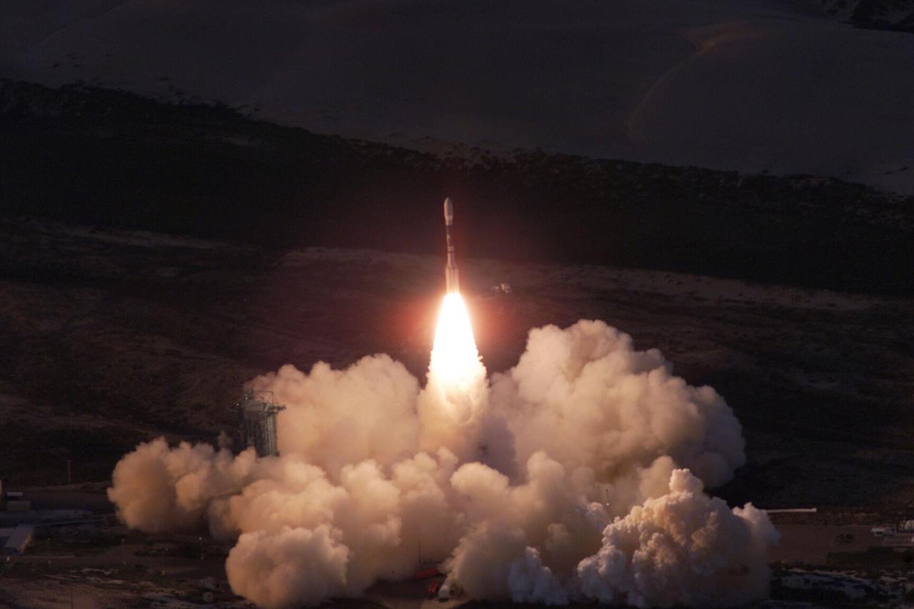
VANDENBERG AIR FORCE BASE, Calif. -- A Delta II rocket appears to erupt from the undulating clouds of smoke below as it launches with the joint NASA/French Space Agency oceanography satellite Jason 1 and Thermosphere Ionosphere Mesosphere Energetics and Dynamics satellite aboard. Liftoff from Launch Complex 2W occurred at 7:07 a.m. PST (10:07 a.m. EST or 15:07 GMT). Jason 1 joins the orbiting Topex/Poseidon satellite to continue observations of the global climate interaction occurring between the sea and the atmosphere as a result of stored solar energy. Instruments on Jason 1 will map variations in ocean surface topography to monitor world ocean circulation, study interactions of the oceans and atmosphere, improve climate predictions and observe events like El Nino. The mission is expected to last three years. The TIMED satellite will study a little-known region above the atmosphere, some 40 to 110 miles from the Earth's surface. Studying this region has been nearly impossible until now because conventional airplanes and balloons cannot reach this high altitude, and it is too low for direct satellite measurements

VANDENBERG AIR FORCE BASE, Calif. -- A Delta II rocket launches successfully with the joint NASA/French Space Agency oceanography satellite Jason 1 and Thermosphere Ionosphere Mesosphere Energetics and Dynamics satellite aboard. Liftoff from Launch Complex 2W occurred at 7:07 a.m. PST (10:07 a.m. EST or 15:07 GMT). Jason 1 joins the orbiting Topex/Poseidon satellite to continue observations of the global climate interaction occurring between the sea and the atmosphere as a result of stored solar energy. Instruments on Jason 1 will map variations in ocean surface topography to monitor world ocean circulation, study interactions of the oceans and atmosphere, improve climate predictions and observe events like El Nino. The mission is expected to last three years. The TIMED satellite will study a little-known region above the atmosphere, some 40 to 110 miles from the Earth's surface. Studying this region has been nearly impossible until now because conventional airplanes and balloons cannot reach this high altitude, and it is too low for direct satellite measurements
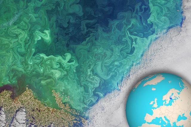
NASA's Landsat 8 satellite collected this view of phytoplankton blooming in the southern Gulf of Bothnia, in the Baltic Sea, between Sweden and Finland on April 14, 2019. Jupiter's atmosphere is one of the most turbulent places in the solar system. Orbiting Jupiter and its 79 moons is NASA's Juno spacecraft, which sends images from the largest planet in our solar system back to researchers on Earth. These images from Juno have given oceanographers the raw materials to study the rich turbulence at Jupiter's poles and the physical forces that drive large cyclones on the gas giant. Lia Siegelman, a physical oceanographer and postdoctoral scholar at Scripps Institution of Oceanography at the University of California, San Diego, observed similarities between the richness of turbulence around Jovian cyclones and the filaments around smaller eddies with turbulence seen in Earth's oceans. These similarities between the phenomena on Earth and Jupiter are especially evident on high-resolution images of plankton blooms, as seen above. https://photojournal.jpl.nasa.gov/catalog/PIA25033
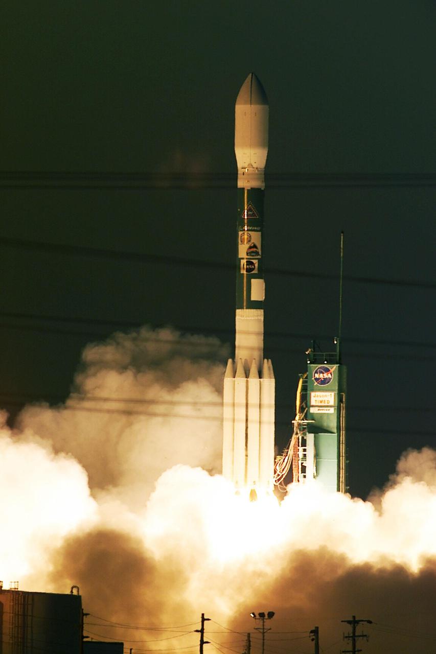
VANDENBERG AIR FORCE BASE, Calif. -- A Delta II rocket launches successfully with the joint NASA_French Space Agency oceanography satellite Jason 1 and Thermosphere Ionosphere Mesosphere Energetics and Dynamics satellite aboard. Liftoff from Launch Complex 2W occurred at 7:07 a.m. PST (10:07 a.m. EST or 15:07 GMT). Jason 1 joins the orbiting Topex_Poseidon satellite to continue observations of the global climate interaction occurring between the sea and the atmosphere as a result of stored solar energy. Instruments on Jason 1 will map variations in ocean surface topography to monitor world ocean circulation, study interactions of the oceans and atmosphere, improve climate predictions and observe events like El Nino. The mission is expected to last three years. The TIMED satellite will study a little-known region above the atmosphere, some 40 to 110 miles from the Earth's surface. Studying this region has been nearly impossible until now because conventional airplanes and balloons cannot reach this high altitude, and it is too low for direct satellite measurements
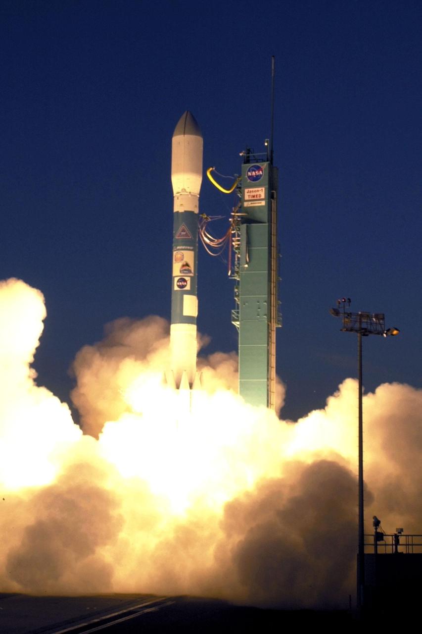
VANDENBERG AIR FORCE BASE, Calif.. -- A Delta rocket leaps off Launch Complex 2W carrying the joint NASA/French Space Agency oceanography satellite Jason 1 and Thermosphere Ionosphere Mesosphere Energetics and Dynamics satellite aboard. Liftoff occurred at 7:07 a.m. PST (10:07 a.m. EST or 15:07 GMT). Jason 1 joins the orbiting Topex/Poseidon satellite to continue observations of the global climate interaction occurring between the sea and the atmosphere as a result of stored solar energy. Instruments on Jason 1 will map variations in ocean surface topography to monitor world ocean circulation, study interactions of the oceans and atmosphere, improve climate predictions and observe events like El Nino. The mission is expected to last three years. The TIMED satellite will study a little-known region above the atmosphere, some 40 to 110 miles from the Earth's surface. Studying this region has been nearly impossible until now because conventional airplanes and balloons cannot reach this high altitude, and it is too low for direct satellite measurements

VANDENBERG AIR FORCE BASE, Calif.. -- A Delta rocket leaps off Launch Complex 2W carrying the joint NASA_French Space Agency oceanography satellite Jason 1 and Thermosphere Ionosphere Mesosphere Energetics and Dynamics satellite aboard. Liftoff occurred at 7:07 a.m. PST (10:07 a.m. EST or 15:07 GMT). Jason 1 joins the orbiting Topex_Poseidon satellite to continue observations of the global climate interaction occurring between the sea and the atmosphere as a result of stored solar energy. Instruments on Jason 1 will map variations in ocean surface topography to monitor world ocean circulation, study interactions of the oceans and atmosphere, improve climate predictions and observe events like El Nino. The mission is expected to last three years. The TIMED satellite will study a little-known region above the atmosphere, some 40 to 110 miles from the Earth's surface. Studying this region has been nearly impossible until now because conventional airplanes and balloons cannot reach this high altitude, and it is too low for direct satellite measurements

VANDENBERG AIR FORCE BASE, Calif. -- A Delta II rocket appears to erupt from the undulating clouds of smoke below as it launches with the joint NASA_French Space Agency oceanography satellite Jason 1 and Thermosphere Ionosphere Mesosphere Energetics and Dynamics satellite aboard. Liftoff from Launch Complex 2W occurred at 7:07 a.m. PST (10:07 a.m. EST or 15:07 GMT). Jason 1 joins the orbiting Topex_Poseidon satellite to continue observations of the global climate interaction occurring between the sea and the atmosphere as a result of stored solar energy. Instruments on Jason 1 will map variations in ocean surface topography to monitor world ocean circulation, study interactions of the oceans and atmosphere, improve climate predictions and observe events like El Nino. The mission is expected to last three years. The TIMED satellite will study a little-known region above the atmosphere, some 40 to 110 miles from the Earth's surface. Studying this region has been nearly impossible until now because conventional airplanes and balloons cannot reach this high altitude, and it is too low for direct satellite measurements