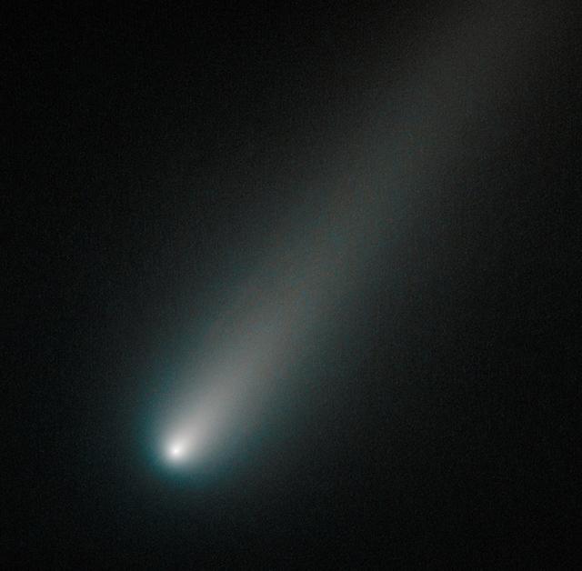
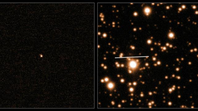
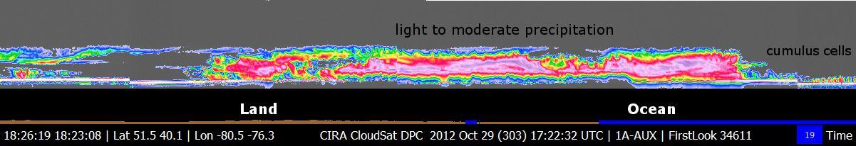
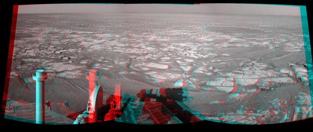
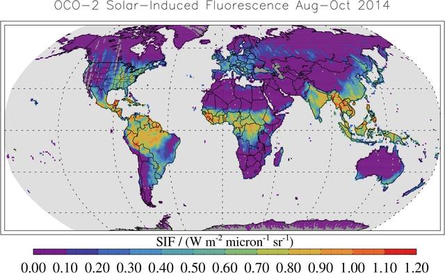
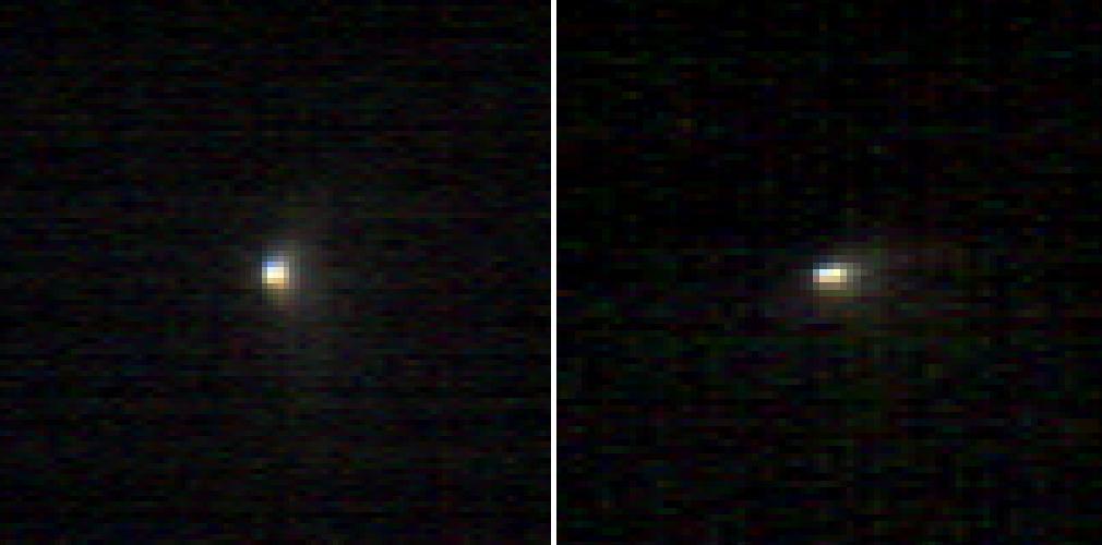
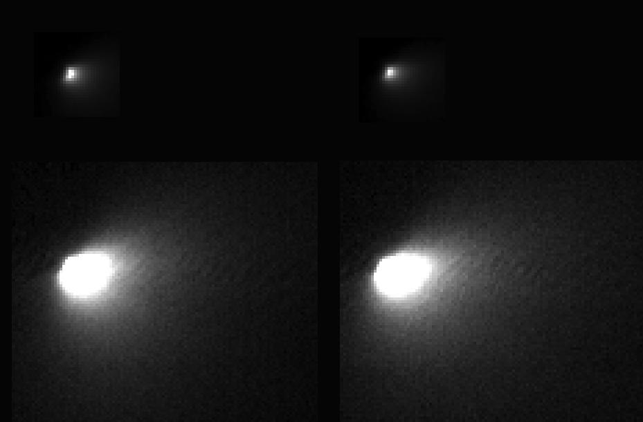
Office of the Chief Technologist, OCT Innovation Workshop, and Facility Tours
Office of the Chief Technologist, OCT Innovation Workshop, and F
Office of the Chief Technologist, OCT Innovation Workshop, and Facility Tours
Office of the Chief Technologist, OCT Innovation Workshop, and F
On Oct. 9, 2013, Hubble observed comet ISON once again, when it was inside the orbit of Mars, about 177 million miles from Earth. This image shows that the comet was still intact despite some predictions that the fragile icy nucleus might disintegrate closer to the sun. The comet will pass closest to the sun on Nov. 28, 2013.  If the nucleus had broke apart then Hubble would have likely seen evidence of multiple fragments. Moreover, the coma, or head, surrounding the comet's nucleus is symmetric and smooth. This would probably not be the case if clusters of smaller fragments were flying along.  This color composite image was assembled using two filters. The comet's coma appears cyan, a greenish-blue color due to gas, while the tail is reddish due to dust streaming off the nucleus. The tail forms as dust particles are pushed away from the nucleus by the pressure of sunlight.   Credit: NASA  --------  More details on Comet ISON:  Comet ISON began its trip from the Oort cloud region of our solar system and is now travelling toward the sun. The comet will reach its closest approach to the sun on Thanksgiving Day -- 28 Nov 2013 -- skimming just 730,000 miles above the sun's surface. If it comes around the sun without breaking up, the comet will be visible in the Northern Hemisphere with the naked eye, and from what we see now, ISON is predicted to be a particularly bright and beautiful comet.  Catalogued as C/2012 S1, Comet ISON was first spotted 585 million miles away in September 2012. This is ISON's very first trip around the sun, which means it is still made of pristine matter from the earliest days of the solar system’s formation, its top layers never having been lost by a trip near the sun. Comet ISON is, like all comets, a dirty snowball made up of dust and frozen gases like water, ammonia, methane and carbon dioxide -- some of the fundamental building blocks that scientists believe led to the formation of the planets 4.5 billion years ago.   NASA has been using a vast fleet of spacecraft, instruments, and space- and Earth-based telescope, in order to learn more about this time capsule from when the solar system first formed.   The journey along the way for such a sun-grazing comet can be dangerous. A giant ejection of solar material from the sun could rip its tail off. Before it reaches Mars -- at some 230 million miles away from the sun -- the radiation of the sun begins to boil its water, the first step toward breaking apart. And, if it survives all this, the intense radiation and pressure as it flies near the surface of the sun could destroy it altogether.   This collection of images show ISON throughout that journey, as scientists watched to see whether the comet would break up or remain intact.    The comet reaches its closest approach to the sun on Thanksgiving Day -- Nov. 28, 2013 -- skimming just 730,000 miles above the sun’s surface. If it comes around the sun without breaking up, the comet will be visible in the Northern Hemisphere with the naked eye, and from what we see now, ISON is predicted to be a particularly bright and beautiful comet.   ISON stands for International Scientific Optical Network, a group of observatories in ten countries who have organized to detect, monitor, and track objects in space. ISON is managed by the Keldysh Institute of Applied Mathematics, part of the Russian Academy of Sciences.  <b><a href="http://www.nasa.gov/audience/formedia/features/MP_Photo_Guidelines.html" rel="nofollow">NASA image use policy.</a></b>  <b><a href="http://www.nasa.gov/centers/goddard/home/index.html" rel="nofollow">NASA Goddard Space Flight Center</a></b> enables NASA’s mission through four scientific endeavors: Earth Science, Heliophysics, Solar System Exploration, and Astrophysics. Goddard plays a leading role in NASA’s accomplishments by contributing compelling scientific knowledge to advance the Agency’s mission.  <b>Follow us on <a href="http://twitter.com/NASA_GoddardPix" rel="nofollow">Twitter</a></b>  <b>Like us on &lt;a href=&quot;http://www.facebook.com/pages/Greenbelt-MD/NASA-Goddard/39501</b>
Oct. 9 Hubble View of ISON
Cassini Oct. 28, 2005, Titan Flyby
Radar Swath of Oct. 28, 2005, Titan Flyby
Office of the Chief Technologist, OCT Innovation Workshop, and Facility Tours
Office of the Chief Technologist, OCT Innovation Workshop, and F
Office of the Chief Technologist, OCT Innovation Workshop, and Facility Tours
Office of the Chief Technologist, OCT Innovation Workshop, and F
Office of the Chief Technologist, OCT Innovation Workshop, and Facility Tours
Office of the Chief Technologist, OCT Innovation Workshop, and F
Office of the Chief Technologist, OCT Innovation Workshop, and Facility Tours
Office of the Chief Technologist, OCT Innovation Workshop, and F
Office of the Chief Technologist, OCT Innovation Workshop, and Facility Tours
Office of the Chief Technologist, OCT Innovation Workshop, and F
Add your images to our Flickr group: <a href="https://www.flickr.com/groups/2014solareclipse/">www.flickr.com/groups/2014solareclipse/</a>  During the late afternoon of Oct. 23, 2014, a partial solar eclipse will be visible from much of North America before sundown.  Partial eclipses occur when the moon blocks part of the sun from view.  Read more on how, when and where to Safely Watch the Oct. 23, 2014 Partial Solar Eclipse: <a href="http://www.nasa.gov/content/goddard/how-to-safely-watch-the-october-23-partial-solar-eclipse/" rel="nofollow">www.nasa.gov/content/goddard/how-to-safely-watch-the-octo...</a>  Credit: T. Ruen  <b><a href="http://www.nasa.gov/audience/formedia/features/MP_Photo_Guidelines.html" rel="nofollow">NASA image use policy.</a></b>  <b><a href="http://www.nasa.gov/centers/goddard/home/index.html" rel="nofollow">NASA Goddard Space Flight Center</a></b> enables NASA’s mission through four scientific endeavors: Earth Science, Heliophysics, Solar System Exploration, and Astrophysics. Goddard plays a leading role in NASA’s accomplishments by contributing compelling scientific knowledge to advance the Agency’s mission. <b>Follow us on <a href="http://twitter.com/NASAGoddardPix" rel="nofollow">Twitter</a></b> <b>Like us on <a href="http://www.facebook.com/pages/Greenbelt-MD/NASA-Goddard/395013845897?ref=tsd" rel="nofollow">Facebook</a></b> <b>Find us on <a href="http://instagram.com/nasagoddard?vm=grid" rel="nofollow">Instagram</a></b>
Share YOUR images of the Oct. 23 Partial Solar Eclipse
Office of the Chief Technologist, OCT Innovation Workshop, and Facility Tours
Office of the Chief Technologist, OCT Innovation Workshop, and F
Office of the Chief Technologist, OCT Innovation Workshop, and Facility Tours
Office of the Chief Technologist, OCT Innovation Workshop, and F
Office of the Chief Technologist, OCT Innovation Workshop, and Facility Tours
Office of the Chief Technologist, OCT Innovation Workshop, and F
Enceladus Oct. 9, 2008 Flyby - Posted Image #3
Enceladus Oct. 9, 2008 Flyby - Posted Image #5
Enceladus Oct. 9, 2008 Flyby - Posted Image #2
Enceladus Oct. 9, 2008 Flyby - Posted Image #1
Enceladus Oct. 9, 2008 Flyby - Posted Image #4
This image was obtained by NASA Cassini radar instrument during a flyby on Oct. 9, 2006. North Polar Pass Northern Lakes Region, Aaru.  https://photojournal.jpl.nasa.gov/catalog/PIA03187
Titan Radar Swath T-19 Flyby - Oct. 9, 2006
This image was obtained by NASA Cassini radar instrument during a flyby on Oct. 28, 2005. Equatorial Pass Trailing hemisphere, Central Adiri, Central Belet, Huygens Landing Site, Antillia Faculae.
Titan Radar Swath T-8 Flyby, Oct. 28, 2005
This image was obtained by NASA Cassini radar instrument during a flyby on Oct. 2, 2007. The radar antenna was pointing toward Titan at an altitude of 965 kilometers 600 miles during the closest approach.  The image has been processed with a resolution of 128 pixels/deg.  https://photojournal.jpl.nasa.gov/catalog/PIA04390
Titan Radar Swath T-36 Flyby - Oct. 2, 2007
A Co-inventor of the Shape Memory Alloy, Spring Tire, shows the NASA Chief Technologist the first SMA Spring Tire Prototype during a tour of the Glenn Research Center, Simulated Lunar Operations Laboratory (SLOPE).
Office of the Chief Technologist, OCT Innovation Workshop, and Facility Tours
SOFIA's primary mirror assembly rests in its transportation cradle prior to reinstallation in NASA's airborne laboratory on Oct. 8, 2008.
SOFIA's primary mirror assembly rests in its transportation cradle prior to reinstallation in NASA's airborne laboratory on Oct. 8, 2008
NASA Chief Technologist Douglas Terrier meets with members of the media at “NASA Day in Arkansas” at Harding University in Searcy, Arkansas, on Jan. 27, 2020.
NASA Chief Technologist Meets with Media at NASA Day in Arkansas
NASA Chief Technologist Douglas Terrier presents to grade school students about NASA’s Artemis Program -- which will send the first woman and the next man to surface of the Moon by 2024 -- at “NASA Day in Arkansas” at Harding University in Searcy, Arkansas, on Jan. 27, 2020.
NASA Chief Technologist Present Artemis to Students in Arkansas
SOFIA's primary mirror assembly is lifted above wing level prior to its reinstallation in the telescope cavity of NASA's 747 airborne observatory Oct. 8, 2008.
SOFIA's primary mirror assembly is lifted above wing level prior to its reinstallation in the telescope cavity of NASA's 747 airborne observatory Oct. 8, 2008
Veterans of the X-15 flight research program, most of them now retired, reunited at Dryden on the 40th anniversary of the last X-15 flight on Oct. 24, 1968 for a historical colloquium on the X-15 by noted aerospace historian and author Dennis Jenkins on Oct. 24, 2008. Gathered in front of the replica of X-15 #3 the were (from left) Johnny Armstrong, Betty Love, Paul Reukauf, Bob Hoey, Dave Stoddard, Dean Webb, Vince Capasso, Bill Dana (who flew the last flight), John McTigue and T.D. Barnes. Jenkins, the author of "X-15: Extending the Frontiers of Flight," maintained during his presentation that despite setbacks, the X-15 program became the most successful of all the X-plane research programs due to the can-do, fix-the-problem and go-fly-again attitude of the X-15's cadre of engineers and technicians.
Veterans of the X-15 program reunited at Dryden during a historical colloquium on the 40th anniversary of the last X-15 flight that occurred Oct. 24, 1968.
ISS038-E-011804 (4 Dec. 2013) --- NASA astronaut Michael Hopkins, Expedition 38 flight engineer, speaks in a microphone while working in the Harmony node of the International Space Station.
OH OCT Test and Fundoscope Examination Experiment
ISS038-E-011806 (4 Dec. 2013) --- In the International Space Station?s Harmony node, Japan Aerospace Exploration Agency astronaut Koichi Wakata, Expedition 38 flight engineer, performs an eye exam for the Ocular Health experiment which observes and seeks to understand vision changes during long-term space missions.
OH OCT Test and Fundoscope Examination Experiment
This image shows the most recent observations of the 2-mile-wide 4-kilometer-wide comet 67P/Churyumov-Gerasimenko, which is the upcoming target of the European Space Agency Rosetta mission.
Comet 67P/Churyumov-Gerasimenko on Oct. 5, 2013
NASA ISS-RapidScat ocean wind scatterometer viewed Hurricane Ana as it approached Hawaii. From Oct. 13 to Oct. 19, 2014, RapidScat observed Ana seven times. This frame is from a movie containing multiple days of observation.
Hurricane Ana Viewed by NASA ISS-RapidScat
A brief tour through NASA's modified Boeing 747 Shuttle Carrier Aircraft was a popular attraction at the Edwards Air Force Base open house Oct. 28-29, 2006.
A brief tour through NASA's modified Boeing 747 Shuttle Carrier Aircraft was a popular attraction at the Edwards Air Force Base open house Oct. 28-29, 2006
Crowds thronged around NASA's modified 747 Shuttle Carrier Aircraft and an Air Force B-1B Lancer at the Edwards Air Force Base open house Oct. 28-29, 2006.
Crowds thronged around NASA's modified 747 Shuttle Carrier Aircraft and an Air Force B-1B Lancer at the Edwards Air Force Base open house Oct. 28-29, 2006
X-15A-2 post flight photo showing heat damage from Mach 6.7 flight on 3 Oct 67. Flt. 2-53-97; pilot-Pete Knight.
X-15A-2 post flight photo showing heat damage from Mach 6.7 flight on 3 Oct 67. Flt. 2-53-97; pilot-Pete Knight
One of NASA's two ER-2 Earth resources aircraft shows off its lines during a flyover at the Edwards Air Force Base open house Oct. 28-29, 2006.
NASA's RapidScat's antenna, lower right, was pointed at Hurricane Patricia as the powerful storm approached Mexico on Oct. 23, 2015. Patricia was the strongest hurricane ever recorded in the Western Hemisphere, with maximum winds of 200 mph (320 kilometers per hour). When it first made landfall on the Pacific coast of Mexico on Oct. 23, it was a destructive Category 5 storm.  The videos are from the International Space Station. RapidScat's spinning antenna, lower right, collects wind-speed data from Hurricane Patricia.  http://photojournal.jpl.nasa.gov/catalog/PIA20049
RapidScat and Hurricane Patricia
At 11:29 p.m. PDT on Oct. 6 (2:29 a.m. EDT on Oct. 7), NASA's Atmospheric Infrared Sounder (AIRS) instrument on NASA's Aqua satellite produced this false-color infrared image of Matthew as the storm moved up Florida's central coast. The image shows the temperature of Matthew's cloud tops or the surface of Earth in cloud-free regions, with the most intense thunderstorms shown in purples and blues.  http://photojournal.jpl.nasa.gov/catalog/PIA21097
NASA AIRS Examines Hurricane Matthew Cloud Top Temperatures
During a flyby of Saturn moon Enceladus on Oct. 1, 2011, NASA Cassini spacecraft snapped this portrait of the moon joined by its sibling Epimetheus and the planet rings.
Hiding Little Brother
Global atmospheric carbon dioxide concentrations from Oct. 1 through Nov. 11, as recorded by NASA Orbiting Carbon Observatory-2.
Global Atmospheric Carbon Dioxide
On Oct. 24, 2006, NASA MESSENGER spacecraft came within 2,990 kilometers 1,860 miles of Venus during its second planetary encounter.
Approaching Venus
The scope and extent of the strong Santa Ana wind event in Southern California the week of Oct. 21, 2007, is visible in this image from NASA QuikScat satellite.
NASA QuikScat Maps Southern California Destructive Santa Ana Winds
NASA Phoenix Mars Lander took this anaglyph on Oct. 21, 2008; the trench on the upper left is called Dodo-Goldilocks. 3D glasses are necessary to view this image.
Phoenix Deepens Trenches on Mars 3-D
This graphic depicts what Mars atmosphere would have looked like to a viewer with ultraviolet-seeing eyes after a meteor shower on Oct. 19, 2014.
Emission from Ionized Magnesium in Mars Atmosphere After Comet Flyby
NASA Cassini spacecraft successfully completed its Oct. 1, 2011 flyby of Saturn moon Enceladus and its jets of water vapor and ice.
Saturn Geyser Moon Enceladus Shows off for NASA Cassini
This image is a stereo, panoramic view of various trenches dug by NASA Phoenix Mars Lander on Oct. 7, 2008. 3D glasses are necessary to view this image.
Phoenix Trenches
The Prandtl-D No. 3 research aircraft is being readied for new flight tests this summer. It had its first flight on Oct. 28, 2015.
ED15-0330-079
This map shows the route driven by NASA Mars rover Curiosity through the 56th Martian day, or sol, of the rover mission on Mars Oct. 2, 2012.
Curiosity Travels Through Sol 56
NASA Cassini spacecraft captured this high-resolution view of the cratered surface of Saturn moon Rhea as the spacecraft flew by the moon on Oct. 17, 2010.
Rhea Northern Craters
This view, taken on Oct. 21, 2016, from NASA Dawn spacecraft shows Megwomets Crater on Ceres. Megwomets is the largest crater in this image, at right of center. The crater is named for a Yurok god of acorns and distributor of vegetal abundance.  Dawn took this image on Oct. 21, 2016, from its second extended-mission science orbit (XMO2), at a distance of about 920 miles (1,480 kilometers) above the surface. The image resolution is about 460 feet (140 meters) per pixel.  http://photojournal.jpl.nasa.gov/catalog/PIA21245
Dawn XMO2 Image 25
NASA Chief Technologist Douglas Terrier, left of center, meets with Dr. Ed Wilson, engineering professor emeritus and tours Wilson's atmospheric sciences laser lab during “NASA Day in Arkansas” at Harding University in Searcy, Arkansas, on Jan. 27, 2020.
NASA Chief Technologist Douglas Terrier Meets with Ed Wilson at NASA Day in Arkansas
NASA Chief Technologist Douglas Terrier, right, and NASA Deputy Chief Technologist David Steitz, left, investigate a rover developed at Harding University in Searcy, Arkansas, in partnership with NASA’s Jet Propulsion Laboratory in Silicon Valley, California, and the University of Arkansas-Little Rock while attending “NASA Day in Arkansas” hosted at the university on Jan. 27, 2020.
NASA's Douglas Terrier and David Steitz Investigate a Rover at Arkansas' Harding University
NASA Chief Technologist Douglas Terrier, center, and NASA Deputy Chief Technologist David Steitz, left, talk with a Harding University student researcher about LED technology being used to track atmospheric composition, while attending “NASA Day in Arkansas” hosted at the university in Searcy, Arkansas on Jan. 27, 2020.
NASA's Douglas Terrier and David Steitz Talk with a Student at NASA Day in Arkansas
NASA Chief Technologist Douglas Terrier, right, being briefed on student-developed precision atmospheric laser technology mounted on a remotely-operated rover at Harding University in Searcy, Arkansas, while attending “NASA Day in Arkansas” hosted at the university on Jan. 27, 2020.
NASA's Chief Technologist Talks with a Student at NASA Day in Arkansas
During MIT's "Better MIT Innovation Week 2018," a group of experts discussed innovation as a critical component to and professional accomplishment. From left: Rebecca Chui, founder, RootsStudio; Reinaldo Normand, entrepreneur in residence, MIT; Douglas Terrier, NASA chief technologist; Linda Foster, chief technologist, Lockheed Martin. (Photo: Damian Barabonkov/MIT Technique)
NASA Chief Technologist on Panel at Massachusetts Institute of Technology
NASA Chief Technologist Douglas Terrier meets with researchers conducting plant research relevant to space exploration during “NASA Day in Arkansas” at Harding University in Searcy, Arkansas, on Jan. 27, 2020.
NASA Chief Technologist Meets with Researchers at NASA Day in Arkansas
NASA Chief Technologist Douglas Terrier joined students, faculty and experts in Boston as part of MIT's "Better MIT Innovation Week 2018," a week-long program promoting leadership, entrepreneurship and action for a better future. During the February event, Terrier spoke about a culture of innovation at America's Space Program. (Photo: Damian Barabonkov/MIT Technique)
NASA Chief Technologist Speaks at Massachusetts Institute of Technology
NASA Chief Technologist Douglas Terrier, center, talk with a Harding University student about a miniaturized laser sample analysis device that may be used for planetary science research. Terrier attended “NASA Day in Arkansas,” hosted at the university in Searcy, Arkansas on Jan. 27, 2020.
NASA Chief Technologist Speaks with a Student at NASA Day in Arkansas
This scene captured by NASA Dawn spacecraft on Oct. 21, 2016, from Ceres northern hemisphere shows part of the rim of Dantu Crater, at top right. Rao Crater is the largest crater in the bottom left corner of the image.  Dawn took this image on Oct. 21, 2016, from its second extended-mission science orbit (XMO2), at a distance of about 920 miles (1,480 kilometers) above the surface. The image resolution is about 460 feet (140 meters) per pixel.  http://photojournal.jpl.nasa.gov/catalog/PIA21243
Dawn XMO2 Image 23
NASA's Cassini spacecraft spied this tight trio of craters as it approached Saturn's icy moon Enceladus for a close flyby on Oct. 14, 2015. The craters, located at high northern latitudes, are sliced through by thin fractures -- part of a network of similar cracks that wrap around the snow-white moon.  The image was taken in visible light with the Cassini spacecraft narrow-angle camera on Oct. 14, 2015 at a distance of approximately 6,000 miles (10,000 kilometers) from Enceladus. Image scale is 197 feet (60 meters) per pixel.  The image was taken with the Cassini spacecraft narrow-angle camera on Oct. 14, 2015 using a spectral filter which preferentially admits wavelengths of ultraviolet light centered at 338 nanometers.  http://photojournal.jpl.nasa.gov/catalog/PIA20011
Saturnian Snowman
The 230-foot 70-meter DSS-14 antenna at Goldstone, Ca. obtained these radar images of asteroid 2015 TB145 on Oct. 31, 2015.  Asteroid 2015 TB145 is depicted in eight individual radar images collected on Oct. 31, 2015 between 5:55 a.m. PDT (8:55 a.m. EDT) and 6:08 a.m. PDT (9:08 a.m. EDT). At the time the radar images were taken, the asteroid was between 440,000 miles (710,000 kilometers) and about 430,000 miles (690,000 kilometers) distant. Asteroid 2015 TB145 safely flew past Earth on Oct. 31, at 10:00 a.m. PDT (1 p.m. EDT) at about 1.3 lunar distances (300,000 miles, 480,000 kilometers).  To obtain the radar images, the scientists used the 230-foot (70-meter) DSS-14 antenna at Goldstone, California, to transmit high power microwaves toward the asteroid. The signal bounced of the asteroid, and their radar echoes were received by the National Radio Astronomy Observatory's 100-meter (330-foot) Green Bank Telescope in West Virginia. The images achieve a spatial resolution of about 13 feet (4 meters) per pixel.  http://photojournal.jpl.nasa.gov/catalog/PIA20043
Halloween Asteroid Rotation
Damage Proxy Map (DPM) v0.5, derived from the Italian Space Agency's COSMO-SkyMed Spotlight synthetic aperture radar (SAR) data acquired from an ascending orbit, covering an area of 6.2-by-6.2 miles (10-by-10 kilometers), centered at Norcia, Italy. Red pixels (pixel size about 16 feet, or 5 meters)represent areas of potential damage due to the Magnitude 6.6 Oct 30, 2016, Central Italy earthquakes, as well as ground surface change during the time period Oct. 30, 2016 -- Oct. 31, 2016. The color variation from yellow to red indicate increasingly more significant ground surface change. Preliminary validation was carried out by comparing with high-resolution pre- and post-event optical imagery acquired by DigitalGlobe's WorldView satellites, and a damage map produced by the European Commission Copernicus Emergency Management Service based upon visual inspection of high-resolution pre- (Orthophoto) and post-event (Pleiades-1) optical imagery. This DPM provides broad geographic coverage of the earthquake's impact in the region. Areas that fall in radar shadow and layover were masked out. The DPM should be used as guidance to identify damaged areas, and may be less reliable over vegetated areas.   http://photojournal.jpl.nasa.gov/catalog/PIA15374
Damage Map of Latest Italian Quake Produced by NASA
In this image from Oct. 26, 2019 — the 325th Martian day, or sol, of the mission — InSight's heat probe, or "mole," is seen after backing about halfway out of the hole it had burrowed.  Animation available at https://photojournal.jpl.nasa.gov/catalog/PIA23213
InSight's Heat Probe Partially Backs Out of Hole
Oxo Crater and its surroundings are featured in this image of Ceres' surface from NASA's Dawn spacecraft.  Dawn took this image on Oct. 18, 2016, from its second extended-mission science orbit (XMO2), at a distance of about 920 miles (1,480 kilometers) above the surface. The image resolution is about 460 feet (140 meters) per pixel.  http://photojournal.jpl.nasa.gov/catalog/PIA21225
Dawn XMO2 Image 5
NASA CloudSat passed over Sandy at 10:32 a.m. EDT on Oct. 27, 2012. Light to moderate precipitation associated with parts of the outer bands of Hurricane Sandy were moving on shore into parts of North Carolina.
NASA CloudSat Views Hurricane Sandy
Located to the northeast of Olympus Mons, Cyane Sulci is a complexly fractured region of material inundated on its margins by volcanic flows. This image was captured by NASA Mars Odyssey on Oct. 24, 2010.
Cyane Sulci
This 360-degree view combines frames taken by the navigation camera on NASA Mars Exploration Rover Spirit during the rover 271st martian day, or sol, on Oct. 7, 2004. 3D glasses are necessary to view this image.
Full-Circle View from Near Tetl 3-D
The Surface Stereo Imager on NASA Phoenix Mars Lander took this anaglyph on Oct. 21, 2008; the trench on the upper left is called Upper Cupboard. 3D glasses are necessary to view this image.
Phoenix Deepens Trenches on Mars 3-D
NASA MAVEN spacecraft obtained this ultraviolet image of hydrogen surrounding comet Siding Spring on Oct. 17, 2014, two days before the comet closest approach to Mars.
MAVEN Ultraviolet Image of Comet Siding Spring Hydrogen Coma
These spectrograms from the MARSIS instrument on the European Space Agency Mars Express orbiter show the intensity of radar echo in Mars far-northern ionosphere at three times on Oct. 19 and 20, 2014.
Radar-Detected Change in Martian Near-Polar Ionosphere After Comet Flyby
On Oct. 25, 2011, the Chao Phraya River was in flood stage as NASA Terra spacecraft imaged flooded agricultural fields and villages depicted here in dark blue, and the sediment-laden water in shades of tan.
NASA Spacecraft Images Continued Thailand Flooding
NASA Mars Exploration Rover Opportunity used its navigation camera to take the images combined into this stereo view of the rover surroundings on the 958th sol, or Martian day, of its surface mission Oct. 4, 2006
Opportunity View, Sol 958 Polar
On Oct. 9, NASA Juno spacecraft flew past Earth, using our home planet gravity to get the final boost it needed to reach Jupiter. The JunoCam instrument captured this monochrome view of Earth.
Earth from Juno
This animation shows a mosaic of imagery from Cassini radar instrument obtained during three flybys of Titan north pole: T16 July 22, 2006, T18 Sept. 23, 2006 and T19 Oct. 9, 2006
Titan Lakes Movie
A seven-year journey to the ringed planet Saturn began on Oct. 15, 1997 with the liftoff of a Titan IVB/Centaur carrying NASA Cassini orbiter and its attached Huygens probe
Launch of Cassini Orbiter and Huygens Probe on Titan IV
This artist rendering shows NASA Juno spacecraft during its Earth flyby gravity assist on Oct. 9, 2013. On Earth below, the southern Atlantic Ocean is visible, along with the coast of Argentina.
Juno Earth Flyby Artist Rendering
Researchers used the Pancam on NASA Mars Exploration Rover Opportunity to capture this view of comet C/2013 A1 Siding Spring as it flew near Mars on Oct. 19, 2014.
Mars Rover Opportunity View of Passing Comet
NASA Mars Exploration Rover Opportunity used its navigation camera to take the images combined into this stereo view of the rover surroundings on the 958th sol, or Martian day, of its surface mission Oct. 4, 2006
Opportunity View, Sol 958
On Oct. 9, 2008, just after coming within 25 kilometers 15.6 miles of the surface of Enceladus, NASA Cassini captured this stunning mosaic as the spacecraft sped away from this geologically active moon of Saturn.
A Tectonic Feast
NASA Mars Exploration Rover Opportunity combined images into this stereo, 360-degree view of the rover surroundings on Oct. 22, 2008. Opportunity position was about 300 meters southwest of Victoria. 3D glasses are necessary to view this image.
Opportunity Surroundings on Sol 1687 Stereo
Hot eruption sites scattered across Jupiter moon Io stand out dramatically in an infrared image taken Oct. 13, 2001, by NASA Galileo spacecraft as it sped past this most volcanically active of all known worlds.
Io in Infrared, Night and Day
This global map of Mars was acquired on Oct. 28, 2008, by the Mars Color Imager instrument on NASA MRO. One global map is generated each day to forecast weather conditions for the entry, descent and landing of NASA Curiosity rover.
Mars Weather Map, 2008
NASA CloudSat spacecraft overpassed Hurricane Sandy on Oct. 29, 2012 just as Sandy was approaching the Atlantic coastline. Sandy contained estimated maximum sustained winds of 90 miles per hour 78 knots.
CloudSat View of Hurricane Sandy
A seven-year journey to the ringed planet Saturn began on Oct. 15, 1997 with the liftoff of a Titan IVB/Centaur carrying NASA Cassini orbiter and its attached Huygens probe.
Launch of Cassini Orbiter and Huygens Probe on Titan IV
Clouds of dust and ice swirl past the Surface Stereo Imager SSI camera on NASA Phoenix Mars Lander in this frame from a series of images taken on the 132nd Martian day of the mission Oct. 7, 2008.
Dark Skies and Clouds Move in at Phoenix site
These three images are from NASA ER-2 aircraft which imaged the area around the Palmdale, Calif., airport during its first checkout flight on Oct. 7, 2010. For more details, go the Photojournal.
NASA ER-2 Checks Out New Airborne Multiangle Polarizing Imager
These two infrared images of comet C/2013 A1 Siding Spring were taken by the Compact Reconnaissance Imaging Spectrometer for Mars CRISM aboard NASA Mars Reconnaissance Orbiter on Oct. 19, 2014.
Images From Mars-Orbiting Spectrometer Show Comet Coma
These images are located in Vesta Rheasilvia quadrangle, near asteroid Vesta south pole. NASA Dawn spacecraft obtained the apparent brightness image with its framing camera on Oct. 22, 2011.
Apparent Brightness and Topography Images of Severina Crater
The active volcano Prometheus on Jupiter moon Io was imaged by NASA Galileo spacecraft during the close flyby of Io on Oct.10, 1999. The spectrometer can detect active volcanoes on Io by measuring their heat in the near-infrared wavelengths.
Galileo Near-Infrared Mapping Spectrometer Detects Active Lava Flows at Prometheus Volcano, Io
This map shows solar-induced fluorescence, a plant process that occurs during photosynthesis, from Aug. through Oct. 2014 as measured by NASA Orbiting Carbon Observatory-2.
Global Solar-Induced Fluorescence
The ASTER instrument onboard NASA Terra spacecraft imaged the hot volcanic flow that resulted from collapse of the summit lava dome from the Merapi volcano in Indonesia that erupted on Oct. 26, 2010.
Merapi Volcano, Indonesia
NASA Dawn spacecraft captured this scene, showing southern mid-latitudes on Ceres, on Oct. 18, 2015, from an altitude of 915 miles 1,470 kilometers. It has a resolution of 450 feet 140 meters per pixel.
Dawn HAMO Image 79
This view from NASA Dawn spacecraft taken on Oct. 18, 2015, from an altitude of 915 miles 1,470 kilometers, shows Toharu crater 55 miles or 88 kilometers wide at lower right.
Dawn HAMO Image 80
On Oct. 23, 2011, a magnitude 7.2 earthquake struck eastern Turkey, near the city of Van, the result of the collision between the Arabian and Eurasian tectonic plates. Turkey is a tectonically active country, experiencing frequent devastating earthquakes.
NASA Images Topography of Quake-Stricken Eastern Turkey
The Chemistry and Camera ChemCam instrument on NASA Mars rover Curiosity used its laser and spectrometers to examine what chemical elements are in a drift of Martian sand during the mission 74th Martian day, or sol Oct. 20, 2012.
Laser Hit on Martian Sand Target, Before and After
NASA NEOWISE mission detected comet C/2013 A1 Siding Spring on July 28, 2014, less than three months before this comet close flyby of Mars on Oct. 19.
NEOWISE Spies Comet C/2013 A1 Siding Spring a Second Time
This mosaic of images from NASA Mars Exploration Rover Opportunity shows surroundings of the rover location following an 122.2-meter 401-foot drive on Oct. 25, 2010. 3D glasses are necessary.
Opportunity Eastward View After Sol 2401 Drive Stereo
NASA Mars Exploration Rover Opportunity used its navigation camera to take the images combined into this stereo view of the rover surroundings on the 958th sol, or Martian day, of its surface mission Oct. 4, 2006
Opportunity View, Sol 958 Vertical
NASA Dawn spacecraft captured this view of mid-latitudes on Ceres on Oct. 18, 2015, from an altitude of 915 miles 1,470 kilometers. The image has a resolution of 450 feet 140 meters per pixel.
Dawn HAMO Image 78
The worst forest fires in nearly two decades are burning out of control on Borneo, creating the thick blanket of smoke in this Oct. 14, 2015 image from NASA Terra spacecraft.
Borneo on Fire