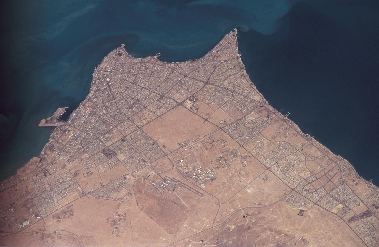
Smoke from the burning oil fields to the north of Kuwait City, seen on the south shore of Kuwayt Bay, almost totally obscures the view of the tiny, but oil rich, nation of Kuwait (30.0N, 48.0E). During the brief war between Iraq and the Allied forces, many of the oil wells in Kuwait were destroyed and set afire. For several months, those fires burned out of control, spewing wind borne smoke and ash for hundreds of miles.
Smoke from the burning oil fields to the north and south of Kuwait City, seen on the south shore of Kuwayt Bay almost totally obscures the view of the tiny, but oil rich, nation of Kuwait (29.0N, 48.0E). During the brief war between Iraq and the Allied forces, many of the oil wells in Kuwait were destroyed and set afire. For several months, those fires burned out of control, spewing wind borne smoke and ash for hundreds of miles.
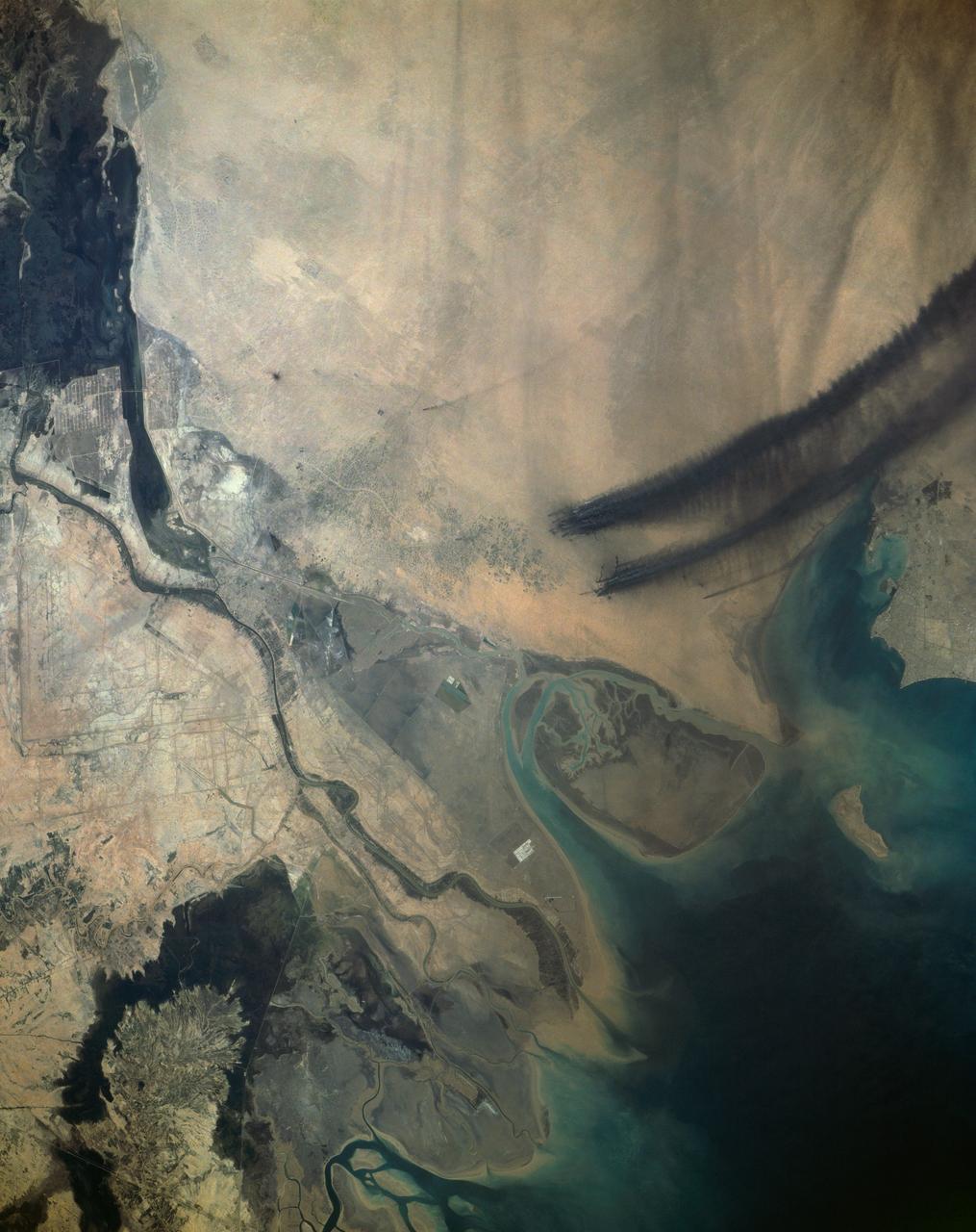
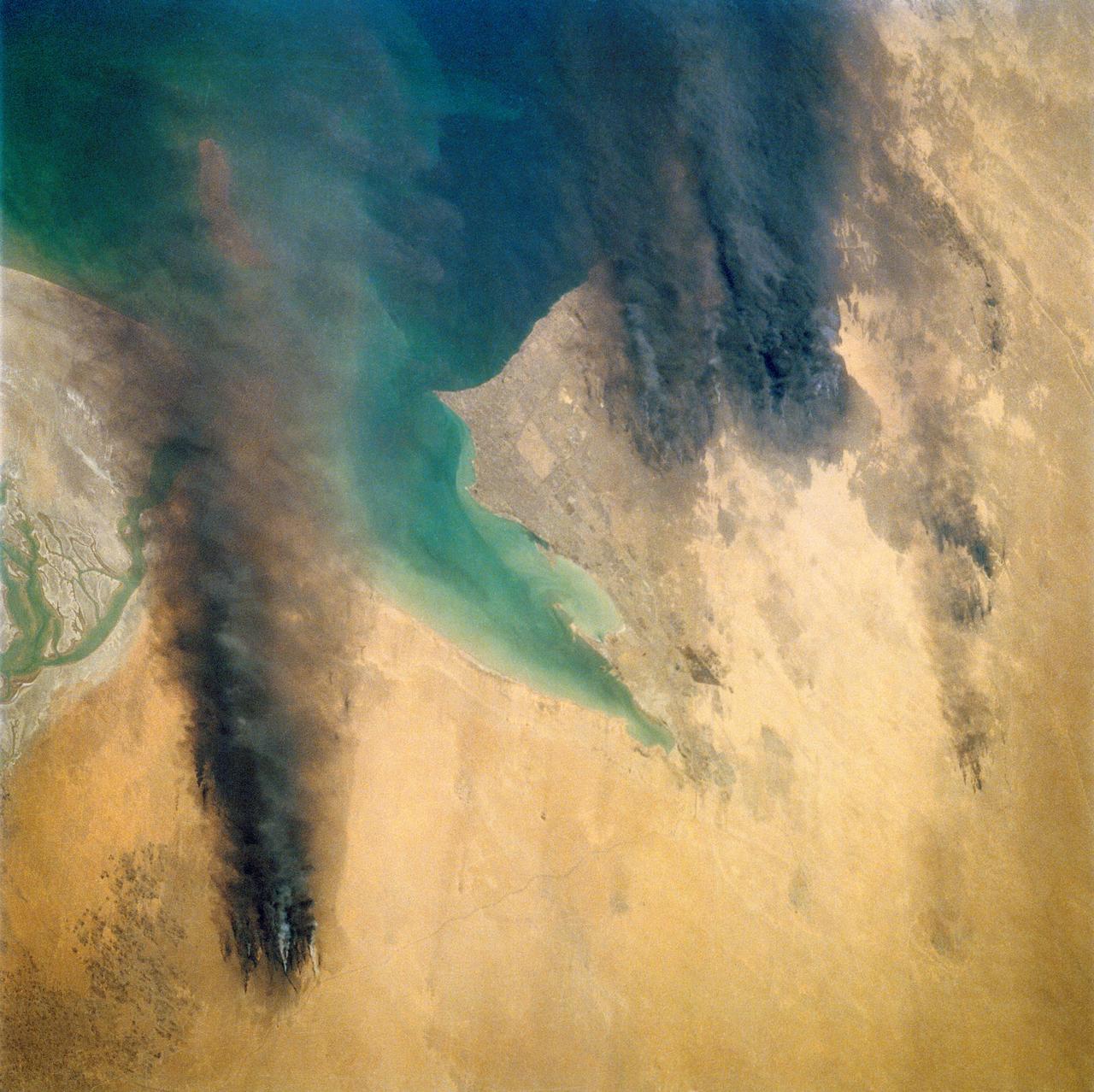
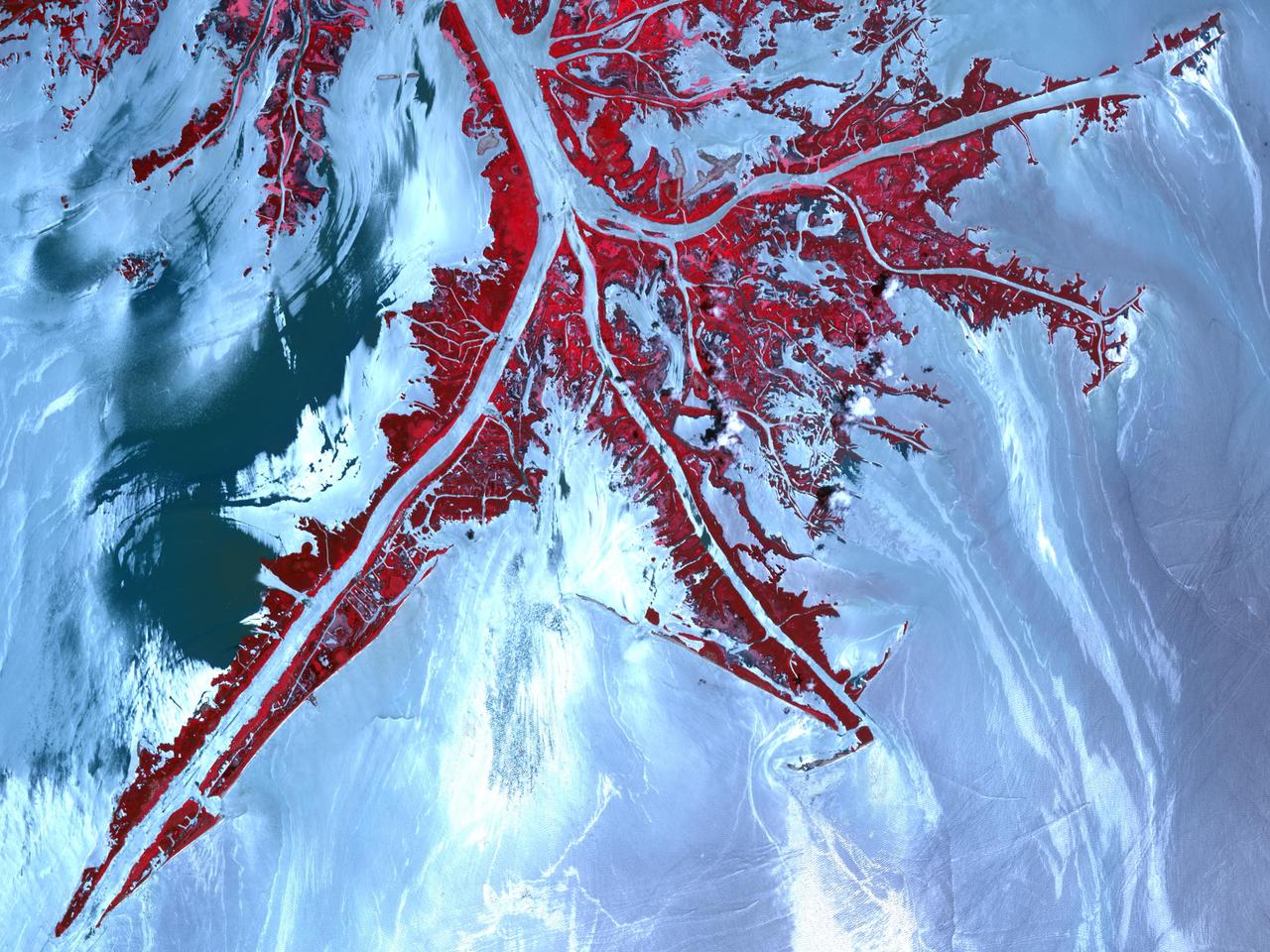
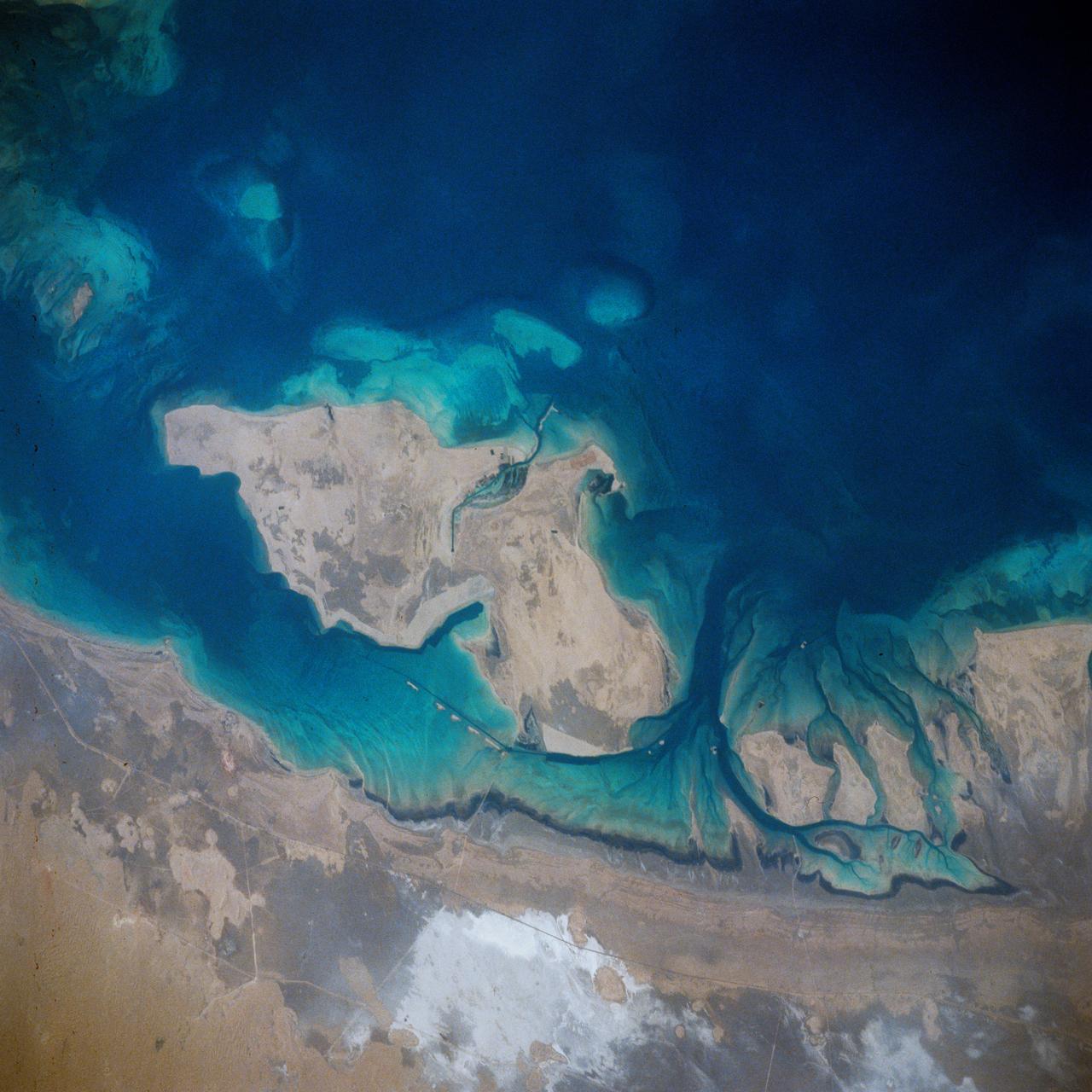
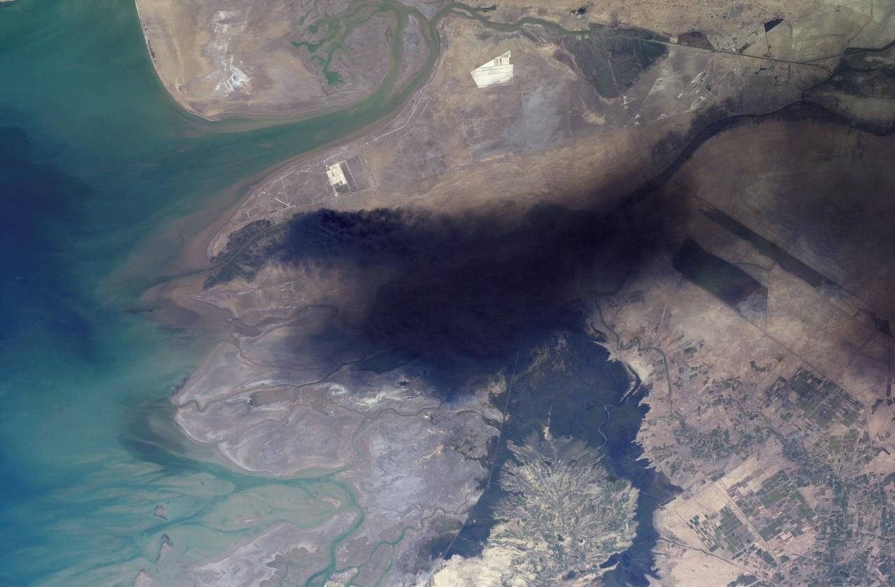
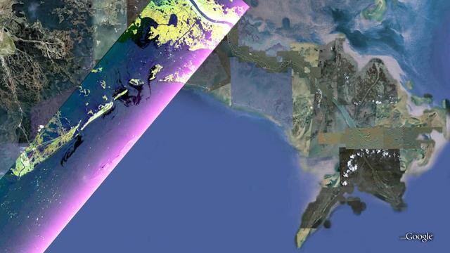
This view of the northern Persian Gulf shows Kuwait City and the Tigris and Euphrates River Deltas (29.5N, 48.5E). The oil laden sands and oil lakes of the Kuwait Oil Fields to the north and south of the city are clearly visible as dark patches surrounded by oil free desert sands. Comparison with earlier photos indicate that the oil laden sands are slowly being covered with clean sand carried by strong NW winds called Shmals.
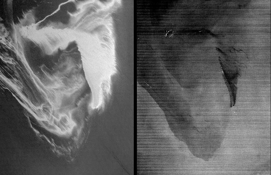
STS039-87-012 (28 April-6 May 1991) --- A handheld 70mm camera onboard the Space Shuttle Discovery exposed this infrared frame showing oil fires near the Kuwait coast as well as south-bound oil slicks in the Gulf. Pools of oil on the land are recognized as white objects near the burning wells.
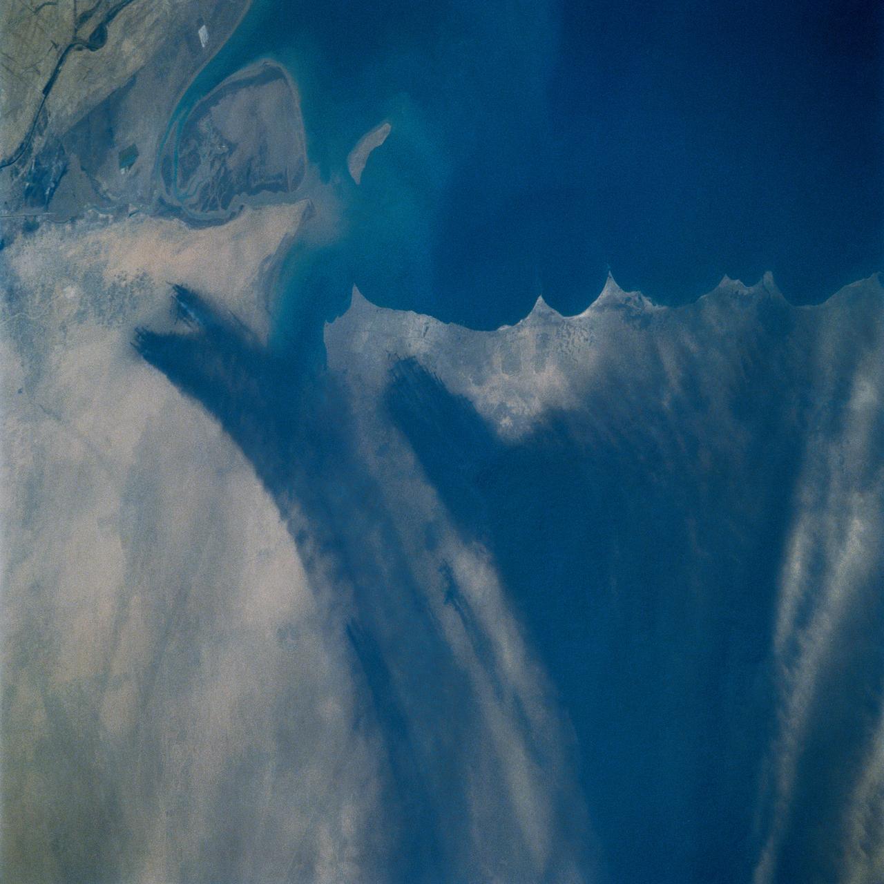
STS039-72-060 (28 April-6 May 1991) --- This view from the Earth-orbiting Space Shuttle Discovery shows the smoke from burning oil well fires, aftermath of Iraqi occupation. Oil wells to the north of the Bay of Kuwait and just south of Kuwait City, on the south shore, can be seen burning out of control. Compared with pictures of the same area shot during STS-37 (April 1991), this frame shows a complete shift of winds, with much of the smoke blowing eastward over the Gulf. The STS-37 scenes showed lengthy southward-blowing sheets of smoke toward Saudi Arabia. In this view, the Gulf island Faylakah Awhah is barely visible through the smoke.
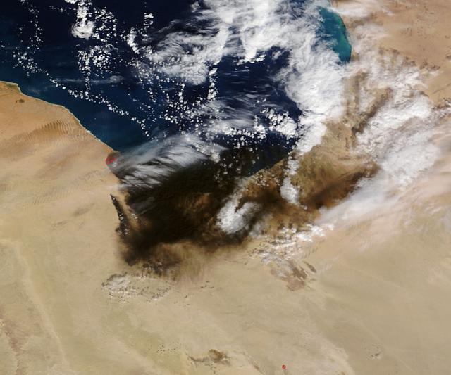
The oil refinery fires in Libya that were started by attacks on oil terminals in Libya in very early January continue. The stream of black smoke that emanates from the refinery has grown tremendously as the fires caused by the initial shelling have spread to giant storage tanks. These fires are reported to be raging in Sidra, on the coast between Sirte and Benghazi. Actively burning areas, detected by MODIS’s thermal bands, are outlined in red. The initial image of the fires taken on January 07, 2016 can be found here for comparison: <a href="http://www.nasa.gov/image-feature/goddard/2016/terra-captures-images-of-oil-fires-in-libya" rel="nofollow">www.nasa.gov/image-feature/goddard/2016/terra-captures-im...</a> NASA image courtesy Jeff Schmaltz, MODIS Rapid Response Team <b><a href="http://www.nasa.gov/audience/formedia/features/MP_Photo_Guidelines.html" rel="nofollow">NASA image use policy.</a></b> <b><a href="http://www.nasa.gov/centers/goddard/home/index.html" rel="nofollow">NASA Goddard Space Flight Center</a></b> enables NASA’s mission through four scientific endeavors: Earth Science, Heliophysics, Solar System Exploration, and Astrophysics. Goddard plays a leading role in NASA’s accomplishments by contributing compelling scientific knowledge to advance the Agency’s mission. <b>Follow us on <a href="http://twitter.com/NASAGoddardPix" rel="nofollow">Twitter</a></b> <b>Like us on <a href="http://www.facebook.com/pages/Greenbelt-MD/NASA-Goddard/395013845897?ref=tsd" rel="nofollow">Facebook</a></b> <b>Find us on <a href="http://instagrid.me/nasagoddard/?vm=grid" rel="nofollow">Instagram</a></b>
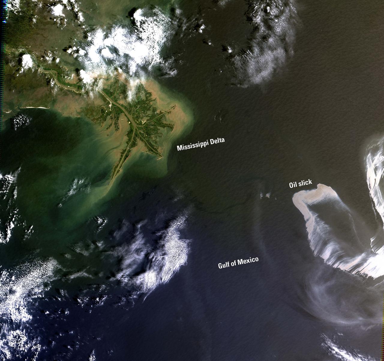
On April 20, 2010, an explosion at an oil well in the Gulf of Mexico resulted in a major oil spill. Since then, emergency response efforts have been underway to contain the growing oil slick before it reaches the southern coast of the United States. Landsat imagery, acquired by the U.S. Geological Survey on May 1 shows the extent of the oil slick. The Landsat data are being used to monitor the extent and movement of the slick. Location: LA, USA Date Taken: May 1 2010 Credit: NASA/GSFC/Landsat <b><a href="http://www.nasa.gov/centers/goddard/home/index.html" rel="nofollow">NASA Goddard Space Flight Center</a></b> enables NASA’s mission through four scientific endeavors: Earth Science, Heliophysics, Solar System Exploration, and Astrophysics. Goddard plays a leading role in NASA’s accomplishments by contributing compelling scientific knowledge to advance the Agency’s mission. <b>Follow us on <a href="http://twitter.com/NASA_GoddardPix" rel="nofollow">Twitter</a></b> <b>Join us on <a href="http://www.facebook.com/pages/Greenbelt-MD/NASA-Goddard/395013845897?ref=tsd" rel="nofollow">Facebook</a></b>
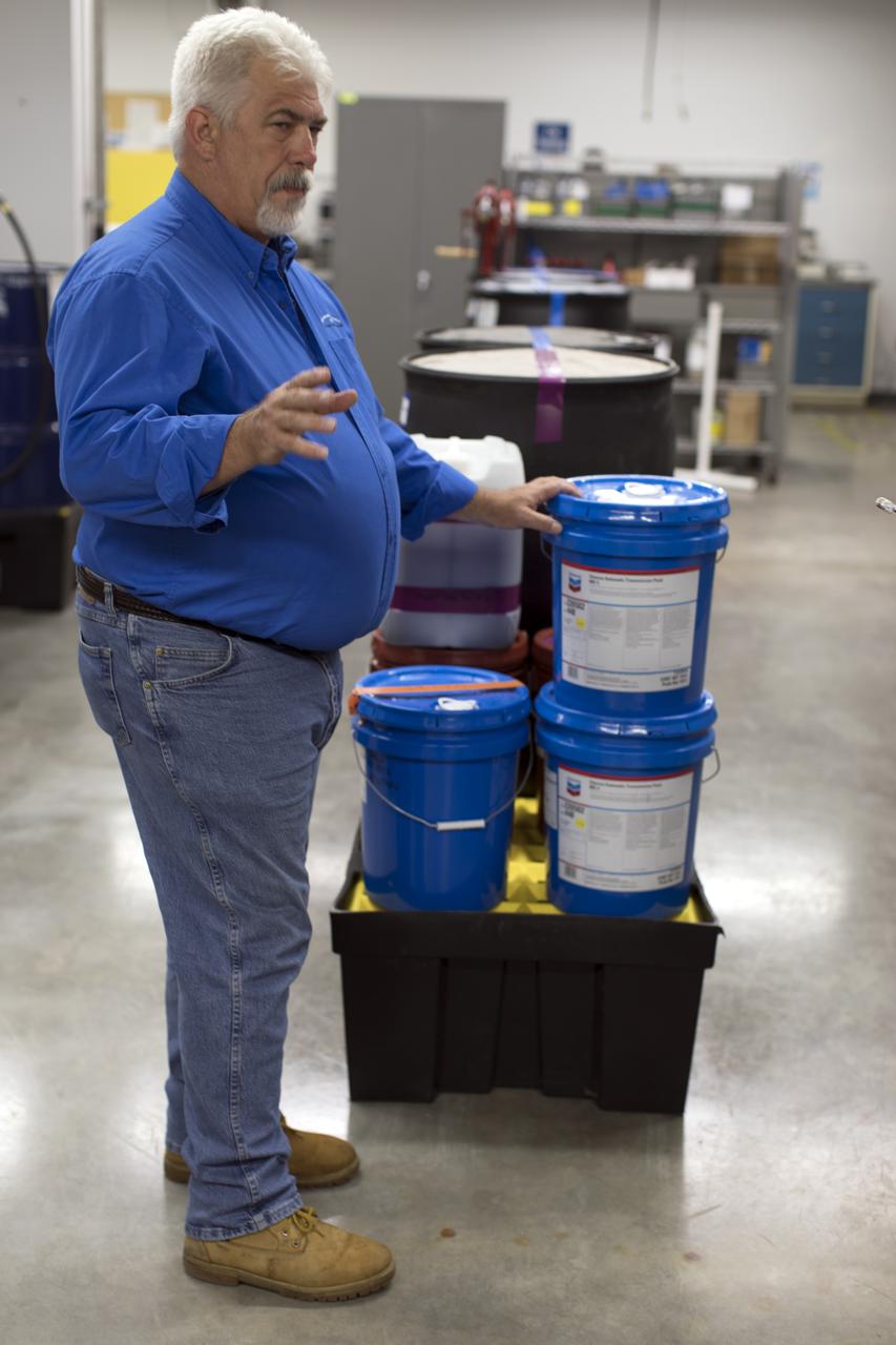
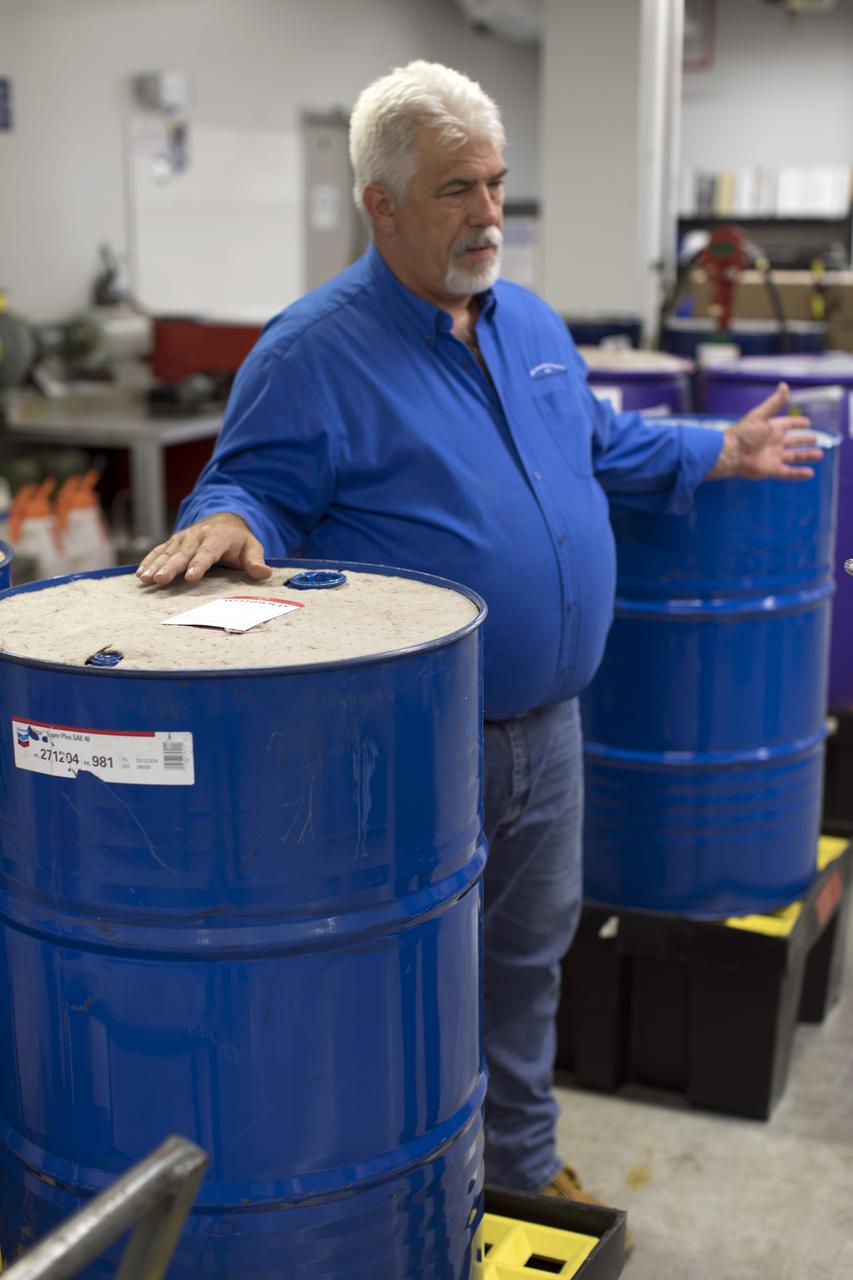
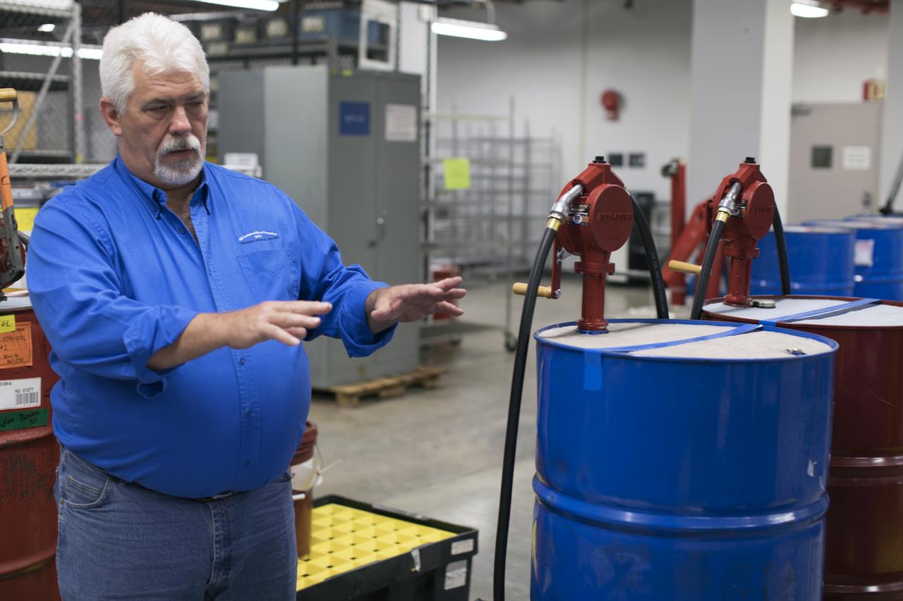
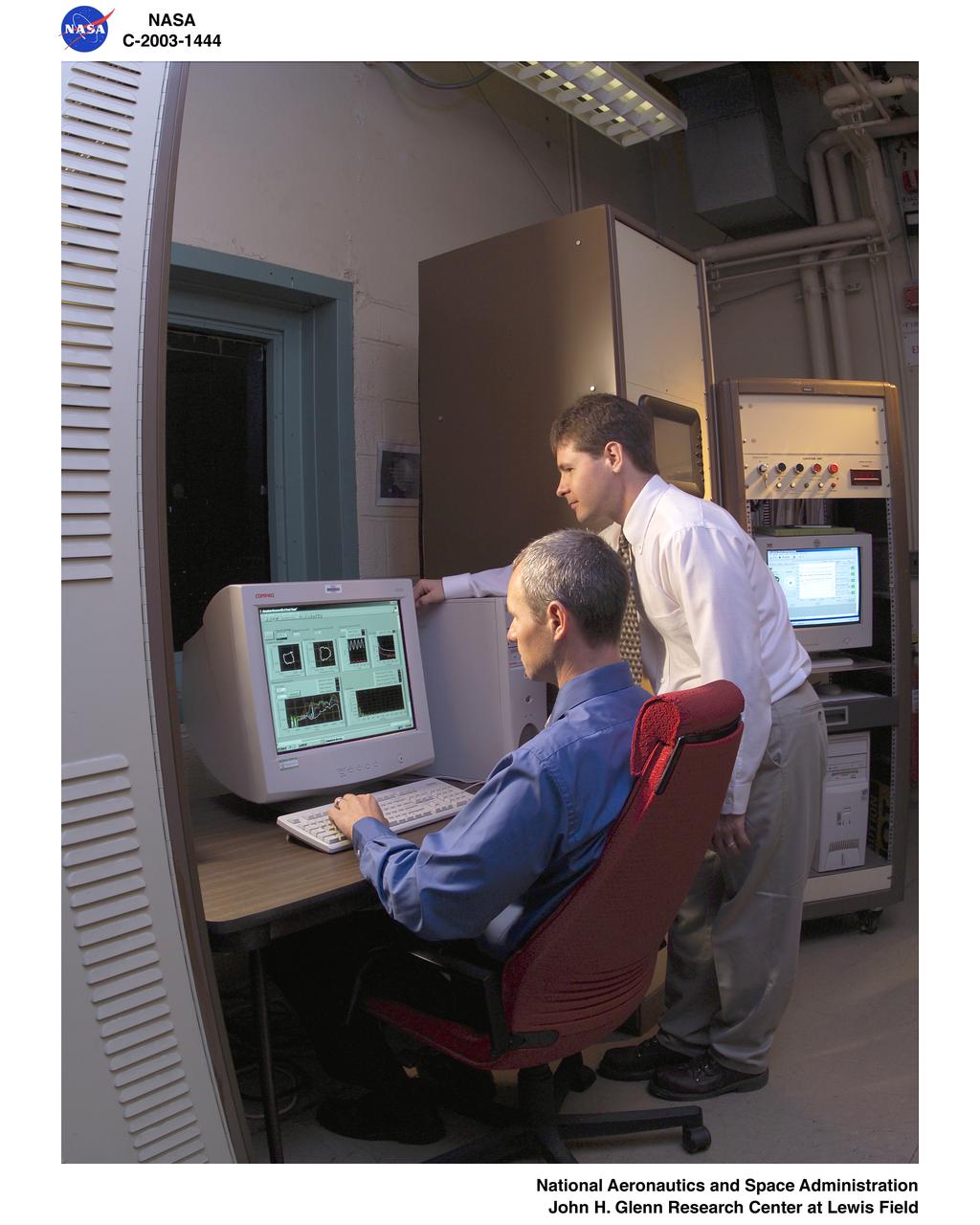
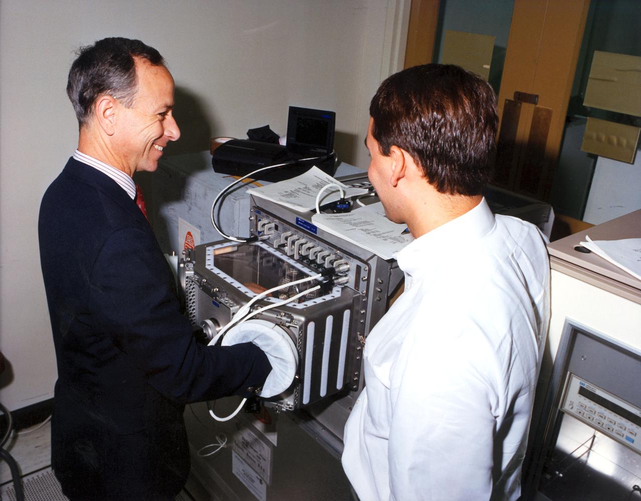
Tim King of Jacobs at NASA's Kennedy Space Center in Florida, explains operations in the Oil Pharmacy operated under the Test and Operations Support Contract, or TOSC. The facility consolidated storage and distribution of petroleum products used in equipment maintained under the contract. This included standardized naming, testing processes and provided a central location for distribution of oils used in everything from simple machinery to the crawler-transporter and cranes in the Vehicle Assembly Building.
Tim King of Jacobs at NASA's Kennedy Space Center in Florida, explains operations in the Oil Pharmacy operated under the Test and Operations Support Contract, or TOSC. The facility consolidated storage and distribution of petroleum products used in equipment maintained under the contract. This included standardized naming, testing processes and provided a central location for distribution of oils used in everything from simple machinery to the crawler-transporter and cranes in the Vehicle Assembly Building.
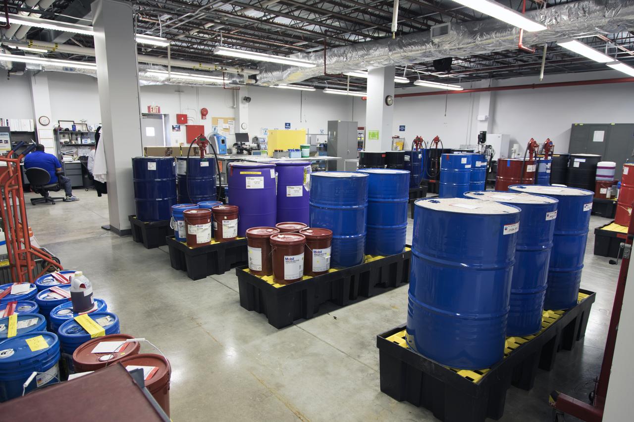
An overall view of the Oil Pharmacy operated under the Test and Operations Support Contract, or TOSC. The facility consolidated storage and distribution of petroleum products used in equipment maintained under the contract. This included standardized naming, testing processes and provided a central location for distribution of oils used in everything from simple machinery to the crawler-transporter and cranes in the Vehicle Assembly Building.
Tim King of Jacobs at NASA's Kennedy Space Center in Florida, explains operations in the Oil Pharmacy operated under the Test and Operations Support Contract, or TOSC. The facility consolidated storage and distribution of petroleum products used in equipment maintained under the contract. This included standardized naming, testing processes and provided a central location for distribution of oils used in everything from simple machinery to the crawler-transporter and cranes in the Vehicle Assembly Building.
An oil slick from naturally occurring oil seeps off the coast of Santa Barbara, California. The NASA-NOAA Marine Oil Spill Thickness (MOST) project is using the area to test the ability of a radar instrument called UAVSAR to detect the thickness of oil in oil slicks – important information for first responders to oil spills. Having concluded their second field campaign in Santa Barbara at the end of October, 2021, the MOST team is working to develop a way for NOAA – the lead federal agency for detecting and tracking coastal oil spills – to use remote sensing data to determine not just where oil is, but where the thickest parts of it are. NASA's UAVSAR, or Uninhabited Aerial Vehicle Synthetic Aperture Radar, attaches to the fuselage of an airplane that collects a roughly 12-mile-wide (19-kilometer-wide) image of the area. The instrument sends radar pulses down to the surface of the ocean, and the signals that bounce back are used to detect roughness, caused by waves, at the ocean's surface. Oil dampens the waves, creating areas of smoother water that appear darker than the surrounding clean water in the SAR imagery – the thicker the oil, the darker the area appears. When the project concludes, likely in 2023, scientists hope to have a prototype system for detecting oil spill thickness that can be deployed in emergencies. https://photojournal.jpl.nasa.gov/catalog/PIA23699
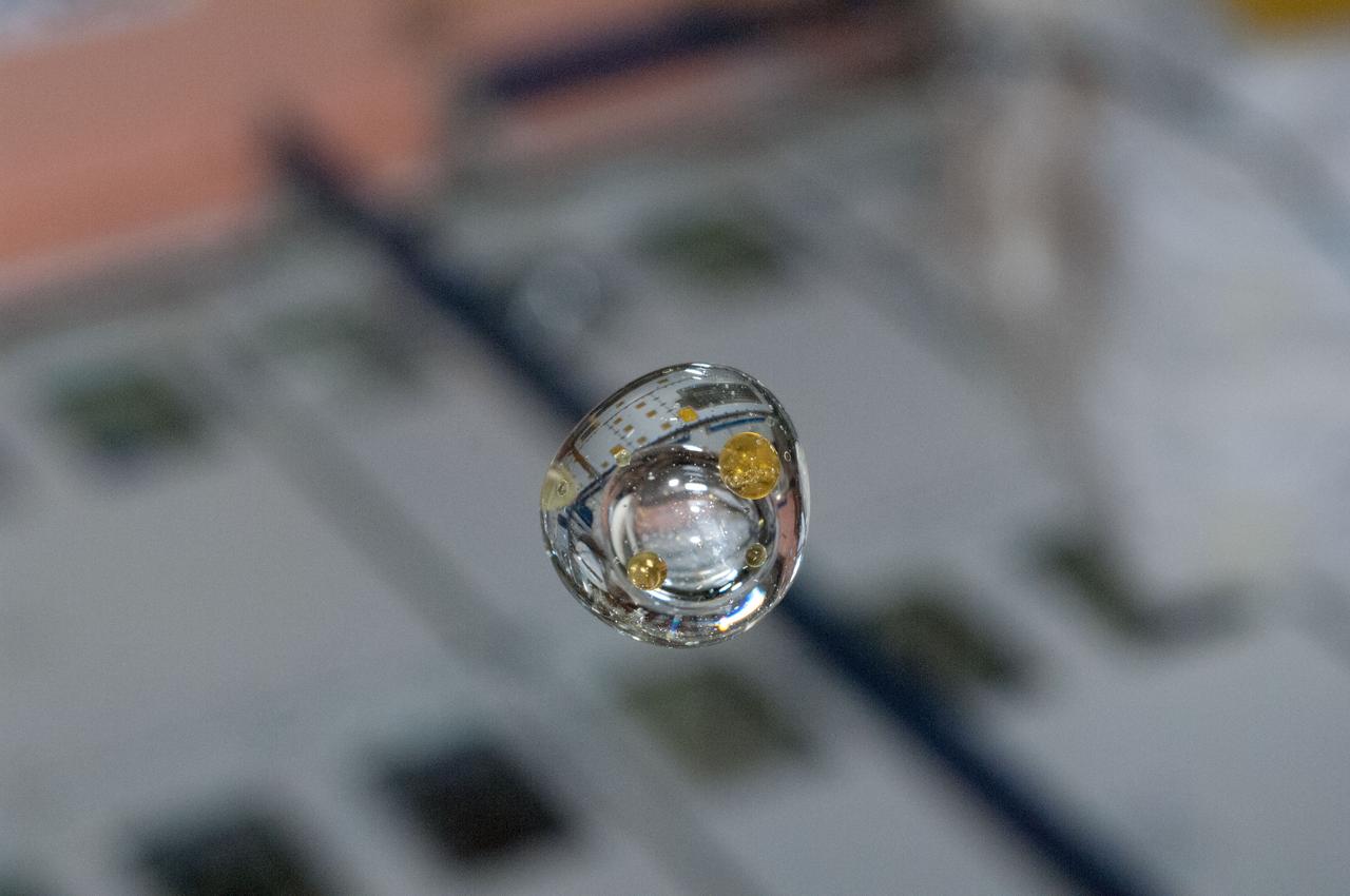
View of air and pepper oil experiment suspended in a water blob. Photo was taken during Expedition 34.

View of air and pepper oil experiment suspended in a water blob. Photo was taken during Expedition 34.
In this sunglint view of the Arabian Seacoast of Oman (19.0N, 59.0E) an oil slick is highlighted on the water's surface by sunglint lighting conditions. Nearly 50 percent of the oil transported worldwide passes through the Gulf of Oman, en route from the Persian Gulf and numerous ship wakes can be seen in this view. The oil slick, rounding the tip of Cape Ras Al Hadd, has formed a counterclockwise bright spiral indicating the local ocean currents.
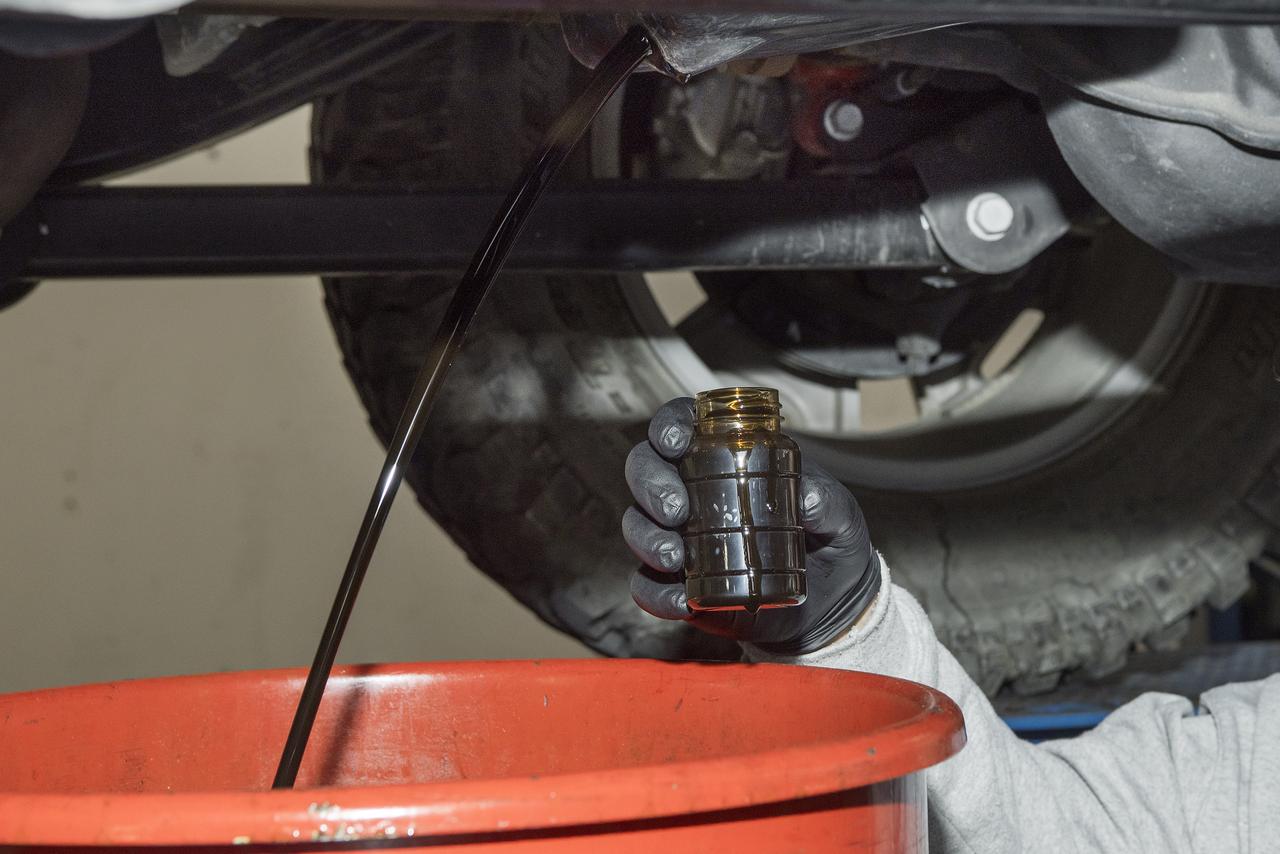
Before new bio-based synthetic oils were added to Armstrong vehicles, the old oil was drained and sent to a lab for analysis to compare to the new lubricant.
STS058-73-054 (18 Oct-1 Nov 1993) --- A clear view of the northern Kuwaiti coast shows the southern part of Kuwait City, and the major oil fields to the south. Oil-laden sands, where wells were set ablaze during the Gulf War in 1991, are visible south of Kuwait City as a dark, elongated patch surrounded by light-colored sand. Oil-stained sand between well sites (dots) and criss-crossing roads is gradually being covered by clean sand carried by strong, seasonal northwest winds.
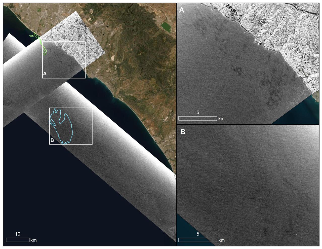
An oil spill off the Southern California coast – first reported to the U.S. Coast Guard on Oct. 2, 2021 – prompted an effort by NASA's Applied Sciences Disasters Program to determine what NASA resources and capabilities could be available to support response efforts for the spill. As part of those efforts, a team from NASA's Jet Propulsion Laboratory in Southern California flew an airplane equipped with an instrument known as the Uninhabited Aerial Vehicle Synthetic Aperture Radar (UAVSAR) over the spill area on Oct. 6 to corroborate the presence and location of oil slicks. Mapping the location of oil slicks and determining how thick the oil is can also help with clean-up activities. The JPL researchers collected the UAVSAR data in support of the National Oceanic and Atmospheric Administration (NOAA), which regularly monitors U.S. coastal waters for potential spills. This image shows a composite of two images taken during passes (grayscale regions) made by the UAVSAR instrument off the coast of Huntington Beach. Dark smudges off the coast in the close-up images to the right (labeled A and B) are potential oil slicks – NOAA researchers will analyze the data to look for the presence of oil. The area outlined in light green (image on the left) was identified by NOAA using satellite data as a region possibly containing oil on Oct.3, while the blue outline shows an area on Oct. 6 that could also contain oil. Attached to the bottom of a Gulfstream-III based at NASA's Armstrong Flight Research Center near Palmdale, California, UAVSAR is an all-weather tool that bounces radar signals off of Earth's surface. Repeated images of the same areas, taken at different times, enable scientists to detect changes in those regions. The radar signals will reflect differently off of different surfaces, including oil and seawater. These signal variations can tell researchers about the presence of an oil slick in the ocean, and in some cases provide information about its thickness. https://photojournal.jpl.nasa.gov/catalog/PIA23782

Oil painting depicting the storms of Jupiter, the satellite Io and the Great Red Spot
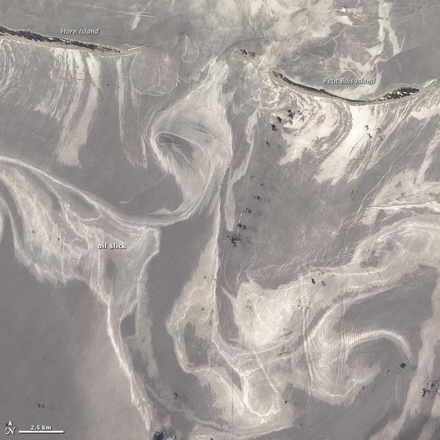
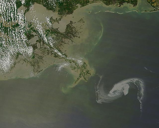
NASA image acquired June 26, 2010 As of June 27, 2010, the entire gulf-facing beachfront of several barrier islands in eastern Mississippi (offshore of Pascagoula) had received a designation of at least “lightly oiled” by the interagency Shoreline Cleanup Assessment Team that is responding to the disaster in the Gulf of Mexico. A few small stretches of Petit Bois Island had been labeled heavily or moderately oiled. (To view this image without a description go to: This high-resolution image shows Petit Bois Island (top right) and the eastern end of Horn Island (top left) on June 26. In general, oil-covered waters are silvery and cleaner waters are blue-gray. This pattern is especially consistent farther from the islands. The intensely bright patches of water directly offshore of the barrier islands, however, may be from a combination of factors, including sediment and organic material, coastal currents and surf, and oil. The islands provide a sense of scale for the ribbons of oil swirling into the area from the south. Petit Bois Island is about 10 kilometers (6 miles) long. It is one of seven barrier islands that, along with some mainland areas of Mississippi and Florida, make up the Gulf Islands National Seashore. According to the National Park Service Gulf Islands National Seashore Website, all the islands remained open to the public as of June 28, 2010, and clean-up crews were on hand to respond to any oil coming ashore. The large version of this image, which was captured by the Advanced Land Imager on NASA’s Earth Observing-1 (EO-1) satellite, shows a larger area, including the Mississippi Sound and parts of mainland Mississippi. Although oil has been observed in the Sound, it is unlikely that all the bright patches of water in that area are thickly oil-covered. Differences in brightness in coastal area waters may be due to other factors, including freshwater runoff, strong currents, and water depth and clarity. NASA Earth Observatory image created by Jesse Allen and Robert Simmon, using EO-1 ALI data provided courtesy of the NASA EO-1 team. Caption by Rebecca Lindsey. Instrument: EO-1 - ALI To see more images go to: <a href="http://earthobservatory.nasa.gov/" rel="nofollow">earthobservatory.nasa.gov/</a> <b><a href="http://www.nasa.gov/centers/goddard/home/index.html" rel="nofollow">NASA Goddard Space Flight Center</a></b> is home to the nation's largest organization of combined scientists, engineers and technologists that build spacecraft, instruments and new technology to study the Earth, the sun, our solar system, and the universe.
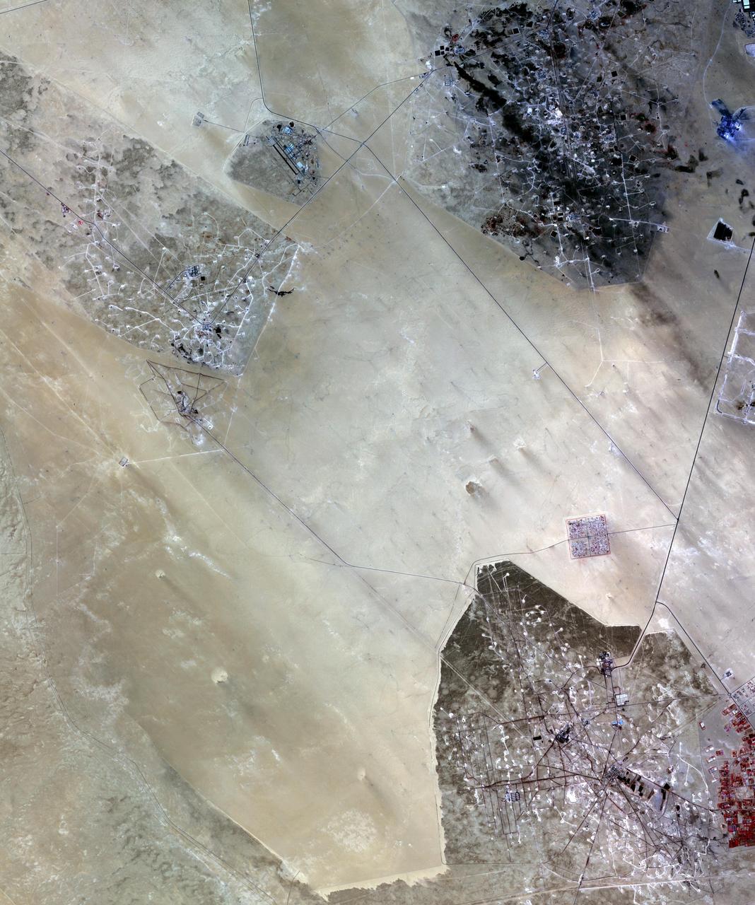
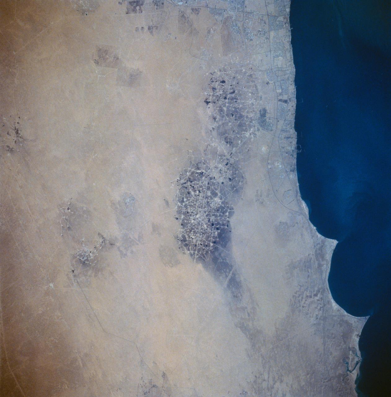
In the desert of southern Kuwait, three oil fields spread out across the empty landscape as seen by NASA Terra spacecraft.
This image from NASA Terra satellite was acquired on May 1, 2010. The red symbol indicates the approximate position of the Deepwater Horizon platform and the source of the oil slick which resulted in a significant oil spill in the Gulf of Mexico.
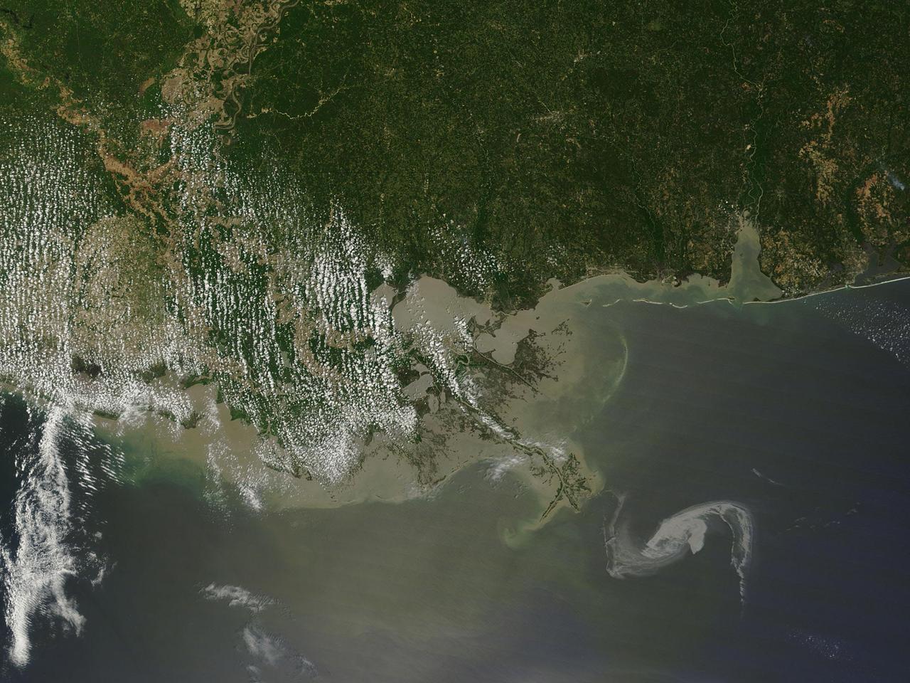
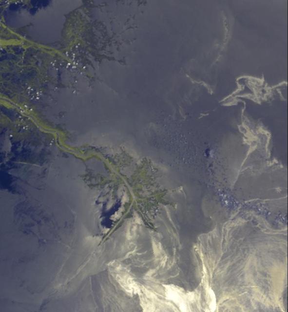
Oil from the Deepwater Horizon spill laps around the mouth of the Mississippi River Delta in this May 24, 2010, image from NASA Terra spacecraft. The oil appears silver, while vegetation is red.

Oil Painting of the tile team at work, in 1980, in the orbiter processing facility at Kennedy Space Center.

A new bio-based synthetic engine oil is added to one of the vehicles that Armstrong is using to assist in performance testing of the new product.
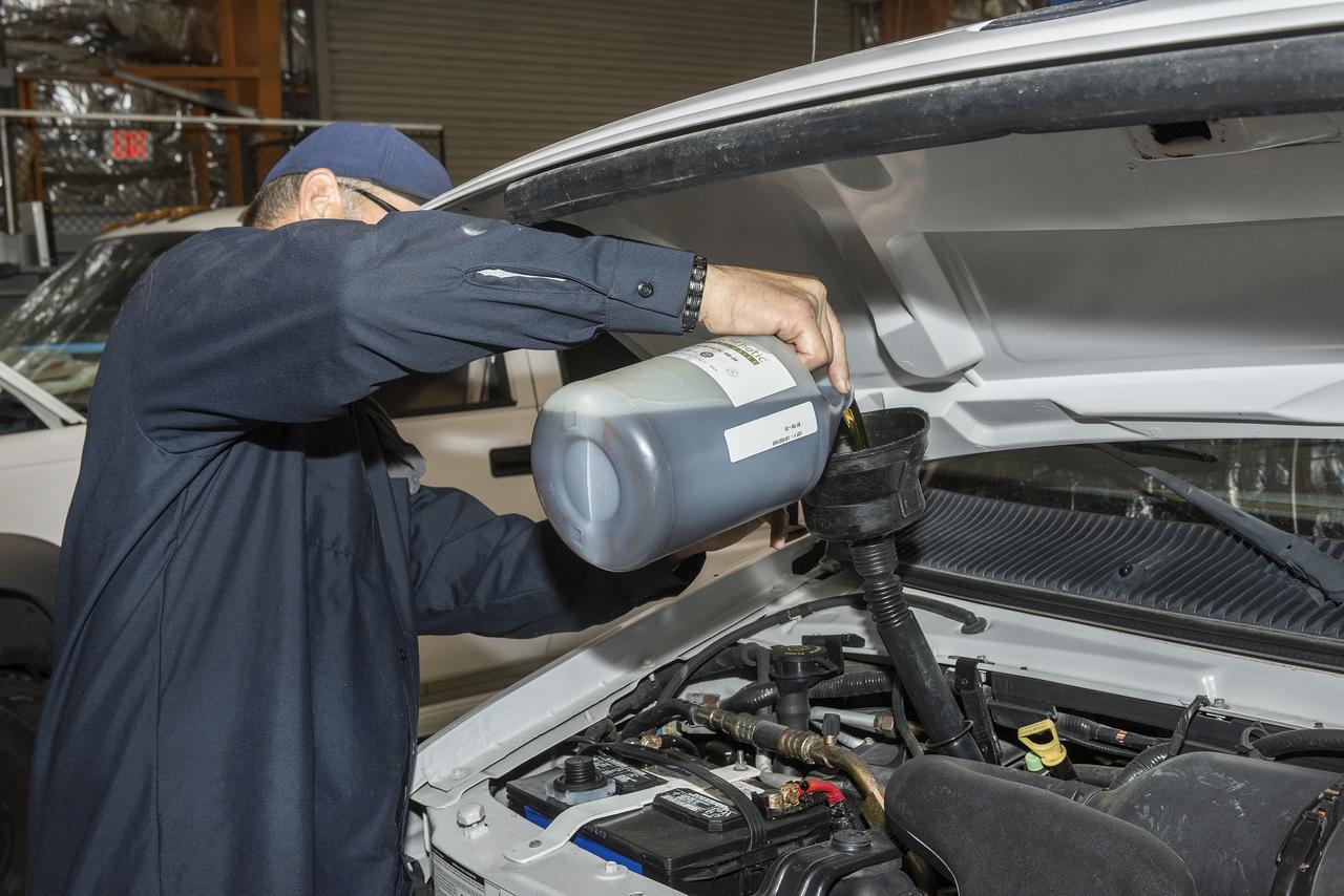
Scott Rogers pours a new bio-based synthetic engine oil into one of the vehicles that Armstrong is using to assist in the performance testing of the new product.
NASA Terra spacecraft captured this image of the growing oil spill in the Gulf of Mexico on May 1, 2010. On April 20, 2010, an explosion destroyed the Deepwater Horizon oil platform operating offshore in the Gulf of Mexico.

NASA Terra spacecraft captured this image of the growing oil spill in the Gulf of Mexico on May 7, 2010. The thickest parts of the oil spill appear as dark grey, filamentous masses in the southern part of the image, extending off of the bottom.
This image from NASA Airborne Visible/Infrared Imaging Spectrometer instrument AVIRIS was collected on May 17, 2010, over the site of the Deepwater Horizon BP oil spill disaster. In the image, crude oil on the surface appears orange to brown.
2010/119 - 04/29 at 16 :48 UTC Oil slick in the Gulf of Mexico (Input Direct Broadcast data courtesy Direct Readout Lab, NASA/GSFC) Satellite: Terra NASA/GSFC/Jeff Schmaltz/MODIS Land Rapid Response Team To learn more about MODIS go to: <a href="http://rapidfire.sci.gsfc.nasa.gov/gallery/?latest" rel="nofollow">rapidfire.sci.gsfc.nasa.gov/gallery/?latest</a> <b><a href="http://www.nasa.gov/centers/goddard/home/index.html" rel="nofollow">NASA Goddard Space Flight Center</a></b> is home to the nation's largest organization of combined scientists, engineers and technologists that build spacecraft, instruments and new technology to study the Earth, the sun, our solar system, and the universe.
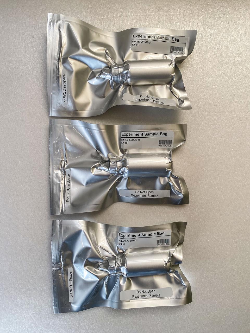
jsc2022e034193 (10/9/2021) --- Preflight imagery of the Extra-Virgin Olive Oil in Space (EVOOS) samples vacuum sealed and labeled ready for shipment to NASA for launch. The Extra Virgin Olive Oil in Space (EVOO in Space) investigation studies the effects of exposure to the space environment on extra virgin olive oil. The physicochemical, sensorial, and nutritional characteristics of veiled and filtered extra virgin olive oils are compared to those from controls kept on the ground. Image courtesy of Stefano Polato.

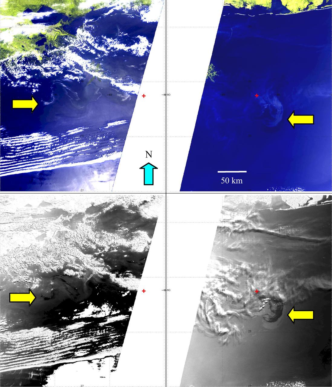
A C-20 based at NASA’s Armstrong Flight Research Center in Edwards, California, departs to use its Uninhabited Aerial Vehicle Synthetic Aperture Radar to support the Marine Oil Spill Thickness mission. Thousands of gallons of oil seep through cracks in the ocean floor and rise to the surface just off the coast of Santa Barbara. It’s one of the largest naturally occurring oil seeps and serves as a laboratory for NASA and the National Oceanic and Atmospheric Administration to test automated oil spill detection, oil extent mapping, and oil thickness characterization.
This image acquired on May 24, 2010 by NASA Terra spacecraft shows oil from the former Deepwater Horizon rig encroaching upon several of Louisiana wildlife habitats.
This image, from NASA Terra spacecraft, was acquired May 1, 2010. An explosion destroyed the Deepwater Horizon oil platform operating in the offshore in Gulf of Mexico on April 20, 2010.
This image captured by NASA Terra spacecraft is an enhanced true color image of the Gulf of Mexico as it passed over the Deepwater Horizon oil slick on May 10, 2010.
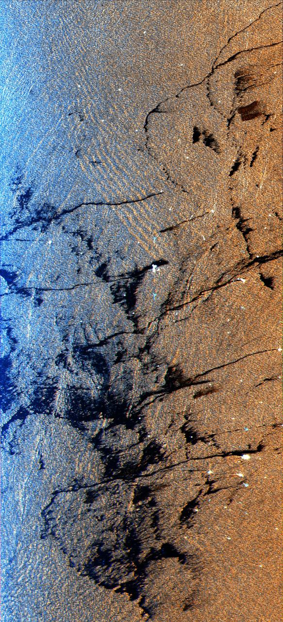
This is a radar image of an offshore drilling field about 150 km 93 miles west of Bombay, India, in the Arabian Sea. The dark streaks are extensive oil slicks surrounding many of the drilling platforms, which appear as bright white spots.
Dark smoke from oil fires extend for about 60 kilometers south of Iraq capital city of Baghdad in this anaglyph acquired by the MISR instrument aboard NASA Terra spacecraft on April 2, 2003. 3D glasses are necessary to view this image.
2010/119 - 04/29 at 16 :48 UTC Oil slick in the Gulf of Mexico To see a full view of this image go to: <a href="http://www.flickr.com/photos/gsfc/4563296541/">www.flickr.com/photos/gsfc/4563296541/</a> (Input Direct Broadcast data courtesy Direct Readout Lab, NASA/GSFC) Satellite: Terra NASA/GSFC/Jeff Schmaltz/MODIS Land Rapid Response Team To learn more about MODIS go to: <a href="http://rapidfire.sci.gsfc.nasa.gov/gallery/?latest" rel="nofollow">rapidfire.sci.gsfc.nasa.gov/gallery/?latest</a> <b><a href="http://www.nasa.gov/centers/goddard/home/index.html" rel="nofollow">NASA Goddard Space Flight Center</a></b> is home to the nation's largest organization of combined scientists, engineers and technologists that build spacecraft, instruments and new technology to study the Earth, the sun, our solar system, and the universe.

An oil slick in the Gulf of Mexico following Hurricane Ida – a high-end Category 4 when it made landfall near Port Fourchon, Louisiana, on Aug. 29, 2021 – appears as a green trail in the inset false-color graphic provided by NASA's Delta-X project, while the surrounding seawater appears orange. The National Oceanic and Atmospheric Administration (NOAA) regularly monitors U.S. coastal waters for potential spills and noticed slicks that appeared just off the coast after the hurricane. They were able to use this information from Delta-X to corroborate other data they had about oil slicks in the area (satellite image in the second inset picture). The blue-green swath crossing from the Gulf of Mexico over the Louisiana coast denotes the flight path of the Delta-X radar instrument on Sept. 1, just before 11:30 a.m. CDT. Charged with studying the Mississippi River Delta, Delta-X was gearing up to collect data on Louisiana's coastal wetlands when Hurricane Ida barreled ashore in late August. The storm damaged buildings and infrastructure alike, resulting in power outages, flooding, and oil slicks in the Gulf of Mexico. Oil tends to smooth out the bumps on the ocean's surface, which results in a distinct radar signal that the Delta-X mission was able to pick out of their data. Delta-X added flight paths to their planned schedule – with the support of NASA's Applied Science Disaster Program – in order to collect information over the gulf in areas of interest to NOAA. Delta-X is studying two wetlands – the Atchafalaya and Terrebonne Basins – by land, boat, and air to quantify water and sediment flow as well as vegetation growth. While the Atchafalaya Basin has been gaining land through sediment accumulation, Terrebonne Basin, which is right next to the Atchafalaya, has been rapidly losing land. The data collected by the project will be applied to models used to forecast which areas of the delta are likely to gain or lose land under various sea level rise, river flow, and watershed management scenarios. The mission uses several instruments to collect its data. Affixed to the bottom of a Gulfstream-III airplane, one of those instruments, the all-weather Uninhabited Aerial Vehicle Synthetic Aperture Radar (UAVSAR), bounces radar signals off of Earth's surface, forming a kind of image of a particular area. Repeated images of the same regions, captured at different times, enable researchers to detect changes in those areas, such as fluctuating water levels beneath the vegetation as the tides move in and out of these wetlands. In addition to radar measurements, teams from Caltech, Louisiana State University, Florida International University, and other collaborating institutions gather water and vegetation samples – among other data – by boat, other airborne sensors, and from instruments on the ground. Funded by NASA's Earth Venture Suborbital (EVS-3) program, Delta-X is managed by the agency's Jet Propulsion Laboratory. Caltech in Pasadena, California, manages JPL for NASA. Fall 2021 was Delta-X's last scheduled field campaign, although the five-year mission will run through the end of 2023. https://photojournal.jpl.nasa.gov/catalog/PIA24540
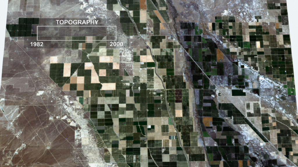
This frame from an animation depicts ground subsidence resulting from the extraction of oil. The oil fields are located near the community of Lost Hills, California, approximately 100 km northwest of Bakersfield.
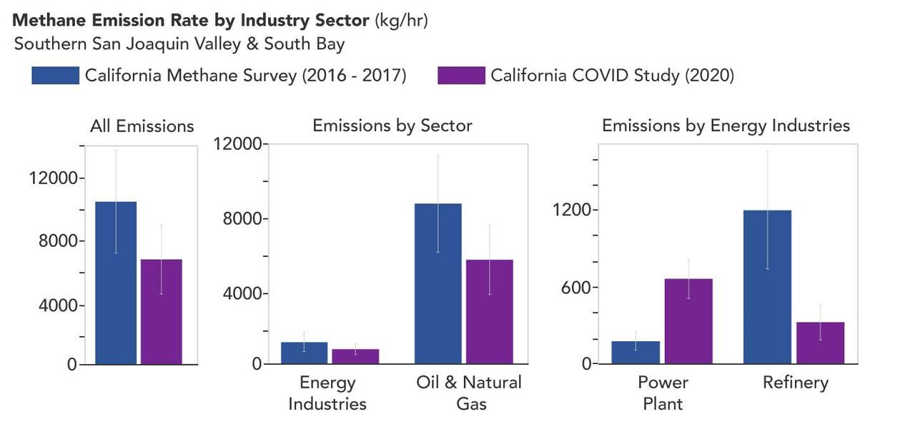
A March 2023 study by researchers at NASA's Jet Propulsion Laboratory in Southern California compared emissions from a belt of oil refineries across the South Bay area of Los Angeles during the first summer of the COVID-19 pandemic to those observed three years earlier. Using data from a NASA airborne instrument, researchers saw that most of the facilities they identified as methane sources in 2016-17 were no longer emitting the greenhouse gas in 2020, leading to a 73% reduction in measured emissions. The study uses measurements made by an imaging spectrometer called AVIRIS-NG (Airborne Visible/Infrared Imaging Spectrometer-Next Generation). Attached to the bottom of an aircraft, the instrument can detect greenhouse gas emissions from individual facilities or even pieces of equipment by looking at how the gases absorb sunlight. In 2016 and 2017, AVIRIS-NG was flown over 22,000 square miles (57,000 square kilometers) of the state as part of the California Methane Survey. From July to September 2020, researchers retraced some of those flight paths over refineries and power plants in Los Angeles County and over oil fields in central California's San Joaquin Valley. The flights were funded by NASA's Earth Science Division, the California Air Resources Board, and the California Energy Commission. The 2020 surveys over Los Angeles identified only 11 plumes from five refinery sources, with a total emissions rate of about 712 pounds (323 kilograms) methane per hour. The 2016 and 2017 flights had found 48 plumes from 33 sources, with a total emissions rate of roughly 2,639 pounds (1,197 kilograms) methane per hour. The drop correlates with an 18% decrease in monthly production in Southern California refineries between the two flight campaigns, the scientists noted, citing data from the California Energy Commission. The study also found that emissions from oil fields in and around the city of Bakersfield in central California fell 34.2%, correlating with a 24.2% drop in oil production. Reduced production during the pandemic due to lower demand for fuel and lower gas prices could have led to the drop in methane emissions, as oil fields and refineries emitted less methane as part of operations. However, researchers said, improved equipment maintenance and mitigation efforts at those facilities between 2016 and 2020 can't be ruled out as a factor. https://photojournal.jpl.nasa.gov/catalog/PIA25864
This is an X-band image of an oil slick experiment conducted in the North Sea, Germany. The image is centered at 54.58 degrees north latitude and 7.48 degrees east longitude. This image was acquired by the Spaceborne Imaging Radar-C and X-band Synthetic Aperture Radar (SIR-C/X-SAR) aboard the space shuttle Endeavour on October 6, 1994, during the second flight of the spaceborne radar. The experiment was designed to differentiate between petroleum oil spills and natural slicks floating on the sea surface. Two types of petroleum oil and six types of oils resembling natural sea surface slicks were poured on the sea surface from ships and a helicopter just before the space shuttle flew over the region. At the bottom of the image is the Sylt peninsula, a famous holiday resort. Twenty-six gallons (100 liters) of diesel oil was dissipated due to wave action before the shuttle reached the site. The oil spill seen at the uppermost part of the image is about 105 gallons (400 liters) of heavy heating oil and the largest spill is about 58 gallons (220 liters) of oleyl alcohol, resembling a "natural oil" like the remaining five spills used to imitate natural slicks that have occurred offshore from various states. The volume of these other oils spilled on the ocean surface during the five experimental spills varied from 16 gallons to 21 gallons (60 liters to 80 liters). The distance between neighboring spills was about half a mile (800 meters) at the most. The largest slick later thinned out to monomolecular sheets of about 10 microns, which is the dimension of a molecule. Oceanographers found that SIR-C/X-SAR was able to clearly distinguish the oil slicks from algae products dumped nearby. Preliminary indications are that various types of slicks may be distinguished, especially when other radar wavelengths are included in the analysis. Radar imaging of the world's oceans on a continuing basis may allow oceanographers in the future to detect and clean up oil spills much more swiftly than is currently possible. http://photojournal.jpl.nasa.gov/catalog/PIA01748
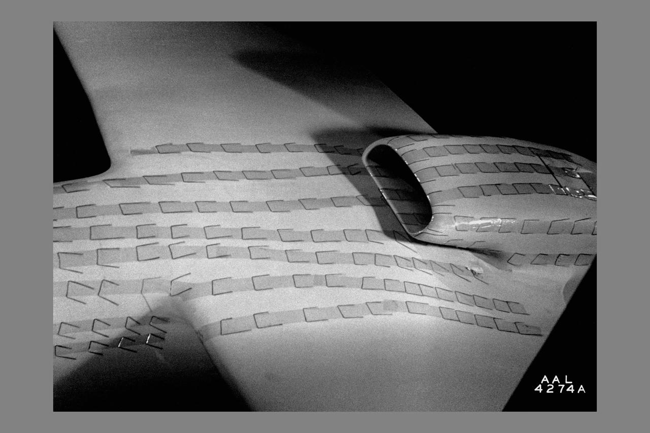
The modified F-18 High Alpha Research Vehicle (HARV) carries out air flow studies on a flight from the Dryden Flight Research Center, Edwards, California. Using oil, researchers were able to track the air flow across the wing at different speeds and angles of attack. A thrust vectoring system had been installed on the engines' exhaust nozzles for the high angle of attack research program. The thrust vectoring system, linked to the aircraft's flight control system, moves a set of three paddles on each engine to redirect thrust for directional control and increased maneuverability at angles of attack at up to 70 degrees.
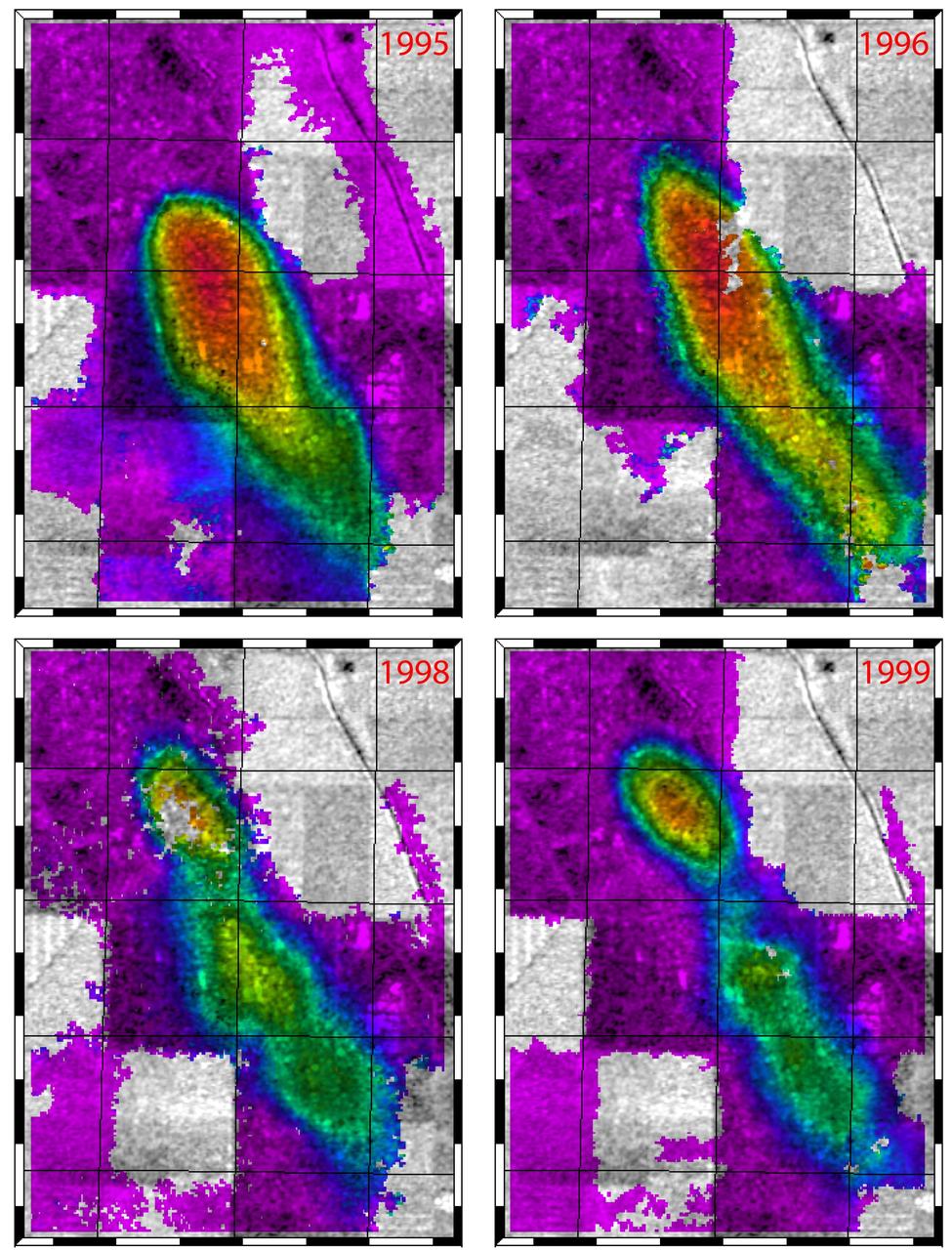
This figure shows a comparison of interferograms from four different years mapping the rapid ground subsidence over the Lost Hills oil field in California.

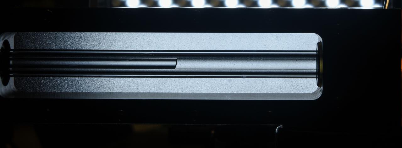
Various Oil-Free Turbomachinery Hardware and Rigs - oil-free turbomachinery demonstration rigs
STS-42 closeup view shows Student Experiment 81-09 (SE 81-09), Convection in Zero Gravity experiment, with radial pattern caused by convection induced by heating an oil and aluminum powder mixture in the weightlessness of space. While the STS-42 crewmembers activated the Shuttle Student Involvement Program (SSIP) experiment on Discovery's, Orbiter Vehicle (OV) 103's, middeck, Scott Thomas, the student who designed the experiment, was able to observe the procedures via downlinked television (TV) in JSC's Mission Control Center (MCC). Thomas, now a physics doctoral student at the University of Texas, came up with the experiment while he participated in the SSIP as a student at Richland High School in Johnstown, Pennsylvia.
Oil-Free Turbocharger
OIL IMMERSION EXPERIMENT RACK

Oil-Free Disk, Bushings and Coupons
Tropical Storm Bonnie, now a depression, rakes South Florida in this infrared image from NASA Atmospheric Infrared Sounder , en route to a weekend run-in with the Gulf of Mexico and the Gulf oil spill.
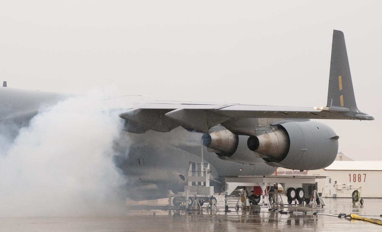
Oil smoke billows from the right inboard engine of the C-17 while a probe collects emissions data during 2011 VIPR engine health monitoring tests.

Oil Portrait of Ames Fellow R. T. Jones

Oil-Free Turbomachinery Thrust Bearing Test Rig

Oil Portrait of Ames Fellow James Pollack
Oil Portrait of Ames Fellow Harvard Lomax

Oil-Free Turbomachinery Thrust Bearing Test Rig
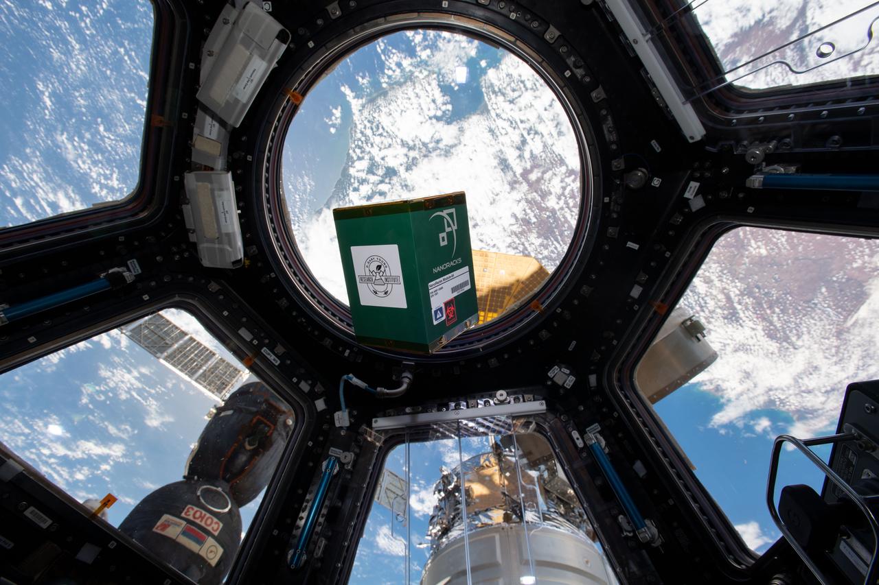
iss060e020116 (7/31/2019) --- A view of the NanoLab containing the Young Living investigation in the Cupola window aboard the International Space Station (ISS). The Young Living investigation studies the effects of exposure to the extraterrestrial environment on plant seeds and essential oils. Researchers expose seeds to the space environment then germinate and grow them to maturity on the ground and extract essential oils. The plant growth and composition of essential oils are compared to those from controls kept on the ground.
jsc2023e055882 10/5/2023) --- Oil flows into a glass tube during the imbibition phase of the experiment. The oil is initially stored in a reservoir on the right side of the tube (not visible). When the reservoir is open, the oil spontaneously flows into the tube, driven by interfacial/capillary action. The Wicking in Gel-Coated Tubes (Gaucho Lung) investigation studies fluid transport within gel-coated tubes to learn more about treatment programs for respiratory distress syndrome and develop new contamination control strategies. Image courtesy of University of California, Santa Barbara.
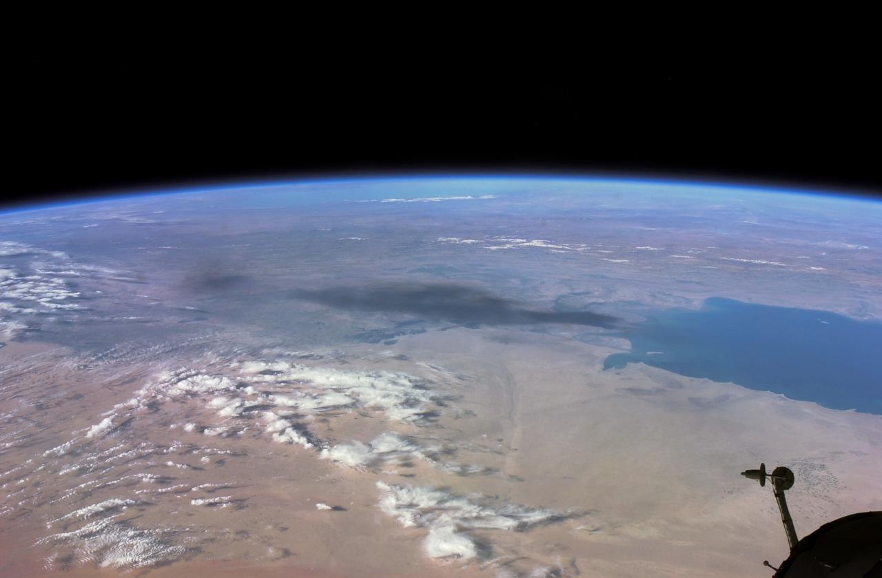
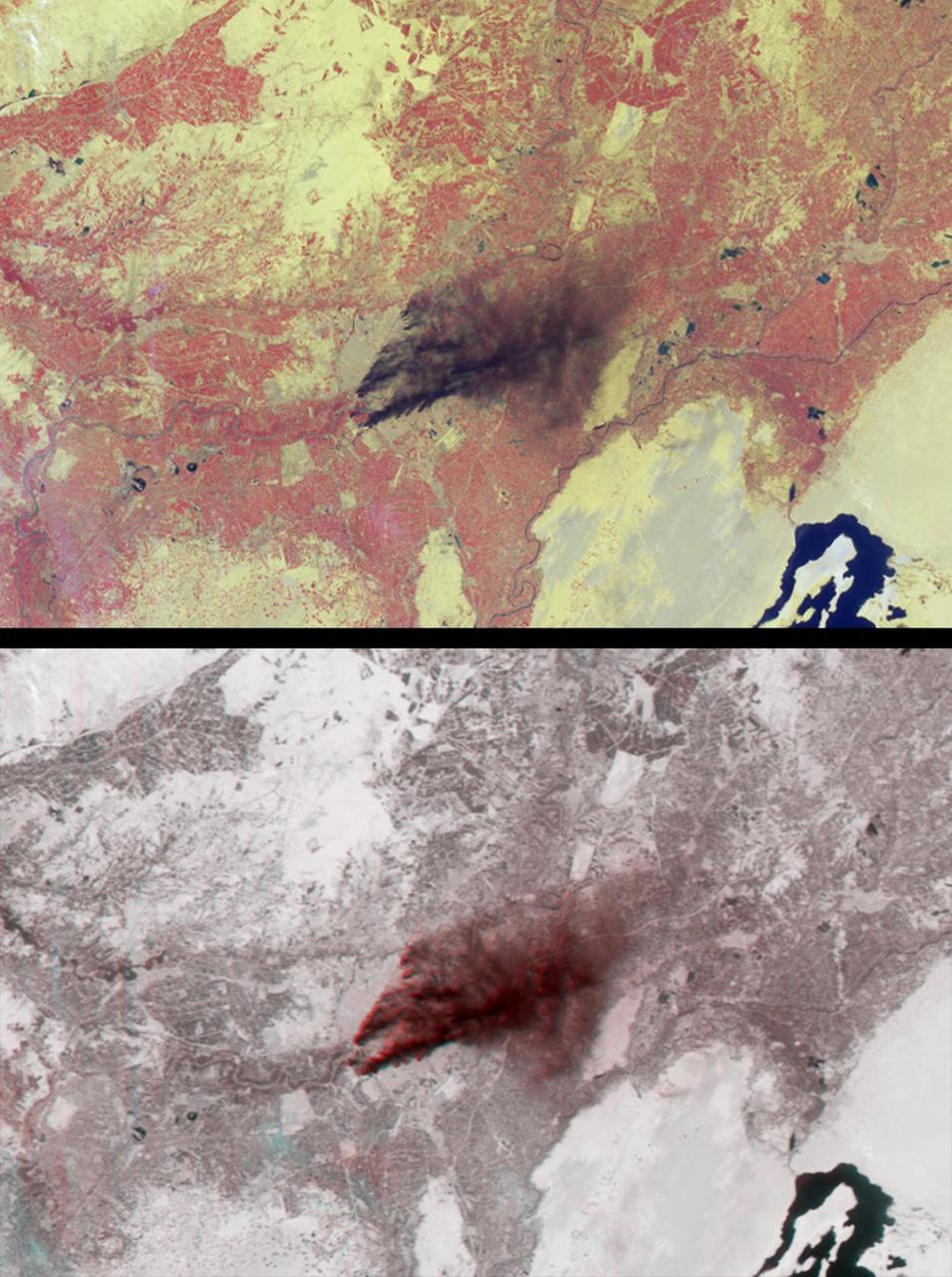
ISS008-E-18935 (24 March 2004) --- This photo of a large black smoke plume from an oil fire was taken by an Expedition 8 crewmember on the International Space Station as the Station orbited northeastward across Saudi Arabia. According to a front-page story in the New York Times, an oil pipeline near the channel of Shatt al Arab in southeastern Iraq on the Persian Gulf ruptured the day before. The resulting oil spill ignited and its smoke can here be seen to extend over 100 miles northwestward into southern Iraq.
Various Oil-Free Turbomachinery Hardware and Rigs - SE-8 control room

Oil portrait of Howard Goldstein A leader of Ames' research on thermal protection systems.
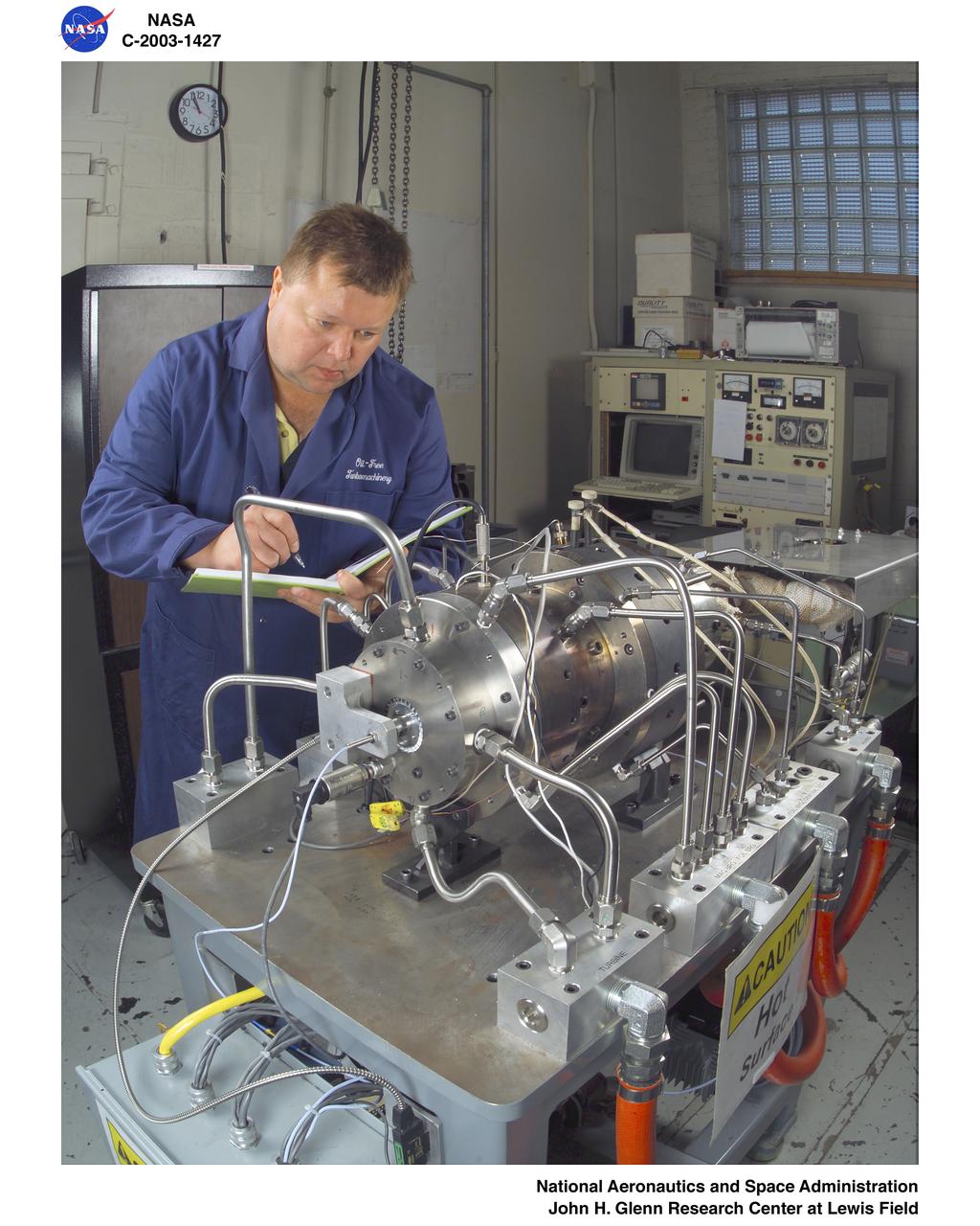
Various Oil-Free Turbomachinery Hardware and Rigs - thrust bearing rig
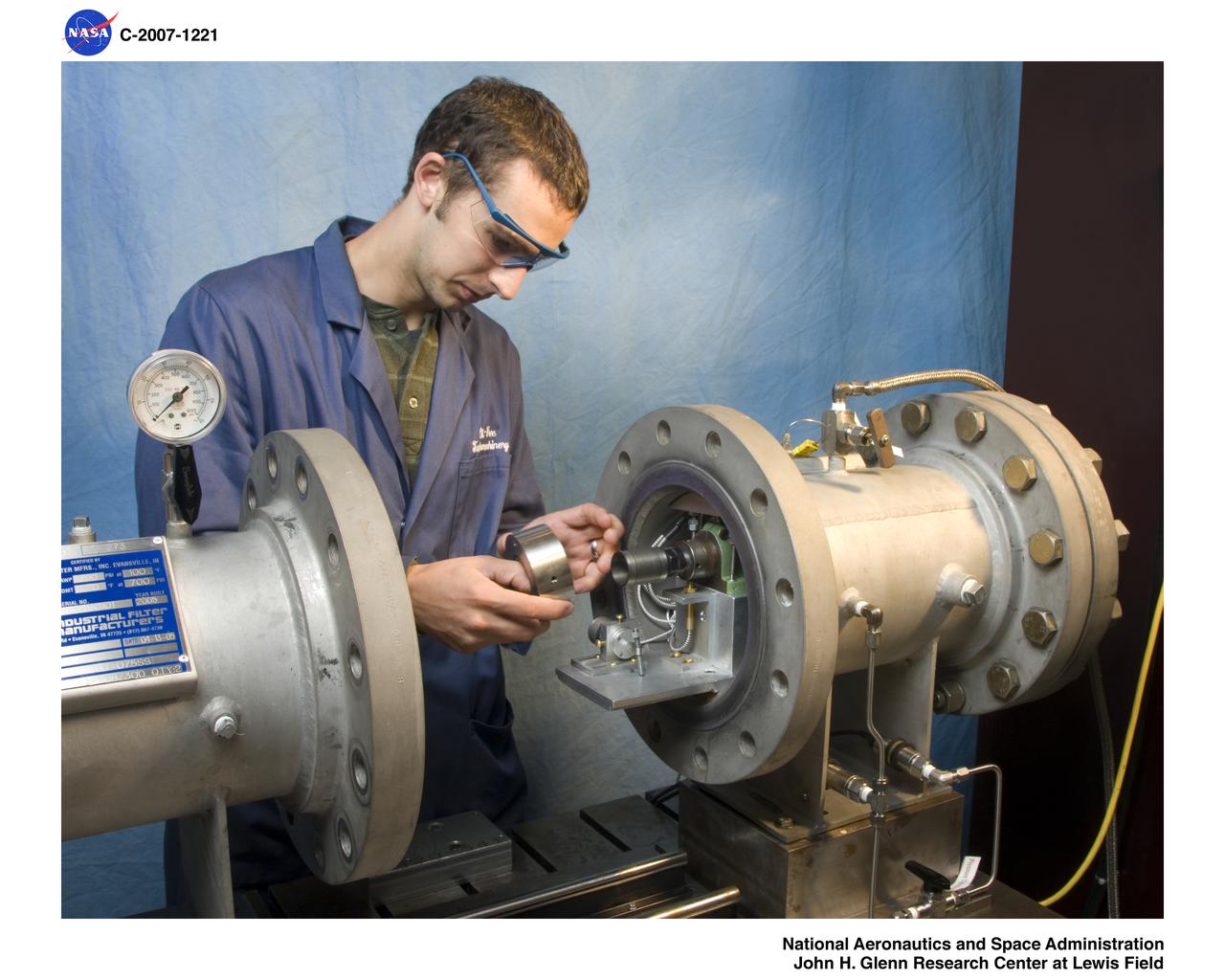
Oil-Free High-Pressure Journal Bearing Test Rig
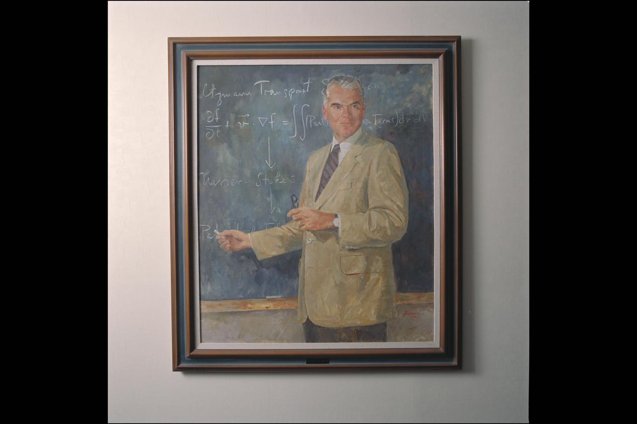
Oil Portrait: Hans Mark, Ames Director from 1969 to 1978

Oil Portrait: Clarence 'Sy' Syvertson Ames Director from 1977 to 1984
Various Oil-Free Turbomachinery Hardware and Rigs - bushing rig
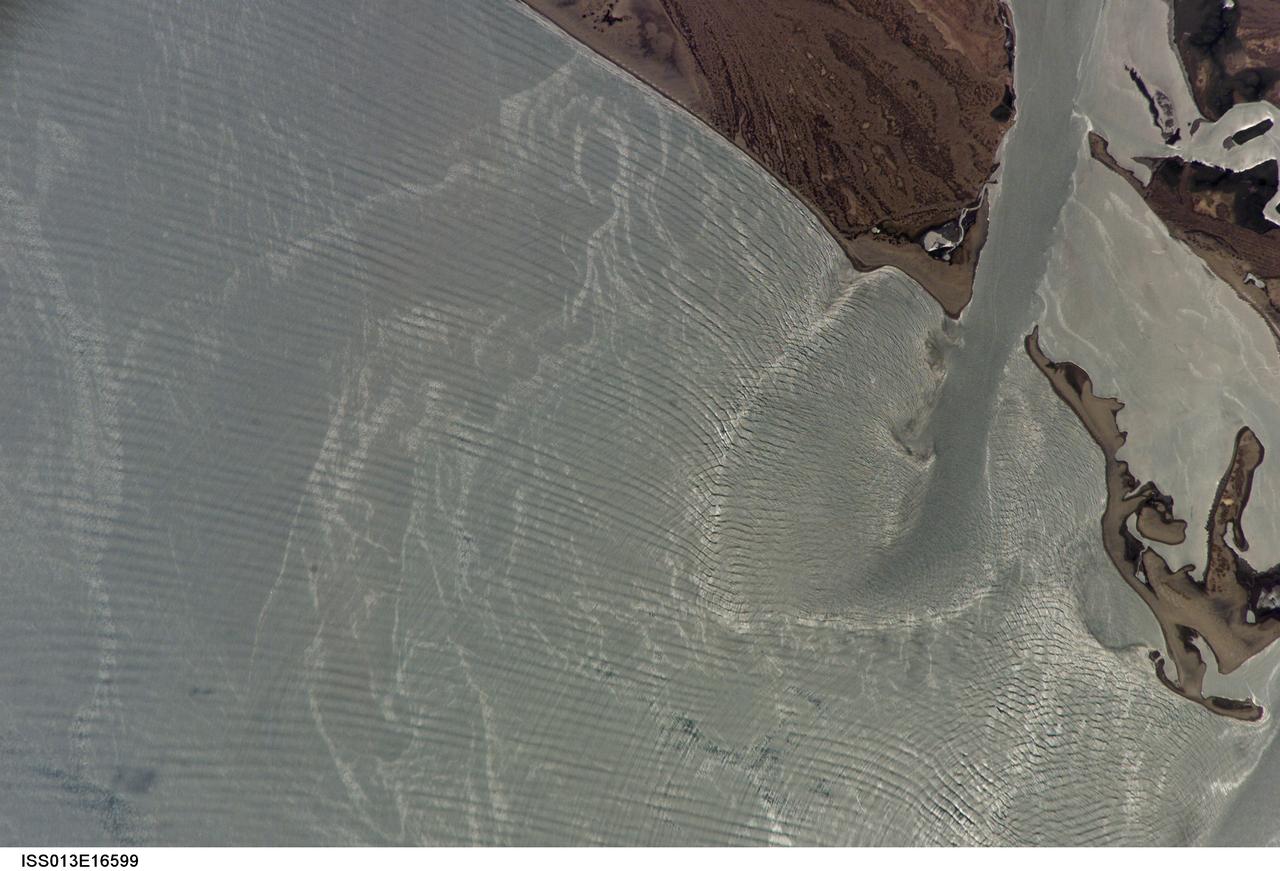
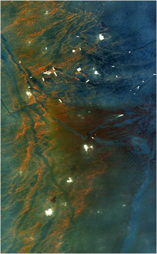
ISS013-E-16599 (9 May 2006) --- Wave sets and tidal currents in the Gulf of California are featured in this image photographed by an Expedition 13 crewmember on the International Space Station. In this image, sunglint off the Gulf of California gives the water a silver-gray appearance rather than the usual azure blue color. The sunglint allows us to see several active features which would not be visible otherwise. In this view of Punta Perihuete, Mexico we can see three major features: biological or man-made oils floating on the surface; the out-going tidal current; and complex wave patterns. The oils on the surface are recognizable as light grey, curved and variable-width streamers shaped by the local winds and currents. Plankton, fish, natural oil seeps and boats dumping bilges are all potential sources for these oils.
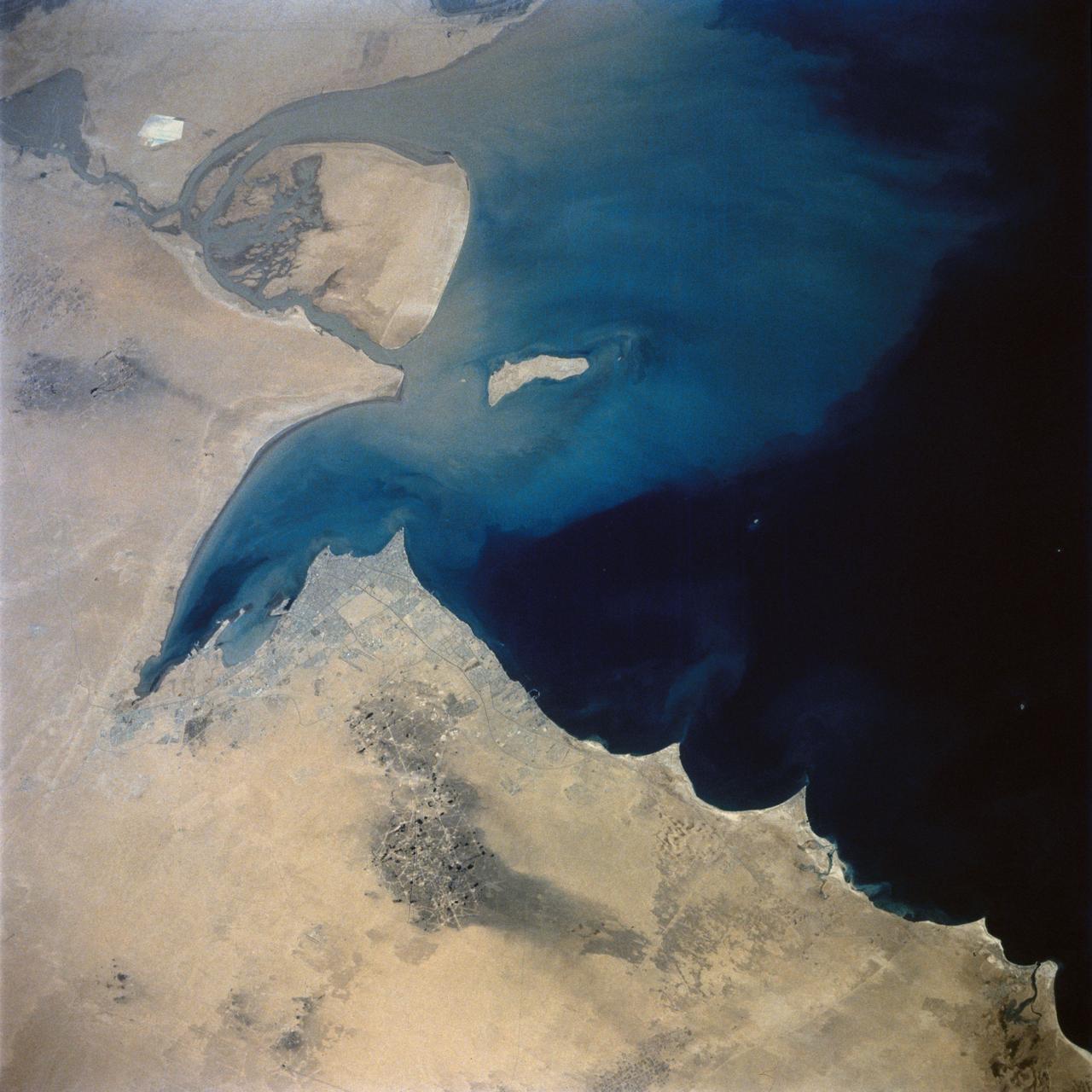
STS039-71-088 (28 April-6 May 1991) --- A handheld 70mm frame of the southern Persian Gulf area. The island in the middle of the frame is Al Jirab, 30 miles west of Abu Dhabi in the United Arab Emirates. On the mainland beaches opposite the island, a thick and continuous black fringe of oil can be seen as a line. Photo experts studying the STS 39 photography have not yet ascertained the source of the oil. They disclosed that if the oil does in fact stem from damaged Kuwaiti offshore oil fields, the slick has been blown southward at least 460 miles. The city of Tarif is visible in the affected area. Lighter brown slicks can be seen offshore. A causeway joins Al Jirab to the mainland and a dredged ship channel with its associated islands can be seen west of the causeway.
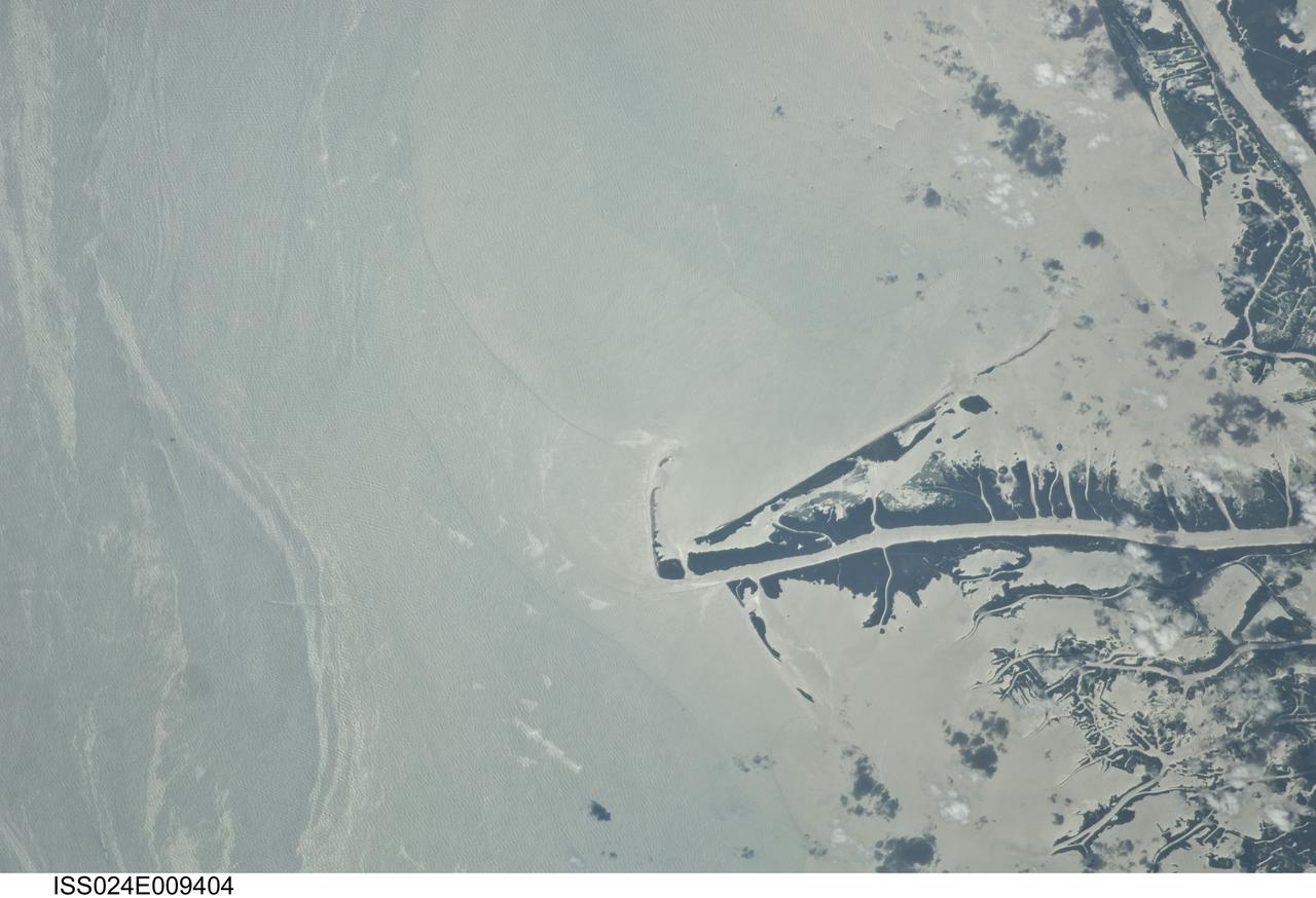
ISS024-E-009404 (23 July 2010) --- This photo taken from the International Space Station on July 23, 2010, shows the Gulf of Mexico oil spill as part of ongoing observations of the region. When this image was taken, three months after the explosion on the Deepwater Horizon oil rig, the leak had been plugged for eight days. Water surfaces appear bright and land surfaces appear dark in the image. The stark contrast is due to sun glint, in which the sun is reflected brilliantly off all water surfaces back towards the astronaut observer on board the station. The sun glint reveals various features in the Gulf of Mexico, especially sheens of oil as packets of long bright streaks seen on the left side of the image. Sediments carried by the Mississippi River have a light-yellow coloration in this image, with distinct margins between plumes that likely mark tidal pulses of river water into the Gulf of Mexico. A boat wake cuts across one of the oil packets at image lower left. Daily National Oceanic and Atmospheric Administration (NOAA) maps of oil distribution show predicted heavier and lighter oil movement near the Gulf coastline. The maps show that on the day this image was taken, the north edge of the ?oiled? zone was expected to bank up against the delta. The observed spread of the surface oil in the approximately 100 days since the explosion highlights the connectivity between the deepwater areas and coastlines of the Gulf of Mexico.
7x10ft#1 W. T. aircraft carrier (model ship) installation for oil flow tests
Oil Portrait: H. Julian Allen, Ames Director from 1965 thru 1969

SOFIA’s 9-foot mirror is lowered into the cavity and attached to a structure sitting on a thin layer of oil for stability and vibration-free operation.
oil protrait of Dr. Baruch Blumberg, Director of Ames Astrobiology by artist Elizabeth Zanzinger
oil protrait of Dr. Baruch Blumberg, Director of Ames Astrobiology by artist Elizabeth Zanzinger
7x10ft#1 W. T. aircraft carrier (model ship) installation for oil flow tests with Bill Warmbrodt
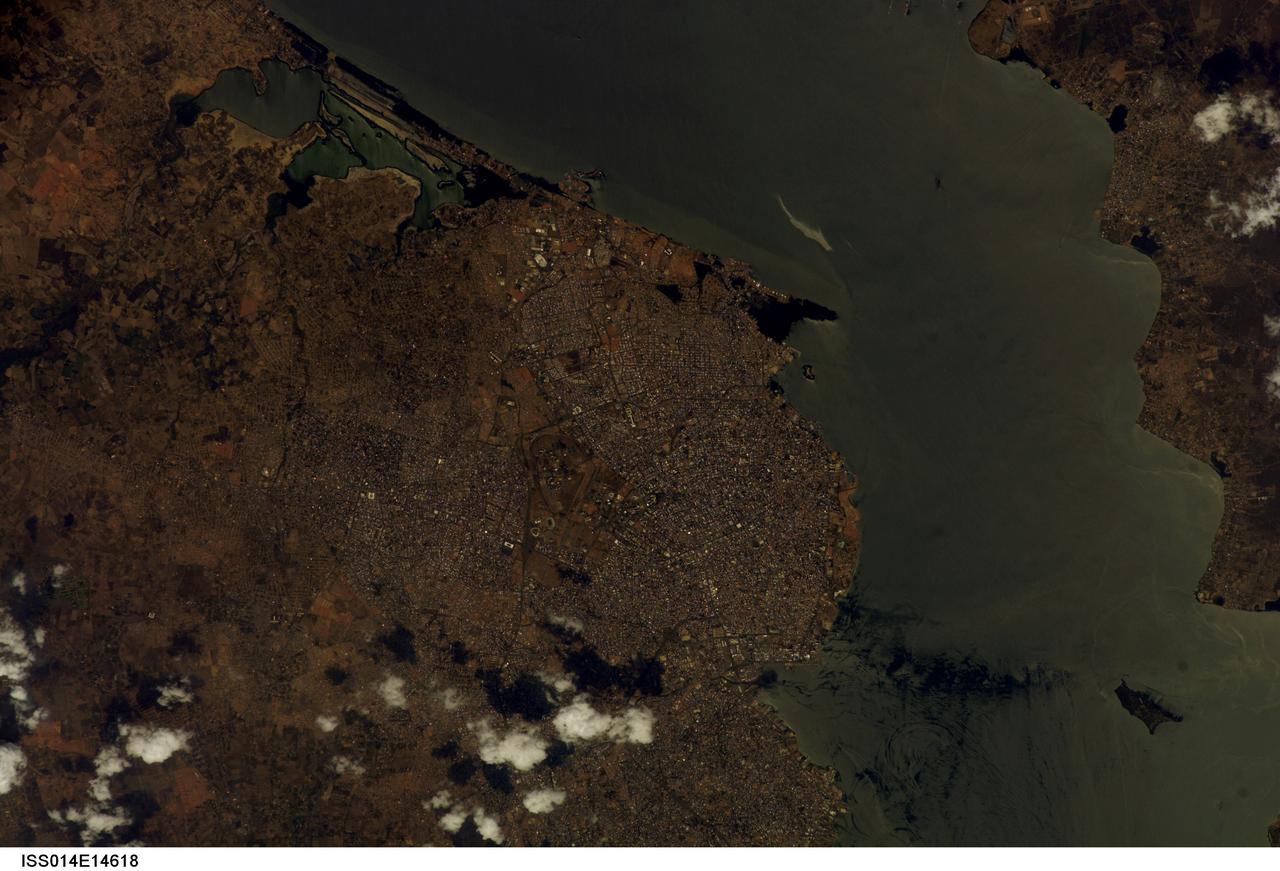
ISS014-E-14618 (23 Feb. 2007) --- Maracaibo City and Oil Slick, Venezuela are featured in this image photographed by an Expedition 14 crewmember on the International Space Station. This view depicts the narrow (6 kilometers) strait between Lake Maracaibo to the south and the Gulf of Venezuela to the north. This brackish lake in northern Venezuela is the largest in South America. The lake and its small basin are situated atop a vast reservoir of buried oil deposits, first tapped in 1914. Venezuela is now the world's fifth largest oil producer. The narrow strait is deepened to allow access by ocean-going vessels, dozens of which now daily transport approximately 80 per cent of Venezuela's oil to world markets. Shipping is one of the main polluters of the lake, caused by the dumping of ballast and other waste. An oil slick, likely related to bilge pumping, can be seen as a bright streak northeast of El Triunfo. Other sources of pollution to the lake include underwater oil pipeline leakage, untreated municipal and industrial waste from coastal cities, and runoff of chemicals from surrounding farm land. Deepening the narrow channel for shipping has also allowed saltwater intrusion into the lake, leading to adverse effects to Lake Biota. Since the discovery of oil, cities like Maracaibo have sprung up along the northwestern coastline of the lake. With satellite cities such as San Luis and El Triunfo, greater Maracaibo has a population of approximately 2.5 million. Just outside the lower margin of the picture a major bridge spans the narrows pictured here, connecting cities such as Altagracia (top right) to Maracaibo.
jsc2023e055883 (10/5/2023) --- Oil is pushed back into the reservoir by a jet of air during the reset phase of the investigation. As the oil moves back into the reservoir, it leaves behind a thin liquid film. The Gaucho Lung investigation will study fluid transport within gel-coated tubes to learn more about treatment programs for respiratory distress syndrome and develop new contamination control strategies. Image courtesy of University of California, Santa Barbara.
Oscillatory Thermocapillary Flow Experiment (OTFE); by using silicone oil for a study on the characteristics of themocapillary flow during the onset of oscillations with particular attention to parameters; the experiment will use submerged heaters to provide a constant temperature source in open cylindrical containers to cause thermocapillary flows. Thermocouples located in the heaters, the container walls, and the fluid will monitor the temperatures in the apparatus. Tracer particles will be added to the silicone oil sample to allow observation of the flow.
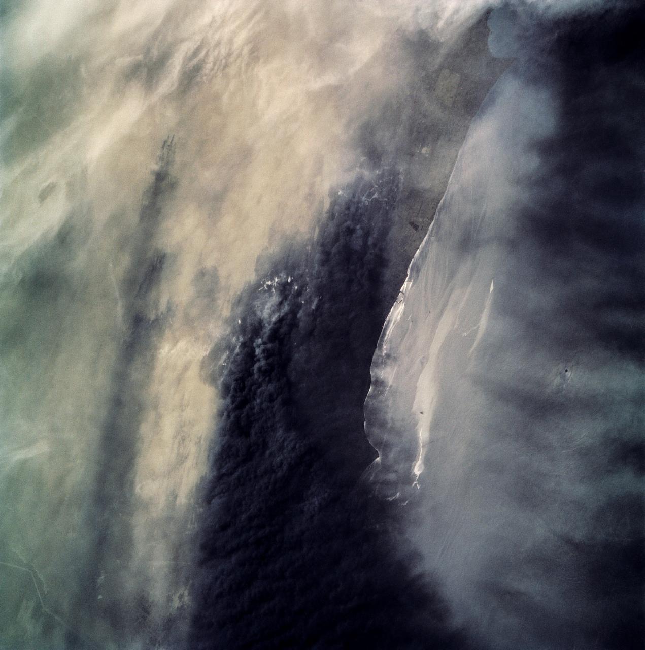
STS059-306-034 (9-20 April 1994) --- The radiating transportation pattern of this 20th-Century urban plan is nicely displayed in this high-resolution photograph. Light-toned spots in the desert mark oil well sites; along the south edge of the scene, some dark residue remains from the fires set during the recent Gulf War. Blown sand has nearly hidden the soot and thick oil that were deposited on the surface. Nikon photograph, 300mm lens.
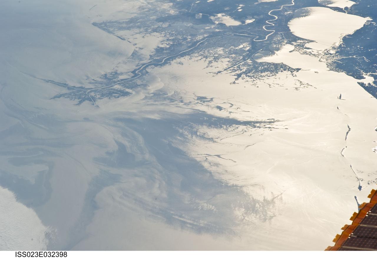
ISS023-E-032398 (4 May 2010) --- Japan Aerospace Exploration Agency (JAXA) astronaut Soichi Noguchi, Expedition 23 flight engineer, photographed the Mississippi Delta showing the oil slick in the Gulf of Mexico on May 4, 2010. Part of the river delta and nearby Louisiana coast appear dark in the sunglint. This phenomenon is caused by sunlight reflecting off the water surface, in a mirror-like manner, directly back towards the astronaut observer onboard the International Space Station (ISS). The sunglint improves the identification of the oil spill which is creating a different water texture (and therefore a contrast) between the smooth and rougher water of the reflective ocean surface. Other features which cause a change in surface roughness that can be seen in sunglint are wind gusts, naturally occurring oils that will be gathered by and take the form of water currents or wave patterns, and less windy areas behind islands.

ISS023-E-032396 (4 May 2010) --- Japan Aerospace Exploration Agency (JAXA) astronaut Soichi Noguchi, Expedition 23 flight engineer, photographed the tail end of the Mississippi Delta showing the oil slick in the Gulf of Mexico on May 4, 2010. Part of the river delta and nearby Louisiana coast appear dark in the sunglint. This phenomenon is caused by sunlight reflecting off the water surface, in a mirror-like manner, directly back towards the astronaut observer onboard the International Space Station (ISS). The sunglint improves the identification of the oil spill which is creating a different water texture (and therefore a contrast) between the smooth and rougher water of the reflective ocean surface. Other features which cause a change in surface roughness that can be seen in sunglint are wind gusts, naturally occurring oils that will be gathered by and take the form of water currents or wave patterns, and less windy areas behind islands.
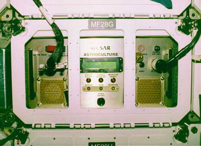
Research with plants in microgravity offers many exciting opportunities to gain new insights and could improve products on Earth ranging from crop production to fragrances and food flavorings. The ASTROCULTURE facility is a lead commercial facility for plant growth and plant research in microgravity and was developed by the Wisconsin Center for Space Automation and Robotics (WSCAR), a NASA Commercial Space Center. On STS-95 it will support research that could help improve crop development leading to plants that are more disease resistant or have a higher yield and provide data on the production of plant essential oils---oils that contain the essence of the plant and provide both fragrance and flavoring. On STS-95, a flowering plant will be grown in ASTROCULTURE and samples taken using a method developed by the industry partner for this investigation. On Earth the samples will be analyzed by gas chromatography/mass spectrometry and the data used to evaluate both the production of fragrant oils in microgravity and in the development of one or more products.
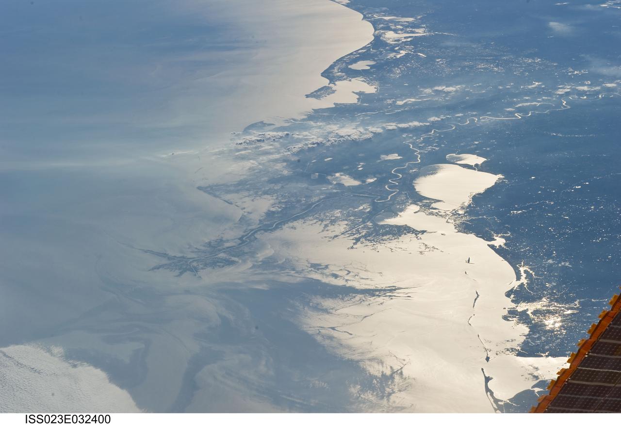
ISS023-E-032400 (4 May 2010) --- Japan Aerospace Exploration Agency (JAXA) astronaut Soichi Noguchi, Expedition 23 flight engineer, photographed the Mississippi Delta showing the oil slick in the Gulf of Mexico on May 4, 2010. Part of the river delta and nearby Louisiana coast appear dark in the sunglint. This phenomenon is caused by sunlight reflecting off the water surface, in a mirror-like manner, directly back towards the astronaut observer onboard the International Space Station (ISS). The sunglint improves the identification of the oil spill which is creating a different water texture (and therefore a contrast) between the smooth and rougher water of the reflective ocean surface. Other features which cause a change in surface roughness that can be seen in sunglint are wind gusts, naturally occurring oils that will be gathered by and take the form of water currents or wave patterns, and less windy areas behind islands.
STS062-86-196 (4-18 March 1994) --- This photo depicts many of the types of ocean features seen when illuminated by sunglint. These features include a shear line, bilge dump, currents and ship wakes. Winds, currents and oils effect the smoothness of the surface of the water. The oils smooth the water which reflect the sun more than the rougher surround water. This is seen in the bright curved line which is a bilge dump of oily water from a ship. The oils then start to take the form of the currents and in this case are also being blown by the surface winds. The shear line is approximately 240 miles west of Bombay, India. This shear line appears to be a result of two water masses, moving at slightly different speeds, having converged. Ship wakes, such as those in the photo, which cross a shear line, often give us an indication of the relative strenght of a a shear.
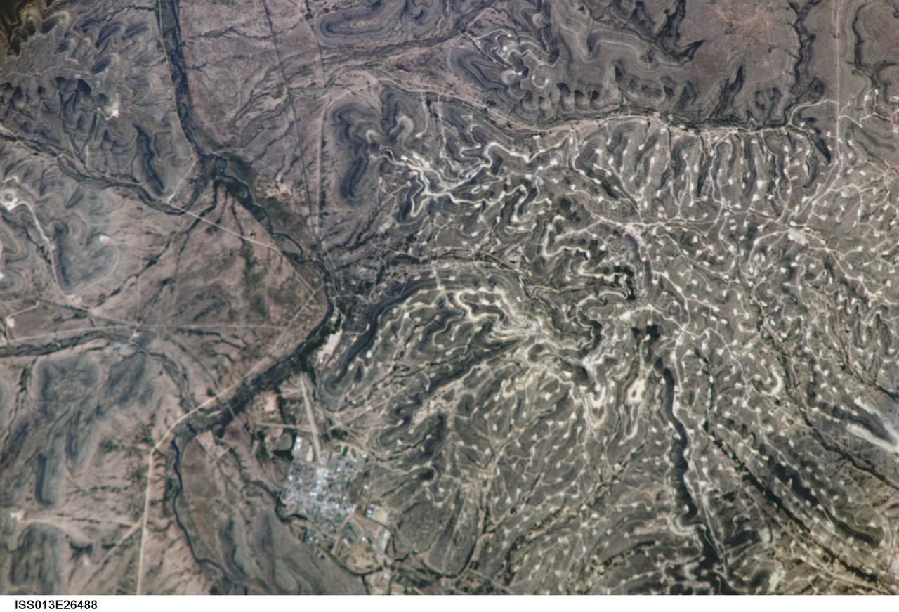
ISS013-E-26488 (25 May 2006) --- Yates Oilfield, west Texas is featured in this image photographed by an Expedition 13 crewmember on the International Space Station. The Permian Basin of west Texas and southeastern New Mexico is one of the most productive petroleum provinces of North America. The Basin is a large depression in the Precambrian bedrock surface along the southern edge of the North American craton, or oldest bedrock core of the continent. The Yates Oil Field is marked in this image by numerous white well locations and petroleum infrastructure dotting the layered sedimentary rocks of the Permian Basin. The Pecos River bed borders the oil field to the east-northeast. The Yates Field started petroleum production in 1926, and by 1995 had produced over 2 billion barrels of oil.
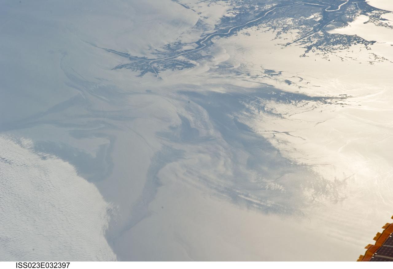
ISS023-E-032397 (4 May 2010) --- The Gulf of Mexico oil spill is featured in this image photographed by an Expedition 23 crew member on the International Space Station. On April 20, 2010 the oil rig Deepwater Horizon suffered an explosion and sank two days later. Shortly thereafter oil began leaking into the Gulf of Mexico from ruptured pipes as safety cutoff mechanisms failed to operate. Automated nadir-viewing orbital NASA sensors have been tracking the growth of the oil spill as it has spread towards the northern Gulf Coast. This detailed photograph provides a different viewing perspective on the ongoing event. The image is oblique, meaning that it was taken with a sideways viewing angle from the space station, rather than the ?straight down? or nadir view typical of automated satellite sensors. The view is towards the west; the ISS was located over the eastern edge of the Gulf of Mexico when the image was taken. The Mississippi River Delta and nearby Louisiana coast (top) appear dark in the sunglint that illuminates most of the image. This phenomenon is caused by sunlight reflecting off the water surface ? much like a mirror ? directly back towards the astronaut observer onboard the orbital complex. The sunglint improves the identification of the oil spill (colored dark to light gray) which is creating a different water texture, and therefore a contrast, between the smooth and rougher water of the reflective ocean surface (colored silver to white). Wind and water current patterns have modified the oil spill?s original shape into streamers and elongated masses. Efforts are ongoing to contain the spill and protect fragile coastal ecosystems and habitats such as the Chandeleur Islands (right center). Other features visible in the image include a solid field of low cloud cover at the lower left corner of the image. A part of one of the ISS solar arrays is visible at lower right. Wave patterns at lower right are most likely caused by tidal effects.
North American P-51B tuft studies done in the NACA Ames Research center 16ft Transonic Wind Tunnel Radiator air scoop with oil and prestone cooler exit flaps in flush position.
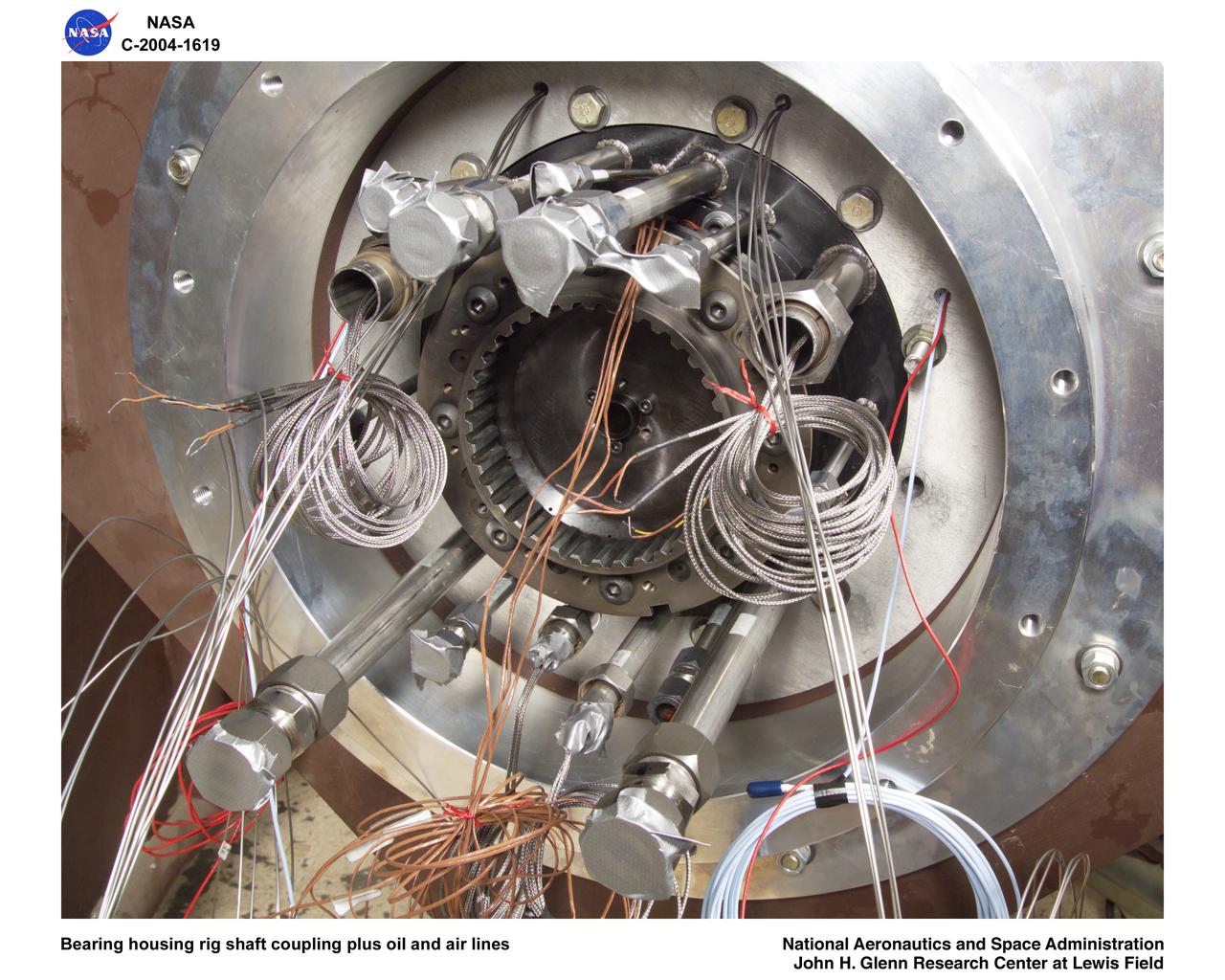
Ultra-Efficient Engine Technology (UEET), Proof of Concept Compressor, Advanced Compressor Casing Treatment testing; bearing housing rig shaft coupling and oil, air lines
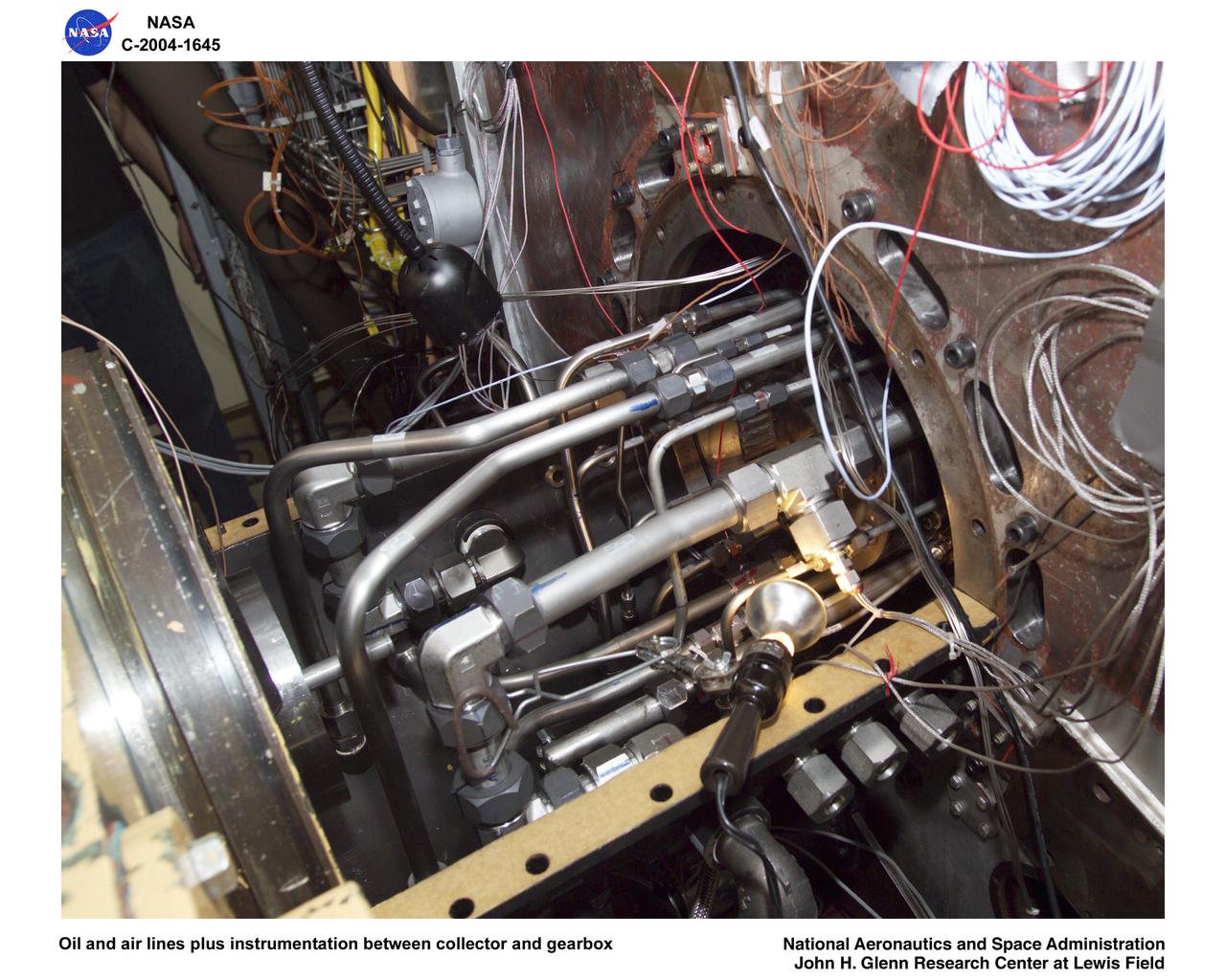
Ultra-Efficient Engine Technology (UEET), Proof of Concept Compressor, Advanced Compressor Casing Treatment testing; oil and air lines plus instrumentation between collector and gearbox
ISS008-E-18938 (24 March 2004) --- This photo of a large black smoke plume over southeastern Iraq was taken by an Expedition 8 crewmember on the International Space Station. The oil that is burning spilled from a ruptured pipeline on March 23, 2004. This photo was taken the next afternoon and shows details of land use near the fire. The delta of the Shatt al Arab has numerous channels, estuaries, and tidal flats. Near the top of the photo (southwest) are two large white salt evaporator operations while to the lower right are wetlands and irrigated agricultural fields. Iraq’s only oil terminal on the Persian Gulf is near the left edge of the plume.
A 16mm film frame shows convective regions inside silicone oil playing the part of a stellar atmosphere in the Geophysical Fluid Flow Cell (GFFC). An electrostatic field pulled the oil inward to mimic gravity's effects during the experiments. The GFFC thus produced flow patterns that simulated conditions inside the atmospheres of Jupiter and the Sun and other stars. Numbers of the frame indicate temperatures and other conditions. This image is from the Spacelab-3 flight in 1985. GFFC was reflown on U.S. Microgravity Laboratory-2 in 1995. The principal investigator was John Hart of the University of Colorado at Boulder. It was managed by NASA's Marshall Space Flight Center. (Credit: NASA/Marshall Space Flight Center)
A steel hemisphere was at the core of the Geophysical Fluid Flow Cell (GFFC) that flew on two Spacelab missions. It was capped by a sapphire dome. Silicone oil between the two played the part of a steller atmosphere. An electrostatic field pulled the oil inward to mimic gravity's effects during the experiments. The GFFC thus produced flow patterns that simulated conditions inside the atmospheres of Jupiter and the Sun and other stars. GFFC flew on Spacelab-3 in 1985 and U.S. Microgravity Laboratory-2 in 1995. The principal investigator was John Hart of the University of Colorado at Boulder. It was managed by NASA's Marshall Space Flight Center. (Credit: NASA/Marshall Space Flight Center)
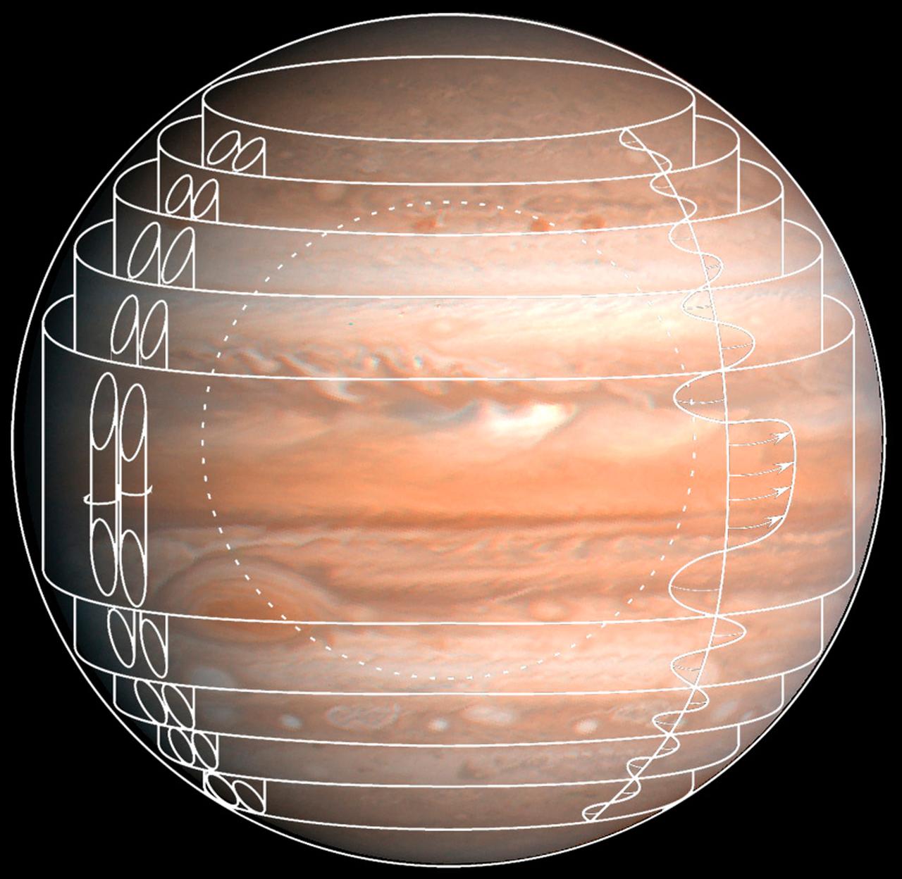
This composite image depicts one set of flow patterns simulated in the Geophysical Fluid Flow Cell (GFFC) that flew on two Spacelab missions. Silicone oil served as the atmosphere around a rotating steel hemisphere (dotted circle) and an electrostatic field pulled the oil inward to mimic gravity's effects during the experiments. The GFFC thus produced flow patterns that simulated conditions inside the atmospheres of Jupiter and the Sun and other stars. GFFC flew on Spacelab-3 in 1985 and U.S. Microgravity Laboratory-2 in 1995. The principal investigator was John Hart of the University of Colorado at Boulder. It was managed by NASA's Marshall Space Flight Center. (Credit: NASA/Marshall Space Flight Center)
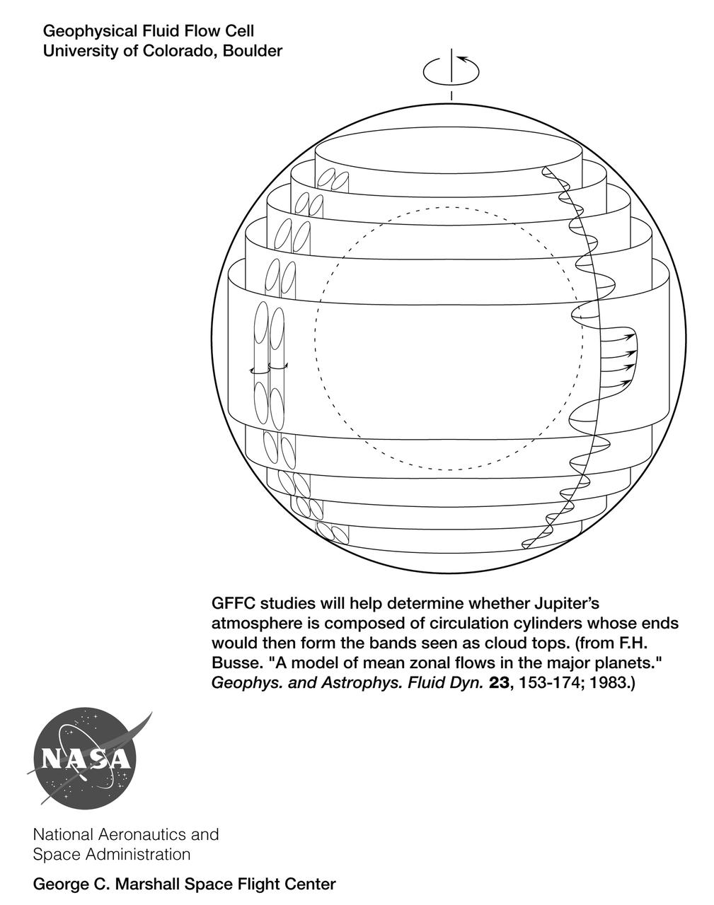
This drawing depicts one set of flow patterns simulated in the Geophysical Fluid Flow Cell (GFFC) that flew on two Spacelab missions. Silicone oil served as the atmosphere around a rotating steel hemisphere (dotted circle) and an electrostatic field pulled the oil inward to mimic gravity's effects during the experiments. The GFFC thus produced flow patterns that simulated conditions inside the atmospheres of Jupiter and the Sun and other stars. The principal investigator was John Hart of the University of Colorado at Boulder. It was managed by NASA's Marshall Space Flight Center (MSFC). An Acrobat PDF copy of this drawing is available at http://microgravity.nasa.gov/gallery. (Credit: NASA/Marshall Space Flight Center)
Research with plants in microgravity offers many exciting opportunities to gain new insights and could improve products on Earth ranging from crop production to fragrances and food flavorings. The ASTROCULTURE facility is a lead commercial facility for plant growth and plant research in microgravity and was developed by the Wisconsin Center for Space Automation and Robotics (WSCAR), a NASA Commercial Space Center. On STS-95 it will support research that could help improve crop development leading to plants that are more disease resistant or have a higher yield and provide data on the production of plant essential oils---oils that contain the essence of the plant and provide both fragrance and flavoring. On STS-95, a flowering plant will be grown in ASTROCULTURE and samples taken using a method developed by the industry partner for this investigation. On Earth, the samples will be analyzed by gas chromatography/mass spectrometry and the data used to evaluate both the production of fragrant oils in microgravity and in the development of one or more products. The ASTROCULTURE payload uses these pourous tubes with precise pressure sensing and control for fluid delivery to the plant root tray.

AS6-02-1455 (4 April 1968) --- Texas is photographed from the Apollo 6 (Spacecraft 020/Saturn 502) unmanned space mission. Seen in this photograph are Midland, Brownfield, Big Spring, J. B. Thomas Lake, headwaters of Colorado and Brazos Rivers, and the west Texas gas and oil fields.

Artist: John Bahrer Oil Portrait: Dr.Smith J. DeFranch, founding Director of Ames Research Center 1940 to 1965 Note: printed in 60 year at NASA Ames Research Center by Glenn Bugos NASA SP-2000-4314
41G-120-163 (5-13 Oct 1984) --- The long, linear parallel ridges of the Zagros Mountains of southwestern Iran. Dark, round salt domes intrude from deep beneath the earth to produce oil, much of which has yet to be exploited in this area.
41G-38-060 (5-13 Oct 1984) --- A large ship wake in the central Mediterranean Sea is highlighted by sunglint in this handheld camera's view from STS-41G. According to NASA and U.S. Navy scientists studying the STS-41G film, the depicted reflectance is similar to oil slicks seen in the various oceans of the world. They note that it is apparent that a ship is pumping a mixture of bilge water and oil overboard. The crew consisted of astronauts Robert L. Crippen, commander; Jon A. McBride, pilot; mission specialist's Kathryn D. Sullivan, Sally K. Ride, and David D. Leestma; Canadian astronaut Marc Garneau; and Paul D. Scully-Power, payload specialist. EDITOR'S NOTE: The STS-41G mission had the first American female EVA (Sullivan); first seven-person crew; first orbital fuel transfer; and the first Canadian (Garneau).
This false-color composite image from NASA UAVSAR taken on June 23, 2010, shows the southern Louisiana coastline, covering the area around Grande Isle and the entrance to Barataria Bay.