
New Employee orientation and swearing-in with L-r in front are Joseph Haglage and Erin Czech

New Employee orientation and swearing-in with Left to right Brandon Baeza, Kailin Kwan, Joseph Haglage

New Employee orientation and swearing-in, left to right (far left) unknow) Tracie Perez, Spenser Monheim (behind Tracie) and Daniel Chang

New Employee orientation and swearing-in left to right (far left, unknown) Tracie Perez, Spenser Monheim (behind Tracie),Daniel Chang, Brandon Baeza

New Employee Orientation swearing-in N-232. Tom Edwards, Ames Deputy Director address the group.

New Employee Orientation swearing-in N-232. Lee Stone, President of the Ames Federal Employees Union addresse the group.

2014 Fall Intern Orientation at NASA Ames Research Center.
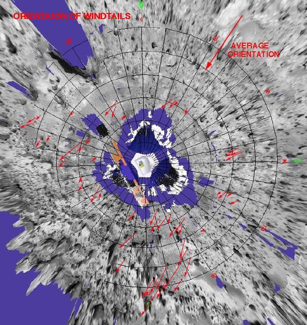
Orientation of Windtails at Pathfinder Landing Site
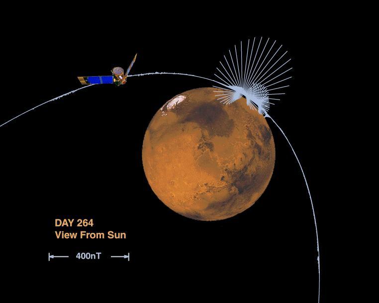
Orientation and Magnitude of Mars Magnetic Field

Summer 2018 College Intern Orientation. Center Director Chris Scolese.

Trajectory oriented operatons with limited delegation simulation in Airspace Operations Lab N-262 rm-270 with Jeff Homola

Trajectory oriented operatons with limited delegation simulation in Airspace Operations Lab N-262 rm-270 with Jeff Homola

Trajectory oriented operatons with limited delegation simulation in Airspace Operations Lab N-262 rm-270 with Todd Callantine

Trajectory oriented operatons with limited delegation simulation in Airspace Operations Lab N-262 rm-270 with Todd Callantine and Tom Prevot

Diversity and Inclusion Program D&IP Advisory Committee Orientation was held August 9, 2018 Group shot

new Employee Orientation held in Building 3 MTCC with Code I - Infromation Technology booth.

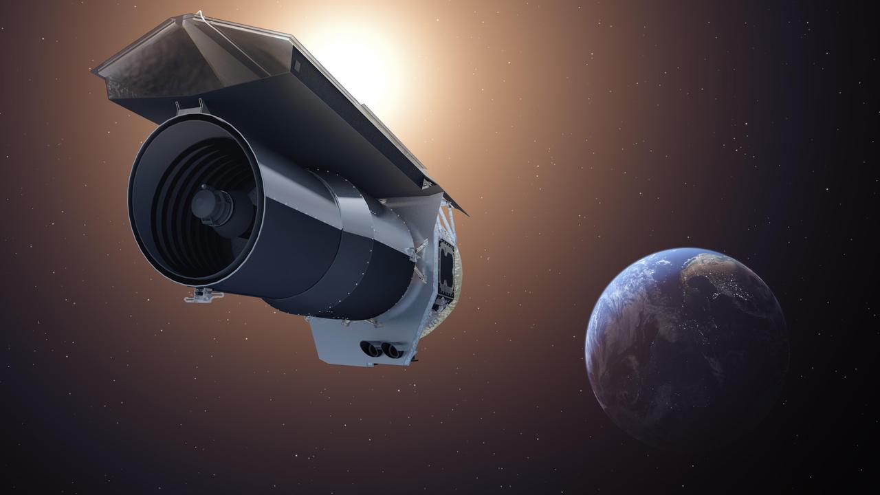
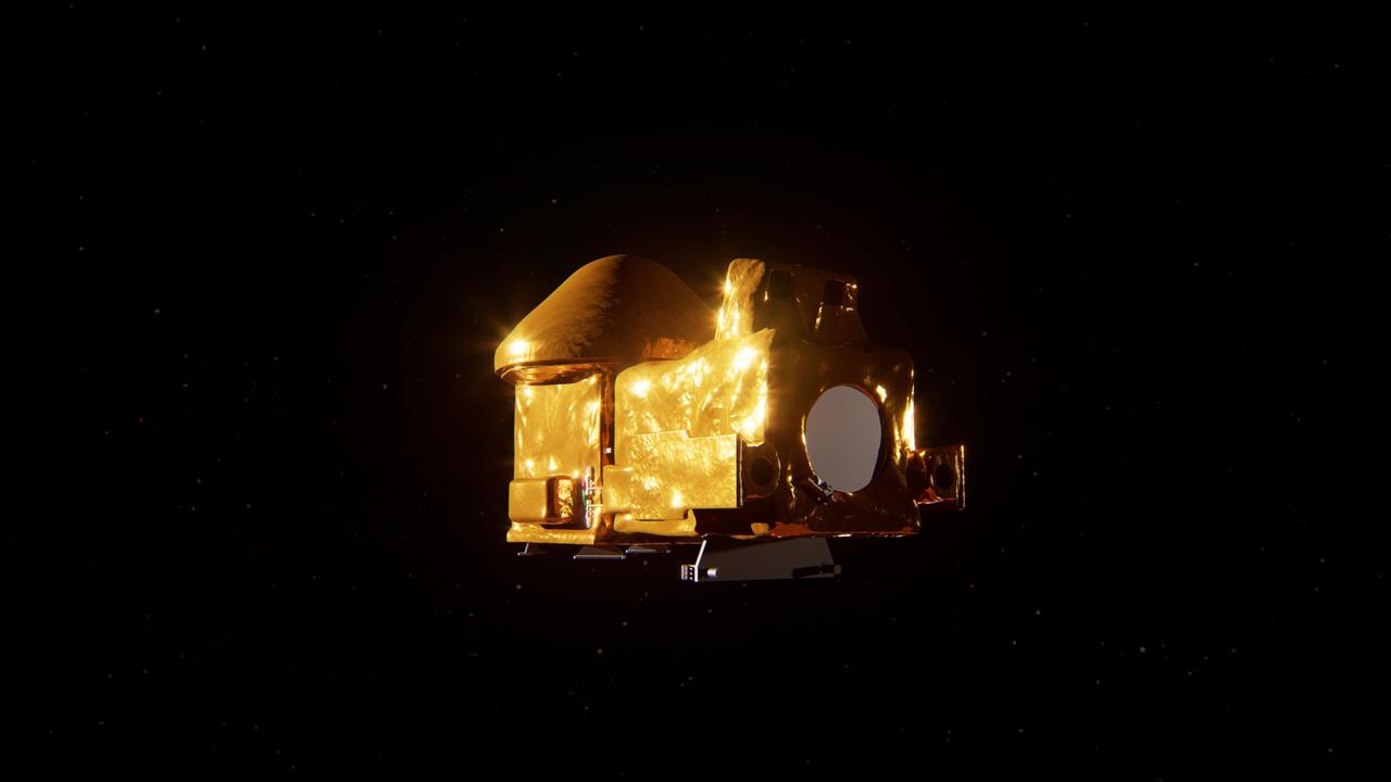
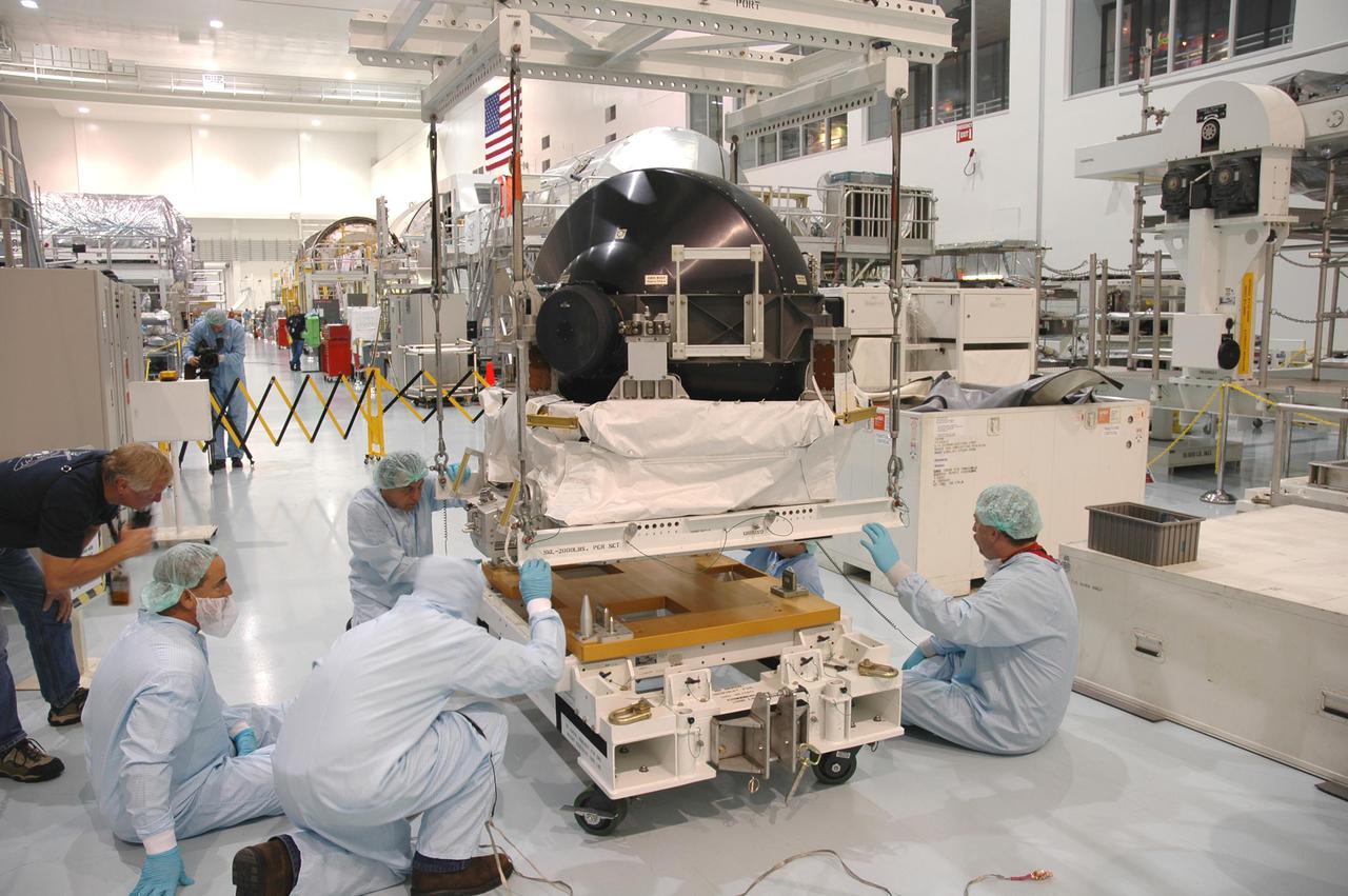
NASA's SPHEREx observatory is oriented in a horizontal position, revealing all three layers of photon shields as well as the telescope. This photo was taken at BAE Systems in Boulder, Colorado, in April 2024. Short for Spectro-Photometer for the History of the Universe, Epoch of Reionization and Ices Explorer, SPHEREx will create a map of the cosmos like no other. Using a technique called spectroscopy to image the entire sky in 102 wavelengths of infrared light, SPHEREx will gather information about the composition of and distance to millions of galaxies and stars. With this map, scientists will study what happened in the first fraction of a second after the big bang, how galaxies formed and evolved, and the origins of water in planetary systems in our galaxy. https://photojournal.jpl.nasa.gov/catalog/PIA26542
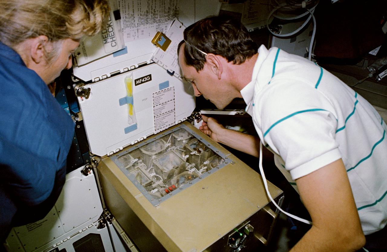
New Employees A Kujaneck, B Baeza, S Cahill, J Carolino, D Chang, E Czech, A Davila, R Everroad, R Fisher, A Ging, J Haglage, B Hooey, K Kwan, C Fung, P Ung-Joon Lee, M Mahzari, L Martin, K McMillin, S Monheim, A Nguyen, B Nikaido, T Perez, V Salazar, K Sato, D Shaw, Irene Smith, Melanie Smith, Lindsay Sturre, E Uribe Jr. with Tom Edwards, Ames Deputy Director.
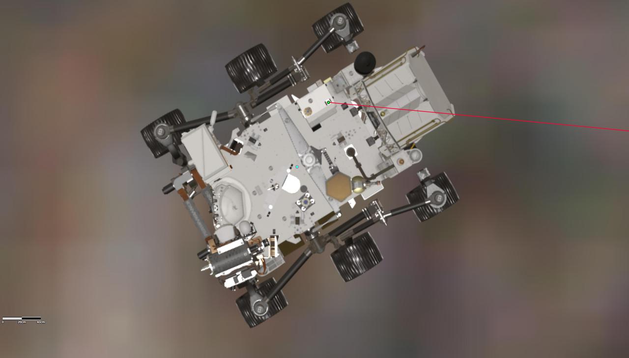
This annotated graphic depicts the orientation of NASA's Perseverance Mars rover during the 17th flight of the agency's Ingenuity Mars Helicopter on Dec. 5, 2021. A green dot on the rover, toward the top center of the frame, indicates the location of the Mars Helicopter Base Station antenna on Perseverance, which sends radio signals to and receives them from the rotorcraft. The red line depicts the line of sight to the helicopter during the final moments of Flight 17. Perseverance's power source, the Multi-Mission Radioisotope Thermoelectric Generator (MMRTG), is at the back of the rover, on the right. It angles above the antenna, impeding direct communications between the rover and helicopter as the rotorcraft descended toward the surface at the end of the flight. https://photojournal.jpl.nasa.gov/catalog/PIA24966
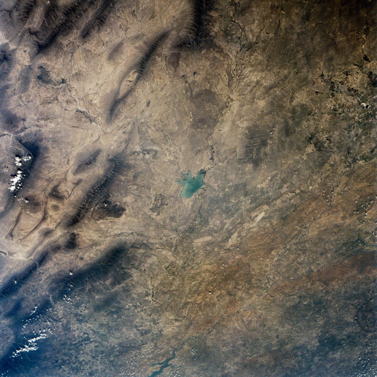
This is a single scene from a pair (frames 021 & 024) to study the effects of polarized light in Earth Observations. One scene was exposed with vertically polarized light, the other, horizontally. The subject in this study, is a lake behind Presa (dam) Don Martin (27.5N, 100.5W) on thge edge of the Rio Grande Plain near it's boundry with the Sierra Madre Oriental in Coahuila, Mexico.
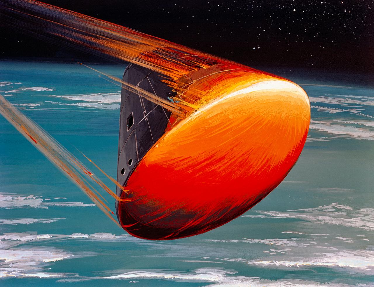
S68-55292 (August 1968) --- A North American Rockwell Corporation artist's concept depicting the Apollo Command Module (CM), oriented in a blunt-end-forward attitude, re-entering Earth's atmosphere after returning from a lunar landing mission. Note the change in color caused by the extremely high temperatures encountered upon re-entry.
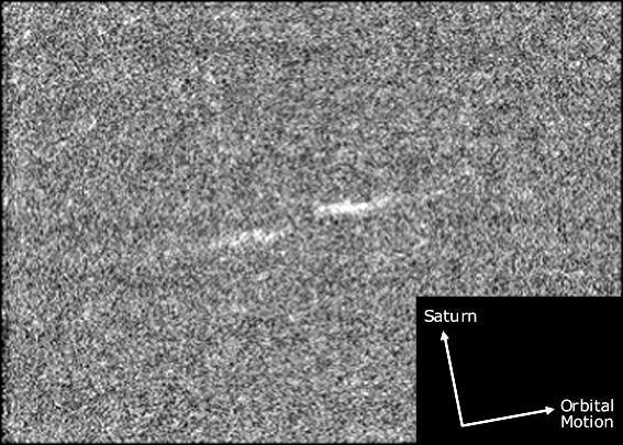
This magnified view illustrates the general orientation of the propeller features in Saturn rings as they orbit the planet.

S85-39979 (10 Sept. 1985) --- Two teachers training for participation in the STS-51L flight get their first introduction to space food during an orientation session in the life sciences building at the Johnson Space Center (JSC). Sharon Christa McAuliffe (left) chews on a morsel while Barbara R. Morgan reaches for a bite. Dr. C.T. Bourland of Technology, Incorporated, looks on. McAuliffe was chosen from among ten finalists as prime citizen observer payload specialist and Morgan was named as backup for the STS-51L flight. Photo credit: NASA
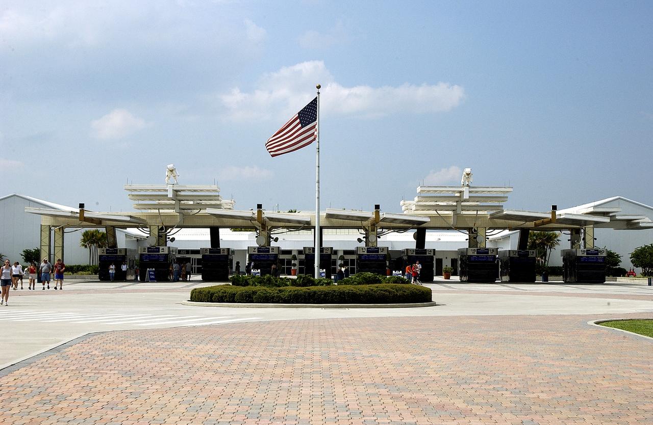
KENNEDY SPACE CENTER, FLA. - The ticket plaza provides entrance into the KSC Visitor Complex. An orientation center inside provides a multilingual guest service staff to greet guests.
This image from NASA Dawn spacecraft of asteroid Vesta shows a part of the surface in Vesta northern hemisphere, which is scoured by many grooves with different orientations.

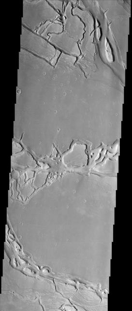
This image from NASA 2001 Mars Odyssey spacecraft of Zephyria Planum shows erosion in different orientations, related to different wind directions.
Radially symmetrical, star dunes dominate the Grand Erg Oriental of the Algerian Sahara, as depicted in this image acquired October 27, 2012 acquired by NASA Terra spacecraft.
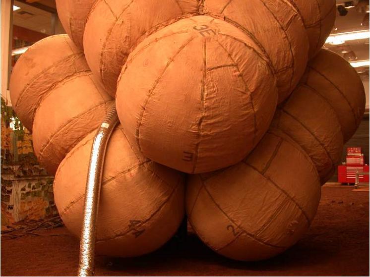
Airbags are fully inflated in this photograph taken at the JPL In-Situ Instrument Laboratory or Testbed, where engineers simulated the orientation of the airbags during the deflation process.
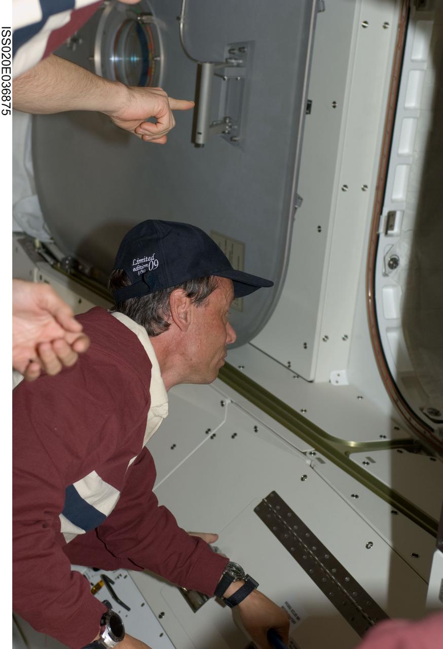
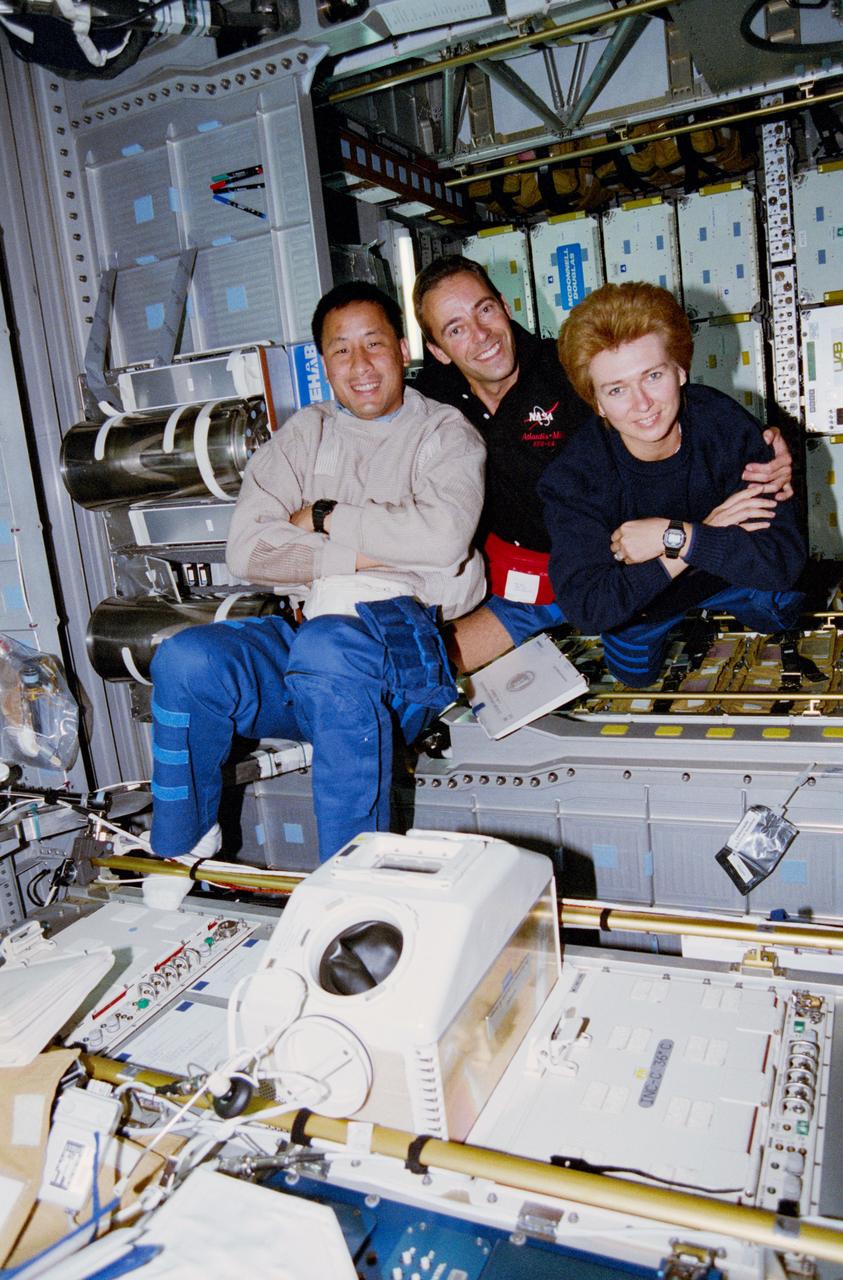
ISS020-E-036875 (30 Aug. 2009) --- This is one of a series of digital still images that were recorded shortly after the STS-128 and Expedition 20 crewmembers reunited in space and not long after the Space Shuttle Discovery and the International Space Station joined up in Earth orbit to form the second consecutive 13 person aggregation to perform more work on the orbital outpost. Pictured near a hatch way is European Space Agency astronaut Christer Fugelsang, STS-128 mission specialist.
Launch date makes a difference in the orientation of ellipses marking where NASA Phoenix Mars Lander would have a high probability of landing, given the planned targeting for the spring 2008 landing site.

This artist concept illustrates the two Saturn-sized planets discovered by NASA Kepler mission. The star system is oriented edge-on, as seen by Kepler, such that both planets cross in front, or transit, their star, named Kepler-9.
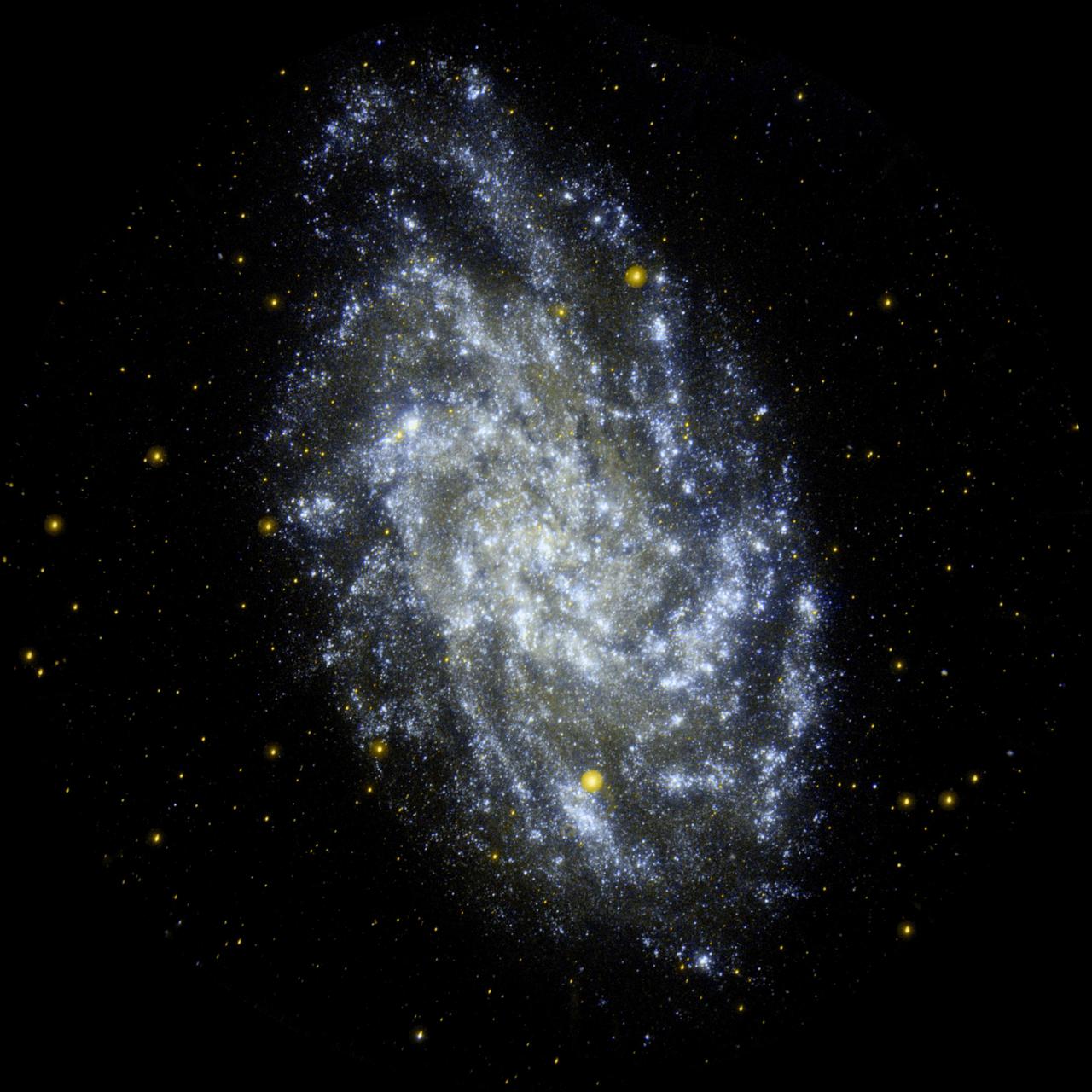
This image from NASA Galaxy Evolution Explorer shows M33, the Triangulum Galaxy, is a perennial favorite of amateur and professional astronomers alike, due to its orientation and relative proximity to us.
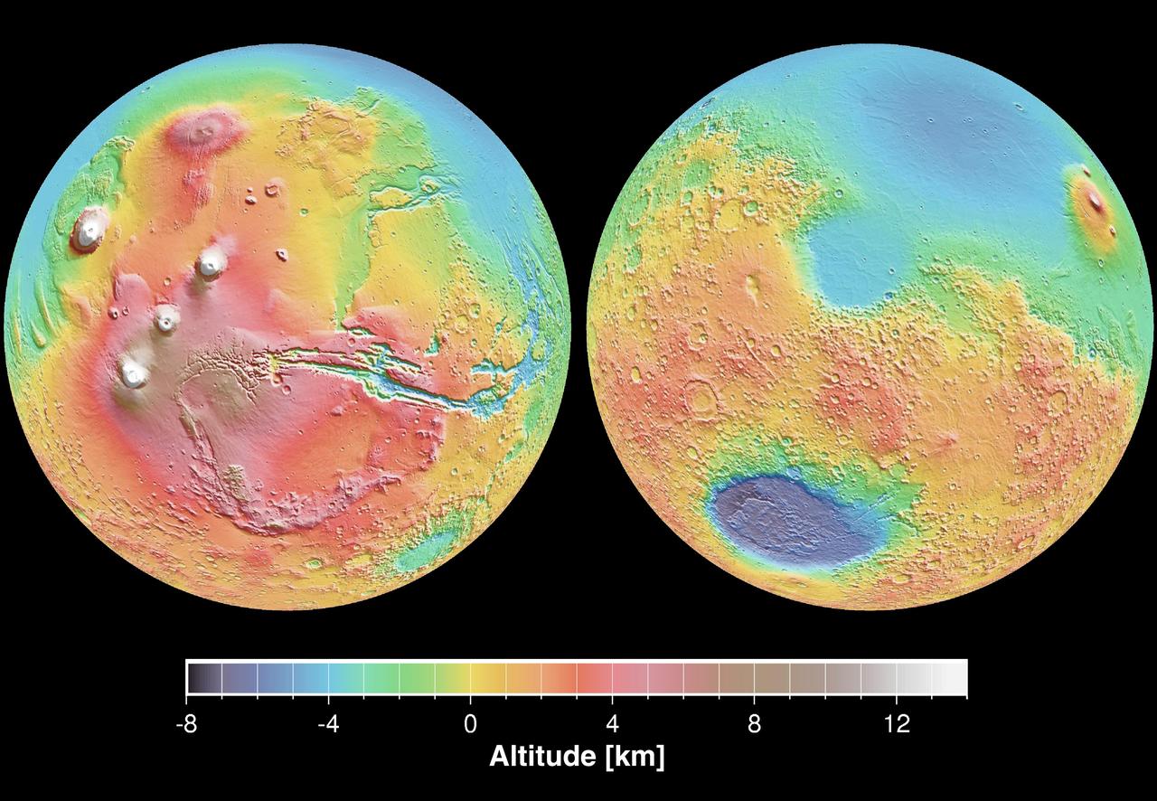
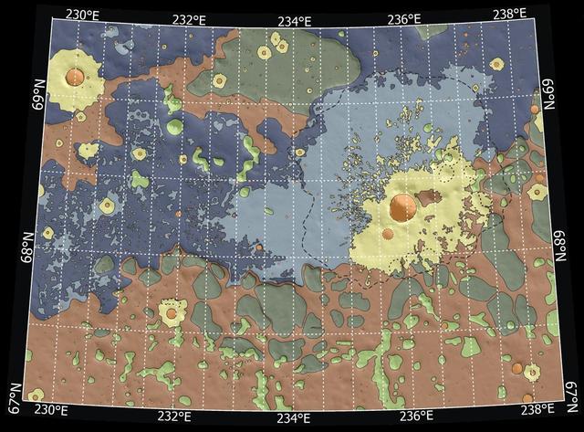
These maps are global false-color topographic views of Mars at different orientations from NASA Mars Orbiter Laser Altimeter MOLA. The maps are orthographic projections that contain over 200,000,000 points and about 5,000,000 altimetric crossovers.
This image, acquired 11-05-2007 by NASA Terra spacecraft, shows the city of Chateaubriant, France, surrounded by very old farmsteads. The surrounding countryside presents an interesting pattern of randomly oriented, small individual farmsteads.
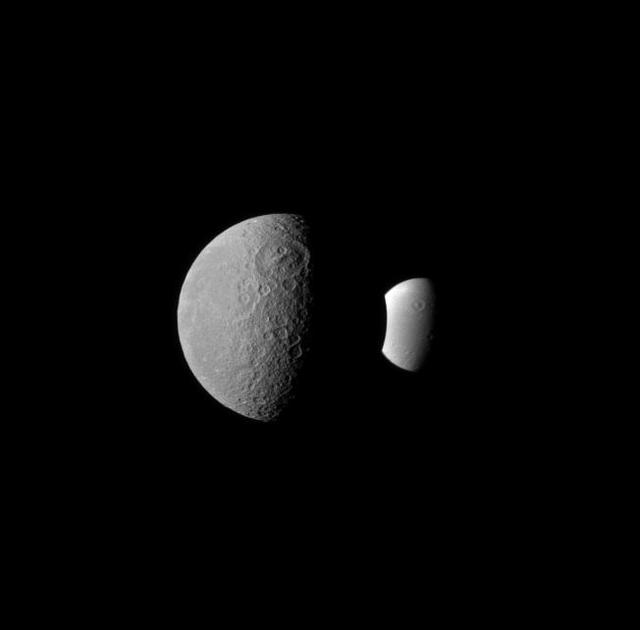
Rhea and Dione seem like dark and light fraternal twins in this image from NASA Cassini spacecraft, with each of these two Saturnian moons displaying a large crater oriented similarly in the northern hemisphere.
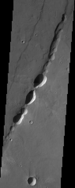
These pit-chain features in this NASA Mars Odyssey image of south Noctis Labryinthus are oriented parallel to grabens in the area, suggesting that tensional stresses may have been responsible for their formation.
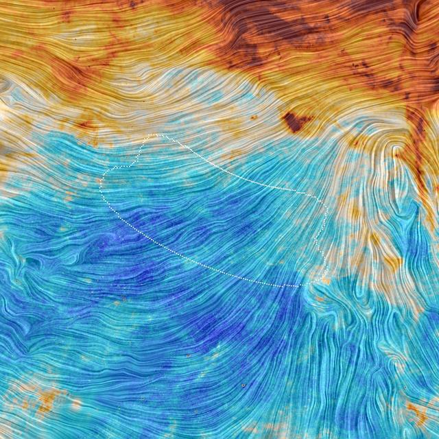
The color scale in this image from the Planck mission represents the emission from dust, a minor but crucial component that pervades our Milky Way galaxy. The texture indicates the orientation of the galactic magnetic field.

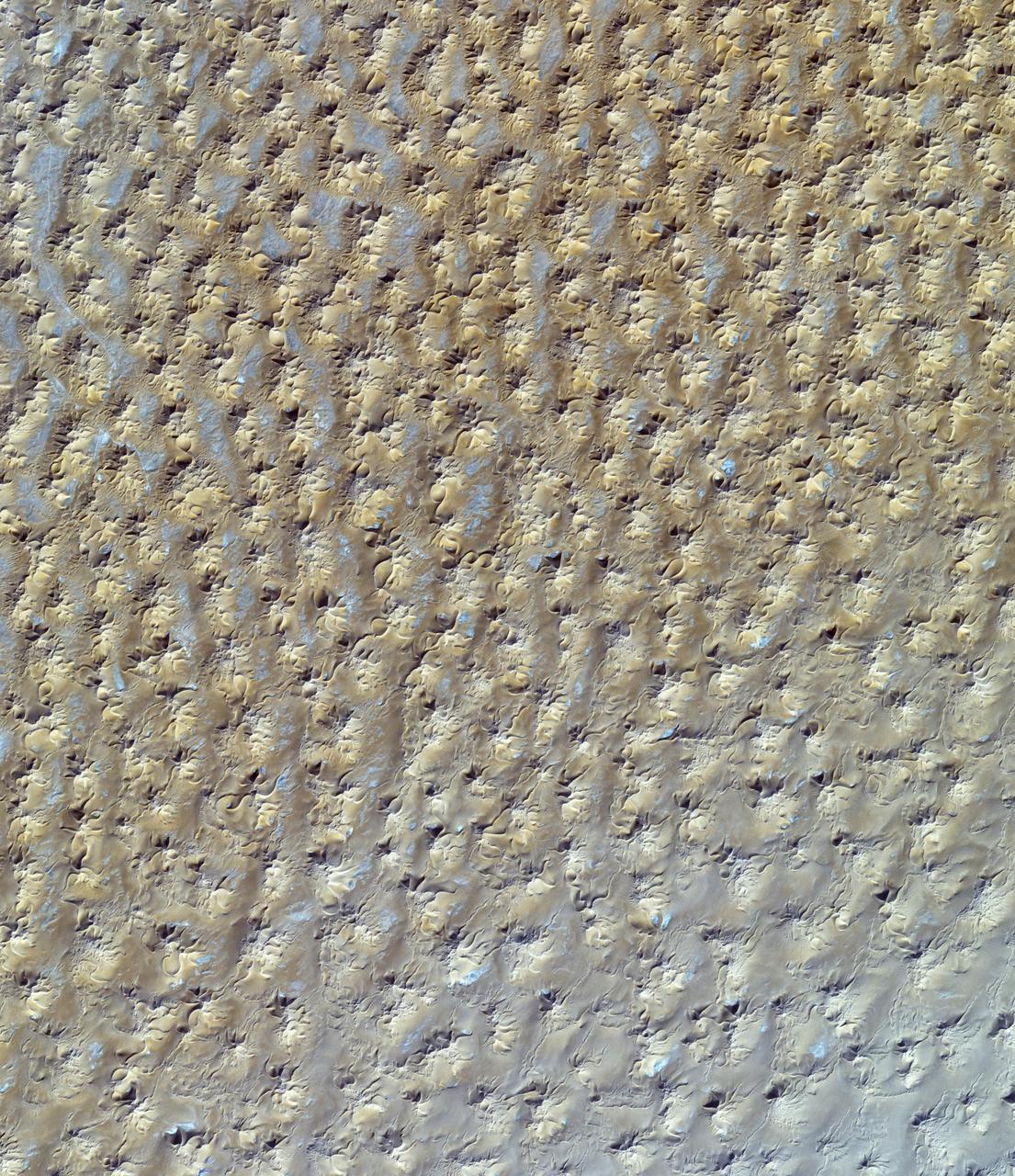
This image from NASA Mars Reconnaissance Orbiter shows dunes on the floor of Herschel Crater. Steep faces lipfaces are oriented downwind, in the direction of motion of the dunes. A dune-free area downwind of the crater is seen at the image center.

iss072e487421 (Jan. 16, 2025) --- NASA astronaut and Expedition 72 Commander Suni Williams is pictured during a spacewalk outside the International Space Station where she replaced a rate gyro assembly that helps maintain the orientation of the orbital outpost.
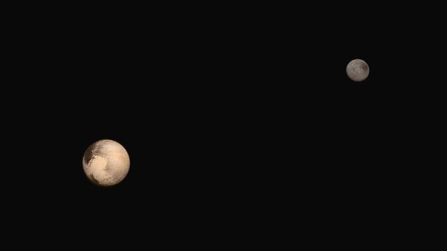
These two images of Pluto and Charon were collected separately by NASA New Horizons during approach on July 13 and July 14, 2015. The relative reflectivity, size, separation, and orientations, and colors are approximated in this composite image, and they are shown in approximate true color. http://photojournal.jpl.nasa.gov/catalog/PIA19717

MSFC DIRECTOR, PATRICK SCHEUERMANN, ADDRESSES THE SUMMER INTERNS DURING ORIENTATION AT THE USSRC. JUNE 1, 2015
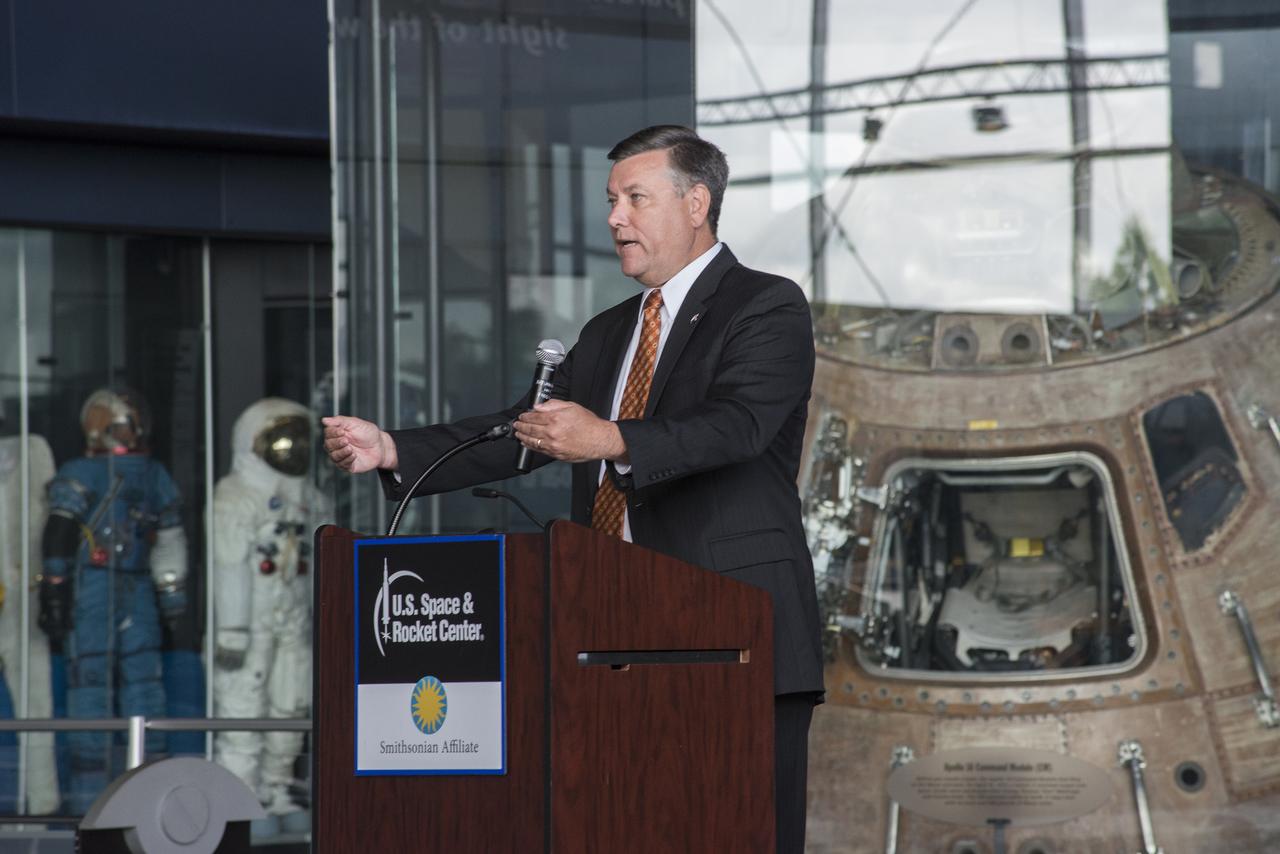
MSFC DIRECTOR, PATRICK SCHEUERMANN, ADDRESSES THE SUMMER INTERNS DURING ORIENTATION AT THE USSRC. JUNE 1, 2015
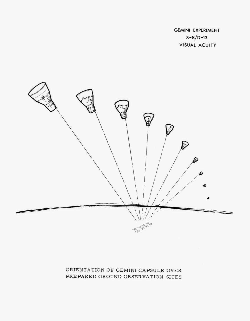
S65-28639 (June 1965) --- Drawing illustrating orientation of Gemini spacecraft over prepared ground observation sites.

CHRIS SINGER, MANAGER OF THE MSFC ENGINEERING DIRECTORATE, ADDRESSES THE SUMMER INTERNS DURING ORIENTATION EVENTS AT THE USSRC. JUNE 1, 2015

NASA Cassini spacecraft profiles several features oriented north-south on Saturn moon Tethys. A line of craters runs north to south near the center of the image: from top Phemius, Polyphemus, Ajax and the large southern crater Antinous.
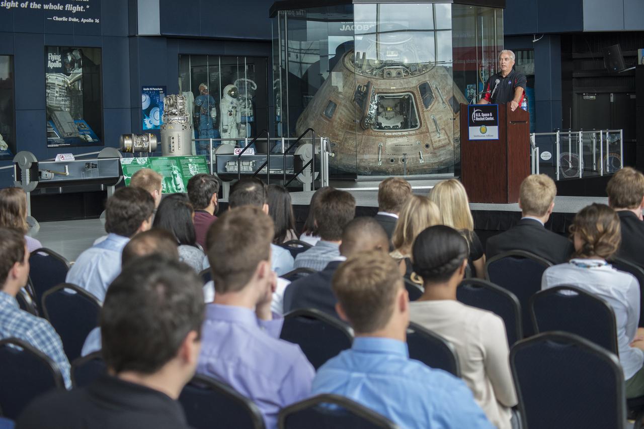
CHRIS SINGER, MANAGER OF TTHE MSFC ENGINEERING DIRECTORATE, ADDRESSES THE SUMMER INTERNS DURING ORIENTATION EVENTS AT THE USSRC. JUNE 1, 2015
DR. FRANK SIX OF MSFC'S ACADEMIC AFFAIRS OFFICE ADDRESSES THE SUMMER INTERNS DURING ORIENTATION EVENTS AT THE USSRC. JUNE 1, 2015.

JSC2005-E-37989 (8 September 2005)--- Extensive flooding of neighborhoods to the east of the 17th Street Canal (left center, oriented north-south) is evident in this image acquired on September 8, 2005 from the International Space Station. Standing water in the street grid imparts a dark greenish brown coloration to the inundated regions. Flooded portions of I-610 (extending east-west) are clearly visible in the center of the image. Image is cropped from original ISS011-E-12527 and is oriented with north to the top.
STS047-02-018 (12 - 20 Sept 1992) --- Astronauts N. Jan Davis, mission specialist, and Curtis L. Brown, Jr., pilot, oversee the progress of some of the 180 female Oriental Hornets onboard the Space Shuttle Endeavour. The insects are part of the Israeli Space Agency Investigation About Hornets (ISAIAH) experiment. The objective of this experiment is to examine the effects of microgravity on the orientation, reproductive capability and social activity of the hornets. Also, the direction of comb-building by hornet workers in microgravity, as well as the structural integrity of the combs, will be examined.
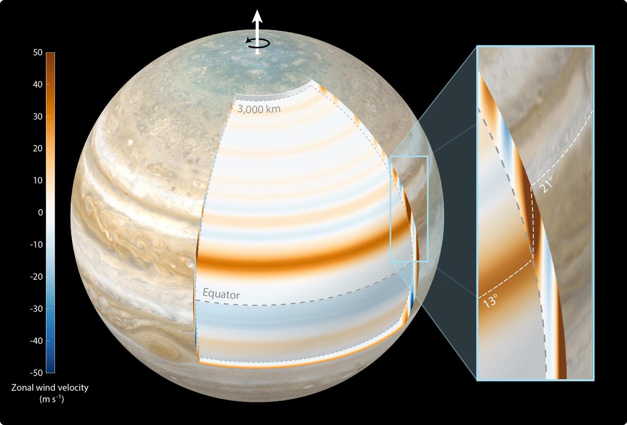
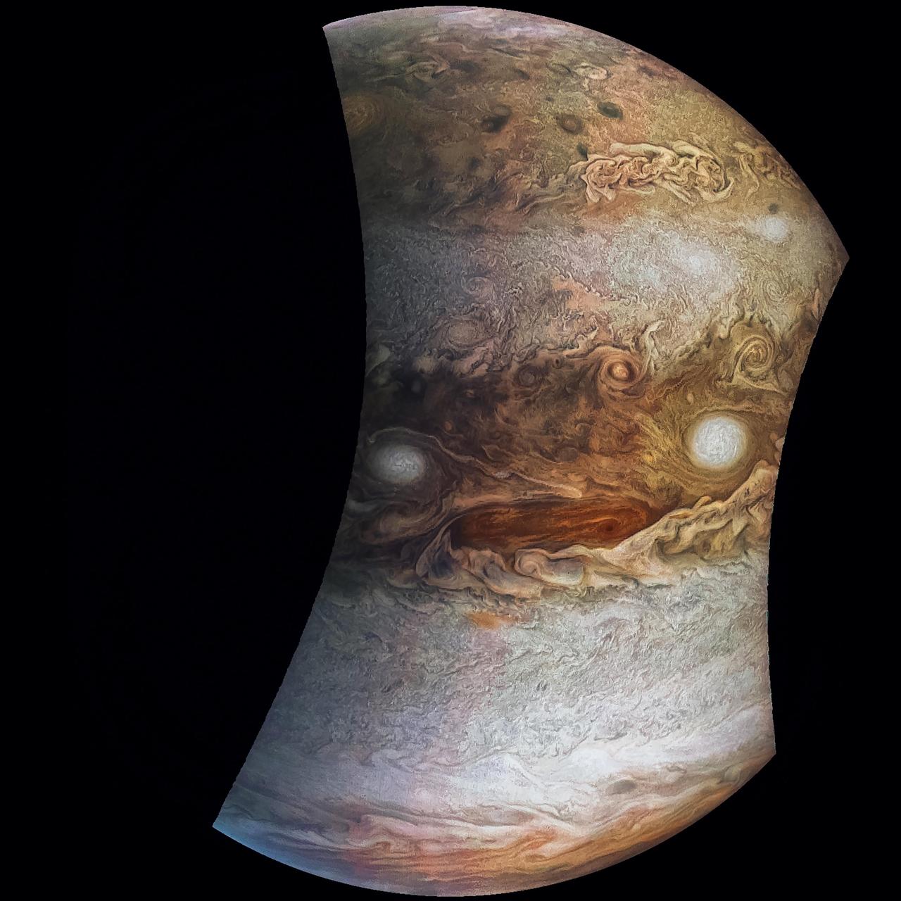
This composite illustration depicts scientists' findings that Jupiter's atmospheric winds penetrate the planet in a cylindrical manner and parallel to the planet's spin axis. The study, published in Nature Astronomy in October 2023, used gravity data from NASA's Juno mission. The top layer of Jupiter's atmosphere – the cloud level – was generated for this illustration using a combination of visible light images from Juno and NASA's Cassini mission. The annotated cutout reveals the gas giant's zonal winds at a depth of 1,800 miles (3,000 kilometers) below cloud level. In the cutout, Jupiter's belts are depicted with blue bands, the zones with reddish bands. The annotated close-up view at right shows the most dominant jet recorded by Juno. At cloud level, the jet is located at 21 degrees north latitude, above the planet's equator. However, at 1,800 miles (3,000 kilometers) below cloud level the jet is positioned at 13 degrees north latitude. The dashed white line represents the location of the jet's maximum velocity at all depths, showing its cylindrical structure. The color bar at left indicates the velocity of the zonal winds in meters per second at 1,800 miles (3,000 kilometers) below cloud level. https://photojournal.jpl.nasa.gov/catalog/PIA26076
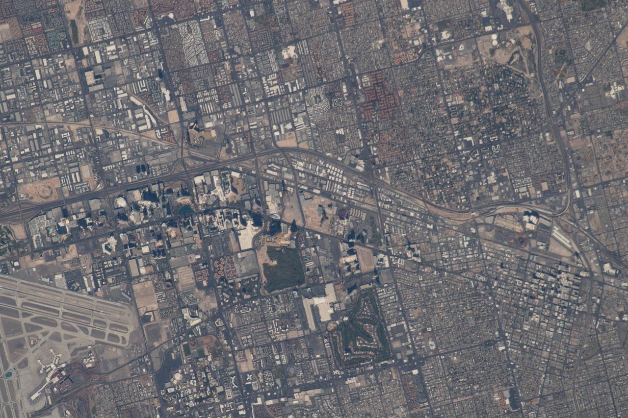
iss056e032756 (June 20, 2018) --- From left to right (true orientation is from south to north along Interstate 15) in this photograph are McCarran International Airport and downtown Las Vegas, Nev.

S65-59952 (1 Nov. 1965) --- Artist's concept depicting the approximate positions which the Gemini 6 and 7 spacecrafts will be oriented at the terminal phase of the proposed rendezvous mission. Photo credit: NASA

iss066e146350 (Feb. 17, 2022) --- Houston, Texas, is pictured in this near-overhead photograph from the International Space Station as it orbited 258 miles above. The orientation, from top to bottom, goes from southeast to northwest.

ISS026-E-005821 (30 Nov. 2010) --- From 220 miles above Earth one of the Expedition 26 crew members used a 180-mm lens to capture this pre-dawn image of the Baltimore-Washington, D.C. area. The photo is oriented 180 degrees different from conventional map orientation, because of the Atlantic-side perspective of the station, therefore Washington, D.C. is to the right of Baltimore which is in the center of frame. The center coordinates of the pictured area are actually located over the Atlantic at approximately 37.4 degrees north latitude and 66.4 degrees west longitude.

STS047-35-022 (12 - 20 Sept 1992) --- Astronauts Curtis L. Brown, Jr., pilot, and N. Jan Davis, mission specialist, team up to cure a high humidity problem in the hornet experiment in the Spacelab-J Science Module of the Earth-orbiting Space Shuttle Endeavour. Via a jury-rigged hose hook-up, the two were able to blow air from a spacesuit fan into the experiment, thus eliminating condensation that obscured the viewing of the Israeli hornet experiment. The experiment examined the effects of microgravity on the orientation, reproductive capability and social activity of 180 female Oriental Hornets.
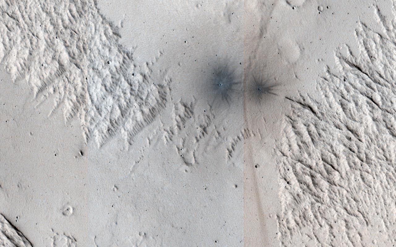
This image shows terrain near Mangala Valles. At the bottom of the image are two black spots that are recent impact craters. The black spots form because the craters exposed cleaner materials in the subsurface beneath the bright, dusty surface. Our image is also interesting because the surface has a criss-cross pattern formed by wind activity. Bright ripples that are oriented from the upper right to the lower left are perpendicular to the wind flow. In contrast, outcrops that have been eroded by the wind are oriented perpendicular to the ripples to produce the criss-cross pattern we now observe. https://photojournal.jpl.nasa.gov/catalog/PIA24146
The force of moving water from a flood carved these teardrop-shaped islands within Granicus Valles. The orientation of the islands can be used as an indicator of the direction the water flowed. In this case, the water flowed primarily towards the upper left of the image. The image also contains many narrow sinuous channels. Geologists can determine that the floods occurred before a later tectonic event in the region. This event caused the crust to fracture into numerous blocks and fissures (grabens). Many fissures can be seen cutting across the former flood pathways. http://photojournal.jpl.nasa.gov/catalog/PIA04037
JunoCam images aren't just for art and science -- sometimes they are processed to bring a chuckle. This image, processed by citizen scientist Jason Major, is titled "Jovey McJupiterface." By rotating the image 180 degrees and orienting it from south up, two white oval storms turn into eyeballs, and the "face" of Jupiter is revealed. The original image was acquired by JunoCam on NASA's Juno spacecraft on May 19, 2017 at 11:20 a.m. PT (2: 20 p.m. ET) from an altitude of 12,075 miles (19,433 kilometers). https://photojournal.jpl.nasa.gov/catalog/PIA21394 . - Enhanced image by Jason Major based on images provided courtesy of NASA/JPL-Caltech/SwRI/MSSS
The moon Hyperion tumbles as it orbits Saturn. Hyperion's (168 miles or 270 kilometers across) spin axis has a chaotic orientation in time, meaning that it is essentially impossible to predict how the moon will be spinning in the future. So far, scientists only know of a few bodies with such chaotic spins. The image was taken in green light with the Cassini spacecraft narrow-angle camera on Aug. 22, 2016. The view was acquired at a distance of approximately 203,000 miles (326,000 kilometers) from Hyperion and at a Sun-Hyperion-spacecraft, or phase, angle of 10 degrees. Image scale is 1 mile (2 kilometers) per pixel. http://photojournal.jpl.nasa.gov/catalog/PIA20512
Galaxy NGC 5866 lies 44 million light-years from Earth and has a diameter of roughly 60,000 light-years — a little more than half the diameter of our own Milky Way galaxy. From our viewpoint, NGC 5866 is oriented almost exactly edge-on, yielding most of its structural features invisible. Spitzer detects infrared light, and the red color here corresponds to a wavelength typically emitted by dust. The clean edges of the dust emission from NGC 5866 indicate that there is a very flat ring or disk of dust circling the outer region of the galaxy. Spitzer took this image during its "cold" mission, which ended in 2009. The colors represent three infrared wavelengths captured by the Infrared Array Camera instrument. Blue light corresponds to a wavelength of 3.6 microns, produced mainly by stars; green corresponds to 4.5 microns, and red corresponds to 8 microns. https://photojournal.jpl.nasa.gov/catalog/PIA23129
It's spring in the Northern Hemisphere of Mars (when this image was taken), and this area was recently completely covered by the seasonal frost cap. Here, we see polygonal patterns that are highlighted by carbon dioxide frost that has not entirely sublimed away. These organized patterns are likely caused by differences in the soil (regolith) characteristics such as grain size, density, even grain-shape and orientation in the underlying landforms and geologic materials. Variations in these characteristics strongly influence the strength of the ice-rich permafrost. This gives a preferred orientation to the stress field that produces the polygonal patterns. In this case, there appears to have been a meander in a fluvial channel in which sediments that differ from the native soil were deposited. The physical properties of these sediments probably change near the channel banks where flow rate drops off. Additionally, a high ice content might have resulted from a sediment-rich slurry flow that froze in place. Higher ice content will produce a weaker stress field and larger polygons, more so than just changes in grain size or orientation. https://photojournal.jpl.nasa.gov/catalog/PIA23581

KC-135 inflight training of the STS-30/61B Crew for suit donning doffing and Zero-G orientation for Rudolfo Neri, Astronaut Mary Cleave, and Ricardo Peralta, Backup Neri. 1. Astronaut Cleave, Mary - Zero-G 2. Neri, Rodolfo - Zero-G 3. Peralta, Ricard - Zero-G

S68-41156 (August 1968) --- North American Rockwell Corporation artist's concept depicting the Apollo Command Module, oriented in a blunt and forward attitude, reentering Earth's atmosphere after returning from a trip to the moon. Cutaway view illustrates position of the three astronauts in the Command Module.

Artist: Rick Guidice Pioneer Venus Mission Artwork: An artist concept of the multiprobe approaching Venus is shown here shortly after the probes release - Top to bottom - night probe, day probe sounder probe, North probe, followed by the bus (Note: this original painting's orientation is upside- down)
ISS028-E-045535 (9 Sept. 2011) --- The greater New York City metropolitan area can be studied in this photograph taken aboard the International Space Station by one of the Expedition 28 crew members. Central Park on Manhattan can be used as a guide for orientation, just to the right of center in the frame.
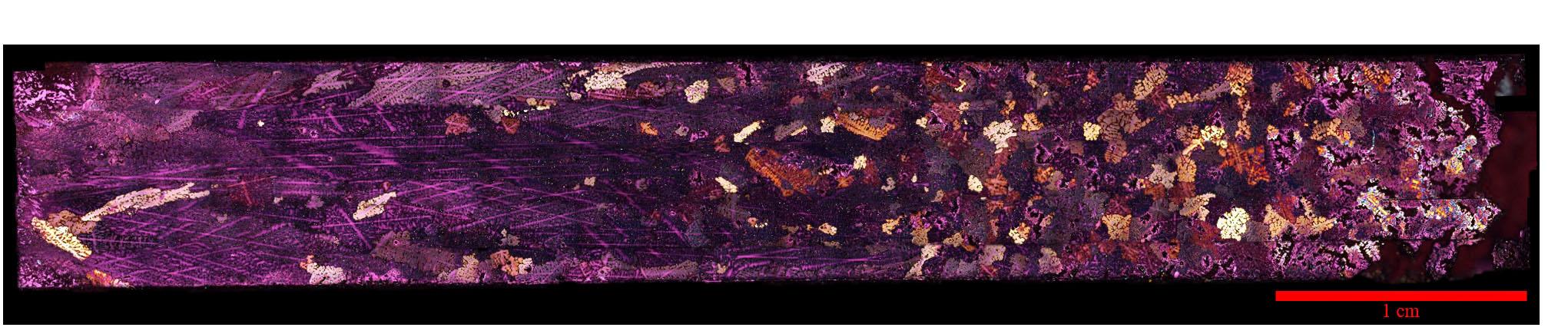
jsc2020e017721 (3/30/2020) --- A preflight view of a Polarized light micrograph of an Al-4%Cu alloy sample solidified in the SUBSA furnace showing a columnar-to-equiaxed transition in the grain structure. The sample has been electrolytically etched to show grains of differing orientation in color contrast under polarized light.
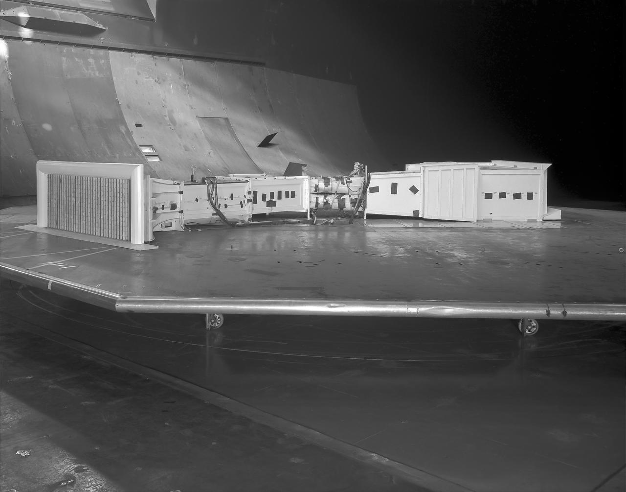
(03/12/1976) 1/50 scale model of the 80x120 foot wind tunnel model (NFAC) in the test section of the 40x80 foot wind tunnel. Model mounted on a rotating ground board designed for this test, viewed from the west, oriented for North wind.

KC-135 inflight training of the STS-30/61B Crew for suit donning doffing and Zero-G orientation for Rudolfo Neri, Astronaut Mary Cleave, and Ricardo Peralta, Backup Neri. 1. Astronaut Cleave, Mary - Zero-G 2. Neri, Rodolfo - Zero-G 3. Peralta, Ricard - Zero-G

S82-E-5734 (18 Feb. 1997) --- Tear is visible (lower right if picture is oriented horizontally) at base of Bay #8, later repaired by Smith and Lee. One bit of patchwork is visible on left. This view was taken with an Electronic Still Camera (ESC).

ISS032-E-015055 (5 Aug. 2012) --- One of the Expedition 32 crew members aboard the International Space Station recorded this nighttime image of Portugal featuring Porto (left) and Vila Nova de Gaia (right) astride the Douro River on the northwestern coast. For orientation purposes, the top is almost due east.

51C-08-017 (24-27 Jan 1985) --- Astronaut Ellison S. Onizuka, mission specialist, (left) turns 180 degrees near airlock hatch, while Loren J. Shriver, pilot, records verbal mission - pertinent notes. For orientation hold the picture with lockers on right.

Barbara Marino (left), Stennis Space Center education technology specialist, shows Astro Camp Counselor Beverly Fitzsimmons a LEGO model during a teambuilding exercise May 29 at SSC's North Gate computer lab as a part of the counselors' `new hire' orientation.

Artist: Rick Guidice Pioneer Venus Mission Artwork: An artist concept of the orbiter and multiprobe approaching Venus are shown here shortly after probes release - Top to bottom - night probe, day probe sounder probe, North probe, followed by the bus (Note: this original painting's orientation is upside- down)
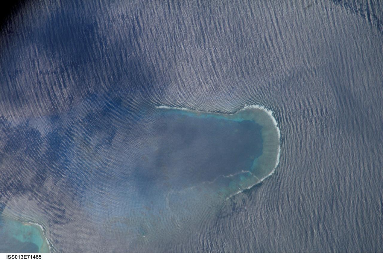
ISS013-E-71465 (27 Aug. 2006) --- Bajo Nuevo Reef in the western Caribbean Sea is featured in this image photographed by an Expedition 13 crewmember on the International Space Station. The Bajo Nuevo reef is approximately 26 kilometers long, comprising two separate U-shaped cays, with only tiny sandy islands associated with them. The eastern cay, shown in this image, encloses a lagoon. Protected from open-sea swells, the water surface is calmer and some back reef detail is visible within the lagoon. Cloud shadows darken the top left corner. The clearest feature is the broad pattern of swells which show two slightly different orientations, producing a tightly crossed pattern. These swells are oriented transverse to the wind direction and were probably set in motion by two different storms hundreds of kilometers east of the reef. A single irregular line of light color--also suggestive of surface oil--traces a path along the south side of the lagoon.
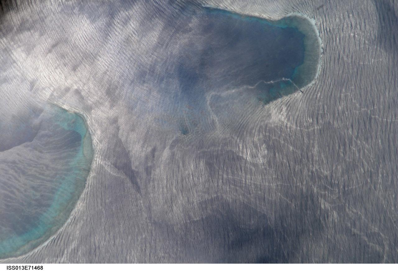
ISS013-E-71468 (27 Aug. 2006) --- Bajo Nuevo Reef in the western Caribbean Sea is featured in this image photographed by an Expedition 13 crewmember on the International Space Station. The Bajo Nuevo reef is approximately 26 kilometers long, comprising two separate U-shaped cays, with only tiny sandy islands associated with them. This detailed view reveals small, low islands that fringe the upwind side (image right) of the lagoon. These islands seem dwarfed by wave swells, which almost appear to wash over them. The clearest feature is the broad pattern of swells which show two slightly different orientations, producing a tightly crossed pattern. These swells are oriented transverse to the wind direction and were probably set in motion by two different storms hundreds of kilometers east of the reef. A single irregular line of light color--also suggestive of surface oil--traces a path along the south side of the lagoon.
This artist's concept shows NASA's Spitzer Space Telescope. Spitzer begins its "Beyond" mission phase on Oct. 1, 2016. Spitzer is depicted in the orientation it assumes to establish communications with ground stations. Spitzer is over 130 million miles (210 million kilometers) away from Earth, or about 1.5 times the distance between Earth and the Sun. The selected research proposals for Spitzer's Beyond phase include a variety of objects that the mission was not originally planned to address -- such as galaxies in the early universe, the black hole at the center of the Milky Way and exoplanets. Spitzer faces increasing challenges and risks in its Beyond phase. To enable this riskier mode of operations, the mission team will have to override some autonomous safety systems. Mission engineers are hard at work preparing for these new challenges. http://photojournal.jpl.nasa.gov/catalog/PIA20913

This artist's impression depicts the accretion disc surrounding a black hole, in which the inner region of the disc precesses. "Precession" means that the orbit of material surrounding the black hole changes orientation around the central object. In these three views, the precessing inner disc shines high-energy radiation that strikes the matter in the surrounding accretion disc. This causes the iron atoms in that disc to emit X-rays, depicted as the glow on the accretion disc to the right (in view a), to the front (in view b) and to the left (in view c) (see Figure 1). In a study published in July 2016, astronomers used data from ESA's XMM-Newton X-ray Observatory and NASA's NuSTAR telescope to measure this "wobble" in X-ray emission from excited iron atoms. Scientists interpreted this as evidence for the Lense-Thirring effect -- a name for the precession phenomenon -- in the strong gravitational field of a black hole. http://photojournal.jpl.nasa.gov/catalog/PIA20697
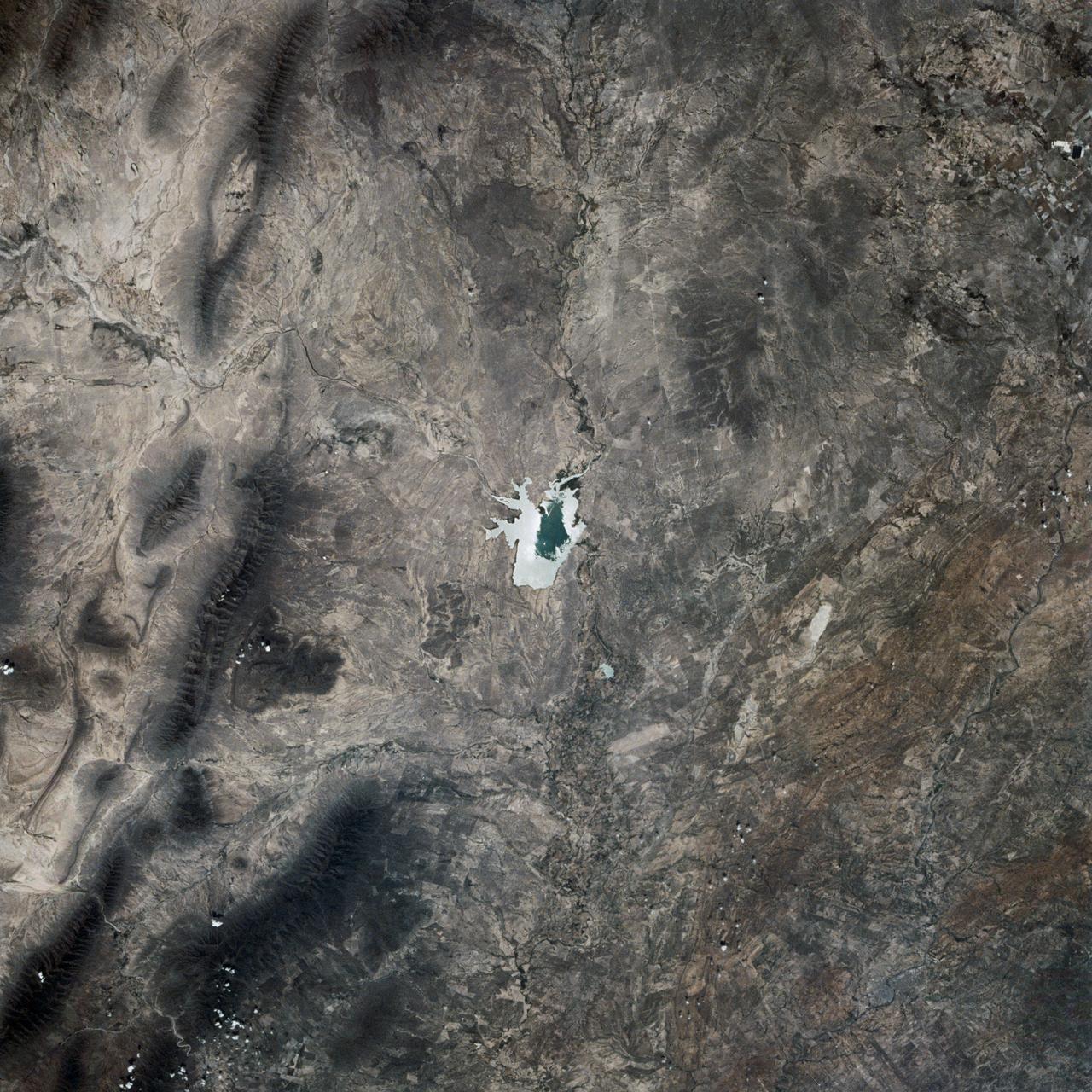
This is a single scene from a pair (frames 021 & 024) to study the effects of polarized light in Earth Observations. One scene was exposed with vertically polarized light, the other, horizontally. The subject in this study, is a lake behind Presa (dam) Don Martin (27.5N, 100.5W) on the edge of the Rio Grande Plain near it's boundry with the Sierra Madre Orientral in Coahuila, Mexico.
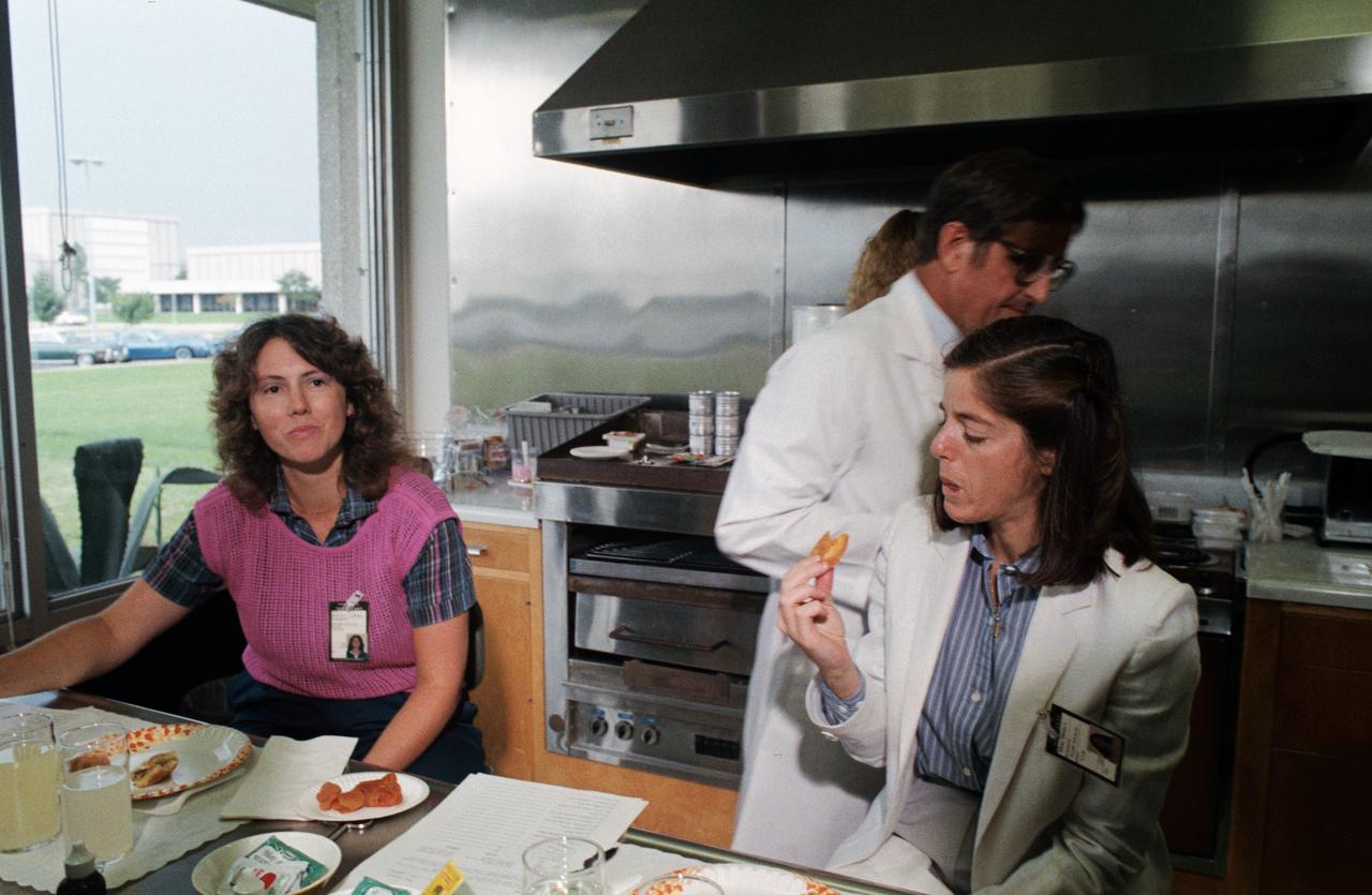
S85-39978 (10 Sept. 1985) --- Sharon Christa McAuliffe, left, appears to be deciding what she thinks of a piece of space food she tastes during a session of interfacing with space shuttle life sciences. Barbara R. Morgan samples an apricot. The two are in early training at the Johnson Space Center (JSC) in preparation for the STS-51L spaceflight early next year. McAuliffe is prime payload specialist representing the Teacher in Space Project, and Morgan is her backup. Dr. C.T. Bourland, a dietitian specialist, assists the two. Photo credit: NASA
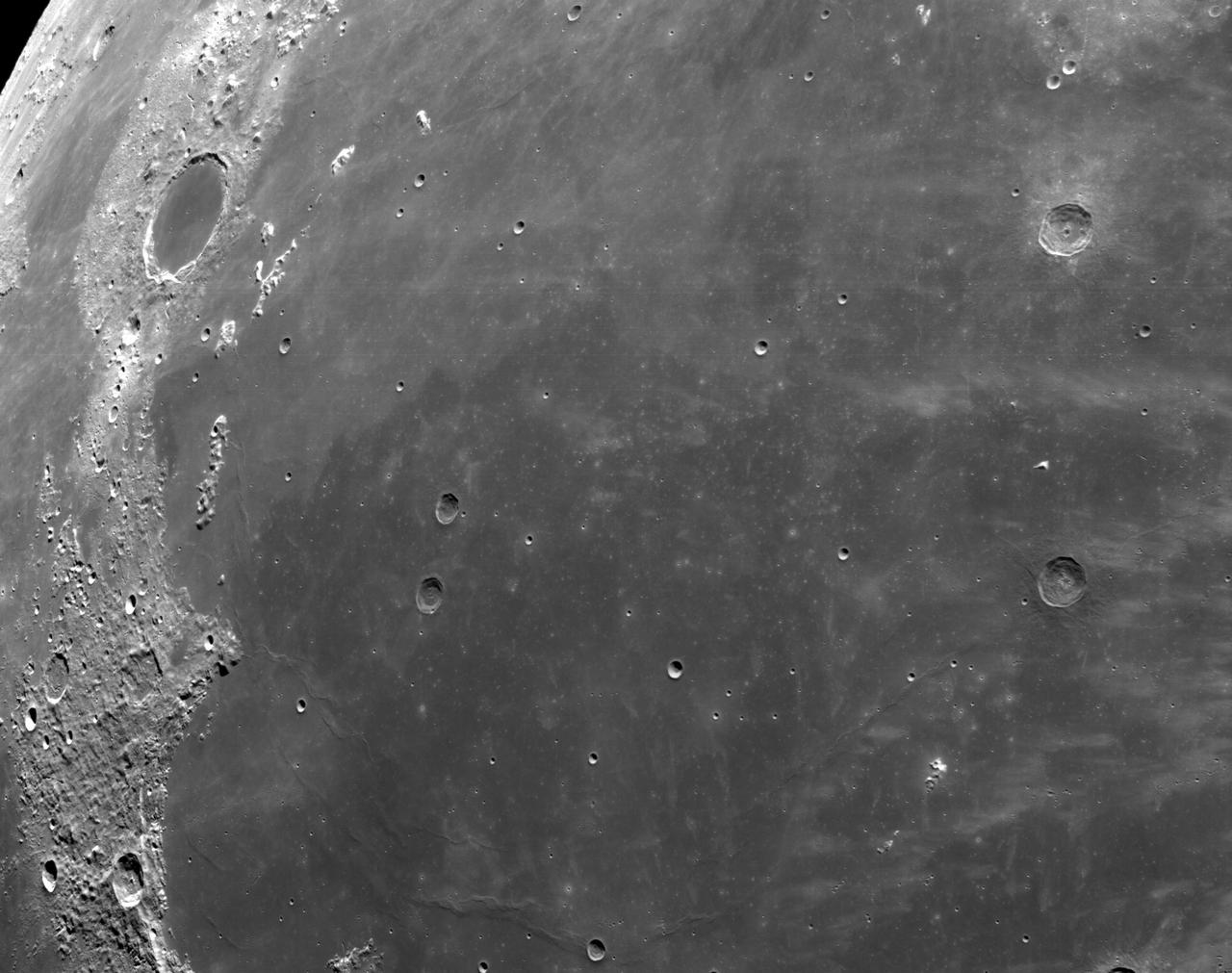
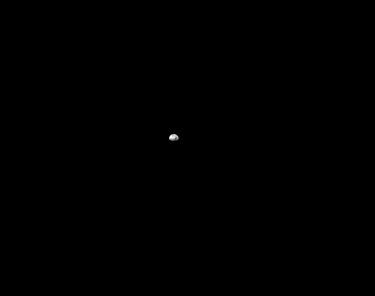
art001e000342 (Nov. 21, 2022) – On the sixth day of the Artemis I mission, Orion’s optical navigation camera captured black-and-white images of craters on the Moon below. Orion uses the optical navigation camera to capture imagery of the Earth and the Moon at different phases and distances, providing an enhanced body of data to certify its effectiveness under different lighting conditions as a way to help orient the spacecraft on future missions with crew.
art001e002647 (Dec. 5, 2022): The optical navigation camera mounted on the Orion spacecraft captured these views of the Moon’s surface. On flight day 20 of the Artemis I mission, the spacecraft made its second and final close approach to the Moon before its returned powered flyby burn. Orion uses the optical navigation camera to capture imagery of the Earth and the Moon at different phases and distances, providing an enhanced body of data to certify its effectiveness under different lighting conditions as a way to help orient the spacecraft on future missions with crew.
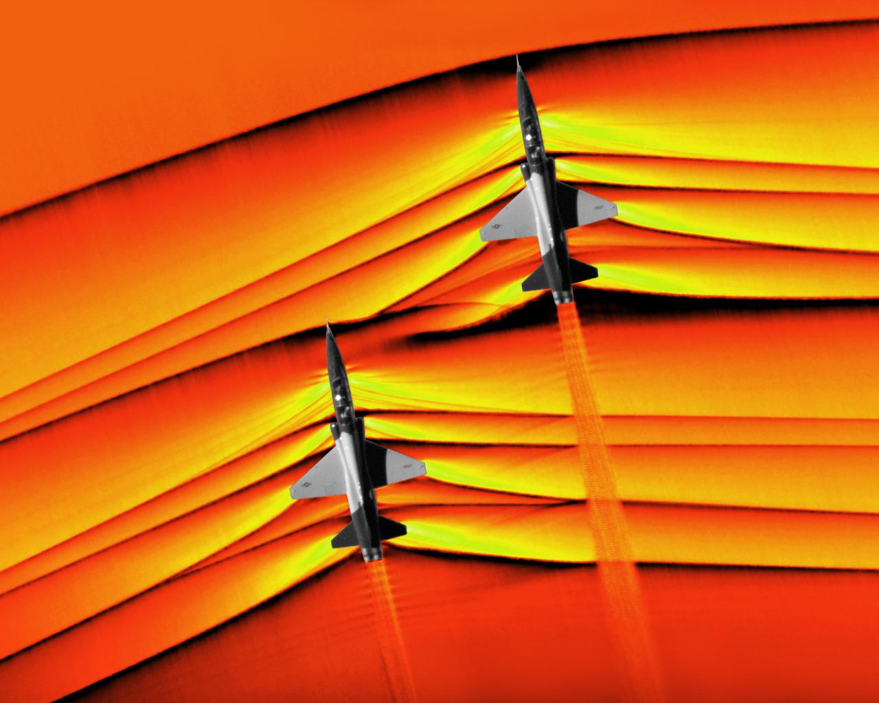
Composite image of Background Oriented Schlieren (BOS) data (contour) with a cut-out images of the T-38’s during a Mach Number 1.02 pass. The interaction of the shockwave of the trailing aircraft with the exhaust plume of the lead aircraft shows a shockwave reflection. Original recording of the pass taken in the Black Mountain Supersonic Corridor at near Edwards AFB in December of 2018. Image acquired by JT Heineck, schlieren data processed by Neal Smith.
art001e002604 (Dec. 5, 2022): The optical navigation camera mounted on the Orion spacecraft captured these views of the Moon’s surface. On flight day 20 of the Artemis I mission, the spacecraft made its second and final close approach to the Moon before its returned powered flyby burn. Orion uses the optical navigation camera to capture imagery of the Earth and the Moon at different phases and distances, providing an enhanced body of data to certify its effectiveness under different lighting conditions as a way to help orient the spacecraft on future missions with crew.
This artist's concept shows the proposed Capture, Containment, and Return System, a NASA payload on the European Space Agency's Earth Return Orbiter. The payload is tasked with capturing the Orbiting Sample container, orienting it, sterilizing its exterior, and transferring it into a clean zone for secondary containment, toward safe return to Earth. The Capture, Containment, and Return System is part of the multi-mission Mars Sample Return program being planned by NASA and European Space Agency (ESA). https://photojournal.jpl.nasa.gov/catalog/PIA25894
art001e000339 (Nov. 21, 2022) – On the sixth day of the Artemis I mission, Orion’s optical navigation camera captured black-and-white images of craters on the Moon below. Orion uses the optical navigation camera to capture imagery of the Earth and the Moon at different phases and distances, providing an enhanced body of data to certify its effectiveness under different lighting conditions as a way to help orient the spacecraft on future missions with crew.
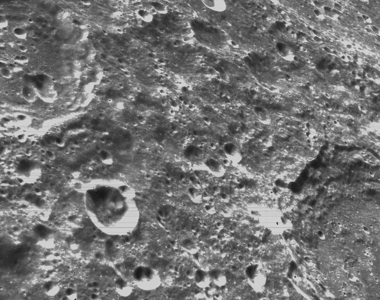
art001e001813 (Nov. 30, 2022) On flight day 15, Orion’s optical navigation camera captured this black-and-white image of our Moon. Orion uses the optical navigation camera to capture imagery of the Earth and the Moon at different phases and distances, providing an enhanced body of data to certify its effectiveness under different lighting conditions as a way to help orient the spacecraft on future missions with crew.
KENNEDY SPACE CENTER, FLA. - In the Space Station Processing Facility, workers help maneuver the Control Moment Gyroscope (CMG) onto a stand prior to its being returned to the vendor for repair. The faulty CMG was removed from the International Space Station and replaced with a new one on mission STS-114 in August. A control moment gyroscope is an actuator used to apply very high attitude-control torques to agile spacecraft. The Space Station uses four massive control moment gyroscopes to maintain the Station’s orientation in space.

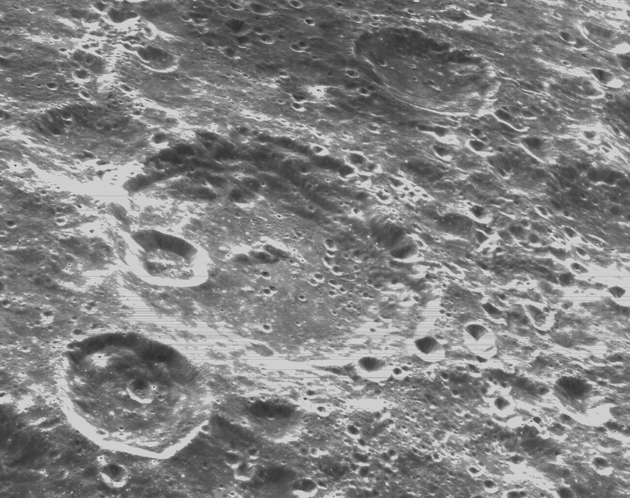
art001e002596 (Dec. 5, 2022): The optical navigation camera mounted on the Orion spacecraft captured these views of the Moon’s surface. On flight day 20 of the Artemis I mission, the spacecraft made its second and final close approach to the Moon before its returned powered flyby burn. Orion uses the optical navigation camera to capture imagery of the Earth and the Moon at different phases and distances, providing an enhanced body of data to certify its effectiveness under different lighting conditions as a way to help orient the spacecraft on future missions with crew.
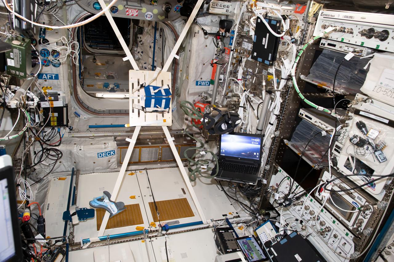
iss060e014594 (7/25/2019) ---Photo documentation during the preparation for the VECTION experiment in the Columbus module aboard the International Space Station (ISS). The objective of The Effect of Long Duration Hypogravity on the Perception of Self-Motion (VECTION) study is to determine to what extent an astronaut's ability to visually interpret motion, orientation, and distance may be disrupted in a microgravity environment, and how it may adapt, and how it may be changed upon return to Earth. Multiple experimental time points inflight and upon return to Earth allows for the adaptation and recovery process to be investigated.
art001e000735 - On flight day 10, NASA’s Orion spacecraft captured imagery of the Moon while in a distant retrograde orbit. Orion uses the optical navigation camera to capture imagery of the Earth and the Moon at different phases and distances, providing an enhanced body of data to certify its effectiveness under different lighting conditions as a way to help orient the spacecraft on future missions with crew.

art001e002595 (Dec. 5, 2022): The optical navigation camera mounted on the Orion spacecraft captured these views of the Moon’s surface. On flight day 20 of the Artemis I mission, the spacecraft made its second and final close approach to the Moon before its returned powered flyby burn. Orion uses the optical navigation camera to capture imagery of the Earth and the Moon at different phases and distances, providing an enhanced body of data to certify its effectiveness under different lighting conditions as a way to help orient the spacecraft on future missions with crew.
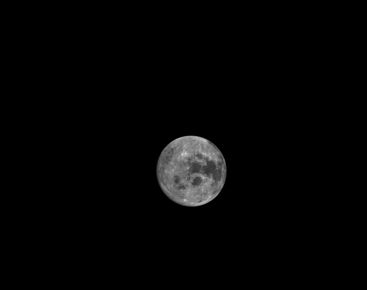
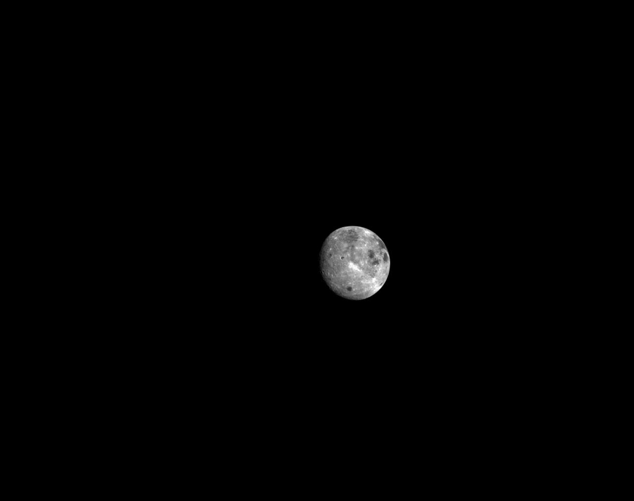
art001e002058 (Dec. 4, 2022) On flight day 19, Orion’s optical navigation camera captured this image of the full Moon as the spacecraft continued its approach toward the return powered flyby burn. Orion uses the optical navigation camera to capture imagery of the Earth and the Moon at different phases and distances, providing an enhanced body of data to certify its effectiveness under different lighting conditions as a way to help orient the spacecraft on future missions with crew.
STS084-301-014 (15-24 May 1997) --- Zero-gravity adds a flavor of confusion to this 35mm frame, photographed onboard the Spacehab Double Module during a break in transfer operations of supplies for the STS-84 mission. For orientation purposes, the picture should be held with the glovebox positioned vertically on the right side of the frame. The crew members pictured, from top to bottom, are Elena V. Kondakova, Jean-Francois Clervoy and Edward T. Lu.

ISS035-E-008051 (23 March 2013) --- One of the Expedition 35 crew members aboard the Earth-orbiting International Space Station exposed this 400 millimeter night image of the greater New York City metropolitan area on March 23. For orientation purposes, note that Manhattan runs horizontal through the frame from left to the midpoint. Central Park is just a little to the left of frame center.
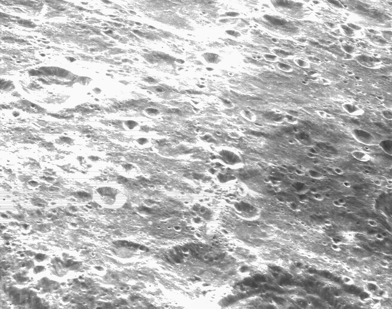
art001e000274 Nov. 21, 2022 -- On the sixth day of the Artemis I mission, Orion's optical navigation camera was commanded to take this black-and-white photo of the lunar surface. Orion uses the optical navigation camera to capture imagery of the Earth and the Moon at different phases and distances, providing an enhanced body of data to certify its effectiveness under different lighting conditions as a way to help orient the spacecraft on future missions with crew.
art001e000334 (Nov. 21, 2022) – On the sixth day of the Artemis I mission, Orion’s optical navigation camera captured black-and-white images of craters on the Moon below. Orion uses the optical navigation camera to capture imagery of the Earth and the Moon at different phases and distances, providing an enhanced body of data to certify its effectiveness under different lighting conditions as a way to help orient the spacecraft on future missions with crew.

art001e000736 - On flight day 10, NASA’s Orion spacecraft captured imagery of the Moon while in a distant retrograde orbit. Orion uses the optical navigation camera to capture imagery of the Earth and the Moon at different phases and distances, providing an enhanced body of data to certify its effectiveness under different lighting conditions as a way to help orient the spacecraft on future missions with crew.
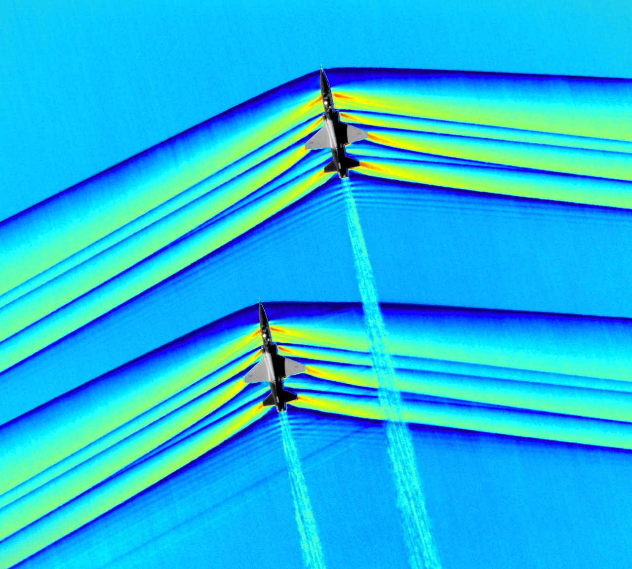
Composite image of Background Oriented Schlieren (BOS) data (contour) with a cut-out images of the T-38’s during a Mach Number 1.01 pass. This data is the first time shockwave interactions between two full scale aircraft traveling faster than the speed of sound have been imaged and shown with schlieren visualization. Original recording of the pass taken in the Black Mountain Supersonic Corridor at near Edwards AFB in December of 2018. Image acquired by JT Heineck, schlieren data processed by Neal Smith
art001e003051 (Dec. 10, 2022) On flight day 25 of the 25.5-day Artemis I mission, Orion’s optical navigation camera looked back at the Moon as the spacecraft continued its return journey to Earth. Orion uses the optical navigation camera to capture imagery of the Earth and the Moon at different phases and distances, providing an enhanced body of data to certify its effectiveness under different lighting conditions as a way to help orient the spacecraft on future missions with crew.
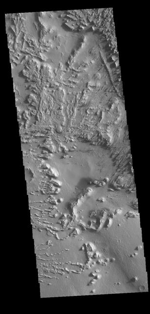
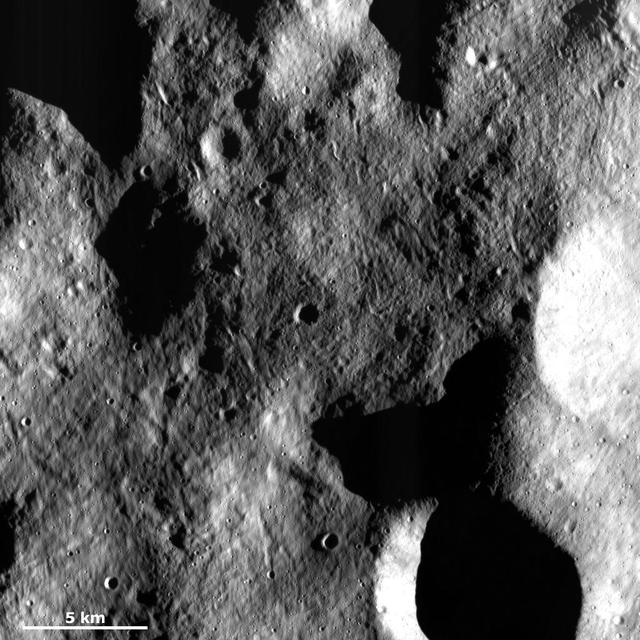
Today's VIS image shows the surface between Aeolis Planum and Zephyria Planum in Elysium Planitia. Long term winds have eroded the surface in this region. Features align with wind direction, and the multiple ridge orientations in this image indicate varying wind directions over time. Orbit Number: 79757 Latitude: -5.05219 Longitude: 155.498 Instrument: VIS Captured: 2019-12-07 12:12 https://photojournal.jpl.nasa.gov/catalog/PIA23708