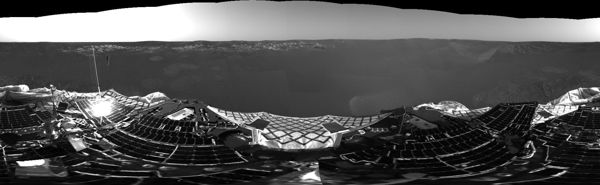
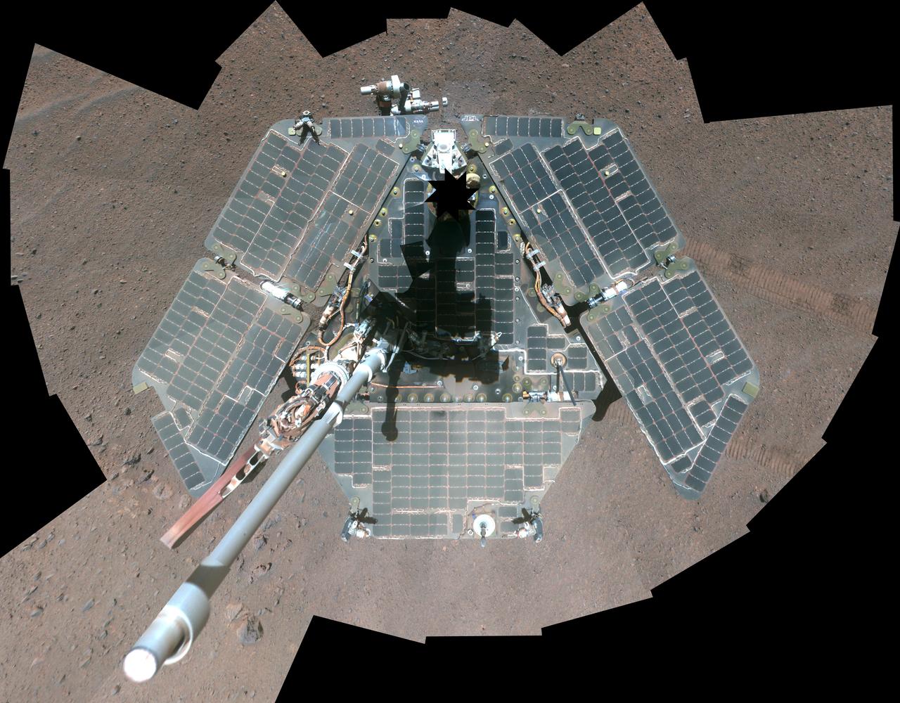
Panoramic View of Lander During Turn
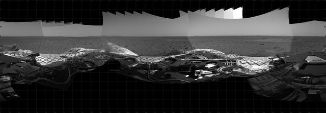
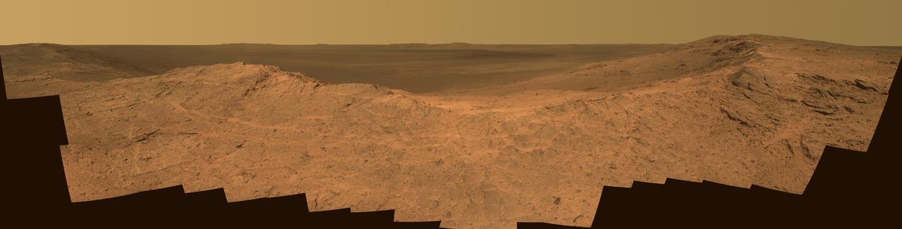
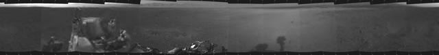
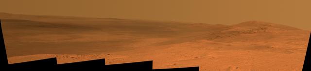
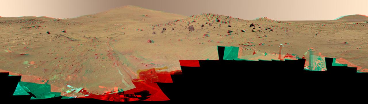
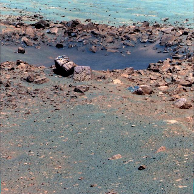
First Panoramic Look at Meridiani Planum, Mars
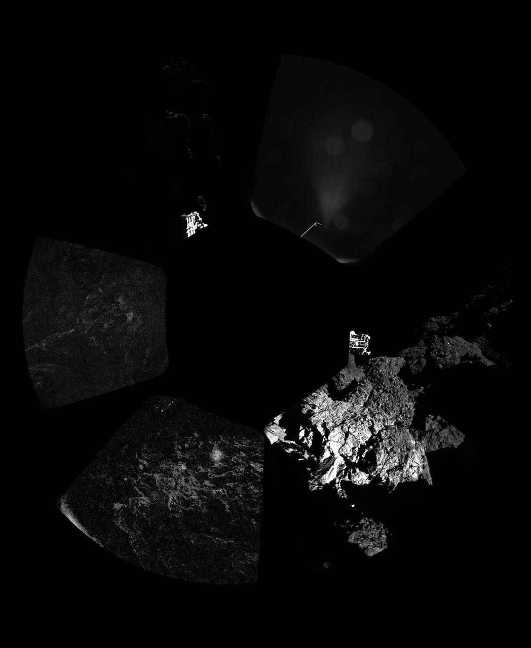
The Philae lander of Europe Rosetta mission has returned the first panoramic image from the surface of a comet. The unprocessed panorama from the lander CIVA-P camera shows a 360-degree view around the point of final touchdown.
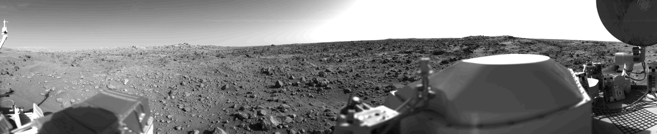
First panoramic view by NASA's Viking 1 from the surface of Mars. The out of focus spacecraft component toward left center is the housing for the Viking sample arm, which is not yet deployed. Parallel lines in the sky are an artifact and are not real features. However, the change of brightness from horizon towards zenith and towards the right (west) is accurately reflected in this picture, taken in late Martian afternoon. At the horizon to the left is a plateau-like prominence much brighter than the foreground material between the rocks. The horizon features are approximately three kilometers (1.8 miles) away. At left is a collection of fine-grained material reminiscent of sand dunes. The dark sinuous markings in left foreground are of unknown origin. Some unidentified shapes can be perceived on the hilly eminence at the horizon towards the right. A horizontal cloud stratum can be made out halfway from the horizon to the top of the picture. At left is seen the low gain antenna for receipt of commands from the Earth. The projections on or near the horizon may represent the rims distant impact craters. In right foreground are color charts for Lander camera calibration, a mirror for the Viking magnetic properties experiment and part of a grid on the top of the Lander body. At upper right is the high gain dish antenna for direct communication between landed spacecraft and Earth. Toward the right edge is an array of smooth fine-grained material which shows some hint of ripple structure and may be the beginning of a large dune field off to the right of the picture, which joins with dunes seen at the top left in this 300 degree panoramic view. Some of the rocks appear to be undercut on one side and partially buried by drifting sand on the other. http://photojournal.jpl.nasa.gov/catalog/PIA00383
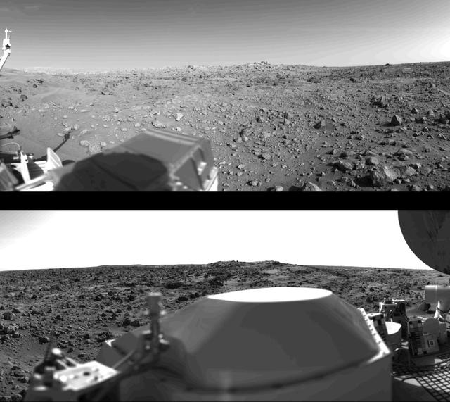
First panoramic view by Viking 1 from the surface of Mars. (Top): The out-of-focus spacecraft component toward left center is the housing for the Viking sample arm, which is not yet deployed. Parallel lines in the sky are an artifact and are not real features. However, the change of brightness from horizon towards zenith and towards the right (west) is accurately reflected in this picture, taken in late Martian afternoon. At the horizon to the left is a plateau-like prominence much brighter than the foreground material between the rocks. The horizon features are approximately three kilometers (1.8 miles) away. At left is a collection of fine-grained material reminiscent of sand dunes. The dark sinuous markings in left foreground are of unknown origin. Some unidentified shapes can be perceived on the hilly eminence at the horizon towards the right. Patches of bright sand can be discerned among the rocks and boulders in middle distance. In right fore-ground are two peculiarly shaped rocks which may possibly be ventifacts produced by wind abrasion on Mars. A horizontal cloud stratum can be made out halfway from the horizon to the top of the picture. (Bottom): At left is seen the low gain antenna for receipt of commands from the Earth. The projections on or near the horizon may represent the rims distant impact craters. In right foreground are color charts for Lander camera calibration, a mirror for the Viking magnetic properties experiment and part of a grid on the top of the Lander body. At upper right is the high-gain dish antenna for direct communication between landed space-craft and Earth. Toward the right edge is an array of smooth fine-grained material which shows some hint of ripple structure and may be the beginning of a large dune field off to the right of the picture, which joins with dunes seen at the top left in this 300 panoramic view. Some of the rocks appear to be undercut on one side and partially buried by drifting sand on the other. http://photojournal.jpl.nasa.gov/catalog/PIA00382
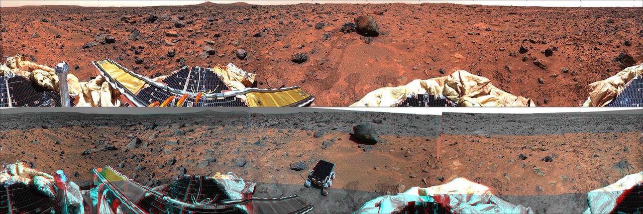
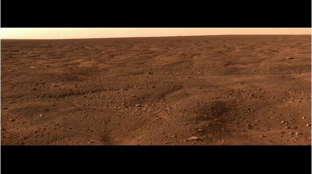
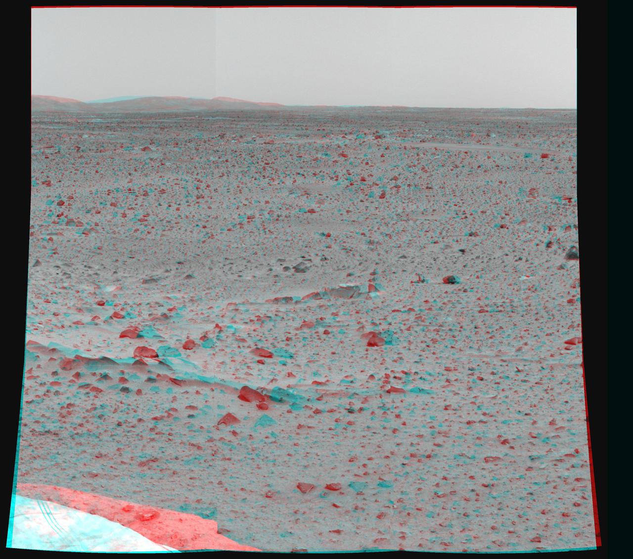
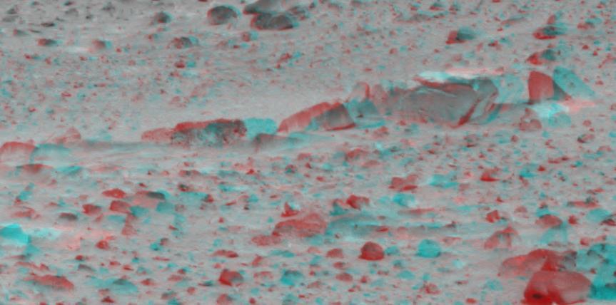
This panoramic view taken by NASA Mars Pathfinder is a controlled mosaic of approximately 300 IMP images. 3D glasses are necessary to identify surface detail.

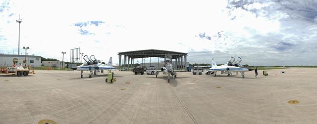
PANORAMIC VIEW OF PAYLOAD OPERATIONS INTEGRATION CENTER, PCA1, BLDG. 4663…UPDATED 10/21/15
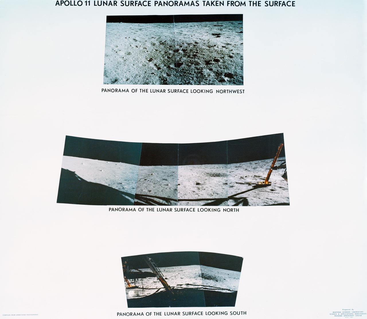
S69-44463 (July 1969) --- Astronaut Neil A. Armstrong took this series of pictures of the landing site of Apollo 11's Lunar Module (LM) Eagle on the lunar surface. These panoramic views of the lunar surface reveal the surface near where the LM touched down, in the southeastern Sea of Tranquility. Foot pads and shadows of the LM are visible in the two of the three panoramic views.
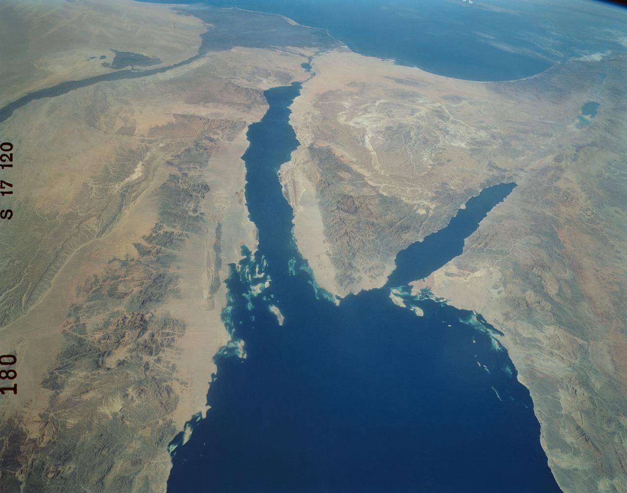
An excellent panoramic view of the entire Sinai Peninsula (29.0N, 34.0E) and the nearby Nile River Delta and eastern Mediterranean coastal region. The Suez Canal, at the top of the scene just to the right of the Delta, connects the Mediterranean Sea with the Gulf of Suez on the west side of the Sinai Peninsula and the Gulf of Aqaba is on the west where they both flow into the Red Sea. At upper right, is the Dead Sea, Jordan River and Lake Tiberius.
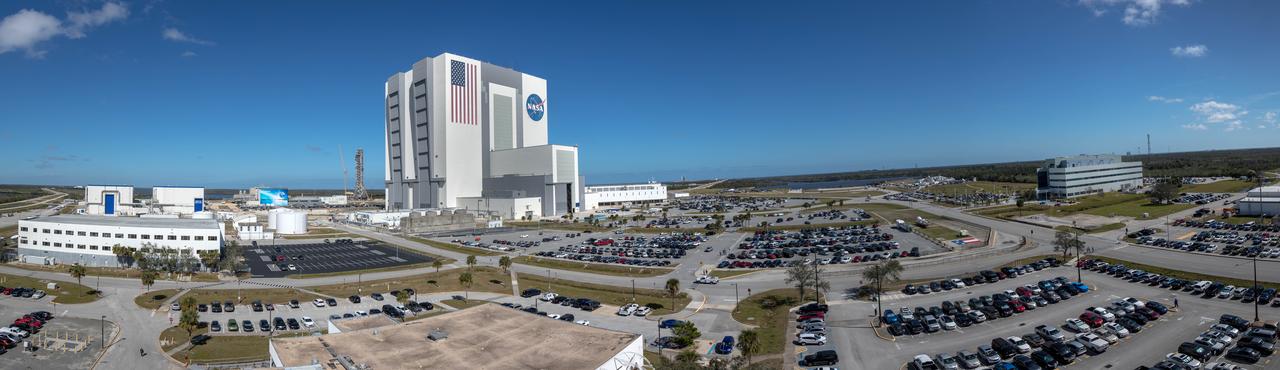
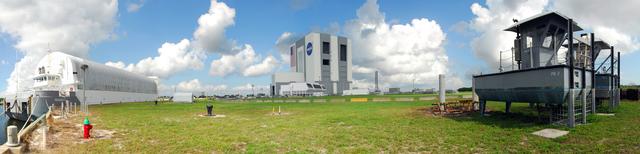
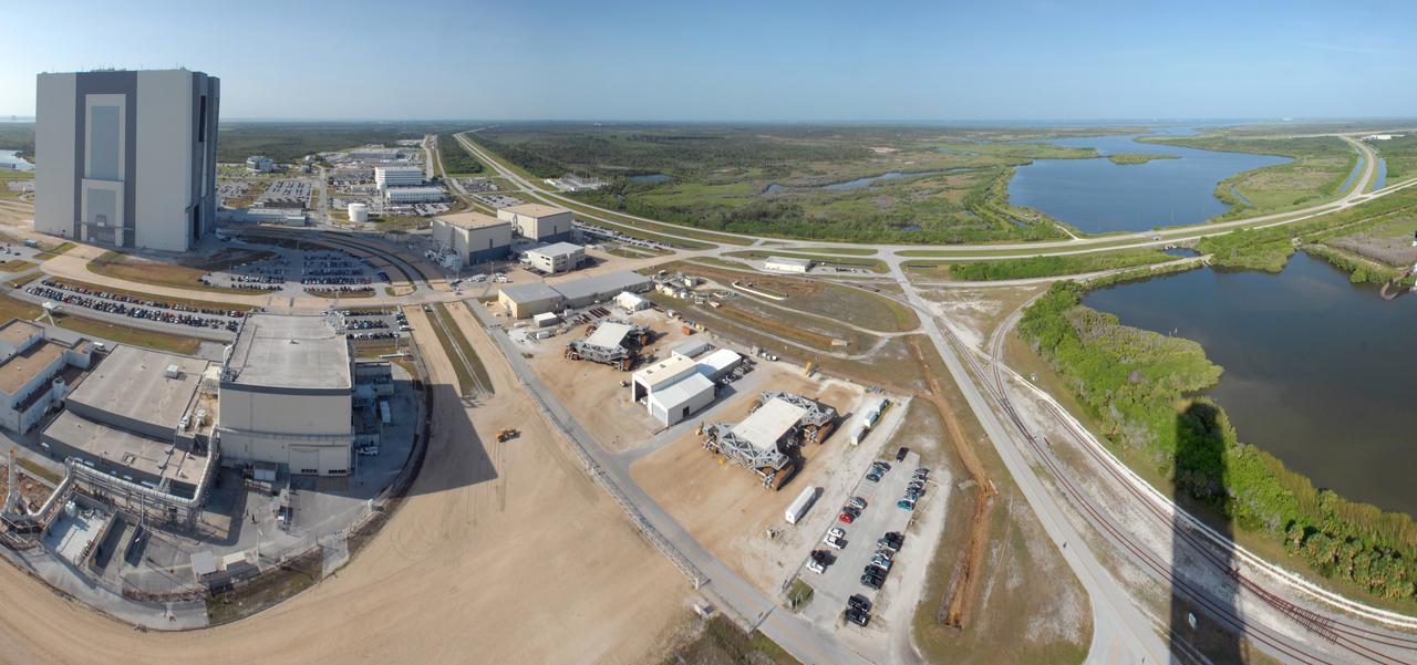
A brilliant blue sky serves as the backdrop for a panoramic view of the iconic Vehicle Assembly Building, mobile launcher at left, and Launch Control Center at right, at NASA's Kennedy Space Center in Florida. These facilities are being upgraded for NASA's Space Launch System and Orion spacecraft for launches to deep space destinations, including the Moon, Mars and beyond.
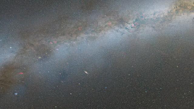
Zoom into the Andromeda galaxy. The largest NASA Hubble Space Telescope image ever assembled, this sweeping view of a portion of the Andromeda galaxy (M31) is the sharpest large composite image ever taken of our galactic neighbor. Though the galaxy is over 2 million light-years away, the Hubble telescope is powerful enough to resolve individual stars in a 61,000-light-year-long section of the galaxy's pancake-shaped disk. It's like photographing a beach and resolving individual grains of sand. And, there are lots of stars in this sweeping view — over 100 million, with some of them in thousands of star clusters seen embedded in the disk. This ambitious photographic cartography of the Andromeda galaxy represents a new benchmark for precision studies of large spiral galaxies which dominate the universe's population of over 100 billion galaxies. Never before have astronomers been able to see individual stars over a major portion of an external spiral galaxy. Most of the stars in the universe live inside such majestic star cities, and this is the first data that reveal populations of stars in context to their home galaxy. Credit: NASA, ESA, and G. Bacon (STScI) <b><a href="http://www.nasa.gov/audience/formedia/features/MP_Photo_Guidelines.html" rel="nofollow">NASA image use policy.</a></b> <b><a href="http://www.nasa.gov/centers/goddard/home/index.html" rel="nofollow">NASA Goddard Space Flight Center</a></b> enables NASA’s mission through four scientific endeavors: Earth Science, Heliophysics, Solar System Exploration, and Astrophysics. Goddard plays a leading role in NASA’s accomplishments by contributing compelling scientific knowledge to advance the Agency’s mission. <b>Follow us on <a href="http://twitter.com/NASAGoddardPix" rel="nofollow">Twitter</a></b> <b>Like us on <a href="http://www.facebook.com/pages/Greenbelt-MD/NASA-Goddard/395013845897?ref=tsd" rel="nofollow">Facebook</a></b> <b>Find us on <a href="http://instagram.com/nasagoddard?vm=grid" rel="nofollow">Instagram</a></b>

The largest NASA Hubble Space Telescope image ever assembled, this sweeping bird’s-eye view of a portion of the Andromeda galaxy (M31) is the sharpest large composite image ever taken of our galactic next-door neighbor. Though the galaxy is over 2 million light-years away, The Hubble Space Telescope is powerful enough to resolve individual stars in a 61,000-light-year-long stretch of the galaxy’s pancake-shaped disk. It's like photographing a beach and resolving individual grains of sand. And there are lots of stars in this sweeping view -- over 100 million, with some of them in thousands of star clusters seen embedded in the disk. This ambitious photographic cartography of the Andromeda galaxy represents a new benchmark for precision studies of large spiral galaxies that dominate the universe's population of over 100 billion galaxies. Never before have astronomers been able to see individual stars inside an external spiral galaxy over such a large contiguous area. Most of the stars in the universe live inside such majestic star cities, and this is the first data that reveal populations of stars in context to their home galaxy. Hubble traces densely packed stars extending from the innermost hub of the galaxy seen at the left. Moving out from this central galactic bulge, the panorama sweeps from the galaxy's central bulge across lanes of stars and dust to the sparser outer disk. Large groups of young blue stars indicate the locations of star clusters and star-forming regions. The stars bunch up in the blue ring-like feature toward the right side of the image. The dark silhouettes trace out complex dust structures. Underlying the entire galaxy is a smooth distribution of cooler red stars that trace Andromeda’s evolution over billions of years. Because the galaxy is only 2.5 million light-years from Earth, it is a much bigger target in the sky than the myriad galaxies Hubble routinely photographs that are billions of light-years away. This means that the Hubble survey is assembled together into a mosaic image using 7,398 exposures taken over 411 individual pointings. Read more: <a href="http://1.usa.gov/1y0i3H8" rel="nofollow">1.usa.gov/1y0i3H8</a> Credit: NASA, ESA, J. Dalcanton, B.F. Williams, and L.C. Johnson (University of Washington), the PHAT team, and R. Gendler <b><a href="http://www.nasa.gov/audience/formedia/features/MP_Photo_Guidelines.html" rel="nofollow">NASA image use policy.</a></b> <b><a href="http://www.nasa.gov/centers/goddard/home/index.html" rel="nofollow">NASA Goddard Space Flight Center</a></b> enables NASA’s mission through four scientific endeavors: Earth Science, Heliophysics, Solar System Exploration, and Astrophysics. Goddard plays a leading role in NASA’s accomplishments by contributing compelling scientific knowledge to advance the Agency’s mission. <b>Follow us on <a href="http://twitter.com/NASAGoddardPix" rel="nofollow">Twitter</a></b> <b>Like us on <a href="http://www.facebook.com/pages/Greenbelt-MD/NASA-Goddard/395013845897?ref=tsd" rel="nofollow">Facebook</a></b> <b>Find us on <a href="http://instagram.com/nasagoddard?vm=grid" rel="nofollow">Instagram</a></b>
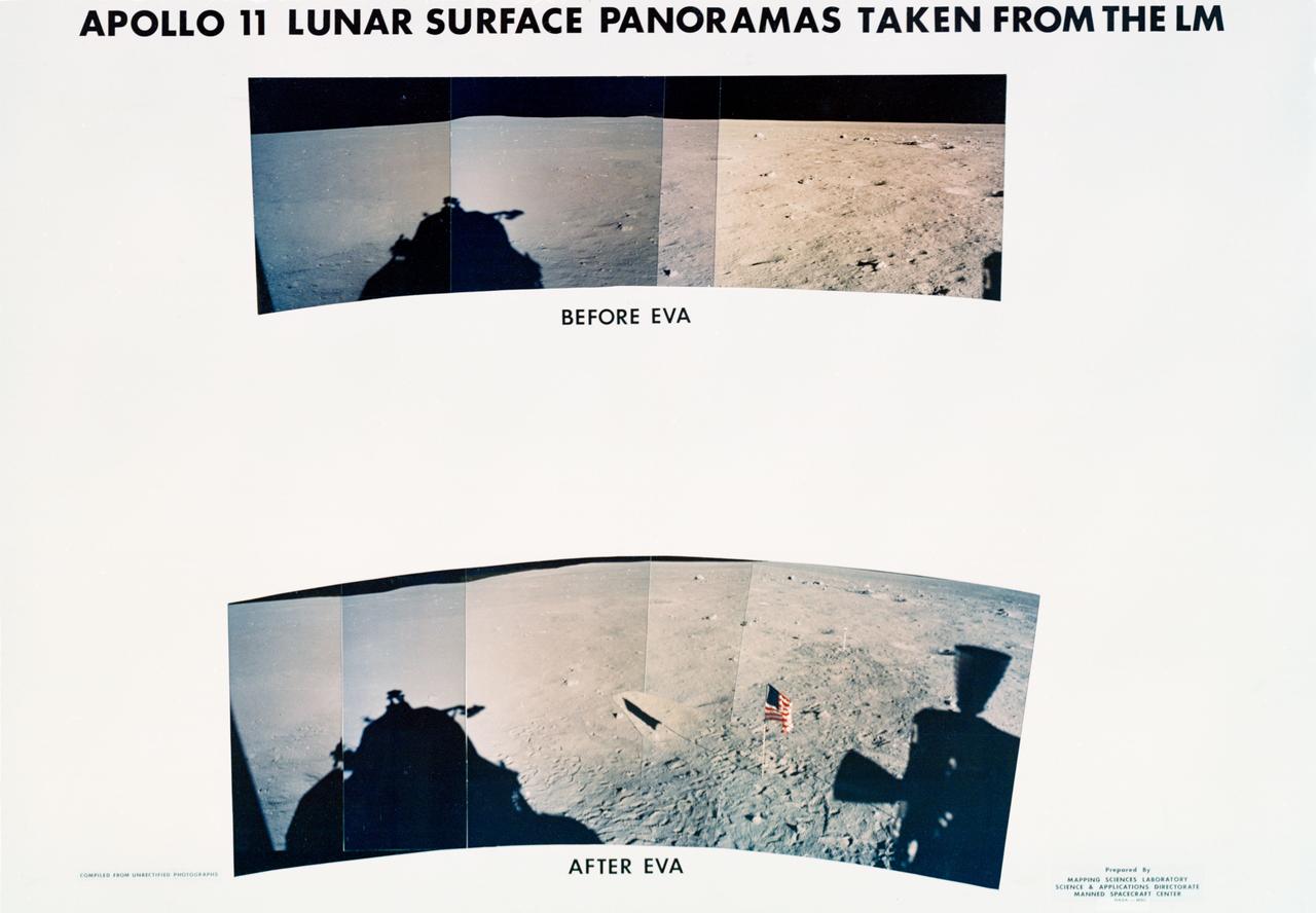
S69-44465 (20 July 1969) --- These panoramic views of the lunar surface, photographed from the Apollo 11 Lunar Module (LM) as it rested on the lunar surface. The views reveal the surface near where the LM touched down, in the southeastern Sea of Tranquility. The views are as it looked before and after astronauts Neil A. Armstrong and Edwin E. Aldrin Jr. participated in extravehicular activity (EVA). The United States flag is pictured in the bottom or "after" photo with the black and white lunar surface television camera pictured at the right of flag. Shadows of the LM are visible in the two panoramic views and a silhouette of part of a Reaction Control Subsystem thruster is seen in the bottom picture. Note the numerous footprints made by the two crewmen during the EVA period.
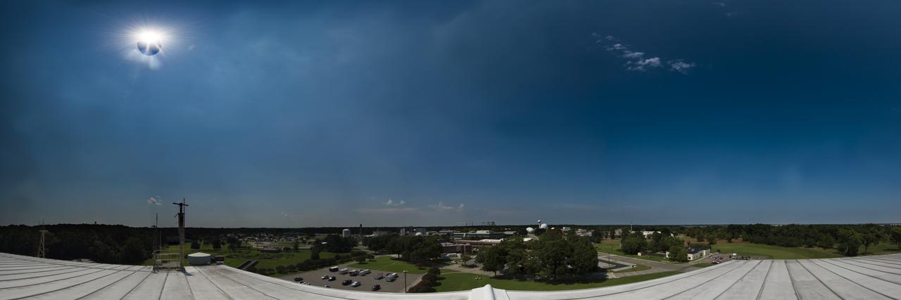
This panoramic view of the partial solar eclipse was taken from the roof of the aircraft hangar at NASA Langley Research Center in Hampton, Virginia. The eclipse in Hampton was about 85 percent of totality.
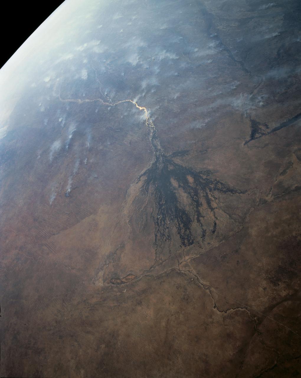
In this panoramic view of the Okavango Swamp, Botswana, (19.0S, 22.0E), the Okavango River, seen in sunglint, flows into a topographic trough to form an inland delta. Water, trapped in the meandering delta distributaries is evaporated or transpired by vegetation. In Angola to the north, the many fires of the seasonal burning of savannah vegetation for land clearing, in preparation for agriculture, has filled the atmosphere with haze and smoke.
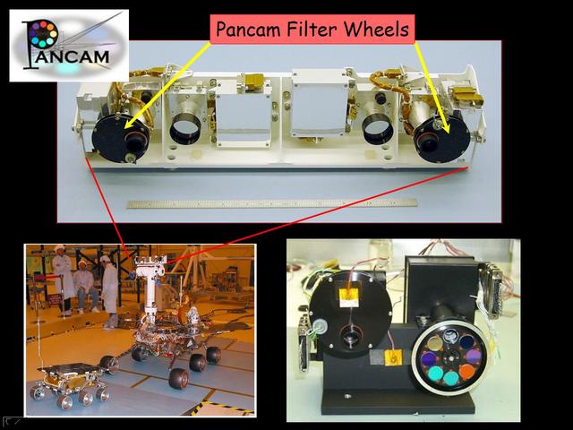
This image taken at NASA Jet Propulsion Laboratory shows the panoramic camera used onboard both NASA Mars Exploration Rovers.
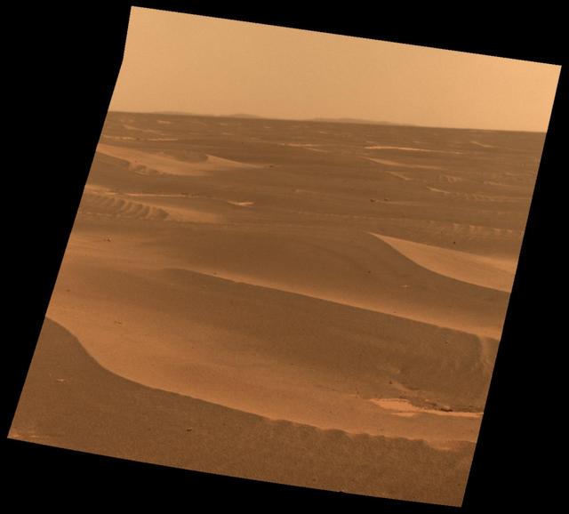
Images taken by NASA Phoenix Mars Lander Surface Stereo Imager, combined into a panoramic view looking north from the lander.
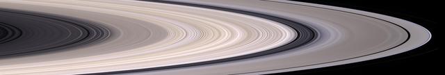
Saturn most prominent feature, its dazzling ring system, takes center stage in this stunning natural color mosaic which reveals the color and diversity present in this wonder of the solar system.
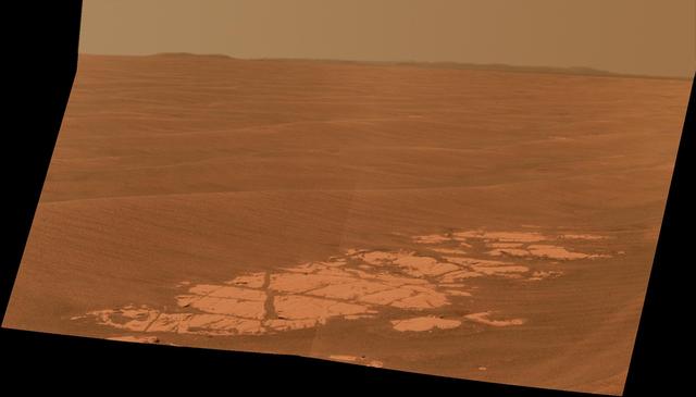
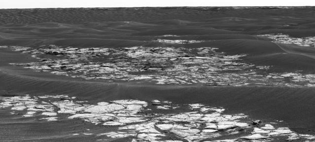
This image from the panoramic camera Pancam on NASA Mars Exploration Rover Opportunity shows a pale rock called Esperence, which was inspected by the rover in May 2013.
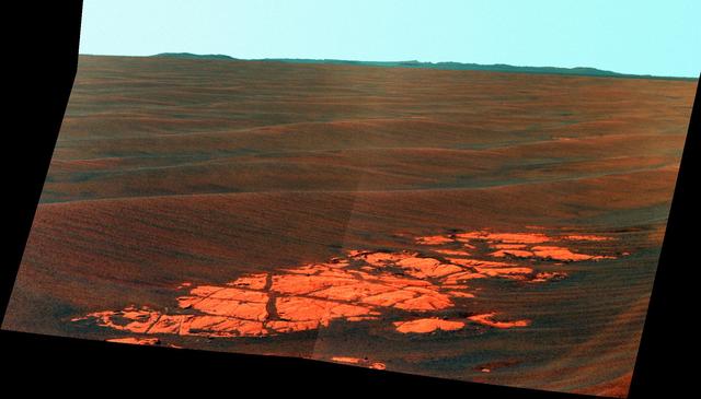
This false-color scene from the panoramic camera Pancam on NASA Mars Exploration Rover Opportunity catches Pillinger Point, on the western rim of Endeavour Crater, in the foreground.
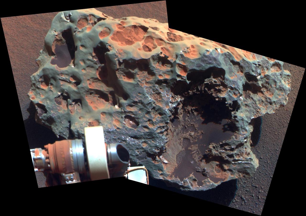
This view of a rock called Block Island, the largest meteorite yet found on Mars, comes from the panoramic camera Pancam on NASA Mars Exploration Rover Opportunity.
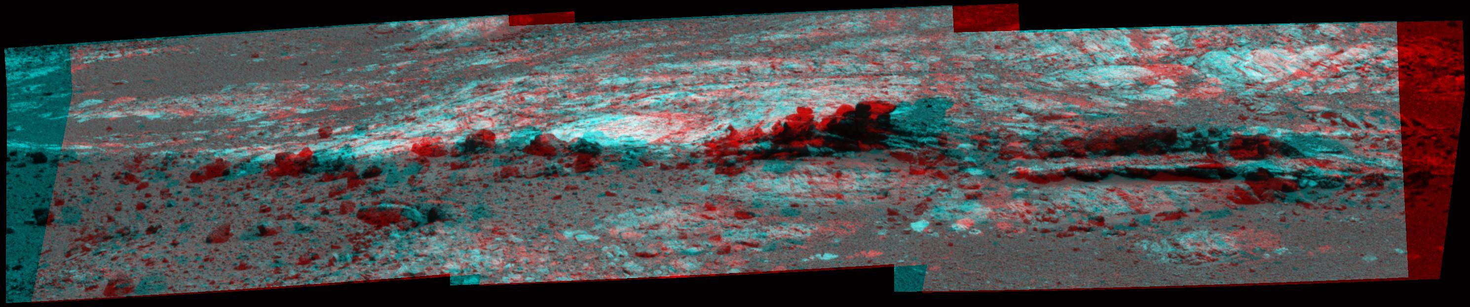
This mosaic of images from NASA Mars Exploration Rover Spirit shows a panoramic anaglyph of the Columbia Hills. 3D glasses are necessary to view this image.

The sun descends to the Martian horizon and sets in this image from the panoramic camera Pancam on NASA Mars Exploration Rover Opportunity. A movie is available at the Photojournal.
This scene from the panoramic camera Pancam on NASA Mars Exploration Rover Opportunity catches Pillinger Point, on the western rim of Endeavour Crater, in the foreground.

New insights into the nature of Saturn’s rings are revealed in this panoramic mosaic of 15 images taken during the planet’s August 2009 equinox, taken by NASA Cassini Orbiter.
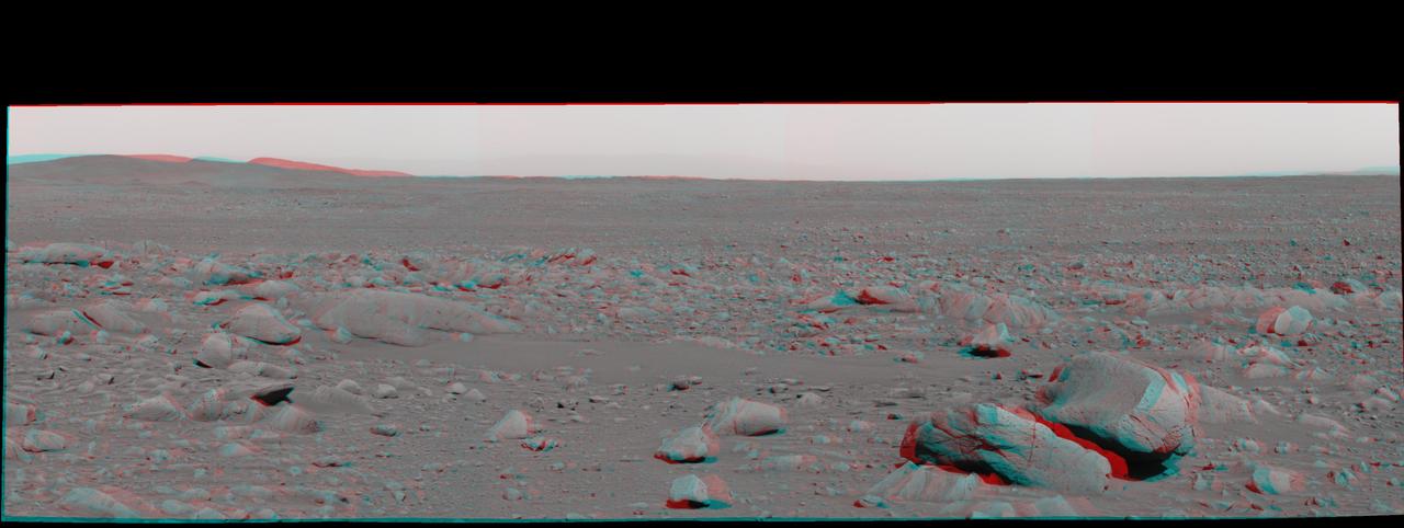
Martian terrain is seen in this 3-D image taken by the panoramic camera on NASA Mars Exploration Rover Spirit. 3D glasses are necessary to view this image.
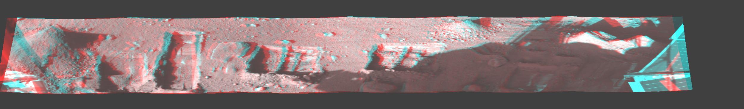
This image is a stereo, panoramic view of various trenches dug by NASA Phoenix Mars Lander on Oct. 7, 2008. 3D glasses are necessary to view this image.

This panoramic side view of NASA’s X-59 Quiet SuperSonic Technology airplane shows the aircraft sitting on jacks at a Lockheed Martin test facility in Fort Worth, Texas. Lockheed Martin Aeronautics Company - Fort Worth - Chris Hanoch Subject: SEG 230 Nose Attachement FP#: 21-03420 POC: Analiese Smith, Chris Higgins Other info: X-59 in Fort Worth, testing
PANORAMIC VIEW - PAD 39B
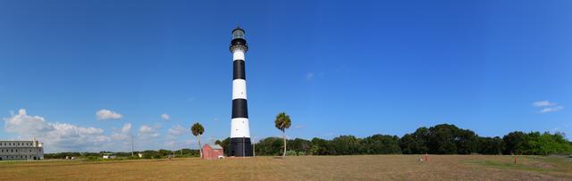
Panoramic View of the Lighthouse
PANORAMIC VIEWS - MLP PARK
PANORAMIC VIEWS - MLP PARK
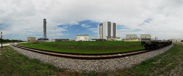
PANORAMIC VIEWS - MLP PARK

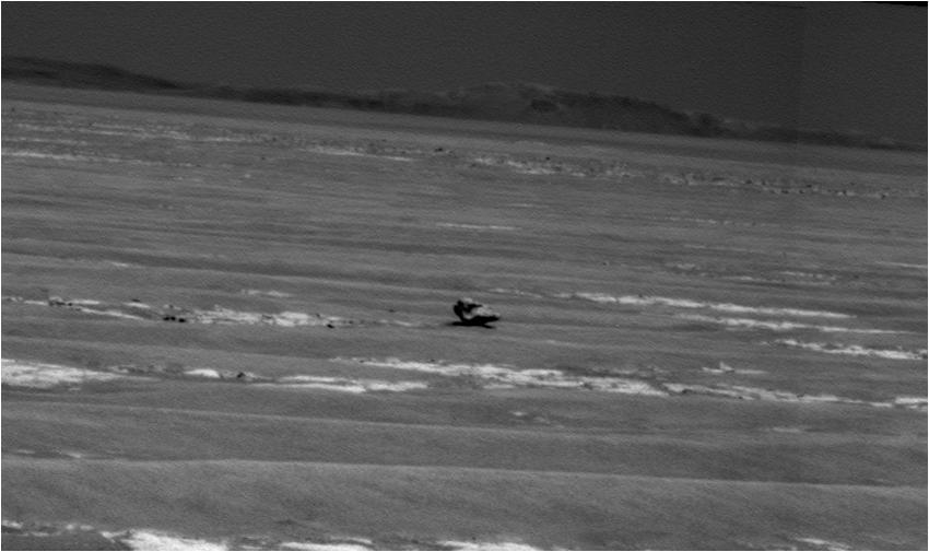
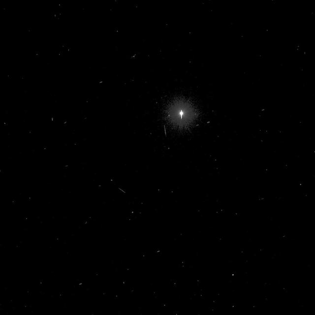
This is the first image ever taken of Earth from the surface of a planet beyond the Moon. It was taken by the Mars Exploration Rover Spirit one hour before sunrise on the 63rd martian day, or sol, of its mission. The image is a mosaic of images taken by the rover's navigation camera showing a broad view of the sky, and an image taken by the rover's panoramic camera of Earth. The contrast in the panoramic camera image was increased two times to make Earth easier to see. The inset shows a combination of four panoramic camera images zoomed in on Earth. The arrow points to Earth. Earth was too faint to be detected in images taken with the panoramic camera's color filters. http://photojournal.jpl.nasa.gov/catalog/PIA05547
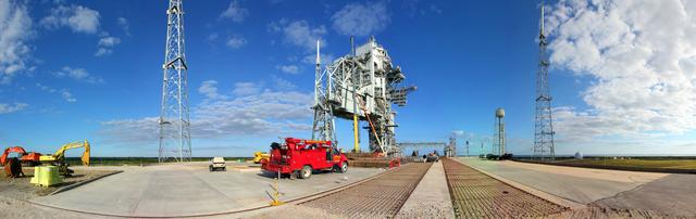
PAD 39B DEMO OPS - PANORAMIC
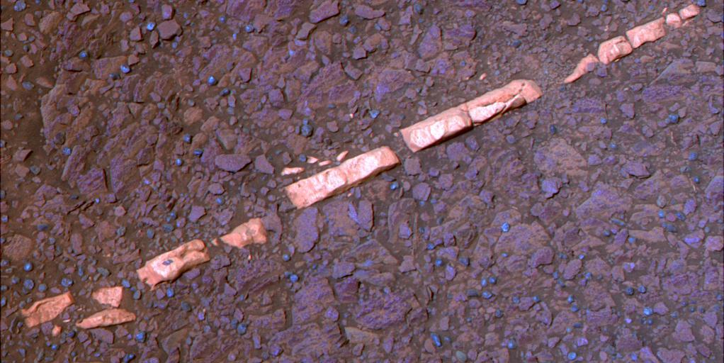
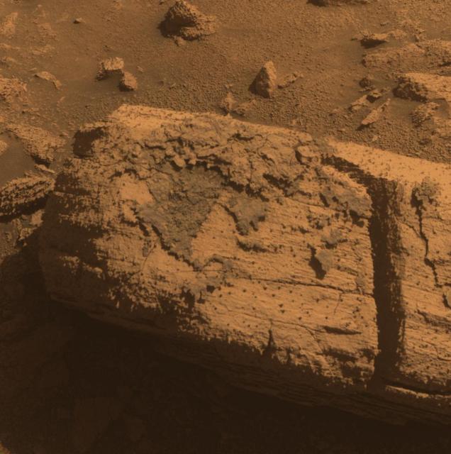
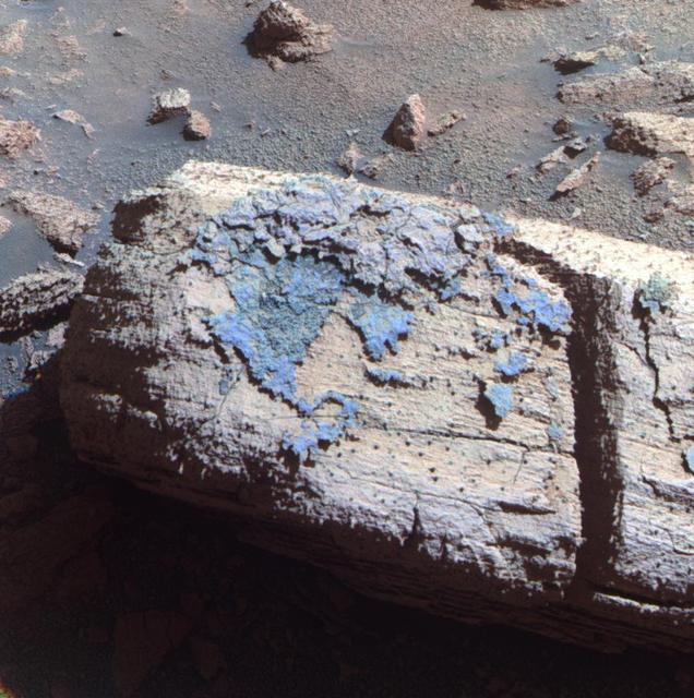
This false-color view of a mineral vein called Homestake comes from the panoramic camera Pancam on NASA Mars Exploration Rover Opportunity. The vein is about the width of a thumb and about 18 inches 45 centimeters long.
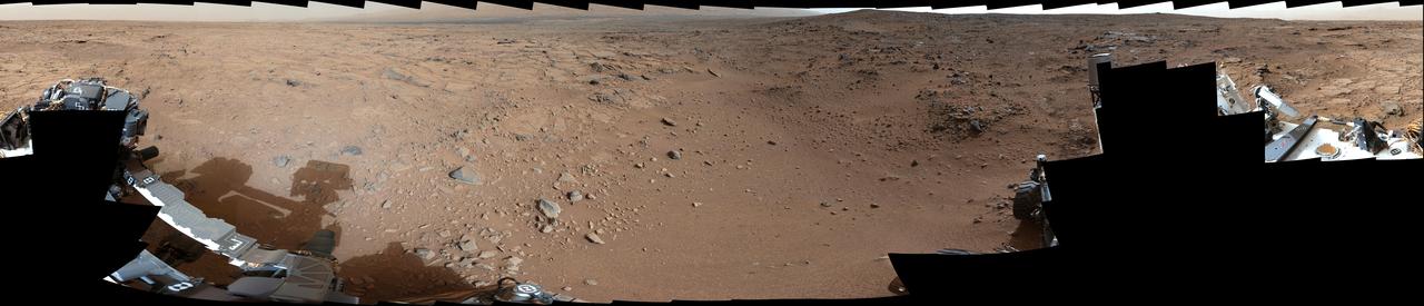
This is the first 360-degree panoramic view from NASA Curiosity rover, taken with the Navigation cameras. Mount Sharp is to the right, and the north Gale Crater rim can be seen at center. The rover body is in the foreground.
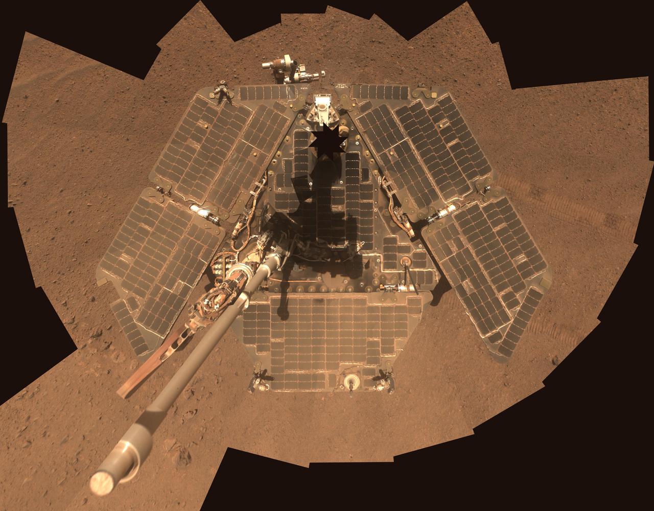
A self-portrait of NASA Mars Exploration Rover Opportunity taken by the rover panoramic camera Pancam in late March 2014 shows effects of recent winds removing much of the dust from the rover solar arrays.
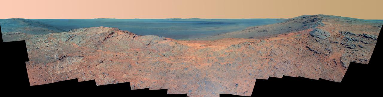
On the horizon in the right half of this panoramic view from NASA Opportunity is an area of Mars informally named Matijevic Hill, in commemoration of an influential rover-team leader. The hill includes an outcrop called Kirkwood.
NASA Mars Exploration Rover used its panoramic camera to record this view of the rim of a crater about 65 kilometers 40 miles in the distance, on the southwestern horizon. This crater, Bopolu, is about 19 kilometers 12 miles in diameter.
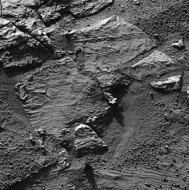
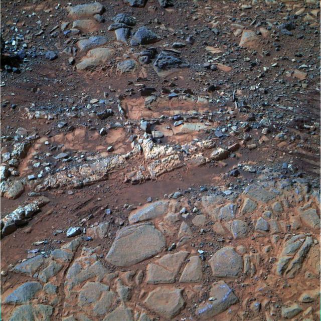
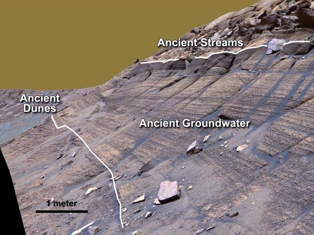
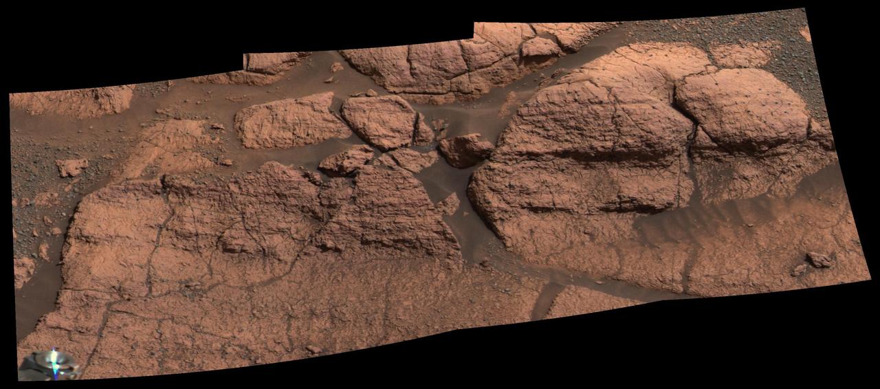
This image from the panoramic camera on NASA Mars Exploration Rover Opportunity shows the best examples yet seen in Meridiani Planum outcrop rocks of well-preserved, fine-scale layering and what geologists call cross-lamination.
Rock fins up to about 1 foot 30 centimeters tall dominate this approximate true color scene from the panoramic camera Pancam on NASA Mars Exploration Rover Opportunity.
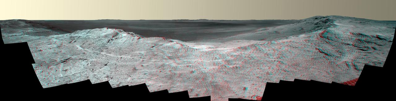
This vista of the Endeavour Crater rim was acquired by NASA Mars Exploration Rover Opportunity panoramic camera on April 18, 2014, from the southern end of Murray Ridge on the western rim of the crater.
This image from the panoramic camera Pancam on NASA Mars Exploration Rover Opportunity shows the location of Pinnacle Island rock before it appeared in front of the rover in early January 2014.
This 3-D image combines computer-generated models of NASA Mars Exploration Rover Spirit and its lander with real surface data from the rover panoramic camera. 3D glasses are necessary to view this image.
This is the Opportunity panoramic camera Erebus Rim panorama, acquired on sols 652 to 663 Nov. 23 to Dec. 5, 2005 , as NASA Mars Exploration Rover Opportunity was exploring sand dunes and outcrop rocks in Meridiani Planum.

This image uses a view from the navigation camera on NASA Mars Exploration Rover Opportunity to show context for a horizon shot by the rover narrower-angle panoramic camera of the rim of Endeavour crater.
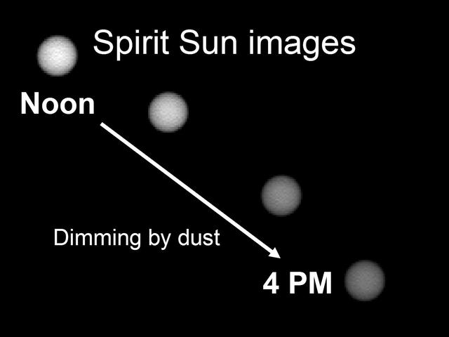
This image shows the Sun as it appears on Mars throughout the day. Scientists monitor the dimming of the setting Sun to assess how much dust is in the martian atmosphere. The pictures were taken by the Mars Exploration Rover Spirit panoramic camera.
NASA Mars Exploration Rover Opportunity used its panoramic camera Pancam to capture this view approximately true-color view of the rim of Endeavour crater, the rover destination in a multi-year traverse along the sandy Martian landscape.

This full-circle,stereo view from the panoramic camera Pancam on NASA Mars Exploration Rover Spirit shows the terrain surrounding the location called Troy, where Spirit became embedded in soft soil during the spring of 2009.
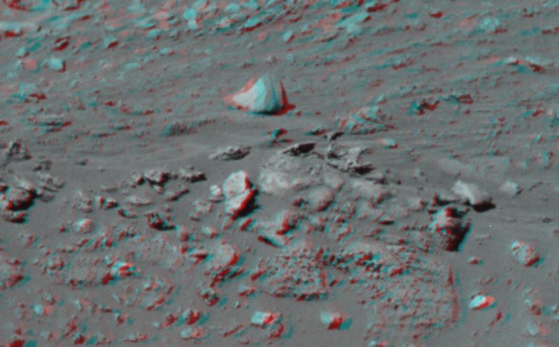
This 3-D image taken by the left and right eyes of the panoramic camera on NASA Mars Exploration Rover Spirit shows the odd rock formation dubbed Cobra Hoods center. 3D glasses are necessary to view this image.
The highest point visible in this panoramic anaglyph from on NASA Mars Exploration Rover Spirit is Husband Hill, named for space shuttle Columbia Commander Rick Husband. 3D glasses are necessary to view this image.
NASA Mars Exploration Rover Opportunity used its panoramic camera to capture this view of a dark rock the size of a toaster that may be an iron meteorite. Part of the rim of Endurance Crater is on the horizon.
This stereo panoramic view combines 14 images taken by NASA Mars rover Curiosity during the mission 120th Martian day, or sol Dec. 7, 2012. You need 3D glasses.
NASA Mars Exploration Rover Opportunity used its panoramic camera Pancam to capture this false-color view of the rim of Endeavour crater, the rover destination in a multi-year traverse along the sandy Martian landscape.
This stereo vista from the panoramic camera Pancam of NASA Mars Exploration Rover Opportunity catches Pillinger Point, on the western rim of Endeavour Crater, in the foreground. You need 3-D glasses to view this image.
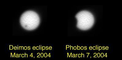
The panoramic camera on NASA Opportunity combines the first photographs of solar eclipses by Mars two moons, Deimos and Phobos. Deimos appears as a speck in front of the Sun and Phobos grazes its edge.

NASA Mars Exploration Rover Opportunity used its panoramic camera to record this eastward horizon view. A portion of Endeavour Crater eastern rim, in the distance, is visible over the Meridiani plain.
Dust-covered rocks can be seen in this portion of the 3D image taken by the panoramic camera on NASA Mars Exploration Rover Spirit. 3D glasses are necessary to view this image.
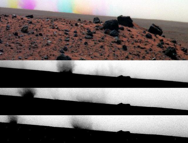
While the panoramic camera Pancam on NASA Mars Exploration Rover Spirit was taking exposures with different color filters on May 27, 2009, dust devils moved across the field of view.
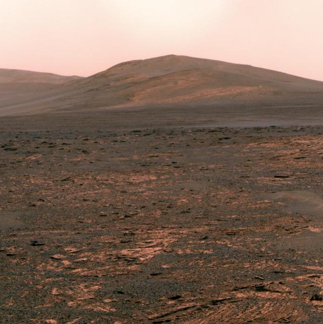
NASA Mars Exploration Rover Opportunity used its panoramic camera Pancam to acquire this view of Solander Point. The southward-looking scene, presented in true color, shows Solander Point on the center horizon.
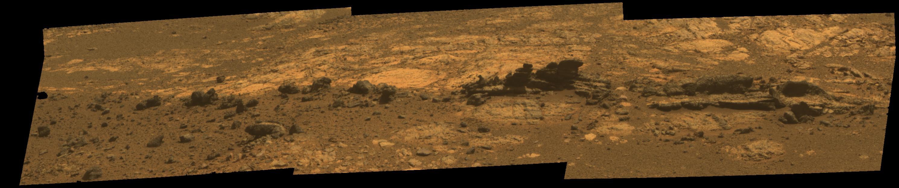
This image from the panoramic camera on NASA Mars Exploration Rover Opportunity shows a rock called Chocolate Hills, which the rover found and examined at the edge of a young crater called Concepción.
The flat-topped rock, informally named Tisdale 2, just below the center of this raw image from the rover Opportunity panoramic camera was chosen by the rover team in August 2011 as a stop for inspecting with tools on Opportunity robotic arm.
This false color image from the panoramic camera on NASA Mars Exploration Rover Opportunity shows a rock called Chocolate Hills, which the rover found and examined at the edge of a young crater called Concepción.
Rock fins up to about 1 foot 30 centimeters tall dominate this false color scene from the panoramic camera Pancam on NASA Mars Exploration Rover Opportunity.
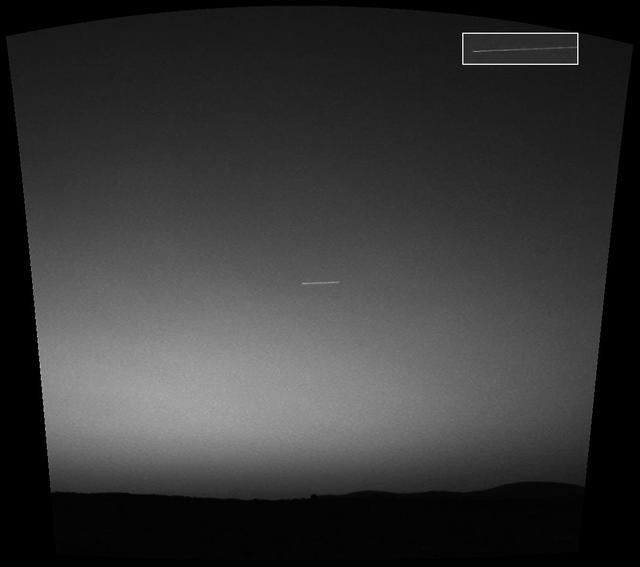
Observing the sky with the green filter of it panoramic camera, NASA Mars Exploration Rover Spirit came across a surprise: a streak across the sky, probably the brightest object in the sky at the time.
The NASA Mars rover Curiosity used its Navigation Camera Navcam during the mission 120th Martian day, or sol Dec. 7, 2012, to record the seven images combined into this panoramic view.
This false-color vista of the Endeavour Crater rim was acquired by NASA Mars Exploration Rover Opportunity panoramic camera on April 18, 2014, from Murray Ridge on the western rim of the crater.
NASA Mars Exploration Rover Opportunity studied layers in the Burns Cliff slope of Endurance Crater in 2004. The layers show different types of deposition of sulfate-rich sediments. Opportunity panoramic camera recorded this image.
A false-color self-portrait of NASA Mars Exploration Rover Opportunity taken by the rover panoramic camera Pancam shows effects of recent winds removing much of the dust from the solar arrays.

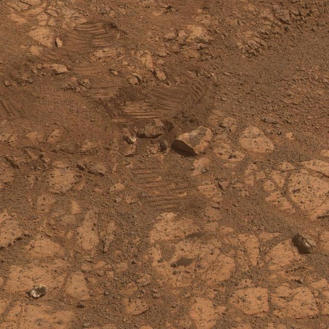
Panoramic View of Slidewire Baskets Used for Last Time
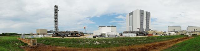
PANORAMIC VIEW OF PEGASUS BARGE AREA WITH VAB IN BACKGROUND
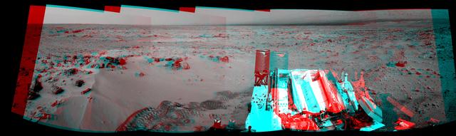
This mosaic of images taken by the panoramic camera onboard the Mars Exploration Rover Opportunity shows the rock region dubbed "El Capitan," which lies within the larger outcrop near the rover's landing site. "El Capitan" is being studied in great detail using the scientific instruments on the rover's arm; images from the panoramic camera help scientists choose the locations for this compositional work. The millimeter-scale detail of the lamination covering these rocks can be seen. The face of the rock to the right of the mosaic may be a future target for grinding with the rover's rock abrasion tool. http://photojournal.jpl.nasa.gov/catalog/PIA05492
NASA's Mars Exploration Rover Spirit acquired the images that went into this color composite with its panoramic camera around 1:00 p.m. martian time on its 270th martian day, or sol (Oct. 5, 2004). The view represents the panoramic-camera team's best current attempt at generating a "true color" view of what this scene would look like if viewed by a human on Mars. It was generated from a mathematical combination of six calibrated images acquired through filters for wavelengths between 430 nanometers and 750 nanometers. http://photojournal.jpl.nasa.gov/catalog/PIA06938
PANORAMIC VIEW OF VAB AREA FROM ATOP MOBILE LAUNCH TOWER

STS-134 PANORAMIC VIEWS - AMS ARRIVAL AND XFER TO SSPF
STS-134 PANORAMIC VIEWS - AMS ARRIVAL AND XFER TO SSPF
STS-134 PANORAMIC VIEWS - AMS ARRIVAL AND XFER TO SSPF
STS-133 PANORAMIC VIEWS OF SRB MATE ON MLP IN VAB
STS-134 PANORAMIC VIEWS - AMS ARRIVAL AND XFER TO SSPF

STS-134 PANORAMIC VIEWS - AMS ARRIVAL AND XFER TO SSPF
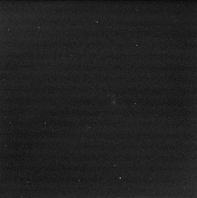
NASA Mars Exploration Rover Opportunity used its panoramic camera to snap pictures of Mars moon Deimos. Three frames were taken with long exposures to measure Deimos position with respect to the background stars. http://photojournal.jpl.nasa.gov/catalog/PIA12290
This is a mosaic assembled from some of the images taken by the panoramic camera on NASA's Mars Exploration Rover Opportunity during the rover's 590th sol (Sept. 21, 2005). The view is toward the south and includes rock exposures north of "Erebus Crater," with the crater in the background. The rover will investigate the exposed rocks in the foreground and will take additional panoramic-camera images of Erebus Crater, which is about 300 meters (about 984 feet) across. Erebus Crater dwarfs the landing-site crater, "Eagle Crater," which measures about 22 meters (72 feet) in diameter. And, it is nearly twice the diameter of "Endurance Crater," which, at 130 meters (430 feet) wide, has been compared to a stadium. The camera's red filter was used for taking the images in this mosaic. It admits light with a wavelength of 750 nanometers http://photojournal.jpl.nasa.gov/catalog/PIA06341
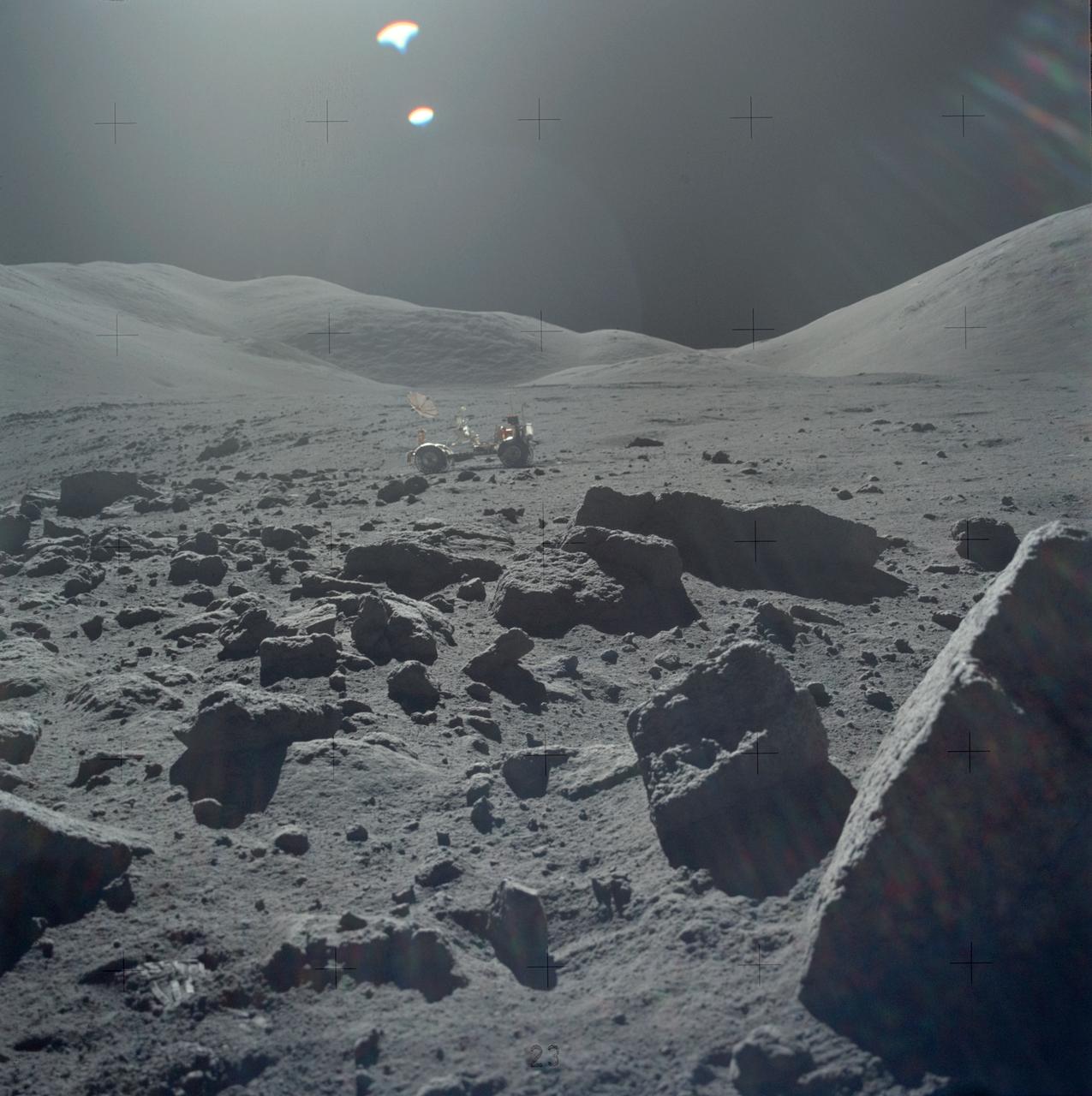
AS17-145-22162 (7-19 Dec. 1972) --- One of the Apollo 17 crew photographed this view during lunar surface extravehicular activities (EVA) at the Taurus-Littrow landing site. The Lunar Rover Vehicle (LRV), which was used extensively by astronauts Eugene A. Cernan and Harrison H. Schmitt, is visible in the background.
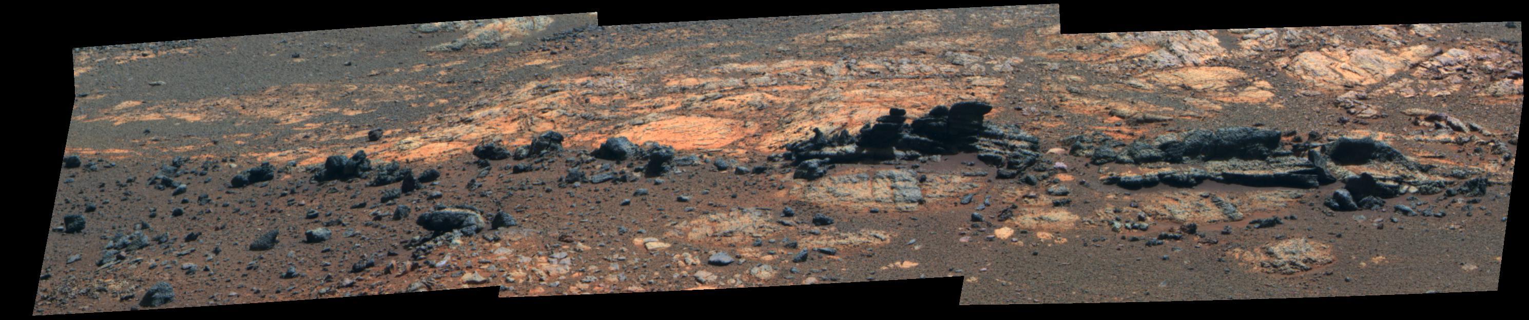
On Nov. 22, 2012, or sol 106, NASA Mars rover Curiosity was near a location called Point Lake for an overlook of a shallow depression called Yellowknife Bay which is in the left third of this scene, in the middle distance.
Rock fins up to about 1 foot 30 centimeters tall dominate this stereo scene from the panoramic camera Pancam on NASA Mars Exploration Rover Opportunity taken during the 3,058th Martian day Aug. 23, 2012.
This stereo view was taken by the panoramic camera on NASA Mars Exploration Rover Spirit on the rover 87th martian day, or sol April 1, 2004, just after Spirit left Bonneville Crater. 3D glasses are necessary to view this image.

On May 19th, 2005, NASA Mars Exploration Rover Spirit captured this stunning view as the Sun sank below the rim of Gusev crater on Mars. This Panoramic Camera Pancam mosaic was taken around 6:07 in the evening of the rover 489th martian day.
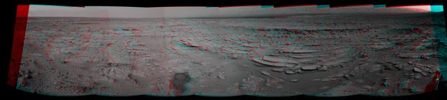
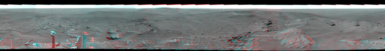
This 360-degree view, called the McMurdo panorama, comes from the panoramic camera aboard NASA Mars Exploration Rover Spirit. From April through October 2006, Spirit has stayed on a small hill known as Low Ridge. 3D glasses are necessary.
This 360-degree color view, called the McMurdo panorama, comes from the panoramic camera aboard NASA Mars Exploration Rover Spirit. From April through October 2006, Spirit has stayed on a small hill known as Low Ridge. 3D glasses are necessary.
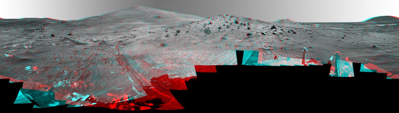
NASA Mars Exploration Rover Spirit used its panoramic camera Pancam to record a 360-degree vista, dubbed the Everest panorama, from the top of Husband Hill in early October 2005. 3D glasses are necessary to view this image.
NASA Mars rover Curiosity drove 6.2 feet 1.9 meters during the 100th Martian day, or sol, of the mission Nov. 16, 2012. The rover used its Navigation Camera after the drive to record the images combined into this 3-D panoramic view.
This two-image blink shows a comparison of two exposure times in images from the panoramic camera Pancam on NASA Mars Exploration Rover Opportunity showing comet C/2013 A1 Siding Spring as it flew near Mars on Oct. 19, 2014.
This full-circle, false color view from the panoramic camera Pancam on NASA Mars Exploration Rover Spirit shows the terrain surrounding the location called Troy, where Spirit became embedded in soft soil during the spring of 2009.
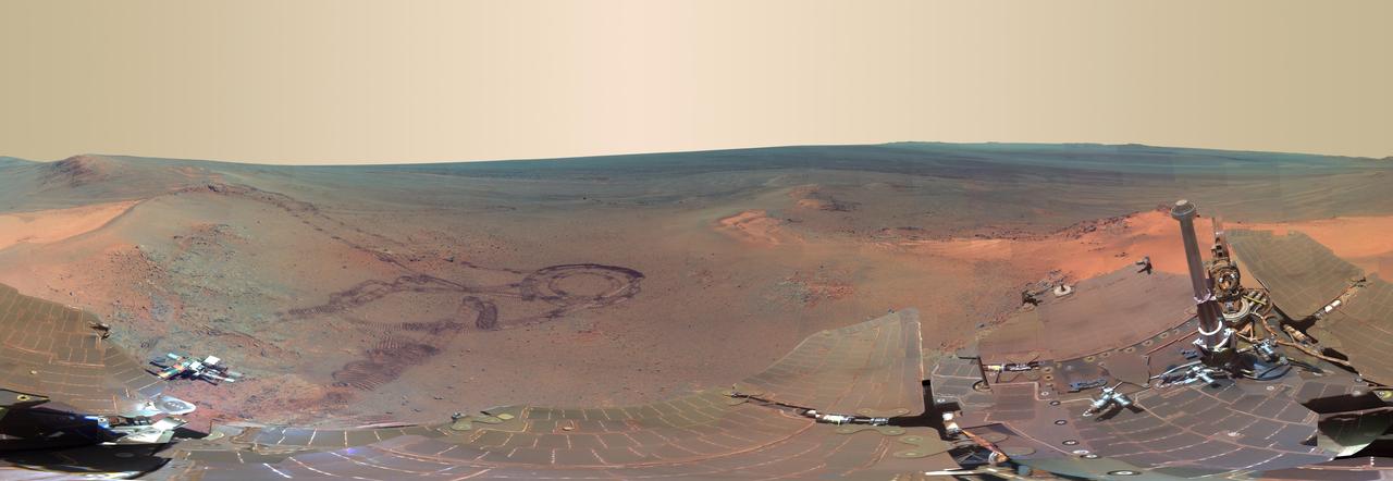
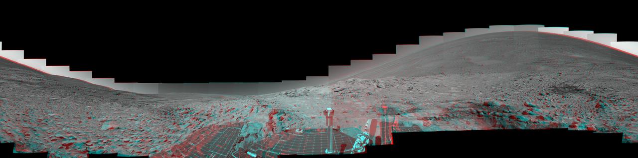
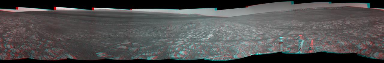
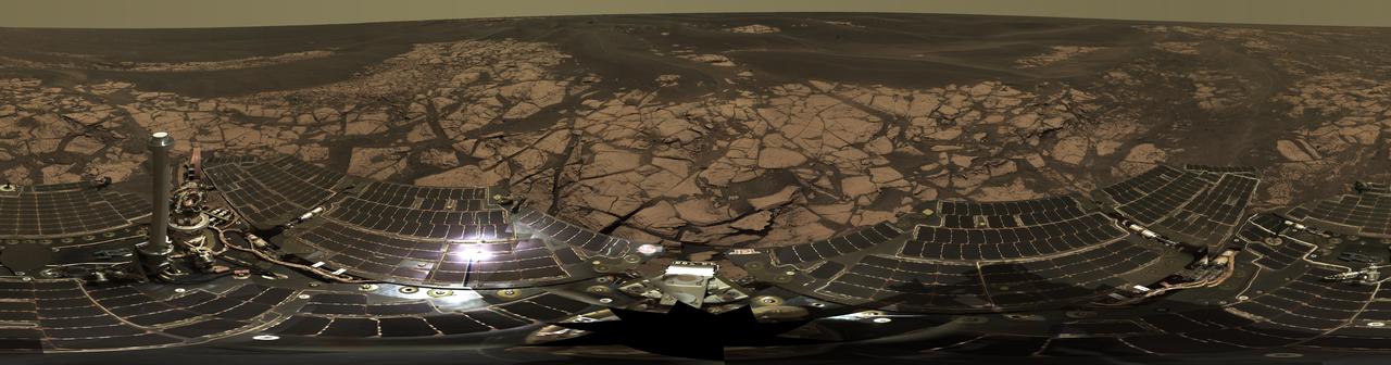
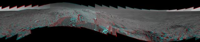
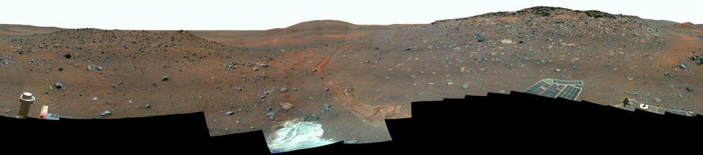
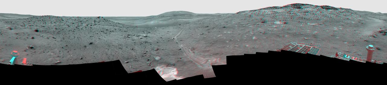
This full-circle scene combines 817 images, taken by the panoramic camera on NASA Mars Exploration Rover Opportunity, showing the terrain that surrounded the rover while it was stationary for four months of work during its most recent Martian winter.
NASA Mars Exploration Rover Spirit used its panoramic camera Pancam to record a 360-degree vista, dubbed the Thanksgiving panorama, from the northwestern side of Husband Hill in late 2004. 3D glasses are necessary to view this image.
This full-circle view from the panoramic camera Pancam on NASA Mars Exploration Rover Spirit shows the terrain surrounding the location called Troy, where Spirit became embedded in soft soil during the spring of 2009. 3D glasses are necessary.
This false-color image, taken by the panoramic camera on NASA rover Opportunity, shows the rock Chocolate Hills, perched on the rim of the 10-meter 33-foot wide Concepcion crater. This rock has a thick, dark-colored coating resembling chocolate.

This is the first image ever taken of Earth from the surface of a planet beyond the Moon. It was taken by the Mars Exploration Rover Spirit one hour before sunrise on the 63rd martian day, or sol, of its mission. Earth is the tiny white dot in the center. The image is a mosaic of images taken by the rover's navigation camera showing a broad view of the sky, and an image taken by the rover's panoramic camera of Earth. The contrast in the panoramic camera image was increased two times to make Earth easier to see. http://photojournal.jpl.nasa.gov/catalog/PIA05560
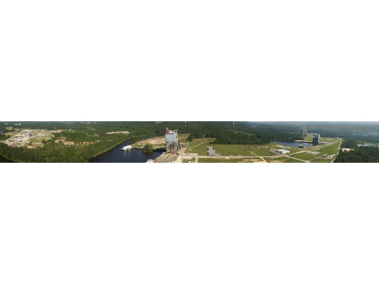
photo taken from the top of the new A-3 Test Stand at Stennis Space Center offers a panoramic view of the A, B and E test complexes at the south Mississippi faci