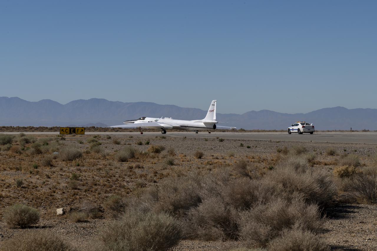
The ER-2 conducted over 80 flight hours in service of the Plankton, Aerosol, Cloud, ocean Ecosystem Postlaunch Airborne eXperiment (PACE-PAX) mission. The ER-2 is uniquely qualified to conduct the high-altitude scientific flights that this project required, and is based at NASA’s Armstrong Flight Research Center in Edwards, California.

NASA videographer Jacob Shaw shares a moment with his constant companion during a break in the cafeteria at NASA’s Armstrong Flight Research Center in Edwards, California, on May 21, 2025. Shaw recently earned first place in NASA’s 2024 Videographer of the Year Awards – documentation category – for his film, “Reflections,” which chronicles the 2024 Airborne Science mission PACE-PAX – short for Plankton, Aerosol, Cloud, ocean Ecosystem Postlaunch Airborne eXperiment.

NASA videographer Jacob Shaw captures footage of the ER-2 aircraft inside a hangar at NASA’s Armstrong Flight Research Center in Edwards, California, in December 2024. Shaw recently earned first place in NASA’s 2024 Videographer of the Year Awards – documentation category – for his film, “Reflections,” which chronicles the 2024 Airborne Science mission PACE-PAX – short for Plankton, Aerosol, Cloud, ocean Ecosystem Postlaunch Airborne eXperiment.

Sam Habbal (quality inspector), Darick Alvarez (aircraft mechanic), and Juan Alvarez (crew chief) work on the network “canoe” on top of the ER-2 aircraft, which provides network communication with the pilot onboard. Experts like these sustain a high standard of safety while outfitting instruments onboard science aircraft like the ER-2 and science missions like the Plankton, Aerosol, Cloud, ocean Ecosystem Postlaunch Airborne eXperiment (PACE-PAX) mission. The ER-2 is based out of NASA’s Armstrong Flight Research Center in Edwards, California.
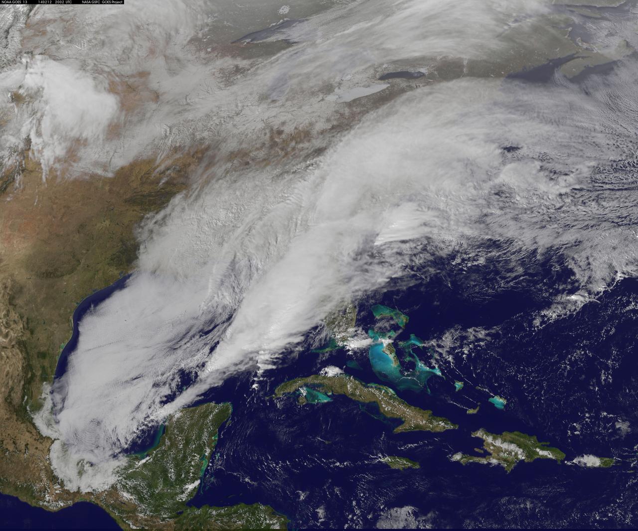
<b>View a video of the storm here: <a href="http://bit.ly/1m9aJFY" rel="nofollow">bit.ly/1m9aJFY</a></b> This visible image of the winter storm over the U.S. south and East Coast was taken by NOAA's GOES-13 satellite on Feb. 12 at 1855 UTC/1:55 p.m. EST. Snow covered ground can be seen over the Great Lakes region and Ohio Valley. On February 12 at 10 a.m. EST, NOAA's National Weather Service or NWS continued to issue watches and warnings from Texas to New England. Specifically, NWS cited Winter Storm Warnings and Winter Weather Advisories were in effect from eastern Texas eastward across the interior section of southeastern U.S. states and across much of the eastern seaboard including the Appalachians. Winter storm watches are in effect for portions of northern New England as well as along the western slopes of northern and central Appalachians. For updates on local forecasts, watches and warnings, visit NOAA's <a href="http://www.weather.gov" rel="nofollow">www.weather.gov</a> webpage. NOAA's Weather Prediction Center or WPC noted the storm is expected to bring "freezing rain spreading into the Carolinas, significant snow accumulations are expected in the interior Mid-Atlantic states tonight into Thursday and ice storm warnings and freezing rain advisories are in effect across much of central Georgia. GOES satellites provide the kind of continuous monitoring necessary for intensive data analysis. Geostationary describes an orbit in which a satellite is always in the same position with respect to the rotating Earth. This allows GOES to hover continuously over one position on Earth's surface, appearing stationary. As a result, GOES provide a constant vigil for the atmospheric "triggers" for severe weather conditions such as tornadoes, flash floods, hail storms and hurricanes. For updated information about the storm system, visit NOAA's WPC website; <a href="http://www.hpc.ncep.noaa.gov/" rel="nofollow">www.hpc.ncep.noaa.gov/</a> For more information about GOES satellites, visit: <a href="http://www.goes.noaa.gov/" rel="nofollow">www.goes.noaa.gov/</a> or <a href="http://goes.gsfc.nasa.gov/" rel="nofollow">goes.gsfc.nasa.gov/</a> Rob Gutro NASA's Goddard Space Flight Center <b><a href="http://goes.gsfc.nasa.gov/" rel="nofollow">Credit: NOAA/NASA GOES Project</a></b> <b><a href="http://www.nasa.gov/audience/formedia/features/MP_Photo_Guidelines.html" rel="nofollow">NASA image use policy.</a></b> <b><a href="http://www.nasa.gov/centers/goddard/home/index.html" rel="nofollow">NASA Goddard Space Flight Center</a></b> enables NASA’s mission through four scientific endeavors: Earth Science, Heliophysics, Solar System Exploration, and Astrophysics. Goddard plays a leading role in NASA’s accomplishments by contributing compelling scientific knowledge to advance the Agency’s mission. <b>Follow us on <a href="http://twitter.com/NASAGoddardPix" rel="nofollow">Twitter</a></b> <b>Like us on <a href="http://www.facebook.com/pages/Greenbelt-MD/NASA-Goddard/395013845897?ref=tsd" rel="nofollow">Facebook</a></b> <b>Find us on <a href="http://instagrid.me/nasagoddard/?vm=grid" rel="nofollow">Instagram</a></b>
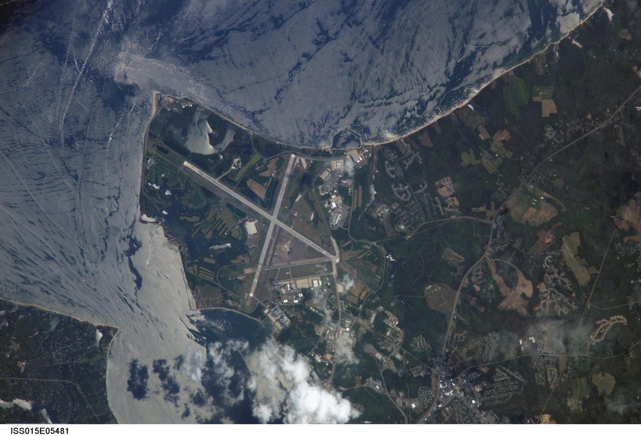
ISS015-E-05481 (28 April 2007) --- Patuxent River Naval Air Station, Maryland is featured in this image photographed by an Expedition 15 crewmember on the International Space Station. The Patuxent River Naval Air Station - or NAS Patuxent River -- is located on a small peninsula, bordered by the Patuxent River to the north-northeast and Chesapeake Bay to the east and southeast. The air station was commissioned in 1943, replacing farmlands that had occupied the peninsula less than a year earlier. The primary purpose of "Pax River" (as the site is known by the US Navy) was to consolidate geographically-dispersed air testing facilities that existed in the US prior to World War II into a central location. The NAS Patuxent River is now the primary center for naval air technology research, development, testing, and support, as well as being the location of the Navy Test Pilot School. The NAS Patuxent River is used frequently as a geographic reference point and training target by station crews. This view illustrates why --the distinctive pattern of the airfield runways and the station's location in Chesapeake Bay make it easy to spot from orbit, and provides sharp land cover boundaries for camera focusing practice. This particular image also captures surface water current patterns around the peninsula. Wind and wave-roughened water surfaces appear silver-gray due to increased reflectance of light back towards the camera (sunglint), whereas dark blue water patches indicate water smoothed by the presence of oils and surfactants. A zone of mixing from converging shoreline currents extends northeast into the bay from Cedar Point.